scenario building process & purpose
TRANSCRIPT
SCENARIO BUILDING PROCESS & PURPOSE
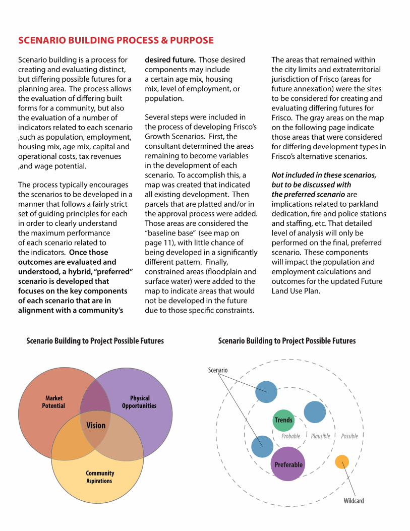
Scenario building is a process for creating and evaluating distinct, but differing possible futures for a planning area. The process allows the evaluation of differing built forms for a community, but also the evaluation of a number of indicators related to each scenario ,such as population, employment, housing mix, age mix, capital and operational costs, tax revenues ,and wage potential.
The process typically encourages the scenarios to be developed in a manner that follows a fairly strict set of guiding principles for each in order to clearly understand the maximum performance of each scenario related to the indicators. Once those
outcomes are evaluated and
understood, a hybrid, “preferred”
scenario is developed that
focuses on the key components
of each scenario that are in
alignment with a community’s
desired future. Those desired components may include a certain age mix, housing mix, level of employment, or population.
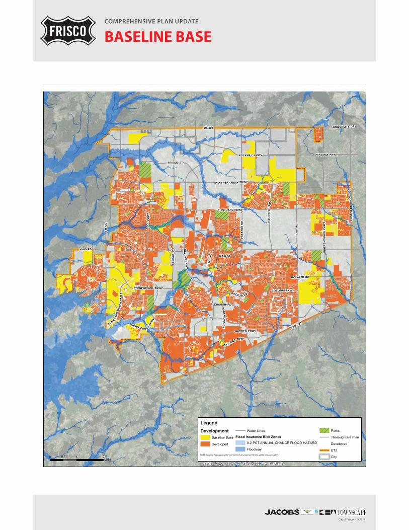
Several steps were included in the process of developing Frisco’s Growth Scenarios. First, the consultant determined the areas remaining to become variables in the development of each scenario. To accomplish this, a map was created that indicated all existing development. Then parcels that are platted and/or in the approval process were added. Those areas are considered the “baseline base” (see map on page 11), with little chance of being developed in a significantly different pattern. Finally, constrained areas (floodplain and surface water) were added to the map to indicate areas that would not be developed in the future due to those specific constraints.
The areas that remained within the city limits and extraterritorial jurisdiction of Frisco (areas for future annexation) were the sites to be considered for creating and evaluating differing futures for Frisco. The gray areas on the map on the following page indicate those areas that were considered for differing development types in Frisco’s alternative scenarios.
Not included in these scenarios, but to be discussed with the preferred scenario are implications related to parkland dedication, fire and police stations and staffing, etc. That detailed level of analysis will only be performed on the final, preferred scenario. These components will impact the population and employment calculations and outcomes for the updated Future Land Use Plan.
Scenario
Wildcard
Trends
Preferable
Probable Plausible Possible
Scenario Building to Project Possible Futures
PhysicalOpportunities
Vision
Market Potential
CommunityAspirations
Scenario Building to Project Possible Futures

Rura
l Liv
ing Ru
ral l
ivin
g ar
eas
are
char
acte
rized
by
very
larg
e lo
ts, a
bund
ant
open
spa
ce a
nd a
hig
h de
gree
of s
epar
atio
n be
twee
n bu
ildin
gs.
Resi
dent
ial h
ome
site
s ar
e lo
cate
d ra
ndom
ly th
roug
hout
the
coun
trys
ide,
whi
ch h
elps
to m
aint
ain
the
rura
l cha
ract
er, s
cale
an
d sc
enic
vie
ws.
Urb
an N
eigh
borh
ood
Urb
an n
eigh
borh
oods
sup
port
a m
ix o
f mod
erat
e to
hig
h de
nsity
ho
usin
g op
tions
. The
se n
eigh
borh
oods
are
rel
ativ
ely
com
pact
an
d w
alka
ble.
The
des
ign
and
scal
e of
the
deve
lopm
ent i
n an
ur
ban
neig
hbor
hood
enc
oura
ges
activ
e liv
ing
with
a c
ompl
ete
and
com
preh
ensi
ve n
etw
ork
of w
alka
ble
stre
ets.
Urb
an C
ente
rU
rban
Cen
ter c
onta
ins
the
high
est d
ensi
ty y
ou w
ould
find
in th
e Ci
ty.
It is
a c
ente
r with
a m
ix o
f hig
h de
nsity
hou
sing
, com
mer
icia
l an
d em
ploy
men
t opt
ions
. The
sca
le o
f the
Cen
ter i
s ve
ry w
alka
ble
and
enco
urag
es u
rban
sty
le li
ving
.
Subu
rban
Nei
ghbo
rhoo
d Su
burb
an n
eigh
borh
oods
are
foun
d in
clo
se p
roxi
mity
to s
trip
co
mm
erci
al c
orrid
ors.
The
se n
eigh
borh
oods
are
gen
eral
ly
form
ed a
s su
bdiv
isio
ns w
ith re
side
ntia
l den
sitie
s ra
ngin
g fr
om
0.5
to 6
dw
ellin
g un
its p
er a
cre.
Mix
ed-U
se N
eigh
borh
ood
A m
ixed
-use
nei
ghbo
rhoo
d off
ers
resi
dent
s th
e ab
ility
to li
ve,
shop
, wor
k, a
nd p
lay
in o
ne c
omm
unity
. In
clud
eing
a m
ix o
f ho
usin
g ty
pes
and
resi
dent
ial d
ensi
ties
in c
lose
pro
xim
ity to
the
good
s an
d se
rvic
es n
eede
d on
a d
aily
bas
is. A
sm
all u
rban
sq
uare
sup
port
s co
mm
erci
al u
ses
in th
e ne
ighb
orho
od. T
he
deve
lopm
ent e
ncou
rage
s ac
tive
livin
g, w
ith a
com
plet
e an
d co
mpr
ehen
sive
net
wor
k of
wal
kabl
e st
reet
s.
Tow
n Ce
nter
Tow
n ce
nter
s ar
e lo
cally
-ser
ving
are
as o
f eco
nom
ic,
ente
rtai
nmen
t, an
d co
mm
unity
act
ivity
. It i
s an
em
ploy
men
t ce
nter
and
sho
ppin
g de
stin
atio
n fo
r sur
roun
ding
mix
ed-u
se o
r ur
ban
neig
hbor
hood
s. Bu
ildin
gs ty
pica
lly s
tand
two
or m
ore
stor
ies
with
con
dom
iniu
ms
or a
part
men
ts o
ver s
tore
fron
ts. T
he
deve
lopm
ent e
ncou
rage
s ac
tive
livin
g, w
ith a
com
preh
ensi
ve a
nd
inte
rcon
nect
ed n
etw
ork
of w
alka
ble
stre
ets.
CO
MP
RE
HE
NS
IVE
PL
AN
UP
DA
TE
PLA
CE T
YPES
City
of F
risco
- 9
.201
4
CO
MP
RE
HE
NS
IVE
PL
AN
UP
DA
TE
PLA
CE T
YPES
City
of F
risco
- 9
.201
4
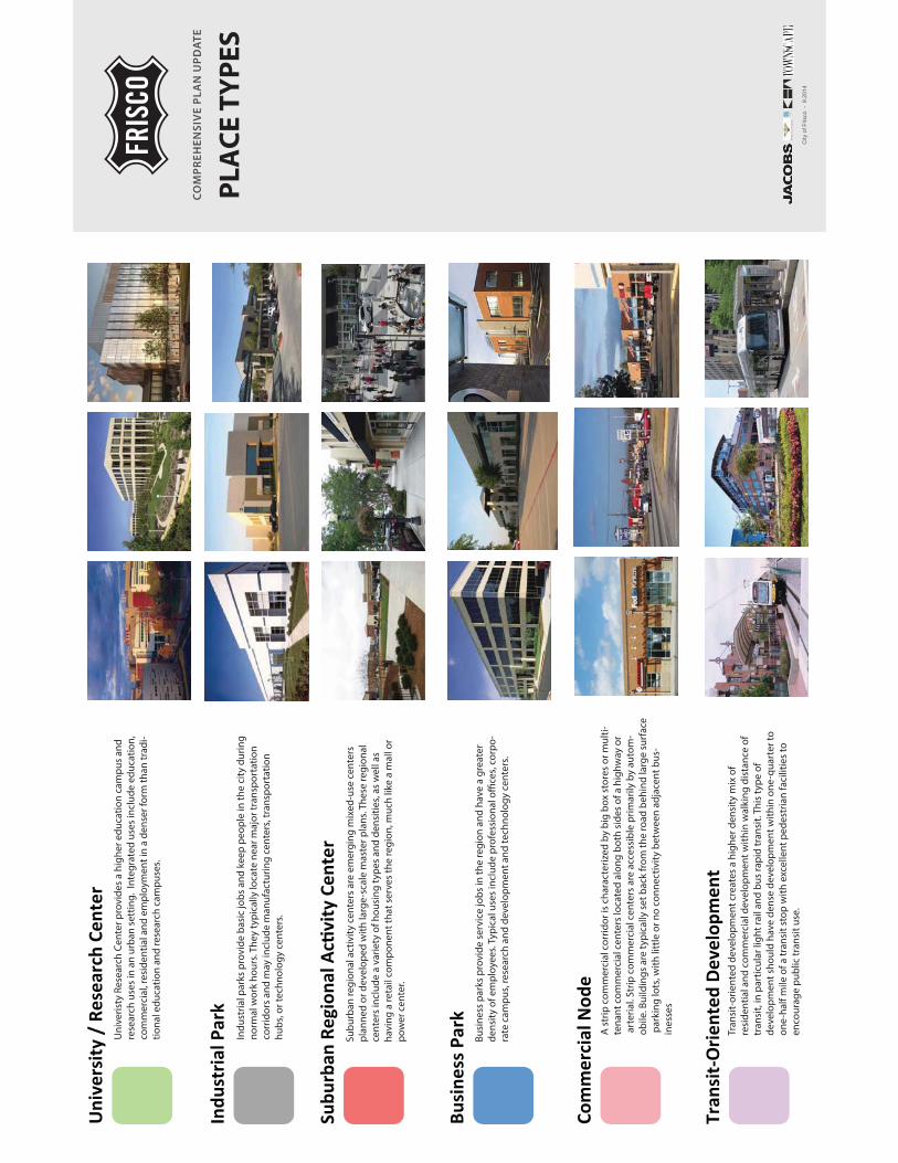
Busi
ness
par
ks p
rovi
de
serv
ice
job
s in
the
regi
on a
nd h
ave
a gr
eate
r d
ensi
ty o
f em
plo
yees
. Typ
ical
use
s in
clud
e p
rofe
ssio
nal o
ffice
s, c
orp
o-ra
te c
amp
us, r
esea
rch
and
dev
elop
men
t and
tech
nolo
gy
cent
ers.
Ind
ustr
ial p
arks
pro
vid
e b
asic
job
s an
d k
eep
peo
ple
in th
e ci
ty d
urin
g
norm
al w
ork
hour
s. T
hey
typ
ical
ly lo
cate
nea
r maj
or tr
ansp
orta
tion
co
rrid
ors
and
may
incl
ude
man
ufac
turi
ng c
ente
rs, t
rans
por
tati
on
hub
s, o
r tec
hnol
ogy
cent
ers.
Uni
veri
sty
Rese
arch
Cen
ter p
rovi
des
a h
ighe
r ed
ucat
ion
cam
pus
and
re
sear
ch u
ses
in a
n ur
ban
set
ting
. In
tegr
ated
use
s in
clud
e ed
ucat
ion,
co
mm
erci
al, r
esid
enti
al a
nd e
mp
loym
ent i
n a
den
ser f
orm
than
trad
i-ti
onal
ed
ucat
ion
and
rese
arch
cam
pus
es.
Tran
sit-
orie
nted
dev
elop
men
t cre
ates
a h
ighe
r den
sity
mix
of
resi
den
tial
and
com
mer
cial
dev
elop
men
t wit
hin
wal
king
dis
tanc
e of
tr
ansi
t, in
par
ticu
lar l
ight
rail
and
bus
rap
id tr
ansi
t. Th
is ty
pe
of
dev
elop
men
t sho
uld
hav
e d
ense
dev
elop
men
t wit
hin
one-
qua
rter
to
one-
half
mile
of a
tran
sit s
top
wit
h ex
celle
nt p
edes
tria
n fa
cilit
ies
to
enco
urag
e p
ublic
tran
sit u
se.
A s
trip
com
mer
cial
cor
rid
or is
cha
ract
eriz
ed b
y b
ig b
ox s
tore
s or
mul
ti-
tena
nt c
omm
erci
al c
ente
rs lo
cate
d a
long
bot
h si
des
of a
hig
hway
or
art
eria
l. St
rip
com
mer
cial
cen
ters
are
acc
essi
ble
pri
mar
ily b
y au
tom
-ob
ile. B
uild
ing
s ar
e ty
pic
ally
set
bac
k fr
om th
e ro
ad b
ehin
d la
rge
surf
ace
par
king
lots
, wit
h lit
tle
or n
o co
nnec
tivi
ty b
etw
een
adja
cent
bus
-in
esse
s
Sub
urb
an re
gion
al a
ctiv
ity
cent
ers
are
emer
ging
mix
ed-u
se c
ente
rs
pla
nned
or d
evel
oped
wit
h la
rge-
scal
e m
aste
r pla
ns. T
hese
regi
onal
ce
nter
s in
clud
e a
vari
ety
of h
ousi
ng ty
pes
and
den
siti
es, a
s w
ell a
s ha
ving
a re
tail
com
pon
ent t
hat s
erve
s th
e re
gion
, muc
h lik
e a
mal
l or
pow
er c
ente
r.
Indu
stria
l Par
k
Uni
vers
ity /
Res
earc
h Ce
nter
Subu
rban
Reg
iona
l Ac�
vity
Cen
ter
Busi
ness
Par
k
Com
mer
cial
Nod
e
Tran
sit-
Orie
nted
Dev
elop
men
t
5TH
ST
STONEBROOK PKWY
PANTHER CREEK PKWY
MAIN ST
LEBANON RD
US 380
ROCK CRE EK
PKW
Y
UNIVERSITY DR
COLLEGE PKWY
KING RD
WADE BLVD
LONE
STA
RRA
NC
HPK
WY
ROCKHILL PKWY VIRGINIA PKWY
WARREN PKWY
ROLATER RD
IND
EPE
ND
EN
CE
PK
WY
HWY 121
ELDORADO PKWY
FM42
3
LEG
AC
Y D
R
CO
ITR
D
GAYLORD PKWY
TEEL
PK
WY
PAR
KWO
OD
DR
HIL
LCR
ES
TR
D
FRISCO ST
PRE
STO
N R
D
OHIODR
CU
STER
RD
DA
L LAS
PK
WY
Source: Esri, DigitalGlobe, GeoEye, i-cubed, Earthstar Geographics,CNES/Airbus DS, USDA, USGS, AEX, Getmapping, Aerogrid, IGN, IGP,swisstopo, and the GIS User Community
LegendDevelopment
Baseline Base
Developed
Water Lines
Flood Insurance Risk Zones
0.2 PCT ANNUAL CHANCE FLOOD HAZARD
Floodway
Parks
Thoroughfare Plan
Developed
ETJ
City0 1 20.5Miles
COMPREHENSIVE PLAN UPDATE
BASELINE BASE
City of Frisco - 9.2014
NOTE: Baseline Base represents “Committed” development that is yet to be constructed

COMPREHENSIVE PLAN UPDATE
SCENARIO A | BASELINE
City of Frisco - 9.2014
NOTE: Baseline Base represents “Committed” development that is yet to be constructed

The “Baseline” scenario explores the implications of
a future for Frisco based upon current trends and
policies. The scenario reflects future development pattern if this current trends continue and existing policies remain in place. It focuses development of those parcels available for future scenario building as identified on the baseline base map, and applies place types that generally reflect the current zoning categories on those parcels that are currently zoned with any category, except for agricultural. For those parcels that are zoned agricultural or located within the extraterritorial jurisdiction (currently outside the city boundaries, but intended for future annexation), the scenario applies place types that generally reflect the uses indicated for those parcels in the 2006 Future Land Use Plan.
Under this scenario, much of the undeveloped property along the Dallas North Tollway would develop as commercial, with the exception of key nodes at the intersection with Main Street and north of Panther Creek which would develop as mixed-use neighborhoods. The State Highway 121 corridor would also have an emphasis on commercial uses, with the exception of small pockets of TOD and mixed-use developments near the intersection of SH 121 and Spring Creek.
The US 380 Corridor would primarily have light industrial uses; however, key intersections with Coit Road, Preston Road, Legacy Drive, and FM 423 would have retail development. The intersection with the DNT would be the location for a major retail development and for transit-oriented development.
The area between Main Street, Eldorado Parkway, Preston Road, and Coit Road would become a major urban node within Frisco with a focus on mixed-use and urban neighborhood development. The majority of the remaining areas of the community would focus on suburban neighborhood place types with commercial at the corners of primary intersections.
SCENARIO A | BASELINE
Key Characteristics
• Scenario reflects future development pattern, if current trends and existing policies remain
• Reflects uses indicated under current zoning and in the 2006 Future Land Use Plan
• DNT would develop as strip commercial with mixed use neighborhoods
• Small pockets of TOD and mixed use along SH 121
• 380 corridor to be primarily light industrial with some strip commercial
• DNT / US 380 to be a major retail development for Transit-Oriented Development (TOD)
• Major urban nodes would focus on mixed-use and urban neighborhood development

COMPREHENSIVE PLAN UPDATE
SCENARIO B | URBAN SPINE
City of Frisco - 9.2014
NOTE: Baseline Base represents “Committed” development that is yet to be constructed

The “Urban Spine” scenario explores the implications of a future for Frisco if development is encouraged to follow a pattern of an intense, linear, urban spine along the DNT corridor with decreasing development intensity to the east and west. It applies place types that generally reflect a much higher density and intensity of development along the major corridors, but keeps the suburban character for interior parcels.
Under this scenario, all of the undeveloped property along the Dallas North Tollway (DNT) would develop as an urban core. Parallel and immediately adjacent to this corridor, mixed use and urban neighborhood place types would act as a transition for the highest density development along the DNT into the surrounding community. The State Highway 121 (SH 121) corridor would have an emphasis on mixed-use development with the retail component taking advantage of the visibility that this corridor provides, and the higher density residential component to provide additional support for the retail in the area.
The US 380 corridor would primarily have blended light industrial types of uses that are needed to support a major employment hub. Infill development along Preston Road would primarily focus on urban neighborhood development, with the exception of the area along Preston Road between Main Street, Eldorado Parkway, and Hillcrest Road. This area would become an urban node within Frisco with a focus on town center, mixed-use neighborhood and urban neighborhood development types between Preston and Hillcrest, and transitioning to single family neighborhoods between Hillcrest and Coit. The majority of the remaining areas of the community would focus on suburban neighborhood place types with commercial nodes at the corners of primary intersections.
SCENARIO B | URBAN SPINE
Key Characteristics
• Pattern of intense, linear development along the DNT spine
• Decreasing intensity to east and west of the DNT
• Urban core densities along the DNT
• Adjacent mixed-use and urban neighborhood place types running parallel to the DNT
• SH 121 corridor primarily mixed-use place types
• US 380 corridor to be primarily industrial park place type
• Mixed-use and mixed residential place types at Preston Road between Main Street, Eldorado Pkwy and Coit Road.

COMPREHENSIVE PLAN UPDATE
SCENARIO C | DISTRIBUTED CENTERS
City of Frisco - 9.2014
NOTE: Baseline Base represents “Committed” development that is yet to be constructed
SCENARIO C | DISTRIBUTED CENTERS
The “Distributed Centers” scenario explores the implications of development that is encouraged to follow a pattern of community centers, at a variety of scales of intensity and located throughout Frisco. This scenario focuses on centers scattered throughout the community with differing scales and character depending on locations and adjacencies.
Primary nodes in this scenario (those nodes with the highest intensity and density) are located at the intersection of the DNT and US 380, and at the DNT and Main Street. The overall scenario could also support this type of development at the intersection of the DNT and SH 121, but only in a future redevelopment scenario. Under this scenario, all of the properties in these nodes would develop as an urban core. Between these nodes along the DNT, secondary nodes would develop with business park place types near the intersections with Panther Creek Parkway and Lebanon Road.
Secondary nodes would also be located along US 380 with a number of place types including mixed-use neighborhood, commercial, and industrial park types. SH 121 would also be the location of a number of secondary nodes with mixed-use neighborhood, commercial, and urban neighborhood place types infilling and completing the development pattern along this corridor. Additionally, a mixed use neighborhood node would be located at the intersection of SH 121 and Spring Creek adjacent to the rail corridor to support adjacent TOD development in this area.
Another primary node would be located in the area between Main Street, Eldorado Parkway, Preston Road and Coit Road. This area would become a major Higher-Ed Campus with supporting tech/research campus development. This development would be a major catalyst that could change the development direction for this part of Frisco.
The majority of the remaining areas of the community would focus on suburban neighborhood place types.
Key Characteristics
• Development pattern of mixed-use centers at a variety of scales and intensity throughout Frisco
• Primary nodes at intersections of DNT / US 380 and DNT / Main Street
• Nodes will develop as urban core densities
• Mixed-use Higher Ed/Tech Campus node between Main Street, Eldorado Parkway, Preston Road and Coit Road.
• Secondary nodes to develop as business park along the DNT
• Along US 380 secondary nodes will include mixed-use neighborhood, urban neighborhood and industrial park place types