schedule for exposure visit of administrators / civil ... · schedule for exposure visit of...
TRANSCRIPT

Schedule for Exposure Visit of Administrators / Civil Servants of District Solan, Himachal Pradesh
Date Location of visit Time Purpose
10 Sept.
2014
CSWCRTI,
Udhagamandalam
10.00 -
11.00
Ice breaking session / discussion
11.00 -
13.00
Visit to CSWCRTI - Museum and Research Farm. Advancements in science and technology of soil and
water conservation and watershed development.
Model Watershed Iduhatti,
The Nilgiris
14.30 –
18.00
How to increase the ground water which is so far more useful to the stakeholders of the mountainous
region of the Himachal Pradesh, through watershed management. Improve the quality of structures
developed under IWMP and process ways and means for monitoring the same in sustainable manner by
village level institutions. Different ways and means to deal with the menace of wild animals under
watershed management. Process and ways to change the land use pattern from barren and fallow land to
cultivable land. A convergence model with the forward and backward linkages with the government
sponsored schemes with Integrated Watershed management programme.
11 Sept.
2014
RVP watershed, Elada, The
Nilgiris
10.00 –
13.00
Development of suitable technology for increasing the production from eroded and degraded lands and to
find out suitable remedial measures for checking accelerated erosion and conserve Soil and Water in high
rainfall hilly regions in order to obtain higher yields on sustained basis from unit area in unit time without
affecting soil fertility.
Landslide site Acchanakal
and
Khirada village
14.30 –
17.30
A convergence model with the forward and backward linkages with the government sponsored schemes
with Integrated Watershed management programme. Different bio-engineering measures that can be
carried out in rocky topography.
12 Sept.
2014
Ayalur Watershed, Erode 08.00 –
20.30
Different techniques and principles of water harvesting techniques to tackle the problems of the portable
water. Development of irrigation techniques in rain fed farming areas with efficient water management.
Process and ways to change the land use pattern from barren and fallow land to cultivable land. Different
ways to promote increase income generation activities through the introduction of farm and off farm based
activities under watershed management, to increase the economic condition of the landless and asset less
under IWMP linking it with other schemes.

Annexure 1 Scanned copy of list of participants along with their names and designations

An exposure visit of civil servants of District Solan Himachal Pradesh
(10th -12th Sepetember, 2014)
At CSWCRTI Fernhill PO Udhagamandalam-643004 The Nilgiris District, Tamil Nadu
Facilitated by People’s Science Institute, 653 Indiranagar Dehradoon Uttrakhand


Agronomical management practices for higher productivity, resource use efficiency sand farm income in
semi-arid region
Model watershed – Iduhatti, The Nilgiris District, Tamil Nadu developed under Hill area
Development Programme.
The CSWCRTI, research centre udhgaamandalam had taken up Iduhatti micro watershed for developing a
model watershed in the Nilgiris district with funding support from Hill area development programme
(HADP), with the following objectives:
Objectives of the project
Participatory planning and demonstration of suitable conservation measures and land use options
for sustainable production.
Improvement in socio-economic conditions of resource poor section of the watershed community.
Monitoring and assessment of hydrological, bio- physical and socio economic impacts on
watershed basis.
General Description of Iduhatti watershed
Iduhatti micro watershed belonging to Thuneri macro watershed (58/57) is located about 20 kms from
Udhagamandalam and lies between 76 º 45’ 58.5” to76 º 47’ 42.5” E longitude and 11 º 26’ 42.7” to11 º
29’ 10.7” N latitude. This micro watershed with an area of 715.7 ha comprises of eight hamlets viz.
Doddanni, Trichigadi, Iduhatti, periyarnagar, Bharathinagar, Ganganagar, Morakutti and
Muthusaminagar. The watershed area belongs to two panchayats namely Ebanad and Kagguchi in
Udhagamandalam taluk.
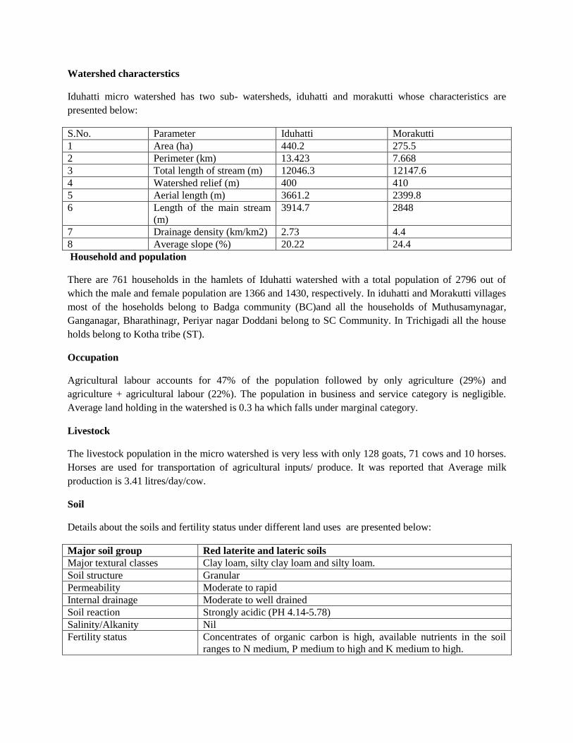
Watershed characterstics
Iduhatti micro watershed has two sub- watersheds, iduhatti and morakutti whose characteristics are
presented below:
S.No. Parameter Iduhatti Morakutti
1 Area (ha) 440.2 275.5
2 Perimeter (km) 13.423 7.668
3 Total length of stream (m) 12046.3 12147.6
4 Watershed relief (m) 400 410
5 Aerial length (m) 3661.2 2399.8
6 Length of the main stream
(m)
3914.7 2848
7 Drainage density (km/km2) 2.73 4.4
8 Average slope (%) 20.22 24.4
Household and population
There are 761 households in the hamlets of Iduhatti watershed with a total population of 2796 out of
which the male and female population are 1366 and 1430, respectively. In iduhatti and Morakutti villages
most of the hoseholds belong to Badga community (BC)and all the households of Muthusamynagar,
Ganganagar, Bharathinagr, Periyar nagar Doddani belong to SC Community. In Trichigadi all the house
holds belong to Kotha tribe (ST).
Occupation
Agricultural labour accounts for 47% of the population followed by only agriculture (29%) and
agriculture + agricultural labour (22%). The population in business and service category is negligible.
Average land holding in the watershed is 0.3 ha which falls under marginal category.
Livestock
The livestock population in the micro watershed is very less with only 128 goats, 71 cows and 10 horses.
Horses are used for transportation of agricultural inputs/ produce. It was reported that Average milk
production is 3.41 litres/day/cow.
Soil
Details about the soils and fertility status under different land uses are presented below:
Major soil group Red laterite and lateric soils
Major textural classes Clay loam, silty clay loam and silty loam.
Soil structure Granular
Permeability Moderate to rapid
Internal drainage Moderate to well drained
Soil reaction Strongly acidic (PH 4.14-5.78)
Salinity/Alkanity Nil
Fertility status Concentrates of organic carbon is high, available nutrients in the soil
ranges to N medium, P medium to high and K medium to high.

Major land uses in Iduhatti watershed
S.No. Land Use Area (ha) Percent
1. Agriculture 363.1 50.7
1.1 Annual vegetable crops 143.7 20.1
1.2 Tea 219.5 30.7
2 Forest 315.0 44.0
2.1 Revenue forest 309 43.2
2.2 Shola 6 0.8
3 Swamps and grass
land
4.6 0.6
4 Habitation 33 4.6
Total 715.7 100
Agriculture
Annual vegetable crop cultivation and tea cultivation are the major agricultural activities in the watershed.
The most commonly grown annual vegetables are potato, cabbage, carrot, peas beans, beetroot,
cauliflower, radish etc. Beans and double beans are grown as inter crop with potato and carrot. On flat
lands where water source is available, carrot, beans and peas are grown during summer under irrigated
conditions. Potato, beans, cabbage and carrot are grown during monsoon season both under rainfed and
irrigated conditions. No prominent agro- forestry systems are found in the watershed.
Tea occupies an area 219.5 ha in the watershed. Double hedge staggered planting of tea is most common
with silver oak as shade tree. Maintenance level is poor to good. Most of the farmers are using sickles for
harvesting tea leaves.
Forest, grass land and swamps
The entire revenue forest is degraded and at places encroached for tea cultivation. Only shoal forest is
under protection since it serves as a perennial source of drinking water to Iduhatti hamlet. Swamps and
grassland are in degraded condition.
Soil and water conservation measures
The following measures are being practiced by farmers in the watershed for soil erosion control.
Maximum area of annual crops is under outward slopping terraces (72.46 ha), followed by level terraces
(52.66 ha) and sloping land (18.54 ha). Conservation measures for sloping land area under annual
vegetables, majority of the farmers follow up and down cultivation with cross drains.
Hydrology and water resources
Four drop structures in the gullies for surface runoff harvesting (water storage/ impounding capacity of
270 cum) and 60 numbers of unlined open wells in middle and lower reaches for sub- surface runoff
water harvesting exist in the watershed. The depth of wells ranges from 3.0 to 4.0 meters and diameter
from 2.5 to 3.5m.
Community organization activities

In the initial stage, during 2008 eight village resource management committees (VRMCs) were formed at
the hamlet/village level and Iduhatti watershed association and it’s executive committee at watershed
level. Meetings of watershed executive committee were regularly conducted and records are maintained
in proper manner by the office bearers of the committee. All social and technical interventions were
thoroughly discussed with the watershed community in the general body and executive committee
meetings and beneficiaries were selected before implementation on farmer’s fields. Also, various issues
pertaining to effective implementation of the watershed programme were discussed in those meetings.
One user group- small tea grower society which had been formed with 240 members during 2008 and
linked with tea board Coonoor, The Nilgiris, is successfully functioning and with the support from tea
board, the Nilgiris, had bought two small pick up vehicles for transporting tea leaves directly to the tea
factory. Other benefits were also incurred by the society apart from above said benefits like better price
for quality leaves, no cheating in weighing of tea leaves, loans to members for purchase of inputs. Two
more user groups have been formed for spraying of insecticides and pesticides in the watershed.
Livelihood support activities
With the concurrence of the executive committee, 19 SHGs were formed in the project period for taking
up income generating activities among the resource poor sections of the micro watershed community.
Among these groups, 13 SHGs were initially formed with a revolving fund of Rs. 3,15,000 and six more
SHGs were formed from the amount paid pack by the initial groups. A total amount of Rs. 1, 92,800 had
been paid back by these 19 SHGs till date out of which Rs. 1,10,020 had been ploughed back to form the
new groups. The overall repayment is 45.4 percent. Through these SHG activities 5108 man days of
employment and a net income of Rs. 13,82,356 have been generated.
Livestock improvement
Around 170 farmers with 177 animals (cows, goats, calves ) were treated by the veterinarians for various
ailments and disorders in the 2 animal health camps. Vaccination was given for foot and mouth diseases,
pregnancy diagnosis was carried out, de-worming was done for animals and mineral mixtures were
distributed to weak as well as yigh yielding animals in Iduhatti watershed.
Trenching in new tea plantation
With the technical assistance of CSWCRTI, Udhagamandalam scientific approach of taking up trenches
and planting tea on contour in new plantations were observed. The design of staggered contour trenches
were ( 2m x 0.3m x0.45m) with 2m spacing between a pair of trenches in a row were taken up in the 12
ha of new tea plantation in Iduhatti watershed as a project intervention. Farmers were trained to maintain
correct spacing (0.65 m between two paired rows and 0.75m between the plants) using a triangular frame
(measuring 0.75m on all three sides( devised for that purpose.
Bench terracing
Inward sloping bench terraces are the recommended soil and water conservation measure for cultivation
of annual crops in steeply sloping lands of Nilgiris. This measure was demonstrated in 0.6 ha of sloping
land in Trichigadi village of Iduhatti watershed. The terraces wer constructed with an inward slope of
2.5% and longitudinal gradient of 1%. Toe drains were installed in all the terraces and the riser portion

was shaped with a slope of 1:1. Tea was planted in the riser portion of the first two terraces. The water
from the toe drains was led through a vertical dran into a surface pond created in the valley portion.
Sub surface water harvesting
A total of sixteen collection wells were installed in Iduhatti watershed. 4 in Iduhatti village and 5 in
Doddanni viallge, 7 in Trichigadi village for harvesting sub surface flow and increasing the water
availability during the lean season.
Stream widening
Stream alignment, widening and deepening had been done for a total length of 1013.5 m in Iduhatti
watershed to increase its carrying capacity. Apart from these check dams were constructed in the main
stream which is perennial in nature and provides water for irrigation during summer season.
Introduction of Sprinkler Irrgation
Ten units of sprinkler irrigation systems have been introduced in the watershed during the project period
with a total cost of Rs. 240240 out of which Rs. 160240 was met from the project side and Rs.80000 from
the farmer’s side as contribution.
Runoff Measurement in Iduhatti watershed
Runoff monitoring is being carried out through gauging station constructed at the outlet of Iduhatti
subwatershed, where agriculture is the major land use. The total runoff from this sub watershed during
Jan- Dec, 2009 was 222.61mm (18.31% of rainfall) while during the period from July to Dec, 2010 it was
178.2mm which works from Iduhatti watershed during 2011 was 95.2 mm which works out to 8.8% of
rainfall received during this period. The total run off from this sub watershed during the year 2012 was
74.9mm which works out to 9.5 % of rainfall received during this period.
Interventions through convergence approach
One community hall in Trichagadi village and one gabion retaining wall in Doddanni village were
constructed through convergence approach wherein proposals were submitted to Hill area development
programme. The Nilgiris by CSWCRTI, Udhagamandalam on behalf of the villagers and the works
executed through Agricultural Engineering department, the Nilgiris.
2. Impact of watershed Project taken up under River Valley Project (RVP) in Nilgiris District
Background
The lower Bhavani River Valley Project in the states of Tamil Nadu and Karnatka initiated under the
centrally sponsored soil plan period with the objective of planning soil conservation measures in the
catchments of river valley projects for effective treatment of the problematic areas in order to minimize
the yield of silt from the catchment ultimate goal. Overall agricultural development has been envisaged as

the ultimate goal. The lower Bhavani project which is mainly envisaged as river Bhavani at a place called
Bhavnisagar in Avinashi Taluk in the Coimbatore district, Tamil Nadu. The total extent of the catchment
of the lower Bhavani reservoir is 2,67,200 ha below Pillur dam. It spreads over parts of Gundulpet and
Chamarjnagar taluks of Mysore district in Karnatka (23000 ha) and Udhagamandalam and Coonoor
taluks of Nilgiris ditstrict and Gobichetiipalayam and Avinashi taluks of Coimbatore district in Tamil
Nadu (2,44,200 ha)
Storage created and Ground water status in RVP watersheds in TN
Surface storage capacity created
A total of 368 ha-m additional surface water storage capacity has been created through construction of
different type of water harvesting structures under this project. The additional water storage capacity has
helped in improving ground water recharge and water availability for cattle and other non domestic uses
in the watershed.
Additional storage capacity 368 ha-m out of this 55% is water harvested through farm ponds followed by
25% water harvested by water harvesting structures like minor check dams, major check dams,
percolation ponds, farm ponds, community wells and other water harvesting structures. In addition to this
fixed capacity, storage capacity repeatedly available for different fillings after the filled water was
percolated. It helped in improving the ground water recharge and water availability for supplemental
irrigation and other non domestic uses in the watershed.
Ground water recharge
Impact of percolation ponds on ground water recharge in the influence zone at velliakadu watershed has
been gauged by observing recharge from October 2010 to February 2011. It was observed that due to high
rainfall during October, 2010, the percolation ponds got filled in full capacity and increased the recharge
which could be gauged from sufficient water availability during the month of February. It shows that
percolation ponds constructed under RVP projects has made direct impact on increasing the ground water
recharge in the region.
Increase in water table
On the basis of data collected from observation wells and perception of the farmers obtained during the
field visit, it was found that the water table has increased in the range of 0.3 to 0.5 m in the influence zone
of percolation ponds (generally found limited from 480m to 590m). it clearly shows that the percolation
ponds made visible impact on increased ground water table. The response of the structures was quite
quick showing its effect on recharge within 20-30 days and this was almost maintained beyond the end of
January.
Increased water availability duration in wells
Duration of water availability in wells over the years was taken as a measure to examine as to how the
watershed management works have helped in improving ground water availability. The duration of water
availability in wells has gone up from 3-6 months before watershed interventions to 9-12 months (38%-

45%) after watershed interventions. It shows the combined positive effect of water harvesting and gully
control structures constructed in the watersheds under this RVP project.
Improvement in perenniality of the streams
Based on visual observations (photographs) and local enquiry, it was revealed that after the project
implementation the duration of flow in most of the hill streams in a year has increased substantially.
Similar improvement was observed in the perenniality of streams in upper and middle reaches also. This
is due to the fact the gully control structures and silt detention tanks constructed in the upper and middle
reaches of the catchment have increased the sub surface flow resulted the perennial flow of streams.
Stabilization of Gullies
Most of the engineering measures were carried out in the upper and middle reaches of the watershed
which had contributed in larger way for reduction in gully enlarging. Due to sediment deposition in the
upstream side of the structures constructed in the streams and reduced the flow quantity and velocity, the
gully beds were stabilized.
Increased irrigation area
Based on the interpersonal communication with the farmers in the influence zone of percolation ponds in
Velliangadu watershed, it was observed that the irrigated area under well command is increased up to 18
%. Farmers also has the opinion that they are able to give the life saving irrigation to vegetable crops
during water stress period due to water harvesting structures created under RVP watershed development
project activities.
Changes in Land Use Pattern
Land use under different agricultural activities during pre and post project period is given in table.1. in
general, area under vegetable crops reduced and area under tea cultivation is increased in watersheds in
Nilgiris. Vegetable and coffee area has been converted to tea land use during 1996-2003 due to there was
huge hike in green tea leaves prize in the market and assured revenue obtained from this perennial crop.
But, in plain watersheds, area under Sorghum and Kambu is reduced and area under Ragi and other
millets were noticed in increasing trend. This may be due to tht the farmer’s started to adopt the strategy
of less water requirement crops with more yields. It is also come out in the discussion that the area under
irrigated crop like banana and sugarcane is increased. This can be the impact of the RVP activities that
increased water availability made the farmers to go for more area under irrigated crop. Few farmers told
us that there is no change of cropping pattern. However, the farmers agreed that the additional area is
brought under irrigation due to additional surface water harvesting structures created by watershed
development project.
Production and productivity
The average yield of different crops for pre and post project period is shown in the table appended below.
The yield of dry land crops has been increased considerably for all the crops. This may be partly
attributed due to supplemental irrigation provided from water harvesting structures. Similar trend was
noticed in case of irrigated crops also. The increased crops yield was in the range of 3 to 29 %. In Nilgiris,

the yield of vegetable crops has shown drastic increase in yield, which may be due to supplemental
irrigation given to farmers from the collection wells created under watershed development project.
Similarly, yield of millets, sugarcane and banana has also shown in the increasing trend which can be
considered as impact of RVP activities in terms of increased water availability for irrigation.
Table showing Land Use average yield of crops for pre and post project period in RVP watersheds
in lower Bhavani catchments
Crops Area in (ha) Average yield (t/ha)
Before After Before After
Agricultural crops
Potato 2277 2167 21.50 24.00
Cabbage 1394 1285 70 79
Carrot 1026 878 25 23
Raddish 153 167 20 23
Beans 266 321 16 17.50
Brinjal 24 27 13.42 14.81
Tomato 40 57 6 6.50
Chilly 12 39 6.05 6.48
Sorghum 1625 1428 1.28 1.35
Ragi 310 359 1 1
Pulses 355 317 0.20 0.23
Sugarcane 325 419 125 137
Banana 402 658 29.70 32
Tapico 69 65 29.6 38.9
Samai 4 16 1 0.78
Cotton 12 0 0.65 0
Kambu 205 68 0.96 1.06
Plantation crops
Arecanut 134 185 0.80 0.92
Coffee 89 48 0.62 0.60
Tea 8193 9148 7.50 8.30
Coconut 98 168 8365 nuts 8626 nuts
Agri-horticultural crops
Mango 32 47 4.42 5
Guava 41 58 5.02 5.95
Sapota 17 18.5 9.04 10.15
Jack 85 95 14 17
Orange 292 283 2 2
Lime 22 9 2 2.07
Tamarind 5
3. Ayalur watershed at a glance
Particulars Status
Name of the micro watershed Ayalur
Area of the micro watershed 782 ha (729 ha costing to 87.48 lakhs)
Total hamlets Five revenue villages: Mallipalayam, Kulaimuppanur, Palapalayam,

Semmandampalaiyam and Pulliyandgadu are located in the micro
watershed.
Total Population 3610 Numbers.
Major occupation Agriculture
Average Land holdings 1.2 ha
Land use and Agriculture
Agricultural area (ha) 708 ha
Irrigated area 144.53 ha (20.6 ha)
Rainfed area 430.53 ha (60.3 ha)
Waste land 18.22 ha
Habitation 23.86 ha
Major crops grown in the area Groundnut, tobacco, sugarcane, Turmeric, Banana and Maize.
Water Related data
Rainfall 600mm
Open wells 126 numbers
Tube wells 285 numbers
Depth of water table 700-900 feet
Technical Interventions at a glance of Ayalur Watershed
Details Status
Entry point activities Community hall (Rs. 3,45,562)
Capacity buildings Exposure visit- 3 in numbers
Soil and moisture conservation
measures
1. Earthen Bunding-1557 running meters.
2. Field bunding (stone) 340.5 running meters.
3. Trenches- 226 Numbers.
4. Farm ponds- 2 Numbers.
5. Dug out ponds- 5 Numbers.
6. Surface Pond with Silpaulin lining – 10 Numbers.
Agronomic conservation 1. Dry land horticulture-10.5 ha
2. Agro- horticulture-14.5 ha.
3. Crop demonstration- 50 Numbers.
Runoff Management structures 1. Percolation Pond- new 8 Numbers.
2. Percolation Pond (Rejuvenation)-4 Numbers.
Development of waste land 1. Live fencing- 1213 running meters.
2. Agroforestry- 3.7 ha
Drainage line treatment measures 1. Loose boulder Check Dam-3 Numbers.
2. Gabion check dams- 3 Numbers.
3. Random Rouble Check dams- 3 Numbers.
4. Renovation of check dams- 3 Numbers.
Livelihood support system 1. Household production system-38 HHs.
2. Small entrepreneurship/ small business-31 Numbers.
Major activities includes: Dairy, backyard poultry, goatry, carpentry,
barber shop, small daily needs based shops, turmeric boiler,
sparayers, lending out utensils, tailoring, wet grinders, laundry,
workshops.
Production sysem and micro
enterprises
1. Crop diversification-4 Numbers.
2. Integrated farming system-12 Numbers.

3. Drip irrigation for fruit trees- 34 Numbers.
4. Sprinkler irrigation-8 Numbers.
5. Introduction of improved fodder-36 Numbers.
6. Animal health camps- 3 Numbers.
7. Live stock improvement measures-30 Numbers.
Amount deposited in watershed
development fund
Rs. 1, 33, 575. (Though exit protocol after withdrawl for utilizing
the WDF has not framed yet.
Backround:
Soil and water are the most precious natural resources, which sustain our life. In rain fed area watershed
management is the approach used for conservation of water and other natural resources as well as for
sustainable management of natural resources. A watershed is a hydrologically defined area that is drained
by a network of streams, which meet together in such way that the water leaves through a common point.
Soil and water conservation including micro-scale water resource development is the foundation of any
watershed development programme supported by a number of other protection, production and livelihood
support interventions therefore, watershed management is the process of guiding and organizing land use
and use of other resources in a watershed to provide desired goods and services to people while
enchancing the resource base without adversely affecting natural resources and the environment (Wani et
al; 2001)
In india, though rainfed areas account for about 67 percent of the cultivated area (Singh et al; 2000) their
contribution is only about 45 percent of total food grain production. A major part of the coarse cereals,
pulses and oilseeds are cultivated in the rainfed regions. Crop productivity in these areas is low and highly
variable, depending on the vagaries of monsoon. This has led to wide regional disparities in the income
and living standards of farmers. Irrigation facilities in these areas are limited due to lack of suitable sites
for large storage, high cost involved and environmental considerations. There is a general tendency to
exploit ground water for food crops by few resourceful farmers.
Watershed programmes in India so far have mainly focused on natural resource conservation and
interventions such as soil and rain water conservation and to some extent afforestation in the government
forest lands. As far as the production aspect is concerned, no much important has been given. Mostly it
was confined with the distribution of inputs like, fertilizers, seeds and organic manures for agriculture and
distribution of fruit and tree seedlings as horticulture and agro forestry interventions respectively.
However, watershed projects should move from purely soil and moisture conservation and water
harvesting interventions to approach which includes production aspects also. For meaningful
interventions in the production aspects, it is important to design the interventions as technical package as
per the constraints identified for various production system in a particular area. This approach not only
increases the productivity but also helps in conserving the natural resources. In the backdrop of this, the
research cum development effort was focused here on increasing productivity, resources use efficiency
and farm income in the semi-arid area.
Ayalur Watershed
This dryland development project was undertaken during 2008-09 to 2012-13. The Ayalur watershed is
located in Gobichettipalayam taluk, Erode district, Tamilnadu state at 21 kms from Sathymangalam –
Perudurai road. It is about 120 kms from Ooty and 8 kms from Gobichettipalayam between 77 º 22’ 43”
to77 º 24’ 10” E longitude and 11 º 25’ 19” N latitude. Five revenue villages namely Mallipalayam
(including the hamlet puthucolony) Kulaimuppanur (including the hamlet Anna colony) palapalayam
(including hamlets Odaimedu, Kattusalai, papathikadu) Semmandampalaiyam and Pulliyandadu are
located in the micro watershed. It lies in the tropical zone characterized with scanty rainfall and dry
climate. The average annual rainfall is about 600 mm. most of the annual rainfall (51%) is received
during (NE monsoon) in the months of October to December accompanied with high intensity storms.
30% of rainfall is received through SW monsoon also. The uncertainty of NE monsoon and not favorable
contribution from SW monsoons make the plight of local agriculturists miserable. Even though NE
monsoon contributes more than the SW monsoon, farmers take up rainfed sowing during SW monsoon
only as the distribution of rainfall is poor in case of NE monsoon.
Socio-Economic conditions in the watershed
The total population of five villages of the watershed is 3610 with average family size of 6 persons.
Majority of the watershed farmers are in the category of small and marginal with average land holding of
1.2 ha. These small land holdings are further scattered in 3-4 different places which makes cultivation
very difficult. Small farmers (1-2 ha) contribute 50.2 % followed by marginal (< 1ha) farmers (32.5%)
Annual net income from agriculture and allied activites in dryland area ranges from Rs 15000 to 65000.
Out of which only 56% is contributed by the agricultural crops. Land less labourers constitutes 30% of
the population who resides mainly in the small hamlets. Their livelihoods are mainly depends on the
labour demand on day to day basis.
Rain fed Agriculture
In the watershed, out the total area (782 ha), about 90% area (708.38 ha) is under agriculture, of which
60.1% (430.47 ha) is under rainfed agriculture. Only single cropping is followed in this area. Groundnut-
either fallow or fodder sorghum is main crop sequence in the watershed. Crop failure is very common in
this area. Crops are sown during the second week of July and harvested in the last week of September to
first week of October. Quite often late onset of monsoons, early withdrawal of monsoon rainfall and large
intervening gaps adversely affect the germination, growth and productivity of kharif crops. The low water
holding capacity of soils present in this area (gravely red sandy soil) also causes soil moisture stress.
Average productivity of groundnut crop is around 625 kg per ha. This watershed was characterized by
low input use and even farm yard manure was applied in little quantity. Appropriate dry land technologies
could considerably increase efficiency of the rainfed Kharif cropping for achieving higher productivity.
Agriculture with supplementary irrigation
Out of 708.38 ha of total agricultural area, 17.27 % (122.35 ha) is under partial irrigation. Bore well is the
main source of irrigation. Average depth of bore well is about 650 feet. Water yield of bore well is largely
depends on monsoon. Bore well water is pumped into open well before irrigating the crops. Lot of energy
was wasted in this system. Some farmers were pumping water into surface ponds from where irrigation is
given to field crops leading to low water use efficiency. In this method also lot of water is wasted as deep
percolation and evaporation. Since the water yield is poor in bore wells, crops are not fully irrigated. Only
supplementary irrigation is given along with the rainfall. These wells remain in dry condition for most
part of the year. Crops often experience moisture stress. Depending on the yield in bore wells, few

farmers take up three crops per year. Groundnut- tobacco, maize- tobacco, groundnut- fallow are the crop
sequences followed in this areas. The yield level is not up to the irrigated crop as only supplementary
irrigation is practiced and the input use is also less compared to irrigated agriculture. Soil of this area is
red sandy to red sandy loam. Crops often express micro nutrient deficiencies (boron in groundnut and
zinc in maize). Average yield of ground nut and maize was 1.5 t ha and 3.0 t ha respectively under
supplementary irrigated conditions.
Agro-forestry and horticulture
The watershed does not have much organized orchards. However, farmers have planted fruit plants
(tamarind, citrus, mango, pomegranate etc) in the homesteads and kitchen gardens. Palmyra trees are
scattered in few farm lands especially in the rainfed areas as natural/plantation trees. The climate and soil
is suitable for growing spota, aonla, tamarind, drumstick, guava and mango. Neem and erythrina indica
are the main multipurpose agro- forestry trees grown along the field boundaries, trees like leucaena
leucocephala and gliricidia spp. Were found in the few fields as scattered trees.
Problem identification and prioritization
Certain problems related to natural resources management in the watershed was identified and prioritized
during the PRA exercises and through the transect walk the available resources and their scope of
interventions were for better natural resources management were identified.
Following problems were prioritized as per the ranking suggested by the community
1. Low water yield in the bore wells.
2. Lack of water resources.
3. Low productivity.
4. Low soil depth and massive soil erosion.
5. Gravel soil with low fertility.
6. Open grazing during rabi season.
7. Lack of fodder availability.
8. Low employment for landless labour.
Less rainfall, increased water demand and more dependence on ground water further leads to faster
ground water depletion. Rapid run off due to poor vegetation cover and lack of water conservation
measures led to poor ground water recharge.
Most of the red soils in the watershed are gravelly, light and are prone to erosion. Poor ground cover of
vegetation and improper management add more severity to the erosion problem. Soils of the watershed
have low water holding capacity and low nutrient status. Hence, it required a careful crop management
programme ideal for shallow red soils and also soil fertility maintenance measures in an integrated
manner. In irrigated areas, efficient water use management practices were needed to save scarce water
resources. A sizeable area in the watershed with least productive soils was put under occasional crops.
This could be considered for alternative land use including agri-horticulture, agro-forestry, horticulture
etc. there was no forest as such in the watershed and the open pasture or vegetation on rocky and
degraded wastelands with sparse grassy vegetation are used for grazing. Land less labourers form a
significant part of population and need employment or other income generation activities.

Approach and technology plan
One of the major short comings/reasons of non adoption of technology by rainfed farmers is the
incompatibility of technology with their socio economic conditions and risk taking capacity. Thus it is
essential to identify different levels of package of practices to give the farmer an option to choose the
level of technology as per the site condition and socio economic conditions and risk taking capacity.
Demonstrations were carried out successfully by the central soil and water conservation research and
training institute Udhagamandalam. Certain bio engineering measures were carried out to improve
productivity, resource use efficiency and farm income in Ayalur Model Micro-watershed of Erode
District, developed under macro management of agriculture under NWDPRA programme of the ministry
of Agricutlure, Govt of India. Watershed management plan for Ayalur watershed with an outlay of Rs.
89.76 lakhs, was prepared with specific objectives of increasing farm income, productivity, employment
generation and water use efficiency. In micro plan preparation due importance was given to problems,
needs, priorities of the villagers, topographic fragility, land use suitability, irrigation potentiality and
prevailing farming systems. Technologies option was blended with the indigenous knowledge based on
the successful experience gained by PIA in the Salaiyur watershed in Tamilnadu, where similar situation
exists.
Efficient Land use system
Considering the huge livestock population and absence of livestock based agro- forestry/farm forestry and
pasture land, emphasis was given to increase the land under agro-forestry by introducing tree species
suitable for dry land system. Due to less soil depth only
those horticulture and agro forestry interventions were
proposed which were best suited for taking up in
dryland, taking into consideration the soil
conservation measures and micro site improvement.
Emphasis has been given on maximum use of
farmyard manure (FYM) and suitable modifications
are suggested for increasing the quality of soil which
is having low nutrient content, low water holding
capacity and poor soil depth. Enrichment of FYM by
suitable technologies would further increase the soil
productivity. Under partially irrigated agriculture
owing to the poor yield of water in the bore wells,
considerable area was allotted to agri-horticulture for
achieving higher water use efficiency and farm income. Since there is a little scope for the creation of
water resources, it is proposed to convert the partial irrigated area to assured irrigation area by micro-
irrigation and better water recharge through conservation structures. Stress was given to increase the yield
and water use efficiency of sugarcane, rice, turmeric and banana by micro- irrigation, better varieties and
other improved agro techniques.
Water resource development and soil conservation measures
Check dam apart from percolation tank was constructed for
assured irrigation and to augment ground water.

Hydrologic characterstic of semi arid watershed typically contain ephemeral streams having flow mostly
during the NE monsoon. In this micro watershed after the cessation of rains, sub surface flow contribution
could also be noticed in these streams but for a limited time. Rapid surface run off due to poor vegetation
cover, light soil, graveliness/stoniness, low rainfall and high evaporation causes reduced sub surface flow
and ground water recharge. Water deficit or moisture stress
is expected except of a little water surplus during the
month of October. The stored water is utilized in the
subsequent months. Maximum water harvesting of rain
water for storage and ground water recharging exists.
There also exists ample scope to check and store runoff in
the watershed by constructing a series of check dams,
percolation tanks and ponds.
Water conservation through irrigation system
management
Farmers in the watershed are going for the bore wells to a depth greater than 200 meter to get water.
These bore wells are mostly fitted with 7.5 horse power air compressor pumps in
order to fill water in open wells and
surface ponds, where it is pumped
through centrifugal pump or under
gravity flow to irrigate fields. Thus
very low overall irrigation efficiency
is
Achieved. Temporary storage in shallow ponds is estimated
to have recurring seepage loss of the order of 30-40 percent.
In view of the existing water scarcity, lining of the ponds,
each with silpaulin sheet was demonstrated at three ponds to
prevent seepage losses. In order to to utilize the water
resources more efficiently in the watershed, the system needs
to be made more efficient from water management point of
view by minimizing the conveyance losses in bore
well irrigation system. In partial irrigated area, laying
high density polyethylene (HDPE) irrigation pipelines, sprinkler irrigation for field crops and drip
irrigation was introduced to increase water use efficiency, in turn increase the irrigated area.
The upgradation of existing system results in
1. Minimization of conveyance losses.
High density polyethylene tank constructed by the
villagers
Micro irrigation technology i.e. drip irrigation technique is adopted by a progressive
farmer of Ayalur micro watershed
Drip irrigation unit for ferti-irrigation established by
a progressive farmer in their farmland

2. Increase in irrigation frequency.
3. Assured cultivation of cash crops.
4. Increase in cropping intensity.
Crop production
In the light of land capability classification of the watershed and need of the farmers, the reallocation of
the watershed area under rain fed, partial irrigated area was done for improving productivity, generating
income and maintaining ecological balance.
Organic farming system (OFS)
In the context of rainfed semi arid agriculture, organic farming system has been specially recommended
for achieving high productivity. This is more important in view of the fact that the soils of the watershed
have large proportion of inert gravels, meager fine soil and generally low nutrient status. Demonstrations
were conducted to train the farmers on preparation of compost using locally available materials.
Management of major crops with improved cultivation methods
Farmers participated research on improved cultivation practices pertaining to the dryland agriculture were
taken up involving introduction of improved varieties, biofertilizer, integrated nutrient management,
micronutrients, intercropping in groundnut and maize based cropping systems for increasing productivity
and rain water use efficiency. In the rain fed areas INM with the use of drought tolerant high yielding
variety approach was adopted to enable good crop growth and get the maximum yield in the watershed.
Emphasis was given for inter cropping for insurance against the crop failure and increasing rain water use
efficiency in groundnut crop. In partial irrigated area, crop diversification options were explored for
Micro irrigation technology of ferti irrigation through
drip irrigation system in the farmlands.

higher income. Considering the huge livestock population and absence of sufficient fodder, importance
for given for the introduction of high yielding fodder grasses.
Horticulture and Agri-horticulture
About 32 ha area of watershed constituted cultivable and uncultivable wastelands. Rehabilitation of these
areas through alternative, sustainable, economical and perennial system of biomass production was
envisaged by putting these areas under horticulture, agri-horti, agro- forestry and forestry plantations
covering marginal and degraded lands with shallow gravelly soils of rainfed, partial irrigated area and
cultivable waste. Under dryland horticulture, mango and tamarind were planted whereas coconut, sapota,
mango and lemon were planted under agri-horticulture. Improved micro-site condition for soil working
and planting by adopting 1metre cube pit size, back filling pit with gravel free soil mixed with pond silt
and FYM was demonstrated.
Agro-forestry
Under afforestation works, species like leucaena leucocephala, albizia lebbeck and Acacia leucophloea,
Erthring, teak were planted in 7 ha of waste land, cultivable waste and field bunds in the private land with
the spacing of 3 x 3m by following a pit size of 0.45 metre cube.
INTERVENTIONS TO ENHANCE PRODUCTIVITY AND INCOME
Integrated Nutrient Management
Indiscriminate use of chemical fertilizers for the supply of major nutrients and declining use of secondary
nutrients and organic sources of inputs over time led to the secondary and micronutrient deficiencies,
particularly boron and zinc are emerging as one of the major constraints for sustainable production in
rainfed areas.
Groundnut is the major crop under oilseeds accounting for 8.36% of the total cropped area in Tamilnadu.
But the average yield of groundnut in most of the areas is still extremely low when compared to those
prevailing in other areas of the country. The reasons for low groundnut yield are the use of low yield
potential varieties, poor soil fertility and nutrient management. Groundnut performs better in terms of
yield and quality when good cultivar sown under optimum nutrient management coupled with organic and
inorganic nutrient management. Groundnut is capable of fixing atmospheric nitrogen with the help of the
bacteria Rhyzobium. Biofertilisation, in contrast to the use of chemical fertilizers, is receiving steadily
increased attention.
Even though use of improved variety is common in case of maize, zinc deficiency reduces the maize yield
by 20 percent. Nutrients such as boron and zinc are important to plant growth and yield of groundnut and
maize respectively, which are deficient in watershed. Traditional cultivation practices, coupled with poor
quality seeds and varieties resulted in low crop yields. Average productivity of groundnut crop during
good rainfall year is around 800-900 kg ha against the potential yield of 1916 kg ha in rainfed region.
In groundnut, along with the recommended dose of chemical fertilizer (10:10:45 kg NPK ha) for rainfed
groundnut and for irrigated groundnut (17:34:54 kg NPK ha) Rhyzobium and phosphobacteria (each 2 kg
ha), gypsum (200kg ha) and boron (5kg ha) were used in the demonstrations fields. Farmers used

improved VRI-2 and CO 6 variety of groundnut under rainfed condition and VI-2 under irrigated
condition.
The average yield and additional benefit obtained from different farmers for different interventions in
groundnut under irrigated condition is appended below:
Table-1. Response of groundnut to INM
Interventions Yield (kg ha) Additional yield
(kg ha)
Additional cost
(Rs. ha)
Additional income
(Rs. ha)
Farmer’s
practice
1650 - - -
Local variety
with INM
2400 750 3668 12832
Improved
variety (VRI-2)
1950 300 2400 4600
Improved
variety with
INM
2850 1200 4668 21732
An average additional yield (31%) was obtained when the farmers practiced INM with their local variety.
And a additional yield of 15% was realized when they used improved variety even without INM
compared to their practice of using local variety without INM. The increase in groundnut was still higher
(42%) when they practiced both improved variety and INM. Additional return of Rs. 12832, Rs. 4600 ad
Rs. 21732 per ha was achieved respectively with the practice of INM, use of improved variety and both
improved variety and INM.
Rainfed Groundnut
Eight crop demonstrations on improved seed and integrated nutrient management were conducted in the
farmer’s field. The average yield and additional benefit obtained from different farmers for different
interventions in groundnut under irrigated condition is appended below in Table-2.
Table-2. Response of groundnut to INM under rainfed condition
Interventions Yield (kg ha) Additional yield
(kg ha)
Additional cost
(Rs. ha)
Additional income
(Rs. ha)
Farmer’s
practice
1078 - - -
Local seed
with INM
1345 267 (24%) 3470 5875

Improved seed
(CO 5) without
INM
1265 187 1100 5445
Improved seed
(CO 5) with
INM
1650 572 4570 15450
Improved seed
(VRI 2)
without INM
1184 106 1100 2610
Improved seed
(VRI 2) with
INM
1583 505 4570 13105
Maize
In case of maize, along with the recommended dose of chemical fertilizer (60:30:30 kg NPK ha) , bio
fertilizer (Azospirillum and phosphobacteria each (2kg ha) and ZnSO4 @ 25 kg ha were applied.
Improved variety COH (M) 4 was introduced. About 22 percent increase in yield (5500 kg ha) was
achieved with improved practices. Rain water use efficiency (RWUE) was also 22% higher compared to
the farmer’s practice. An additional benefit of Rs. 8000 ha was achieved over farmer’s practice when
hybrid seeds and INM were adopted.
Response of maize to INM is shown in the table 3 which is appended below
Table 3
Particulars Farmer’s Practice INM
Yield (kg ha) 4500 5500
Additional yield - 1000
Additional cost (Rs) - 2747
Additional benefits (Rs) - 8000
RWUE (kg/ha mm) 10 12.2
Intercropping in Groundnut
Adverse weather conditions like delay in the onset of rains and /or failure of rains for few days to weeks
some time or other during the crop period is very common in the rain fed groundnut growing areas.
Adverse weather conditions result in economic losses to the farmers due to the partial or total failure of
groundnut crop. To overcome this situation there is need to adopt or follow groundnut based cropping
systems like intercropping or mixed cropping in rain fed groundnut growing areas. Even though the
Ayalur watershed receives both southwest and northeast monsoon, cropping activities in dry land
confined to kharif only as the number of rainy days during NE monsoon is very less. In order to utilize
both monsoon effectively, long duration(180 days) red gram variety CO-6 was intercropped with
groundnut variety VRI-2 (110 days) duration 10:1 ratio. Groundnut was harvested in the month of
October and red gram was harvested in the month of February. Cow pea was intercropped with groundnut
at 6:1 ratio for insurance against crop failure. In this system, 20% and 10% higher groundnut + red gram

and groundnut+ cowpea intercropping respectively Table-4 which is appended below. Higher rain water
use efficiency (RWUE) and land equivalent ratio (LER) were also achieved due to the intercropping
system.
Table 4 Intercropping in groundnut on productivity and RWUE
Intervention Groundnut
yield (kg/ha)
Red gram
yield (kg/ha)
Groundnut
Equivalent
yield (kg/ha)
RWUE
(kg/ha-mm)
Land
equivalent
ratio (LER)
Groundnut
alone 2840 - 2840 3.32 1
Groundnut+
red gram
intercropping
10:1 ratio
2840 250 3408 3.98 1.2
Groundnut
+cow pea
intercropping
6:1 ratio
2720 150 3129 3.65 1.1
Crop diversification
At present, our agricultural system is dominated by a certain group of crops as more than 80% of our food
comes from about 10 species only (Sharda et al, 2006). Under circumstances, crop diversification will be
a boon from ecological as well as nutritional point of view. Concept of diversification is need based as
well as economically viable. Crop diversification is intended to give a wider choice in the production of a
variety of crops in a given area so as to expand production related activities on various crops and also to
lessen risk. Crop diversification in India is generally viewed as a shift from traditionally grown less
remunerative crops to more remunerative crops to more remunerative crops.
Groundnut –tobacco or maize- groundnut is the cropping pattern followed in the partially irrigated area in
the watershed. In orde to diversify the crops and increase the net income, cultivation of marigold and
cabbage was introduced for groundnut crop. The price of groundnut pod, marigold and cabbage during
the intervention is Rs 23, Rs 15 and Rs 4 per kg of produce. Among three crops cultivated, marigold
produced the highest income (Rs 70850 per ha) which was followed by cabbage (Rs 63240 per ha).
Marigold and cabbage produced 62.4% and 57% higher net income compared to the conventional crop
groundnut.
Table 5 Economics (Rs ha) of crop diversification ( Average of three farmers)
Particulars Groundnut Marigold Cabbage
Yield (kg ha) 1875 8120 28560
Cost of cultivation 16500 50950 51000
Gross income 43125 121800 114240
Net income 26625 70850 63240
Additional income - 55225 36615

Compost production
with the introduction of the farm machinery and commercial fertilizers, the reliance of the animal power
as cultural tool has substantially reduced in the recent past and has thus reduced the availability of farm
yard manure availability in the farm. Environmental degradation is a major threat and the rampant use of
chemical fertilizers contributes largely to the deterioration of the environment through depletion of fossil
fuels.
Coir pith compost is a good source of organic manure for dry land agriculture as it can absorb water five
times its weight and thereby when applied to soil increase the water holding capacity of soil. Coir industry
in Tamilnadu generates nearly 4.5 lakh tones of organice waste (coir pith) every day which needs safe
disposal. Coir pith contains constituents like lignin (30%) and Cellulose (26%), which do not degrade
quickly but cane be decomposed by employing the fungus pleurotus sojar-caju with urea
supplementation. At the end of the composting period, the coir pith is changed into a well decomposed
black mass. The C:N ratio is reduced to nearly 24:1 with the N content enhanced from 0.26 to 1.06%. the
advantages of coir pith compost over other compost materials are that it adds micronutrient to the soil,
enhances microbial activity and reduces soil erosion. In addition to the higher moisture content, coir pith
compost is known to supply micro and secondary nutrients such as magnesium, sulphur, calcium besides
nitrogen, phosphorous and potassium.
Preparation of coir pith compost
One ton of coir pith, 5kg of urea and 5 bottles of pleurotus spawn is required to prepare one ton of coir
pith compost. First 100 kg of coir pith waste should be spread over a shady place. Then one bottle of
spawn should be applied over this layer uniformly, this procedure of alternate application of pleurotus and
urea should be done for the whole one tone of coir pith waste. Sufficient moisture should be ensured for
speedy decomposition in this composting process, takes nearly on month for complete decomposition of
coir pith indicated when its colour changes to black.
Fodder improvement
Considering the importance of animal husbandry in increasing the farm income in dry land areas, efforts
were taken o introduce improved fodder grass like hybrid napier in the watershed as pur and intercrop in
coconut garden.
ALTERNATE LAND USE SYSTEM
Horticulture and agri- horticulture
The watershed does not have any organized or compact orchard block. The scattered fruit plants present
in the farm and homestead are mango, tamarind pomegranate and oranges. About 32 ha area of the
watershed constituted cultivable and uncultivable wastelands. Rehabilitation of these areas through
alternative, sustainable, economical and perennial system of biomass production envisaged by putting
these areas under horticulture, agri-horti, agro – forestry and forestry plantations.
Agro- Forestry
Under afforestation works, species like Melia dubea, teak and Ailanthus Leucaena were planted as block
plantation and field bunds to increase the farm income.
Income generating activities
Considering the presence of large number of land less poor in the watershed, alternative income
generating activities were taken up through formation of SHGs for the upliftment of landless poor and
resource poor farming families in the watershed.
Community organization activities
As a part of community organization activities, five Village Resource Management Committees
(VRMCs) had bee initially formed for the five major villages/ hamlets located in Ayalur watershed viz.
Semmandampalayam, Mallipalayam, Kulaimoopanur, Puducolony/Annanagar colony and
Palapallayam/Pulliyangadu/Odaiemedu. Twenty five members had been selected from these VRMCs to
act as embers of Ayalur watershed executive committee. President, Vice president, Secretary and
Treasurer were then elected from these 25 members to function as office bearers of Executive Committee.
Bye- laws for the watershed committee were then framed and during the month of July, 2009 , Ayalur
watershed Association was registered under the society registration act. Regular meetings of watershed
executive committee were conducted in which all watershed development works were discussed before
implementing them on the farmers fields. The beneficiaries for the various project interventions in
different villages were identified by the members of the respective VRMCs. All records pertaining to the
watershed are being maintained in proper manner by the office bearers of the executive committee. Two
accounts for Ayalur watershed viz Ayalur watershed project fund and Ayalur watershed development
fund were opened at Canara bank, Kollapallur, Gobi taluk which is the nearest nationalized bank. All
financial transactions pertaining to watershed works were operated through the former account while
contributions received form beneficiaries and membership fee from members of the watershed association
are being deposited in the latter.
Entry point activities
As a rapport building measure, a community hall for the SC community of the watershed was constructed
at a total cost of Rs. 3,45,562 in the pudu colony hamlet of Ayalur watershed as EPA. District panchayat
Chairman, District Collector and Project officer (DRDA), Erode district were approached for convergence
of their development schemes to suppor this EPA in the watershed at an outlay of Rs. 2.75 lakhs. This
cost includes provision of electricity and water supply to the community hall and addition of a kitchen
and toilet which will enhance its utility. The concerned officials have agreed in principle for completing
these works with panchayat funds.
Technology interventions
Bio – physical technology were tested with the following objectives
1. To increase the productivity and farm income of dryland areas.
2. To augment the groundwater recharge in the dryland areas.
3. To harvest the rainwater for supplemental irrigation

4. To find the means to the efficient use of irrigation water
5. To create livelihood opportunities for the landless labourers in the dry land area.