schenectady county-mohawk river blueway trail plan · the vision for the schenectady county-mohawk...
TRANSCRIPT

Schenectady County-Mohawk River Blueway Trail Plan
Schenectady County
Prepared by
Town of Glenville
In Conjunction with
City of Schenectady County of Schenectady
Town of Niskayuna Town of Rotterdam
Village of Scotia
This document was prepared for the New York State Department of State Division of Coastal Resources (www.nyswaterfront.com) with funds provided under Title 11 of the Environmental Protection Fund and by the Town of
Glenville (townofglenville.org).
Funding for this publication was made possible in part by a grant from the New York State Canal Corporation, nwww.canals.state.ny.us • 1-800-4CaNal4 (422-6254)

1
VISION The vision for the Schenectady County-Mohawk River Blueway Trail Project (hereafter called the Mohawk Blueway Trail Project) is to establish an 18-mile recreational water trail along the Mohawk River as it winds through the historic landscape from Rotterdam to Glenville. This project will unite both municipalities and community-based organizations behind the effort to showcase, preserve, enhance, and promote this portion of the Mohawk River. The Mohawk Blueway Trail project is designed to provide visitor and recreational boaters with the information they need to access and enjoy the Mohawk River and the facilities, services, and points of interest along the trail. The project will also begin to identify future development efforts that are needed, such as creating a consistent and easily recognizable signage system, in order to create an enjoyable and memorable boater experience along the Mohawk Blueway Trail.
BACKGROUND Many statewide and regional programs have been put into place to encourage the recreational use of New York’s waterways and canal system. The objective of these programs is generally to stimulate recreational and tourism-based economic activities in waterfront communities and to protect cultural and environmental resources along our waterways. The ultimate goal is to transform New York’s waterway system into a major economic development and recreational asset that benefits all residents of Upstate New York. Like many New York communities, the Mohawk riverfront communities throughout Schenectady County offer a significant number of recreational attractions and facilities that can be enjoyed by boaters. By cohesively and consistently promoting these communities and the Mohawk River as a recreation and tourist attraction, the Mohawk River waterway can be translated into economic dollars for the communities along this historic waterway. Establishing a cohesive, county-wide Mohawk Blueway Trail will promote local businesses to river users and will serve to provide economic benefits for the communities along the river and to create a more enjoyable river experience for boaters.
Schenectady County Local Waterfront Revitalization Plan The Mohawk Blueway Trail Project was undertaken within the context of a larger effort to revitalize Schenectady County’s waterways as described in the Schenectady County Local Waterfront Revitalization Program (LWRP, draft). Schenectady’s LWRP is being developed to create a cohesive plan to enhance and promote all waterways throughout Schenectady County. During the work stages of the LWRP, Schenectady County planners identified the key issues that are affecting our waterways and developed specific waterfront locations in Schenectady County that must be developed, enhanced, or protected. One critical component of the Schenectady LWRP is the development of a Mohawk Blueway Trail. The creation of a Mohawk Blueway Trail along the Mohawk River is logical step to bridge the larger community-wide issues and opportunities identified in the LWRP to a project that can be undertaken on a local level. The Mohawk Blueway Trail project specifically supports and furthers many of the Recreation and Cultural Policies identified in the LWRP including:
Policy 11.0: Provide for public access to and recreational use of riverfronts, public lands, and public resources of the riverfront area
Policy 12.0: Enhance visual quality and protect outstanding scenic resources Policy 13.0: Preserve historic resources of the riverfront area.
COMPLEMENTARY PROJECTS The Mohawk Blueway Trail project complements a number of initiatives that have been funded or are proposed for funding under various State programs. The physical planning of the Mohawk Blueway Trail will heighten the impact of the individual projects that have been funded by the various State agencies involved (see Figure 1). With additional funding specifically allocated to the planning and development of a physical connector route, the

Schenectady County – Mohawk Blueway Trail Planning Grant
Expansion/enhancement of the existing Bike-Hike Trail to connect areas on the north side of the river with the south side, as well as to historic
sites, businesses, and recreational opportunities along the river.
Protect and preserve sensitive environmental areas (i.e. wetlands, wildlife habitats, soils for agricultural
use).
Expand opportunities for watercraft to dock and patronize the central business districts of Scotia and
Schenectady, and riverfront attractions.
Develop new public access and recreational opportunities along the river.
Preserve and improve the water quality of the Great Flats Aquifer and the Mohawk River.
Enhance and improve existing riverfront recreational facilities to better serve the public (fishing, boat access, picnic tables, restrooms, handicapped
accessibility, drinking water, interpretive/directional signage and kiosks.)
Preserve, protect and promote historic sites, and where appropriate capitalize on tourism
opportunities by improving access by car, foot, bike, or boat.
Encourage development of new waterfront dependent uses in the County.
ISSUES/OPPORTUNITIES
COMPLEMENTARY PROJECTS
Schenectady Local Waterfront Revitalization Program (LWRP)
Freemans Bridge Road Boat Access Expansion Study
(Proposed) Funding Sources: Schenectady County,
City of Schenectady DEC
Maalywyck (Riverfront) Park Build Out (Proposed)
Funding Source: Town of Glenville CLEAN WATER CLEAN AIR
Freemans Bridge Master Plan Study
(Funded) Funding Source: Town of Glenville
TEA-21
Scotia/City of Schenectady Feasibility Study for Riverfront
Development (Funded)
Funding Sources: Scotia, City of Schenectady
DOS
Dock Access to Mabee Farm & Native American Cultural Center
(Funded) Funding Source: Schenectady County CLEAN WATER CLEAN AIR
2
FIGURE 1

3
participating municipalities can make significant progress towards a more cohesive and comprehensive waterfront revitalization effort for the water based localities along this portion of the Mohawk. The development of promotional materials and formalized plans for on-going marketing of the Mohawk Blueway Trail will create a tourism vehicle that will increase traffic to local attractions, support local hospitality, waterfront, and recreation businesses, and stimulate economic development throughout the specific project area in Schenectady County.
SCHENECTADY COUNTY-MOHAWK BLUEWAY TRAIL While the Mohawk Blueway Trail project was conceived of to support and advance larger, regional waterway efforts, this project focuses specifically on the needs of the communities along one stretch of the Mohawk River. The goal of this project is to establish an 18-mile water trail, called the Mohawk Blueway Trail, on the Mohawk River as it runs from Rotterdam to Glenville. This local initiative will begin a coordinated effort across several communities to enhance and promote water transportation, recreational opportunities, and local points of interests. The ultimate goal of this project is to utilize waterway recreation and tourism to increase the economic viability of communities along the Mohawk River. The Mohawk Blueway Trail project includes waterfront points along the Mohawk River in the Towns of Glenville, Niskayuna, and Rotterdam; the Village of Scotia; and the City of Schenectady. Points of interest along the Mohawk Blueway Trail include historic attractions, natural history and cultural attractions, parks and picnic areas, locks, trailheads, marinas, and businesses. Facilities include restrooms, access to water, docking facilities and mechanic services. The primary tasks in this project include identifying local points of interest and developing a physical waterway route along the Mohawk River, to be known as the Mohawk Blueway Trail. Another important component of the project includes facilitating community participation for a marketing and promotional effort to promote the Mohawk Blueway Trail. The marketing and promotion effort in this project will occur via partnerships with participating municipalities, the Mohawk Valley Heritage Corridor Commission, the Schenectady County Chamber of Commerce, various not-for-profit entities and private business partners.
4
PROJECT PARTNERS The Mohawk Blueway Trail Plan was developed in partnership with the following municipal organizations:
New York State Department of State, Division of Coastal Resources. Schenectady County. Representative: Susan Savage Chair, Schenectady County Legislature. Town of Glenville. Representative: Frank Quinn, Supervisor. Town of Niskayuna. Representative: Luke Smith, Supervisor. Town of Rotterdam. Representative: Steven Tommasone, Supervisor. City of Schenectady. Representative: Brian U. Stratton, Mayor. Village of Scotia. Representative: Kris Kastberg, Mayor.
In addition, many community-based organizations participated in the completion of this project including:
Mohawk Valley Heritage Corridor Commission (Canajoharie) The Chamber of Schenectady (Schenectady) Environmental Clearinghouse, Inc.(Niskayuna) Schenectady Museum (Niskayuna) Boat House (Rotterdam) Schenectady County Community College (Rotterdam) Apple Junction (Rotterdam) Mabee Farm & Native American Cultural Center (Rotterdam) Anthony’s Restaurant (Rotterdam) Mohawk Valley Marina (Glenville) Capital District Maritime Center (Glenville) Riverhouse (Glenville) Freedom Park (Scotia) Jumping Jacks (Scotia) Flint House (Scotia) Glen Sanders Mansion Restaurant & Lodging (Scotia) River Stone Manor (Scotia) Arrowhead Marina (Scotia) Mohawk Valley Airport Skydiving (Scotia) Airport Snack Bar (Scotia) NYS Paddlers Association (Scotia)

5
PROJECT SCOPING SESSION A project scoping session was held at the Schenectady County Department of Planning and Economic Development on 03/15/05. The main focus of this meeting was to review the process of the Mohawk Blueway Trial project to date and to discuss the necessary elements of the work program. Meeting attendees included:
Paula Marshman, NYS Division of Coastal Resources Jim Kalohn, Schenectady County Department of Planning and Economic Development Mark Storti, Department of Planning and Economic Development Susan Lombardi, Town of Glenville Grants Administrator
With guidance from the NYS DCR representative, the group discussed the preliminary scope of activities for the Mohawk Blueway Trail, including:
The appointment of a steering committee, with discussion of what type of representation should be on the committee (municipal, community-based agencies, community members, local businesses, etc.).
The development of a listing of local attractions and amenities, cultural and historic points of interest, recreation sites, etc.
Local businesses located along or accessible from the Mohawk Blueway Trail. Type of mapping and promotional materials (brochure) to be developed to promote the Mohawk
Blueway Trail. Method of distribution for promotional materials once completed.
PROJECT SCOPE The steps followed to implement this project included:
Preparing an inventory of local points of interest along the Mohawk Blueway Trail including: - Access points and dockage facilities, - Camping and lodging facilities, - Food, dining, restrooms, and refuse disposal services. - Retail and commercial establishments, - Recreational and tourism attractions, - Historic landmarks and historic and cultural entertainment opportunities.
Communicating with municipalities within the planned Mohawk Blueway Trail area to secure endorsement for the project and to invite potential participation in later stages of development.
Soliciting participation from both the not-for-profit and private sectors. This work also involves facilitating community input and holding planning sessions.
Developing a plan to coordinate efforts between municipal and private entities to promote tourism, economic development, and broader access to and use of waterfront attractions.
Gathering information about local points of interest inventory for inclusion in promotional materials that will be used to attract visitors and to promote education of local heritage topics.
Producing GIS-based mapping products for inclusion in promotional materials. Creating promotional materials (a brochure) to emphasize and promote the water-based recreational
opportunities, dining an lodging facilities, and local heritage and recreational attractions that are located along the Mohawk Blueway Trail.
Holding planning sessions to analyze currently-funded waterfront initiatives and incorporate proposed projects in awaiting funding announcements.
Developing an implementation plan and listing of potential funding sources for each future project identified as an element of the progression of the Mohawk Blueway Trail.
Developing a public event agenda to publicize and promote the awareness of the newly-developed Mohawk Blueway Trail.

6
STEERING COMMITTEE The Mohawk Blueway Trail project is a collaborative effort that utilizes the staff resources from the various Town and County Planning Departments participating in the project. Staff expertise from the Mohawk Valley Heritage Corridor Commission (MVHC) and the Chamber of Schenectady were also essential to complete this project. In addition, representatives from numerous other community organizations participated in this project. At the beginning of this project, a steering coming was formed to oversee the preparation of the Mohawk Blueway Trail Plan in cooperation with municipal officials and the Technical Advisors from MVHC and the Chamber of Schenectady. This committee was made up of representatives from a variety of waterfront interests, both public and private. The committee provided input and guidance throughout the project and was instrumental in building the community partnerships that allowed for successful implementation of the project tasks. The steering committee roster is shown below.
Steering Committee Member
Affiliation Contact Information
Melinda Perrin ECOS [email protected] Beverly Clark ECOS [email protected] Pat Barrot Mabee Farm Historic Site [email protected] Stanley Lee Mabee Farm Historic Site [email protected] Terry Tamer Northern New York Paddlers [email protected] Bud Halsey The Boat House [email protected] Donald Patneaude Northern New York Paddlers (518) 887-5483 Mark Storti Schenectady County Economic Development & Planning [email protected] Jim Kalohn Schenectady County Economic Development & Planning [email protected] Peter Comenzo Town of Rotterdam Planning Department [email protected] Steven Strichman City of Schenectady [email protected] Sue Lombardi Community Development Resources [email protected]
As project lead, the Town of Glenville was responsible for project management and coordination of team partners and work activities. The Town of Glenville contracted with the Mohawk Valley Heritage Corridor Commission to provide the services of Technical Advisor on Local Heritage. The responsibilities of the Technical Advisor on Heritage were to conduct research on local historic resources along the Mohawk Blueway Trail and to present recommendations to the Steering Committee regarding which historic resources should be included on the GIS products and promotional brochure. The Town of Glenville also engaged the Chamber of Schenectady to provide the services of a Technical Advisor on Promotion and Tourism. The responsibilities of this Technical Advisor were to develop the promotional material associated with this project and to contribute to the development of a marketing and promotions plan.
Mohawk Valley Heritage Corridor: (Barbara Henderson, MVHC Consultant) Ms. Henderson has been the Regional Development Program Manager for MVHC for the past several years. She has been involved in numerous successful development projects across the eight-county heritage region. Ms. Henderson has noted expertise in the area of professional research and writing for historic and local heritage venues.
Schenectady County Chamber of Commerce: (Robin Granger, Chamber of Commerce Consultant) Ms. Granger is the Promotion & Events Manager for the Chamber of Schenectady. Ms. Granger directs the marketing efforts of the Chamber, directing projects under their designation of NYS Tourism Promotion Agency (local TPA), and has been instrumental in recent revitalization and promotion efforts in Schenectady County.
7
LOCAL POINTS OF INTEREST AND USER FACILITIES As a key component of this project, the Technical Advisor of Local Heritage inventoried the local points of interest and historic resources that exist along the Mohawk Blueway Trail. A descriptive overview of each point of interest was developed including amenities at available at each site. Overall, the goal of this work was to document waterway access points along the Mohawk Blueway Trail; the availability of vehicle parking, lodging, picnic areas, etc.; availability of food, retail, and service organizations; and nearby recreation, historic, and nature sites. The following categories of local points of interest and user facilities were inventoried.
Day-use sites The availability of existing day-use sites along the Mohawk Blueway Trail are essential to the overall success and continued development of the trail. Day-use sites include those attractions and facilities located along the Mohawk Blueway Trail that provide either essential services to users (e.g., food and bathroom facilities or boat access) or recreation and tourism attractions. Day-use sites include natural, historic, and cultural attractions as well as picnic areas, shopping districts, and restaurants. There are many existing day-use sites along the Mohawk Blueway Trail including a combination of public and government owned facilities and privately-owned facilities. The public lands owned by local, county, or state government along the Mohawk Blueway Trail primarily include waterway access points, park lands, picnic areas, hiking trails, and Canal Locks. In addition to publicly-owned sites, the Mohawk Blueway Trail is home to a variety of privately-owned marinas, restaurants, shops, historic sites and recreation attractions. These privately-owned, fee-for-service facilities are an important part of the development of the Mohawk Blueway Trail as they provide essential services for boaters, such as food and beverages and restrooms, that are not available at many of the public sites. These sites also add to the diversity of the points of interest along the Mohawk Blueway Trail. Access Points Access points include launch sites for motorized and non-motorized boats that allow boaters to enter or leave the Mohawk Blueway Trail. Access points were inventoried if they were accessible from both the water and from land transportation routes. Several free public access points already exist along the Mohawk Blueway Trail. These access points are well maintained and provide sufficient facilities for both motorized (in some instances) and non-motorized watercraft. Adequate vehicle parking, signage, service facilities, solid waste disposal facilities, and proximity to nearby commercial establishments were inventoried and documented. Trail Guidance and Signage Trail guidance includes both logistics (access points and parking), as well as safety information, stewardship promotion, and interpretation of points of interest. One key future development project identified during this project is the need to develop and install Mohawk Blueway Trail signage at all identified sites along the trail, both on the waterway and on the roadways leading to access points. Consistent, well-identified signage will be essential help water users to find and identify Mohawk Blueway Trail sites and to allow project partners to better promote the trail over time.
MOHAWK RIVER/ERIE CANAL BLUEWAY TRAIL MAP & GUIDE AND GIS PRODUCTS Once the local points of interest were documented, the project team began work to physically map the Mohawk Blueway Trail and created GIS-based products that would be included in promotional materials. The Mohawk River/Erie Canal Blueway Trail Map & Guide developed through this project (see attached) included the boundary of the Mohawk Blueway Trail area including those portions of the water body that fall within each municipality. This map also identified lands adjacent to the Mohawk Blueway Trail including other public open spaces, historical and cultural attractions; and commercial centers that link to the trail.

8
This work also included the development of an informational brochure to promote the Mohawk Blueway Trail and to guide boaters following the trail. This brochure emphasizes the water-based recreational opportunities, dining and lodging, and local heritage and tourist attractions located along the trail. This brochure is currently available on-line at a number of local websites and in hard copy. The website locations are shown in the Marketing Materials and Public Events section. A total of 6,000 copies of the brochure were produced and were distributed to project partners, community businesses and tourism-related organizations and at community events.
ANALYSIS, PLANNING AND IMPLEMENTATION As part of this project, the Town of Glenville prepared an implementation strategy/action plan for the Mohawk Blueway Trail to describe the steps that must be taken to further develop the Mohawk Blueway Trail. The implementation plan is in the form of a project matrix and summarizes the following information:
Project description Identification of activity leader Identification of potential funding sources Implementation timeline
This implementation matrix is attached (see Table 1). As part of this project, and in consultation with the Schenectady County Planning Department and the project steering committee, the Town of Glenville Grant Administrator undertook an effort to analyze currently-funded waterfront revitalization projects, projects awaiting funding, and new projects that were identified as necessary for the continued progress of the Mohawk Blueway Trail. The project team also identified potential funding sources for each of the proposed projects. Projects and potential funding sources were identified for each of the proposed projects as shown below:

9
TABLE 1.
Project Description Activity Leader Potential Funding Source(s) Implementation Timeline
Marketing Projects Distribute Mohawk River/Erie Canal Blueway Trail Map & Guide
Chamber, MVHC, municipalities
Tourist-based grant initiatives and local foundations (i.e. “Tourism Loves Tomorrow”, Broughton Foundation, and corporate foundations).
Initial distribution completed. Brochures continue to be distributed as needed.
Promote Blueway Trail at Festivals and Annual Events.
Chamber, MVHC, municipalities and local community groups
See above. On-going.
Physical Improvement Projects Install Mohawk Blueway Trail Flags at each of the 35 locations on the map.
Municipalities State & Federal funding sources (i.e., NYS Parks, Recreation and Historic Preservation, NYS Division of Coastal Resources , EPF Waterfront Revitalization, Member Item Initiatives)
3-5 years.
Make Mohawk River/Erie Canal Blueway Trail Map & Guide Available on Local Websites.
Schenectady County Planning Department
See above. Completed
Links to promote Additional Business Lists for Scotia and downtown Schenectady
Schenectady County Planning Department
See above. On-going.
Install Kiosks and Interpretive Signage at Landing/Launching Sites (Locks 7, 8, 9, Kiwanis Park, Historic Lock 23, Freedom Park, Gateway Landing, Gillette House, Freeman’s Bridge Aqueduct Park, Railroad Station Park).
Municipalities See above. 3-5 years.
Make Improvement to boat/kayak/canoe launch sites (Lock 9, Maalwyck Park/Lock 8).
Municipalities See above. 3-5 years.
Further develop boater services along the trail.
Municipalities See above. On-going.
Install/make available restrooms along the Blueway Trail (Locks 7,8,9, Kiwanis Park, Maalwyck Park, Gateway Landing)
Municipalities See above. 3-5 years.

10
MARKETING MATERIALS AND PUBLIC EVENTS In consultation with the Chamber of Schenectady County and the Mohawk Valley Heritage Corridor, the Town of Glenville developed a plan to effectively market the Mohawk Blueway Trail to residents and tourists. This work included producing an informational brochure (see attached) that emphasizes the water-based recreational opportunities, dining and lodging, and local heritage and tourism attractions along the Mohawk Blueway Trail. The Technical Advisor for Promotion and Tourism also developed a public events agenda to promote awareness of the Mohawk Blueway Trail. Marketing activities promoting this program include: Distribution of the Mohawk River/Erie Canal Blueway Trail Map & Guide to local sites that serve residents and tourists interested in water-related activities. These brochures were distributed for display at:
Municipal Offices and Town Centers o Town of Glenville o Town of Rotterdam o Town of Niskayuna o Village of Scotia o City of Schenectady o Schenectady County
Retail Stores and Restaurants o Canoe/kayak shops throughout Hudson/ Mohawk Valley o The Waterford Center o Boat House o Jumpin’ Jacks Restaurant o Glen Sanders Mansion o River Stone Marina
Tourism and Water-Related Activity Organizations o Mohawk Valley Heritage Corridor Commission o The Chamber of Schenectady (for display at the chamber and to be included as direct mail in
Chamber promotional materials). o NYS Canal Locks o ECOS o Schenectady County Community College o Mohawk Valley Marina o Capital District Maritime Center o Arrowhead Marina o NYS Paddler’s Association o Mabee Farm Historic Site and Native American Cultural Center
Promotion of the Mohawk Blueway Trail at Festivals and Annual Events including:
Head of the Mohawk Regatta (October) Freedom Park Fireworks (July) Northern NY Paddlers events (varies) NYS Canalfest (July) Stockade Walkabout (September) Towpath Regatta (June) U.S. Waterski Show Team shows (varies)
The Mohawk River/Erie Canal Blueway Trail Map & Guide was distributed to local organizations for inclusion on their websites including:
Local Government websites Chamber of Schenectady (www.schenectadychamber.org) Mohawk Valley Heritage Corridor Commission (www.mvhcc.org) NYS Division of Coastal Resources (www.nywaterfronts.com)

11
Capital District Planning Commission (www.cdrpc.org) I Love NY (www.iloveny.org) Schenectady County Historic Society (www.schist.org) Local Business Websites NYS Canal Corporation (www.nycanals.gov) National Trails (www.nps.gov/nts) American Canoe Association Trail (www.americancanoe.org)
STEWARDSHIP Along with development of our waterways, it is essential that we recognize the need to protect both the river itself and the natural, cultural, and recreational assets along the river. Protecting the river and the points of interest along the river will be an on-going effort of multiple organizations, both private and public. This group effort will also be required to more fully develop the Mohawk Blueway Trail in the future. Protection and development of the waterway itself is the responsibility of many public organizations including the NYS Department of Conservation, the NYS Division of Coastal Resources, NYS Canal Corporation, the County of Schenectady, and various local municipalities. The project team will continue to work with each of these agencies as needed to protect and enhance the Mohawk Blueway Trail. The Mohawk Blueway Trail also connects boaters to historic, recreation, and cultural attractions via the waterway. Stewardship of the Mohawk Blueway Trail also includes the protection, restoration, and interpretation of these important assets. Many private organizations have ownership and responsibility for the stewards and protection of these important assets. For example, the Schenectady County Historical Society owns and maintains the Mabee Farm Historic Site in Rotterdam Junction and the Stockade Association has taken the lead and works with private owners to preserve and protect the historic Stockade District in Schenectady. These organizations will continue to protect and develop these sites and will take the lead on site interpretation and education. The many organizations currently involved in the stewardship of the natural, historic and cultural assets located along the Mohawk Blueway Trail include, but are not limited to:
NYS Department of State, Division of Coastal Resources Chamber of Schenectady City of Schenectady Environmental Clearinghouse, Inc. Freedom Park Keeper of the Circle, Native American Cultural Center Mohawk Valley Heritage Corridor Commission NY Canal Corporation NYS Department of Environmental Conservation Rotterdam Kiwanis Park/Boat Launch Schenectady County Historical Society Schenectady County Community College Town of Glenville Town of Niskayuna Town of Rotterdam Village of Scotia
Local businesses also act as stewards of riverfront property due to the location of their establishments, including:
Anthony’s Ristorante Apple Junction Arrowhead Marina and RV Park Boat House Glen Sanders Mansion Jumpin’ Jacks Drive In Mohawk Valley Marina Stockade Inn Waters Edge Lighthouse Restaurant Waters Edge Marina Capital District Maritime Center Riverstone Manor Stewart’s Shops

12
Attachments

13
ATTACHMENT A: EXERPT FROM SCHENECTADY COUNTY LWRP
County of Schenectady Local Waterfront Revitalization Program
COUNTYWIDE KEY WATERFRONT ISSUES W/ CORRESPONDING POTENTIAL PROJECT LOCALITIES
• Preserve and improve the water quality of the Great Flats Aquifer, and the Mohawk River.
Wellheads of Rotterdam Junction, Rice Rd.(City and Town), Town of Niskayuna. • Enhance, and improve existing riverfront recreational facilities to better serve the public
(fishing, boat access, picnic tables, restrooms, drinking water, interpretive/directional signage, and kiosks).
Kiwanis Park, Maalwyck Park, Riverside Park, Freedom Park, DEC Boat Launch, Aqueduct Park, Railroad Station Park.
• Expansion/enhancement of the existing Bike-Hike Trail to connect areas on the north side of
the river with the south side, as well as to historic sites, businesses, and recreational opportunities along the river.
• Develop new public access and recreational opportunities along the river.
Rotterdam State, Pattersonville Boat Launch/ Land East of Lock 9. Glenville Lower Freemans Bridge Master Plan. Niskayuna Potential Boat Launch West end of State Land near Anthony St., or at
Niskayuna Harbor, and look for a suitable location east of Lock 7. Niskayuna Landfill Potential reuses.
• Protect and preserve sensitive environmental areas (i.e. wetlands, wildlife habitats, soils for
agricultural use). • Expand opportunities for watercraft to dock and patronize the central business districts of
Scotia and Schenectady, and riverfront attractions. Western Gateway Bridge Area/ Docking Facility with Overnight Boater
Services(Rotterdam, Scotia). Dock at NACC.
• Preserve, protect and promote historic sites, and where appropriate capitalize on tourism
opportunities by improving access by car, foot, bike, or boat. NAAC/ Mabee House Stockade Lock 23 Aqueduct Park Train Station
• Encourage development of new waterfront dependent uses in the County.
Glenville, Lock 9 RV Park and Marina/ Scarlatas/Lower Freemans Bridge. Rotterdam, Baans Farm.

14
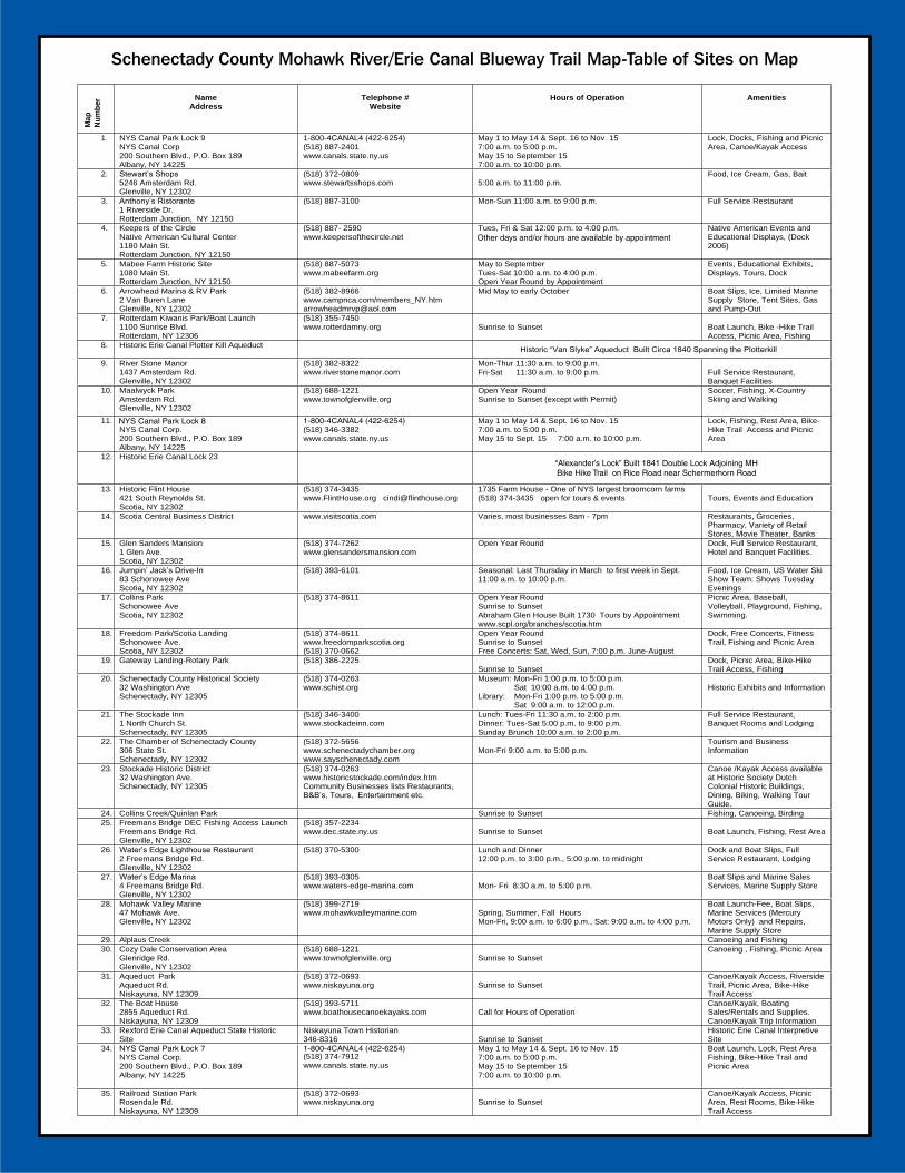
APPENDIX B: MASTER LIST OF MOHAWK BLUEWAY TRAIL FACILITIES The user facilities* located along the Mohawk Blueway Trail, which are included in the brochure, and their related amenities are shown below. *items are listed in order of appearance along the Mohawk Blueway Trail (as reflected on the map)
Map# Sites along Mohawk Blueway Trail Amenities at each site
1.
NYS Canal Park—Lock 9
Locks Docks Fishing and Picnic Area Canoe/Kayak Access
2. Stewart’s Shops Food and Ice Cream Gas Fishing Bait
3. Anthony’s Ristorante Full Service Restaurant 4. Keeper of the Circle, Narrative
American Cultural Center Native American events and educational displays (Dock 2006)
5. Mabee Farm Historic Site Events (Historic Recreations, etc.) Educational Exhibits and Displays Tours Docks
6. Arowhead Marina and RV Park Boat Slips Ice Marine Supply Store (limited) Tent Sites Gas and Pump Out Facilities
7. Rotterdam Kiwanis Park/Boat Launch Boat Launch Bike/Hike Trail Access Picnic Area Fishing
8. Historic Erie Canal Plotterkill Aqueduct Historic “Van Slyke” Aqueduct (built c 1840) 9. River Stone Manor Full service restaurant
Banquet facilities 10. Maalwyck Park Soccer fields
Fishing Walking trails X-country skiing trails
11. NYS Canal Park—Lock 8 Canal Lock Fishing Rest area Bike/Hike Trail Access Picnic Area
12. Historic Erie Canal—Lock 23 Historic “Alexander’s Lock” (built c 1841) 13. Historic Flint House Tours, events, and education programs 14. Scotia Central Business District Restaurants
Grocery stores and pharmacies Various retail stores Movie theater Banks
15. Glen Sanders Mansion Dock Full service restaurant Hotel and banquet facilities
16. Jumpin’ Jacks Drive In Food and ice cream U.S. Water Ski Show Team performance area

15
Map# Sites along Mohawk Blueway Trail Amenities at each site
17. Collins Park (Village of Scotia) Picnic area Sports facilities (volleyball, baseball, tennis) Playground Fishing Swimming
18. Freedom Park/Scotia Landing Dock Free concerts Fitness trail Fishing Picnic area
19. Gateway Landing—Rotary Park Dock Picnic area Bike/Hike Trail access Fishing
20. Schenectady County Historical Society Historic exhibitions, events, and information 21. The Stockade Inn Full service restaurant
Banquet Rooms Lodging
22. The Chamber of Schenectady County Tourism and business information 23. Stockade Historic District Canoe/kayak access
Various restaurant/dining establishments Biking Walking tour guide
24. Collins Creek/Quinlan Park Fishing Canoeing Birding
25. Freeman’s Bridge DEC Fishing Access Launch
Boat launch Fishing Rest area
26. Water’s Edge Lighthouse Restaurant Dock and boat slips Full service restaurant Lodging
27. Water’s Edge Marina Boat slips Marine sales/services and supply store
28. Mohawk Valley Marine Boat launch (fee-based) Boat slips Marie services and repairs Marine supply store
29. Alplaus Creek Canoeing Fishing
30. Cozy Dale Conservation Area Canoeing Fishing Picnic area
31. Aqueduct Park Canoe/kayak access Riverside trail Picnic area Bike/Hike trail access
32. The Boat House Canoes/kayaks Boating sales/rentals and supplies Canoe/kayak trip information
33. Rexford Erie Canal Aqueduct State Historic Site
Historic Erie Canal Interpretive Site
34. NYS Canal Park—Lock 7 Boat launch Canal lock Rest area Fishing Bike/Hike Trail access Picnic area
35. Railroad Station Park Canoe/kayak access Picnic area Restrooms Bike/Hike Trail access

16
APPENDIX C: MOHAWK BLUEWAY TRAIL BROCHURE

MOHAWK RIVER
Mohawk River/Erie Canal Blueway Trail
in
Schenectady CountyMap & GuidE
Susan SavageChair, Schenectady County Legislature
Frank QuinnSupervisor, Town of Glenville
Luke SmithSupervisor, Town of Niskayuna
Steven TommasoneSupervisor, Town of Rotterdam
Brian U. StrattonMayor, City of Schenectady Kris Kastberg Mayor, Village Of Scotia
“Cruise the Past, Unlock the Adventure.”
CONTaCT iNFORMaTiON
The Chamber of Schenectady County306 State Street • Schenectady, New York 12305
Telephone: (518) 372-5656 • Fax: (518) 370-3217Email: [email protected]
Website: www.sayschenectady.org
Schenectady County Department of Economic Development and Planning
107 Nott Terrace, Schaffer Heights, Suite 303Schenectady, New York 12308
Telephone: (518) 386-2225 • Fax: (518) 382-5539Website: www.schenectadycounty.com
Funding for this publication was made possible in part by a grant from the New York State Canal Corpotation. www.canals.state.ny.us • 1-800-4CaNal4 (422-6254)
Funding for the design of this publication made possible by funds from Title 11 of the Environmental Protection Fund,
The New York State Department of State and the Town of Glenville.
You can reach the New York State Department of State through their website: www.nyswaterfront.com.
Welcome to the Mohawk River/Erie Canal Blueway Trail. The Town of Glenville has partnered with the County of Schenectady and the New York State Department of State to showcase our 18 mile Blueway Trail that winds its way through our historic landscape.
We invite visitors and residents to explore the local restaurants, retail shops, parks and historic sites along our riverfront. Paddle your way through our historic river valley following the path traveled by members of the Mohican Confederacy and the Iroquois Nation.
as you cruise the river you will see that the riverfront offers several fine dining establishments; or if the mood strikes you, places for a quick snack. Dine out on the patios of the Glen Sanders Mansion, River Stone Manor, Water’s Edge lighthouse Restaurant, or Jumpin’ Jack’s and watch the evening sunsets as the many varieties of watercraft cruise the canal. Historical, cultural and recreational opportunities await you at each bend in the river. Whether it’s landing a hefty smallmouth from a river shoal or fighting a tiger muskie from underneath a dock, the Mohawk River is a fishing paradise. Visit the Mabee Farm, the oldest Dutch house in the Mohawk Valley, and explore its authentic Dutch barn. Stay and visit the Historic Schenectady Stockade, the first Historic District in New York State. Enjoy identifying a variety of bird species such as Bald Eagles, Red-tailed Hawks, Blue Herons, Egrets, Kingfishers, Bitterns, ducks and geese along the river bank. You can access the river at a number of public and private launches. Public boat launch sites can be found at lock 7, Kiwanis Park and the NYSDEC launch at Freemans Bridge Road. Canoe and kayak access is available at lock 9, Train Station Park and Gateway landing. For more information on other boat access sites go to the Blueway Trail Table of Sites in this brochure.
NYSDEC Freemans Bridge Fishing Access Launch
Fishing By Lock 8 in theTown of Rotterdam
Schenectady County Mohawk River/Erie Canal Blueway Trail Map Table of Sites on Map
Map
Num
ber Name
Address Telephone #
Website Hours of Operation Amenities
1. NYS Canal Park Lock 9 NYS Canal Corp 200 Southern Blvd., P.O. Box 189 Albany, NY 14225
1-800-4CANAL4 (422-6254)(518) 887-2401 www.canals.state.ny.us
May 1 to May 14 & Sept. 16 to Nov. 15 7:00 a.m. to 5:00 p.m. May 15 to September 15 7:00 a.m. to 10:00 p.m.
Lock, Docks, Fishing and Picnic Area, Canoe/Kayak Access
2. Stewart’s Shops 5246 Amsterdam Rd. Glenville, NY 12302
(518) 372-0809 www.stewartsshops.com 5:00 a.m. to 11:00 p.m.
Food, Ice Cream, Gas, Bait
3. Anthony’s Ristorante 1 Riverside Dr. Rotterdam Junction, NY 12150
(518) 887-3100 Mon-Sun 11:00 a.m. to 9:00 p.m. Full Service Restaurant
4. Keepers of the Circle Native American Cultural Center 1180 Main St. Rotterdam Junction, NY 12150
(518) 887- 2590 www.keepersofthecircle.net
Tues, Fri & Sat 12:00 p.m. to 4:00 p.m. other days and/or hours are available by appointment
Native American Events and Educational Displays, (Dock 2006)
5. Mabee Farm Historic Site 1080 Main St. Rotterdam Junction, NY 12150
(518) 887-5073 www.mabeefarm.org
May to September Tues-Sat 10:00 a.m. to 4:00 p.m. Open Year Round by Appointment
Events, Educational Exhibits,Displays, Tours, Dock
6. Arrowhead Marina & RV Park 2 Van Buren Lane Glenville, NY 12302
(518) 382-8966 www.campnca.com/[email protected]
Mid May to early October Boat Slips, Ice, Limited Marine Supply Store, Tent Sites, Gas and Pump-Out
7. Rotterdam Kiwanis Park/Boat Launch 1100 Sunrise Blvd. Rotterdam, NY 12306
(518) 355-7450 www.rotterdamny.org Sunrise to Sunset Boat Launch, Bike -Hike Trail
Access, Picnic Area, Fishing 8. Historic Erie Canal Plotter Kill Aqueduct Historic “Van Slyke” Aqueduct Built Circa 1840 Spanning the Plotterkill
9. River Stone Manor 1437 Amsterdam Rd. Glenville, NY 12302
(518) 382-8322 www.riverstonemanor.com
Mon-Thur 11:30 a.m. to 9:00 p.m. Fri-Sat 11:30 a.m. to 9:00 p.m. Full Service Restaurant,
Banquet Facilities 10. Maalwyck Park
Amsterdam Rd. Glenville, NY 12302
(518) 688-1221 www.townofglenville.org
Open Year Round Sunrise to Sunset (except with Permit)
Soccer, Fishing, X-Country Skiing and Walking
11.NYS Canal Corp. 200 Southern Blvd., P.O. Box 189 Albany, NY 14225
1-800-4CANAL4 (422-6254)(518) 346-3382 www.canals.state.ny.us
May 1 to May 14 & Sept. 16 to Nov. 15 7:00 a.m. to 5:00 p.m. May 15 to Sept. 15 7:00 a.m. to 10:00 p.m.
Lock, Fishing, Rest Area, Bike-Hike Trail Access and Picnic Area
12. Historic Erie Canal Lock 23 “Alexander’s Lock Built 1841 Double Lock Adjoining MHBike Hike Trail on Rice Road near Schermerhorn Road
13. Historic Flint House 421 South Reynolds St. Scotia, NY 12302
(518) 374-3435 www.FlintHouse.org [email protected]
1735 Farm House - One of NYS largest broomcorn farms (518) 374-3435 open for tours & events Tours, Events and Education
14. Scotia Central Business District www.visitscotia.com Varies, most businesses 8am - 7pm Restaurants, Groceries,Pharmacy, Variety of Retail Stores, Movie Theater, Banks
15. Glen Sanders Mansion 1 Glen Ave. Scotia, NY 12302
(518) 374-7262 www.glensandersmansion.com
Open Year Round Dock, Full Service Restaurant, Hotel and Banquet Facilities.
16. Jumpin’ Jack’s Drive-In 83 Schonowee Ave Scotia, NY 12302
(518) 393-6101 Seasonal: Last Thursday in March to first week in Sept. 11:00 a.m. to 10:00 p.m.
Food, Ice Cream, US Water Ski Show Team: Shows Tuesday Evenings
17. Collins Park Schonowee Ave Scotia, NY 12302
(518) 374-8611 Open Year Round Sunrise to Sunset Abraham Glen House Built 1730 Tours by Appointment www.scpl.org/branches/scotia.htm
Picnic Area, Baseball, Volleyball, Playground, Fishing, Swimming.
18. Freedom Park/Scotia Landing Schonowee Ave. Scotia, NY 12302
(518) 374-8611 www.freedomparkscotia.org(518) 370-0662
Open Year Round Sunrise to Sunset Free Concerts: Sat, Wed, Sun, 7:00 p.m. June-August
Dock, Free Concerts, Fitness Trail, Fishing and Picnic Area
19. Gateway Landing-Rotary Park (518) 386-2225 Sunrise to Sunset
Dock, Picnic Area, Bike-Hike Trail Access, Fishing
20. Schenectady County Historical Society 32 Washington Ave Schenectady, NY 12305
(518) 374-0263 www.schist.org
Museum: Mon-Fri 1:00 p.m. to 5:00 p.m. Sat 10:00 a.m. to 4:00 p.m. Library: Mon-Fri 1:00 p.m. to 5:00 p.m. Sat 9:00 a.m. to 12:00 p.m.
Historic Exhibits and Information
21. The Stockade Inn 1 North Church St. Schenectady, NY 12305
(518) 346-3400 www.stockadeinn.com
Lunch: Tues-Fri 11:30 a.m. to 2:00 p.m. Dinner: Tues-Sat 5:00 p.m. to 9:00 p.m. Sunday Brunch 10:00 a.m. to 2:00 p.m.
Full Service Restaurant, Banquet Rooms and Lodging
22. The Chamber of Schenectady County 306 State St. Schenectady, NY 12302
(518) 372-5656 www.schenectadychamber.orgwww.sayschenectady.com
Mon-Fri 9:00 a.m. to 5:00 p.m. Tourism and Business Information
23. Stockade Historic District 32 Washington Ave. Schenectady, NY 12305
(518) 374-0263 www.historicstockade.com/index.htmCommunity Businesses lists Restaurants, B&B’s, Tours, Entertainment etc.
Canoe /Kayak Access available at Historic Society Dutch Colonial Historic Buildings, Dining, Biking, Walking Tour Guide.
24. Collins Creek/Quinlan Park Sunrise to Sunset Fishing, Canoeing, Birding 25. Freemans Bridge DEC Fishing Access Launch
Freemans Bridge Rd. Glenville, NY 12302
(518) 357-2234 www.dec.state.ny.us Sunrise to Sunset Boat Launch, Fishing, Rest Area
26. Water’s Edge Lighthouse Restaurant 2 Freemans Bridge Rd. Glenville, NY 12302
(518) 370-5300 Lunch and Dinner 12:00 p.m. to 3:00 p.m., 5:00 p.m. to midnight
Dock and Boat Slips, Full Service Restaurant, Lodging
27. Water’s Edge Marina 4 Freemans Bridge Rd. Glenville, NY 12302
(518) 393-0305www.waters-edge-marina.com Mon- Fri 8:30 a.m. to 5:00 p.m.
Boat Slips and Marine SalesServices, Marine Supply Store
28. Mohawk Valley Marine 47 Mohawk Ave. Glenville, NY 12302
(518) 399-2719 www.mohawkvalleymarine.com Spring, Summer, Fall Hours
Mon-Fri, 9:00 a.m. to 6:00 p.m., Sat: 9:00 a.m. to 4:00 p.m.
Boat Launch-Fee, Boat Slips, Marine Services (Mercury Motors Only) and Repairs, Marine Supply Store
29. Alplaus Creek Canoeing and Fishing 30. Cozy Dale Conservation Area
Glenridge Rd. Glenville, NY 12302
(518) 688-1221 www.townofglenville.org Sunrise to Sunset
Canoeing , Fishing, Picnic Area
31. Aqueduct Park Aqueduct Rd. Niskayuna, NY 12309
(518) 372-0693 www.niskayuna.org Sunrise to Sunset
Canoe/Kayak Access, Riverside Trail, Picnic Area, Bike-Hike Trail Access
32. The Boat House 2855 Aqueduct Rd. Niskayuna, NY 12309
(518) 393-5711 www.boathousecanoekayaks.com Call for Hours of Operation
Canoe/Kayak, Boating Sales/Rentals and Supplies.Canoe/Kayak Trip Information
33. Rexford Erie Canal Aqueduct State Historic Site
Niskayuna Town Historian 346-83161-800-4CANAL4 (422-6254)
Sunrise to Sunset Historic Erie Canal Interpretive Site
34. NYS Canal Park Lock 7 NYS Canal Corp. 200 Southern Blvd., P.O. Box 189 Albany, NY 14225
(518) 374-7912 www.canals.state.ny.us
May 1 to May 14 & Sept. 16 to Nov. 15 7:00 a.m. to 5:00 p.m. May 15 to September 15 7:00 a.m. to 10:00 p.m.
Boat Launch, Lock, Rest Area Fishing, Bike-Hike Trail and Picnic Area
35. Railroad Station Park Rosendale Rd. Niskayuna, NY 12309
(518) 372-0693 www.niskayuna.org Sunrise to Sunset
Canoe/Kayak Access, Picnic Area, Rest Rooms, Bike-Hike Trail Access
Schenectady County Mohawk River/Erie Canal Blueway Trail Map-Table of Sites on Map
Other days and/or hours are available by appointment
“Alexander’s Lock” Built 1841 Double Lock Adjoining MH Bike Hike Trail on Rice Road near Schermerhorn Road
NYS Canal Park Lock 8

19
APPENDIX D: MOHAWK RIVER/ERIE CANAL BLUEWAY TRAIL MAP
