school of natural resources and the environment 325 biological
TRANSCRIPT

Final Report
JFSP Project Number: 06-3-1-27
Project Title: Fire Regimes of Montane Grasslands of the Valles Caldera National Preserve,
New Mexico
Principal Investigator: Donald A. Falk
Co-Investigators: Craig Allen, US Geological Survey
Robert Parmenter, Valles Caldera National Preserve
Thomas Swetnam, University of Arizona, Laboratory of Tree-Ring Research
Federal Cooperator: Clifford Dils, US Forest Service, Santa Fe National Forest
`
School of Natural Resources and the Environment 325 Biological Sciences East
College of Agriculture and Life Sciences P.O. Box 210043
Tucson, AZ 85719
Telephone: (520) 626-7201
Fax (520) 621-8801
www.snre.arizona.edu

Final Report, JFSP 06-3-1-27, University of Arizona, p.2
Abstract
Montane grasslands are an important ecosystem type in Southwestern landscapes,
occurring from the forest borders of piñon-juniper woodland to high elevation subalpine and
alpine ecosystems. Thus, they often represent a mosaic element embedded in the forest
landscape matrix, playing key roles in processing water and nutrients, and providing habitat for
unique suites of species, often at higher levels of diversity than those found in surrounding
uplands. Soils, local temperature and moisture gradients, and disturbance all play roles in
determining the distribution and extent of montane grasslands. Of these factors, fire plays the
most dynamic role in regulating the location and composition of the grassland-forest ecotone.
In this project we undertook the first landscape-scale characterization of the historic fire
regime of one of the major montane grassland-forest complexes in southwestern North
America, the 36,400 ha (90,000 ac) Valles Caldera National Preserve (VCNP) in the heart of the
Jemez Mountains of northern New Mexico. The VCNP is a post-volcanic landscape consisting of
multiple forested resurgent domes within a matrix of high-elevation valle grasslands. Where
forest meets grassland, an ecotonal zone occurs with moderate tree cover and high herbaceous
productivity. We hypothesized that the ecotone represented the highest fire frequency and
served as a pathway for fire spread among the valles. To test this idea we collected fire-scarred
tree-ring samples from over 450 trees from the forest-grassland ecotone in all of the major
valles in the VCNP, making this one of the most comprehensive landscape fire history
collections in the United States. All sample locations were georeferenced to facilitate spatial as
well as temporal patterns of historical fire occurrence. To allow stronger interpretation of the
point fire-scar record as a proxy for fire spread, we modeled fire behavior in the same
landscape using Minimum Travel Time (MTT) and other capabilities of the FlamMap system,
using a model calibrated to local weather streams, ignitions, and fuels (Finney 2002).
The resulting VCNP tree-ring record extends back to the early AD 1418, establishing a
591-yr period of record. We dated more than 2000 fire scars, with the earliest dating to 1501,
representing 468 years with fire occurrence. Our fire history analysis shows high fire frequency
in the forest-grassland ecotone, with average mean fire interval (MFI) of 6.9 yr in individual
valles, and 1.3 yr between fires in the VCNP as a whole. Fire frequencies were highest in the
largest valles and MFI was significantly associated with valle area. Historically, fires occurred in
years of significantly low Palmer Drought Severity Index (PDSI); the most widespread fire years
represented contingent combinations of low fire-year PDSI preceded by 2-3 years of unusually
high PDSI (cool-wet conditions), indicating climate control on fine fuel production. More than
20 instances of back-to-back fire years occurred in the VCNP landscape, generally entrained by
sequential low-PDSI years as well as spatial separation of burned areas. Fire modeling
simulations identified the forest-grassland ecotone as the optimal pathway for fire spread: both
more mesic, upslope closed forest and the mesic internal wet meadow conditions of the
grasslands impede fire flow, whereas the relatively drier conditions with abundant fine fuels

Final Report, JFSP 06-3-1-27, University of Arizona, p.3
facilitate rapid fire spread across the VCNP landscape. These findings are being provided to
managers of the VCNP to informal ecosystem management, including their fire management
program.

Final Report, JFSP 06-3-1-27, University of Arizona, p.4
Background and purpose
Montane grasslands and their associated ecotones have been an understudied
ecosystem type throughout the western US, including in the Southwest. The goal of this study
was to reconstruct the historical fire regime of the grassland-forest ecotones of the Valles
Caldera National Preserve (VCNP) in northern New Mexico, USA. We used a combination of
dendrochronological and fire simulation modeling methods to quantify the historic occurrence
of fire in forests immediately adjacent to grasslands, and to capture patterns of spatial and
temporal synchrony and climate control in the grassland-ecotone fire regime. Specifically, we
used these data to (1) compare historical fire patterns recorded by trees in the forest-grassland
ecotone with trees more centrally located within continuous forest, to assess potential
differences between forest and grassland fire regimes; (2) to understand fire-vegetation-
climate relationships that entrained the montane grassland fire regime; and (3) to assess
pathways of fire spread across the VCNP under contemporary fuel conditions.
We coupled dendrochronology with modeling of fire behavior in relation to the present-
day fire regime in specific ways to enable us to address key questions about the forest-
grassland ecotone fire regime (Falk et al. 2007). In both approaches we employed a spatially
explicit framework at the landscape scale with the ultimate purpose of informing ecosystem
management and ecological restoration (Allen et al. 2002, Swetnam et al. 2011). Spatial
reconstruction of both historical and contemporary fire regimes permits the framing and
testing of hypothesis about fire as a landscape process, which is an emerging priority in fire
research and management (McKenzie et al. 2011; Falk et al. 2011).
Fire history. In the fire history component of our study, we asked the following
questions to develop a deeper understanding of the fire regime of the forest-grassland
ecotone:
1. How does fire frequency vary between forests on the periphery of the grassland-forest
ecotone and forests more centrally located, in higher elevations?
H1: Fire frequency of the grassland-forest ecotone reflects high frequencies endemic
to grassland fire regimes; frequency decreases away from the forest-ecotone
periphery, and upslope into coniferous forest.
2. How does the occurrence and extent of fire vary with changing summer Palmer Drought
Severity Index (PDSI) in the fire year prior years’ climate?
H2: Fire size is correlated directly with increasing levels of drought (PDSI), with larger
fires occurring when summers are drier and proceeded by wetter, cooler years that
Final Report, JFSP 06-3-1-27, University of Arizona, p.5
contribute to fuel accumulation. Conversely, small fire years occur when summers are
wetter and cooler, and preceding years are dry, limiting fuel production.
3. Can fire occur in sequential years in this moderate productivity ecotone fire regime, and
if so what conditions facilitate this response?
H3: Fire can occur in sequential years either as a result of spatial separation or unusually
dry multi-year climate.
Fire modeling. Multiple-iteration fire simulation modeling is capable of providing
insights into patterns of fire spread and spatial extent. The modeling process allows for the
investigation of the relationships between fire, climate, and vegetation by breaking each
component into distinct, controllable variables (Keane 2004). Mechanistic fire behavior models
that link mathematical equations to the physical environment, such as FlamMap, allow the
researcher to test fire behavior under various wind, weather, and fuel conditions and compile
the results into a burn probability layer (Miller 2003).
We used simulation modeling to explore the pathways of fire in this complex landscape,
as a means of strengthening interpretation of the historical fire scar record of a process that
flows continuously across a landscape. We used these tools to address the following questions:
1. Do dominant fire spread pathways follow the forest-grassland ecotone or burn
across grasslands?
2. Does fire spread across grasslands require exceeding a wind-speed threshold?
We hypothesized that the ecotone facilitates the spread of fire between adjacent valles,
or grasslands, under most weather conditions, due to the optimal conditions of fine fuel mass,
continuity, low fuel moistures. The narrow valleys between cerros, the resurgent domes within
the caldera, promote the spread of fire by increasing the rate of spread by concentrating wind
energy and decreasing fuel moistures through preheating due to the ‘chimney effect’ of
topography and tall stands of trees around the periphery of the grasslands. High wind speeds
are required to carry fire across the grasslands where fuel loads and fuel bed connectivity are
lower due to grazing activity. We predicted that fire would not carry across the center of the
largest valles because of the marsh vegetation that dominates those areas, although hot and
dry weather conditions can evaporate standing water and sufficiently lower fuel moistures to
allow fire to carry across the grassland under the most severe fire weather conditions. The
ecotone not only assists in carrying fire through the narrow passages between valles, but also
facilitates the spread of fire upslope into the Canadian and Hudsonian life zones. Recent
downslope encroachment of the ecotone coupled with a warming climate may have altered the
dynamics of the fire regime at the stand and landscape scales. Spatial analysis of the model’s
outputs with a GIS system will show degraded areas that are at risk from crown fire.

Final Report, JFSP 06-3-1-27, University of Arizona, p.6
Study description and location
The Valles Caldera constitutes the central lands of the Valles Caldera National Preserve
(VCNP) as well as adjacent lands of the Santa Fe National Forest, Bandelier National Monument,
lands of the Santa Clara and Jemez Pueblos, and private lands (Allen 1989; Figure 1). The Valles
Caldera National Preserve (VCNP, 35o50’-36o00’ N, 106o 24’-106o37’ W) occupies the central 88
900 acres (36,400 ha) of the Jemez Mountains. The Jemez Mountain range is encircled by the
continuation of the San Juan Range of the Rocky Mountains to the north, the valley of the Rio
Grande on the east and south, and by the margin of the Colorado Plateau on the west.
The 24 km wide caldera basin of the Valles Caldera is a remnant volcanic caldera that
derived from the collapse of a pair of underlying magma chambers following a series of volcanic
eruptions 1.6 and 1.2 million years ago. The Valles Caldera formed during the youngest of these
eruptions, leaving behind a landscape of ring-fractured domes that arc from east to the west in
the northern portion of the caldera. The base elevation of the VCNP begins at approximately
8000 ft (2439 m) and contains lava-dome mountains forming the caldera’s rim that rise more
than 3200 ft (1000 m) above this base elevation. The highest of these peaks is Cerro Redondo,
which rises to an elevation of 11 254 ft (3431 m) (Anschuetz and Merlan 2007 ).
The montane grasslands that today occupy to bottomlands of these valles comprise
approximately 26 000 acres (10 500 ha) in of the VCNP, and are primarily in the expansive
broad valley bottoms of the caldera floor at elevations between 8500 and 8900 ft (2575 to 2700
m). These valley bottoms support largely treeless meadows that are fringed with ponderosa
pine and mixed conifer forests. Mountain slopes are made up of ignimbrite and ryholite rock
types with primarily mountain soils (Andisols, Alfisol, and Inceptisol soil orders) derived from
volcanic rock and gravel. The caldera floor is underlain mostly with Mollisols (grassland soils),
which are a mixture of alluvial and lacustrine sediments developed from the deposition of
volcanic alluvium (Muldavin et al. 2006).
The valle grasslands are dominated by native bunchgrasses, including various species of
oatgrass (Danthonia spp.), fescue (Festuca spp.), and muhly (Muhlenbergia spp.), and native
and non-native rhizomatous grasses, including Kentucky bluegrass (Poa pratensis). Overall the
grasslands sustain >100 species of forbs and graminoids (Muldavin et al. 2006; Coop and
Givnish 2007).
Forest types within the Valles Caldera vary with elevation and aspect. Spruce-fir forests
are found at the highest elevations (9000 to 11 250 feet; 2749 to 3430 m) and are dominated
by Engelmann spruce (Picea engelmannii) and corkbark fir (Abies lasiocarpa var. arizonica).
Mid-elevation (below 10 000 feet, 3050 m) forests are generally mixed conifer types co-
dominated by a blend of pine and fir species, including white fir (Abies concolor), Douglas-fir
(Pseudotsuga menziesii), Colorado blue spruce (Picea pungens), Southwestern white pine (Pinus
strobiformis), limber pine (Pinus flexilis), and ponderosa pine (Pinus ponderosa). Patches of
aspen (Populus tremuloides) and Gambel oak (Quercus gambelli) occur on warmer sites where

Final Report, JFSP 06-3-1-27, University of Arizona, p.7
sections have been burned or logged within the spruce-fir or mixed conifer zones. Ponderosa
pine becomes dominant below the mixed-conifer zone, with stringers of pine extending
downslope into washes and drainages. Several other woody species grow sporadically at the
lowest elevations and around bogs, such as common juniper (Juniperus communis), Gambel
oak, shrubby cinquefoil (Potentilla fruticosa), and kinnickinnick (Arctostaphylos uva-ursi)
(Muldavin et al. 2006).
Open stands of fire- and drought-tolerant ponderosa pine intermixed with piñon and
juniper woodlands dominate the fringe ecotonal forest bordering the montane grasslands on
exposed drier south facing aspects. In contrast, north facing valle borders are typically cloaked
in dense mixed conifer forest dominated by Colorado blue spruce on the lower slopes, white fir
intermixed with Douglas fir and aspen dominating mid-slope stands and gradually shifting to
dominance by Engelmann spruce and corkbark fir on the highest slope positions. These
differences in vegetation are also reflected in contrasting fire regimes on north- and south-
facing aspects in the grassland-forest ecotones.
Field and Laboratory Methods
In order to obtain a multi-century record of surface fires in the montane grassland, we
used searched extensively to locate and collect fire scars in the grassland-forest ecotone of the
VCNP. Specifically, our sampling strategy was to obtain a representative sample of sections
from georeferenced fire-scarred trees on the ecotones of the major valles of the VCNP to allow
reconstruction of long-term inventories of fire events at the forest stand level. Fire-scarred
specimens were sampled within sites by systematically searching throughout forest stands at
the grassland-ecotone. Site (forest stands) boundaries were established based upon multiple
clusters of fire-scarred trees within a landscape facet. These site chronologies generally
included fewer than 10 fire-scarred trees. Some of our site collections were from multiple
clusters of trees more widely dispersed across the forest-grassland ecotone of valles, including
10 to 25 fire-scarred trees. We employed a sampling design that would allow us to capture and
analyze both spatial and temporal patterns in the grassland-forest fire regime (Figure 2). Most
field sampling was conducted during the summers of 2007-2008.
We also sampled for evidence of historic low-severity fire regimes across the VCNP in
the smaller linear areas of grassland that might provide pathways for fire spread between
major valles (i.e. “connectors”). Sampled sites were geographically dispersed primarily along
the grassland-forest ecotone to capture patterns of fire synchrony in VCNP ponderosa pine
communities. All valles and connectors exhibited ample evidence of surface fires during the
past several centuries, as reflected by the abundance of scarred trees. While selecting samples,
we made a concerted effort to locate remnant wood (logs, snags, or stumps) throughout the

Final Report, JFSP 06-3-1-27, University of Arizona, p.8
forest-grassland ecotone in order to minimize the cutting of living trees and to extend fire
chronologies as far into the past as possible. Once suitable fire-scarred trees were located, we
used chain saws to remove partial or full sections from snags, logs, stumps, and living trees.
Wherever possible, we cut wedge sections from the face of fire scars in order to preserve
standing trees and snags.
In the laboratory, samples were re-assembled and stabilized, prepared for analysis by
trimming excess wood, and then sanded with a series of progressively finer sanding abrasives
(from 40 to 400 grit) until cell structure was clearly visible. We used a binocular microscope to
examine each cross section and employed standard crossdating techniques (Stokes and Smiley
1996; Dieterich and Swetnam 1984) to determine the calendar year of each fire event recorded
on the landscape. Cross-dating of samples was essential to ensure annual accuracy of the
record, especially important for climate and spatial synchrony analyses. Other important
characteristics reported on each sample included the visible clarity of the fire scar within a
dated ring, the presence of resin ducts that could be fire-related, any noticeable ring growth
releases or suppressions, and any other injuries that could be fire-related. Additional scars that
were not detected in the field were sometimes frequently found in laboratory analyses upon
preparation and microscopic examination. Two dendrochronologists cross-dated each sample
independently so as to ensure the accuracy of each fire scar date and ring chronologies.
Analytical methods
For fire history, fire chronologies were composited at different spatial scales to assess
changes in fire regimes at multiple scales (Falk et al. 2011). All fire dates from successfully
crossdated samples were entered into a database and then graphed and analyzed utilizing FHX2
and FHAES, which are software packages for performing statistical analyses and developing
graphical presentations (Grissino-Mayer 2001). Fire years in the site level chronologies were
identified when at least one tree within the site recorded fire. These site level chronologies
were compiled into nine valle-level chronologies and then furthered joined to create a
landscape fire chronology for the study area as a whole. These multi-scale composites of the
fire record enabled us to assess the frequency, relative extent and the synchronicity of fire
events both within and among valles and across the entire VCNP landscape. FHX2 and FHAES
programs were also used to analyze seasonality and fire-climate relationships.
The relative extent of fire across the landscape was determined based on the number of
valles in which fire occurred in a given year, as well as the number or proportion of trees within
a site or valle recorded fire. For example, widespread fire years were defined as years in which
evidence of fire was found at more than 6 valles, whereas local fire years were those in which
fire occurred in only 1-2 valles. This approach allowed us to evaluate the antecedent conditions
for widespread fire based on its geographic distribution in the study landscape.

Final Report, JFSP 06-3-1-27, University of Arizona, p.9
For each level of filtering, we determined the mean fire interval (MFI) and Weibull
median probability interval (WMPI) for each sampled site and each valle for the period of
record, defined as the average interval in years between fire dates in a composite fire
chronology. In order to reconstruct spatial and temporal patterns of historical fires, we used a
combination of dendroecological and Geographic Information System (GIS) methods.
Georeference data were analyzed in GIS for determining spatial properties of the fire record,
including the extent of individual fire years around the valle perimeters.
For simulation modeling, FlamMap requires the construction of a Landscape (LCP) File
representing topographical and ecological conditions. Eight layers of raster data at 30-meter
resolution are overlaid in ArcMap to create a single file containing a digital elevation model
(DEM), slope, aspect, canopy cover, canopy height, CBH, canopy bulk density, and a fire
behavior fuel model (FBFM) layer. This file acts as the independent variable for this study. All
of the required input layers were downloaded from the LANDFIRE data service, administered by
the Forest Service and US Geological Survey, with the exception of the FBFM layer, which was
provided by the VCNP staff. LANDFIRE products are derived from remote sensing, and as such
are subject to the limitations of image classification techniques. Preliminary investigation of
the LANDFIRE FBFM layer showed that the valles were classified as an unburnable agricultural
fuel model NB3 (93) in the standard fire behavior fuel model system (Scott and Burgan 2005).
The VCNP staff, in conjunction with researchers from the Missoula Fire Science Laboratory,
spent two years creating and calibrating a custom fuel model (FM 114) to represent the valle
grassland fuels with respect to fuel load and moisture. The custom valle grass fuel model was
derived from the GS4 (104) fuel model, with the exception of live fuel moistures modeled
higher than normal to capture the wet areas of marsh in the center of the Valle Grande and
along the banks of the Jemez River and Jaramillo Creek.
Weather data were downloaded from the Kansas City Fire Access Software (KCFAST)
server, managed by the National Wildfire Coordinating Group (NWGC) for all Remote
Automated Weather Stations (RAWS). For this study, the Jemez RAWS (35° 50’ 28” N, 106° 37’
8” W) was deemed the most suitable due to its similar elevation of the valles, approximately
2500 meters, and proximity to the study site. Daily weather data from 1966 to 1988, and
hourly data from 1988 to 2009, were available for download. The length of the fire season must
be defined before extracting weather variables from FireFamily Plus. We defined the fire
season in terms of Energy Release Component (ERC), which is an index of the amount of
available energy per unit area within the flaming front at the head of a fire. Live and dead fuel
moistures across all size classes influence the ERC value. When live fuels cure and dead fuels
dry, ERC increases; thus, ERC may be considered as a reflection of composite, cumulative fuel
moisture across the landscape. ERC is also a component of the National Fire Danger Rating
system, along with ignition and spread components. The 90th percentile of historic ERC values is

Final Report, JFSP 06-3-1-27, University of Arizona, p.10
used widely to represent very high fire danger and previous studies used this breakpoint for
defining the fire season (Miller and Davis 2009). The VCNP system typically crosses this
threshold on April 1st and August 1st, peaking in late June before the onset of the monsoon
season. We extended the fire season until August 31st to account for the lag in 10 hour, 100
hour, and 1000 hour fuels and to keep the fire season consistent with other literature (Balice et
al. 2005). The graph of the ERC values (Figure 3) shows a bimodal fire season in extremely hot
and dry years only during October and November; however, this bimodality was not considered
or incorporated into the model, mostly for the sake of simplicity and the limitation on the
capability of FlamMap to vary weather conditions during the simulation.
After defining the fire season, we extracted temperature and humidity percentiles using
FireFamily Plus for the typical weather scenarios. We chose the 50th, 90th, and 99th
percentiles of historic temperature and humidity to reflect average, very dry, and extreme
scenarios. The 90th and 99th percentiles correlate to the conditions during the Cerro Grande
and Dome fires respectively. FireFamily Plus generated graphs for the weather variables from
8,569 observations for temperature and 6,017 humidity records. The extracted percentiles
were entered into an ASCII text file for later use in FlamMap.
Ignition is rarely a random process (Parisien et al. 2010), so controlling the location of
ignition reduces the potential for significant alterations to the resulting simulated fire pattern
and retains both the stochastic and deterministic components of the fire regime (Miller et al.
2008). The ignition point variable used in VCNP fire modeling is a subset of a dataset of 368
ignitions that includes anthropogenic and lightning fire starts within the VCNP boundary from
1970 to 2003. Attributes of ignitions includes the day, month, and year of ignition, the cause,
and the fire size class. Lightning strikes are the most important source of natural ignition in
many grasslands and comprise the majority of the total ignitions in the VCNP dataset. Ten
ignition points were randomly selected from this distribution. Once ignited, fires were allowed
to burn for four days, or 5,760 minutes with raster outputs at 30 meter resolution. Using actual
ignition points from lightning allowed us to retain naturally occurring stochastic properties of
ignitions across the VCNP landscape.

Final Report, JFSP 06-3-1-27, University of Arizona, p.11
Key findings
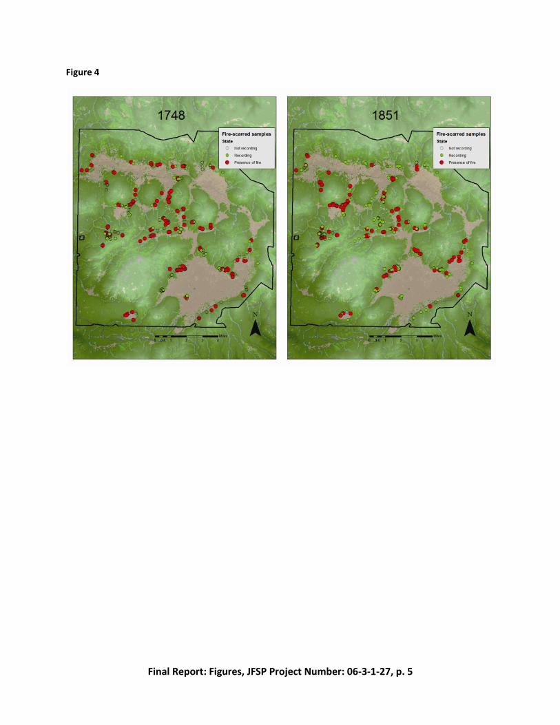
1. Fires spread through the forest-grassland ecotones frequently under historic conditions.
For all sites over the 768-year period from 1240 to 2008 A.D. (the earliest and latest dated
tree rings, respectively), a total of 2443 fire scars representing 238 fire years were reliably
cross-dated from 330 trees collected in the nine valles (Table 1). Most of these trees were
dead when sampled by chainsaw as stumps, logs, or snags (91.5%). Of the cross-dated
samples, most were ponderosa pine (80.5%), while 7% were southwestern white pine. The
remaining dated samples were either Rocky Mountain Douglas-fir or unknown (usually
older wood too deteriorated to determine species reliably). Fire frequencies are lower in
the more mesic forests on the domes of the Caldera. Fire frequencies in the grasslands per
se can be inferred only from a handful of sites where trees are surrounded by open
grassland; frequencies in these areas were generally lower than the ecotones. MFI for the
valle ecotones ranged from 2.7-10.1 yr for individual valles, and 1.6 yr for the VCNP
landscape as a whole. Fires were quite widespread in some years, as indicated by fire-year
maps (Figure 4).
2. Interannual climate variability regulates variation in fire return intervals. Fires in the VCNP
were related significantly to climate, both at inter-annual and inter-decadal time scales
(Figure 5). The time series of reconstructed regional PDSI (grid point 119) shows the
variability in drought conditions from the period of analysis 1601-1902. PDSI values of -1.0 <
0 Palmer are generally considered moderate drought, while extreme drought conditions
exist when the PDSI value falls below -1.5. Reconstructed PDSI values indicate that 20 of 22
widespread fires occurred during moderate to extreme drought conditions (PDSI < -1.0),
while two of the widespread fire years occurred in close to normal conditions (Figure 6). Of
the 22 widespread fires, 17 occurred during years that are characterized as extreme
drought conditions (PDSI < -1.5). The results of the Superposed Epoch Analysis suggest that
drought conditions (measured by PDSI) are significantly (p < 0.001) related to the
occurrence of widespread fires in the VCNP. There is strong support for an effect of
antecedent moist years. In the three years prior to the year of a fire event the PDSI values
are positive and in the second year prior they show statistically significant (p <0.001) wet
conditions (Figure 7).
3. Moderate fire years, which burned 3 to 5 of the nine valles, were also significantly
associated with negative (dry) conditions during the year of a fire event. However, unlike
the widespread fire years that exhibited antecedent moist years, moderate fire years
display little evidence of antecedent moist or dry years. Interestingly, moderate fire years

Final Report, JFSP 06-3-1-27, University of Arizona, p.12
are followed by generally dry years, but the latter are not statistically significant. The
opposite was true for local and non-fire years in that they are preceded by several dry
years. Local fire years that burned in only 1-2 valles were not significantly associated with
drier or warmer than average conditions (Figure 7) in the year of fire, but the antecedent
conditions indicate that local fire years were preceded by at least six dry years, with
consistent statistically significant (p < 0.001) dry conditions in the fourth year prior to a fire
event. A similar trend of 1-6 dry years prior to a fire event was observed when comparing
non-fire years to the PDSI (Figure 7). However, years when no fires burned on the landscape
occurred when conditions were significantly wet (p <0.001), even though the year prior was
significantly drier/warmer (p <0.001) than average. These results indicate the importance of
antecedent wet/cool conditions, which presumably lead to higher fine fuel accumulation
and eventually set up more widespread events.
4. Back-to-back fire years were a regular feature of the VCNP fire regime. There are many
back-to-back fire years in the VNCP. In seven cases, back-to-back fire events included at
least one widespread fire (fire recorded in 6-9 of the valles) while the other fire year was
either widespread or moderate (occurring in at least 4 valles), which are hereafter referred
to as widespread back-to-back fire years (Figure 8). The remaining back-to-back fire years
were comprised of two moderate fire events (occurring in 3-5 valles), or one widespread
fire and one localized fire year, one moderate fire and one localized fire year, or two
localized fire years (hereafter referred to as moderate back to back fire years). Remarkably,
on review of all back-to-back fire year data, there was only one tree out of 229 recording
trees that recorded having been burned in two successive years, 1779-1780. For all back-to-
back pairs, the first year of the back-to-back years appears to be slightly drier than normal,
but statistically no significant (p > 0.1), while the second year there were extreme drought
conditions (PDSI < -1.5). However, when the data from the 7 widespread back-to-back fire
years is separated from that of the 14 moderate back-to-back fire years, a different picture
emerges: results of the SEA for the widespread back-to-back fires suggests that the back-to-
back fire events occurred after 4 years that were cooler and wetter than normal (PDSI > 0).
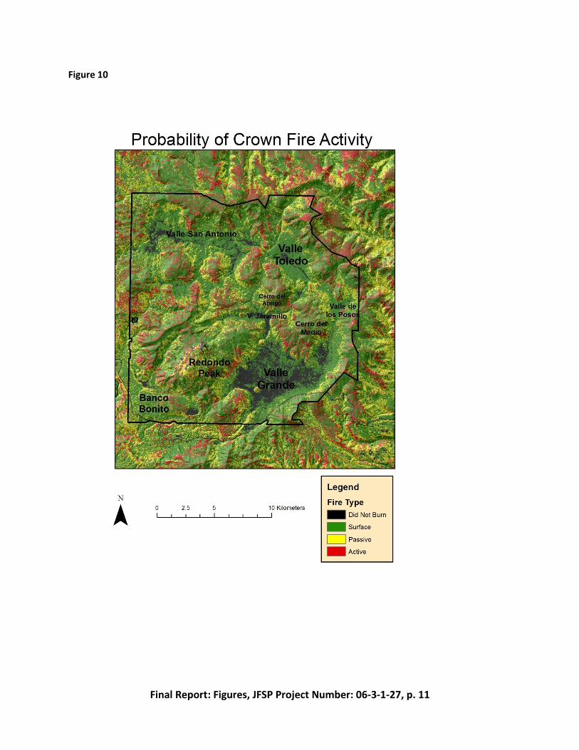
5. Fire spread pathways are concentrated in the forest-grassland ecotones. The MTT analysis
indicates typical fire pathways around the ecotone of the VCNP (Figure 9). The Valle Grande
is strongly fire resistant and fire can carry across the grassland only on the eastern side of
the Cerro del Medio under most conditions. Additionally, fire does not readily cross the
Valle Jaramillo, instead spreading west-to-east around the edge of this grassland. The other
major valles are capable of spreading fire across the grassland. In the case of the Valle San
Antonio and the Valle Toledo, the fire pathway splits into multiple vectors once the flaming

Final Report, JFSP 06-3-1-27, University of Arizona, p.13
front exits the narrow passages between cerros. These two valles contain patches of the
custom valle grass fuel model in the center of the grassland, but the model shows fire is
capable of spreading around these areas. The rate of spread around the ecotone ranges
from 20 to 50 chains per hour, faster than the forest rate 100 meters to 400 meters
upslope. The grass fuel models around the periphery of the valles and fewer fine fuels in the
upslope forests account for this pattern. Rate of spread also increases as fire burns upslope
to the tops of the resurgent domes. In the cases of Cerro Santa Rosa, Cerro del Medio, and
Cerro San Luis, the forest stands with the highest rate of spread also experience crown fire
(Fig. 10).
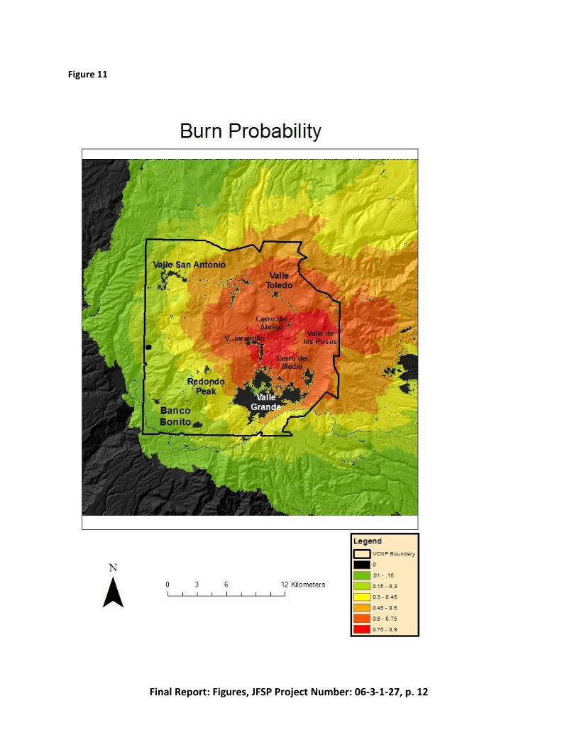
6. Burn probabilities are highest in the ecotone. The burn probability map shows clear spatial
trends (Fig. 11). The valles show a general resistance to carrying fire even with severe fire
weather. Fire may burn portions of the grassland but these do not behave like a typical dry
grassland/prairie fire. This trend is most obvious in the Valle Grande, where fire carries
across the grassland at only three points. The Valles San Antonio, Toledo, and Jaramillo also
show resistance to carry fire completely across the grassland but at a much smaller scale
than the Valle Grande. The area between the Cerro del Abrigo and the Cerro del Medio has
the highest burn probability, indicating that this area facilitates the spread of fire from the
southwest and northwest into the Valle Toledo and Valle de los Posos. The narrow gap
between resurgent domes facilitates fire spread through accelerating wind speeds and
preheating fuels through the chimney effect. Burn probability also responds along an
elevational gradient, with the highest probability along the grassland and ecotone at the
caldera floor. Burn probability at the pixel level ranged from 0 to .828 with a mean of .263.
Previous studies found that the pixels with the highest burn probability are associated with
the major pathways of fire spread (Ager et al 2007). The largest simulated fire had a burned
area of 263,241 acres and the smallest simulated fire burned 5,966 ac (for comparison, the
2011 Las Conchas fire burned 156,593 acres).
Final Report, JFSP 06-3-1-27, University of Arizona, p.14
Management implications
Fire can be returned at high frequency to the forest-grassland ecotone in the Valles
Caldera and other high montane grassland systems in the southwestern US. Fire helps to
maintain the boundary zone between foret and grassland, preventing incursion of woody
species into the grassland system (Archer 1994; Coop and Givnish 2007). Fire helps to maintain
an open stand structure which tends to increase herbaceous growth, thus enhancing fine fuel
mass and continuity in the ecotone. The result is a positive feedback relationship that
concentrates fire occurrence in ecotonal forests. In the historical record, fires are present in the
VCNP in two of every three years (MFI = 1.6 yr).
The ecotone is the “path of least resistance” for fire spread in the Valles Caldera
grassland-forest mosaic. Optimal conditions of fine fuel mass and moisture, wind, relative
humidity, and temperature allow fires to spread relatively rapidly across the VCNP landscape,
using the ecotone as a conduit. The ecotone thus plays a keystone role in landscape function,
by bringing fire around the VCNP grassland complex under even moderate fire weather. Fires
are less frequent in the more mesic upslope forests, where higher fuel moistures, lower
temperatures, and higher humidity impedes fire spread except under unusually favorable
conditions. The ecotone plays key role in the relatively large number of widespread fire events
in the VCNP historical record, reflected by the index of the number of valles with fire in
individual years.
There are significant differences within the ecotone system that constitute “bottom-up”
regulating of fire patterns. Fire frequency is higher on south-facing aspects dominated by
ponderosa pine then on north-facing aspects fringed by spruce-fir forest. These differences,
which reflect the biophysical constraints for individual species, are also self-perpetuating local
fire regimes since the fuel matrix produced in pine forest facilitates fire (for example, by lower
fuel bulk density, packing ratio, and fuel moistures attributable to open stand conditions),
whereas fuels in the spruce-fir ecotone have higher moisture and more dense packing, tending
to reduce spread rates and heat output. These local differences would be expected to persist
even under a managed fire program.
Interannual climate variability is a dominant influence on the VCNP fire regime,
including in the ecotonal zone. Widespread fire years, those in which fire was present in 2/3 or
more of the major valles, occurred several times per century, approximately every 25 years.
Fires in 1/3 or more valles were extremely common, occurring at least once every decade.
These widespread fire years occur consistently in the conditions of lowest PDSI. Our results also
indicate a strong “set-up” of large fire years by relatively cooler and wetter conditions (positive
PDSI), which presumably increase fine fuel production that persists into the fire year.
Final Report, JFSP 06-3-1-27, University of Arizona, p.15
Back-to-back fire years occur relatively frequently in the VCNP historical record. This
temporal pattern appears to be strongly driven by interannual climate variation, particularly a
series of warm-dry years. Two spatial patterns emerge: in one case, part of the VCNP burns, but
fires do not extend across the entire landscape, and fire spreads to unburned valles in the
following year. In the alternate case, fire spreads widely but patchily over the VCNP landscape,
leaving a mosaic of unburned fuel that can carry fire in the second year. The differences
between these two landscape fire patterns probably reflect bottom-up control of fire spread
and fuel consumption.
Simulation modeling outputs show a departure from expected fire behavior for many
forested areas of the VCNP, underscoring the need for repeated treatment of the landscape.
Hazardous areas indicated by the model should be the first priority for treatment, as they are
most at risk from catastrophic crown fire. Predicted fireline intensities produce sufficient flame
lengths that fire transitions from the ground to the canopy within 100 meters of the forest-
grassland ecotone. The goal of treatment should be to reduce the factors that contribute to
high intensity fire and restore structure and process of forest stands so that widespread surface
fires become the dominant fire behavior. Ecosystem health and low-severity fire are
historically linked, but the current ecosystem trajectory removes this coupling.
Final Report, JFSP 06-3-1-27, University of Arizona, p.16
Relationship to other recent findings
This is the first major study of fire in montane grassland-forest ecotones in the
Southwest. Similar environments exist throughout the southern Rocky Mountains, although
few studies have been conducted at the scale or sampling intensity used here (Mast et al.
1998). Our design is unique in coupling fire history and simulating modeling, which we believe
offers great promise by integrating the point record of fire scars with modeling of fire as a
dynamic and contagious landscape process.
Our findings of strong top-down entrainment of the VCNP fire regime by regulation by
interannual climate variation is consistent with other studies of high-frequency fire regimes
throughout the Rocky Mountains and Intermountain West. We used the number of valles with
fire as an index of widespread fire years instead of the more usual approach of filtering by the
percentage of trees, because even a relatively localized fire (for example, in one corner of the
Valle Grande or other large VCNP grasslands) could pass a numerical filter while not being
widespread at the landscape scale.
Future work needed
This study documents the fire regime in a montane forest-grassland ecotone in the
southern Rocky Mountains. Similar montane grassland complexes occur throughout the
Intermountain West. Fire regimes in these ecosystems could also be characterized, following
sampling and analytical procedures used in this study to enhance comparability. Grasslands and
their associated ecotones remain under-studied ecosystems throughout the western US (Coop
and Givnish 2007).
We found the combination in this study of historical reconstruction through
dendrochronology and simulation modeling to be highly effective. Tree-ring studies provide
highly accurate point records of fire as an ecosystem process over centennial time periods and
longer. However, interpolating the fire scar record for a continuous, contagious landscape flux
such as fire requires an independent foundation of support (Farris et al. 2010). Here we used a
well-calibrated fire behavior model to provide a view of fire as a continuous surface, for which
fire-scarred trees are recorders. This combination of methods shows great promise for
advancing understanding of fire regimes past, present, and future.
Fire, along with other factors, plays an important role in regulating the boundary
between forest and grassland (Moore 1994). Understanding how changes in the fire regime,
brought about by EuroAmerican land use in the late 19th and early 20th centuries, affect forest
dynamics would provide valuable insights. For example, transects could be placed orthogonally

Final Report, JFSP 06-3-1-27, University of Arizona, p.17
to the valle edges, and tree ages determined using dendroecological sampling and dating
methods. Arraying these age patterns in a spatially explicit demographic study could help to
clarify which of the interacting processes plays the greatest role in regulating the forest-
grassland transition.

Final Report, JFSP 06-3-1-27, University of Arizona, p.18
Figures
1. The Valles Caldera National Preserve (VCNP) occupies a central location in the Jemez
Mountains in northern New Mexico.
2. Sample locations of fire-scarred trees within the VCNP.
3. Time series of ERC values for the VCNP.
4. Two widespread fire years in the VCNP fire history record, 1748 and 1851.
5. Time series of Palmer Drought Severity Index (PDSI) for the period 1600-1900. Years of
widespread fire (6 or more valles recording fire) are marked with red stars.
6. Record of fire sizes in the VCNP, 1600-1900, indicated by the number of valles recording fire
in a given year. Sample size (number of recorder trees) is shown by year in the continuous
trace. Dates of the largest 22 fire years are shown.
7. Superpose Epoch Analysis for the VCNP, 1600-1900. Separate panels indicate SEA results for
widespread, local, and low-fire years respectively.
8. Maps of fire incidence in two sequential years in the VCNP, 1860-61 (widespread) and 1872-
3 (local).
9. Primary fire spread pathways as indicated by Minimum Travel Time analysis.
10. Crown fire potential in the VCNP.
11. Composite VCNP burn probability from all weather and wind scenarios.

Final Report, JFSP 06-3-1-27, University of Arizona, p.19
Table 1. Period of record for each individual valle and for the entire VCNP. The previous study
by Allen et al. (2008) of Alamo Bog is included in analysis.
Tree-ring Date
Fire scar date
Valle name
# of
Trees
Dated
# of
Samples
Dated
# of
Rings
Dated
Beginning
year
Last
year
# of
Fire
Scars
Dated Earliest Latest
Alamo Bog 46 46 11495 1412 2005 186 1422 1896
El Cajete 11 15 2111 1640 1997 97 1650 1904
Grande 119 133 25600 1418 2005 796 1530 1992
Jaramillo 50 64 11185 1240 2005 484 1248 1992
San Antonio 45 55 10653 1526 2008 384 1542 1969
Seco 19 25 3566 1484 2005 137 1586 1929
San Luis
Drainage 11 13 2076 1614 1960 95 1684 1908
Santa Rosa 22 28 5110 1479 2005 218 1501 1971
Toledo 7 9 1274 1660 1965 46 1729 1901
Total 330 388 73070 1412 2008 2443 1501 1992
Final Report, JFSP 06-3-1-27, University of Arizona, p.20
Deliverables crosswalk table
Deliverable Status Format and additional products generated
1. Quantify the natural fire regimes of the montane grasslands of the VCNP, using a combination of fire-scar and cohort evidence.
Completed. MS thesis (J. Dewar), Fall 2011. Journal ms. in prep. For submission Jan 2012.
2. Complement fire history with contemporary observations of fire behavior in montane grasslands of the major valles.
Completed. Fire behavior modeling was used extensively to develop this objective.
MS thesis (J. Conver), Fall 2011. Journal ms. in prep. For submission Jan-Feb 2012.
3. Characterize the spatial dynamics of the grassland-forest ecotone and landscape patterns of fire spread into higher elevation forests.
Completed. Included in Dewar and Conver theses and journal ms.
4. Describe the effect of climate variability on grassland fire regimes using the long dendrochronological record of both fire and climate.
Completed. Included in Dewar and Conver theses and journal ms.
5. Organize the scientific insights from the project for immediate application by the VCNP to meet pressing management needs.
Completed. Ongoing meetings and engagement of VCNP scientific and management staff. Presentations to VCNP 2010 and conferences 2009, 2010, 2011, 2012.

Final Report, JFSP 06-3-1-27, University of Arizona, p.21
Literature cited
Ager, A.A. (2007) Modeling Wildfire Risk to Northern Spotted Owl Habitat in Central
Oregon, USA. Forest Ecology and Management. 246: 45-56.
Allen, C. D. 1989. Changes in the landscape of the Jemez Mountains, New Mexico. Ph.D.
dissertation. University of California, Berkeley.
Allen, C. D., Savage, M., Falk, D.A., Suckling, K.F., Swetnam, T.W., Shulke, T., Stacey, P.B.,
Morgan, P., Hoffman, M., and Klingel., J.T. (2002) Ecological Restoration of Southwestern
Ponderosa Pine Ecosystems: A Broad Perspective. Ecological Applications. 12(5): 1418-1433.
Anschuetz, K.F. and Merlan, T. (2007) More Than a Scenic Mountain Landscape: Valles
Caldera National Preserve Land Use History. USDA Forest Service Rocky Mountain Research
Station General Technical Report RMRS-GTR-196.
Archer, S. 1994. Woody plant encroachment into southwestern grasslands and
savannas: Rates, patterns and proximate causes. Pp. 13-68 In: Vavra, M., Laycock, W. A. and
Pieper, R. D., editors. Ecological implications of livestock herbivory in the west. Society for
Range Management, Denver, CO.
Balice, R. G., Johnson, S.D., Bennett, K.D., Graves, T.L., Donald, S., Broxton, P.D., and
Chiu, W.F. 2005. A Preliminary Probabilistic Wildfire Risk Model for Los Alamos National
Laboratory. Ed. Hector Hinojosa. United States Department of Energy Los Alamos National
Laboratory LA-UR-05-3321.
Coop, J.D., and Givnish, T.J. (2007) Spatial and Temporal Patterns of Recent Forest
Encroachment in Montane Grasslands of the Valles Caldera, New Mexico, USA. Journal of
Biogeography 34: 914-927.
Coop, J.D., and Givnish, T.J. (2008) Constraints on Tree Seedling Establishment in
Montane Grasslands of the Valles Caldera, New Mexico. Ecology. 89(4): 1101-1111.
Dieterich, H. J and Swetnam TW (1984) Dendrochronology of a fire-scarred ponderosa
pine. Forest Science 30, 238-247.
Falk, D. A. , E. K. Heyerdahl, P. M. Brown, C. A. Farris, P. Z. Fulé, D. McKenzie, T. W.
Swetnam, A. H. Taylor, and M. L. Van Horne. 2011. Multiscale controls of historical fire regimes:
New insights from fire-scar networks. Frontiers in Ecology and the Environment 9(8): 446-454.
Falk, D.A., Miller, C., McKenzie, D., and Black, A.E. (2007) Cross-Scale Analysis of Fire
Regimes. Ecosystems. 10(5):809-823.
Farris, C.A., D. A. Falk, C. H. Baisan, S. R. Yool, and T. W. Swetnam. 2010. Spatial and
temporal corroboration of fire-scar based fire history reconstructions in a frequently burned
ponderosa pine forest in southern Arizona. Ecological Applications 20: 1598–1614.
Finney, M. (2002) Fire Growth Using Minimum Travel Time Methods. Canadian Journal
of Forest Research. 32:1420-1424.
Grissino-Mayer, D. H (2001) FHX2 -- Software for analyzing temporal and spatial
patterns in fire regimes from tree rings. Tree-Ring Research 57, 115-124.

Final Report, JFSP 06-3-1-27, University of Arizona, p.22
Keane, R.E., Cary, G.J., Davied, I.D., Flannigan, M.D., Gardner, R.H., Lavorel, S., Lenihan,
J.M., Li, C. and Rupp, T.S. (2004) A Classification of Landscape Fire Succession Models: Spatial
Simulations of Fire and Vegetation Dynamics. Ecological Modeling. 179: 3–27.
Mast, J. N., Veblen, T. T. and Linhart, Y. B. 1998. Disturbance and climatic influences on
age structure of ponderosa pine at the pine/grassland ecotone, Colorado Front Range. Journal
of Biogeography 25: 743-755.
McKenzie, D., C. Miller, and D. A. Falk (Eds.). 2011. The landscape ecology of fire.
Ecological Studies Series No. 213, Springer, Dordrecht, Netherlands.
Miller, C. (2003) The Spatial Context of Fire: A New Approach for Predicting Fire
Occurrence. In Galley, K.E.M., Kinger, R.C., and Sugihara, N.G. (eds.) Proceedings of Fire
Conference 2000: The First National Congress on Fire Ecology, Prevention, and Management.
Miscellaneous Publication No. 13, Tall Timbers Research Station, Tallahassee, FL. Pp. 22-29.
Miller, C. and Davis, B. (2009) Quantifying the Consequences of Fire Suppression in Two
California National Parks. The George Wright Forum. 26(1): 76-88.
Miller, Carol, Parisien, M.A., Ager, A.A., and Finney, M.A. (2008) Evaluating Spatially-
Explicit Burn Probabilities for Strategic Fire Management Planning. Transactions on Ecology and
the Environment. 119: 245-252.
Moore, M. M. 1994. Tree encroachment on meadows of the North Rim of Grand Canyon
National Park. Report #CA B000-B-0002. National Park Service, Washington, D.C., 86 pp.
Muldavin E., Neville, P., Jackson, C., Neville, T. (2006) A Vegetation Map of Valles
Caldera National Preserve, New Mexico. Natural Heritage: Albuquerque, New Mexico; 59 pp.
Parisien, M.A., Miller, C., Ager, A.A., and Finney, M.A. (2010) Use of Artificial Landscapes
to Isolate Controls on Burn Probability. Landscape Ecology. 25: 79-93.
Scott JH, Burgan RE (2005) 'Standard fire behavior fuel models: A comprehensive set for
use with Rothermel's surface fire spread model.' US Forest Service, Rocky Mountain Research
Station, General Technical Report RMRS-GTR-153, Ft. Collins, CO.
Stokes MA, Smiley TL (1996) 'An introduction to tree-ring dating.' (University of Arizona
Press: Tucson)
Swetnam, T. L., D. A. Falk, A. Hessl, and C. Farris. 2011. Reconstructing landscape pattern
of historic fires and fire regimes. In McKenzie, D., C. Miller, and D. A. Falk (Eds.). The landscape
ecology of fire. Ecological Studies Series No. 213, Springer, Dordrecht, Netherlands.

Final Report: Figures, JFSP Project Number: 06-3-1-27, p. 1
Final Report: Figures
JFSP Project Number: 06-3-1-27
Project Title: Fire Regimes of Montane Grasslands of the Valles Caldera National Preserve,
New Mexico

Final Report: Figures, JFSP Project Number: 06-3-1-27, p. 2
Figure 1

Final Report: Figures, JFSP Project Number: 06-3-1-27, p. 3
Figure 2

Final Report: Figures, JFSP Project Number: 06-3-1-27, p. 4
Figure 3
Final Report: Figures, JFSP Project Number: 06-3-1-27, p. 5
Figure 4

Final Report: Figures, JFSP Project Number: 06-3-1-27, p. 6
Figure 5

Final Report: Figures, JFSP Project Number: 06-3-1-27, p. 7
Figure 6

Final Report: Figures, JFSP Project Number: 06-3-1-27, p. 8
Figure 7

Final Report: Figures, JFSP Project Number: 06-3-1-27, p. 9
Figure 8

Final Report: Figures, JFSP Project Number: 06-3-1-27, p. 10
Figure 9
Final Report: Figures, JFSP Project Number: 06-3-1-27, p. 11
Figure 10
Final Report: Figures, JFSP Project Number: 06-3-1-27, p. 12
Figure 11