seabed petroleum in northeast asia: conflict or cooperation?
TRANSCRIPT

Asia Program
Seabed Petroleum in NortheastAsia: Conflict or Cooperation?
Selig S. Harrison
Asia Program
Seabed Petroleum in NortheastAsia: Conflict or Cooperation?
Selig S. Harrison
©2005 Woodrow Wilson International Center for Scholars, Washington, D.C.www.wilsoncenter.org

WOODROW WILSON INTERNATIONAL CENTER FOR SCHOLARSLEE H. HAMILTON, DIRECTOR
BOARD OF TRUSTEESJoseph B. Gildenhorn, Chair; David A. Metzner, Vice Chair. Public Members: James H. Billington, Librarian ofCongress; John W. Carlin, Archivist of the United States; Bruce Cole, Chair, National Endowment for theHumanities; Michael O. Leavitt, Secretary, U.S. Department of Health and Human Services; CondoleezzaRice, Secretary, U.S. Department of State; Lawrence M. Small, Secretary, Smithsonian Institution; MargaretSpellings, Secretary, U.S. Department of Education. Private Citizen Members: Joseph A. Cari, Jr., CarolCartwright, Robert B. Cook, Donald E. Garcia, Bruce S. Gelb, Charles L. Glazer, Tamala L. Longaberger
WILSON COUNCILBruce S. Gelb, President. Elias F. Aburdene, Jennifer Acker, Charles S. Ackerman, B.B. Andersen, RussellAnmuth, Cyrus A. Ansary, Lawrence E. Bathgate II, David H. Bass, Tom Beddow, Theresa Behrendt, JohnBeinecke, Joseph C. Bell, Steven Alan Bennett, Stuart Bernstein, Rudy Boschwitz, A. Oakley Brooks, DonaldA. Brown, Melva Bucksbaum, Richard I. Burnham, Nicola L. Caiola, Mark Chandler, Peter B. Clark, MelvinCohen, William T. Coleman, Jr., David M. Crawford, Jr., Michael D. DiGiacomo, Sam Donaldson, Beth Dozoretz,Elizabeth Dubin, F. Samuel Eberts III, I. Steven Edelson, Mark Epstein, Melvyn J. Estrin, Susan R. Farber, A.Huda Farouki, Julie Finley, Michael Fleming, Joseph H. Flom, John H. Foster, Charles Fox, Barbara HackmanFranklin, Norman Freidkin, John H. French, II, Morton Funger, Gregory M. Gallo, Chris G. Gardiner, BernardS. Gewirz, Alma Gildenhorn, David F. Girard-diCarlo, Michael B. Goldberg, Roy M. Goodman, Gretchen MeisterGorog, William E. Grayson, Ronald Greenberg, Raymond A. Guenter, Cheryl F. Halpern, Edward L. Hardin, Jr.,John L. Howard, Osagie O. Imasogie, Darrell E. Issa, Benjamin Jacobs, Jerry Jasinowski, Brenda LaGrangeJohnson, Shelly Kamins, James M. Kaufman, Edward W. Kelley, Jr., Anastasia D. Kelly, Christopher J. Kennan,Willem Kooyker, Steven Kotler, Markos Kounalakis, William H. Kremer, Daniel Lamaute, James Langdon,Raymond Learsy, Dennis A. LeVett, Francine Gordon Levinson, Harold O. Levy, Frederic V. Malek, David S.Mandel, Jeffrey A. Marcus, John Mason, Jay Mazur, Robert McCarthy, Linda McCausland, Stephen G.McConahey, Donald F. McLellan, Charles McVean, J. Kenneth Menges, Jr., Kathryn Mosbacher, Jeremiah L.Murphy, Martha T. Muse, John E. Osborn, Paul Hae Park, Gerald L. Parsky, Jeanne L. Phillips, Michael J.Polenske, Donald Robert Quartel, Jr., Bruce Rattner, Thomas R. Reedy, Larry D. Richman, Carlyn Ring, EdwinRobbins, Juan A. Sabater, Roger Sant, Timothy R. Scully, J. Michael Shepherd, George P. Shultz, Raja W.Sidawi, Kenneth Siegel, Ron Silver, William A. Slaughter, James H. Small, Shawn Smeallie, Gordon V. Smith,Thomas F. Stephenson, John Sitilides, Norman Kline Tiefel, Mark C. Treanor, Anthony G. Viscogliosi, ChristineM. Warnke, Ruth Westheimer, Pete Wilson, Deborah Wince-Smith, Herbert S. Winokur, Jr., Paul Martin Wolff,Joseph Zappala, Richard S. Ziman, Nancy M. Zirkin
ABOUT THE CENTERThe Center is the living memorial of the United States of America to the nation’s twenty-eighth president,Woodrow Wilson. Congress established the Woodrow Wilson Center in 1968 as an international institutefor advanced study, “symbolizing and strengthening the fruitful relationship between the world of learningand the world of public affairs.” The Center opened in 1970 under its own board of trustees.
In all its activities the Woodrow Wilson Center is a nonprofit, nonpartisan organization, supportedfinancially by annual appropriations from Congress, and by the contributions of foundations, corporations,and individuals. Conclusions or opinions expressed in Center publications and programs are those of theauthors and speakers and do not necessarily reflect the views of the Center staff, fellows, trustees, adviso-ry groups, or any individuals or organizations that provide financial support to the Center.
WOODROW WILSON INTERNATIONAL CENTER FOR SCHOLARS

1 ForewordRobert M. Hathaway
3 Seabed Petroleum in Northeast Asia:Conflict or Cooperation?Selig S. Harrison
15 Conference Participants
Selected Working Papers:SEABED PETROLEUM IN THE EAST CHINA SEA: GEOLOGICAL PROSPECTS, JURISDICTIONAL CONFLICTS AND PATHS TO COOPERATIONApril 12-13, 2004, Beijing, China
18 Choon-Ho ParkSeabed Boundary Issues in the East China Sea
23 Susumu Yarita Toward Cooperation in the East China Sea
29 Zhao Li GuoSeabed Petroleum in the East China Sea:Geological Prospects and the Search forCooperation
32 Zhiguo Gao and Jilu WuKey Issues in the East China Sea: A Status Reportand Recommended Approaches
Contents
SEABED PETROLEUM IN NORTHEAST ASIA: CONFLICT OR COOPERATION? iii
iv WOODROW WILSON INTERNATIONAL CENTER FOR SCHOLARS
Selected Working Papers:SEABED PETROLEUM IN THE YELLOW SEA:GEOLOGICAL PROSPECTS, JURISDICTIONALCONFLICTS AND PATHS TO COOPERATIONApril 15-16, 2004, Beijing, China
39 Keun Wook PaikNorth Korea and Seabed Petroleum
49 Zhang Hai QiOil and Gas Exploration and Development in theYellow Sea
51 Kim Myong GilSeabed Petroleum and the Economic Developmentof the D.P.R.K.
54 Kook-Sun ShinHydrocarbon Potential of the Yellow Sea KunsanBasin
The Working Papers prepared by the participants are pre-sented in full on the website of the Woodrow WilsonInternational Center for Scholars:www.wilsoncenter.org/asiapubs

With its energy needs steadily multiplying, Northeast Asia willrequire ever increasing petroleum imports for its economicexpansion and survival. Most of these imports will come from
the same sources—the Persian Gulf and Southeast Asia—where the UnitedStates and Western Europe obtain much of their petroleum. Yet there areenormous untapped oil and gas resources in contested areas of the East ChinaSea and Yellow Sea seabed that could, if exploited, reduce Northeast Asiandependence on costly imports from politically turbulent faraway sources.
The Project on Oil and Gas Cooperation in Northeast Asia, sponsoredby the Woodrow Wilson International Center for Scholars, has focusedintensively on promoting cooperation in the development of seabed petro-leum as part of a broader study under the direction of Wilson CenterSenior Scholar Selig S. Harrison. The project is also exploring the role thatgas pipelines from Russia to neighboring countries can play in meeting theenergy needs of Northeast Asia and in advancing regional cooperation.Mr. Harrison is the author of China, Oil and Asia (Columbia UniversityPress, 1977) and five other books on Asia.
This study draws both on extensive field research in Northeast Asia andon the proceedings of two unprecedented workshops in Beijing co-spon-sored by the Wilson Center and the China Institute of InternationalStudies, an arm of the Chinese Foreign Ministry. The initial workshop(April 12-13, 2004) brought together for the first time Chinese, Japaneseand independent participants to discuss “Seabed Petroleum in the EastChina Sea: Geological Prospects, Jurisdictional Conflicts and Paths toCooperation.” In the second workshop (April 15-16, 2004), Chinese,South Korean, North Korean and independent participants discussed“Seabed Petroleum in the Yellow Sea: Geological Prospects, JurisdictionalConflicts and Paths to Cooperation.”
The roster of distinguished participants is listed on page 15.To encourage frank discussion, it was agreed that Mr. Harrison, who
moderated the proceedings, would name no names in his report on the
ForewordRobert M. Hathaway
Director, Asia ProgramWoodrow Wilson International Center for Scholars
SEABED PETROLEUM IN NORTHEAST ASIA: CONFLICT OR COOPERATION? 1

workshops. As the following account shows, there were contentiousexchanges among the participants, and no progress toward agreement onthe intractable Law of the Sea disputes that underlie the tensions overseabed petroleum in Northeast Asia. At the same time, his report demon-strates that the workshops reached a significant consensus on how to avoidconflict over petroleum resources and how to move toward cooperativedevelopment. His recommendations merit the attention of both govern-ments and public opinion in the countries concerned.
The Wilson Center wishes to express its thanks to the U.S. Departmentof Energy for its support of the Project on Oil and Gas Cooperation inNortheast Asia.
Selected working papers most relevant to Mr. Harrison’s conclusions arepresented in this report. All 12 of the working papers prepared for theworkshops, edited by Mr. Harrison, may be consulted in their entirety onthe Wilson Center website at www.wilsoncenter.org/asiapubs.
2 WOODROW WILSON INTERNATIONAL CENTER FOR SCHOLARS
QUIET STRUGGLE IN THE EAST CHINA SEAIs the vast expanse of the East China Sea between China and Japan“another Persian Gulf,” a treasure trove of untapped seabed oil and gasreserves, as a United Nations survey mission reported in 1968?1
Until ten years ago, China and Japan did little to find out. A complexlegal dispute over their seabed jurisdictional rights has paralyzed petroleumexploration. China asserts that the entire East China Sea continental shelfis a “natural prolongation” of the Chinese mainland that extends east-ward all the way to the Japanese island of Okinawa. Japan, rejecting thisclaim, has drawn a hypothetical median line based on its own unilater-ally-defined Law of the Sea criteria. Faced with this impasse, Chinarespected the Japanese line for nearly three decades, restricting its petro-leum exploration to waters close to the Chinese coast. But multiplyingenergy needs, plus the discovery of promising gas deposits in the middleof the East China Sea, has gradually led Beijing to adopt a moreassertive posture.
The Chun Xiao DisputeBy 1995, Chinese geologists had focused increasingly high hopes on thepotential of a 940-square-mile swath of the seabed straddling the medianline northeast of Shanghai in a seabed geological depression known as theXihu Trough. They gave Chinese names to three promising gas fields thathad been discovered in their drilling on the Chinese side: Chun Xiao(Spring Morning), Duanquiao (Broken Ridge) and Tianwaitian(Boundless Skies). All of them overlap the median line. In the case ofChun Xiao, the most hopeful of the three, the overlap extends for someten miles, though the exact distance has not yet been determined.
At the same time that they were setting the stage for production atChun Xiao on the Chinese side of the line, Beijing launched survey oper-
SEABED PETROLEUM IN NORTHEAST ASIA: CONFLICT OR COOPERATION? 3
Seabed Petroleum in Northeast Asia:Conflict or Cooperation?
Selig S. HarrisonDirector, Project on Oil and Gas Cooperation in Northeast Asia, and Senior Scholar
Woodrow Wilson International Center for Scholars

ations to assess petroleum prospects on the Japanese side—triggeringsteadily spiraling tension that still continues.
Initially, China conducted sporadic seismic surveys on the Japanese sideof the line from 1995 through 1997. Then, from January, 1998, throughAugust, 2000, 16 ships intruded into areas on the Japanese side on 12 dif-ferent occasions. In July, 2001, a Chinese-chartered Norwegian seismicsurvey ship, the “Nordic Explorer,” turned up on the Japanese side andstayed for two months.
When China set up production platforms in August, 2003, at ChunXiao, one of them less than a mile from the median line, Japan finallyreacted by chartering another Norwegian seismic survey ship, equippedwith the latest three-dimensional seismic survey technology. Starting inJuly, 2004, the “Ramform Victory” intensively surveyed the seabed on theJapanese side of the line opposite Chun Xiao, Tianwaitian and Duanqiao.What Japan wanted to know was how far the geological structures under-lying the three gas fields extended onto the Japanese side, and whetherthese structures were configured in such a way that China could suck upgas from the Japanese side even if its production sites are located on theChinese side.
Japan called on China repeatedly during 2004 to suspend productionclose to the median line pending a diplomatic resolution of the dispute andto share geological data on the three gas fields with an eye to a possiblejoint development program. China reacted with menacing military moves.On November 10, 2004, the Japanese Navy spotted three Chinese sub-marines near Chun Xiao and chased them for two days. In early January,2005, two Chinese Navy destroyers crisscrossed the Chun Xiao area for aweek, provoking a series of patrol missions by Japanese PC3 patrol planes.
The Chun Xiao dispute finally came to a head on February 19, 2005,when the Japanese Agency for Natural Resources and Energy issued areport on the findings of the $75 million “Ramform Victory” survey,announcing a “high probability” that the structures where China is drillingextend onto the Japanese side. While it is “not fully certain” that there is oiland gas on the Japanese side, the report said, “we believe on the basis of theavailable evidence that such deposits exist.” Moreover, it added, “there isreason for concern” that Chinese production operations will extract gasfrom the Japanese side. The only way to find out how much petroleumexists on the Japanese side and exactly where it is located, the report con-cluded, would be for Japan to start drilling on the Japanese side of the line.2
On April 14, 2005, after China flatly refused to share geological data onthe three gas fields, Japan authorized three of its oil companies to proceed
4 WOODROW WILSON INTERNATIONAL CENTER FOR SCHOLARS
What Japanwanted to knowwas how far the
geological structures
underlying thethree gas fieldsextended onto
the Japaneseside.

with test drilling on the Japanese side of the line, threatening to set up itsown production platforms to compete for Chun Xiao resources if a diplo-matic compromise cannot be reached.
Assessing The ReservesUntil much more exploration takes place, the extent of East China Seapetroleum reserves will remain speculative. Based on the known geologicalfacts, Chinese petroleum officials believe that the most promising reserves lieon the eastern side of the continental shelf claimed by Japan. Chinese esti-mates of potential East China Sea gas reserves on the entire shelf range from175 trillion to 210 trillion cubic feet in volume. (Saudi Arabia has “provenand probable” gas reserves of 21.8 trillion cubic feet and the United States,117.4 trillion). Foreign estimates of potential oil reserves on the shelf havegone as high as 100 billion barrels. (Saudi Arabia has “proven and probable”oil reserves of 261.7 billion barrels and the United States 22 billion).
SEABED PETROLEUM IN NORTHEAST ASIA: CONFLICT OR COOPERATION? 5
MAP: East China Sea: Zone of Conflict
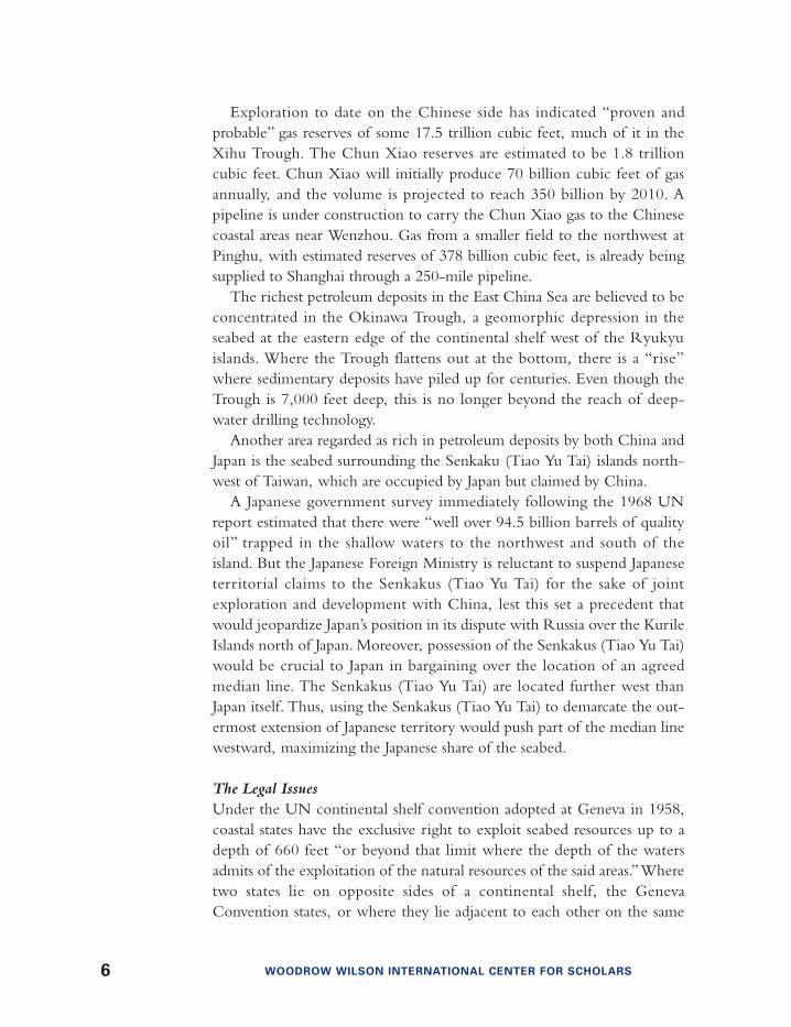
Exploration to date on the Chinese side has indicated “proven andprobable” gas reserves of some 17.5 trillion cubic feet, much of it in theXihu Trough. The Chun Xiao reserves are estimated to be 1.8 trillioncubic feet. Chun Xiao will initially produce 70 billion cubic feet of gasannually, and the volume is projected to reach 350 billion by 2010. Apipeline is under construction to carry the Chun Xiao gas to the Chinesecoastal areas near Wenzhou. Gas from a smaller field to the northwest atPinghu, with estimated reserves of 378 billion cubic feet, is already beingsupplied to Shanghai through a 250-mile pipeline.
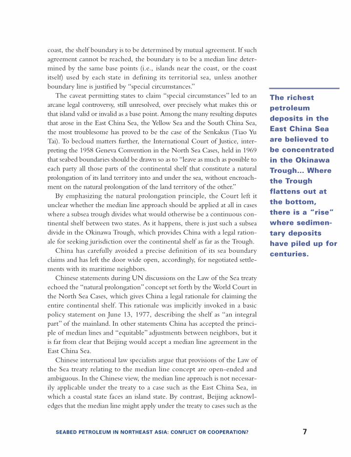
The richest petroleum deposits in the East China Sea are believed to beconcentrated in the Okinawa Trough, a geomorphic depression in theseabed at the eastern edge of the continental shelf west of the Ryukyuislands. Where the Trough flattens out at the bottom, there is a “rise”where sedimentary deposits have piled up for centuries. Even though theTrough is 7,000 feet deep, this is no longer beyond the reach of deep-water drilling technology.
Another area regarded as rich in petroleum deposits by both China andJapan is the seabed surrounding the Senkaku (Tiao Yu Tai) islands north-west of Taiwan, which are occupied by Japan but claimed by China.
A Japanese government survey immediately following the 1968 UNreport estimated that there were “well over 94.5 billion barrels of qualityoil” trapped in the shallow waters to the northwest and south of theisland. But the Japanese Foreign Ministry is reluctant to suspend Japaneseterritorial claims to the Senkakus (Tiao Yu Tai) for the sake of jointexploration and development with China, lest this set a precedent thatwould jeopardize Japan’s position in its dispute with Russia over the KurileIslands north of Japan. Moreover, possession of the Senkakus (Tiao Yu Tai)would be crucial to Japan in bargaining over the location of an agreedmedian line. The Senkakus (Tiao Yu Tai) are located further west thanJapan itself. Thus, using the Senkakus (Tiao Yu Tai) to demarcate the out-ermost extension of Japanese territory would push part of the median linewestward, maximizing the Japanese share of the seabed.
The Legal Issues Under the UN continental shelf convention adopted at Geneva in 1958,coastal states have the exclusive right to exploit seabed resources up to adepth of 660 feet “or beyond that limit where the depth of the watersadmits of the exploitation of the natural resources of the said areas.”Wheretwo states lie on opposite sides of a continental shelf, the GenevaConvention states, or where they lie adjacent to each other on the same
6 WOODROW WILSON INTERNATIONAL CENTER FOR SCHOLARS
coast, the shelf boundary is to be determined by mutual agreement. If suchagreement cannot be reached, the boundary is to be a median line deter-mined by the same base points (i.e., islands near the coast, or the coastitself) used by each state in defining its territorial sea, unless anotherboundary line is justified by “special circumstances.”
The caveat permitting states to claim “special circumstances” led to anarcane legal controversy, still unresolved, over precisely what makes this orthat island valid or invalid as a base point. Among the many resulting disputesthat arose in the East China Sea, the Yellow Sea and the South China Sea,the most troublesome has proved to be the case of the Senkakus (Tiao YuTai). To becloud matters further, the International Court of Justice, inter-preting the 1958 Geneva Convention in the North Sea Cases, held in 1969that seabed boundaries should be drawn so as to “leave as much as possible toeach party all those parts of the continental shelf that constitute a naturalprolongation of its land territory into and under the sea, without encroach-ment on the natural prolongation of the land territory of the other.”
By emphasizing the natural prolongation principle, the Court left itunclear whether the median line approach should be applied at all in caseswhere a subsea trough divides what would otherwise be a continuous con-tinental shelf between two states. As it happens, there is just such a subseadivide in the Okinawa Trough, which provides China with a legal ration-ale for seeking jurisdiction over the continental shelf as far as the Trough.
China has carefully avoided a precise definition of its sea boundaryclaims and has left the door wide open, accordingly, for negotiated settle-ments with its maritime neighbors.
Chinese statements during UN discussions on the Law of the Sea treatyechoed the “natural prolongation” concept set forth by the World Court inthe North Sea Cases, which gives China a legal rationale for claiming theentire continental shelf. This rationale was implicitly invoked in a basicpolicy statement on June 13, 1977, describing the shelf as “an integralpart” of the mainland. In other statements China has accepted the princi-ple of median lines and “equitable” adjustments between neighbors, but itis far from clear that Beijing would accept a median line agreement in theEast China Sea.
Chinese international law specialists argue that provisions of the Law ofthe Sea treaty relating to the median line concept are open-ended andambiguous. In the Chinese view, the median line approach is not necessar-ily applicable under the treaty to a case such as the East China Sea, inwhich a coastal state faces an island state. By contrast, Beijing acknowl-edges that the median line might apply under the treaty to cases such as the
SEABED PETROLEUM IN NORTHEAST ASIA: CONFLICT OR COOPERATION? 7
The richestpetroleumdeposits in theEast China Seaare believed tobe concentratedin the OkinawaTrough… Wherethe Trough flattens out atthe bottom,there is a “rise”where sedimen-tary depositshave piled up forcenturies.

Tonkin Gulf and Yellow Sea, where states contiguous on the same landmass can invoke the “natural prolongation” doctrine.
Japan has attempted to push its base points for a median line as far to thewest as possible on the shelf by claiming the status of “special circum-stances” for the Senkaku islands (Tiao Yu Tai), in the southern part of theEast China Sea, and for two other uninhabited islets, Danjo Gunto andTori Shima, in the northern part. Both of these are on the western side ofthe Okinawa Trough, however, and in order to win recognition of theseclaims, Japan would have to prove that it is entitled to “jump” the Trough.The argument advanced by Japan is that the seabed between the Ryukyusand the mainland is a common prolongation of both Japanese territory,i.e., the Ryukyus, and of the Chinese mainland. Thus, it is argued, Japan’sjurisdiction extends past the Trough to the median line.
China’s formal position has long been that the Ryukus themselves arepart of the prolongation of the mainland, and that the shelf ends, and theocean floor begins, on the eastward side of the Ryukyus. Both sides treatthe Trough as a geomorphic depression in the shelf, not a geologicalbreach. As a practical matter, however, given Japanese sovereignty over theRyukyus, Beijing has not pressed this claim recently. Instead, Beijingfocuses on where the eastern edge of the shelf should be demarcated if itacknowledges that the shelf does end to the west of the Ryukyus. On thiskey point, Beijing argues that the shelf embraces not only the westerndownward slope of the Trough but also the “rise” where the slope flattensout at the bottom.
Paths To CooperationChina has carefully kept its options open in the East China Sea.Repeatedly, Beijing has offered to negotiate joint development arrange-ments in contested areas. At the same time, however, it has continued toassert the “natural prolongation” principle, which makes it difficult, if notimpossible, to reach agreement with Japan on the location and demarca-tion of joint development zones.
The papers prepared for the Beijing workshop on Seabed Petroleum inthe East China Sea, some of which are presented in this report, underlinethe wide gap in the Chinese and Japanese approaches to the goal of jointdevelopment zones and suggest possible ways of narrowing this gap. Theworkshop discussions did not attempt to adjudicate the complex andintractable legal issues that underlie this divergence. The participantsfocused instead on proposals for practical immediate measures that wouldforestall conflict and move the two sides step by step toward cooperative
8 WOODROW WILSON INTERNATIONAL CENTER FOR SCHOLARS
petroleum development. There was a broad consensus that the economicneeds of the two countries should be given priority and that the resolutionof Law of the Sea issues and of the territorial conflict over the Senkakus(Tiao Yu Tai) should be deferred in order to make joint development pos-sible. As Masahiro Miyoshi and Keun-Gwan Lee pointed out in theirpapers, China and Japan did give priority to their immediate economicneeds when they concluded the Sino-Japanese Fisheries Agreement ofNovember 11, 1997. The fishing accord established agreed fishing zones inlimited but substantial areas of the East China Sea, sidestepping the still-unresolved Sino-Japanese conflict over the boundaries of the “exclusiveeconomic zones” envisaged in the 1982 Law of the Sea Treaty.
The Japanese government has already demarcated petroleum develop-ment concessions in seabed areas on its side of the hypothetical medianline and has authorized designated Japanese companies to operate in theseareas when and if a seabed agreement is reached with China—or whenTokyo decides to start exploring without an agreement, as it has done inthe waters opposite Chun Xiao.
In his revealing paper, Susumu Yarita, managing director of one ofthese companies, Uruma Resources, which has a concession area embrac-ing the Senkakus and adjacent areas immediately to the north of the dis-puted islands, provides a hitherto-unpublished account of Uruma’s secretnegotiations over the past two decades on possible cooperation with theChina National Offshore Petroleum Corporation (CNOOC).
As Yarita explains in his paper and as Chinese participants in the work-shop agreed, the two sides are not far apart on the modalities for setting upcooperative arrangements for exploration and for an equitable division ofthe spoils of development. What has impeded agreement is the conflictbetween Japan’s desire for a joint zone that straddles the hypothetical medi-an line, embracing areas on the Chinese as well as Japanese side of the line,and China’s position that the zone should be limited to areas on theJapanese side of the line.
China bases its position on the argument that only the area on theJapanese side is “disputed,” since under the median line concept, Japandoes not dispute China’s authority on its side of the line, while China doeslay claim to the seabed on the Japanese side under the “natural prolonga-tion” principle.
Chinese participants emphasized this argument during the workshopdiscussions on how to demarcate a joint development zone that wouldembrace Chun Xiao. Japanese and other non-Chinese participants pro-posed a zone that would straddle the median line, covering the entire area
SEABED PETROLEUM IN NORTHEAST ASIA: CONFLICT OR COOPERATION? 9

on both sides of the line encompassed by the geological structures thatChina has started exploring at Chun Xiao, Tianwaitian and Duanqiao. ButChinese participants heatedly rejected this approach, calling for a zonerestricted to the Japanese side of the line that would extend to the mid-channel line in the Okinawa Trough. As a compromise, some non-Chineseparticipants suggested an alternative: The zone would extend to the middleof the Trough, on the east, but it would straddle the median line on thewest. This, too, was rejected by the Chinese, but with less vehemence.
Lurking behind the Chun Xiao dispute is the fact that the “rise” at thebottom of the Trough may well contain the richest petroleum deposits inthe East China Sea. This is the underlying explanation for what wouldotherwise appear to be a completely unreasonable Chinese stance.Another complicating factor is that China has been exploring ChunXiao and surrounding areas for more than a decade. Beijing knows whatit would lose if it agreed to joint development with Japan and does notyet know whether there is enough petroleum on the Japanese side tomake joint development attractive.
In principle, both Chinese and non-Chinese participants agreed that itmakes sense to determine the extent and location of the petroleumresources to be developed before seeking to demarcate a joint developmentzone. But this principle is easier to apply in the Senkakus (Tiao Yu Tai),where neither side has done much exploration, than in Chun Xiao, whereChinese exploration is so far advanced. To the extent that cooperativeexploration can begin before discoveries are made, the participants con-cluded, the prospects for avoiding conflict will improve.
Most, but not all, participants reached a consensus that the Chineseand Japanese governments should authorize their oil companies to takethese steps:
• Conduct seismic surveys in areas envisaged for possible joint develop-ment, either separately or jointly
• Exchange data• Conduct joint evaluation workshops to review the data• Seek to negotiate the boundaries of exploration and development zones• Conduct exploratory drilling, separately or jointly• Negotiate the terms of production operations and profit sharing
In the absence of government support, it was agreed, efforts by oilcompanies such as those related in Yarita’s paper are unlikely to succeed.
10 WOODROW WILSON INTERNATIONAL CENTER FOR SCHOLARS

NEW OPPORTUNITIES IN THE YELLOW SEACompared to the high hopes for major petroleum discoveries in the EastChina Sea, China, South Korea and North Korea have adopted a moreguarded, wait-and-see attitude concerning the magnitude of the petro-leum resources in the Yellow Sea. The most optimistic predictions ofsignificant discoveries center on two areas: the Kunsan Basin in thesouthern Yellow Sea and the West Korea Bay Basin off the west coast ofNorth Korea.
Kook-Sun Shin, vice-president for exploration and production ofSouth Korea’s state oil company, the Korea National Oil Corporation,pointed in his paper to a promising geological structure (the SouthwestSub-Sag of the Kunsan Basin) that straddles the hypothetical median linewith China and has thus not yet been fully explored. North Korea, for itspart, has found evidence of significant seabed reserves near Anju. Theexploitation of these reserves could help to stabilize Pyongyang’s shakyeconomy. But jurisdictional conflicts with China, coupled with U.S.economic sanctions that block investment by Western companies, haveparalyzed exploration.
Tensions between China and South Korea over the Yellow Sea seabedstarted to develop soon after the 1968 UN survey mission report. Thereport was less ecstatic about petroleum prospects there than in the EastChina Sea but said that the Yellow Sea seabed and adjacent areas of theEast China Sea seabed had “great potential as oil and gas reservoirs.”
In April 1969, the Gulf Oil Company was awarded the first two con-cessions granted by Seoul to explore the Yellow Sea seabed. This was fol-lowed by Shell and Texaco concessions in January and February of 1970.
At first, China made little effort to interfere with the seismic surveyships that crisscrossed the Yellow Sea after Seoul had granted its conces-sions to foreign companies. As this survey work grew more intense, how-ever, Chinese naval craft began to harass survey vessels operating in apotentially disputed middle zone of the Yellow Sea.
In Chinese eyes, Seoul had acted provocatively by allocating conces-sions “unilaterally” without first reaching a boundary agreement withBeijing or Pyongyang or both. Beginning in 1971, China conveyed its dis-pleasure over these concessions by sending lightly armed fishing vesselsinto the vicinity of survey operations. The floating tracer cables used inseismic studies were systematically cut on at least four occasions. WhenGulf conducted drilling operations from February to June 1973, in one ofits two concession areas, Beijing escalated its response by dispatchingKomar-class gunboats. The Chinese boats appeared intermittently less than
SEABED PETROLEUM IN NORTHEAST ASIA: CONFLICT OR COOPERATION? 11

a mile from the Gulf drilling rig Glomar IV, remaining menacingly nearbyfor three days in early March.
This encounter was followed by a Chinese Foreign Ministry statementon March 15, 1973, attacking the drilling activities of Glomar IV as “thelatest step taken by international oil monopolies in their attempt to grabChina’s coastal seabed resources… The areas of jurisdiction of China andher neighbors in the Yellow Sea and the East China Sea have not yet beendelimited. The Chinese government hereby reserves all rights in connec-tion with the possible consequences rising therefrom.”
Seoul interpreted the reference to “China and her neighbors” as an indi-rect invitation to negotiate and responded promptly with a statement onMarch 16, 1973, offering to hold talks with “the authorities of the People’sRepublic of China on the question of the delimitation of the continentalshelf areas between the two countries.”But China maintained a stern silence,and six days later Gulf quietly capped the well it had been drilling and shift-ed its operations to a new site within the same concession zone. Finally, onJune 10, 1973, Gulf terminated its drilling. South Korea later created thestate-owned Korean National Oil Corporation, which has since drillednumerous wells in the Yellow Sea close to shore, avoiding disputed areas.
A report by Gulf geologists prepared for a technical conference in late1974 made it clear that the most promising parts of the zone in geologicalterms were the Kunsan Basin and the western Yellow Sea Subbasin, bothlocated at the western end of the concession area where Chinese andSouth Korean claims appeared to overlap. The report stressed that the two1973 wells have provided data covering only “a limited portion of thearea” and that a “considerable area remains to be tested by the drill.”3
From the outset Gulf knew in general terms that the most attractivestructures were located in the western portions of the areas involved andwere geologically linked with more extensive structures still closer toChina. Viewed in terms of international law, the issue at stake was whetherBeijing had a right to claim a group of four islands, located between 38and 69 miles from the Chinese coast, as appropriate base points for a medi-an line or whether the line should properly be drawn on the basis of threedifferent islands within 24 miles of the coast.
Kook Sun Shin’s paper, together with exchanges between Chinese andSouth Korean participants in the Yellow Sea workshop, confirmed whatGulf geologists had reported in 1974: that the most promising deposits inthe Kunsan Basin lie in an area that straddles the median line and has thusbeen off-limits to China and South Korea alike. Similarly, North Korea’sexploration of the seabed west of Anju has been constrained by a jurisdic-
12 WOODROW WILSON INTERNATIONAL CENTER FOR SCHOLARS
North Korea…hasfound evidence
of significantseabed reserves
near Anju. Theexploitation ofthese reservescould help to
stabilizePyongyang’s
shaky economy.
tional conflict with China that was acknowledged publicly for the firsttime by both Chinese and North Korean participants in the workshop.Even if the United States removes the sanctions that block investment byU.S. and U.S.-linked companies in North Korea, this conflict would con-strain exploration.
North Korean participants in the workshop did not quantify the pos-sible extent of Pyongyang’s seabed reserves, but on a subsequent visit toPyongyang in April, 2005, Petroleum Ministry officials told me thattwo foreign consulting firms, Cantek of Canada and an affiliate ofNissho Iwai of Japan, had both estimated that there are potentialreserves of 12 billion barrels of oil in the seabed west of Anju. To illus-trate the inhibiting effect of boundary tensions with China on NorthKorea’s exploration of these reserves, a workshop participant noted thatthe Malaysian state oil company Petronas had concluded a concessionagreement with Pyongyang but had cancelled the agreement afterreceiving indications of Chinese displeasure. This was not disputed byNorth Korean participants and was later confirmed during my discus-sions in Pyongyang in 2005.
The Yellow Sea discussions on joint development zones produced sever-al ideas that went beyond the recommendations made by the East ChinaSea workshop. One was a suggestion by a Chinese participant for a perma-nent seabed commission with members from each of the three littoralstates adjacent to the Yellow Sea. The commission would begin as an advi-sory body and would gradually acquire increasing powers related to seabedboundary and joint development issues. Another proposal envisaged asequence of steps leading to petroleum production that differed from theEast China Sea recommendations.
The first five of the six conflict avoidance steps suggested by the EastChina Sea workshop would be the same in the Yellow Sea, one participantsuggested, but after the completion of exploration, there would be aneffort to negotiate a boundary settlement before the start of actual produc-tion. Once the location of petroleum deposits is known, it was argued, theprospects for a boundary settlement would improve. In the event of a set-tlement, or settlements, Beijing, Seoul and Pyongyang could assesswhether the nature and location of the geological structures involved makejoint development desirable or whether they prefer to conduct separateproduction operations. There was considerable support for this proposaland no expression of dissent.
The fact that Korea is divided into two states that are both committed tothe goal of reconciliation and eventual reunification poses issues that make
SEABED PETROLEUM IN NORTHEAST ASIA: CONFLICT OR COOPERATION? 13

the long-term resolution of seabed disputes more complicated in theYellow Sea than in the East China Sea.
Should the two Koreas negotiate separate seabed agreements withChina, or should they form a joint seabed development enterprise thatwould give Korea unified representation in boundary or joint developmentagreements, as one Korean participant suggested?
The workshop discussions left the door open for a joint approach. KeunWook Paik in his paper urges the two Koreas to discuss bilateral seabedpetroleum cooperation and to promote trilateral exchanges with Chineseoil officials and Law of the Sea experts.
Despite their recognition that the petroleum potential of the Yellow Seamight not rival that of the East China Sea, the participants in the YellowSea workshop ended their discussions on an upbeat note. The prospects forseabed agreements between China and the two Koreas are brighter thanbetween China and Japan, they agreed, for geological as well as geopoliti-cal reasons: There is no pot of gold yet apparent in the Yellow Sea, like the“rise” in the Okinawa Trough, to influence the calculations of the protag-onists, and there is no emotion-laden territorial conflict like the Senkakus(Tiao Yu Tai) dispute to frustrate a seabed compromise based on mutualeconomic advantage.
NOTES
1. K.O. Emery, “Geological Structure and Some Water Characteristics of the EastChina Sea and the Yellow Sea,” CCOP Technical Bulletin, (United Nations ECAFE,Bangkok) 2 (1969): 41.
2. “Basic Geophysical Exploration in 2004: The Interim Report on the Operation ofthe Interpretation of the ‘Northwestern Sea Area in Okinawa (3D)’,” Agency for NaturalResources and Energy, Ministry of Economy, Trade and Industry, Tokyo, February 18,2005. (Translation by Diane Oh).
3. Selig S. Harrison, China, Oil and Asia: Conflict Ahead? (Columbia University Press,New York, 1977), p. 131.
14 WOODROW WILSON INTERNATIONAL CENTER FOR SCHOLARS

SEABED PETROLEUM IN NORTHEAST ASIA: CONFLICT OR COOPERATION? 15
Seabed Petroleum in the East China Sea:Geological Prospects, Jurisdictional Conflictsand Paths to CooperationApril 12-13, 2004, Beijing, China
MODERATOR: SELIG S. HARRISONDirector, Project on Oil and Gas Cooperation in Northeast Asia, andSenior Scholar, Woodrow Wilson International Center for Scholars
ZHIGUO GAODirector General, China Institute for Marine AffairsState Oceanic Administration
ZHAO LI GUOGeneral Manager, Legal DepartmentChina National Offshore Oil Corporation
KEUN-GWAN LEEProfessor of International LawKonkuk University
YANG LIDeputy DirectorDepartment of Treaty and LawMinistry of Foreign Affairs, China
MIYOSHI MASAHIROFaculty of LawAichi University, Japan
Conference Participants

16 WOODROW WILSON INTERNATIONAL CENTER FOR SCHOLARS
CHOON-HO PARK Member, International Tribunal for the Law of the Sea, Hamburg,Germany; Distinguished Professor of International Law, KonkukUniversity
SUSUMU YARITA Managing DirectorUruma Resources Exploration Co, Ltd.
Seabed Petroleum in the Yellow Sea:Geological Prospects, Jurisdictional Conflictsand Paths to CooperationApril 15-16, 2004, Beijing, China
MODERATOR: SELIG S. HARRISONDirector, Project on Oil and Gas Cooperation in Northeast Asia, andSenior Scholar, Woodrow Wilson International Center for Scholars
KIM MYONG GILDeputy Director, North American DivisionMinistry of Foreign Affairs, Democratic People’s Republic of Korea
KIM TAE GILBureau of Economic DevelopmentMinistry of Foreign Affairs, Democratic People’s Republic of Korea
KEUN-GWAN LEEProfessor of International LawKonkuk University
YANG LIDeputy DirectorDepartment of Treaty and LawMinistry of Foreign Affairs, China
SEABED PETROLEUM IN NORTHEAST ASIA: CONFLICT OR COOPERATION? 17
KEUN WOOK PAIKRoyal Institute of International Affairs
CHOON-HO PARKMember, International Tribunal for the Law of the Sea,Hamburg, GermanyDistinguished Professor of International Law, Konkuk Univeristy
ZHANG HAI QIDirector, Department of Marine GeologyChina Geological Survey
KOOK-SUN SHINVice-President, Domestic Exploration and ProductionKorea National Oil Corporation
XIA YISHANResearch Fellow, China Institute of International Studies
The Working Papers prepared by the participants are presented in full onthe website of the Woodrow Wilson International Center for Scholars:www.wilsoncenter.org/asiapubs

18 WOODROW WILSON INTERNATIONAL CENTER FOR SCHOLARS
Choon-Ho ParkSEABED BOUNDARY ISSUES IN THE EAST CHINA SEA
Member, International Tribunal for the Law of the Sea, Hamburg, GermanyDistinguished Professor of International Law, Konkuk University
The Contending ClaimsBetween March 1969 and September 1970, altogether 11 seabed petrole-um blocks were unilaterally staked out by Japan, South Korea, Taiwan andOkinawa (which was still under United States administration). Thefour Japanese blocks and Okinawa’s one were claimed by private oil inter-ests, unlike South Korea’s two and Taiwan’s four by the respective govern-ments (Map 1).1
In staking out their respective unilateral claims, Japan applied themedian-line principle, and South Korea and Taiwan the so-called naturalprolongation of land territory principle. Inevitably, the claims overlappedwith one another to different extents.
The contending claims of the three claimants centered on the legal sta-tus of the Okinawa Trough, which lies parallel close to the east of theOkinawa Islands chain. Japan ignored the Trough as a limiting factor instaking out its claims, while South Korea and Taiwan invoked the 200-meter-depth criterion as defined in the Geneva Convention on theContinental Shelf of 1958, the Trough being much deeper than 200meters. Thus, the claims of South Korea and Taiwan extended to the westbank of the Trough.
In search of a breakthrough from what was otherwise likely to remainan endless legal scramble among the three claimants, they agreed to tryjoint development of mineral resources, leaving boundary demarcationaside for future negotiation.
Late in 1970, the three claimants had agreed to proceed with someform of joint development, when China came forward with a strongprotest. Later an informal agreement was reached between Japan and South
Selected Working PapersSeabed Petroleum in the East China Sea: Geological Prospects, JurisdictionalConflicts and Paths to CooperationApril 12-13, 2004, Beijing, China

SEABED PETROLEUM IN NORTHEAST ASIA: CONFLICT OR COOPERATION? 19
Korea to proceed with the scheme without Taiwan.Finally, Japan and South Korea signed two agreements in January
1974, one of them relating to their shelf boundary in the northern part ofthe Korea Strait (called Tsushima Strait in Japan) and the other relating tojoint development in the overlapping area (Map 2).2
The two agreements came into force in 1978. Based on the median-line
MAP 1: Unilateral Claims and Concession Areas in the Yellow Sea and the EastChina Sea, as of Sept. 1970
Source: Choon-Ho Park, “Oil Under Troubled Waters: The Northeast Asia Sea-Bed OilControversy,” Harvard International Law Journal, Vol. 14, No. 2, Spring 1993, p. 219.
20 WOODROW WILSON INTERNATIONAL CENTER FOR SCHOLARS
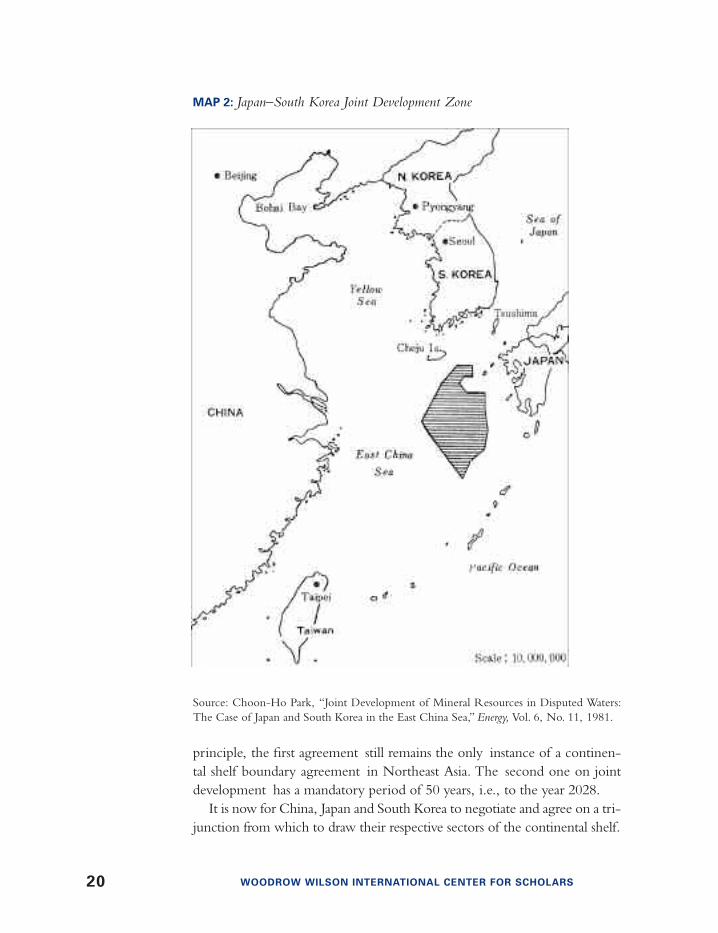
principle, the first agreement still remains the only instance of a continen-tal shelf boundary agreement in Northeast Asia. The second one on jointdevelopment has a mandatory period of 50 years, i.e., to the year 2028.
It is now for China, Japan and South Korea to negotiate and agree on a tri-junction from which to draw their respective sectors of the continental shelf.
MAP 2: Japan–South Korea Joint Development Zone
Source: Choon-Ho Park, “Joint Development of Mineral Resources in Disputed Waters:The Case of Japan and South Korea in the East China Sea,” Energy, Vol. 6, No. 11, 1981.

SEABED PETROLEUM IN NORTHEAST ASIA: CONFLICT OR COOPERATION? 21
In this paper, the author tries to identify critical legal issues with respectto the delimitation of the seabed boundaries among China, Japan andSouth Korea. For unavoidable reasons, no opinion is given on how or onwhat international legal criteria the issues should be finally settled amongthe three parties.
Legal IssuesOn a broad basis, four legal issues are relevant with respect to the demar-cation of shelf boundaries in the East China Sea.
1. The first issue has to do with the applicability of the naturalprolongation of land territory principle, because, within 200 nauti-cal miles from the coast, this criterion would appear to have beensuperseded by the new regime of the 200-mile exclusive economiczone (hereinafter “EEZ”).3
In other words, from the standpoint of Japan, it would appearthat, under the new law of the sea regime, the legal status of theOkinawa Trough could no longer be a limiting factor in thedemarcation of maritime boundaries in this particular area. Now, itis for the other two coastal states, namely, China and South Korea,to justify the legal grounds on which to sustain their common posi-tion vis-a-vis Japan.
2. The second issue is related to the status of the Japan–SouthKorea joint development agreement, which was signed and cameinto force before the 1982 UN Convention on the Law of theSea came into force for the three coastal states. The fact thatChina has been strongly opposed to the joint developmentscheme from the beginning would make it necessary, as a pre-requisite, for the three coastal states to agree on a boundarybetween China on the one side and Japan and South Korea onthe other.
3. The third issue concerns Japan and South Korea only. Their jointdevelopment scheme being not a boundary agreement, the twoparties have yet to agree on their shelf boundary within their com-mon sector. In this regard, the fact that most of the joint develop-ment zone happens to lie apparently on the Japanese side of whatwould likely be the median-line between the two states couldemerge as a critical legal point at issue.

22 WOODROW WILSON INTERNATIONAL CENTER FOR SCHOLARS
4. The fourth issue relates to the fact that South Korea has appliedthe median-line principle toward China in the Yellow Sea and thenatural prolongation of land territory principle toward Japan in theEast China Sea. It is now for South Korea to justify its applicationof two different criteria in the two Seas contiguous to each other.
Concluding RemarksIn the particular case of continental shelf boundary demarcation in theEast China Sea, the fact that the law of the sea itself has basically changedfrom the 1958 Geneva Conventions to the new Convention of 1982 hascaused seabed controversies which would otherwise have not arisen.
In other words, the median-line criterion as defined in the 1958Convention was superceded by the 1969 natural prolongation criterion,which in turn has been overtaken by the 200-mile EEZ regime. As aresult, it would appear that the applicability of the median-line criterionhas been revived.
NOTES
1. For further details with cartographic illustrations, see Choon-Ho Park, “Oil UnderTroubled Waters: The Northeast Asia Sea-Bed Controversy,” Harvard International LawJournal, Vol. 14, No. 2, Spring 1973, pp. 212-260.
2. For further details with cartographic illustrations, see U.S. Department of State,Bureau of Intelligence and Research, Office of the Geographer, Limits in the Seas, No. 75,Sept. 2, 1977 (contains the texts and maps of the two agreements); Choon-Ho Park,“Joint Development of Mineral Resources in Disputed Waters: The Case of Japan andSouth Korea in the East China Sea,” Energy, Vol. 6, No. 11, 1981; and Masahiro Miyoshi,The Joint Development of Offshore Oil and Gas in Relation to Maritime Boundary Delimitation,Maritime Briefing, Vol. 2, No. 5, 1999.
3. For further details, see Choon-Ho Park, “The Sino-Japanese-Korean Sea ResourcesControversy and the Hypothesis of a 2—Mile Economic Zone,” Harvard International LawJournal, Vol. 16, No. 3, Summer 1975, pp. 27-46.
Opinions expressed in this paper are strictly the author’s own, and do not reflectthose of the Tribunal in any way.

SEABED PETROLEUM IN NORTHEAST ASIA: CONFLICT OR COOPERATION? 23
Susumu YaritaTOWARD COOPERATION IN THE EAST CHINA SEA
Managing DirectorUruma Resources Exploration Co, Ltd.
The need to develop the hydrocarbon potential of the East China Sea isincreasingly critical for both Japan and China, not only to meet theirenergy requirements but, more broadly, to promote a climate of region-al economic stability that will reduce political and military tensions.Both sides clearly recognize this need and have periodically discussedthe possibilities for joint petroleum development since 1985. However,domestic political problems in both countries have blocked the successof these discussions.
I would like to review the basic facts relating to the jurisdictional dis-putes in the East China Sea before discussing what can be done to pursuethe goal of joint development.
The Position of Japan and China on the Territorial Dispute and theExclusive Economic Zone (EEZ)The Japanese government officially denies the existence of a disputebetween Japan and China concerning the Senkaku islands (Tiao Yu Tai),arguing that these islands have historically been ruled under Japanese law.China, for its part, has been claiming ownership of these islands since 1971and in 1992 promulgated the Law of the Territorial Sea, which declaredthe islands to be Chinese territory.
Regarding the Exclusive Economic Zone, the Japanese governmentclaims that the boundary of the EEZ of each country shall be a medianline. However, the Chinese government claims that the border of the EEZshall be the margin of the continental shelf, which extends far to the eastof the Japanese-claimed median line. Therefore, China has been insistingthat the area between the Japanese-claimed line and the Chinese-claimedline shall be considered a “disputed area.”
If the UN Law of the Sea clearly defines how to fix the boundary of theEEZ, then neither China nor Japan would have any margin to maneuver.But the status of the treaty remains unclear and inoperative.
History of the Joint Petroleum Development NegotiationsSince 1985, Japan and China have been discussing the concept of jointoperations in the East China Sea through various channels. Both basically

24 WOODROW WILSON INTERNATIONAL CENTER FOR SCHOLARS
agreed on the desirability of joint operations but had different views on thedemarcation of the area to be developed.
In 1985, Japex and China had been discussing the concept of jointoperations in the East China Sea. Teikoku Oil separately proposed to theChina National Offshore Oil Corporation (CNOOC) that joint seismicshooting in the East China Sea be undertaken to determine the geologicalprospects. The CNOOC was then nominated by the Chinese governmentto negotiate with its Japanese counterpart on possible joint operations inthe East China Sea.
In mid-1986, China proposed that the joint area must be located in thesouthern part of the East China Sea where Deng Xiao Peng had onceenvisaged a possible joint development area.
In late 1986, CNOOC proposed that if Japan agreed that the areaaround the Senkaku (Tiao Yu Tai) islands should be jointly developed,with territorial claims indefinitely suspended, China would be ready todiscuss joint operations. But at the same time it said that it was not ready todiscuss joint development in areas north of these islands, which Japaninsisted should be included in the joint area.
In mid-1987, CNOOC proposed to Uruma the specific latitudes andlongitudes within which a joint area could be established. However, thearea proposed was to be located only to the east of the median line: i.e.,E124° 00’ – E125° 00’ and N26° 20’ – N27° 50’. Uruma insisted that thejoint area should include an area to the west of the median line and pro-posed that an expert meeting be held to discuss how to define such ajoint area.
In early 1988, Uruma held discussions with CNOOC and proposedadoption of these basic concepts with respect to the proposed joint areas:
• Neither should raise the issue of the ownership of the Senkaku (TaioYu Tai) islands
• Japan should not raise the issue of the median line
• China should not raise the issue of the continental shelf margin as thebasis for its seabed jurisdiction
China countered that the proposed joint area must be limited to an arealocated to the south of N28° and requested that Uruma provide the entirefunding for the joint operations to be conducted.
In mid-1988, a Japanese mission consisting of representatives of Japex andthe Japan National Oil Corporation (JNOC), both government-sponsoredentities, met with officials of the Chinese government and of CNOOC.
SEABED PETROLEUM IN NORTHEAST ASIA: CONFLICT OR COOPERATION? 25
The mission proposed a 100,000 km2 joint area straddling both sides ofthe median line. The area was to be divided into blocks, with joint explo-ration work conducted gradually on a 50-50 basis.
China commented that both sides should invent some measures toavoid possible arguments on the ownership of the Senkaku (Tiao Yu Tai)and the EEZ. China then expressed these ideas on what such measuresshould be:
• China would float a tender for the areas located to the west of themedian line where they have envisaged joint operations. Japanese par-ticipation in such a tender would be most welcome.
• The “disputed area” based on the Japanese-claimed EEZ would besuitable for joint operations.
In early 1989, a CNOOC delegation visited Japan and explained thatdomestic problems were impeding progress on initiating joint operations.The delegation said that the Ministry of Foreign Affairs, Ministry ofGeology and Mines and CNOOC had different positions on joint opera-tions in the East China Sea. The CNOOC officials made clear that aJapanese government approach to top Chinese officials concerning jointoperations would be highly appreciated because CNOOC itself was not ina position to raise the issue with its own high-level officials.
In early 1991, Uruma officials visited Beijing and learned the followingin discussions with CNOOC:
• Chinese officials and CNOOC thought that the Japanese counterpartsin negotiations on joint operations should be the same as thoseappointed by the Japan National Oil Corporation in the 1988 negoti-ations and should have the appropriate high-level standing.
• Regarding the scope of the joint area, China would still like to stick tothe southern part of the East China Sea to start with.
• Regarding the southern part, China would like to leave it untouchedfor about ten years.
In May, 1991, a CNOOC delegation visited Japan and met JNOC offi-cials, who said that even if joint operations were to start from the south,there should be an understanding that the north would also be developedjointly, and that the two governments should agree on an overall frame-work for joint operations, including the area to be covered. CNOOC

26 WOODROW WILSON INTERNATIONAL CENTER FOR SCHOLARS
claimed that if Japan insisted on raising such basic principles once again,negotiations would be set back to where they were in 1987.
Uruma later learned that Chinese exploration and production opera-tions in the East China Sea were being conducted at that time separatelyby CNOOC and the Ministry of Geology and Mines. CNOOC wasresponsible in the southern part and Geology and Mines in the northernpart. Thus, even though China had nominated CNOOC as the officialnegotiator with Japan on joint operations in the East China Sea, CNOOCdid not actually have the authority to negotiate concerning the north.
Since time had been consumed without any progress in negotiations,China finally decided to act unilaterally and floated an international tenderin 1992 covering part of the area that had earlier been proposed to Japan asthe joint area. Japex and Teikoku Oil decided to participate in this tenderand were awarded a few blocks. However, their results were miserable.There was no indication in those blocks of the existence of hydrocarbons.
After this failure, the dialogue on joint operations stopped, and bothsides decided to await the outcome of official negotiations on theSenkakus (Tiao Yu Tai) and EEZ before resuming dialogue on joint oper-ations. Japan and China have continued negotiations on these issues butwith no progress.
In June, 2001, Uruma representatives met CNOOC officials in Tokyoand reopened dialogue. CNOOC claimed that the ball regarding jointoperations was already in the Japanese court. Uruma found later thatChina had made an approach to JNOC and that JNOC, unknown toUruma, had replied that matters in which sovereignty is involved shouldbe handled by the two governments. This led CNOOC to give up pursu-ing the issue.
In October, 2001, Uruma representatives met with CNOOC in Beijingand discussed practical proposals to permit joint operations. I will outline thediffering concepts in these discussions in Section 3. Despite such discussionsand the best efforts of the private sector in Japan to find ways to make thingsmove, this will take a long time because the two governments must firstdecide how to handle the issues relating to territorial sovereignty.
Conflicting Concepts of Joint Development
Japanese Concept:The joint area should be an area which includes areas on both sides of themedian line. In the western part, China would hold a 51 percent stake andJapan 49 percent. In the eastern part, China would hold a 49 percent stake
SEABED PETROLEUM IN NORTHEAST ASIA: CONFLICT OR COOPERATION? 27
and Japan 51 percent. Chinese law shall apply in the west and Japanese lawin the east.
Chinese Concept:China and Japan should each hold an undivided 50 percent interest in theoverall area covering both sides of the median line. Neither Chinese norJapanese law shall apply in this area. Both governments shall agree on newgoverning rules to be applied to the joint operations.
The Japanese and Chinese Rebuttal
Japanese Rebuttal:The Japanese stand that Chinese law shall apply in the western area andJapanese law in the eastern area would lead to arguments over where eachlaw shall apply because the demarcation of the two areas could wellbecome a subject of contention given the unresolved territorial issue.
Chinese Rebuttal:Even though the Chinese concept envisages a joint area covering bothsides of the median line, in which neither Chinese nor Japanese law shallapply, China wants Japanese companies to secure exploration rights underJapanese mining laws as a prerequisite for participation in joint operations.China also wants Japan to enact new laws stipulating that Japanese laws arenot applicable in the joint areas.
Paths to CooperationTaking into account the current difficulties and differences concerningjoint operations, as stated above, Japan and China should nonetheless seekto find a realistic way to achieve mutual cooperation. To this end, thoughwe can expect many problems ahead, we should continue to maintain dia-logue. Through such continuous dialogue, we can deepen mutual under-standing and may find a realistic solution.
Following are examples of possible cooperative steps that Japan andChina could take:
Data Exchange: SINOPEC, CNOOC, JNOC and Japanese privateentities are in possession of indigenous seismic data relating to the EastChina Sea seabed. Although this data is the property of those who haveconducted the seismic surveys, it would, nevertheless, be worthwhile toexchange this data so that both parties can better understand the potentialof the East China Sea and lay the basis for future cooperation.

28 WOODROW WILSON INTERNATIONAL CENTER FOR SCHOLARS
Workshop: After such an exchange of data, both sides should conductindependent assessments of the data and then hold a workshop to reviewthe results of these assessments and to evaluate them.
Joint Seismic Shooting: Both sides should propose possible areas for seismicshooting spreading across both sides of the median line. If both can agree onan area, joint shooting should then be conducted with the results made avail-able to both sides. A workshop should then be held to evaluate these results.
Joint Exploration and Production Activities: Regarding 1, 2 and 3,CNOOC may initiate contacts and propose these steps to JNOC and/orJapanese private companies. Such an initiative would be most realisticwhen both governments have agreed on territorial issues and the demarca-tion of each EEZ. When 1, 2 and 3 have been carried out, both sidesshould propose areas within which joint exploration and production proj-ects can be implemented.
* * *
Although I am not an expert on international law, I sincerely hope that theUN Law of the Sea Treaty will be reactivated and put into effect on a pri-ority basis. This would greatly facilitate the resolution of seabed jurisdic-tional issues in the East China Sea. We must search positively for a realisticway to solve the East China Sea dispute on a basis that might contribute tothe resolution of disputes between other countries that face each other insimilar geographical circumstances.
The basic concept in arriving at such a solution should be that eachcountry can have an EEZ extending up to 200 nautical miles and that thisconcept shall supersede the continental shelf concept.
Four principles should then be applied to reach a solution:
• If the distance between facing countries is less than 400 nautical miles,then the median line should be the border of the EEZ.
• If the distance between facing countries is more than 400 nauticalmiles, then each facing country can have an EEZ boundary up to 200miles from an agreed base point.
• If the distance between facing countries is less than 650 nautical milesand both countries have a continental shelf, then the median line shallbe the border of the EEZ. If one country has a continental shelf, thatcountry shall respect the other country’s 200 nautical mile limit, i.e.the EEZ of the country with the shelf shall be the balance of the arearemaining between the total distance and 200 nautical miles.

SEABED PETROLEUM IN NORTHEAST ASIA: CONFLICT OR COOPERATION? 29
• If the distance between facing countries is more than 700 nauticalmiles and both have a continental shelf, each can claim up to 350 nau-tical miles.
Zhao Li GuoSEABED PETROLEUM IN THE EAST CHINA SEA: GEOLOGICALPROSPECTS AND THE SEARCH FOR COOPERATION
General Manager, Legal DepartmentChina National Offshore Oil Corporation
Geological Structure of the East China SeaThe East China Sea is a semi-closed sea lying between the east bank of theChinese mainland and the Pacific Ocean. It connects with the Yellow Sea onthe north, from the north of the Yangtze River estuary to the Jeju Island ofSouth Korea; on the south, with the South China Sea from the Nan’aoIsland of Guangdong Province and the south of Taiwan Island; and on theeast is separated from the Pacific Ocean by Kyushu Island of Japan, theRyukyu Archipelago and Taiwan Island. The East China Sea has a total areaof about 770,000 square kilometers with average water depth of 370 meters,of which the continental shelf covers 460,000 square kilometers with aver-age water depth of 72 meters. The seabed terrain of the East China Seamainly consists of the continental shelf and the Okinawa Trough Basin.
The continental shelf basin of the East China Sea is the largestCenozoic sedimentary basin in offshore China. It covers 2.4 million squarekilometers, consisting of, from north to south, Yangtze Trough, ZhedongTrough, Taipei Trough and Pengjiayu Trough. With a maximum sedimentthickness of over 10,000 meters, it is abundant in oil and gas resources.
Xihu TroughXihu Trough, located within Zhedong Trough, has an area of 43,000square kilometers with geological reserves of about 30 million tons ofcrude oil and 100 billion cubic meters of natural gas. Now the Pinghu oiland gas field is in operation. The natural gas cooperation program in XihuTrough of the East China Sea has five foreign contract areas covering22,108 square kilometers, three of which are exploration areas (12/21area, 20/14 area and 27/05 area) and the other two are development areas(Chunxiao Area and Baoyunting Area). The partners are the ChinaNational Offshore Oil Corporation (CNOOC), holding 30 percent of the

30 WOODROW WILSON INTERNATIONAL CENTER FOR SCHOLARS
shares, Sinopec 30 percent, Unocal Corporation 20 percent and Shell 20percent. The foreign companies shall bear the risk of prospecting the threeexploration areas, and the four partners shall develop the two developmentareas together according to their ratio of shares. CNOOC will be theoperator, and establish a joint management committee made up of thefour partners with the Star Oil Company of Sinopec Corporation as thefirst chair of the committee. The foreign partners shall pay compensationfor the resources that have been explored.
Lishui TroughThis is one of the main areas on which the fourth round of exploration isfocused. With an area of 14,700 square kilometers, it has been identifiedby the fourth round of cooperation with foreign partners as the troughwith the richest oil and gas reserves.
These conclusions have been reached concerning the Lishui Trough:
• One condensate gas field has been proven to reach the bottom line forcommercial production. In this field, the proved reserve of natural gasis 6 billion cubic meters.
• Two layers of Paleocene hydrocarbon source rock have been discov-ered, and the lower layer is richer than the upper one.
• There is a low risk in the lower trap assemblage.
• There are still structure traps in the lower assemblage of the Trough tobe drilled.
Yangtze River TroughThis trough covers 16,000 square kilometers, including an area of 11,820square kilometers covering the substructure unit of Jinshan Troughwhich is being explored with foreign cooperation. Compared with thenearby Xihu Trough, this area boasts the Paleocene source-reservoir-capassemblage. Current seismic data also show that there exist several largeareas of formation.
CNOOC plans to continue its cooperation with foreign companies toexplore the areas around Lishui Trough and Yangtze Trough.
China’s Position on Joint Development Efforts
Japan, South Korea and TaiwanA report released in 1969 by the Committee for the Coordination of JointProspecting for Mineral Resources in Asia Offshore Areas, which was set

SEABED PETROLEUM IN NORTHEAST ASIA: CONFLICT OR COOPERATION? 31
up by the United Nations Economic Commission of Asia and Far East in1966, indicated that the continental shelves between Taiwan and Japan areprobably one of the most prospective oil and gas reserve areas in the world.Subsequently, Japan, South Korea and the Taiwan authorities all respec-tively declared seabed exploration and development boundaries delimitedby themselves. The three sides discussed jointly developing the oilresources of the East China Sea, and proposed establishing a private com-pany for developing the East China Sea in order to avoid boundary issues.The Chinese side made a protest against it and pointed out that the estab-lishment and activities of such a joint company violated the interests andrights of China. With strong opposition from the Chinese side, theTaiwanese authorities retreated from the joint development, and the threesides’ joint development attempt failed.
Japan and South KoreaIn June 1972, Japan and the Republic of Korea (ROK) started to draft abilateral agreement on joint development. China’s Ministry of ForeignAffairs stated, “according to the principle of natural prolongation of con-tinental shelves, it is up to China to consult with relevant countries todecide how to delimit the continental shelves of the East China Sea. Theestablishment of a joint development zone by Japan and the ROKinfringes China’s sovereignty. The Japanese side admitted that China hadnot been consulted. Nevertheless, in June, 1978, South Korea and Japanexchanged instruments of ratification, the agreement came into effect, andthe Chinese side made a strong objection once again.
China and Japan China and Japan both claim territorial sovereignty over Diaoyu Island, anddiverge greatly on the delimitation of the East China Sea. The Chineseside maintains that the delimitation should be in accordance with the prin-ciple of equality and the principle of natural prolongation of continentalshelves, while the Japanese side stands for the principle of a median line. Inview of the situation, the Chinese leaders put forward the principled posi-tion of setting aside the dispute and pursuing joint development as early as1978, which received a positive response from the Japanese side. However,in August 1979, the Japanese side changed its position and proposed thatthe adjacent waters of Diaoyu Island should be excluded from the pro-posed joint development zone.
After the 1980s, the Japanese government started to discuss nongovern-mental seabed petroleum cooperation with the Chinese side in the East
32 WOODROW WILSON INTERNATIONAL CENTER FOR SCHOLARS
China Sea but continued to insist on excluding areas adjacent to DiaoyuIsland from the zone. The oil circles of the two sides reached an extensivecommon understanding concerning the contents of joint development,but still diverged greatly on how to locate the joint development area. TheJapanese side claimed that the joint development zone should straddle itsunilaterally proposed “median line,” and meanwhile rejected the inclusionof the adjacent waters of Diaoyu Island. The Chinese side claimed that thejoint development zone should be limited within the disputed areas of theEast China Sea, that is, the area between the Japanese-proposed medianline and the Chinese-proposed natural prolongation of continental shelves.For the Diaoyu Island, the Chinese side proposed setting aside the disputeon the territorial sovereignty of the island and jointly developing its adja-cent sea area. But the Japanese side refused to set aside the dispute on theDiaoyu Island, paralyzing relevant discussions.
Zhiguo Gao and Jilu WuKEY ISSUES IN THE EAST CHINA SEA: A STATUS REPORTAND RECOMMENDED APPROACHES
Director General, China Institute for Marine AffairsState Oceanic Administration
Research Fellow, China Institute for Marine Affairs
The Evolution of Seabed Petroleum Issues in the East China Sea Offshore oil and gas exploitation and development have grown throughoutthe world in recent decades due largely to two major factors. First, theadvance of science and new technology for the exploitation of oceanresources. Second, the demand for petroleum by the major industrializedeconomies. The demand for oil has also been witnessed in the East Asianstates that were also growing rapidly. This combination of factors led to theformation of the Committee for Coordination of Joint Prospecting forMineral Resources in Asian Offshore Areas (CCOP) under the auspices ofthe United Nations Economic Commission for Asia and the Far East(ECAFE) in 1966.
Late in 1968, a geophysical survey was conducted by CCOP in theYellow Sea and the East China Sea. It was reported in their report by thescientists that “a high probability exists that the continental shelf betweenTaiwan and Japan may be one of the most prolific oil reservoirs in the

SEABED PETROLEUM IN NORTHEAST ASIA: CONFLICT OR COOPERATION? 33
world. A second most favorable area for oil and gas is beneath the YellowSea.” This report caused a great sensation among the literal states. In thecase of the East China Sea, the immediate reaction of the coastal states wasto make conflicting claims of sovereignty over the oil-rich continentalshelf, often in the form of establishing unilaterally offshore concessionblocks and boundary limits.
Japan unilaterally asserted the principle that the shelf should be dividedon the basis of an equidistant median line, and following this principle,delineated four exploration blocks defined by the median line and theOkinawa Trough on the east. China claimed in December 1970 both sov-ereign rights over the continental shelf up to the Okinawa Trough and itsunderlying resources and the ownership of the Tiaoyutai Islands.
Japan and South Korea engaged in bilateral negotiations concerning dis-puted seabed areas that ended in the conclusion of a joint developmentagreement in January 1974. South Korea ratified this agreement inDecember 1974. But it was not until June 1978 that Japan finally ratifiedthe agreement.
The Korea-Japan Agreement The Korea-Japan agreement was concluded with no regard to Chineseclaims to sovereignty over the shelf up to the Okinawa Trough. The majorcontents and features of its 31 articles can be summarized as follows:
The Joint Development Zone. The Zone is the overlap of 24,092 squarenautical miles enclosed by the outer limits of each party’s claims to thecontinental shelf. Japan’s claim is based on the median-line toward Chinaand South Korea, and South Korea’s claim is based on the natural prolon-gation of land territory toward China and Japan. The Zone is divided intonine Subzones to be jointly explored and exploited by concessionairesnominated by both parties (Article III).
Nomination of Concessionaires. Each party is required to nominate a con-cessionaire or concessionaires for each Subzone within three months fol-lowing the coming into force of the agreement (Article IV).
Equality of Rights and Obligations. Each party is entitled to one-half ofthe proceeds recovered from each Subzone, and is also obligated to meetone-half of the expenses incurred for the recovery (Article IX).
Duration of Contracts. The rights of concessionaires comprise the rightsof exploration and the rights of exploitation. The rights of exploration aretenable for a period of eight years; and the rights of exploitation are ten-able for an initial period of 30 years, five-year extensions being possiblethereafter (Article X [1-3]).

34 WOODROW WILSON INTERNATIONAL CENTER FOR SCHOLARS
Commencement and Suspension of Operations. Concessionaires are requiredto commence operation within six months from the date on which therights of exploration or exploitation are granted, and operation may notbe suspended for longer than six months (Article XI1).
Measures for Prevention of Marine Pollution. Each party is required to takemeasures necessary for the prevention of collision at sea and marine pollu-tion with reference to the 1954 International Convention for thePrevention of Pollution of the Sea by Oil, as amended in 1962 and 1969.
Non-Interference with Other Uses of the Sea. Exploration and exploitationactivities are not to interfere with other uses of the superjacent waters,such as navigation or fishing (Article XXVII).
Non-prejudice Clause. It is stipulated that the agreement does not, in anyway, affect each party’s sovereign rights over the Joint Development Zoneor otherwise prejudice its stand with respect to the delimitation of the shelfboundary with the other (Article XXVIII).
Duration of the Agreement. The agreement is to remain in force for a peri-od of 50 years, being subject to abrogation upon or following the expiry ofthis period. This provision notwithstanding, it is also subject to termina-tion by agreement between the parties should they recognize that the nat-ural resources are no longer economically exploitable in the JointDevelopment Zone (Article XXXI [2-4]).
China and Japan: Recent DevelopmentsAfter more than 30 years of periodic seabed controversies with no progressin the East Asian region in general and in the East China Sea in particular,the beginning years of the 21st century began to see positive develop-ments. This progress has been led by China and Japan in developing a“conflict avoidance” regime for the East China Sea where they have exten-sive overlapping claims. Two aspects of this regime merit attention as pos-sible precursors of future cooperation relating to seabed petroleum devel-opment: a joint fishing agreement and a prior notification scheme for sci-entific research.
Fisheries AgreementNegotiations for a new fisheries agreement between China and Japanstarted in 1996. In the process of the negotiations, China wanted a smallX factor and a larger joint management area than Japan, while Japan justwished for the reverse. Japan had wanted the eastern boundary of thejoint zone set at 127~ E. After seven rounds of negotiations, China andJapan finally concluded their new agreement in November 1997. The two

SEABED PETROLEUM IN NORTHEAST ASIA: CONFLICT OR COOPERATION? 35
countries agreed to establish three different zones where different fisheriesregimes apply.
Exclusive Fishing Zones. The exclusive fishing zones extend up to 52nautical miles from their respective baselines in the area between 27~ Nand 30~ 40’ N. Within this zone the principle of coastal-state jurisdictionapplies.
Fishing Quotas. If Japan or China does not have the capacity to harvest theentire allowable catch in their respective zones, as provided for in Article 62of the 1982 Law of the Sea Convention, each state can allow the nationalsand fishing vessels of other states to fish its EEZ in accordance with thisagreement and other related laws and regulations, based on the principle ofmutual interest. Every year Japan and China are to determine the quotas ofcatch, fishing areas, and other terms of fishing of the nationals and fishingvessels of other signatory states that are allowed to fish in its EEZ.
Joint Fisheries Commission. A Joint Fisheries Commission is set up as amanagement body to enforce the treaty. Its responsibility and functionsinclude making recommendations on matters relating to catch quotas andother terms and conditions of fishing operations for the nationals and fish-ing vessels of each signatory state in the other’s EEZ, on matters regardingthe maintenance of the fisheries order, and on matters relating to fisheriescooperation between the two states.
Conservation Measures. The Agreement also provides that each party maytake necessary measures in its EEZ in accordance with international law toensure that the nationals and fishing vessels of the other observe its conser-vation measures. To this end, each state is to immediately notify the otherstate to observe its conservation measures. To this end, each state is toimmediately notify the other state of its measures for the conservation ofthe marine living resources and other terms provided for in its domesticlaws and regulations.
Each state is to take appropriate measures to control its catch in order toavoid over-exploitation in the joint management area, taking traditionalfishing operations into consideration.
The parties also agreed to allow a total of 600 fishing boats from Chinaannually into its exclusive economic zone east of the “free” fisheries zone,while China agreed to allow 317 Japanese vessels into its EEZ to the westof the zone. These numbers are to be renegotiated each year.
The application of the fisheries agreement does not extend to the areasouth of 27~ N. The agreement is valid for five years (2000-2005) and afterthis period will continue to remain in effect until a six-month advancenotice of abrogation from either party terminates it.
36 WOODROW WILSON INTERNATIONAL CENTER FOR SCHOLARS
In summary, under the provisions of the agreement, each country willmanage its fisheries within 52 miles of its baselines; beyond 52 nm, andbetween 27º N and 30º 40’ No boats of the two countries may fish with-out prior approval of the other’s government. The area south of 27º Nincluding the area around the disputed Tiaoyutai islands remains excludedfrom the treaty coverage.
The Agreement is by nature provisional pending boundary delimitationof the EEZ and the continental shelf. The two states have committedthemselves to continue negotiating the boundary delimitation in goodfaith, so as to reach an agreement. However, both China and Japan havemade it clear that the provisions of the Fisheries Agreement do not affecttheir positions on other legal matters, including the issue of disputedislands and boundary delimitation of their EEZs and the continentalshelves.
The Agreement adversely affects the fishermen of both countries. Morethan 17,000 Chinese fishing boats will be unemployed, affecting 170,000fishermen, and the Chinese fish catch is expected to be reduced by a mil-lion tons a year in Zhejiang Province alone.
Although this bilateral agreement is a step in the right direction, theagreement may be said to have a number of inherent inefficiencies includ-ing its ambiguity of third party application. The fact that boats from othercountries and regions also fish in the East China Sea is a complication,since it is not clear whether the joint management areas are with the EEZof Japan and South Korea. Moreover, there is no effective dispute settle-ment mechanism built into the Agreement. Nevertheless, this shortcom-ing will not offset its merits toward the building of a transitional bilateralregime governing fishing activities in overlapping areas.
Notification on Scientific Research Entering the 21st century, China and Japan began to encounter a new sortof issue: incidents relating to research vessels in the areas of overlappingclaims in the East China Sea. The two nations agreed on August 31, 2000to negotiate an agreement for advance notification of such “surveys” byeither party. The first working level meeting was held in Beijing onSeptember 15, 2000. Finally, on February 13, 2001 China and Japanagreed on a mutual prior notification system.
The Agreement cleverly avoids specifying any line beyond whichadvance notification is required. It simply says that China is to give Japan atleast two months’ notice when its research ships plan to enter waters “nearJapan and in which Japan takes interest” and that similarly, Japan is to
SEABED PETROLEUM IN NORTHEAST ASIA: CONFLICT OR COOPERATION? 37
inform China before its vessels enter waters “near” China. The notificationmust include the name of the organization conducting the research, thename and type of vessels involved, the responsible individual, the details ofthe research such as its purpose and equipment to be used, the plannedlength of the survey, and the areas to be surveyed.
Findings and Policy SuggestionsThe East China Sea is perhaps one of the most complicated marine areasanywhere in the world in terms of its overlapping claims, sovereign dis-putes over islands and boundary delimitation. No progress has beenachieved in negotiating bilateral maritime boundaries over a long period of35 years. The existing marine policy regimes are weak and frequently inef-fective.
Significantly, the unilateral maritime claims made in Northeast Asianseas in general and in the East China Sea in particular have traditionallybeen inexplicit. This practice has either intentionally or unintentionallyserved as a buffer for conflict avoidance. Despite the lack of precise defini-tion of bilateral marine boundaries, incidents and friction have been min-imal because the governments of the states concerned have tried to controlthe extent of petroleum development activities by pursuing them solely inmarine areas that clearly belong to them. For instance, the coastal stateshave generally refrained from oil and gas exploration in the East China Seaexcept in non-disputed sections of the continental margin.
Of the controversies over islands and boundary delimitation, the mostcontentious issue is beyond any doubt sovereignty over the Diaoyudaiislands. It is China’s consistent position and policy that Diaoyudai islandsbelong to China since time immemorial. Japan also claims these uninhab-ited features and has attempted to re-enforce its claim by actual control.
To shelve disputes and pursue joint development in overlapping areashas been China’s consistent policy and position over the last two or threedecades. On November 11, 2003, it was announced that China and thePhilippines signed an agreement of intention to jointly develop oil and gasresources in the South China Sea. The agreement provides that the twoparties shall proceed to set up a Joint Working Committee to: look forblocks suitable for exploration; study and examine geological and otherrelevant data and information; and prepare together the work program.This agreement represents a major breakthrough by China in the bilateralrelations with its neighbors. It may well serve as a paradigm for resolvingthe issues in the East China Sea.
To move forward, the littoral states should work closely on confidence-

38 WOODROW WILSON INTERNATIONAL CENTER FOR SCHOLARS
building measures, and avoid steps that increase mutual suspicion andcloud their political relations. In the longer term a partial or comprehen-sive resolution of the current dilemma in terms of island disputes andboundary delimitation is necessary to minimize the danger of conflict andpromote regional peace and security.

SEABED PETROLEUM IN NORTHEAST ASIA: CONFLICT OR COOPERATION? 39
Keun Wook PaikNORTH KOREA AND SEABED PETROLEUM
Royal Institute of International Affairs
North Korea faces a serious shortage of petroleum that has crippled bothits industrial and its agricultural development. This has been and remainsthe driving force that has impelled the Pyongyang authorities to pursuecomprehensive exploration of both onshore and offshore areas withinNorth Korean territory.
In this paper, I will focus on the search for offshore, or seabed,petroleum, while putting this search into the perspective of onshoreefforts. First, I will briefly review efforts to find and develop oil and gasresources in the Yellow Sea, where the seabed boundary has not been set-tled among the littoral states. Second, I will touch on the characteristics ofseabed geology in the Yellow Sea. Third, I will note the unsettled charac-ter of the boundary issues in the Yellow Sea, and finally, I will propose acooperative approach on the part of the littoral states to resolve thesethorny boundary issues.
Exploring the Seabed:A Brief ReviewFor the past five decades, North Korea has made serious efforts, in vain, tofind and develop petroleum resources. This effort has been divided intofour stages:
1960s: Preparation for Exploration In 1965, North Korea established the “Administration Bureau of FuelResources and Geological Exploration.” The first extensive geophysicalexploration was done jointly with China from 1965 to 1980. In 1967,North Korea conducted a joint geological study with the Soviet Union inthe Tumen estuary. On top of this, North Korean scientists conducted
Selected Working PapersSeabed Petroleum in the Yellow Sea: Geological Prospects, Jurisdictional
Conflicts and Paths to CooperationApril 15-16, 2004, Beijing, China

40 WOODROW WILSON INTERNATIONAL CENTER FOR SCHOLARS
MAP: North Korea and East Asian Basins
SEABED PETROLEUM IN NORTHEAST ASIA: CONFLICT OR COOPERATION? 41
their own geophysical studies along the coastal seabed of the East andYellow Seas.
1970s:The First Foreign ContactsIn 1976, North Korea sent a delegation to the Soviet Union to study off-shore exploration methods in the Caspian Sea. In 1977, North Koreasigned a protocol with Asia Exploration Consultants (AEC) of Singaporeregarding oil exploration and development, but this never went beyondthe protocol stage. In September, 1979, the first limited seismic work wasundertaken in the Yellow Sea with Soviet assistance, and the Yugoslaviannational oil company INAP was awarded the right to conduct seismicstudies in a 15,000 square kilometer area of the central Yellow Sea.
1980s: Exploration Work BeginsIn 1980, a contract was signed with the Norwegian firm GECOGeophysical, a subsidiary of Schlumberger, to survey Blocks, 1, 2 and 3.The exact location of these blocks has not been disclosed.
In 1981, GECO initiated a 2,000 kilometer seismic survey in the cen-tral portion of West Korea Bay within the INAP zone.
During this period, China also carried out a seismic survey of the west-ern Korea Bay, including areas near or straddling the boundary. Two west-ern-designed jack-ups drilled close to the border in 1980. Some minor oiland gas discoveries were apparently made in the same region earlier, andthe structures in question continue across the boundary into North Koreanjurisdiction. This was why China was interested in assisting North Korea inits exploration efforts. However, both sides left the demarcation issueunsettled, and there have been no reports of Chinese participation inNorth Korea’s offshore exploration and development since the second halfof the 1980s.
In October 1983, a “Crude Oil Exploration Bureau” was establishedunder the Cabinet.
North Korea secured an exploration drilling ship (14,000 tonnes level)from Singapore and initiated the exploration work in the seabed adjacentto Nampo on its east coast.
In 1986, North Korea signed an agreement with the Soviet Union ona “North Korea Soviet economic zone and continental shelf boundary”and decided to develop the continental shelf jointly with Moscow. Boththe Far Eastern Division of the Soviet Academy of Sciences and thePyunsung division of North Korea’s Academy of Sciences undertook astudy on North Korea’s coastal geological structure and untapped
42 WOODROW WILSON INTERNATIONAL CENTER FOR SCHOLARS
resources, and found signs of oil from Heungnam offshore. But no fur-ther progress was made.
In 1987 Leeward petroleum (UK) signed a contract with North Koreafor exploration projects.
Reportedly North Korea discovered 425 barrels a day of crude oil inZone C in the Yellow Sea at the end of 1988 with the help of anAustralian company, Meridian Oil NL, which made a contract withNorth Korea covering the western Korea Bay on July 31, 1987. It was alsoreported that North Korea confirmed gas reserves in the Heungnam area.
1990s: Foreign Investment IncreasesIn 1993, North Korea upgraded its Crude Oil Exploration Bureau to theMinistry of Crude Oil Industry. Then during April, 1994, the SupremePeople’s Assembly adopted a resolution pledging “to increase the invest-ment in the crude oil industry for upgrading the industry related equip-ment and concentrating on exploration of the promising areas and findingmore crude oil reserves.”
Meridian Oil. The first western company that obtained an explorationlicense in North Korea was Meridian Oil NL of Australia in 1990.Meridian was formerly part of the Independent Resources Ltd (ILR)group, which acquired control of Beach Petroleum NL, Adelaide, and itsthen parent company, Claremont Petroleum NL. Until the late 1980s,Claremont owned part of the interest in the West Korea Bay acquired byMeridian. Meridian Oil’s seismic data was sent to a processing center inLondon but North Korea failed to pay for the processing. As a result,North Korea failed to get the data back and re-advertised the concession.European and Australian companies were invited to examine prospectsafter North Korea’s Ministry of National Resources Development draftedframework laws governing production sharing contracts.
Taurus Petroleum. Taurus Petroleum AB decided to take the permits in1992, without knowing of Meridian’s earlier activity.
In February 1993 Taurus Petroleum AB signed a PSA with ZosonSulbi(North Korea Equipment), a state trading firm that acts on behalf of theMinistry of Energy. The agreement provides for a five-year explorationperiod, extendable by a further three years on payment of US$ 1 million.The agreement provides for North Korea to secure a rising share of pro-duction in proportion to the level of output, starting at 55 percent of pro-duction. Like Meridian Oil, no taxes or signature bonuses are payable, andTaurus Petroleum has 100 percent ownership rights. Basically Taurus tookover the old Meridian blocks.

SEABED PETROLEUM IN NORTHEAST ASIA: CONFLICT OR COOPERATION? 43
The exploration phase is divided into four periods. The first period (2years extendable to December 1998) required reprocessing and interpreta-tion of the earlier seismic shot by GECO, together with acquisition andprocessing of new seismic carried out in 1997.
Under the PSA, the firm was required to drill one well in the secondperiod of the exploration phase at an approximate cost of US$7 millionand then one more well in each of the two succeeding years.
Beach Petroleum. In 1974, Beach Petroleum’s new management accept-ed an offer to acquire permits to explore the two other concessions (pre-sumably these are just above the Block C in the Taurus concession. Thesewere located above the old Meridian blocks, now let to TaurusPetroleum AB, Stockholm, and the whole East Sea side. BeachPetroleum decided to take the option on the east side, covering approxi-mately 29,000 square kilometers.
Beach Petroleum signed a 25-year Production Sharing Agreement(PSA) with Zoson Sulbi. This consists of a five-year exploration periodand a twenty-year production period. No taxes or signature bonuses arepayable, with the exception of a production payment bonus that becomespayable if a certain level of production is reached.
Beach Petroleum’s PSA with North Korea was similar to that ofMeridian, with the share determined on a sliding scale based on total out-put from the concession.
In 1997 Beach Petroleum farmed out a 25 percent interest to aMalaysian company, Puspita Emas, in return for financing the costs ofshooting 1,000 kilometers of additional seismic in July, 1997. The firmalso reprocessed 7,000 line kilometers of seismic shot during the Sovietperiod and evaluated data from the two wells drilled (the two wells con-firmed oil shows).
In total, Beach Petroleum has identified eight prospects and nine leads.These include buried hill structures, with a potential up to 500 million–1billion barrels. Beach Petroleum’s studies reveal that the onset of oil gener-ation is likely to occur in the Lower and Middle Miocene sediments atsubsurface depths of below 2,100 meters.
SOCO International. In May 1998, SOCO International, a London-based exploration and production company spun off from Snyder Oil ofFort Worth, Texas, decided to take the third concession.
The PSA covers an exploration area of 7,000 kilometers, two thirdsoffshore and one third onshore in the Anju and Onshon basins. Theterms of the PSA agreement Soco International has signed required anoutlay of US$350,000 for five years to determine whether further inves-

44 WOODROW WILSON INTERNATIONAL CENTER FOR SCHOLARS
tigation is warranted. Information concerning the progress made to dateis not available.
The First Onshore Concession: Sovereign VenturesIn September, 2001, it was reported that Sovereign Ventures Pte. Ltd.(SVPL), Singapore, was seeking experienced partners to explore anddevelop the first onshore oil and natural gas concession in DPRK to begranted to a foreign company. The concession was awarded by KOEC andit covers some 6,000 square miles or about five miles of North Korea’slandmass. Known as PSCA Techon-rajin, it is on the Chinese border acrossthe Tumen River in the northeastern part of the Korean Peninsula andsouthwest of Vladivostok, Russia.
According to Ben Tan, executive vice president of SVPL, which wasformed in 1993 as the upstream subsidiary of the Korasia group, the conces-sion provides for an initial three-year testing period for geophysical explo-ration, a two-year exploration drilling stage and if successful, 20 years fordevelopment and production. No corporate tax will be applicable during thefirst five years of operations. During the following two years, company prof-its are to be taxed at 5 percent, escalating to 10 percent after that. Extensionof the concession agreement can be negotiated on mutually agreeable terms.
SVPL aims at investing at least US$10 million in the total project,including at least US$2 million in the seismic testing and exploratorydrilling stages. SVPL estimates that the concession area’s recoverablereserves are well in excess of 150 million barrels of oil or its equivalent ingas. SVPL anticipates a 30 percent success rate in exploration drilling andup to 70 percent success with development drilling.
In August, 2002, SVPL announced that it had found oil and gas reservesin the contracted area and expects to be able to recover a minimum of onetrillion cubic fact of natural gas and 10 million barrels of oil from the con-cession area.
The Aminex DealOn September 19, 2004, The Observer reported that “Aminex, the Britishoil minnow listed on the Dublin stock market, has clinched a deal with thegovernment of North Korea to explore and develop all the country’spotentially oil-bearing territory, with a decisive say in production… Thedeal—signed secretly in Pyongyang during the summer—gives Aminex20-year rights over the industry, via a joint venture with the government.It has also negotiated the right to reserve royalties, revenues and the pick ofthe best acreage should it prove productive.”

SEABED PETROLEUM IN NORTHEAST ASIA: CONFLICT OR COOPERATION? 45
A more detailed interview story by the Financial Times revealed the char-acteristics of the deal:
The North Koreans proposed to draw the contract up under Swisscommercial law. It was finally signed in Pyongyang in June in the presenceof the British ambassador… Under the agreement, Aminex will providetechnical assistance such as analyzing seismic data and introducing foreigninvestment in return for a share of future production and royalties. Thecompany also has the right to cherry-pick and drill wherever it considerspromising and is eyeing an area off the western coast.
If these reports are correct, the deal is extremely good for Aminex,which lacks the capacity to make a real investment for exploration, but isterribly bad for North Korea, exemplifying its inability to attract a reliableWestern energy firm with adequate capital to conduct its offshore explo-ration. Unless, as Aminex hopes, it is able to find bigger companies to joinwith it, the Aminex deal could prove to be an obstacle rather than a facil-itator for offshore exploration.
Characteristics of North Korea’s Offshore GeologyNorth Korean exploration and production activities, both onshore and off-shore, have leaked out to the outside world only to bits and pieces. Little isknown about the true scale of the offshore potential, but it is apparent thatNorth Korea has high expectations for an eventual offshore breakthrough.
One of the few systematic presentations concerning North Korean off-shore geology to surface outside the country came in an October 7th,1997, seminar titled “Explanatory Meeting For Hydrocarbon ExplorationOpportunities Offshore DPR Korea,” organized by North Korean andJapanese promoters in Tokyo. Dr. Dong R. Choi, a geologist of Koreanancestry, based in Australia and a technical adviser for Petrex Co. Ltd.,Tokyo, presented a summary of the massive survey logs on North Korea’soil formations. In this seminar, the characteristics of North Korea’s off-shore geology were summarized as follows:
West Korea Bay (exploration area: 18,600 square kilometers)The basement made of thick carbonate rocks (5,000 meters) of the LatePreterozoic and Early Paleozoic is overlain by the Mesozoic (6,000–10,000meters) and Cenozoic (4,000–5,000 meters) sediments. Source rocks arethe Jurassic black shale (3,000 meters or more), Cretaceous black shale(1,000–2,000 meters), and pre-Mesozoic–Cenozoic sandstone with highporosity and pre-Mesozoic fractured carbonate rocks. Petroleum traps areanticline, fault-sealed, buried hills and stratigraphic types.

46 WOODROW WILSON INTERNATIONAL CENTER FOR SCHOLARS
Existing exploration data: 4,500 kilometers of integrated geophysicalsurveys with grid of 2 x 4 kilometers. Seven wells have been drilled,recovering oil and gas from several wells and hydrocarbon shows from allof the wells.
Korea East Sea (exploration area: 30,000 square kilometers)Pre-Mesozoic gneiss and carbonate rocks are overlain by the Mesozoic andCenozoic sediments, 6,000–7,000 meters in thickness. A source rock is theTertiary thick marine shales (1,500 to 2,000 meters) and underlyingMesozoic rocks. Reservoir rocks are Tertiary sandstone of a good reservoirphysical property and fractured carbonate rocks which constitute the base-ment. Trap structures—anticline, fault-sealed, buried hill, facies-sealed,stratigraphic types and reefs.
Existing exploration data—Integrated geophysical surveys with a grid of10 x 20 kilometers throughout the basin, with a grid of 2 x 2 kilometersover some parts. Two wells drilled, oil and gas shows found from both wells.
Until a comprehensive exploration is made, any suggested figure on thepotential hydrocarbon reserves carries no weight at all. According to ShinDong-A, however, Dr. Bu-Seop Park, MIT educated nuclear physicist andwho has been on working on DRPK offshore exploration since mid-1990s, argued that North Korea has five oil deposit zones in the WesternSea, off Nampo, South Pyongnam province.
Dr. Park said the estimated oil reserves of the first zone are 65 milliontonnes, those of the second, third and fourth fifth are 50 million tonnes,30 million tonnes, a small amount of oil, and 10 million tonnes respec-tively. It is worth noting among these five zones North Korea is giving pri-ority to developing the field in the third zone. (Source: “DPRK has 12Mil. Barrels of Oil Reserves in Western Sea,” http://www.hartford-hwp.com/archives/55a/161/html) As both the China National OffshoreOil Corporation (CNOOC) and Korea National Oil Corporation(KNOC) have the exploration technology and financial capacity to deter-mine the extent and location of these reserves, the exploration of theYellow Sea, including North Korea’s West Korea Bay, is a matter of time,once the thorny offshore boundary is settled.
The Yellow Sea Boundary IssuePetroleum development in the Yellow Sea is currently dormant as theexploration has never reached to the areas of uncertain jurisdiction. Underthe current situation, even a preparatory attempt to figure out any exis-tence of hydrocarbon resources could trigger the kind of claims and coun-
SEABED PETROLEUM IN NORTHEAST ASIA: CONFLICT OR COOPERATION? 47
terclaims that have been witnessed in other parts of Asia. However, theYellow Sea coastal states will have no choice but to exploit offshoredeposits in disputed areas at some point.
What is needed for the Yellow Sea coastal states is the wisdom of a win-win strategy. To find a solution that can be equally applied to the boundarydispute between North Korea and China, and South Korea and China isvery difficult.
If China maintains the silt-line principle based on the concept of thenatural prolongation of the continental shelf or alternatively claims anexclusive economic zone (EEZ) extending from Haiyang Island, 69 kilo-meters off Liaodong Peninsula, problems could arise. A boundary alongthe silt line would give almost the entire Korea Bay Basin to North Korea,whereas if the equidistant-line boundary were applied, only a small podof possible oil bearing sediment would lie on the North Korean side ofthe line.
When it comes to the Yellow Sea boundary issue between South Koreaand China, the focus of the argument is different. The silt line boundary inthe Yellow Sea would place the entire basin on the Chinese side of theline. If the boundary was the equidistant line, most of the basin would beon the Chinese side but half a pod of potentially oil bearing sediment,including a tip of the area with the best prospects, would be on the SouthKorean side.
In autumn 2003, Interfax China reported that China is conductingactive surveying and prospecting for marine energy deposits, includingthose of the highly efficient “combustible ice,” in the northern Yellow Seaand part of the East China Sea. Qingdao Institute of Marine Geology(QIMG), under the auspices of China’s Ministry of Land and Resources(MLR), confirmed that geophysical analysis under the sea had alreadyindicated the presence of hydrocarbon deposits. However, fearing theprospect of a territorial dispute with Japan and the South Korea, especial-ly in the North Yellow Sea, the Chinese government has been carryingout the program discreetly, said the official of the QIMG, who would notdiscuss the progress made by prospectors in the area.
A rumor in the oil industry in Korea is that the Malaysian state oil com-pany Petronas was planning to undertake an exploration work somewherein the area initially allocated to Soco International in early 2004 but decid-ed not to pursue the work due to the Chinese-North Korean boundarydisputes. This confirms that the boundary issue is a major obstacle toexploration work in the West Korea Bay.
48 WOODROW WILSON INTERNATIONAL CENTER FOR SCHOLARS
The Case for CooperationWith exploration underway both onshore and offshore, it is clear that NorthKorea is increasingly serious about oil and gas exploration. The most promis-ing possibilities for major oil and gas discoveries appear to lie in the seabed,but until comprehensive exploration is carried out, the magnitude of thispotential will remain unknown. North Korea faces seemingly intractablepolitical obstacles, facing as it does a continued impasse in relations with theUnited States that has so far discouraged big-name, reliable Western compa-nies from making exploration commitments to Pyongyang. Until the nuclearcrisis is peacefully and completely settled, it will be very difficult to attractWestern investment in North Korea’s search for petroleum.
Pending a resolution of the impasse with the United States, the mostpromising course for North Korea lies in cooperation with South Korea andChina, specifically cooperation between North Korea’s Korean OilExploration Corporation (KOEC), South Korea’s Korean National OilCorporation (KNOC) and the China National Offshore Oil Corporation(CNOOC), which are responsible for continental shelf exploration anddevelopment and concessions with foreign companies in the three countries.
In May, 2000, SOCO and Taurus, acting for North Korea, invitedKNOC and South Korea’s giant conglomerate, Hyundai, to form a con-sortium for oil and gas exploration in the Yellow Sea. Hyundai estimatedthe Block B and C reserves to be around 100 million–1 billion barrels,based on exploration to date. The firms saw that the economics of explo-ration in the West Korean Bay can be justified if a minimum discovery of40-50 million barrels reserves is made. They wanted to apply for SouthKorean government funds for exploration and planned to take the nextstep after the June, 2000, Summit meeting, but received no encourage-ment from Seoul, and no significant step was taken after the Summit.
Another abortive cooperative effort occurred in May, 2004, when NorthKorea’s KOEC proposed to South Korea’s KNOC a group meeting to dis-cuss cooperative exploration in the Yellow Sea. A media leak in South Koreaangered North Korea and led to cancellation of the proposed meeting.
To date, KNOC and KOEC have never met to discuss adopting a com-mon approach to resolving the Yellow Sea boundary issue with China and tocooperating in exploration and development. Such contacts and, better still,a tripartite meeting between the two Korean oil enterprises and CNOOC,are increasingly urgent. The North and South should first adopt a commonapproach to China in resolving the boundary issue. The three should thenwork together to resolve this issue and proceed to joint exploration anddevelopment in one of the least explored offshore areas in the world.

SEABED PETROLEUM IN NORTHEAST ASIA: CONFLICT OR COOPERATION? 49
The real question is whether Seoul, Pyongyang and Beijing are ready totake the first step toward cooperation by having a face to face meeting tobreak the present deadlock.
Zhang Hai QiOIL AND GAS EXPLORATION AND DEVELOPMENT IN THEYELLOW SEA
Director, Department of Marine GeologyChina Geological Survey
With ever increasing demands for resources caused by global economicdevelopment, there has been a severe shortfall in petroleum resources onland. Therefore, men have turned their eyes to the sea that is rich in oil andgas potential.
Geographically, the Yellow Sea is encompassed by the coasts of China’sLiaoning Province, Shandong Province and the northern part of Jiangsuprovince as well as the Korean Peninsula. It is separated from the Bohai Seaby Miaodao Island and Chanshan Island in the northwest and joins theEast China Sea in the south with a shared line linking Qidong Mouth onthe Yangtze River Estuary and Jeju Island of the Republic of Korea(ROK), covering an area of around 380,000 square kilometers. The YellowSea is divided into two sections by the line linking Chengshan Mount onthe Shandong Peninsula and Baengnyeongdo Island to the west of theKorean Peninsula, namely the South Yellow Sea and the North YellowSea, covering an area of 80,000 square kilometers and 300,000 square kilo-meters respectively.
The Yellow Sea waters include both the North Yellow Sea Basin andthe South Yellow Sea Basin with a number of Mesozoic and Cenozoicsedimentary basins in its neighboring area. The basin group in the NorthYellow Sea waters is comprised of the Anju Basin near the West KoreanBay, the Bohai Bay Basin, the Jiao-Lai Basin and the Yanbian-Yanji Basinin the Yalu River Area. As for the basin group in the South Yellow Seawaters, it mainly includes the Northern Basin of the South Yellow Sea, theSouthern Basin of the South Yellow Sea, the Northern Jiangsu Basin, theMountains Basin and the Heishan Basin.
The Current State of Exploration in the North Yellow Sea The Democratic People’s Republic of Korea (DPRK) conducted large-

50 WOODROW WILSON INTERNATIONAL CENTER FOR SCHOLARS
scale geophysical prospecting and drilling work in the eastern part of theNorth Yellow Sea Basin with the purpose of identifying oil and gasresources. In 1980, the DPRK started to mark some zones in the easternsection of the North Yellow Sea and opened the marked sections to inter-national tenders in an effort to cooperate with western oil companies in oiland gas exploitation. As a result, several oil wells were drilled in the area.
The DPRK carried out quite a number of studies into the geologicalcondition of the oil reserves in the central and eastern part of the NorthYellow Sea Basin, such as the formation and evolution of the basin, its stra-tum structure, its tectonic and sedimentation characteristics as well as itscombination of sluice reservoir and covering rock.
In general, exploration by the DPRK in the central and eastern part ofthe North Yellow Sea Basin has reached a high level and the DPRK isspeeding up the exploration and exploitation of oil and gas resources in thearea. Some of the DPRK’s exploration work is carried out in areas overwhich China and the DPRK have a dispute.
The Current State of Exploration in the South Yellow Sea In 1968, a scientific research ship of the U.S. Navy, Hunter, conducted aseismic magnetic survey in the Yellow Sea and drew sections of four majorareas. In 1969, U.S. oceanographer K.O. Emery and his colleagues issued aresearch paper, The Geographical Structure and Hydrological Features of the EastChina Sea and The Yellow Sea, which acknowledged that oil and gas mightexist in the sedimentary basins in the Yellow Sea.
On January 1, 1970, the ROK formulated a law on the development ofseabed mineral resources and identified concession zones. The legal princi-ple applied in defining the concession zones was based on a “median line”presumed unilaterally by the ROK. However, considering the lack ofdelimitation of an agreed maritime boundary in these zones, the two sideshad disputes over the exploration end exploitation of oil and gas resourcesin the area.
The U.S. Gulf Oil Corporation was the first company to win an off-shore petroleum mining concession from the ROK, even though part ofthe western section of the area reaches to Chinese waters. In disregard ofpolitical troubles, Gulf Corporation was rather hasty in launching explo-ration in the concession zones and drilled two test wells from February toJune in 1973. In response, the Chinese government issued a statement onMarch 15, 1973, opposing the move of the ROK.
On March 16 of the same year, the ROK issued a statement expressingits willingness to negotiate with China over delimitation of maritime
SEABED PETROLEUM IN NORTHEAST ASIA: CONFLICT OR COOPERATION? 51
boundaries. However, given the situation then existing, it was impossiblefor the Chinese government to negotiate with the ROK government. GulfOil Corporation was put in an embarrassing position. On the one hand,there was the pressure from ROK calling for continued drilling, and onthe other strong opposition from China. Moreover, the U.S. StateDepartment also asked Gulf to shift its operations to areas close to the coastof the Korean Peninsula. Therefore, while the company had to cap the twowells drilled, it had no intention to withdraw from the concession zones.
The aftermath of the dispute over the Yellow Sea lingered on for yearsuntil 1976. In 1975, J.B. Harrison, General Manager of Zapata ExplorationCompany, Gulf Oil Corporation’s small partner, decided to take the U.S.administration’s advice and quit the controversial operation. In April 1977,with the expiration of the two concession contracts, Gulf Oil Corporationofficially abandoned the two concession areas. Besides Gulf Oil, two otherforeign oil companies, Shell and Texaco also acquired concession zonesfrom the ROK. Exploration was conducted for some time, but the out-come was not so positive. Upon protests by the Chinese government, thetwo companies immediately stopped their exploration activities.
It is reported that in recent years, the ROK has reactivated its exploita-tion of oil and gas resources in the South Yellow Sea waters. However, dueto the fact that the maritime boundary between China and the ROK inthe South Yellow Sea is yet to be delimited, disputes still exist in terms ofthe oil development zones in the South Yellow Sea. At present, China hasconducted some oil and gas prospecting in the western section of theSouth Yellow Sea. The results of these researches and studies suggest thatthere might be a certain amount of oil and gas reserves in the NorthernBasin and the Southern Basin of the South Yellow Sea.
Kim Myong GilSEABED PETROLEUM AND THE ECONOMIC DEVELOPMENTOF THE D.P.R.K.
Deputy Director, North American DivisionMinistry of Foreign Affairs, Democratic People’s Republic of Korea
Our people are now firmly rallied around the great leader, Comrade KimJong Il, to make strenuous efforts to activate and develop the nationaleconomy. The most essential prerequisite for developing the economy is

52 WOODROW WILSON INTERNATIONAL CENTER FOR SCHOLARS
petroleum development, and the exploration and development of petrole-um in our West Sea seabed is of great importance.
In addition to the petroleum sector, for making the economy active, weare concentrating on the overall renovation of technology and the devel-opment of science and technology. We are giving priority to the electric,coal and metal industries while attaching importance to the developmentof light industry and agriculture. As a result, the overall economy, whichhas been in difficulty since the late 1990s because of continuing naturaldisasters, is being gradually activated.
In accordance with the changed circumstances and conditions and theconcrete reality of our country, we have adjusted the structure of theeconomy and continue to improve and perfect the methods of economicmanagement on the principle of gaining maximum benefits.
Two years ago, new prices were applied to all commodities and we arenow applying new criteria for the salaries of the working people based onthe principle of giving favor to the producers. At the same time, we havetaken a measure to replace the former farmers’ market with the compre-hensive market for all consumers.
As an example of the high priority given to petroleum, we organized aseparate state agency for petroleum development and mobilized appropri-ate personnel to begin the oil exploration.
Because of lack of experience in oil exploration and development, thegovernment of the Republic has attached importance to cooperation withother countries from the beginning. Cooperation with other countriesbegan in the early 1980s.
A number of firms of many countries expressed interest in the oil devel-opment of our country and practical cooperation was realized with severalamong them. We conducted 2,000 meter x 2,000 meter geophysical sur-veys in the East Sea and West Sea jointly with the companies of the SovietUnion, Czechoslovakia and Norway.
After that, Swedish and Australian companies also did surveys. The sur-vey data and seismic tapes were analyzed for us by oil exploration anddevelopment companies and experts from Austria, Singapore,Netherlands, Japan, France and Denmark reviewed many survey data andanalyzed seismic geophysical survey tapes. This review and analysis gave usthe conviction that there is the possibility of seabed oil deposits.
Initially, we did only regional surveys of 2,000 meters x 2,000 metersbut failed to do detailed surveys of 1,000 meters x 1,000 meters or 500meters x 500 meters. So we were not able to define the concrete oilreserves.
SEABED PETROLEUM IN NORTHEAST ASIA: CONFLICT OR COOPERATION? 53
On the basis of the lessons learned from our early experience, we con-cluded long term contracts for detailed exploration and development withthe Australian Meridian Company in July, 1987, and with the SwedishTaurus Company in February, 1993. We authorized them to conduct explo-ration and development in specific areas that they wanted at their disposal.
For example, Taurus was able to conduct seismic surveys and somedrilling in an area that covered 9,278 square kilometers of a concessionblock known as C District located below latitude 39º.
This exploration and the analysis of its seismic data showed that theseabed basin of sediments had big oil deposits and the potential for thecommercial development of petroleum. However, cooperation with othercountries could not be carried to its completion and as a result we have notbeen successful in the commercial development of oil.
There were several reasons for the failure of cooperation with othercountries. First of all, the political element was there. Cooperation wasaffected by the hostile policy and hindering acts of the non-friendly coun-tries, including the United States.
These countries put a brake into cooperation between our country andother countries for oil development. In particular, the United Statesaggravated the situation of the Korean peninsula by fabricating thenuclear issue, thus making the investors of other countries nervous ininvesting into our country.
Certain companies that were related with the U.S. said that they couldnot complete the cooperation with us because the U.S. government didnot give them the necessary licenses. The hostile forces also hindered theinternational monetary institutions and private lending companies fromfurnishing funds to those companies that were cooperating with us.
Another reason why the cooperation was not completed was that thecapability of the entities themselves was not sufficient. Their financial,technical and equipment standards were not high enough.
For example, the Swedish Taurus was capable until the explorationstage but could not but call off the cooperation because it could not findappropriate partners.
The maneuvers of the United States and other hostile forces that are nothappy with the petroleum development in our country are still being con-tinued. Nevertheless, we will attach importance to the petroleum develop-ment and will actively push ahead with all the work that we can internally.
In December, 2003, the General Bureau of Oil Industry in the Ministryof Natural Resources was elevated to the status of a separate Ministry ofPetroleum.
54 WOODROW WILSON INTERNATIONAL CENTER FOR SCHOLARS
At the same time, we will actively encourage cooperation with anyother countries that have a sincere interest in cooperation with us. We arewilling to provide them with all the conditions and convenience in theiractivities.
The oil development in our country will be beneficial not only to ourcountry but also to our neighbors and those countries that offer coopera-tion. They could purchase, at a good price, crude oil and petroleum prod-ucts initially processed by the abundant labor of our country.
We are convinced that petroleum development in our country will bepracticable through friendly cooperation with the countries and peoplesthat wish tension reduction and stability in the Korean peninsula.
Kook-Sun ShinHYDROCARBON POTENTIAL OF THE YELLOW SEA KUNSANBASIN
Vice-President, Domestic Exploration and ProductionKorea National Oil Corporation
The Yellow Sea is surrounded by the mainland Chinese continent and theKorean peninsula. Two major sedimentary basins are situated in the YellowSea: The North and South Yellow Sea Basins. The basins developed in theNorth Yellow Sea from west to east include Jiaolai Basin, Bohai Bay Basin,the North Yellow Sea Basin in China and the West Korea Bay Basin inNorth Korea.
The South Yellow Sea Basin is subdivided into the Northern andSouthern South Yellow Sea Basins by a central uplift area. The NorthernSouth Yellow Sea Basin included the North Basin in China and KunsanBasin in South Korea, and the Southern South Yellow Sea Basin devel-oped the Subei Basin, the South Basin in China and the Heuksan Basin inSouth Korea. Commercial oil discoveries have been made in the BohaiBay basin, the Subei basin and the South Basin in China. However, nocommercial discovery has been made yet in the South Yellow Sea Basinsin South Korea.
Petroleum exploration in the South Yellow Sea in South Korea datesback to the 1970s and led to the awarding of exploration concessions toseveral international oil companies, Gulf Oil, Texaco, Marathon Oil andShell (Blocks I, II and III). These concession blocks cover approximately117,320 square kilometers. By 2004, a total of 33,784 L-km of 2D seis-
SEABED PETROLEUM IN NORTHEAST ASIA: CONFLICT OR COOPERATION? 55
mic data had been acquired in this area. Five wells were drilled. Most ofthe wells were drilled in the eastern portions of the Northern SouthYellow basin and the Kunsan Basin. So far no well has been drilled in theHeuksan Basin.
The sedimentary successions in the Kunsan basin can be subdivided intothree distinct tectono-stratigraphic units: Pre-Cretaceous, Cretaceous toEarly Tertiary (Paleocene), and Tertiary (Eocene to Plio/Pleistocene). TheLate Cretaceous and possible Paleocene shales are considered as the mostprobable source rocks in the basin, while the younger Paleocene andEocene fluvial-deltaic rocks appear to be the likely reservoirs.
This paper is mainly focused on the hydrocarbon potential of the Koreaportion of the Northern part of South Yellow Sea Basin—that is, theKunsan Basin.
Hydrocarbon PotentialSeveral of the previous wells drilled tested fairly substantial but relativelyyoung structural features. It is clear that these features postdate hydrocar-bon generation and migration in the basin and do not form effective traps.This is notably the case for the Kachi-1 well, which while testing substan-tial older, Cretaceous age strata, drilled a very young structure that is evi-dently still somewhat active. In other cases, the wells tested off-structure orwhere the structural trap may not have been present.
Regarding source rock, none of the five wells encountered favorablesection, although there are some indications that the maturity level neces-sary to generate hydrocarbons was reached in the area. The LateCretaceous and possible Plaeocene shales are considered the most likelysource rocks in the basin.
Finally, the issue of reservoir rocks must be addressed. The five wells allencountered shaley to interbedded, poorly sorted sands and volcanoclasticswhich would not be considered good reservoir material. However, thesewells were drilled in hindsight locations where the reservoir rock was lessfavorable to develop. This basin does have several areas that may have beenthe depocenters for well-sorted lacustrine sands in a lacustrine delta envi-ronment. Notably, two areas draw interest for further evaluation, namelythe East Sag and Southwestern Sub-sag. It is thought that these areas havenot been adequately tested.
East Sag The combination of the findings cited above lead to negative conclusionsconcerning much of the area. However, there are two areas in which the
56 WOODROW WILSON INTERNATIONAL CENTER FOR SCHOLARS
results of the previous five wells have not supplied the answers as to theexploration potential. The first of these lies in the vicinity of the Inga-1well. This well was drilled on an intra-basinal high and tested a Cretaceousfeature. However, the well encountered a thick Palecene section. Thisyounger section climbs from this location to the northwest-northeast andto the west. There is a potential for updip stratigraphic traps and somestructural traps along the margin of the east sag.
The stratigraphic play identified is a deltaic complex in the MiddleUpper Eocene. It transitions to a fan system on the west flank of the basin.The seismic data shows a delta build-up with focused point source deposi-tion on the basin margin that changes character and becomes thin into thebasin. Conversely, from the east the deposition is more line- sourced intothe basin. This pattern is similar to the pattern of half-graben depositionalpattern from the Subei-basin. This view offers a possibility that a similardepositional system with good source rock and reservoir rock potentialcould be developed in the basin.
Southwest Sub-Sag There are three structural traps in the Southwest Sub-sag area. They are alltraps in close proximity indicating similar source rock and reservoir poten-tial as well as trap timing. Play one is a downthrown three-way structuraltrap. At the top of the Paleocene horizon, this feature is a abroad south-westerly plunging nose with a small crestal four-way closure, cut by anorthwest to southeast, down-to-the-west fault. Displacement along thefault ranges from minimal, increasing to over 50 meters. The structure hasabout 200 meters height of structural closure.
Support for source rock potential is based on two possibilities. There is alocal source potential from the underlying Cretaceous section. The secondplay type is an upthrown three-way fault closure structural trap. At the top ofthe Paleocene horizon, this trap is a long yet narrow closure, highside to abifurcating down-to-the-northeast normal fault pair. The fault displacementranges from less than 50’ to over 250’ and the trap has about 150’ of structur-al closure. At the top of the Cretaceous horizon, the trap is bounded by a sin-gle down-to-the-northeast fault but the fault displacement is quite variable.
The third play in the Southwest Sub-sag area is an upthrown three-wayfault closure structural trap. At the top of the Cretaceous horizon this trapis a very elongated yet narrow closure, highside to a northwest to south-west trending normal fault with variable displacement. At the top ofPaleocene mapping horizon the structure is subdivided by a saddle, whichresults in two smaller but significant closures.

SEABED PETROLEUM IN NORTHEAST ASIA: CONFLICT OR COOPERATION? 57
ConclusionOn the basis of integrated analyses of the geological and geophysical dataof South Korea and China, the Kunsan Basin has a good condition to formlacustrine sand reservoir and source rocks, mainly with the LateCretaceous and Paleocene shale. The faults developed well in this area andthese faults could act as an important passage of petroleum migration.
Two areas of significant lead potential have been recognized in thisbasin. In both areas, they target the Upper Cretaceous and Lower toMiddle Tertiary sections.
The first of these lies in the designated East Sag. The Cretaceous andpossible Paleocene strata may provide both source rock and reservoir rockfor hydrocarbon potential in this moderate-sized basin. The secondprospective area is the structurally complex sub-basin downthrown to thenortheast of the Kachi-1 well in the Southwestern Sub-sag. This areaappears to have both an Upper Cretaceous and a Lower Tertiary sectionthat is found in both stratigraphic trapping and upthrown structural clo-sures within a series of down-to-the-northeast normal faults.
Note: This abridged version of Mr. Shin's paper omits his detailed geological analy-sis of the Yellow Sea.The full text of his paper may be consulted on the WilsonCenter website at www.wilsoncenter.org/asiapubs.

THE WOODROW WILSON INTERNATIONAL CENTER FOR SCHOLARSOne Woodrow Wilson Plaza
1300 Pennsylvania Avenue, NWWashington, DC 20004-3027
www.wilsoncenter.org