sealls house historic property study 2011 july
TRANSCRIPT
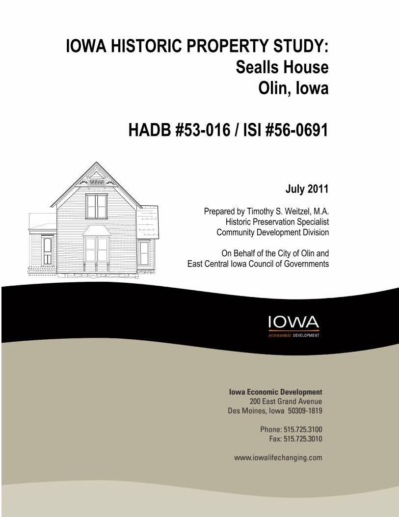
IOWA HISTORIC PROPERTY STUDY: Sealls House
Olin, Iowa
HADB #53-016 / ISI #56-0691
July 2011
Prepared by Timothy S. Weitzel, M.A. Historic Preservation Specialist
Community Development Division
On Behalf of the City of Olin and East Central Iowa Council of Governments

Iowa Historic Property Documentation Study
Sealls House
HADB #53-016
Iowa Site Inventory #53-00691
Timothy S. Weitzel, M.A.,
Historic Preservation Specialist
Iowa Department of Economic Development, Community Development Division
A Mitigation Treatment
Supplemental Disaster Recovery Community Development Block Grant Home Acquisition Program
on behalf of
City of Olin, Iowa
The 24 CFR Part 58 Responsible Entity
July 2011

PREFACE
SEALLS HOUSE HISTORIC PROPERTY
(Interpretive Summary)
The Sealls House located at 208 E. Locust Street, Olin, Iowa was constructed approximately in 1895 or
within a few years of that date. The house exhibits distinctive features in some of its decorative elements,
ready-made and shipped to Olin and applied as decoration according to the tastes of the owner and
builder of the house. The styles embodied in the design palate are therefore a local interpretation of broad
themes in the architecture of Midwest American homes spanning the last decades of the 19th century and
into the first two decades or so of the 20th Century. Property Deed Records and detailed City plat map
further refined the suggested the date of construction.
An unusually wet winter and late spring thaw in 2008 lead to generally high water content in the soil
(Buchmiller and Eash 2010). Over the late spring and summer, one community after another in Iowa
succumbed to higher than usual rainfall. With the ground already saturated and creeks, streams and rivers
running higher than usual, the heavy rainfall had virtually nowhere else to go but into the adjacent
floodplain. Within towns, this cause substantial damage to a record number of properties, many of them
historic and occupied by low to moderate income residents. Following a Presidential Disaster Declaration,
Congress enacted as series of public laws to allow federal agencies and dollars come to the rescue. The
Federal Emergency Management Agency, Department of Homeland Security moved in to provide relief
first. At the same time, officials knew that FEMA funding would not be enough. As the Emergency
Management Division of the Iowa Department of Homeland Security geared up for record number of
reconnaissance surveys to identify and evaluate historic properties, IDED with the help of state and federal
representatives in government secured a supplemental disaster recovery Community Development Block
Grant through US Department of Housing and Urban Development. One program under those allocations
aims to minimizing future risk to loss of life and property by removing those properties that were
demonstrated to be in a hazardous location on the flood plain. The homeowner must voluntarily apply to
the program. Other programs involved rehabilitation of flood damaged properties, repair and construction
of public sewers and flood control structures and assistance to business among others.
The Sealls house is modest residence and the last surviving example of a of its specific design type in Olin.
A city-wide reconnaissance survey conducted in spring 2011 indentified a handful of other Gable front and
wing houses, none of which retain historic integrity. Of the houses that retain their historic integrity, the
vast majority, well over three quarters of the total, are larger Queen Anne homes. One is a fairly large Art
and Crafts period bungalow. Few smaller houses retain integrity. The machine-made applied ornament to
the upper gable end on the street side of the Sealls House along with the bracket supports under the oriel
and the corner plinths all speak to a design that is unique among its peers in Olin. However, events have
aligned in such a way that is it no longer practicable and feasible to retain the house on its original site.
Working in advance of the CDBG flood acquisition program, The Iowa Homeland Security survey team
recommended the house located at 208 E Locust Street, Olin Iowa, as eligible to the National Register and
FEMA adopted the recommendation as their Agency Determination (Svendsen 2010, Svendsen and

Sealls House Historic Property Documentation Study
iii
Zimmer 2009). The Iowa State Historic Preservation Office concurred with the finding (Ammerman 2009).
As a result, the City of Olin adopted this finding as their determination of eligibility for the building.
Therefore, the intended acquisition and demolition of the flood-affected property means that the adverse
effect to a historic property must be mitigated.
Properties listed in the National Register receive limited Federal protection and certain benefits under the
National Historic Preservation Act and its implementing regulations at Title 36, Code of Federal
Regulations, Part 800. The National Register, criteria for eligibility, and standards for evaluation are
delegated to the National Park Service under supervision of the Secretary of the Interior. For more
information concerning the effects of listing, and how the National Register may be used by the general
public and Certified Local Governments, as well as by local, State, and Federal agencies, and for copies of
National Register Bulletins, contact the National Park Service, National Register, 1849 C Street, NW, NC400,
Washington, D.C., 20240. Information may also be obtained by visiting the National Register Web site at
www.cr.nps.gov/nr or by contacting the Iowa State Historic Preservation Office, State Historical Society of
Iowa, Department of Cultural Affairs, 600 East Locust Street, Des Moines, Iowa 50319-0290.
The Secretary of the Interior's Standards and Guidelines for Archeology and Historic Preservation are
found in the Federal Register, Vol. 48, No. 190 (Thursday, September 29, 1983). A copy can be obtained by
writing the National Park Service, Heritage Preservation Services (at the address above).

Preface
iv
ACKNOWLEDGMENTS
The author wishes to express sincere appreciation to Eugene Rearick for his cooperation in opening his
flood ravaged house to be photographed and evaluated.

TABLE OF CONTENTS
List of Figures ............................................................................................................................. v
List of Tables ........................................................................................................................... viii
Preface ....................................................................................................................................... ii
Chapter I: Introduction ............................................................................................................. 1
Chapter II: The Property In 2011 .............................................................................................. 4
Chapter III: Historical Background ......................................................................................... 10
Chapter IV: Construction History ........................................................................................... 30
Chapter V: Significance ........................................................................................................... 33
Reference Sources .................................................................................................................. 34
Appendix A: Building Elevations, Plans and Sketches ........................................................... 36
Appendix B: Representative Photographs ............................................................................. 46
Appendix C: Reference Figures and Tables ........................................................................... 83

Sealls House Historic Property Documentation Study
vi
LIST OF FIGURES
I N T E X T F I G U R E S
Title ..................................................................................................................................... Page
Relative locations of key political geographic features important in Olin History ............... 16
Principal Highways and Stage routes during the Territorial Period ...................................... 29
A P P E N D I X A : B U I L D I N G E L E V A T I O N S , P L A N S A N D S K E T C H E S
Number ...................................................................................................................................... Page
1. North Elevation Sketch ....................................................................................................... 36
2. Trim and Doors Sketch ........................................................................................................ 37
3. Basement Plan Sketch ......................................................................................................... 38
4. First Floor Plan Sketch ......................................................................................................... 39
5. Upper Story Plan Sketch ..................................................................................................... 40
6. Roofline Sketch ................................................................................................................... 41
7. Elevation: Primary Façade, View South .............................................................................. 42
8. Elevation: Tertiary Façade, View West ............................................................................... 43
9. Elevation: Tertiary Façade, View North .............................................................................. 44
10. Elevation: Secondary Façade, View East ............................................................................ 45
Sealls House Historic Property Documentation Study
vii
A P P E N D I X B : R E P R E S E N T A T I V E P H O T O G R A P H S
Number Page
1. Sealls House, View SW ........................................................................................................ 47
2. View NE ............................................................................................................................... 48
3. View SW ............................................................................................................................... 49
4. Property, View NW ............................................................................................................. 50
5. Accessory Building, View NE ............................................................................................... 51
6. Accessory Building, View SW .............................................................................................. 52
7. Neighborhood, View SW ..................................................................................................... 53
8. Neighborhood, View SW ..................................................................................................... 54
9. Neighborhood, View NW .................................................................................................... 55
10. Neighborhood, View NW .................................................................................................... 56
11. Neighborhood, View NE...................................................................................................... 57
12. Neighborhood, View SE ...................................................................................................... 58
13. Basement, central room ..................................................................................................... 59
14. Exterior of south wall of central room, door to west passage .......................................... 60
15. Front Room or Parlor, View E ............................................................................................. 61
16. Front Room or Parlor, View NW ......................................................................................... 62
17. Front Room or Parlor, Dining Room, Kitchen ..................................................................... 63
18. Dining Room and Doorway to Bath .................................................................................... 64
19. North wall of dining Room and Entry ................................................................................. 65
20. Covered ceiling, leaking evident ......................................................................................... 66
21. West Room and Closet under stairs ................................................................................... 67
22. Stairs from Main Floor to Upper Story ............................................................................... 68
23. Upper Story , Leaks evident ............................................................................................... 69

Sealls House Historic Property Documentation Study
viii
24. Upper Story, Front Room scuttle to attic and wall structure ............................................ 70
25. Accessory Structure. Pot belly heating stove ..................................................................... 71
26. Detail of Applied Gableboard ............................................................................................. 72
27. Detail of corner pilaster ...................................................................................................... 73
28. Detail of Oriel ...................................................................................................................... 74
29. Detail of Northwest building Corner .................................................................................. 75
30. Detail of coal chute set in modern cast concrete block wall ............................................. 76
31. Detail of Chimney ................................................................................................................ 77
32. Detail of Water Pump ......................................................................................................... 78
33. Detail of Cast Concrete front stoop and hand worked railing ........................................... 79
34. Detail of East Wing, Exterior of North wall ........................................................................ 80
35. Detail of handmade wooden awning ................................................................................. 81
36. Detail of handmade wooden flag pole bracket ................................................................. 82
A P P E N D I X C : R E F E R E N C E F I G U R E S A N D T A B L E S
Number Page
1. Location Map ................................................................................................................... 83
2. Composite USGS Map...................................................................................................... 84
3. LiDAR Hillshade Relief Map ............................................................................................. 85
4. 1838 General Land Office Map ....................................................................................... 86
5. 1875 map ......................................................................................................................... 87
6. 1877 map ......................................................................................................................... 88
7. 1893 map ......................................................................................................................... 89

Sealls House Historic Property Documentation Study
ix
8. 1893 City of Olin plat map ............................................................................................... 90
9. Schematic Representation of Land Use History as of fall 2008 ..................................... 92
LIST OF TABLES
I N T E X T T A B L E S
Title Page
Historic Population Estimates for Olin, Jones County, and the State of Iowa ....................................... 22
Professions Listed for Rome Township in 1850 Census ......................................................................... 23
A P P E N D I X C : R E F E R E N C E F I G U R E S A N D T A B L E S
Title Page
Table of Historic Persons, Occupations and Immigration Details .......................................................... 92


1
CHAPTER 1
I N T R O D U C T I O N
The City of Olin, together with grant administration assistance from the East Central Iowa Council of
Governments and technical assistance provided by the Community Development Division at the Iowa
Department of Economic Development participated in this project. The city of Olin, as Responsible Entity
for the CDBG project, examined the property and determined that the damage to the property was
substantial and that the level of damage outweighed the total value of the property. Beyond this, the
CDBG was unable to repair the property due to its location in the floodplain. Given that few other options
were available other than to acquire and demolish the property, the City had limited options to provide
assistance to the homeowner other than to proceed to apply for assistance to acquire and remove the
property from the floodplain. With just the one property in the Olin CDBG acquisition program, there were
a limited number of choices in the type mitigation to be performed.
A general pattern of history for the house and community were established. Although limited by the
available resources, an intensive residential property study containing a comprehensive documentation of
the history and architecture of the property was accomplished. This document is the result of this study.
The mitigation treatments for properties affected by the 2008 Natural Disasters were originally designed
to go beyond the direct documentation of a property with the intent to provide something additional that
will be of lasting value to historic preservation in the affected communities. As research progressed on the
Sealls House it became evident that documentation of association with historical events, trends, and
people would be difficult because there has not been a concerted effort to describe the History of Olin
since the Sesquicentennial Celebration of the town, held in 1985. Previous to this, the most recent
historical description for the community was prepared in the early part of the 20th Century. For this reason,
there has been a greater level of attention directed at providing a public interpretation of the people,
events and broad patterns of history that form the historic context for the larger area that includes Olin
and goes beyond the specific property that is the focus of the mitigation effort.
This document is prepared as a mitigation treatment to one of these historic properties, the Sealls House
in Olin, Iowa. The signatory acceptance of this document by the State Historic Preservation Office indicates
fulfillment of the prescribed mitigation treatment—the activities agreed to by the consultation parties as
representing an at a minimum and adequate and sufficient compensation for the loss of a Historic
Property due to a federal undertaking.
Purpose
This document is an intensive historic property documentation study of the Sealls House, 208 E. Locust
Street, Olin, Iowa. The document intends to discover any historic associations as well as provide an in-
depth discussion of the architectural history of the building and its associated land parcel with discussion
of how these relate, interact with and were shaped by the courses of events in the City of Olin, Jones
County, and the State of Iowa.
Sealls House Historic Property Documentation Study
2
Methods
In the fall of 2008, the State of Iowa was well underway in securing funding and making plans to recover
from the 2008 natural disasters in a manner that was Historic background information and intensive
research reviewed the site forms prepared previously for the property along with a search for county and
town plat maps or atlases, a search for Sanborn maps, City directories, and township and City historical
census and tax records information. The current owner (as of June 2011) provided access to a copy of the
abstract of title to the property for review and graciously allowed visits to the property on two separate
occasions ahead of property acquisition by the City. On April 30 and May 25, 2011, Tim Weitzel, IDED
Historic Preservation Specialist conducted on-site visits, exterior and interior survey, and background
research on behalf of the City of Olin. A reconnaissance tour of the majority of the town on both sides of
Walnut Creek was also made by the author. Although the initial determination of eligibility was made
outside of the CDBG undertaking, the assessments of building condition, research, architectural
descriptions, photography and sketch work not otherwise attributed are credited to the author. The
opinions expressed herein are not reflective of broader departmental opinion, goals or policy and should
not be taken out the context of the purpose for this report.
Conducting background research and onsite inspection, the Historic Preservation Specialist at IDED
attempted to discover what information there could be found about the history of the property, to identify
potential association with persons, events or patterns of history and to document its current and original
condition.
Research included examination of the plats, atlas, fire insurance maps, county histories and indexes
available at the Iowa State Historical Archives in Iowa City. Research also involved an extensive, potentially
exhaustive internet search for background information, maps, census data, and historical narratives for
individuals associated by title or other records with the property. An oral interview was conducted on two
occasions during site visits with the current homeowner. Plat maps and atlases, state and federal census
and tax records available for the 19th Century in Rome Township and Olin do not indicate addresses of the
individuals recorded. Insurance maps do not cover the majority of Cronkhite’s Addition. City Directories
are lacking for Olin. The scrapbooks, photos, and other memorabilia at the Olin Heritage Center indicate
the community has a long and proud remembrance of their associations with military service, especially
with the Second World War, and especially the Navy. Former residents of the property and the Community
were invited to contribute any knowledge of local history to the project.
The Jones County Historical Society was invited to contribute any information for Jones County history.
Lead by Richard Harrison and Don Wherry and their membership especially document photographer Jim
Christiansen the Society has had the foresight to provide their county history in an accessible, digital
format for all to see and learn from. More to their credit, the effort has been entirely voluntary with
support from their membership and the IAGenWeb project and we can therefore set aside some of the
issues with inconsistency of format and it can be understood that the overall format is intended for an
audience much broader than professional historians. Homeowner, Eugene Rearick, reported additional
floods, some minor, some more severe and described efforts to repair the house along with various
details as he was able to recall them about changes he has made to the property. Members of the Henry
and Julia Hanken family were contacted but were unavailable for comment

Chapter 1: Introduction
3
Purpose of the Funding Source
The federal involvement is related to the 2008 natural disasters in Iowa, which, in April of that year
resulted in heavy losses to property due to sustained and severe flooding of the Wapsipinicon River. As a
result, the owner of the Sealls House became eligible for assistance through the supplemental disaster
recovery Community Development Block Grant, specifically under the program that offers homeonwers
the voluntary opportunity to sell their property to the City which will then contract to safely demolish
building to reduce future risk to loss of life and property due to flooding by removing flood prone
properties from the floodplain.
Although many properties across the state were repaired and rehabilitated for continued use, a number of
Historic Properties received damage in amounts too large to feasibly repair and when combined with
program requirements to limit exposure to future flood hazard risks the conditions for providing assistance
to homeowners require removal of property and construction of green space that will serve as a buffer
area for future flooding.

4
CHAPTER 2
N A R R A T I V E D E S C R I P T I O N O F T H E H I S T O R I C P R O P E R T Y
The Sealls Property, 208 E. Locust St, is located on Lots 3, 4, & East 12 Feet of Lot 5, Block 3, Cronkhite’s
Addition to Olin. Olin is located in Section 13, T83N–R3W, Rome Township, Jones County, Iowa (Figure 1).
This location is about 41.9988 degrees north latitude and 91.1396 degrees west longitude. (UTM
Coordinates: 15 654075 4651321). The property is a set of two buildings, including a single family dwelling
and an accessory building that is a combination garage, shop, and storage building. An active well is
located just behind the primary building, below a concrete stoop.
To establish the potential significance of a building or neighborhood, it is necessary to develop a historic
context within which to evaluate a property. One aspect of the history of a built up area is its history of
land use, which further informs the need of what other potential there is for historic properties within a
given area. This chapter will describe the natural and built environment, discuss the neighborhood and
then will provide an in depth description of the property as it stands today. It is assumed that most houses
are residences first and their purpose is to provide a home to its owners. As a result, architectural review
anticipates changes to a building over time. Different owner-builder partnerships arrive at these
improvements with greater or lesser degrees of success. Each house is weighed in its current condition
against the original design and intent for the building and also gains the context of its own history and that
of its neighborhood, community and persons or events associated with the building. Some houses retain
architectural or other historic significance, many do not.
Any time there is a reduced sense of historic integrity, the importance of associations with events or
persons of significance becomes more distinct because a building with only moderate architectural
integrity may still be significant for its historical association with events, patterns of history, or individuals
who are historically significant.
NEIGHBORHOOD DESCRIPTION
Olin is a small community with a population of about 700 people in 2009. The community is located on the
right bank of the Wapsipinicon River, just above the point where Walnut Creek branches from the main
channel (Figure 2). The town is located in the Iowan Surface Landform Region, an area that was been down
cut by wind and water erosion during the Pleistocene with additional large scale erosion (mass wasting of
land surfaces) in the early middle Holocene. As a result, The hillsides have natural step-like structures
owing to erosion contacting former subsoil horizons in which heavy clay accumulations create an
impermeable barrier to groundwater and naturally resistant to movement unless overly dry or saturated.
As part of former land surfaces, the impermeable clay forces groundwater to remain somewhat close to
the surface flowing toward the Wapsipinicon (Figure 3).

Sealls House Historic Property Documentation Study
5
Olin is situated at the distal end of an upland ridge that trends somewhat abruptly downward to the
floodplain of Walnut Creek on the south edge of the Central Business District, but trends much more
gradually from there to the north east and the Wapsipinicon River. The Wapsi valley is oversized due to
ancient periglacial outwash flooding that would have occurred at depths tremendously greater than
today’s flood events. As a result the channel is meandered and at places abraded. This tends to create
slower water rate and flood waters can only be accommodated by overflow into the adjacent floodplain.
Areas of relatively poor drainage and high water table form Marshy areas along the floodplain margins. In
the past, the river would frequently cut new channels but modern agriculture and landownership has
attempted to restrict the river to much narrower channel. Many streams cut across the floodplain on the
way to the river. The lower reaches of these channels also have been embanked with earthen levies. In
addition to Walnut Creek, there were four other creeks in the Olin area, including, just below town, Sibles
Creek that Joins Walnut Creek, Catfish Creek north of town that was rerouted, possibly by the railroad
after that creek washed out the railroad berm in 1927 and then placed into a channel protected by
earthen levies (Figure 2, Olin Heritage Center 2011). The fourth was a small stream channel that formerly
ran through town and is visible on a late 19th Plat Map (Figure 8). The flooding is perhaps exacerbated by
the naturally occurring sizable reduction in width of the valley just below Olin. As the Wapsipinicon leaves
Anamosa, it enters a broad outwash basin about 15 miles or so in length. However, just below Olin, the
river has cut through an area of resistant material (glaciofluvial sediments high in clay content or bedrock
outcrops) as the Wapsi heads toward Hale, especially in the north–south transect through the west half
Section 17, T83N–R2W. The resulting width of the valley is much narrower and the valley lacks the capacity
in additional floodplain area to accommodate flooding, and the water likely tends to back up from this
point. American settlers to the Olin area found Walnut Creek to have a rate of flow sufficient to power
mills and the wetlands and steam corridors formed a riparian habitat with groves of trees to use to build
and as fuel for cooking and heating and supported early industry in saw milling (Figure 4).
The neighborhood is comprised of Houses more than 50 yrs old that have been altered, houses less than
50 years old, pre-manufactured housing, and lots vacated since the flood. Of the houses more than 50 yrs
old, most are 1 ½ or 2 stories tall. There are a variety of forms, including four square, side gable, and front
gable. Newer forms are based on vernacular ranch styles, including raised ranch, two stories tall with split
foyer or split level entrance as well as one story ranches. The building set backs are not consistent, which
along with the wide variety of styles and forms, indicates a protracted period of growth further indicated a
lack of a focused time period with which to establish a historic context. One of the most direct means to
establish a historic context for a district is continuity in development, especially if that development is
focused into a relatively short time period. Also congruity in styles and forms can be another means to
establish commonality within a subset of a community. Absent these and there usually needs to be a fairly
direct association with specific events or persons or a distinct example of a discernable broad pattern of
history which is also significant.
In this example, however, there are a number of alterations to the neighborhood setting, design, and
materials that have not achieved significance in their own right. These alterations include replacement
siding (cement tile, metal, hardboard, and vinyl) and replacement windows and doors. Most porches
have been permanently enclosed. Some new houses have been built, where as others were removed in
the past or recently due to flood hazard mitigation through FEMA voluntary acquisition and health-
safety demolition programs. These alterations have sufficiently diminished the materials, design, setting
and association to the point that historic integrity has been lost. The statement of significant for the
neighborhood therefore will indicate this area does not constitute a historic district.

Chapter 2: Narrative Description
6
BUILDING DESCRIPTION
The Sealls house is a one and a half story residential building with asymmetric massing with primary facade
oriented to the north. Its form is front facing, gabled-ell-and-wing house with a one story side wing
oriented east to west. The house was built on a relatively modest stone foundation, and its structure was a
wooden frame. The roof originally was likely wooden shingles. In form and arrangement of mass and bulk,
the house effectively calls upon the rural architecture of the Eastern United States and the folk
interpretations that were made there of European, especially English Country aesthetic and organic
architecture (Gottfried and Jennings 1989, 2009).
The primary building, the dwelling r residence, clearly indicates that damage was sustained from the flood
in 2008 and there are further indications of other episodic and gradual damage due to floods and frequent
high water table. There appears to have been problems with contracted work on the property, particularly
the roof. Because power was cut to the property and the meter pulled, all portions of the building are at
best a semi-conditioned space. The property as it existed in 2008 had no permanent means to redirect
water or to remove it from below grade on the property.
A very small west wing was built at the back of the west elevation. The side wing on the east elevation and
a projecting rear addition and the original open porch were modified to increase the usable space of the
home and to update the house with important amenities, namely running water, kitchen and lavatory
facilities and heating. Despite additions there has been an attempt to maintain similarity in cladding and
exterior trim work. The alterations therefore are most notable in the foundation materials and roofline
and to a lesser degree there are some minor inconsistencies in the building fenestration—the windows
and doors have some alterations.
Foundation and Basement Level Description
The builder utilized locally available foundation stone. The front-facing wing was and is an open gable
form. The roof over the original wing may have been gabled as well, but it’s difficult to discern due to
extensive alteration. The basement under the original house is rock-faced, dolomitic limestone dressed
only along the courses. Above grade, the walls are close to being coursed, rock face limestone but below
the grade line they verge into a jumble closer to coursed rubble trending to uncoursed or puzzle rubble
(c.f. Phillips 1994). It appear to be a type of stone widely available in Jones and Cedar County (Anderson
1998). As discussed in the Olin Industry section, rock quarries have been present locally since the last
third of the 19th century. Under the south addition, the base course is a form of massive, rectangular
concrete block, possibly cast on site or brought in by rail or wagon, which is overlain in places in rock-
faced, coursed limestone. In other areas, such as the east coal room, the original stone is overlain in
modern concrete block. The basement floor has been paved in all but the central cellar and was visibly
wet at the time of the visit. The central cellar retains a dirt floor. The exposed courses of the west
addition appear to be rotating and slumping inward. The foundation under the rear and east additions is
typical concrete block similar to modern concrete masonry units. The porch is supported by an open
brick lattice or honeycomb brickwork of extruded, high-fire, high quality face brick with a raked finish
and definitely not locally made. Both the front steps and rear entry stoop are cast concrete. The rear
entry stoop also serves as a cover for the well head and place to mount the steel pump, which
reportedly still functions.
Sealls House Historic Property Documentation Study
7
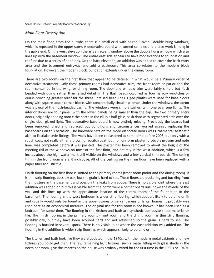
Main Floor Description
On the main floor, from the outside, there is a small oriel with paired 1-over-1 double hung windows,
which is repeated in the upper story. A decorative board with turned spindles and pierce work is hung in
the gable end. On the west elevation there is an accent window above the double hung window which also
lines up with the basement window. The entire east side appears to have modifications to foundation and
roofline due to a series of additions. On the back elevation, an addition was added to cover the back entry
area and the basement entryway and add a bathroom. This area correlates to the modern block
foundation. However, the modern block foundation extends under the dining room.
There are two rooms on the first floor that appear to be detailed in what would be a Primary order of
decorative treatment. Only these primary rooms had decorative trim, the front room or parlor and the
room contained in the wing, or dining room. The door and window trim were fairly simple but flush
beaded with quirks rather than raised detailing. The flush beads occurred as four narrow v-notches or
quirks providing greater relief for the three unraised bead lines. Ogee plinths were used for base blocks
along with square upper corner blocks with concentrically circular paterae. Under the windows, the apron
was a piece of the flush-beaded casing. The windows were simple sashes, with one over one lights. The
interior doors are four panel, with the lower panels being smaller than the top. The two primary entry
doors, originally opening onto e the porch in the ell, is a half-glass, sash door with segmented arch over the
single, clear glazed light. The decorative base board is now entirely missing. Previously the boards had
been removed, dried and replaced but conditions and circumstances worked against replacing the
baseboards on this occasion. The hardware sets on the more elaborate doors was Ornamental Aesthetic
akin to Eastlake style fittings. The walls have been replastered at some time before 2008, but only with a
rough coat, not really either a brown or scratch coat, but non-uniform plaster, probably gypsum and note
lime, was completed before it was painted. The plaster has been removed to about the height of the
meeting rail of the windows on most of the first floor, and entirely in the west addition, which is a few
inches above the high water mark still visible on the windows and a few vertical trim boards. The ceiling
trim in the front room is a 2 ½ inch cove. All of the ceilings on the main floor have been replaced with a
paper fiber acoustic tile.
Finish flooring on the first floor is limited to the primary rooms (front room parlor and the dining room). It
is thin strip flooring, possibly oak, but the grain is hard to see. These floors are puckering and buckling from
the moisture in the basement and possibly the leaks from above. There is no visible joint where the east
addition was added on but this is visible from the porch were a corner board runs down the middle of the
wall and this lines up with the approximate location of the central room of the foundation in the
basement. The flooring in the west bedroom is wider strip flooring, which appears likely to be pine or fir
and usually would only be found in the upper stories or servant areas of larger homes. It probably was
used here as an economical measure. The original use for this room is not known. It has been used as a
bedroom for some time. The flooring in the kitchen and bath are synthetic composite sheet material or
tile. The finish flooring in the primary rooms (front room and the dining room) is thin strip flooring,
possibly oak, but they have been scoured hard and not refinished so the grain is hard to see. The
flooring is buckled in several spots. There is no visible joint where the east addition was added on. The
flooring in the addition is wider strip flooring, which appears likely to be pine or fir.
The kitchen and bath look like they were updated in the 1940s, with the modern metal cabinets and new
fixtures you could get then. The few remaining light fixtures, such a metal fitting with glass shade in the
north bedroom, give the impression the house was probably wired for the first time in the 1930s or 1940s.

Chapter 2: Narrative Description
8
Flooring in the kitchen is small square tiles. The west gabled addition and upstairs both have a lower-order
trim, than the primary two rooms. It is plain and utilitarian when compared to the fluted work in the front
room and dining room. The porch has been enclosed, the east roofline altered, and an imposing addition
to the rear and east elevation has made a noticeable difference in the style of the building. It is not easy to
discern what the original nature of the property was. The foundation and exterior trim work suggest the
building was either a gabled-front-and-wing building, with several later additions, or it was a variant of that
form or front-facing gable with up to three original wings and then later altered through additions. The
front porch does not appear to be original and rather appears to date to the mid-20th Century. However,
some relatively unique aspects probably indicate this addition has gained significance in its own right,
despite the modifications to the original design. A wooden slat awning, the decorative treatment to the
porch skirt made in face brick, a purpose-built concrete stoop and a handmade bracket for a flag pole
suggest a great deal of pride in ownership of the building. These features are well-executed and therefore
retain a high level of workmanship. Some of the materials match the existing structure, other do not but
perhaps compliment it, or otherwise are not highly detracting from the original, with the exception of the
changes to roofline, which has altered the massing, and the foundation block. The manner in which the
rear addition was added and the changes that this made to the roofline as well as the enclosure of the
porch appear to be fairly well executed. While their design are perhaps not very compatible to the original
design, the reader is reminded that the building is of a vernacular nature, with only a light degree of
architectural styling. The materials and the decorative treatments for the cladding and window trim match
the original. The foundation materials along the west elevation are not very compatible with the
appearance and design of the original stone.
Upper Story Description
The stairway to the upper floor is a box stair, with narrow fliers, tall risers, and runs in one long flight. The
area beneath the stairs is a closet. The stairs are carpeted. The rooms to either side of the upper floor
landing rise another step into each room. The ceilings are plaster, where it has not collapsed, exposing the
lath. The walls are papered in a mid-1980s pattern. The trim in the upstairs and addition are of a plain,
utilitarian, nature with 1 x 3 or 1 x 4 boards, butt joints, and no back band. The windows have thin, milled
lumber bullnose stools and another 1 x 3 or 1 x 4 dimensional board as the apron. Access ways leave the
south room upstairs and allow entrance to the east and south attic areas. An attic hatch is located in the
north room of the upstairs. A mid-century pressed class shad covers the light in the north room. The south
room has a bare bulb with a twist switch fixture hanging from the electrical wire (fabric insulation). Both
upper story rooms have a structure in the wall adjacent to the stairwell reminiscent of wall chimneys seen
in multi-story brick buildings near the roof. The house entirely wood framing and it is not clear how such a
feature would be supported. It is clear they structures extent do the roofline due to the large amount of
leakage around them. If these were chimneys, they have been reduced down to the roofline. The chimney
still visible on the roof runs through the south room extending from basement through the roof. Today a
modern HVAC system has an air handler and heating chamber in the upper floor and heat pump looking
air conditioner on a pedestal outside next to the kitchen. Like the studs on the first floor, the roof rafters
and original knee walls also appear originally to be unplanned, full dimension, machine-sawn boards. Later
additions are readily identifiable by the presence of planned, nominal dimension lumber that has the
appearance of fir rather than pine.

Sealls House Historic Property Documentation Study
9
Stylistic Elements
The stylistic orders of the Sealls House, such as there are, are first and last styled elements bought and
applied in a vernacular manner. That said, more details can be conveyed by selecting an order with which
the majority of the building features are aligned. The Sealls House is at the core, Front-and-wing form with
a 1 ½ story front, open gable with a one story wing. The form and exterior ornamentation have elements
in a Cottage Order with predominantly Picturesque Aesthetic details, though there are some elements
borrowed from the Italianate Aesthetic (Gottfried and Jennings 2009). The exterior of the building also
featured a few elements with discernable styles. The applied gable decoration has the appearance of
carpenter gothic construction details and stylistic elements, including steep roof pitch, open gables, oriel,
fleur-de-lis, a four pointed star, and wheat or acanthus floral elements. This matches much of the stylistic
feel of the house, its roof pitch, the rough dressed foundation stone, the plain sawn clapboards and trim,
and simple one over one windows and the Oriel especially references a cottage aesthetic. However the
segmental arch main entry doors and in particular the console or foliate brackets beneath the oriel are
distinctly Italianate in appearance. The Interior styling is limited to the front two main rooms and kitchen.
The Primary Order is largely Italianate Aesthetic with some overlap in trim, and hardware with the
Ornamental Aesthetic (c.f. Gottfried and Jennings 2009). The house was laid out in a very modest and
utilitarian nature and as a result, opportunities in which to embellish the basic form of the walls, doors,
trim and so on are limited. The stairway has no balustrade or newel. The largest opening between rooms
does not have a screen, colonnade, or pocket doors. The interior design included both elements of classical
revival that align best with the Italianate order that also feature elements of Ornamental Aesthetic details.
These are limited in the parlor and dining room. Ornamental work includes fluted vertical trim boards and
paterae, entry doors with semi-glazed, segmented arch windows over two panels, but Hardware akin to
Eastlake (Gottfried and Jennings 2009). Effectively no ornamentation was used or applied in the remainder
of the original house. Elements distinctive of the modern colonial revival from the middle of the 20th
century were used in the Kitchen remodel. Together, along with a purpose-built feel to the floor plan and
layout, the thrift and modesty of features used daily, such as stairs and bedrooms, all speak to a house
built on a budget, and with materials available locally, either as raw material or bought as finished goods.
Following the civil war, and in the city advertisements it is clear that all kinds and sorts of building
materials were available, shipped in by train, no doubt. The modesty of the design and ornament speak
possibly to thrifty homeowners but also it should remembered the economic and social situation,
following the Panic of 1893 and the temperance prohibition of the last quarter of the 20th Century.
Description of the Accessory Building
Historic preservation reserves the term building for habitable and occupational construction while the
term structure is tends to be reserved for construction with engineered design, such as bridges, viaducts,
tunnels, outdoor facilities and so on. However, most planning and property assessors will use the term
structure to mean the same thing as a building, as in primary structure, secondary structure, or assessor
structure. The property includes a secondary or accessory structure—a building with a vehicle door on
back that is built into a hip roofed wall dormer and looks somewhat like it has an agricultural origin. The
rear vehicle door faces a ramp built of limestone consistent with the original foundation of the house. The
ramp provides vehicular access from the alley into the lot and the door of the accessory building. The alley
otherwise is elevated above the adjacent lots to the north of its alignment and extends from 18 inches to
three feet above the back yards along its length. Rearick stated this was a modification of the outbuilding
by Hanken, who was a lineman for the Olin-Morley Telephone Company. Rearick added the two stall
garage door on the north side of the accessory Building.
10
CHAPTER 3
H I S T O R I C A L B A C K G R O U N D
Because residential vernacular buildings develop over time, and their interpretation of national and world
trends in architecture are specific to a given place, architectural historians tend to regard surviving
examples as important to local history in that they the remaining tangible examples of the trends and
tastes in architecture of the period available in a readily visible and direct manner as well as informing the
viewer about key aspects of local economic and social conditions.
The neighborhood provides much of the associations of land development, when and why the subdivision
was built town was a place to obtain finished goods, sell produce, and interact with the other people in the
township. The town was also the nerve center for communications—post office, newspapers, telegraph
and telephone office, and social halls were all located in the Central Business District alongside stores and
shops. As the town expanded toward the railroad, much of the focus of the town also shifted toward the
connection with the outside world. The hotel would be situated near to the Depot. Before land use zoning
ordinances, Industrial operations could occur anywhere but usually were found on the edges of town. The
townspeople at the time the house was constructed were the merchants, workers, clergy, clerks,
professional services, and leaders of the community and the residential streets that naturally grew out
from the Central Business District, or Main Street, is where the townspeople lived. Before Television, much
of life was carried out along Main Street but visitors to other people’s homes were a frequent and even
common occurrence. Socialization was entertainment and vice versa.
HISTORIC CONTEXT FOR OLIN
Olin is a small incorporated community that has a substantial number of front gabled and Gabel-ell-and-
wing buildings. A fairly large number of Folk Victorian and Queen Anne styled homes featuring round
turrets and canted turrets. Many buildings have a American Colonial Revival stylistic influence. Most
buildings have frame construction, and there are three or so brick buildings. Walnut Creek has a fairly
steep-sided valley. The majority of potentially historic buildings are north of that divide. Much of the town
south of Walnut Creek dates to the 1960s and later. The contemporary Public Library and more recent
school building are on the south side of town, as is the current grain elevator.
The Central Business District features mostly brick clad buildings, including an 1893 Brick Front Commercial
and a 1903 Masonic Hall. Most of the well-preserved buildings are within a block or two of Jackson
Avenue, which is also the main thoroughfare through town. Examples include 100 W. Cleveland St, 100 E.
Maple St., 509 Jackson St., One brick bungalow is fairly large and retains a high degree of integrity and
there is an Italianate house that is in a moderately good state of preservation. Integrity at the District type
of property appears to be lacking. The residents have for the most part kept up on improvements, with
major changes occurring once per decade or so to a majority of the housing stock. For many reasons,

Sealls House Historic Property Documentation Study
11
including losses due to natural disasters, as well as open lots remaining available for infill, many homes
have been built since 1960.
The town of Olin was officially incorporated in 1878 with a population of 392 following a State circuit court
action which granted a request in the form of citizens’ petition but quite likely also had at least been
encouraged by the Chicago, Milwaukee, & St. Paul Railroad (the Milwaukee Road). The town had been
plated as early as 1854, which at that time there were effectively three unincorporated but adjacent
villages that represented a single community.
In many ways, the last decade of the 19th century was a high water mark for community development in
Olin. Olin adopted a centralized electrical utility in 1909 when Oxford Junction Light, Power, & Mill Co
initiated a franchise to provide electricity to the local population. The town implemented centralized city
water and sewer utilities in 1898. Prior to this, a city well was located along Jackson Street, probably at 2nd
Ave. A photo of this well is available in County Histories and at City Hall in Olin. A one-cent from around
1898 to 1907 is a hand tinted color image that depicts Olin as an Idyllic, Victorian farm village in the Upper
Midwest. A copy of the post card is in the collection at the Olin Heritage Center (Ellison 2011).
Consistent with other Idyllic villages in the upper Midwest, Olin has seen its share of memorable occasions,
ranging from curious happenstance to the devastating for community growth and prosperity. Two minor
earthquakes had little effect on Olin in 1890 and 1909. In 1904, one of two banks in Jones County that
failed before the Great Depression and regarded at the time as the single greatest financial disaster in the
history of the county. R.J. Cleveland recalled the winter of 1842–43 was especially severe, the coldest he
recalled from 1840 to 1979. A severe snow storm was recorded 1959. Several tornadoes and windstorms
have passed through Jones County over the years, including an 1860 tornado that killed two children when
their farm was mostly destroyed in Rome Township and Olin reportedly felt the effects as well. A county-
wide 1898 mesocyclone or strait line winds destroyed over 7,000 windmills in the county and blew barns
over in the north. Another event that figures prominently in historical accounts of Olin is the Olin College,
founded when the town was incorporated, but closed within two years due to problems with their public
relations image. The founding of small, private colleges that failed to thrive into the present are
unfortunately not uncommon in Iowa History. Those events appear in county histories but appear to have
had little to no effect on the course of events for the growing town. On the other hand, two fires along
Jackson Street shattered growth in the central business district (Corbit 1910). In 1876 a fire of unrecorded
causes expanded out of control and destroyed nearly the entire east side of Jackson Street including some
residences. Only the harness shop at the south end was saved by a bucket brigade, probably operating
from the well or Walnut Creek. The second fire occurred 1892 and was thought to have been intentionally
set (Corbit 1910). This fire resulted in total loss to the west side of the central business district excluding
only two frame buildings again on the south end, nearer to the town well and river and within reach of the
bucket brigade. The town hall and its records of Rome Township, the School and other important
documents were also destroyed at this time (Corbit 1910). In the great misfortune, the Olin Recorder was
destroyed physically but the operation was rebuilt within a month. The outcome of the two fires was the
opportunity to build a brick clad streetscape that is largely what survives today. Today the Olin volunteer
hose company is prominent fixture of the community, proudly hosting annual fund raising events.
Floods of the Wapsipinicon River have repeatedly affected Olin including 2008 when 80 homes were
outright destroyed or substantially damaged due to record flooding (23 ft or 9 feet above flood stage). The
US Geological Survey has also recorded previous major floods on the Wapsi in 1968, 1971, 1993, and 1999,
2004, and again in 2010. In 1927 a flash flood Catfish Creek washed out the 1912 railroad berm built with a

Chapter 3: Historical Background
12
Great Seal of the Iowa
steam shovel and in 1931 there was a train wreck near town (Olin Heritage Center 2011). During television
coverage of the latest flood event in 2010, Aaron Alderson, a resident of Locust Street and a neighbor to
the Sealls House quipped to the KCRG reporter that “I don't know, I guess I'm fortunate to live on the flood
street again. They ought to just rename the street probably,” Alderson said. Those same neighbors spent 3
days building sandbag flood walls that provided largely ineffective to stop the invading water. The USGS
has reported that flood discharges and peak elevations were at record levels for the middle reaches of
several Iowa Rivers, including the Wapsi in 2008.
In 2006, the Olin area became the subject of attention as a three span, bow string arch, wrought Iron
bridge was flown from its original site crossing the Wapsi between Olin and Hale, to its new location
several miles upstream near Anamosa. The Olin area was once the setting for a number of wrought Iron
bridges which were installed to cross the relatively large number of streams and rivers in the area. The iron
bridge for the road (Iowa Highway 38) over the Wapsipinicon was replaced with a concrete deck bridge in
1959. The highway had been converted to asphalt hard surface in 1957.
The Early Years: Settlement and Growth in the US territorial period
Olin is located in Section 13, T83N–R3W, Rome Township. This vicinity is within the Second Black Hawk
Purchase, 1832. Although there were some, especially American fur traders who entered the territory
before this time the land was officially opened for settlement in 1833. The earliest settlement to present
day Jones County (1837) was Hugh Bowen, in 1836. The first political division of the County was by
electoral precincts. Walnut Precinct, an area that include all of the area in corresponding to the
congressional survey area of township T83N, and half of T84N and R1W to R3W. The area was given the
political division name Walnut Precinct. In 1842, the precinct system was converted to Civil Townships, and
Walnut Precinct became Rome Township with no alteration of the political boundaries. Over the next
decade and a half, the townships were subdivided and began to confirm with greater regularity to the
Congressional Townships delineated by the Government Land Office Survey.
The Iowa Territory was organized and incorporated within the United States in
1838 and continued until statehood was granted by Congress in 1846. Jones County is located in a Native
American land cession from 1832. Originally it had been in a large province of New France, name Louisiane
(1682–1764), held by Spain for France (1764–1800), and finally included in the US Louisiana Purchase of
1803 from France and governed for about a year as the US District of Louisiana (1804–1805). From that
point, the area was under the jurisdiction of the Territories of Louisiana (1805–1812), Missouri (1812–
1821), Michigan (1833–1836) and Wisconsin, including the District of Iowa (1836–1838), the succeeding
territories being the area remaining after an area gained sufficient population to be granted statehood and
was then cleaved out of the larger territory, orphaning the remainder. County formation followed a
roughly similar process. Organization and regulation in Iowa began primarily when the Michigan territorial
legislature organized the first two counties (previous settlements had remained largely unregulated). From
1821 to 1833 the area that became Iowa briefly reverted to an unorganized federal territory intended to
be inhabited by displaced Native Americans from East of the Mississippi and the new state of Missouri,
which created a new drive toward establishing states due to the Missouri Compromise.
Jones County is located in the area known as the First Black Hawk Purchase or less commonly as Forty-Mile
Strip or Scott's Purchase. The acquisition was an attempt to formally compensate the acquisition of land
form Native American nations by execution of an international treaty— itself still a somewhat new
concept. The treaty also served as a formal declaration to end recent hostility between the United States

Sealls House Historic Property Documentation Study
13
and the amalgamated Sauk and Meskwaki. The uprising known now as the Black Hawk war was an
outcome of centuries of displacement and the attempted revolution by members of Sauk and Meskwaki
tribes under the leadership of Chief Blackhawk was seen as a last stand to fend off the invading Americans.
The Americans conversely saw the Sauk and Meskwaki as former British allies and they stood in the way of
expansion. The uprising was in many ways was an aftershock of the War of 1812 but also was response to
the forced relocation of Native American tribes, which had become an active federal policy under
President Andrew Jackson, 1829–1837. For the still young United States, an “Era of Good Feelings” was
melted away with Jackson’s polarizing stance on many issues, among them slavery, Native American
Removal, and a system of rewarding political support with political favoritism, not the first, or the last, but
certainly a point in time when this became yet another sore point between opposing political viewpoints.
The second Wisconsin Territorial Legislature meeting at Burlington during the winter of 1837–1838
approved the subdivision of Dubuque County and organization of nine additional counties, including Jones
County. Not too long after that decision and before adjourning the legislative session they decided to
create a separate Wisconsin Territory with a capital closer to the Wisconsin settlements where many of
the members of the assembly lived. The Iowa Territorial Legislature met in the fall of 1838 and confirmed
the decisions to create nine new counties, retaining the name of Jones County whose namesake was the
congressman from the Wisconsin Territory. The first election of officers occurred in 1839 and the first
political divisions were established 1840.
One of the earliest recorded settlements known in Rome Township was platted north of the present
location of Olin. It was named Elkford (Figure 4). The existence of this settlement is something of a
mystery. Due to the loss of early township records, the only firm evidence is in the form of the
Government Land Office Survey and other accounts appear to be derived from this source. One possible
explanation is that the inhabitants laid out a claim and then returned east to gather their family and for
one reason or another were unable to return to their claim. It was common for a claim to be staked and
then to not actually live on the claim until a number of years later. John Merritt is one such example as is
the platted town site was situated in the northeast quarter of Section 11, a location about a mile north of
the current city (Western Historical Company 1879). At the time of the General Land Office Survey of
Rome Township, January 13 to February 3, 1838, the survey team recorded the location and name of
Elkford but noted that although the town was visibly laid out, no improvements had been made. The name
Elkford appears next to a settlement an early territorial period map of the surveyed counties of Iowa
(Coulton in Cole 1920). Little more can be said without speculation. However, it is intriguing to consider
that John Merritt had set up a cabin in 1836 and quietly returned to New York, returning the next year
with his father, his many brothers and their families. The GLO and Settlers in their reminiscences recount
the large stands of timber that occupied the overly broadened river valley and the tributary channels. The
large Groves of trees, including the one labeled “Sugar Grove” in Sections 15, 14, 22, and 23. As confirmed
in R.J. Cleveland’s reminiscence from this time, platted towns were easy to spot (Corbit 1910, Western
Historical Company 1879.) They typically were cleared of brush and all but the largest trees ended up as
materials to stake out the streets and blocks, and too, much of the wood that attracted settlers to an area
was burnt as fuel and it appears that Rome was not an exception.
Segments of well established trails were noted by the Government Land Office survey team and R.J.
Cleveland remarks on the existing of previously made trails during the early settlement period. At the
beginning of the settlement period in the Black Hawk purchases, paper towns were abundant and usually
were staked out and plats filed by earlier Euro American settlers to the area. Competition was variable, but
a wide variety of incidents ultimately worked in favor of some town sites over others. Often times these

Chapter 3: Historical Background
14
towns were laid out by fur traders and others engaged in trade of goods and produce with Native
American Tribes in the area. One estimate for the number of Native Americans in the State at the time of
initial settlement in 1832 was 8,000 with about 50 American settlers. That number rapidly inverted, and by
1840 population estimates were 43,000 settlers. Not infrequently settlers were in to be found across the
Mississippi River in “Indian Territory” ahead of the approval to settle in Iowa. If found, companies of US
Army Dragoons were obliged to remove them back to the east side of the River (for example Van der Zee
1916). The Dragoons also were charged with keeping the peace between tribes as well and most of the
forts in Iowa were a testament to this fact.
Absent of other information, it would appear Elfkford likely never caught on as an idea or possibly, the
settlement was founded too far in advance of support structure. John Merritt reportedly set up a claim
cabin in the general vicinity of Elkford as early as 1836, but due to the large number of encounters with
Native American, he decided to return to New York. When he returned, it was with many of his adult sons,
brothers, and their wives and families and his father and they set up in Section 3. Careful examination of
early plat maps indicate that a cemetery was reported in the vicinity of Elkford in Section 11, appearing
variously to the southwest or north east of the turn from a northerly track to a westerly track before the
Olin to Newport Road branches form Green Rd to head up pas the Merritt homestead in Section 3. The
location of the cemetery symbols are in the same NE ¼ of Section 11, Rome Township, the approximate
location of the Rome 11 Cemetery. It appears at least one or more pioneer families lived in the area of
Elkford for at least a time sufficient to require the dedication of a cemetery. At the same time, the
confused locations of the cemetery through the 1870s, disappearing by 1893 suggests some level of
confusion existed through the 19th century but according to at least one local land owner, the headstones
are extant but have been removed from their original location in the cemetery. Beyond the cemetery,
these early settlers left behind few traces of their time in Rome Township.
At around the same time that the land survey was being completed, the first Euro American birth in the
county was recorded in separate homestead area. Rebecca Merritt was born two miles west of present-
day Olin in 1839. John Merritt in 1837 had settled in what is now the southern part of Jackson Township,
on the right bank of the Wapsi and at a location later platted as Merritt’s Timber, (Section 33, T84N–R3W).
Merritt was preceded in the county by Hugh Bowen and John Flinn at Bowen’s Prairie in 1836 and in that
same year Daniel Varvel and William Clark at Monticello. Also in 1837, an unnamed African American
settled near Pleasant Grove in Hale Township. During the 1839–1840 County Meeting, Road districts and in
1840 Election Precincts were assigned numbers. The Precincts were Bowen Prairie, Farm Creek, Buffalo
Fork, and Walnut (Western Historical Company 1898). The areas unequally divided the county with Bowen
Prairie taking the northwest quarter of the county, and the northwest quarter of the northeast quarter of
the county, Farm Creek having the remaining three-quarters of the northeast part of the county, Buffalo
Fork, taking the south west and northwest of the southwest quarter of the county, and Walnut taking the
rest. As population grew, regular townships of 36 sections, six miles on a side, were divided out of these
early townships. People living in Walnut township in 1840 may later be found living in Hale Township in
1851 without having moved.
Rome Township 1837
Olin proper has its origins in two platted communities laid out in the tallgrass prairie of the Iowa District,
Wisconsin Territory. Walnut Fork was organized by Norman B. Seeley. Adjacent and to the east of Walnut
Fork, was the platted village of Rome, which appears to have been championed, if not directly organized,
by Richard J. Cleveland. Seeley arrived in 1839 and Cleveland in 1840.

Sealls House Historic Property Documentation Study
15
Seeley had arrived at the future site of Olin somewhat after the first wave of settlers who came in 1837.
The first families listed included John and Joseph Merritt, Orville and Oran Cronkhite, Francis Sibbals, Isaac
Simpson, Moses Garrison, George Saum, Thomas Green, Horace Sealy, and the Booth, Brown, and Joselyn
families and others soon followed. By 1840–1841, at least 15 families are recorded in the area. Household
sizes were quite large at this point in history, so the total population may reasonably be assumed to be
many times the number of recorded surnames.
Seeley was a man of purpose and he directly went to work building a log cabin, a hearth for iron working,
and a sawmill that began operation on Walnut Creek the same year, the second in the County. He added a
grist mill in 1841 and his settlement, which became known as Walnut Fork, had secured a foothold in the
tallgrass prairie, which was a good start. A good image of what an early Iowa gristmill of the 19th Century
looked like is provided in a July 10, 1965 reprint by the Monticello Express of a 1900s photo of the 1848
Eby’s (Applegate’s) grist mill and saw mill south of Monticello.
The 1840 plat of Walnut Fork is still evident in the subdivision record for Olin, and is situated west of
Jackson St between Locust and 2nd St (Figure 5). The claims of Iowa ghost town indexes to the contrary,
this location is on the hill that is now occupied by the Olin, a safer and drier location to live, even if the
mills were located along the creek. The success of Seeley earned him the chance to name his portion of the
county Walnut. In 1841, when a post office was established at Walnut Fork, Seeley became the postmaster
and the post office retained the name Walnut Fork even after Seeley’s capture and untimely death at
Andersonville during the Civil War. The first political division of the county for purposes of democratic
representation occurred in 1842. Seeley’s precinct was called Walnut Fork or Walnut Precinct, the current
location of Olin. Contrary reports notwithstanding, this early village were situated on the higher ground
west of Walnut Fork at the approximate location of the Central Business District for Olin.

Chapter 3: Historical Background
16
The second plat filed in Olin was a contemporary of Seeley’s Walnut Fork and was named Rome. Rome
developed on a similar trajectory to Walnut Fork. The plat for Rome was accepted in 1842, three years
after Walnut Fork was settled, but just two years after Rome was settled and apparently much sooner than
the official plat was filed for Walnut Fork. Like its Classically derived namesake—Rome, Italy—in the Iowa
Territory, Rome was located on higher ground along both sides of a sinuous body of water, Walnut Creek,
and perhaps occupying several hill tops and side slopes. Despite while the township name was changed
from Walnut to Rome, the post office continued to be known as Walnut Fork until 1872, when two
additions to Olin were added. The town was platted as Olin in 1854.
Despite many romantic portrayals of the settlement of the Northwest Territory and the tallgrass prairie
areas beyond it and west of the Mississippi River whereby the intrepid pioneer would enter the frontier
and live off the land, many of the first Americans to arrive in the area that would become eastern Iowa
never completely left cash economies. Early settlers seemed to realize the importance of economic ties to
the east to provide a steady supply of goods and services and conversely to provide markets for the
frontier goods to be sold. Despite the Puritan roots of New England, most people moved from the east to
the Northwest Territory with the acceptance of risk in return for the opportunity to become wealthy.
To secure permanent trade relations, settlements and eventually towns would be needed. But among the
first things sought out by nearly every fledgling community were the Post Office, a recorded Plat, Seats of
Government, From there, the local council and mayor would be able to control the generation of revenue
Relative locations of key political geographic features important in Olin History—Walnut Fork, Rome, Smith’s Addition,
Cronkhite’s Addition, and Elkford. Bloomfield was an apparent name given to this a Stage Coach stop in this area for
1840–1849. Several land additions followed incorporation
R3W
OLIN
Platted 1842, 1854
Incorporated 1878
R4W
Walnut Fork
(Platted 1854, settled 1839) Rome (Platted 1842, settled 1840)
Cronkhite’s Addition to Olin (1873)
Smith’s Addition to Olin (1873) Walnut Creek
T83N
Elkford (before 1838)
T84N

Sealls House Historic Property Documentation Study
17
and funding for future improvements, including obtaining rail access and finally major industry and
commercial operations.
Nearly every early historical account will enumerate the locations and dates of the first post offices. It is a
perhaps unfortunate reality; however, that post offices and post masters both were somewhat ephemeral,
easily displaced or removed to another location at the time that their post was superseded by another
community in size and relative importance. As one of the early forms of official recognition, the post office
was a position eagerly sought. Early post offices were little more than an appointed postal clerk who was
also usually conducting business in trade, milling, or other profession and had enough ties to the area to
be reliable place to send the mail. Consistently there was the drive to file a civil plat, build population to
the point where the area could be recognized by the government, and then seek out the local or regional
seat of for the new government that would be formed.
The two platted villages that can still be seen in the Jones County assessor’s information appear to have
been in direct competition but perhaps in a friendly way for the first quarter century or so of the
community’s history. By the time of the first recorded histories in the early 1870s, the Civil War had come
and left and the economy of Olin was on the rise to a high point in the 1890s.
Transportation, the Railroad, and Incorporation of Olin
Until the arrival of the railroad in the last quarter of the 19th Century, travel to Olin was restricted to
overland routes (Thompson). Although a system of canals had been proposed for Iowa paralleling major
rivers in their flood plains, this idea never developed (Sage). Even though steam boats had traveled north
along the Mississippi as early as 1820s, and assertions contemporary to about 1840 that the Wapsi was
navigable, the Wapsi was at once too meandered, to rapid a current, and also presumably too
unpredictable throughout the year to allow for steamboats especially along the middle stretch of the river
(Van der Zee 1905, Cooper 1958).
Logically, no roads existed at first, other than the occasional trail used by Native Americans and the odd
explorer or fur trader. For the most part, these improvised roads remained packed only by use, and were
judged by at least on historian to have been inadequate for team wagons (Van der Zee 1905). The first
appropriations for roads in the Iowa Territory were made in the 1836 session and concentrated on making
Burlington accessible to other established settlements, such as Keosauqua, Keokuk, and Dubuque. In the
1838–39, roads were extended to the new capital located Iowa City. In 1839, territorial representatives to
Congress secured funding for a Military Road connecting Dubuque to Iowa City, Mt. Pleasant, and the
Missouri Border and an Agency Road from Burlington to Agency City near Ottumwa. The Military Road was
laid out under direct supervision of a surveying engineer with a marker furrow plowed by Lyman Dillon.
Although no other federal appropriations were granted in the next many years, Van der Zee notes the
exceptional success of obtaining even the funds for the Military Road due to the generally poor economy
following widespread economic downturn in 1837 (Van der Zee 1905). Beginning in 1840, the Territorial
Legislative Assembly made it a legal requirement that voting citizens perform three days service work on
building and improving roads and building bridges or pay a fee in lieu of the work (Van der Zee 1905,
Thomson 1989).
In his memoir, Richard J. Cleveland mentions the particular trouble it took to travel in eastern Iowa before
the railroad. R.J. Cleveland mentions in his memoir having walked 50 miles to Dubuque for supplies dozens
of times in the 1840s and once to Davenport. The 1838 Government Land Office survey recorded

Chapter 3: Historical Background
18
segments of these trails (Figure 4). Cleveland likely would have used the trails to go northward, ford the
Wapsi at a favorable location and join the Federal road somewhere northwest of Monticello.
This account is repeated with others traveling to Iowa in the 1830s. Although the common mental image
of early settlers was traveling by covered wagon, most early settlers had invested their wealth in supplies
and tools and traveled as they could, by lumber or supply wagon if on the Cumberland Trail through
Indiana, or by boat down the Ohio, and up the Mississippi or across the great lakes. Many times a pioneer
would settle first in Midwest but between the Ohio and Mississippi Rivers. After a time, some proceeded
on to Iowa for a number of reasons, but many times it was because they had little money, and there was
opportunity in the west to earn a better living. It can be learned in the several accounts of Old Settlers
Reunions, that until the last half of the 19th century, many pioneers did not have sufficient assets to buy a
wagon and may traveled as far as they could in someone else’s lumber or supply wagon and then
proceeded as needed by foot, which is what R.J. Cleveland did. Although Cleveland caught a ride on a
lumber wagon, several others arrived with oxen, or horses, or both as well as wagons. Others did leave
Ohio, Indiana or other states well-equipped. George Saum, did bring wagons and draft animals, as did
Orville Crohkhite. Both ultimately were very successful, as was Cleveland. As time passed, people were
able to travel by stage coach, but this was not available to the first pioneers. That anyone, let alone many
pioneers would travel hundreds of miles in any manner, to undeveloped area suggests the travelers sought
opportunity and thought they had a reasonable chance of obtaining success. It is assumed that the popular
account of early Iowa published by Albert M. Lea, a former US Army Dragoon, and similar accounts in
Galland’s Iowa Immigrant 1840, published and promoted by William C. Jones provided a vivid image that
greatly promoted life on the frontier in Iowa. However, within 10 years, many farmers did arrive with or
acquired oxen, horse, and because extremely successful. Despite the hardships, Cleveland recalled with
great pride and satisfaction in the opportunity to have been a pioneer.
Still, the Wapsipinicon and other waterways, such as Walnut Creek could prove difficult to Ford, adding
another level of complexity in getting from here to there in eastern Iowa. Ferries were essential, and a
number of people made their fortunes in early Iowa history running ferries at crossings on the Mississippi,
Mathias Ham or Antoine Le Claire, for example. The Territorial Legislature, later County Governments) set
the rates that could be legally charged. The first Ferry available to cross the Wapsipinicon River was
established in 1847.
Ferries, though, were susceptible to the random nature of rivers and the demand for bridging rivers and
streams became increasingly sharp. Cleveland noted no ferries or bridges in the Jones County existed in
early in the history of the Olin area. With the economy recovering and the US industrial revolution reaping
rewards in technologies for forming and shaping metal as well as mining coal, it was only a matter of time
before marked improvements would arrive in Iowa. A bridge was built over the Wapsipinicon River at
Newport in 1865. Newport was the first County Seat, formerly located in Lot 2, Section 33, T84N–R3W)
Jackson Township and consisted just Adam Overacker’s log cabin designated to be the courthouse. The
County Seat moved to Lexington (Anamosa) the following year. Several wrought iron truss bridges for
roads were built in the Olin area in the 1870s, mostly by the King Iron Bridge Company of Cleveland, Ohio
(Western Historical Publishing Co. 1879). The railroad bridge over the Wapsi was built in 1872, a simple
pony truss. Walnut Creek Bridge was built 1877 at Olin, replaced 1917(Western Historical Company 1879,
Olin Sesquicentennial Committee 1985). As bridges were built, the roadways to and from them were
improved to the point that they were generally passable by horse and wagon.

Sealls House Historic Property Documentation Study
19
Principal Highways and Stage routes during the Territorial Period as describe by Van Der Zee
The fact that travel to the vicinity of Jones County was difficult on a good day and an entirely overland
venture, at least as far as most American settlers were concerned, certainly had much to do with the
continued lobby on the part of the Iowa Territory to Congress for transportation authorizations. It is clear
that while George W. Jones was representative to Congress from the Wisconsin Territory had much to do
with the improvement of Federal roadways (Van Der Zee 1905). L likewise, they had much to do with
railroad appropriations spurring the railroad rivalries of the third quarter of the 19th century. Every town
wanted to be part of good railroad connection, and every railroad company wanted to be the first to
connect to any area (Thompson 1989, Cole 1920, Sage 1974, and Schwieder 1996). These appropriations
no doubt lead to the rapid increase in economic output from Iowa as it moved from supplying lumber,
lead, and furs becoming a leading producer of grain, dairy, and meat with secondary specialties used
locally, including beer, wine, brick, tile, coal and all manner of locally manufactured goods.
The duality of the railroad development era was despite the potential for rapid growth and development
the railroad could bring, there was a less than permanent nature of towns in the face of the apparent
whimsy of railroad companies. As can be seen in Olin, many towns expended large sums of capital and
physical effort to obtain the favor of a railway (Thompson 1979). Often times these investments paid off
but usually at the expense of other towns that were not served directly. In addition to ready transport for
goods and passengers, railroads could bestow the favor of a workshop, roundhouse, or refueling/watering
station on a town. This usually meant many jobs for a good number of years. The Milwaukee Road, for
instance, based its principal shops in Iowa out of Dubuque (for example Jacobsen 2011). On the other
Chapter 3: Historical Background
20
hand, the prevalence of towns by the name Junction, are usually an indication of an appendage to a town
or where a town sometimes picked up and moved to be connected with transportation by rail (Thompson
1989).
The Railways of the 19th century had several distinct advantages that made them a vast improvement over
many other types of transport. Once steel and fuel were plentiful, the rails could be laid just about
anywhere. Railroads also made use of the influxes of immigrants as a ready source of labor to prepare
grades, build trestles and bridges and lay track and even move streams in many instances. It can be noted
that the former location of Catfish Creek ran near the center of Section 11 and 12, and appears to have
originated in Section 16 in the 1875 plat map. By 1875, the railroad had diverted the course of at least one
stream to the north (Andreas 1975, Burlingame 1877). Rechanneled streams are an occurrence in Iowa
History and examples can be found in studies of other localities, for example USGS plat maps and local and
county historical accounts (for example Weitzel 2005).
Railroads in Iowa began in 1854 with the Mississippi & Missouri Railway that extended into Eastern Iowa
Thompson 1889, Weitzel 2005). Other companies had an interest in railroading, and with their persuasion,
the U.S. Congress passed a sweeping land grant bill in 1856 whereby railroad companies could expect a six
mile right-of-way on either side of the main alignment. The idea was to provide ample opportunity for
alternative routes when engineering or other obstacles were happened upon. In areas where the full 6
miles were not available, the grant could be made up in alternate locations.
Depending on opinion and judgment of some historians, many of the early railroads only existed on paper
until the investors were bought out by the official company (Thompson 1989, Western Historical Company
1879). In this somewhat cynical view, the paper roads were meant to diffuse liability and protect the
investors. With a few notable exceptions, many planners for railways consistently underestimated the
level of work necessary build a new railway and likewise were over confident in the potential investment
returns. In many accounts, once construction began expenses outpaced capital, The Iowa Central Air Line
Railroad, is perhaps the best known example of this. As a result, so the alternative viewpoint states, new
companies were created to prevent the loss of the lucrative land grants as the initial investments ran into
debt and receivership, which was a frequent occurrence (Sage 1974, Thompson 1989). The difference is
more of a point of view, perhaps. In any case, railroad construction east of the Mississippi had proven to
be a worthwhile investment. A vision for linking the eastern United States with the west coast took hold
and planning began for the first and subsequent transcontinental rail routes. To hasten private investment,
President Lincoln authorized an incentive for the first railroad to reach the Council Bluffs Terminus of the
Iowa segment of the future Transcontinental Railroad. Land grant authorization came with a more than
generous offer in the form of land grants in return for meeting specified completion dates. The penalty for
failure was forfeiture of the land grants. Four principal rail routes across Iowa had been planned in the
initial Land grant program (Thompson 1989; Sage 1974). Through the 1860s, as the parent companies of
the first four railways enjoyed success and a fifth railroad was started in 1863 with a completion date set
for 1875 (Thompson 1989, Sage 1974). This railway eventually became the Milwaukee Road and had two
alignments in Iowa. The northern track was intended to connect Chicago to Prairie Du Chien, and from
there crossing to McGregor then northwest to Cresco and on to Minneapolis and St. Paul, reaching Canton,
South Dakota by 1879. A branch line pushed on to Sioux City with connections to the southern track. Due
to the Panic of 1873, this segment did not meet the specified deadline and the company had to be
reconstituted to renew the grant and prevent forfeiture to inventors (Western Historical Company 1879,
Sage 1974). The southern route had originally been intended to run from Jackson County to Hardin County
and on to the Dakotas Western Historical Comply 1879). The townspeople of Sabula and Ackley envisioned

Sealls House Historic Property Documentation Study
21
a small rail company to connect their communities from Savannah, Illinois to the Dakota Territory
(Western Historical Company 1879, Corbit 1910). It was organized in 1870 as the Sabula, Ackley and
Dakota railroad which made it about one third the distance across Clinton County from Sabula before it
ran out of financial steam. Its counterpart in Illinois was the Western Union Railroad but it like the
northern route—the Milwaukee & Mississippi and Dubuque & Pacific—it was controlled through small
front companies by the Chicago, Milwaukee & St. Paul Railroad (Sage 1974, Thompson 1879). The Sabula,
Ackley and Dakota Railroad was bought out by the same company (Western Historical Company 1879). As
was the case with many small railway companies in Iowa in the 1850s–1875, the smaller company enjoyed
the backing of a larger, usually silent partner company which assisted their efforts in connecting Olin
agricultural producers in Rome Township to Chicago (Thompson 1989, Sage 1974, Western Historical
Company 1979).
By 1872, earlier in some accounts, the southern track of the Chicago, Milwaukee & St. Paul Railroad had
reached Olin, and continued on toward Marion, Iowa (Thompson 1989). In fact, continuing the history of
the Milwaukee Road further back, O. Cronkhite and D.A. Carpenter of Rome also invested in the Sabula,
Ackley and Dakota Railway Company a n attempt to revive the failed 1859 Anamosa Branch of the Tipton
Railway and the second attempt to bring a rail line to Olin (Western Historical Company 1879). Cronkhite,
the settler of 1837 had become less than 20 years later a successful farmer who understood and was
driven by the need to be connected to markets. It is no surprise, then, that the platted name for the town
was not Sealy’s Walnut Fork, or Cleveland’s Rome. Instead, the 1854 plat carried the namesake of General
Superintendent of the Chicago, Milwaukee & St. Paul Railroad—D.A. Olin (Western Historical Company
1879, Corbit 1910).
In 1872, the focus of development in the slow but steadily growing villages of Walnut Fork and Rome was
drawn to the north end of the current community, with the anticipated arrival of the Sabula, Ackley &
Dakota Railroad (North West Publishing Company 1893). In 1873, two areas of the community were
platted as additions to Olin (Western Historical Company 1879). Walnut Fork and Rome became part of
the Olin town plat in that year. Five years later in 1878 and following a rise in prosperity and growth due to
the railroads that the town officially became incorporated. At the time of incorporation, Olin consisted of
several small enclaves or formative communities, including the original town sites of Rome, Walnut Fork,
and the two 1873 additions to the town plat of the platted but unincorporated town of Olin that included
Cronkhite’s Addition in the northeast part of the community and Smith’s addition, in the northwest corner.
The central business district was located in Rome. Most of the institutional space for churches and the
Public School were in Walnut Fork. The Livery was in an unincorporated area until Cronkhite’s Addition.
That addition and Smith’s Addition were mostly residential, and most lots were occupied, except where
Catfish Creek ran through town. Much of the area between was still empty lots (Figure 7, Figure 10). Again,
it is apparent that Elkford was proven not viable before even Norman Seeley founded Walnut Fork, but the
name of the community remained part of local history through the first (Western historical Company
1879). By 1910, Corbit does not even mention Elkford.
Olin Demographics Professions and Trades
The first Federal Census was taken in Rome Township in 1850 with population of 584. That number was
just 442 people in the State census for 1852 and some of the families that arrived earlier were not listed. In
1854, the State Census recognized separate totals for Rome Township (539) and Town of Rome (104),
returning to just the township for the for 1856 (737). The Federal Census of 1870 recorded 1068 for the
entire township. The population in 25 years had roughly doubled. Unlike the dominant trend the trend of

Chapter 3: Historical Background
22
Jones County as a whole, and the State at large, Rome Township’s population did not increase
tremendously with the coming of the railroad, that arrive in 1873. In 1885, the State Census recognized
Olin, at 487. There were 634 in the Township. The federal census again collapsed the total in 1910 (1236).
The state census for 1895 and 1925 show Olin at 648 and 646 respectively, which was a period of stability
for the town but Rome Township lost population during that time going from 927 to 689. From census
data, we find that in the first Federal Census, immigrants came to Rome Township from 17 states, three
countries, and Iowa. 188 or 32% of the 584 people moved from Ohio and 94 (16%) had moved from
Indiana. 137 or 23% came from Iowa. Just over 3% came from another country, either Germany or the
United Kingdom (England or British North America).
Historic Population Estimates for Olin , Jones County, and the State of Iowa
Year Rome or Olin Rome Twp Jones County State of Iowa
1833 — — — 10, 531
1838 — 15 families — 22, 859
1840 — — — 43,116
1846 — — — 96,088
1850 — 584 3,007 192,214
1854 104 643 10,481 —
1860 — — 13,306 674,913
1870 — 1,068 19,712 1,194,020
1880 — — — 1,624,615
1885 487 1,121 18,300 —
1900 19,444 2,231,000
1895 648 1,575 — —
1960 — — 20,693 2,758,000
2010 702 — 20,638 3,046,355
Olin Commerce
Unlike many other townships in Jones County, but closer demographically and philosophically with
Madison and perhaps other townships, the pioneers and second generation immigrants to Rome
Township included predominantly American Citizens from the East, including Massachusetts, Virginia, New
York, Kentucky, Pennsylvania, Indiana, New Hampshire and 8 of 27 came from Ohio, a goodly number,
nearly 30%, of the Patrons to the Andreas Atlas. One patron came from Germany. Three were natives to
Jones County.
In the early days of the settlements at Olin, there were not a great many options for supplies and
materials. It is clear that many came to farm and immediately went about farming when they arrived.
Many farmers grew wheat, something relatively unknown as a potential crop today. Other grains included
oats and maize corn. It is fairly clear that little was available off the shelf or readymade before about 1850.
R.J. Cleveland indicated many times he had walked the 50 miles to Dubuque more than 50 times and once

Sealls House Historic Property Documentation Study
23
to Davenport for supplies prior to the general store opening in either 1847 or 1848. As first roads, then
bridges, then railroads and finally highways were built, the range of available goods as well as potential
markets expanded dramatically, and in comparison perhaps exponentially by the middle of the 20th C.
when food became marketable to the world. Much of the grains if not all was consumed locally or
regionally at first but as transportation improved, milled grains were sold to markets outside the area.
Norman Sealy set up grist mill to accommodate local trade in flour.
Olin was on a stage coach route, and mail arrived in this manner (Van der Zee 1905, Cleveland 1910).
Livestock was brought into the state, but at first this was mostly for products rather than as meat, such as
butter and cheese or wool. Again, by the 1880s, hogs and cattle were sold as meat in addition to an
increase in products made. Throughout the 19th century, farms remained diversified, growing three or
more grains, peas, beans, potatoes, buckwheat, oats, corn, wheat, maintaining pastures, selling grass,
clover and hay seeds, and making butter and cheese, wool, and meat. Miscellaneous other crops and
produce included flax, honey, wax, hops, and wine. Two noticeable trends through the period were
increasing specialization, decreases in number of crops per farm, and increasingly selling raw materials,
like unprocessed grains to larger mills further away and such as milk to dairies rather than making butter
and cheese on the farm. Another striking trend is the contrast of settler reminiscences of the general
fertility and depth of native soils and the use of fertilizers by the 1870s. Cut wood continued to be an
agricultural product throughout the 19th century. Eventually wood would be all but replaced by coal (Coal
Age 1911). In the 1921 Atlas, there were two banks operating and merchants listed included the Olin Rug
Factory, and the Hog Reliance Company, makers of medication and remedies for pigs, which was becoming
a big business.
There is little doubt that once a stable settlement was established and transportation was secured that the
prosperity of Olin was mainly dependent upon goods and services in support of the famers of Rome
Township. By 1850, a merchant and clerk along with a number of skilled tradesmen and a few
professionals had moved to town. In the 1860s, Inland Revenue tax receipts from Rome indicate trade and
fees for physician-surgeons, carriage, keepers of Stallions, retail liquor, slaughtered hogs, conveyance,
miscellaneous retail and general, unspecified income. During the same period, Walnut Fork reports sales in
Hogs, Sorghum, Retail, Carriage, Watch, and Hotel. All of these materials came and went primarily by
overland route to Dubuque. By 1870, the town added a shoe Maker, veterinary Surgeon, Wagon maker.
Professions listed for Rome Township in 1850 Census
Farmer Carpenter Black Smith Physician Others Total (1850)
138 9 3 2 6 158 People 10 Professions
87.3% 5.7% 1.9% 1.3% 3.8% 100%
In 1875, successful farmers outnumbered all other trades 2 to 1. Some famers were successful enough to
have hired hands and domestic servants on staff. Professional Services available in the last quarter of the
19th Century included attorney, Justice of the Peace, Physician and Surgeon, Land Surveyor and Teacher.
The teacher and butcher were of diversified interests and both also professed to be farmers. Trades
included Carpenter, Sawyer, Sawmaker, Cooper, Clerk, and Blacksmith (Andreas 1875).
At this time, finished goods locally available included cut meat, grain, cut lumber, lath, shingles, lime,
plastering hair, building sand, stucco, paper, mouldings and millwork, other building supplies (Andreas
1875). By 1893, Olin’s businesses included purveyors of building supplies included window glass, sashes
and doors, and Portland cement delivered most probably by rail, and the brick and tile works as in

Chapter 3: Historical Background
24
operation at this time (North West Publishing Company 1893). A this time the fuel source included coal—
both hard (anthracite) and soft (bituminous or lignite) probably from Iowa or Illinois but potentially from
the Dakotas with peak coal use occurring between about 1912 and the Second World War (Coal Age
various dates). Grove size and numbers, decreasing since settlement, had become marked by this (Figures
4, 5, 6 and 2). With a newspaper, insurance agent, a notary public, schools churches, and social events,
Olin was bustling, if modest, community. There was a hotel across from the Depot; its location is noted in
the 1893 plat of Olin. Supplies available from local merchants included dry goods and finished goods,
including ready-made clothing, boots and shoes, furniture, undertaker’s goods, and window blinds. The
Lamb Brothers has opened the Olin creamery in 1880 and continued until 1906. Olin’s farmers had added
being breeder of stock or stock raiser to their operations listed in the 1893 directory and a modest stock
yard was located along the southern railroad siding west of the Depot, There also was a breeder of farm
work horses and a couple Livery stables were in town, the location also noted on the 1893 plat.
Olin Industry
Sealy had set up two mills on Walnut Creek, first a grist mill and then a saw mill. It is not clear exactly
where the mills were located or when these were not longer in use. Later a grist mill and a woolen mill
operated on the north east side of Olin in the 1870s but the millrace appears to have been defunct by
1893 (Burlingame 1877, Western Historical Company 1879, North West Publishing Company1893). The
race and mill are not indicated in the detailed city plat and the companies do not appear in advertising or
patrons listings.
By 1893, Olin had a local stone quarry with finished quarry good including flag stone, stone steps, water
tables, cap stones, lintels and pedestals and column bases for granite and marble available on short notice
(North West Publishing Company1893).
The Olin plat in the North West Publishing Co.’s Jones County atlas showed Olin Brick & Tile Company held
two parcels in 1893. Their primary products were common brick and field drainage tile (Andreas 1875).
That company existed from 1881 to 1903 and utilized coal fired kilns throughout its existence (Corbit
1910). Since coal was used to fire kilns, it was also available for the steam boiler to power the pug mill and
extruded. Brick of this type can be attributed to manufacturer running a steam-powered pug mill and
extruder and coal fired kilns (Brick 1897, Weitzel 2005, 2008). Although temperatures high enough to melt
clay into glass can be achieved with wood-fired kilns, the design of these kilns is not typically conducive to
large-scale production. There is probably little doubt the company flourished with the reconstruction of
the central business district after the two fires (Corbit 1910), but likely ran out of work as competition
increased and better brick became available by rail car and latter by large overland truck vans. The exact
limits of their product distribution area are not known. The 1875 Andreas Atlas Patron’s directories
indicate that the distribution of their products extended to Anamosa, probably to other towns and famers
in Southwest Jones County, and possibly further to the northeast and into northwest Cedar County.
Schools
The first report of school teaching occurred in the summer of 1840 in the Sugar Grove. Later, Mary
Cleveland taught school out of their home. The abstract of title for the Sealls house indicates an area was
subdivided from Cleveland’s original 80 acres for a school building. The lot was later rejoined to the
property. In 1893, a school was cited in the middle of Block 4 of Walnut Fork. Calls for consolidation for
Rome Township elementary schools appear in the local press as early as 1920 (The Olin-ite 1920). The First

Sealls House Historic Property Documentation Study
25
High School, built along the lines of a 1880s H.H. Richardsonian Romanesque styled institutional building,
was demolished in 1960 (Olin Heritage Center 2011). For a brief period, a College existed at Olin. The
school was religious foundation opened in 1878 and closed 1881. There were reported indiscretions
between the music teacher and the principal who had also lost favor in the community through open
involvement in the intemperance movement (Corbit 1910).
Building Location and Land Use Planning
The 2011 Assessor’s plat indicates the Sealls House is sited with a moderate set back on its lot. As is typical
with many pre-1930 land additions, the house massing and location emphasizes an orientation toward the
street on which the house fronts. The combined alignment of buildings, large and small, toward the street
can serve to create a formal avenue if the setbacks are roughly uniform, especially when the front set back
is small and the building is close to the street. The majority of open space on the lot is oriented toward an
alley, a common approach that emphasized utilitarian or privacy of functions for that space. When a
uniform set back provides deep front lawns, the space opens up to a park like area and though less formal,
more of the lot is devoted to public space. This arrangement is typical of more affluent developments that
date to early part of the 20th century and later, especially in suburban communities. A third alternative
occurs when the setbacks are not aligned and a less formal but frequently haphazard appearance is the
result. It usually indicates an extend period of development during which the local authorities exercised
little or no control over development-a less than ideal situation for urban designers and planners, but a
sensible approach to small communities where local government is less hierarchical and exercise of control
is simply not practical. It is known within studies of near-surface geology, geomorphology and archaeology
that the area of flowing water visible in a streambed is only a small fraction of the total area in which
ground water will move, seeking the channel, but when the channel is full, it will continue parallel to the
stream below the surface (Figure 3). This factor creates seasonal and episodic high water table that will be
evident in basements in these areas. By the 1930s the north side of the block had been built out and all the
lots had houses on them. A marked study in contrast, the buildings along the south side included a house
at the south east corner of Jackson St and E. Locust, the Sealls house, and possibly one other at the south
west corner of Wall St and E. Locust. That house appeared before 1893 at that location. It is not possible to
tell with the tree canopy in the 1930s and 1950s aerial photos. By May 1994, that lot was cleared. A
manufactured home later replaced the house until it was removed around 2009. The series of maps and
aerial photos therefore is a study in contrasts. The North side did not build out immediately, but did so
eventually whereas the south side was not ever completely built out and although houses did come and
go, there were empty lots from the date the subdivision was platted.
HISTORIC CONTEXT FOR THE SEALLS HOUSE
Prior to 1875 Lots 1–4, Block 3 Cronkhite’s Addition were held by Nicholas M. and Susana Everhart,
husband and wife. The land was initially acquired by patent for 80 acres from the U.S. Government Land
Office in Iowa City that was granted to R.J. Cleveland. William Cronkhite Eventually purchased the land and
platted the land addition with his name in 1873. On October 26, 1875, Lots 1–4 were transferred to James
Slife. Jones County Property Transfer Records show the property as owned by passing to James Slife in
1875. It is believed that the Sealls family held the property when the house was erected in ca. 1895. In
1926 members of the Sealls family transferred the house to Josephine Sealls Crain and Jennie Sealls
Rummell. They held the property together until 1939 when Jennie transferred it to Josephine. Two years

Chapter 3: Historical Background
26
later in 1941, Josephine sold it to H.B. and Sarah Hanken. The Hankens retained the property in the family
until 1972 when a contract to purchase the house was signed transferring the house from Henry and Julia
Hanken to Eugene Rearick. The contract had a purchase price of $12,500 for the property and was paid in
full in September 1980. In 2010, Eugene Rearick indicated his intent to sell the property to the City of Olin
as part of a CDBG block grant.
The single largest mortgage on the property appears in 1870s after the patent holder to the original 80
acre parcel was deceased and a subsequent owner, William Cronkhite, had platted the land addition under
his name. In other words, no improvements appear to have been made antebellum or during the Civil War.
Margaret Sealls obtained the property, at the time just Lots 3–4, Block 3 of Cronkhite’s addition, under
warranty deed in 1877 for $800 and mortgaged it for just under $243 in that same year. J.C. Austin was the
mortgage holder. The terms of the mortgage were satisfied in 1902. Three years later, Margaret Seals and
her husband E.R. acquired the additional property including Lots 5, 6, & 7 of the same Block 3 to the
combined the parcels. The Sealls go on to have eight children, presumably in this house. Margaret died
twenty years later and her children inherited the property, probably through probate court. No amounts
were recorded in this entry on the deed. The next two largest sums taken against the property appear to
be related to the purchase of the property by the Hanken’s in 1941 (mortgage satisfied in 1944) and then
in 1950 another mortgage is taken out and probably indicates when much of the alterations probably
occurred. There was a major effort to clear the title of any inconsistencies and potential problems in 1895,
including an affidavit of sale from Mary E Lowery (formerly Cleveland) which correlates to the original
estimate for the date of construction (Svendsen 2011).
HISTORICAL SKETCHES OF FAMILY NAMES
SEALLS-TRUAX-RUMMELL
Three families in Rome Township intermarried and were involved to a greater or lesser degree in the
history of the Sealls house. These Include the Edmund and Margaret Sealls Family, the John Albert
Rummell Family, and the Mary Truax family. The Easterly family is reported to have been well known in
their time and its members were In-laws of the Sealls. As stated on the original Iowa Site Inventory form
for the Sealls House completed by Marlys Svendsen, it is believed that the Sealls family held the property
in ca. 1895 when the house was built based on the deed, county atlas and stylistic details of the property.
The Sealls family first appears in early Olin History with three brothers Sealls who were among the
enlistees in the volunteer Iowa Volunteer Infantry from Jones County during the Civil War. These were E.R.
(1830–1907), Bernard (1838–1912), and Amos Sealls. Of the three, E.R. is the most noteworthy. The three
brothers married three women who where sisters—Margaret, Martha, and Elizabeth Truax. Mary
(Stingley) Sealls was their mother, and referenced as the Widow Sealls who arrived in 1853 in the 1879
county history. According to the 1910 county history, she and a Mr. Stingley arrived the same year and
began farms.
Edmund and Margaret J. (Truax) Sealls arrived in Olin before the Civil War, emigrating from Indiana.
Edmund was born 1830, Margaret in 1834. They emigrated from Indiana. Margaret Sealls acquired the
property through warranty deed from James Slife in fall 1877. They paid $800. Margaret and Edmund took
out a mortgage on their property from one J.C. Austin, in the amount of $242.60 in 1891. They paid this off

Sealls House Historic Property Documentation Study
27
in 1902. By 1905, lots 5, 6, 7 & 8 were considered one contiguous property. In 1893, their property on East
Locust Street remained vacant. Unfortunately, no maps were identified for the Cronkhite Addition post
1893. The area remained too sparsely populated to be included in fire insurance mapping and most atlases
discontinued showing lot in town after 1900. Edmund Sealls died in 1907. Margaret died in 1917. She left
no will as indicated by the annotation on the deed to this fact. Her Son-in-law J.A. Rummell acquired the
Sealls house in September of 1925.
E.R. Sealls was the landlord of the local hotel, Olin House (Corbit 1910). Sealls advertised in Stickle &
Arien’s short-lived Olin Times (1874–1875) and this is possibly the hotel indicated in the 1893 town plat
located near the Train Depot. No city directories were available to identify city residents beyond patrons
and businesses listed in County Plat Atlases. E.R. Seals was listed in the 1910 County History as a member
of the Grand Army of the Republic post 191, organized 1883. E.R. Seals was listed in school records as
being on the Board of Directors for the Olin High School, and in 1894, was listed a director of the Olin
Cemetery (Corbit 1910). E.R. Sealls was a City Trustee for three years beginning in 1880. He was a member
of Town Council from 1889–1892, 1894–1896. E.R. was also a member of several local fraternal, mutual
benefit, benevolent service, and workers representational lodges, Including the Independent Order of Odd
Fellows Ancient Order of Untied Workmen, and Ancient Landmark Society, which was affiliated with the
Freemasons, A.F. & A.M. Lodge No. 200, serving as their treasurer for three years. The fraternal
organization began in the 1700s in Europe, was brought to America by English Colonists and is widely
involved in charity and community service activities. Edmund also was a member of the Order of the
Knights of Pythias lodge No. 245, an international, non-sectarian fraternal order, dedicated to universal
peace and understanding. The order was established in 1864 in Washington, D.C., by Justus H. Rathbone
and was the first fraternal order to be chartered by an Act of Congress.
Edmond and Margaret had eight Children, including Claudence (b. 1866), Jennie M. (b. 1868), George V.
(b.1870), Will E. (b. 1873), Elnora (b. 1877), and Josephine (b.1890). Other children in the Sealls family
included Kathleen Sealls (1896–1904) and Ann Sealls (no date). George was assessor almost continuously
from 1899 to 1906. Later, but before 1920, George moved to the west coast state of Washington and
married his wife Rachel there. Jennie attended the school in Olin and was a trained musician who
performed or arranged musical events in multiple locations in the county. She married John Albert
Rummell and was treasurer of the Olin Cemetery Association.
Amos Sealls was a Private in Company B, Ninth Iowa Regiment Volunteer Infantry First Brigade First
Division Fifteenth Army Corps in the Civil War. In 1857, he married Elizabeth Truax (b. 1840, Indiana). They
lived in Jackson Township. Their daughter, Mary, was born 1873. Amos died before 1880.
Barnard (Barney) Sealls, a farmer and private in Company A 15th volunteer Iowa Infantry in 1885, was born
in 1838 and buried in the Olin Cemetery in 1912. His wife was Martha C (Truax) Sealls (1840–1917). They
were married a month after Amos and Elizabeth. Mary Sealls lived with Barney and Martha on their farm.
Mary (Stingley) Sealls was the widowed mother of Edmond, Barney, and Amos, was born in Ohio in 1807
and died in Olin at the age of 72, December 1880.
Other relations include son-in-law, Claude Stingley (1875–1933) who married Elnora (Nora Sealls-Stingley),
daughter-in-law Della I.(Easterly), who married Will (their children were Nellie Mae and Edmund Sealls),
and son-in-law John A. Rummell ,who married Jennie Sealls. John and Jennie later inherited the house or
acquired it through an action of the probate court. Josephine married William H. Crain (d. 1919) who

Chapter 3: Historical Background
28
emigrated from Pennsylvania In 1890. Josephine held the property after Jennie and John moved to
Lebanon, Missouri.
RUMMELL
John Mathias Rummell (1828–1906) first and Margaret Ann (McConkhil) first appear in the state census of
1856, which indicates they moved in that year. The 1910 county history reported that J.M. Rummell,
Samuel Easterly, Norman. B. Seeley established the Olin cemetery in the early 1840s. Their Son John Albert
Rummel married Jennie Sealls. They were recorded as living in Lebanon Missouri in 1910.
John M. Rummel was from Pennsylvania and Margaret (1832–1919) was from Virginia. John’s grandfather,
was George P. Rummell, who appears in the 1856 census as well. George was a stone mason. He and his
wife J. Rummell were from Pennsylvania. Their three teenage children were born in Ohio and emigrated
from their state of birth at the same time. Among them, John Albert Rummell had reported income for
1865, he married Jennie Sealls. David E. Rummell enlisted in the in August of 1861 and was mustered out
in January 1864. He obtained the rank of Corporal and filed the history of Company B, Ninth Iowa
Regiment Volunteer Infantry. He continued his life of service to community and country as the Walnut
Fork postmaster in 1868 and 1872. He was listed as a Tinner in 1875, a druggist in 1879 and advertised in
the Olin Recorder for this profession. He was a General Insurance agent and Notary Public in 1883. He was
superintendent of the Olin School from 1897 to 1908. He, D.E., and Wm. Rummell were among the 32
signatories to the petition to incorporate Olin in 1868 (Corbit 1910). David. E., George Franklin, and William
Rummell each take turns at being City Treasurer and City Council Members throughout the 1880s with D.E.
becoming mayor in 1896. C.P. Rummell is City Clerk from 1899–1901. From the 1840s, Josiah M. Rummell
is instrumental in the initial care of the Olin Cemetery Association and D.E. Rummell from 1894 served
continuously on the board of that organization most often being its president.
John M. Rummell retired to Olin in 1894 and died in 1906. His wife was still living in their house in town in
1909. J.A. Rummell acquired the Sealls house in 1925 when Margret Sealls died intestate.
Martha Jane Rummell was married to T.W Easterly. Easterly arrived at Rome in 1852 from Ohio at the age
of 17. They lived in their hewn log house well into the 1880s. Agriculturalist E. R. Easterly, reportedly well
known, was their son, born 1871 in Rome Township. Della I was married to W.E. Sealls, son of Edmund and
Margaret. Other Easterly progeny and siblings moved to western Iowa and John Albert in Missouri.
HANKEN
The Hanken Family has long been associated with Jones County History, going back to shortly after 1854
when Wesley and Margaret Hanken came to Jones County after their marriage in Germany and a brief stay
in Dixon, Illinois. Wesley’s father and three brothers all arrived in Rome at the same time. The family is
therefore large and by the middle of the 20th century, the number of cousins was quite large.
Henry Hanken was a lineman for the Olin-Morley Telephone Company after the Second World War. The
telephone company was organized in 1900 as the Merritt telephone company. Telephone lines were
extended within a few years from Morely and St. John to Olin and from Morley to Anamosa in 1901 giving
rise to the Olin–Morley Telephone Company, with J.A. White President and W.M. Gilbert Blahney
Secretary. E.R. Easterly was the treasurer beginning in 1908. Initially J.W. Lyon conducted repairs and ran
the basic operation. H.S. Merritt was the president. The main office and exchange building was located at

Sealls House Historic Property Documentation Study
29
the south end of Main Street in Olin. The modifications to the Accessory Building that Rearick thought may
have been due to Hanken being a rural mail carrier probably are more likely related to a service vehicle
with ladders or aerial boom lift and bucket. Sara (Platner) Hanken (1902–18967) is buried in the Olin
Cemetery.
SLIFE
James Slife was the son of Daniel and Catherine Slife. James was born in Ohio and moved to Jones County
with his parents in 1849. Daniel Slife was a carpenter from Ohio, who was born in Maryland. He and his
wife Catherine, who was from Pennsylvania, moved to Jackson Township in 1849 and appear in the US
Census 1850 with four children born in Ohio (Christina, Rachel, James, and David). James’ uncle and aunt
were Valentine and Margaret M. (Houstman) Slife. They were farmers from Ohio who moved to Johnson
County in 1839 and Jones County in 1840–41, 18 months later. Their farm was in Sec. 26, Jackson
Township. James was in the Olin Lodge, No. 90, Ancient Order of United Workmen with Edmond Sealls and
W.A. Seeley. H. Rummel was the Lodge Master.
EVERHART
Nicholas M. Everhart. Came to Olin between 1870 and appear in the 1895 state census. Nicholas and his
wife Susan owned Lots 1–4, Block 3 Cronkhite’s Addition from 1874 to 1875. Their house in Rome was built
in 1842 by Richard J. and Mary (Seeley) Cleveland. On October 26, 1877 the Everharts transferred property
to James Slife. Nicholas was a He was a merchant and Postmaster 1872 until 1885 and Treasurer of the ill-
fated Olin College (1878–1880). N.M. Everhart owned a house built by Richard Cleveland in 1842.
CRONKHITE
Two farmers with the surname Cronkhite were among the first of the Euro American land holders and
settlers to Rome Township before the Civil War. Orville [Oril] Cronkhite arrived in the fall of 1839 and is
among the first recorded settlers to Walnut, later Rome Township, John Merritt having the distinction of
being the very first settler to this part of Jones County in 1837. Orville was on the Board of Directors for the
Sabula, Ackley & Dakota Railroad in 1870 and the early paper railway company known as the Anamosa
Branch of the Tipton Railway. Richard J. Cleveland as noted in his Reminiscence that Orville was among the
dozen or so families in the Township when he arrived from Boston with his wife, Mary (Seeley) Cleveland.
Orville was married to Lavina (Baugh) Cronkhite. Orville was from New York and Lavina from Ohio. The
couple had six children, two of whom traveled with them from Indiana. Son William E. Cronkhite was born
in Indiana. He came to Jones County with his parents in 1839 in the Section of Walnut Township that
became Hale Township. His wife Caroline (Mangold) was from Switzerland, emigrating from that country
sometime between 1837 and 1846. They married in 1866 after William returned from the Civil War. He
became the first county treasurer that same year. William and Caroline purchased the Clevelands’ 80 acres
from Mary. Three years later, he filed the plat for the 1873 Cronkhite addition in which the Sealls house is
located.
Orville’s brother Orin [Orran] arrived shortly before the 1870 census, having left New York with Orville but
taking up a claim in Lee County from 1840 until he moved to Jones County. Orin was married to Lucinda
(Baugh) Cronkhite.

30
CHAPTER 4
C O N S T R U C T I O N H I S T O R Y
The Sealls House appears to have been originally built as a front and wing cottage with a porch built into
the ell. It was styled but not architect designed. Ready-made decorative elements and cladding were
added to a standard dimension lumber frame, the exposed members of which appear to be cut by
reciprocating saw (not by circular saw mill, pit saw or adze). The joists are not cantilevered and instead are
cut and notched to fit over the wall on either side at the central room of the house and are supported by
knee walls that originally extended to frost footings along the building perimeter. All the joists have
perpendicular, vertical saw cuts akin to a steam or water powered saw mill. This type of board could have
been shipped in or locally made but they are later than first settlement period, are not pit sawn or hand
hewed and at the same time are also earlier than 20th century rotary sawn and mill planed dimensional
lumber.
To the original building three or four additions and a front porch were added over the first 60 years of the
building’s life. The exact form of the original roof over the east facing wing remains uncertain as are the
dates for the various remodeling events. It appears likely that some additions predate the middle of the
20th Century at the point when most of the incongruous styles were added to the kitchen and bath, newer
materials were added to the foundation and roof structure and changes were made to the basement to
accommodate central heating. Eugene Rearick indicated all the additions predate 1971, which is consistent
with the materials and type of construction observed in the west and rear alterations but it should be
noted that through the 1960s a wider range of traditional materials were available than at a later date. It is
possible much of the cladding was made to match the original, potentially confusing the issue of when
additions occurred. The configuration of the basement and foundation walls suggests an east wing was
built with the original house but smaller than presently seen. On the front elevation of the side wing a
vertical trim board appears to be the original corner of the east wing and indicates the location of the
addition, which is supported from below by a modern cast concrete block wall.
The basement plan is clearly modified from the original. There is a central cellar, an area into which a
doorway was set originally near the base of the stairs. It is consistent with an exterior bulkhead doorway
for a cellar entrance. Alternatively, a bulkhead doorway may have entered on the east side of the house
adjacent, but at the time still outside the wing of the house. It appears that extensive area of floors that
extened beyond the central cellar were supported by only a frost footing that followed the original outer
walls. If there was a basement entrance along the east side of the house, it would likely also have been a
bulkhead entrance and the wooden stairs would have descended into the area that was later converted to
a coal room. Holes have been cut in the stone of the central cellar and they appear to be consistent for
supply lines and return gravity ductwork for a central gravity, “octopus” or so-called “stoker” furnaces
though some appear to be the size of windows or access ways for crawl spaces. The chimney for the
gravity furnace is of extruded, fairly high-fired brick. The chimney runs up through the roof and is located
just to the west of the central axis of the front wing of the house. The original construction period of the
home is consistent with availability of brick from the Olin Brick & Tile Company and the brick in the house
is not inconsistent with the type of brick that could have been made locally. It remains unknown if the

4: Construction History
31
furnace was built with the house or added later. Central gravity or “octopus” furnaces were available in the
1880s (Holohan 2011). However, a large stove that could have come from the house sits in the shop area
of the secondary building of Sealls House property. There is no firm evidence that heating was provided by
stoves that directly heated individual rooms. Having many more stoves than a cooking range and one
heating stove is a considerable investment and contradicts some of the more Spartan appearance of the
majority of the house as well as the efficiency of single, central unit. There are not chimney plates or other
indicates of former connection points for stoves anywhere in the house. If walls were relathed and
plastered following mid-century or earlier additions, which appears likely, then evidence for these
connections may have been removed. An old pressure tank stands near the chimney and the house
probably had hot running water from the time that it and the furnace were installed.
At some point the following modifications have been made to the basement: Some of the mortar has been
repointed with concrete. The dirt has been dug out in what was likely a crawl space surrounding the
central cellar and concrete block was laid down to underpin the original limestone frost footing. This
arrangement was reversed on the east side where the newest wall was set on top of the stone, which sat
at the same level as the central cellar. Plumbing runs down from the kitchen and bath in the newer south
basement area.. The coal chute hatch door is set into a newer basement wall of this type of block. This
block is highly visible along the east and south elevations. Therefore, the foundation along the southeast
addition is clearly not original. Aesthetically, it adds little to the overall appearance of the building and
arguably alters the original design and materials.
Along the south basement, an entirely new wall has been laid down. The south wall is made of a massive
type of CMU). These are huge blocks and moving them any distance would be very labor intensive (not
that stone does not ever get moved a long way. On the south and west sides of the basement, outside the
central cellar, the floor elevation is a good foot lower than the central cellar, and has a concrete floor. The
middle room seems to still have a rammed earth floor but there is a lot of debris from several types of
insulation that have been pulled down and lay on the floor. Reportedly a floor drain is located in the
southeast corner where a show curtain is hung. The drain was not visible due to the standing water on the
floor. Water stood about 8 inches on the floor on the May 25th visit.
From the exterior and main floor, the west wing appears to be the oldest apparent alteration but it is not
clear if it was or was not constructed with the original building. The foundation is of similar stone to the
remainder of the building, but it is not clear if the block is structurally tied into the basement wall or laid
adjacent to the exterior of the original building. The trim, roof pitch, and cladding match the original
structure. The roofline attaches to the main structure at a point where the ridge board of the wing is
nearly in contact with the west eaves. The space under the floor of the wing is not accessible from the
basement. The west gabled addition and upstairs have a lower order trim than the primary two rooms. It is
plain and utilitarian when compared to the classically styled trim work in the front room and dining room.
The Kitchen addition was originally smaller, much more like the west addition, and then was added on to
along the back and east side, allowing the dining room to expand, add a bathroom on the main floor,
increase the kitchen space, and enclose the entryway to the basement as well as a coal chute and coal
room for the large furnace installed about this time. The foundation under east wall of the addition is
modern concrete block. Under back wall the foundation is a somewhat massive, apparently solid, concrete
block. The west wall and north wall are limestone but supported from beneath with the same massive
stone block. The rafters of the roof for the south addition are a clear indication of the alteration to the
roofline and the relative time periods the alteration took place. The west side, the original roof, has full-
dimensional, rough cut 2 x 4 lumber with reciprocating saw mill marks while the east side has nominal
Sealls House Historic Property Documentation Study
32
dimensional 2 x 4, mill planed, clear of visible knots and reddish in color, suggesting Douglas fir, a common
structural grade material in the middle of the 20th century. The Fir rafters match the type in the Accessory
Building, which is thought to have been built by Hanken. The door hardware on the secondary or accessory
building matches the 1940s-1960s time period.
The choice of trim also indicates potential alterations. Only the primary rooms had decorative trim but the
decorative treatment, if any, along with width, thickness, type of cut or saw marks, and methods of
construction all can be approximately equated with known time periods. Only the primary rooms had
decorative trim. The door and window trim was fairly simple but the decorative base board is entirely
missing. The base blocks of the door trim are consistent with Ornamental Aesthetic or Italianate Aesthetic
interior trim (c.f. Gottfried and Jennings 2009). They have a flat base, caped with a large recurvate trim
piece, not unlike a stylized scroll or acanthus typical of renaissance classical revival. The hardware sets on
the more elaborate doors was Ornamental Aesthetic akin to Eastlake style fittings, but not exactly in the
Eastlake style (Gottfried and Jennings 2009). The walls have been replastered at some time before 2008,
but only with a rough coat, not really either a brown or scratch coat, but uneven plaster, probably gypsum
and not lime, was completed before it was painted. The plaster has been removed to about the height of
the meeting rail of the windows on most of the first floor, and entirely in the west addition. The meeting
rails area a few inches above the high water mark still visible on the windows and a few vertical trim
boards. The ceiling trim in the front room is a 2 ½ inch cove. The ceilings have been replaced with a paper
fiber acoustic tile in the other rooms on the main floor.
The door and window trim was fairly simple but flush beaded with ogee plinths or base blocks and square
corner blocks with paterae, but on the windows, the apron was a piece of the flush-beaded casing. The
windows were simple sashes, with one over one lights. The doors are four-panel, with the lower panels
being smaller than the top. The flush beads occurred as four narrow v-notches or quirks providing greater
relief for the three unraised bead lines. The Front entry door is a half-glass, sash door with segmented arch
over the single, clear-glazed light. Any remaining decorative base board has been completely removed.
The hardware sets on the more elaborate doors of the front room parlor was Ornamental Aesthetic akin to
Eastlake style fittings but in exact detail somewhat different. The time period for this type of decorative
hardware is consistent with the 1890s. The hardware on the door to the upper floor had a sanitary
porcelain handle. The walls have been replastered at some time before 2008, but only with a rough coat,
not really either a brown or scratch coat, but nonuniform plaster, probably gypsum and not lime, was
completed before it was painted. The plaster has been removed to about the height of the meeting rail of
the windows on most of the first floor, and entirely in the west addition, which is a few inches above the
high water mark still visible on the windows and a few vertical trim boards. The ceiling trim in the front
room is a 2 ½ inch cove. The ceilings have been replaced with a paper fiber acoustic tile in the other rooms
on the main floor. Trim in other areas is plain and utilitarian with butt joinery and no ornamentation.
The kitchen and bath look like they were updated in the 1940–1950s, with the modern metal cabinets and
new fixtures you could get then. The few remaining light fixtures, such a metal fitting with glass shade in
the north bedroom, give the impression the house was probably wired for the first time in the 1930s or
1940s. Flooring in the kitchen is small square tiles. The upper story floors are linoleum.
Rearick stated has had the property since 1971. He says he has had a number of floods, and made repairs
after each. At some point, he is not sure when, he moved his mechanical units—furnace and water
heater—to an attic space off of one of the two second floor bedrooms. It appears that the mechanical
contractor or other installer or the recent roofer failed to flash the vent pipe correctly and all penetrations

4: Construction History
33
of the roofline appear to be leaking. All have water damage and plaster has failed along the ceiling in these
locations and lower along the eves in a number of spots as well. Where the plaster has not fallen, it is
mildewed. After cleaning up from the flood, which removed the base boards, plaster to about 3 feet in the
dining room, and left the floors puckered, Rearick undertook to have electrical service entrance upgraded
to 200 amps moving it from the basement to the front room. Rewiring of the house and outbuilding in 12
a.w.g. wire with plastic receptacle boxes were begun, but not completed. The roof was reshingled, but it
appears that flashing was not installed correctly. The current condition of the house, provided that it
retains sufficient structural integrity that it continues to function as originally intended, does not influence
the determination of eligibility of a historic property.
SIGNIFICANCE
The Sealls house is modest residence from around 1895 and the last surviving example of a of its specific
design type in Olin. Few smaller houses in the community retain integrity. The house is primarily defined
by its form, scale, and both interior and exterior ornamentation, and especially the exterior. The machine-
made applied ornament to the upper gable end on the street side of the Sealls House along with the
bracket supports under the oriel and the corner plinths all speak to a design that is unique among its peers
in Olin. The modest single family residence retains distinctive characteristics of a type, period, and method
of construction and therefore is eligible to the National Register under Criteria C for architecture. The
house also was the dwelling of a large family with direct ties to many of the other prominent families and
social organizations of the community. As such, it is a surviving example of Olin society at the end of the
19th Century and the building reflects the either or both the attitude toward thrift and the economic
situation of the period of construction and represents changing values and attitudes toward housing in the
middle of the 20th Century. The alterations to house occurred more than 50 years ago and are therefore
deemed to have obtained significance in their own right particularly in this instance due to the state of
preservation and the addition of hand-made elements in the mid-20th century juxtaposed favorably with
manufactured design ornaments from the late 19th century. Therefore the house is also a surviving
example of Mid-20th century modifications of an existing structure and reflects changes in technology and
tastes in housing over the period of significance. Given that major changes to the house and property
occurred during the ownership of the Hanken family, and that form and appearance of the accessory
building was directly related to Mr. Hanken’s profession and designed by him to accommodate his
telephone boom truck, and that Mr. Haknen provided a vital service to the community through the Olin-
Morley Telephone company, the accessory building is a contributing part of the overall property. Taken
together, the property as a whole is judged to also be eligible under Criteria A for association with broad
patterns of history, specifically local interpretations of social norms and responses to trends in
manufacturing and the economy and housing needs of the middle 20th century.

34
REFERENCE SOURCES
Ammerman, Jeremy, Architectural Historian. Letter of Concurrence dated March 19, 2009 to Marlys Svendsen and
Justine Zimmer, Iowa Homeland Security and Emergency Management Division, R&C #090353049 Regarding
FEMA—Jones County—Olin—Flood 2008—HADB #53-013—HISTORICAL AND ARCHITECTURAL RECONNAISSANCE SURVEY
FOR 2008 FLOOD PROJECTS IN OLIN, JONES COUNTY BY IOWA HOMEALND SECURITY & EMERGENCY MANAGEMENT
DIVISION–REVISED 3/9/2009. Iowa State Historic Preservation Office, Department of Cultural Affairs, Des Moines.
2009.
Anderson, Wayne l. Iowa’s Geologic Past: Three Billion Years of Earth History. University of Iowa Press, Iowa City.
1998.
Andreas, Alfred T., A.T. Andreas’ Illustrated Historical Atlas of the State of Iowa. Andreas Atlas Company, Chicago.
1875.
Atlas and Plat Book of Jones County, Iowa. Jones County Times. [s.l.] 1921.
Bennett, H., Insurance Map, Olin, October 1899, Pop. 900. Cedar Rapids, Iowa. 1899.
Brick, Vol. VI, Windsor and Kinfeild Publishing Company, 1897.
Vol. XVIII, Windsor and Kinfeild Publishing Company, 1903.
Vol. XXI, Windsor and Kinfeild Publishing Company, 1904.
Buchmiller, Robert C. and David A. Eash. Floods of May and June 2008. Open File Report 2010-1096.
http://www.usgs.gov www. pubs.usgs.gov/of/2010/1096/. U.S. Geological Survey, Reston, Virginia, 2010.
Burlingame, Q. C.E., New Sectional Atlas of Jones County, Iowa. [s.l.]. 1877.
Cleveland, R.J. Reminiscences of Rome, personal manuscript essay, reproduced in Corbit, R.M. 1910 and Western
Historical Company 1879.
Coal Age: Devoted to Coal Mining and Manufacture. Hill Publishing Co. (Continued after 1916 by McGraw-Hill), New
York. 1911–ca. 1955.
Cole, Cyrenus. A History of the People of Iowa. The Torch Press, Cedar Rapids, Iowa. 1921.
Colton, J.H., Map of the Surveyed Part of Iowa. New York. 1830.
Cooper, Claire C. The Role of Railroads in the Settlement of Iowa. M.A. Thesis, University of Nebraska, Lincoln. 1958,
Cited in Thompson 1989.
Corbit, R.M., ed. History of Jones County: Past and Present. S.J. Clarke Publishing Co, Chicago. 1910.
Ellison, Todd. Tips for Determining When a U.S. Post Card Was Printed, from Beginner’s Guide to the Hobby of
Postcard Collecting, The Capital of Texas Postcard Club. Center for Southwest Studies, Fort Lewis College,
Durango, CO. 2006. Accessed June 15, 2011.
Gottfried, Herbert and Jan Jennings. American Vernacular Design: 1870–1940. Iowa State University Press, Ames.
1985.
American Vernacular Buildings and Interiors: 1870–1960. W.W. Norton Co., New York. 2009.
Holohan, Dan. Ask Old House Journal. Old House Journal, February 2011.
The History of Jones County, Iowa. Western Historical Company, Chicago. 1879.
Jacobsen, James E. National Register Nomination Form, Washington Street and East 22nd
Street Historic District,
Dubuque, Iowa, State Historical Society of Iowa, Des Moines. Certified January 10, 2011.
Sealls House Historic Property Report
35
Lea, Albert. M. Notes on the Wisconsin Territory; Particularly with Reference to the Iowa District or Black Hawk
Purchase. H.S. Tanner, Philadelphia. 1836. Reprint The Book that Gave Iowa Its Name. State Historical Society of
Iowa, Iowa City. 1935.
McAlester, Virginia and Lee. A Field Guide to American Houses. Alfred A. Knopf. New York. 2000.
Olin Heritage Center. Scrapbooks: clippings, photos, and historical accounts. Olin, Iowa. 2011.
Olin, Iowa. Fire Insurance Bureau, [s.l.]. 1935.
The Olin-Ite. [newspaper] Vol. 1, No. 23. May 5, 1920. Olin, Iowa. 1920.
Olin Sesquicentennial Committee, Olin, Iowa Sesquicentennial, 1835-1985 : the Oldest Town in Jones County. Olin
Sesquicentennial Committee, Olin, Iowa. 1985.
Philips, Stephen J. Old House Dictionary. National Trust for Historic Preservation. Washington, D.C. 1994.
Platbook of Jones County, Iowa. North West Publishing Company [s.l., probably Philadelphia]. 1893.
Sage, Leland. A History of Iowa. Iowa State University Press. Ames, Iowa. 1974.
Schwieder, Dorthy. Iowa: The Middle Land. Iowa State University Press. Ames, Iowa. 1996
Standard Atlas of Jones County, Iowa. Geo. A. Ogle Co., Chicago. 1915.
Svendsen, Marlys. Iowa Site Inventory Form 53-00691, Department of Public Defense, Iowa Homeland Security and
Emergency Management Division. 2011.
Svendsen, Marlys and Justine Zimmer, Historical and Architectural Reconnaissance Survey for Flood Projects in Olin,
Jones County. HADB #53-9013, Department of Public Defense, Iowa Homeland Security and Emergency
Management Division, Des Moines, Iowa. 2009.
Thompson, William H. Transportation in Iowa: A Historical Summary. Iowa Department of Transportation, Ames,
Iowa. 1989.
Van Der Zee, Jacob. The Roads and Highways of Territorial Iowa. Iowa Journal of History and Politics, Volume III,
Benjamin F. Shambaugh, ed., State Historical Society of Iowa, Iowa City. 1905.
The Opening of the Des Moines Valley. Iowa Journal of History and Politics, Volume XIV, Benjamin F. Shambaugh,
ed., State Historical Society of Iowa, Iowa City. 1916.
Weitzel, Tim. An Armchair Walking Tour of the Longfellow Neighborhood, Library Cable Chanel 4, August 1, 2005,
Iowa City Public y, Iowa City. 2005.
History Notes: The Oakes Brickworks and “1142” in The Long View [Newsletter], Longfellow Neighborhood
Association, November 2005, Iowa City, Iowa. 2005.
The Longfellow Neighborhood Historic Markers, in Past, Present, Future, Spring 2005, Friends of Historic
Preservation, Iowa City, Iowa. 2005.
The Oakes Brickworks, Sign #2B, Longfellow Neighborhood Art Project. Historic Markers and Public Art in the
Longfellow Neighborhood, Iowa City. http://www.icgov.org/default/?id=1684 and
http://www.icgov.org/site/CMSv2/file/publicArt/LNAbrochure.pdf, Accessed July 20, 2011, City of Iowa City,
Iowa City, Iowa. Updated 2008.

36
APPENDIX A
BUILDING ELEVATION AND PLANS
53-00691 Sealls House 208 E Locust St., Olin, IA
North Elevation Sketch
Primary Façade
( h )

Sealls House Historic Property Documentation Study
37
53-00691 Sealls House 208 E Locust St., Olin, IA
Trim and Doors Sketch
Primary Order

Appendix A: Building Elevation and Plans
38
53-00691 Sealls House 208 E Locust St., Olin, IA
Basement Plan Sketch
(Schematic)
approximately .01” per Foot
Coursed, rock-faced
limestone block
Coursed rock faced
limestone over massive
cast concrete block
Concrete Block
equivalent to that
currently available,
(CMUs) with coal
chute installed
Gaps near top of wall and hole
cut, then refilled are likely to
have been for ductwork from
gravity furnace

Sealls House Historic Property Documentation Study
39
53-00691 Sealls House
208 E Locust St., Olin, IA
First Floor Plan Sketch
(Schematic)
approximately .01” per Foot
W.
Standing well pump
Electrical service
entrance and panel
Closet
CELL
Trim these two rooms:
First Order hardware,
moldings, and doors.
Trim this room: Tertiary
0rder; wide strip flooring
Joists run original width of
central cellar.
Utility trim, non-
decorative, but stained to
match existing in room.

Appendix A: Building Elevation and Plans
40
Standing well pump
53-00691 Sealls House 208 E Locust St., Olin, IA
Upper Story Plan Sketch
(Schematic)
approximately .01” per Foot
Upper attic Scuttle
in ceiling
Access hatchways to
attic above addition
(connects to attic over
east wing and porch
Original size and
massing of rear
addition

Sealls House Historic Property Documentation Study
41
53-00691 Sealls House 208 E Locust St., Olin, IA
Roofline Sketch
(Schematic)
approximately .01” per Foot
Side Gable d Roof
Hip Roof over enclosed
porch, mid-century
alteration
Front Gabled Roof
Gabled Roof, modified into
long Shed on east slope
Half shed/half hip roof
Wooden slat awning
Overlapping roof

Appendix A: Building Elevation and Plans
42
Sealls House, Elevation: Primary Façade, View South

Sealls House Historic Property Documentation Study
43
Sealls House, Elevation: Tertiary Façade, View W

Appendix A: Building Elevation and Plans
44
Sealls House, Elevation: Tertiary Façade, View N
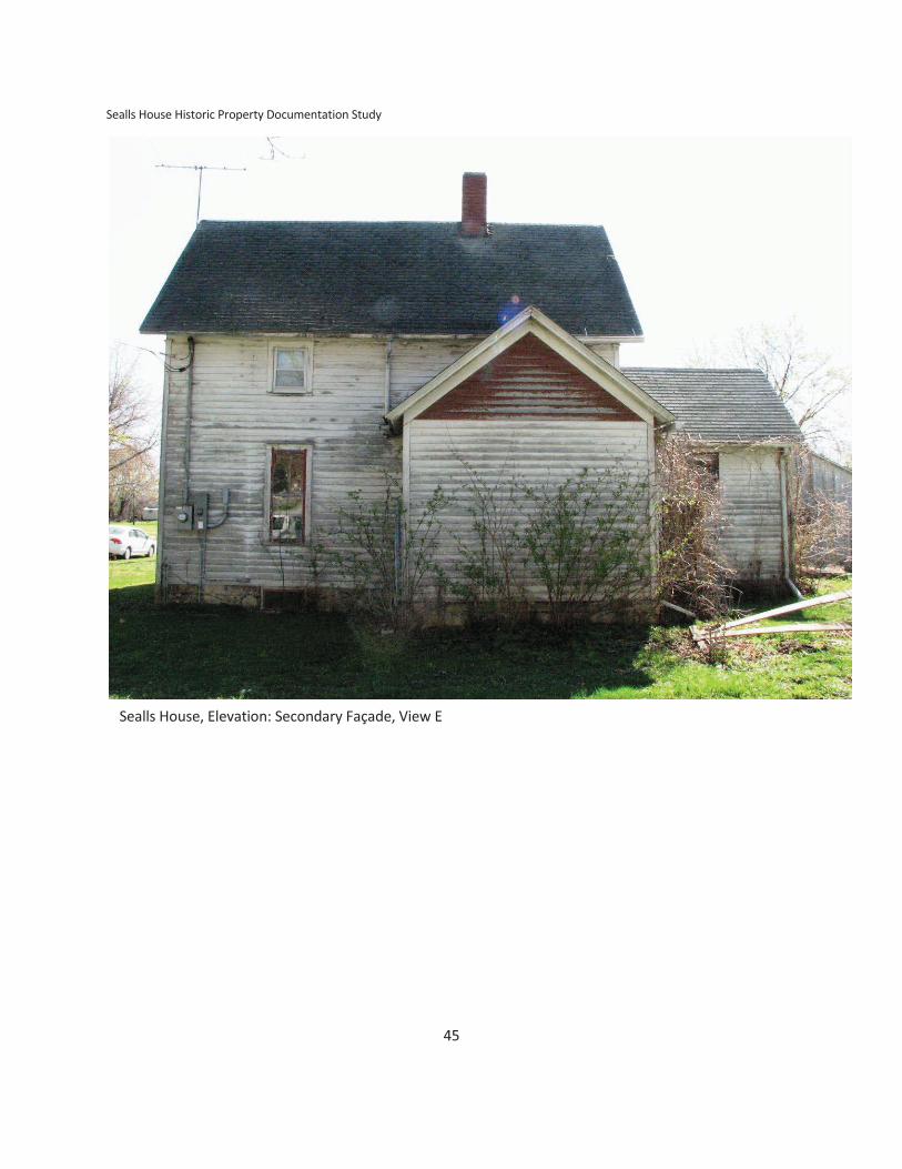
Sealls House Historic Property Documentation Study
45
Sealls House, Elevation: Secondary Façade, View E

46
APPENDIX B
REPRESENTATIVE PHOTOGRAPHS
Photographic Documentation Specifications
Photos on this supplemental form taken by Tim Weitzel, IDED-HPS, on behalf of the City of Olin, for CDBG-
DRHB flood risk minimization building acquisition and removal activity.
Narrative Description (supplemental form)
Field photography—4.29.11
Date April 29, 2011
Camera IDED Canon PowerShot S3 IS
Format JPEG 1600 X 1200 pixels at 360 dpi
Image Size 5.25 X 7 Inches (Nominally scaled to ISIF format)
Archival Photos—5.25.11 (provided on Compact Disk, write-once -R DVD-ROM #255-1 & #255-2)
Date May 25 2011
Camera Weitzel Nikon D60 Nikor DX 18-55 mm lens
Format RAW 2592 X 3872 pixels at 300 X 300 dpi/ppi
Color mode SRGB 24-bit depth

Sealls House Historic Property Documentation Study
47
Photo 1. Sealls House, View SW

Appendix B: Representative Photographs
48
Photo 2. Sealls House, View NE

Sealls House Historic Property Documentation Study
49
Photo 3. Sealls House, Property, View SW

Appendix B: Representative Photographs
50
Photo 4. Sealls House, Property, View NW

Sealls House Historic Property Documentation Study
51
Photo 5. Sealls House, Accessory Building. View NE

Appendix B: Representative Photographs
52
Photo 6. Sealls House, Accessory Building, View SW

Sealls House Historic Property Documentation Study
53
Photo 7. Sealls House, Neighborhood, View SW

Appendix B: Representative Photographs
54
Photo 8. Sealls House, Neighborhood, View SW

Sealls House Historic Property Documentation Study
55
Photo 9. Sealls House, Neighborhood, View NW
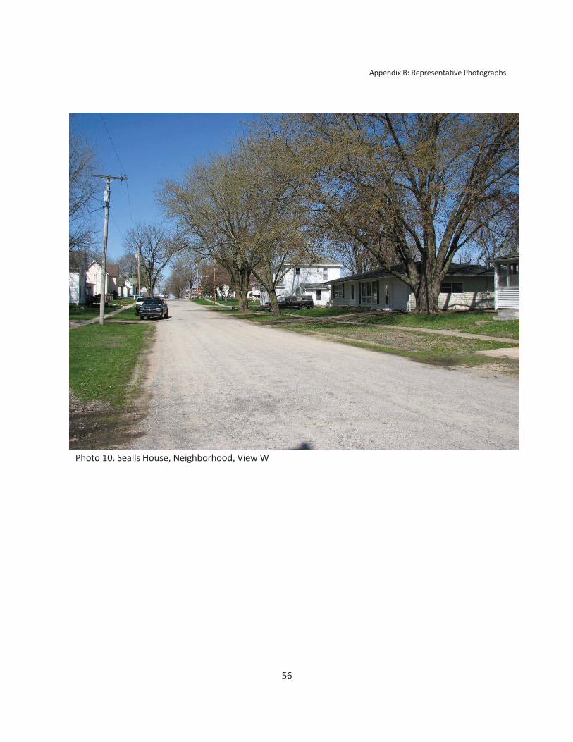
Appendix B: Representative Photographs
56
Photo 10. Sealls House, Neighborhood, View W

Sealls House Historic Property Documentation Study
57
Photo 11. Sealls House, Neighborhood, View NE

Appendix B: Representative Photographs
58
Photo12. Sealls House, Neighborhood, View SE
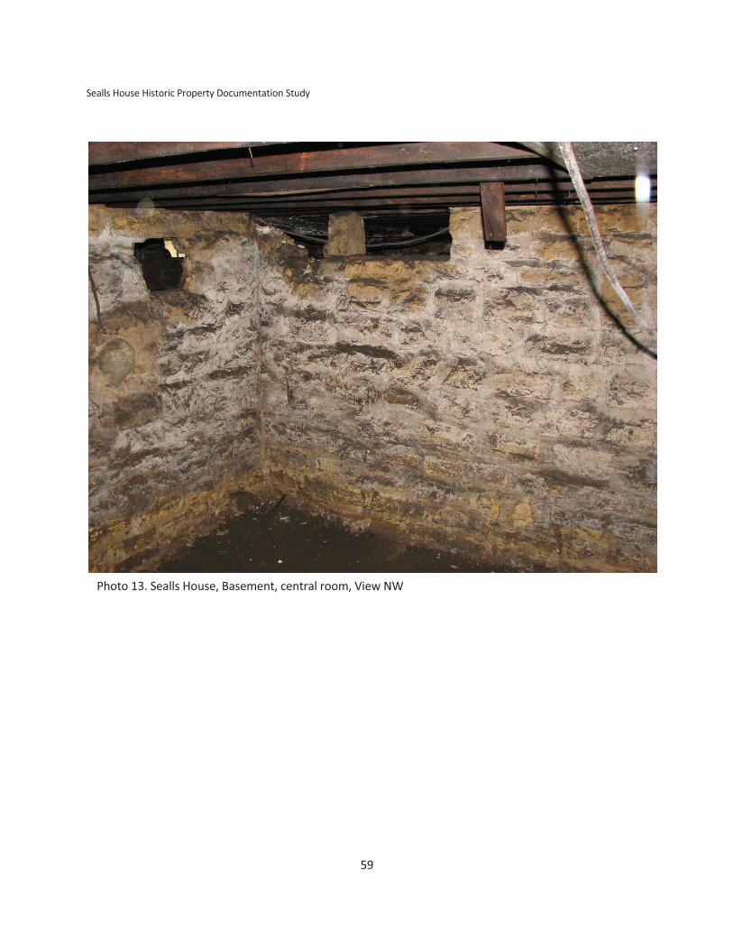
Sealls House Historic Property Documentation Study
59
Photo 13. Sealls House, Basement, central room, View NW

Appendix B: Representative Photographs
60
Photo 14. Sealls House, Basement, exterior of south wall of central room, door to
west passage, View W

Sealls House Historic Property Documentation Study
61
Photo 15. Sealls House, Front room or Parlor, View E

Appendix B: Representative Photographs
62
Photo 16. Sealls House, Front Room or Parlor, View NW

Sealls House Historic Property Documentation Study
63
Photo 17. Sealls House, Front Room or Parlor, Dining Room, Kitchen, View S

Appendix B: Representative Photographs
64
Photo 18. Sealls House, Dining Room and Doorway to Bath, View SE

Sealls House Historic Property Documentation Study
65
Photo 19. Sealls House, North wall of Dining Room and Entry, View NE

Appendix B: Representative Photographs
66
Photo 20. Sealls House, Covered ceiling, leakage evident, a. dining room, View NE;
b. Parlor, View SW

Sealls House Historic Property Documentation Study
67
Photo 21. Sealls House, West Room (Bedroom) and Closet under stairs, View NW

Appendix B: Representative Photographs
68
Photo 22. Sealls House, Stairs from Main Floor to Upper Story,
View E

Sealls House Historic Property Documentation Study
69
Photo 23. Sealls House, Upper Story, Leaks evident. a. at chimney (Added middle
of 20th C. South Room), and b. along west eaves in north room, View NE (Top),
View NW (Bottom)

Appendix B: Representative Photographs
70 Photo 24. Sealls House, Upper Story, a. Front Room Scuttle to Attic, and b. Wall
Structure, with leaks evident. View NE (Top), View SE (Bottom)

Sealls House Historic Property Documentation Study
71
Photo 25. Sealls House, Accessory Structure. Pot belly heating stove reported to be from a train depot,
View NE

Appendix B: Representative Photographs
72
Photo 26. Sealls House, Detail of Applied Gableboard. Ornamentation built from machined wood
elements featuring lathe-turned spindles, scroll saw cut work, saw milled boards, drop pendants, and
featuring Victorian Stylistic Elements (Carpenter Gothic and Queen Anne Elements). View SW

Sealls House Historic Property Documentation Study
73
Photo 27. Sealls House, Detail of Corner Pilaster with capital made of, bedmold fillets, and 5/4-board cap.
View SW

Appendix B: Representative Photographs
74
Photo 28. Sealls House, Detail of Oriel with curvilinear scroll saw cut ornamental
brackets with integral drop pendants. View SW.

Sealls House Historic Property Documentation Study
75
Photo 29. Sealls House, Detail of Northwest Building Corner showing relationship of
weatherboard, cornerboard, and stone foundation. Also note absence of water table, and joint
work repointed with Portland cement. View S

Appendix B: Representative Photographs
76
Photo 30. Sealls House, Detail of coal chute set into foundation wall of effectively modern cast
concrete masonry unit construction on east elevation. View W

Sealls House Historic Property Documentation Study
77
Photo 31. Sealls House, Detail of Chimney and roof vent that post-dates period of construction. View NW

Appendix B: Representative Photographs
78
Photo 32. Sealls House, Detail of Water Pump. View NE

Sealls House Historic Property Documentation Study
79
Photo 33. Sealls House, Detail of Cast Concrete front stoop and hand worked steel railing. View SW

Appendix B: Representative Photographs
80
Photo 34. Sealls House, Detail of East Wing, Exterior of North wall. View S

Sealls House Historic Property Documentation Study
81
Photo 35. Sealls House, Detail of handmade wooden awning. View SW

Appendix B: Representative Photographs
82
Photo 36. Sealls House, Detail of handmade wooden flag pole bracket attached east
adjacent to front porch doorway. View SW

83
APPENDIX C
REFERENCE FIGURES AND TABLES
Figure 1. Location Map. Sources: Iowa DOT and Wikipedia.
OLIN
JONES

Appendix C: Reference Figures and Tables
84
Figure 2. Composite USGS Map depicting local topography, permanent water, and the location of
early settlements and existing City of Olin. Note also the constriction of the river valley as the
Wapsipinicon exits the Rome outwash plain heading eastward toward Hale. (USGS Morley, 1996 and
USGS Stanwood, 1990 7.5 quadrangles.)
Elkford

Sealls House Historic Property Documentation Study
85
2nd St
Alley
Locust St
Cleveland St
River Scarp and Ox Bow
(abandoned ancient
channel) W
all
St
Ha
rris
on
St
North St
Railroad Berm
Iow
a H
igh
wa
y 3
8
Jack
son
St
APE
Creek Scarp and Ox Bow
(abandoned channel)
FIRM ZONE A
FIRM ZONE A
Figure3. LiDAR Hillshade Relief Map depicting areas of greater or lesser elevation and highlighting
natural and constructed topographic features. Area between dashed lines is the FEMA Flood
Insurance Rate Map designation for Zone A, which has a flood risk equivalent to the 100-year flood
plain (risk of flooding equal to 0.1% chance per year). Source: Iowa State Geographical Map Server,
Iowa Department of Natural Resources Light Detection and Ranging 1 meter digital elevation model
and Flood Insurance Rate Map, Intranetix FIRM viewer.

Appendix C: Reference Figures and Tables
86
Figure 4. 1838 General Land Office Map of Section 13, T83N-R3W and vicinity, including physical
geographical information such as rivers, streams, embankments, and political geographic features such
as the plat of Elkford and segments of well-established and conveyance trails. Note also the large groves
of trees, including the one labeled “Sugar Grove” in Sections 15, 14, 22, and 23. Retrieved June 9, 2011,
from the Iowa Geographic Map Server, Iowa State University Geographical Information Systems
Research and Support Facility and ISU GLO Research Project, Paul F. Anderson, Department of Landscape
Architecture and Department of Agronomy.

Sealls House Historic Property Documentation Study
87
Figure 5. 1875 Map. Plat map depicting Rome Township within a Plat of Jones County from a
statewide atlas. Note the proposed route for the S. A. & D Railroad, which had been recorded but
was not built. The rights to the line were bought and constructed as one line of the Chicago,
Milwaukee, & St. Paul. Source: A.T. Andreas’ Illustrated Historical Atlas of the State of Iowa.
Andreas Atlas Company, Chicago. 1875. Color copy retrieved June 9, 2011, from the Jones County
Historical Society Web Site, photographed by Jim Christensen.
Elkford

Appendix C: Reference Figures and Tables
88
Elkford
Figure 6. 1877 Map. Plat and Atlas showing Olin, the mill race north of town, and the location of
early settlements. Burlingame 1877, color copy retrieved June 9, 2011, from the Jones County
Historical Society Web Site, photographed by Jim Christensen.

Sealls House Historic Property Documentation Study
89
Figure 7. 1893 Map. Plat and Atlas showing Olin, the mill race north of town and Olin Town
Cemetery in the middle of Section 24, south of town. North West Publishing 1893, color copy
retrieved June 9, 2011, from the Jones County Historical Society Web Site, photographed by Jim

Appendix C: Reference Figures and Tables
90
Figure 8. 1893 Map. Plat of Olin, indicating subdivisions, lot lines, geophysical features, and rural
ownership. North West Publishing 1893, color copy retrieved June 9, 2011, from the Jones County
Historical Society Web Site, photographed by Jim Christensen.

Sealls House Historic Property Documentation Study
91
1870–1890
1890–1910
1910–1930
1930–1950
1970–2008
1950–1970
D. Dwelling
f.D. (former)
G. Accessory Building
Figure 9. Schematic Representation of Land Use History as of fall 2008 Block 2 and Block 3, Cronkhite’s
Addition.
Former creek channel
1
2
3
4
5
6
7
8
16 15 14 13 12 11 70 9
16 15 14 13 12 11 70 9
Sealls House
11
D.
D. f. D.
f. D. D. D.
D. D.
G.
G.
O.
D.
G.
D. D.
13
G.
G.
14
O.
D.
D.
D. D.D. D.D.
1312
O.
D. D.
G.
G.
15G.
D.
A.G.
13
O.
Overlapping building
footprint from distinct
time periods

Ap
pe
nd
ix C
: R
efe
ren
ce F
igu
res
an
d T
ab
les
92
Ta
ble
of
His
tori
c P
ers
on
s, O
ccu
pa
tio
ns,
an
d Im
mig
rati
on
De
tails
Na
me
O
ccu
pa
tio
n a
nd
Off
ice
s R
esi
de
nce
Y
ea
r A
rriv
ed
Fro
m L
oca
tio
n
Bir
th P
lace
V
ita
l S
tati
stic
s
SEE
LEY
, N
orm
an
B.
Lyd
ia
1st
P
ost
M
ast
er,
M
ille
r,
Farm
er.
E
lect
ion
s
18
39
–1
85
2 h
eld
at
his
ho
use
ne
ar
Jack
son
an
d
2n
d A
ven
ue
.
Wa
lnu
t Fo
rk
18
39
N
ew
Yo
rk
b. 1
81
0
d.
18
64
(P
OW
An
de
rso
nvi
lle, G
A)
N
ew
Yo
rk
b. 1
81
2
CLE
VE
LAN
D,
Ric
ha
rd J
.
Ma
ry (
SEE
LEY
)
Surv
eyo
r, F
arm
er-
Ga
rdn
er,
Po
st M
ast
er,
Am
on
g
the
ma
ny
are
as
he
su
rve
yed
incl
ud
e t
he
Pla
t fo
r
Ro
me
an
d L
exi
ng
ton
(A
na
mo
sa)
Ro
me
22
0
ac.
Sold
18
68
18
40
Illin
ois
Bo
sto
n
Gra
du
ate
d
Ha
rva
rd 1
82
7
b. 1
80
5
d. 1
87
7
m. 1
83
9 Il
lino
is
18
40
Illin
ois
Ne
w Y
ork
Mo
ved
18
36
b. 1
81
4
m.
18
78
Jo
sep
h
Low
ry
ME
RR
ITT
, Jo
hn
Ca
the
rin
e
or
Ka
the
rin
e
(CU
LP)
Ca
rolin
e
(DU
NLA
P,
HA
RV
EY
)
1st
Se
ttle
r in
Olin
Are
a a
nd
fir
st a
s fa
r w
est
as
the
Me
rrit
t H
om
est
ea
d i
n J
on
es
cou
nty
. M
ay
ha
ve a
rriv
ed
as
ea
rly
as
18
36
bu
t re
turn
ed
to
Ne
w
Yo
rk,
the
n
Clin
ton
, IA
w
ith
h
is
fam
ily.
Farm
er,
1
st
Ro
ad
Su
pe
rvis
or
Jon
es
Co
un
ty
Dis
tric
t 3
, T
rust
ee
, In
he
rite
d
Surv
eyo
r’s
Co
mp
ass
fro
m A
bo
litio
nis
t Jo
hn
Bro
wn
Me
rrit
t H
om
est
ea
d
Sec.
3
Ro
me
TW
P
75
4 a
c
18
36
Ne
w Y
ork
18
37
Clin
ton
, IA
Ne
w Y
ork
Mo
ved
1
83
6,
18
37
b. 1
80
6
d.
P
en
nsy
lva
nia
Pe
nn
sylv
an
ia
b. 1
80
0
d. 1
83
5
m. 1
82
7
b. 1
82
8
d.
m. 1
85
6
ME
RR
ITT
, Jo
sep
h H
.
Ma
ry
Farm
er
Me
rrit
t H
om
est
ea
d
Sec.
3
Ro
me
TW
P
18
37
Oh
io
Ne
w Y
ork
Mo
ved
b. 1
83
3
d.
N
ew
Yo
rk
b.
18
00
(Pe
nn
sylv
an
ia)
d.

Sea
lls H
ou
se H
isto
ric
Pro
pe
rty
Do
cum
en
tati
on
Stu
dy
93
Ta
ble
of
His
tori
c P
ers
on
s, O
ccu
pa
tio
ns,
an
d Im
mig
rati
on
De
tails
Na
me
O
ccu
pa
tio
n a
nd
Off
ice
s R
esi
de
nce
Y
ea
r A
rriv
ed
Fro
m L
oca
tio
n
Bir
th P
lace
V
ita
l S
tati
stic
s
CR
ON
KH
ITE
, Will
iam
E.
Ca
rolin
e (
MA
NG
OLD
)
Farm
er,
Ro
ad
Su
pe
rvis
or,
1st
Co
un
ty T
rea
sure
r
Cro
nkh
ite
Ho
me
ste
ad
Sec.
3
Ro
me
TW
P
18
37
In
dia
na
b
. 18
33
to
d. 1
92
6
m.
18
66
W
aln
ut
Fork
Sw
itze
rla
nd
b
. 18
37
–1
84
6
d. a
fte
r 1
92
0
CR
ON
KH
ITE
, O
rvill
e
Lovi
nia
(B
AU
GH
)
Farm
er,
M
erc
ha
nt,
E
lect
ion
Ju
dge
, P
rob
ate
Jud
ge,
Just
ice
of
the
Pe
ace
Cro
nkh
ite
Ho
me
ste
ad
Sec.
15
44
0 a
c.
18
39
Ne
w Y
ork
b
. 18
10
d. 1
87
5,
Ro
me
O
hio
b
. 18
14
d. 1
90
0,
Olin
CR
ON
KH
ITE
, O
rio
n
(Ora
n, O
rin
)
Luci
nd
a (
SAU
M)
Farm
er
Son
Will
iam
Ste
wa
rd b
. 18
49
Jo
ne
s C
ou
nty
Cro
nkh
ite
Ho
me
ste
ad
Sec.
15
Ro
me
TW
P,
Fre
em
on
t T
WP
, C
ed
ar
Co
un
ty 1
88
0
Be
fore
18
70
Lee
Co
. IA
18
40
Ind
ian
a
Ne
w Y
ork
b. 1
81
3
d. 1
87
1
m. 1
83
5
Oh
io
Oh
io
b. 1
81
7
d. a
fte
r 1
88
5
RU
MM
ELL
, Jo
hn
Ma
thia
s
Ta
nn
er,
Son
of
G. P
. an
d J
. R
um
me
ll o
f P
en
nsy
lva
nia
Olin
18
53
Oh
io
Pe
nn
sylv
an
ia
mo
ved
18
35
b. 1
82
8
d. 1
90
6
m. 1
85
3
Ma
rga
ret
(MC
CO
NK
IE)
Pa
ren
ts o
f Jo
hn
Alb
ert
Ru
mm
el
wh
o m
ove
d t
o
Leb
an
on
, M
isso
uri
O
hio
O
hio

Ap
pe
nd
ix C
: R
efe
ren
ce F
igu
res
an
d T
ab
les
94
Ta
ble
of
His
tori
c P
ers
on
s, O
ccu
pa
tio
ns,
an
d Im
mig
rati
on
De
tails
Na
me
O
ccu
pa
tio
n a
nd
Off
ice
s R
esi
de
nce
Y
ea
r A
rriv
ed
Fro
m L
oca
tio
n
Bir
th P
lace
V
ita
l S
tati
stic
s
RU
MM
ELL
, Da
vid
E.
Ha
rrie
t,
or
Ha
ttie
(EA
STE
RLY
)
Me
rch
an
t,
tin
ne
r,
mis
cella
ne
ou
s o
ffic
es
Son
of
G. P
. an
d J
. R
um
me
ll o
f P
en
nsy
lva
nia
.
Olin
Olin
18
55
Oh
io
Pe
nn
sylv
an
ia
mo
ved
18
35
b.1
84
0
d.
m. 1
86
8
18
52
Oh
io
Oh
io
b.1
85
1
SAU
M,
Ge
org
e
Susa
na
T.
(ST
ING
LEY
)
Co
rde
lia H
UG
EN
S
Farm
er,
Fath
er
wa
s in
U.S
. Co
nti
ne
nta
l Arm
y
Orc
ha
rds
18
42
Firs
t M
cCo
rmic
k R
ea
pe
r in
co
un
ty 1
84
4
Firs
t ra
ise
r o
f st
ock
18
46
Eve
ntu
ally
ow
ne
d 1
60
0 a
c Jo
ne
s C
o.,
40
0 a
c.
Ce
da
r C
ou
nty
Sau
m H
om
est
ea
d,
Wa
lnu
t G
rove
,
Sec.
27
Ro
me
TW
P
19
0 a
c
18
41
(1
83
9)
Fort
Ma
dis
on
Oh
io
b. 1
81
4
d. 1
90
8
Ind
ian
a
An
am
osa
b. 1
81
1
m. 1
83
4
d. 1
87
3
SLIF
E, D
an
iel
Ca
the
rin
e
Ca
rpe
nte
r O
lin
18
49
O
hio
(Pe
nn
sylv
an
ia)
No
te:
All
wo
me
n w
ere
list
ed
as
“Ke
ep
ing
Ho
use
”
Sou
rce
: U
S Fe
de
ral a
nd
Iow
a S
tate
Ce
nsu
s, A
nce
stry
.Co
m, H
isto
rica
l Bio
gra
ph
ies

Sea
lls H
ou
se H
isto
ric
Pro
pe
rty
Do
cum
en
tati
on
Stu
dy