seamap field operations manual for ......tips on keyboard use 1-20 c. data editing 1-20 d. first, or...
TRANSCRIPT

SEAMAP FIELD OPERATIONS MANUAL
FOR COLLECTION OF DATA
Prepared by:
NATIONAL MARINE FISHERIES SERVICE
and
GULF STATES MARINE FISHERIES COMMISSION
October 2001 (Revision No. 4)
-ii-
FOREWORD
This manual presents the procedures to be followed by all vessels that participate in the Southeast Area Monitoring andAssessment Program (SEAMAP) surveys. These procedures have beenestablished and agreed to by the Gulf SEAMAP Subcommittee for thepurpose of standardizing data collection.
This manual is not meant to be a static document. Thedocument will be updated as new types of surveys and modificationof existing surveys are introduced. This is the fourth (4th)revision to this manual.
Please report problems or errors in this document to one ofthe following personnel:
Rob FordNational Marine Fisheries Service
P O Drawer 1207Pascagoula, MS 39568-1207(228) 762-4591 ext. 286
Jeff ResterSEAMAP-Gulf CoordinatorGulf States MarineFisheries Commission
P O Box 726Ocean Springs, MS 39564
(228) 875-5912
-iii-
TABLE OF CONTENTS
INTRODUCTION . . . . . . . . . . . . . . . . . . . . . . vi
I. COLLECTING BIOLOGICAL DATA 1-1A. Introduction 1-2B. Summer and Fall Trawl Surveys 1-2 1. Trawling 1-2 2. Survey Strategy 1-2 3. Sampling Catch 1-2 4. Processing Catch (Sample) 1-3C. Instructions for NMFS Pascagoula Station Sheet, Types I-IV 1-4 1. General Comments 1-4 2. Data requirements For All Stations 1-4 3. Data requirements For Biological Stations 1-6D. NMFS Length Frequency Form Instructions 1-13 1. Introduction 1-13 2. General Length Frequency Form 1-15 3. NMFS Reef/Large Fish Length Frequency Form 1-17 4. Shrimp Length Frequency Form 1-17E. Instructions for Electronic Measuring Boards 1-19 1. Introduction 1-19 2. Software Setup Instructions 1-19
a. Computer Setup 1-19b. Tips On Keyboard Use 1-20c. Data Editing 1-20d. First, or Next New Station 1-21e. Shrimp Corrections 1-21f. Fish And Other Non-Shrimp Corrections 1-21
3. Data Entry At The Boards 1-22a. Entering Station data 1-22b. Entering “Fish” Measurements 1-22c. Shrimp Measurements For Summer Cruise Only 1-23d. Reef/Large Fish- Detailed Meristics 1-24
4. How To Correct Board Entry Errors 1-25F. List of Figures Figure 1-1, NMFS Pascagoula Station Sheet-Type II 1-10 Figure 1-2, Gulf Shrimp Landing Statistical Zones 1-11 Figure 1-3, NMFS Faunal Zones 1-12 Figure 1-4, General Length Frequency Form 1-14 Figure 1-5, NMFS Reef/Large Fish Detailed
Meristics Form 1-16 Figure 1-6, Shrimp Length Frequency Form 1-18
II. SEAMAP REAL-TIME DATA 2-1A. Introduction 2-2B. 1. SEAMAP Real-Time Station Data Form Instructions 2-3 2. SEAMAP Real-Time Station Data Form, Figure 2-1 2-5C. 1. SEAMAP Real-Time Length/Frequency Data Form
Instructions 2-62. SEAMAP Real-Time Length/Frequency Data Form,
Figure 2-2 2-7 D. SEAMAP Real-Time Alphabetic List of Species Codes,
Table A 2-8
-iv-
E. SEAMAP Real-Time Numeric List of Species Codes, Table B 2-9
III. STANDARD SEAMAP SHRIMP AND GROUNDFISH SAMPLING TRAWL GEAR SPECIFICATIONS 3-1
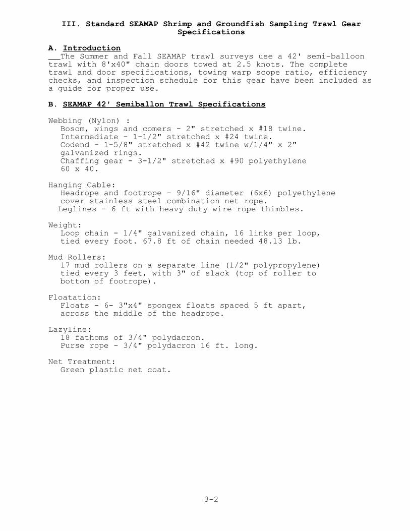
A. Introduction 3-2B.1. SEAMAP 42' Trawl Specifications 3-2 2. SEAMAP 42' Trawl Schematic, Figure 3-1 3-3C.1. Door, Tickler Chain, and Bridle Specifications 3-4 2. 8 Foot x 40 Inch Otter Door Design, Figure 3-2 3-5 3. 8 Foot Door Shoe Design, Figure 3-3 3-6D. Recommended Towing Warp Scope Ratio 3-7E. Checks to Determine Trawl Efficiency 3-8F. Gear and Rigging Schedule 3-9
IV. COLLECTING ENVIRONMENTAL DATA 4-1A. Introduction 4-2B. Environmental Data Form, Instructions 4-3 Environmental Data Form, Figure 4-1 4-6C. Sample Collection Methodology 4-7 1. Secchi Disc Water Transparency Measurements 4-7 2. Forel-Ule Water Color Measurements 4-7 3. Hydrocast Sampling Procedures 4-8 4. Collecting Water Samples for Salinity 4-10 5. Chlorophyll Sampling Procedures 4-10 6. Collecting Dissolved Oxygen(DO)Procedures 4-12D. CTD Procedures 4-15 1. Introduction 4-15 2. Initial CTD Inspection Prior to the Cruise 4-15 3. Precruise SEASAVE Software Setup 4-17 4. Making A Cast 4-23 5. Printing A CTD Profile Graph 4-25
V. COLLECTING ICHTHYOPLANKTON 5-1A. Introduction 5-2B. SEAMAP Ichthyoplankton Sampling: General Comments 5-2C. Ichthyoplankton Station Procedures 5-2
1. Bongo Sampling 5-2(a)Station Operations I without a monitored depth device 5-3 Table A - Approximate payout and retrieval rates 5-4(b)Station Operations II, with a monitored depth device 5-7
2. Neuston Sampling 5-10D. NMFS Pascagoula Station Sheet TYPE-I, Instructions 5-13
E. Ichthyoplankton Station Form Instructions 5-17
F. Instructions for Completing Ichthyoplankton Sample Labels 5-21
1. Outside Labels 5-212. Inside Labels 5-22
G. Flowmeter Performance Tracking Form Instructions 5-24

-v-
H. Ichthyoplankton Sample Ledger and Transfer Record Instructions 5-26
I. Handling and Storage of Ichthyoplankton Gear 5-281. Bongo Nets\Frames 5-282. Neuston Nets\Frames 5-283. 2030R Mechanical Flowmeter 5-284. Cod Ends 5-28
J. Disposition of Samples 5-29K. Your Field Notes 5-30L. List of Figures 1. NMFS Pascagoula Station Sheet Type-I, Figure 5-1 5-16 2. Ichthyoplankton Station Form, Figure 5-2 5-20 3. Sample Completed Labels, Figure 5-3 5-23 4. Flowmeter Performance Tracking Form, Figure 5-4 5-25 5. Ichthyoplankton Sample Transfer
Record Form, Figure 5-5 5-27
VI. APPENDICES A-1 1. Vessel Codes A-2 2. A. Time Zone Codes A-3 B. Beaufort Sea Condition Scale A-3 C. Data Source Codes A-3 3. Gear Type Codes With Examples A-4 4. Operation Codes A-6 5. A. Water Color Codes A-7 B. Bottom Type Codes A-7 C. Bottom Regularity Codes A-7 D. Precipitation Codes A-7 6. Alphabetic List of Species Length Frequency Measurement Codes A-8 7. Length Frequency Measurement Code Finder List A-19 8. Measuring Board Species Codes A-22 9. Five Point Sexual Maturity Scale A-2710. Equipment Checklist For Ichthyoplankton Cruises A-2811. Ichthyoplankton Data Sheet Gear and Mesh Codes A-29 A. Gear Codes A-29 B. Mesh Size Codes A-29
VII. TABLES 1. Conversion for Meters to Fathoms T-12. Conversion for Meters to Feet T-23. Conversion for Feet to Fathoms T-34. Temperature Conversion Table T-45. Solubility of Oxygen in Fresh Water T-56. Refractometer (Conversion - Brix to Salinity) T-67. Dissolved Oxygen Saturation Values in Sea Water T-78. Wire Angle Table T-8
-vi-
INTRODUCTION
The following is a SEAMAP operations manual for use aboardall designated SEAMAP survey vessels. The procedures in thismanual have been agreed to by the SEAMAP Subcommittee in order tostandardize SEAMAP data collection. These procedures are thesequence of events to be followed on each station for SEAMAPcruises. All vessels may not adhere to this sequence rigidly asthey may not all have the same environmental, plankton orbiological collecting gears. For those vessels lacking certaintypes of sampling apparatus, these methods will still apply. Iffor some reason procedures in this manual are not followed,please take the time to document the procedures used for yourparticular survey.
This manual is composed of five sections. Three sectionsaddress the major types of SEAMAP survey data: biological ortrawling data, environmental data, and ichthyoplankton data. Onesection addresses Real-Time Data. A new section on the trawlinggear has been added. New material has been included for using theelectronic measuring boards, CTD, and STD.
On all SEAMAP surveys, a Pascagoula Station Sheet Type I-IVmust be completed for every station- trawl station, environmentalstation, or plankton station. The following general instructionsapply to all types of data sheets- Biological, Environmental, andPlankton:
Please use a soft lead pencil and make entries DARK enoughand LEGIBLE enough so that the key entry operator can readthem. All numeric fields are to be right justified oraligned with the decimal place. A leading zero is notrequired, but enter any trailing zeros.

1-1
I. COLLECTING BIOLOGICAL DATA
1-2
I. COLLECTING BIOLOGICAL DATA
A. Introduction
SEAMAP surveys use trawling gear to collect biological data(i.e. finfish, shrimp, and other invertebrates). Prior to 1987three types of SEAMAP trawling surveys were: offshore butter-fish, summer shrimp (Texas Closure), and fall groundfish. Theoffshore butterfish surveys were discontinued in 1986. The samesurvey design for the summer shrimp (Texas Closure) and fallgroundfish surveys have been used from 1987 to the present.
B. Summer and Fall Trawl Surveys
1. Trawling - sampling will be conducted around the clock withan equal number of day and night stations. Day and night aresampled as independent strata. (Note: Several of the statevessels will not be able to operate around the clock or atnight due to size limitations and availability ofpersonnel).
2. Survey strategy - SEAMAP sampling sites are chosen randomlywithin strata determined by depth and statistical area (twoor three areas per stratum). Sampling sites in water depthsof 5-20 fathoms, stations occur at 1 fathom strata; 20-22fathom stations at 2 fathom strata; 22-25 fathom stations at3 fathom strata; 25-50 fathom stations at 5 fathom strata,and finally a 50-60 fathom stratum. Trawls are towedperpendicular to the depth contours and cover the entiredepth stratum for each sample site. Towing time can varyfrom a minimum of 10 minutes to a maximum of 55 minutes. Forsample sites with depth strata that cannot be covered by asingle 55 minute tow, a series of consecutive trawl tows (2,3, or 4) will be necessary to cover that depth stratum. Eachtow receives a separate station number. An extremely narrowstratum may be towed obliquely to ensure at least 10minutes towing time.
3. Sampling Catch a. If the total weight of the catch is less than 22.7 kilos
and is not excessively diverse in species composition, thenthe entire catch shall be processed. If a catch isespecially diverse, then the watch leader may exercise theoption of sampling.
b. If the total weight of the catch is between 22.7 and45.4 kilos, obtain a sample equal to 50% of the totalweight and process.
c. If the total weight of the catch is between 45.4 and 90.7kilos, obtain a sample equal to 25% of the total weight andprocess.
d. If total weight of catch is between 90.7 and 136.0 kilos,obtain a sample equal to 18% of the total weight and
1-3
process.
e. If the total weight of catch is greater than 136.0kilos, obtain a sample equal to 12% of the total weight andprocess.
Note: If time allows, the watch leader should process theentire catch regardless of catch weight.
4. Processing Catch (Sample)
a. Separate entire catch or aliquot sample into itscomponent species, then weigh (a species total weight) andcount the number of individuals for each species.
b. Record species, weight, and number on field datasheet, NMFS Pascagoula Station Sheet-Type II.
c. Measure all organisms that are identified to the specieslevel. Do not measure organisms identified to the genus orhigher taxon. Record measurements on the General LengthFrequency Form.
d. Process shrimp species in the following prescribedmanner:
(1) For the summer survey only, to include: sex, lengthfrequency, and weight. Farfantepenaeus aztecus (brownshrimp), F. duorarum (pink shrimp) and Litopenaeussetiferus (white shrimp) will be separated from eachtrawl catch station. Total count and weight by specieswill be recorded. A random sample of up to 200 of eachspecies from each trawl catch will be sexed, thenweighed and measured by sex to obtain length frequencydata. On SEAMAP stations where more than one trawl towis necessary to cover the depth stratum, shrimp fromeach haul will be worked up separately as describedabove. Shrimp data will be recorded only on the ShrimpLength Frequency Form or measured on the electronicmeasuring boards. Do not record on the General LengthFrequency Form.
(2) For the fall survey, shrimp are treated the same asfinfish and other invertebrates. Only 20 shrimp lengthfrequencies are recorded per station.
e. Proceed to the next station.
1-4
C. NMFS Pascagoula Station Sheet - Types I-IV Instructions
1. GENERAL COMMENTS- A Pascagoula Station Sheet MUST becompleted for every SEAMAP station. The top section (down tothe heavy black line across page) MUST be completed for eachstation occupied, regardless of gear types(s) used. Thereare four types of NMFS Pascagoula Station Sheets, Types I toIV. Each type of data sheet has the same data entry fieldsexcept for the species list. The Type I data sheet specieslist is blank, and is used primarily for plankton surveysand as a continuation sheet for the other three types. TheType II data sheet lists dominant species encountered atdepths of 0-49 fathoms (Figure 1-1, page 1-10), Type III fordepths of 50-149 fathoms, and Type IV for depths of 150-300fathoms.
Please use a lead pencil and make entries DARK enough and LEGIBLEenough so that the key entry operator can read them. All numericfields are to be right justified or aligned with the decimalplace. Leading zeros are not required, but enter trailing zeros.
2. Data Requirements For All Stations:
FIELD BY FIELD INSTRUCTIONS
VESSEL - Enter 2-digit numerical code from Appendix 1,Vessel Codes, page A-2. If your vessel has not beenassigned a code, notify NMFS Pascagoula to receive one.
PASCAGOULA STATION NUMBER - This is a unique sequentialconsecutive 5-digit number within each cruise, preferablystarting with "00001". For state vessels enter the 2-digitvessel code followed by a 3-digit station number. Transferthis station number to the environmental or plankton sheet.Do not duplicate this station number for other stations on acruise.
CRUISE - Enter 3-digit cruise number. Except for the OregonII and other vessels having historically different cruisenumbering conventions, the cruise number for ALL VESSELSshall be the calendar year of the survey followed by thecruise number for the year, e.g. "011" first cruise for year2001, "012"- second cruise for year 2001, etc. The leadingzero is required. Use this cruise number on all sheetsduring a cruise; do not change it.
START TIME - Obtain time zone code from Appendix 2-A, TimeZone Codes, page A-3. Enter military time (0000-2359), HHMM,of start of station. For fishing stations, enter dog-offtime or end of gear set. For environmental and planktonstations, enter the time data acquisition started.
START LATITUDE & LONGITUDE - Enter position occupied atstart time in degrees, minutes, and hundredths of minutes,observing indicated decimals and entering trailing zeros.
1-5
START DEPTH - Enter starting depth in fathoms and tenths.
SEAMAP/OTHER STATION NO. - Use for SEAMAP or other alternatestation numbers. For SEAMAP Station numbers, use four alpha/numeric characters and right justify, but be consistent infield length - all numbers should be the same number ofcharacters, T065, W102, NOT T65 or W0102.
DATE - Enter station date (based on start time), in theformat MMDDYY.
END TIME - Enter as for start time - fishing stations end atstart of haulback, others when data acquisition ends.
END LATITUDE & LONGITUDE - Enter position occupied at endtime in degrees, minutes, and hundredths of minutes,observing indicated decimals and entering trailing zeros.
END DEPTH - Enter end depth in fathoms and tenths, observingthe indicated decimal and entering a trailing zero.
GEAR TYPES USED AT THIS STATION - Enter codes for all geartypes used- see Appendix 3, Gear Codes and Examples on Use,page A-3.
SURFACE AND BOTTOM TEMPERATURES - If taken, entertemperatures in degrees Celsius, observing 2 indicateddecimals. Add trailing zeros if necessary. If more than one method is used, data entry precedence is 1) CTD, 2) XBT,and 3) bucket.
Wind speed and direction may be measured by either the ship’sonboard instruments or handheld anemometers and a compass. Handheld anemometers and compasses are available from wildlife andfishery supply houses. All weather data should be rounded off tonearest hour, i.e. if the time is 13:31 then record weather datacollected at 14:00 hours.
AIR TEMPERATURE - Enter in degrees Celsius and tenths (drybulb), observing 1 indicated decimal.
BAROMETRIC PRESSURE - Enter in millibars of mercury,observing 1 indicated decimal.
WIND SPEED - Enter wind speed in knots, no decimals.
WIND DIRECTION - Enter wind direction in compass degrees,001-360.
WAVE HEIGHT - Enter wave height in meters, observing 1indicated decimal.
SEA CONDITION - Enter Beaufort scale- see Appendix 2-B,
1-6
Beaufort Sea Condition Table, page A-3.
DATA SOURCE CODE - Enter code identifying data collectingentity- see Appendix 2-C, Data Source Codes, page A-3.
VESSEL SPEED - Enter vessel speed, in knots, during thestation, observing 1 indicated decimal.
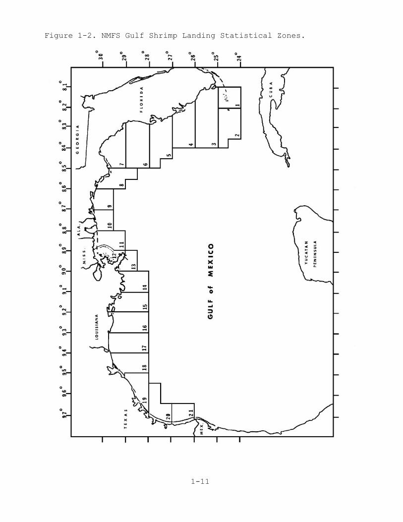
STATISTICAL ZONE - Enter GCSD statistical zone from Figure1-2, page 1-11. Leave blank if you are outside astatistical zone.
TOW NO. - Consecutive number of the tow within a SEAMAPstation.
NET NO. - 1 = Port, 2 = Starboard and 3 = Stern Trawl.
The data above must be recorded regardless of type of station.
3. Data Requirements For Biological And Trawling stations:
FIELD BY FIELD INSTRUCTIONS
NMFS FAUNAL ZONE - Enter NMFS Faunal Zone from Figure 1-3,page 1-12.
GEAR SIZE - Enter gear size as follows:
Trawls - headrope length in feetLonglines (surface, bottom, and off-bottom) - number of hooks returnedTraps - number returned Handlines, trolling gear - number of lines fished. Other - see FPC or contact Pascagoula data management
GEAR TYPE - Enter the code for fishing gear type used fromAppendix 3, Gear Codes with Examples On Use, page A-4.
MESH SIZE - Enter stretched mesh size in inches: a 40-ft trawl is 1.58 inchesa 65-ft trawl is 2.00 inches
OPERATION - Enter codes only for unsuccessful or abnormalstations from Appendix 4, Operation Codes, page A-6.
MINUTES FISHED - Enter minutes actually fished (end set tostart haulback; 55 minutes maximum for SEAMAP trawlstations).
WATER COLOR - Enter the gross water color, daytime only,from Appendix 5-A, Water Color Codes, page A-7.
BOTTOM TYPE - Enter from Appendix 5-B, Bottom Type, page A-7, if known. Left justify if code is one character.
1-7
BOTTOM REGULARITY - Enter from Appendix 5-C, Bottomregularity, page A-7, if known.
TOTAL LIVE CATCH - Enter total LIVE catch in kilograms,observing 1 decimal. For extremely small catches, you mustenter a minimum weight of 0.1 kg. DO NOT include weight ofdead shell, mud, sand, wood, rocks, trash, etc. Such itemsshould be mentioned in the comments section or with anoperation code. Use an actual or estimated weight, but domake an entry.
FINFISH, CRUSTACEANS, AND OTHER LIVE CATCH - Record in thesesections the totals for each category in kilos and tenths. These should reflect the ENTIRE live catch, not just thesample or select weight. When completed, these figuresshould add up to the "total live catch" weight above. Whenworking up the entire catch, obtain total weight for eachcategory and record. For catches which were sampled, it isnecessary to extrapolate from the sample weights to obtainthe total weights. This is done by using the formula:
(A-B) x D + E = F C
where:
A = Total live catch. B = Select weight (weight of all species removed from the
catch in their entirety). C = Total sample weight.
D = Sample weight of category (finfish, crustaceans, orothers).
E = Select weight of category (finfish, crustaceans, orothers).
F = Total catch weight of category. Record this figure inthe appropriate block. Enter at least 0.001 if acategory is represented.
This operation should be performed for each category. The "Other live catch" includes any organisms that are notfinfish or crustaceans, such as squid, jellyfish, starfish,horse shoe crabs, sea-turtles, sea grasses, mollusks, etc.
The following two fields should be completed ONLY if thecatch was sampled.
SELECT WEIGHT - Enter total weight of all species removedfrom the catch IN THEIR ENTIRETY. This will normallyinclude commercial shrimp; some food or sport fish; sharks,skates, rays, or other large fish; or other species that arerare or poorly represented in the catch. Observe 3 decimalplaces. Do not record any weight data in this section ifthe catch was NOT sampled.
1-8
SAMPLE WEIGHT- Total weight of the sample, obtained bysumming the various sample components. Be sure not toinclude any of the 'select' species in the sample. Observe 3 decimal places. DO NOT record data in this section if thecatch was NOT sampled.
SPECIES DATA SECTION - Crustacea, other, finfish. ThePascagoula Types II-IV station sheet contains pre-printedlists based on working depth, the Type I does not have apre- printed species list, use it for a continuation sheetor for a plankton station.
GENUS AND SPECIES - Locate organism in pre-printed specieslist. If not present, enter first seven characters of genusname and first six of species name, or, if not identified tospecies level, enter up to thirteen characters of genus,family, class, etc. Refer to Appendix A-6, Alphabetic Listof Length Frequency Codes, page A-8, for genus and speciesnames.
YOY - Make an entry from the codes below only if:Two distinct size classes occur for a species; Samples weretaken; organisms were Counted, but no weight is available;the organism(s) weight was Estimated; or if colonialorganisms such as sponges, corals, or zoobotryon wereWeighed, but not counted. Otherwise, leave this field blank.
YOY Entry Codes:T- denotes young of the year.S- denotes specimens were retained frozen or preserved.C- denotes counts were recorded without a weight.E- denotes an estimated weight was recorded.W- denotes a recorded weight, but individual numbers are unavailable, for colonial organisms, sponges, corals, etc.
NUMBER - Enter number of individuals in SELECT or SAMPLE.For some colonial organisms, sponges and corals, enter thenumber of pieces.
SAMPLE WT.(kg) - Enter weight in kilos of organism in theSAMPLE column, observing three decimal places. Entertrailing zeros where needed.
SELECT WT.(kg) - Enter weight in kilos of organism in the SELECT column, observing three decimal places. Entertrailing zeros where needed. IMPORTANT: If the catch wasworked up in its entirety (not sampled), ALL weight entrieswill be in the SELECT column. Do not list a species in boththe sample and SELECT column.
Subtotal the sample and select weights columns for each category,then combine for total sample and select weights.
GEAR DATA - Detail gear used. If the same gear is to be usedfor the entire cruise, this section need be filled out only

1-9
for the first station.
COMMENTS - Enter comments or observations, problemsencountered, samples saved, etc.
RECORDER - Enter initials of person(s) completing form.

1-10
Figure 1-1. NMFS Type II Field Data Sheet.
1-11
Figure 1-2. NMFS Gulf Shrimp Landing Statistical Zones.

1-12
Figure 1-3. NMFS Faunal Zones.
1-13
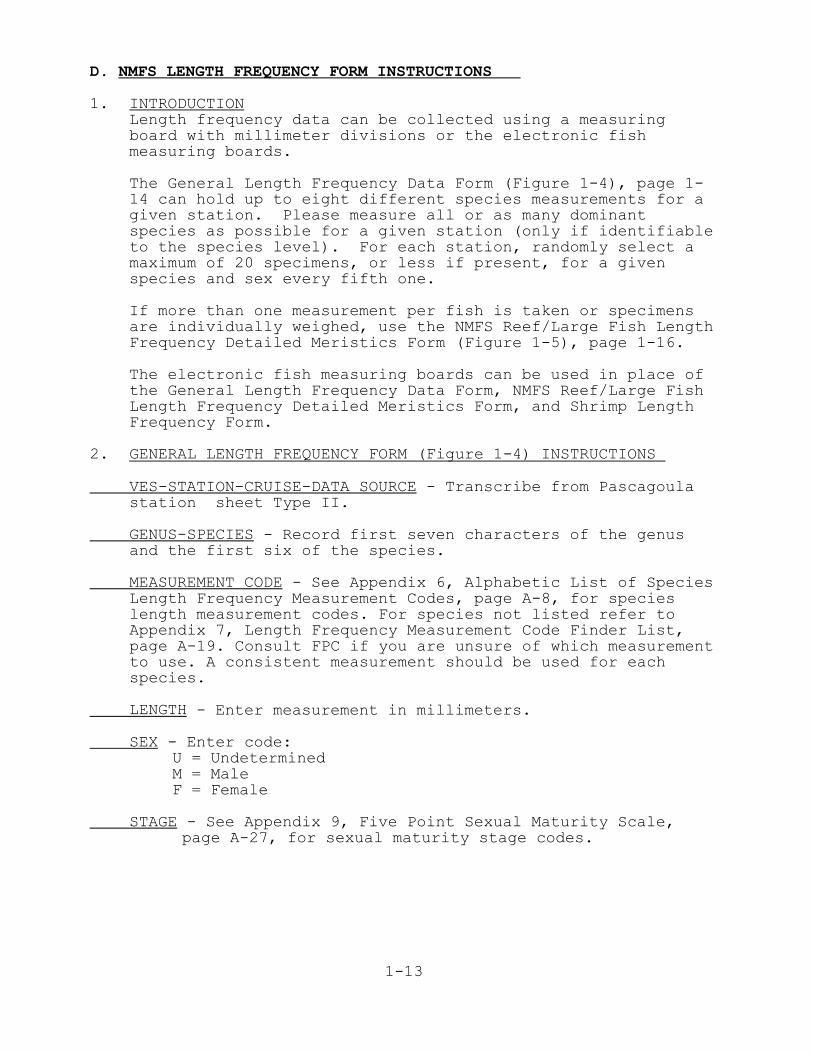
D. NMFS LENGTH FREQUENCY FORM INSTRUCTIONS
1. INTRODUCTIONLength frequency data can be collected using a measuringboard with millimeter divisions or the electronic fishmeasuring boards.
The General Length Frequency Data Form (Figure 1-4), page 1-14 can hold up to eight different species measurements for agiven station. Please measure all or as many dominantspecies as possible for a given station (only if identifiableto the species level). For each station, randomly select amaximum of 20 specimens, or less if present, for a givenspecies and sex every fifth one.
If more than one measurement per fish is taken or specimensare individually weighed, use the NMFS Reef/Large Fish LengthFrequency Detailed Meristics Form (Figure 1-5), page 1-16.
The electronic fish measuring boards can be used in place ofthe General Length Frequency Data Form, NMFS Reef/Large FishLength Frequency Detailed Meristics Form, and Shrimp LengthFrequency Form.
2. GENERAL LENGTH FREQUENCY FORM (Figure 1-4) INSTRUCTIONS
VES-STATION-CRUISE-DATA SOURCE - Transcribe from Pascagoulastation sheet Type II.
GENUS-SPECIES - Record first seven characters of the genusand the first six of the species.
MEASUREMENT CODE - See Appendix 6, Alphabetic List of SpeciesLength Frequency Measurement Codes, page A-8, for specieslength measurement codes. For species not listed refer toAppendix 7, Length Frequency Measurement Code Finder List,page A-19. Consult FPC if you are unsure of which measurementto use. A consistent measurement should be used for eachspecies.
LENGTH - Enter measurement in millimeters.
SEX - Enter code:U = UndeterminedM = MaleF = Female
STAGE - See Appendix 9, Five Point Sexual Maturity Scale, page A-27, for sexual maturity stage codes.
1-14
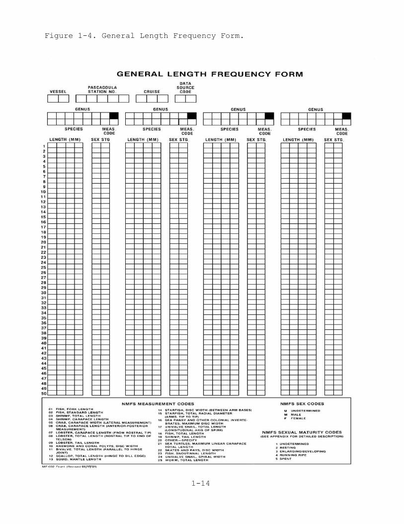
Figure 1-4. General Length Frequency Form.
1-15
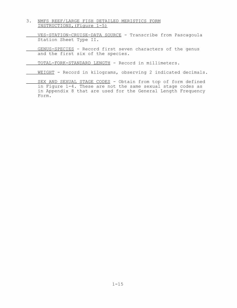
3. NMFS REEF/LARGE FISH DETAILED MERISTICS FORMINSTRUCTIONS,(Figure 1-5)
VES-STATION-CRUISE-DATA SOURCE - Transcribe from PascagoulaStation Sheet Type II.
GENUS-SPECIES - Record first seven characters of the genusand the first six of the species.
TOTAL-FORK-STANDARD LENGTH - Record in millimeters.
WEIGHT - Record in kilograms, observing 2 indicated decimals.
SEX AND SEXUAL STAGE CODES - Obtain from top of form definedin Figure 1-4. These are not the same sexual stage codes asin Appendix 8 that are used for the General Length FrequencyForm.
1-16
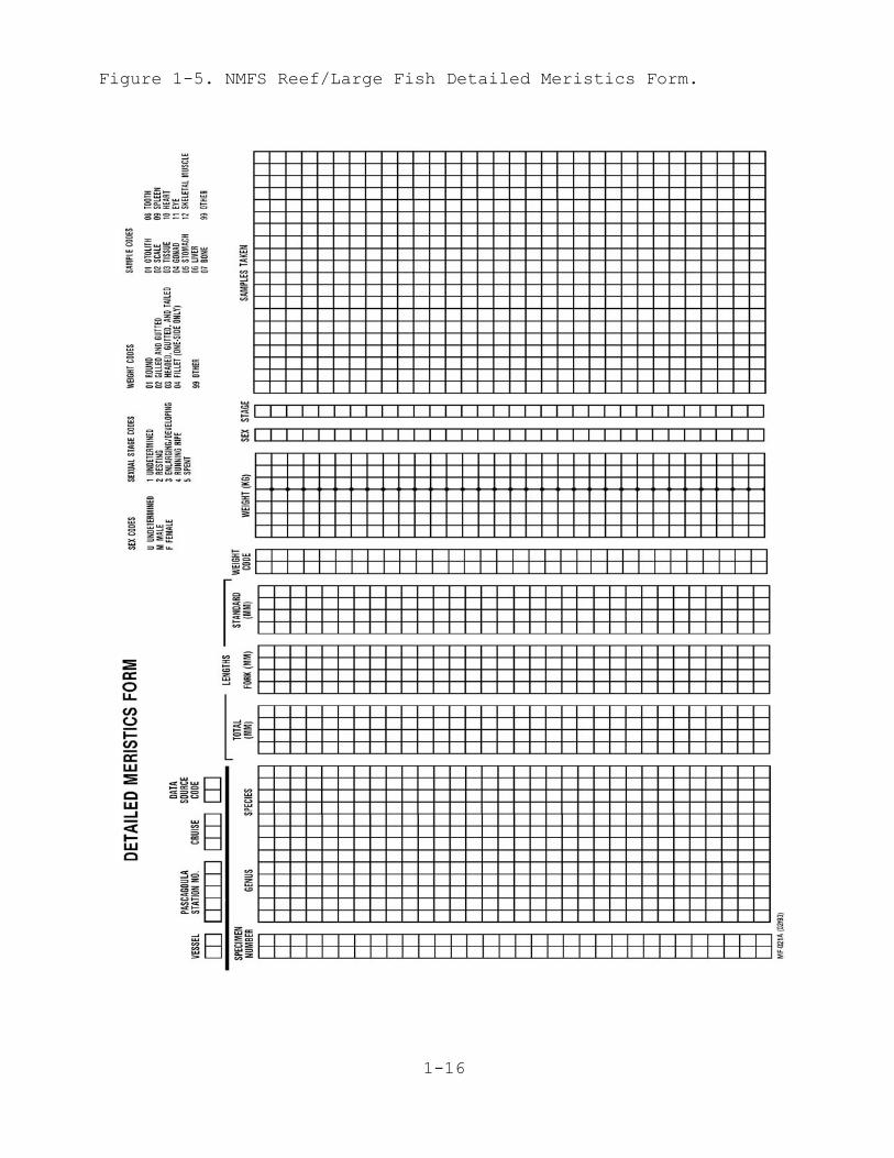
Figure 1-5. NMFS Reef/Large Fish Detailed Meristics Form.
1-17
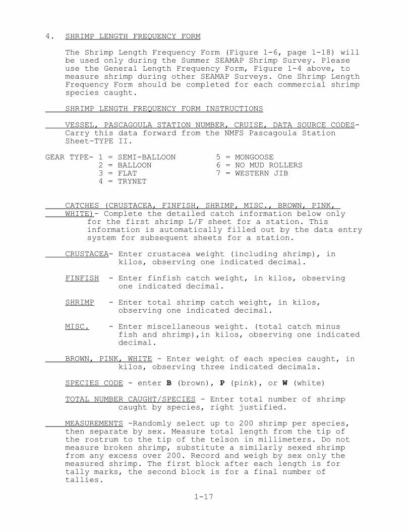
4. SHRIMP LENGTH FREQUENCY FORM
The Shrimp Length Frequency Form (Figure 1-6, page 1-18) willbe used only during the Summer SEAMAP Shrimp Survey. Pleaseuse the General Length Frequency Form, Figure 1-4 above, tomeasure shrimp during other SEAMAP Surveys. One Shrimp LengthFrequency Form should be completed for each commercial shrimpspecies caught.
SHRIMP LENGTH FREQUENCY FORM INSTRUCTIONS
VESSEL, PASCAGOULA STATION NUMBER, CRUISE, DATA SOURCE CODES-Carry this data forward from the NMFS Pascagoula StationSheet-TYPE II.
GEAR TYPE- 1 = SEMI-BALLOON 2 = BALLOON 3 = FLAT 4 = TRYNET
5 = MONGOOSE6 = NO MUD ROLLERS7 = WESTERN JIB
CATCHES (CRUSTACEA, FINFISH, SHRIMP, MISC., BROWN, PINK, WHITE)- Complete the detailed catch information below only
for the first shrimp L/F sheet for a station. Thisinformation is automatically filled out by the data entrysystem for subsequent sheets for a station.
CRUSTACEA- Enter crustacea weight (including shrimp), in kilos, observing one indicated decimal.
FINFISH - Enter finfish catch weight, in kilos, observing one indicated decimal.
SHRIMP - Enter total shrimp catch weight, in kilos, observing one indicated decimal.
MISC. - Enter miscellaneous weight. (total catch minus fish and shrimp),in kilos, observing one indicated decimal.
BROWN, PINK, WHITE - Enter weight of each species caught, in kilos, observing three indicated decimals.
SPECIES CODE - enter B (brown), P (pink), or W (white)
TOTAL NUMBER CAUGHT/SPECIES - Enter total number of shrimp caught by species, right justified.
MEASUREMENTS -Randomly select up to 200 shrimp per species,then separate by sex. Measure total length from the tip ofthe rostrum to the tip of the telson in millimeters. Do notmeasure broken shrimp, substitute a similarly sexed shrimpfrom any excess over 200. Record and weigh by sex only themeasured shrimp. The first block after each length is fortally marks, the second block is for a final number oftallies.
1-18
Figure 1-6. Shrimp Length Frequency Form.
1-19
E. Instructions for Electronic Fish Measuring Boards
1. Introduction
These fish measuring board (FMB) instructions are for WatchLeaders and field personnel who are measuring biologicalspecimens. Instructions for data file manipulations and dataentry corrections are separately available for the FieldParty Chief.
The instructions are basic key strokes and directions on howto measure specimens. All length measurement codes used withthe FMB are the same as those used for the General LengthFrequency Data Forms. Refer to Appendix 8, ElectronicMeauring Board Species Codes with Length Measurement Codes,page A-22, for the code for each species to be measured.Refer to Appendix 6, Alphabetic List of Length FrequencyMeasurement Codes, page A-8, for species lacking a FMBspecies code.
Note: References to “fish” measurements and their codes alsorefer to the various invertebrates that are measured.
2. Software Setup Instructionsa. Computer Setup
Field Party Chief/Watch Leader Input-- keyboardinstructions are in ITALICS, keys to press and commandsto enter are in BOLD, the computer prompt is underlined,and other comments are in normal text.
(1) At the C:> TYPE CD\LIMNO
(2) C:\LIMNO> TYPE GO The FMB software will thenstart and change directories to MS.
(3) C:\LIMNO\MAIN> TYPE MM The software will generatea window titled : MAIN MENU.
(4) MAIN MENU In this screen, using the down arrow key, scroll to(3)MAINTAIN CRUISE DATA FILES and PRESS ENTER, the software will go to a newwindow. Your choices are:
*1. CREATE NEW CRUISE DATA FILE SET2. USE EXISTING DATA FILE SET3. BACKUP CRUISE DATA FILE SET4. REMOVE CRUISE DATA FILE SET5. RESTORE CRUISE DATA FILE SETScroll with the arrow keys to make a selection andPRESS ENTER, the screen should switch back to theprevious menu with your selected “file.name” at thetop. PRESS ESC key to return to the MAIN MENU.
1-20
*Note: If you select (1), CREATE NEW CRUISE DATA FILESET, you must use a name that meets DOS file nameconventions, i.e. no more than 8 characters (O4CR2004).
(5) Back to MAIN MENU (using the down arrow key) scrolldown to: (4) START LDCE/FMB’S, PRESS ENTER
(6) Go turn on all the boards and then TYPE Y
(7) Limnoterra Data capture will appear on the screen.Press any key to continue. The screen will then display:
CRUISE REC.DATA
(8) CRS ID, PRESS CONTROL END, then F8. This will takeyou to a blank space for the cruise you are working on.If the space is blank, enter the cruise number. (F7 willtake you back if you went too far).
a. Vessel Code-type the vessel code (PRESS F3 for a list).b. Data Source Code-type the source code.c. First Station Number-type the first station number.d. Last Station Number-enter the number that you think will be the last station number for the cruise. This can be changed if it is too low.e. Gear Code-enter the gear code-01. PRESS F9 to SAVE DATA.
(9) PRESS F7, to return to the previous level. The CTRLEND, and then F8 keys will allow you to find a blankspace to ENTER the STATION NUMBER and ENTER YOURINITIALS. Leave the logon number blank. PRESS F9 to SAVEDATA.
(10) PRESS F7 to return to your station number. Now youare ready to begin measuring fish, shrimp, crabs, etc.
b. Tips on Keyboard Use -
CTRL END takes you to the end of a record level.CTRL HOME takes you to the top of a record level. F8 scrolls down and F7 scrolls up from record to record.F9 saves data.F10 saves new (inserted) data
c. Data Editing - Field Party Chief/Watch Leaders Only
To edit data or to enter something you missed, go to thecomputer and call up that species record.
To call up a record, PRESS CTRL PAGE UP. This will takeyou to the CRS ID level. Then PRESS CTRL PAGE DOWN to goto the LOGIN level. PRESS F8 to scroll down (F7 scrolls
1-21
up) to your LOGIN level. PRESS CTRL RIGHT ARROW to go tothe station level, then the F8 key to scroll down to yourstation number.
d. First or Next New Station
A new station number is required to be entered at thecomputer prior to a station number entry at themeasuring boards. To begin a new station, return to thecomputer and PRESS CTRL LEFT ARROW to return to the LOGIN# level. Leave the number blank, it is auto-assigned, andENTER YOUR INITIALS, PRESS F9 to SAVE. Caution: Onlyenter one new station at a time, if you enter more thanone it will create a horrendous error. PRESS CTRL RIGHTARROW to return to the station level and use the END orF8 key to scroll to a blank. ENTER the new STATION numberand PRESS F9 to SAVE DATA. Now you can return to theboards and begin entering new data under the new stationnumber.
e. Shrimp Corrections and Missed Data
This is for use during the Summer Shrimp measurements.PRESS CTRL PAGE DOWN to go to the shrimp level.PRESS CTRL PAGE DOWN again to go to the shrimp species(SH. SP.) level filler. Use the F8 key to scroll to thedesired species.
PRESS CTRL PAGE DOWN again to get to the shrimp sex. Usethe F8 key to scroll to the desired sex. PRESS CTRL PAGE DOWN again to get to shrimp weights. Now do a CTRL RIGHT ARROW to get down to the shrimplengths.
Use the F8 key to scroll to the desired length or blank.You can delete the field by pressing the DELETE orBACKSPACE key. When the field is empty, PRESS INSERT andenter in the correct or new data. PRESS F10 to SAVE DATA.
f. Fish and Other Non-shrimp Corrections
Beginning at the shrimp level, PRESS CTRL RIGHT ARROW togo to the ?Fish" level. Use the F8 key to scroll down (F7to scroll up) to the desired species.
PRESS CTRL PAGE DOWN to go to the fish length. Use the F8key to scroll down (F7 to scroll up) to the desiredlength error or blank.
You can delete the field by PRESSing the DELETE orBACKSPACE key. When the field is empty, PRESS INSERT andenter in the correct or new data. PRESS F10 to SAVE DATA.
1-22
3. Data Entry At The Boards
All data at the measuring boards are entered with a magneticprobe. To use it just touch the desired place on the board. PRESSING down hard does not make it work, just touch theplace. Be careful where you place the probe when you are notusing it! In these instructions, named places on the boardare referred to as [KEYS]. Everything on the board that isenclosed in parentheses ( ) requires the [SHIFT] key to go tothe shift function mode. Once in the [SHIFT] mode you staythere until you touch the [EXIT SHIFT] to exit shift mode. For each station, you must always enter in this order:CRUISE, INITIALS, and STATION NUMBER before entering data.When entering data always monitor the LCD screen for an OK orerror message, and listen for the BEEPS when data is entered.If an OK does not appear, you made an error and it has to becorrected now. To correct an error, touch [EXIT SHIFT] andthen [LDCE QUERY]. Wait for the data error to appear on theLCD screen and use the [BACKSPACE] or [DELETE] key to deletethe record and then reenter the data. On the board there arearrows to scroll right and left for data editing.
a. Entering Station Data
(1) With the probe TOUCH the [SHIFT] key.(2) TOUCH [CRUISE #], Enter cruise number by
touching numbers on the number line.(3) TOUCH [SAVE DATA], Look for the OK on the LCD
screen and listen for beeps.(4) TOUCH [INITIALS], Enter your initials from the alphabet line.(5) TOUCH [SAVE DATA], Look for the OK on the LCD
screen and listen for beeps.(6) TOUCH [STATION #], Enter station number by touching numbers on the number line.(7) TOUCH [SAVE DATA], Look for the OK on the LCD
screen and listen for beeps.
b. Entering “Fish” Measurements- Fish, invertebrates, and fall cruise shrimp are measured in the following manner:
(1) a- TOUCH [SHIFT][K], (3-DIGIT SPECIES CODE) Look upthe desired fish code in Appendix 9, ElectronicMeasuring Board Species Codes, page A-22, and enterit from the number line. Go to b.(2) below.
b- For fish without a code, you will need tospell out the 7-character genus name and 6-character species name, 13 characters. If agenus name has fewer than 7-characters youneed to enter a BLANK(s) for a total of
13 characters. Refer to Appendix 6, Alphabetical Listof Length Frequency Measurement Codes, page A-16.
1-23
i. TOUCH [SHIFT][L] (13 CHAR. NAME), spell thename using the alphabet line.
ii. TOUCH [SAVE][DATA], Query ready shoulddisplay on the LCD screen
iii. TOUCH [SHIFT][DATA MESSAGE] to display thename, notice there is a blank at the end toenter the length code from the number line.iv. Enter the length code number andTOUCH [SAVE DATA]. Go to b.(2) below.
c- To add measurements to an existing fish species -
i. TOUCH [SHIFT][J], enter the fish code fromthe number line.
ii. TOUCH [SAVE DATA], begin measuring the fish.Go to b.(2) below.
(2) TOUCH [SAVE DATA], QUERY READY should display on thescreen.
(3) TOUCH [SHIFT][DATA MESSAGE], This will display thefish name and define the length measurement code,total, fork, standard, etc.
(4) TOUCH [SAVE DATA].(5) Start measuring the fish. It is not necessary to
touch [SAVE DATA] for every fish. Enter the sex forevery fifth fish. While measuring fish watch for OK!after each fish.
a-to enter sex after measuring the fish, TOUCH [SEXCODE] and then TOUCH [MALE], [FEMALE] or[UNDETERMINED].
b- TOUCH [SEX STAGE], then TOUCH the appropriatesex stage, TOUCH [SAVE DATA].
c- go to the next fish (specimen #6,#11, etc.)
(6) After the last specimen of a species, TOUCH [SAVEDATA].
(7) Start a new species by returning to step a.above.
c. Shrimp Lengths For The Summer Cruise Only.
Shrimp are measured using this method for the summercruise only. They are measured as "fish" during the Fallcruise.
(1) TOUCH [SHIFT][BROWN] or other shrimp species. Allshrimp measurement functions are done in the shiftmode.
(2) TOUCH [SAVE][DATA].(3) TOUCH [SHRIMP][SEX],then TOUCH [MALE] or [FEMALE]
from the ruler line. Watch the screen for thecorrect entry!
1-24
(4) TOUCH [SAVE][DATA] Begin measuring the shrimp.(5) TOUCH [SAVE][DATA] Again when you have completed
measuring the shrimp.(6) TOUCH [SHRIMP][WEIGHT] Enter the weight from the
number line. If the weight is less than a kilogramyou must enter a leading zero before the decimal.
(7) TOUCH [SAVE][DATA].(8) If you have another shrimp sex of the same species,
TOUCH [SHRIMP][SEX], and enter the opposite sex ofwhat you have already measured, then [SAVE DATA].Continue as in step c.(4) above.
(9) For a different shrimp species go back to step c.(1)above and enter a new species ([WHITE] or [PINK])and continue.
d. Reef Fish - Detailed Meristics
(1) TOUCH [SHIFT][K] 3-digit species code.(2) Enter 3-digit species code from the number
line. TOUCH [SAVE][DATA].(3) QUERY READY should appear on the LCD screen.(4) TOUCH [MESSAGE DATA] The species name and measurement
code will appear on the screen. Verify that it iscorrect.
(5) TOUCH [SAVE DATA].(6) TOUCH [SHIFT][P] to exit shift mode.(7) TOUCH [DTL MERISTIC], [SAVE DATA]. Only one length is
required "TL, or FL, or SL." The other two areoptional.
a- Place the fish on the board and TOUCH FORK LENGTHto measure the fork length, TOUCH STD LENGTH tomeasure the standard length, or TOUCH SHIFT TTLLENGTH to measure the total length.
b- Place the fish on the board with the snoutagainst the LCD screen end of the board. TOUCH theprobe on the ruler line for the appropriatemeasurement.
(8) TOUCH [WEIGHT CODE] from the ruler line and only ifthe weight is other than round weight.
(9) TOUCH [SPECIMEN WGT] on the number line. Enter theweight with a leading zero if the weight is lessthan one kilogram. The board assumes the weight isin kilos. You can specify pounds by entering[SHIFT][V].
(10) TOUCH [SEX CODE] from the ruler line, enter [MALE],or [FEMALE], or [UNDETERMINED].
(11) TOUCH [SEX STAGE] from the ruler line enter thestage.
a- TOUCH [SPECIMEN #] on the number line. Enter the specimen number. This is required only if samples are taken from the fish.

1-25
b-TOUCH [SAMPLE CODES]. On the ruler line. Enter the code or codes of the samples collected, ex.
scales, tissue, etc. Then you MUST ...
c- TOUCH [END] on the ruler line.
d- TOUCH [SAVE DATA], go to another fish and repeat. If the same species, go to step d.(7)i. If a new species, go to step d.(1).
4. How To Correct Board Data Entry Errors
There are many places in the measurement procedureto make errors. When an error is entered, data cannot bebypassed or overwritten. All errors have to be deleted at thetime they are made before correct data may be entered. Mosterrors are identified with a message, a few you willrecognize when the screen does not display an OK!
a. DATA OUT OF RANGE (1) While measuring fish- An entry error likely occurred
prior to measurement. TOUCH [SHIFT][PUT TEMP] totemporarily save the current record. TOUCH[SHIFT][P] (exit shift), TOUCH [LDCE QUERY], waitfor the data error to appear on the screen. Alegitimate length entry message can be overriddenwith a [SHIFT][T]. Otherwise, for a true error, usethe [DELETE] and [BACKSPACE] keys to delete therecord; it is deleted when LIMNOTERRA appears on theLCD screen. Now TOUCH [SHIFT][GET TEMP] and [SAVEDATA]. Continue measuring fish.
(2) While spelling a 13 character species name. TOUCH[LDCE QUERY] to call the record to the screen.Verify the correct spelling and make anycorrections. Use the [BLANK], [DELETE], or[BACKSPACE] keys as necessary. If the name iscorrect, it is a new name and needs to be added intothe database. To enter a new name, use the arrowkeys to scroll to the left side of the display.Remove the "N" from "SN" combination. Scroll to thebeginning of the display, TOUCH [SHIFT][M], thiswill override the species name, TOUCH[MEASURE][CODE], from the ruler line TOUCH the codefor that species. TOUCH [SHIFT DATA] to verify thatyou have “BDMC_S” and the name. TOUCH [SAVE DATA],you should get an OK!
b. RECALREADY EXISTS(1) Summer Shrimp Measurements- the shrimp species you
are trying to enter has already been entered. TOUCH[LDCE QUERY] to call the record to the screen.Delete the record. TOUCH [EXISTING SHRIMP SPECIES]then select that species from the ruler line andTOUCH [SAVE DATA].
(1) Fish- TOUCH [LDCE QUERY] to call the record to the
1-26
screen. Delete the record. TOUCH [EXISTING 3 DIGITCODE], enter the code, TOUCH [SAVE DATA].
c. NOTSAMERECTYPE- when entering sample codes, this errorwill appear when you have not selected detail MERISTIC beforeentering the sample codes. Use [LDCE QUERY] to retrieve therecord, delete the record, and select the correct fish recordtype, then redo the record.
d. NO REQUIRED DATA - if you have not completed an operation. For example, you touched weight and did not enter theweight and tried to enter something else you will get thismessage. Use [LDCE QUERY] to retrieve the record, deletethe record, and reenter the correct data.

2-1
II. REAL-TIME DATA
2-2
II. REAL-TIME DATA
A. INTRODUCTIONSince 1982 the SEAMAP Subcommittee has committed to the
distribution of catch data taken during the summer survey on areal-time basis. Data was collected and transmitted daily viasatellite or radio to the NMFS Mississippi Laboratories. Thedata was then summarized, plotted and distributed weekly tofishermen, seafood processors, and scientists. For each SEAMAP Station, please complete the SEAMAP Real TimeStation Data Form, Station Record (Figure 2-1, page 2-5) and theSEAMAP Real-Time Length/Frequency Data Form, Catch Record (Figure2-2, page 2-7). The Catch Record form can be computed from thestation shrimp length frequency form. Remember, these two formsapply to the SEAMAP station number. If more than one trawlstation is made to cover the depth strata, shrimp data from thosemultiple tows are to be combined on the completed form. If you have any questions concerning the real-time data,please contact Perry Thompson, NMFS, (601) 762-4591 extension271.
2-3
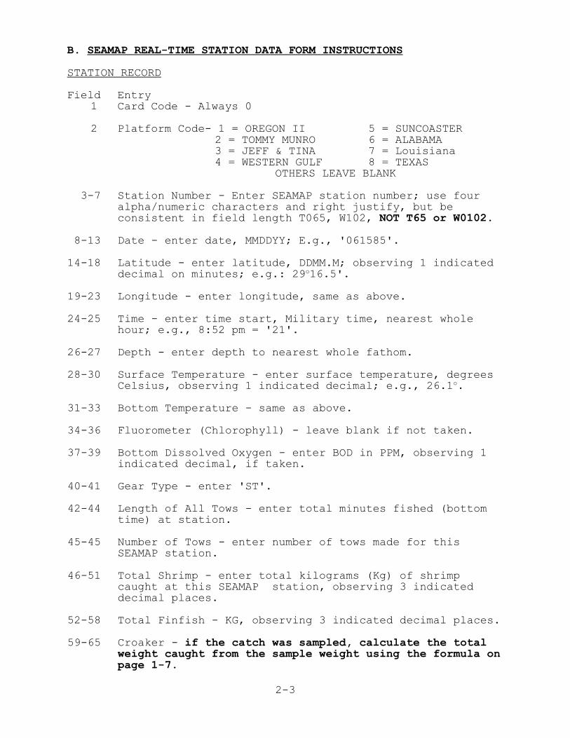
B. SEAMAP REAL-TIME STATION DATA FORM INSTRUCTIONS
STATION RECORD
Field Entry 1 Card Code - Always 0
2 Platform Code- 1 = OREGON II 5 = SUNCOASTER2 = TOMMY MUNRO 6 = ALABAMA3 = JEFF & TINA 7 = Louisiana4 = WESTERN GULF 8 = TEXAS
OTHERS LEAVE BLANK
3-7 Station Number - Enter SEAMAP station number; use fouralpha/numeric characters and right justify, but beconsistent in field length T065, W102, NOT T65 or W0102.
8-13 Date - enter date, MMDDYY; E.g., '061585'.
14-18 Latitude - enter latitude, DDMM.M; observing 1 indicateddecimal on minutes; e.g.: 29o16.5'.
19-23 Longitude - enter longitude, same as above.
24-25 Time - enter time start, Military time, nearest wholehour; e.g., 8:52 pm = '21'.
26-27 Depth - enter depth to nearest whole fathom.
28-30 Surface Temperature - enter surface temperature, degreesCelsius, observing 1 indicated decimal; e.g., 26.1o.
31-33 Bottom Temperature - same as above.
34-36 Fluorometer (Chlorophyll) - leave blank if not taken.
37-39 Bottom Dissolved Oxygen - enter BOD in PPM, observing 1indicated decimal, if taken.
40-41 Gear Type - enter 'ST'.
42-44 Length of All Tows - enter total minutes fished (bottomtime) at station.
45-45 Number of Tows - enter number of tows made for thisSEAMAP station.
46-51 Total Shrimp - enter total kilograms (Kg) of shrimpcaught at this SEAMAP station, observing 3 indicateddecimal places.
52-58 Total Finfish - KG, observing 3 indicated decimal places.
59-65 Croaker - if the catch was sampled, calculate the totalweight caught from the sample weight using the formula on page 1-7.
2-4
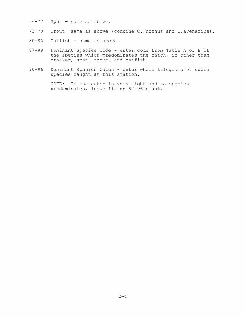
66-72 Spot - same as above.
73-79 Trout -same as above (combine C. nothus and C.arenarius).
80-86 Catfish - same as above.
87-89 Dominant Species Code - enter code from Table A or B ofthe species which predominates the catch, if other thancroaker, spot, trout, and catfish.
90-96 Dominant Species Catch - enter whole kilograms of codedspecies caught at this station.
NOTE: If the catch is very light and no speciespredominates, leave fields 87-96 blank.
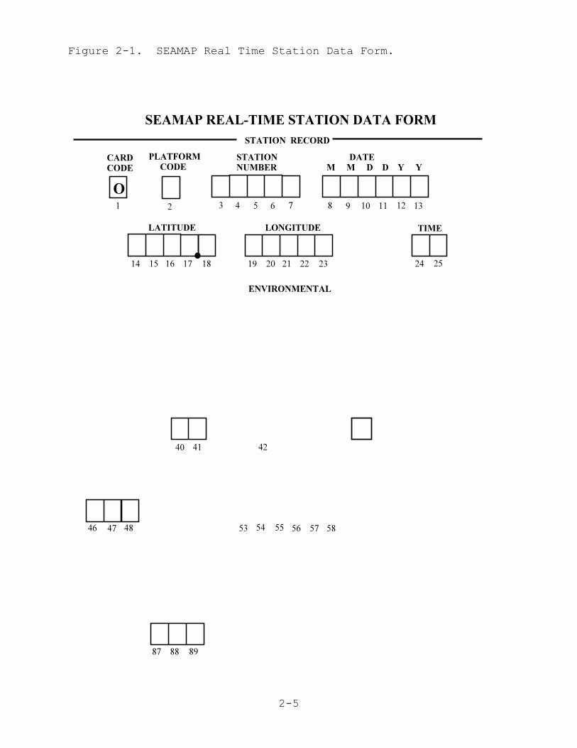
2-5
Figure 2-1. SEAMAP Real Time Station Data Form.
2-6
C. SEAMAP REAL-TIME LENGTH/FREQUENCY DATA FORM INSTRUCTIONS
CATCH RECORD
Field Entry 1 Card Code - enter code for shrimp species for which
length frequencies follow: 1 = Brown, 2 = White, and 3 = Pink.
2 Platform - same as page 1.
3-7 Station Number - same as page 1.
8-13 Total Catch - total weight in KG of this shrimp speciescaught at this SEAMAP station, observe 3 decimal places.
14-18 Number - total number caught at this station, thisspecies.
19-24 Modal Length and Frequency - enter length in MM andfrequency of the single largest group of shrimp at anyone length. If no single measurement contained moreshrimp than any other, there is no mode and these fieldswill be left blank.
25-78 Length/Frequencies - enter number of shrimp at each 1 cm(10 mm) interval; e.g., if 7 shrimp were measured between 130-139 mm Enter 130 007 for that group. Length groups in excess of 9 can be added on additional pages, filled outlike the first page except that the modal slot (fields19-24) can be used for L/F. Use as many sheets as necessary.
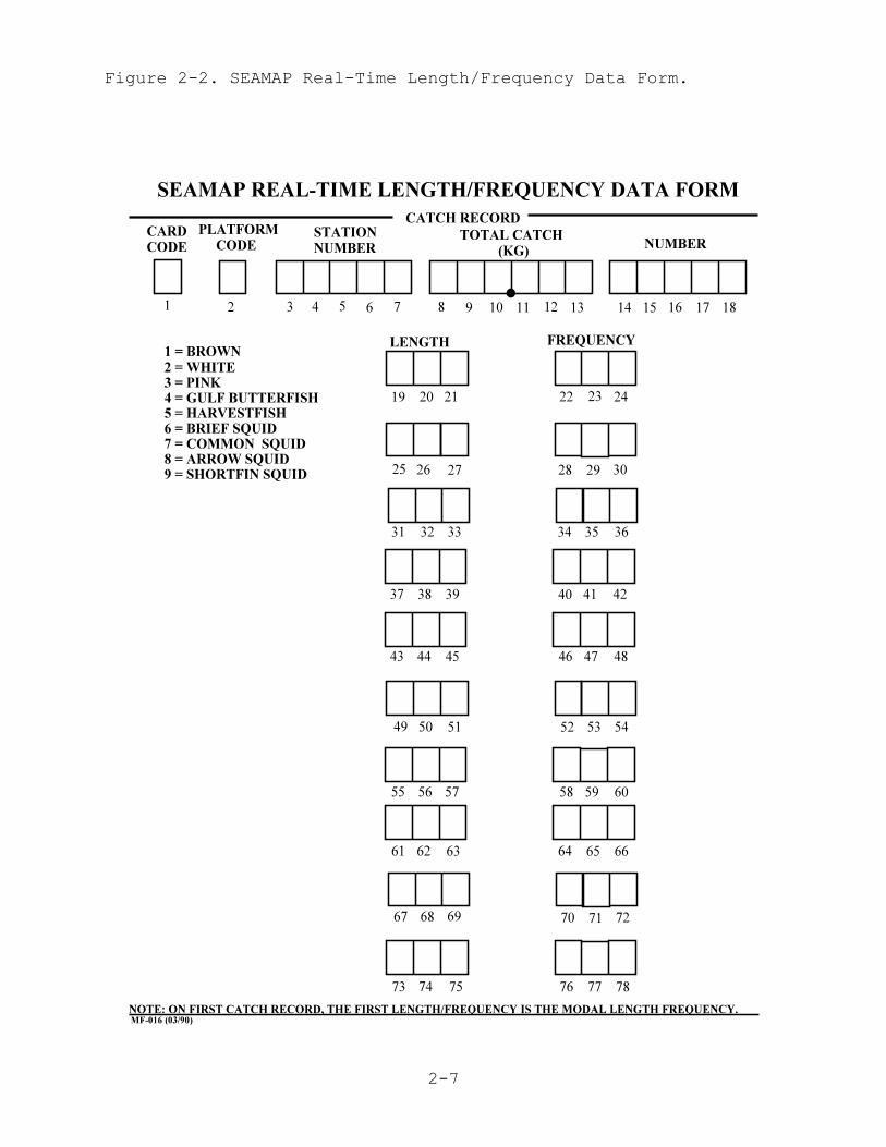
2-7
Figure 2-2. SEAMAP Real-Time Length/Frequency Data Form.

2-8
Table A. SEAMAP Real-Time Alphabetic List of Species Codes.
SPECIES SPECIESCODE COMMON NAME CODE COMMON NAME 1 ANCHOVY 27 ANGEL SHARK 91 ATLANTIC MANTA115 ATLANTIC THREADFIN 10 BANDED DRUM 41 BANK CUSK-EEL 2 BEARDED BROTULA107 BEARDFISH110 BIGEYE SCAD 28 BLACK DRUM112 BLACKMOUTH BASS 37 BLACKEAR SEABASS 11 BLACKEDGE CUSKEEL 18 BLACKFIN SEAROBN102 BLACKFIN GRENADIER118 BLACKNOSE SHARK 19 BLACKWING SEAROBN 82 BLUNTNOSE STINGRAY 71 BLUE CRAB 3 BLUE RUNNER 80 BANDED SHRIMP EEL 99 BONNETHEAD SHARK 78 BRIEF SQUID116 BROWN SHRIMP 15 BULL SHARK 5 BUMPER 65 CALICO SCALLOP 42 CHANNEL FLOUNDER114 CHUB MACKERAL 88 CLEARNOSE SKATE 95 COBIA 34 COWNOSE RAY 66 CUSK-EEL 26 CUTLASSFISH111 DEEPBODY BOARFISH103 DUCKBILL FLATHEAD 23 DUSKY FLOUNDER 63 DWARF SAND PERCH 89 FLATFISH 60 FLOUNDER 40 GOATFISH 31 GRAY TRIGGERFISH 64 GREEN SEABISCUIT109 GULF BUTTERFISH 86 GULF MENHADEN 94 HAKE 16 HARVESTFISH 51 HEART URCHIN 58 INSHORE LIZARDFISH 96 IRIDESCENT SWIMMING CRAB 56 JELLYFISH 13 KINGFISH 24 LIZARDFISH 67 LONG FINNED SQUID 81 LOGGERHEAD SEA TURTLE 22 LONGSPINE PORGY119 LARGESCALE LIZARDFISH 54 LUMINOUS HAKE 87 MANTIS SHRIMP 59 MEXICAN FLOUNDER 52 OFFSHORE BLUE CRAB106 OFFSHORE HAKE 45 ORANGE FILFISH105 PANCAKE BATFISH 75 PAPER SCALLOP 53 PARAPENAEUS
85 PEARLY RAZORFISH 76 PIGFISH 9 PINFISH117 PINK SHRIMP 32 PUFFER108 RED BARBER 30 RED DRUM 92 RED PORGY 12 RED SNAPPER 55 ROCK SEABASS 46 ROCK SHRIMP 25 ROUGH SCAD113 ROUND HERRING120 ROUND SCAD 57 ROUNDEL SKATE 48 SAND DOLLAR 7 SAND PERCH 97 SARGASSUM 8 SCALED SARDINE 83 SCORPIONFISH 4 SEA BASS 17 SEAROBIN 98 SHAMEFACED CRAB 61 SHARKSUCKER 20 SHARPNOSE SHRK 29 SHEEPSHEAD 33 SHOAL FLOUNDER101 SHORTSPINE BOARFISH 90 SILVER JENNY 68 SLIPPER LOBSTER 62 SMOOTH PUFFER 93 SMOOTH HOUND SHARK 49 SNAKEFISH 72 SOLENOCERA 36 SOUTHERN FLOUNDER 43 SOUTHERN HAKE100 SPECKLED SHRIMP 39 SPINY ARM CRAB 21 SPANISH MACKEREL 69 SPANISH SARDINE 47 SPONGE 38 SPOTFIN FLOUNDER 70 SQUID 50 STARFISH 79 SOUTHERN KINGFISH 74 SOUTHERN STINGRAY 6 STINGRAY 77 STRIPED ANCHOVY 14 THREAD HERRING 84 TRACHYPENAEUS 35 UNKNOWN SHARK 44 WENCHMAN 73 YELLOW CONGER104 YELLOWHEAD DAMSEL
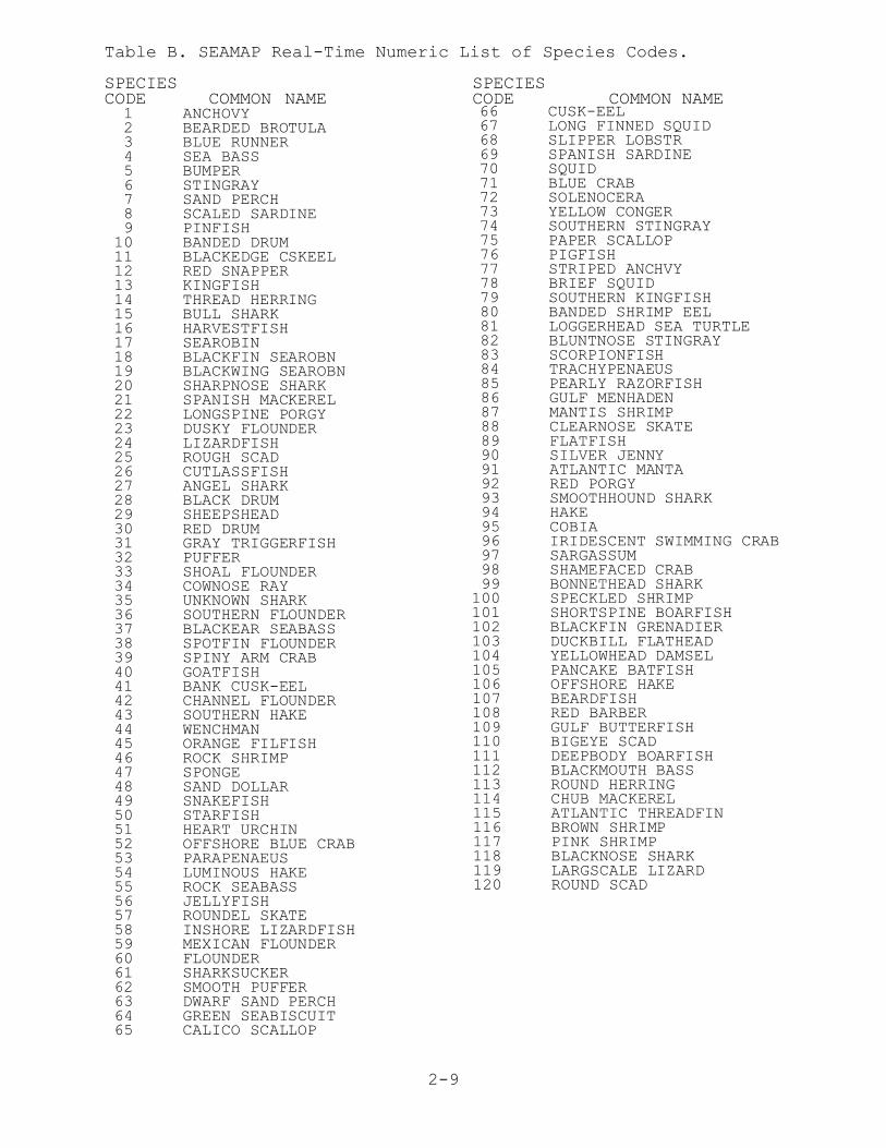
2-9
Table B. SEAMAP Real-Time Numeric List of Species Codes.
SPECIES SPECIESCODE COMMON NAME CODE COMMON NAME 1 ANCHOVY 2 BEARDED BROTULA 3 BLUE RUNNER 4 SEA BASS 5 BUMPER 6 STINGRAY 7 SAND PERCH 8 SCALED SARDINE 9 PINFISH 10 BANDED DRUM 11 BLACKEDGE CSKEEL 12 RED SNAPPER 13 KINGFISH 14 THREAD HERRING 15 BULL SHARK 16 HARVESTFISH 17 SEAROBIN 18 BLACKFIN SEAROBN 19 BLACKWING SEAROBN 20 SHARPNOSE SHARK 21 SPANISH MACKEREL 22 LONGSPINE PORGY 23 DUSKY FLOUNDER 24 LIZARDFISH 25 ROUGH SCAD 26 CUTLASSFISH 27 ANGEL SHARK 28 BLACK DRUM 29 SHEEPSHEAD 30 RED DRUM 31 GRAY TRIGGERFISH 32 PUFFER 33 SHOAL FLOUNDER 34 COWNOSE RAY 35 UNKNOWN SHARK 36 SOUTHERN FLOUNDER 37 BLACKEAR SEABASS 38 SPOTFIN FLOUNDER 39 SPINY ARM CRAB 40 GOATFISH 41 BANK CUSK-EEL 42 CHANNEL FLOUNDER 43 SOUTHERN HAKE 44 WENCHMAN 45 ORANGE FILFISH 46 ROCK SHRIMP 47 SPONGE 48 SAND DOLLAR 49 SNAKEFISH 50 STARFISH 51 HEART URCHIN 52 OFFSHORE BLUE CRAB 53 PARAPENAEUS 54 LUMINOUS HAKE 55 ROCK SEABASS 56 JELLYFISH 57 ROUNDEL SKATE 58 INSHORE LIZARDFISH 59 MEXICAN FLOUNDER 60 FLOUNDER 61 SHARKSUCKER 62 SMOOTH PUFFER 63 DWARF SAND PERCH 64 GREEN SEABISCUIT 65 CALICO SCALLOP
66 CUSK-EEL 67 LONG FINNED SQUID 68 SLIPPER LOBSTR 69 SPANISH SARDINE 70 SQUID 71 BLUE CRAB 72 SOLENOCERA 73 YELLOW CONGER 74 SOUTHERN STINGRAY 75 PAPER SCALLOP 76 PIGFISH 77 STRIPED ANCHVY 78 BRIEF SQUID 79 SOUTHERN KINGFISH 80 BANDED SHRIMP EEL 81 LOGGERHEAD SEA TURTLE 82 BLUNTNOSE STINGRAY 83 SCORPIONFISH 84 TRACHYPENAEUS 85 PEARLY RAZORFISH 86 GULF MENHADEN 87 MANTIS SHRIMP 88 CLEARNOSE SKATE 89 FLATFISH 90 SILVER JENNY 91 ATLANTIC MANTA 92 RED PORGY 93 SMOOTHHOUND SHARK 94 HAKE 95 COBIA 96 IRIDESCENT SWIMMING CRAB 97 SARGASSUM 98 SHAMEFACED CRAB 99 BONNETHEAD SHARK100 SPECKLED SHRIMP101 SHORTSPINE BOARFISH102 BLACKFIN GRENADIER103 DUCKBILL FLATHEAD104 YELLOWHEAD DAMSEL105 PANCAKE BATFISH106 OFFSHORE HAKE107 BEARDFISH108 RED BARBER109 GULF BUTTERFISH110 BIGEYE SCAD111 DEEPBODY BOARFISH112 BLACKMOUTH BASS113 ROUND HERRING114 CHUB MACKEREL115 ATLANTIC THREADFIN116 BROWN SHRIMP117 PINK SHRIMP118 BLACKNOSE SHARK119 LARGSCALE LIZARD120 ROUND SCAD
3-1
III. STANDARD SEAMAP SHRIMP ANDGROUNDFISH SAMPLING TRAWL GEAR
SPECIFICATIONS
3-2
III. Standard SEAMAP Shrimp and Groundfish Sampling Trawl GearSpecifications
A. IntroductionThe Summer and Fall SEAMAP trawl surveys use a 42' semi-balloon
trawl with 8'x40" chain doors towed at 2.5 knots. The completetrawl and door specifications, towing warp scope ratio, efficiencychecks, and inspection schedule for this gear have been included asa guide for proper use.
B. SEAMAP 42' Semiballon Trawl Specifications
Webbing (Nylon) :Bosom, wings and comers - 2" stretched x #18 twine.Intermediate - 1-1/2" stretched x #24 twine.Codend - 1-5/8" stretched x #42 twine w/1/4" x 2"galvanized rings.Chaffing gear - 3-1/2" stretched x #90 polyethylene 60 x 40.
Hanging Cable:Headrope and footrope - 9/16" diameter (6x6) polyethylenecover stainless steel combination net rope.
Leglines - 6 ft with heavy duty wire rope thimbles.
Weight:Loop chain - 1/4" galvanized chain, 16 links per loop,tied every foot. 67.8 ft of chain needed 48.13 lb.
Mud Rollers:17 mud rollers on a separate line (1/2" polypropylene)tied every 3 feet, with 3" of slack (top of roller tobottom of footrope).
Floatation:Floats - 6- 3"x4" spongex floats spaced 5 ft apart,across the middle of the headrope.
Lazyline:18 fathoms of 3/4" polydacron. Purse rope - 3/4" polydacron 16 ft. long.
Net Treatment:Green plastic net coat.
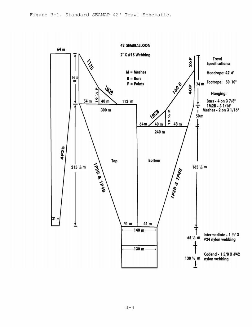
3-3
Figure 3-1. Standard SEAMAP 42' Trawl Schematic.

3-4
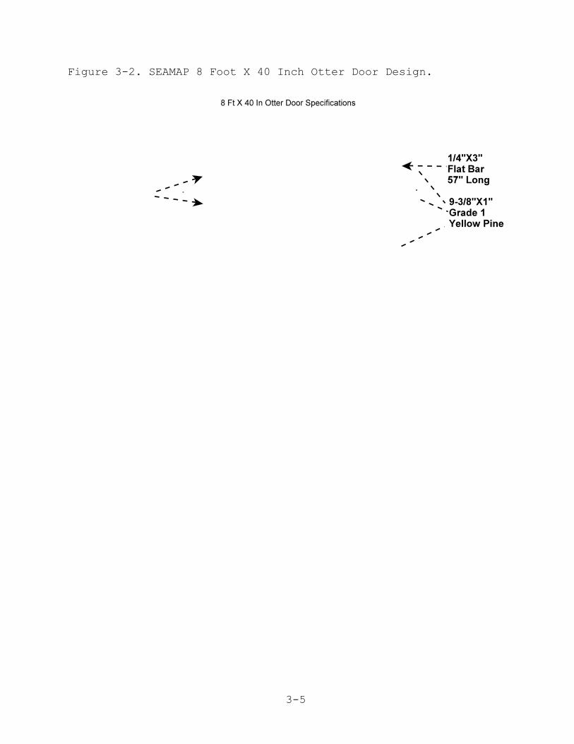
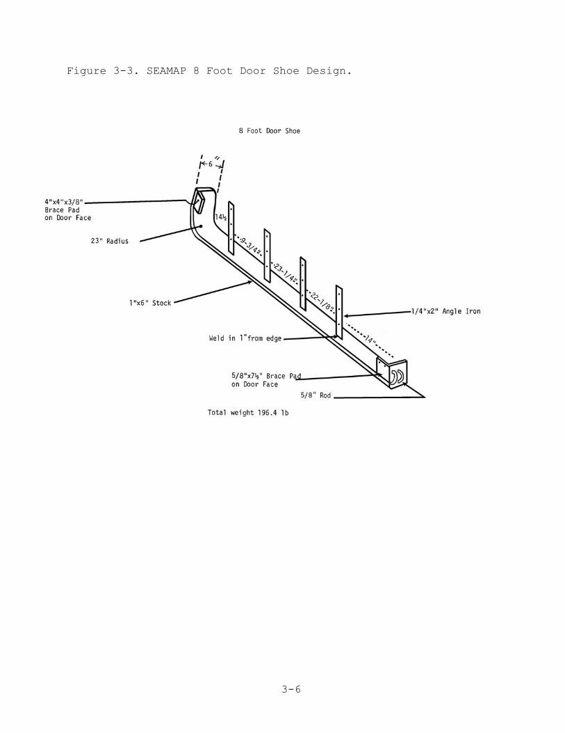
C. Door Specifications:Length and Height 8’40"Chain - 1/2" proof coil chainSwivels - 1/2"Bolts - 5/16"Planking - 5/4 yellow pine, Grade 1Stiffeners - 4"x4"Uprights - 2"x10"Shoe - 1"x6" stockLift pads in centerBonded and boltedDoors have 23-1/2" bridle (tow point to door face)
Tickler Chain Specifications:Type - Standard free tickler Size - 1/4" galvanized chainLength - 42" shorter than the footrope including the leglines = 58.6' = 41.6 lb.
Bridle Specifications:Wire Type - 6x19 strand marine lubeDiameter - 9/16"Length - 30 fathoms
Total Trawl Twine Area:240.2794 sq. ft.
Total Door Surface Area:53.2 sq. ft. (per set)
Recommended Towing Speed:2.5 knots
3-5
Figure 3-2. SEAMAP 8 Foot X 40 Inch Otter Door Design.
3-6
Figure 3-3. SEAMAP 8 Foot Door Shoe Design.
3-7
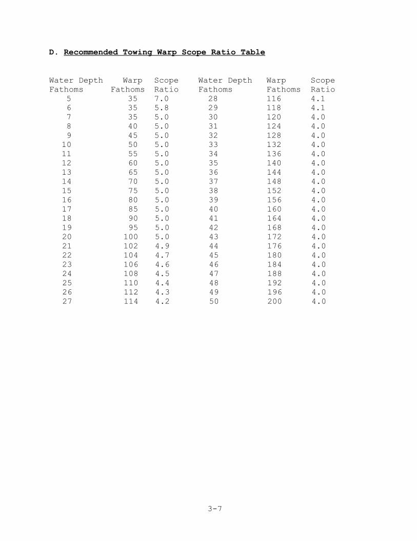
D. Recommended Towing Warp Scope Ratio Table
Water Depth Warp Scope Water Depth Warp ScopeFathoms Fathoms Ratio Fathoms Fathoms Ratio
5 35 7.0 28 116 4.1 6 35 5.8 29 118 4.1 7 35 5.0 30 120 4.0 8 40 5.0 31 124 4.0 9 45 5.0 32 128 4.010 50 5.0 33 132 4.011 55 5.0 34 136 4.012 60 5.0 35 140 4.013 65 5.0 36 144 4.014 70 5.0 37 148 4.015 75 5.0 38 152 4.016 80 5.0 39 156 4.017 85 5.0 40 160 4.018 90 5.0 41 164 4.019 95 5.0 42 168 4.020 100 5.0 43 172 4.021 102 4.9 44 176 4.022 104 4.7 45 180 4.023 106 4.6 46 184 4.024 108 4.5 47 188 4.025 110 4.4 48 192 4.026 112 4.3 49 196 4.027 114 4.2 50 200 4.0
3-8
E. CHECKS TO DETERMINE TRAWL FISHING EFFICIENCY
1. SEAMAP Survey Trawl Door Shine- 8'x40" Doors
a. If the door is fishing properly, shine will be down theentire length of the leading edge and should taper to apoint on the front of the shoe.
b. Shine only on the back, or heel, of the shoe indicatesimproper tow cable scope ratio, improper door chainsetting, or too much setback in the leglines.
c. If shine is uniform across the entire shoe width, thescope ratio may be incorrect or tilt angle of the doorinadequate.
d. Shine on the nose or front portion of the shoe indicatesimproper door chaining, inadequate setback in the trawlfootrope, inadequate weight on the footrope, or too short of a scope ratio.
e. Door angle of attack can be determined by measuring theangle of the shine. For maximum efficiency the angle ofattack should be approximately 36o.
2. Footrope Loop Chain Shinea. Shine should be apparent on the middle 6 to 8 links of
each loop of chain around the entire footrope length,indicating that the trawl is fishing at least 4 inchesoff the bottom.
b. Hard bottom contact is indicated by shine on almost alllinks of the loops around the entire footrope length.This condition indicates the trawl is under spread or has too much weight on the footrope.
c. No footrope-bottom contact is indicated by a lack ofshine on any of the loop chain links. The trawl isoverspread or has insufficient weight on the footrope.
3. Catch Composition and Consistencya. The amount of benthic invertebrates and debris in the
catch indicates the degree of bottom contact and ticklerchain efficiency.
b. Variations in catch consistency can be an indication of possible gear adjustment problems.

3-9
GEAR AND RIGGING INSPECTION SCHEDULE
Gear or Rigging
Doors
Loop Chain
Tickler Chain
Trawl
Bridle
Inspection
Shoe Shine
Shine
Tangles, breaks, orstretching
Tears and holes
Twists
Interval
At least once a day.
At least once a day.
Check for tangles orbreaks every tow andstretch every fishing day
Every tow for obvioustears and holes. Thetrawl should be broughton board once a day tocheck for less obviousdamage.
If twists extend 25% ormore of the bridle’slength, the bridle shouldbe untwisted.

4-1
IV. COLLECTING ENVIRONMENTAL DATA
4-2
IV. COLLECTING ENVIRONMENTAL DATA
A. INTRODUCTION
This document describes standard operational procedures forcollecting environmental data at sea and establishes primarymeasurements (minimum requirements) for all SEAMAP cruises. Thosemeasurements are: water temperature, salinity, dissolved oxygen,chlorophyll, Secchi disc depth, and Forel-Ule color. Samplingdepths include the surface, mid-water, and bottom (or 200 meterswhere depths are greater than 200 meters). Samples are to be takenin conjunction with each biological station. Additionalmeasurements and more frequent sampling may be required dependingon the type of SEAMAP survey.
The SEAMAP is striving to acquire the most accurate datapossible. A CTD or STD is primarily used to collect temperature,salinity, dissolved oxygen, chlorophyll, and transmissivity. Thepreferred chlorophyll sampling method is extraction. Watersamples can be collected with water collection bottles. Dissolvedoxygen is measured with in-situ D.O. sensors, onboard the vesselwith D.O. meters (laboratory probe), or by a titration method. Secchi depth is measured with a standard white, 30 cm or 52 cmdiameter Secchi disc. Water color measurements are made by use ofthe Forel-Ule color comparator.
When a CTD or STD is unavailable, hydrocasts with watercollection bottles will be used to collect water samples formeasurement of the parameters identified as minimal. Samplingdepths will be calculated by using wire length and angle tables orby direct measurement, when possible. If no other method isavailable, then temperature of the water samples collected at thesurface, mid-water and maximum depth will be determined by otheracceptable methods. When salinity cannot be determined at sea,water samples should be collected and returned to shore for lateranalysis.
Instrument calibration checks are to be made on a daily basisfor temperature and salinity. This means that a salinity sampleshould be taken for return to the laboratory and temperatureshould be measured independently of the CTD, STD, or other method. An XBT cast can be used to check sample depth and temperatureagainst the CTD or STD. Calibration of chlorophyll measurementsshould be conducted prior to and after each cruise to ensureproper instrument functions. The dissolved oxygen instrumentselected should be checked against Winkler determinations in thelaboratory before and after each cruise. These qualityassessment/quality control (QA/QC) checks are recorded on the data
4-3
sheets and should be maintained for inclusion into the metadata.
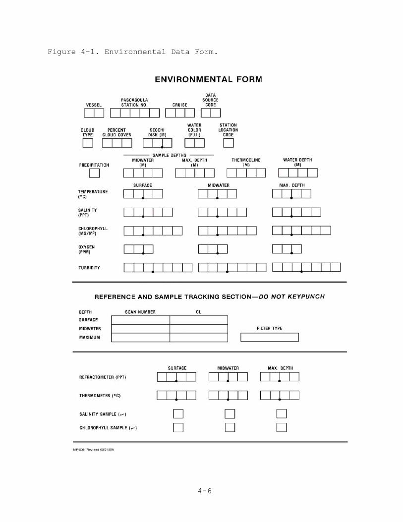
Please use a lead pencil and make entries dark and legible tofacilitate data entry. All numeric fields on the EnvironmentalData Form (Figure 4-1) are to be right justified or aligned withthe decimal place. Leading zeros are not required, but entertrailing zeros. On all SEAMAP surveys, an NMFS Pascagoula StationBiological Type II data sheet must be completed for everyenvironmental station.
B. ENVIRONMENTAL FORM INSTRUCTIONS
The methods of collecting environmental data and thecompletion of the environmental data sheet are as follows:
1. Required Data.
VESSEL - Enter 2-digit numerical code from Appendix 1, VesselCodes, page A-2. If your vessel has not been assigned a code,notify NMFS Pascagoula to receive one.
PASCAGOULA STATION NUMBER - This is a unique sequentialconsecutive 5-digit number within each cruise, preferablystarting with "00001". For state vessels enter the 2-digitvessel code followed by a 3-digit station number. Transfer thisstation number to the environmental or plankton sheet. Do notduplicate this station number for other stations on a cruise.
CRUISE - Enter 3-digit cruise number. Except for the Oregon IIand other vessels having historically different cruisenumbering conventions, the cruise number for ALL VESSELS shallbe the calendar year of the survey followed by the cruisenumber for the year, e.g. "011" first cruise for year 2001,"012"- second cruise for year 2001, etc. The leading zero isrequired. Use this cruise number on all sheets during a cruise;do not change it.
DATA SOURCE CODE - Enter data source code from Appendix 2-C.
CLOUD TYPE - Leave blank; cloud type is no longer collected onGulf of Mexico SEAMAP cruises.
% CLOUD COVER - Enter percent cloud cover during daylight hoursonly. Cloud cover is determined for the entire sky, not justthat portion overhead.
SECCHI DISC - Enter secchi disc reading in meters (see Tables

4-4
1, 2, and 3 for meter/feet/fathom conversion factors),observing one indicated decimal. Take readings only duringdaylight hours and from shady side of platform. See sectionC.1. below for transparency measurements with the Secchi disc.
WATER COLOR (F.U.) - Obtain Forel-Ule (F.U.) reading (daylighthours only); convert Roman numerals to Arabic. See sectionC.2. below for taking water color measurements.
STATION LOCATION CODE - Enter S (start) or E (end) for positionlocation closest to where environmental data was actuallycollected. Enter U if location was unknown.
PRECIPITATION - Enter code from Appendix 5-D.
SAMPLE DEPTHS - Enter midwater and maximum sample depths inwhole meters. See section C.3. below for the hydrocastsampling procedure.
WATER DEPTH - Enter water depth in meters, observing oneindicated decimal place, at the point where environmental datawere taken. This should be equal to or greater than themaximum sample depth.
TEMPERATURES - Enter surface, midwater, and maximum sampledepth temperatures in degrees Celsius (see Table 4 for conversion factors), observing two indicated decimals, addingtrailing zeros if needed. If state vessels have additionalequipment for measuring temperature, please document type ofequipment. Thermometer readings should be entered in theblocks provided at the bottom of the data sheet.
SALINITIES - Enter surface, midwater, and maximum sample depthsalinity measurements in parts per thousand, observing threeindicated decimals, adding trailing zeros if needed. If samplesare taken for later analysis, record vessel code or name,cruise, station number, date, and sample depth on each sample.Indicate on the bottom of the form if samples were taken forlater analysis. If salinity is determined with a refractometer,record the readings in the boxes provided at the bottom of theform. See Section C.4. below for collecting salinity samplesfrom a hydrocast.
CHLOROPHYLL - Enter surface, midwater, and maximum sample depthchlorophyll determinations in milligrams per cubic meterobserving four indicated decimals. If samples are taken forlater analysis, document the number of samples taken at eachdepth on the bottom of the form. See Section C.5. below for
4-5
chlorophyll sampling procedures.
OXYGEN - Enter surface, midwater and maximum sample depthdissolved oxygen readings in parts per million, observing oneindicated decimal place. See Section C-6 below for DissolvedOxygen (D.O.) sampling procedures.
TRANSMISSIVITY - Enter transmission as percent transmission. Nodecimals are used. This is a measure of the amount of suspendedmaterial in the water.
2. REFERENCE AND SAMPLE TRACKING SECTION (NOT TO BE KEYPUNCHED)
SCAN NUMBER/CL/FILTER TYPE - Complete when CTD is used. EnterCTD scan number from which temperature, salinity, dissolvedoxygen, fluorescence, and transmissivity data are taken. Under"CL" record the volume of water filtered for the chlorophyllsample. Under "filter type", record nucleopore, GF/C, or GF/F,depending on filter type used.
REFRACTOMETER (PPT) - Enter refractometer readings in ppt. Refractometer readings are not recorded if you are saving asalinity sample or have recorded other salinity measurements.
THERMOMETER (Co) - Enter thermometer temperature readings indegrees Celsius (Co). Temperature readings are not recorded inthis section if you are using other equipment.
SALINITY SAMPLE (�) - Enter a check in the appropriate boxes ifyou collect a salinity sample.
CHLOROPHYLL SAMPLE (�) - Enter a check in the appropriate boxesif you collect a chlorophyll sample.
4-6
Figure 4-1. Environmental Data Form.
4-7
C. SAMPLE COLLECTION METHODOLOGY
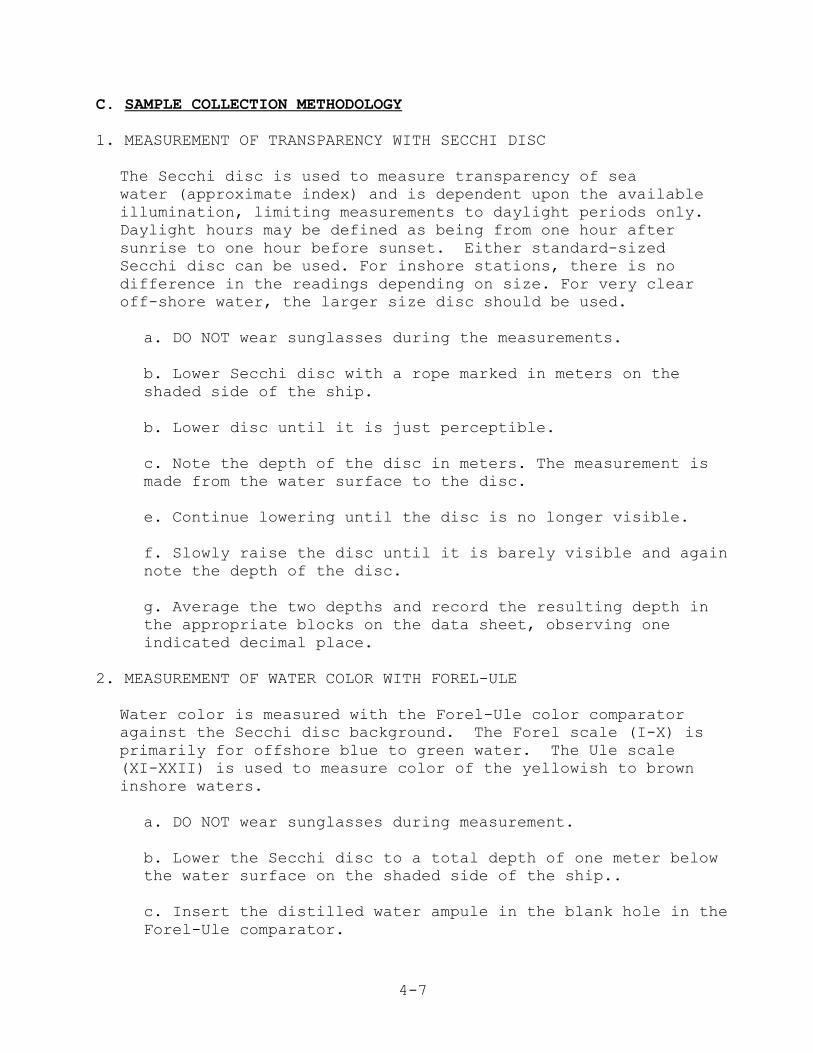
1. MEASUREMENT OF TRANSPARENCY WITH SECCHI DISC
The Secchi disc is used to measure transparency of seawater (approximate index) and is dependent upon the availableillumination, limiting measurements to daylight periods only. Daylight hours may be defined as being from one hour aftersunrise to one hour before sunset. Either standard-sizedSecchi disc can be used. For inshore stations, there is nodifference in the readings depending on size. For very clearoff-shore water, the larger size disc should be used.
a. DO NOT wear sunglasses during the measurements.
b. Lower Secchi disc with a rope marked in meters on theshaded side of the ship.
b. Lower disc until it is just perceptible.
c. Note the depth of the disc in meters. The measurement ismade from the water surface to the disc.
e. Continue lowering until the disc is no longer visible.
f. Slowly raise the disc until it is barely visible and againnote the depth of the disc.
g. Average the two depths and record the resulting depth inthe appropriate blocks on the data sheet, observing oneindicated decimal place.
2. MEASUREMENT OF WATER COLOR WITH FOREL-ULE
Water color is measured with the Forel-Ule color comparatoragainst the Secchi disc background. The Forel scale (I-X) isprimarily for offshore blue to green water. The Ule scale(XI-XXII) is used to measure color of the yellowish to browninshore waters.
a. DO NOT wear sunglasses during measurement.
b. Lower the Secchi disc to a total depth of one meter belowthe water surface on the shaded side of the ship..
c. Insert the distilled water ampule in the blank hole in theForel-Ule comparator.
4-8
d. Hold the comparator at arm's length so as to view both theSecchi disc and the Forel-Ule scale.
e. Compare the color as seen through the blank hole in thecomparator with the color of the water as viewed over theSecchi disc.
f. Determine the value in the comparator that most nearlymatches the color of the water over the Secchi disc. Recordthe value in the appropriate boxes on the data sheet.
3. HYDROCAST SAMPLING PROCEDURES
Water samples need to be collected for QA/QC purposes and toobtain temperature, salinity, D.O., and chlorophyll when a CTD,STD or XBT is unavailable. Water samples are collected with theaid of water collection bottles (Niskin) attached to ahydrowire at the surface, mid and bottom depths or at thesurface, 100 meters and 200 meters for stations with depthsgreater than 200 meters. The procedure for a hydrocast withwater collection bottles is as follows:
a. Verify (by communication with the bridge) that ship is onstation, is "dead" in the water and oriented so cast is onweather side of ship.
b. Obtain bottom depth from bridge for proper bottleplacement on the hydrowire.
c. Attach the deepest water collection bottle to thehydrowire above a hydroweight as follows:
(1) Ensure air vent and drain valve are closed.(2) Attach the loop in the top stopper wire to the leftrelease mechanism. The bottom stopper wire is clipped belowthe ball on the top stopper wire.(3) Clamp the water collection bottle to the cable fingertight, top clamp first, then bottom clamp.
d. When the first bottle is ready for lowering (just belowthe sea surface), zero the meter wheel.
e. Lower this bottle until the meter wheel reads theequivalent of the desired depth and measure the wire anglewith an inclinometer. Take into account the distance from thedeck of the ship to the water surface before attaching thenext bottle.

4-9
f. Calculate the length of wire required to reach desireddepth of each bottle (see wire angle Table 8) or compute thedepth by using the following formulas for computing wirerequired, depth of bottom bottle or COS angle:
depth of bottle = wire out x COS anglewire required = depth ÷ COS angleCOS angle = depth ÷ wire out(1 fathom = 1.83 meter = 6 feet)
At shallow water stations an alternative to Steps D and Eis to initially "bump" the sea floor with the hydro-weight.Use the wire length to determine placement of the mid-water sample bottle. Retrieve the hydroweight and attach themidwater bottle.
g. Haul back or pay out wire until the meter wheel readsrequired wire length for second bottle.
h. Clamp a second water collection bottle to hydrowire andset stoppers.
i. Attach a messenger lanyard to the bottle at the rightrelease mechanism and CLIP THE MESSENGER TO THE HYDROWIREbelow the bottle.
j. Pay-out the wire and attach remaining bottles andmessengers at the calculated wire length.
k. End cast preparation with a water collection bottle andattached messenger just below the surface. Record sampledepths in appropriate boxes on data sheet.
l. CLIP A MESSENGER to the wire and release to trip the cast,allowing approximately 1 minute per 100 meters of wire lengthfor messenger travel.
m. Retrieve the cast, observing ascending cable, and warningwinch operator when each bottle is first visible.
n. Remove the bottle from the wire by loosening the bottomclamp first. Care should be taken so as to not shake thebottle or otherwise disturb the water sample before takingthe D.O. samples.
o. Take temperature measurements by opening top stopper andimmersing hand held thermometer. Record temperature inappropriate boxes on data sheet.
4-10
p. Immediately after taking temperature, draw dissolvedoxygen samples before retrieving salinity samples.
4. COLLECTING WATER SAMPLES FOR SALINITY
a. Salinity samples are to be drawn after all the oxygensamples are collected.
b. Rinse the sample bottles three times, using aboutone-fourth bottle of water for each rinse.
c. Shake the bottles vigorously during each rinse and pourthe rinse water inside the bottle cap to rinse it also.
d. Draw the salinity samples directly from the drain spigot,filling the sample bottle to within one-half (½) inch of thetop.
e. Do not force the cap on the sample bottle too tightly. Pressure supplied between thumb and forefinger issufficient.
f. Label each bottle with the vessel name, cruise number,station number, date, and depth (surface, mid-water, orbottom).
5. CHLOROPHYLL SAMPLING PROCEDURES
A surface chlorophyll water sample, sufficient for threereplicate filters, should be collected at all SEAMAP stationsexcept those stations inside 20 fathoms off Louisiana. Atthose Louisiana stations a bottom sample is collected alongwith the surface sample.
Samples should remain in the dark until the filtration step,which should be done in as low light as is realistic. Alwaysuse a forceps to handle the filters.
a. Obtain a 10 liter water sample at surface.
b. Filter three replicate samples up to 1000 ml each throughthe 25mm GF/F or GF/C filter or as much as possible in 3-5minutes. (In rich coastal waters, 50 ml is sufficient.)
c. Do not exceed a setting on the vacuum pump of 10 psi in GEvacuum.
e. Using the forceps, fold each sample filter in half twice

4-11
so it resembles a pie wedge and place all three samples in alabeled plastic petri dish, wrap in aluminum foil, and label.
f. Record the following information on the petri dish, label,and environmental station sheets.
(1) Sample depth (S, M, B or actual depth)(2) Station number(3) Filter type(4) Volume filtered (5) Vessel (6) Cruise(7) Date
g. Check the appropriate boxes at the bottom of the datasheet if chlorophyll samples were obtained.
h. Place the samples in a low temperature (-80°C) freezer orin a liquid nitrogen dewer flask for storage untilprocessing.
There are several points that need to be kept inmind when taking chlorophyll samples. The damaging orbreaking of algal cells is a problem because when the cellruptures the chlorophyll escapes and ends up passing throughthe filter. Using too high a vacuum pressure will damage thecells and should therefore be avoided. Acidity is a majorproblem because it also causes the algal cells to disinte-grate with a consequent loss of chlorophyll. This is thereason that filters should never be touched with yourfingers. Always use a forceps to handle the filters. Whilethe samples are in storage, they get banged around and someof the algal cells may be knocked off the filters. Tominimize this problem, fold the filter in half before placingit in the petri dish, preferably folded twice so it resemblesa pie slice. At some locations there is occasionally a veryhigh sediment load that makes it impossible to filter theoptimal amount of water. In such a situation a smallerquantity of water can be filtered but this always createssome problems. Never pour unfiltered water off the filter. This will result in algal cells that should have been on thefilter being dumped out as well. Generally one will realizeafter a few minutes that there is no way to filter theoptimal amount. At that point it is recommended that youstart over. Discard the filter and water sample that is overthe filter. Put on a new filter and measure out a quantity ofthe sample water that you are certain will go through thefilter.
4-12
Light will cause chlorophyll to break down. Neverleave samples standing for long periods before filtering andonce the filtration is finished the samples should be kept inthe dark. That is the reason for wrapping samples inaluminum foil. Lastly, freeze the samples as soon aspossible to prevent spoilage, at which time the cells breakdown and the chlorophyll escapes.
6. COLLECTING DISSOLVED OXYGEN (DO) PROCEDURES
Water samples for dissolved oxygen determination should bedrawn from the water collection bottles as soon as thebottles are retrieved and before any other samples are taken.
a. Collecting the Water Sample
(1) Attach a clear plastic tube of the proper diameter, about 25 cm in length, to the spigot at the bottom of the water collection bottle. Lift the free end of the tubing to near the level of the air vent, and then open the air vent and the spigot, letting the tubing fill with water. There should be no air trapped in the tubing. If air bubbles are observed, let the water flow out slowly by slightly lowering the free end of the tubing and tapping on the tubing until the bubbles are cleared.
(2) Place the free end of the tube deep into the B.O.D. bottle (biochemical oxygen demand) and fillapproximately 1/4 full.
(3) Close the drain valve, swirl the water around in the bottle to rinse it, and discard the water.
(4) Reinsert the tube into the bottle near the bottom and allow water to flow.
(5) Count the number of seconds it takes for the bottle to fill and begin to overflow the B.O.D. bottle.
(6) Continue counting and allow the water to overflow until the bottle has filled at least three times. For example: If it takes a count of 7 to fill the bottle, continue letting the water overflow and count to 21.
(7) Place the ground glass stopper in the top of the B.O.D. bottle and as you do so, twist it gently. Leave the excess water on top of the bottle. This provides
4-13
an additional air seal. Draw samples from theremaining water collection bottles following the sameprocedure.
(8) Samples are now ready to be measured with an oxygen meter or by the Winkler titration method within 30 minutes of collection.
b. Measuring Dissolved Oxygen with the YSI Meter
(1) Adjust the SALINITY knob on the YSI meter to the salinity of the sample (use a refractometer todetermine salinity if a CTD is unavailable. If yourrefractometer measures in Brix, use the conversionfactors in Table 5 to convert to salinity).
(2) Place probe and stirrer in the sample and switch on stirrer (toggle switch on top of probe).
(3) When the meter has stabilized, read D.O. The reading should be taken within 30 seconds of immersion of the probe.
(4) Leave the instrument on (switch at RED LINE) between measurements to avoid the necessity for repolarizing the probe.
(5) Record D.O. measurements in the appropriate blocks on the station sheet.
(6) A calibration check of the oxygen meter should be performed during the first hydrocast each day.
(7) If this is the first hydrocast of the day, draw a second water sample (Steps a.1-8 above) from each Niskin bottle and measure dissolved oxygen with a SECOND calibrated dissolved oxygen meter and probe.
(8) Record the second D.O. measurements just ABOVE the previously recorded measurements on the station sheet.
(9) Occasionally dissolved oxygen readings will appear lower or higher than expected, and may indicateconditions of hypoxia or supersaturation respectively.These readings should be substantiated when below 2 ppmor above saturation levels (Table 7) for the existingtemperature and salinity of the sample. Water sampleswith questionable readings should be checked by both of
4-14
the following methods.
a- Run water sample for determination of dissolvedoxygen using a SECOND calibrated meter.
b- Water sample should be titrated using the fieldtitration kit (Hach) supplied.
c. Calibrating the YSI Oxygen Meter.
While these instructions are specific to a YSI meter, eachtype of oxygen meter should come with instructions on how tocalibrate it and how often to calibrate. If you don't havecalibration information for your instrument, contact themanufacturer for instructions. Air calibration of the YSIoxygen meter is straight forward and requires only a fewminutes to accomplish once the meter and probe have beenprepared and the instrument stabilizes. Preparing theinstrument prior to making the hydrocast allows optimum time(30 minutes) for stabilization and reduces the time betweendrawing the samples and taking measurements. Procedures forair calibration follow:
1) Turn on the meter to Redline 30 minutes beforecalibration or use. Check probe membrane for tears andbubbles in the electrolyte. Replace membrane ifnecessary and refill probe with fresh electrolyte.
2) Place the probe in moisture saturated air. Use a B.O.D. bottle partially filled (about 1") with FRESHwater.
3) Switch meter to RED LINE and adjust.
4) Switch meter to ZERO and adjust.
5) Adjust SALINITY knob to FRESH, i.e fully counter clock- wise.
6) Switch meter to TEMPERATURE and read.
7) Use probe temperature to determine calibration valuefrom Table 6, "Solubility of Oxygen in Fresh Water",page T-10.
8) Switch to the desired dissolved oxygen range 0-5, 0-10,
4-15
or 0-20, and adjust CALIBRATE knob until meter reads thecorrect calibration value from Step 7. Verifycalibration stability. Readjust if necessary.
The meter/probe is now calibrated and should be recalibratedbefore each use or hydro station.
D. CTD Procedures
1. INTRODUCTIONThe CDT unit is the preferred method for collecting the variousenvironmental measurements required by the SEAMAP. It is adelicate piece of equipment and requires care in handling. TheCTD manufacturer’s recommendations for a CTD/computer interfaceshould be considered the minimal requirement for computercapabilities. A computer of lesser capabilities will be slowprocessing data.
NOTE: Field operation instructions for the NMFS CTD areundergoing major revision. Below are preliminary, introductoryinstructions for use with a SEABIRD CTD. SEAMAP members usingvarious CTD instruments will have to compile their own detailedoperational instructions for the present time. SEAMAP membersare welcome to submit their CTD operation instructions forincorporation into this manual. Please study and follow theoperational instructions furnished by the manufacturer.
The CTD operator should be familiar with the CTD unit hardwareand software. As a minimum the operator should be able toidentify all sensors, understand the plumbing arrangement, andknow how to use programs required to make a cast.
2. INITIAL CTD INSPECTION PRIOR TO THE CRUISE.
a. Fill plastic tubing with water and inspect for leaks.
b. Inspect plastic tubing for kinks or any condition whichmay restrict water flow.
c. Make sure the orifice in the top of the inverted "Y"plastic tubing connector is not blocked.
d. Check that the sensors are attached firmly in the CTD cageand that the CTD cage is securely bolted and safety-wired to

4-16
the frame.
e. Test fire the Rosette.
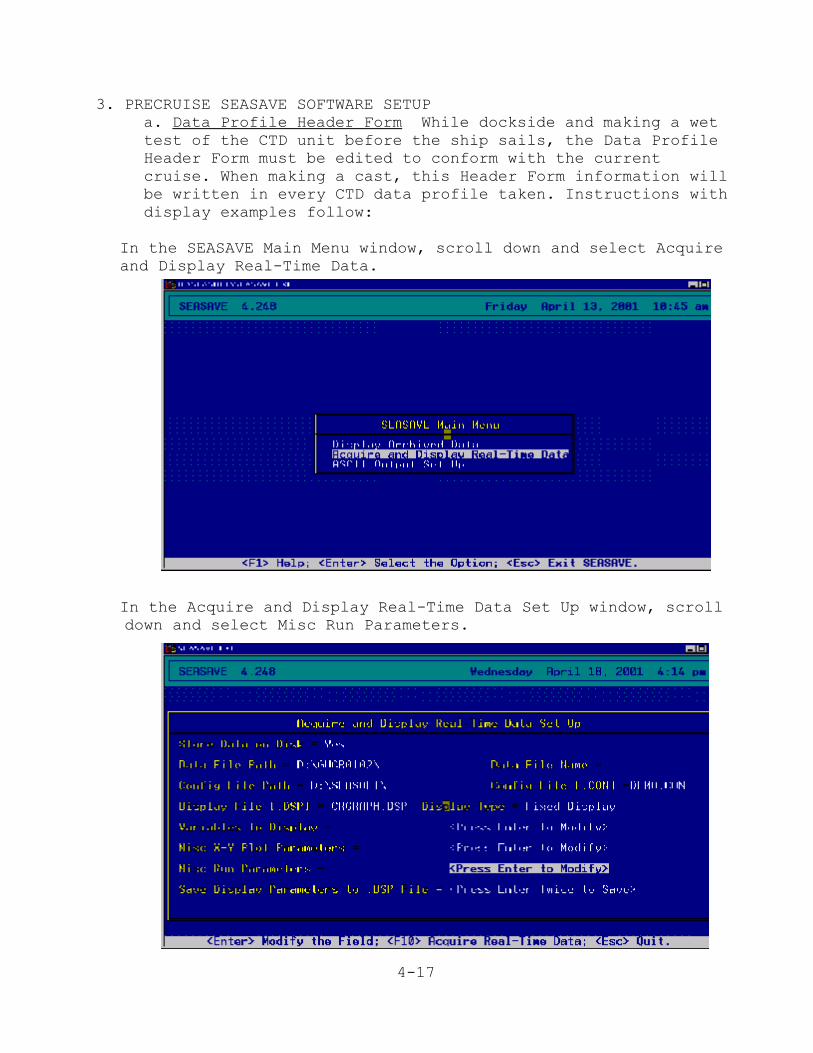
4-17
3. PRECRUISE SEASAVE SOFTWARE SETUPa. Data Profile Header Form While dockside and making a wettest of the CTD unit before the ship sails, the Data ProfileHeader Form must be edited to conform with the currentcruise. When making a cast, this Header Form information willbe written in every CTD data profile taken. Instructions withdisplay examples follow:
In the SEASAVE Main Menu window, scroll down and select Acquireand Display Real-Time Data.
In the Acquire and Display Real-Time Data Set Up window, scroll down and select Misc Run Parameters.
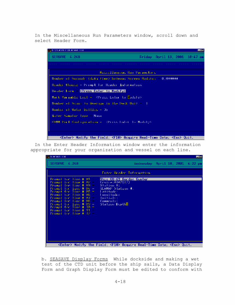
4-18
In the Miscellaneous Run Parameters window, scroll down andselect Header Form.
In the Enter Header Information window enter the information appropriate for your organization and vessel on each line.
b. SEASAVE Display Forms While dockside and making a wettest of the CTD unit before the ship sails, a Data DisplayForm and Graph Display Form must be edited to conform with

4-19
the current cruise. When making a cast, the Display Form willbe displayed so you can transcribe data to the EnvironmentalData Sheet. The Graph Display Form will be printed and givento the Field Party Chief for post cruise data profile qualitycontrol purposes. Instructions with display examples follow:
(1) Fixed Display Form In the SEASAVE Main Menu window,scroll down and select Acquire and Display Real-Time Data.
In the Acquire and Display Real-Time Data Set Up window,scroll down to Display Type and select Fixed Display, thenselect Variables to Display.
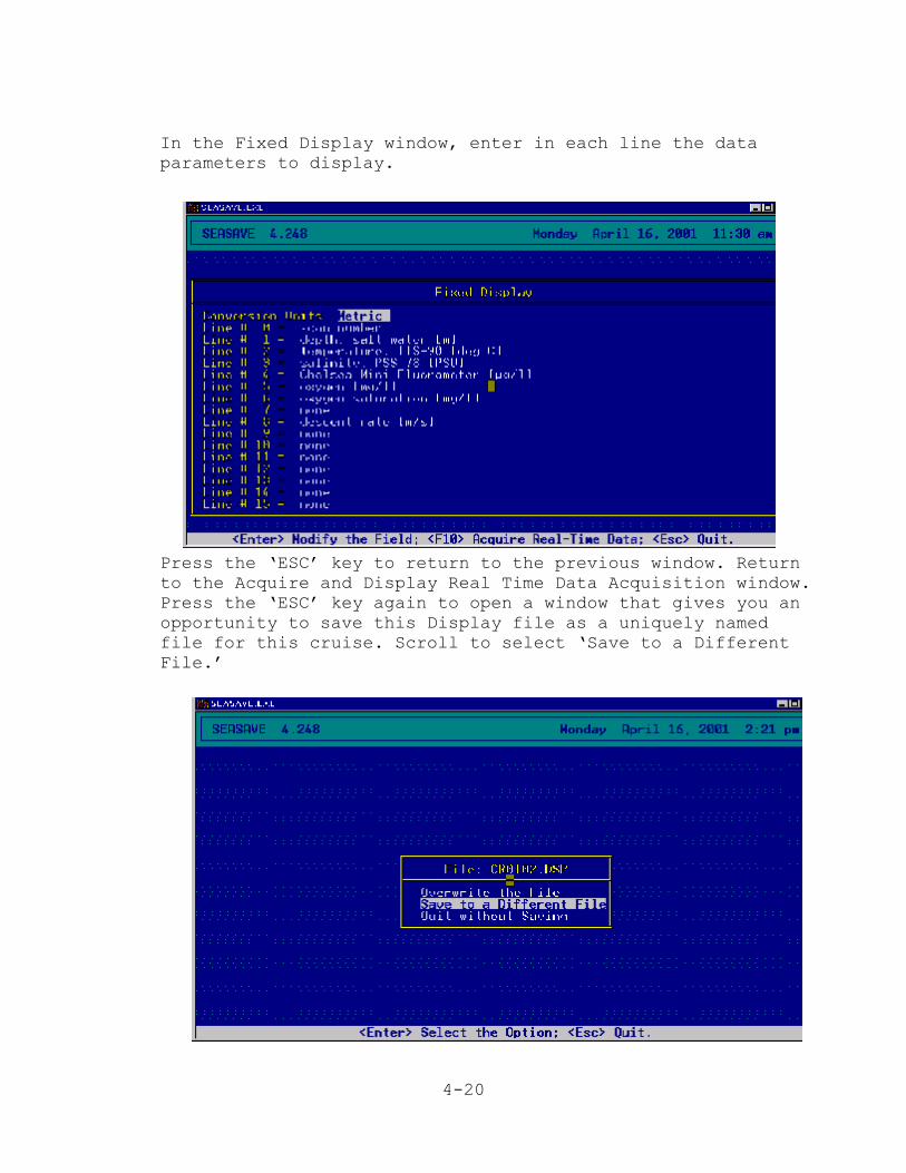
4-20
In the Fixed Display window, enter in each line the dataparameters to display.
Press the ‘ESC’ key to return to the previous window. Returnto the Acquire and Display Real Time Data Acquisition window.Press the ‘ESC’ key again to open a window that gives you anopportunity to save this Display file as a uniquely namedfile for this cruise. Scroll to select ‘Save to a DifferentFile.’
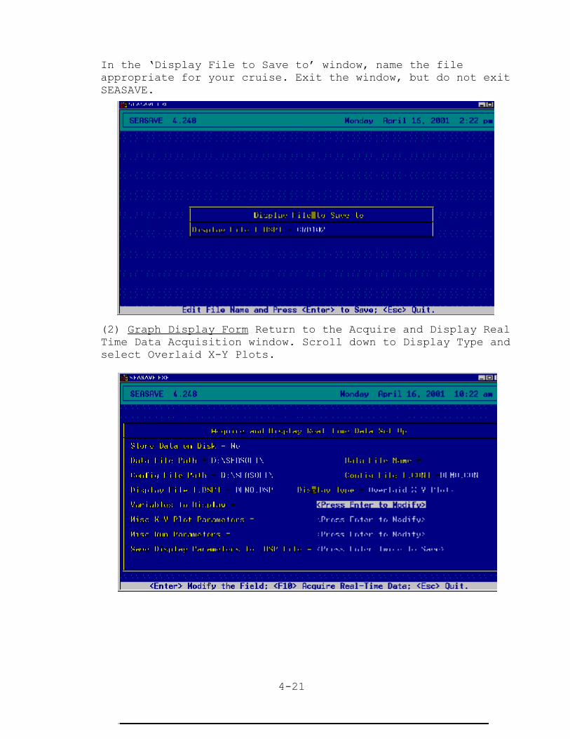
4-21
In the ‘Display File to Save to’ window, name the fileappropriate for your cruise. Exit the window, but do not exitSEASAVE.
(2) Graph Display Form Return to the Acquire and Display RealTime Data Acquisition window. Scroll down to Display Type andselect Overlaid X-Y Plots.

4-22
Then select Variables to Display. Fill in depth (M) on the‘Y’ axis. Be sure to select saltwater and 290 Latitude. On the‘X’ axis, fill in water temperature (oC), salinity (PSU), and dissolved oxygen (mg/l).
Press the ‘ESC’ key to return to the previous window. Returnto the Acquire and Display Real Time Data Acquisition window.Press the ‘ESC’ key again to open a window that gives you anopportunity to save this Display file as a uniquely namedfile for this cruise. Scroll to select ‘Save to a DifferentFile.
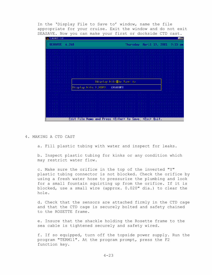
4-23
In the ‘Display File to Save to’ window, name the fileappropriate for your cruise. Exit the window and do not exitSEASAVE. Now you can make your first or dockside CTD cast.
4. MAKING A CTD CAST
a. Fill plastic tubing with water and inspect for leaks.
b. Inspect plastic tubing for kinks or any condition whichmay restrict water flow.
c. Make sure the orifice in the top of the inverted "Y"plastic tubing connector is not blocked. Check the orifice byusing a fresh water hose to pressurize the plumbing and lookfor a small fountain squirting up from the orifice. If it isblocked, use a small wire (approx. 0.020" dia.) to clear thehole.
d. Check that the sensors are attached firmly in the CTD cageand that the CTD cage is securely bolted and safety chainedto the ROSETTE frame.
e. Insure that the shackle holding the Rosette frame to thesea cable is tightened securely and safety wired.
f. If so equipped, turn off the topside power supply. Run theprogram "TERM11". At the program prompt, press the F2function key.
4-24
The program will enter a parameter set-up menu. Verify that"vmain"is greater than or equal to 11.5 volts. If not,replace the D cell batteries. Verify that "v lithium" isgreater than or equal to 5.5 volts. If not, contactEngineering support.
g. Turn on the topside power supply if so equipped. Press theF3 function key and verify that vmain exceeds 12 volts.
h. If required, use the "cc" command to set the conductivityturn-on frequency to 3500 for oceanic waters, or a lesservalue for low salinity water where the CTD does not turn onreliably when it enters the water. Use a conductivity turn-onfrequency of 0 only for on deck tests.
i. At the TERM11 prompt, issue the "il" command followed bythe "qs" command. Exit TERM11 immediately. If any keys areinadvertently pressed after the "qs" command is issued andbefore exiting TERM11, the "qs” command must be given again.
j. Run the program SEASAVE and confirm the correct "*.con"file is selected. Select "YES" as the option for the "Storedata to disk" menu item and make sure \CRXXX (where XXX isthe cruise number) is chosen as the output data path. Selecta name conforming to the following convention for saving datato disk if this is not an operational cast ("SSMMDD" where SSis replaced by O2 for OREGON II, GU for GORDON GUNTER, CR forCARETTA, or any appropriate initials for any other ship.Replace MM with the month 01-12 and replace DD with the dayof the month 01-31. For example, a test cast on the CARETTAperformed on July 9 would use the filename CR0709). Use thestation number as the data filename for a normal cast. Entera filename incorporating the station number, ex.,for thefirst Caretta station would be CR001. Select "Fixed Display"as an option for the "Display type" menu item. For variablesto display, select scan number, depth, salinity, dissolvedoxygen(mg/L), temperature, fluorometer (Sea Tech), lighttransmission, and descent rate (or a subset of thesevariables if not all of the sensors are used). Also, select“Overlaid X-Y Plots” as an option for the “Display Type”menu. For variables to display select depth, dissolved oxygen(mg/l), fluorometer, and transmissmivity. You will need bothwindow displays open during your CTD cast. Press functionkey F10 to enter the data acquisition mode.
k. Disconnect the fill hose from the conductivity cell andturn on the magnetic switch.
l. Deploy the CTD over the side and hold it just below the

4-25
surface for 3 minutes. Monitor the computer display. Theinstrument should turn on about 1 minute after entering thewater.
m. Commence lowering the CTD at 20 meters per minute. Thedescent rate display should be 0.333 meters per second. Usethe descent rate display to call for a speed-up or slow-downof the winch.
n. Stop 1 meter off the bottom or at maximum depth, 200meters. Wait 1 minute, press the pause key and record yourreadings on the Environmental Data Form. Take a water sampleby PRESSING the rosette control switch. While a water sampleis being taken, you can do a screen dump of the active FixedDisplay window (ALT+PRINT SCREEN) to get a hard copy of thedata at that point. Open Wordpad and paste the data displayinto the window. Print this file.
o. Press the space bar to resume data updates.
p. Haul the CTD up to midwater, wait 1 minute, press thePAUSE key and record your readings. Take a water sample byPRESSING the rosette control switch. While a water sample isbeing taken, you can do a screen dump of the active FixedDisplay window (ALT+PRINT SCREEN) to get a hard copy of thedata at that point. Open Wordpad and paste the data displayinto the window. Print this file.
q. Press the space bar to resume data updates.
r. Bring the CTD to the surface, wait one minute, press thePAUSE key and record your readings. Take a water sample byPRESSING the rosette control switch. While a water sample isbeing taken, you can do a screen dump of the active FixedDisplay window (ALT+PRINT SCREEN) to get a hard copy of thedata at that point. Open Wordpad and paste the data displayinto the window. Print this file.
s. Press the space bar to resume data updates.
t. When the cast is over and the CTD is back on deck, turnoff the magnetic switch, and rinse the instrument down withfresh water. Reconnect the hose, flush the tube with freshwater, leave it filled with fresh water, and inspect forleaks.
5. PRINTING A CTD PROFILE GRAPH. Click the mouse arrow on the Graph Display window to make itactive. Press the ‘ALT+PRINT SCREEN’ keys to capture the graph

4-26
in the PC memory buffer. Open Wordpad and paste the graph intothe window. Print this graph file and give it to the Field PartyChief.

5-1
V. COLLECTING ICHTHYOPLANKTON DATA
5-2
V. Collecting Ichthyoplankton Data
A. IntroductionWhen filling out station sheets, please use a lead pencil and
make entries dark and legible. A NMFS PASCAGOULA STATION SHEET-TYPE I (Figure 5-1, page 5-16) must be completed for all ichthyo-plankton stations. An ICHTHYOPLANKTON STATION FORM (Figure 5-2,page 5-20) must be filled out for all plankton stations whereSEAMAP ichthyoplankton samples are collected. All numeric fieldson field data sheets are to be right justified or aligned with thedecimal place. On all NOAA vessels equipped with the ScientificComputing System (SCS), Watch Leaders should, prior to the firstplankton station, confer with the Field Party Chief (FPC) on theselection of the most appropriate data to be collected during SCSplankton events.
A checklist of sampling equipment and supplies is listed inAppendix 10, page A-27. Prior to a cruise, the FPC shoulddetermine the equipment (kinds of collecting gear) and supplies(number of sample jars, approximate amount of formalin, andalcohol, etc.) that will be required for the cruise and submitthose requirements to ichthyoplankton personnel for placement onthe vessel.
B. SEAMAP ICHTHYOPLANKTON SAMPLING: General Comments
Important changes have been made so please review these proceduresfor collecting SEAMAP ichthyoplankton samples.
Some confusion has risen over just when weather conditionsprohibit sampling. This is truly a subjective decision based onboat stability and personnel capabilities. In general, when windspeed approaches 15-20 knots, it is time to begin appraising thesituation. In some cases, with larger ships and experienced crew,it is possible for operators to maneuver the boat into a leeposition so that work can continue in winds over 20kts. At othertimes, specific sea conditions and/or inexperienced personnel maywarrant stopping operations in 20 knot winds. Remember that highwinds will cause the flowmeters to turn prior to submergence. When that becomes a problem, try to deploy the bongo net asquickly as possible or put a Styrofoam cup over the flowmeterrotor. Holding cod ends until the mouth of the bongo frame issubmerged will reduce cracking and breakage of cod ends that areblown into the side of the ship in strong winds.
C. ICHTHYOPLANKTON STATION PROCEDURES
1. BONGO SAMPLING
When conducting bongo tows using the standard SEAMAP bongoconfiguration, without a monitored depth sensing device (SBE-19
5-3
or similar device), follow the directions outlined in StationOperations I (page 5-3). If a monitored depth sensing device(SBE-19 or other) is used, follow the protocols outlined inStation Operations II for use of that device (page 5-7).
Before and after each cast, check bongo array for:
Make sure cod ends are secure.
Check for major rips or holes in the mesh, especially in thelower 1/3 of the net. If holes are detected, repair them(see page 5-23) or replace the net.
Make sure there are NO air bubbles in the flowmeters. Ifneeded, fill with silicone oil. Tap water (NOT distilled orsalt water!) can be substituted in an emergency.
Check to insure that the flowmeter rotor spins freely anddoes not wobble, i.e., the shaft is not bent. If theflowmeter does not spin freely or a wobble is detected,replace the meter.
a. STATION OPERATIONS I
The following procedure should be used when no monitored depthsensing device (SBE-19) is being used.
(1) Record station information on station log sheets. Seepage 5-17 for ichthyoplankton station sheet instructions.
(2) Record flowmeter serial number and START readings.
(3) Upon notification that the Bridge and Deck are ready andupon your command, tell the deck crew to lower the gear tojust above water surface; check that nets are streamed outstraight. Zero meter wheel.
(4) Ship should be moving at 1.5-2.0 knots.
(5) Deploy gear. When nets enter water and flowmeters start toturn, record the time to nearest second (Gear in) using awristwatch displaying seconds. Watches should besynchronized with the ship’s time.
(6) Pay out wire, using Table A below as a guide, until theamount of wire is delivered to reach the Target Fishing Depth(TFD). In <200m water depth, the optimum TFD samples as muchof the water column as possible. In water depths <50m, it ispossible to sample within 1-2 m above the bottom. A word ofcaution, in 50-200 m depths, a small drop in the wire anglegreatly increases the chance the bongo nets will hit the

5-4
bottom. As depth increases, the TFD should become moreconservative. It can be as much as 4 m above the bottom in199 m of water depth.
(7) Use Table 8, Towing Wire Required To Reach Depths of 1-500Meters With Wire Angles from 300 To 600, to adjust amount ofwire needed for net to actually reach target depth at theobserved wire angle.
(8) Adjust ship speed to maintain a uniform wire angle,preferably 45°, during wire payout.
(9) At maximum depth, stop payout of cable and immediatelystart retrieval (do not allow net to ‘settle’). Record time,angle of wire, amount of wire out and the calculated depth(see * below) that the net reached. Please indicate in theremarks section that the standard *calculated depth wasrecorded in the maximum depth field of the Ichthyoplanktonstation form.
*Calculated max depth = max wire out x cosine of wire anglewhen max depth is reached
(10) Retrieve net at a rate commensurate with the amount of wireout, using Table A as a guide while maintaining a 45° wireangle. It is EXTREMELY IMPORTANT that the wire angle be asclose to 45° as possible during retrieval.
If angle exceeds 55°, falls to 35° OR if combined variationexceeds 15°, the tow should be repeated (save the sampleuntil a better tow is completed).
TABLE A. APPROXIMATE RATES OF WIRE PAYOUT AND RETRIEVAL FORSEAMAP BONGO NET COLLECTIONS. (Actual rates will depend onwinch capabilities).
Target fishingDEPTH (m)
Total amountWIRE OUT (m)
PAYOUT RATE* RETRIEVE RATE*
0 - 19 < 27 10m/min 10m/min
20 - 69 28 - 97 15m/min 15m/min
70 - 100 > 99 20 - 30m/min 20m/min
101-200 > 143 50m/min 20m/min
*Once established, these rates must be held constant.
(11) Record time to the second (Gear out) when the net breakssurface and flowmeters stop turning, while an assistant orthe winch operator immediately pulls the frame from the
5-5
water. Do not let the bongo array continue to fish once itbreaks the surface.
(12) When possible, rinse plankton into the cod end of the netwith a seawater hose while the net hangs over the side. Inhigh winds, bring net directly on board and rinse downcompletely on deck. If using the ring bongo frame, record theflowmeter readings before rinsing down the ichthyoplanktonnet. If using the standard MARMAP bongo frame or collarbongo, take care not to wash or spin the flowmeter rotorbefore the tow readings are taken.
(13) Put bongo frame and net on deck (take care not to restframe on net or scrape net with frame on the deck!) andrecord flowmeter readings. After taking readings, check thatthe flowmeter shaft is not bent by spinning the flowmeterrotor gently.
(14) Gently rinse the lower portion of net into cod ends. Visually check that no plankton is left in net, especiallycheck seams and cod end sleeves. If mud or sand is presentin both samples, the tow must be repeated. Save any marginalsample until completion of the next tow. If mud (no morethan 2 tablespoons) is present in only one sample the towneed not be repeated. Save both samples and record thepresence of mud in the sample in the remarks section of theIchthyoplankton station sheet and the Plankton TransferRecord (Figure 5-4).
(15) Remove cod ends and place cod ends into bucket. It isimperative that samples be preserved immediately uponcollection. Keep samples in a dark temperature controlledarea when possible.
Note: Sometimes extremely fine phytoplankton material will be
difficult to rinse out. It is not necessary to save this
phytoplankton, if you are completely sure you have rinsed down
all the zooplankton. (When in doubt, SAVE IT ALL!!!) However,
a dense accumulation of phytoplankton will clog the net and
should be cleaned prior to the next station. Rinse net with
your usual effort to obtain sample, preserve, then scrub net
afterwards as needed.
Rinse off any Sargassum, grass or other debris. Note theapproximate type and volume of material (less than a handful, ahandful, a half bucket, etc.) in the comment section of the NMFSPascagoula Station Sheet-Type I (or on the Ichthyoplanktonstation sheet on cruises/stations where plankton is secondary),then discard after checking carefully for any clinging planktonmaterial. Small adult fish and invertebrates that can easilyfit in the sample jar should be saved. Larger fish may be

5-6
discarded (note on data sheets) unless needed for anotherpurpose. (Freeze any unusual or rare specimens if at allpossible!). Concentrate plankton using a fine mesh cone orsieve. Some samples are slow to filter; for these samplesconcentrate smaller quantities at a time and use a vigorousswirling motion. Jellyfish slime can be cut with a small amount(1-2 tsp) of ethanol (NOT formalin!!). If needed, preserve thesample "as-is", liquid and all. You may be able to condense thesample later when transferring to ethanol.
(16) Transfer plankton to sample jars with a seawater filledrinse bottle. A plastic spoon may be used, but is notrecommended. If necessary, use a plastic spoon to transfer alarger quantity of sample at one time into the jar. Neverscrape plankton from the mesh cone or sieve with the spoon. This mutilates larvae and makes them impossible to identify.
(17) Most SEAMAP plankton samples are initially fixed in 10%formalin. Add 50 ml of full strength formalin to the 0.5liter jar or 100 ml of formalin to the 1 liter jar containingthe plankton sample seawater mixture (jar should be at leasthalf filled with seawater), then top off the jar withseawater. Do not fill jars more than 1/3 full with plankton,use more jars and label each jar accordingly, i.e., 1 of 2, 2of 2, etc.
All samples should be transferred to 95% ethanol solutionafter a minimum of 48 hours for permanent preservation. It isvery important to not mix water into the sample at this stage.Unless there is precipitate, it is not necessary to rinsesample, just drain and add ethanol. If you need to rinse, useethanol and NOT seawater. If a sample has spoiled, rinse itlightly, subdivide into more jars (this time do not fill morethan ¼ with sample), and fill with 10% formalin solution. Afteranother 48 hours, transfer into 95% ethanol as usual. Notepreservation problems on the Ichthyoplankton station sheet, thePascagoula station sheet and the Ichthyoplankton Sample TransferRecord.
Sometimes SEAMAP samples are initially preserved in 95% ethanol;check with the FPC and Watch Leader to determine when this is tobe the case. Initial preservative information should berecorded in the remarks section on the Ichthyoplankton stationsheet. This information should also be written in the commentssection of the inside labels and the ‘gear’ section of theoutside sample labels.
(18) Follow instructions for labeling sample jars starting on page 5-20.
(19) After the station is completed fill in appropriate
5-7
information on the Flowmeter Performance Tracking Form,Figure 5-4, and the Plankton Transfer Record, Figure 5-5, asinstructed on pages 5-22 to 5-23.
b. STATION OPERATIONS II
The following procedure should be used when a monitored depthsensing device (SBE-19) is used.
(1) Deck Scientist: Inspect underwater depth sensing device(SBE-19) by making sure the device is properly secured to thewire, connections are secure, Tygon tube is filled withwater, magnetic switch is off and wires are not damaged. Report findings to Lab Scientist. The Watch Leader willreport damages to Electronics Technician. Report both theleft and right bongo flowmeter serial numbers and startreadings to the Lab Scientist.
IMPORTANT: Measure the distance from the SBE-19 to the bottomof the bongo frame for use as a depth correction factor(DCF). This should be done by the FPC/Chief IchthyoplanktonScientist prior to the first bongo tow and that number shouldbe given to the Watch Leaders and displayed in the Lab wherethe SBE-19 operations will be conducted. Also record thisvalue on the Pascagoula Type I sheet in the Comments section.
(2) Lab Scientist: Record both the left and right bongoflowmeter serial numbers and start readings on theIchthyoplankton Station Form. Follow SBE-19 (SEACAT) Programminginstructions. Determine if you are using a DOS or a Windowsdriven computer system. Select and follow appropriateinstructions:
DOS:Type “cd SBE4213"turn on deck boxat C:\SBE4213> Type "term19"blue screen, press Enterat S> type "DS", hit Enter or just hit F3 to display statuscheck vmain (should be greater than 12 to run)at S> type "IL", hit Enter or just hit F8 to initialize loggingat S> type "QS", hit Enter, then press F10 to exit at C:\SBE4213> type "SEASAVE", hit Enterfile (on right part of screen), enter station # as filenamepress F10 to fill out header formto leave header, press escSave header and continue, press Enter
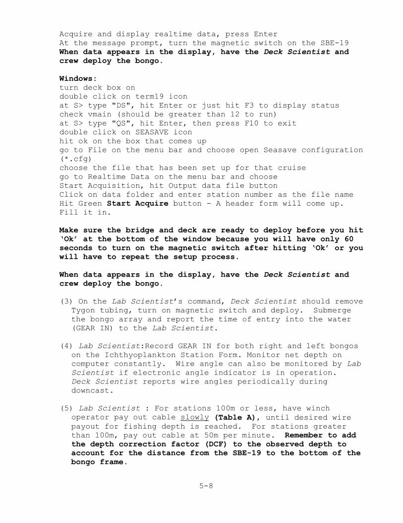
5-8
Acquire and display realtime data, press EnterAt the message prompt, turn the magnetic switch on the SBE-19When data appears in the display, have the Deck Scientist andcrew deploy the bongo.
Windows:turn deck box ondouble click on term19 iconat S> type "DS", hit Enter or just hit F3 to display statuscheck vmain (should be greater than 12 to run)at S> type "QS", hit Enter, then press F10 to exitdouble click on SEASAVE iconhit ok on the box that comes upgo to File on the menu bar and choose open Seasave configuration(*.cfg)choose the file that has been set up for that cruisego to Realtime Data on the menu bar and chooseStart Acquisition, hit Output data file buttonClick on data folder and enter station number as the file name Hit Green Start Acquire button - A header form will come up. Fill it in.
Make sure the bridge and deck are ready to deploy before you hit‘Ok’ at the bottom of the window because you will have only 60seconds to turn on the magnetic switch after hitting ‘Ok’ or youwill have to repeat the setup process.
When data appears in the display, have the Deck Scientist andcrew deploy the bongo.
(3) On the Lab Scientist’s command, Deck Scientist should removeTygon tubing, turn on magnetic switch and deploy. Submergethe bongo array and report the time of entry into the water(GEAR IN) to the Lab Scientist.
(4) Lab Scientist:Record GEAR IN for both right and left bongoson the Ichthyoplankton Station Form. Monitor net depth oncomputer constantly. Wire angle can also be monitored by LabScientist if electronic angle indicator is in operation. Deck Scientist reports wire angles periodically duringdowncast.
(5) Lab Scientist : For stations 100m or less, have winchoperator pay out cable slowly (Table A), until desired wirepayout for fishing depth is reached. For stations greaterthan 100m, pay out cable at 50m per minute. Remember to addthe depth correction factor (DCF) to the observed depth toaccount for the distance from the SBE-19 to the bottom of thebongo frame.
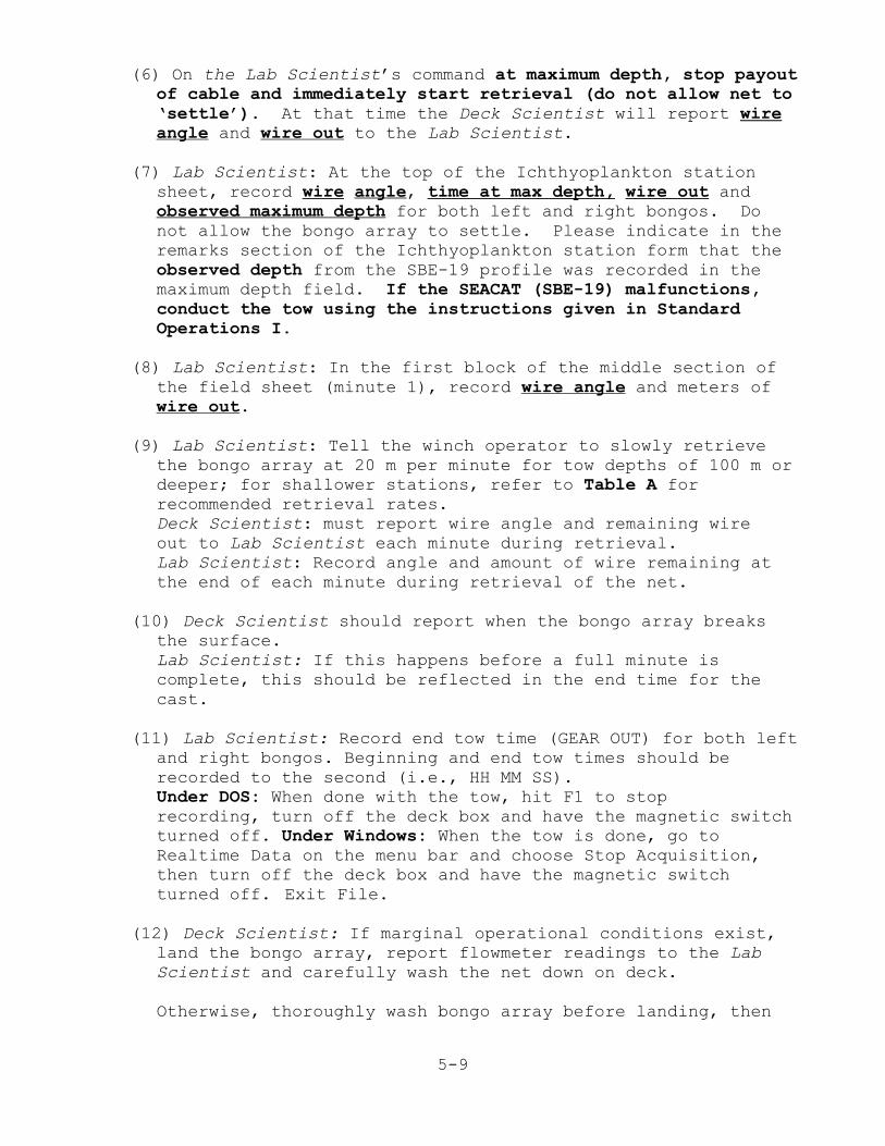
5-9
(6) On the Lab Scientist’s command at maximum depth, stop payoutof cable and immediately start retrieval (do not allow net to‘settle’). At that time the Deck Scientist will report wireangle and wire out to the Lab Scientist.
(7) Lab Scientist: At the top of the Ichthyoplankton stationsheet, record wire angle, time at max depth, wire out andobserved maximum depth for both left and right bongos. Donot allow the bongo array to settle. Please indicate in theremarks section of the Ichthyoplankton station form that theobserved depth from the SBE-19 profile was recorded in themaximum depth field. If the SEACAT (SBE-19) malfunctions,conduct the tow using the instructions given in StandardOperations I.
(8) Lab Scientist: In the first block of the middle section ofthe field sheet (minute 1), record wire angle and meters ofwire out.
(9) Lab Scientist: Tell the winch operator to slowly retrievethe bongo array at 20 m per minute for tow depths of 100 m ordeeper; for shallower stations, refer to Table A forrecommended retrieval rates.Deck Scientist: must report wire angle and remaining wireout to Lab Scientist each minute during retrieval.Lab Scientist: Record angle and amount of wire remaining at the end of each minute during retrieval of the net.
(10) Deck Scientist should report when the bongo array breaksthe surface. Lab Scientist: If this happens before a full minute iscomplete, this should be reflected in the end time for thecast.
(11) Lab Scientist: Record end tow time (GEAR OUT) for both leftand right bongos. Beginning and end tow times should berecorded to the second (i.e., HH MM SS). Under DOS: When done with the tow, hit F1 to stoprecording, turn off the deck box and have the magnetic switchturned off. Under Windows: When the tow is done, go toRealtime Data on the menu bar and choose Stop Acquisition,then turn off the deck box and have the magnetic switchturned off. Exit File.
(12) Deck Scientist: If marginal operational conditions exist,land the bongo array, report flowmeter readings to the LabScientist and carefully wash the net down on deck.
Otherwise, thoroughly wash bongo array before landing, then

5-10
report flowmeter readings to the Lab.
(13)Lab Scientist: Record end flowmeter readings for both leftand right bongos.Deck Scientist: Collect samples for preservation following procedures outlined for bongo collections on pages 5-2 to 5-6.
2. NEUSTON SAMPLING
a. Deploy net so that the neuston frame is half submerged.
b. Tow at 1.5-2.0 Knots for 10 minutes (±30 seconds).Usually the bridge times this tow. Check with FPC fordetermination of who keeps the tow time during the survey. Record the beginning (start) and ending (stop) times to thesecond on the Ichthyoplankton station sheet. Start timeoccurs when the gear is in the water half submerged and isfishing properly. End time occurs when the net is out of thewater.
The duration of a neuston tow may be shortened up to fiveminutes when there are high concentrations of jellyfish,ctenophores, Sargassum, floating weed and/or debris. It isvery important to keep accurate tow times, because towduration is the only measure of fishing effort for neustonsamples.
c. Retrieve net. Rinse plankton into cod end with saltwaterwhile net hangs over side (if windy, bring net directly onboard and rinse on deck).
d. Gently rinse the lower portion of net into the end. Untiesleeve of net and carefully rinse plankton into bucket orremove cod ends (if used) as with bongo nets and place inbucket. Visually check that no plankton is left in net;especially check seams and cod end sleeves. It isimperative that samples be preserved immediately uponcollection.
Note: Sometimes extremely fine phytoplankton material will be
difficult to rinse out. It is not necessary to save this
phytoplankton, if you are completely sure you have rinsed down
all the zooplankton. (When in doubt, SAVE IT ALL!!!) However,
a dense accumulation of phytoplankton will clog the net and
should be cleaned prior to the next station. Rinse net with
your usual effort to obtain sample, preserve, then scrub net
afterwards as needed.
Rinse any Sargassum, grass or other extraneous material. Note
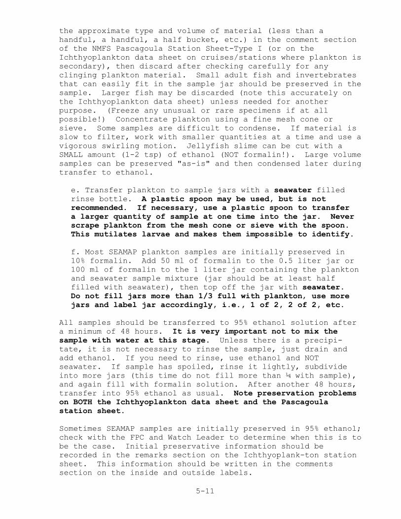
5-11
the approximate type and volume of material (less than ahandful, a handful, a half bucket, etc.) in the comment sectionof the NMFS Pascagoula Station Sheet-Type I (or on theIchthyoplankton data sheet on cruises/stations where plankton issecondary), then discard after checking carefully for anyclinging plankton material. Small adult fish and invertebratesthat can easily fit in the sample jar should be preserved in thesample. Larger fish may be discarded (note this accurately onthe Ichthyoplankton data sheet) unless needed for anotherpurpose. (Freeze any unusual or rare specimens if at allpossible!) Concentrate plankton using a fine mesh cone orsieve. Some samples are difficult to condense. If material isslow to filter, work with smaller quantities at a time and use avigorous swirling motion. Jellyfish slime can be cut with aSMALL amount (1-2 tsp) of ethanol (NOT formalin!). Large volumesamples can be preserved "as-is" and then condensed later duringtransfer to ethanol.
e. Transfer plankton to sample jars with a seawater filledrinse bottle. A plastic spoon may be used, but is notrecommended. If necessary, use a plastic spoon to transfer a larger quantity of sample at one time into the jar. Neverscrape plankton from the mesh cone or sieve with the spoon. This mutilates larvae and makes them impossible to identify.
f. Most SEAMAP plankton samples are initially preserved in10% formalin. Add 50 ml of formalin to the 0.5 liter jar or100 ml of formalin to the 1 liter jar containing the planktonand seawater sample mixture (jar should be at least halffilled with seawater), then top off the jar with seawater.Do not fill jars more than 1/3 full with plankton, use morejars and label jar accordingly, i.e., 1 of 2, 2 of 2, etc.
All samples should be transferred to 95% ethanol solution aftera minimum of 48 hours. It is very important not to mix thesample with water at this stage. Unless there is a precipi-tate, it is not necessary to rinse the sample, just drain andadd ethanol. If you need to rinse, use ethanol and NOTseawater. If sample has spoiled, rinse it lightly, subdivideinto more jars (this time do not fill more than ¼ with sample),and again fill with formalin solution. After another 48 hours,transfer into 95% ethanol as usual. Note preservation problemson BOTH the Ichthyoplankton data sheet and the Pascagoulastation sheet.
Sometimes SEAMAP samples are initially preserved in 95% ethanol;check with the FPC and Watch Leader to determine when this is tobe the case. Initial preservative information should berecorded in the remarks section on the Ichthyoplank-ton stationsheet. This information should be written in the commentssection on the inside and outside labels.

5-12
g. Follow instructions for labeling sample jars starting onpage 5-21.
h. After the station is completed, fill in appropriateinformation on the Plankton Transfer Record, Figure 5-4.
5-13
D. NMFS Pascagoula Station Sheet - Type I Instructions
GENERAL COMMENTS - A NMFS Pascagoula Station Sheet MUST becompleted for every SEAMAP station. The top section (down to theheavy black line across page) MUST be completed for each stationoccupied, regardless of gear types(s) used. The Type I (Figure 5-1, page 5-16) data sheet species list is blank, and is usedprimarily for plankton surveys and as a continuation sheet forother surveys.
Please use a lead pencil and make entries DARK enough and LEGIBLEenough so that the key entry operator can read them. All numericfields are to be right justified or aligned with the decimalplace. Leading zeros are not required, but enter trailing zeros.
Data Requirements For All Stations:
FIELD BY FIELD INSTRUCTIONS
VESSEL - Enter 2-digit numerical code from Appendix 1, VesselCodes, page A-2. If your vessel has not been assigned a code,notify NMFS Pascagoula to receive one.
PASCAGOULA STATION NUMBER - This is a unique sequentialconsecutive 5-digit number within each cruise, preferablystarting with "00001". For state vessels enter the 2-digitvessel code followed by a 3-digit station number. Transfer thisstation number to the environmental or plankton sheet. Do notduplicate this station number for other stations on a cruise.
CRUISE - Enter 3-digit cruise number. Except for the Oregon IIand other vessels having historically different cruise numberingconventions, the cruise number for ALL VESSELS shall be thecalendar year of the survey followed by the cruise number forthe year, e.g. "011" first cruise for year 2001, "012"- secondcruise for year 2001, etc. The leading zero is required. Usethis cruise number on all sheets during a cruise; do not changeit.
START TIME - Obtain time zone code from Appendix 2-A, Time ZoneCodes, page A-3. Enter military time (0000-2359), HHMM, of startof station. For fishing stations, enter dog-off time or end ofgear set. For environmental and plankton stations, enter thetime data acquisition started.
START LATITUDE & LONGITUDE - Enter position occupied at starttime in degrees, minutes, and hundredths of minutes, observingindicated decimals and entering trailing zeros.
START DEPTH - Enter starting depth in fathoms and tenths.
5-14
SEAMAP/OTHER STATION NO. - Use for SEAMAP or other alternatestation numbers. For SEAMAP Station numbers, use four alpha/numeric characters and right justify, but be consistent in fieldlength - all numbers should be the same number of characters,T065, W102, NOT T65 or W0102.
DATE - Enter station date (based on start time), in the formatMMDDYY.
END TIME - Enter as for start time - fishing stations end atstart of haulback, others when data acquisition ends.
END LATITUDE & LONGITUDE - Enter position occupied at end timein degrees, minutes, and hundredths of minutes, observingindicated decimals and entering trailing zeros.
END DEPTH - Enter end depth in fathoms and tenths.
GEAR TYPES USED AT THIS STATION - Enter codes for all gear typesused at this station - see Appendix 3 for codes.
SURFACE AND BOTTOM TEMPERATURES - If taken, enter temperaturesin degrees Celsius, observing 2 indicated decimals. Addtrailing zeros if necessary. If more than one method is used,data entry precedence is 1) CTD, 2) XBT, and 3) bucket.
All weather data should be rounded off to nearest hour, i.e.if the time is 13:31 then record weather data collected at 14:00 hours.
Wind speed and direction measurements are a concern for somevessels. Handheld anemometers are available from wildlife andfishery supply houses and should be used to measure wind speed. Wind direction can be determined by a handheld compass
AIR TEMPERATURE - Enter in degrees Celsius and tenths (drybulb).
BAROMETRIC PRESSURE - Enter in millibars of mercury, observing 1indicated decimal.
WIND SPEED - Enter wind speed in whole knots.
WIND DIRECTION - Enter wind direction in compass degrees,001-360.
WAVE HEIGHT - Enter wave height in meters, observing 1 indicateddecimal.
SEA CONDITION - Enter Beaufort scale- see Appendix 2-B, BeaufortSea Condition Table, page A-3.
5-15
DATA SOURCE CODE - Enter code identifying data collectingentity- see Appendix 2-C, Data Source Codes, page A-3.
VESSEL SPEED - Enter vessel speed, in knots, during the station,observing 1 indicated decimal.
STATISTICAL ZONE - Enter GCSD statistical zone from Figure 1-2. Leave blank if you are outside a statistical zone.
TOW NO. - Consecutive number of the tow within a SEAMAP station.
NET NO. - 1 = Port, 2 = Starboard and 3 = Stern Trawl.
The data above must be recorded regardless of station type.
5-16
Figure 5-1. NMFS PASCAGOULA STATION SHEET TYPE-I.
5-17
E. ICHTHYOPLANKTON STATION FORM INSTRUCTIONS
GENERAL COMMENTS - An Ichthyoplankton Station Form (Figure 5-2,page 5-20) must be completed for all trawl stations whereichthyoplankton tows are made and for all ichthyoplanktonstations.
Please use a lead pencil and make entries DARK enough and LEGIBLEenough so that the key entry operator can read them. All numericfields are to be right justified or aligned with the decimalplace. Leading zeros are not required, but enter trailing zeros.
VESSEL - Enter 2-digit numerical code from Appendix 1, VesselCodes, page A-2. If your vessel has not been assigned a code,notify NMFS Pascagoula to receive one.
PASCAGOULA STATION NUMBER - This is a unique sequentialconsecutive 5-digit number within each cruise, preferably startingwith "00001". For state vessels enter the 2-digit vessel codefollowed by a 3-digit station number. Transfer this station numberto the environmental or plankton sheet. Do not duplicate thisstation number for other stations on a cruise.
CRUISE - Enter 3-digit cruise number. Except for the Oregon II andother vessels having historically different cruise numberingconventions, the cruise number for ALL VESSELS shall be thecalendar year of the survey followed by the cruise number for theyear, e.g. "011" first cruise for year 2001, "012"- second cruisefor year 2001, etc. The leading zero is required. Use this cruisenumber on all sheets during a cruise; do not change it.
DATA SOURCE CODE - Enter Data Source Code from Appendix 2-C.
TIME AT MAX DEPTH - Enter Time Zone (ZN) from Appendix 2-A. Entermilitary time (24 hours) when the bongo net reaches maximum depthto the nearest minute, just prior to haulback. For planktonstations in which only a neuston net is towed, enter the starttime of the neuston tow.
ANGLE - Enter angle at maximum depth, just prior to haulback.
WIRE OUT - Record the amount of wire required to reach thetargeted maximum tow depth with the 45o wire angle using Table 8.Before the tow begins, get an estimate of total wire out needed toreach max. depth with a 45o wire angle. Please note that if,during wire payout, it appears that the wire angle upon reachingyour targeted maximum depth will differ by more than +5o from 45°,reduce or increase accordingly the amount of wire ultimately paid
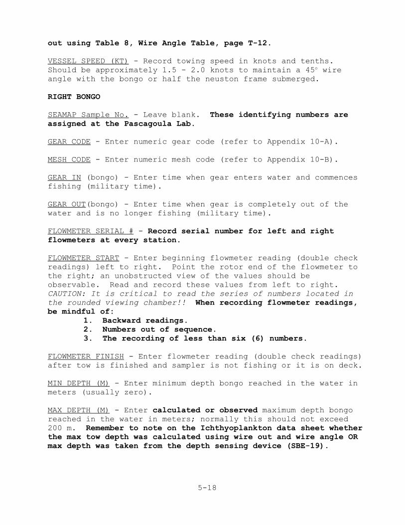
5-18
out using Table 8, Wire Angle Table, page T-12.
VESSEL SPEED (KT) - Record towing speed in knots and tenths. Should be approximately 1.5 - 2.0 knots to maintain a 45o wireangle with the bongo or half the neuston frame submerged.
RIGHT BONGO
SEAMAP Sample No. - Leave blank. These identifying numbers areassigned at the Pascagoula Lab.
GEAR CODE - Enter numeric gear code (refer to Appendix 10-A).
MESH CODE - Enter numeric mesh code (refer to Appendix 10-B).
GEAR IN (bongo) - Enter time when gear enters water and commencesfishing (military time).
GEAR OUT(bongo) - Enter time when gear is completely out of thewater and is no longer fishing (military time).
FLOWMETER SERIAL # - Record serial number for left and rightflowmeters at every station.
FLOWMETER START - Enter beginning flowmeter reading (double checkreadings) left to right. Point the rotor end of the flowmeter tothe right; an unobstructed view of the values should beobservable. Read and record these values from left to right. CAUTION: It is critical to read the series of numbers located in
the rounded viewing chamber!! When recording flowmeter readings,be mindful of:
1. Backward readings. 2. Numbers out of sequence. 3. The recording of less than six (6) numbers.
FLOWMETER FINISH - Enter flowmeter reading (double check readings)after tow is finished and sampler is not fishing or it is on deck.
MIN DEPTH (M) - Enter minimum depth bongo reached in the water inmeters (usually zero).
MAX DEPTH (M) - Enter calculated or observed maximum depth bongoreached in the water in meters; normally this should not exceed200 m. Remember to note on the Ichthyoplankton data sheet whetherthe max tow depth was calculated using wire out and wire angle ORmax depth was taken from the depth sensing device (SBE-19).

5-19
LEFT BONGO - Repeat as with right bongo.
MIN ANGLE - Start recording wire angle one minute (60 seconds)after commencing haulback (DO NOT record angle on the way down thewater column).
WIRE OUT - Start recording amount of wire out in meters one minute(60 seconds) after commencing haulback. Record wire and angleevery minute thereafter until tow is completed.
RECORDER - Enter name of person responsible for the watch. Otherinitials may be included.
NEUSTON OR OTHER - If other gear type, specify.
SEAMAP Sample No. - Leave blank.
GEAR CODE - Enter gear code (refer to Appendix 11-A, page A-28).
MESH CODE - Enter mesh code (refer to Appendix 11-B, page A-28).
GEAR IN (neuston)- Enter military time down to seconds when thegear is in the water half submerged and is fishing properly. Ifthere is only a neuston tow conducted at a station, record thatvalue in the time at max depth field at top of station sheet.
GEAR OUT (neuston)- Enter military time when gear is out of thewater down to seconds.
MIN DEPTH (M) - Enter minimum depth gear is in the water in meters(0.5 m).
MAX DEPTH (M) - Enter maximum depth gear is in the water in meters(0.5 m). It is important that min and max depths are identicalfor gear like the neuston net that is hauled at the same depththroughout the tow.
5-20
Figure 5-2. Ichthyoplankton Station Form.
5-21
F. INSTRUCTIONS FOR COMPLETING ICHTHYOPLANKTON SAMPLE LABELS
Label accuracy and completeness is essential, but never delaypreserving the samples just for station position and station time. The most important sample identifiers recorded on the inside andoutside jar labels are Vessel, Cruise, Station Number and Gear(Figure 5-3, Sample Completed Labels, page 5-23). Stationlatitude, longitude and time correspond to the start position andtime, but if an exact position cannot be received from the Bridgein a timely manner, then use the targeted station position and agood estimate of station time. Always double check inside samplelabels before placing them in the jars.
1. OUTSIDE SAMPLE LABEL
Serial number - Leave blank, this is reserved for SEAMAP numberassignment at the NMFS Pascagoula Laboratory.
Vessel - Use appropriate SEAMAP vessel code or FPC approvedvessel name.
Cruise - SEAMAP cruise number.
Station - Use Pascagoula station number.
Haul - Fill in only if multiple net systems are used at thisstation, i.e., Tucker trawl, MOCNESS, or if multiple deploymentsof the same gear are made.
Mesh - mesh size of net used to collect the sample.
Number of jars - This information is critical to postcruisesample inventory. Write in the jar number of the total numberof jars used to contain the sample; i.e. 1/1 if only one jar wasused, 1/2 and 2/2 if two jars were used, etc.
Vol. - Unless otherwise instructed, leave blank.
Gear - Fill in with gear type used and other pertinentinformation; i.e., Left, right, or single/double neuston; gearsize, and initial preservative (formalin or alcohol).
Sort 1 - Leave blank.
Sort 2 - Leave blank.
5-22
2. INSIDE SAMPLE LABEL
FRONT:
Station # - Use Pascagoula station number.
Vessel - Use appropriate SEAMAP vessel code or FPC approvedvessel name.
Cruise - SEAMAP cruise number.
Comments - Write in the SEAMAP (or other) station number (‘B’numbers) and the initial preservative used (eg., Form orEthanol).
BACK:
Sample # - Leave blank. Reserved for SEAMAP inventory numberassignment.
Latitude - Record station target position or actual startposition if time permits.
Longitude - Record station target position or actual startposition if time permits.
Zone - Record time zone being used on the vessel collecting thesamples (eg. NOAA vessels use zones 3 or 4 throughout the Gulfduring a survey. This is not necessarily the time zone in which
the station is located and the sample is taken.
GMT date/time - Do NOT use GMT (Greenwich Mean Time), use localtime which will be either Standard or Daylight Savings Mode. Use time at preservation. At the request of the Polish SortingCenter, do not use a numeric format for date, e.g., 7/15/01, usethe format 15 Jul 01 instead.
Haul - Fill only if a multiple net system is used at thisstation; i.e., Tucker trawl, MOCNESS.
MESH - Fill in with appropriate mesh size of net used tocollect the sample.
GEAR - Write in gear type used and other pertinent information;i.e. Left, right bongo, net 1 tucker trawl, left, right neustonor just neuston.
NUMBER OF JARS - This information is critical to postcruisesample inventory. Write in the jar number of the total number ofjars used to contain the sample; i.e. 1/1 if only one jar wasused, 1/2 and 2/2 if two jars were used etc.
5-23
Figure 5-3. Sample Completed Labels.
INSIDE LABEL
FRONT
NOAA
NATIONAL MARINE FISHERIES
SERVICE
MISSISSIPPI LABS
STATION # 63001
VESSEL
G. Gunter
CRUISE
002
COMMENTS
B165
FORM
(Over)
BACK
SAMPLE #
LATITUDE 29 000'00" N
LONGITUDE 86 000'00 w
ZONE
4
GMT DATE/TIME
27 Jan 00/1330
HAUL MESH
0.335
GEAR
60cm
RIGHT
1__of__1
Bongo
OUTSIDE LABEL
SERIAL NO.
VESSEL
G. GUNTERCRUISE
002
STATION
63001HAUL MESH
0.947
_1__ OF _1__ VOL
GEAR 1 x 2m
RIGHT NEUSTON
FORM
SORT 1
SORT 2
5-24
G. FLOWMETER PERFORMANCE TRACKING FORM
We have introduced the Flowmeter Performance Tracking Form (FPT,Figure 5-4, page 5-25) because malfunctioning flowmeters andincorrect flowmeter readings are the single most serious errorfound in SEAMAP field data. Completion of this form is required ofWatch Leaders. Field Party Chiefs are asked to make sure that theform is filled out consistently throughout the cruise and is usedby the Watch Leaders for early detection of failing flowmeters anderroneous flowmeter readings.
1. Record the Pascagoula station number, flowmeter serial number and the position of the flowmeter in the bongo frame (Left or Right).
2. Record start and finish flowmeter readings.
3. Calculate the Total counts column, which is the difference between the finish and start flowmeter readings for a given
tow.
4. Tow depth is the maximum depth the gear was fished inmeters, i.e, the maximum depth as noted on theIchthyoplankton station sheet.
5. Total tow time is the elapsed time in minutes (include seconds as the fraction of a minute, eg. 1' 30" = 1.5') between the recorded values for gear out and gear in.
6. Number of counts per minute (Counts/min) is the total counts divided by the total tow time.
7. The Ichthyoplankton Watch Leader and FPC should review the FPT form regularly, first to make sure it is being filled out in its entirety and secondly, to check if flowmeters are performing consistently. The counts/min values within a cruise should be relatively uniform among tows to similar maximum tow depths.

5-25
Figure 5-4. Flowmeter performance tracking form.
Project:_______________________ CRUISE:____________________________
PASCAGOULASTATION NO.
SERIALNUMBER
POSITION(Left or
Right Bongo)
FLOWMETER COUNTS TOWDEPTH
TOTAL TOWTIME
COUNTS/MINUTE
START FINISH TOTAL
COUNTS= ACTUAL NUMBERS READ ON FLOWMETER

5-26
H. ICHTHYOPLANKTON SAMPLE TRANSFER RECORD FORM
Fill out the Ichthyoplankton Sample Transfer Record after eachstation (Figure 5-5, page 5-26). This will provide the FieldParty Chief and the Ichthyoplankton Team with informationrequired to track and inventory plankton samples after thecruise.
Please record information in the fields in bold print afterinitial preservation of the sample:
PASCAGOULA STATION #DATE / TIMERIGHT BONGO*
LEFT BONGO*
RIGHT NEUSTON*
LEFT NEUSTON*
OTHER*
TRANSFER DATEINITIALS
The fields listed above in bold italics with an asterisk, shouldbe filled in with the actual number of jars used for each geartype. Initials should be those of the individual responsible forthe initial preservation. After 48 hours, or when weatherconditions permit, transfer the samples as outlined and record thetransfer date. If the number of jars changes due to consolidationduring transfer, note this on this form. Place right bongo, leftbongo and neuston samples into separate boxes and label.
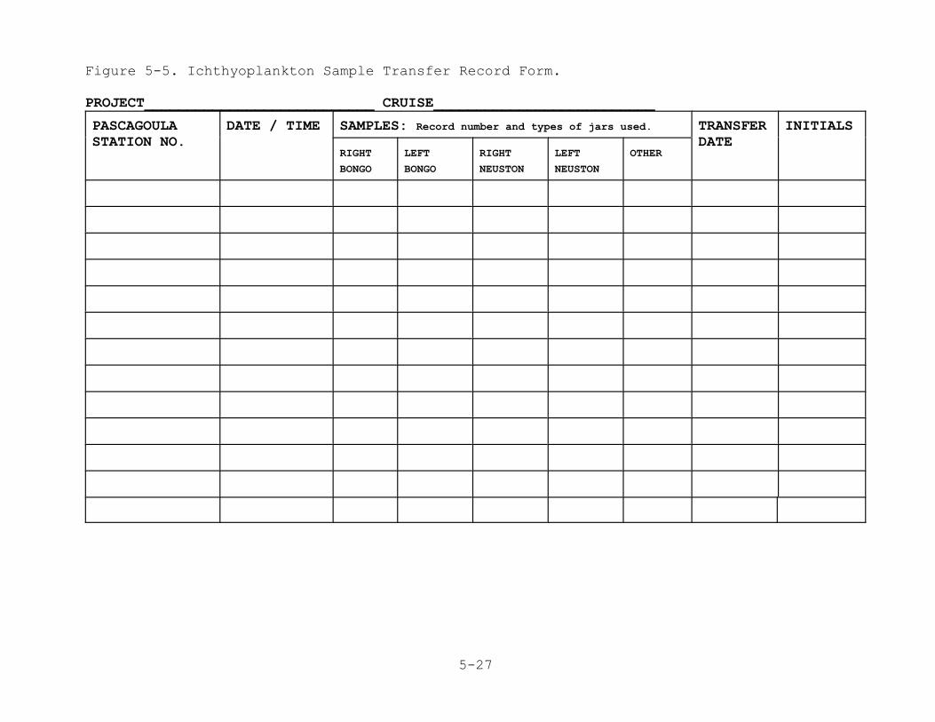
5-27
Figure 5-5. Ichthyoplankton Sample Transfer Record Form.
PROJECT___________________________ CRUISE__________________________
PASCAGOULASTATION NO.
DATE / TIME SAMPLES: Record number and types of jars used. TRANSFERDATE
INITIALS
RIGHT
BONGO
LEFT
BONGO
RIGHT
NEUSTON
LEFT
NEUSTON
OTHER
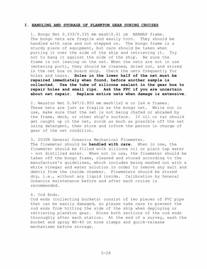
5-28
I. HANDLING AND STORAGE OF PLANKTON GEAR DURING CRUISES
1. Bongo Net 0.333/0.335 mm mesh\0.61 cm MARMAP frame.The bongo nets are fragile and easily torn. They should behandled with care and not stepped on. The bongo frame is asturdy piece of equipment, but care should be taken whenputting it over the side of the ship and retrieving it. Trynot to bang it against the side of the ship. Be sure theframe is not leaning on the net. When the nets are not in use(entering port), they should be cleaned, dried out, and storedin the net box on board ship. Check the nets frequently forholes and tears. Holes in the lower half of the net must berepaired immediately when found, before another sample iscollected. Use the tube of silicone sealant in the gear box torepair holes and small rips. Ask the FPC if you are uncertainabout net repair. Replace entire nets when damage is extensive.
2. Neuston Net 0.947/0.950 mm mesh\1x2 m or 1x4 m frames.These nets are just as fragile as the bongo net. While not inuse, make sure that the net is not being chafed or abraded bythe frame, deck, or other ship’s surface. If oil or tar shouldget caught up in the net, scrub as much as possible off the netusing detergent, then store and inform the person in charge ofgear of the net condition.
3. 2030R General Oceanics Mechanical Flowmeter. The flowmeter should be handled with care. When in use, theflowmeter should be filled with silicone oil or plain tap water- not distilled water. When not in use, the flowmeter should betaken off the bongo frame, cleaned and stored according to themanufacture's guidelines, which includes being washed out with awhite vinegar and water solution in order to remove any salt anddebris from the inside chamber. Flowmeters should be storeddry, i.e., without any liquid inside. Calibration by GeneralOceanics maintenance before and after each cruise isrecommended.
4. Cod Ends.Cod ends (collecting buckets) consist of two pieces of PVC pipethat can be easily damaged, so please take care to prevent thecod ends from hitting the side of the ship when deploying orretrieving plankton gear. Rinse both sections of the cod endsthoroughly after each station. At the end of a survey, wash thebucket and spray WD-40 on hose clamps and quick-releasemechanisms before storage.
5-29
J. DISPOSITION OF SAMPLES
After each survey, give the samples, Ichthyoplankton SampleTransfer Record sheets, Flowmeter Performance Tracking sheets, andthe Ichthyoplankton station sheets to an Ichthyoplankton TeamMember. When the samples are in the ichthyoplankton laboratory,count the boxes, inventory the samples, request, receive andassign SEAMAP sample numbers from NMFS Pascagoula and store in acool place before transport. The right bongo and neuston samplesshould be boxed and sent to the Pascagoula Laboratory, which hasthe responsibility for preparation of samples for shipment to thePolish Sorting and Identification Center. The current (January2001) contact is Alonzo N. Hamilton, Jr., National MarineFisheries Service, 3209 Frederic Street, P O 1207, Pascagoula, MS 39568-1207; e-mail: [email protected]. Contact Mr.Hamilton (228-762-4591 ext. 279) to inform him of what you aresending and when they should arrive. At the same time you sendthe samples, please also send the original Ichthyoplankton sheets(keep copies) and copies of all other SEAMAP field data sheets(Type I or II and the environmental). Left bongo samples shouldbe sent to Sara LeCroy, USM/Gulf Coast Research Laboratory, P OBox 7000, 703 East Beach Drive, Ocean Springs, MS 39564; e-mail:[email protected] (Current as of Jan. 2001). Contact Ms.LeCroy (228-872-4238) to inform her of what you are sending andwhen it should arrive.

5-30
K. NOTES

5-31

A-1
VI. APPENDICES
A-2
Appendix 1. VESSEL CODES
01---OREGON02---SILVER BAY03---GEORGE M. BOWERS04---OREGON II05---COMBAT06---PELICAN07---FRIGATA08---KINGFISHER09---HERNAN CORTEZ10---GERONIMO11---UNDAUNTED12---ANTILLAS13---CALAMAR14---ALCYON15---GULF RANGER16---WESTERN GULF17---TOMMY MUNRO18---TANYA & JOE19---ONJUNKU20---JEFF & TINA21---DELAWARE II22---OSV ANTELOPE23---ALABAMA INSHORE VESSELS24---FLORENCE MAY25---LOUISIANA INSHORE VESSELS26---SUNCOASTER27---MISSISSIPPI INSHORE
VESSELS28---CHAPMAN29---NISSIHINO MARU #201
30---R/V BELLOWS31---R.J. KEMP (ARANSAS BAY)32---MATAGORDA BAY33---LAGUNA MADRE34---GALVESTON BAY35---LUMCON PELICAN36---HERNAN CORTEZ II (CORAL
SEA)37---OLD COLONY38---SEAWOLF39---ATLANTIC HARVESTER40---SABINE41---PERSISTANCE42---CAPTAIN GRUMPY43---GULF STREAM44---KELCY ANN45---MR. JUG46---CALANUS47---A. NEEDLER48---B.I.P.49---ALBATROSS IV50---MOLLY M.51---LADY LISA52---MISS CARRIE53---CSS HUDSON63---GORDON GUNTER64---FERREL65---TRINITY BAY67---NUECES99---OTHER VESSELS
A-3
Appendix 2. Time Zone Codes, Beaufort Sea Condition Table, andData Source Codes.
2.A. Time Zone Codes
1---Eastern Standard Time2---Eastern Daylight Savings Time3---Central Standard Time4---Central Daylight Savings Time8---Greenwich Mean Time9---Other - Explain in Comment Section
2.B. Beaufort Sea Condition Table
Beaufort Sea DescriptionCondition0-----------Wind speed under 1 knot, sea like a mirror.1-----------Wind speed 1-3 knots; small ripples on surface
with the appearance of scales.2-----------Wind speed 4-6 knots; small wavelets with glassy
appearance.3-----------Wind speed 7-10 knots; large wavelets; crests
begin to break; scattered whitecaps.4-----------Wind speed 11-16 knots; small waves becoming
longer; numerous whitecaps.5-----------Wind speed 17-21 knots; moderate waves taking
longer to form; many whitecaps; some spray.6-----------Wind speed 22-27 knots; larger waves forming;
whitecaps everywhere; more spray.7-----------Wind speed 28-33 knots; sea heaps up; white foam
from breaking waves begins to be blown in streaks.8-----------Wind speed 34-40 knots; moderately high waves of
greater length; edges of crests begin to breakinto spin-drift; foam is blown in well marked
streaks.9-----------Wind speed 41-47 knots; high waves; sea begins to
roll; dense streaks of foam; spray may reduce visibility.
2.C. Data Source Codes
NC-- North Carolina MS-- MississippiSC-- South Carolina LA-- LouisianaGA-- Georgia TX-- TexasFL-- Florida US-- National Marine FisheriesAL-- Alabama Service
99-- Other
Appendix 3. Gear Codes and Examples on Use.
CODE GEAR TYPE CODE GEAR TYPE
A-4
*T TRAWL, STAR01 COMBINATION--SS+CC02 COMBINATION--SS+PR03 COMBINATION--CC+PR04 COMBINATION--SS+CC+PR05 COMBINATION--FM+SS06 COMBINATION--FM+SS+PR07 COMBINATION--FM+PR A ASSORTEDAC BIOSONICS ACOUSTIC SYSTEMBB TRAWL, BIBBC BOTTLE CASTBG BATHYTHERMOGRAPH (CTD, STD)BL LONGLINE , BOTTOMBS SEINE, BEACHBT TRAWL, BEAMCA CHLOROPHYLL, EXTRACTIONCC CAMERA, CLOSED CIRCUIT
TELEVISIONCD DREDGE, CLAMCM CURRENT DOPPLERCR CORAL REEF MODUALCS CONTINUOUS FLOW SYSTEMCT TRAP, CRABDL DEEP LINEDN PLANKTON, DOUBLE NEUSTON OR
NEKTONDR SURFACE DRIFTERDV DIVINGEF TRAWL, FISH, EXPERIMENTALES TRAWL, SHRIMP, EXPERIMENTALFD TRAWL, FISH DEFLECTORFE TRAWL, FISH EXCLUDERFL FLUORESCENCE, CONTINUOUS FLOW
SYSTEMFM FATHOMETERFP FISH PUMPFT TRAWL, FISHFX FLUORESCENCE, IN SITUGN GILL NETGR BOTTOM GRAB OR CORE SAMPLERHL HANDLINEHO TRAWL, HIGH OPENING BOTTOMIT TRAP, ICHTHYOPLANKTON,
ILLUMINATEDJP JACKPOLEKP LONGLINE, KALI POLEKT TRAWL, WINGLL LONGLINE, SURFACELN LIFT NETLP SEINE, LAMPARALR TRAP, LOBSTER, REEDLT NIGHT LIGHTLW TRAP, LOBSTER, WIREMC CAMERA, MOVIEML MISCELLANEOUS- DETAIL IN
COMMENTSMN MICROPEKTON
MO PLANKTON, MOCNESSMQ MARQUESETTEMS TRANSMISSIVITYMT TRAWL, MIDWATERNN PLANKTON, SINGLE NEUSTON OR NEKTONNS NETSONDEOB LONGLINE, OFF-BOTTOMOD ODOMETEROF OVERFLIGHTOH OXYGEN, TITRATION, HACH KITOI OXYGEN, SENSOR, IN SITUOO OXYGEN, SENSOR, ON DECKOR OYSTER RAKEOW OXYGEN, TITRATION, WINKLEROX OXYGEN, SENSOR, CTDOY OXYGEN, SENSOR, YSIPN PLANKTON, GENERAL (BONGO, ETC.)PR PROFILER, 3.5 KHZ SUB-BOTTOMPS SEINE, PURSEPT TRAWL, SCALLOPQD DREDGE, QUAHOGRE SALINITY, REFRACTOMETERRF RECORDING FATHOMETERRG PLANKTON, RING NETRL TAG RELEASERN ROUND NETRR ROD AND REELRS TRAWL, NON-STANDARDRT ROTENONERV REMOTELY OPERATED VEHICLE (ROV)S5 TRAWL, MONGOOSES6 TRAWL MONGOOSESA SALINITY, AUTOSALSB SALINITY, BECKMAN RS5SC CAMERA, STILLSD DREDGE, SCALLOPSE SECCHI DISCSF SALINITY, CONTINUOUS FLOW SYSTEMSH TRAWL, SHUMANSI SALINITY, SENSOR, IN SITUSL SALINITY, BENCH TOP/LABORATORYSJ SQUID JIGSM TRAWL, STANDARD MONGOOSESN TRAWL, SEPARATORSO SONARSS SONAR, SIDE SCANST TRAWL, SHRIMPSX SALINITY, CTDSY SALINITY,YSIT3 TEMPERATURE SCSTA TEMPERATURE, CONTINUOUS FLOW SYSTEMTB TEMPERATURE, BECKMAN RS5TC TEMPERATURE, CTDTD DREDGE, TUMBLERTE TRAWL, TURTLE EXCLUDERTF TEMPERATURE, FLUKETG TROLLING GEARTH TEMPERATURE, THERMOMETER

Appendix 3. Gear Codes and Examples on Use, Continued...
CODE GEAR TYPE
A-5
TI TEMPERATURE, SENSOR, IN SITUTM TEMPERATURE, BUCKETTN TRAWL, TRY NETTO TEMPERATURE, SENSOR, ON DECKTR TRAP, FISHTS SEINE, PURSE, TURTLETT TRAWL, TWINTU PLANKTON, TUCKER TRAWLTV TRAP VIDEOTY TEMPERATURE, YSI UD DREDGE, UNSPECIFIEDVC CAMERA, VIDEOVD VERTICAL DRIFTLINEVJ VISUAL OBSERVATIONVP VERTICAL PROFILEWI WEATHER INSTRUMENTWT TRAP, LOBSTER, WOODXB EXPENDABLE BATHYTHERMOGRAPH (XBT)
SEAMAP Examples of Gear Code Use
For Chlorophyll- Sample obtained from bottle cast for extractionBC, CA
For Salinity- Reading obtained by CTD: BG, SI
Sample obtained from bottle cast for AUTOSAL analysis BC, SL
For- Oxygen reading obtained by CTD: BG, OI
Sample obtained from bottle cast for titration by the Winkler method BC, OW
For Temperature- Reading obtained by CTD: BG, TI
Scenario Example-
Procedures at a SEAMAP station included a CTD profile, a Secchidisc reading, a bottle cast for water samples, a sediment grab,and a trawl.
BG, BC, TI, SI, SE, OI, CA, GR, and ST
There are only seven spaces on the data sheet to enter the ninelisted gear types used. Record in the Comment section theadditional two gear types used.

A-6
Appendix 4. Operation Codes.
A = Net not spreadB = Gear boggedC = Bag chokedD = Gear not diggingE = Twisted warp or lineF = Gear fouledG = Bag untiedH = Hooks or traps lostI = Fish not attractedK = Bad weather stopped operationL = Lost whole rigM = Miscellaneous (detail in comments)N = Shark damageO = Gear off bottomP = Vessel off positionT = Torn webbingU = UnknownW = Water haulX = Lost fishZ = Hangup
A-7
Appendix 5. Water Color Codes, Bottom Type, Bottom Regularity,and Precipitation codes.
Appendix 5-A.Water Color Codes
Record as follows:
Blue or clear = BGreen = GBlue green = TYellow = YMuddy or brown = M
Appendix 5-B. Bottom Type
Record as follows:
Boulders = BDMarl = MLClay = CLOoze = OZCoral = CORock = RKGravel = GSand = SGrass = GRShell = SHMud = MSponge = SPMud & Sand = MSMud & Clay = MC
Appendix 5-C.Bottom Regularity
Record as follows:
Smooth = SSteep = PSlight = LIrregular = EModerate = OLump = M
Appendix 5-D.Precipitation Codes0 None1 Light Rain2 Moderate Rain3 Heavy Rain4 Snow5 Sleet6 Sleet/Rain7 Hail
There has been some question about the meanings of theprecipitation codes. This is an attempt to provide somestandardization to the meanings.
Light rain would be a rate of precipitation such that most peoplewouldn't hesitate to step out into it for a couple of minutes orto go from one location to another without protection.
In a moderate rain you would want at least as much protection aswould be provided by an umbrella. You would be very wet if youwere out without protection for two minutes.
. . . . . .A heavy rain is when you don't want to go out into it at all andyou would be soaked to the skin instantly without protection.
Appendix 6. Alphabetic List of Species Length Frequency Measurement Codes.
A-8
GENUS SPECIES MC FMB BIOCODE
ABLENNEHIANS 1 368 147010101
ABRALIAREDFIE 13 348030203
ABRALIAVERANY 13 348030204
ABUDEFDSAXATI 1 170270101
ACANTHEARMATA 3 228290102
ACANTHOALEXAN 5 229260301
ACETES AMERIC 3 228020105
ACHIRUSLINEAT 18 196 183040105
AEQUIPEGLYPTU 12 352 330231101
AEQUIPEMUSCOS 12 330231106
AETOBATNARINA 22 110070101
AGRIOPOTEXASI 11 335641601
ALBUNEAPARETI 6 229310102
ALECTISCILIAR 1 214 170110101
ALLOTHYMEXICA 25 694040301
ALOSA ALABAM 1 121050101
ALOSA CHRYSO 1 121050106
ALOSA SAPIDI 1 121050105
ALPHEUSFORMOS 3 228150102
ALUTERUHEUDEL 18 290 189040401
ALUTERUMONOCE 18 230 189040402
ALUTERUSCHOEP 18 150 189040403
ALUTERUSCRIPT 18 250 189040404
AMUSIUMDALLI 12 330234401
AMUSIUMPAPYRA 12 49 330234402
ANACANTLONGIR 22 377 110100202
ANADARABAUGHM 11 175 328043602
ANADARABRASIL 11 336 328043601
ANADARALIENOS 11 328043604
ANADARAOVALIS 11 338 328043607
ANADARATRANSV 11 328043608
ANASIMULATUS 6 103 229210601
ANCHOA CUBANA 1 253 121060104
ANCHOA HEPSET 1 32 121060101
ANCHOA LAMPRO 1 317 121060102
ANCHOA LYOLEP 1 136 121060105
ANCHOA MITCHI 1 76 121060103
ANCHOA NASUTA 1 244 121060106
ANCHOVIPERFAS 1 152 121060302
ANCYLOPDILECT 18 80 183012102
GENUS SPECIES MC FMB BIOCODE
ANCYLOPQUADRO 18 85 183012105
ANOMIA SIMPLE 12 330390102
ANTENNAOCELLA 18 195020101
ANTENNARADIOS 18 115 195020102
ANTENNASTRIAT 18 236 195020103
ANTHENOPEIRCE 15 691060501
ANTIGONCAPROS 1 162030101
ANTIGONCOMBAT 1 162030102
APHRODIOBTECT 25 649030101
APLATOPCHAULI 18 365 143150601
APLYSIAWILLCO 17 316020104
APOGON AFFINI 1 170060204
APOGON AUROLI 1 268 170060201
APOGON MACULA 1 170060203
APOGON PSEUDO 1 248 170060207
ARBACIAPUNCTU 14 693050101
ARCHITENOBILI 24 343 307310102
ARCHOSAPROBAT 1 170213601
ARCINELCORNUT 12 334020402
ARENAEUCRIBRA 5 140 229110101
ARGENTISTRIAT 1 121110101
ARGONAUARGO 24 350110101
ARGOPECGIBBUS 12 199 330231201
ARIOMMABONDI 1 221 170530101
ARIOMMAMELANU 1 420 170530102
ARIOMMAREGULU 1 406 170530104
ARIUS FELIS 1 40 141020101
ASTARTEGLOBUL 12 335260104
ASTEROPANNULA 14 329 692050202
ASTRAPOALUTUS 1 170060101
ASTRAEAPHOEBI 24 306110104
ASTROCYCAECIL 14 692050501
ASTROGOCACAOT 14 692050401
ASTROPEALLIGA 15 691010109
ASTROPEAMERIC 15 179 691010101
ASTROPEANTILL 15 691010108
ASTROPEARTICU 15 691010102
ASTROPECINGUL 15 422 691010106
ASTROPEDUPLIC 15 148 691010105
ASTROPHMURICA 14 692050301
ASTROSCY-GRAE 18 210 170340102

Appendix 6. Alphabetic List of Species Length Frequency Measurement Codes. Continued...
A-9
GENUS SPECIES MC FMB BIOCODE
ATRINA SEMINU 11 339 329020103
ATRINA SERRAT 11 329020102
AULOSTOMACULA 2 151010101
AURELIAAURITA 16 616010201
AXIANASARENAR 8 229180101
BAGRE MARINU 1 120 141020401
BAIRDIECHRYSO 18 186 170200502
BALANUSTRIGON 20 213010101
BALISTECAPRIS 1 44 189030502
BARBATICANCEL 11 337 328040702
BARBATICANDID 11 328040701
BARNEA TRUNCA 11 337010102
BATHYANMEXICA 1 151 170023102
BELLATOBRACHY 18 168020801
BELLATOEGRETT 18 168020802
BELLATOMILITA 18 94 168020803
BEMBROPANATIR 18 170320201
BEMBROPGOBIOI 18 241 170320202
BENTHODTENUIS 1 170460503
BOLLMANCOMMUN 18 90 170554301
BOTHUS LUNATU 18 183012202
BOTHUS OCELLA 18 381 183012203
BOTHUS ROBINS 18 291 183012204
BRACHIDEXUSTU 11 329011202
BREGMACATLANT 18 122 148030101
BREVOORGUNTER 1 310 121050301
BREVOORPATRON 1 64 121050302
BREVOORSMITHI 1 121050303
BRISSOPATLANT 14 693110102
BROSMICIMBERB 18 148020301
BROTULABARBAT 18 70 170390301
BUSYCONCANDEL 17 308070109
BUSYCONCOARCT 17 308070104
BUSYCONCONTRA 17 283 308070103
BUSYCONPERVER 17 308070105
BUSYCONPULLEY 17 308070113
BUSYCONSPIRAT 17 335 308070107
CAELORICARIBB 18 148061201
CALAMUSARCTIF 1 411 170210601
CALAMUSBAJONA 1 170210602
CALAMUSCALAMU 1 256 170210603
GENUS SPECIES MC FMB BIOCODE
CALAMUSLEUCOS 1 201 170210604
CALAMUSNODOSU 1 246 170210608
CALAMUSPENNA 1 260 170210610
CALAPPAFLAMME 5 191 229260102
CALAPPASULCAT 5 52 229260105
CALLIACTRICOL 10 619380301
CALLIANLATISP 3 229040101
CALLINEMARGIN 5 229110205
CALLINESAPIDU 5 57 229110203
CALLINESIMILI 5 4 229110206
CALLIONHIMANT 2 170420101
CALOCARHIRSUT 8 229170101
CANCELLRETICU 17 308150101
CANTHARCANCEL 17 308040502
CANTHERMACROC 18 189040101
CANTHIDSUFFLA 1 380 189030402
CANTHIGROSTRA 1 189080101
CARANX BARTHO 1 170110801
CARANX CRYSOS 1 62 170110803
CARANX HIPPOS 1 184 170110804
CARANX LATUS 1 170110805
CARANX RUBER 1 170110807
CARCHARACRONO 18 192 108020201
CARCHARBREVIP 18 305 108020207
CARCHARFALCIF 18 301 108020202
CARCHARISODON 18 108020215
CARCHARLEUCAS 18 108020204
CARCHARLIMBAT 18 234 108020205
CARCHAROBSCUR 18 108020209
CARCHARPLUMBE 18 108020208
CARCHARPOROSU 18 108020210
CARDITAFLORID 12 349 335200202
CARETTACARETT 21 325 531070201
CAULOLACYANOP 18 170070101
CAULOLAINTERM 18 89 170070102
CAULOLAMICROP 18 269 170070103
CENTROPOCYURA 2 111 170024804
CENTROPPHILAD 2 6 170024805
CENTROSLONGIS 14 693010201
CHAETODAYA 2 298 170260301
CHAETODCAPIST 2 170260302
Appendix 6. Alphabetic List of Species Length Frequency Measurement Codes. Continued...
A-10
GENUS SPECIES MC FMB BIOCODE
CHAETODFABER 2 50 170250101
CHAETODOCELLA 2 419 170260307
CHAETODSEDENT 2 170260309
CHAMA CONGRE 12 334020201
CHASCANLUGUBR 18 331 183010201
CHICOREFLORIF 17 308012701
CHILOMYATINGA 18 319 189090202
CHILOMYSCHOEP 18 153 189090203
CHIONE CLENCH 11 300 335643609
CHIONE LATILI 11 335643605
CHIROPSQUADRU 16 618050101
CHLAMYSBENEDI 12 330231601
CHLOEIAVIRIDI 25 347 649110101
CHLOROSCHRYSU 1 14 170110902
CHROMISENCHRY 1 286 170270302
CHROMISSCOTTI 1 170270303
CHRYSAOQUINQU 16 616010101
CIRCOMPSTRIGI 11 335640201
CIRRHIPLEUTKE 16 619420101
CITHARIARCTIF 18 183010301
CITHARIARENAC 18 183010308
CITHARICORNUT 18 247 183010303
CITHARIMACROP 18 129 183010304
CITHARISPILOP 18 61 183010305
CLYPEASPROSTR 14 424 693100103
CLYPEASRAVENE 14 373 693100104
COELOCESPINOS 6 394 229211301
COLLODELEPTOC 6 229210801
COLLODEROBUST 6 229210803
COMACTIMERIDI 20 690020101
CONGER OCEANI 18 281 143130501
CONGER TRIPOR 18 143130502
CONODONNOBILI 1 416 170190601
CONUS AUSTIN 17 274 308190101
CONUS CLARKI 17 308190110
CONUS STIMPS 17 308190135
COOKEOLBOOPS 1 170050301
CORNIGESPINOS 1 161110701
CORYPHAHIPPUR 1 170130202
CRASSOSVIRGIN 12 330410101
CREPIDUCONVEX 17 307640302
GENUS SPECIES MC FMB BIOCODE
CRUCIBUAURICU 17 307640201
CYCLOPSCHITTE 18 45 183010401
CYCLOPSFIMBRI 18 226 183010403
CYMATIUPARTHE 17 307780119
CYMATIUPILEAR 17 307780109
CYNOSCIARENAR 18 8 170200901
CYNOSCINEBULO 18 170200903
CYNOSCINOTHUS 18 25 170200904
CYPSELUCYANOP 1 147040703
CYPSELUEXSILI 1 370 147040704
CYPSELUFURCAT 1 147040705
CYPSELUHETERU 1 147040706
DACTYLOQUINQU 16 618030101
DACTYLOVOLITA 18 179010301
DANIELUIXBAUC 5 229102601
DARDANUFUCOSU 6 229450102
DARDANUINSIGN 6 425 229450101
DASYATIAMERIC 22 190 110050201
DASYATICENTRO 22 110050202
DASYATISABINA 22 235 110050204
DASYATISAY 22 273 110050205
DECAPTEMACARE 1 415 170111201
DECAPTEPUNCTA 1 104 170111202
DECAPTETABL 1 170111203
DECODONPUELLA 2 144 170283001
DIAPHUSSPLEND 18 131010219
DIBRANCATLANT 18 195050301
DICROLEINTRON 18 170390701
DINOCARROBUST 11 350 335291001
DIODON HYSTRI 18 384 189090302
DIOPATRCUPREA 25 649090101
DIPLECTBIVITT 2 15 170020905
DIPLECTFORMOS 2 96 170020903
DIPLOGRPAUCIR 18 404 170420401
DISTAPLBERMUD 596050201
DISTORSCLATHR 17 334 307780401
DOROSOMPETENE 1 372 121051202
DROMIDIANTILL 5 229250301
DRYMONEDALMAT 16 618020201
DYSOMMAAPHODO 18 143170101
DYSPANOTEXANA 5 229030102
Appendix 6. Alphabetic List of Species Length Frequency Measurement Codes. Continued...
A-11
GENUS SPECIES MC FMB BIOCODE
ECHENEINAUCRA 18 145 170090101
ECHENEINEUCRA 18 170090102
ECHINASSERPEN 15 691030104
ECHIOPHINTERT 18 263 143150302
ECHIOPHMORDAX 18 366 143150301
ECHIOPHPUNCTI 18 143150303
ELOPS SAURUS 1 378 124010101
ENCOPE ABERRA 14 693030303
ENCOPE MICHEL 14 693030302
ENGRAULEURYST 1 131 121060201
ENGYOPHSENTA 18 97 183011401
EPIGONUPANDIO 18 170760101
EPINEPHADSCEN 1 170021203
EPINEPHFLAVOL 1 181 170021206
EPINEPHGUTTAT 1 356 170021208
EPINEPHMORIO 1 170021211
EPINEPHNIGRIT 1 359 170021202
EPINEPHNIVEAT 1 170021201
EPINNULMAGIST 1 170450102
EPINNULORIENT 1 405 170450103
EQUETUSACUMIN 18 142 170201103
EQUETUSIWAMOT 18 183 170201108
EQUETUSLANCEO 18 417 170201104
EQUETUSPULCHE 18 170201101
EQUETUSPUNCTA 18 170201107
EQUETUSUMBROS 18 107 170201105
EROTELISMARAG 1 170541201
ETELIS OCULAT 1 170150501
ETHUSA MICROP 6 340 229370301
ETROPUSCROSSO 18 38 183010602
ETROPUSCYCLOS 18 137 183010607
ETROPUSINTERM 18 259 183010603
ETROPUSMICROS 18 188 183010605
ETROPUSRIMOSU 18 164 183010606
ETRUMEUTERES 1 77 121051602
EUCIDARTRIBUL 14 693060201
EUCINOSARGENT 1 282 170180301
EUCINOSGULA 1 41 170180303
EUCRASSSPECIO 12 335270501
EULEPTOVELOX 1 147040401
EUPHROSCLAUSA 5 229381201
GENUS SPECIES MC FMB BIOCODE
EURYPANDEPRES 5 229030301
EUTHYNNALLETT 1 314 170440201
EXHIPPOOPLOPH 3 228170201
EXOCOETOBTUSI 1 147040301
FASCIOLHUNTER 17 308100101
FASCIOLLILIUM 17 308100107
FASCIOLTULIPA 17 308100103
FICUS COMMUN 17 307810104
FISTULAPETIMB 2 361 151020101
FISTULATABACA 2 328 151020102
FOETOREAGASSI 2 170420501
FUSINUSCOUEI 17 308100301
GALATHEROSTRA 8 229190201
GALEOCECUVIER 18 108022201
GASTROPFRONTA 18 183011501
GERRES CINERE 1 170180601
GINGLYMCIRRAT 18 320 113010101
GLYCERAABRANC 25 649050101
GNATHAGEGREGI 18 170340901
GOBIOIDBROUSS 18 407 170550301
GOBIONEBOLEOS 18 170552304
GOBIONEHASTAT 18 267 170552303
GOBIONEOCEANI 18 170552301
GOBIONESMARAG 18 170552309
GOBIONESTIGMA 18 170552302
GOBIOSOOCEANO 18 170550208
GONEPLAHIRSUT 5 229380302
GONIASTTESSEL 15 691060103
GUNTERILONGIP 18 171010601
GYMNACHMELAS 18 198 183040802
GYMNACHNUDUS 18 183040803
GYMNACHTEXAE 18 95 183040804
GYMNOTHFUNEBR 18 143060201
GYMNOTHKOLPOS 18 233 143060209
GYMNOTHMORING 18 143060202
GYMNOTHNIGROM 18 127 143060203
GYMNOTHOCELLA 18 258 143060204
GYMNOTHSAXICO 18 146 143060205
GYMNOTHVICINU 18 143060206
GYMNURAALTAVE 22 110050401
GYMNURAMICRUR 22 110050402
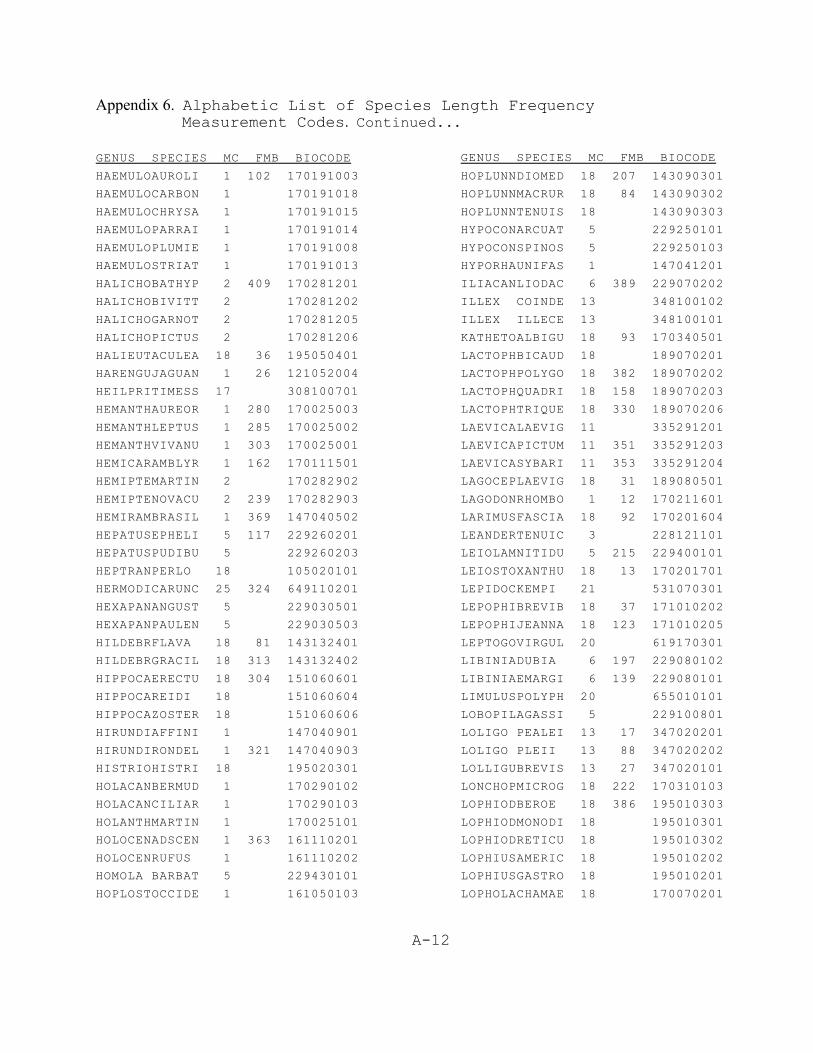
Appendix 6. Alphabetic List of Species Length Frequency Measurement Codes. Continued...
A-12
GENUS SPECIES MC FMB BIOCODE
HAEMULOAUROLI 1 102 170191003
HAEMULOCARBON 1 170191018
HAEMULOCHRYSA 1 170191015
HAEMULOPARRAI 1 170191014
HAEMULOPLUMIE 1 170191008
HAEMULOSTRIAT 1 170191013
HALICHOBATHYP 2 409 170281201
HALICHOBIVITT 2 170281202
HALICHOGARNOT 2 170281205
HALICHOPICTUS 2 170281206
HALIEUTACULEA 18 36 195050401
HARENGUJAGUAN 1 26 121052004
HEILPRITIMESS 17 308100701
HEMANTHAUREOR 1 280 170025003
HEMANTHLEPTUS 1 285 170025002
HEMANTHVIVANU 1 303 170025001
HEMICARAMBLYR 1 162 170111501
HEMIPTEMARTIN 2 170282902
HEMIPTENOVACU 2 239 170282903
HEMIRAMBRASIL 1 369 147040502
HEPATUSEPHELI 5 117 229260201
HEPATUSPUDIBU 5 229260203
HEPTRANPERLO 18 105020101
HERMODICARUNC 25 324 649110201
HEXAPANANGUST 5 229030501
HEXAPANPAULEN 5 229030503
HILDEBRFLAVA 18 81 143132401
HILDEBRGRACIL 18 313 143132402
HIPPOCAERECTU 18 304 151060601
HIPPOCAREIDI 18 151060604
HIPPOCAZOSTER 18 151060606
HIRUNDIAFFINI 1 147040901
HIRUNDIRONDEL 1 321 147040903
HISTRIOHISTRI 18 195020301
HOLACANBERMUD 1 170290102
HOLACANCILIAR 1 170290103
HOLANTHMARTIN 1 170025101
HOLOCENADSCEN 1 363 161110201
HOLOCENRUFUS 1 161110202
HOMOLA BARBAT 5 229430101
HOPLOSTOCCIDE 1 161050103
GENUS SPECIES MC FMB BIOCODE
HOPLUNNDIOMED 18 207 143090301
HOPLUNNMACRUR 18 84 143090302
HOPLUNNTENUIS 18 143090303
HYPOCONARCUAT 5 229250101
HYPOCONSPINOS 5 229250103
HYPORHAUNIFAS 1 147041201
ILIACANLIODAC 6 389 229070202
ILLEX COINDE 13 348100102
ILLEX ILLECE 13 348100101
KATHETOALBIGU 18 93 170340501
LACTOPHBICAUD 18 189070201
LACTOPHPOLYGO 18 382 189070202
LACTOPHQUADRI 18 158 189070203
LACTOPHTRIQUE 18 330 189070206
LAEVICALAEVIG 11 335291201
LAEVICAPICTUM 11 351 335291203
LAEVICASYBARI 11 353 335291204
LAGOCEPLAEVIG 18 31 189080501
LAGODONRHOMBO 1 12 170211601
LARIMUSFASCIA 18 92 170201604
LEANDERTENUIC 3 228121101
LEIOLAMNITIDU 5 215 229400101
LEIOSTOXANTHU 18 13 170201701
LEPIDOCKEMPI 21 531070301
LEPOPHIBREVIB 18 37 171010202
LEPOPHIJEANNA 18 123 171010205
LEPTOGOVIRGUL 20 619170301
LIBINIADUBIA 6 197 229080102
LIBINIAEMARGI 6 139 229080101
LIMULUSPOLYPH 20 655010101
LOBOPILAGASSI 5 229100801
LOLIGO PEALEI 13 17 347020201
LOLIGO PLEII 13 88 347020202
LOLLIGUBREVIS 13 27 347020101
LONCHOPMICROG 18 222 170310103
LOPHIODBEROE 18 386 195010303
LOPHIODMONODI 18 195010301
LOPHIODRETICU 18 195010302
LOPHIUSAMERIC 18 195010202
LOPHIUSGASTRO 18 195010201
LOPHOLACHAMAE 18 170070201
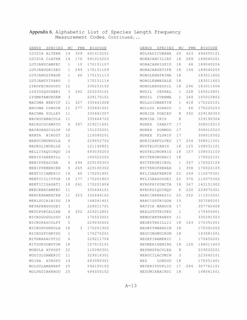
Appendix 6. Alphabetic List of Species Length Frequency Measurement Codes. Continued...
A-13
GENUS SPECIES MC FMB BIOCODE
LUIDIA ALTERN 14 309 691010201
LUIDIA CLATHR 14 176 691010203
LUTJANUCAMPEC 1 10 170151107
LUTJANUGRISEU 1 299 170151109
LUTJANUSYNAGR 1 46 170151113
LUTJANUVIVANU 1 170151114
LYROPECNODOSU 12 330233102
LYSIOSQSCABRI 3 242 225030101
LYSMATAWURDEM 3 228170101
MACOMA BREVIF 11 327 335441008
MACOMA CONSTR 11 277 335441001
MACOMA PULLEY 11 335441007
MACROCAMACULA 11 335644702
MACROCOCAMPTO 6 397 229211601
MACRORHSCOLOP 18 151030201
MANTA BIROST 22 110080201
MANUCOMUNGULA 6 229052702
MAUROLIMUELLE 1 121140801
MELLITAQUINQU 14 693030203
MENIDIABERYLL 1 165022202
MENIPPEADINA 5 294 229100303
MENIPPEMERCEN 5 265 229100302
MENTICIAMERIC 18 60 170201801
MENTICILITTOR 18 177 170201803
MENTICISAXATI 18 261 170201806
MERCENACAMPEC 11 335644101
MERCENAMERCEN 11 323 335644102
MERLUCCALBIDU 18 148041401
METAPENGOODEI 3 228011701
METOPORCALCAR 6 302 229212801
MICROGOGULOSU 18 170553001
MICROPASCULPT 5 229030602
MICROPOUNDULA 18 3 170201902
MICROSPCHRYSU 1 170270201
MITHRAXACUTIC 6 229211706
MITSUKUOWSTON 18 107010101
MOBULA HYPOST 22 110080301
MODIOLUAMERIC 11 329014301
MOIRA ATROPU 14 693080301
MOLGULAMANHAT 25 596100102
MOLPADIBARBOU 25 694050102
GENUS SPECIES MC FMB BIOCODE
MOLPADICUBANA 20 423 694050101
MONACANCILIAT 18 289 189040201
MONACANHISPID 18 68 189040204
MONACANSETIFE 18 194 189040205
MONOLENATRIMA 18 183011602
MONOLENMEGALE 18 183011603
MONOLENSESSIL 18 296 183011604
MUGIL CEPHAL 1 228 165010801
MUGIL CUREMA 1 364 165010802
MULLOIDMARTIN 1 418 170220101
MULLUS AURATU 1 66 170220203
MUNIDA FORCEP 8 392 229190303
MUNIDA IRIS 8 229190304
MUREX CABRIT 17 308010513
MUREX DONMOO 17 308010523
MUREX FLORIF 17 308010502
MURICANFULVES 17 254 308011501
MUSTELUCANIS 18 125 108031101
MUSTELUNORRIS 18 157 108031103
MYCTEROBONACI 18 170022101
MYCTEROMICROL 1 357 170022104
MYCTEROPHENAX 1 358 170022105
MYLIOBAFREMIN 22 249 110070301
MYLIOBAGOODEI 22 376 110070302
MYROPHIPUNCTA 18 367 143151902
MYROPSIQUINQU 6 220 229070301
NARCINEBRASIL 22 252 111010201
NARCISSTRIGON 15 307080201
NATICA MAROCH 17 307760408
NEALOTUTRIPES 1 170450401
NEMOCARTRANSV 11 335291503
NEOBYTHGILLII 18 163 170391001
NEOBYTHMARGIN 18 170391002
NEOCONGMUCRON 18 143081601
NEOEPINAMERIC 1 170450201
NEOMERIHEMING 18 126 168011403
NEPHROPACULEA 8 229020201
NEROCILACUMIN 3 223040101
NES LONGUS 18 170551401
NEVERITDUPLIC 17 264 307761101
NEZUMIABAIRDI 18 148061501

Appendix 6. Alphabetic List of Species Length Frequency Measurement Codes. Continued...
A-14
GENUS SPECIES MC FMB BIOCODE
NIBILIAANTILO 6 395 229211401
NOMEUS GRONOV 1 170510301
NOTOMASLOBATU 25 650120101
OCTOPUSBRIARE 13 350020101
OCTOPUSBURRYI 13 350020102
OCTOPUSMACROP 13 350020105
OCTOPUSVULGAR 13 308 350020106
OCYPODEQUADRA 5 393 229140101
OCYURUSCHRYSU 1 170151501
ODONTASTAURUS 18 107080101
ODONTOSDENTEX 18 297 170202201
OGCOCEPCORNIG 18 225 195050209
OGCOCEPDECLIV 18 110 195050204
OGCOCEPNASUTU 18 387 195050203
OGCOCEPPANTOS 18 169 195050205
OGCOCEPPARVUS 18 287 195050206
OGCOCEPPUMILU 18 257 195050201
OGCOCEPRADIAT 18 237 195050207
OGCOCEPVESPER 18 195050208
OLENCIRPRAEGU 3 223040301
OLIGOPLSAURUS 1 187 170112201
OLIVA SAYANA 17 308110205
OPHICHTGOMESI 18 155 143150401
OPHICHTOPHIS 18 143150405
OPHICHTPUNCTI 18 262 143150402
OPHICHTREX 18 143150407
OPHICHTSPINIC 18 143150406
OPHIDIOGRAYI 18 166 171010302
OPHIDIOHOLBRO 18 138 171010303
OPHIDIOMARGIN 18 403 171010306
OPHIDIOSELENO 18 171010304
OPHIDIOWELSHI 18 91 171010305
OPHIODEBREVIS 14 312 692040101
OPHIODEDEVANE 14 692040102
OPHIOLEELEGAN 14 426 692030101
OPHIONERETICU 14 692100101
OPHIOTHANGULA 14 692110101
OPISTHOOGLINU 1 48 121053002
OPSANUSBETA 18 270 193010601
OPSANUSPARDUS 18 288 193010602
OPSANUSTAU 18 385 193010603
GENUS SPECIES MC FMB BIOCODE
ORNITHOANTILL 13 348100301
ORTHOPRCHRYSO 1 59 170191702
OSTREA EQUEST 12 348 330410302
OTOPHIDDORMIT 18 171010403
OTOPHIDOMOSTI 18 171010402
OVALIPEFLORID 5 204 229110603
OVALIPEOCELLA 5 232 229110602
PAGRUS PAGRUS 1 156 170212302
PAGURISHUMMI 6 229450202
PAGURISLYMANI 6 229450209
PAGURISSERICE 6 229450205
PAGURISTRIANG 6 229450208
PAGURUSBULLIS 6 229050601
PAGURUSIMPRES 6 229050606
PAGURUSPOLLIC 6 229050611
PALICUSALTERN 5 229390102
PALICUSOBESA 5 229390104
PANOPEUBERMUD 5 388 229030402
PANOPEUHERBST 5 229030403
PANULIRARGUS 8 229010301
PARACAUCHILEN 25 694050201
PARACONCAUDIL 18 224 143131502
PARAHOLLINEAT 18 189020301
PARALICALBIGU 18 159 183012401
PARALICDENTAT 18 183012403
PARALICLETHOS 18 58 183012404
PARALICSQUAMI 18 180 183012407
PARANTHFURCIF 10 170022701
PARANTHRAPIFO 10 619090101
PARAPENPOLITU 3 178 228010503
PARASQUCOCCIN 3 391 225020401
PAREXOCBRACHY 1 147040601
PARTHENAGONUS 5 229400201
PARTHENGRANUL 5 342 229400206
PARTHENPOURTA 5 229400203
PARTHENSERRAT 5 227 229400205
PECTEN RAVENE 12 330230703
PECTEN ZICZAC 12 330230705
PENAEUAZTECUS 7 228010701
PENAEUDUORAR 3 78 228010703
PENAEUSETIFER 3 28 228010705
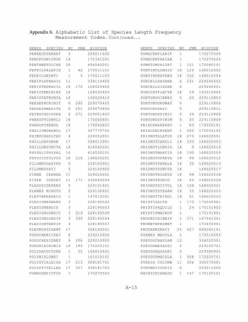
Appendix 6. Alphabetic List of Species Length Frequency Measurement Codes. Continued...
A-15
GENUS SPECIES MC FMB BIOCODE
PENAEOPSERRAT 3 228011602
PENOPUSMICROP 18 170391201
PENTAMEPULCHE 25 694040201
PEPRILUALEPID 1 42 170511101
PEPRILUBURTI 1 5 170511103
PERIPLOFRAGIL 11 338110406
PERISTEGRACIL 18 170 168020402
PERISTEMINIAT 18 168020405
PERISTETRUNCA 18 168020410
PERSEPHCRINIT 6 295 229070405
PERSEPHMEDITE 6 251 229070406
PETROCHDIOGEN 6 271 229051403
PHAEOPTCONKLI 18 170060801
PHAEOPTXENUS 18 170060802
PHALIUMGRANUL 17 307770702
PHIMOCHHOLTHU 6 229052801
PHYLLONPOMUM 17 308012901
PHYLLORPUNCTA 16 618040301
PHYSALIPHYSAL 16 616030101
PHYSICUFULVUS 18 216 148020201
PILUMNUDASYPO 5 229100901
PILUMNUSAYI 5 229100905
PINNA CARNEA 11 329020601
PITAR CORDAT 11 171 335644904
PLAGUSIDEPRES 5 229131401
PLANES MINUTU 5 229130801
PLATYBEARGALU 1 147010201
PLESIONEDWARD 3 228190502
PLESIONENSIS 3 228190503
PLESIONLONGIC 3 219 228190509
PLESIONLONGIP 3 390 228190504
PLESIONTENUIP 3 228190507
PLEUROPGIGANT 17 308100201
PODOCHERIISEI 6 229210904
PODOCHESIDNEY 6 206 229210905
POGONIACROMIS 18 185 170203101
POLYDACOCTONE 1 55 166010401
POLYMIXLOWEI 1 161010101
POLYSTIALBIDA 17 213 308181701
POLYSTITELLEA 17 307 308181702
POMACENPICTUS 1 170270503
GENUS SPECIES MC FMB BIOCODE
POMACENPLANIF 1 170270506
POMACENVARIAB 1 170270504
POMATOMSALTAT 1 121 170080101
PONTINULONGIS 18 124 168010502
PONTINURATHBU 18 332 168010504
PORCELLSAYANA 6 231 229240602
PORCELLSIGSBE 6 229240601
PORICHTPLECTR 18 29 193010806
PORTUNUGIBBES 5 20 229110803
PORTUNUORDWAY 5 229110806
PORTUNUSAYI 5 229110811
PORTUNUSPINIC 5 34 229110808
PORTUNUSPINIM 5 65 229110809
PRIACANARENAT 1 83 170050101
PRIACANCRUENT 1 200 170050102
PRIONOTALATUS 18 275 168020501
PRIONOTCAROLI 18 333 168020503
PRIONOTLONGIS 18 9 168020519
PRIONOTMARTIS 18 195 168020509
PRIONOTOPHRYA 18 99 168020512
PRIONOTPARALA 18 30 168020513
PRIONOTPUNCTA 18 168020517
PRIONOTROSEUS 18 98 168020518
PRIONOTRUBIO 18 63 168020528
PRIONOTSCITUL 18 108 168020521
PRIONOTSTEARN 18 35 168020523
PRIONOTTRIBUL 18 51 168020525
PRISTIGALTA 1 173 170050401
PRISTIPAQUILO 1 24 170151802
PRISTIPMACROP 1 170151801
PROGNICGIBBIF 1 371 147041001
PROMETHPROMET 1 170450901
PROTANKGRAYI 25 427 694060101
PSENES MACULA 1 170510203
PSEUDOCRADIAN 12 334020301
PSEUDOMAGASSI 5 229100701
PSEUDORQUADRI 5 229380901
PSEUDUPMACULA 1 408 170220701
PTERIA COLYMB 11 306 330070601
PYROMAICUSPID 6 229211002
RACHYCECANADU 1 147 170100101
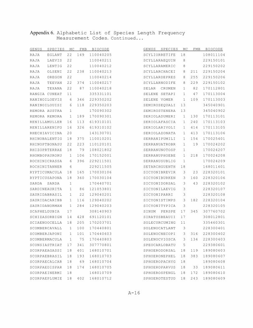
Appendix 6. Alphabetic List of Species Length Frequency Measurement Codes. Continued...
A-16
GENUS SPECIES MC FMB BIOCODE
RAJA EGLANT 22 149 110040205
RAJA LAEVIS 22 110040211
RAJA LENTIG 22 110040212
RAJA OLSENI 22 238 110040213
RAJA OREGON 22 110040214
RAJA TEEVAN 22 374 110040217
RAJA TEXANA 22 87 110040218
RANGIA CUNEAT 11 335331101
RANINOILOEVIS 6 346 229350202
RANINOILOUISI 6 118 229350203
REMORA AUSTRA 1 170090302
REMORA REMORA 1 189 170090301
RENILLAMULLER 16 113 619310101
RENILLARENIFO 16 326 619310102
RHECHIAVICINA 20 143130701
RHINOBALENTIG 18 375 110010201
RHINOPTBONASU 22 223 110120101
RHIZOPRTERRAE 18 79 108021802
RHOMBOPAURORU 1 106 170152001
ROCHINICRASSA 6 396 229211501
ROCHINITANNER 6 229211505
RYPTICUMACULA 18 165 170030106
RYPTICUSAPONA 18 360 170030104
SARDA SARDA 1 170440701
SARDINEAURITA 1 86 121053801
SAURIDABRASIL 1 22 129040201
SAURIDACARIBB 1 116 129040202
SAURIDANORMAN 1 284 129040203
SCAPHELDUBIA 17 308140903
SCHIZASORBIGN 14 428 691120101
SCIAENOOCELLA 18 205 170203701
SCOMBERCAVALL 1 100 170440801
SCOMBERJAPONI 1 101 170440603
SCOMBERMACULA 1 75 170440803
SCONSIASTRIAT 17 341 307770801
SCORPAEAGASSI 18 401 168010701
SCORPAEBRASIL 18 193 168010703
SCORPAECALCAR 18 69 168010704
SCORPAEDISPAR 18 174 168010705
SCORPAEINERMI 18 168010709
SCORPAEPLUMIE 18 402 168010712
GENUS SPECIES MC FMB BIOCODE
SCYLIORRETIFE 18 108011104
SCYLLARAEQUIN 8 229150101
SCYLLARAMERIC 8 229150202
SCYLLARCHACEI 8 211 229150204
SCYLLARDEPRES 8 255 229150206
SCYLLARNODIFE 8 229 229150102
SELAR CRUMEN 1 82 170112801
SELENE SETAPI 1 47 170113004
SELENE VOMER 1 109 170113003
SEMIROSEQUALI 13 345040901
SEMIROSTENERA 13 345040902
SERIOLADUMERI 1 130 170113101
SERIOLAFASCIA 1 240 170113103
SERIOLARIVOLI 1 414 170113105
SERIOLAZONATA 1 413 170113106
SERRANIPUMILI 1 154 170025401
SERRANUATROBR 1 19 170024202
SERRANUNOTOSP 1 170024207
SERRANUPHOEBE 1 218 170024208
SERRANUSUBLIG 1 170024209
SETARCHGUENTH 18 168011601
SICYONIBREVIR 3 23 228320101
SICYONIBURKEN 3 160 228320106
SICYONIDORSAL 3 43 228320102
SICYONILAEVIG 3 228320107
SICYONIPARRI 3 228320108
SICYONISTIMPS 3 182 228320104
SICYONITYPICA 3 228320105
SINUM PERSPE 17 345 307760702
SIRATUSBEAUII 17 308012801
SOLECURCUMING 11 335460301
SOLENOCATLANT 3 228300401
SOLENOCNECOPI 3 316 228300402
SOLENOCVIOSCA 3 134 228300403
SPEOCARLOBATU 5 229380601
SPHOERODORSAL 18 119 189080603
SPHOERONEPHEL 18 383 189080607
SPHOEROPACHYG 18 189080608
SPHOEROPARVUS 18 33 189080611
SPHOEROSPENGL 18 172 189080610
SPHOEROTESTUD 18 243 189080609
Appendix 6. Alphabetic List of Species Length Frequency Measurement Codes. Continued...
A-17
GENUS SPECIES MC FMB BIOCODE
SPHYRAEBARRAC 1 165030101
SPHYRAEBOREAL 1 279 165030102
SPHYRAEGUACHA 1 71 165030103
SPHYRAEPICUDI 1 322 165030105
SPHYRNALEWINI 18 209 108040102
SPHYRNAMOKARR 18 108040103
SPHYRNATIBURO 18 133 108040104
SQUALUSCUBENS 18 109011503
SQUATINDUMERI 18 161 106010101
SQUILLACHYDAE 3 72 225010112
SQUILLAEDENTA 3 225010102
SQUILLAEMPUSA 3 16 225010103
SQUILLANEGLEC 3 245 225010108
STEINDAARGENT 18 132 148041501
STELLIFLANCEO 18 112 170203902
STENOCICOELAT 6 398 229211801
STENOCIFURCAT 6 399 229211802
STENOCISPINIM 6 293 229211803
STENOCISPINOS 6 272 229211804
STENOPUSCUTEL 3 292 228240201
STENORHSETICO 6 141 229211101
STENOTOCAPRIN 1 2 170213403
STOMOLOMELEAG 16 618040201
STROMBUALATUS 17 344 307580101
STYELA PLICAT 20 596080101
STYLOCIAFFINI 14 693060501
SYACIUMGUNTER 18 39 183011001
SYACIUMMICRUR 18 203 183011002
SYACIUMPAPILL 18 56 183011003
SYMPHURCIVITA 18 212 183050701
SYMPHURDIOMED 18 114 183050702
SYMPHURPARVUS 18 183050712
SYMPHURPELICA 18 379 183050705
SYMPHURPLAGIU 18 73 183050707
SYMPHURUROSPI 18 183050709
SYNAGROBELLA 1 315 170060701
SYNAGROSPINOS 1 208 170060704
SYNGNATFLORID 18 151061508
SYNGNATLOUISI 18 362 151061506
SYNGNATSCOVEL 18 151061510
SYNGNATSPRING 18 151061504
GENUS SPECIES MC FMB BIOCODE
SYNODUSFOETEN 1 1 129040302
SYNODUSINTERM 1 217 129040303
SYNODUSPOEYI 1 54 129040304
SYNODUSSYNODU 1 129040306
TAGELUSPLEBEI 11 335460403
TAMOYA HAPLON 16 616040201
TELLINAALTERN 11 311 335441403
TEREBRAFLORID 17 308200104
TETHYASGRANDI 15 691010901
TETRAXABIDENT 5 400 229101002
TETRAXARATHBU 5 421 229101001
THAIS HAEMAS 17 308011003
THYONELGEMMAT 25 694020302
TONNA GALEA 17 307800201
TORPEDONOBILI 22 111010403
TRACHINCAROLI 1 202 170113601
TRACHINFALCAT 1 412 170113603
TRACHINMYOPS 1 135 129040101
TRACHURLATHAM 1 18 170113802
TRACHYPCONSTR 3 128 228011801
TRACHYPSIMILI 3 67 228011802
TRICHIULEPTUR 23 21 170460402
TRICHOPVENTRA 18 53 183011801
TRINECTINSCRI 18 266 183040202
TRINECTMACULA 18 167 183040201
UMBRINACOROID 18 410 170204001
UPENEUSPARVUS 1 11 170220605
UPOGEBIAFFINI 3 229040301
URASPISSECUND 1 170114202
UROCONGSYRING 18 143131401
UROPHYCCIRRAT 18 105 148010102
UROPHYCFLORID 18 74 148010103
UROPHYCREGIA 18 278 148010105
UROSALPCINERE 17 308011401
UROSALPPERRUG 17 308011402
VENTRICRIGIDA 11 355 335640501
VERMICUKNORRI 17 307350502
VESICOMVENUST 11 354 335600402
VIRGULAPRESBY 20 619070101
XENOPHOCONCHY 17 307650202
XIPHOPEKROYER 3 168 228010901

A-18
GENUS SPECIES MC FMB BIOCODE
ZALIEUTMCGINT 18 318 195050501
ZENOPSICONCHI 1 162010201
ZENOPSIOCELLA 1 162010202
ZOOBOTRPELLUC 20 642060101
A-19
Appendix 7. Length Frequency Measurement Code Finder List.
FISH - DO NOT MEASURE IF ONLY THE GENUS IS KNOWN
Fish, default Measurement, no instructions - standard length.
Code Type measurement SpeciesNo. (Alphabetical List Attached,
Appendix 6)01 Fish, fork length Alphabetical list
02 Fish, standard length Alphabetical list
18 Fish, total length Alphabetical list* if fish has produced caudal ray elements at the fork or upper and/or lower caudal lobes take standard length, Code 02 measurement
20 Other - specify and check with Field party Chief for special Code no.
22 Skates and rays, disc width Alphabetical list
23 Fish, snout/anal length Alphabetical list
CRUSTACEANS - DO NOT MEASURE IF ONLY THE GENUS IS KNOWN
Code Type measurement SpeciesNo. (Alphabetical List Attached)
03 Shrimp, total length(Default Measurement)
04 Shrimp, carapace length(measure when requested)
19 Shrimp tail length(measure when requested)
A-20
Appendix 7. Length Frequency Measurement Code Finder List, Continued...
05 Crab, carapace width Alphabetical list(lateral measurement)If carapace length exceeds carapace width-measurecarapace length instead (code 06)
06 Crab, carapace length Alphabetical list(Default measurement)If carapace length exceeds carapace width (measure whenrequested other wise)
07 Lobster, carapace length Alphabetical list(from rostral tip)(Default measurement all lobsters)
08 Lobster, total length Alphabetical list(rostral tip to end of telson)(Measure when requested)
OTHER SPECIES - DO NOT MEASURE IF GENUS ONLY KNOWN(Exclusive of fish and crustaceans)
Code Type of measurement SpeciesNo. (Alphabetical List Attached)
10 Disc width anemonesand corals (solitary)
11 Bivalve, total length (clams)(All bivalves except scallops)Parallel to hinge joint, umbo to bill edge
12 Scallop, total length(All scallops)(hinge to bill length)
13 Squid, mantle length

A-21
Appendix 7. Length Frequency Measurement Code Finder List, Continued...
14 Starfish- disc width(between arm bases- default measurement);Sand dollars, sea biscuits, heart urchins, etc.- greatestlinear distance
15 Starfish, total radial diameter (measure when requested).
16 Sea pansy and other colonial invertebrates, maximum discwidth;Jellyfish- bell diameter.
17 Univalve snails (most univalves): total length- point topoint;shelled- Columella total length (apex to tip of anterior canal - Spire axis); for Abalones and Chitons use maximum total length of shell;for sea hares use total length.
21 Sea turtles - maximum linear carapace total length
24 Univalve snails, spiral width (includes Argonauts).
25 Worm, total length.
A-22
Appendix 8. Measuring Board Species Codes with Length Measurement Codes.
Species Measurement Species Measurement Code Code Code CodeABLENNEHIANS 368 1ACHIRUSLINEAT 196 18AEQUIPEGLYPTU 352 12ALECTISCILIAR 214 1ALUTERUHEUDEL 290 18ALUTERUSCHOEP 150 18ALUTERUSCRIPT 250 18ALUTERUMONOCE 230 18AMUSIUMPAPYRA 49 12ANACANTLONGIR 377 22ANADARABRASIL 336 11ANADARABAUGHM 175 11ANADARAOVALIS 338 11ANASIMULATUS 103 6ANCHOA CUBANA 253 1ANCHOA HEPSET 32 1ANCHOA LYOLEP 136 1ANCHOA LAMPRO 317 1ANCHOA NASUTA 244 1ANCHOA MITCHI 76 1ANCHOVIPERFAS 152 1ANCYLOPDILECT 80 18ANCYLOPQUADRO 85 18ANTENNASTRIAT 236 18ANTENNARADIOS 115 18APLATOPCHAULI 365 18APOGON AUROLI 268 1APOGON PSEUDO 248 1ARCHITENOBILI 343 24ARENAEUCRIBRA 140 5ARGOPECGIBBUS 199 12ARIOMMABONDI 221 1ARIOMMAREGULU 406 1ARIOMMAMELANU 420 1ARIUS FELIS 40 1ASTEROPANNULA 329 14ASTROPEAMERIC 179 15ASTROPEDUPLIC 148 15ASTROSCY-GRAE 210 18ATRINA SEMINU 339 11BAGRE MARINU 120 1BAIRDIECHRYSO 186 18BALISTECAPRIS 44 1BARBATICANCEL 337 11BATHYANMEXICA 151 1
BELLATOMILITA 94 18BEMBROPGOBIOI 241 18BOLLMANCOMMUN 90 18BOTHUS ROBINS 291 18BOTHUS OCELLA 381 18BREGMACATLANT 122 18BREVOORGUNTER 310 1BREVOORPATRON 64 1BROTULABARBAT 70 18BUSYCONCONTRA 283 17BUSYCONSPIRAT 335 17CALAMUSARCTIF 411 1CALAMUSCALAMU 256 1CALAMUSLEUCOS 201 1CALAMUSPENNA 260 1CALAMUSNODOSU 246 1CALAPPAFLAMME 191 5CALAPPASULCAT 52 5CALLINESIMILI 4 5CALLINESAPIDU 57 5CANTHIDSUFFLA 380 1CARANX CRYSOS 62 1CARANX HIPPOS 184 1CARCHARBREVIP 305 18CARCHARACRONO 192 18CARCHARFALCIF 301 18CARCHARLIMBAT 234 18CARDITAFLORID 349 12CARETTACARETT 325 21CAULOLAINTERM 89 1CAULOLAMICROP 269 18CENTROPOCYURA 111 2CENTROPPHILAD 6 2CHAETODAYA 298 2CHAETODFABER 50 2CHAETODOCELLA 419 2CHASCANLUGUBR 331 18CHILOMYATINGA 319 18CHILOMYSCHOEP 153 18CHIONE CLENCH 300 11CHLOEIAVIRIDI 347 25CHLOROSCHRYSU 14 1CHROMISENCHRY 286 1CITHARICORNUT 247 18CITHARIMACROP 129 18

Appendix 8. Measuring Board Species Codes with Length Measurement Codes, Continued...
Species Measurement Species MeasurementCode Code Code Code
A-23
CITHARISPILOP 61 18CLYPEASRAVENE 373 16COELOCESPINOS 394 6CONGER OCEANI 281 18CONODONNOBILI 416 1CONUS AUSTIN 274 17CYCLOPSCHITTE 45 18CYCLOPSFIMBRI 226 18CYNOSCIARENAR 8 18CYNOSCINOTHUS 25 18CYPSELUEXSILI 370 1DASYATIAMERIC 190 22DASYATISAY 273 22DASYATISABINA 235 22DECAPTEMACARE 415 1DECAPTEPUNCTA 104 1DECODONPUELLA 144 2DINOCARROBUST 350 12DIODON HYSTRI 384 18DIPLECTBIVITT 15 2DIPLECTFORMOS 96 2DIPLOGRPAUCIR 404 18DISTORSCLATHR 334 17DOROSOMPETENE 372 1ECHENEINAUCRA 145 18ECHIOPHINTERT 263 18ECHIOPHMORDAX 366 18ELOPS SAURUS 378 1ENGRAULEURYST 131 1ENGYOPHSENTA 97 18EPINEPHGUTTAT 356 1EPINEPHFLAVOL 181 1EPINEPHNIGRIT 359 1EPINNULORIENT 405 1EQUETUSACUMIN 142 18EQUETUSIWAMOT 183 18EQUETUSLANCEO 417 18EQUETUSUMBROS 107 18ETHUSA MICROP 340 6ETROPUSCROSSO 38 18ETROPUSCYCLOS 137 18ETROPUSINTERM 259 18ETROPUSMICROS 188 18ETROPUSRIMOSU 164 18
ETRUMEUTERES 77 1EUCINOSARGENT 282 1EUTHYNNALLETT 314 1FISTULAPETIMB 361 2FISTULATABACA 328 2GINGLYMCIRRAT 320 18GOBIOIDBROUSS 407 18GOBIONEHASTAT 267 18GYMNACHMELAS 198 18GYMNACHTEXAE 95 18GYMNOTHKOLPOS 233 18GYMNOTHOCELLA 258 18GYMNOTHNIGROM 127 18GYMNOTHSAXICO 146 18HAEMULOAUROLI 102 1HALICHOBATHYP 409 2HALIEUTACULEA 36 18HARENGUJAGUAN 26 1HEMANTHAUREOR 280 1HEMANTHLEPTUS 285 1HEMANTHVIVANU 303 1HEMICARAMBLYR 162 1HEMIPTENOVACU 239 2HEMIRAMBRASIL 369 1HEPATUSEPHELI 117 5HERMODICARUNC 324 25HILDEBRGRACIL 313 18HILDEBRFLAVA 81 18HIPPOCAERECTU 304 20HIRUNDIRONDEL 321 1HOLOCENADSCEN 363 1HOPLUNNDIOMED 207 18HOPLUNNMACRUR 84 18ILIACANLIODAC 389 6KATHETOALBIGU 93 18LACTOPHQUADRI 158 18LACTOPHPOLYGO 382 18LACTOPHTRIQUE 330 18LAEVICAPICTUM 351 12LAEVICASYBARI 35 12LAGOCEPLAEVIG 31 18LAGODONRHOMBO 12 1LARIMUSFASCIA 92 18LEIOLAMNITIDU 215 5
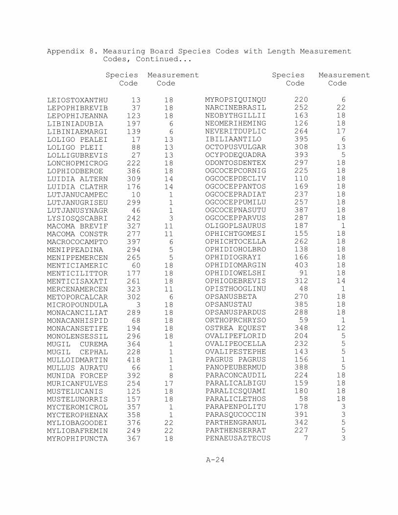
Appendix 8. Measuring Board Species Codes with Length Measurement Codes, Continued...
Species Measurement Species MeasurementCode Code Code Code
A-24
LEIOSTOXANTHU 13 18LEPOPHIBREVIB 37 18LEPOPHIJEANNA 123 18LIBINIADUBIA 197 6LIBINIAEMARGI 139 6LOLIGO PEALEI 17 13LOLIGO PLEII 88 13LOLLIGUBREVIS 27 13LONCHOPMICROG 222 18LOPHIODBEROE 386 18LUIDIA ALTERN 309 14LUIDIA CLATHR 176 14LUTJANUCAMPEC 10 1LUTJANUGRISEU 299 1LUTJANUSYNAGR 46 1LYSIOSQSCABRI 242 3MACOMA BREVIF 327 11MACOMA CONSTR 277 11MACROCOCAMPTO 397 6MENIPPEADINA 294 5MENIPPEMERCEN 265 5MENTICIAMERIC 60 18MENTICILITTOR 177 18MENTICISAXATI 261 18MERCENAMERCEN 323 11METOPORCALCAR 302 6MICROPOUNDULA 3 18MONACANCILIAT 289 18MONACANHISPID 68 18MONACANSETIFE 194 18MONOLENSESSIL 296 18MUGIL CUREMA 364 1MUGIL CEPHAL 228 1MULLOIDMARTIN 418 1MULLUS AURATU 66 1MUNIDA FORCEP 392 8MURICANFULVES 254 17MUSTELUCANIS 125 18MUSTELUNORRIS 157 18MYCTEROMICROL 357 1MYCTEROPHENAX 358 1MYLIOBAGOODEI 376 22MYLIOBAFREMIN 249 22MYROPHIPUNCTA 367 18
MYROPSIQUINQU 220 6NARCINEBRASIL 252 22NEOBYTHGILLII 163 18NEOMERIHEMING 126 18NEVERITDUPLIC 264 17IBILIAANTILO 395 6OCTOPUSVULGAR 308 13OCYPODEQUADRA 393 5ODONTOSDENTEX 297 18OGCOCEPCORNIG 225 18OGCOCEPDECLIV 110 18OGCOCEPPANTOS 169 18OGCOCEPRADIAT 237 18OGCOCEPPUMILU 257 18OGCOCEPNASUTU 387 18OGCOCEPPARVUS 287 18OLIGOPLSAURUS 187 1OPHICHTGOMESI 155 18OPHICHTOCELLA 262 18OPHIDIOHOLBRO 138 18OPHIDIOGRAYI 166 18OPHIDIOMARGIN 403 18OPHIDIOWELSHI 91 18OPHIODEBREVIS 312 14OPISTHOOGLINU 48 1OPSANUSBETA 270 18OPSANUSTAU 385 18OPSANUSPARDUS 288 18ORTHOPRCHRYSO 59 1OSTREA EQUEST 348 12OVALIPEFLORID 204 5 OVALIPEOCELLA 232 5 OVALIPESTEPHE 143 5PAGRUS PAGRUS 156 1PANOPEUBERMUD 388 5PARACONCAUDIL 224 18PARALICALBIGU 159 18PARALICSQUAMI 180 18PARALICLETHOS 58 18PARAPENPOLITU 178 3PARASQUCOCCIN 391 3PARTHENGRANUL 342 5PARTHENSERRAT 227 5PENAEUSAZTECUS 7 3
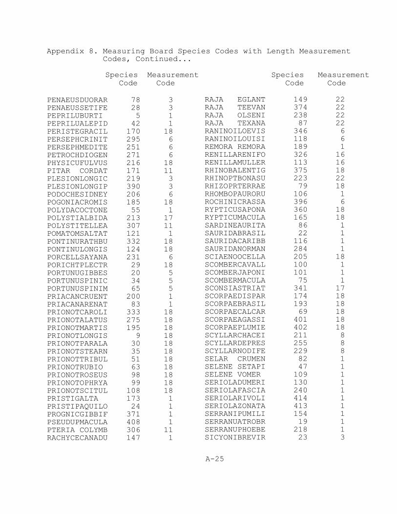
Appendix 8. Measuring Board Species Codes with Length Measurement Codes, Continued...
Species Measurement Species MeasurementCode Code Code Code
A-25
PENAEUSDUORAR 78 3PENAEUSSETIFE 28 3PEPRILUBURTI 5 1PEPRILUALEPID 42 1PERISTEGRACIL 170 18PERSEPHCRINIT 295 6PERSEPHMEDITE 251 6PETROCHDIOGEN 271 6PHYSICUFULVUS 216 18PITAR CORDAT 171 11PLESIONLONGIC 219 3PLESIONLONGIP 390 3PODOCHESIDNEY 206 6POGONIACROMIS 185 18POLYDACOCTONE 55 1POLYSTIALBIDA 213 17POLYSTITELLEA 307 11POMATOMSALTAT 121 1PONTINURATHBU 332 18PONTINULONGIS 124 18PORCELLSAYANA 231 6PORICHTPLECTR 29 18PORTUNUGIBBES 20 5PORTUNUSPINIC 34 5PORTUNUSPINIM 65 5PRIACANCRUENT 200 1PRIACANARENAT 83 1PRIONOTCAROLI 333 18PRIONOTALATUS 275 18PRIONOTMARTIS 195 18PRIONOTLONGIS 9 18PRIONOTPARALA 30 18PRIONOTSTEARN 35 18PRIONOTTRIBUL 51 18PRIONOTRUBIO 63 18PRIONOTROSEUS 98 18PRIONOTOPHRYA 99 18PRIONOTSCITUL 108 18PRISTIGALTA 173 1PRISTIPAQUILO 24 1PROGNICGIBBIF 371 1PSEUDUPMACULA 408 1PTERIA COLYMB 306 11RACHYCECANADU 147 1
RAJA EGLANT 149 22RAJA TEEVAN 374 22RAJA OLSENI 238 22RAJA TEXANA 87 22RANINOILOEVIS 346 6RANINOILOUISI 118 6REMORA REMORA 189 1RENILLARENIFO 326 16RENILLAMULLER 113 16RHINOBALENTIG 375 18RHINOPTBONASU 223 22RHIZOPRTERRAE 79 18RHOMBOPAURORU 106 1ROCHINICRASSA 396 6RYPTICUSAPONA 360 18RYPTICUMACULA 165 18SARDINEAURITA 86 1SAURIDABRASIL 22 1SAURIDACARIBB 116 1SAURIDANORMAN 284 1SCIAENOOCELLA 205 18SCOMBERCAVALL 100 1SCOMBERJAPONI 101 1SCOMBERMACULA 75 1SCONSIASTRIAT 341 17SCORPAEDISPAR 174 18SCORPAEBRASIL 193 18SCORPAECALCAR 69 18SCORPAEAGASSI 401 18 SCORPAEPLUMIE 402 18SCYLLARCHACEI 211 8SCYLLARDEPRES 255 8SCYLLARNODIFE 229 8SELAR CRUMEN 82 1SELENE SETAPI 47 1SELENE VOMER 109 1SERIOLADUMERI 130 1SERIOLAFASCIA 240 1SERIOLARIVOLI 414 1SERIOLAZONATA 413 1SERRANIPUMILI 154 1SERRANUATROBR 19 1SERRANUPHOEBE 218 1SICYONIBREVIR 23 3
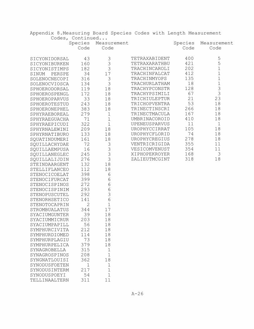
Appendix 8.Measuring Board Species Codes with Length Measurement Codes, Continued...
Species Measurement Species Measurement Code Code Code Code
A-26
SICYONIDORSAL 43 3SICYONIBURKEN 160 3SICYONISTIMPS 182 3SINUM PERSPE 34 17SOLENOCNECOPI 316 3SOLENOCVIOSCA 134 3SPHOERODORSAL 119 18SPHOEROSPENGL 172 18SPHOEROPARVUS 33 18SPHOEROTESTUD 243 18SPHOERONEPHEL 383 18SPHYRAEBOREAL 279 1SPHYRAEGUACHA 71 1SPHYRAEPICUDI 322 1SPHYRNALEWINI 209 18SPHYRNATIBURO 133 18SQUATINDUMERI 161 18SQUILLACHYDAE 72 3SQUILLAEMPUSA 16 3SQUILLANEGLEC 245 3SQUILLALIJDIN 276 3STEINDAARGENT 132 18STELLIFLANCEO 112 18STENOCICOELAT 398 6STENOCIFURCAT 399 6STENOCISPINOS 272 6STENOCISPINIM 293 6STENOPUSCUTEL 292 3STENORHSETICO 141 6STENOTOCAPRIN 2 1STROMBUALATUS 344 17SYACIUMGUNTER 39 18SYACIUMMICRUR 203 18SYACIUMPAPILL 56 18SYMPHURCIVITA 212 18SYMPHURDIOMED 114 18SYMPHURPLAGIU 73 18SYMPHURPELICA 379 18SYNAGROBELLA 315 1SYNAGROSPINOS 208 1SYNGNATLOUISI 362 18SYNODUSFOETEN 1 1SYNODUSINTERM 217 1SYNODUSPOEYI 54 1TELLINAALTERN 311 11
TETRAXABIDENT 400 5TETRAXARATHBU 421 5TRACHINCAROLI 202 1TRACHINFALCAT 412 1TRACHINMYOPS 135 1TRACHURLATHAM 18 1TRACHYPCONSTR 128 3TRACHYPSIMILI 67 3TRICHIULEPTUR 21 23TRICHOPVENTRA 53 18TRINECTINSCRI 266 18TRINECTMACULA 167 18UMBRINACOROID 410 18UPENEUSPARVUS 11 1UROPHYCCIRRAT 105 18UROPHYCFLORID 74 18UROPHYCREGIUS 278 18VENTRICRIGIDA 355 11VESICOMVENUST 354 11XIPHOPEKROYER 168 3ZALIEUTMCGINT 318 18
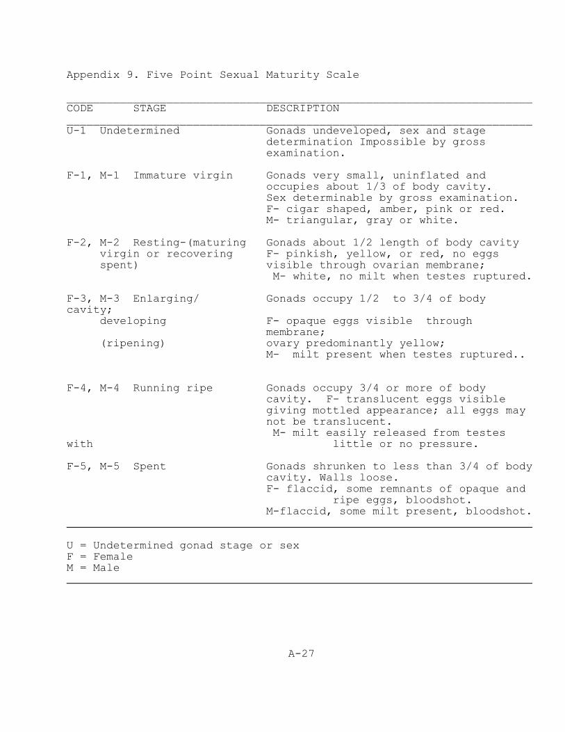
A-27
Appendix 9. Five Point Sexual Maturity Scale
______________________________________________________________________CODE STAGE DESCRIPTION______________________________________________________________________U-1 Undetermined Gonads undeveloped, sex and stage
determination Impossible by grossexamination.
F-1, M-1 Immature virgin Gonads very small, uninflated and occupies about 1/3 of body cavity.
Sex determinable by gross examination. F- cigar shaped, amber, pink or red. M- triangular, gray or white.
F-2, M-2 Resting-(maturing Gonads about 1/2 length of body cavity virgin or recovering F- pinkish, yellow, or red, no eggsspent) visible through ovarian membrane;
M- white, no milt when testes ruptured.
F-3, M-3 Enlarging/ Gonads occupy 1/2 to 3/4 of bodycavity;
developing F- opaque eggs visible throughmembrane;
(ripening) ovary predominantly yellow; M- milt present when testes ruptured..
F-4, M-4 Running ripe Gonads occupy 3/4 or more of bodycavity. F- translucent eggs visiblegiving mottled appearance; all eggs maynot be translucent.
M- milt easily released from testeswith little or no pressure.
F-5, M-5 Spent Gonads shrunken to less than 3/4 of bodycavity. Walls loose.
F- flaccid, some remnants of opaque andripe eggs, bloodshot.
M-flaccid, some milt present, bloodshot.
U = Undetermined gonad stage or sexF = Female M = Male
A-28
Appendix 10. Equipment Checklist for Ichthyoplankton Cruises.
AlcoholAngle indicatorAngle/wire out tablesBatteries for ctd & bongoBleach bottleBongo framesBongo netsBridge log Cable tiesCarboysChemical pumpClip boardsCod end buckets (bongo/tucker trawl)Cod end hose clamp (bongo/tucker trawl)Cod end sleeve (bongo/tucker trawl)Concentrators (sieves)of appropriatemeshsizesCrimping toolCruise chartDiskettesDuct tapeFlowmetersForceps, large and smallFormalinFormalin dispenserHoses (nozzles)Hose y- connectorIchthyoplankton station sheetsInside labelsKnifeDisposable latex glovesLead weight (80 lbs) or depressorMessengers (tucker trawl)Monofilament and sleevesNet repair materialNeuston framesNeuston netsNylon rope (1/4 in) to attach neustonnet to framePascagoula station sheets type IPencilsPermanent markers fine point (12)Plastic buckets (6)Plastic syringeRope or lineSafety glasses
Sample jars (lids) ScissorsScrewdriverShacklesSilicone oil Silicone greaseStick on labels(outside)Stop watches Squeeze bottles Syringes to fillflowmetersTableTwineTucker trawl Tucker trawl netsWide mouth funnels WD 40
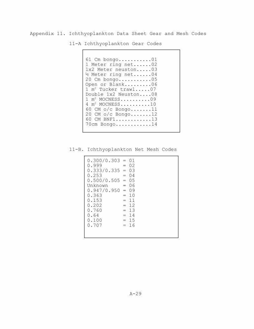
A-29
61 Cm bongo...........011 Meter ring net......021x2 Meter neuston.....03½ Meter ring net......0420 Cm bongo...........05Open or Blank.........061 m2 Tucker trawl.....07Double 1x2 Neuston....081 m2 MOCNESS..........094 m2 MOCNESS..........1060 CM o/c Bongo.......1120 CM o/c Bongo.......1260 CM BNF1............1370cm Bongo............14
0.300/0.303 = 010.999 = 020.333/0.335 = 030.253 = 040.500/0.505 = 05Unknown = 060.947/0.950 = 09 0.363 = 100.153 = 110.202 = 120.760 = 130.64 = 140.100 = 150.707 = 16
Appendix 11. Ichthyoplankton Data Sheet Gear and Mesh Codes
11-A Ichthyoplankton Gear Codes
11-B. Ichthyoplankton Net Mesh Codes

T-1
VII. TABLES

T-2
Table 1. Conversions for meters to fathoms. The center “Units” column denotes a depth in either metersor fathoms. To convert from either scale to the other, simply go to the value in the “Units” column thatyou desire to convert. If meters to fathoms look in the right hand “Fathoms” column for the fathomequivalent of that meter value. If fathoms to meters look in the left hand “Meters” column for the meterequivalent of that fathom value. For example, 10 Units read as meters will equal 5.47 fathoms and 10Units read as fathoms will equal 18.29 meters. Meters Units Fathoms Meters Units Fathoms Meters Units Fathoms
1.83 1 0.55 3.66 2 1.09 5.49 3 1.64 7.32 4 2.19 9.14 5 2.73 10.97 6 3.28 12.80 7 3.83 14.63 8 4.37 16.46 9 4.92
18.29 10 5.47
20.12 11 6.01 21.95 12 6.56 23.77 13 7.11 25.60 14 7.66 27.43 15 8.20 29.26 16 8.75 31.09 17 9.30 32.92 18 9.84 34.75 19 10.39 36.58 20 10.94
38.41 21 11.48 40.23 22 12.03 42.06 23 12.58 43.89 24 13.12 45.72 25 13.67 47.55 26 14.22 49.38 27 14.76 51.21 28 15.31 53.04 29 15.86
54.86 30 16.40
56.69 31 16.95 58.52 32 17.50 60.35 33 18.04 62.18 34 18.59 64.01 35 19.14 65.84 36 19.68 67.67 37 20.23 69.50 38 20.78 71.32 39 21.33 73.15 40 21.87
74.98 41 22.42 76.81 42 22.97 78.64 43 23.51 80.47 44 24.06 82.30 45 24.61 84.13 46 25.15 85.95 47 25.70 87.78 48 26.25 89.61 49 26.79
91.44 50 27.34
93.27 51 27.89 95.10 52 28.43 96.93 53 28.98 98.76 54 29.53 100.59 55 30.07 102.41 56 30.62 104.24 57 31.17 106.07 58 31.71 107.90 59 32.26
109.73 60 32.81
111.56 61 33.35 113.39 62 33.90 115.22 63 34.45 117.04 64 35.00 118.87 65 35.54 120.70 66 36.09 122.53 67 36.64 124.36 68 37.18 126.19 69 37.73
128.02 70 38.28
129.85 71 38.82 131.68 72 39.37 133.50 73 39.92 135.33 74 40.46 137.16 75 41.01 138.99 76 41.56 140.82 77 42.10 142.65 78 42.65 144.48 79 43.20
146.31 80 43.74
148.13 81 44.29 149.96 82 44.84 151.79 83 45.38 153.62 84 45.93 155.45 85 46.48 157.28 86 47.02 159.11 87 47.57 160.94 88 48.12 162.76 89 48.67
164.59 90 49.21
166.42 91 49.76 168.25 92 50.31 170.08 93 50.85 171.91 94 51.40 173.74 95 51.95 175.57 96 52.49 177.40 97 53.04 179.22 98 53.59 181.05 99 54.13
182.88 100 54.68
184.71 101 55.23 186.54 102 55.77 188.37 103 56.32 190.20 104 56.87 192.03 105 57.41 193.85 106 57.96 195.68 107 58.51 197.51 108 59.05 199.34 109 59.60
201.17 110 60.15
203.00 111 60.69 204.83 112 61.24 206.66 113 61.79 208.49 114 62.34 210.31 115 62.88 212.14 116 63.43 213.97 117 63.98 215.80 118 64.52 217.63 119 65.07
219.46 120 65.62
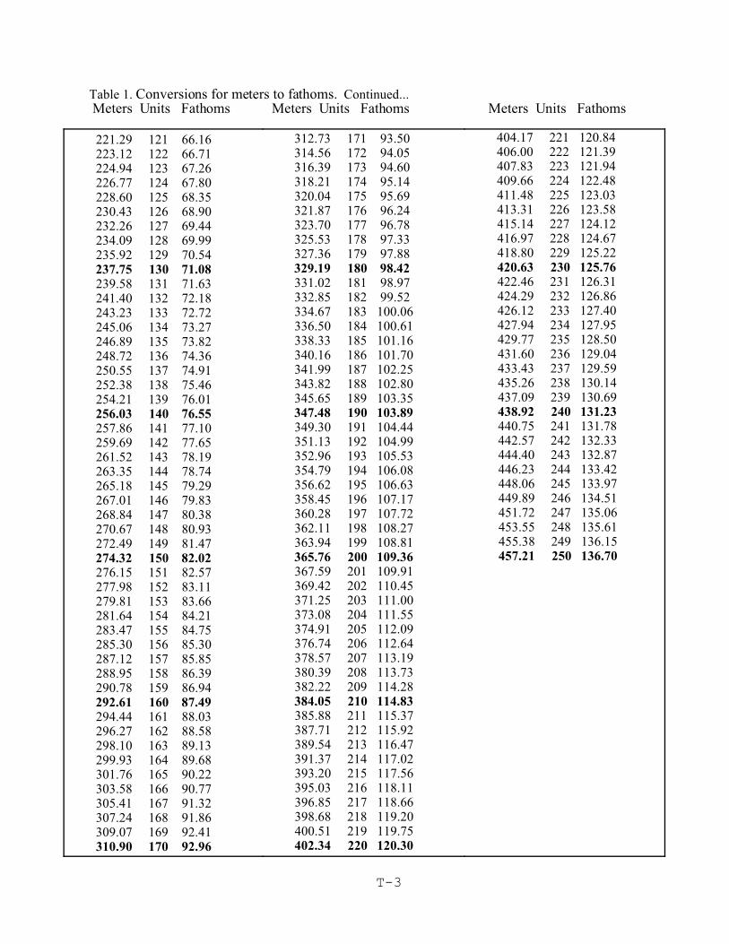
Table 1. Conversions for meters to fathoms. Continued...Meters Units Fathoms Meters Units Fathoms Meters Units Fathoms
T-3
221.29 121 66.16 223.12 122 66.71 224.94 123 67.26 226.77 124 67.80 228.60 125 68.35 230.43 126 68.90 232.26 127 69.44 234.09 128 69.99 235.92 129 70.54
237.75 130 71.08
239.58 131 71.63 241.40 132 72.18 243.23 133 72.72 245.06 134 73.27 246.89 135 73.82 248.72 136 74.36 250.55 137 74.91 252.38 138 75.46 254.21 139 76.01
256.03 140 76.55
257.86 141 77.10 259.69 142 77.65 261.52 143 78.19 263.35 144 78.74 265.18 145 79.29 267.01 146 79.83 268.84 147 80.38 270.67 148 80.93 272.49 149 81.47
274.32 150 82.02
276.15 151 82.57 277.98 152 83.11 279.81 153 83.66 281.64 154 84.21 283.47 155 84.75 285.30 156 85.30 287.12 157 85.85 288.95 158 86.39 290.78 159 86.94
292.61 160 87.49
294.44 161 88.03 296.27 162 88.58 298.10 163 89.13 299.93 164 89.68 301.76 165 90.22 303.58 166 90.77 305.41 167 91.32 307.24 168 91.86 309.07 169 92.41 310.90 170 92.96
312.73 171 93.50 314.56 172 94.05 316.39 173 94.60 318.21 174 95.14 320.04 175 95.69 321.87 176 96.24 323.70 177 96.78 325.53 178 97.33 327.36 179 97.88
329.19 180 98.42
331.02 181 98.97 332.85 182 99.52 334.67 183 100.06 336.50 184 100.61 338.33 185 101.16 340.16 186 101.70 341.99 187 102.25 343.82 188 102.80 345.65 189 103.35
347.48 190 103.89
349.30 191 104.44 351.13 192 104.99 352.96 193 105.53 354.79 194 106.08 356.62 195 106.63 358.45 196 107.17 360.28 197 107.72 362.11 198 108.27 363.94 199 108.81
365.76 200 109.36
367.59 201 109.91 369.42 202 110.45 371.25 203 111.00 373.08 204 111.55 374.91 205 112.09 376.74 206 112.64 378.57 207 113.19 380.39 208 113.73 382.22 209 114.28
384.05 210 114.83
385.88 211 115.37 387.71 212 115.92 389.54 213 116.47 391.37 214 117.02 393.20 215 117.56 395.03 216 118.11 396.85 217 118.66 398.68 218 119.20 400.51 219 119.75
402.34 220 120.30
404.17 221 120.84 406.00 222 121.39 407.83 223 121.94 409.66 224 122.48 411.48 225 123.03 413.31 226 123.58 415.14 227 124.12 416.97 228 124.67 418.80 229 125.22
420.63 230 125.76
422.46 231 126.31 424.29 232 126.86 426.12 233 127.40 427.94 234 127.95 429.77 235 128.50 431.60 236 129.04 433.43 237 129.59 435.26 238 130.14 437.09 239 130.69
438.92 240 131.23
440.75 241 131.78 442.57 242 132.33 444.40 243 132.87 446.23 244 133.42 448.06 245 133.97 449.89 246 134.51 451.72 247 135.06 453.55 248 135.61 455.38 249 136.15
457.21 250 136.70
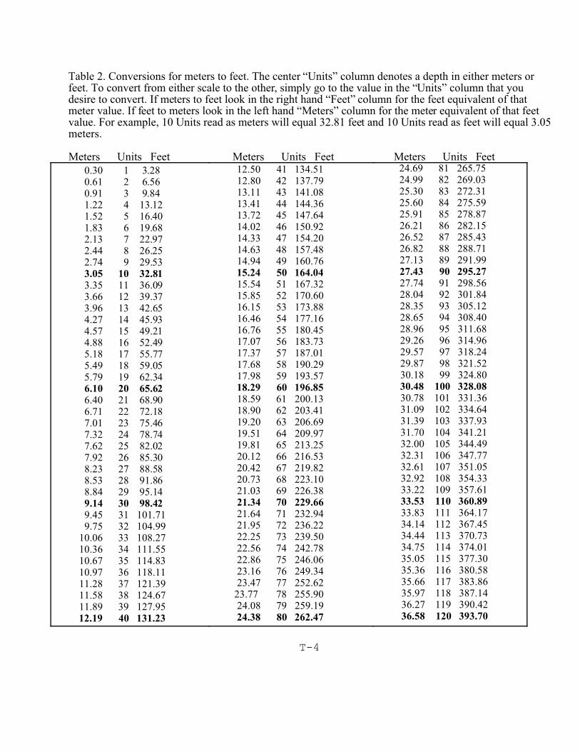
T-4
Table 2. Conversions for meters to feet. The center “Units” column denotes a depth in either meters orfeet. To convert from either scale to the other, simply go to the value in the “Units” column that youdesire to convert. If meters to feet look in the right hand “Feet” column for the feet equivalent of thatmeter value. If feet to meters look in the left hand “Meters” column for the meter equivalent of that feetvalue. For example, 10 Units read as meters will equal 32.81 feet and 10 Units read as feet will equal 3.05meters.
Meters Units Feet Meters Units Feet Meters Units Feet
0.30 1 3.28 0.61 2 6.56 0.91 3 9.84 1.22 4 13.12 1.52 5 16.40 1.83 6 19.68 2.13 7 22.97 2.44 8 26.25 2.74 9 29.53 3.05 10 32.81
3.35 11 36.09 3.66 12 39.37 3.96 13 42.65 4.27 14 45.93 4.57 15 49.21 4.88 16 52.49 5.18 17 55.77 5.49 18 59.05 5.79 19 62.34 6.10 20 65.62
6.40 21 68.90 6.71 22 72.18 7.01 23 75.46 7.32 24 78.74 7.62 25 82.02 7.92 26 85.30 8.23 27 88.58 8.53 28 91.86 8.84 29 95.14 9.14 30 98.42
9.45 31 101.71 9.75 32 104.99 10.06 33 108.27 10.36 34 111.55 10.67 35 114.83 10.97 36 118.11 11.28 37 121.39 11.58 38 124.67 11.89 39 127.95
12.19 40 131.23
12.50 41 134.51 12.80 42 137.79 13.11 43 141.08 13.41 44 144.36 13.72 45 147.64 14.02 46 150.92 14.33 47 154.20 14.63 48 157.48 14.94 49 160.76
15.24 50 164.04
15.54 51 167.32 15.85 52 170.60 16.15 53 173.88 16.46 54 177.16 16.76 55 180.45 17.07 56 183.73 17.37 57 187.01 17.68 58 190.29 17.98 59 193.57
18.29 60 196.85
18.59 61 200.13 18.90 62 203.41 19.20 63 206.69 19.51 64 209.97 19.81 65 213.25 20.12 66 216.53 20.42 67 219.82 20.73 68 223.10 21.03 69 226.38 21.34 70 229.66
21.64 71 232.94 21.95 72 236.22 22.25 73 239.50 22.56 74 242.78 22.86 75 246.06 23.16 76 249.34 23.47 77 252.62 23.77 78 255.90 24.08 79 259.19
24.38 80 262.47
24.69 81 265.75 24.99 82 269.03 25.30 83 272.31 25.60 84 275.59 25.91 85 278.87 26.21 86 282.15 26.52 87 285.43 26.82 88 288.71 27.13 89 291.99
27.43 90 295.27
27.74 91 298.56 28.04 92 301.84 28.35 93 305.12 28.65 94 308.40 28.96 95 311.68 29.26 96 314.96 29.57 97 318.24 29.87 98 321.52 30.18 99 324.80
30.48 100 328.08
30.78 101 331.36 31.09 102 334.64 31.39 103 337.93 31.70 104 341.21 32.00 105 344.49 32.31 106 347.77 32.61 107 351.05 32.92 108 354.33 33.22 109 357.61
33.53 110 360.89
33.83 111 364.17 34.14 112 367.45 34.44 113 370.73 34.75 114 374.01 35.05 115 377.30 35.36 116 380.58 35.66 117 383.86 35.97 118 387.14 36.27 119 390.42
36.58 120 393.70
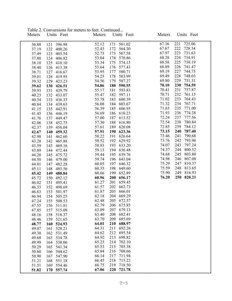
Table 2. Conversions for meters to feet. Continued... Meters Units Feet Meters Units Feet Meters Units Feet
T-5
36.88 121 396.98 37.19 122 400.26 37.49 123 403.54 37.80 124 406.82 38.10 125 410.10 38.40 126 413.38 38.71 127 416.67 39.01 128 419.95 39.32 129 423.23 39.62 130 426.51
39.93 131 429.79 40.23 132 433.07 40.54 133 436.35 40.84 134 439.63 41.15 135 442.91 41.45 136 446.19 41.76 137 449.47 42.06 138 452.75 42.37 139 456.04
42.67 140 459.32
42.98 141 462.60 43.28 142 465.88 43.59 143 469.16 43.89 144 472.44 44.20 145 475.72 44.50 146 479.00 44.81 147 482.28 45.11 148 485.56
45.42 149 488.84
45.72 150 492.12 46.02 151 495.41 46.33 152 498.69 46.63 153 501.97 46.94 154 505.25 47.24 155 508.53 47.55 156 511.81 47.85 157 515.09 48.16 158 518.37 48.46 159 521.65
48.77 160 524.93
49.07 161 528.21 49.38 162 531.49 49.68 163 534.78 49.99 164 538.06 50.29 165 541.34 50.60 166 544.62 50.90 167 547.90 51.21 168 551.18 51.51 169 554.46
51.82 170 557.74
52.12 171 561.02 52.43 172 564.30 52.73 173 567.58 53.04 174 570.86 53.34 175 574.15 53.64 176 577.43 53.95 177 580.71 54.25 178 583.99 54.56 179 587.27
54.86 180 590.55
55.17 181 593.83 55.47 182 597.11 55.78 183 600.39 56.08 184 603.67 56.39 185 606.95 56.69 186 610.23 57.00 187 613.52 57.30 188 616.80 57.61 189 620.08
57.91 190 623.36
58.22 191 626.64 58.52 192 629.92 58.83 193 633.20 59.13 194 636.48 59.44 195 639.76 59.74 196 643.04 60.05 197 646.32 60.35 198 649.60 60.66 199 652.89
60.96 200 656.17
61.27 201 659.45 61.57 202 662.73 61.87 203 666.01 62.18 204 669.29 62.48 205 672.57 62.79 206 675.85 63.09 207 679.13 63.40 208 682.41 63.70 209 685.69 64.01 210 688.97
64.31 211 692.26 64.62 212 695.54 64.92 213 698.82 65.23 214 702.10 65.53 215 705.38 65.84 216 708.66 66.14 217 711.94 66.45 218 715.22 66.75 219 718.50
67.06 220 721.78
67.36 221 725.06 67.67 222 728.34 67.97 223 731.63 68.28 224 734.91 68.58 225 738.19 68.89 226 741.47 69.19 227 744.75 69.49 228 748.03 69.80 229 751.31
70.10 230 754.59
70.41 231 757.87 70.71 232 761.15 71.02 233 764.43 71.32 234 767.71 71.63 235 771.00 71.93 236 774.28 72.24 237 777.56 72.54 238 780.84 72.85 239 784.12
73.15 240 787.40
73.46 241 790.68 73.76 242 793.96 74.07 243 797.24 74.37 244 800.52 74.68 245 803.80 74.98 246 807.08 75.29 247 810.37 75.59 248 813.65 75.90 249 816.93
76.20 250 820.21
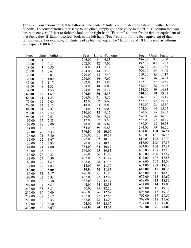
T-6
Table 3. Conversions for feet to fathoms. The center “Units” column denotes a depth in either feet orfathoms. To convert from either scale to the other, simply go to the value in the “Units” column that youdesire to convert. If feet to fathoms look in the right hand “Fathom” column for the fathom equivalent ofthat feet value. If fathoms to feet look in the left hand “Feet” column for the feet equivalent of thatfathom value. For example, 10 Units read as feet will equal 1.67 fathoms and 10 Units read as fathomswill equal 60.00 feet.
Feet Units Fathoms Feet Units Fathoms Feet Units Fathoms
6.00 1 0.17 12.00 2 0.33 18.00 3 0.50 24.00 4 0.67 30.00 5 0.83 36.00 6 1.00 42.00 7 1.17 48.00 8 1.33 54.00 9 1.50
60.00 10 1.67
66.00 11 1.83 72.00 12 2.00 78.00 13 2.17 84.00 14 2.33 90.00 15 2.50 96.00 16 2.67 102.00 17 2.83 108.00 18 3.00 114.00 19 3.17
120.00 20 3.33
126.00 21 3.50 132.00 22 3.67 138.00 23 3.83 144.00 24 4.00 150.00 25 4.17 156.00 26 4.33 162.00 27 4.50 168.00 28 4.67 174.00 29 4.83
180.00 30 5.00
186.00 31 5.17 192.00 32 5.33 198.00 33 5.50 204.00 34 5.67 210.00 35 5.83 216.00 36 6.00 222.00 37 6.17 228.00 38 6.33 234.00 39 6.50
240.00 40 6.67
246.00 41 6.83 252.00 42 7.00 258.00 43 7.17 264.00 44 7.33 270.00 45 7.50 276.00 46 7.67 282.00 47 7.83 288.00 48 8.00 294.00 49 8.17 300.00 50 8.33
306.00 51 8.50 312.00 52 8.67 318.00 53 8.83 324.00 54 9.00 330.00 55 9.17 336.00 56 9.33 342.00 57 9.50 348.00 58 9.67 354.00 59 9.83
360.00 60 10.00
366.00 61 10.17 372.00 62 10.33 378.00 63 10.50 384.00 64 10.67 390.00 65 10.83 396.00 66 11.00 402.00 67 11.17 408.00 68 11.33 414.00 69 11.50
420.00 70 11.67
426.00 71 11.83 432.00 72 12.00 438.00 73 12.17 444.00 74 12.33 450.00 75 12.50 456.00 76 12.67 462.00 77 12.83 468.00 78 13.00 474.00 79 13.17 480.00 80 13.33
486.00 81 13.50 492.00 82 13.67 498.00 83 13.83 504.00 84 14.00 510.00 85 14.17 516.00 86 14.33 522.00 87 14.50 528.00 88 14.67 534.00 89 14.83
540.00 90 15.00
546.00 91 15.17 552.00 92 15.33 558.00 93 15.50 564.00 94 15.67 570.00 95 15.83 576.00 96 16.00 582.00 97 16.17 588.00 98 16.33 594.00 99 16.50
600.00 100 16.67
606.00 101 16.83 612.00 102 17.00 618.00 103 17.17 624.00 104 17.33 630.00 105 17.50 636.00 106 17.67 642.00 107 17.83 648.00 108 18.00 654.00 109 18.17
660.00 110 18.33
666.00 111 18.50 672.00 112 18.67 678.00 113 18.83 684.00 114 19.00 690.00 115 19.17 696.00 116 19.33 702.00 117 19.50 708.00 118 19.67 714.00 119 19.83
720.00 120 20.00
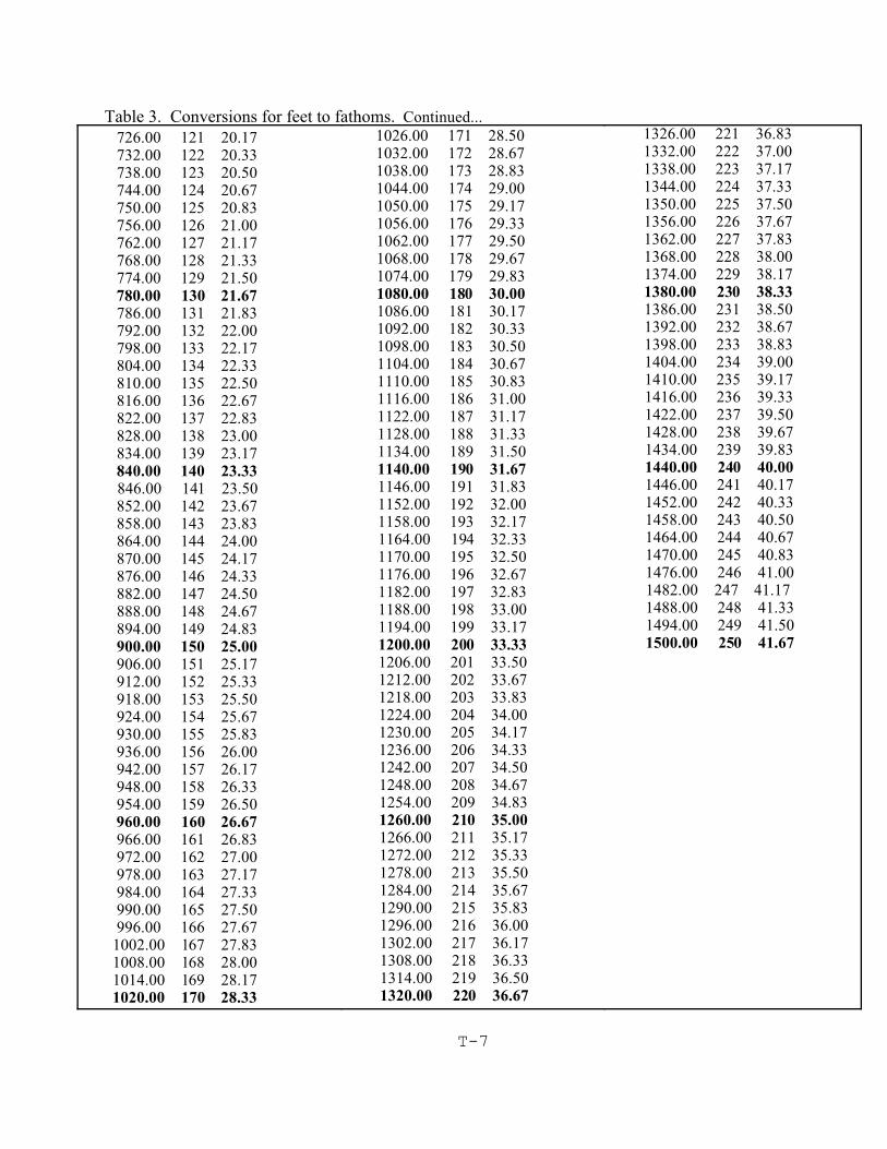
T-7
Table 3. Conversions for feet to fathoms. Continued...
726.00 121 20.17 732.00 122 20.33 738.00 123 20.50 744.00 124 20.67 750.00 125 20.83 756.00 126 21.00 762.00 127 21.17 768.00 128 21.33 774.00 129 21.50
780.00 130 21.67
786.00 131 21.83 792.00 132 22.00 798.00 133 22.17 804.00 134 22.33 810.00 135 22.50 816.00 136 22.67 822.00 137 22.83 828.00 138 23.00 834.00 139 23.17 840.00 140 23.33
846.00 141 23.50 852.00 142 23.67 858.00 143 23.83 864.00 144 24.00 870.00 145 24.17 876.00 146 24.33 882.00 147 24.50 888.00 148 24.67 894.00 149 24.83 900.00 150 25.00
906.00 151 25.17 912.00 152 25.33 918.00 153 25.50 924.00 154 25.67 930.00 155 25.83 936.00 156 26.00 942.00 157 26.17 948.00 158 26.33 954.00 159 26.50
960.00 160 26.67
966.00 161 26.83 972.00 162 27.00 978.00 163 27.17 984.00 164 27.33 990.00 165 27.50 996.00 166 27.67 1002.00 167 27.83 1008.00 168 28.00 1014.00 169 28.17
1020.00 170 28.33
1026.00 171 28.50 1032.00 172 28.67 1038.00 173 28.83 1044.00 174 29.00 1050.00 175 29.17 1056.00 176 29.33 1062.00 177 29.50 1068.00 178 29.67 1074.00 179 29.83
1080.00 180 30.00
1086.00 181 30.17 1092.00 182 30.33 1098.00 183 30.50 1104.00 184 30.67 1110.00 185 30.83 1116.00 186 31.00 1122.00 187 31.17 1128.00 188 31.33 1134.00 189 31.50
1140.00 190 31.67
1146.00 191 31.83 1152.00 192 32.00 1158.00 193 32.17
1164.00 194 32.33 1170.00 195 32.50 1176.00 196 32.67 1182.00 197 32.83 1188.00 198 33.00 1194.00 199 33.17
1200.00 200 33.33
1206.00 201 33.50 1212.00 202 33.67 1218.00 203 33.83 1224.00 204 34.00 1230.00 205 34.17 1236.00 206 34.33 1242.00 207 34.50 1248.00 208 34.67 1254.00 209 34.83
1260.00 210 35.00
1266.00 211 35.17 1272.00 212 35.33 1278.00 213 35.50 1284.00 214 35.67 1290.00 215 35.83 1296.00 216 36.00 1302.00 217 36.17 1308.00 218 36.33 1314.00 219 36.50
1320.00 220 36.67
1326.00 221 36.83 1332.00 222 37.00 1338.00 223 37.17 1344.00 224 37.33 1350.00 225 37.50 1356.00 226 37.67 1362.00 227 37.83 1368.00 228 38.00 1374.00 229 38.17
1380.00 230 38.33
1386.00 231 38.50 1392.00 232 38.67 1398.00 233 38.83 1404.00 234 39.00 1410.00 235 39.17 1416.00 236 39.33 1422.00 237 39.50 1428.00 238 39.67 1434.00 239 39.83
1440.00 240 40.00
1446.00 241 40.17 1452.00 242 40.33 1458.00 243 40.50 1464.00 244 40.67 1470.00 245 40.83 1476.00 246 41.00
1482.00 247 41.17 1488.00 248 41.33 1494.00 249 41.50
1500.00 250 41.67
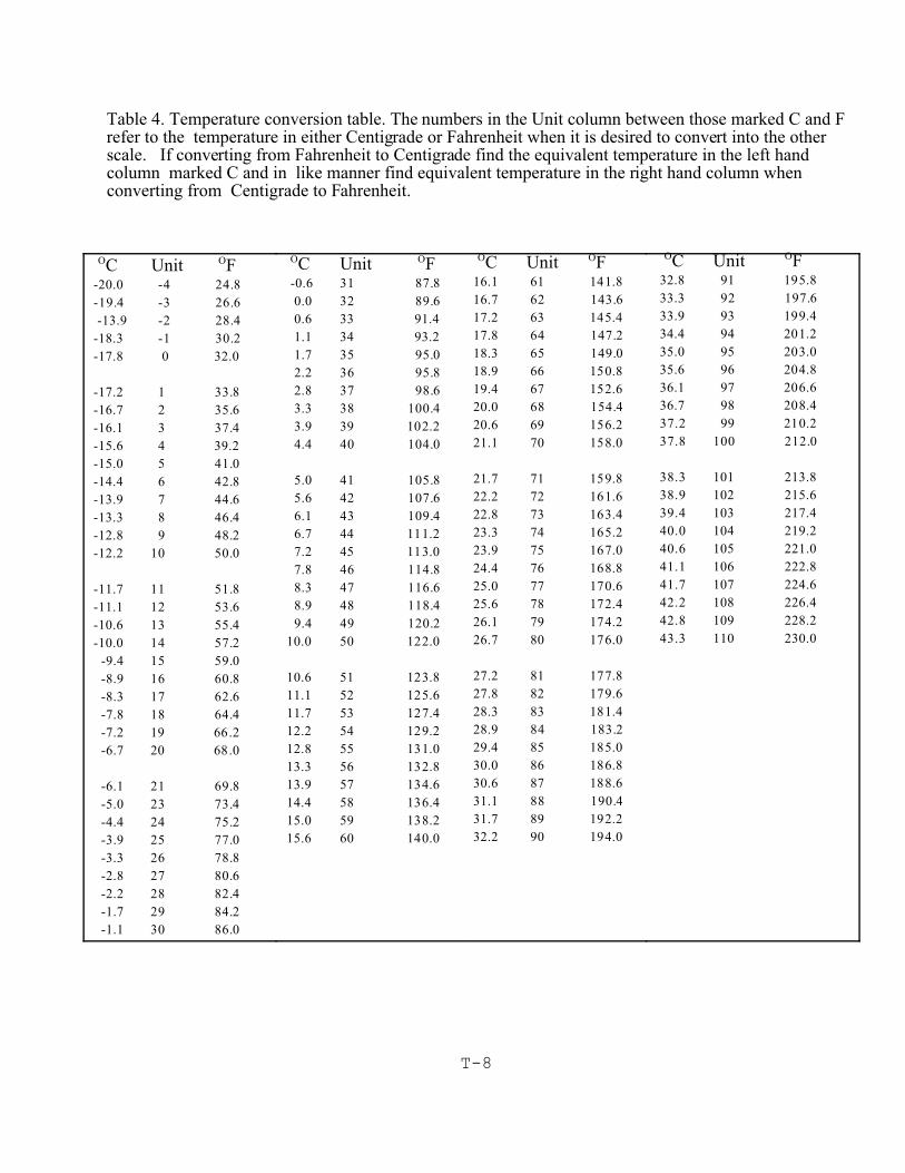
T-8
Table 4. Temperature conversion table. The numbers in the Unit column between those marked C and Frefer to the temperature in either Centigrade or Fahrenheit when it is desired to convert into the otherscale. If converting from Fahrenheit to Centigrade find the equivalent temperature in the left handcolumn marked C and in like manner find equivalent temperature in the right hand column whenconverting from Centigrade to Fahrenheit.
OC Unit OF-20.0 -4 24.8
-19.4 -3 26.6
-13.9 -2 28.4
-18.3 -1 30.2
-17.8 0 32.0
-17.2 1 33.8
-16.7 2 35.6
-16.1 3 37.4
-15.6 4 39.2
-15.0 5 41.0
-14.4 6 42.8
-13.9 7 44.6
-13.3 8 46.4
-12.8 9 48.2
-12.2 10 50.0
-11.7 11 51.8
-11.1 12 53.6
-10.6 13 55.4
-10.0 14 57.2
-9.4 15 59.0
-8.9 16 60.8
-8.3 17 62.6
-7.8 18 64.4
-7.2 19 66.2
-6.7 20 68.0
-6.1 21 69.8
-5.0 23 73.4
-4.4 24 75.2
-3.9 25 77.0
-3.3 26 78.8
-2.8 27 80.6
-2.2 28 82.4
-1.7 29 84.2
-1.1 30 86.0
OC Unit OF -0.6 31 87.8
0.0 32 89.6
0.6 33 91.4
1.1 34 93.2
1.7 35 95.0
2.2 36 95.8
2.8 37 98.6
3.3 38 100.4
3.9 39 102.2
4.4 40 104.0
5.0 41 105.8
5.6 42 107.6
6.1 43 109.4
6.7 44 111.2
7.2 45 113.0
7.8 46 114.8
8.3 47 116.6
8.9 48 118.4
9.4 49 120.2
10.0 50 122.0
10.6 51 123.8
11.1 52 125.6
11.7 53 127.4
12.2 54 129.2
12.8 55 131.0
13.3 56 132.8
13.9 57 134.6
14.4 58 136.4
15.0 59 138.2
15.6 60 140.0
OC Unit OF16.1 61 141.8
16.7 62 143.6
17.2 63 145.4
17.8 64 147.2
18.3 65 149.0
18.9 66 150.8
19.4 67 152.6
20.0 68 154.4
20.6 69 156.2
21.1 70 158.0
21.7 71 159.8
22.2 72 161.6
22.8 73 163.4
23.3 74 165.2
23.9 75 167.0
24.4 76 168.8
25.0 77 170.6
25.6 78 172.4
26.1 79 174.2
26.7 80 176.0
27.2 81 177.8
27.8 82 179.6
28.3 83 181.4
28.9 84 183.2
29.4 85 185.0
30.0 86 186.8
30.6 87 188.6
31.1 88 190.4
31.7 89 192.2
32.2 90 194.0
OC Unit OF32.8 91 195.8
33.3 92 197.6
33.9 93 199.4
34.4 94 201.2
35.0 95 203.0
35.6 96 204.8
36.1 97 206.6
36.7 98 208.4
37.2 99 210.2
37.8 100 212.0
38.3 101 213.8
38.9 102 215.6
39.4 103 217.4
40.0 104 219.2
40.6 105 221.0
41.1 106 222.8
41.7 107 224.6
42.2 108 226.4
42.8 109 228.2
43.3 110 230.0

T-9
Table 5. Refractometer Conversion of Brix to Salinity.
SalinityBrix (PPT)2.5 18.82.6 19.62.7 20.42.8 21.22.9 22.03.0 22.73.1 23.53.2 24.23.3 25.03.4 25.83.5 26.43.6 27.23.7 28.0
SalinityBrix (PPT)3.8 28.83.9 29.44.0 30.24.1 31.04.2 31.84.3 32.54.4 33.34.5 34.24.6 35.04.7 35.54.8 36.34.9 37.25.0 38.0
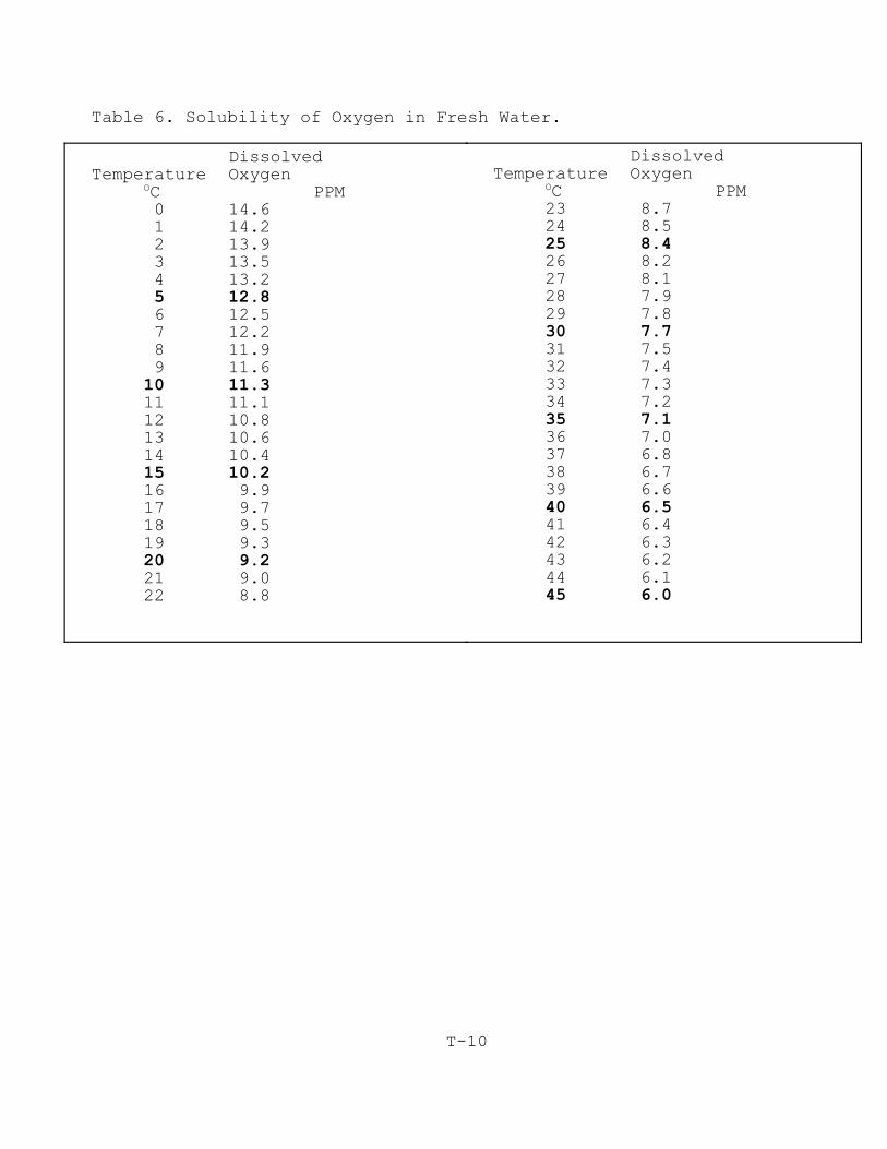
T-10
Table 6. Solubility of Oxygen in Fresh Water.
DissolvedTemperature Oxygen
OC PPM 0 14.6 1 14.2 2 13.9 3 13.5 4 13.25 12.8 6 12.5 7 12.2 8 11.9 9 11.610 11.311 11.112 10.813 10.614 10.415 10.216 9.917 9.718 9.519 9.320 9.221 9.022 8.8
DissolvedTemperature Oxygen
OC PPM23 8.724 8.525 8.426 8.227 8.128 7.929 7.830 7.731 7.532 7.433 7.334 7.235 7.136 7.037 6.838 6.739 6.640 6.541 6.442 6.343 6.244 6.145 6.0
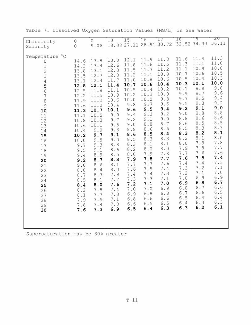
T-11
Table 7. Dissolved Oxygen Saturation Values (MG/L) in Sea Water
ChlorinitySalinity
Temperature OC 0 1 2 3 4 5 6 7 8 9101112131415161718192021222324252627282930
00
14.614.213.813.513.112.812.512.211.911.611.311.110.810.610.410.210.0 9.7 9.5 9.49.2 9.0 8.8 8.7 8.58.4 8.2 8.1 7.9 7.87.6
09.06
13.813.413.112.712.412.111.811.511.211.010.710.510.310.1 9.99.7 9.5 9.3 9.1 8.98.7 8.6 8.4 8.3 8.18.0 7.8 7.7 7.5 7.47.3
1018.08
13.012.612.312.011.711.411.110.910.610.410.1 9.9 9.7 9.5 9.39.1
9.0 8.8 8.6 8.58.3
8.1 8.0 7.9 7.77.6
7.4 7.3 7.1 7.06.9
1527.11
12.111.811.511.211.010.710.510.210.0 9.89.6 9.4 9.2 9.0 8.88.6 8.5 8.3 8.2 8.07.9 7.7 7.6 7.4 7.37.2 7.0 6.9 6.8 6.66.5
1628.91
11.911.611.311.110.810.610.410.210.0 9.79.5
9.3 9.1 8.8 8.6 8.5 8.3 8.1 8.0 7.97.8
7.7 7.5 7.4 7.3 7.1 7.0 6.8 6.6 6.56.4
1730.72
11.811.511.210.810.610.410.210.0 9.8 9.6 9.4 9.2 9.0 8.7 8.5 8.4 8.3 8.1 8.0 7.87.7 7.6 7.4 7.3 7.17.0 6.9 6.8 6.6 6.56.3
1832.52
11.611.311.110.710.510.310.1 9.9 9.7 9.59.2 9.0 8.8 8.6 8.5 8.3 8.2 8.0 7.9 7.77.6 7.4 7.3 7.2 7.06.9 6.8 6.7 6.5 6.46.3
1934.33
11.411.110.910.610.410.1 9.9 9.7 9.5 9.3 9.1 8.8 8.6 8.5 8.38.2
8.1 7.9 7.8 7.67.5
7.4 7.2 7.1 6.96.8
6.7 6.6 6.4 6.36.2
2036.11
11.311.010.810.510.310.0 9.8 9.6 9.4 9.29.0
8.8 8.6 8.5 8.3 8.1 8.0 7.8 7.7 7.6 7.4 7.3 7.1 7.0 6.96.7
6.6 6.5 6.4 6.36.1
Supersaturation may be 30% greater
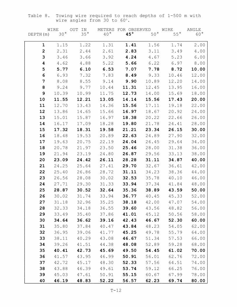
Table 8. Towing wire required to reach depths of 1-500 m withwire angles from 30 to 60o.
WIRE OUT IN METERS FOR OBSERVED WIRE ANGLEDEPTH(m) 30° 35° 40° 45° 50° 55° 60°
T-12
1 1.15 1.22 1.31 1.41 1.56 1.74 2.00
2 2.31 2.44 2.61 2.83 3.11 3.49 4.00
3 3.46 3.66 3.92 4.24 4.67 5.23 6.00
4 4.62 4.88 5.22 5.66 6.22 6.97 8.00
5 5.77 6.10 6.53 7.07 7.78 8.72 10.00
6 6.93 7.32 7.83 8.49 9.33 10.46 12.00
7 8.08 8.55 9.14 9.90 10.89 12.20 14.00
8 9.24 9.77 10.44 11.31 12.45 13.95 16.00
9 10.39 10.99 11.75 12.73 14.00 15.69 18.00
10 11.55 12.21 13.05 14.14 15.56 17.43 20.00
11 12.70 13.43 14.36 15.56 17.11 19.18 22.00
12 13.86 14.65 15.66 16.97 18.67 20.92 24.00
13 15.01 15.87 16.97 18.38 20.22 22.66 26.00
14 16.17 17.09 18.28 19.80 21.78 24.41 28.00
15 17.32 18.31 19.58 21.21 23.34 26.15 30.00
16 18.48 19.53 20.89 22.63 24.89 27.90 32.00
17 19.63 20.75 22.19 24.04 26.45 29.64 34.00
18 20.78 21.97 23.50 25.46 28.00 31.38 36.00
19 21.94 23.19 24.80 26.87 29.56 33.13 38.00
20 23.09 24.42 26.11 28.28 31.11 34.87 40.00
21 24.25 25.64 27.41 29.70 32.67 36.61 42.00
22 25.40 26.86 28.72 31.11 34.23 38.36 44.00
23 26.56 28.08 30.02 32.53 35.78 40.10 46.00
24 27.71 29.30 31.33 33.94 37.34 41.84 48.00
25 28.87 30.52 32.64 35.36 38.89 43.59 50.00
26 30.02 31.74 33.94 36.77 40.45 45.33 52.00
27 31.18 32.96 35.25 38.18 42.00 47.07 54.00
28 32.33 34.18 36.55 39.60 43.56 48.82 56.00
29 33.49 35.40 37.86 41.01 45.12 50.56 58.00
30 34.64 36.62 39.16 42.43 46.67 52.30 60.00
31 35.80 37.84 40.47 43.84 48.23 54.05 62.00
32 36.95 39.06 41.77 45.25 49.78 55.79 64.00
33 38.11 40.29 43.08 46.67 51.34 57.53 66.00
34 39.26 41.51 44.38 48.08 52.89 59.28 68.00
35 40.41 42.73 45.69 49.50 54.45 61.02 70.00
36 41.57 43.95 46.99 50.91 56.01 62.76 72.00
37 42.72 45.17 48.30 52.33 57.56 64.51 74.00
38 43.88 46.39 49.61 53.74 59.12 66.25 76.00
39 45.03 47.61 50.91 55.15 60.67 67.99 78.00
40 46.19 48.83 52.22 56.57 62.23 69.74 80.00
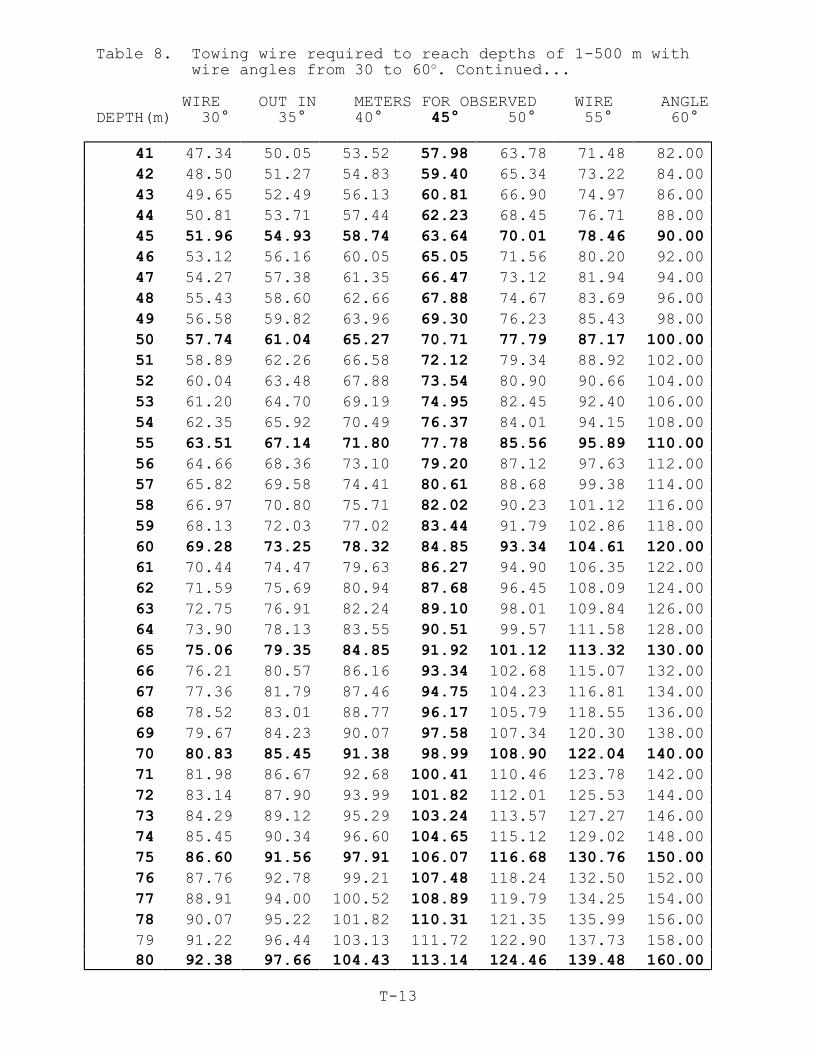
Table 8. Towing wire required to reach depths of 1-500 m withwire angles from 30 to 60o. Continued...
WIRE OUT IN METERS FOR OBSERVED WIRE ANGLEDEPTH(m) 30° 35° 40° 45° 50° 55° 60°
T-13
41 47.34 50.05 53.52 57.98 63.78 71.48 82.00
42 48.50 51.27 54.83 59.40 65.34 73.22 84.00
43 49.65 52.49 56.13 60.81 66.90 74.97 86.00
44 50.81 53.71 57.44 62.23 68.45 76.71 88.00
45 51.96 54.93 58.74 63.64 70.01 78.46 90.00
46 53.12 56.16 60.05 65.05 71.56 80.20 92.00
47 54.27 57.38 61.35 66.47 73.12 81.94 94.00
48 55.43 58.60 62.66 67.88 74.67 83.69 96.00
49 56.58 59.82 63.96 69.30 76.23 85.43 98.00
50 57.74 61.04 65.27 70.71 77.79 87.17 100.00
51 58.89 62.26 66.58 72.12 79.34 88.92 102.00
52 60.04 63.48 67.88 73.54 80.90 90.66 104.00
53 61.20 64.70 69.19 74.95 82.45 92.40 106.00
54 62.35 65.92 70.49 76.37 84.01 94.15 108.00
55 63.51 67.14 71.80 77.78 85.56 95.89 110.00
56 64.66 68.36 73.10 79.20 87.12 97.63 112.00
57 65.82 69.58 74.41 80.61 88.68 99.38 114.00
58 66.97 70.80 75.71 82.02 90.23 101.12 116.00
59 68.13 72.03 77.02 83.44 91.79 102.86 118.00
60 69.28 73.25 78.32 84.85 93.34 104.61 120.00
61 70.44 74.47 79.63 86.27 94.90 106.35 122.00
62 71.59 75.69 80.94 87.68 96.45 108.09 124.00
63 72.75 76.91 82.24 89.10 98.01 109.84 126.00
64 73.90 78.13 83.55 90.51 99.57 111.58 128.00
65 75.06 79.35 84.85 91.92 101.12 113.32 130.00
66 76.21 80.57 86.16 93.34 102.68 115.07 132.00
67 77.36 81.79 87.46 94.75 104.23 116.81 134.00
68 78.52 83.01 88.77 96.17 105.79 118.55 136.00
69 79.67 84.23 90.07 97.58 107.34 120.30 138.00
70 80.83 85.45 91.38 98.99 108.90 122.04 140.00
71 81.98 86.67 92.68 100.41 110.46 123.78 142.00
72 83.14 87.90 93.99 101.82 112.01 125.53 144.00
73 84.29 89.12 95.29 103.24 113.57 127.27 146.00
74 85.45 90.34 96.60 104.65 115.12 129.02 148.00
75 86.60 91.56 97.91 106.07 116.68 130.76 150.00
76 87.76 92.78 99.21 107.48 118.24 132.50 152.00
77 88.91 94.00 100.52 108.89 119.79 134.25 154.00
78 90.07 95.22 101.82 110.31 121.35 135.99 156.00
79 91.22 96.44 103.13 111.72 122.90 137.73 158.0080 92.38 97.66 104.43 113.14 124.46 139.48 160.00
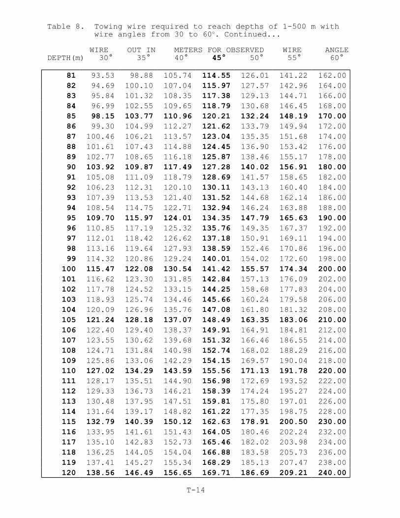
Table 8. Towing wire required to reach depths of 1-500 m withwire angles from 30 to 60o. Continued...
WIRE OUT IN METERS FOR OBSERVED WIRE ANGLEDEPTH(m) 30° 35° 40° 45° 50° 55° 60°
T-14
81 93.53 98.88 105.74 114.55 126.01 141.22 162.00
82 94.69 100.10 107.04 115.97 127.57 142.96 164.00
83 95.84 101.32 108.35 117.38 129.13 144.71 166.00
84 96.99 102.55 109.65 118.79 130.68 146.45 168.00
85 98.15 103.77 110.96 120.21 132.24 148.19 170.00
86 99.30 104.99 112.27 121.62 133.79 149.94 172.00
87 100.46 106.21 113.57 123.04 135.35 151.68 174.00
88 101.61 107.43 114.88 124.45 136.90 153.42 176.00
89 102.77 108.65 116.18 125.87 138.46 155.17 178.00
90 103.92 109.87 117.49 127.28 140.02 156.91 180.00
91 105.08 111.09 118.79 128.69 141.57 158.65 182.00
92 106.23 112.31 120.10 130.11 143.13 160.40 184.00
93 107.39 113.53 121.40 131.52 144.68 162.14 186.00
94 108.54 114.75 122.71 132.94 146.24 163.88 188.00
95 109.70 115.97 124.01 134.35 147.79 165.63 190.00
96 110.85 117.19 125.32 135.76 149.35 167.37 192.00
97 112.01 118.42 126.62 137.18 150.91 169.11 194.00
98 113.16 119.64 127.93 138.59 152.46 170.86 196.00
99 114.32 120.86 129.24 140.01 154.02 172.60 198.00
100 115.47 122.08 130.54 141.42 155.57 174.34 200.00
101 116.62 123.30 131.85 142.84 157.13 176.09 202.00
102 117.78 124.52 133.15 144.25 158.68 177.83 204.00
103 118.93 125.74 134.46 145.66 160.24 179.58 206.00
104 120.09 126.96 135.76 147.08 161.80 181.32 208.00
105 121.24 128.18 137.07 148.49 163.35 183.06 210.00
106 122.40 129.40 138.37 149.91 164.91 184.81 212.00
107 123.55 130.62 139.68 151.32 166.46 186.55 214.00
108 124.71 131.84 140.98 152.74 168.02 188.29 216.00
109 125.86 133.06 142.29 154.15 169.57 190.04 218.00
110 127.02 134.29 143.59 155.56 171.13 191.78 220.00
111 128.17 135.51 144.90 156.98 172.69 193.52 222.00
112 129.33 136.73 146.21 158.39 174.24 195.27 224.00
113 130.48 137.95 147.51 159.81 175.80 197.01 226.00
114 131.64 139.17 148.82 161.22 177.35 198.75 228.00
115 132.79 140.39 150.12 162.63 178.91 200.50 230.00
116 133.95 141.61 151.43 164.05 180.46 202.24 232.00
117 135.10 142.83 152.73 165.46 182.02 203.98 234.00
118 136.25 144.05 154.04 166.88 183.58 205.73 236.00
119 137.41 145.27 155.34 168.29 185.13 207.47 238.00
120 138.56 146.49 156.65 169.71 186.69 209.21 240.00
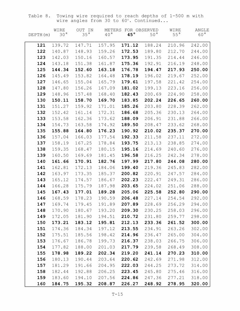
Table 8. Towing wire required to reach depths of 1-500 m withwire angles from 30 to 60o. Continued...
WIRE OUT IN METERS FOR OBSERVED WIRE ANGLEDEPTH(m) 30° 35° 40° 45° 50° 55° 60°
T-15
121 139.72 147.71 157.95 171.12 188.24 210.96 242.00
122 140.87 148.93 159.26 172.53 189.80 212.70 244.00
123 142.03 150.16 160.57 173.95 191.35 214.44 246.00
124 143.18 151.38 161.87 175.36 192.91 216.19 248.00
125 144.34 152.60 163.18 176.78 194.47 217.93 250.00
126 145.49 153.82 164.48 178.19 196.02 219.67 252.00
127 146.65 155.04 165.79 179.61 197.58 221.42 254.00
128 147.80 156.26 167.09 181.02 199.13 223.16 256.00
129 148.96 157.48 168.40 182.43 200.69 224.90 258.00
130 150.11 158.70 169.70 183.85 202.24 226.65 260.00
131 151.27 159.92 171.01 185.26 203.80 228.39 262.00
132 152.42 161.14 172.31 186.68 205.36 230.13 264.00
133 153.58 162.36 173.62 188.09 206.91 231.88 266.00
134 154.73 163.58 174.92 189.50 208.47 233.62 268.00
135 155.88 164.80 176.23 190.92 210.02 235.37 270.00
136 157.04 166.03 177.54 192.33 211.58 237.11 272.00
137 158.19 167.25 178.84 193.75 213.13 238.85 274.00
138 159.35 168.47 180.15 195.16 214.69 240.60 276.00
139 160.50 169.69 181.45 196.58 216.25 242.34 278.00
140 161.66 170.91 182.76 197.99 217.80 244.08 280.00
141 162.81 172.13 184.06 199.40 219.36 245.83 282.00
142 163.97 173.35 185.37 200.82 220.91 247.57 284.00
143 165.12 174.57 186.67 202.23 222.47 249.31 286.00
144 166.28 175.79 187.98 203.65 224.02 251.06 288.00
145 167.43 177.01 189.28 205.06 225.58 252.80 290.00
146 168.59 178.23 190.59 206.48 227.14 254.54 292.00
147 169.74 179.45 191.89 207.89 228.69 256.29 294.00
148 170.90 180.67 193.20 209.30 230.25 258.03 296.00
149 172.05 181.90 194.51 210.72 231.80 259.77 298.00
150 173.21 183.12 195.81 212.13 233.36 261.52 300.00
151 174.36 184.34 197.12 213.55 234.91 263.26 302.00
152 175.51 185.56 198.42 214.96 236.47 265.00 304.00
153 176.67 186.78 199.73 216.37 238.03 266.75 306.00
154 177.82 188.00 201.03 217.79 239.58 268.49 308.00
155 178.98 189.22 202.34 219.20 241.14 270.23 310.00
156 180.13 190.44 203.64 220.62 242.69 271.98 312.00
157 181.29 191.66 204.95 222.03 244.25 273.72 314.00
158 182.44 192.88 206.25 223.45 245.80 275.46 316.00
159 183.60 194.10 207.56 224.86 247.36 277.21 318.00
160 184.75 195.32 208.87 226.27 248.92 278.95 320.00

Table 8. Towing wire required to reach depths of 1-500 m withwire angles from 30 to 60o. Continued...
WIRE OUT IN METERS FOR OBSERVED WIRE ANGLEDEPTH(m) 30° 35° 40° 45° 50° 55° 60°
T-16
161 185.91 196.54 210.17 227.69 250.47 280.69 322.00
162 187.06 197.77 211.48 229.10 252.03 282.44 324.00
163 188.22 198.99 212.78 230.52 253.58 284.18 326.00
164 189.37 200.21 214.09 231.93 255.14 285.93 328.00
165 190.53 201.43 215.39 233.35 256.69 287.67 330.00
166 191.68 202.65 216.70 234.76 258.25 289.41 332.00
167 192.83 203.87 218.00 236.17 259.81 291.16 334.00
168 193.99 205.09 219.31 237.59 261.36 292.90 336.00
169 195.14 206.31 220.61 239.00 262.92 294.64 338.00
170 196.30 207.53 221.92 240.42 264.47 296.39 340.00
171 197.45 208.75 223.22 241.83 266.03 298.13 342.00
172 198.61 209.97 224.53 243.24 267.58 299.87 344.00
173 199.76 211.19 225.84 244.66 269.14 301.62 346.00
174 200.92 212.41 227.14 246.07 270.70 303.36 348.00
175 202.07 213.64 228.45 247.49 272.25 305.10 350.00
176 203.23 214.86 229.75 248.90 273.81 306.85 352.00
177 204.38 216.08 231.06 250.32 275.36 308.59 354.00
178 205.54 217.30 232.36 251.73 276.92 310.33 356.00
179 206.69 218.52 233.67 253.14 278.47 312.08 358.00
180 207.85 219.74 234.97 254.56 280.03 313.82 360.00
181 209.00 220.96 236.28 255.97 281.59 315.56 362.00
182 210.16 222.18 237.58 257.39 283.14 317.31 364.00
183 211.31 223.40 238.89 258.80 284.70 319.05 366.00
184 212.46 224.62 240.19 260.22 286.25 320.79 368.00
185 213.62 225.84 241.50 261.63 287.81 322.54 370.00
186 214.77 227.06 242.81 263.04 289.36 324.28 372.00
187 215.93 228.28 244.11 264.46 290.92 326.02 374.00
188 217.08 229.51 245.42 265.87 292.48 327.77 376.00
189 218.24 230.73 246.72 267.29 294.03 329.51 378.00
190 219.39 231.95 248.03 268.70 295.59 331.25 380.00
191 220.55 233.17 249.33 270.11 297.14 333.00 382.00
192 221.70 234.39 250.64 271.53 298.70 334.74 384.00
193 222.86 235.61 251.94 272.94 300.25 336.49 386.00
194 224.01 236.83 253.25 274.36 301.81 338.23 388.00
195 225.17 238.05 254.55 275.77 303.37 339.97 390.00
196 226.32 239.27 255.86 277.19 304.92 341.72 392.00
197 227.48 240.49 257.17 278.60 306.48 343.46 394.00
198 228.63 241.71 258.47 280.01 308.03 345.20 396.00
199 229.79 242.93 259.78 281.43 309.59 346.95 398.00
200 230.94 244.15 261.08 282.84 311.14 348.69 400.00
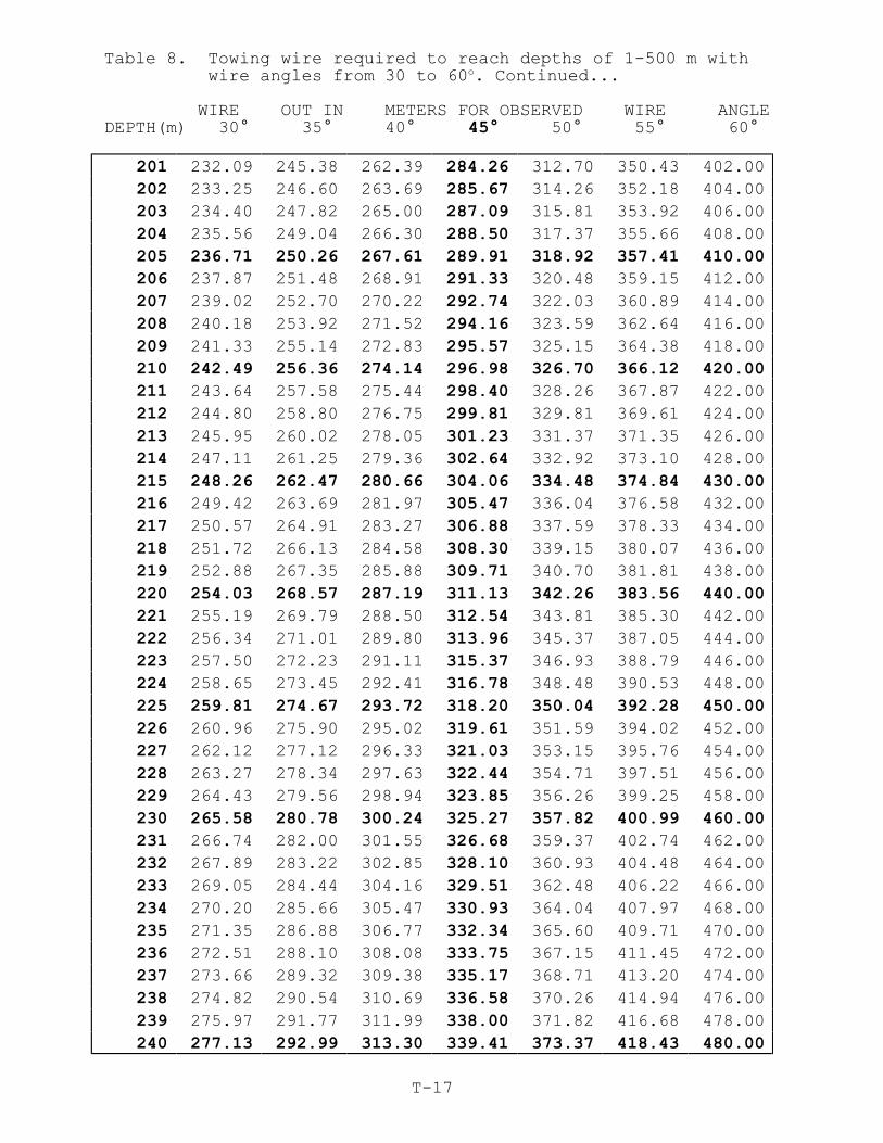
Table 8. Towing wire required to reach depths of 1-500 m withwire angles from 30 to 60o. Continued...
WIRE OUT IN METERS FOR OBSERVED WIRE ANGLEDEPTH(m) 30° 35° 40° 45° 50° 55° 60°
T-17
201 232.09 245.38 262.39 284.26 312.70 350.43 402.00
202 233.25 246.60 263.69 285.67 314.26 352.18 404.00
203 234.40 247.82 265.00 287.09 315.81 353.92 406.00
204 235.56 249.04 266.30 288.50 317.37 355.66 408.00
205 236.71 250.26 267.61 289.91 318.92 357.41 410.00
206 237.87 251.48 268.91 291.33 320.48 359.15 412.00
207 239.02 252.70 270.22 292.74 322.03 360.89 414.00
208 240.18 253.92 271.52 294.16 323.59 362.64 416.00
209 241.33 255.14 272.83 295.57 325.15 364.38 418.00
210 242.49 256.36 274.14 296.98 326.70 366.12 420.00
211 243.64 257.58 275.44 298.40 328.26 367.87 422.00
212 244.80 258.80 276.75 299.81 329.81 369.61 424.00
213 245.95 260.02 278.05 301.23 331.37 371.35 426.00
214 247.11 261.25 279.36 302.64 332.92 373.10 428.00
215 248.26 262.47 280.66 304.06 334.48 374.84 430.00
216 249.42 263.69 281.97 305.47 336.04 376.58 432.00
217 250.57 264.91 283.27 306.88 337.59 378.33 434.00
218 251.72 266.13 284.58 308.30 339.15 380.07 436.00
219 252.88 267.35 285.88 309.71 340.70 381.81 438.00
220 254.03 268.57 287.19 311.13 342.26 383.56 440.00
221 255.19 269.79 288.50 312.54 343.81 385.30 442.00
222 256.34 271.01 289.80 313.96 345.37 387.05 444.00
223 257.50 272.23 291.11 315.37 346.93 388.79 446.00
224 258.65 273.45 292.41 316.78 348.48 390.53 448.00
225 259.81 274.67 293.72 318.20 350.04 392.28 450.00
226 260.96 275.90 295.02 319.61 351.59 394.02 452.00
227 262.12 277.12 296.33 321.03 353.15 395.76 454.00
228 263.27 278.34 297.63 322.44 354.71 397.51 456.00
229 264.43 279.56 298.94 323.85 356.26 399.25 458.00
230 265.58 280.78 300.24 325.27 357.82 400.99 460.00
231 266.74 282.00 301.55 326.68 359.37 402.74 462.00
232 267.89 283.22 302.85 328.10 360.93 404.48 464.00
233 269.05 284.44 304.16 329.51 362.48 406.22 466.00
234 270.20 285.66 305.47 330.93 364.04 407.97 468.00
235 271.35 286.88 306.77 332.34 365.60 409.71 470.00
236 272.51 288.10 308.08 333.75 367.15 411.45 472.00
237 273.66 289.32 309.38 335.17 368.71 413.20 474.00
238 274.82 290.54 310.69 336.58 370.26 414.94 476.00
239 275.97 291.77 311.99 338.00 371.82 416.68 478.00
240 277.13 292.99 313.30 339.41 373.37 418.43 480.00

Table 8. Towing wire required to reach depths of 1-500 m withwire angles from 30 to 60o. Continued...
WIRE OUT IN METERS FOR OBSERVED WIRE ANGLEDEPTH(m) 30° 35° 40° 45° 50° 55° 60°
T-18
241 278.28 294.21 314.60 340.83 374.93 420.17 482.00
242 279.44 295.43 315.91 342.24 376.49 421.91 484.00
243 280.59 296.65 317.21 343.65 378.04 423.66 486.00
244 281.75 297.87 318.52 345.07 379.60 425.40 488.00
245 282.90 299.09 319.82 346.48 381.15 427.14 490.00
246 284.06 300.31 321.13 347.90 382.71 428.89 492.00
247 285.21 301.53 322.44 349.31 384.26 430.63 494.00
248 286.37 302.75 323.74 350.72 385.82 432.37 496.00
249 287.52 303.97 325.05 352.14 387.38 434.12 498.00
250 288.68 305.19 326.35 353.55 388.93 435.86 500.00
251 289.83 306.41 327.66 354.97 390.49 437.61 502.00
252 290.98 307.64 328.96 356.38 392.04 439.35 504.00
253 292.14 308.86 330.27 357.80 393.60 441.09 506.00
254 293.29 310.08 331.57 359.21 395.15 442.84 508.00
255 294.45 311.30 332.88 360.62 396.71 444.58 510.00
256 295.60 312.52 334.18 362.04 398.27 446.32 512.00
257 296.76 313.74 335.49 363.45 399.82 448.07 514.00
258 297.91 314.96 336.80 364.87 401.38 449.81 516.00
259 299.07 316.18 338.10 366.28 402.93 451.55 518.00
260 300.22 317.40 339.41 367.70 404.49 453.30 520.00
261 301.38 318.62 340.71 369.11 406.04 455.04 522.00
262 302.53 319.84 342.02 370.52 407.60 456.78 524.00
263 303.69 321.06 343.32 371.94 409.16 458.53 526.00
264 304.84 322.28 344.63 373.35 410.71 460.27 528.00
265 306.00 323.51 345.93 374.77 412.27 462.01 530.00
266 307.15 324.73 347.24 376.18 413.82 463.76 532.00
267 308.31 325.95 348.54 377.60 415.38 465.50 534.00
268 309.46 327.17 349.85 379.01 416.93 467.24 536.00
269 310.61 328.39 351.15 380.42 418.49 468.99 538.00
270 311.77 329.61 352.46 381.84 420.05 470.73 540.00
271 312.92 330.83 353.77 383.25 421.60 472.47 542.00
272 314.08 332.05 355.07 384.67 423.16 474.22 544.00
273 315.23 333.27 356.38 386.08 424.71 475.96 546.00
274 316.39 334.49 357.68 387.49 426.27 477.70 548.00
275 317.54 335.71 358.99 388.91 427.82 479.45 550.00
276 318.70 336.93 360.29 390.32 429.38 481.19 552.00
277 319.85 338.15 361.60 391.74 430.94 482.93 554.00
278 321.01 339.38 362.90 393.15 432.49 484.68 556.00
279 322.16 340.60 364.21 394.57 434.05 486.42 558.00
280 323.32 341.82 365.51 395.98 435.60 488.17 560.00
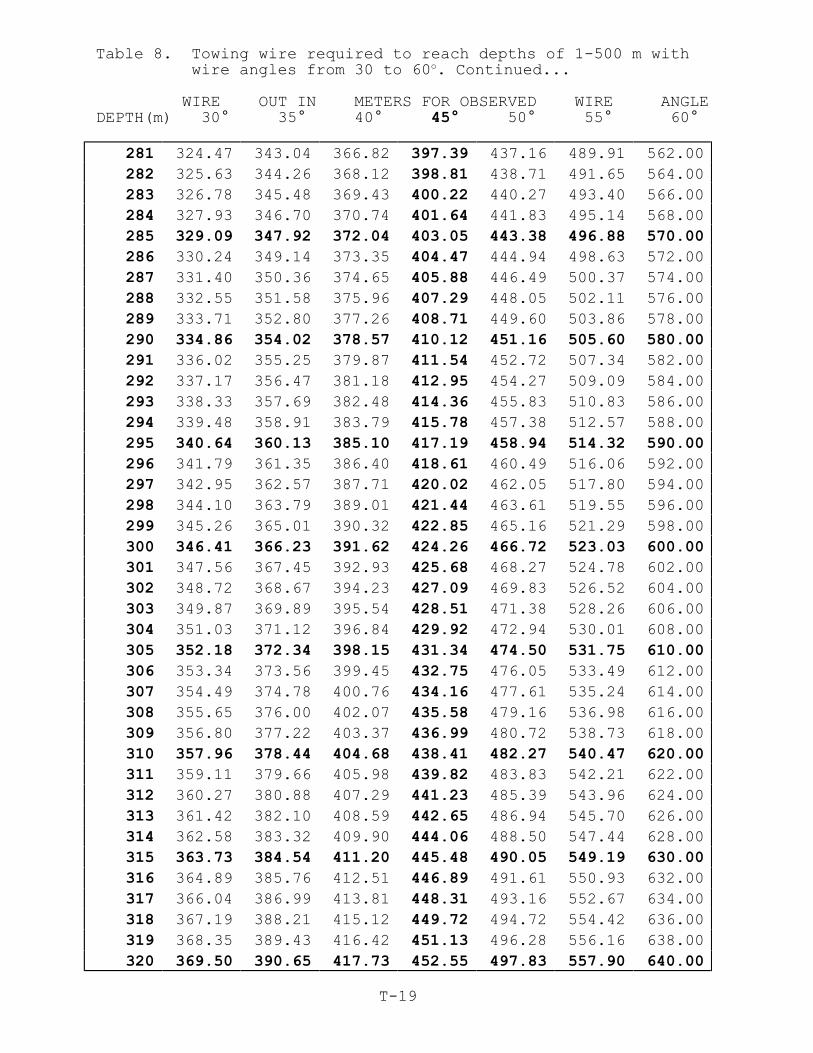
Table 8. Towing wire required to reach depths of 1-500 m withwire angles from 30 to 60o. Continued...
WIRE OUT IN METERS FOR OBSERVED WIRE ANGLEDEPTH(m) 30° 35° 40° 45° 50° 55° 60°
T-19
281 324.47 343.04 366.82 397.39 437.16 489.91 562.00
282 325.63 344.26 368.12 398.81 438.71 491.65 564.00
283 326.78 345.48 369.43 400.22 440.27 493.40 566.00
284 327.93 346.70 370.74 401.64 441.83 495.14 568.00
285 329.09 347.92 372.04 403.05 443.38 496.88 570.00
286 330.24 349.14 373.35 404.47 444.94 498.63 572.00
287 331.40 350.36 374.65 405.88 446.49 500.37 574.00
288 332.55 351.58 375.96 407.29 448.05 502.11 576.00
289 333.71 352.80 377.26 408.71 449.60 503.86 578.00
290 334.86 354.02 378.57 410.12 451.16 505.60 580.00
291 336.02 355.25 379.87 411.54 452.72 507.34 582.00
292 337.17 356.47 381.18 412.95 454.27 509.09 584.00
293 338.33 357.69 382.48 414.36 455.83 510.83 586.00
294 339.48 358.91 383.79 415.78 457.38 512.57 588.00
295 340.64 360.13 385.10 417.19 458.94 514.32 590.00
296 341.79 361.35 386.40 418.61 460.49 516.06 592.00
297 342.95 362.57 387.71 420.02 462.05 517.80 594.00
298 344.10 363.79 389.01 421.44 463.61 519.55 596.00
299 345.26 365.01 390.32 422.85 465.16 521.29 598.00
300 346.41 366.23 391.62 424.26 466.72 523.03 600.00
301 347.56 367.45 392.93 425.68 468.27 524.78 602.00
302 348.72 368.67 394.23 427.09 469.83 526.52 604.00
303 349.87 369.89 395.54 428.51 471.38 528.26 606.00
304 351.03 371.12 396.84 429.92 472.94 530.01 608.00
305 352.18 372.34 398.15 431.34 474.50 531.75 610.00
306 353.34 373.56 399.45 432.75 476.05 533.49 612.00
307 354.49 374.78 400.76 434.16 477.61 535.24 614.00
308 355.65 376.00 402.07 435.58 479.16 536.98 616.00
309 356.80 377.22 403.37 436.99 480.72 538.73 618.00
310 357.96 378.44 404.68 438.41 482.27 540.47 620.00
311 359.11 379.66 405.98 439.82 483.83 542.21 622.00
312 360.27 380.88 407.29 441.23 485.39 543.96 624.00
313 361.42 382.10 408.59 442.65 486.94 545.70 626.00
314 362.58 383.32 409.90 444.06 488.50 547.44 628.00
315 363.73 384.54 411.20 445.48 490.05 549.19 630.00
316 364.89 385.76 412.51 446.89 491.61 550.93 632.00
317 366.04 386.99 413.81 448.31 493.16 552.67 634.00
318 367.19 388.21 415.12 449.72 494.72 554.42 636.00
319 368.35 389.43 416.42 451.13 496.28 556.16 638.00
320 369.50 390.65 417.73 452.55 497.83 557.90 640.00
Table 8. Towing wire required to reach depths of 1-500 m withwire angles from 30 to 60o. Continued...
WIRE OUT IN METERS FOR OBSERVED WIRE ANGLEDEPTH(m) 30° 35° 40° 45° 50° 55° 60°
T-20
321 370.66 391.87 419.04 453.96 499.39 559.65 642.00
322 371.81 393.09 420.34 455.38 500.94 561.39 644.00
323 372.97 394.31 421.65 456.79 502.50 563.13 646.00
324 374.12 395.53 422.95 458.21 504.05 564.88 648.00
325 375.28 396.75 424.26 459.62 505.61 566.62 650.00
326 376.43 397.97 425.56 461.03 507.17 568.36 652.00
327 377.59 399.19 426.87 462.45 508.72 570.11 654.00
328 378.74 400.41 428.17 463.86 510.28 571.85 656.00
329 379.90 401.63 429.48 465.28 511.83 573.59 658.00
330 381.05 402.86 430.78 466.69 513.39 575.34 660.00
331 382.21 404.08 432.09 468.10 514.94 577.08 662.00
332 383.36 405.30 433.40 469.52 516.50 578.82 664.00
333 384.52 406.52 434.70 470.93 518.06 580.57 666.00
334 385.67 407.74 436.01 472.35 519.61 582.31 668.00
335 386.82 408.96 437.31 473.76 521.17 584.05 670.00
336 387.98 410.18 438.62 475.18 522.72 585.80 672.00
337 389.13 411.40 439.92 476.59 524.28 587.54 674.00
338 390.29 412.62 441.23 478.00 525.83 589.29 676.00
339 391.44 413.84 442.53 479.42 527.39 591.03 678.00
340 392.60 415.06 443.84 480.83 528.95 592.77 680.00
341 393.75 416.28 445.14 482.25 530.50 594.52 682.00
342 394.91 417.50 446.45 483.66 532.06 596.26 684.00
343 396.06 418.73 447.75 485.08 533.61 598.00 686.00
344 397.22 419.95 449.06 486.49 535.17 599.75 688.00
345 398.37 421.17 450.37 487.90 536.72 601.49 690.00
346 399.53 422.39 451.67 489.32 538.28 603.23 692.00
347 400.68 423.61 452.98 490.73 539.84 604.98 694.00
348 401.84 424.83 454.28 492.15 541.39 606.72 696.00
349 402.99 426.05 455.59 493.56 542.95 608.46 698.00
350 404.15 427.27 456.89 494.97 544.50 610.21 700.00
351 405.30 428.49 458.20 496.39 546.06 611.95 702.00
352 406.45 429.71 459.50 497.80 547.61 613.69 704.00
353 407.61 430.93 460.81 499.22 549.17 615.44 706.00
354 408.76 432.15 462.11 500.63 550.73 617.18 708.00
355 409.92 433.37 463.42 502.05 552.28 618.92 710.00
356 411.07 434.60 464.72 503.46 553.84 620.67 712.00
357 412.23 435.82 466.03 504.87 555.39 622.41 714.00
358 413.38 437.04 467.34 506.29 556.95 624.15 716.00
359 414.54 438.26 468.64 507.70 558.50 625.90 718.00
360 415.69 439.48 469.95 509.12 560.06 627.64 720.00
Table 8. Towing wire required to reach depths of 1-500 m withwire angles from 30 to 60o. Continued...
WIRE OUT IN METERS FOR OBSERVED WIRE ANGLEDEPTH(m) 30° 35° 40° 45° 50° 55° 60°
T-21
361 416.85 440.70 471.25 510.53 561.62 629.38 722.00
362 418.00 441.92 472.56 511.95 563.17 631.13 724.00
363 419.16 443.14 473.86 513.36 564.73 632.87 726.00
364 420.31 444.36 475.17 514.77 566.28 634.61 728.00
365 421.47 445.58 476.47 516.19 567.84 636.36 730.00
366 422.62 446.80 477.78 517.60 569.39 638.10 732.00
367 423.78 448.02 479.08 519.02 570.95 639.84 734.00
368 424.93 449.25 480.39 520.43 572.51 641.59 736.00
369 426.08 450.47 481.70 521.84 574.06 643.33 738.00
370 427.24 451.69 483.00 523.26 575.62 645.08 740.00371 428.39 452.91 484.31 524.67 577.17 646.82 742.00372 429.55 454.13 485.61 526.09 578.73 648.56 744.00
373 430.70 455.35 486.92 527.50 580.28 650.31 746.00
374 431.86 456.57 488.22 528.92 581.84 652.05 748.00
375 433.01 457.79 489.53 530.33 583.40 653.79 750.00
376 434.17 459.01 490.83 531.74 584.95 655.54 752.00
377 435.32 460.23 492.14 533.16 586.51 657.28 754.00
378 436.48 461.45 493.44 534.57 588.06 659.02 756.00
379 437.63 462.67 494.75 535.99 589.62 660.77 758.00
380 438.79 463.89 496.05 537.40 591.18 662.51 760.00
381 439.94 465.12 497.36 538.82 592.73 664.25 762.00
382 441.10 466.34 498.67 540.23 594.29 666.00 764.00
383 442.25 467.56 499.97 541.64 595.84 667.74 766.00
384 443.41 468.78 501.28 543.06 597.40 669.48 768.00
385 444.56 470.00 502.58 544.47 598.95 671.23 770.00
386 445.71 471.22 503.89 545.89 600.51 672.97 772.00
387 446.87 472.44 505.19 547.30 602.07 674.71 774.00
388 448.02 473.66 506.50 548.71 603.62 676.46 776.00
389 449.18 474.88 507.80 550.13 605.18 678.20 778.00
390 450.33 476.10 509.11 551.54 606.73 679.94 780.00
391 451.49 477.32 510.41 552.96 608.29 681.69 782.00
392 452.64 478.54 511.72 554.37 609.84 683.43 784.00
393 453.80 479.76 513.03 555.79 611.40 685.17 786.00
394 454.95 480.99 514.33 557.20 612.96 686.92 788.00
395 456.11 482.21 515.64 558.61 614.51 688.66 790.00
396 457.26 483.43 516.94 560.03 616.07 690.40 792.00
397 458.42 484.65 518.25 561.44 617.62 692.15 794.00398 459.57 485.87 519.55 562.86 619.18 693.89 796.00
399 460.73 487.09 520.86 564.27 620.73 695.64 798.00
400 461.88 488.31 522.16 565.69 622.29 697.38 800.00
Table 8. Towing wire required to reach depths of 1-500 m withwire angles from 30 to 60o. Continued...
WIRE OUT IN METERS FOR OBSERVED WIRE ANGLEDEPTH(m) 30° 35° 40° 45° 50° 55° 60°
T-22
401 463.03 489.53 523.47 567.10 623.85 699.12 802.00
402 464.19 490.75 524.77 568.51 625.40 700.87 804.00
403 465.34 491.97 526.08 569.93 626.96 702.61 806.00
404 466.50 493.19 527.38 571.34 628.51 704.35 808.00
405 467.65 494.41 528.69 572.76 630.07 706.10 810.00
406 468.81 495.63 530.00 574.17 631.62 707.84 812.00
407 469.96 496.86 531.30 575.58 633.18 709.58 814.00
408 471.12 498.08 532.61 577.00 634.74 711.33 816.00
409 472.27 499.30 533.91 578.41 636.29 713.07 818.00
410 473.43 500.52 535.22 579.83 637.85 714.81 820.00
411 474.58 501.74 536.52 581.24 639.40 716.56 822.00
412 475.74 502.96 537.83 582.66 640.96 718.30 824.00
413 476.89 504.18 539.13 584.07 642.51 720.04 826.00
414 478.05 505.40 540.44 585.48 644.07 721.79 828.00
415 479.20 506.62 541.74 586.90 645.63 723.53 830.00
416 480.36 507.84 543.05 588.31 647.18 725.27 832.00
417 481.51 509.06 544.35 589.73 648.74 727.02 834.00
418 482.66 510.28 545.66 591.14 650.29 728.76 836.00
419 483.82 511.50 546.97 592.56 651.85 730.50 838.00
420 484.97 512.73 548.27 593.97 653.40 732.25 840.00
421 486.13 513.95 549.58 595.38 654.96 733.99 842.00
422 487.28 515.17 550.88 596.80 656.52 735.73 844.00
423 488.44 516.39 552.19 598.21 658.07 737.48 846.00
424 489.59 517.61 553.49 599.63 659.63 739.22 848.00
425 490.75 518.83 554.80 601.04 661.18 740.96 850.00
426 491.90 520.05 556.10 602.45 662.74 742.71 852.00
427 493.06 521.27 557.41 603.87 664.29 744.45 854.00
428 494.21 522.49 558.71 605.28 665.85 746.20 856.00
429 495.37 523.71 560.02 606.70 667.41 747.94 858.00
430 496.52 524.93 561.33 608.11 668.96 749.68 860.00
431 497.68 526.15 562.63 609.53 670.52 751.43 862.00
432 498.83 527.37 563.94 610.94 672.07 753.17 864.00
433 499.99 528.60 565.24 612.35 673.63 754.91 866.00
434 501.14 529.82 566.55 613.77 675.18 756.66 868.00
435 502.29 531.04 567.85 615.18 676.74 758.40 870.00
436 503.45 532.26 569.16 616.60 678.30 760.14 872.00
437 504.60 533.48 570.46 618.01 679.85 761.89 874.00
438 505.76 534.70 571.77 619.43 681.41 763.63 876.00
439 506.91 535.92 573.07 620.84 682.96 765.37 878.00
440 508.07 537.14 574.38 622.25 684.52 767.12 880.00
Table 8. Towing wire required to reach depths of 1-500 m withwire angles from 30 to 60o. Continued...
WIRE OUT IN METERS FOR OBSERVED WIRE ANGLEDEPTH(m) 30° 35° 40° 45° 50° 55° 60°
T-23
441 509.22 538.36 575.68 623.67 686.07 768.86 882.00
442 510.38 539.58 576.99 625.08 687.63 770.60 884.00
443 511.53 540.80 578.30 626.50 689.19 772.35 886.00
444 512.69 542.02 579.60 627.91 690.74 774.09 888.00
445 513.84 543.24 580.91 629.33 692.30 775.83 890.00
446 515.00 544.47 582.21 630.74 693.85 777.58 892.00
447 516.15 545.69 583.52 632.15 695.41 779.32 894.00
448 517.31 546.91 584.82 633.57 696.96 781.06 896.00
449 518.46 548.13 586.13 634.98 698.52 782.81 898.00
450 519.62 549.35 587.43 636.40 700.08 784.55 900.00
451 520.77 550.57 588.74 637.81 701.63 786.29 902.00
452 521.92 551.79 590.04 639.22 703.19 788.04 904.00
453 523.08 553.01 591.35 640.64 704.74 789.78 906.00
454 524.23 554.23 592.65 642.05 706.30 791.52 908.00
455 525.39 555.45 593.96 643.47 707.85 793.27 910.00
456 526.54 556.67 595.27 644.88 709.41 795.01 912.00
457 527.70 557.89 596.57 646.30 710.97 796.76 914.00
458 528.85 559.11 597.88 647.71 712.52 798.50 916.00
459 530.01 560.34 599.18 649.12 714.08 800.24 918.00
460 531.16 561.56 600.49 650.54 715.63 801.99 920.00
461 532.32 562.78 601.79 651.95 717.19 803.73 922.00
462 533.47 564.00 603.10 653.37 718.74 805.47 924.00
463 534.63 565.22 604.40 654.78 720.30 807.22 926.00
464 535.78 566.44 605.71 656.20 721.86 808.96 928.00
465 536.94 567.66 607.01 657.61 723.41 810.70 930.00
466 538.09 568.88 608.32 659.02 724.97 812.45 932.00
467 539.25 570.10 609.63 660.44 726.52 814.19 934.00
468 540.40 571.32 610.93 661.85 728.08 815.93 936.00
469 541.55 572.54 612.24 663.27 729.63 817.68 938.00
470 542.71 573.76 613.54 664.68 731.19 819.42 940.00
471 543.86 574.98 614.85 666.09 732.75 821.16 942.00
472 545.02 576.21 616.15 667.51 734.30 822.91 944.00
473 546.17 577.43 617.46 668.92 735.86 824.65 946.00
474 547.33 578.65 618.76 670.34 737.41 826.39 948.00
475 548.48 579.87 620.07 671.75 738.97 828.14 950.00
476 549.64 581.09 621.37 673.17 740.52 829.88 952.00
477 550.79 582.31 622.68 674.58 742.08 831.62 954.00
478 551.95 583.53 623.98 675.99 743.64 833.37 956.00
479 553.10 584.75 625.29 677.41 745.19 835.11 958.00
480 554.26 585.97 626.60 678.82 746.75 836.85 960.00

Table 8. Towing wire required to reach depths of 1-500 m withwire angles from 30 to 60o. Continued...
WIRE OUT IN METERS FOR OBSERVED WIRE ANGLEDEPTH(m) 30° 35° 40° 45° 50° 55° 60°
T-24
481 555.41 587.19 627.90 680.24 748.30 838.60 962.00
482 556.57 588.41 629.21 681.65 749.86 840.34 964.00
483 557.72 589.63 630.51 683.07 751.41 842.08 966.00
484 558.88 590.85 631.82 684.48 752.97 843.83 968.00
485 560.03 592.08 633.12 685.89 754.53 845.57 970.00
486 561.18 593.30 634.43 687.31 756.08 847.32 972.00
487 562.34 594.52 635.73 688.72 757.64 849.06 974.00
488 563.49 595.74 637.04 690.14 759.19 850.80 976.00
489 564.65 596.96 638.34 691.55 760.75 852.55 978.00
490 565.80 598.18 639.65 692.96 762.30 854.29 980.00
491 566.96 599.40 640.95 694.38 763.86 856.03 982.00
492 568.11 600.62 642.26 695.79 765.42 857.78 984.00
493 569.27 601.84 643.57 697.21 766.97 859.52 986.00
494 570.42 603.06 644.87 698.62 768.53 861.26 988.00
495 571.58 604.28 646.18 700.04 770.08 863.01 990.00
496 572.73 605.50 647.48 701.45 771.64 864.75 992.00
497 573.89 606.72 648.79 702.86 773.19 866.49 994.00
498 575.04 607.95 650.09 704.28 774.75 868.24 996.00
499 576.20 609.17 651.40 705.69 776.31 869.98 998.00
500 577.35 610.39 652.70 707.11 777.86 871.72 1000.0