second congress · symbolic words, groups and letters ., ... universal decimal classification,...
TRANSCRIPT

WORLD METEOROLOGICAL ORGANIZATION
SECOND CONGRESS OF THE
WORLD ~IETEOROLOGICAL ORGANIZATION
GENEVA, 14 APRIL - 13 MAY 1955
Final Report : Volume 11
TECHNICAL REGULATIONS
PRICE: Sw. frs. 10.-
I WMO - No. 4.8. RC.IO I Secretariat of the World Meteorological Organization - Geneva - Switzerland
1956

TABLE OF CONTENTS
Preface ...... , ........ , ....... ,., ... .
Chapter 1 - Definitions ........ , ................ ,., ...............••..
2 Chapter 2 - Meteorological observing stations
2.1 Classificaflon of meteorological observing stations
2.1 .1 General ......... , . , ..... , , . , ..... , , ..... .
2.1 .2 Synoptic stations ... , .. .
2.1.3 Climatological stations ........ .
2.1.4 Agricultural meteorological stations
2,1,5
2,2
2.2.1
2,2,2
2,2,3
Special stations. , ............ .
Network of meteorological observing stations. , , ........ , .. .
Observing stations for synoptic purposes" ... .
Observing stations for climatological purposes ..... .
Observing stations for agricultural meteorological purposes
2.2.4 Observing stations for special purposes ...
2.3 Location of meteorological observing stations
2 ,3, 1
2,3.2
General ............................. .
Synoptic stations ., ..
2.3.3 Climatological stations ...... , ................. .
2.3.4. Agricultural meteorological stations, .. , .. , .. , .. .
2.4 Identification of meteorological observing stations ...
2,4,1
2,4,2
2.5
2,5,1
2.5,2
Synoptic stations ' ..................... .
Other stations
Supervision of meteorological observing stations
General., ........... , .......... .
Synoptic stations
2.5.3 Climatological stations ..... , ........ .
2.5.4 Agricultural meteorological stations .. .
2,6 Information relating to stations ......... .
2.6.1 Synoptic stations .. ,,'
2.6.2 Climatological stations ........ ,.
Pages
XI
5
5
5
6
6
6
7
7
7
8
8
8
8
8
9
9
9
9
9
10
10
10
10
11
11
11
12

IV
3
3.1 3.1.1
3.1.2
3.1.3
3.1.4
3.2
3.2.1
3.3 3.3.1
3.3.2
3.3.3
3.3.4
3.4
3.4.1
3.4.2
3.4.3
3.4.4
3.4.5
3.4.6
3.4.7
3.4.8
3.4.9
TABLE OF CONTENTS
Chapter 3 - Meteorological surface observations
Composition of observations ... , ... Synoptic observations .... ,.,", ..... , .. , ..... , . , , , .......... , . , , , , .. .
Climatological observations ...... "" , .. , .... "., ....... ,' , ........... "
Agricultural meteorological observations .. " ." ... ,., , ..
Special observations .... ,", ......... ,", .. "., .. , ........ ,',." ...... ,
Times of observation .... " .... , , .. , , , ........ , ...... , , , , , . , . , .. .
Times of observation for synoptic purposes ..... , .. , ........ , .. ".,',.
Observing and reporting programme ."., ... ,',., .... " .. ,., ..
Programme for synoptic purposes" , .... ," ..... " .. , ......... .
Programme for climatological purposes., ....... , ......... , .. ,", ..
Programme for agricultural meteorological purposes
Programme for special purposes,., .... , ...... , ... .
Equipment and methods of observation ..... " .. .
General
Clouds, , , ..... , . , . , , .. , .... , , , .. , .. ,
Weather phenomena
Atmospheric pressure", ,., .. ,."
Air temperature,. '" ".,"",.,. "." .. , , .. , ",.,.,,' '" , "., .. ,
Humidity .. " ",.,'" "., ,.,'" " "" ,., ,',.',.,", .. ,., ,.,' , ,,-, ,.,",',
~nd ....................... ··················· Precipitation
Radiation,."."" .. ,
3.4.10 Sea temperature,."."", .. """".".""."""",··,··"·"",,,·,
3.4.11 Waves""",."., .. ".,."", .. ",."""·",·,···"""·,,,·,,,,··,,·
3,5 Recording and preservation of observations "', ... ".,"",.,',',.,",.
3,5,1 Synoptic observations , .. ".".,""', .. ,",.".,.,""., .. "".".'"
Annex 1 : International Barometer Conventions.", ... ,.,." .. ,., , .. ' '" , .".,' .,
Annex 2: Procedure for calculating theoretical value of local acceleration of gravity
4 Chapter 4 - Meteorological upper air observations
4.1
4.1.1
4.2
4.2.1
4.3
4.3.1 4.4 4.4.1
Composition of observations. , , , ' , . , , , , , . , ' .. , , , , . , ' . , . , . , , . , , .. , , , ' . ,
Synoptic observations ",.,""',., .. ,", .. ".,.,.,"',.,"'., .. , .. ,.'"
Times of observation", , .. , .. ,"
Times of observation for synoptic purposes ""',., .. , .. ".,'
Observing and reporting programme "",.".,",.,", .. ,
Programme for synoptic purposes., .. " .. ,.".",."" .. , ..... ".,
Equipment and methods of observation., .... ,.,
General .. """, .. ".",.,
4,4.2 Upper wind observations,.,
Pages
13 13 15
15
16
16
16
17
17
18
18
18
19 19 19 19 19 20
20 20 21
21
21
21
21
21
23
26
28
28
28
28
29
29
29
29
29
, -,~

TABLE OF CONTENTS
4.4.3 lvieteorological reconnaissance flight observations ..
4.5 Recording and preservation of observations ....
4.5,1 Synoptic observations .... , .... , ... , ... ,', .. , .. , ............ .
v
Pages
29 30
30
Annex: Values of some physical functions and constants used in meteorology 31
5 Chapter 5 - Meteorological codes
5.1
5.1.1
5.1.2
General ,.,",." .... , .......... .
Code forms ....... , , , , , . , , , .
Symbolic words, groups and letters ., .. , ................. , ... .
6 Chapter 6 - Meteorological telecommun1cations
6.1
6.1.1 6.2
6.2.1
6.2.2
6.3 6.3.1
Meteorological transmissions ... , , . , . , , .... ,
General , .... " .. , . , .. , .. , . , ... , . . . . . . . .......... .
Collection of meteorological reports
General .... "."., .... , .......... ,.
Meteorological reports from ships
Broadcasts for the purposes of synoptic meteorology
Continental broadcasts .... "., .. , ........... .
6.3.2 Sub~contjnental broadcasts ..... , ..... ,.
6.3.3 Territorial broadcasts ... , .... , .. , ..... .
6.4 Teleprinter and facsimile transmissions
6.4.1 Teleprinter transmissions ..
6.4.2 Facsimile transmissions .... , ..
7 Chapter 7 - Synoptic and forecasting practices
7.1
7.1.1
7.2
7.2.1
7.3
7.3.1
7.4
Numerical computation., ..... " ... " ... , ... , .. , ..... " ......... , .... , ..
General .,., ... , ... , ... , ........... , ..... , .... ,",." .... , ... , .. .
Weather charts ... ,",.,',., ...... , ... " .... " ... ,.",., .. ,.,"",.".,
Projections scales and symbols .. ,',.,.,.,., ..... , ...
Properties of aerological diagrams
General requirements .".", '.' .......... , ....... , , . , , . , . , .... , , , , , . , . ' ,
Upper air analyses.,.. . .. , .... , ... , .. , " " ..
7 .4.1 Reference surfaces
7.5 Daily bulletins
7 .5.1 General .,. , ....... , . , ... , , ... , , , .
Annex: Definitions and specifications of water vapour in the atmosphere
8 Chapter 8 - Climatological practices
8.1 Climatological data, ..... .
8,1.1 General,., ... , .. , ... , .. .
34 34 34
35
35
36 36 36 38 38 38 38 38 38 39
40
40
40
40
41 41
41 41
42
42
43
47 47

VI TABLE OF CONTENTS
8.2 Collection of climatological data ..
8.2.1 Nat,ional arrangements ...
8.3 Exchange of climatological data ..
8,3,1
8.4
8.4,1
8.4,2
8,5
8,5,1
International requirements ..
Climatological statistics
Time units, ...... , ........ :
Climatological averages .. .
Publication of climatological data ..
Publication of surface observations ...
8.5.2 Publication of upper air observations ..
8.5.3 Publication of old climatological data
8.6 Climatological chatis ..
8.6.1 Projections ....
9 Chapter 9 - Bibliography and publications
9,1 Meteorological documents and abstracts ...... ,., .... .
9.1.1 General form of meteorological documents and abstracts
9.1.2 Classification of meteorological documents and abstracts
9.1.3 Preparation of catalogues of meteorological documents ..
9.2 Exchange of meteorological publications .............. ,.
9,2,1 General .................. .
Annex: Universal Decimal Classification, Section 551.5 ... , ........ , .. ,.
10 Chapter 10 - MeteorologIcal service for shippIng
10.1 Meteorological information for shipping in coastal waters
10,1 ,1 Storm warnings .. , ...... , ............................. .
10.2 Meteorological information for shipping on the high seas ....... .
10.2,1 General ... , ...
10.2.2 Storm warnings .,', ....... .
10.2.3 Weather bulletins for shipping
10.3 Meteorological training ................. .
10.3.1 General, ............ , .......... , .. , .... .
11 Chapter 11 - Meteorological service for agriculture
11 ,1 Presentation of agricultural meteorological data
11,1.1 Publication of agricultural meteorological data ..
11 ,2
11.2,1
11.3
11 ,3,1
Agricultural meteorological reports
Crop-weather reports ..... , ......................... , ... .
Forecasts for agriculture,., ................ , ........ .
Forecasting programme ............ " .............. " ..... ,., ......... .
Pages
47 47 48
48 48 48 48 49
49
50 50 51
51
52 52 52 52 53
53
54
66 66 66 66 66 67
68 68
69 69 69 69 70 70

I , !
12
[12,1]
[12,1 ,]
[12,1.]1,1
TABLE OF CONTENTS
Chapter 12 - Meteorological service for international air navigation
Part 1 - Basic obligations for meteorological service for international air navigation
Definitions ..... .
Definitions ., ............ , ... , .. .
[12.1.] 1.1.1 Expressions of limited meaning ...... .
[12.1.J 2 Meteorological service for international air navigation
[12,1,] 2,1
[12,1,]2,1,1
[12,1,] 2,1.2
[12.1,]2,1,3
[12,1,]2,1.4
[12,1.] 2,1.5
[12.1.] 2,2
[12,1,] 2,2,1
[12,1,] 2,2,2
[12,1.] 2,3
[12,1.] 2,3,1
[12,1,] 2,3,2
[12,1.] 2,3,3
[12,1.] 2,3.4
[12,1,] 2.4
[12,1,] 2.4,1
[12,1,] 2,4,2
[12,1,] 2,5
[12,1.]2,5,1
[12,1.] 2,5,2
[12,1.] 2,5,3
[12,1,] 2,6
[12,1,] 2,6,1
[12,1,] 2,6,2
[12,1.] 2,6,3
[12,1,] 2,6.4
[12,1,] 3
[12,1,] 3,1
[12,1,] 3,1,1
[12,1,] 3,2
General ................ .
Objective ... , ....... , ..
Determination of service
Designation of authority ...
Liaison ....... . .......... , , , ... , •. , . , , .. , .. , . , , .. , ..
Notification required by Meteorological Authorities and meteorolog-ical offices... . . . . . . . . . . . . . . . . . . . . . . . .............. .
Meteorological offices and aeronautical meteorological stations ...
Meteorological offices ...
Aeronautical meteorological stations
Aircraft observations ...... .
De-briefing .............. .
Meteorological watch .............. .
Area meteorological waich
Flight meteorological watch
Dissemination of meteorological information
Dissemination to meteorological offices ..
Dissemination to aeronautical personnel .....
Use of meteorological information
Forms of meteorological messages ...
Meteorological messages exchanged between meteorological offices
Meteorological messages transmitted to aircraft in flight .... .
Air-to-ground transmission of air-reports ................ .
Exchange of air-reports between meteorological offices
AIREP and POMAR form of air-report
AIREP form of air-report ........... .
POMAR form of air-repoli
[12.1.] 3,2.1 Symbolic form ...
[12,1,]3,2,2 Code symbols """""
[12.1.] 3,2.3 Code specifications .......... .
VII
Pages
71
71
73
74 74 74 74 74 74
75 75 75 76 77
77
77
77
77
78
78 78
78 78
78
80 80
80
81
81
81
81
81
81
82
82
82 84

!'';'
VIII
[12.2]
[12.2.J 1
[12.2.J 1.1
[12.2.J 2
[12.2.] 2.1
[12.2.J 2.1.1
[12.2.J 2.1.2
[12.2.J 2.1.3
[12.2.] 2.1.4 [12.2.] 2.2
[12.2.] 2.2.1
[12.2.] 2.2.2
[12.2.] 2.2.3
[12.2.] 2.2.4
[12.2.J 2.2.5
[12.2.J 2.3
[12.2.J 2.3.1
[12.2.] 2.3.2
[12.2.] 2.3.3
[12.2.] 2.3.4
[12.2.J 2.4
[12.2.} 2.5
[12.2.J 2.5.1
[12.2.J 2.5.2
[12.2.J 2.5.3
[12.2.J 2.5.4
[12.2.J 2.5.5
[12.2.J 2.5.6
[12.2.] 2.5.7
TABLE OF CONTENTS
Part 2 - Specifications for meteorological service for international air navigation
Definitions .... , , . , , . , .. , .
Definitions
Meteorological service for air navigation"., ....... .
Meteorological offices ..... " .. ,." .......... , .. , .............. .
Main meteorological office ........... ".,""',., ..... " .. ,",.,
Dependent meteorological office.". ..... . ........... .
Supplementary meteorological office .... , .. ,.,.,."., .. ,.
Meteorological watch office ..... , .... ,"', ..
Aeronautical meteorological stations .....
Routine observations at aerodromes
Special observations at aerodromes
Selected special reports .....
Reports to aircraft for an approach-to-Iand ., .... , ..... , ...
Locations of meteorological instruments at aerodromes
Aircraft observations .......... , ................ , ............... .
Routine aircraft observations ........ , .. , .................. ,., .. .
Record of aircraft observations ... ,""', .. , .. '.-........ , ........ .
Repoliing of aircraft observations during flight ................. .
Distribution of air·reports beyond the aerodrome
Aerodrome forecasts ..... .
Dissemination of information .... ,.,., ........... .
Information for operators' local representatives , ...... , .. , .. ,', ..
Information for pilots-in-command prior to departure ., ...
Information for pilots-in-command during flight ......... .
Information for air traffic services "., .......................... .
Information for search and rescue , ..... , ...... , ... , ........... .
Information for the protection of parked and moored aircraft , ...
Criteria for amendments
Pages
89
89
89
89
89
90
90
90 90
90
91
91
94 94
94 94
94 95
95
95
96
96
100
105
111
112
112
114
[12,2.] 2.5.8 Aeronautical climatological information.",., .. , .. , .. , .. ".,."., 114
[12,2.J 2.6 Forms of meteorological messages ..... ".".".".,', .... ,.,'" 115
[12.2.] 2.6.1 Routine reports ..... ".,.,"', .... , .... , ... ".,"""',... 115
[12.2.J 2.6.2 Special reports ........ "."" .. ,." ..... , ... ""."., .. . 115
[12,2.] 2.6,3 Reports for an approach·to-Iand ", ......... , .. ""...... 115
[12.2.J 2,6,4 Forecasts and amendments to forecasts .... ,',., .. ,",... 116
[12.2.J 2.6.5 Ditching reports................................................ 116
[12,2.] 2,6.6 Routine and special reports in plain language,.", ... ,.",., .. ,. 116
[12.2,] 2.6.7 Forecasts (and amendments to forecasts) in plain language..... 118
• f 4 ,
I I I i I
I ! , , , ; ~ ~.

[12.3]
[12.3.] 1
[12.3.]1.1
[12.3.] 1.2
[12.3.) 2
[12.3.) 2.1
[12.3.) 2.1.1
[12.3.) 2.1.2
[12.3.) 2.1.3
[12.3.) 2.1.4
[12.3.) 2.1.5
[12.3.) 2.2
[12.3.) 2.2.1
[12.3.) 2.2.2
[12.3.) 2.2.3
[12.3.) 2.2.4
[12.3.) 2.2.5
[12.3.) 2.2.6
[12.3.) 2.2.7
[12.3.) 2.2.8
[12.3.) 2.2.9
TABLE OF CONTENTS
Part 3 - Briefing and documentation practices
Briefing , ....... ,',.
Preparation of documents ....
Flight and aerodrome forecast (Model FA)
Heading .................................... , .. ,", ... ,",.
Special features of the meteorological situation ........... .
Zones .... , ........... , ....... ,.,"', .. ,',." .... , ...... .
Flight forecast" .. ,." .....
Aerodrome forecasts .... , ...... , .. ,.,.,', .. , .. , .. , .. , .... .
Flight forecast folder ........ ,., .. ......... " ... ,
Cover (Model C) ........................... ..
Cross-section and f1jght forecast form (Model F.1) ,.
Aerodrome forecast (Model A) ........... .
Flight forecast (Model F.3)." .... , ...... ".,." ..... , ... , ...... .
Cross·section (Model F .2) ...... .
Prognostic chali of significant weather (Model SW)
IX
Pages
121
121
121
121
121
121
122
122
122
123
124
124
124
127
127
127
128
128
128
128
[12.3.] 2.2.10 Prognostic chart for an upper level (Model Pa or Pb) ...... 129
[12.4)
[12.4.] 1
[12.4.) 1.1
[12.4.)1.1.1
[12.4.)1.1.2
[12.4.) 1.2
[12.4.) 1.3
[12.4.) 1.4
[12.4.) 1.5
[12.4.)1.6
[12.4.)1.7
[12.4.) 2
[12.4.) 2.1
[12.4.) 2.2
[12.4.) 2.3
Part 4 - Aeronautical climatological summaries and aeronautical descriptive climatological memoranda
Aeronautical climatological summaries ....... .
Aeronautical descriptive memoranda
131
131
132
132
132
132
132
132
132
132
133
133
133
133

x
Climatological summaries
Model LA - AIREP
Model LP - POMAR
Model C
Model A
Model F.1
Model F.2
TABLE OF CONTENTS
Model F.3
Model FA
Model SW Model Pa
Model Pb
EDITORIAL NOTE
The following typographical practice has been followed .. :
Pages
134
Standard meteorological practices and procedures have been printed in semi-bold roman.
Recommended meteorological practices and procedures have been printed in light face roman. (Definitions appear in bigger type.)
Noles have been printed in smaller type, light face roman, and preceded of the indication NOTE.

PREFACE
Before adopting the Technical Regulations of the World Meteorological Organization in accordance with Article 7(d) of the Convention, the Second Congress defined in Resolution 17(Cg-11) two categories of Technical Regulations, namely the standard meteorological practices and procedures and the recommended meteorological practices and procedures, The standard practices and procedures are those which it is necessary that Members follow or implement and to which Article 8 of the Convention is applicable; they afe distinguished by the use of the verb shall in the English text and are printed in heavy type. The recommended practices are those which it is desirable that Members follow or implement and in this case Article 8{b) of the Convention is not applicable; they are distinguished by the use of the verb should in the English text and are printed in ordinary type.
The Regulations in Chapters 1-11 come into force on 1 July 1956 with the exception of Annex V (Universal Decimal Classification, section 551.5) which comes into force on 1 January 1957; Chapter 12 came into force on 1 January 1956.
The Technical Regulations adopted in Resolution 19(Cg-ll) are also published in two separate volumes; Volume I (publication WMO No. 49.80.2) contains Chapters 1 to 11 which relate to all branches of meteorology other than meteorological service for international air navigation·; Volume 11 relates exclusively to the meteorological service for international air navigation (Publicution WMO No. 49.8D.3).
Only the version of the Technical RegUlations published in WMO Publications No. 49.80.2 and No. 49.8D.3 will be kept up to date by means of supplements and will be completed by information on deviations from the Technical Regulations.

CHAPTER 1
DEFINITIONS
Introductory no/e. The following terms, when used in Chapters 1 to 11 of these Technical Regulations I
have the meanings given below:
Actual time of observation
(1) In the case of a surface synoptic observation, the actual time of observation is the time at which the barometer is read;
(2) In the case of upper air observations, the actual time of observation is the time at which the balloon, parachute or rodet is actually released.
NOT E : The 10regoiog definitions do not preclude the use of the term "actual time of observation" with specific re1erence to an individual meteorological element but in such cases the individual meteorological element involved must be speCifically named, e,g. "actual time of observation of sea temperature" .
Aeronautical meteorological station. A station designated to make observations and meteorological reports for use in international air naVigation.
Aircraft weather station. A station situated in a meteorological reconnaissance aircraft.
Altitude. The vertical distance of a level, a point, or an object considered as a point, measured from mean sea level.
Auxiliary agricultural meteorological station. A station which provides meteorological and biological information, The meteorological information may include such items as soil temperature or moisture, potential evapotranspiration, detailed soundings of -the very lowest layer of the atmosphere; the biological information may cover phenology, onset and spread of plant diseases, etc,
Auxiliary ship station. A mobile ship station normally without certified meteorological instruments which mal~es reports on request in certain areas and under certain conditions in the short code form for surface reports from ships, Of in plain language.
Basic land station. A surtace synoptic station on land equipped and staffed to observe the elements specified in paragraph 3,1,1,1 and report the observations for international exchange.
Collective transmission. A transmission by radio or land line of a collection of meteorological information relating to several stations,
Communication centre. A centre at which meteorological information is collected for international dissemination, '

2 CHAPTER 1 - DEFINITIONS
Continental broadcast, A broadcast of meteorological data normally covering a Region and, exceptionally, limited portions of adjacent Regions, and intended for world-wide interception,
Elevation. The vertical distance of a point or level on or affixed to the surface of the earth, measured from mean sea level.
First order climatological station. A station at which autographic records or hourly readings of pressure;. temperature, humidity, wind, sunshine and precipi
_ tation are made, together with observations at fixed hours of the amount and form of clouds and notes on the weather.
Fixed ship station. An ocean weather station Of a station situated aboard a light-ship.
Forecast. A statement of expected meteqrological conditions related to a spe-cified period of time and location or portion of airspace.
Height.
(1) The vertical distance of a level, point, or an object considered as a point! measured from a specified datum.
NOT E : The datum may be specified either in the text or in an explanatory note in the publication conce~ned.
(2) The vertical dimension of an object. NOT E: The term "height" may be used in a figurative sense for a dimension other than vertical, e~g. tlie height of a letter or a figure painted on a ·runway. :' '.,
Meteorological message. A message containing only meteorological reports, meteorological data, analyses and/or forecasts.
Meteorological observation (Observation). The evaluation of one or more meteor-ological elements.
Meteorological observing station (Station). A place where meteorological observations are made with the approval of the Member or Members concerned.
Meteorological reconnaissance {light. An aircraft flight for the specific purpose of making meteorological observations.
Meteorological report (Report). A statement of observed meteorological conditions related to a speCified time and location..
Meteorological transmission. :i.·A transmission by radio or land line of meteorological information.
Mobile ship station. A statidn situated aboard a ship and established by the voluntary co·operation of the owners of the ship and of the ship's captain with a Member.
National standard barometer. A barometer designated by a Member as the reference standard barometer for its territory.
{
I i I i

CHAPTER 1 - DEFINITIONS 3
Ocean weather station. A fixed maritime location occupied by a ship equipped and staffed to observe the elements specified in 3.1 .1 .2 and report the observations for international exchange.
Ordinary agricultural meteorological station. A station which provides, on a rou~ tine basis, simultaneous meteorological and biological information and may be equipped to assist in research into specific problems; in general the programme of biological or phenological observations for research will be related to the local climatic regime of the station.
Pilot balloon observation. A determination of upper winds by optical tracking of a free balloon.
Pilot balloon station. A station at which upper winds are determined by optical tracking of a free balloon.
Precipitation station. A station at which observations of precipitation only are made,
Principal agricultural meteorological station. A station which provides detailed simultaneous meteorological and biological information and where research in agricultural meteorology is carried out. The instrumental facilities, the range and frequency of observations In both meteorological and biological fields, and the professional personnel are such that fundamental investigations into agricultural meteorological questions of interest to the countries or Regions concerned can be carried out.
Radiosonde stat/on. A station at which observations of atmospheric pressure, temperature and humidity in the upper air are made by electronic means.
Radiowind observation. A determination of upper winds by tracking of a free balloon by electronic means.
Radiowind station. A station at which upper winds are determined by tracking of a free balloon by electronic means.
Rawinsonde station. A combined radiosonde and radiowind station,
Regional standard barometer. A barometer which, by resolution of the Regional Association of the Region in which it is situated, is designated as the reference standard barometer for that Region.
Second order climatological station. A station at which observations of temperature, humidity, wind, cloud and weather are made at least -twice daily, at fixed hours, and at which the daily maxima and minima of temperature, the daily amount of precipitation and the duration of bright sunshine, are observed.
Selected ship station. A mobile ship station with a full set of certified meteorological instruments, which makes reports in the full code form for sudace reports from ships.

4 CHAPTER 1 - DEFINITIONS
Sub~conUnental broadcast. A broadcast of meteorological data covering a portior:! of a Region and, exceptionally, limited portions of adjacent Regions, and intended for interception anywhere in that Region and, exceptionally, in adjacent Regions,
Supplementary ship station. A mobile ship station' with a limited set of certified meteorological instruments, which makes reports in the abbreviated code form for surface_ reports from ships,
Supplementary station. A surface synoptic station on land other than a basic station.
Surface synoptic station. A station at which surface synoptic o~servations are made,
Territorial broadcast. A broadcast of data normally covering the territory of one Member and intended for interception at one or more sub-continental broadcasting centres, and, if possible, at the appropriate continental broadcast centre.
Territorial transmission. A transmission by radio or land line of the content of a territorial broadcast.
Third order climatological station, A station other than a precipitation station at which the observations are of the same kind as at second order climatological stations but are (a) not so comprehensive and/or (b) made once a day only, and/or (c) made at other than the recognized hours.
Upper air chart. A weather chart on which meteorological conditions 'Or elements relating to a specified upper air surface or to a specified layer of the atmosphere are represented.
Upper air synoptic station. A station at which ypper air synoptic observations are made.
Weather chart. A geographical map on which meteorological conditions or elements are represented by figures. symbols or isopleths.
. I
I I !
~
i , ! I I f<.

CHAPTER 2
METEOROLOGICAL OBSERVING STATIONS
2.1
Classification of meteorological observing stations
2.1.1
General Meteorological observing stations shall be classified as:
(a) Synoptic stations; (b) Climatological stations; (e) Agricultural meteorological stations i (d) Aeronautical meteorological stations: (e) Special stations.
NOT E : Any station may faJl under more than one of the above categories.
2.1.2
Synoptic stations Synoptk stations shall be classified as:
2.1.2.1
Surface synoptic stations
A. Land slations:
(a) Basic stations;
(b) Supplementary stations.
B. Sea stations: (a) Mobile ship stations:
(i) Selected ship stations; (ii) Supplementary ship stations; (iii) Auxiliary ship stations.
(b) Fixed ship stations: (i) Light-ship stations;
(ii) Ocean weather stations.
2.1.2.2
Upper air synoptic stations
A, Land stations:
(a) Rawinsonde stations; (b) Radiosonde stations;
2

6 CHAPTER 2 - METEOROLOGICAL OBSERVING STATIONS
(c) Radiowind stations; (d) Pilot balloon stations.
B. Sea stations:
(a) Rawinsonde stations; (b) Radiosonde stations (c) Radiowind stations; (d) Pilot balloon stations.
C. Aircraft weather stations
NO TE1: Any station may fall under more than one of the above categories.
NOT E 2 : Observations made by synoptic stations are supplemented by aircraft meteorological observations made in accordance with the provisions of Chapter 12, see page 71.
2.1.3
Climatological stations
Climatological stations shall be classified as:
(a) First order stations; (b) Second order stations; (c) Third order stations; (d) Precipitation stations; (e) Stations for specific purposes.
2.1.4
Agricultural meteorological stations
Agricultural meteorological stations shall be classified as:
(a) Principal stations; (b) Ordinary stations; (e) Auxiliary stations.
2.1.5
Special stations
Special stations shall comprise all meteorological observing stations for purposes not served by synoptic, climatological, agricultural, meteorological or aeronautical meteorological stations, and include, but not be limited to, stations serving the following purposes: (a) Observations of atmospherics; (b) Radar detection of clouds and hydrometeors; (e) Hydrology; (d) Measurement of radiation; (e) Measurement of ozone; «() Microclimatology.
NOT E : Any station may serve more than one of the above purposes.
i I I i , I I ! ~ ~ I , , ,

CHAPTER 2 - METEOROLOGICAL OBSERVING STATIONS 7
2.2
Network of meteorological observing stations
2.2.1
Observing stations for synoptic purposes
2.2.1.1 Each Member shall establish in its territory a network of synoptic stations on land.
2.2.1.2 Basic land stations should be spaced at intervals not exceeding 150 km.
2.2.1.3 Upper air land stations should be spaced at intervals not exceeding 300 km.
2.2.1.4 If in certain desert and other sparsely populated areas it is impossible to establish networks with the densities recommended in 2.2.1 .2 and 2.2.1.3 above, densities as near as possible to those recommended should be provided. Although observations from more widely separated stations are also very valuable, surface stations should not be further apart than 500 km and upper air stations making observations of temperature, humidity and wind not further apart than 1000 km. Special efforts should be made to establis_h an adequate network in such an area when it borders a populated area or is traversed by a regularly used air route.
2.2.1.5 Each Member shall arrange forthe recruitment of ships which are on the national register of that Member and for the establishment of mobile ship stations therein.
NOT E : This regulation does not preclude any Member from seeking the cQ.operation of any ship irrespective of its State of registry.
2.2.1.6 The recruitment programme of each Member should be planned so as to make the maximum possible contribution to the networ!~ of mobile ship stations in each ocean area where ships on that Member's national register sail during their voyages.
2.2.1.7 Arrangements for ships' surface observations should aim at securing a density of ships' reports from ships of all nationalities over all ocean areas traversed by shipping, of at least one per 500 km for each main standard time of observation or if the density of shipping permits of at least one report per 300 km.
2.2.1.8 Arrangements for ships' upper air stations should aim at securing a density of upper air reports of at least one per 1000 km for each standard time of upper air observation,
2.2.2
Observing stations for climatological purposes
2.2.2.1 Each Member shall establish in its territory a network of climatological stations.

8 CHAPTER 2 - METEOROLOGICAL OBSERVING STATIONS
2.2.2.2 The network of climatological stations should give a satisfactory representation of the climatic characteristics of all types of terrain in the territory of the Member concerned (e.g. plains, ridges, plateaus, coasts, islands).
2.2.2.3 [n order to provide long-period, homogeneous series of observations' for use as climatological reference standards, each Member should establish and maintain a selection of its climatological stations at places where the exposure will remain unchanged over a very long period.
2.2.3 Observing stations for agricultural meteorological purposes
2.2.3.1 Each Member should establish in Its territory a network of agricultural meteorological stations.
2.2.3.2 The desirable density of the network of each category of agricultural meteorological stations should be determined by the agricultural meteorological features of the country.
2.2.4
Observing stations for special purposes
2.2.4.'1 Members should co-operate in the establishment of special stations for particular purposes.
2.3 Location of meteorological observing stations
2.3.1
General
2.3.1.1 Each meteorological observing station should be located at a site which permits correct exposure of the instruments and satisfactory non-instrumental observations.
2.3.1.2 Geographical co-ordinates of meteorological observing stations on land shall be specified in degrees and minutes of arc. .
2.3.2
Synoptic stations
2.3.2.1 Each synoptic station should be located- so as to give meteorological data which are representative of the area in which it is situated.
2.3.2.2 The elevation of a synoptic land station or an aeronautical meteorological station on land shall be specified in whole metres or feet.
NOT E: The metre is the recommended unit.

CHAPTER 2 - METEOROLOGICAL OBSERVING STATIONS 9
2.3.3 Climatological stations
2.3.3.1 Each climatological station should be located at a place and under an arrangement which will provide for the continued operation of the station for at least 10 years, and for the exposure to remain unchanged over a long period.
2.3.3.2 The elevation of a climatological station should be specified to the nearest 5 metres or 10 feet.
NOT E: The metre is the recommended unit.
2.3.4 Agricultural meteorological stations
2.3.4.1 Each agricultural meteorological station should be located at a place which is representative of agricultural and natural conditions in the area concerned, preferably:
(a) At experimental or research stations for agriculture, horticulture, animal husbandry, forestry and hydrobiology; ,
(b) At institutions of soil sciences; (c) At agricultural and allied colleges; (d) In areas of importance for agriculture and animal husbandry; (e) In forest areas; (f) In national parks and reserves; (g) in areas where the climate affects unfavourably the development of agriculture and
animal husbandry.
2.4
Identification of meteorological observing stations
2.4.1 Synoptic stations
2.4.1.1 A synoptic land station or an aeronautical meteorological station on land shall be identified by a station index number assigned by the Member concerned in compliance with the scheme prescribed in Publication No.9, Volume A.
NOT E : A light-ship station may be identified by a station index number.
2.4.1.2 If a change of index number of a synoptic land station or an aeronautical meteorological station on land, the reports of which are included in international exchanges, is necessary, such change should be made effective on 1 January or 1 July.
2.4.2 Other stations
2.4.2.1 A climatological, agricultural, meteorological or special station should be identified by its name and geographical co-ordinates.

10 CHAPTER 2 - METEOROLOGICAL OBSERVING STATIONS
2.5 Supervision of meteorological observing stations
2.5.1 General
2.5.1.1 In order to ensure the maintenance of a high standard of observation and the correct func· tioning of instruments, stations should be inspected periodically.
2.5.2 Synoptic stations
2.5.2.1 Each Member should arrange for its synoptic [and stations to be inspected at least once every two years.
2.5.2.2 Each Member concerned should appoint port meteorological liaison officers, having maritime experience, at its main ports; (a) To instruct and maintain contact with observers on board ships on the national register
of the Member concerned and maintain and inspect meteorological instruments installed on boar.d these ships;
(b) Upon request of the master of any ship, irrespective of it~ State of registry, to check meteorological instruments and to provide other advice or assistance in meteorological matters;
(c) To maintain liaison with the owners or local agents ot ships of all nationalities with a view to enlisting the ships 1 co-operation in furnishing meteorological reports from such areas as are significant to the Member concerned provided that the basic instructions for meteorological reports from J/le ships arE;! not rnQdified by· such action . .. _ , _.. ___ "~, - -_:, :'"" ,c,. ,_ . --., ~(_:" 1~,'
2.5.2.3 A barometer used at a sea station should be checked at least twice a year by referenc"e to a standard barometer. ' ' , .
2.5.2.4 Complaints about meteorological work aboard an observing ship should be directed to the Member- with which the ship is regis~ered. 1 "
2.5.2.5 A Member who has accepted the responsibility for collecting ships' reports should have them examined periodically in conjunction with synoptic charts in order to detect significant recurring errors in reports from individual ships and bring these errors to the attention of the Member with which the ship is registered".
2.5.3 Climatological stations
2.5.3.1 Each Member should arrange for its first and second order climatological stations to be inspected at least once every two years.
! I
I

CHAPTER 2 - METEOROLOGICAL OBSERVING STATIONS 11
2.5.3.2
Each Member should arrange for its climatological stations, other than first and second order stations, to be inspected at least every five years.
2.5.4
Agricultural meteorological stations
2.5.4.1
Each Member should arrange for its agricultural meteorological and special stations to be inspected at intervals which are sufficiently close to ensure the maintenance of a high standard of observation and the correct functioning of instruments.
2.6
Information relating to stations
2.6.1
Synoptic stations
2.6.1.1
When a Member establishes a synoptic land station or an ocean weather station, the Member shall send the following information to the Secretariat:
(a) Name and, where appropriate, station index number i (b) Geographical co-ordinates and, where appropriate, elevation; (c) Altitude ofthe datum level to which pressure is reduced (or the reference isobaric sur-
face, the altitude of which is reported); (d) Times at which synoptic observations are made and reported; (e) Topographical situation; (f) Any other information required for completion of the entries in Publication No. g,
Volume A.
2.6.1.2
A Member shall send necessary amendments to the information supplied under 2.6.1.1 to the Secretariat.
2.6.1.3
Any change in index number of a synoptic station, whose reports are included in international exchanges, should be notified to the Secretariat at least six months before becoming effective.
2.6.1.4
Except as provided in 2,6.1.3, the information specified in 2.6.1.1 and 2.6.1.2 should be furnished to the Secretariat at least two months before becoming effective.
2.6.1.5
Each Member should publish a description, in sufficient detail to enable departures of the representativeness of observations to be assessed, of each of its synoptic stations whose reports are included in international exchanges.
2.6.1.6
Each Member concerned shall send to the Secretariat not later than 1 March each year a complete list of its selected and supplementary ship stations in operation at the beginning

12 CHAPTER 2 - METEOROLOGICAL OBSERVING STATIONS
of the year, or amendments to the previous list, giving the following information for each ship: .
(a) Name of ship; (b) Radio call sign; (c) Route Of route designator.
2.6.1. 7 Each Member should include in the lists of selected and supplementary ship stations and amendments thereto, the following information for each ship:
(a) Type of barometer; (b) Type of psychrometer; (c) Method of obtaining sea sunace temperature; (d) Type of barograph; (e) Other instruments; (f) Type of radio equipment aboard the ship; (g) Number of radio operators.
2.6.2 Climatological stations
2.6.2.1 Each Member should maintain an up~to-date diredory of climatological and agricultural meteorological statlon~ in its terrItory, giving the following information for each station':,
(a) Name and geographical co'ordinates ; (b) Elevation of station; (c) A brief desr:ription of the local topography; (d) Category of station and details of observing programme; (e) Ex-posure of-instru"merits, includilig height~ above g'rou'nd ofthermometers, rain-gauges
and anemometers; (f) A station history (dates of begrnning of records, removals, closing or interruption of
records, changes in the name of the station and important changes in observing programme) ;
(g) The name of the supervising organization or institution; (h) The datum level to which atmospheric pressure data of the station refer.
I ! r !
I I ~

CHAPTER 3
METEOROLOGICAL SURFACE OBSERVATIONS
3.1
Composition of observations
3.1.1
Synoptic observations
3.1.1.1 At a basic station. a surface synoptic observation shall consist of observations of the following elements:
(a) Present weather; (b) Past weather; (e) Wind direction and speed; (d) Amount of cloud; (e) Type of cloud; (f) Height of cloud base; (g) Visibility; (h) Temperature; (i) Humidity; (j) Atmospheric pressure;
together with such of the following elements as are determined by Regional Association resolutions:
(k) Pressure tendency;
(I) Characteristic of pressure tendency; (m) Extreme temperatures; (n) Amount of precipitation; (0) State of ground; (p) Direction of cloud movement j (q) Special phenomena.
3,1.1.2
At an ocean weather station, a surface synoptic observation shall consist of observations of the following elements:
(a) Present weather; (b) Past weather; (c) Wind direction and speed; (d) Amount of cloud; (e) Type of cloud;

14 CHAPTER 3 - METEOROLOGICAL SURFACE OBSERVATIONS
(f) Height of cloud base; (g) Visibility; (h) Temperature; (i) Humidity; en Atmospheric pressure; (If) Pressure tendency; (I) Characteristic of pressure tendency; (m) Ship's course and speed; (n) Sea temperature; (0) Direction of movement of waves; (p) Period of waves; (q) Height of waves; (r) lee, when appropriate; (s) Special phenomena.
3.1.1.3
At a selected ship station, a surface synQptic observation should consist of observations of the following elements:
(a) Present weather; (b) Past weather; (e) Wind direction and speed; (d) Amount of cloud; (e) Type of cloud; (f) Height of cloud base; (g) Visibility; (h) Temperature; (i) Humidity; (j) Atmospheric pressure; (k) Pressure tendency; (I) Characteristic of pressure tendency; (m) Ship's course and speed; (n) Sea temperature; (D) Diredion of movement of waves; (p) Period of waves; (q) Mean maximum height of waves; (r) Ice, when appropriate.
3.1.1.4
At a supplementary ship station, a surface synoptic observation should consist of observations of the following elements:
{a} Present weather; (b) Past weather; (c) Wind direction and speed; (d) Amount of cloud; (e) Type of cloud; (f) Height of cloud base; (g) Visibility;
I I i , I 1
! i I J~_ , ; ! I ~ a ~
! l ,
I , ! , ! , I ~ , , ~
!

CHAPTER 3 - METEOROLOGICAL SURFACE OBSERVATIONS
(h) Temperature; (i) Atmospheric pressure; (j) Jc.e, when appropriate.
3.1.1.5
15
At an auxiliary ship station, a suliace synoptic observation should consist of observations of the following elements:
(a) Present weather; (b) Past weather; (e) Wind direction and speed; (d) Amount of cloud; (e) Visibility; (f) Ice, when appropriate.
3.1.2
Climatological observations
3.1.2.1
At a first order climatological station, a climatological observation shall consist of observations of the -following elements:
(a) Weather; (b) Wind; (e) Amount of cloud; (d) Type of cloud; (e) Temperature; (f) Humidify; (g) Atmospheric pressure; (h) Extreme temperatures; (i) Precipitation; (j) Sunshine.
3.1.2.2
At a second order climatological station, climatological observations shall consist of observations of the following elements:
(a) Weather; (b) Wind; (c) Cloud; (d) Temperature; (e) Humidity; (f) Extreme temperatures; (g) Amount of precipitation; (II) Duration of bright sunshine.
3.1.3
Agricultural meteorological observations
At an agricultural meteorological station, the observing programme should include some or all of the following:
16 CHAPTER 3 - METEOROLOGICAL SURFACE OBSERVATIONS
3.1.3.1 Observations of physical environment (a) Temperature and humidity of the air at different levels in the layer: adjacent to the soil
(from ground level up to about ten metres above the upper limit of prevailing vegetationL including extreme values of these elements;
(b) Soil temperature at various dept~s; (c) Soil moisture or water content at various depths; (d) Turbulence and mixing of air in the lower layer (including wind measurements at
different levels) ; (e) Hydrometeors and other moisture balance factors (including hail, dew, fog, soil and
water evaporation, plant transpiration, run-off and water table); (f) Sunshine and radiation.
3.1.3.2 Observations of a biological nature (a) Phenological observations; (b) Observations on growth (as required for the establishment of biocllmatic relationships).; (e) Observations on qualitative and quantitative yield of plant and animal products; (d) Observations of direct weather damage on crops and animals (adverse effects of frost,
hail,. drought, floods .. etc.) ; (e) Observations of damage caused by diseases and pests, insofar as they are influenced
by meteorological conditions.
3.1.4
Special observations
3.1.4.1 At a special station for the measurement of radiation, the observing programme ~'hould include: . ,.,
(a) Continuous recording of the total radiation of sun and sky, and of sky"<separately, on· a horizontal surface;
(b) Regular measurements of direct solar radiation, both for total radiation and for selected spectral regions;
(e) Measurement of the long-wave effective outgoing radiation "nocturnal radiation",
3.1.4.2 At a seledion of meteorological observing stations, the observing programme shoulq include: (a) The recording with simple equipment of the duration of bright sunshine;. (b) The continuous recording of the total radiation of sun and sky on a horizontal surface.
3.2 Times of observation
3.2.1 Times of observation for synoptic purposes
3.2.1.1 The main standard times for surface synoptic observations shall be 0000, 0600" 1200 and 1800 GMT.
I !
I I I I I ! ! , i I I

CHAPTER 3 - METEOROLOGICAL SURFACE OBSERVATIONS
3.2.1.2
The intermediate standard times for surface synoptic observations shall be:
(i) 0300, 0900, 1500 and 2100 GMT, or
17
(ii) 0200,0400,0800,1000,1400,1600,2000 and 2200 GMT, preference being given to the times in (i).
3.2.1.3
Members should co-operate to maintain uniformity in the intermediate times adopted for surface synoptic observations over large areas,
3.2.1.4
Atmospheric pressure observations should be made at exactly the standard time for the surface synoptic observation,
3.2.1.5
The observation of elements other than pressure should be made within the ten minutes preceding the standard time for the surrace synoptic observation.
3.3
Observing and reporting programme
3.3.1
Programme for synoptic purposes
3.3.1.1 At bask land stations, surface synoptic observations'should be made and reported at both main and intermediate standard times.
3.3.1.2
When surface synoptic observations cannot be made at a!l standard times, preference should be given to the malting of observations at main standard times.
3.3.1.3
At ocean weather stations, surface synoptic observations shall be made and reported at both main and intermediate standard times.
3.3.1.4
At mobile ship stations, surrace synoptic observations should be made and reported at main standard times.
3.3.1.5
When operational difficulties on board ship make it impracticable to make a surface synoptic observation at a main standard time, the actual time of observation should be as near as possible to the main standard time.
3.3.1.6
Whenever storm conditions threaten or prevail, surface synoptic observations should be made at and reported from a mobile ship station more frequently than at the main standard times.

18 CHAPTER 3 - METEOROLOGICAL SURFACE OBSERVATIONS
3.3.1.7
When sudden and dangerous weather developments are encountered at sea stations, surface synoptic observations should be made and reported as soon as possible without regard to the standard time of observation.
NOT E : This provision is in accordance with the Convention fdf Safety of Life at Sea,
3.3.2
Programme for climatological purposes
3.3.2.1
Each Member should fix the times of observations made for climatological purposes so that they are made at fixed times GMT throughout the year. and so as to satisfy as far as possible the following conditions:
(iI) Observations should be made at, or as near as possible to the standard times of surface synoptic observations;
(b) Observations should be made at times which are uniform over areas as large as possible;
(c) Where observations are made twice a day, the times of observation should be close to the average time of occurrence of the extreme temperatures;
(d) Where more than two observations a day are made, the times of such additional observations should be fixed so as to reflect-significant diurnal-variations"_ofthe meteorological elements,
3.3.2.2
When changes are made, in a network, of the times of climatologic-al -observations, sY~ultaneous observations should be carried out at a skeleton network of representative stations for a period which covers the major climatic seasons of the area at the old times of observa-tion-"and at the new ones, -
3.3.3
Programme for agricultural meteorological purposes
3.3.3.1
In addition to those observations which have for special r~asons to be made at particular times, observations"for agricultural meteorological purposes should be made aUhe average times of occurrence of extreme temperatures, '
3.3.4
Programme for special purposes
3.3.4.1
Where automatic registration is not available, measurements of direct solar radiation should be made at least three times a day, provided the sun and sky in its vicinity are free from clouds, corresponding to three different solar heights, one of them being near the maximum.
3.3.4.2
During clear sky conditions, measur.ements of long-wave effective radiation should be made" every night, one of them being made soon after the end of evening civil twilight.
i ! ~ I ~ , I I I
I , ! ! ] :~
~
-~
I I ,
I I
. ·-i

CHAPTER 3 - METEOROLOGICAL SURFACE OBSERVATIONS 19
3.4
Equipment and methods of observation NOT E : In addition to the regulations In this section, detailed guidance about instruments and methods of observation is given in Publication No.8. TP. 3.
3.4.1
General
3.4.1.1
Each meteorological observing station should have an appropriate manual of instructions.
3.4.1.2
Instrumental readings shall be corrected and reduced as appropriate.
3.4.2
Clouds
3.4.2.1
Each Member shall use the classification, definitions and descriptions of clouds given in the "International Cloud Atlas" for all cloud observations.
3.4.2.2
Height of cloud base should preferably be obtained by measurement.
3.4.3
Weather phenomena
3.4.3.1
Each Member shall use a classification of weather phenomena which is consistent with the classification, definitions and descriptions of meteors given in the "International Cloud Atlas".
3.4.4
Atmospheric pressure
3.4.4.1
At basic stations, atmospheric pressure shall be determined f{Om a mercury barometer for which the index error has been determined.
3.4.4.2
At sea stations, atmospheric pressure should be measured either with a mercury or high quality aneroid barometer.
3.4.4.3
Each Member shall apply the International Barometer Conventions given in Annex 1 to this Chapter.
3.4.4.4
Whenever it is necessary to compute the theoretical value of local gravity, each Member shall follow the procedure given in Annex 2 to this Chapter.

20 CHAPTER 3 - METEOROLOGICAL SURFACE OBSERVA lIONS
3.4.4.5
Atmospheric pressure at a station shall be reduced to· mean sea level except at those stations where Regional Association resolutions prescribe otherwise,
3.4.4.6
Members shall inform Presidents of Regional Associations of the results of comparisons of national and regional standard barometers for communication to the Secretariat.
3.4.4.7
Members should arrange regional comparisons of national standard barometers with a regional standard barometer at least once every ten years.
3.4.5
Air temperature
3.4.5.1
Thermometers shall be read to O.1cC or O.2°F or closer for psychrometric purposes.
3.4.5.2
Air temperature at synoptic surface lan-d station;, aeronautical meteorological stations an'd climatological stations should be measured at a height of between 1.25 and 2.0 metres above ground level.
NOT E: At a station where a considerable snow cover may be experienced on occasion. a greater height is permissible.
3.4.6
Humidity
3 .. 4,6.1 Values of humidity should be derived from the readings of a dry and wet bulb psychrometer unless other instruments of equal or greater accuracy are available.
3.4.6.2
The ventilation of psychrometers should be such as to provide an air flow of not less than 2.5 metres per second past the thermometer bulbs, whether or not the thermometers are ~~U.n~E1~. in a scre,en.
3.4.7
Wind
3.4.7.1
In the absence of an anemometer, the wind speed shall be estImated using the criteria given in Publication No.9, Volume B, where possible.
3.4.7.2
At sea stations in the absence of an anemometer, the wind speed shall be estimated by reference· to the Beaufort Scale, us.ing the criteria gIven In- Publication 9, Volume D, and wind direction by observing the' motion of the sea waves whenever possible.
i I
I !
! I r:
I ~ I ,

3.4.8
Precipitation
3.4.8.1
CHAPTER 3 - METEOROLOGICAL SURFACE OBSERVAT!ONS 21
The design and exposure of a raingauge should be such as to minimize the effects of wind, evaporation, and splashing,
3.4.8.2
For a synoptic surface observation, the amount of precipitation shall be the sum of the amounts of liquid precipitation and the liquid equivalent of solid precipitation.
3.4.8.3
Amounts of precipitation up to 10 mm (0.4 inch) should be read to 0.2 mm (0.01 inch); larger amounts to 2 per cent of the total.
3.4.9
Radiation
3.4.9.1
The pyrheliometric scale in use shall be either the original (uncorrected) Angstrom scale or the Smithsonian (1913) scale.
3.4.9.2
The calibration of radiation instruments should be checked at least once a year, against absolute standards.
3.4.10
Sea temperatul'e
3.4.10.1
Sea temperature should be measured b~r either the "bucket" method or the condenser intake method, the method used being dearly indicated in the ship's meteorological logbook or equivalent record,
3.4 .11
Waves
3.4.11.1
When separate wave systems are clearly distinguishable, each of them should be recorded.
3.5
Recording and pl'esel'vation of observations
3.5.1
Synoptic observations
3.5.1.1
A record of all surface synoptic observations shall be made and preserved.
3

22 CHAPTER 3 - METEOROLOGICAL SURFACE OBSERVATIONS
3.5.1.2 Observations made at selected and supplementary ship stations shall be recorded in a meteorological log-book.
3.5.1.3 The entries in a ship's meteorologicallcg-book should follow the sequence of elements on the international maritime meteorological punch card.
3.5.1.4 A Member should collect the meteorological log-books from ships on its national registry.
I t. , I

Annex 1 to Chapter 3 (See paragraph 3.4.4.3)
INTERNATIONAL BAROMETER CONVENTIONS
(1) Standard temperature and density of mercury
The value of on C shall be the standard temperature to which mercury barometer readings are reduced for the purpose of relating actual density of mercury at its observed temperature to the standard density of mercury at 00 C.
The standard density of mercury at 0° C (symbol PHg,o) shall be considered to be 13.5951 grams per cubic centimetre; and, for the purposes of calculating absolute pressures by means of the hydrostatic equation, the mercury in the column of a mercury barometer shall be regarded conventionally as an incompressible fluid,
(2) Standard (normal) gravity
Barometric readings shall be reduced from local acceleration of gravity to standard (normal) gravity. The value of standard (normal) gravity (symbol gn) shall be regarded as a conven· tional constant;
gn = 980.665 cmjsec2
NOT E: This is recoQnized by scientists as a gmvity cl;ritlm to which reported baromstric data in mm or inches of mercury shall refer but it does no! represent the value of gravity at latitude 45°, at sea level.
(3) Pressure units
(a) The miJlibar, defined as a unit of pressure equal to 1000 dynesjcrn2 , shall be the unit in which pressures are reported for meteorological purposes.
(b) In accordance with the provisions of paragraphs (1) and (2), a column of mercury at a standard temperature of 0° C when subjected to an acceleration of gravity equal to standard (normal) gravity, gn = 980.665 cm!sec2 , may be regarded as representing pressure due to the weight of mercury on a unit cross~section area (one square centi· metre), When the mercury column under these standard conditions of temperature and grav'lty has a true scale height of one millimetre, it shall be considered to represent a unit of pressure called "one millimetre of mercury under standard conditions", symbol "(mm Hg)n". When it is clear from the context that standard conditions are implied, the briefer term "millimetre of mercury" may be used in reference to ihis unit, In view of the provisions of paragraphs (1), (2) and (3 a), a column of mercury having a true scale height of 760 miJiimetres when subjected to standard conditions of temperature and gravity yields a pressure of 1013250 dynes/cm2 = 1013,250 mb,
Consistent with the foregoing the following conversion factors obiain:
millibar = 0.750062 (mm Hg)n
(mm Hg)o ~ 1.333224 mb
(c) Analogous to the case outlined above under (b), "one inch of mercury under standard conditions", symbol" (in, Hg)n", shall refer to i he pressure due to the weig hi: of mercury per unit cross-section area when the colu mn has a -true scale l1eight of one inch,

24 CHAPTER 3 - ANNEX 1
provided the mercury is at the standard temperature of O°C (32QF) and it is subjected to an acceleration of gravity equal to the standard (normal) value, gn = 980.665 cmJsec2
,
When it is clear from the context that standard conditions are implied, the briefer term "inch of mercury" may be used in reference to this unit.
In cases where the conventional engineering relationship between the inch and millimetre is assumed, namely 1 inch-= 25.4 miliimetres, the following conversion factors obtain:
mb ~ 0.0295300 (in.Hg)o
(in. Hg)o ~ 33.8639 mb
(mm Hg)n ~ 0.03937008 (in. Hg)n
(d) When pressure data are issued, preference shaH be given to expressing them in millibars; but if they are required in other units they should be given preferably in standard units as outlined under (b) and (c) above; that is, either in (mm Hg)n or in (In. Hg)n, as the case may be.
(4) Mercury barometer scales and standard instrumental conditions
Except for mercury barometers, still serviceable and graduated with scales on a different basis than that outlined below, scales on mercury barometers shall be graduated so that they yield true pressure readings directly in standard units as defined under paragraph (3) when the entire instrument is maintained at the standard temperature of O°C and at the standard (normal) value of gravity, gn= 980.665 cm/sec2
,
It will be understood that .the foregoing recommendation implies' that the scales of Fortin barometers' graduated in millimetres or inches shall yield true linear readings when the scale is maintained at a temperature of DoC, except possibly for the case of barometers referred to in the first clause of the preceding paragraph.
Mercury barometers having scales engraved so as to yield standard units of pff~ss\Jre as prescribed in paragraph (3) when the Instrument is maintained at the standard conditions of temperature and gravity specified under paragraphs (1) and (2) should have inscribed on the barometer scale(s) whichever of the following legends are appropriate:
"True mb at O°C and 980,665 cm/sec2"
"True (mm Hg)n at O°C and 980.665 cm/sec2"
'.'True (in,Hg)n at O°C and 980.665 cm/sed""
(1 )
(2)
(3)
Barometers may have more than one scale engraved on them: for example, mb and {mm Hg)n, or mb and {in.Hg)n, provided the conditions specified above are fulfilled,
(5) Determination of local acceleration of gravity
The value of 9!p,H required for reducing mercury barometer rea,dings to standard gravity shall be ascertained in accordance with the provisions of Annex [I.
(6) Standard instrumental conditions for mercury barometers bearing altitude
scales
Except for mercury barometers still serviceable and graduated with scales on a different basis than that outlined below, mercury barometers that bear a scale representing altitudes corresponding to pressures in accordance with some specified standard atmosphere shall have the scale graduated so that it will indicate the assumed pressure-altitude relationship when the entire instrument is maIntained at the standard temperature of COC and at the standard (norma[) value of gravity, gn = 980.665 cm/sec2
,
I I I I I , , i I I , I I , , I
I I I ,

CHAPTER 3 - ANNEX 1 25
Barometers bearing scales satisfying these standard conditions should have inscribed on the scales an inscription of the following character:
"True ~--- pressure-altitude at aoc, 980.665 cm/sec2 "
where there is inserted in the blank space the standard on which the pressure-altitude relationship is based, for example, ICAO.

Annex 2 to Chapter 3 (See paragraph 3.4.4.4)
PROCEDURE FOR CALCULATING THEORETICAL VALUE OF LOCAL ACCELERATION OF GRAVITY
(1) The theoretical value (Q!p,o) of the acceleration of gravity at mean sea level at geographic latitude cp is computed by means of the equation:
Q!p,Q = 980.616 (1 - 0,0026373 cos 2£P + 0,0000059 cos2 2<p) I in cm/sec2 (1)
(2) The local value of the acceleration of gravity at a given point on the surface of the ground at a ·Iand station is computed by means of the equation:
g~ g •• 0-0.0003086 H+ 0.0001118 (H - H') (2)
where 9 = local calculated value of the acceleration of gravity, in cm/sec2 , at the given point;
Q<p,o = theoretical value of the acceleration of gravity in cmjsec2 at mean sea level at geographic latitude £PI computed in accord with equation (1) above;
H = actual elevation of the given point, in metres above mean sea level; and
H' = mean elevation in metres above mean sea level, of the actual surface of the terrain included within a circle whose radius is about 150 kilometres, centred at the given point.
(3) The local value of the acceleration of gravity at a given point within a short distance (H) above mean sea level where the point lies over the sea-water surface is computed by means of the equation:
g ~ g •• o - 0.0003086 H - 0.0000688 (D - D') (3)
where g = local calculated value of the acceleration of gravity, in cm/sec2 , at the given point;
g</"o = theoretical value of the acceleration of gravity, in cm/sec2 , at mean sea level at geographic latitude <p, computed in accord with equation (1) ;
H = actual elevation of the given point, in metres above mean sea level;
D = depth of water, in metres, below the given poInt;
D' = mean depth of water, in metres, included within a circle whose radius is about 150 kilometres centred at the given point.
(4) At stations or points on or near a sea coast, the local value of the acceleration of gravity should be calculated, so far as practicable, through the use of equations (2) and (3) on a pro-rata basis, weighting the last term of equation (2) according to the relative area of land included within the specified circle and weighting the last term of equation (3) according to the relative area of the sea included within the circle, then combining algebraically the values thus secured to obtain a correction which is applied to the first two terms in the right-hand members of either of those equations.
I I I !
I
I g
i 1
I ~
I
I
I I I ! t \\ 1 I ,
~
I ,
I I :1
'I

CHAPTER 3 - ANNEX 2 27
(5) In order to compute the value of the acceleration of gravity at a given point in the free air at an altitude Z, in metres, above mean sea level, equations (2) and (3), for land and sea surfaces respectively, may be adapted for the purpose by substituting for the term
- ° ,(XX)3086 H
in equations (2) and (3) the following free-air term:
Free-air term =
\ - [0,00030855 + 0,000000227 cos 2q>] Z + [0,00007254 - 0,00000010 cos 2q>] C~)' I (4)
(6) Any values of acceleration of gravity derived in the manner described in paragraphs (1)-(5), inclusive, will be referred to as being on the Meteorological gravity system, to distinguish the data from those on the so-called Potsdam system which is widely used by geodetic organizations and which is on a basis that yields values 0,013 cm/sec2 greater than those on the Meteorological gravity system.
NOT E: Further procedures ior determining loca! acceleration of gravity are {liven in WMO Public· ation No, B. TP,3.

CHAPTER 4
METEOROLOGICAL UPPER AIR OBSERVATIONS
4.1
Composition of observations
4.1 .1
Synoptic observations
4.1.1.1 An upper air synoptic observation shall consist of observations of one or more of the following elements:
(a) Atmospheric pressure; (b) Air temperature; (c) Humidity; (d) Wind speed and direction.
4.2 Times of observation
4.2.1 Times of observation for synoptic purposes
4.2.1.1 The standard times of upper air synoptic observations shall be 0300, 0900, 1500 and 2100 GMT.
4.2.1.2 The actual time of each upper air synoptic observation should be as close as practicable to one of the standard times of synoptic upper air observation, except that for pilot balloon observations in order to obtain winds to greater heights, the actual time of an observation may be varied In accordance with cloud conditions.
4.2.1.3 For an upper air synoptic observation, otherthan a pilot balloon observation, which requires a substantial time to complete, the actual time of observation should in no case be more than one hour from one of the sta~dard times of observation.
4.2.1.4 For an upper air synoptic observation which can be made in a short time (e.g. shell burst observations of wind) the actual time of observation should in no case be more than ten minutes from one of the -standard times of observations.
, ! ! , ! I J ~

CHAPTER 4 - METEOROLOGICAL UPPER AIR OBSERVATIONS 29
4.3 Observing and reporting programme
4.3.1
Programme for synoptic purposes
4.3.1.1 Synoptic upper air observations should be made and reported at all standard times of upper air synoptic observations.
4.3.1.2 When four upper air synoptic observations cannot be made, upper air observations should be made and reported at 0300 and 1500 GMT at least.
4.3.1.3 Each Member should arrange for the results of each upper air synoptic observation to be reported within an hour of completion of the observation.
4.4 Equipment and methods of observation NOT E : In addition to the regulations in this section, detailed guidance about instruments and methods of observation is given in Publication No.8. TP. 3.
4.4.1
General
4.4.1.1 Computations of upper air observations shall be based on the relevant definitions of physical functions and values of constants given in the Annex to this Chapter.
4.4.1.2 Each upper air station should have an appropriate manual of instructions.
4.4.2
Upper wind observations
4.4.2.1
Upper wind observations should be made by electronic means.
NOT E : At stations where the skies are generally clear, upper winds may be determined by optical tracking of a balloon.
4.4.2.2
If for any reason a scheduled radiowind observation cannot be made, an optical observation should be made in its place.
4.4.3
Meteorological reconnaissance flight observations
4.4.3.1
Meteorological reconnaissance flight observations should include:
(a) Observations made at frequent Intervals during a horizontal flight at low level;

30 CHAPTER 4 - METEOROLOGICAL UPPER AIR OBSERVATIONS
(b) Observations made during flights at higher levels as near as possible to standard isobaric surfaces;
(c) Vertical soundings, either by the aircraft or dropsonde.
4.4.3.2
The elements to be observed during meteorological reconnaissance flights should include those required for completion of the report of a meteorological reconnaissance flight as specified in Publication No.9, Volume B.
4.5 Recording and preservation of observations
4.5.1
Synoptic observations
4.5.1.1
In order that upper air synoptic observations may be available for other purposes, a record of them shall be made and preserved.
i ! ! !

Annex to Chapter 4
(See paragraphs 4.4.1.1, 7.1.1.1 and 7.3.1.1)
VALUES OF SOME PHYSICAL FUNCTIONS AND CONSTANTS
USED IN METEOROLOGY
(1) Composition of dry air up to about 25 km
Constituent gas
Nitrogen ... Oxygen .. Argon ... Carbon dioxide. Neon ... Helium .. Krypton . Hydrogen Xenon. Ozone. , Radon ..
(2) Molecular weights, of gases constituting dry air
Constituent gas
Nitrogen (N,) . . . . Oxygen (0,) .. . Argon (A) .. . Carbon dioxide (C02)
Neon (Ne) .. Helium (He) . Krypton (Kr) . Hydrogen (H2)
Xenon (Xe) Ozone (03 )
Radon (Rn) .
(3) Apparent molecular weight of dry air (M)
1v1~ 28.966
(4) Absolute temperature of the ice point (To)
T"~ 273.16"K
Mol fraction (per cent)
78.09 20.95 0.93 0.03 1.8 x10⁻³
5.24x 10--4 1.0 X 10--4 5.0 x10-O 8,0 X1Q-G 1.0x10-B 6,0 X 10⁻¹⁸
Molecular weight (0 = 16.0000)
28.016 32.0000 39.944 44.010 20.183
4.003 83.7 2.0160
131.3 48.0000
222

32 CHAPTER 4 - ANNEX
(5) Temperature (T) on the absolute thermodynamic Celsius scale
T ('K) ~ t('Cl+ T,
where t = temperature on the thermodynamic Celsius scale (~C).
(6) The fundamental unit of energy in any WMQ publication of aerologica! tables shall be the absolute joule.
(7) Energy equivalent of International Steam Table calorie (IT cal) and of 15Q C waler calorie (callS)
IT cal
erg
= 4.18684x10⁷ ergs=.4.18~~ absolut,e jou,les
~ 2.38844x 10--' IT cal
absolute joule= 0.238844 IT cal
IT cal
mean international kilo· watt-hour
1 = 1 ,00032 cal lii = 860 x 1001 mean international kilowatt·hour
= 1.00019 absolute kilowatt-hour
(8) Unit of geopotentiaf (Hgpm)
1 geopotentiaJ metre (gpm) = 0.98 dynamic metre (dm)
Hence
where
, Hgpm =2 [9 dz
9.8, o
9 = acceleration of gravity, in m/sec2
z = geometric height, in metres
Hgpm = geopotential in geoDotential metres.
(9) Gas constant (R*) for 1 gram mol of idea! gas
R* = 8.31436 X 10⁷ erg mol--:1 "K-l
= 1.98583 IT cal mol-1 "K-l
(10) Gas constant (R) for 1 gram of dry air
R = 2.8704 X 10⁶ erg gm-1 °K-l
= 6.8557 X 10--2 IT cal gm-1 "K-l
(11) Molecular weight (Mw) of water vapour
Mw~ 18.0160
(12) Gas constant (Rw) {or 1 gram of waler vapour
Rw = 4.6150 X 10⁶ erg gm-1 "K-l
= 1.10226 X 10⁻¹ IT cal gm-1 "K-l
--.-.,

CHAPTER 4 - f1.NNEX
(13) Heals of transformation of phases of waler
Heat of vaporization * at O°C, (Lv)o = 597.26 IT cal gm-1
Heat of fusion at GOC, (Lt)o = 79.67 IT cal gm-1
Heat of sublimation at GOC, (Ls}o = 676,.93 IT cal gm-l.
(14) Saturation vapour pressures
1. Over water (ew) from - 50"G to 1000G
(373.16 ) 373.16
I0910eW = - 7.90298 -T- -1 + 5.02808 logiO -T-
-1.3816x 10--7 [1011.344 (l-:n;:lo)_1]
[ -3 MIJ.49 (-373.16 1) 1 + 8.1328 X 10-- 3 10' -T- - -1
+ IOglO 1013.246 where ew is expressed in millibars and T in oK.
2. Over ice. (ei) from OOG to -100"G
(273.16 ) 273.16
[ogl0e i = -9.09718 -T- -1 -3.56654IoQIO -T-
-1- 0.876793 (1 - 27;16) + log" 6.10714
where ei is expressed in millibars and T in oK.
33
* The heat of vaporization varies with tomperature, e.g. at 25"C, Lv = 583.22 IT cal gm-i , and at 50"C. Lv = 568.97 IT cal gm-l •

5.1
General
5.1.1
Code forms
5.1.1.1
CHAPTER 5
METEOROLOGICAL CODES
Contents of meteorological messages exchanged for international purposes, other than those p(ovided for in Chapter 12, Parti, paragraph [12.1.] 2.6, shall be in the appropriate international cod-eforms specified in Publication No, 9, Volume B f except that meteorological messages exclusively for exchange between one Member and another may be in other forms by bilateral agreement.
5.1.1.2 Meteorological reports transmitted from sea stations and meteorological reports and analyses transmitted to ships shall be in the appropriate code forms specified in Publication No.9, Volume B.
5.1.2
Symbolic words, groups and letters
5.1.2.1 The symbolic words, groups and letters (or groups of letters) used in international code forms and their meanings or specifications shall be as given in Publication No.9, Volume B.
5.1.2.2 Symbolic words, groups and letters (or groups of letters) required for Regional or national purposes only shall be selected so as not to duplicate those used in international messages.
! j f_"
I I I ~
I ,

CHAPTER 6
METEOROLOGICAL TELECOMMUNICATIONS
6.1
Meteorological transmissions
6.1.1
General
6.1.1.1
Each Member shall make available to the appropriate communication centre:
(a) Those meteorological reports made at synoptic stations in its territory which are, by Regional Association resolution, required for international dissemination;
(b) Meteorological reports received from ships and aircraft.
6.1.1.2
A Member making a territorial transmission shall ensure that it is capable of satisfactory reception by the centre responsible for the sub-continental broadcast covering the area concerned.
6.1.1.3 Eaell Member should maintain the highest possible standard of reliability, regularity and promptitude in the dissemination of meteorological messages to meet international requirements.
6.1.1.4
A Member receiving a meteorological transmission should report any deficiencies, in detail, to the President of his Regional Association and to the Member responsible for the transmission.
6.1.1.5
Radiotelegraphic transmissions should be made by an automatic keying device to ensure correct speed as well as uniformity of transmission.
6.1.1.6
The speed of radiotelegraphic transmissions should be between 18 and 20 five-figure groups per minute (24 to 28 bauds), except that in areas where transmission and reception is still accomplished by hand, the average speed oftransmission may be 15 five-figure groups per minute, if agreed regionally.
6.1.1.7
When a Member establishes within its territory a routine meteorological transmission intended for use by other Members, the Member shall send the following inform ation to the Secretariat;
(a) Name and call-sign of transmitting station;

36 CHAPTER 6 - METEOROLOGICAL TELECOMMUNICAT!ONS
(b) Power employed; (e) Type of modulation; (d) Frequencies i (e) Contents, detailed time schedules and category of the transmissions.
6.1.1.8 A Member shall. send neCElssary C!mendments to the .information suppli€ld under 6.1.1.7 to the Secretariat. '
6.1.1.9 Amendments to the information supplied under 6.1.1.7 should be sent to the Secretariat at least two months before a routine meteorological transmission is established or a change is made in an existing routine transmission.
6.1.1.10 When it is necessary to change the mode of emission of a transmission intended primarily for reception by other Members, provision should be made to continue to meet requirements of all recipients of the transmission.
NOT E : Transmissions by a Member intended primarily for its own use are not affected by the above, even if they aTe used by other Members.
6.2 Collection of meteorological reports
6.2.1
General
6.2.1.1 Members shall establish collecting centres charged with the duty of assembling meteorological reports from individual stations for dissemination collectively.
NOT E: The reports from the territories of two or more Members may be colle.cted at one centre.
6.2.2
Meteorological reports from ships
6.2.2.1 Members responsible for the reception of meteorological reports from ships shall provide the Secretariat with a list of its coastal stations designated for this purpose including information on location, call-signs and working frequencies.
6.2.2.2 Each Member designating a coastal station for reception of meteorologIcal reports from ships shall confirm to the Secretariat that It will be responsible for any transmission costs of such messages received at that station.
6.2.2.3 Members shall provide their mobile sea stations with details of the procedures given in Publication No, g,. Volume D, for addressing and routing meteorological reports In different sea areas.

CHAPTER 6 - METEOROLOGICAL TELECOMMUNICATIONS 37
6.2.2.4
Members responsible for the reception of meteorological reports from ships should arrange that adequate coastal stations are available to discharge this responsibility.
6.2.2.5
Changes in the areas of responsibility of Members for reception of meteorologIcal reports from ships should not come into effect until six months after the Secretariat has been notified.
6.2.2.6
Meteorological reports from ships should be transmitted to a coastal station as soon as possible after the time of observation.
6.2.2.7
Members should not ask a ship to send the same meteorological report to more than one address.
6.2.2.8
The abbreviation OBS should be included in the call from observing ships to the coastal stations to secure the appropriate priority of answer by the coastal station.
6.2.2.9
Members should arrange with their telecommunication services for the inclusion of fourletter call-signs of ships in the preamble of meteorological reports from selected and supplementary ship stations when transmitted from coastal stations to collecting centres.
6.2.2.10
When included in collective transmissions, meteorological repoJis from ships should be prefaced by the four·letter ca!!-sign of the ship.
6.2.2.11
Whenever meteorological reports from ships received at co!!ecting centres are insufficient or unduly delayed, the Member responsible for the collection should first take. local or Regional action in an endeavour to correct the deficiency I and, if such action is not effective, notify the Secretariat,
6.2.2.12
Members should make every effort to encourage ships in ocean areas where shipping is relatively sparse to relay weather messages through other ships when the reporting ship is out of radio contact with land or when communication conditions are difficult.
6.2.2.13
Members should encourage ships to exchange radio weather messages for the benefit of each other when in areas where shipping is sparse or where no regular weather bulletin is i:::sued.
4

38 CHAPTER 6 - METEOROLOGICAL TELECOMMUNICATIONS
6.3 Broadcasts for the purposes of synoptic meteorology
6.3.1
Continental broadcasts
6.3.1.1 Continental broadcasts shall include: (a) A representative selection of reports of surface and upper air synoptic observations;
(b) Surface and upper air analyses.
6.3.1.2 There should be eight (8) continental broadcasting centres, viz:
1 for North and Centra! America,
6.3.1.3
1 for South America, 1 for Europe and Asia Minor, 1 for Africa, 3 for Asia, 1 for Oceania, New Zealand and Australia.
The time schedules and order of contents in continental broadcasts should follow the general plan set out in Publication No, 9, Volume C.
6.3.2 Sub-continental broadcasts
6.3.2.1 Members shall arrange for details of sub-continental broadcasts for which they have accepted responsibility to be made in accordance with Regional Association resolutions.
6.3.3
Territorial broadcasts
6.3.3.1 Territorial broadcasts shall include all data required for inclusion in sub-continental broadcasts.
6.4 Teleprinter and facsimile transmissions
6.4.1
Teleprinter transmissions
6.4.1.1 Time schedules and operational procedures relating to teleprinter transmissions should be established to the satisfaction of the Members concerned.
~ , ;\
! i
I
I I I I , ! ! , t 1
~ I I
! I J
I
I

CHAPTER 6 - METEOROLOGICAL TELECOMMUNICATIONS 39
6.4.2
Facsimile transmissions
6.4.2.1
Members maintaining regular transmissions by radio of weather charts, etc., by facsimile should provide the following information to the Secretariat:
(a) Index of co·operation and drum speed(s) of facsimile transmitter: (b) Frequencies and call-sign(s) (or identifications) of radio transmitters; (c) Type of modulation; (d) Details of the programme of transmissions.

CHAPTER 7
SYNOPTIC AND FORECASTING PRACTICES
7.1 Numerical computation
7.1.1
General
7.1.1.1 If the formula for a function or the value of a constant is given in the Annex to Chapter 4, Members shall use that formula or value, when required, for meteorological purposes,
7.1.1.2 Each Member shall use the "Definitions and specifications of water vapour in the atmosphere" given in the Annex to this Chapter,
7.2
Weather charts
7.2.1 Projections, scales and symbols
7.2.1.1
The following projections should be used for weather charts:
(a) The stereographic projection for the polar regions on a plane cutting the sphere at the standard parallel of latitude 60";
(b) Lambert's conformal conic projection for middle latitudes, the cone cutting the sphere at the standard parallels of latitude 100 and 40° or 30° and 60°;
(c) Mercator's projection for the equatorial regions. with true scale standard parallel of latitude 22 Xo,
NOT E : The stereographic polar projection may be extended to cover a hemisphere; Lambert's conformal conic projection may be extended poleward from 60· or eQuatorward from30Q as may be necessary, and Mercator's projection may be extended to make a chart of the world or of any large part of the world when t.he region of primary interest is in the equatorial zone.
7.2.1.2
The scales along the standard parallels should be as follows for weather charts:
(a) Covering the world, . , . 1 : 40.000,000 (b) Covering a hemisphere. 1 : 30,000,000 (c) Covering a large part of a hemisphere 1 : 20,000,000
f • , i ! I i i i I I I ! " i ~
! '.
It

CHAPTER 7 ~ SYNOPTIC AND FORECASTING PRACTICES
{d} Covering a continent or an ocean or considerable parts of either or both .................... .
7.2.1.3
41
7,500,000 or 10,000,000 or 12,500,000 or 15,000,000
'fhe name of the projection, the scale at the standard parallels and the scales for other lati· tudes should be indicated on every weather chart.
7.2.1.4
The symbols used for the graphical representation of data and analyses on weather charts should be those given in the Guide to Synoptic Meteorological Practice.
7.3
Properties of aerological diagrams
7.3.1
General requirements
7.3.1.1 Diagrams used for representation and analysis of upper air observations of pressure, temperature, and humidity should:
,(a) Be constructed on the basis of; (i) The values of the physical constants and parameters given in the Annex to
Chapter 4 ; and (ii) The assumption of ideal gas properties. except for the values of both saturation
vapour pressure and heats of transformation of phases of water, at specific temper· atures;
(b) Contain a legend listing the principles used in their construction.
7.3.1.2
Diagrams used for the accurate computation of geopotentiaJ from upper air observations of pressure, temperature and humidity should possess the following features;
(a) Equal-area transformation of pressure-volume diagram; (b) Straight and parallel isobars; (c) A scale such that the errors involved in computation are significantly smaller than
those arising from instrumental errors.
7.4
Upper air analyses
7.4.1
Reference surfaces
7.4.1.1 The principal type of reference surface for representing and analysing the conditions in the free atmosphere over large areas should be isobaric.

42 CHAPTER 7 - SYNOPTIC AND FORECASTING PRACTICES
7.4.1.2 The standard isobaric surfaces for representing ~nd analysing the conditions in the atmosphere shall be the 1000 mb, 850 mb, 700 mb, 500 mb, 400 mb, 300 mb and 200 mb surfaces.
7.4.1.3 Members should prepare upper air charts for at least the 850 mb, 700 mb, and 500 mb surfaces.
7.4.1.4 The upper air analyses in continental broadcasts shall include those for the 700 mb, 500 mb and 300 mb surfaces.
7.4.1.5 The upper air analyses in sub~continental broadcasts shall be in accordance with Regional decisions.
7.5 Daily bulletins
7.5.1
General
7.5.1.1 Each Member should publish, with as little delay as pOSSible, a daily bulletin consisting, if so desired, of reports in the International code form, including: (a) Reports made at main standard times by its basic stations or a selection of them if the
network Is dense.; (b) Reports from its upper air stations; (c) Reports from sea stations, or a selection of them if the network is dense,
I I I I I i !
I ~
, i I i ~ ,

Annex to Chapter 7 (See paragraph 7.1.1.2)
DEFINITIONS AND SPECIFICATIONS OF WATER VAPOUR IN THE ATMOSPHERE
(1) The mlXJng ratio r of moist air is the ratio of" the mass mv of water vapour to the mass rna of dry air with which the water vapour is associated:
mv r=
ma
(2) The speci{Jc humidity, mass concentration or moisture content q of moist air is the ratio of the mass mv of water vapour to the mass mv+ rna of moist air in which the mass of water vapour mv is contained:
mv q~--
mv+ rna
(3) Vapour concentration (density of water vapour in a mixture) or absolute humidity: For a mixture of water vapour and dry air the vapour concentration dv is defined as the ratio of the mass of vapour mv to the volume V occupied by the mixture:
d _ mv v-V
(4) Mol fradion of the waler vapour of a sample of moist air: The mol fraction Nv of the water vapour of a sample of moist air, composed of a mass ma of dry air and a mass mv of water vapour is deflned by the ratio of the number of mols of water vapour (nv= mv/Mv) to the total number of mols of the sample nv + na, where na indicates the number of mols of dry air (na= ma/Ma) of the sample concerned. This gives us:
or
n,. Nv=--
na+ nv
0.62197 + r where r is merely the mixing ratio (r = mv/ma) of the water vapour of the sample of moist air.
(5) The vapour pressure e' of water vapour in moist air at total pressure p and with mixing ratio r is defined by:
e' 0.62197+ r p~ Nvp
(6) Saturation,' Moist air at temperature T and at total pressure p is said to be saturated it its composition is such that it can co-exist in neutral equilibrium with a plane surface of pure condensed phase (water or ice) at the same temperature and pressure.

44 CHAPTER 7 - ANNEX
(7) Saturation mixing raUo: The symbol fw denotes saturation mlxmg ratio of moist air with respect to a plane surface of pure water. The symbol n denotes saturation mixing ratio of moist air with respect to a plane surrace of pure ice.
(8) Saluration vapour pressure in the pure phase: The saturation vapour pressure 8W of pure aqueous vapour with respect to water is the pressure of the vapour when in a state of neutral equilibrium with a plane surface of pure water at the same temperature and pressure: similarly for ei in respect to ice. ew and ej are temperature-dependent functions only, Le.:
ew= ew (T)
ei = 'ei (T)
(9) Mol fradion of saluration waler vapour of a sample of moist air: The mol fraction of saturation vapour pressure with respectio water, at pressure p and temperature T, is the mol fraction Nvw of the water vapour of a sample of moist air, at the same pressure p and the same temperature T, in unstable equilibrium in the presence of a plane surface of pure water.
Similarly. Nvi will be used to indicate the saturation mol fraction with respect to a plane surface of pure ice.
(10) 'Saturation vapour pressure of moist air,' The saturation vapour pressure with respect to water e'w of moist air at pressure p and temperature T is defined by:
, rw N e w = 0,62197 + rw p = vwp
Similarly, the saturation vapour pressure with respect to ice e'i of moist-air at pressure p and temperature T is defined by:
r; e'i = -o=o;,-.--::-p = NviP
0.62197+ ri
(11) Refations between saturation vapour pressures of t/:le pure phasE? and of moist air,' In the meteorological range of pressure and temperature the following relations hold with an error of 0.5 per cent or less;
e'w= ew
e'r = ej
(12) The thermodynamic dew-point temperature T d of moist air at temperature T, pressure p and mixing ratio r is the temperature to which the air must be cooled in order that it shall be saturated with respect to water at the- initial pressure p and mixing, ratio r.
(13) The thermodynamic frost-point temperature Tf of moist air at temperature T, pressure p and mixing ratio r is the temperature to which the air must be cooled in order that it shall be saturated with respect to ice at the initial pressure p and mixing ratio r.
(14) The dew- and frost-point temperatures so defined are related with the mixing ratio r and total pressure p by the respective equations:
, (T)- r - N e w d = 0.62197 + r p = vwP
r e'l (Ttl = 0.62197 + r p = Nv;p

CHAPTER 7 - ANNEX 45
(15)* The relative humidity with respect to waler UW of moist air at pressure p and temperature T is the ratio in per cent of the vapour mol fraction Nv to the vapour mol fraction Nvw which the air would have if it were saturated with respect to water at the same pressure p and temperature T, In conformity with the definition given in paragraph (5), the vapour pressure e' of the moist air is equal to the product of its vapour mol fraction Nv and its pressure p; similarly the vapour mol fraction e'w of saturated air at the pressure p and iemperature T is equal to the product of its saturated vapour mol fraction Nvw and the pressure p, Accordingly;
Uw ~ 10D (NNv) ~ 100 (~)
VW, p,T e w p,T
where the last expression is formally similar to the classica! definition based on the assumption of Dalton's law of partial pressures,
(16)* The relative humidity with respect to ice Uj of moist air at pressure p and temperature T is the ratio in per cent of the vapour mol fraction Nv to the vapour mol fraction Nvi which the air would have if it were saturated with respect to ice at the same pressure p and temperature T,
Corresponding to the defining equations in (15),
( NV) (e') . Ui~ 100 - ~lOD-, Nvi, p,T e i p,T
(17) Relative humidify at temperatures less than onC is to be evaluated with respect to water, The advantages of this procedure are as follows:
(a) Most hygrometers which are essentially responsive to the relative humidity indicate relative humidity with respect to water at all temperatures.
(b) The majority of clouds at temperatures below O~C consist of water, or mainly of water, (c) Relative humidities greaierthan 100 per cent would in general not be observed. This is
of particular importance in synoptic weather messages, since the atmosphere is often supersaturated with respect to ice at temperatures below O~C.
(d) The majority of existing records of relative humidity at temperatures below O"C are expressed on a basis of saturation with respect to water.
(18) The thermodynamic wet-bulb temperature of moist air at pressure p, temperature T and mixing ratio r is the temperature T w at which pure water at pressure p must be evaporated into the moist air under steady-state conditions to saturate it adiabatiCally at pressure p and temperature Tw.
T w is defined by the equation:
where
rw(p,Tw)
hw(p,Tw)
h (p, T,r)
h (p, T, r)~ [rw (p,Tw)~rl hw (p, Tw)~ h (p,Tw,rw (p,Tw))
is the mixing ratio of saturated moist air at pressure p and temperature Tw;
is the enthalpy ** of 1 gram of pure water at pressure p and temperature Tw;
is the enthalpy of 1 + r grams of moist air, composed of 1 gram of dry air and r grams of water vapour, at pressure p and temperature T;
* Defmitions (15) and (16) do not apply to moist air when the total pressure is Jess that the saturation vapour pressure at the temperature of the moist air.
HThe enthalpy of a system in equilibrium at pressure p and temperature T is defined as E + pV, where E is the internal energy of the system and V is its volume, The sum of the en thai pies of the phases of a closed system is conserlled in adiabatic isobaric processes,

46 CHAPTER 7 - ANNEX
h (p,Tw,rw(p,Tw)) is the enthalpy of 1 + fw grams of saturated air, composed of 1 gram of dry air and fw grams of water vapour, at pressure p and temperature T w. (This is a function of p and T w only, and may appropriately be denoted by h,w (p, Tw),)
If air and water vapour are regarded as jdeal gases with constant specific heats, this equation becomes
where
L, (T w)
Cp
Cp,
Tw~ T _ [rw (p,Tw) -r] L, (Tw) Cp + rCpv
is the heat of vaporization of water at temperature T w;
is the specific heat of dry air at constant pressure;
_ is the specific heat of water vapour at constant pressure,
NOT E: The last equation expresses the so-called "temperature of adiabatic saturation" commonly used by engineers in air-conditioning practice.
(19) The thermodynamic ice-bulb temperature of moist air at pressure p, temperature T and mixing ratio r is the temperature TI at which pure ice at pressure p must be evaporated into the moist air under steady-state conditions to saturate it adiabatically at pressure p and temperature Ti.
Ti is defined by the equation:
where
r;(p,Ti)
hi (P,Ti) h (p,T,r)
h (p,Ti, r; (p,Ti))
h (p,T,r)+ [r; (p, Ti) - r] hi (p, Ti) ~ h (p, Ti ,r; (p, Ti))
is the mixing ratio of saturated" moist air at pressure p and temperature Ti;
is the enthalpy of 1 gram of pure ice at pressure p and temperature Ti :
is the enthalpy of 1 + r gram.s of moist air, composed of 1 gram of dry air and r grams of water vapour, at pressure p and temperature T;
is the enthalpy of 1 + fi grams of saturated air, composed of 1 gram of dry air and n grams of water vapour, at pressure p and temper· ature TI. (This is a function of p and Tj only, and may appropriately be denoted by h,i(P,Ti),)
If air and water vapour are regarded as ideal gases with constant specific heats, this equation becomes:
where
Ls (TI)
Cp Cp,
Ti ~ T _ [r; (p, Ti) - r] Ls (TI) Cp + rCpv
is the heat of sublimation of ice at temperature Ti;
is the specific heat of dry air at constant pressure;
is the specific heat of water vapour at constant pressure.

CHAPTER 8
CLIMATOLOGICAL PRACTICES
8.1
Climatological data
8.1 .1
General
8.1.1 .1
Climatological data should include the results of observations made at the meteorological observing stations specified in 2.1.
8.1.1.2
Climatological data should consist of records in some or all of the following forms:
(a) Podet registers and log-books; (b) Registers of data of a single element. such as rainfall registers; (c) Regular returns (weekly, halfmonthly, monthly); (d) Charts of recording instruments: (e) Registration forms, including punch cards, containing compilations of observa
tions I etc. ; (f) Tables and diagrams containing evaluations of climatological observations; (g) Other forms of records which may serve climatological purposes,
8.2 Collection of climatological data
8.2.1
National arrangements
8.2.1.1
Each Member should called in its central meteorological archives all climatological records from its meteorological observing stations.
8.2.1.2
Each Member should maintain an up-to-date inventory of the climatological data available in its archives and also of any other climatological data available in its territory,
8.2.1.3
Each Member should transfer to eighty-column punch cards the climatological data from its meteorological observing stations,

48 CHAPTER 8 - CLIMATOLOGICAL PRACTICES
8.2.1.4 The internaiional maritime meteorological punch card should be used for recording synoptic surface observations made at sea stations.
8.3 Exchange of climatological data
8.3.1 International requirements
8.3.1.1 Each Member should arrange for the transmission to communication centres, as SOOI1 as possible after the end of each month and not later than the fifth day of the following month, of the climatological data for a selection of its stations, in accordance with Publication No. g, Volumes B and C.
8.3.1.2 Each Member should establish and periodically revise normals for stations whose climatological data are transmitted to a communication centre in accordance with Publication No.9, Volume B and forward these normals to the Secretariat.
8.3.1.3 Members should exchange routine and special climatological publications by mutual agreement.
8.3.1.4 Copies of climatological data, either in ordinary script or on punch cards, microfilm or'in some other suitable form, should be made available on request, provided that the requesting Member undertakes to bear any additional expenditure involved.
8.4 Climatological statistics
8.4.1 Time units
8.4.1.1 The time units used in processing climatological data should be selected from the following: (a) The Gregorian calendar year; (b) The months and weeks of this calendar; (c) The pentade (S-days) period, dividing the year into 73 pentades, the leap-year day
being added to the twelfth pentade; (d) When the climatological data permit, the mean solar day, from midnight to midnight,
according to the zonal time of the place of observation.
8.4.2 Climatological averages
8.4.2.1 Averages of the observations of a meteorological element at a fixed time of the day or of extreme values for the day should be computed either for individual time units (days,
J I ~
I I I I ~
I i i i ~ ! i I i

CHAPTER 8 - CLIMATOLOGICAL PRACTICES 49
pentades, months, years, etc.) orfor a sequence of recurring time units (e.g. 10 successive Januaries etc.).
8.4.2.2 Averages of the following data for first and second order climatological stations should be computed for each month, and also for a selection of these stations for each week or pentade;
(a) Atmospheric pressure at station level at fixed times; (b) Air temperature at fixed times; (e) Daily air temperature extremes; (d) Relative humidity at fixed times; (e) Vapour pressure at fixed times; (f) Wind speed at fixed times, or for fixed periods; (g) Cloud amount at fixed times,
8.4.2.3
Averages of hourly values at first order climatological stations should be computed for each month for at least the following elements:
(a) Atmospheric pressure at station level; (b) Air temperature; (e) Relative humidity or vapour pressure; (d) Wind speed.
8.4.2.4 Annual averages should be computed from the monthly averages by dividing the sum of the monthly averages by twelve, without consideration of the varying lengths of the months.
8.4.2.5 The most recent available period of 30 years starting on 1 January of a year ending with the digit 1 should be used forthe computation of standard normals, which should be recomputed each decade (i.e. at the end of 1960, 1970 etc.).
8.5 Publication of climatological data
8.5.1
Publication of surface observations
8.5.1.1 Each Member should publish annual climatological reports.
NOT E : Monthly repotis plus an annual summary may constitute an annual report.
8.5.1.2 Annual climato!ogical reports should be subdivided into sections containing:
(a) General information (see 8.5.1.3); (b) Extenso reports for selected stations; (c) Climatological summaries for first and second order climatological stations; (d) Shorter climatological summaries for third order climatological stations; (e) Hourly climatological data for selected stations; (n Statistics of special phenomena,

50 CHAPTER 8 - CLIMATOLOGICAL PRACTICES
8.5.1.3
The general information contained in annual climatological reports should consist of:
8.5.1.3.1
A statement giving:
(a) The standards of time used; (b) The types of instruments used; (c) The methods of applying corrections; (d) The methods in which conventional means are computed; (e) The times at which -extreme temperatures -are read;
8.5.1.3.2
A list for each station giving:
(a) Name and geographical co-ordinates; (b) The altitude of the reference level for station pressure; (e) The heights of the thermometer bulb, the anemometer head and the rim of the rain
gauge above ground level.
NOT E: Model tables for climatological summaries will be given in the Guide for Climatological Practice.
8.5.1.4
If the main language of a publication is not one of the four official languages of WMO, all headings oftables should be in one ofthe official languages, or in internationally-recognized symbols or letters,
8.5.2
Publication of upper air observations
8.5.2.1
Where publication of checked data of upper air observations is impracticable, the data shaJi be made available on request by other means,
8.5.2.2
Members, either individually or in groups under mutual agreement, should publish checked data of upper air observations with their monthly means and extremes, including those from ocean weather stations,
NOT E; Model tables will be given in the Guide for Climatological Practice.
8.5.3
Publication of old climatological data
8.5.3.1
Members should publish old series of reliable data which have not previously been published,

CHAPTER 8 - CLIMATOLOGICAL PRACTICES
8.6
Climatological charts
8.6.1
Projections
8.6.1.1
51
Equal-area projections should be used for climatological charts, other than those included in maritime climatological atlases, or those depicting wind direction.
8.6.1.2
Mercator's projection should be employed in the compilation of maritime climatological atlases, and of charts depicting wind direction.

CHAPTER 9
BIBLIOGRAPHY AND PUBLICATIONS
9.1
Meteorological documents and abstracts
9.1.1 General form of meteorological documents and abstracts
9.1 .1 .1 Official publications which give the results of research in meteorology should include an abstract in English or French,
9.1.1.2 Films, perforated or not used for making microfilm copies of meteorological documents should have a width between 16 and 35 mm.
9.1.2 Classification of meteorological documents and abstracts
9.1 .2.1 Meteorological documents and abstracts shall be classified in conformity with the Universal Decimal Classification, Section 551,5, as given in the Annex to this Chapter.
NOT E : Details of the practical application of this classification are given in a special WMO publication.
9.1.3 Preparation of catalogues of meteorological documents
9.1.3.1 The catalogue cards of meteorological documents, books, pamphlets and periodicals shall contain the relevant UDC number.
NOT E: The Guide to Meteorological Library Practice * gives information on the cataloguing of micro· films, microcards, motion-picture films, photographs and pictures.
9.1.3.2 Catalogue cards for books, pamphlets and periodicals should contain the following infor· mation : the UDC indexes, the name or names of the author(s), the title and its translation where applicable, the name of the editor, the number of the edition, the volume-number, or year of publication, or of reprinting (in the case of periodicals or series), the number of section or issue, place of publication, publisher and date of publication, the number of volumes of a single work, format, pagination of the book or article, Hlustrations and plates,
* WMO Publication No. 39. TP. 14.
i !
i I ! I !
I ! i !
I I I i l ! ,
i I f ! , I ! ~ , !

CHAPTER 9 - BIBLIOGRAPHY AND PUBLICATIONS 53
collection or series to which the work belongs, a note on the existence of an author's abstract, if any, and any amplification of the title.
NOT E : Details of format and presentation of bibliographic references are given in the Guide to Meteorological library Practice.
9,2
Exchange of meteorological publications
9,2,1
Genel'al
9,2,1,1
Each Member shall notify the Secretariat as soon as possible of additions and amendments to the lists of its meteorological publications given in Publication No.2.
9,2,1,2
Members should exchange their meteorological publications, including publications of data and results of researches, on a reciprocal basis.
5

551.5
551.50
Annex to Chapter 9 (See paragraph 9.1.2.1)
UNIVERSAL DECIMAL CLASSIFICATION
SECTION 551.5 - METEOROLOGY
Geographical subdivision (Table e) is essential for papers classified under numbers accompanied by the leUer (e)
METEOROLOGY
PRACTICAL METEOROLOGY (METHODS, DATA, INSTRUMENTS, FORE· CASTS AND OTHER APPLICATIONS)
551.501 Methods of observation and computation - Observatories
Instructions for observers
551 .506
551.507
.1
.3
.4
.42
.45
.5
.7
.8
.81
.83
.89
. 9
.1
.2
.3
.5
.7
.8
.9
Systems of units, weather notations and scales (e.g. Beaufort Scale) Methods of and tables for reduction and computation
Methods of and tables for reduction Methods of and tables for statistical computation
Graphical methods of representation - IsopJeths Upper air, methods of observation and computation Methods of observation of atmospheric structure by radar and r?ldio. Use of sferics
Radar storm detection and radar weather re(;unnaissance Uses of sferics Other uses
Construction and maintenance of observatories. Exposure of instruments . Site
Periodical observational data (from pentadal to annual means)
Pentadal, weeldy, monthly and annual weather reports, charts, maps and bulletins (e) Observations and reports referring to particular periods (e) Observations and reports for periods exceeding one year (e) Expeditions (e) Upper air observations (e) Phenology (plants and animals regarded as meteorological indicators) Other observational data
Devices for carrying or supporting meteorological instruments or stations
NOT E: The subdivisions. 1 to .7 are only for use within the meteorological libraries. In the Universal Classification, : 629. 1 is used (Dr vehicles (. 1 Lo .5) i : 624.9 for constructions under.7 and: 621.22 (or supports under .6.
,1 Mobile land vehicles for carrying meteorological instruments or stations .2 Water-borne vehicles or supports for meteorological instruments or stations
(meteorological use of ships, craft and rafts, buoys, etc.) ,22 Ocean weather ships .23 Selected ships .25 Other ships i
1\
! , J ! I
I "

CHAPTER 9 - ANNEX 55
551,507 (continued)
551 .508
.3 Sounding vehicles for upper air, meteorological uses
.32 Vehicles lighter than air
.321 Balloons without means of propulsion
.321.2 Free balloons; sounding balloons
.321.4 Captive balJoons
.322 Dirigible balloons ,35 Vehicles heavier than air, with wings or planes .351 Without means of propulsion - kites, gliders .352 Aircraft .354 Helicopters, autogyros .355 Hydroplanes, seaplanes, flying boats .36 Apparatus heavier than air, without wings .361 Parachutes .362 Projectiles. Rockets .6 Methods of supporting or fixing meteorological apparatus or instruments .7 Masts, towers, etc. on land or ice
.1
.2
.21
.22
.23
.25
.26
.27
.29
.4
.41
.43
.45
.49
.5
.51
.53
.54
.56
.57
.58
.59
.7
.71
.72
.74
.76
.761
.762
.765
.768
.769
.77
.79
Meteorological instrumentation
Whole section dropped Instruments for determining radiation and temperature
Actinometers, pyrheliometers, pyrgeorneters, lucimeters Black-bUlb thermometers Recorders of sunshine durations, solarigraphs Other 'Instruments for determining radiation Thermometers, thermographs Screens, thermometer stands, etc, Other instruments (for determining temperature)
Instruments for determining atmospheric pressure Barometers and barographs depending upon liquid pressure Metallic barometers (aneroids), barographs, microbarograplls 551.508.43: 551.541 Hypsometers Other instruments (for determining atmospheric pressure)
Instruments for determining wind Simple instruments (wind vanes, weathercocks) Anemometers for direction only Anemometers for velocity only Pilot-balloon theodolites Balloon or target radio-direction finders or radar trackers; rawin equipment Nephoscopes Other instruments (for determining wind)
Instruments for determining humidity, evaporation, deposits, precipitation cloud characteristics
Psychrometers, hygrometers, hygrographs Evaporimeters Drosometers Instruments for measuring cloud characteristics
Cloud cameras Cloud base and top indicators, ("Ceilometers", cloud searchlights) Cloud water content and drop size meters Instruments for measuring ice accretion Other instruments for investigating clouds
Rain-gauges, pluviographs, snow-gauges, etc, Other instruments (for determining humidity, evaporation, evapotranspiration, deposits, precipitation, cloud characteristics)

56 CHAPTER 9 - ANI-JEX
551,508 (continued)
551.509
,8 Combined instruments ,82 Meteorographs .821 Graphical recording meteorographs ,822 Radiosondes and rawin-sondes .823 Wire-transmitting met8orographs .824 Automatic stations ,85 Radar equipment for detecting meteorological phenomena .9 Instruments for measuring various physical phenomena .91 Instruments for measuring nuclei Of impurities .92 Instruments for measuring visibility ,93 Instruments for measuring scattering of light .94 Instruments for atmospheric electricity .95 Instruments for measuring composition of the atmosphere ,952 Ozona meters ,96 Instruments for investigating ionosphere (as part of atmospheric
structure) ,98 Instruments for measuring cooling power and heat [ass ,99 Other instruments
Weather forecasting, artificial action on weather
.1 Meteoro[ogica[ telecommunications and codes used in weather forecasting services
.2
.21 Regular meteorological bu[letins, charts and diagrams used in forecasting
Synoptic bulletins, charts and diagrams; short-range forecasts (up to 3 days) Bulletins, charts and diagrams giving mean values for a period. Extended range forecasts
.22
.25
.3
.31
.311
.312
.313
.314
.317
.318
.319
.32
.322
.322.)
.323
.323.2
.323.7
.324
.325
.326
.32)
.329
.33
.34
.39
Prognostic chalis Bases' and methods of forecasting
Forecasts from daify synoptic charts Structure of disturbances, including aIr masses and fronts on a small scale, as applied to forecasting Kinematics as applied to forecasting. Barometric tendencies, Isallobaric charts Dynamics (Hydrodynamics and thermodynamics) applied to forecasting Statistical methods of forecasting Upper air information as applied to forecasting Types of atmospheric circulation on a large scale as applied to forecasting Other bases of forecasting from daily synoptic chaJis
Forecasting of specific elements and phenomena Wind
Upper air wind, including forecasting of least time tracks under 551.509.322.): 629.13 or 551.509.322.): 656.7
Temperature Frosts Upper air temperature
Precipitation, rime, glazed frost Visibility, mist, fog Thunderstorms Tropical cyclones, hurricanes, typhoons, tornadoes Other elements and phenomena
Forecasts for long period (week, month or season) Single station forecasting (forecasting with only local observation) Other forecasts

CHAPTER 9 - ANNEX 57
551.509 (conllnued) .5 Organization of forecasting services, use and checking of forecasts .51 Weather .52 Strong winds .53 Temperature .532 Frost. Former number: 551.509.53 .54 Precipitations, glazed ice, rime .55 Visibility, mist, fog .56 Thunderstorms .57 Tropical cyclones, waterspouts, tornadoes .58 Forecasts for special purposes .59 Other forecasts .6 Artifldal actions on the weather .62 Temperature or radiation. Former numher for pro[edJon against frost:
551 .524.371 .65 Fog .66 Cloud .67 Precipitation. Formerly included jn 551.577.53 .8 Weather lore .9 Other questions relating to weather forecasting and artificial action on the
weather
551.51 STRUCTURE, MECHANICS AND THERMODYNAMICS OF THE ATMOSPHERE IN GENERAL
551.510 Physical properties, composition and general structure of the atmosphere
551.511
.3 Density
.4 Composition of the atmosphere
.41 Chemical composition
.42 Impurities and dust
.5 General description of structure of the atmosphere
.52 Troposphere
.522 Layer in contact with the earth's surface
.528 Tropopause
.53 Atmosphere above the tropopause (highest tropopause if there is a multiple arrangement)
.534 Ozone Jayer
.535 Ionosphere
.536 Extreme exterior layers
Mechanics and thermodynamics of the atmosphere in general. See a/so, for example, 551.513 and 551.515
.1 Statics and quasi-statics
.12 Hydrostatics. Standard atmospheres
.13 Static and quasi-static thermodynamic states and processes. Thermal equilibrium
.2 Kinematics
.3 Dynamics
.32 Hydrodynamics
.33 Thermodynamics
.6 Turbulence and diffusion

58
551.513
551,515
551,52
551,521
551,524
,1 ,2 ,3 ,7
,1 ,11 ,12 ,127 ,13 ,2
,3
.4 ,5
,7 ,8
,1 ,11 ,12 ,13 ,14 ,16 ,2 ,3 ,31 ,32 ,326 ,6 ,61 ,63 ,64 ,67 ,9
,1 ,2 ,3 ,31 ,32 ,33 ,34 ,35 ,36 ,37 ,4 ,7
CHAPTER 9 - ANNEX
General circulation of the atmosphere Mechanics and thermodynamics. See 551.511 Distribution of elements including air masses Centres of action Relations between distant regions
Atmospheric formations and disturbances Barometrical depressions, extratropicaf cyclones
Mechanics and thermodynamics Distribution of elements
Distribution of elements in the upper air Life history, displacement, tracks
Tropical cyclones, hurricanes, typhoons. Subdivisions as for 551.515.1 if necessary Tornadoes, waterspouts, whirlwinds and dust devils. Subdivisions as for 551.515,1 if necessary Thunderstorms. Subdivisions as for 551.515.1 If necessary Tropical atmospheric formations and disturbances other than tropical cyclones, hurricanes, typhoons. Subdivisions as for 551.515,1 Anticyclones. SubdivIsions as for 551 .515.1 if necessary Air-masses and fronts. Subdivisions as for 551,515.1 if necessary
RADIATION AND TEMPERATURE
Radiation Solar radiation in general
Sunshine (e) Actinometer or pyrheliometer observations (e) 'Solar' constant Reflection of solar radiation from surface of earth or clouds. Albedo DayJight illumination
Terrestrial radiation Absorption, emission, scattering and transmissi?n in the atmosphere
Sofar radiation Terrestrial and atmospheric radiation
Radiation from the night sky Radiation of specific wave-lengths and corpuscular radiation
Infra-red radiation Ultra-violet radiation Cosmic radiation (meteorological aspects) Corpuscular radiation from the sun (meteorological aspects)
Other radiations
Temperature of the air Structure, microvariations Distribution at earth's surface, Isotherms (e) Variations at earth's surface
Diurnal variation Annual variation Other periodic variations Secular trend Non-periodic variations Frequencies. Maximum and minimum temperatures Frosts. Former number
Vertical distribution in the turbulent layer near the earth's surface Upper air temperatures
K ~ , I I
I I
I , I , , I ~ ~
i I I i
!

CHAPTER 9 - ANNEX 59
551.525 Earth temperature
.2 Surface temperature (including grass minima)
.4 Vertical distribution
.5 Frozen soil
.6 Temperature in soil cavities (e.g. caves, mines, tunnels)
551,526 Temperature of water surfaces as a meteorological element
551.54
551 .541
551 .542
551.543
551 .547
551.55
551.551
551 .552
.6 Oceans and seas ,64 Vertical distribution .8 lakes and rivers .84 Vertical distribution
.1
.1
.2
.3
.4
.5
.6
.1
.2
.3
.5
.2
.21
.25
.5
.8
ATMOSPHERIC PRESSURE
Microvariations
Distribution at earth's surface, Isobars (e)
Barometric gradient
Variations of pressure
Diurnal and semi-diurnal variations Annual variation Other periodic variations Secular trend Non -periodic variations Frequencies: range of variation
Upper air pressure
Computation of altitude by barometric observation Reduction to standard levels Variations Distribution in space. Isohypses. Isobars
WIND
Turbulence, gustiness, micro-variations of wind, turbulent diffusion in the atmosphere
Turbulence in the lower layers defined as the region accessible by instruments mounted on the ground, on masts, towers or fixed balloon cables
Turbulence in the layers up to normal anemometer height Turbulence in the lower layers above normal anemometer height
Turbulence in the free atmosphere Turbulent diffusion of momentum, heat, water vapour and aerosols
Horizontal distribution near earth's surface. Streamlines (e)

60
551.553
551.554
551.555
CHAPTER 9 - ANNEX
Variations of wind at earth's surface
.1 Diurnal variation ,11 Land and sea or lake breezes .12 Mountain and valley winds .2 Annual variation .21 Monsoons .22 Other seasonal winds .3 Other periodIc variations .4 Secular trend .5 Non-periodic variations .6 Frequencies: range of variation. Wind roses .8 Gales
Vertical distribution in the turbulent layer near earth's surface
Winds of special localities (e)
,1 Trade winds, doldrums .3 Warm catabatic winds (e.g. fohn winds) .4 Cold catabatic winds (e.g. bora, mistral, bize, tramontana) ,6 Outbreak of polar air (e.g. blizzard, norther, barber) .8 Sand and dust-bearing winds (e.g. scirocco, harmattan, khamsin, haboob,
simoon, chergui, etc.) ,g Other winds
551.556 Effects of wind
.1 Damage by wind
.2 Protection against wind
.3 Utilization of wind
.4 . Transport of foreign bodies by wind
.6 Effects of wind on buildings
.8 Effects of wind on water surfaces
551.557 Upper air wind
551. 558
.2 Horizontal distribution of upper winds. Streamlines (e)
.3 Variations of wind in the upper air
.31 Diurnal variation
.32 Annual variation
.33 Other periodic variations
.34 Secular trend
.35 Non-periodic variations
.36 Frequencies: range of variation. Wind roses
.5 Specific large-scale winds (e.g. jet-stream, anti-trades)
Vertical component of air motions
.1 Convection, thermals, vertical currents of air in or below individual clouds ,2 Large-scale vertical components ,21 Orographic disturbance to the win·ds of the free air (e.g. helm winds,
moazagotl) ,29 Other large-scale vertical components .in the free air

551 .57
551 .571
.1
.2
.3
.31
.32
.33
.34
.35
.36
.4
.7
CHAPTER 9 - ANNEX
AQUEOUS VAPOUR AND HYDROMETEORS
Humidity Structure Distribution at earth's surface (e) Variations
Diurnal variation Annual variation Other periodic variations Secular trend Non-periodic variations Frequencies: range of variations
Vertical distribution in the turbulent layer near earth's surface Upper air humidities
551.573 Evaporation and evapo-transpiration
551.574 Condensation and deposits
551 .575
551 .576
551.577
.1 Physics, nuclei
.2 Artificial condensation
.4 Condensation on earth's surface
.41 Liquid (dew)
.42 Solid (rime, hoar-frost, glazed frost silver thaw, etc.)
.7 Condensation and deposits on objects in the upper air
.1
.2
.3
.5
.1
.11
.12
.2
.3
.4
.5
.1
.11
.12
.2
.21
.22
.3
.31
.32
.33
.34
.35
.36
.37
.38
Fog and mist
Structure, formation and dissolution Distribution (e) Variations. Sub-divIsions as for 551.571,3 if necessary Particular occasions
Cloud Structure, formation, evolution and dissolution; classjfication
Structure, formation, evolution and dissolution Nomenclature, classification, description
Amount, nebulosity (e) Variations. Sub-divisions as {or 551.571.3 if necessary Height Movement
Precipitation in general
Structure, formation and dissolution, classification Structure, formation and dissolution Nomenclature, classification, description
Distribution at earth's surface (e) Amount, isohyets (e) Duration, days with preCipitation (e)
Variations Diurnal variation Annual variation Other periodic variations Secular trend Non-periodic variations Frequencies Excessive falls in short or long periods Droughts
61

I·'
62 CHAPTER 9 - ANNEX
551.577 (continued) ,5 Various influences .51 Influence of topography .52 Influence of vegetation (e.g. forests) ,53 Influence of human activities (e.g. towns) .54 Influence of sheets of water .59 Other influences .6 Damage .61 Damage caused by precipitation ,62 Damage caused by droughts
551.578 Special forms of precipitation
.1
.11
.13
.4
.41
.42
.43
.45
.46
.7
.71
.72
.73
.8
.9
Liquid precipitation (e.g. rain and drizzle) Structure, composition and temperature Variations
Crystalline precipitation (e.g. snow, sleet, granular snow, ice needles) Structure, composition and temperature. Form of snow crystals Distribution at earth's surface (e) Variations Snow storms Snow cover (including temperature and density)
Solid amorphous precipitation (e.g. hail and soft hail) Structure, composition and temperature Distribution' at earth's surface (e) Variations
Precipitation containing foreign matter (e.g. sand) Other forms of precipitation
551.579 Soil moisture and hydrology. Hydrometeorology
Water suppIY·- from precipitation
551.58
551.581
551 .582
551 .583
.1
.2
.3
.4
.5
.1
.2
.3
Water supply from snow cover. Water equivalent of snow, Melting of snow Water supply from glaciers Fluctuations of surface water (caused by precipitation) Soil moisture, percolation;
CLIMATOLOGY
Solar climate and climatic zones. Influence of latitude
Climatology of particular places, regions and parts of the' earth. Climatological monographs (e)
Oualitative descriptions (e) Numerical data (e) Charts and atlases (except periodic weather charts) (e)
Variations of climate
,1 Instrumental data .13 Periodic variations .14 Secular trend ,15 Non-periodic variations .2 Historical period (non-instrumental) ,3 Prehistoric and the Quaternary geological period ,7 Paleoclimatology
I ! 1 i
I I I i I ;
I I , ! I
I ,
I I
I ! i , ! I

CHAPTER 9 - ANNEX 63
551.584 Microclimatology and mesociimatoiogy
.1 General principles; concepts
.2 Mesoclimates j local climates
.3 Microclimates due to minor topographical and soil features
.31 Microclimates of slopes j thermal belts; frost pockets
.32 Microclimates of bare soH or rocky surfaces
.33 Microclimates of shores or water surfaces
.34 Microclimates of ice and snow surfaces
.4 Microclimates of air layers'modified by vegetation
.41 Microclimates of forests and forest clearings
.42 Microclimates of low growing vegetation and small openings within it
.43 Plant climates: the climate of air layers near surfaces of individual plants or plant parts
.5 Microclimates of streets and open spaces in towns ,6 Cryptoclimates: climates of enclosed spaces .61 Indoor climates .65 Cave, mine and tunnel climates; ice-caves .7 Climate of air spaces in soil and snow layers .9 Other microclimates
551.585 Types of climate. Classification of climate
.1 Oceanic climates
.3 Monsoon climates
.5 Continental climates
.53 Desert climate
.55 Steppe climate
.7 Mountain climates
. 9 Other types of cI i mate
551.586 Biometeorology and bioclimatology Example: : 58 In relation to botany
551.587 Upper air climatology. Climate in the free air above specified places or regions
551.588 Influence of environment on climate
.1 Land and sea distribution, Degree of continentality
.2 Topography and aspect
.3 Soil and subsoil
.4 Lakes and rivers
.5 Ice
.6 Vegetation and forests
.7 Towns, buildings and other human activities
.9 Other influences
551.589 Synoptic climatology
.1 Average or frequency of climatic elements associated with synoptic types. See also subHdivisions of 551.513 and 551.515
.5 Frequency of simultaneous occurrence of two or more climatic elements
.6 Quasi-periodic phenomena (e.g. Ice Saints' Days)

64
551.59
551.590.2 .21 .22 .23 .24 .25 .29
551.591
.1
.2
.3
.31
.32
.33
.34
.35
.36
. 361
.6
.7
551.593
551 .594
.1
.11
.12
.13
.5
.51
.52
.53
.54
.55
.6
.61
.62
.63
.64
.65
.651
.652
.653
.7
.9
.1
.11
.12
.13
.14
.18
CHAPTER 9 - ANNEX
VARIOUS PHENOMENA AND INFLUENCES
Cosmical influences Solar influences (except heat radiation 551 .521) Lunar rnfluences Planetary influences Phenomena attending eclipses Phenomena attending meteors Other cosmical influences
Visibility
Physics of visibility Distribution at earth's surlace (e) Variations at earth's surface
Diurnal variations Annual variations Other periodic variations Secular trend Non-periodic variations Frequencies: range of variation
Exceptional :vlsibility . Vertical and slant visibility Variation with height
Optical phenomena in the atmosphere
Phenomena produced by refraction in the air Mirage Scintillation Deformation of the heavenly bodies
Phenomena produced by absorption and s~attering Green ray Spectra, rainband Blue of the sky pry. haze, turbidity Twilight phenomena, alpine glow
Phenomena produced by condensation products Fog bows. Brocken spectra. Glories Rainbows Haloes, parhelia, paraselenae, anthelia, sunpillars Coronae Coloration of the clouds
Clouds up to Cirrus Mother-of-pearl clouds Nodilucent clouds
Polarisation. Neutral point Other optical phenomena
Electrical phenomena in the atmosphere
Electricity of flne weather Potential gradient Ionisation, Charge [on mobility, Conductivity. Current Radioactivity of the atmosphere Relations to other meteorological elements

CHAPTER 9 ~ ANNEX
551 .594 (continued) .2 Electricity of disturbed weather .21 Electricity of thunderstorms .22 Electrical discharges .221 Disruptive discharges (lightning) .222 Silent discharges (St. Elmo's fire) .223 Ball lightning .25 Electricity of precipitation .5 Aurora .51 Physics of aurora .52 Height and geographical distribution of aurora
551.596
.53 Periodicity
.6 Atmospherics regarded as phenomena of atmospheric electricity .7 Effect of weather on artificial electromagnetic radiations .9 Other electrical phenomena
.1
.5
.9
Acoustic phenomena in the atmosphere
Propagation of sound. Audibility. Zones of silence Thunder Other noises caused by meteorological phenomena
65

CHAPTER 10
METEOROLOGICAL SERVICE FOR SHIPPING
10.1
Meteorological information for shipping in coastal waters
10.1 .1
Storm warnings
10.1.1.1
Members concerned should issue storm warnings, forecasts and other meteorological information for shipping in coastal waters by radiotelephony and radiotelegraphy and exhibit visual storm warning signals when applicable·,
10.1.1.2
Any Member establishing a new visual storm warning signal system should adopt the International System of Visual Storm Signals given in Publication No.9, Volume D.
10.1.1.3 All elements specined for storm warnings to shipping on the high seas should be induded in warnings broadcast by radiotelephony and radiotelegraphy for shipping in coastal waters, the order and wording being determined by the Member concerned to suit its individual requirements.
10.2
Meteorological information for shipping on the high seas
10.2.1
General
10.2.1.1 Members so designated in Publication No.9, Volume D, shall transmit meteorological information to shipping on the high seas in their allotted areas.
10.2.2
Storm warnings
10.2.2.1
The following content and order of items should be adopted for a storm warning issued by radio:
(al International call (TTTl:

CHAPTER 10 - METEOROLOGICAL SERVICE FOR SHIPPING
(b) Type of warning:
Eng/ish French Spanish Russian
Gale warning Avis de coup Aviso de IIpe;J;ynpem,lJ;emJe de vent viento duro o IIlTopMe
Storm warning Avis de Aviso de IIpep;ynpeffii'J;eHue tempete temporal o llTopMe
Hurricane Avis Aviso de IT peAyrrpeill,lJ;eHH8 warning (or d'ouragan huracan o m:eCTOKOi\1 loca! synonym) lIITopIIIe
(c) Time of reference GMT;
Corresponding Wind Beaufort
Force 8-9
Force 10-11
Force 12
67
(d) Type of disturbance (e.g. low, hurricane, etc.), with a statement of central pressure of deep lows in millibars;
(e) Location of disturbance in terms of latitude and longitude;
(f) Direction and speed of movement of disturbance;
(g) Extent of affected area (including reference to sea and swell) ;
(h) Beaufort force and direction of wind in various sections of affected area;
(i) Further indications (if any).
10.2.2.2 Storm warnings shall be given in plain language.
10.2.2.3 Storm warnings should be broadcast in the language of the issuing Member and in English.
10.2.2.4 Storm warnings should be as brief as possible consistent with clarity and completeness.
10.2.2.5 The first warning of a storm of hurricane intensity should be broadcast as soon as possible regardless of existing schedules.
10.2.3
Weather bulletins for shipping
10.2.3.1 Weather bulletins issued by radio for shipping on the high seas shall consist of the following parts:
Part I Part II Part III Part IV Part V Part VI Part VII Part VIII Part IX Part X
Storm warnings Synopsis of meteorological conditions in the forecast area Forecasts Analysis and/or prognosis (optional) A selection of ship reports (optional) A selection of land reports (optional) Additional ship reports (optional) Additional land reports (optional) Upper air reports (optional) Aircraft reports (optional)
68 CHAPTER 10 - METEOROLOGICAL SERVICE FOR SHIPPING
10.2.3.2 When there are no storms in the forecast area, that fact shall be positively indicated in Part I of each weather bulletin. -
10.2.3.3 The transmission of Part I of the weather bulletin shall commence at a scheduled time and be followed immediately by Parts II and III in that order.
10.2.3.4 Weather bulletins should be issued by radio at least twice daily.
10.2.3.5 In fixing the time of issue of weather bulletins for shipping, a Member should take into consideration the time of watch-keeping of the wireless operators in all the areas to which such bulletins apply.
10.2.3.6 Parts II and III of the weather bulletin should be broadcast in the language of the issuing Member and in English.
10.2.3.7 Synopses and forecasts shall be given in plain language.
10.2.3.8 The language of the synopsis should be as free.as possible from technical phraseology.
10.2.3.9 Wind directions shall be given in points of compass and not in degrees.
10.2.3.10 All positions should be given, and areas delineated, in terms of latitude and longitude or with reference to well-known landmarks. NOT E: Forecasts need only refer to areas of significant weather occurring in the forecast area of responsibility.
10.2.3.11 Parts VII to X of the weather bulletin, when included, should'be such 'as to enable mete.or-ological staff on board ships to draw reasonably complete weather charts. .
10.2.3.12 Reference to sea and swell should be made in Parts II and III of. the weather bulletin as necessary.
10.2.3.13 The land reports included in weather bulletins for shipping should be for a frxed selection of stations in a frxed order.
10.3 Meteorological training
10.3.1 General
10.3.1.1 Each Member concerned should ensure that adequate attention is given to meteorology in its merchant marine schools (navigation schools).
~ ! ! !

CHAPTER 11
METEOROLOGICAL SERVICE FOR AGRICULTURE
11 .1
Presentation of agricultural meteorological data
11 .1.1
Publication of agricultural meteorological data
11.1.1.1
Each Member should publish periodically its agricultural meteorological data, other than those published separately as climatological data. }
11.1.1.2
The published information in respect of soil moisture should include:
(a) Actual soil moisture expressed in percentage of dry soH for each depth; (b) Relative moisture, as a function of equivalent moisture content (pF= 2.7); (c) Soil moisture deficit in miliimetres; (d) Available moisture expressed in millimetres per metre of depth.
11.1.1.3
Published agricultural meteorological data should include the following:
(a) Frequency, duration and threshold values of the different elements; (b) Mean values, and also such statistical parameters (standard deviation, mean error,
quintiles, etc,) as are necessary for determin'lng the probability of different values.
11.2
Agricultural meteorological reports
11 .2.1
Crop-weather reports
11.2.1.1
Members should arrange that reports on weather development and state of crops and pastures (crop-weather reports) are prepared and issued at intervals of 5, 7 or 10 days, or at longer intervals, as convenient.
11.2.1.2
The contents of crop-weather reports should include the following elements:
(a) Phenological state of principal crops; (b) Favourable and unfavourable weather factors;
6
70 CHAPTER 11 - METEOROLOGICAL SERVICE FOR AGRICULTURE
(c) Deviation from the mean temperature; (d) Precipitation, soil moisture and sunshine, when such are significant.
11 ,3
Forecasts for agriculture
11.3.1
Forecasting programme
11.3,1,1 Members should enSl're that special forecasts are issued for agricultural p,UrpOS8$.
11.3,1,2 The forecasts programme for agricultural_ purposes should include:
(a) Regular and detailed forecasts for agriculturists and foresters, specifying local variations in weather to the greatest possible extent;
(b) Forecasts related to the selection of the most favourable weather conditions for preparing the soil, for planting, cl!ltivating and harvesting of crops, and for other agricultural operations;
(e) Forecasts for the fight against pests and diseases; (d) Warnings of h_azardous w~ather conditions, such as hail, frosts, gales, floods,
~ l' , ~
I I I ! 1 i , I , ,

CHAPTER 12
METEOROLOGICAL SERVICE FOR INTERNATIONAL AIR NAVIGATION
PART 1
[12.1] BASIC OBLIGATIONS FOR METEOROLOGICAL SERVICE FOR INTERNATIONAL AIR NAVIGATION
[12.1.) 1
[12.1.) 1.1
Definitions
DEFINITIONS
When the following terms are used in this Chapter 12 they have the following meanings:
Advisory message, A notit1cation of the occurrence or expected occurrence, not previously notified, of specified meteorological conditions vllhich may necessitate a change in the conduct of a flight but which are not expected to affect the safety of the aircraft
Aerodrome. A defined area on land or water (including any buildings, installations and equipment) intended to be used either wholly Of in pari for the arrival, departure and movement of aircraft.
Aeronautical meteorological station. A station designated to make observations and meteorological reports for use in international air navigation.
Air-report. A report prepared by the pilot-in-command during the course of a flight in conformity with requirements for position I operational or meteorological reporting in the AIREP or POMAR form.
Air traffic services units
Flight information centre. A unit established to provide flight information service and alerting service.
Air traffic control units
Area control centre. A unit established to provide air traffic control service to IFR flights.

72 CHAPTER 12 - PART 1
Approach control offlce. A unit established to provide airtraffie control service to [FR flights arriving at, or departing from, one Of more aerodromes.
Aerodrome control tower. A unit established to provide air traffic control service to aerodrome traffic.
Altitude. The vertical distance of a level, a point or an object considered as a point measured from mean sea level.
Briefing (Meleorologieal). Oral explanation given by a meteorologist of existing and expected meteorological conditions.
Climatological summary. A table showing the number of occasions, averaged over a period of years, when specified. meteorological conditions or specified values of a meteorological element were observed I or when specified values of two or more meteorological elements were observed simultaneously, at a specified place, during a specified part of the year. .
Composite forecast chart. A forecast chart constructed so that the meteorological situation depicted for any point on the route is that which it is expected will exist there at the time at which the aircraft is expected to be at that point.
Control area. A controlled airspace extending upwards from a specified height above the surface of the earth.
Flight information region. An airspace of defined dimensions within which flight information service and alerting service are provided.
Flight le·vets. Sutiaces of constant atmospheric pressure which are related to a specific pressure d,atum, 1013.2 mb (29.92 in.) and are separated by specific pressure intervals, .
Forecast. A statement of expected meteorological cO(Jditions related to a specified period of time and location or port!on of airspace.
Forecast chart. A forecast, for a portion of airspace, depicted graphically.
Heighl (1) The vertical distance of a level, a point Of an object considered as a point,
measured frofll a specified datum.
NOT E: The datum may be specified either in the text or in an explanatory note in the publication concerned.
(2) The vertical dimension of an object.
NOT E: The term "height" may also be used In a figurative sense for a dimension other than vertical, e.g. the height of a letter or a figure painted on a runway,
Manoeuvering area. That part of an aerodrome to be used for the take-off and landing of aircraft and for the movement of aircraft associated with take-off and landing.
i I ~ Ii.
! fi , , i t i ! ~ ~
i , , I ! I ,
I I i ! I I ! i I , j
~ -,

CHAPTER 12 - PART 1 73
Meteorological Authority. The authority providing or arranging for the provision of meteorological service for international air navigation on behalf of a Member.
Meteorological information. Meteorological reports, analyses, forecasts, advisory messages, warning messages, and any other statement relating to existing or expected meteorological conditions originating from or available through a Meteorological Authority or its meteorological offices.
Meteorologicalotflce (AeronauUcal), An office designated to provide meteoro-logical service for international air navigation.
fl/feieorological report. A statement of observed meteorological conditions related to a specified time and location.
Observation (Meteorological). The evaluation of one or more meteorological elements.
Operational planning. The planning of flight operations by an operator.
Operator. A person, organization or enterprise engaged in or offering to engage in an aircraft operation.
Operator's local representative. An agent of the operator suitably located to permit the ready supply of operational information to the local meteorological office and to receive meteorological information for operational purposes.
Pilot-in-command. The pilot responsible for the operation and safety of the aircraft during flight time.
Rescue co-ordination centre. A centre established within an assigned search and rescue area to promote efficient organization of search and rescue.
Rescue unit. A unit composed of trained personnel and provided with equipment suitable for the expeditious conduct of search and rescue.
Warning message. A notification of the occurrence or expected occurrence, not previously notified, of specified meteorological conditions which may affect the safety of aircraft.
[12.1.]1.1.1
Expressions of limited meaning
For the purpose of this Chapter 12, the expression:
(a) IIService" is used as an abstract noun to designate "services rendered" ; (b) "Provide" is used solely in connection with the provi.sion of service; (c) "Issue" is used solely in connection with cases where the obligation sped·
fically extends to sending out the meteorological information;

74 CHAPTER 12 - PART 1
(d) "Make available" is used solely in connection with cases where the obligation ends with making the information accessible in the meteorological office;
(e) "Supply" is used solely in connection with cases where both (e) and (d) apply.
[12.1.]2 METEOROLOGICAL SERVICE FOR INTERNATIONAL AIR NAVIGATION
Introductory note. It is recognized that the provisions of this Part [12.1J with respect to meteorological informatIon are subject to the understanding that the obligation of a Member is far the supply of meteorolooical information and that the responsibility for the use made of such information is that of the user.
[12.1.]2.1
General
[12.1.]2.1.1
Objective The obie'dive of meteorological service for international air navigation shall be to contribute towards the saie, regu.lar and efficient conguct of international air navigation.
[12.1.] 2.1.1.1 This objective shall be achieved by supplying, operators, pilots-in-command, air traffic service units, rescue units, airport managements "and others concerned with the conduct or development of inter'natlonal air transportation with the meteorological information necessary for the performance of their respectIve functions.
[12.1.] 2.1.2
Determination of service Each Member shall determine the meteorological service which it will provide to meet the needs of international air navigation. This determination 'shall 'be made in accordance with the provisions of this Part [12.1] and with due regard to regional air navigation agreements.
N b TE1: [12.1.J 2.1.2 includes the determination of the meteorological service to be provided for international air navigation over international waters and other areas which lie outside the territory of the Member concerned.
NOT E 2: The phrase ,. regional air navigation agreements" refers to the agreements approved by the Council of ICAO normally on ,the advjce of regional air flavigation meetings.
[12.1.]2.1.3
Designation of authority Each Member shall designate the authority, hereinafter referred to as the Meteorological Authority, to provide or to arrange for the provision of meteorological service for international air navigation on its behalf.
[12.1.]2.1.4
Liaison Close liaison shall be maintained between those concerned with the supply and those concerned with the use of meteorological information for international air navigation on matters which affect the provision of meteorological service.

[12.1.J 2.1.4.1 (Recommendation)
CHAPTER 12 ~ Pft.RT 1 75
The meteorological office and such other offices at an aerodrome as are concerned with the supply and use of meteorological Information for international air navigation should be situated $0 as to facilitate consultation between their staffs by personal contact,
[12.1.J 2.1.5
Notification required by Meteorological Authorities and meteorological offices Operators requiring meteorological service or changes in existing meteorological service shall notify Meteorological Authorities and meteorological offices as Indicated in [12.1.] 2.1.5. The notification shall be given sufficiently in advance, and shall contain sufficient detail, to permit the provision of meteorological service to be arranged. When necessary and upon request, the Meteorological Authority of the Member with which the operator is registered shall initiate action with the other Meteorological Authorities concerned, with a view to co-ordinating detailed arrangements to meet the meteorological requIrements.
[12.1.J 2.1.5.1 Meteorological Authorities concerned shall be notifled by operators requiring meteorological service when:
(a) New routes or new operations are planned i (b) Changes of a lasting character are to be made in scheduled operations.; (e) Non-scheduled operations are planned; (d) It is planned to establish an operator's local representative in a new location or to
after those duties of an operator's local representative which affect his meteorological requirements.
[12.1.J 2.1.5.2 Meteorological offices concerned shall be notifled by the operator's local representative, the pilot-in-command or the air traffic service unii requiring meteorological service:
(a) Of flight schedules; (b) When non-scheduled flights are to be operated; (c) When scheduled (or no n-scheduled) flights are delayed, advanced or cancelled.
[12.1.J 2.1.5.3
The minimum amount of advance notice required shall be as agreed between the Meteorological Authorities or meteorological offices concerned and the operator.
[12.1.J 2.2
Meteorological offices and aeronautical meteorological stations
[12.1.J 2.2.1
Meteorological offices Each Member providing meteorological service for international air navigation shall establish one or more of the following meteorological offices: (a) Main meteorological office; (b) Dependent meteorological office i

76 CHAPTER 12 - PART 1
(c) Supplementary meteorological office; (d) Meteorological watch office. The number and type of _ meteorological offices so established by a Member shall collectively be adequate for the performance of the meteorological service It has determined to provIde in accordance with [12.1.] 2.1.2.
[12.1.] 2.2.1.1
Main meteorp/ogica/ office A main meteorological office shall be competent to: (a) Prepare forecasts; (b) Supply meteorological information and briefing to aeronautical personnel; (c) Supply meteorological informati<;:m- required by an associated dependent or supple-
mentary 'meteorolog!~al office. .
[12.1.]2.2.1.2
Dependent meteorological office A dependent meteorological office shall be competent to: (it) Prepare forecasts under the guidance of a main meteorological office; (b) Supply meteorological information and briefing to aeronautical personnel; (c) Supply meteorological information re'quired by an' associated':supplementary meteo~
rological office. <." '." " __ l -"-, .- ',- -',: .
[12.1.]2,2.1.3·
Supplemeniaiy- meteorological office A supplementary meteorological office shall qe competent to supply aeronautical per~ sonnel with;
(~)_ fV!eteoroJoglcal infqqn.<lJion received" from a main OJ a ~epen~!3:~t n:e.t~orological 'bffjce.;_ ','
(b) M-ete'or'o-lo-g[~"~I' reports otherwise available.
[12.1.] 2.2.1.4
lVIeleorol~gical walch office A meteorological watch office shall be competent to maintain watch over meteorological conditions within a defined area or along designated routes or portions thereof for the pur~ose of supplying, _meteorological information,_ in particular meteorologIcal warnin,gs. A meteorological'watch office may be an Independent office or may be part of a main or a dependent meteorological office.
[12.1.] 2.2.2 ..
Aeronautical meteorological stations
[12.1.] 2.2.2.1
Establishment Each Member shall establish at international aerodromes and other points of significance to international air navigation, in its territories I such additional aeronautical meteorological stations as it determines, in accordance with [12.1.] 2.1.2, to be necessary to augment any network of synoptic stations maintained by that Member.
.-"~'

[12.1.] 2.2.2.2
Observations
CHAPTER 12 - PART 1 77
Routine observations shall be made at aeronautical meteorological stations at times and frequencies determined by the Member in accordance with [12.1.] 2.1.2. Special and other non~routine observations shall be made at aeronautical meteorological stations as necessary, to meet the requirements of international air navigation.
[12.1.] 2.2.2.3
Installation of instruments (Recommendation)
Meteorological instruments at aeronautical meteorological stations should be exposed in accordance with internationally recommended procedures.
NOT E: The internationally recommended procedures for meteorological elements common to aeronautical meteorological and synoptic observations are those promulgated by the WMO.
[12.1.] 2.3
Aircraft observations Each Member shall arrange for the observations prescribed in [12.1.] 2.3 to be made by aircraft of its registry operating on international air routes.
[12.1.] 2.3.1
Routine observations shall be made, recorded and reported by such aircraft and at such times or positions as are determined in accordance with [12.1.] 2.1.2.
[12.1.] 2.3.2
Special observations shall be made and recorded by all aircraft operating on international air routes:
(a) Whenever moderate or severe icing or severe turbulence is encountered; (b) Whenever other meteorological conditions are encountered which, in the opinion of
the pilot-in-command, are likely to affect the safety of other aircraft, and also (c) If a meteorological office providing meteorological service for a flight makes a request
for specific data.
Such special observations shall be reported by the aircraft as soon after they have been made as is practicable.
[12.1.] 2.3.3
(Recommendation)
The form on Which the observations made in flight are recorded should be delivered without delay to the appropriate meteorological office.
[12.1.] 2.3.4
De-briefing (Recommendation)
Oral comment on the meteorological conditions experienced during the flight should be given by a pilot or navigator forming part of the flight crew, to the meteorological office on arrival.

78 CHAPTER 12 - PART 1
[12,1.] 2.4
Meteorological watch
[12,1'.]2.4,1
Area meteorological watch Area meteorological watch shall be maintained (normally continuously) within areas and along routes as determined in accordance with [12.1.] 2.1.2.
[12,1.] 2,4,2
Flight meteorological watch Flight meteorological watch shall be maintained over designated portions of the expected flight path of an aircraft as determined in accordance with [12.1.] 2,1.2. Supplementary arrangements for the maintenance of ,flight meteorological watch may be agreed between the Meteorological Authorities and the operator concerned.
NOT E: Flight meteorological-watch is, in general, to be requested only when an area meteorological watch does not exist, or is insufficient to ensure the necessary service for the particular flight or flights.
[12,1,] 2.5
Dissemination of meteorological information
[12,1.] 2.5,1
Dissemination to meteorological offices Meteorological information shall be disseminated to and exch'anged among meteorological offices as determined in accordance with [12.1 . .] 2.1.2. Supplementary arrangements may be agreed between the Meteorological Authorities concerned.
[12,1 ,J ~.5,,2
Dissemination to aeronautical personnel
NOT E: The introductorY note to [12: 1 .] 2 is of particular relevance to this section [12.1.J 2.5.2.
~;ubjedt'to the provision-s ~f ·[12.1.] 2.1.2 and [12.1.J 2.1.5, aeronautical personnel who, in accordance with this Part [12.1]; are' so -entitled shall be supplied with the meteorological information specified hereiJ),
[12,1.] 2,5,2,1
Meteorological information for operators' local representatives
[12,1.] 2,5,2,1.1
The meteorological office normally providing meteorological service for a flight shall make available to the operator's local representative all available meteorological information and briefing relating to this meteorological service to assist him as necessary in the discharge of his duties in connection with· the flight. By agreement between the Meteorological Authorities concerned and the operator, the obligation to provide this meteorological service may be transferred to another meteorological office,
[12,1.] 2,5,2.1.2
Meteorological reports, aerodrome forecasts, advisory messages and warning messages available at a meteorological office shall be made available to an operator's local representative (if not already made available under [12.1.] 2.5,2.1,1-) to the-extent necessary to assist him in the discharge of his duties.
I I
I I I
I ~ ~ , i I I I " 1
1 l ] )
I , I
I I
I ! I i ~ ;.;.
I ! , ~ o

[12.1.]2.5.2.1.3 (Recommendation)
CHAPTER 12 - PART 1 79
Any other meteorological information not covered by [12.1 .] 2.5.2,1 .1 and [12,1 .J 2.5.2,1 .2 that is available at a meteorological office should be made available to an operator's local representative to the extent necessary to assist him in the discharge of the obligations of the operator, provided that the making available of such meteorological information does not interiere with more urgent commitments of the meteorological office.
NO TE1: Relevant operator's obligations are given in Annex 6 to the Convention on International Civil Aviation.
NOT E 2: The provisions of [12.1.) 2.5.2.1.2 and [12.1.] 2.5,2.1.3 are not intended to change the obligations of the meteorological office normally providing service for a flight but only to assist the operator to comply with Annex 6 to the Convention on International Civil Aviation.
NOT E 3: The phrase "normally providing meteorological service for a flight" refers to a meteoro· logical office providing pre-flight briefing and documentation for the pilot·in-command and/or flight meteorological watch.
[12.1.] 2.5.2.2
Meteorological information for pilotswin-command
[12.1.] 2.5.2.2.1
The meteorological office associated with the aerodrome of departure shall provide briefing and documentation up to that aerodrome of intended landing at which new briefing and documentation will be provided. An additional provisional statement of meteorological conditions expected between the latter aerodrome and one alternate aerodrome designated by the operator shall be provided. In addition, jf agreed between the Meteorological Authorities concerned and the operator, briefing and documentation up to a further aerodrome shall be provided.
[12.1.] 2.5.2.2.2
Arrangements for meteorological service at an aerodrome where briefing and documentation is not normally provided for a flight, shall be as agreed between the Meteorological Authority and the operator concerned,
[12.1.] 2.5.2.2.3
The nature of the briefing and documentation to be provided shall be as agreed between the Meteorological Authority and the operator concerned,
[12.1.] 2.5.2.2.4
The briefing and documentation and any other meteorological service shall be provided to the pilot-in-command or to a representative designated by him.
[12.1.] 2.5.2.2.5 (Recommendation)
The pilot-in-command should himself attend the meteorological office for briefing,
NOT E: Briefing is not provided at a supplementary meteorologica! office.
[12.1.] 2.5.2.3
Meteorological information for air traffic services units Meteorological offices designated by the Meteorological Authority shall supply air traffic services units with such meteorological reports, forecasts, advisory messages and warning messages as are necessary for the conduct of the respective functions of these units.

80 CHAPTER 12 - PART 1
[12.1.J 2.5.2.4
Meteorological information for search and rescue services Meteorological offices designated by the Meteorological Authority shall supply rescue co-ordination centres with such meteorological information as they may require.
[12.1.J 2.5.2.5
Meteorological information for the protection of parked and moored aircraft Meteorological offices in accordance with local arrangements shall issue to operators and to others interested atthe aerodrome which they serve, warnings of the expected development of meteorological conditions hazardous to parked or moored aircraft.
[12.1.J 2.5.2.6
Amendments to meteorological information Meteorological offices shall supply any necessary amendments to meteorologicallnforma~ tion promptly to all recipients of the original meteorological Information who continue to be concerned.
[12.1.] 25.2.7
Aeronautical climatological information Aeronautical climatological intormcttion shall be supplied in accordance with agreements re.ach·e~ ~E!twe.en th~ ~ete.orological Authorlt¥ al).d t~~ aero·na4ti.cal int~rest~,concerned.
[12. (J .2.5.3
Use of meteorological information Su~h -porti~ns of the"meteorological informatio"n suppl_j!3~ in accordance with [1·2:1-.J 2.5.2 as are used in the preparation of an operational mess"age shall remain unchanged in substance.
NOT E: The_phrase'''in s'ubstance" means that no change of meaning is introduced when the opera· tional message is p~epared. ....
[12.1.J 2.6
Forms of meteorological messages
T12.1.J 2.6.1 Meteorological messages exchanged between meteorological offices
[12.1.J 2.6.1.1 Routine and special meteorological' reports and forecasts exch:ariged between meteo'rolo~ gical offices and intended only for aeronautical use shall be in the relevant form of figure code prescribed by the WMO, or exceptionally, and when agreed between the Meteorologi~ cal Authorities concerned, in Q-Code or plain language (or the symbolic form of plain language agreed by them).
[12.1.J 2.6.1.2 Amendments to forecasts exchanged between meteorological offices and intended for aeronautical use shall be:
(a) In the relevant form of figure code prescribed by the WMO ; or
(b) In Q-Code; or (c) In plain language (orthe,symbolic.form of plain language agreed between the Meteor~
ological Authorities concerned).

CHAPTER 12 - PART 1 81
[12.1.] 2.6.2
Meteorological messages transmitted to aircraft in flight
[12.1.]2.6.2.1 Routine and special meteorological reports, forecasts and amendments thereto transmitted to aircraft by radiotelegraphy shall be:
(a) In the relevant form of figure code prescribed by the WMO; or (b) In Q-Code; or (c) In plain language.
[12.1.] 2.6.2.1.1 Other meteorological messages transmitted to aircraft by radiotelegraphy shall be in Q-Code or plain language.
[12.1.] 2.6.2.2 Meteorological messages transmitted to aircraft by radiotelephony shall be in Q-Code or plain language.
NOT E: The figure codes prescribed by the WMO relevant to [12.1.] 2.6.1 and [12.1.] 2.6.2 are given in Volume B of WMO Publication No.9. *
[12.1.] 2.6.3
Air-to-ground transmission of air-reports Air-reports shall be transmitted as follows:
(a) The AI REP form of message shall be used for transmission by radiotelephony; (b) The AIREP form of message shall be used for transmission by radiotelegraphy. unless
it is agreed by the competent authority and the operator concerned that the POMAR form shall be used.
[12.1.J 2.6.4
Exchange of air-reports between meteorological offices Air-reports shall be exchanged between meteorological offices in the form in which they are received from the aircraft, except that Section 2 may be omitted.
[12.1.]3 AIREP AND POMAR FORM OF AIR-REPORT
[12.1.J 3.1
AI REP form of air-report
[12.1.]3.1.1 The elements contained in the AIREP form of report and their order in the message shall be:
SECTION 1 (Position report)
... WMO Publication No.9, TP.4.
I ~~~i\~~ation Time Flight level or altitude Flight conditions Estimated next position

82
SECTION 2 (Operational information)
SECTION 3 (Meteorological information)
CHAPTER 12 - PART 1
{ Estimated time of arrival Endurance
Air temperature Present weather Mean wind and position equivalent- tail wind D-value Cloud Aircraft icing Turbulence Remarks
thereof, or
NOT E: The manner of recording and reporting in the AI REP form of report, and associated instructions, afe given on the model AIREP form (Model LA) - see models at the end of the publication.
[12.1.J 3.2
POMAR form of air-report
[12.1.J 3.2.1 ,
Symbolic form
[12.1.J 3.2.1.1 The PO MAR form of report shall have the foll,?wing symbolic form:
1
1a1a1a1aIa QLaLaLaLa
SECTION 1 L~LoLoLoPd YGGgg (Position report) i4HHHfc L'aL'aL'aL'oL'o
L' oG'6'g'g'
SECTION 2 { (9GaGa9a9a Place) (8FFFF) (Operational information)
1
Te T cW:lI;IxBx (7qmdmff) (6La N!.-a"Lo "Lo")
SECTION 3 (5sMt!t) (4j3HdHdHdHd) (Meteorological information) (2Cehbhbhb) (1 Cehththt)
(ODFSDK)
NOT E: Bracketed groups are included or omitted in accordance with the instructions given on the mode! POMAR form (Model LP) - see models at the end of the publication.
[12.1.J 3.2.2
Code symbols
B,
Ce
D
dmd m
Turbulence. (Table 1)
Cloud character. (Table 2)
Direction of surface wind. (Table 3)
Direction of swell. (Table 4)
True direction of mean wind in tens of degrees. (Table 5)
I I I I !
I I I
!

CHAPTER 12 - PART 1 83
F Force of surface wind. (Table 6)
FFFF Endurance of aircraft in time, or weight of unconsumed fuel.
fc Flight conditions. (Table 7)
ff Wind speed in knots.
ftftft Equivalent tail wind in knots.
GGgg Time in hours and minutes GMT at which the aircraft was at position given by laLaLaLa - LoLoLoLo.
G'G'g'g' Time in hours and minutes GMT at which it is estimated that the aircraft will be at the next position given by L'al'aL/a - L'oL'oL'o.
GaGagaga Estimated time of arrival in hours and minutes GMT.
NOT E: This is followed by the place-name or designator of the aerodrome of first intended landing.
HHH Altitude in decametres or hundreds of feet, or flight level, as indicated by 14'
HdHdHdHd D-value, Le. difference, in metres or feet, between the indication of the radio altimeter and that of the pressure altimeter set to standard pressure.
NOT E: 4 = difference positive, 3 = difference negative.
hbhbhb Altitude of base of cloud (Ce) in decametres or hundreds of feel.
hththt Altitude of top of cloud (Ce) in decametres or hundreds of feet.
Ix Aircraft icing. (Table 8)
Ia1a1a1a1a Identification of aircraft as shown in flight plan.
i4 Indicator for units system. (Table 9)
L"aL"a Latitude of the position to which the mean wind applies, in whole degrees.
L"oL"o Longitude of the position to which the mean wind applies, in whole degrees.
L'aL'aL'a Latitude of the estimated next position of the aircraft, in whole degrees and tens of minutes.
L' oL' OLiO Longitude of the estimated next position of the aircraft, in whole degrees and tens of minutes.
LaLaLaLa Latitude of aircraft position, in tens and units of degrees and tens and units of minutes.
LoLoLoLo Longitude of aircraft position, in tens and units of degrees and tens and units of minutes.
Pd How position was determined. (Table 10)
Q Octant of globe. (Table 11)
S State of sea. (Table 12)

84 CHAPTER 12 - PART 1
st Indicator of sign (4 = plus; 3 = minus) of the equivalent tall wind given by ftftlt.
TeTe Air temperature in whole degrees Celsius.
Wx Present weather. (Table 13)
y Day 01 the week. (Table 14)
[12.1.] 3.2.3
Code specifications
Table 1 - Turbulence (Bx)
Code figure
Light (perceptible) . 2 Moderate; (difficulty in wal.klng) 3 Severe (loose objects become dislodged)
Table 2 - cfoud charader (Ce)
Code figure
2 3
4
5 6
7
Scattered Broken Continuous
Scattered Broken Continuous
Scattered
} - mainly stratiform
} - mainly cumuliform
8 Broken } - towering Cu or Cb, with extensive vertical development
9 Continuous
Table 3 - Direction of surface wind (D)
Code Code figure figure
0 Calm 5 Southwest
Northeast 6 West
2 East 7 Northwest
3 Southeast 8 North
4 South 9 Variable

CHAPTER 12 - PART 1 85
Table 4 - Direction of swell (DK)
Code Code figure figure
0 Calm 5 Southwest Northeast 6 West
2 East 7 Northwest 3 Southeast 8 North 4 South 9 Confused
Table 5 - True direction of mean wind in lens of degrees (dmdm)
Code Code figure figure
00 Calm 19 185°-194° 01 5°_ 14' 20 195"-204° 02 15° - 24° 21 205"-214' 03 25°_ 34° 22 215" - 224° 04 35°_ 44" 23 225° - 234° 05 45" - 54" 24 235° -244" 06 55"- 64° 25 245° -254° 07 65°_ 14' 26 255"-264" 08 75° - 84° 27 265"-214' 09 85° - 94° 28 275° - 284° 10 95"-104° 29 285" - 294" 11 105° -114' 30 295°-304' 12 115° -124° 31 305"-314' 13 125° -134° 32 315'-324° 14 135°-144" 33 325" - 334" 15 145°-154" 34 335°-344" 16 155°-164° 35 345°-354" 17 165°-114' 36 355"- 4° 18 175"-184°
7

86 CHAPTER 12 - PART 1
Table 6 - Force of surface wind (F)
Code figure
0 Calm 1 Light air
2 Light breeze
3 Gentle breeze 4 Moderate breeze 5 Fresh breeze
6 Strong breeze
7 Moderate gale 8 Fresh gale 9 Strong gate
Table 7 - Flight condiUons (fc)
Code figure
o Sky clear 1 Below cloud
2 On top
Table 8 - Aircraft icing (Ix)
Code figure
Wind speed in knots
<1 1-3
4-6 7 -10
11 -16 17 -21 22 - 27 28-33
34-40 41 -47
Code figure
3 Between layers 4 In and out of cloud
5 In cloud
Light (no change in heading Of altitude necessary) 2 Moderate (change In heading and/or altitude may be considered desirable) 3 Severe (immediate change in heading and/or altitude is considered essential)
.-t

CHAPTER 12 - PART 1 87
Table 9 - Indicator for units system (i.{)
Code figure
o Altitude (HHH, hbhbhb, hththt) in English units; Section 2 follows Section 1 1 Altitude (HHH, hbhbhb, hththt) in English units; Section 3 follows Section 1 2 Flight level number; cloud altitude (hbhbhb, hththt) in English units; Section 2
follows Section 1
3 Flight level number; cloud altitude (hbhbhb, hththt) in English units; Section 3 follows Section 1
5 Altitude (HHH, hbhbhb, hththt) in metric units; Section 2 follows Section 1
6 Altitude (HHH, hbhbhb, hththt) in metric units; Section 3 follows Secflon 1
7 Flight level number; cloud altitude (hbhbhb. hththt) in metric units; Section 2 follows Section 1
8 Flight level number i cloud altitude (hbhbhb, hththt) in metric units; Section 3 follows Section 1
NOT E: If a report is edited by deletion of Section 2 before exchange between meteorological offices, the first figure of the fifth group of the position report is changed from 0 to 1, from 2 to 3, from 5 to 6 or from 7 to 8,
Table 10 - How position was determined (Pd)
Code figure
2 3
4 5
Table
Code figure
0
2
3
Dead reckoning Single position line Single radio bearing position line Radio fix Celestial fix
11 - Octanl of Ihe globe (Q)
Greenwich longitude
0°_ 900
W} 90° -180° W Northern
180° - 90° E Hemisphere 90°_ ooE
Code figure
6 Visual or ground fix 7 Loran or Consol fix 8 Radar fix (GEE)
9 Celestial and radio fix
Code Greenwich figure longitude
5 0"-900
Wt 6 90° -180° W Southern 7 180° - 90° E j Hemisphere
8 90° - 0° E

88 CHAPTER 12 - PART 1
Table 12 - State of sea (S)
Code figure
Mean maximum height of sea waves In metres
Mean maximum height of sea waves in feet (approximately)
0 Calm (glassy) Calm (rippled)
2 Smooth (wavelets) 3 Slight 4 Moderate 5 Rough
6 Very rough 7 High 8 Very high 9 Phenomenal *
o D-X
X-X 1':;-1 X
1 X-2X 2 X-4
4-6 6-9 9-14
over 14
* As might exist at the centre of a hurricane.
Table 13 - Present weather (wx)
Code figure
5 Freezing rain
6 Rain 7 Snow
8 Hail 9 Thunderstorm
Table 14 - Day o. the week (V)
Code figure
Sunday
2 Monday 3 Tuesday 4 Wednesday
Code figure
5 Thursday 6 Friday 7 Saturday
o 0-1 1-2 2-4 4-8 8 -13
13 -20 20 -30 30 -45
over 45

PART 2
[12.2] SPECIFICATIONS FOR METEOROLOGICAL SERVICE
FOR INTERNATIONAL AIR NAVIGATION
Introductory nole. By decision of Second Congress, each technical regulation contained in Chapter 12, Part 2, has the status of a recommended meteorological practice or procedure, itrespeclive of the ter· minology which may be employed in the expression of that regulation. If, however, a provision in Part 2 is also given in Part 1 of Chapter 12, the status oftha provision as defined in Part 1 shall prevail.
[12.2.J 1
[12.2.J 1.1
Definitions (See [12.1.] 1.1)
DEFINITIONS
[12.2.J 2 METEOROLOGICAL SERVICE FOR AIR NAVIGATION
Introductory note. Throughout the text reference is made to "regional air navigation agreement". This phrase refers to the agreements approved by the Council of ICAO normally on the advice of regional air navigation meetings.
[12,2.] 2.1
Meteorological offices
[12.2.] 2.1.1
Main meteorological office A main meteorological office shall, in accordance with procedures prescribed herein, as appropriate:
(a) Collect and chart surface and upper air data and determine, by continuing threedimensional analysis of meteorological conditions, the developments affecting flight operations with which it is concerned;
(b) Provide guidance to associated dependent meteorological offices on the preparation of analyses and forecasts;
(c) Supply associated supplementary meteorological offices with flight and aerodrome forecasts;
(d) Exchange meteorological information with other meteorological offices; (e) Maintain a meteorological watch over the aerodromes for which it is designated to
provide aerodrome forecasts: (f) Maintain flight meteorological watch when required; (g) Display meteorological information; (h) Supply meteorological information and provide briefing and documentation to aero
nautical personnel.

~
I I j
I I , ! !
~i
I -1 1
I I I I ,
90 CHAPTER 12 - PART 2
[12.2.] 2.1.2
Dependent meteorological office A dependent meteorological office shall, in accordance with procedures prescribed herein, as appropriate: (a) Collect and chart surface and upper air data for the determination under the guidance
of a main meteorological office of developments affecting flight operations with which the dependent meteorological office is concerned or for the understanding of such developments;
(b) Prepare analyses and forecasts under the guidance of its associated main meteorologj· cal office;
(c) Comply with [12.2.] 2.1.1 (c) to (h) inclusive.
[12.2.] 2.1.3
Supplementary meteorological office A supplementary meteorological office shall, in accordance with procedures prescribed herein, as appropriate: (a) Supply to a pilot-in-command, orto a representative designated by him, documentation
containing the flight and aerodrome forecasts received from the associated main meteorological office or dependent meteorological office;
(b) Supply other meteorological information to aeronautical personnel; (c) Comply with [12.2.] 2.1.1 (d) and [12.2.] 2.1.1 (g) ..
[12.2.] 2.1.4
Meteorological watch office In maintaining area meteorological watch over its assigned area, a meteorological watch office shall, in accordance with procedures prescribed herein, as appropriate;
(a) Collect su rface and upper air data including air-reports and reports from aeronautical meteorological stations, chart appropriate data and determine by continuing threedimensional analysis of meteorological conditions the developments affecting flight operations over the area;
(b) Keep under review the aerodrome forecasts and amendments thereto relating to aerodromes in the area;
(e) Prepare and issue advisory messages and warning messages relating to the area; (d) Exchange meteorological information with other meteorological watch offices; (e) Maintain liaison with main meteorological offices and appropriate dependent meteor·
ological offices in the area; (f) Supply meteorological information to aeronautical personnel through its associated
flight information centre or area control centre.
[12.2.] 2.2
Aeronautical meteorological stations
[12.2.] 2.2.1
Routine observations at aerodromes
[12.2.] 2.2.1.1 Aeronautical meteorological stations located at aerodromes shall make routine observations at intervals of one hour or one half·hour as determined by regional air navigation agreement. Such observations shall be made during all or part of each day as necessitated by aircraft operations and the requirements of air traffic services units.

CHAPTER 12 - PART 2 91
[12.2.} 2.2.1.2
Reports of routine observations made in accordance with [12.2.J 2.2.1.1 shall be issued to local air traffic services units as required and shall be made available to the operator's local representative and to others concerned at the aerodrome,
[12.2.} 2.2.1.3
Reports of routine observations made in accordance with [12.2.J 2.2,1.1 shall be dissemi· nated to meteorological offices in accordance with regional air navigation agreement.
[12.2.} 2.2.2
Special observations at aerodromes
[12.2.} 2.2.2.1
Observations during the intervals between the routine observations prescribed in [12.2.] 2.2.1.1 shall be made as necessary for compliance with the provisions of [12.2.] 2.2.2.2.
[12.2.} 2.2.2.2
Reports of special observations shall be made as special reports in accordance with the criteria specified in Table l.
[12.2.} 2.2.2.2.1
The lists of values to be selected from Table I, column 2, (a) and (c), shall be established by the Meteorological Authority, in conSUltation with operators and others concerned. The lists should include those of the specified values which:
(a) Most closely correspond with each of the operating minima of all the operators regularly using the aerodrome;
(b) In accordance with regional air navigation agreement constitute criteria for selected special reports;
(c) In addition afe required to satisfy other local requirements of the operators-and air traffic services units concerned.
[12.2.} 2.2.2.3
Special reports shall be issued to local air traffic services units as soon as the specified conditions occur, They shall also be made available to the operator's local representative and to others concerned at the aerodrome.
[12.2.} 2.2.3
Selected special reports
[12.2.} 2.2.3.1
Special reports shall be selected, in accordance with the criteria specified in Table I, for dissemination as selected special reports beyond the aerodrome of origin in accordance with regional air navig-ation agreements.
[12.2.} 2.2.3.2
The number of criteria specified for special reports in Table I, column 2, (a), (c), (d) and (e), may be extended to satisfy local requirements of the operators and air traffic services units concerned, provided that the multiples used in meteorological reporting practices are maintained.

I
I ! , Th ,
I ! n
I I I J
Element
(a) Height above official aerodrome elevation of base of lowest cloud of an amount greater than 4 oktas
(b) Amount of lowest cloud
(e) Horizontal visibility
CHAPTER 12 - PART 2
TABLE I
Special report to be made
When the height (I) decreases to a value
equal to or less than, 0'
(ii) increases to a value equal to or greater than,
anyone of a list of values to be selected from one of the following lists:
Metres Feel
30 100 *60 *200
gO 300 t20 400
*150 *500 180 600 240 BOO
*300 *1000 450 1500 600 2000 750 2500 900 3000
When the amount changes (I) from 4 oktas or less
to more than 4oktas, 0'
(iI) from more than 4 oktas to 4 oktas or less,
and the height of the base corresponds with one of the values given above.
When the horizontal visibility
(i) decreases to a value equal to or less than,
0' (ii) Increases to a value
equal to or greater than,
anyone of a list of values to be selected from one of the following lists:
\
Special report to be disseminated as a selected special report
When the special report relates to
(i) one of the values marked with an asterisk In column (2) 0'
(ii) any other values determined by regional air navigation agreement as additional criteria for a selected special report.
When the special report relates to
(i) one of the values marked with an asterisk in column (2) 0'
(II) any other values determined by regional air navigation agreement as additional criteria for a selected special report.

CHAPTER 12 - PART 2 93
TABLE I (continued)
Element I Spec/al report to be made I Special report to be disseminated
as a selected special report
(c) Horizontal Metres Nautical miles visibility 200 '/8
(continued) 400 '/4 600 3/8
*800 *1/2 1000 5/8 1200 3/4
*1600 *1 20CD 1 '/4 2400 1 '/2 2800 13/4 3200 2 4000 2 '/2
*48CO *3
(d) Mean direction When the value changes When the mean wind speed of surface wind rapidly by 45 degrees or before/or after the change
more, the mean wind speed exceeds 20 knots before and/or after the change exceeding 15 knots
(e) Mean speed of When the value changes When the mean wind speed surface wind rapidly by 20 knots or more has increased and, before
the change, exceeded 10 knots
(f) Present weather When anyone of the follow· All ing begins, ends or changes in intensity:
Tornado or waterspout Thunderstorm Hail Snow and rain mixed Freezing precipitation Drifting snow Duststorm or sandstorm Squall
A selected special report representing an improvement in conditions should be disseminated only after the improvement has been maintained for ten minutes; it should be amended before dissemination, if necessary, to indicate the conditions obtaining at the end of this ten·minute period.

~ ~ ~
I I, ,
i I ! .~ , ! ! !
I I I c,
I i I i I ~ I I . l
94 CHAPTER 12 - PART 2
[12.2.] 2.2.4
Reports to aircraft for an approach-tomland Reports of meteorological conditions at aerodromes for aircraft holding or making an approach-to-land should be based on observations which are representative of conditions existing immediately prior to the transmission of the report.
[12.2.] 2.2.5
Locations of meteorological instruments at aerodromes At an aerodrome, the locations of the instruments for the measurement of wind, visibility. and height of cloud base should be such that the readings are representative of conditions over the manoeuvering area.
[12.2,] 2.3
Aircraft observations
[12.2.] 2.3.1
Routine aircraft observations
[12.2.] 2.3,1.1
Routine aircraft observations shalf be made and recorded by all aircraft on all routes except as otherwise provided in regional air navigation agreements.
[12.2.] 2.3.1.2
On routes or portions of routes defined by specified reporting points, routine aircraft observations shall be made and recorded at such of these points as will provide a sequence of observations at approximately hourly intervals.
[12.2.] 2.3.1.3
On routes or portions of routes not defined by specified reporting points, routine aircraft observations shall be made and recorded at hourly intervals when position reports are made.
[12.2.] 2.3.2
Record of aircraft observations Routine aircraft observations shall be recorded on either the AI REP orthe POMAR form * as determined by the requirements for transmission of air-reports.
[12.2.] 2.3.2.1
All elements indicated in Sections 1 and 3 of the forms shall be recorded at each time of observation except when:
(a) In the opinion of the pilot-in-command the element is not observed with sufficient accuracy to be used operationally; or
(b) The omission of a specific element is permitted by regional air navigation agreement or by the instructions for recording and reporting.
[12.2.] 2.3.2.2
Special aircraft observations shall be recorded in the appropriate places on the form prescribed for recording routine aircraft observations. Only those phenomena which warrant the special aircraft observation shall normally be recorded, together with Section 1 .
* See Models LA and LP at the end of the publication.

CHAPTER 12 - PART 2 95
[12.2.J 2.3.3
Reporting of aircraft observations during flight
[12.2.J 2.3.3.1
Routine aircraft observations made in accordance with [12.2.] 2.3.1, shall be reported during flight at the times of transmission of the associated position reports or, if no position report is required for air traffic control purposes, as soon as possible after the observation, as follows:
(a) By all aircraft for which flight meteorological watch is provided, unless the aircraft has been exempted from reporting by regional air navigation agreement;
(b) By all other aircraft, unless operating on a route determined by regional air navigation agreement to be one witll relatively numerous flights or of relatively short flight duration, in which case reports of aircraft observations shall be made only by aircraft designated in accordance with criteria established by, and at times and locations specified in, regional air navigation agreements.
[12.2.J 2.3.4
Distribution of airqreporis beyond the aerodrome
[12.2.J 2.3.4.1
All air-reports received by meteorological offices shal! be transmitted to meteorological offices designated as collecting centres by regional air navigation agreement.
[12.2.J 2.3.4.2
Designated collecting centres shall assemble and disseminate, in accordance with regional air navigation agreement, air-reports received by them. The exchange of collectives on an hourly basis may be found desirable INhen reports are numerous.
[12.2.J 2.3.4.3
Air -reports more than eight hours old shall not be disseminated by collecting centres except when more recent air-reports from the area concerned are not available.
NOT E: Supplementary dissemination of air-reports may be arranged between Meteorological Authorities to satisfy special operational and meteorological requirements.
[12.2.J 2.3.4.4
Information derived from oral comments of a flight crew on the meteorological conditions experienced during a flight shall be disseminated to those meteorological offices to which the information may be significant.
[12.2.J 2.4
Aerodrome forecasts The aerodrome forecasts (and amendments thereto) used in the provision of meteorological service to international air navigation, shall be the forecast prepared by the main or dependent meteorological office associated with the aerodrome. If such a forecast cannot be obtained in time by another main or dependent meteorological office requiring it for the provision of such service, that office may prepare a provisional forecast for the aerodrome. A provisional forecast shall be qualified as such in any use made of it.
i ~ I l
I I I
I i i , I i ! j , i , I
I J ! I ! ! !
1 1
96 CHAPTER 12 - PART 2
[12.2.] 2.5
Dissemination of information
[12.2.] 2.5.1
Information for operators' local representatives
[12.2.] 2.5.1.1
Types of service Service for operators' local representatIves shall include the supply of meteorologIcal Information for:
(a) Advance operational planning; (b) Preliminary operational planning; (c) Pre·flight operational planning; (d) Operational planning for aircraft In flight; (e) Protection of parked and moored aircraft.
NOT E: Meteorological information for advance operational planning is normally supplied up to approximately 24 hours prior to the operation concerned; meteorological information for preliminary operational planning is normally supplied in the period between approximately 24 hours and 3 hours prior to the operation concerned; meteorological information for pre·fIight operational planning is related to a 'specific flight and is normally supplied in the period of approximately 3 hours prior to the commencement of a particular flight. Operational planning during flight consists of the watch upon a flight maintained by an operator and the attendant planning by him during the progress of such a flight.
[12.2.] 2.5.1.2
Advance operational planning
[12.2.] 2.5.1.2.1
Service for advance operational planning shall be provided by main meteorological offices designated by regional air navigation agreement.
[12.2.] 2.5.1.2.2 The flights, routes and areas to which the service applies shall be determined by regional air navigation agreement or by supplementary agreement between the Meteorological Authorities and the operator concerned,
[12.2.] 2.5.1.2.3
Subject to the provisions of [12.2.J 2.5.1,7, meteorological information supplied for advance operational planning shall relate to such elements and be presented in such form as are agreed between the Meteorological Authority and the operator concerned.
[12.2.] 2.5.1.3
Preliminary operational planning
[12.2.] 2.5.1.3.1
Service for preliminary operational planning shall be provided by main meteorological offices, on request, for flights, routes and areas agreed between the Meteorological Authority and the operator concerned,
NOT E: These meteorological offices need not be those serving the aerodrome or aerodromes of departUre and the service is normally confined to flights originating within the territory of the Member concerned,

CHAPTER 12 - PART 2 97
[12.2.J 2.5.1.3.2
Meteorological information for preliminary operational planning shall indicate expected developments in any or all of the following:
(a) The general synoptic situation and associated meteorological conditions, with par-ticular reference to the route or routes concerned;
(b) Meteorological conditions at relevant aerodromes; (c) Upper winds or mean upper wind components along flight paths; (d) Upper air temperatures along flight paths,
[12.2.] 2.5.1.3.3
The periods of validity of routine aerodrome forecasts supplied for use in preliminary operational planning shall be not less than 12 hours and not more than 24 hours,
[12.2.] 2.5.1.3.4
Meteorological information for preliminary operational planning shall be supplied in the form of statements and/or charts and cross-sections, as arranged between the meteorological office and the operator concerned,
[12.2.] 2.5.1.3.5
Meteorological information for preliminary operational planning shall be supplied at times arranged locally,
[12.2.J 2.5.1.4
Pre-flight operational planning
[12.2.]2.5.1.4.1
Service for pre·flight operational planning shall be provided by the main or dependent meteorological offke preparing the flight forecast except that, by agreement between the Meteorological Authority and the operator concerned, the provision of service may be transferred to another office.
[12.2.] 2.5.1.4.2
If the meteorological office preparing the flight forecast is not located at the aerodrome of departure, that meteorological office may provide the service either to the operator's local representative located at the aerodrome of departure, or to the operator's local representative at the location of the meteorological office preparing the flight forecast.
[12.2.J 2.5.1.4.3
Meteorological information for pre·flight operational planning shall consist of any or all of the following:
(a) A statement of the general synoptic situation and of expected meteorological conditions relating to the route, when materially different from the statement supplied for preliminary operational p!anning;
(b) Relevant aerodrome forecasts, when not otherwise supplied; (c) A copy of the upper winds and upper air temperatures which the meteorological office
intends to include in the flight forecast; (d) By agreement between the meteorological office and the operator concerned, a copy
of part or all of the documentation provided to the pilot-in-command ; (e) Pre-departure amendments to flight and aerodrome forecasts,
NOT E : The information supplied under [12.2.1 2.5.1,4.3 (a) and (c) may be in the form of charts.

I I
I ! ;
I i I
I
I I ,
93 CHAPTER 12 - PART 2
[12.2.] 2.5.1.4.4
The periods of validity of routine aerodrome forecasts supplied for use in pre-flight operational planning shall be as follows:
(a) For long-range operations not less than 12 hours and not more than 24 hours; (b) For medium- and short-range operations, not less than 3 hours and not more than
18 hours.
[12.2.] 2.5.1.4.5 Whenever it becomes apparent that the upper winds and upper air temperatures to be inserted in the flightforecast will differ from those given in [12.2.] 2.5.1.4.3 (c) the operator's local representative shall be advised immediately and be provided with the revised information.
[12.2.] 2.5.1.4.6
The information referred to in [12.2.J 2.5.1.4.3 (c) shall normally be supplied within the three hours preceding departure.
[12.2.] 2.5.1.5
Operational planning for aircraft in {light
[12.2.J 2.5.1.5.1
Service for operational planning for aircraft in flight shall be provided by meteorological offices designated by their respective Meteorological Authorities to provide such service for the routes and for the areas concerned. The service shall be provided at the location of the meteorological office.
[12.2.J 2.5.1.5.2 The meteorological information for operational planning for aircraft in flight, supplied by the designated meteorological office shall consist of any or all of the following, as are relevant to the conduct of flights in progress:
(a) Routine and special reports, and forecasts (and amendments thereto) for aerodromes; (b) Advisory messages and warning messages for aerodromes and areas; (c) Upper air information.
[12.2.] 2.5.1.5.3
The period of validity of routine aerodrome forecasts supplied for use in operational planning for aircraft in flight shall be:
(a) For long-range operations, not less than 12 hours and not more than 24 hours; (b) For medium- and short-range operations, not less than 3 hours and not more than
18 hours.
[12.2.] 2.5.1.6
Display, briefing and consultation Unless otherwise readily made available for reference by operators' local representatives, meteorological offices shall display the following meteorological information as available in accordance with regional air navigation agreement: routine and special reports; aerodrome forecasts and amendments thereto; aircraft meteorological observations: warnings and advisory messages; synoptic and prognostic charts. Main and dependent meteor· ological offices normally providing service for a flight shall arrange with the operator the times at which briefing relating to the flight will be provided to the operator's local representative and shall be prepared to enter into consultation with him as necessary. Briefing

CHAPTER 12 - PART 2 99
and consultation for other fiights, and the times at which the former will be provided, shall be as agreed between the meteorological office and the operator concerned.
[12,2,] 2,5,1,7
Upper air information in chart form Upper air information supplied to operators' local representatives in chart form shaJJ consist of prognostic isohypsal (contour) charts for standard pressure surfaces and/or other types of upper air charts as applicable. The number of surfaces for which such charts shari be prepared and the frequency of their availability shall be agreed between the Meteorological Authority and the operator concerned,
[12,2,] 2,5,1,8
Information required from operators
[12,2,] 2,5,1.8,1
Information relating to operational planning According to the types of operational planning for which meteorological service is required, the operator shalf ensure tllat the Meteorological Authority and the meteorological office concerned are provided with appropriate information, including:
(a) Areas, routes, flights and/or aerodromes concerned; (b) Detaifs of the type(s) and formes) of meteorological information required; (c) Time{s) at which and period(s) during which meteorological service is required.
[12,2,] 2,5,1,8,2
Information relating to individual {lights
[12,2,] 2,5,1,8,2,1
Prior to departure
The operator's local representative or the pilot-in-command, shall supply to the meteorological office designated to provide briefing and documentation for the pilot-in-command, the following information ~
(a) Prelimin.1ry notification of the flight; (b) Confirmation of intent to fly, with notification of any changes in the notification given
previously, together with the following: (i) Aerodrome of departure and estimated time of departure;
(ii) Destination and estimated time of arrival; (iii) Route for which the flight forecast is required and estimated times of arrival
at, and departure from, any intermediate aerodromes; (iv) Alternate aerodromes for which aerodrome forecasts are requested_: (v) When appropriate, the route for which a provisional statement for flight to one
alternate aerodrome is requested and/or the route for which briefing and documentation for flight to a further aerodrome is requested;
(vi) Altitudes for which upper winds and upper air temperatures are requested; (vii) Air speed to be assumed in preparation of the flight forecasts; (viii) Form and contents of documentation requested for the pilot-in-command; (ix) Time at which briefing for the pilot-in-command is requested; (x) If flight meteorological watch is to be provided, any other information prescribed
in [12,2,] 2,5,3,7,
NOTE: In the case of scheduled flights some or all of the requirements of [12.2.] 2.5.1.8.2.1 may be wai'led by agreement between the meteorological office and the operator concerned.
I ~ , I j i I I 1 ! I 1 i!
~ 11 'J 1
j j ~ i
i , I , ~ I t I I 1,
100 CHAPTER 12 - PART 2
[12.2.] 2.5.1.8.2.2
If flight meteorological watch is to be provided the operator shall supply to any other meteorological office concerned with the provision of flight meteorological watch over a portion of the flight path such of the Information specified in [12.2.] 2.5.1.8.2.1 as it requires in preparing to undertake flight meteorological watch for the flight.
[12.2.] 2.5.2
I nformation for pilots~in-command prior to departure
NOTE; Throughout this section where reference is made to the provision of briefing and/or documentation to a pilot-In-command it Is intended that such service may instead be provided to a -representative designated by him ..
[12.2.] 2.5.2.1
The meteorological offices at which briefing and/or documentation are to be provided. shall be determined by regional air navigation agreement. or by supplementary agreement between the Meteorological Authorities and the operator concerned. The determination shall be made with respect to each air route for which meteorological service is to be provided. and. when necessary, for individual flights.
[12.2.] 2.5.2.2
Briefing
[12.2.] 2.5.2.2.1
When the meteorological office at the aerodrome of departure is a main or dependent meteorological office. It shall provide briefing. before departure, for the pilot-in-command. [n exceptional cases, the meteorological office may supply an oral commentary on the documentation by telephone_
[12.2.] 2.5.2.2.2
When the meteorological office at the aerodrome of departure is a supplementary meteorological office. an oral commentary on the documentation may be supplied from its associated main or dependent meteorological office by telephone.
[12.2.] 2.5.2.2.3
When the meteorological office which provides the briefing expresses an opinion on the development of the meteorological conditions at an aerodrome which differs appreciably from that assumed in the aerodrome forecast included in the flight forecast form or folder, the attention of the recipient of the briefing shall be drawn to the divergence. At a dependent meteorological offke such a divergent opinion shall be expressed only after consultation with its associated main meteorological office, unless otherwise specified by the Meteorological Authority concerned. The portion of the briefing dealing with the points of divergence shall be recorded at the time of briefing and this record shall be made available to the operator's local representative.
NOT E: Displayed meteorological information, referred to in [12.2.] 2.5.1.6, is displayed to assist pilots-in.command in preparing for flights.

[12.2.] 2.5.2.3
Documentation
[12.2.] 2.5.2.3.1
Flight forecasts
CHAPTER 12 - PART 2
A flight forecast included in documentation shaH contain:
101
(a) A brief statement of the outstanding features of the meteorological situation with special reference to intensity and movement of fronts, aircraft icing, turbulence, thunderstorms, etc. :
(b) Forecasts of the following, for appropriate segments of the route, In relation to the assumed movement of the aircraft:
(I) Upper winds and upper air temperatures; (ii) Cloud (amounts, types, altitudes of bases and of tops) ; (iii) Surface visibility, when required; (iv) Weather conditions: (v) Altitude(s) of zero degree Celsius isotherm(s); (vi) Aircraft icing; (vii) Lowest mean sea level pressure (when required).
[12.2.] 2.5.2.3.2
Cross~sections
A cross-sedion included in documentation shall:
Ca) Depict in relation to the assumed movement of the aircraft, forecasts of the following (n Significant weather;
(Ii) General cloud conditions: (Hi) Positions of fronts and, in tropical regions, locations of convergence zones; (iv) Altitude(s) of the zero degree CelsiUS isotherm(s).
(b) Contain forecasts of the following, for appropriate segments of the route, in relation to the assumed movement of the aircraft:
(i) Upper winds and upper air temperatures; (Ii) Significant weather;
(iii) Altitude of base of low cloud (when required) i (iv) Surface visibility (when required) ; (v) Lowest mean sea level pressure (when required),
[12.2.] 2.5.2.3.3 Aerodrome forecasts
An aerodrome forecast included in documentation shall include forecasts of the following:
(a) Surface wind (direction and speed) and gustiness, if appropriate; (b) Visibility; (c) Weather conditions; (d) Cloud (amounts, types and heights above official aerodrome elevation of bases and
tops) ; (e) Mean sea level pressure (when required).
[12.2.] 2.5.2.3.4
Surface charts
A surface chart included in documentation shall show in outline the pressllre distribution and the positions and types of fronts.
B
,
I I I i I
I i I
102
[12.2.] 2.5.2.3.5
Upper air charts
CHAPTER 12 - PART 2
An upper air chart included in documentation shall show contours (or streamlines when appropriate) and upper air temperature data as required. Upon request, each contour shall be marked to indicate the difference between the true and pressure aititi.ldes of ·the pressure surface along that contour; the difference should be considered as positive when ,the try~_altitude exceeds the pressure altitude.
[12.2,] 2.5.2,3.6
Prognostic charts A prognostic chart Included in documentation shall be either a fixed time chart or a composite chart appropriate to the flight or a combination of sectional fixed time charts approximating to a composite chart.
[12.2.] 2.5.2.3.7
Prognostic charts of significant weather
A forecast chart of significant weather induded in documentation shall depict forecasts of the following, either at a specific time or in relation to the assumed movement of th~ aircraft; ,- - ,
(a) Areas and nature of significant weather; (b) CI~iuds associated-with -significant weather; (c) Positions of fronts; (d) Locations of pressure centres and, in tropical regions, bf convergence zone$; (e): Altitudes and positions of the zero "degree celsius Isother·n~"(s)~-. .
[12.2.] 2.5.2.3.8
Prognostic charts for upper levels A prognostic chart for an upper Je~el included in documenlation shatl indicate_expe.cted conditions aUhat level, either at a specific time or in relation to the assumed movement of the aircraft, in respect of the following:
(a) Pressure isohypses (contours); (b) Upper air temperatures; (c) Upper winds; Cd} ?'9ne(s) of maximum speed of upper wind; (e) Fronts; (f) Height of tropopause over upper air stations, when required for high level operations.
[12.2.] 2.5.2.3,9
Languages and un Us
The forms and charts used in documentation shaH be printed in English, French or Spanish, and shall, wherever practicable, be completed in the language requested by the operator. They should preferably be completed in onEf of the three languages mentioned. The units employe~ shall be those normally employed by the Meteorological Authority concerned, unless the operator requests the Lise of other units arid it is found practicable to comply with the request. The units used for each element shall be indicated.

CHAPTER 12 - PART 2 103
[12.2.J 2.5.2.4
Documentation lo be supplied to pilol-in-command
[12.2.J 2.5.2.4.1
When the meteorological office at the aerodrome of departure is one of the main or dependent meteorological offices designated to provide documentation, it shall supply to the pilat-in-command, before departure, one of the foJiowing :
(a) Flight and aerodrome forecasts (Model FA); * (b) A plain language statement, in the form of a continuous text, giving a forecast for the
route concerned, relating to elements of operational significance and valid for a period covering the anticipated duration of the flight, together with appropriate aerodrome forecasts;
(c) A flight forecast folder as specified below, In all cases the documentation shall also include a form or forms for the recording of aircraft observations, unless such forms are supplied by the operator.
[12.2.J 2.5.2.4.2
A flight forecast folder shall comprise one of the following sets of documents inserted in a cover suitably identified (Model C) :
(a) A flight forecast and cross-section (Model F.1) and appropriate aerodrome forecasts (MOdel A) together with prognostic charts for not more than three standard pressure surfaces;
(b) A flight forecast (Model F.3), a cross-section (Model F.2) and appropriate aerodrome forecasts (Model A) together with prognostic charts for not more than three standard pressure suliaces ;
(e) A flight forecast (Model F.3), a cross-section (Model F.2), and appropriate aerodrome forecasts (Model F,2) together with prognostic charts for not more than three standard pressure surfaces;
(d) A forecast chart of significant weather (Model SW), a prognostic chart (Model Pa or Pb) for the standard pressure surface nearest to the proposed cruising level and appropriate aerodrome forecasts (Model A).
[12.2.J 2.5.2.4.3
A surface chali may be substituted for one of the charts for a standard pressure surface referred to in [12.2.] 2.5.2.4.2 (a), (b) and (c) and, for flights of relatively short duration, the latest available current charts may be suppJied in lieu of prognostic charts.
[12.2.J 2.5.2.4.4
When the meteorological office at the aerodrome of departure is a SLi pplementary meteorological office, it shaH supply to the pilot-in-command before departure, in the most appropriate of the standard forms prescribed above, the flight and aerodrome forecasts received from its associated main or dependent meteorological office, It shall also make available. for examination by the pilot-in-command any other recent meteorological information which it possesses, relating to the section of the route covered by the flight forecast.
[12.2.J 2.5.2.4.5
Retention of records
The Meteorological Authority concerned shall retain, for a period of six months from the date of issue, a copy of the complete documentation supplied to the pilot-in-command and shall make this available to the operator's local representative, during this period.
" See models at the end of the publication,

! , ,
I ~
I t , I I I i I
I I ~
I
104 CHAPTER 12 - PART 2
[12.2.] 2.5.2.5
The flight forecast and additional statements
[12.2.] 2.5.2.5.1 The flight forecast provided in accordance with [12.2.] 2.5.2.3 shall extend from the aerodrome of departure to the next aerodrome at which documentation will be provided in accordance with [12.2.] 2.5.2.1. The latter aerodrome is regarded as the final aerodrome to which the fllg ht forecast refers.
[12.2.] 2.5.2.5.2 A provisional statement of conditions expected between the final aerodrome and one alternate aerodrome shaH be included with the flight forecast on request.
[12.2.] 2.5.2.5.3 When it Is agreed that conditions impose doubt as to the practicability of landing at the final aerodrome, a further provisional statement should be supplied with the flight forecast, indicating the upper winds, upper air temperatures, and meteorological conditions to be expected between the final aerodrome and the next planned stop.
NOT E : If the airc!aft does not land at the final aerodrome the procedures prescribed for diversion apply.
[12.2.] 2.5.2.5.4 The main or dependent meteorological office serving the aerodrome of departure shall prepare the flight forecast. If the meteorological office cannot prepare the forecast for the entire flight, bl,:!cause of lack of meteorological information, It may request the assistance of other meteorological offices in providing forecasts for the remote portions of the flight path.
[12.2.] 2.5.2.6
Aerodrome forecasts
[12.2.] 2.5.2.6.1
The documentation shall include the aerodrome forecasts for:
(a) The final aerodrome and for not more than three alternate aerodromes, chosen by the operator:
(b) Aerodromes at which intermediate stops are planned and for a selection of their alternate aerodromes, not to exceed two for each intended stop: for flights of relatively short duration the number of these alternate aerodromes should, in general, be limited to one for each intended stop;
(c) The next planned stop beyond the final aerodrome, and one of its alternate aerodromes, when the provisions of [12.2.] 2.5.2.5.3 apply.
[12.2.] 2.5.2.6.2 The aerodrome forecasts included In the documentation shall be obtained by routine exchange or by special request. When a required aerodrome forecast issued by the meteorological office designated to prepare forecasts for that aerodrome cannot be obtained in due time, the provisions of [12.2.J 2.4 shall apply. In such a case, the meteorological office at the aerodrome of departure shall inform the pilot-in-command of, and record on the document the origin of the provisional aerodrome forecast and advise him to obtain an aerodrome forecast Jssued by the designated meteorological office as soon as practicable.

[12.2.] 2.5.2.7
Pre-departure amendments
CHAPTER 12 - PART 2 105
After the documentation has been issued to the pilot-in-command and until take-off of the aircraft, the meteorological office at the aerodrome of departure shall issue any necessary amendments to the documentation to the operator's local representative or to the local air traffk services unit, for transmission to the pilot-in-command,
[12.2.] 2.5.2.8
Service dUring stops where briefing and documentation are not normally available for a {light
[12.2.] 2.5.2.8.1
When an aircraft in the course of a flight makes a stop at an aerodrome where briefing and documentation are not normally available for the flight, the meteorological office associated with that aerodrome shall make available to the pilot-in-command :
(a) The most recent aerodrome forecasts which it possesses and which are relevant to the continuation of the flight;
(b) Upon request, the most recent meteorological reports which it possesses and which are relevant to the continuation of the flight.
[12.2.] 2.5.2.8.2
When, because of undue delay of the flight or other exceptional circumstances, the pilotin·command requests new briefing and documentation from a meteorological office at a stop where briefing and documentation are not normally available for the flight, that meteorological office shall:
(a) Provide, or arrange for the provision of, new documentation and whenever practicable, briefing;
(h) Cancel the original documentation and return it to the pilot-in-command,
[12.2.] 2.5.3
Information for pilots~in-command during flight
[12.2.] 2.5.3.1
!nformation shall normally be supplied to pilots-in-command dllring flight in accordance with either:
(a) The procedures for area meteorological watch prescribed in [12.2.J 2.5.3.6, andior (h) The procedures for flight meteorological watch prescribed in [12.2.] 2.5.3.7.
[12.2] 2.5.3.2
In addition, or when neither [12.2.] 2,5.3.1 (a) or (b) applies, the pilot-in-command shall, at his own request, be supplied' with information by the flight information centre or area control centre serving the flight information region or control area through which the aircraft is in fJ'lght.
NOT E! The pitot·in·command is supplied on the initiative of the flight information centre or area control centre with specified meteorological information.
[12.2.] 2.5.3.3
Information from ocean station vessels ,4, pilot-in-command may request directly from an ocean station vessel a report of its most recent meteorological observations.

i
i I
I I I
I I I i I I j
~
~ I !
I i
106 CHAPTER 12 - PART 2
[12.2.] 2.5.3.4
Supply of meteorological information in exceptional circu(11stances In exceptional circumstances when the procedures prescribed in [12.2.] 2.5.3.1 and [12.2.] 2,5,3.2 do not meet the requirements of the pilot-in-command, he may request information from any meteorological office. The meteorological office which receives the request shall arrange to supply the meteorological information, with the assistance. if necessary, of any other meteorological office.
[12.2.] 2.5.3.5
Effect of issue of a new forecast
The issue to the pilot-in-command of a new forecast for a portion of the flight path or for an aerodrome shall automatically cancel a corresponding forecast previously issued to hfm.
[12.2.] 2.5.3.6
Area meteorological walch
[12.2.] 2.5.3.6.1
The area over which area meteorological watch shall be maintained by a meteorological watch office shall be determined by regional air navigation agreement. The boundaries of this area shall, in so far as practicable, be coincident with the boundaries of a flight information region or a control area or a combl'nation of flight information regions and/or control areas.
[12.2.] 2.5.3.6.2
The watch maintained by a meteorological watch office shall be over the meteorological conditions (including upper winds and upper air temperatures, without reference to a particular flight or flights) within its assigned area or withIn zones along routes in its assigned area. In maintaining area meteorological watch the meteorological watch office shall:
(a) Utilize all available analyses, reports, and aerodrome forecasts (arid amendments thereto), giving particular attention to conditions which may endanger aircraft or adversely affect their safe operation as reported from, or forecast for, aerodromes in its assigned area, or reported by aircraft;
(b) Maintain close liaison with the main meteorological offices in its assigned area.
[12.2.] 2.5.3.6.3
A meteorological watch omce shall issue to its associated flight information centre or area control centre, as warning messages or advisory messages for its assigned area:
(a) Those reports from aeronautical meteorological stations in Its assigned area which satisfy the criteria for warning messages and advisory messages established by regional air navigation agreement;
(b) Those forecasts (or amendments thereto) for aerodromes in its assigned area which satisfy the criteria referred to in (a) above;
(e) Special air-reports received from aircraft within its assigned area (and such other special air-reports as are determined by regional air navigation agreement) or sum· maries thereof;
(d) Notifications of the existence or expected occurrence in its assigned area of any other meteorological conditions which satisfy the criteria referred to in (a) above.
NOT E: Such notifications may include information on upper winds and upper air temperatures.

CHAPTER 12 - PART 2 107
[12.2.] 2.5.3.6.4
In addition to the information referred to in [12.2.] 2.5.3.6.3, a meteorological watch office shall supply, on request, to its associated flight information centre or area control centre:
(a) Such advisory messages or warning messages received from other meteorological watch offices under the provisions of [12.2.] 2.5.3.6.5 as are required by the flight information centre or area control centre to meet requests for meteorological information from aircraft in flight through the assigned area;
(b) Any other meteorological information required by the flight information centre or area control centre to meet such requests. When the required information is not available in the meteorological watch office, that office shall requestthe assistance of appropriate meteorological offices.
[12.2.] 2.5.3.6.5
A meteorological watch office sha!! disseminate the warning messages and advisory messages referred to in [12.2.] 2.5.3.6.3 to other meteorological watch offices in accordance with regional air navigation agreements and to the main meteorological offices and appropriate dependent meteorological offices in its assigned area; the dissemination of the information referred to in [12.2.] 2.5.3.6.3 (a) and (b) may be effected by means of scheduled broadcasts.
[12.2.] 2.5.3.6.6
Where area meteorological watch is maintained, meteorological information shall be disseminated to aircraft in flight in the area by one of the following means:
(a) Issue by the flight information centre or area control centre, on its own initiative, of relevant information selected from that received in accordance with [12.2.] 2.5.3.6.3;
(b) Scheduled broadcasts of reports and forecasts for aerodromes in accordance with regional air navigation agreement;
(c) Issue by the flight information centre or area control centre of information in response to a request originated by an aircraft in the assigned area, such information, if not already available under the provisions of [12.2.] 2.5.3.6.3, being obtained from the meteorological watch office associated with the flight information centre or area control centre.
NOT E : Meteorological information, obtained from the ap'propriate main or dependent meteorological office may also be supplied to. the aircraft by the operator s [ocal representative, either on his own initiative or in response to a request for information received from the aircraft.
[12.2.] 2.5.3.6.7
Diversion procedure
A pilot~in-command requesting a flightforecast under [12.2.] 2.5.3.6.6 (c), in connection with a diversion or contemplated diversion, shal! indicate the proposed new flight path and the proposed new destination and the alternate aerodromes, if any.
[12.2.] 2.5.3.7
Flight meteorological watch
[12.2.] 2.5.3.7.1
Flight meteorologica! watch shall be maintained by main and dependent meteorological offices designated by regional air navigation agreement. The division of the flight path in portions over which the designated meteorological offices shall maintain flight meteorological watch shall be as follows:

10B CHAPTER 12 - PART 2
(a) At intersections of the flight path with boundaries of flight information regions 0r control areas, for routes on which this method is agreed to be practicable by regional air navigation agree!11ent;
(b) On routes on which the above method Is found impracticable: 0) At points established by regional air navigation agre~ment; or
Oi) At points agreed between the Meteorological Authority and the operator concerned.
[12.2.] 2.5.3.7.2 Flight meteorological watch should, normally, be requested only when area meteorological watch Is- not available, or is insufficient to provide adequate service for the particular flight or flights.
[12.2.] 2.5.3.7.3 By agreement between the meteorological office and the operator concerned, the meteorological elements to be kept under review during flight meteorological watch may be limited to selected items. In particular, where area meteorological watch is available, flight meteorological watch shall normally relate to upper winds and upper aIr temperatures only.
[12.2.] 2.5.3.7.4 The operator shall arrange to keep the meteorological office providing flight meteorological watch for a flight, informed of the progress of that flight, including diversions.
[12.2.] 2.5.3.7.5 In principle, flight meteorological watch shall be maintained by the main or dependent meteorological offices serving the aerodromes of departure and destination. However, by agreement between the Meteorological Authorities and the ·operator concerned, flight meteorological watch over a portion of the flight path may be transferred:
(a) To a main or dependent meteorological office serving an aerodrome where there is an operator's local representative;
(b) To, an Intermed.late main or dependent meteorological office.
[12.2.] 2.5.3.7.6 When flIght meteorologIcal watch Is maintained succeooively by lwo or more meteorological offices, the meteorological office providing the documentation for the pilot-in-command should supply, on request, to meteorological ·office(s) concerned, the elements of the forecast for the appropriate portion(s) of the flight path, and any amendments thereto. This requirement may be met, when appropriate, by a notification ofthe amendments to be made to the advisory forecast received from one of the meteorological offices concerned or a notification of "no change".
[12.2.] 2.5.3.7.7 Upon notification by the pilot-in-command, the operator's local representative or the air traffic services unit, that an aircraft is about to enter the portion of the flight path for which a meteorological office is providing flight meteorological watch (other than for the initial portion of the flight path) that meteorological office shall supply for the pilot·in-command :
(a) A new forecast for all of the remainder of the flight path of upper winds and upper air temperatures for cruising level and/or such other elements as are agreed with the operator;
(b) Alternatively, if the procedure of [12.2.J 2.5.3.7.6 has been followed, either: (I) Amendments to the forecast information known to be in the possession of the
pllot·ln·command In respect of these elements; or (ii) A notification that no amendments to that information are required.

CHAPTER 12 - PART 2 109
[12.2.] 2.5.3.7.8
When a new flight forecast has been issued to the pilot-in-command at an aerodrome where documentation is not normally provided for a flight, the meteorological office which prepared the new flight forecast shall arrange with the meteorological office or offices normally providing flight meteorological watch, for the provision of flight meteorological watch for the new flight.
[12.2.] 2.5.3.7.9
The meteorological office undertaking flight meteorological watch for any portion of the flight path shall keep under review those elements which have been agreed with the operator, over the remainder of the notifled flight path, and those forecasts (and amendments thereto) for aerodromes notified by the operator's local representative, until flight meteorological watch is transferred or ends.
[12.2.] 2.5.3.7.10
A meteorological office maintaining flight meteorological watch shall supply for the pilotin-command any necessary amendments to the forecast information (induding aerodrome forecasts) known to be in the possession of the pilot-in-command_ Amendments shall be supplied in a form agreed between the Meteorological Authority and the operator concerned.
NOT E: The aerodromes to which [12.2.] 2.5.3.7.9 and [12.2.} 2.5.3.7.10 refer are normally those included in the flight plan.
[12.2.] 2.5.3.7.11
On request by the pilot-in-command orthe operator's local representative, a meteorological office maintaining flight meteorological watch shall supply the most recent forecasts for the aerodrome of destination and for a selection of its alternate aerodromes. Such requests should be made only when these forecasts are not available to the pilot-in-command by broadcasts.
[12.2.] 2.5.3.7.12
For high level flights, mean upper wind and upper air temperature data (or, alternatively, upper winds and upper air temperatures at agreed levels) for descent to destination shall be supplied for the pilot-In-command, as agreed between the meteorological office and the operator concerned.
[12.2.] 2.5.3.7.13
The information specified in [12.2.] 2.5.3.7.7 and [12.2.] 2.5.3.7.10 to [12.2.) 2.5.3.7.12. inclusive, shall be issued by the meteorological office to the operator's local representative, to the air traffic services unit or to the pilot-In-command as agreed between the Meteorological Authori-rj concerned and the operator; if the information is not issued to the operator's local representative, he shall be kept informed of the information supplied.
[12.2.] 2.5.3.7.14
Requests for meteorological information required by a pilot-in-command during flight shall be addressed to the meteorological office maintaining flight meteorological watch.
[12.2.] 2.5.3.7.15
When it is not practicable for a designated meteorological office to maintain flight meteorological watch for individual aircraft in flight over a route, or portion of a route, owing to the high density of traffic requiring service, flight meteorological watch for individual aircraft may be replaced temporarily by a watch on the meteorological conditions along and adjacentto the route or a portion of the route. Pilots-In-command shall be informed through the operator's local representative or the air traffic services unit, of the abandonment of

! !
!
, I ! t
CHAPTER 12 - PART 2'
individual flight meteorological watch, and thereafter shall be kept advised, through the operator's local representative or the air traffic services unit, of any major changes i~ the meteorological conditions over the route or portion of the route or at aerodromes associated with the route:
[12.2.] 2.5.3.).16
In areas with a high density of traffic or where the distribution and frequency of availability of meteorological information are sufficient to warrant such action, the procedure of [12.2.] 2.5.3.7.15 may be established on a regular basis.
[12.2.] 2.5.3.8
Diversion procedure-action by pilot-in-command
[12.2.] 2.5.3.8.1
When a pilot-in-command has diverted or is contemplating diversion to an aerodrome along a flight path or portion of a flight path for whIch no flight ,.orecast has been provided (even though a provisional statement may have been included in the documentation provided to the pilot-in-command) a flight forecast shall be requested from the me·.teorological office maintaining flight meteorological watch. The request may be made directly or through the operator's local representative. The operator's local representative may also, on his own initiative, request such a flight forecast on behalf of the pilot-in-command from the meteorological. office maintaining ·flight meteorological watch. ~ny such request shall indicate the contemplated flight path and new destination and the selected alternate aerodr9m~:;:, if any, A pilot-in-command, having diverted or decided to divert, shall not(fy: .accordingly, either at the time of making the request for the forecast or after receipt of the forecast, as appropriate.
[12.2.] 2.5.3.9
Diversion procedure-action by meteorological 6/fic?s
[12.2.] 2.5.3.9.1
On receipt of a request from a pilot-in-command who has diverted or is contemplating diversion, the meteorological office maintaining flight meteorological watch shall supply the flight forecast for the new flight path and the most recent aerodrome forecasts and meteorological reports which are available for the new destination and the selected alternate aerodromes, jf any, When It is unable to provide the required information due to lad of meteorological information from the area concerned, or to lack of meteorological reports or aerodrome forecasts for the aerodromes involved, it should seel< assistance from other meteorological offices.
[12.2.] 2.5.3.9.2
When it is known that the aircraft is diverting, the meteorological office maintaining flight meteorological watch shall :
(a) Arrange for flight meteorological watch to be transferred to the meteorological office normally providing such service for flights to the new destination;
(b) Advise the pilot-in-command or operator's local representative that flight meteorological watch for the flight has been transferred;
(c) Transmit the necessary details of the diversion forecast to the meteorological office normally providing flight meteorological watch for flights to the new destination.

CHAPTER 12 - PART 2 111
[12.2.] 2.5.3.9.3
The meteorological office to which flight meteorological watch is transferred shall :
(a) Confirm to the pilot-in-command or the operator's local representative that it has assumed flight meteorological watch;
(b) Supply for the pilot-In-command any necessary amendments to the information supplied under the provisions of [12.2.1 2.5.3.9.1;
(e) Confirm to the meteorological off'ice responsible for maintaining flight meteorological watch, prior to the diversion, that the transfer of flight meteorological watch has been accepted,
[12.2.] 2.5.4
Information for air fraffic services
[12.2.] 2.5.4.1
Information for aerodrome control lowers The following meteorological information, as necessary, shall be supplied to the aerodrome control tower by its associated meteorological office:
(a) Routine and special meteorological reports, and forecasts and amendments thereto for the aerodrome concerned;
(b) Meteorological reports for transmission to aircraft about to land or take off: (e) Pressure data for setting altimeters; (d) Warning messages and advisory messages relating tothe aerodrome including warnings
for parked and moored aircraft as prescribed in [12.2.] 2.5.6.
[12.2.] 2.5.4.2
Information for approach control offices The following meteorological information, as necessary, shall be supplied to the approach control office by its associated meteorological office:
(a) Routine and special meteorological reports, and forecasts and amendments thereto for the aerodrome(s) in the area with which the approach control office is concerned:
(b) Pressure data for setting altimeters; (e) Warning messages and advisory messages for aerodromes in the area with which the
approach contra! office is concerned.
[12.2.] 2.5.4.3
Information for area control centres and flight information centres
[12.2.] 2.5.4.3.1
The associated meteorological office sha!1 supply to the area control centre or flight information centre as necessary on'a routine basis, the following information:
(a) Routine reports and selected special reports (in the form received unless otherwise arranged locaJly) for designated aerodromes within the flight information region or the control area and as determined by regional air navigation agreement in neighbouring flight information regions;
(b) Forecasts and amendments thereto (in the form received unless otherwise arranged locally) which have been received and which relate to the flight information region or control area and to the aerodromes within the flight information region or control area and as determined by regional air navigation agreement in neighbouring flight information regions:

112 CHAPTER 12 - PART 2
(c) Pressure dab for setting altimeters; (d) Warning messages and advisory messages which have been received and which relate
to the flight information regions or the control areas as have been determined by regional air navigation agreement;
(e) Any other meteorologkal information required by the flight information centre Of area control centre to meet requests for meteorological information from aircraft in flight through the flight information region or the control area. If the information requested Is not available in the associated meteorological office, that office shalr request the assistance of another meteorological office in providing it.
[12.2.J 2.5.4.3.2
In addition, the associated meteorological office shall supply to the area control centre_on request and as agreed between the Meteorological Authority and the air traffic service authority concerned forecasts for an agreed area (comprising the control area or that portion of the control area which includes the most frequently travelled air routes) and also warning messages and advisory messages for the agreed area.
[12.2.J 2.5.4.3.3
Forecasts supplied under the provIsIons of [12.2.} 2.5.4.3.2 shall include information regarding frontal situations, general weather conditions, upper winds, turbulence, icing conditions and the altitude(s} of the 00 Celsius isotherm(s).
[12.2.J 2.5.4.4
Information required from area control centres and flight information centres The Meteorological Authority ·concerned shall make such arrangements with the Air T rafflc Services Authorities as are necessary to ensure that meteorological observations reported by aircraft in flight to area control centres or fltght information centres are delivered to the associated meteorological office without delay.
[12.2.J 2.5.5
Information for search and rescue
[12.2.J 2.5,5.1 The meteorological information to be provided by designated meteorological offices and rescue co-ordination centres shall be that determined by regional air navigation agreement.
[12.2.J 2.5.5.2
On request the designated meteorological office shall provide, or arrange for the provision of, any meteorological information required by ocean station vessels and/or other ships undertaking search and rescue operations, in connection with such operations.
[12.2.J 2.5.6
Information for the protection of parked and moored aircraft
[12.2.J 2.5.6.1
Warnings for the protection of parked and moored aircraft shall relate to such of the following phenomena as may be determined by local agreement:
Gale Duststorm Rime Squall Rising sand or dust Snow Thunderstorm Hail Freezing precipitation Sandstorm Frost Rough sea
Swell
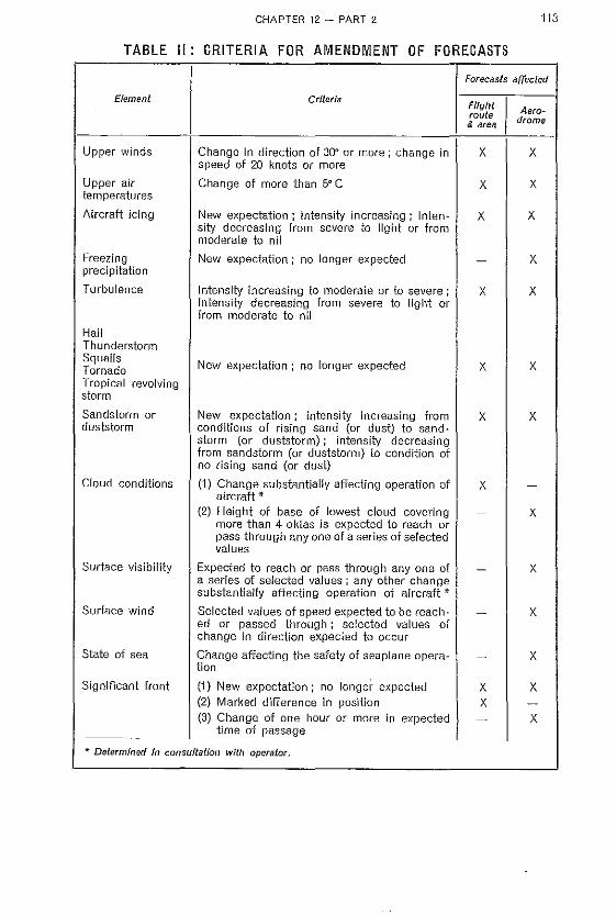
CHAPTER 12 - PART 2 113
TABLE II: CRITERIA FOR AMENDMENT OF FORECASTS
Element
Upper winds
Upper air temperatures
Aircraft icing
Freezing precipitation
Turbulence
Hail Thunderstorm Squalls Tornado Tropical revolving storm
Sandstorm or duststorm
Cloud conditions
Surface visibility
Surface wind
State of sea
Significant front
Criteria
Change in direction of 30G or more; cllange in speed of 20 knots or more
Change of more than 5" C
New expectation; intensity increasing; intensity decreasing from severe to light or from moderate to nil
New expectation; no longer expected
Intensity increasing to moderate or to severe; intensity decreasing from severe to light or from moderate to nil
New expectation; no longer expected
New expectation; intensity increasing from conditions of rising sand (or dust) to sand· storm (or duststorm); intensity decreasing from sandstorm (or duststorm) to condition of no rising sand (or dust)
(1) Change substantially affecting operation of aircraft *
(2) Height of base of lowest cloud covering more than 4 oktas is expected to reach or pass through anyone of a series of selected values
Expected to reach or pass through anyone of a series of selected values; any other change substantially affecting operation of aircraft * Selected values of speed expected to be reach· ed or passed through; selected values of change in direction expected to occur
Change affecting the safety of seaplane operation
(1) New expectation; no longer expected (2) Marked d'rfference in position (3) Change of one hour or more in expected
time of passage
lEo Determined in consultation with operator.
Forecasts affected
Flight I route & area
x
x
x
x
x
x
x
x X
Aerodrome
x
X
x
X
X
X
X
X
X
x
X
X
X

I ! I
l
I I I ! I ! I i ! I i I I I
114 CHAPTER 12 - PART 2
[12.2.] 2.5.6,2
Unless otherwise agreed locally, a warning of a gale shall be issued when the mean speed of the surface wind is expected to exceed 34 knots or when gusts in excess of 41 knots are expected.
[12.2.] 2.5.7
Criteria for amendments
[12.2.] 2.5.7.1
When considering the amendment of flight area route and aerodrome forecasts, meteDr~ oJogicaJ offices shall be guided by the criteria given in Table II. In applying these criteria the operator's local representative shall be consulted whenever necessary and practicable.
[12.2.] 2.5.7.2
The selected values referred to in Table II should be established by the Meteorological Authority concerned in consultation with those concerned.
[12.2.] 2.5.7.3
The criteria given in Table lJ do not apply to aerodrome forecasts which are issued on scheduled broadcasts. Such forecasts should be periodically reviewed and amended as necessary so as to ensure that each forecast, when broadcast, represents so far as practic~ able the latest opinion of the meteorological office concerned irrespective of whether or not the changes made are those required by application of the criteria in Table II..
[12.2.] 2.5.8
Aeronautical climatological information
[12.2.] 2.5.8.1
in so far as practicable, climatological summaries should be published, or otherwise mad~ 8l1ailable, for:
(a) Meteorological stations located at aerodromes and at operationally significant points on air routes (e.g. high level stations, stations on islands on air routes);
(b) Ocean stations; (c) Such other meteorological stations as are considered appropriate.
[12.2.] 2.5.8.2
In so far as practicable, aeronautical descriptive climatological. memoranda should be published for specified regions or portions of air routes, and for aerodromes, within the territory of the Member concerned.
[12.2.] 2.5.8.3
The preparation and publication of aeronautical descriptive climatological memoranda for regions or portions of air routes outside the territory of any Member should be undertaken in accordance with regional air navigation agreements, or as agreed between the Meteorological Authorities 'interested. . .
[12.2.] 2.5.8.4
The climatological summaries and aeronautical descriptive climatological memoranda referred to in [12.2.]2.5.8.1. [12.2.]2.5.8.2 and [12.2.]2.5.8.3 should be prepared in the forms, and according to the procedures, prescribed by WMO.

CHAPTER 12 - PART 2 115
[12.2.] 2.5.8.5
Climatological summaries and aeronautical descriptive climatological memoranda should be exchanged on request between Meteorological Authorities. Operators and other aeronautical interests desiring such information should normally apply to the Meteorological Authority responsible for its preparation or to the Meteorological Authority of the Member with which the operator is registered.
[12.2.] 2.5.8.6
Each ivJeteorological Authority, on request and to the extent practicable, should mal~e available:
(a) To any other Meteorological Authority and to others concerned with the application of meteorology to international air navigation or problems associated therewith, copies of odginal observations required for research and investigation;
(b) To any operator, observational data required for operational analysis.
[12.2.] 2.6
Forms of meteorological messages
[12.2.] 2.6.1
Routine reports
Routine reports from aeronautical meteorological stations shal! be:
(a) Disseminated locally in the AERO form of message, except where the use of plain language, O-code or other form is agreed locally;
(b) Exchanged between meteorological offices and transmitted to aircraft in flight in the AERO form of message, when a figure code prescribed by WMO is employed.
[12.2.] 2.6.2
Special reports Special reports from aeronautical meicofOlogical stations shall be:
(a) Dissemlnated locally in a form to be agreed with the airtraftlc services units concerned; (b) Exchanged between meteorological offices and transmitted to aircraft in flight in the
MMMMMjBBBBB or AERO form of messages, when a figure code prescribed by WMO is employed.
[12.2.] 2.6.2.1
If the AERO form of message is used for transmission of special reports a four-figure group shall be added to the report, giving the time (GMT) of the occurrence necessitating the special report.
[12.2.] 2.6.3
Reports for an appl'Oach-to-land The meteorological information provided to air traffk services units for an approach-to· land shall consist of the foflowing elements in the order shown:
Surface wind direction; Surface wind speed; Visibillty and/or if available runway visual range; Weather conditions; Cloud layers; amount, type and height of base;

'&-<
~ i ;ii
~ ~ " & ~ !
.il
~ ,
! ! r f I'
i , j
~ ! • !
i 1 I • I I I I;
!
J
I I I I I I ;
116 CHAPTER 12 - PART 2
Pressure value for altimeter setting; Remarks when required regarding:
Temperatt,Jre; Oewpoint; Gustiness; Heights of tops of clouds, etc.
[12.2.J 2.6.4
Forecasts and amendments to forecasts Forecasts and amendments to forecasts shall be disseminated locally in one of the forms prescribed for the exchange- of such information between meteorological offices,
[12.2.J 2.6.5
Ditching reports Ditching reports should be transmitted to aircraft in plain language or in Q-code and should comprise the following elements in the order indicated:
(a) Sea level pressure (specified as "approximate" wlien the report is not made- by an ocean station vessel or a selected ship);
(b) Surface wind direction in degrees true; (c) Surface wind speed in knots; c
(d) Swell-length, height and speed of waves and direction from whic~ they'are moving; (e) State of sea - length, height and speed of waves and direction from which they are
moving; (f) Visibility; (g) Amount and height above the sea of base of low cloud (both main layer and any scat
h~red: cloud below) ; (h) Present weather; (i) Remarks.
[12.2.J 2.6.6
Routine and special reports in plain language
[12.2.J 2.6.6.1
Order of elements The order of the elements in routine and special reports in plain language issued by meteorological offices should be:
(a) Identification of type of information which follows; (b) Time group; (e) Identification of location; (d) Wind (direction and speed, in that order) ; (eJ Visibility; (f) Weather conditions; (g) Cloud (amount, type and height of base, in that order, repeated as necessary); (h) Air temperature; (i) Dew point temperature (j) Pressure values (kJ Remarks.
} if required

[12.2.] 2.6.6.2
~arning messages
CHAPTER 12 - PART 2 117
In the case of a warning message, the word WARNING should precede the items given in [12.2.] 2.6.6.1.
[12.2.] 2.6.6.3
Preparation of messages
[12.2.] 2.6.6.3.1
Identification of type of information
The appropriate identifier, MET REPORT or SPECIAL should be used.
[12.2.] 2.6.6.3.2
Time group
Time in hours GMT and minutes should refer to the actual time of making the observation for the weather report.
[12.2.] 2.6.6.3.3
Wind
Direction should normally be given in degrees true using three figure followed by DEGREES. When the direction is not given in degrees true, this should be specified as DEGREES MAGNETIC. The unit for speed should be included e.g. 25 KNOTS. When appropriate, the terms VARIABLE and CALM should be employed e.g. VARIABLE 3 KNOTS.
[12.2.] 2.6.6.3.4
Visibility
The unit of visibility should be specified in full e.g. 15 KILOMETRES. When visibility is less than 3 kilometres (2 nautical miles) the units employed should be metres or yards.
[12.2.] 2.6.6.3.5
Weather conditions
Weather conditions should be given in the terms listed in Table III.
[12.2.] 2.6.6.3.6
Cloud
Cloud should be given in the order: amount-(type)·height-units, e.g. 6 OKTAS 500 METRES. The type of cloud should be included only when it is CUMULONIMBUS or NIMBOSTRATUS. Cloud amount shou'ld be given in oktas. The unit of height should be stated; METRES or FEET only should be used. The phrase SKY CLEAR should be used when appropriate.
[122.] 2.6.6.3.7
Air temperature and dew point temperature
Air temperature and dewpoint temperature when required should be given as e,g, TEM· PERA TURE 21 DEWPO!NT 8. For a temperature below zero degree Celsius, the value should be preceded by the word MINUS.
9

118
[12.2.] 2.6.6.3.8
Pressure values
CHAPTER 12 - PART 2
The value should be pr:eceded by the:'- appropriate O-signaL ;and followed" by the unit employed,
[12.2.] 2.6.7
Forecasts (and amendments to forecasts) in plain language
[12.2.] 2.6.7.1
Aerodrome foreca.sts The procedures of [12.2.J 2.6,6 apply also to aerodrome forecasts (and amendments thereto) in plain language, except that: . . --·"'\1' ,",'-.: (a) The period of validity of the forecast s_hould be given in th_8 time group;
(b) The identifier employed should ;;e FOREcAST or· AMENDED FORECAST, a~ appropriate.
::j.'
FlighC -ro"iJie -and a.rea forecasts' The-~-~~de~-:of the elements in ~ f1ighh.rolJte or i3,rea forecast (or an amendment thereto} it:1 plain lal1g_uag_8, should normally follow tlw,t Qf the "corresponding ,GodedJprm of ,message. In other respects, the procedures of [12.2.] 2.6.6 should be followed In $0 far <;I~ they are applicable, except that:
(a) The period of validity of the forecast should be given in the time group; . ' .- . i
(b) The identifiers employed should be FLIGHT FORECAST, ROUTE FOR~CI\;:;;I:! and AREA FORECAST preceded. in t~,e case of ~men.dm~nts, by tJ:le wO.rd
·AMENDED.
[12.2.] 2.6.7.3
Use of forecast code abbreviations When the abbreviations GRADU, RAPID, INTER and TEMPO are incl~de(J in coded forecasts, the terms should be used in the plain language message; when the numerical change group indicators are included in the coded forecasts, the terms indicated below should be used in the plain language message:
Coded forecast
96 GGG p 97 GGG p 98 GGG p 9999 G2
Plain language forecast
GRADU or RAPID as appropriate } TEMPO INTER PROS
followed by time groups
Other abbreviations denoting local variations used in coded forecasts should be given in full In the plain language message e.g. LOC should be given as LOCALLY.

TABLE III
CHAPTER 12 - PART 2
ABBREVIATED DECODE OF PRESENT WEATHER AND FORECAST WEATHER
119
The following decode for the present weather (ww) and the forecast weather (W1W1) is used when preparing plain language messages from reports and forecasts available only in coded forms,
Code
00-05 06
07 -09 10 11 -12 13 14 -16 17 18 19 20-29 30-32
33 -35
36-37 38-39
40
41 42 - 47 48-49
50-53 54- 55 56
57
58-59 60-63 64-65 66
English
(No mention) Widespread suspended dust (No mention) Mist Shallow fog lightning (No mention) Thunder (No mention) Funnel clouds (No mention) Duststorm or sandstorm Severe duststorm or sandstorm
Low drifting snow Blowing snow
Distant foy
Fog patches Fog Freezing fog
Drizzle Thick drizzle Freezing drizzle
Thick freezing drizzle
Drizzle and rain Rain Heavy rain Freezing rain
Decade
French
(neant) Poussiere en suspension generalisee (neant) Brume Brouillard mince Eclairs (neant) Tannerre (neant) Trombes (neant) Tempete de poussiere au sable Vialente tempete de poussiere ou sable Chasse-neige basse Chasse-neige elevee Brouillard a distance Bancs de brouHlard Brouillard Brouillard givrant
Bruine Forte bruine Bruine se congelant
Forte bruine se congelant
Bruine et pluie Pluie Forte pluie Pluie se congelant
Spanish
(No se menciona) Polvo en suspension extendido (No se menciona) Neblina Niebla baja Relampagos (No se menciona) Trueno (No se menciona) Tromba (No se menciona) Tolvanera 0 tempestad de arena Tolvanera 0 tempestad de arena fuerte Ventisca baja Venti sea alta
Niebla a distancia
Niebla en bancos Niebla Niebla engelante
Uovizna Uovizna fuerte Uavizna engelante
Uovizna fuerte engelante
Uovizna con Iluvia Uuvia Uuvia fuerte Uuvia engelante
Russian
(He rrepe.o;aeTcH) ilbIJIb, B3BerneHn8H n B03p;yxe (He rrepe.o;aeTcH) .II;LBfKa
TIoseMHblfI Ty;'lIaH 8apHHllhl (He rrepe,'l;aeTcH) rpOM (He ncpe,n:aeTcH) CMep'I (He rrepegae'l'cn) IIhIJTbHan HJHI
neC~IaHaff 6ypff
GtfJIhlIall IlbU(blIaff HJlH rrec~m.
HaR 6ypn IToaei\[QK HRaonan ;\reTe.rfb
Ty.L\IaH Ha pacToH
HHH
'I'YMaH HJIO'-IIW;o.HI
Ty.i\wn TY~WII C oem-RneIHW;'If Toep.u:ora oca}.(IW Mopocl> CHJlblIarr MOpOCb
Mopoer. C o6paaoBamre.i\I I'OJIoJ(e,iJ;a CHJIbHaH ;nopach C o6paSOllaI-IHCM rOJIOJIe;'l;a
MOpOCb H p;oa..,rt:b ,1J;omgb
CHJIhHhlfI nOi-liJJ;h
,1J;Oi:H;rJ;h C o6pasonamleM rOJIOJIep;a

120 CHAPTER 12 ~ PART 2
TABLE III (Continued)
Decode
Code EngJlsh French Spanish Russian
67 Heavy freezing rain Forte plule se Lluvla fuerte CllJIbHhl:fI }J;OiK}J;h
congelant engelante C o6pa30BaHHe.i\I rOJIoJIep;a
68 Rain and snow Pluie et neige Lluvia con nieve )J;OlliP;b co CHerOl\I
69 Heavy rain and Pluie et neige Fuerte Ifuvia con CIIJIbilLifl p;omAb snow fortes nieve co' CHerOi\[
70-73 Snow Neige Nleve CHer 74-75 Heavy snow Forte neige Nev!'lda fuerte CHJILHbln CHeI'
76 Ice needles Cristaux de glace Agujas de hlelo JIe,rr;RHhle HrJIbT
77 Granular snow Neige en grains Nieve granulada CHemUbIe 3epHR
~ 78 Snow Neige Nieve GHer
! 79 Ice pellets Gr-anules de glace Granos de hielo JIe,IJ;fIHOH JJ;OiKP;:O
, 80 Showers Averses Chaparrones JIHBIll1
I I 81 -82 Heavy showers Fortes averses Chaparrones CHJlbHbIe mlDHH
,i fuertes
1 83 Showers of rain Averses de pJuie Chaparrones de JIHBII6BOH .MO-
I and ~!lOW et ne_ige aguanieve HPbIit CHer
84 Heavy .showers of Fortes averses de Chaparrones fuer- CUJIbllLlfi JHIBH8-
rain and snow pluie ,et neige . te~.'_de aguanieve BOH MOHpnr"f1 CHeI'
I 85 Snow sh'owers Avets.es de neige ~,h~parrones de JIHBH8nofI CHeI'
I meve
86 He~vy _~'-now Fortes averses de Chaparrones C1!IJThHI>ltt JIHBH8-
sh~wers' nelge fuertes de nieve Bofl CHar
I 87 Hall showers Averses de gre~H Chaparrones de . JhlBHeBan RpyrrB
I . granizo. 88 Heavy hail showers Fortes averses de Chaparrones C.~lJIbHaff JIHDHe-
I gresil fuertes de granizQ Barr Rpyna
89 Hail showers Averses de grele Chaparrones de JIHB6Hb c rpa,rr;Oi':l , pedrisco
i 90 Heavy hail showers Fortes averses de Chaparrones CHJlbHbl~t JUIB8Hb
grele fuertes de pedrisco c rpap;oi.\I .:< 91 Rain Pluie Uuvia ,II;om,n;b 1 '. 92 Heavy rain Forte pluie Lluvia fuerte C:HJIhHbIH ,l1;Omp;b ~
f 93 Hail Grele Granizo rpa~
94 Heavy hall Forte chute de grele Granizadas fuertes CUJIbHhIH rpa,u;
t 95 Thunderstorm Orage Tormenta fpoaa
96 Thunderstorm with Orage avec grete Tormenta con rpoaa c rpap;o,'.1 ¥. hall granizo
97 Heavy thunder- Orage fort Tormenta fuerte CUJIbHaH rpoaa
storm 98 Thunderstorm and Orage avec tem- Tormenta_con rpoaa C llhIJIbHOii
duststorm pete de poussiere tolvanera 6ypefr
99 Heavy thunder- Orage fort avec T armenta fuerte CUJIbHaH rpoaa
storm with hai I greie can granlzQ c rpap;OuI
1 ! , , \'
}1 j, ;; ! i U il
I f
-'''~-.-.------- --

PART 3
[12.3] BRIEFING AND DOCUMENTATION PRACTICES
[12.3.) 1 BRIEFING
[12.3.]1.1
The purpose of meteorological briefing is to explain to pilots-in-command (or representatives designated by them), operators' local representatives, and air traffic services personnel, the prevailing meteorological situation over the areas and air routes with which they are concerned, the expected developments, upon which the forecasts are based and other possible but less probable developments, if any, which may occur and the effect of such other developments upon the conditions as forecast.
[12.3.] 1.2
The meteorological information available for use in briefing should include:
(a) Flight, route and area forecasts as appropriate; (b) Forecasts for the aerodromes concerned; (c) The most recent synoptic and prognostic charts for the surface and upper air and
appropriate aerological diagrams, together with appropriate previous charts and dia· grams;
(d) The latest available reports for aeronautical meteorological stations along the route or over the areas concerned;
(e) The latest available warning messages and advisory messages, including information of tropical disturbances or tropical revolving storms Ii kely to affect the routes or areas and the aerodromes concerned;
(f) Thp. latest available reports of observations received from aircraft along [he routes or in the areas concerned,
[12.3.) 2 PREPARATION OF DOCUMENTS
[12.3.] 2.1
Flight and aerodrome forecast (Model FA) *
[12.3.] 2.1.1
Heading Information identifying the forecast should be included in the spaces provided in the head· ing of the form. The standard ICAO abbreviations for the place-names of aerodromes may be used in lieu of the fuJI names, A significant point or points on the flight path should be entered after "via" if the flight is not direct.
* See models at the end of the publication.

, I !
I !
I I
I i I
~
I
I
I I , I I ~
122 CHAPTER 12 - PART 3
[12.3.] 2.1.2
Special features of the meteorological situation A brief statement should be inserted giving the outstanding features of the meteorological situation, with special reference to the intensity and movement of fronts, aircraft icing, turbulence, thunderstorms, etc.
[12.3.] 2.1.3
Zones The flight forecast should be prepared -for appr.opriate sections or zones along the flight path, identified by zone numbers, by latitude or longitude or by geographical locations.
[12.3.] 2.1.3.1 The zones employed should be those determined by agreement between the Meteorological Authorities concerned with the -foute in accordance with the following gHneral rules-:
(a) Ove~r oceans, 5_~degr'e-e zones of latitude .or longitude, ide-ntified by i~terna.tionallyagreE::d ,1:lUmtJ.ers, should normally. be used;
(b) Over land, 5-degree zones, identified_ by i-nter~ationa!ly-agreed numbers, or by geographical locations, should normally be used.
[12.3.] 2.1.4
Flig ht forecast
[12.3.]2.1.4.1
U,Dpe~' ~/n:ds: _an.d.- _fiPper air- temperatures
The wind and air temperature at each of a series of levels (up to a maximum of five levels), should be given in that order,_ ~The wind and air temperatiJre-at the lowest level should be entered on the first line, followed by those for the higher levelS on successive lines. The wind or ajr.,ter:npe.rature,gi\(~n -for a(lY level $hould be the. mean value over the zone- at that level_,unless,it is neeeqsa,ry -1:0 give the means over smaller sections than: the whole zone, in which case the successive mean values, separated· by the wor:d "becorT>ling"· shbutd be given in the order on_which th_e aircraft is expeded.to encounter them.. In specifying_ wind, the ditei:;ti6~ should be given first (as three figures fndicating degrees true, to. the _nearest 10 degrees) followed by an oblique strol~e and then the value of the speed [n knots (to the nearest 5 knots). Air temperature should be expressed by a fIgure or figures giving the value in degrees Celsius, preceded by the appropriate sign. When so agreed between the m,eteorological office and:_thE!_,0p~rat~r, ~quival~.nt t;;lH _Y"ind may be given in lieu of mean WInd values, .
[12.3.] 2.1.4.2
Cloud : :. The altitude of the- base of low cloud should be indicated, if required by the operator, for all zones, Where cloud below 1600 metres (5000 feet) above the general ground level is expected, the altitude of the base should be given, Where more than one layer of cloud is expected below 1600 metres (5000 feet) above the general ground level, the altitude afthe lowest cloud. base should be indicated, provided that the amount of this lowest cloud is 2 oktas or more, The altitude of the base of the next highest iayer should also be included if relevant. The altitude of the base of low cloud should always' be inserted for those zones in which the aerodromes listed in the flight plan are located, even if the operator does not require this information for all zones. A progressive change in the altih.ide through the zone, when significant, should be shown by two or more figures for the altitude, separated by the word "becoming" or by the word' 'then" in the case of an abrupt change, Occasional

CHAPTER 1'2. - PART 3 123
variations should be indicated in the same way, employing the word "occasionally". Special reference should be made, when necessary, to the height of the cloud base above the level of the ground under or in the vicinity of the proposed flight track and to the altitude of the cloud base in the vicinity affronts. The unit of measurement should always be stated with each value. Amounts should be indicated in oktas (employing the notation ~/8) and types by means of the standard abbreviations, The unit in which an altitude is expressed should be indicated against each value given. A range of values should be indicated by giving the limits separated by a hyphen, When variations with distance are expressed, the successive values should be given in the order in which the aircraft is expected to encounter them.
[12.3.) 2.1.4.3 Surface visibility Horizontal visibHity at the surface should be inserted for such zones as may be required by the operator. A progressive change in visibility through the zone, when significant, should be indicated by two or more Agures for visibility separated by the word "becoming" or by the word' 'then" in the case of an abrupt change. Occasional variations should be indicated in the same way, employing the word "occasionally", Special reference should be made, when necessary, to any conditions causing temporary variations, e.g. " ... in rain". The unit of measurement SllOUJd always be stated with each value.
[12.3.) 2.1.4.4
Altitude of zero degree Celsius isotherm The unit of altitude should be stated with each value. If the air temperature is 0° C at two altitudes, both altitudes should be given,
[12.3.) 2.1.4.5
Aircraft icing Aircraft icing should be described as "light", "moderate" or "severe" and an indication should be given of the locations or conditions in which it is expected to be encountered e.g, "in cloud", "in front",
NOT E : "Aircran icing" refers to ice deposited on the external parts 01 the aircraft.
[12.3.) 2.1.4.6 Lowest mean sea level pressure When required by the operator, the lowest value of mean sea level pressure expected to occur in the zone, during the period in which the aircraft is in the zane, should be inserted, with an indication of the unit of measurement (mb).
[12.3.]2.1.4.7
Remarxs The remarks should include any relevant information not given under "special features of the meteorological situation" or under the headings of individual elements, For high altitude flights, the height of the tropopause should be stated and also the altitude, direction and speed of any jet stream in the section or lone,
[12.3.) 2.1.5
Aerodrome forecasts
[12.3.) 2.1.5.1
Office of origin The meteorological office preparing the aerodrome forecast inserted on the form should be stated.

I I
"
i ,
124 CHAPTER 12--- PART3
[12,3,] 2,1,5,2
Til1)e of latest synoptic chart. used The time of the latest synoptic chart consuited for the preparation of the forec;::asT. should be [ns~rtedJ when appropriate.
[12,3,] 2,1,5,3
Surface wind direction an,d speed The direction should be stated in degrees true, followed by an oblique stroke and the value of the speed in knots. A statement on gustiness should be added, when appropriate.
[12,3,] 2,1.5A
Surface visibility The value Of, if necessary, the range of values and variations, should he stated, employing the, conventions prescribed In [12.3.] 2,1.4:3' as appropriate.
[12,3,] 2,1.5,5
Weather In decoding aerodrome forecasts for inclusion on the form, the decode given in Part 2, Table III, should be employed,
[12,3,] 2,1.5,6
Cloud The procedure prescribed in [12.3.} 2,1.4.2 should be followed, as appropriate.
[12;3,] ,2,2
Flight forecast folder
[12,3,] 2,2,1
Cover (Model C) Information identifying the forecast and the intended recipient shoL!td be included in the spaces provided on the cover, together with any other necessary information-,
[12,3,] 2,2.2
Cross-section and flight forecast form (Model F.1) The flight forecast should be prepared for appropriate sections or zones along the flight path, as prescribed in [12.3.] 2.1.3. Information Identifying the forecast should be inc.luded as indicated in [12.3.J 2.1.1.
[12,3,] 2,2,2,1
Pictorial representation On a cross-section for a flight path over both ocean and land areas, zones identified by internationally agreed numbers or by geographical locations may be ~~_~d.:
[12,3,] 2,2,2,2 The succession of zones should be from left to right on the cross-section with the aerodrome of departure assumed to be represented at the left-hand margin of the cross-section and the aerodrome of next intended landing, at which new documentation will be supplied, at the right-hand margin.
I

CHAPTER 12 - PART 3 125
[12.3.] 2.2.2.3 The horizontal scale for distance employed in constructing the cross-section should not be changed.
[12.3.] 2.2.2.4
The profile of the ground in the vicinity of the horizontal projection of the proposed flight track should be shown in heavy outline along the base of the cross-section, when its inclusion is required by the operator or is considered desirable by the meteorological office preparing the cross-section.
[12.3.] 2.2.2.5
A heal/Y double vertical line should be used to indicate on the crosg-section a marked change in the direction of the flight path or a change In the system of zone identification.
[12.3.] 2.2.2.6 If the cross-section is without printed vertical tines indicating divisions between sections or zones, such vertical lines should be inserted as necessary.
[12.3.] 2.2.2.7
Significant weather Significant weather should be indicated on the cross-section by means of the following symbols, placed at the points corresponding with the locations at which the phenomena are expected to occur,
Symbols
,~/'//
IjHJ 'J JJ/ Rain Severe icing ,/// J , // J/
~ f-reezing rain - Fog
& Ice pellets % Sand or duststorm
• *
Snow and rain mixed i+ Storm of drifting snow
* Snow J\... Moderate turbulence
... Hail JL Severe turbulence
~ Light icing \I Squall
IJiI Moderate icing R Thunderstorm

,
I i t I ~ ~ I j i , , ,
126
[12.3.] 2.2.2.8 Clouds
CHAPTER 12 - PART 3
Cloud should be indicated by pictorial representation of the general cloud structure expected to be encountered over the proposed flight path. This representation should be drawn to indicate against the altitude scale on the cross-section the expected altitudes of cloud bases and tops but may be generally representative only as regards horizontal extent. -The typ'es of cloud should be'indlcated by the- standard abbreviations inserted- within the cloud outline. The number of oktas of sky covered in the viciriity by cloud of the type indicated should be entered after the abbreviation. Shading 'or.colouring may be employed within the cloud outlines if desired. If colouring is employed, green should be used for those portions of douds wherein the temperature is expected to be above 00 Celsius and red should be used for those portions wherein the temperature is expected to be below 00 Celsius,
[12.3.] 2.2.2.9 Aircraft ie/ng and turbulence The symbols shown in the key on Form F, 1 for aircraft icing and turbulence should be placed within thecloud outline and among the precipitation symbols, inserte~ in,accordance with the provisions of [12.3.] 2.2.:3,'to indicate appro)):imatel~l.the portio[l oJ. thE! cloud -9r precipitation area in which the represented intensity is expected to occur.
NOT E : "Aircraft icing" refers to ice deposited on the external parts of the aircraft.
[12.3.]2.2.2.10 .'; "',, 00 eels/us .isotherm The ~ltjtuge(s) of. the 00 C~lsiu,s Jsothefm should be indic~ted by a heavy broken blad line or lines or by a continuous green line or lines,
[12.3.] 2.2.2.11 Fronts and convergence zones The types and positions of fronts should be shown by coloured lines as follows: warm front - red; cold front- blue: occlusion ----; purple; stationary front- alternating red and blue, Alternatively, when -the chart is prepated in one colour only, by the follov';ing system of representation :
warm front .. - cold front ......A. occlusion .... stationary front -,·-ft .,..-
When a front or convergence zone lies at a small angle to, or is parallel to the flight path, this should be specifically stated on the cross-section.
[12.3.] 2.2.2.12 Height of the tropopause For high level flights, the altitude of the tropopause should be indicated by a darl~ brown line,
[12.3.] 2.2.2.13 T abu/ar section
[12.3.] 2.2.2.13.1 Significant weather Symbols for significant weather, including aircraft icing and turbulence, which are indicated in the pictorial representation, should be repeated in this space for each appropriate zone, if required by the operator, When'! pifferent intensities for the same phenomena are shown within any.one lone, only that symbol representing the heaviest intensity sh'duld be inserted under "significant weather" for that lone.

[12.3.J 2.2.2.13.2
Remarks
CHAPTER 12 - PART 3 127
Any relevant information of importance, in addition to or in amplification of information given elsewhere on the form, should be inserted in plain language under "remarks" ; in particular, additional information regarding aircraft icing, turbulence, mountain waves, thunderstorms, intensity and movement of fronts and, when appropriate, state of sea surface, should be inserted. For high altitude flights the altitude, direction and speed of any jet stream in the section or zone should be stated,
[12.3.J 2.2.2.13.3
Aftitude of base of cloud
The procedures prescribed in [12.3,J 2.1.4.2 should be followed.
[12.3.J 2.2.2.13.4
Surface visibility
The procedure prescribed in [12.3.] 2.1.4.3 should be followed.
[12.3.J 2.2.2.13.5
Lowest mean sea level pressure
The value of the lowest mean sea level pressure should be inserted as indicated in [12.3.} 2.1.4.6.
[12.3.J 2.2.2.13.6
Upper winds and upper air temperatures
Upper winds and upper air temperatures should be inserted as indicated in [12 .3.} 2.1.4.1.
NOT E : By agreement between the Meteorological Authority and the-operator conc8med:, the.information specified above may be omitted, in whole or in part, for specified zones and below a specified altitude in both the pictorial representation and the tabular section, in the case of high lever flights.
[12.3.J 2.2.3
Aerodrome forecast (Model A)
Information identifying the document should be included in the spaces provided in the heading of the form and the remainder of the form should be completed as indicated in [12.3.J 2.1.5.
[12.3.J 2.2.4
Flight forecast (Model F.3)
The form should be completed in accordance with [12.3.] 2.1.2 to [12.3.] 2.1.4.7 inclusive.
[12.3J 2.2.5
Cross-seelion (Model F .2)
The form should be completed in accordance with the provisions of [12.3.] 2.2.2.1 to [12,3.} 2.2.2.12 inclusive.

, ,
! t
i ! § , I I i I I i , f ,
128 CHAPTER 12 - PART 3
[12.3.] 2.2.6
Prognostic chart of significant weather (Model SW)
[12.3.] 2.2.6.1
The prognostic chart of significant weather s'houJd be prepared for a fixed time Of as a composite chart, as appropriate, for the flight(s) concerned. Identification of the chart as a fixed time chart or a composite chart should be inserted in the title of the chart.
[12.3.] 2.2.6.2
The issuing meteorological office, the time of issue and the perioq of validity should be inserted in this heading,
[12.3.] 2.2.6.3
The unit used for expressing altitude should be indicated on the chart as tens of metres or hundreds of feet.
[12.3.] 2.2.6.4
The boundaries of the areas of significant weather, induding, aircraft icing, and turbulence, should be indicated on the chart, together with the clouds associated therewith, the positions of fronts (and, in tropical regions, of convergence zones). the locations of pressure centres and the projection, on to the surface represented by the chart, of the position(s) of the 0" Celsius isotherm.
[12.3.] 2.2.6.5
The types of significant weather (including aircraft Icing and turbulence) within each of the indicated areas should be represented by the symbols prescribed in [12.3.] 2.2.2.7. The altitude at which the phenomenon is forecast to occur should be indicated by flgl)res placed againstthe symbol; two figures should be given when the phenomenon is expected to occur between two altitudes, the figure for the"low8T altitude being plaC'ed"underneath that for the higher :altitude. When. necessary,- brief amplifying r.emarks- may be inserted within the area of significant weather. In such amplifying remarks the following abbrevJa 4
tions' should be used ,when appr-bpriate: - .
ClD - cloud(s) CNS - continuous SCT - scattered acc - occasional or BKN - broken occasionally
[12.3.] 2.2.6.6
Clouds should be indicated by one of the standard abbreviations, preceded by a fl,9ure giving the amount expected in oktas. The' abbreviation should be followed by figures giving the expected altitude of the top of the cloud and underneath the figures giving the expected altitude of the base of the cloud,
[12.3.] 2.2.7
The types and positions of fronts should be represented as. presc~ibed in [1~.3.] 2.2.~.11 ..
[12.3.] 2.2.8
The locations of centres of high and low pressure should be represented by the letters "Hit and "l" respectively and the position at the surface at the point of highest or lowest pressure should be indicated by H+", followed by the value of that pressure in millibars.
[12.3.] 2.2.9
The positions and altitudes of the OQ Celsius isotherms should be indicated- by Isohypses shown as continuous green lines or as heavy broken lines appropriately labelled with the altitude values to which they relate.

CHAPTER 12 - PART 3 129
[12.3.J 2.2.10
Prognostic char! for an upper level (Model Pa or Pb)
[12.3.J 2.2.10.1
The prognostic chart should be prepared for a fixed time or as a composite chart, as appropriate, for the flight(s) concerned. Identification of the chart as a prognostic cha!i for an upper level, together with an indication of the standard surface to which it relates should be inserted in the title of the chart.
[12.3.J 2.2.10.2
The issuing meteorological office, the time of issue and the period of validity should be inserted in the heading.
[12.3.J 2.2.10.3
The unit used for expressing altitude should be indicated on the chart as metres or feet.
[12.3.J 2.2.10.4 Pressure isohypses (contours) should be entered as continuous black lines, labelled with the altitude values to which they relate. When tIle wind direction at any point is significantly different from that of the contours, it should be indicated by arrows.
[12.3.J 2.2.10.5
Upper winds and upper air temperatures should be indicated by one of the following methods:
(a) Air temperature at selected points should be indicated by the insertion of the value of the air temperature, in whole degrees Celsius (preceded, if necessary, by a minus sign) inside a small circle. The distribution of wind speed should be indicated in this case by isotachs giving wind speed in knots for increments of 20 knots. Such isotachs should be represented by broken lines, marl(ed with the values of the '/Vind speed in knots to which they respectively refer;
(b) The mean air temperature and the direction and speed of the mean wind for each sector or zone of a track should be indicated against the tracl< in the following form:
TT dddVV
where TT is the air temperature in degrees Celsius (preceded, if necessary, by a minus sign),
ddd is the mean wind direction in degrees true, and VV is the mean wind speed in knots.
NOT E : When method (b) is employed, the upper winds and upper air temperatures indicated may be supplemented by corresponding information for levels above or below the standard level by agree· ment between the Meteorological Authority and the operator concerned.
[12.3.J 2.2.10.6 Zones of maximum speed of upper wind should be indicated by broad arrows.
[12.3.J 2.2.10.7 Fronts should be indicated as prescribed in [12.3.] 2.2.2.11.

I 1
I s
! I ! I
I , ! ! I I
130 CHAPTER 12 - PART 3
[12.3.] 2.2.10.8
When required for high .Ievel operatiolls, the .altitj..lde of th~ tropopause l:ihouJd be lndiGated by isohypses shown as continuous brown lines, or, if only one colour is used in the prepa· ration of the chart, by continuous black lines appropriately labelled,' with the values ofthe altitudes marked thereon.
['12,3.] 2.2.10.9
Centres of areas of high and low pressure should be jndicated by the symbols "H" and ilL" respectively.

PART 4
[12.4] AERONAUTICAL CLIMATOLOGICAL SUMMARIES AND AERONAUTICAL DESCRIPTIVE CLIMATOLOGICAL MEMORANDA
[12.4.] 1 AERONAUTICAL CLIMATOLOGICAL SUMMARIES
[12.4.]1.1
Subject to the provisions of [12.4.J 1.1.1 J [12.4.} 1.1.2 and (12.4.J 1.1.3 below, each Member should publish, or otherwise make available on request, as many as practicable of the following monthly and annual climatological summaries for each international aerodrome within its administrative jurisdiction at which the meteorological elements specified in each summary are observed and for such of its other meteorological stations as it considers necessary:
(a) Mean number of simultaneous occurrences of specified visibility ranges and specified ranges of the height of the base of the lowest cloud layer covering more than 4/8th8 of the sky at each of the eight synoptic hours for which data are available and for such additional hours as may be necessary adequately to represent the diurnal variation (Model A); *
(a') Mean number of occurrences of specified heights oHhe tops of the highest cloud layer of amount more than 4/8ths, the tops of which are below the level of the station (Model A');
(b) Mean number of occurrences of concurrent wind speed and direction within specified ranges at each of the eight synoptic hours for which data are available (Model 8);
(c) Mean number of occurrences of concurrent wind speed and direction within specified ranges when the horizontal visibility and/or the height of the base of the lowest cloud layer covering more than 4/8ths of the sky lie INithin .srp.dflecl ranges (Model C) for hours of observation and ranges agreed between the meteorological authorities and the users;
(c') Mean number of occurrences of specified values of surface dry bulb temperature and wind component along the runway (Model C'), for such hours of observation as will adequately show the diurnal variat'lon;
(d) Mean number of simUltaneous occurrences of specified values of surface dry butb temperature and mixing ratio at 0000, 0600, 1200 and 1800 GMT and mean number of occurrences of specified values of surface maximum and minimum temperatures (Model D1); or Mean number of occurrences of specified values of surrace dry bulb temperature and humidity at 0000, 0600, 1200, and 1800 GMT and of daily maximum and minimum dry bulb temperatures (Model D2);
(e) Mean number of occurrences of specified values of dry bulb and dew point temperatures at the surface and at standard pressure lelJels at 0300,0900, 1500 and 2100 GMT (Model E);
(f) Mean number of occurrences of specified values of atmospheric pressure at station level and mean monthly pressure (Model K),
;,. See page 134,

, T' ,
132 CHAPTER 12 - PART 4
[12.4.]1.1.1
When so requested, summaries referred to in (a), (b), (d), (e) and (f) should be prepared whenever practicable on a routine basis for each international aerodrome, in order to meet aeronautical requirements.
[12.4.]1.1.2
The summary referre_d tq In ,(a) ~nd I where appropriate, _ in-_(a'),_ shoul(j normally -be pre.pared on a routine hasis for any meteorological observing station situated at an operationally sigQificant [b_ya..tion ~J9n.9_ -aJj air route, -ih order" to- meet,-aerqnautic&1 req.lIire.ments ..
[12.4.] 1.2 ,-,-
Each Member should publish, or otherwise make available on request, the following monthly and annual climatological summaries in respect of each ocean station position for which it is responsible (or .for whicht it has been allocated climatological responsibility by agreement between the authorities concerned In the operation of the ocean station):
Mean number of 6cctrrences of specified values of dry bulb and d_ew' polnt,-te_mperatures at the surface aJid-'at standard pressure leve_ls at 0300,0900,';1500 ,an{2100' GMT (Model E).· . . .. . .
[12.4.] 1·.3 The_ p~ri;ct otr.ecord foreach c'lirnatological summ~ry sh~uld be npt less\han five years.
[12.4.] 1.4
The format of each summary should conform with the specified mode! (when .such a model is provided); the n'otes shoWn with the model being reproduced with each- sUnimary, -or set of summaries,· and each summary being compiled in the manner jndic,ated in' the supplementary notes.
[12.4.]1.5
When a Member is unable to comply fully with the provisions of [12.4.] 1.4 in the case of a particular summary, the format and method of compiling the-summary should be such that the summary approximates as closely as possible to the recommended model and will equally well meet the requirements of the users. -
[12.4.] 1.6
Each Member should keep the Secretariat currently advised of the climatological summaries which it is publishing, or is otherwise n-mking' available 'on request, and the Secretariat should issue annually a consolidated statement.
[12.4.]1.7
In order to facilitate the preparation of the climatological summaries necessary to meet aeronautical requirements, each Member should make provision, in so far as practicable, for recording on punched cards (or In some equally suitable form) all routine surface meteorological observations made at international aerodromes and all upperairobservations.

CHAPTER 12 - PART 4 133
(12.4.J 2 AERONAUTICAL DESCRIPTIVE MEMORANDA
[12.4.] 2.1
The information given in the climatological summaries should be amplified as necessary by aeronautical descriptive climatological memoranda for particular areas and air routes.
[12.4.] 2.2
Such descriptive memoranda should normally include:
(a) A discussion of the main climatological features of the area or air-route, with particular reference to seasonal variations;
(b) Descriptions of typical synoptic situations, of the weather conditions associated with them and of the influence of topography upon those conditions;
(c) A discussion of significant features of flight conditions, including upper winds, over the area or along the air route and notes upon the occurrence of phenomena of significance to international air operations e,g, hail, ice-accretion, turbulence, thunderstorms, tropical cyclones, etc. ;
(d) Discussions of the local weather conditions at the international aerodromes in the area or along the routes.
[124.] 2.3
The text should be illustrated by a topographical map of the area concerned, specimen synoptic charts for typical synoptIc situations and aerodrome weather diagrams, on the lines of Model T, for each of the international aerodromes concerned and should be supplemented by such statistical tables as are appropriate,*
'* For climatological summaries, see page 134 and following,
10

,~
~
I , , !
1 I I
I ~ ~
! ~ ! I
i i , I ! i ! " I i I I
I J
134 CHAPTER 12 - PART 4
CLIMATOLOGICAL SUMMARY - Model A
Notes for reproduction below the table
Notes: (a) The ranges of visibility are expressed by the ,figures of tile current international
meteorological code specification for VV. The height of the base_of the cloud layer is similarly expressed by the figures of the current international meteorological code specification for hshs•
(b) The figures in the column marked * indicate the number of occasions on which the specified visil:!Hity was observed in conjunction with-: ' (i) hshs = ·80 or mOore
(ii) cloud amount 4/8ths or less, (c) Insert note indicating the locations at which the observations were made, the method
of observation and the estimated accuracy, (d) An entry in the table gives the mean number of occurrences in the specified category
during the period of the record, Le. if N = number of years of record and n = total n~mb~r of occurr~nces in the category, then the entry is n/N.
(e) The entry "0" indica.tes that the mean, number is greater than zero but less than 0.05.
(f) If p is the mean proportion of occurrences of a particular discrete element for a specified
hour, i.e. ;K' the number of occurrences for a particular month will be approximately
distributed in the binomial distribution (p+ q)K, where q= 1-p, K is the number of days in the month and N equals the period of record. Probabilities of a month having greater than or less than a designated number of occurrences at the specified hour may be read from the attached chart. *
Notes for completion of the table
Entries should be made to the nearest 0.1. A separate table should be prepared for at least each of the eight synoptic hours for which observations are regularly available. Additional tables should be given for other hours if this is necessary for an adequate representation of the diurnal variation. Several of the tables may be printed on the same page to reduce the number of sheets required.
This form of summary may be used for other amounts of cloud if required. Other ranges of both visibility and height of base of cloud may be adopted to suit individual requirements; it is desirable, however, that the selected ranges should be such that they can be combined to conform to the categories of the model tables.
It The mode! for the attached chart is given as Model S.

CHAPTER 12 - PART 4
CLIMATOLOGICAL SUMMARY / RESUME CLIMATOLOGIQUE
Model A / Modele A
Station or aerodrome
Station ou aerodrome
Latitude . __
Latitude
Longitude
Longitude
Month
Mois
Time of observation
Heure d'observation
Period of record
Periode
Elevation
Altitude
______ . _______ . above MSL Total number of observations
Nombre total d'observations_
Mean number of simultaneous occurrences of specified visibility ranges and specified ranges of the height of the base of the lowest cloud layer
covering more than 4jBths of the sky
135
GMT TMG
Frequence moyenne de I'occurrence simultanee de va/eurs determinees de fa visibilite et de vafeurs determinees de la hauteur de la base de fa couche de 'nuages fa plus basse
couvrant plus de 4/B du ciei
~ VV CO 01 02 03 04 05 06·07 08-09 10·14 15-29 30-79 * Total
CO I 01
C2
~ 0·'
05
C ~
~ c-10-11
12-15
16-23
24-39
I '0
or more au plus
Total ,

,
I I
I
I
136 CHAPTER 12 - PART 4
CLIMATOLOGICAL SUMMARY - Model A'
Noles for reproduction below the table
Noles:
(a) An entry In the table gives the mean number of occurrences in the specified category during the period of the record, I.e, if N = number of years of record and n = total number of occurrences in the category, then the entry is n/N.
(b) The entry "0" indicates that the mean number is greater than zero but less than 0.05.
Notes for completion of the table
Entries should be made to the nearest 0.1. The number of hours of observation and the number for which the table is to be compiled is subject to local agreement.
The standard intervals are of 50 metres (150 feet). The altitude intervals in the table should therefore start at the first whole multiple of 50 metres next above the elevation of the station above MSL, and decrease in units of 50 _metres (or multiples of 50 metres) to the maximum distance below the station as is agreed upon locally.

CHAPTER 12 - PART 4 137
CLIMATOLOGICAL SUMMARY I RESUME CLIMATOLOGIQUE
Model A' I Modele A'
Station __________________________ .. __ ••.. __ .. _____________ . Month ~~~~.~.~~.~.~ .. Station Mois
Period of record Latitude
Latitude Peri od e ._____________ __________ _ ________________________ _
Longitude . ____________ _
Longitude
Elevation ______________ _ ____ above MSL Total number of observations __________________ _
Altitude Nombre total d'observations
Mean number of occurrences of specified altitudes of the tops of the highest cloud layer of amount of more than 4/8ths the tops of which
are below the level of the station
Frequence moyenne de I'occurrence de valeurs determinees de I'altitude du sommet de la couche de nuages la plus elevee couvrant plus de 4/8 du ciel
et doni Ie sammet est au-dessous du niveau de fa station
~ Hour Altitude des sommets of obser- des nuages Total vation GMT Heure TMG de I'observation
Tolal

I I ~ , I I I I I
! ~ I I ~ I I ~
! , ! , ,1 , I ,~ , I , i
138 CHAPTER 12 - PART 4
CLIMATOLOGICAL SUMMARY - .Model B
Noles for reproduction below the table
Noles:
(a) Wind direction is with reference to true north.
*(b) Inse~ note indicating the location of the anemometer and its type.
(c) An entry in the table gives the mean number of occurrences in the specified category during the period of the record, i.e. if N = number of years of record and n = total number of occurrences in the category, then the entry is n/N.
(d) The entry "0" indicates that the mean number is greater than zero but less than 0.05.
Notes for completion of the table
Entries should be made to the nearest 0.1, In the case of a land station, a separate table should be prepared for each of the eight synoptic hours for which observations are available. For a Marsden square aJi available observations for the four synoptic hours should be included in one table, The ranges of wind direction employed should be one of the foliowin,g, in accordanc~ with the method of observation:
(a) 16 comp_ass pOints
(b) 8 compass points
(c) 12 ranges of 30" each, beginning w[th 345" ~rue, i.e. 34;5" -14~, 15" - 44", 45" - 74", etc,
* Omitted in tables for Marsden squares,
- ~
"" II 'I
II
CHAPTER 12 - PART 4
CLIMATOLOGICAL SUMMARY I RESUME CLiMATOLOGIQUE
Model B I Modele B
Station or aerodrome or Marsden square
Station,
Month Time of observation
139
GMT
a~rodrome au . __________ ._ .. _____ .. Mois Heure d 'observation ............... TMG carre Marsden
Latitude
Latitude
Period of record _____ ._ .. __ . ___________ ..... _______ ._._
Longitude
Longitude _
Periode
Total number of observations
Nombre total d 'observations
Elevation ... ___________________ . above MSL Height of anemometer ____ above ground Altitude ____________________ _ Hauteur de l'anemomE'dre au-dessus du so! .
Mean number of occurrences of concurrent wind speed and direcUon within specifJed ranges
Frequence moyenne de "occurrence simultanee du vent, en vilesse et direction, entre certaines va/eurs determinees
Wind speed in knots Wind direction Vitesse du vent en nreuds Direction du 'len!
'-3 4-0 7-10 11-15 17-21 22-27 28-;)3 34-40 41-47 48-55 50-!l3 >63
Calm 1/ / / / 1/ / / / / / / / Catme
Total
Total

i
I
I I I I !
140 CHAPTER 12 ~ PART 4
CLIMATOLOGiCAl. SUMMARY - Model C
Noles for reproduction below the table Notes:
(a) WInd direction (dd) is with reference to true north. (b) Ranges of wind speed (ft) are given In knots.
*(c) The ranges of height of the base of the /owesfclol.id layer covering more than 4/Bths of the sky (hshs) are as follows: 00-01 = height equal to or greater than zero but less than 60 metres (200 feet) ; 02-04 = height equal to or greater than 60 metres (200 feet) but less than 150 metres
(500 feet) ; 05-09 = height equal to or greater than 150 metres (500 feet) but less than 300 metres
(1,000 feet). *(d) The ranges of horizontal visibility (VV) are as follows:
QO-03 = horizontal visibility equal to or greater than zero but less than 800 metres (880 yards) ;
04-07 = horizontal visibility equal to or greater than 800 metres (880 yards) but less than 1,600 metres (1 mile):
08-23 = horizontal visibility equal to or greater than 1,600 metres (1 mile) but less than 4,800 metres (3 miles),
(e) The wind observations upon which the above table is based are those made at the meteorological wind observation site at the aerodrome; the remaining observations are those made at the meteorological observation site for those elements,
(f) AI""! entry in the table gives the mean number of occurrences in the specified category duri'ng the period of the record, i,e, if N = number of years of record and n = total number of occurrences in the category, then the entry is nlN,
(g) The entry "0" indicates that the mean number is greater than zero but less than 0,05, *(h) When a combination of hshs and VV occurs which does no{co~res-pond with one of
the combinations listed hi- the coluinn headings of this table, the combination is counted in the lower of the two possible categ.ories, For example, an observation where hshs = 02 and VV =·03 would be counted in the column headed hshs = 00-01, VV~oo-m.
Notes for completion of the table
In general only one table is required for any specified amount of the lowest cloud layer, butthis will depend on local requirements, The ranges of wind direction and speed, of height of base of cloud and of horizontal visibility are to be inserted as required. In the absence of specifically stated limits, the foHowing ranges may be found suitable: (a) Wind direction: 16 compass points or ranges of 30" each, beginning with 345" (true),
Le. 345"-14°, 15"_44", 45"-74", etc, (b) Wind speed: 5 knots. (c) Height of base of lowest cloud layer covering more than 4/8ths of the sky:
(i) less than 60 metres (200 feet) (code 00-01) : (ii) 60 metres or above but less than 150 metres (500 feet) (code 02-04); (iii) 150 metres or above but less than 300 metres (1,000 feet) (code 05-09),
(d) Horizontal visibility: (i) less than 800 metres (880 yards) (code 00-03) ; (ii) 800 metres or over but less than 1,600 metres (1 mile) (code 04-07) ; (iii) 1,600 metres or over but less than 4,800 metres (3 miles) (code 08-23). If tables are required giving the combined frequency of wind speed and direction
with visibility and with height of base of cloud separately, the table heading should be amended by omitting the row giving the values of the unwanted parameter.
... The specific ranges inserted in the headings and in notes (e), (d) and (h) are examples only,

CHAPTER 12 - PART 4
CLIMATOLOGICAL SUMMARY I RESUME CLIMATOLOGIQUE
Model C I Modele C
Station or aerodrome _________________ _ ivlonth . _____________ Based on observations_
141
GMT Station ou aerodrome ivlois _____________ Base: observations de . ____________ . TMG
Latitude Latitu de ____________ _
Longitude
Longitude
Elevation _____________ _
Altitude above MSL
Period of record
Periode
Total number of observations
Nombre total d'observations ______________________ .
Mean number of occurrences of concurrent wind speed and direction within specified ranges when the horizontal visibifity and/or the height of the base of the lowest
cloud layer covering more than 4/8ths of the sKY lie within specified ranges
Frequence moyenne de I'occurrence simultanee du vent, en vitesse et direction, pour une serie de va/eurs specjflees de la visibilite horizonlale et (au) de la hauteur de la base
de la couche de nuages la plus basse cauvranl plus de 4/8 du ciel
" " 06· 7-10' Tolal
h,n. CO 01" 02-04 05 09 00-01 02-04. 05-09
"" and/or el(ou! 00-03" 04.-07 08-23 CO-03 04-07 08-23 'IV
Calm Calme -
I I
I
I
Tol~1 I
.,.. The specific ranges inserted in the headings are examples only. Les valeurs figurant dans les Hites de colonne ne sont mentionnees qu'a titre d'exemple

I j
I I i I ! I ~
I i !
142 CHAPTER 12 - PART 4
CLIMATOLOGICAL SUMMARY ~ Model C'
Noles for reproduction below· the table
Notes:
(a) Insert note stating the locations at which the wind observations and the temperature observations were made; these will normally be the meteorological observation sites for these elements at the station,
(b) A note should be given of any known relationship between the air temperature at various heights over the runway and the dry bulb temperature as observed for meteor· ological purposes,
(c) An entry in the table gives the mean number of occurrences in the specified category, i.e, if N = number of years of record and n = total number of occurrences in the category, then the entry is n/N.
(d) The entry "0''' indicates that the mean number is greater than zero but less than 0.05.
(e) [f p is the mean proportion of occurrences of a parl;icu[ar discrete element for a specified
hour, Le. NnK I th~ number of o~currences for a particular month will be approximately
distributed in the binomial distribution (p + q)K where q = 1 - p, K is the number of days in the month and N equals the period of the record. Probabilities of a month having greater than or less than a designated number of occurrences at the specified hour may be read- from ,the attached chat\,:* .
Notes for cQmpfetion of the tab(e
A separ~te t~bie_ should be ,prepa~~d for at least four eq~~'lIy spaced ~yoo-ptic I;ours~ so chosen as best to show the characteristics of the diurnal variation. Entries should be made to the nearest 0,1. The temperature intervals should be each two degrees Celsius or four degrees Fahrenheit. If the temperatures were originally recorded to tenths of a degree the figures should be rounded off to the nearest whole degree and the tabulations should be based upon the resulting figures. The preferred method of disposing of tenths is that which rounds off to the nearest whole degree with the quantity .5 thrown to the "odd" whole number. Thus 0.5 to 1.5 become 1 ; 1.6 to 2,4 become 2; 2.5 to 3,5 become 3; 3,6 to 4.4 become 4, etc.
If an alternative method of disposing of tenths is adopted the method should be specified in the notes below the table, The entries should distinguish between the two directions of the runway, e.g, in the example sl10wn SE winds are Inserted under runway 14 and NW winds under runway 32, Both runway and wind direction should be expressed in degrees true,
Calms are to be distinguished from winds blowing across the runway and would be entered only in the columns so marked, each wind observation being included in one column only.
* The model for the attached chart is given as Model S.

CHAPTER 12 - PART 4 143
CLIMATOLOGICAL SUMMARY I RESUME CLIMATOLOGIQUE
Model C' I Modele C'
Aerodrome .. _________ ___ . Runway __ 14/32· ........ . IVI an th ____________ .. . .... __ .. ___ ....
Aerodrome ________ ..... _ .. _. __ ..... __ .
latitude. __________ ..... _._. __ . __
latitude
Piste Mois_
Time of observation
Heure d 'observation
longitude
longitUde
Period of record _________________ . ___ . __ ._. ___ _
Elevation _
Altitude
__ " _____________ above MSl
Peri ode
T atal number of observations
Nombre total d'abservations
Mean number of simultaneous occurrences of specified values of surface dry bulb temperature and af ihe surface
wind component along a specified runway
Frequence moyenne de I'occurrence s;muftanee de va/eurs determinees de fa temperature en surface, au lhermamelre sec,
et de la camposanfe du vent en surface Ie long d'une piste determinee
Surface VVind component (knots) along the runway temperature Wind Composante du vent (en nceuds) Ie long de fa piste
'C calm
Temperature Vent 0·3 H 7-10 11-16 17-21 22-27 en surface calme
·c 14" 32' 14 32 14 32 14 32
The runway orientation is inserted as an example only, L'orientation de la piste n'est mention nee Qu'a titre d'exemple,
28-33 34-40 41-47
I
GMT TMG
>47
-

I I
I i ,
! i ! I , ! ! ~ ~ ;
I !
I i
144 CHAPTER 12 - PART 4
CLIMATOLOGICAL SUMMARY - Model D1
Noles for reproduction below the table
Notes:
(a) The observations upon which the above table is based are those made at the meteor· ological temperature observation site at the aerodrome.
(b) An entry in the table gives the mean number of occurrences in the specified category during the period of the record, i.e. if N = number of years of record and n = total number of occurrences in the category, then the entry is n/N.
(c) The entry "Qf" indicates that the mean number is greater than zero but less than 0.05.
(d) If P is the mean proportion of a particular discrete element for a specific hour, i.e.
NnK' the number of occurrences for a particular month will be approximately distributed
in the binomial distribution (p - q)K, where q = 1 - p, K is the number of days in the month and N equals the period of record. Probabilities of a month having greater or less than a designated number of occurrences at the specified hour may be read from the attached chart.*
Nate_s far completion of the table
A sep-arate table shoUICI - be ptep-area fol each of -tile four hours 0000; 0600, 1200, 1800 GMT for which observations are available. Additional tables should be given for other hours if this is necessary for an adequate representation of the diurnal variation. An additional "temperature" column may be inserted to permit of the adoption of different ranges for daily maximum and daily minimum temperatures.
The temperature intervals should be each two degrees Celsius or four degrees Fahrenheit. If the temperatures were originally recorded to tenths of a degree the figures should be rounded off to the nearest whole degree and the tabulations should be based upon the resulting figures. The preferred method of disposing of tenths is that which rounds off to the nearest whole degree, with the quantity .5 thrown to the "odd" whole number. Thus 0.5 to 1.5 become 1 ; 1.6 to 2.4 become 2; 2.5 to 3.5 become 3; 3.6 to 4.4 become 4, etc. If an alternative method of disposing of tenths is adopted the method should be specified in the notes below the table. The class intervals for the tabulation of mixing ratio should be established by dividing by 20 the whole range of mixing ratio for the year, subject to such intervals being not less than 0.5 gm/kg.
.. The mode! for the attached chart is given as Model S.

CHAPTER 12 - PART 4 145
CLIMATOLOGICAL SUMMARY I RESUME CLIMATOLOGIQUE
Model D, I Modele 0-1
Stati"0n or aerodrome _____________________________ •. Month Time of observation_. Heure d 'observation
__ GMT
TWIG Station ou aerodrome _. ___ . __ .. _ .. _
latitude latitude
longitude
longitude _ .. _ ... _ ....... _ ... _._ ..... _ .. _. ___ .. ___ ... _
Elevation .... ________________ . _____ above MSl
Altitude
MOis. ___ .. _. ____ _
Period of record. ______ . __ ... _______________ ......... _ ... _ ... .
Periode
Total number of observations _________________________ _ Nombre total d 'observations ___________________________ _
Mean number of simultaneous occurrences of specified values of surface dry bulb .temperature and mixing ratio,
and mean number of occurrences of specified values of maximum and minimum temperatures
Fffiquence moyenne de I'occurrence simultanee de valeurs determinees de /a temperature au thermometre sec et de /'humidiM specjfique, en surface, et frequence moyenne
de ('occurrence de valeurs determinees des temperatures quotidiennes maximum et minimum
~~ Temperature Daily Daily
Humidite speclfique maximum minimum g/llg O-m,
"C rn , -ffi2 m1 -m J Temperature Ouot!- Quoti· Temperature 'C dienfle dienne Temperatura 'C "C maximum minimum

,
I !
I 1 ! I I
i
I , , ! ~
I
I I I ., ,
146 CHAPTER 12 - PART 4
CLIMATOLOGICAL SUMMARY - Model 02
Noles for reproduction below the table
Noles,'
(a) The temperature observations upon which the above table is based are those made at the meteorological temperature observation site at the ?terodrome.
(b) An entry in the tables gives the mean number of occurrences in the specified category during the period of the record,
(c) The entry "(!1" indicates that the mean number is greater than zero but less than 0.05.
Noles for completion of the table
If no observation is made at one or more of the specified times, the appropriate column or columns may be omitted. Separate "Temperature" columns may be inserted for "any or all of the several elements to permit of the adoption of different ranges of temperature for different elements, if this is more convenient. If the temperatures were originally recorded to tenths of a degree, the figu(es should be rouflded off to the nearest whole degree and the tabuhition shoVld be· base,d upC?n the "n~sulting figures. The preferred Illetho.d.. of. dispo.'?lng of tenths js. that. given ,for Table 01 ; if an alternative mE:l:thod is used it should be specified in the notes below the table.
If ·the range·· of -\ialues· ·irwoJyed.}or ·th~:.Jiarticula( station· is· inconveniently -large· for tabLilation··of all the elements· against a"commori set of temperature intervals, two or more "Temp·erature" columns may be inserted in the table, the set of ·temperature intervals in any such column being selected to suit only the values of the particular observation to which it refers, The temperature intervals to be tabulated throughout the whole range of temperatures for each month are each two degrees Celsius or each four degrees Fahrenheit.
If the daily maximum or minimum dry bulb temperature observations are not obtained by means of maximum and minimum thermometers or from autographic records, a further note indicating how the tabulated values were determined should be inserted below the table. All observations for the month should be recorded in one lable. Entries should be made to the nearest 0.1. The class intervals for the tabulation of humidity mixing ratio, dew point or vapour pressure should be established by dividing by 20 the whole range of each parameter for the year, subject to such intervals being not less than 0.5 gm/kg, O.5"C and 1.0 mb respectively.

CHAPTER 12 - PART 4
CLIMATOLOGICAL SUMMARY I RESUME CLIMATOLOGIQUE
Model 02 I Modele 02
147
Station or aerodrome _ .. _. _____________ .•... Month _ Period of record. ____ .. ___________ _
Station ou aerodrome _ Mois Peri ode
Latitude _______ . ____ . __ .______ Total number of observations
Latitude __________ .. __ . _______________ ... __________ Nombre total d 'observations
Longitude . ___________ . ___ _ Height of thermometer above ground __________ _
Longitude. _ .. _____________________ .. __ .... _ Hauteur du thermo metre au-dessus du sol __ _
Elevation ___________ ._. ___________ above MSL
Altitude
Mean number of occurrences of specified values of surfa.ce dry bulb temperature and humidity at 0000, 0600, 1200 and 1800 GMT
and of daily maximum and minimum dry bulb temperatures
Frequence moyenne de I'occurrence de valeurs deierminees de 1a temperature au thermometre sec et de /'humidiM en surface a 0000, 0600, 1200 et 1800 TMG et des temperatures quotidiennes maximum et minim lim au ihermomfdre sec
Surface dry bulb temperature Surface"
Temperature Temperature en surface, thermometre sec Surface" "C ..
DaBy Temperature Daily
"C 0000 06CO 1200 1800 maximum minimum 0000 0600 GMT GMT GMT GMT QUotl- Quoti- GMT GMT TMG TMG TMG TMG dienne dienne TMG TMG
maximum minimum
.. Insert mixing ratio, dew point or vapour pressure. lndiquer I'humidite specifique, Ie point de rosee ou la tension de la vapeur.
«-* Insert gm/kg, ·C or mb. lndiquer g!kg,·C ou mb.
-------------
1200 1800 GMT GMT HAG TMG

!
I ! I i i !
I i
I ,
148 CHAPTER 12 - PART 4
CLIMATOLOGICAL SUMMARY - Model E
Noles for reproduction below the table
Noles:
(a) The mean number of occurrences at each of -the times of observation (0300, 0900, 1500, and 2100 GMT) of the specified temperature at the specified level is shown by entries within the appropriate square according to the following scheme:
Number at
0300
Number at
0900
Number Number at at
1500 2100
''-------'--------' (b) An entry in the table gives the mean number of occurreh'ces in the specified category
during'the period of the record, i.e. ·if N = number of years and n = total number of occurrences in the category; then the entry is IT/N-, - .
(c) The entry "\!flO indicate? that the mean number is great~r than zero but less than 0,05,.
(d) Insert note regarding the estimated accuracy of the data.
: Notes for compleifon of the table
Only the appropriate boxes need be filled in if less than four daily observational series are available. The temperature scale should be in steps of 2°C, the range for each level being selected to fit the observed values. Entries should be made to the nearest 0.1. Only one table Is required for each station. If the table is required for aeronautical purposes only, it may be prepared for the standard pressure levels only and dew point temperatures may be omitted.