section 1 overview - pearl river county, mississippi use.pdf · section 1 overview . 1.1 land use...
TRANSCRIPT

Section 1 Overview 1.1 Land Use Planning in Pearl River County Pearl River County—one of the fastest growing counties in Mississippi—is at a critical stage of its history. With a rural landscape providing a quality of life and abundant natural resources, its residents are committed to maintaining the character and sense of place that have made this county home to generations and newcomers hoping to benefit from the amenities of country life and small town living.
Even prior to Hurricane Katrina, Pearl River County was experiencing rapid development, spurred by inexpensive land, high quality of life, and proximity to major employment centers such as New Orleans, Gulfport and Biloxi. Located adjacent to the communities hardest hit by Hurricane Katrina, Pearl River County has also had a surge in population as Gulf Coast residents relocate. Since Hurricane Katrina, growth rates have increased dramatically, with a 30.5-percent increase in population projected by 2010.
Critical land use decisions and development in the near future will shape the visual, physical, economic, and environmental character of the County for decades. This component of the Comprehensive Plan aims to help the County adapt to current and projected growth rates and to guide the next twenty to twenty-five years of growth. Strategically allocating resources and coordinating new development will enhance the economic, natural and cultural resources of Pearl River County.
1.2 Purpose and Need Pearl River County has prepared this Land Use Plan with support from state grants to protect the quality of life for County residents, promote economic growth, and simultaneously guide development within the County in efficient ways to maintain a sense of place. This document is a part of a comprehensive plan that includes plans for transportation, housing, community character and image, public infrastructure, and economic development. This document will continue to be revisited and the Land Use Plan is a living document that will continue to evolve
1.3 Plan Overview The Land Use Plan that follows is intended to provide the roadmap for implementation of comprehensive plan related to land use, and contains the following sections;
An review and analysis of existing conditions, including land use, population, housing, economy, the built environment, and the natural environment;
A summary of recent growth trends and projections for population and build out to illustrate potential land use in the near future;
A 1-1
Land Use.doc

Section 1 Overview
A 1-2
Land Use.doc
Suggestions for implementing responsible growth management to preserve the county’s rural atmosphere through growth and conservation corridors;

Section 2 Existing Conditions 2.1 Land Use Identifying and defining current land uses enables a municipality to assess its resources and assets as well as help define its future needs. This section provides an inventory of the existing land use pattern and distribution within Pearl River County.
Land use delineation was created manually by examining post-Katrina aerial photography. Simplified land use categories were formulated and are explained in the table below:
Land Use Category Land Use Description
High Density Residential Residential areas with one or more units per acre. This includes townhomes, multi-family units, and single-family homes on lots smaller than 1 acre.
Low Density Residential Large residential areas with fewer than one unit per acre.
Rural Residential Residential low density areas with fewer than 10 contiguous dwelling units.
Commercial/Industrial/Institutional Any non-residential built environment. These parcels may be further delineated to show commercial, industrial and institutional land uses separately.
Open Space Recreational open space or parks.
Agricultural* Pasture, crop and small farmland.
Forest Any land with forest or shrub cover as well as land that has been recently cleared but not yet developed.
Infrastructure Roads and utility lines within a clear right of way.
*Agricultural land use areas were determined by the extent of cleared land and the absence of additional housing
units.
Aerial photography was employed in order to create a comprehensive Land Use Map and data was consolidated into the consolidated into the eight categories above.
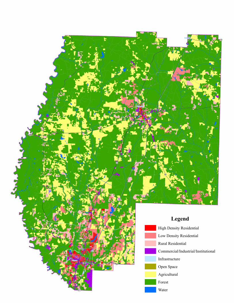
Pearl River County’s approximate 810 square miles are characterized by different types of land uses, as displayed in the Existing Land Use Map below (Figure 21). The
A 2-1
Land Use.doc
!(43
!(43
!(13
!(26
!(43
£¤11
!(43
!(13
§̈¦59
§̈¦59
!(53
!(607
!(43
!(26
Picayune
Poplarville
Lumberton
LegendHigh Density Residential
Low Density Residential
Rural Residential
Commercial/Industrial/Institutional
Infrastructure
Open Space
Agricultural
Forest
Water
Section 2 Existing Conditions
majority of the County is covered by forest or used for agricultural purposes, totaling more than 87 percent of the land area.
More than a quarter of the County’s residents (or 13,136 individuals) are found in its two cities: Picayune and Poplarville, according to the 2000 U.S. Census. Poplarville is the county seat and home to Pearl River Community College. The high density residential areas, those regions with more than one unit per acre, are concentrated within these two cities and along the Interstate 59 (I-59) and Hwy 11 corridor running from Poplarville south to the Mississippi/Louisiana border. These high-density neighborhoods are found in Picayune, Carrier, Poplarville, Nicholson and the Southeast. The Northeast, Steephollow, and Pine Grove neighborhoods are characterized as low-density. Low-density residential zones are areas with less than one unit per acre; they also tend to be concentrated along the major roadways: I-59, Hwy 11, State Highway 53 (MS 53) and State Highway 43 (MS 43). Rural residents, living in areas with less than 10 contiguous single-family residential lots, are found throughout the County. However, Amackertown, Crossroads and the other northwestern areas of the county are nearly exclusively rural in their residential character, whereas the southcentral region of the county is much more heavily populated. Housing developments of all types account for nearly 8.5 percent of the total land area.
The land devoted to recreational open space or parks is a relatively small amount (0.12 percent of total land acreage) and is found almost exclusively within the city limits of Picayune and Poplarville. The Pearl River, Wolf River, Hobolochitto Creek, as well as the lakes, rivers and tributaries that dot the county, make up less than 1 percent of the county’s total area.
Pearl River County’s infrastructure is 0.70 percent of the total acreage. The commercial, industrial and institutional areas, which include any non-residential development, make up just over 1 percent of the county’s total land area. These zones are found in pockets throughout the county but are concentrated in Picayune and Poplarville and along the Hwy 11 and I-59 transportation corridor. These areas consist of the commercial and retail establishments, as well as office parks, industrial parks, schools, hospitals, museums and public spaces.
Pearl River County is overwhelmingly undeveloped. Nearly three-quarters of the county is open space, forest land or part of the waterway system. In fact, there is more land devoted to agriculture alone than to all types of residential neighborhoods and support services (roadways, schools, retail establishments, workplaces, etc.). The county’s open space and sparse development is the foundation for the area’s rural character.
2.2 Population Demographics Pearl River County was home to 48,621 people in 2000 and the U.S. Census Bureau estimates that figure to have grown to 57,099 residents by mid-2006. (In all cases, the
A 2-3
Land Use.doc

Section 2 Existing Conditions
most recent available Census data is used.) This represents a 17.4 percent increase in the county’s population, significantly greater than Mississippi’s 2.7 percent population increase during those years. From 2005 to mid-2006 more than 4,600 new residents moved to the county, signifying a nearly 9 percent jump in population in that year alone. During this time period, Pearl River County was the 6th fastest growing county in the country, according to the U.S. Census Bureau. Many residents from the coastal counties of Hancock, Harrison and Jackson were moving further inland, for these counties were among those with the fastest rate of population decline from 2005 to mid-2006. According to 2000 census figures, more than 70 percent of the population lives in rural unincorporated areas of the county. As a result of such a high number of rural residents, the population density is slightly lower in the county than in the rest of the state, 60.0 and 60.6 persons per square mile respectively. Twenty-seven percent of the population lives within the limits of the county’s two cities: Poplarville and Picayune. Figures 22 and 23 depict the dispersion of the County’s population.
2.2.1 General Just like in the state as a whole, Pearl River County residents are slightly more likely to be female than male (51.2 percent were female in 2005). City residents are even more likely to be female (more than 54 percent for both cities). Nearly 25 percent of the county’s population in 2005, or 12,221 individuals, live with a disability, compared to 21 percent in the state as a whole. In 2000, veterans accounted for 15 percent of the population (compared to 12 percent of the state’s population) and slightly less than 1 percent of the population was institutionalized.
2.2.2. Age According to U.S. Census Bureau figures from 2000, Pearl River’s population is slightly older than the overall Mississippi population; for example, slightly more of the county’s population is 65 and older (12.6 and 12.1 percent respectively). As a result, the county’s median age is 35.9 (compared to 33.8 for the state of Mississippi).
2.2.3 Race and Ethnicity According to the Census Bureau’s 2005 estimates, Pearl River County residents are more likely to be white than residents throughout the state (85.8 percent and 61.2 percent respectively). Consequently, the county’s racial minority population is considerably smaller than the state’s (12.3 percent and 36.9 percent respectively are African American). Less than 1 percent of the County’s population report that they are of Native American or Asian descent, which is comparable to those reporting so in the state as a whole. These numbers change drastically when focusing on the urban centers within the County. In 2000, approximately 26 percent and 38 percent of Poplarville and Picayune residents respectively consider themselves a member of a racial minority group. Pearl River County residents are slightly more likely to report as being more than one race (1.0 percent compared to 0.6 percent for the state as a whole). Additionally, persons of Hispanic or Latino origin represent a similar
A 2-4
Land Use.doc

!(43
!(43
!(13
!(26
!(43
£¤11
!(43
!(13
§̈¦59
§̈¦59
!(53
!(607
!(43
!(26
Population by Block Group797 - 11681169 - 15261527 - 21102111 - 29942995 - 4480
Pearl River County, MSDemographic Profile
\\CAMDFT681C1\Projects\PearlRiver\figure26a.mxd 03/2007 LJW
³0 2 4 6 8 Miles

!(43
!(43
!(13
!(26
!(43
£¤11
!(43
!(13
§̈¦59
§̈¦59
!(53
!(607
!(43
!(26
Elderly Population (%)8.5 - 9.5%9.5 - 11.4%11.4 -13.6%13.6 - 16.2%16.2 - 20.1%
Pearl River County, MSDemographic Profile
\\CAMDFT681C1\Projects\PearlRiver\figure26a.mxd 03/2007 LJW
³0 2 4 6 8 Miles

Section 2 Existing Conditions
proportion of the population within the county than they do within the state (1.6 and 1.7 percent respectively).
Just over 1 percent of residents, according to the 2000 census, are foreign born, nearly 96 percent of whom were born in Europe, Latin America or Asia. French, English, German and Irish are the most common ancestries reported (together totaling nearly 35 percent). Fewer than 4 percent of residents speak a language other than English at home.
2.2.4 Education Pearl River County residents, according to 2000 census figures, are more likely to be high school graduates than Mississippi residents are as a whole (74.6 and 72.9 percent respectively). However, they are less likely to have a bachelor’s degree or higher (13.9 and 16.9 percent respectively). City residents are more likely to achieve higher degrees, 15.5 percent of Picayune residents and more than 22 percent of Poplarville (home to Pearl River County Community College) residents have a bachelor’s degree or higher. Approximately 2,000 individuals (or 4 percent of the population) are currently enrolled in college or graduate school. Nearly 50 percent of the children and young adults enrolled in school are in elementary school. High school students make up 22 percent of the county’s school enrollment.
2.3 Economics Existing economic forces in the Gulf Coast region influence how land is used and capitalized within Pearl River County. There are a number of industrial and commercial centers which serve to stimulate the local economy. The John C. Stennis Space Center in neighboring Hancock County is a prestigious draw for a highly-educated and specialized workforce. Nearly 62 percent of its employees have achieved a Bachelor’s degree or higher. Furthermore, more of the Center’s employees live in Pearl River County than in any other surrounding municipality, including Hancock County itself. (Source: John C. Stennis Space Center. “2005 Economic Impact.” March 2006.) Thus, the Center, and in turn, Pearl River County, is attracting a highly skilled and well-educated labor force.
The Center supports many federal, state, academic and private organizations within Pearl River County, including contractors such as Ionatron, which works to disable vehicle electrical instrumentation systems. Additionally, plastics manufacturing is an emerging industry in the County; Heritage Plastics is one of Pearl River’s largest employers (a 110-person workforce).
The health care and aviation industries are also growing within the County. Forrest General Hospital extended its services through its 2006 acquisition of Crosby Memorial Hospital and the Picayune Airport expanded its terminal in order to better serve the charter interests of the community. Chevron-Texaco, Inc. and El Paso Energy both have helicopter maintenance facilities located at the airport.
A 2-7
Land Use.doc

Section 2 Existing Conditions
Additionally, Chevron recently relocated its offices from the Gulf Coast to Picayune and is now one of the County’s largest local employers.
According to the Mississippi Employment Security Commission, as of 2001, the labor force within Pearl River County counted 20,920. The local government, including the cities and county, is among the top employers in the County. Other leading employers within the County include Avon Engineered Fabrications, Wal-Mart, Home Depot, Movie Star, Inc., Huey Stockstill, Inc., and Valspar Refinish, Inc. Additionally, there are organizations working within the County to stimulate and promote economic growth through business incentives and workforce training: Partners for Pearl River County, Mississippi Gulf Coast Alliance for Economic Development and the Pearl River Community College (PRCC) Workforce Development Center.
2.4 Development/Built Environment Development within Pearl River County is expanding greatly, fueled by the post-Katrina population increase, the demand for housing in safer, higher ground, and the relatively inexpensive cost of land in the county. The number of building permits issued within the County nearly doubled from 788 in 2005 to 1,537 in 2006.
The majority of development occurs within and around the two cities of Picayune and Poplarville. Just seven communities, including the cities, Nicholson, Salem, Caesar, McNeill and Whitesand, contain more than a third of the County’s development projects. Those districts where development is not occurring as rapidly are found throughout the County but are concentrated in Pearl River County’s central and northeastern region.
Several common building types and styles give form to Pearl River County’s built environment. Development in the county is overwhelmingly residential. More than 75 percent of buildings constructed within the County are homes, single- or multi-family, including mobile homes. Residential buildings vary, but the majority of structures within the County are one story houses, accounting for more than a third of all new buildings in 2003. A ubiquitous housing typology in the unincorporated portions of the county is the single-story brick home with low pitched roofs of red metal or asphalt shingle. Most commonly these buildings are situated on large lots, set back fairly far, located on arterials, collectors, and local roads.
In the urban areas of the County, residential neighborhoods typically consist of two-story structures on lots no narrower than approximately 80 feet. Buildings are single-family residences set back roughly 50 feet from the street, and sidewalks are sometimes present on one or both sides of the roadway. While there is no single architectural style, buildings in residential urban neighborhoods tend to have pitched roofs and prominent front porches. Garages and carports are often set back farther than the primary building frontage or located in the rear. Buildings in these neighborhoods use a wide variety of materials including brick, stucco, and wood
A 2-8
Land Use.doc

Section 2 Existing Conditions
siding painted in a range of colors. There are many historic buildings in urban residential neighborhoods, dating from the first half of the 20th century or earlier.
A great deal of recent residential development is in large subdivisions. The most common building typology here is the two-story brick and stucco single-family house. Common architectural elements include small front porches, columns, and steep pitched roofs covered with asphalt tiles. It is common for two- or three-car garages to be located on the façade of the main street frontage. These buildings are generally located on lots ranging from one to one-half acres. Front set backs vary but tend to be greater than in traditional urban residential neighborhoods. Roads through the residential development are generally curved and a minimum of 24 feet wide. Buildings are located several hundred feet from each other, and frequently their primary frontages are not aligned, instead the structures are oriented at different angles away from the street and neighbors.
Commercial development comprises only 3 percent of all development. Outside of city centers, retail is found primarily along the major arterials that feed the cities of Picayune and Poplarville. These districts center around two-lane roads that carry high-speed traffic and have no sidewalk or shoulder. Attached retail, or strip malls is a common typology in these areas. The buildings’ frontages are separated from the roadway by large parking lots that often comprise a significant portion of the lot. The structures are one story tall and contain little architectural detailing or variation. Concrete and stucco are common siding materials, and roofs tend to be metal. Individual businesses are not differentiated in the façade. Glazing rarely makes up more than 40-50 percent of the façade.
Unattached retail is also common in these corridors. This type of development does not follow a single typology, and it ranges from big box to small converted structures. Like attached retail, these buildings are almost always setback from the roadway and contain a great deal of surface parking in front of the structure.
Pearl River County’s downtowns contain a variety of buildings that define the County’s physical environment. Several historic civic buildings such as the old Picayune City Hall, and the Pearl River County Courthouse in Poplarville are markers of the county’s past. The downtowns contain a mix of single- and two-story buildings. The streetwall is generally consistent, with building frontages lining up to the sidewalks. Facades contain over 50 percent glazing and distinctive signage. Streets are two lanes with parallel parking and sidewalks on both sides. There are few street trees or street furniture. This traditional downtown fabric is interrupted in places by other types of buildings, such as large metal structures that house light industry or offices, or chain restaurants and retail businesses with larger signs and drive-through windows.
A 2-9
Land Use.doc

Section 2 Existing Conditions
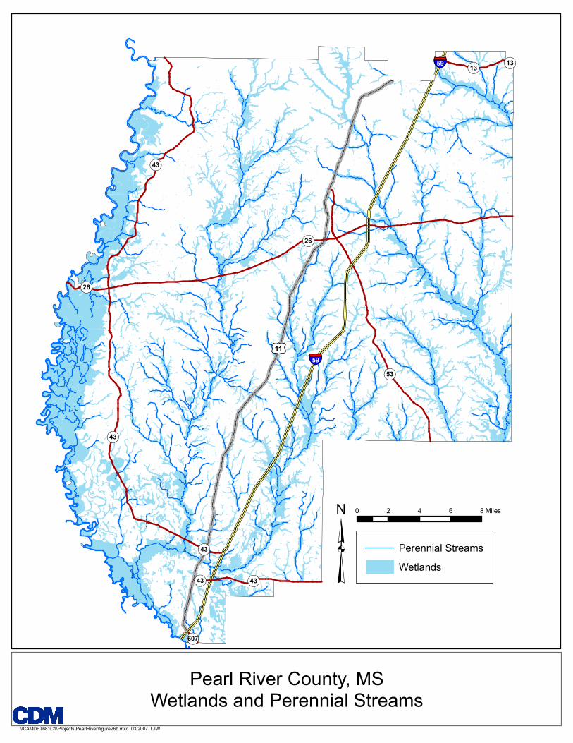
2.5 Natural Environment Pearl River County is extensively undeveloped, which enables its natural beauty to remain not only unspoiled but one of its most notable assets. The County’s namesake, Pearl River, serves as its 116-mile western border with Louisiana. The River provides opportunities for fishing, boating and swimming for the region’s residents. Smaller rivers, streams and creeks, such as the Wolf River and Hobolochitto Creek, are found throughout the County. More than one-fifth of the County’s total acreage (112,005 acres) is within a floodplain zone, as shown in Figure 24. These are areas adjacent to rivers which are inundated in a flood that has a 1 percent (100-year) or 0.2 percent (500-year) annual chance of occurrence. An additional 25,000 acres are not in a floodplain but are considered wetlands, as shown in Figure 25. Picayune alone contains more than 8,300 acres of freshwater wetlands, the majority of which are found along and within the Bogue Chitto National Wildlife Refuge.
The Wolf River was designated as the State’s first Scenic Stream in 2000 (MS Code of 1972, as amended, SEC. 51-4-23), and is included in the State Scenic Streams Stewardship Program. Hunting is a popular activity within the county. The Wolf River Wildlife Management Area, which spans the county’s northern border into Lamar County, and the Old River Wildlife Management Area, east of MS 43, together make up more than 26,200 acres reserved specifically for hunting, fishing and preserving the natural environment.
Pearl River County is located in the Piney Woods soil area, characterized by gently rolling hills and ridges. The DeSoto National Forest, located in the northeastern most corner of the county, spans into seven neighboring counties and at 378,538 acres is the largest national forest in Mississippi. Nearly 170 miles of trails on the DeSoto are accessible to hikers, ATV riders, mountain bike riders and horse riders.
The county enjoys a mild climate with annual temperatures averaging in the upper 60’s. Mean winter temperatures range from 38 to 65 degrees Fahrenheit with summer temperatures ranging from 69 to 91 degrees Fahrenheit. January, on average, is the coolest month, whereas July is usually the warmest. Average monthly precipitation is approximately 5.3 inches, with March and July the wettest months, each accumulating nearly 6.5 inches of rain. The County’s location near the Gulf makes it susceptible to high winds and heavy rains.
A 2-10
Land Use.doc

!(43
!(43
!(13
!(26
!(43
£¤11
!(43
!(13
§̈¦59
§̈¦59
!(53
!(607
!(43
!(26
Perennial StreamsWetlands
Pearl River County, MSWetlands and Perennial Streams
\\CAMDFT681C1\Projects\PearlRiver\figure26b.mxd 03/2007 LJW
³0 2 4 6 8 Miles

!(43
!(43
!(13
!(26
!(43
£¤11
!(43
!(13
§̈¦59
§̈¦59
!(53
!(607
!(43
!(26
Perennial Streams100-year Floodplains500-year Floodplains
Pearl River County, MSFloodplains and Perennial Streams
\\CAMDFT681C1\Projects\PearlRiver\figure26a.mxd 03/2007 LJW
³0 2 4 6 8 Miles

Section 3 Growth Trends Determining how to best guide growth in Pearl River County requires an awareness of the extent and nature of this growth. This section presents the predictions for how, what, and where growth will take place in the county during the next 20 years.
3.1 Population Projections 3.1.1 Factors Behind Population Growth The population of Pearl River County is expected to grow substantially in the next 20 years. In the months following Hurricane Katrina, the population jumped as much as 14%, and several hurricane-related explanations are among the factors for long-term growth in the coming years.
The population of Pearl River County is expected to grow substantially in the next 20 years. In the months following Hurricane Katrina, the population jumped as much as 14%, and several hurricane-related explanations are among the factors for long-term growth in the coming years.
3.1.2 Population Figures Conservative estimates of population growth in Pearl River County indicate that by the year 2025 the population will have grown by over 75% of its 2005 level. The greatest rise in population is expected to occur between 2005 and 2010, due largely to the immediate effects of Katrina, as discussed above. In the following fifteen years, the population is expected to continue growing at a rapid pace. Even these population projections, which are conservative, point to the great population growth that is expected in the coming 20 years. (These population projections were publicly released by the state of Mississippi in fall 2006.) 2005 2010 2015 2020 2025
Population 51,809 67,624 76,511 83,649 91,454
Percent Growth (from preceding year)
23% 12% 9% 9%
Population growth was calculated separately for the eight census tracts within Pearl River County. The tracts with the greatest growth are in the south of the county, specifically in and around Picayune.
3.2 Development Projection The substantial growth in population forecast for the next twenty years is linked to substantial development of the land in Pearl River County. It is estimated that by 2025 almost 30,000 acres will be developed to accommodate this growth. The table below summarizes the development of land that will accompany the increase in population.
A 3-1
Land Use.doc

Section 3 Growth Trends
Using the population projections discussed above, development was projected to 2015 and 2025. 2015 projections indicate how development will occur in the short term, while 2025 projections can help one to imagine the developed landscape at the end of the planning period. As with the population projections, the development calculations are conservative, but they nonetheless show a steep increase in developed acreage in the next twenty years. (Methodology for development projections is explained sections 3.2.1 and 3.2.2.)
2005 2015 2025
Residential Acreage* 41,568 50,667 63,453
Commercial/Industrial* Acreage 3,405 7,655 10,655
*Development projections do not include US Census tract 950600, which corresponds with the City of Picayune, as
most of the city is currently developed, and additional development will increase density rather than consume open
space.
3.2.1 Residential Development As the population of Pearl River County grows, residential development will account for the majority of new land development in the next 20 years. By 2025 it is predicted that almost 22,000 acres of land that are now undeveloped will be used for new housing. This new development constitutes an approximately 50% increase in the housing stock of the county and will lead to the creation of new neighborhoods and residential communities. This is a sizeable change that will have a major impact on the land use and natural resources of the county.
Residential development projections were calculated by dividing the projected population figure for each census tract by the number of persons per housing unit. This calculation yields the future total number of housing units in each tract. (Based on 2005 US Census data, there was an average of 2.65 persons per housing unit in 2005, and this number was extended out to 2015 and 2025 using a geometric regression equation and taking into account national trends in household size.) Translating the number of housing units into acres of developed land was achieved by multiplying the number of housing units by the typical acreage of high density, low density, and rural residential areas determined during the land use analysis. This was done for each census tract according the proportion of residential densities that existed in 2005.
A 3-2
Land Use.doc

Section 3 Growth Trends
The Breakdown of residential densities for the County overall is shown in the table below; this proportion of residential densities was maintained constant in the projections for 2015 and 2025.
RESIDENTIAL DENSITIES IN 2005 (entire county)
PERCENT OF RESIDENTIAL LAND AREA
High Density Residential 25%
Low Density Residential 68%
Rural Residential 7%
The result is a detailed estimate that projects the breakdown and types of future residential development.
3.2.2 Commercial Development Commercial development is difficult to project using a numerical coefficient, as there is no commercial equivalent to “persons per housing unit” used in the analysis of residential development. Nonetheless, it is possible to forecast a certain amount of growth for the next twenty years based on current projects and typical ratios between residential population and retail and office square footage (in essence a “population to business” ratio).
The amount of land devoted to commercial and industrial development in Pearl River County is expected to more than double within the next 20 years. A substantial portion of the projected development is anticipated to occur in office and industrial parks that are linked to the County’s economic development planning efforts. Big box retail (single business covering 20,000-200,000 square feet) and smaller local retail comprise the balance of the projected commercial development. Currently, development in all of these segments is increasing, and with the growth of the population and continued economic development efforts, it is predicted that the trend for increased development will continue.
A 3-3
Land Use.doc

Section 3 Growth Trends
Acreage 2005 2015 2025
Office/Industrial park
+3,000 +900
Small retail +950 +2,100
Big box retail +300
Total 3,405 7,655 10,655
3.3 Buildout Analysis In the absence of growth controls and planning, the projected new development could occur anywhere in the county. Using a buildout model, it is possible to approximate where the projected development would likely take place, assuming that no growth management is applied. This analysis can help determine the areas that would be most likely to experience near term growth, based on assumptions that growth is less expensive to the development community, and has greater access to jobs, shopping, health care, and public services when it occurs at the periphery of existing development. These standard development assumptions can help illustrate how the County might potentially build out/develop in the future without management tools.
3.3.1 Methodology As described above, the number of housing units in each census tract was projected and then categorized as high density, low density, and rural residential in the same proportion that existed in 2005. The 2005 land use map was divided into 25-acre grid squares, where each of the grid squares has a specific capacity for new housing units. These capacities were based on the typical densities observed in Pearl River County in the 2005 Land Use map and the current population data: high density residential was defined as 1.4 units/acre (.71 acres/unit); low density residential was defined as .67 units/acre (1.5 acres/unit); and rural residential was set at .07 units/acre (15 acres/unit).
The focus of this analysis is to predict the most probable locations that will experience new land development (vs. site redevelopment). Therefore, urban infill areas were not included. Census tract 600 was eliminated from these analyses, as it is entirely contained by the City of Picayune. Likewise, figures for census tracts that include Picayune were reduced in proportion to the percentage of land contained by the city. In addition, the areas that are currently high density residential, low density residential, and rural residential were treated as fully-built out, and new construction was located only on areas that were Forest or Agricultural in 2005.
A 3-4
Land Use.doc

Section 3 Growth Trends
The buildout analysis attempts to simulate a typical and often observed development process by applying a mix of criteria that approximate the decision process used in selecting development sites. Given recent trends in Pearl River County (see Sec. 2 Existing Conditions), it seems likely that new development will be located along major roads. Access to existing sewers is also a traditional draw for developers. New development also tends to occur adjacent to existing development. These three factors were combined to rate the likelihood of development of each of the grid squares in the county. The projected number of housing units was then geographically distributed based on which of the currently undeveloped areas of the county were most likely to be developed. This process was conducted for 2015 and 2025.
The result is a theoretical forecast of the land use pattern in 2015 and 2025 that is likely if growth is not planned and managed. This analysis illustrates what this growth will look like in terms of physical development and the use of forest and agricultural land if the population grows as projected.
3.3.2 2015 Buildout The 2015 buildout map (Figure 26) projects the addition of 6,276 housing units and over 4,000 acres of commercial and industrial development to the existing development landscape. The bulk of the growth takes place in the south of the county, around Picayune. Agricultural and forest areas along Highway 43 could see the most striking change, as this area was predominantly undeveloped in 2005. New residential development is also predicted in the 11-59 corridor north of Picayune.
In the northern portions of the county, new residential growth is predicted to cluster around Poplarville, particularly along Route 26. Commercial development in Hillsdale is also expected to increase substantially.
A 3-5
Land Use.doc

£¤11
§̈¦59
§̈¦59 !(13
!(26
!(53
!(43
!(607
!(43!(43
!(13
!(43
Legend
High Density Residential
Low Density Residential
Rural Residential
Commercial/Industrial/Institutional
Infrastructure
Open Space
Agricultural
Forest
Water

Section 3 Growth Trends
3.3.3 2025 Buildout By 2025, it is possible that there will virtually no forest and agricultural land in the two-mile radius surrounding Picayune, with dense development reaching as far as three miles from the city boundary. The city and its surroundings are expected to be built up with an additional housing units. Commercial and industrial development near the southern border of the county could also expand substantially. The areas adjoining Highway 43 could see further development, and the 11-59 corridor near Picayune could become densely built-up.
Poplarville could experience a great expansion by 2025. High density residential development would be likely to occur along Highway 11 and Route 26.
A 3-7
Land Use.doc

£¤11
§̈¦59
§̈¦59 !(13
!(26
!(53
!(43
!(607
!(43!(43
!(13
!(43
Legend
High Density Residential
Low Density Residential
Rural Residential
Commercial/Industrial/Institutional
Infrastructure
Open Space
Agricultural
Forest
Water

Section 3 Growth Trends
3.3.4 Guiding Future Growth The buildout projections herein are theoretical, and development will not occur in exactly the manner projected. However, as a predictive model, the future buildout provides a generalized concept of where development might occur if no growth management is approved and considered by the County. Projected development in 2015 and 2025 using an unconstrained and unplanned trend model highlights several land use outcomes that may be important to better manage. Dense residential development that could surround Picayune could interfere with wetlands and floodplains. The southern portion of the county is likely to experience greater development. Large portions of forest and agricultural land will be developed.
The theoretical future scenarios generally indicate where it is useful to consider adoption of land use policies. Development along the major transportation routes through the cities suggests the importance of locating development in a pattern that preserves the visual character of the county in key high-visibility locations. In addition, the overlap of possible development with natural systems indicates a need to identify and conserve certain natural resources.
3.4 Goals for Future Growth The County’s objective is to guide growth in a manner that best conserves Pearl River County’s natural resources and unique character and simultaneously promotes economic vitality. The goals of the county’s residents, business owners, elected officials, and planners form a vision for the county and provide the basis for planning.
3.4.1 Planning Goals One of the objectives of Pearl River County is to promote new development along the transportation corridors that are best suited to sustain growth. These major corridors were identified as Highway 11-Interstate 59 and Highway 43. These corridors constitute broad, general areas that provide a solid foundation on which to further study and propose the most appropriate locations for growth.
Another central goal of the County planners is the expansion and creation of new east-west transportation routes. Improved east-west access is considered a major priority. Following increased access, these routes can serve as additional growth corridors. Areas that have been identified for improved east-west access and growth include Millard, Anchor Lake, and McNeill.
County planners envision Pearl River County as a place with distinctive yet locally appropriate architecture and urban design. New development in and near urban areas should respect and enhance the small-town feel, while new developments should create attractive new neighborhoods.
A 3-9
Land Use.doc

Section 3 Growth Trends
Conservation of natural resources is a key goal of county planners. The principal areas that should be protected from the impacts of growth are the Wolf River and Hobolochitto Creek and the wetlands that form part of these watersheds.
A 3-10
Land Use.doc
!(43
!(43
!(13
!(26
!(43
£¤11
!(43
!(13
§̈¦59
§̈¦59
!(53
!(607
!(43
!(26
Perennial StreamsWetlands
Pearl River County, MSWetlands and Perennial Streams
\\CAMDFT681C1\Projects\PearlRiver\figure26b.mxd 03/2007 LJW
³0 2 4 6 8 Miles
Section 3 Growth Trends
A 3-12
Land Use.doc
3.4.2 Community Members Goals The residents, business owners, and community leaders of Pearl River County have a variety of individual views on how the county should grow. Together these different viewpoints form a rich vision for the future of Pearl River County that contains some clear mandates for the current planning efforts.
The visual integrity of the county is very important. Residents are concerned that major thoroughfares remain attractive and visually appealing. Trash and litter on major transportation routes is seen as a problem. There is a desire to preserve the “old downtowns” and maintain the character of urban areas.
The form of new development is a major concern. Residents and community leaders express a desire to avoid “sprawl” and “ugly” new buildings, a threat that is seen on other parts of the region that have changed rapidly from rural to urbanized. Maintaining the character of the county through new built development is important; residents wish to incorporate new housing that appears “rural.” In addition, new development needs to keep pace and coordinate with public services. New development must occur in a manner that makes efficient use of social services, such as police and fire, as well as public and private utilities.
Community members acknowledge that steps must be taken to prepare for and accommodate the significant trends indicating strong population growth. However, the public has indicated in past public forums that they do not favor the adoption of traditional zoning tools for Pearl River County. Overregulation is a serious concern, and growth management must take place in a way that does not burden community members with unnecessary restrictions. Residents want to make the most of growth; the growth trends described in this section are an unavoidable change that can provide benefits for the residents of the county. Economic growth and the ability to make economic use of developable land are major goals.
3.5 Planned Development Buildout A buildout under proposed planning controls indicates that the same predicted population growth can be accommodated with the consumption of fewer acres of land. By focusing commercial development and conserving natural areas, development can occur in an orderly manner that meets the County’s desire to preserve the rural nature of the majority of the County.
Section 4 Implementing Land Use Planning Adapting the right techniques for Pearl River County can provide the County with the guiding policies with which to successfully plan for growth consistent with the County’s goals. Preserving the County’s sense of place can be achieved through such planning.
There are development areas that will cause significantly less impact on the environment and the County’s infrastructure systems than others. This is one of the basic factors used for determining future land use, and sections 4.1 and 4.2 review the approach used to identify the most appropriate development lands in Pearl River County.
The next step is to craft a regulatory system for implementing the land use decision-making that fulfill the County’s specific goals and can be effectively and successfully applied. Sections 4.3-4.7 of this chapter lay out the groundwork for the implementation of land use tools in Pearl River County. The final section proposes possible next steps to continue planning in the county.
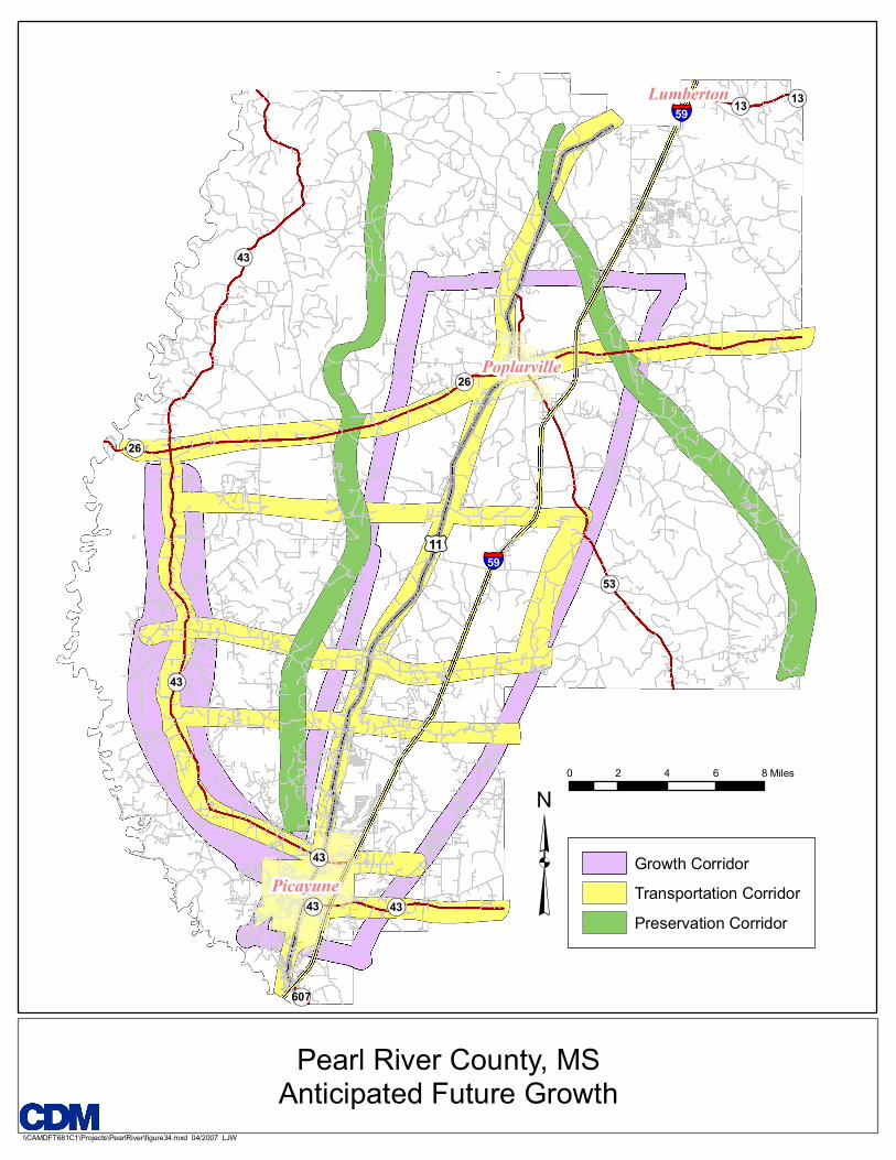
4.1 Growth Corridors As Pearl River County’s population grows, the connection between the expanding residential and commercial districts becomes increasingly important. As a result, new development is expected to cluster along the County’s already existing roadways. However it is essential to foster this growth along key transportation corridors in order to preserve the County’s rural character and environmental resources.
Key transportation corridors are often identified by analyzing and classifying the current roadway system. The most heavily traveled roadways are those that offer direct service between cities and regional centers. Residential and commercial establishments tend to concentrate along these corridors so as to facilitate easier access to and from the sites. Currently the County’s residents are concentrated within the Poplarville and Picayune metropolitan regions, and along the Highway 11 (Hwy 11) and Interstate 59 (I-59) corridor between them. State Highway 43 (MS 43) south of State Highway 26 (MS 26) is also relatively heavily populated. These areas are identified as the potential growth corridors for the County.
I-59, Hwy 11 and MS 43 offer continuous north-south routes through the County. Besides MS 43’s eastward turn through Picayune, MS 26 is at present the only major east-west connector within Pearl River County. In order to increase mobility and alleviate the congestion associated with expected rapid growth, more east-west connectors are recommended within the growth corridor. Roadways formerly operating at the local or community level could be enhanced so as to serve through-traffic as well. Roads such as Savannah-Millard, McNeill-Steephollow and Anchor Lake will increase in importance as the volume of vehicles on the roads increase and people seek alternative routes. Thus the potential growth corridors serve as a nexus for development and mobility. Proposed growth corridors are seen in Figure 29.
A 4-1
Land Use.doc
!(43
!(43
!(13
!(26
!(43
£¤11
!(43
!(13
§̈¦59
§̈¦59
!(53
!(607
!(43
!(26
Picayune
Poplarville
Lumberton
Growth CorridorTransportation CorridorPreservation Corridor
Pearl River County, MSAnticipated Future Growth
\\CAMDFT681C1\Projects\PearlRiver\figure34.mxd 04/2007 LJW
³0 2 4 6 8 Miles

Section 4 Implementing Comprehensive Plan
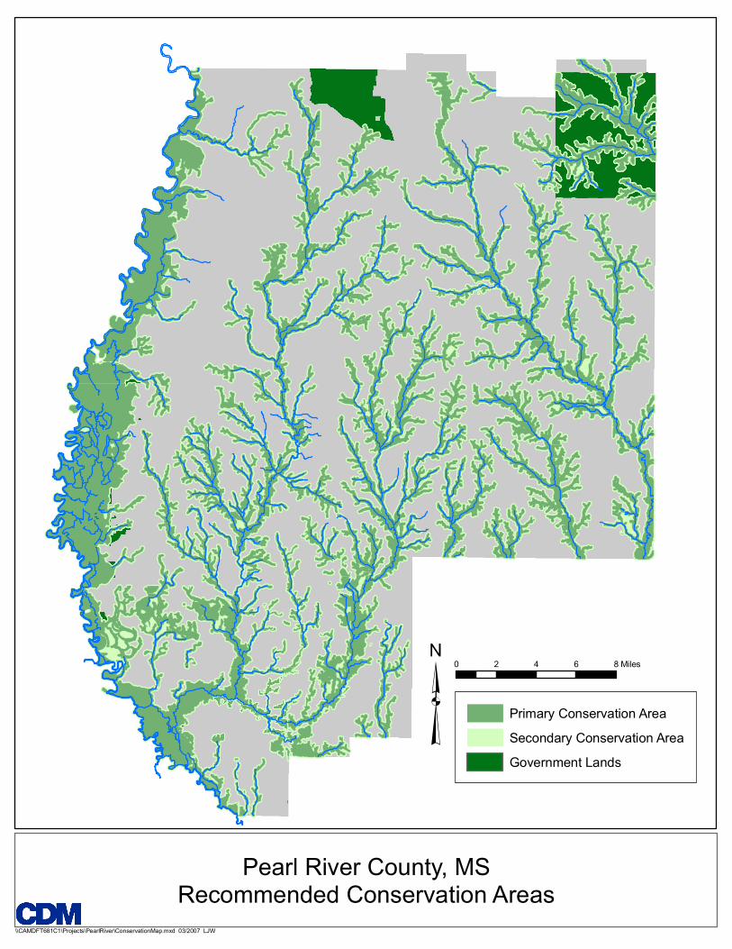
4.2 Conservation Corridors Conservation of undeveloped land is important to land use planning in Pearl River County. Protecting certain natural areas of the county from development serves two functions. Firstly, vital natural systems such as stream corridors and wetlands serve an ecological function that must be protected in order to ensure the future sustainability of the county. Second is the rural landscape, which is central to Pearl River County’s character, can only be maintained if significant portions of the county are allowed to remain forest and agricultural lands. For these two reasons, it is important to identify the lands that are best suited for conservation.
A consultant to the county (Randall Arendt) recommended in 2004 that the County develop a “Countywide map of Potential Conservation Lands.” It was recommended that this map separate conservation lands into three categories: Primary Conservation Areas, Secondary Conservation Areas, and Existing Conservation Areas. Primary Conservation Areas are lands that are “deemed to be inherently unsuitable due to extremely severe environmental constraints.” In contrast, Secondary areas contain “resources that are either significant at some level or are at least notable and worthy of consideration for conservation whenever possible.”
The division of conservation areas into these categories is useful in the regulation and design of future development. The County may choose to apply different regulatory restrictions on Primary areas versus Secondary areas. For example, strong restrictions on development could be allowed in Primary areas, while development in secondary areas might be less strictly managed, for example, by use of special permits.
The County could apply a variety of regulatory approaches that make use of this tiered conservation plan. Developers, land owners, and designers can also benefit from knowing which portions of their sites are crucial to the sustainability of the county and which areas should be avoided. The County needs a tool to quickly identify its conservation priorities in order to best guide and encourage development.
Based on the categories indicated by Arendt, a map of proposed conservation lands has been developed as part of the land use planning process (Figure 30). Primary conservation areas consist of wetlands and FEMA Q3 floodplains. Wetlands perform crucial ecological functions such as filtering ground water; building in floodplains is inadvisable. As such, wetlands and floodplains constitute some of the county’s greatest natural resources but also represent some of the greatest susceptibility to development, making these lands appropriate for a high level of protection.
To identify the areas of primary conservation, the wetlands and floodplain delineations were merged and given a 200 foot buffer to provide the potential for additional protection of anticipated wetland and floodplain areas. Where these areas overlapped with existing development, the conservation designation was removed. The result is a comprehensive demarcation of the natural areas that are most important to protect. Secondary conservation areas consist of the 300-foot area surrounding the primary conservation zones. Secondary areas are not directly in
A 4-3
Land Use.doc
Primary Conservation AreaSecondary Conservation AreaGovernment Lands
Pearl River County, MSRecommended Conservation Areas
\\CAMDFT681C1\Projects\PearlRiver\ConservationMap.mxd 03/2007 LJW
³0 2 4 6 8 Miles
Section 4 Implementing Comprehensive Plan
contact with waterways or wetlands but nonetheless merit protection because of their close proximity. The only current conservation lands in Pearl River County are government-owned park lands, which are also indicated on conservation map. Primary conservation areas comprise 241 square miles, or 29% of the county, and secondary conservation lands constitute an additional 117 square miles, or 14%.
Much of the land delineated in the conservation map is already regulated to some degree by Army Corps of Engineers , FEMA and the Mississippi Department of Environmental Quality. To further tailor the conservation strategy to the natural resources present in Pearl River County, this basic map of conservation lands can be augmented to encompass a broader range of environmental considerations. Additional factors include: estimated habitats of endangered species, old growth forests, high-value agricultural soils, stormwater and groundwater recharge areas, steep slopes, viewsheds, and access points to lakes and streams. Selection of the these criteria can be sued to create a tertiary conservation category, or additional lands can be added to the primary and secondary categories. Although floodplains and wetlands are the cornerstone of natural systems in the County, the conservation corridors ultimately should preserve all of the most important natural resources that will ensure sustainability.
4.3 Regulatory Approaches 4.3.1 Traditional approaches It is generally accepted that zoning alone cannot be used to guide land development . Nonetheless, traditional zoning has been used to promote the construction of denser residential neighborhoods. Often granted by special permit, development in these districts allows greater density than is normally allowed in the underlying residential district zoning. The use of traditional zoning tools that promote dense housing and open space exist in many forms, such as “cluster zoning,” “open space residential districts,” and “conservation subdivisions,” the last of which is used in Pearl River County. In addition, traditional zoning can be used to conserve natural resources in any such district where the construction of buildings is not permitted.
Traditional zoning, however, has many drawbacks. If zoning is not tailored to the needs of a specific community, it can have the effect of needlessly restricting how landowners can use their land. In addition, by focusing almost entirely on separation of land uses and lot dimensioning, the physical guidance it provides is limited to very basic requirements. Traditional zoning usually focuses on managing the intensity of development rather than the character of development. Many zoning codes were adopted in an era when conservation and neighborhood character were not well understood. As a result, traditional zoning codes have little regard for the specific context of a site and systematically discourage higher intensity development. Traditional zoning is considered largely to blame for the sprawl that the County seeks to deter.
A 4-5
Land Use.doc

Section 4 Implementing Comprehensive Plan
The recommended approach to land use regulation is form-based codes. Unlike traditional zoning, which is based on the segmentation of land by use, form-based codes regulate the building types that are allowed within certain areas. With form-based codes, the physical design of a neighborhood determines development, and different uses will naturally be accommodated in the context of well-designed urban form.
4.3.2 A Regulatory Approach for Pearl River County Pearl River County has a deeply held tradition of independence, and a regulating scheme that constricts residents is not desired. A traditional zoning code is limiting, it does not accommodate variety or innovative design and form, and is unlikely to achieve development necessary to fulfill the county’s objectives. In order for Pearl River County to preserve its sense of place, two key objectives must be met: open space must be protected, and the form of development must be visually and functionally compatible with existing development and the existing landscape.
Regulation is certainly not the only tool for implementing the County’s land use objective, but providing guidance for development and conservation requires a detailed and enforceable standard. As such, the County in the future should employ a form-based approach that fully integrates environmental conservation objectives, as identified from input to this land use planning process. A form-based system can set basic design parameters for the types of developments that are most desirable in Pearl River County. Simple, illustrative guidelines will help designers, developers, and owners to visualize the characteristics that are most important in maintaining the character of the County.
4.4 Development Types The creation of built environments that are visually attractive, environmentally sustainable, and complementary to the treasured character of Pearl River County is essential in implementing the County’s vision. . Clearly identifying the development types that will create such places is essential for implementation. An analysis of current buildings and the key goals identified in the planning process can be combined to assemble development characteristics that should be implemented. The result is a roster of preferred typologies that comprise the built form that fosters the county’s unique character. Building typologies are representation of categories of buildings.
4.4.1 Rural Buildings Traditional cabins and farm houses should remain the predominant type of development in rural areas. Rural buildings accommodate very low-density residential development in agricultural and forested areas. Buildings in agricultural or forested areas should be designed in a manner to protect views and the natural landscape of Pearl River County.
A 4-6
Land Use.doc

Section 4 Implementing Comprehensive Plan
4.4.2 Residential Residential subdivisions, which will likely be the largest segment of new development in Pearl River County, should reflect traditional residential patterns and local architectural styles. Sprawling, homogenous neighborhoods with very wide roads and few trees are a problematic type of development that is found across the country. Residential subdivisions should strive to avoid these problems and create walkable districts modeled on the closely knit neighborhoods of the Gulf Coast. Shared open space, mature trees, and relatively dense development can make new subdivisions feel and operate like traditional neighborhoods.
Infill development and development near the cities’ historic neighborhoods should largely reflect their context. That said, the development of multi-unit residential buildings should be promoted. Increased affordability and more efficient provision of services should drive the development and design of multi-unit housing. A series of attached town houses or an apartment building located near a city or village center are examples of multi-unit residential buildings possible in Pearl River County. Increases in density, such as is achieved in an apartment building, can greatly reduce the impact of development.
Housing affordability will be essential as the population of Pearl River County grows and diversifies. In addition to multi-unit housing, other affordable options such as manufactured housing will be in demand. Manufactured housing should be accommodated in certain locations while maintaining the predominance of traditional residential neighborhoods.
4.4.3 Retail Traditional downtown shopping districts are a hallmark of Pearl River County. New retail development should resemble these pedestrian friendly commercial areas. Narrow buildings, animated storefronts with large windows, distinctive signage, and easy pedestrian access are the basic characteristics of such districts. Close proximity between the roadway and the building frontage is an underlying feature of the traditional business district. Parking should be segmented and located away from street frontages. Sidewalks should be accessible on all frontages, and features such as drive-thru windows and loading areas should be avoided on the main public frontage.
Local retail should avoid the traditional strip-mall model, which is characterized by unornamented facades and large parking lots that separate the building frontage from the roadway. Local retail should be organized in clusters of business in a manner to create a sense of place that is similar to traditional shopping districts. Businesses in attached local retail centers can benefit from reduced costs and activity from adjoining businesses.
Big box retail may be inevitable, but it can be designed in a manner that greatly reduces its environmental and visual impact. Increased architectural articulation and greater glazing can transform monolithic facades into building frontages that
A 4-7
Land Use.doc
Section 4 Implementing Comprehensive Plan
resemble traditional shopping districts. Landscaping and screening can be used to minimize the sight of large retail structures from the public view. Moderately scaled signage and parking areas with landscaping, trees, and islands reduce environmental impact and create more attractive settings. Such designs are not frequently employed by big box retailers but are growing in popularity, both among businesses and local communities.
4.4.4. Office Small offices should be integrated into retail and commercial areas, as is found in the cities. Buildings should be harmonious with surrounding structures. Maintaining a consistent street frontage and height and the use materials and styles found in traditional downtowns will create a traditional business and commercial district. Parking, while essential to accommodate employees and customers, should be located in the rear.
4.4.5 Industrial Larger offices and light industry are best suited on industrial campuses. These sites should be screened from the public view to minimize the visual impact of large buildings. Pedestrian infrastructure, such as benches and sidewalks, should be used to integrate the campus into the adjoining fabric and to create more traditional and attractive spaces. Large parking lots should be avoided; landscaping, islands, trees, and the use of porous paving will reduce environmental impact. Like retail buildings, industrial park structures should avoid large, uninterrupted, windowless facades. Traditional design elements, rooflines, and glazing patterns will create campuses that bolster the architectural character of the county.
4.4.6 Mixed Use A mix of uses is vital. As indicated earlier, the strict separation of uses that is inherent in traditional zoning does not create the vibrant neighborhoods that will maintain Pearl River County’s character. It is important for neighborhoods to include residential, commercial retail, and civic buildings. In addition, buildings themselves can house multiple uses, such as retail on the ground floor and residences on upper floors. Being able to walk to local stores for convenience items, and to local health and other government services is highly desirable, both in terms of providing transportation options, and in terms of supporting healthy lifestyles.
4.5 Complementing and Integrating with Current Programs Implementing the land use recommendations in this plan will require coordination with several existing regulations and regulatory agencies. The use of land use regulations will require the County to promote a clear system for regulatory compliance, assuring that all applicable regulations work synchronously. The following regulations may intersect with the proposed land use planning efforts and should be considered if policies and regulations are used.
A 4-8
Land Use.doc
Section 4 Implementing Comprehensive Plan
Subdivision Regulations: The County’s subdivision regulations contain minimum site design standards that include lot size, street design, landscaping, neighborhood density, building setbacks, and open space. Land use regulations, which will address land use and design, will encompass these topics as well.
Hazard Mitigation and Flood Protection Plan: This plan identifies environmental threats and preparedness at the County level. Largely in sync with the Comprehensive Plan, the hazard mitigation plan urges the protection of natural resources and the creation of service, infrastructure, development, and utility plans and regulations. Community goals and strategic recommendations for these topics are included.
Pearl River County Utility Authority Rules and Regulations: The PRCUA regulates some aspects of site design and water, stormwater, and wastewater systems. The standards and approval for individual systems and connection to public utilities will have a substantial impact on the location, cost, and design of future development.
Family of International Building Codes for Pearl River County: The building code sets minimum standards for building, plumbing, electrical, gas, and sanitary features of structures in the county. These regulations have an important impact on the design of buildings, which is also in the purview of the a form-based system. In addition, the building code entails a review and permitting processes that will have to be integrated with additional regulatory approvals.
Pearl River County Strategic Plan: Public input on conservation, economic development, infrastructure improvements, and the provision of County services is compiled in the Strategic Plan. The goals and initiatives expressed in this report have an impact on the shape of development and the underlying land use patterns.
Mississippi Storm Water Pollution Prevention Plan (SWPPP): Requiring review and approval for construction that may affect water quality, the Mississippi Department of Environmental Quality regulates the impact that development can have on hydrological systems. The land use plan’s conservation areas are largely based on hydrology and will overlap in their protection of these lands.
4.6 Administration Implementing land use planning will require dedicated staff and clearly defined roles at the county and city levels and across several departments and organizations. An administrative framework, as opposed to creating an additional administrative body, is suggested for managing its implementation and success. It is recommended that the County appoint members of a Planning Task Force to help ensure the successful implementation of the plan and the Code. This Task Force would include the agencies and stakeholders mentioned in Section 4.5 and others at the discretion of the Board of Supervisors. Planning Department staff will be responsible for development review.
A 4-9
Land Use.doc
Section 4 Implementing Comprehensive Plan
4.7 Economics of Growth Management This plan seeks to lay the groundwork for future development that respects conservation and makes efficient use of resources. In applying the strategies and goals of this plan, it is important to consider the economic and fiscal impacts of growth management. Under a system of growth management, the County’s upfront costs for management, infrastructure development, and the provision of services will be higher than if development were allowed to proceed without planning. However, the growth management approach advocated in this plan can ultimately reduce the cost of government expenditures and services.
Land use management in Pearl River County will guide future development into existing developed areas and new centers, while discouraging development in rural and environmentally sensitive areas. This pattern of development leads to denser development, which can be beneficial in long-term cost savings. Growth management that concentrates growth in developed areas and new centers and conserves natural resources can have the following economic impacts:
Infrastructure: Fewer miles of additional roadways and improvements to existing roadways are necessary when development is more compact. Development in or near existing neighborhoods further decreases the need for additional investment.
Water & Sewer: Demand may not appear to be significantly lower, infrastructure costs can be lowered. Denser development can reduce the cost of water and sewer infrastructure due to multi-unit housing and more compactly oriented single-family lots. As with roads, the use of existing infrastructure in already developed areas will help further reduce costs by carefully managing the extension of infrastructure systems and public services.
Housing affordability: Future land use that provides for a variety of development intensities will create neighborhoods that range from rural to suburban to urban. The result can be housing prices that are lower because of the densities of urban communities, as well as the housing mix possible in denser, traditional neighborhoods.
Schools: As the population of school-age children rises, it will be necessary to provide school transportation and facilities to meet increased demand. Transportation costs can be greatly reduced if residential development is concentrated in certain areas, particularly near major transportation corridors. The construction of additional facilities can also be better located to increase accessibility to residential developments that are contained in more compact neighborhoods.
Emergency Response: As with school transportation, the provision of police, fire, and emergency services is greatly improved by concentrated residential development with easy accessibility to major transportation routes. Reduced travel time will decrease response time. Costs associated with covering dispersed districts, such as multiple stations and a larger staff, will also be reduced.
A 4-10
Land Use.doc

Section 4 Implementing Comprehensive Plan
Urban Communities: The incorporated urban areas of Picayune and Poplarville will gain in several respects. Encouraging growth in the cities makes use of existing services and infrastructure and reduces impact on undeveloped surrounding land. As development is encouraged within the cities, commercial and residential construction will occur, drawing businesses and residents that will boost the cities’ tax bases. Employment and income for city residents can also increase with a higher concentration of commercial development in cities.
4.8 Additional Land Use Programs In tandem with using a form-based system for development, the following programs can help achieve the County’s land use goals.
4.8.1 Forest Conservation areas The conservation corridors that are delineated in this plan are focused on hydrology and constitute the most essential lands for protection. There are many other undeveloped areas that can be of great value to the County if maintained in a natural state. In particular, forested land is abundant in Pearl River County and is a key element in its distinctive rural character. Through a variety of methods, the County can protect significant swaths of forest land. The proposed conservation map could be augmented with the addition of forest conservation areas, which will restrict the use of this land to its current natural condition. In order to avoid unfair takings or to overly regulate, forest conservation areas should be delineated in consultation with land owners. One possibility is for forest conservation areas to be created as a form of mitigation for related development projects.
4.8.2 Walkability Zones Pearl River County is an expansive area whose rural character will require that residents use vehicular transportation to travel in and through the county. Nonetheless, pedestrian activity is a feature of the county’s small-town character that can be promoted. Walking has many advantages, including health benefits, reduced congestion, reduced pollution, and a lively public realm. The State of Mississippi has established the “Let’s Go Walking” campaign to promote community health. Design standards for future development will encourage neighborhoods that are relatively dense and have sidewalks, which supports pedestrian activity. In continuing to promote pedestrians, Pearl River County could establish districts in which future development must expressly be oriented toward increasing walkability. Within these areas, sidewalk networks would be continuous, and dense, mixed use development would be strongly encouraged if not required. The result would be a new choice in residential lifestyle that is particularly well suited to residents who do not wish to drive, such as senior citizens. Walkability zones would be appropriate in or near existing areas of development, or in new planned downtowns.
4.8.3 Low Impact Development In order to minimize the environmental impact of land development, Pearl River County has the option of considering low impact development (LID) strategies. LID
A 4-11
Land Use.doc

Section 4 Implementing Comprehensive Plan
A 4-12
Land Use.doc
encompasses a wide variety of sustainable land development approaches to stormwater management. Their aim is to reduce rainfall runoff and pollution at its source, through design techniques which preserve and recreate a site’s natural hydrologic features. These techniques, such as permeable pavement surfaces, bioretention ponds (or rain gardens), green roofs (or roof gardens), and cistern collection systems, decrease the impervious footprint of a site, which decreases the surface runoff and so improves the quality of stormwater drainage. Additionally, LID works to reduce non-point source pollution to drinking water supplies, recreational waters and wetlands. Due to its flexibility in design and emphasis on natural processes, LID techniques are often more cost-effective than traditional stormwater management practices.