section 3 mapping earth’s surface - midway middle...
TRANSCRIPT

Section 3
Mapping Earth’s Surface
Key Concept Maps are tools that are used to display data about a given
area of a physical body.
What You Will Learn
• Maps can be used to find locations on Earth and to represent
information about features of Earth’s surface.
• Most maps are made from data collected by a process called remote
sensing.
Why It Matters
Maps help us find directions and locations on Earth.
The Greeks thought of Earth as a sphere almost 2,000 years before
Ferdinand Magellan began his round-the-world voyage in 1519. The
observation that a ship sinks below the horizon as it sails into the
distance supported the idea of a spherical Earth. If Earth were flat, the
ship would not sink below the horizon.
The way in which people have seen the world has been reflected in their
maps. A map is a representation of the features of a physical body such
as Earth. If you were to look at a world map from the second century,
you might not recognize the physical features that are represented.
However, if you looked at a map of Earth’s surface made from a
photograph taken from a satellite, you might see physical features of
Earth you never knew existed.
What is a map?
Finding Directions on Earth Although Earth’s shape is not a true sphere, it is best represented by a
sphere. A sphere has no top, bottom, or sides to use as reference points
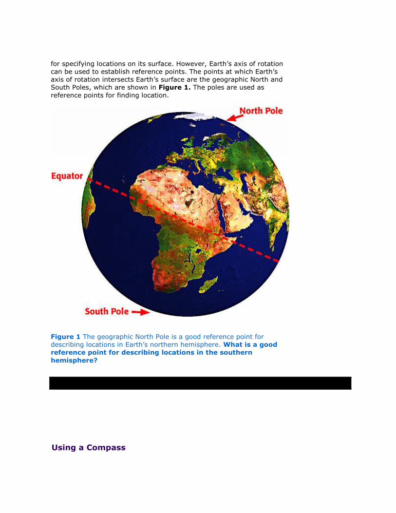
for specifying locations on its surface. However, Earth’s axis of rotation
can be used to establish reference points. The points at which Earth’s
axis of rotation intersects Earth’s surface are the geographic North and
South Poles, which are shown in Figure 1. The poles are used as
reference points for finding location.
Figure 1 The geographic North Pole is a good reference point for
describing locations in Earth’s northern hemisphere. What is a good
reference point for describing locations in the southern
hemisphere?
Using a Compass

Earth’s core generates a magnetic field that causes
Earth to act as a giant magnet. Therefore, Earth has
two magnetic poles that are located near the
geographic poles. A compass is a tool that uses
Earth’s natural magnetism to show direction. A
compass needle points to the magnetic north pole.
Therefore, a compass will show you which direction
is north.
Finding Locations on Earth All of the houses and buildings in your neighborhood
have addresses that give their location. But how
would you find the location of something such as a
city center or tip of an island? These places can be
given an “address” by using latitude and longitude.
Latitude
The equator is a circle halfway between the North
and South Poles that divides Earth into the Northern
and Southern Hemispheres. Imaginary lines drawn
around Earth parallel to the equator are called lines
of latitude, or parallels. Latitude is the distance
north or south from the equator. Latitude is
expressed in degrees, as shown in Figure 2. The
equator represents 0° latitude. The North Pole is
90° north latitude, and the South Pole is 90° south
latitude. North latitudes are found between the
equator and the North Pole. South latitudes are
found between the equator and the South Pole.

Figure 2 Degrees latitude are a measure of the
angle made by the equator and the location on
Earth’s surface, as measured from the center of
Earth.
Longitude
Lines of longitude, or meridians, are imaginary lines that connect both
poles. Longitude is the distance east and west from the prime
meridian. Like latitude, longitude is expressed in degrees, as shown in
Figure 3. The prime meridian is the line that represents 0° longitude.
Unlike lines of latitude, lines of longitude are not parallel. Lines of
longitude touch at the poles and are farthest apart at the equator.
Figure 3 Degrees longitude are a measure of the angle made by the
prime meridian and the location on Earth’s surface, as measured from
the center of Earth.
Unlike the equator, the prime meridian does not completely circle the
globe. The prime meridian runs from the North Pole through Greenwich,
England, to the South Pole. The 180° meridian lies on the opposite side
of Earth from the prime meridian. Together, the prime meridian and the
180° meridian divide Earth into the Eastern and Western Hemispheres.
East lines of longitude are found east of the prime meridian, between 0°
and 180° longitude. West lines of longitude are found west of the prime
meridian, between 0° and 180° longitude.
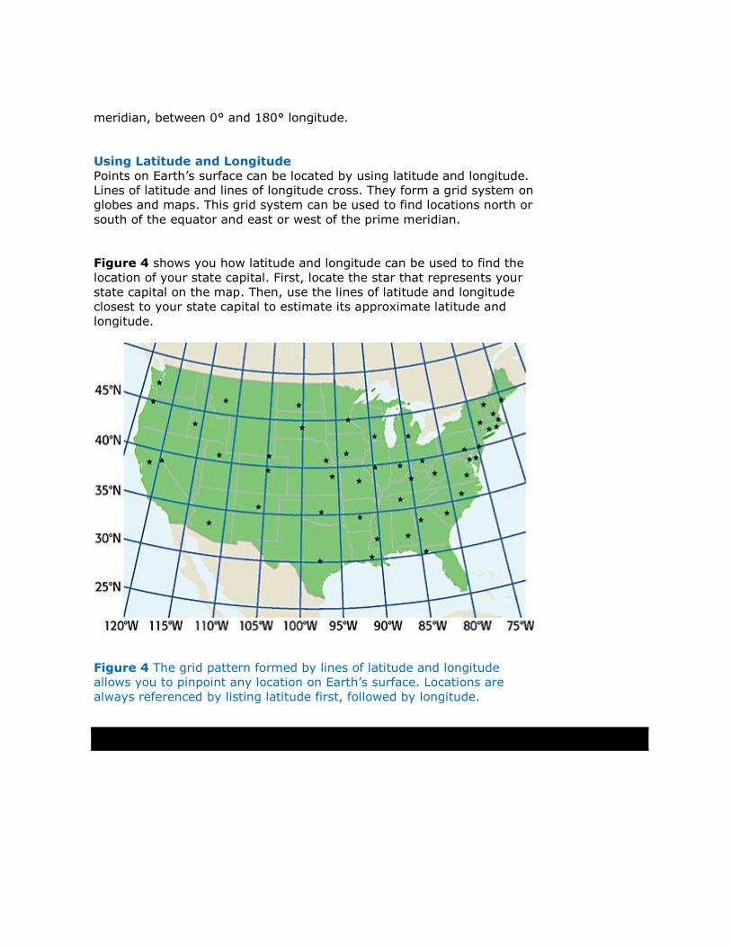
Using Latitude and Longitude
Points on Earth’s surface can be located by using latitude and longitude.
Lines of latitude and lines of longitude cross. They form a grid system on
globes and maps. This grid system can be used to find locations north or
south of the equator and east or west of the prime meridian.
Figure 4 shows you how latitude and longitude can be used to find the
location of your state capital. First, locate the star that represents your
state capital on the map. Then, use the lines of latitude and longitude
closest to your state capital to estimate its approximate latitude and
longitude.
Figure 4 The grid pattern formed by lines of latitude and longitude
allows you to pinpoint any location on Earth’s surface. Locations are
always referenced by listing latitude first, followed by longitude.

Information Shown on Maps Maps provide information through the use of symbols. To read a map, you must
understand the symbols on the map and be able to find directions and calculate
distances. Regardless of the kind of map you are reading, a map typically contains the
information shown in Figure 5. This information includes a title, an indicator of
direction, a scale, a legend, and a date.

Figure 5 This road map of Sacramento, California, contains all of the needed
information to use the map.
What information should every map contain?
Modern Mapmaking Data used in many of today’s maps are provided by the process of
remote sensing. Remote sensing is a way to gather information about
an object without directly touching or seeing the object. Today, most
maps are made from photographs taken by mapping cameras that are
mounted on low-flying aircraft. However, mapmakers are beginning to
rely on more sophisticated instruments. These instruments are carried
on both aircraft and Earth-orbiting satellites. Figure 6 shows an image
taken by a satellite.

Figure 6 This image of downtown San Francisco was obtained by using
remote-sensing technology.
Passive Remote Sensing
All objects on Earth’s surface emit electromagnetic radiation, such as
heat or X rays. In a passive remote-sensing system, sensors record the
amount of different kinds of electromagnetic radiation that is emitted or
reflected by objects. The data are gathered by a satellite-mounted
sensor and are recorded as a series of numbers. These numbers are
beamed to a ground station. There, a computer processes the data and
converts the data into a satellite image of Earth’s surface.
Active Remote Sensing
An active remote-sensing system produces its own electromagnetic
radiation and measures the strength of the return signal. In an active
remote-sensing system, radar is used to gather data. Radar gathers
data by using microwaves. An advantage to using microwaves for
remote sensing is that they can penetrate clouds and water. Therefore,
microwaves can be used to map areas that are difficult to study.

Global Positioning System
Did you know that satellite technology can actually keep you from getting lost? The
global positioning system (GPS) can help you find where you are on Earth. GPS is a
system of orbiting satellites that send radio signals to receivers on Earth. The receivers
calculate the latitude, longitude, and elevation of a given place. Figure 7 shows how
GPS works.
Figure 7 How GPS Works
GPS was invented in the 1970s by the U.S. Department of Defense for military use.
However, during the last 30 years, GPS has made its way into people’s daily lives.
Mapmakers use GPS to check the location of boundary lines between countries and
states. Airplane and boat pilots use GPS for navigation. Businesses and state agencies
use GPS for mapping and environmental planning. Many new cars have GPS units that
show information on a screen on the dashboard. Some GPS units are small enough to
wear on your wrist, as shown in Figure 8, so you can know your location anywhere
you go!
Figure 8 This tiny GPS unit may come in handy if you are ever lost.
How can GPS technology be used as a tool to
gather data?
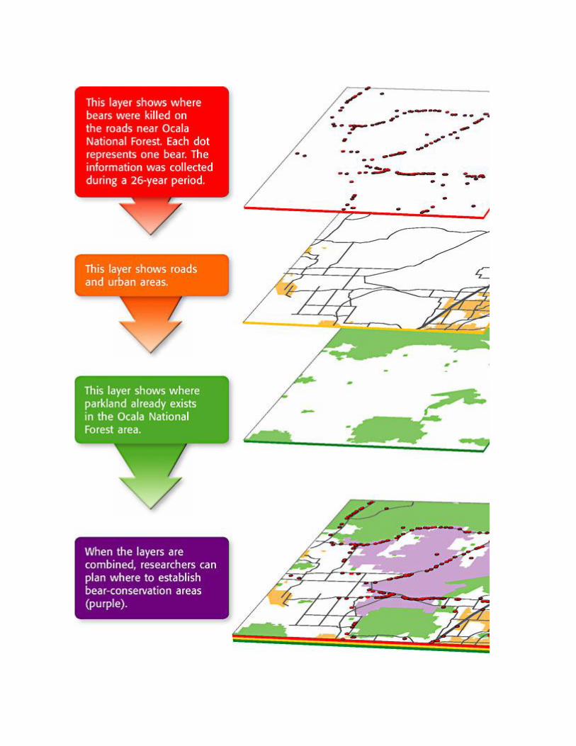
Geographic Information Systems
Geographic information systems (GISs ) are computerized systems that visually
present information about an area. A GIS organizes information in overlapping layers.
Scientists can compare the layers to answer questions. Figure 9 shows how GISs
helped scientists plan conservation areas for Florida black bears near Ocala National
Forest, located northwest of Orlando.
Figure 9 How GIS Works

Section Summary
• A map is a representation of the features of a
physical body such as Earth.
• A compass is a tool that uses the natural
magnetism of Earth to show direction.
• Latitude and longitude can be used to find
points on Earth’s surface.
• Most maps contain a title, a scale, a legend,
an indicator of direction, and a date.
• Modern mapmakers use data gathered by
remote-sensing technology to make most
maps.
• Remote sensing is a way to collect information
about an object without being in physical
contact with the object.
• The global positioning system (GPS)
calculates the latitude, longitude, and
elevation of locations on Earth’s surface.
• Geographic information systems (GISs) are
computerized systems that allow mapmakers
to store and use many types of data.