section 4: opportunity sites · 2020-03-05 · retail and commercial space could offer easily...
TRANSCRIPT

South Cicero Corridor: Final Plan Report ____________________________________________________Page 30 June 2005
SECTION 4: OPPORTUNITY SITES
The land use and urban design analysis and the assessment of market development oppor-tunities discussed in the previous sections of this Plan are the first steps in redesigning the Study Area. The land-use planning combined with an economic analysis, yields a sound basis for further planning and new development within the Study Area.
Approach to Improvement and Redevelopment:
Many existing uses in the Study Area are sound and viable. However, there are significant opportunities for new development and redevelopment along the major corridors.
The Plan allows for improvement and redevelopment to occur in the Study Area over a period of years, in a series of phases, as opportunities arise and resources become available. While redevelopment might take place over a period of years, redevelopment should not occur as a series of isolated and unrelated projects. While each project should be capable of standing on its own merits, each should also be consistent with the Design Guidelines as presented in Sec-tion 6 for the Study Area as a whole.
Furthermore, since redevelopment will be phased over a period of years, the Plan addresses both the short- and long-term needs of the various Opportunity Sites. For example, short-term improvements for certain sites might include the enhancement of sites, buildings, parking lots, design enhancements, and development of sites that are currently vacant and readily available for development. Long-term improvements might include large-scale redevelopment, requir-ing potential land assembly and more significant investments within the area.
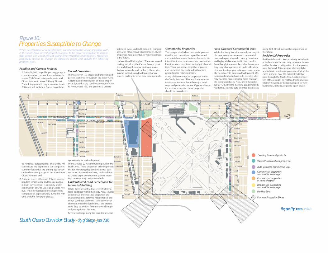
Properties Susceptible to Change
While development or redevelopment could conceivably occur anywhere within the Study Area, several properties appear to be more “susceptible” to change than others and could present strong redevelopment opportunities.
Properties potentially subject to change are illustrated and described in more detail in Fig-ure 10 and include:
• Pending and Current Projects,
• Vacant properties,
• Underutilized surface parking,
• Underutilized land parcels and deteriorated buildings,
• Select commercial properties,
• Select used car lots and auto repair facilities, and
• Select residential properties.
Pending & current projects
Vacant/Underutilized properties
Auto-oriented commercial uses
Commercial properties susceptible to change
Commercial properties in need of repair
Residential properties susceptible to change
Parking Lots
Runway Protection Zones
Cicero
55TH
Kostner
59th
Kenneth
Central
Keating
Leamington
Kilbourn
66TH
MA
RQU
ETTE
LUNA
Kolmar
LOTUS
61st
60th
Lorel
Lavergne
La Crosse
Laramie
Lamon
Lamon
Kilbourn
63rd
Keating
57th
58th
56th
55th
54th
Linder
Kolmar
Kenneth
Laporte
Latrobe
Stev
enso
n Ex
pres
sway
I55
Kenneth
Lockwood
51st
Arc
her
Long
45th
La Crosse
Lawler
64TH
66hh
65th
62n
d
46th
47thh
4 48th
49th
50th
44th
Knox
Laporte53
RD
La Crosse
Kilpatrick
44th
44th
43rd
52n
d52
nd
43rd
42n
d
Leclaire
Central
Lorel
Lavergne
La Crosse
LaramieLaramie
Lamon
Linder
Laporte
Latrobe
Lockwood
Long
Lawler
Knox
Kilpatrick
Leclaire
444444444444444444444444444
Pending and Current Projects 1. A 7-level 6,300 car public parking garage is
currently under construction on the north side of 55th Street between Laramie and Cicero Avenue to serve Midway Airport. Phase II is planned to begin construction in 2006 and will include a 5-level consolidat-
ed rental car garage facility. This facility will consolidate the eight rental car companies currently located at the existing space-con-strained terminal garage on the east side of Cicero Avenue; and
2. Autumn Green at Midway Village, an inde-pendent senior rental and for-sale condo-minium development is currently under construction at 67th Street and Cicero Ave-nue. This new residential development is comprised of approximately 200 units with land available for future phases.
Vacant Properties There are over 150 vacant and underutilized parcels scattered throughout the Study Area. A significant concentration of these proper-ties is located at the southeast corner of Cice-ro Avenue and I-55, and presents a unique
opportunity for redevelopment. There are also 22 vacant buildings within the Study Area. These properties offer opportuni-ties for relocating displaced residents, busi-nesses or airport-related uses, or demolition to create larger development parcels meet-ing contemporary design standards.
Underutilized Land Parcels and De-teriorated BuildingWhile there are only a few severely deterio-rated buildings within the Study Area, several commercial and industrial properties are characterized by deferred maintenance and minor condition problems. While these con-ditions may not be significant at the present time, they do detract from the overall image and perception of the area. Several buildings along the corridor are char-
acterized by: a) underutilization; b) marginal uses; and c) functional obsolescence. These properties have potential for redevelopment in the future. Underutilized Parking Lots. There are several parking lots along the Cicero Avenue corri-dor and along the major east-west streets that are currently underutilized. These sites may be subject to redevelopment or en-hanced parking to serve new developments.
Commercial Properties This category includes commercial proper-ties that are currently occupied by sound and viable businesses that may be subject to intensification or redevelopment due to their location, age, current use, and physical condi-tion. These properties might be improved and upgraded, or combined with nearby properties for redevelopment. Many of the commercial properties within the Study Area are older and have an unat-tractive appearance from the major road-ways and pedestrian routes. Opportunities to improve or redevelop these properties should be considered.
Auto-Oriented Commercial UsesWhile the Study Area has no truly incompati-ble uses, some auto-oriented commercial uses and repair shops do occupy prominent and highly visible sites within the corridor. Even though these may be viable businesses, they may also represent an underutilization of prime frontage properties and may eventu-ally be subject to future redevelopment. Un-derutilized industrial and auto-oriented sites may become prime sites for more compati-ble commercial uses. Also, given the poten-tial for 47th street to become predominantly residential, existing auto-oriented businesses
along 47th Street may not be appropriate in the future.
Residential Properties Residential uses in close proximity to industri-al and commercial uses may represent incom-patible landuse configuration if not appropri-ately buffered. This category also highlights several older residential properties that are lo-cated along or near the major streets that pass through the Study Area. Certain proper-ties of these might be replaced with new mul-ti-family housing, or be redeveloped for new businesses, parking, or public open space.
While development or redevelopment could conceivably occur anywhere with-in the Study Area, several properties appear to be more "susceptible" to change than others and could present strong redevelopment opportunities. Properties potentially subject to change are illustrated below and include the following property types.
South Cicero Corridor Study �City of Chicago �June 2005
Figure 10:Properties Susceptible to Change
Prepared by:
South Cicero Corridor: Final Plan Report ____________________________________________________Page 32 June 2005
Opportunity Sites
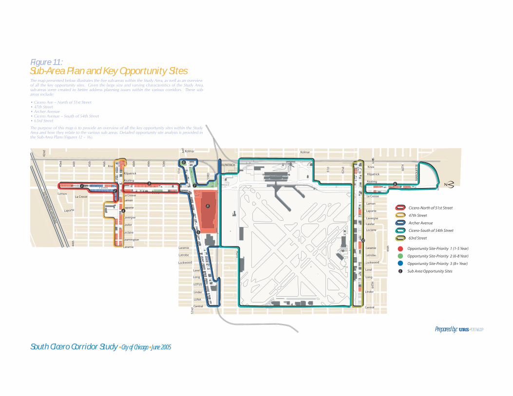
Based on the presence of susceptible properties described above and illustrated in Figure 10, Figure 11 illustrates the five sub-areas within the Study Area, as well as an overview of all the key opportunity sites identified for potential new commercial, office, residential, and mixed-use development. Followed by Figure 11 are the sub-area plans (Figures 12-16), which provide detailed analysis on the individual key sites within each sub-area.
Figures 11 - 16 highlight potential Opportunity Sites within the Study Area that have been identified as having strong potential for future improvement and redevelopment based on both our physical assessment and market findings for the Study Area. The Opportunity Sites are identified by the following development priorities:
Priority 1: Potential development within next 1 - 5 years
Priority 2: Potential development within next 6 - 8 years
Priority 3: Potential development within next 8 + years
These development priority rankings were based on the following factors:
• Land Assembly Issues
• Site Configuration
• Taxpayer Information
• Existing Use
• Market Demand
The existing characteristics and future potentials of each Opportunity Site are presented in Table 1, which highlights the following:
• Site Location,
• Site Size,
• Strengths,
• Challenges,
• Improvement or Redevelopment,
• Future Development/Improvement Recommendations,
• Current Zoning,
• Recommended Zoning, and
• Development Priority.
The figures represent an identification of key development opportunity sites, a summary of their strengths and weaknesses, and an initial recommendation for market- and community-appropriate development on each site.
Opportunity Site-Priority 1 (1-5 Year)
Opportunity Site-Priority 2 (6-8 Year)
Opportunity Site-Priority 3 (8+ Year)
Sub Area Opportunity Sites
Cicero-North of 51st Street
47th Street
Archer Avenue
Cicero-South of 54th Street
63rd Street
Cicero
55TH
Kostner
59th
Kenneth
Central
Keating
Leamington
Kilbourn
66TH
MA
RQU
ETTE
LUNA
Kolmar
LOTUS
61st
60th
Lorel
Lavergne
La Crosse
Laramie
Lamon
Lamon
Kilbourn
663rd
6633rd
Keating
57th
58th
56th
55th
54th
Linder
Kolmar
Kenneth
Laporte
Latrobe
Stev
enso
n Ex
pres
sway
I55
KILPATRICK
Kenneth
Lockwood
51st
Arc
her
Long
45th
La Crosse
Lawler
64TH
6h
65th
62n
d
46th
47th
4h
48th
49th
50th
44th
Knox
Laporte53
RD
La Crosse
Kilpatrick
44th
44th
43rd
52n
d52
nd
43rd
42n
d
Leclaire
Central
Lorel
Lavergne
L CL CLL CCCC
LaramieLaramie
Lamon
Linder
Laporte
Latrobe
Lockwood
Long
Lawler
Knox
Kilpatrick
Leclaire
CCCCC
447thtt
4th
CiCiCCi
444444444444444444
The map presented below illustrates the five sub-areas within the Study Area, as well as an overview of all the key opportunity sites. Given the large size and varying characteristics of the Study Area, sub-areas were created to better address planning issues within the various corridors. These sub-areas include:
• Cicero Ave – North of 51st Street• 47th Street• Archer Avenue• Cicero Avenue – South of 54th Street• 63rd Street
The purpose of this map is to provide an overview of all the key opportunity sites within the Study Area and how they relate to the various sub areas. Detailed opportunity site analysis is provided in the Sub-Area Plans (Figures 12 – 16).
South Cicero Corridor Study �City of Chicago �June 2005
Figure 11:Sub-Area Plan and Key Opportunity Sites
Prepared by:
12
3
5
8
10
1
97
6
4
KNOX
KEATING
47TH
45TH
46TH
49TH
48TH
50TH
51ST
KILPATRICK
44TH
43RD
LAPORTE
LAVERGNE
42N
D
CICERO AV
LAM
ON
LA CROSSE
44TH
LAMONairLeClaire
CourtsCourtsCourts
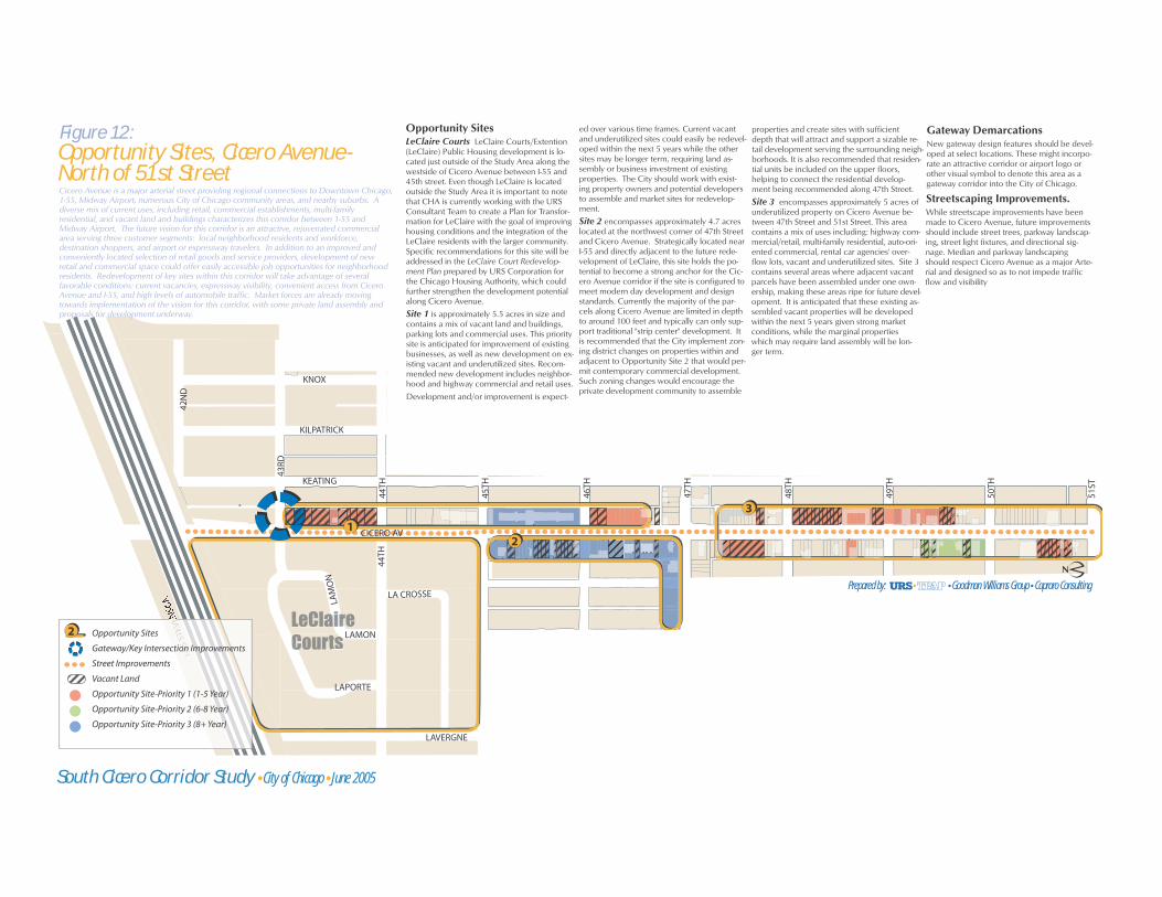
Cicero Avenue is a major arterial street providing regional connections to Downtown Chicago, 1-55, Midway Airport, numerous City of Chicago community areas, and nearby suburbs. A diverse mix of current uses, including retail, commercial establishments, multi-family residential, and vacant land and buildings characterizes this corridor between 1-55 and Midway Airport. The future vision for this corridor is an attractive, rejuvenated commercial area serving three customer segments: local neighborhood residents and workforce, destination shoppers, and airport or expressway travelers. In addition to an improved and conveniently located selection of retail goods and service providers, development of new retail and commercial space could offer easily accessible job opportunities for neighborhood residents. Redevelopment of key sites within this corridor will take advantage of several favorable conditions: current vacancies, expressway visibility, convenient access from Cicero Avenue and I-55, and high levels of automobile traffic. Market forces are already moving towards implementation of the vision for this corridor, with some private land assembly and proposals for development underway.
Opportunity SitesLeClaire Courts LeClaire Courts/Extention (LeClaire) Public Housing development is lo-cated just outside of the Study Area along the westside of Cicero Avenue between I-55 and 45th street. Even though LeClaire is located outside the Study Area it is important to note that CHA is currently working with the URS Consultant Team to create a Plan for Transfor-mation for LeClaire with the goal of improving housing conditions and the integration of the LeClaire residents with the larger community. Specific recommendations for this site will be addressed in the LeClaire Court Redevelop-ment Plan prepared by URS Corporation for the Chicago Housing Authority, which could further strengthen the development potential along Cicero Avenue.
Site 1 is approximately 5.5 acres in size and contains a mix of vacant land and buildings, parking lots and commercial uses. This priority site is anticipated for improvement of existing businesses, as well as new development on ex-isting vacant and underutilized sites. Recom-mended new development includes neighbor-hood and highway commercial and retail uses.
Development and/or improvement is expect-
ed over various time frames. Current vacant and underutilized sites could easily be redevel-oped within the next 5 years while the other sites may be longer term, requiring land as-sembly or business investment of existing properties. The City should work with exist-ing property owners and potential developers to assemble and market sites for redevelop-ment.
Site 2 encompasses approximately 4.7 acres located at the northwest corner of 47th Street and Cicero Avenue. Strategically located near I-55 and directly adjacent to the future rede-velopment of LeClaire, this site holds the po-tential to become a strong anchor for the Cic-ero Avenue corridor if the site is configured to meet modern day development and design standards. Currently the majority of the par-cels along Cicero Avenue are limited in depth to around 100 feet and typically can only sup-port traditional "strip center" development. It is recommended that the City implement zon-ing district changes on properties within and adjacent to Opportunity Site 2 that would per-mit contemporary commercial development. Such zoning changes would encourage the private development community to assemble
properties and create sites with sufficient depth that will attract and support a sizable re-tail development serving the surrounding neigh-borhoods. It is also recommended that residen-tial units be included on the upper floors, helping to connect the residential develop-ment being recommended along 47th Street.
Site 3 encompasses approximately 5 acres of underutilized property on Cicero Avenue be-tween 47th Street and 51st Street. This area contains a mix of uses including: highway com-mercial/retail, multi-family residential, auto-ori-ented commercial, rental car agencies' over-flow lots, vacant and underutilized sites. Site 3 contains several areas where adjacent vacant parcels have been assembled under one own-ership, making these areas ripe for future devel-opment. It is anticipated that these existing as-sembled vacant properties will be developed within the next 5 years given strong market conditions, while the marginal properties which may require land assembly will be lon-ger term.
Gateway DemarcationsNew gateway design features should be devel-oped at select locations. These might incorpo-rate an attractive corridor or airport logo or other visual symbol to denote this area as a gateway corridor into the City of Chicago.
Streetscaping Improvements.While streetscape improvements have been made to Cicero Avenue, future improvements should include street trees, parkway landscap-ing, street light fixtures, and directional sig-nage. Median and parkway landscaping should respect Cicero Avenue as a major Arte-rial and designed so as to not impede traffic flow and visibility
I-55
STEV
EE
Opportunity Sites
Gateway/Key Intersection Improvements
Street Improvements
Vacant Land
Opportunity Site-Priority 1 (1-5 Year)
Opportunity Site-Priority 2 (6-8 Year)
Opportunity Site-Priority 3 (8+ Year)
2
12
3
South Cicero Corridor Study �City of Chicago �June 2005
Figure 12:Opportunity Sites, Cicero Avenue-North of 51st Street
Prepared by: Goodman Williams Group Capraro Consulting

4
Opportunity Sites
Street Improvements
Vacant Land
Opportunity Site-Priority 1 (1-5 Year)
Opportunity Site-Priority 3 (8+ Year)
2
KN
OX
KEA
TIN
G
CIC
ERO
LAR
AM
IE
47TH
48TH
KIL
PATR
ICK
LEC
LAIR
E
LEA
MIN
GTO
N
LA C
ROSS
E
LAW
LER
LAPO
RTE
LAV
ERG
NE
LAM
ON
The 47th Street corridor between Laramie Avenue and the Kenton Line railroadtracks east of Knox Avenue is surrounded on the north and south by solid residentialneighborhoods. The corridor itself, however, features numerous underutilizedproperties and a significant number of vacant lots and buildings, reflecting theerosion of the corridor's historic purpose as a neighborhood shopping street. Thevision for the 47th Street Corridor is to maintain its neighborhood and pedestrianorientation, while encouraging redevelopment as a residential zone. Housing in avariety of product types and price ranges, interspersed with some neighborhood-oriented retail or services at key intersections, would help to reestablish vitality andpositive activity along the corridor.
Opportunity SitesSite 4 encompasses approximately 9 acres of vacant parcels on 47th Street between Lara-mie and the railroad tracks just east of KnoxAvenue. The majority of the sites along thiscorridor are either vacant or underutilized.47th Street was historically intended to be a neighborhood commercial corridor. The old neighborhood habits of daily shopping havebeen generally replaced with supermarketsand big-box retail stores. People no longerwant to invest the time to make separatestops at the bakery or the butcher. In manyways, the role and function of the traditionalneighborhood commercial district has changed. This has left many commercial corri-dors throughout Chicago looking for newways to remain useful.
The recommended redevelopment strategyfor the 47th Street corridor is to encouragethe "de-commercialization" of 47th Street and promote residential development to fill the
void left by commercial businesses that areno longer viable along 47th Street. Recom-mended residential development along 47thinclude: attractive townhomes, 3 to 6 unit walk-ups, 3 - 5 story condominium and/or rental buildings, and mixed-use buildings at key intersections with neighborhood re-tail/services on the ground floor. Currently,there is strong residential demand in the area,which indicates that this corridor has potentialto be redeveloped within the next five years.
The majority of this corridor is currently zon-ed as C1-2, B1-1, and B2-1 Districts. It is rec-ommended that this corridor be re-zoned toallow for the above referenced residentialunits types and to allow for residential devel-opment on the ground floors. Such recom-mended zoning categories include B2 and B3 districts.
Streetscaping Improvements
Coordinated streetscape improvementsshould be undertaken along 47th Street. Im-provements should include street trees, park-way landscaping, street light fixtures, pedes-trian lighting, and directional signage.
Figure 13:Opportunity Sites, 47th Street
South Cicero Corridor Study City of Chicago June 2005
Prepared by: Goodman Williams Group Capraro Consulting

5 8 7
6
Opportunity Sites
Gatewaww y/Key Intersection Improvements
Street Improvements
VacVV ant Land
Opportunity Site-Priority 1 (1-5 Year)
Opportunity Site-Priority 2 (6-8 Year)
2
51ST
CIC
ERO
KEA
TIN
G
KIL
PATR
ICK
KN
OXARCHER
52ND
LON
G
LUN
A
CEN
TRA
L
53RD
LORE
L
LOTU
S
LIN
DER
LOC
KW
OO
D
LATR
OB
E
LARA
MIE
LEA
MIN
GTO
N
LEC
LAIR
E
LAW
LER
53RDLA
VER
GN
E
LAPO
RTE
LAM
ON
LA C
ROSS
E
The Archer Avenue corridor is bounded by Central Avenue on the west and theKenton Line railroad tracks east of Knox Avenue. This stretch of Archer Avenue is adense, mixed-use commercial corridor serving local and regional traffic, carrying onaverage over 29,000 vehicles per day. The vision for this corridor is to strengthenthe existing commercial character. Much of the current commercial development -small businesses, neighborhood goods and services, and specialty goods - iscurrently healthy and well-maintained, although there are instances of deferredmaintenance and opportunities for aesthetic improvement. As an alternate routeinto downtown Chicago from the Midway Airport, the image and strength of thiscorridor is important not only for the neighborhood, but also for the City as a whole.
Opportunity SitesSite 5 generally includes Archer Avenue as a whole between Central Avenue and therailroad tracks. Archer Avenue is a healthymixed-use commercial corridor with relativelylittle to no vacancies. While there are only a few severely deteriorated buildings along Archer Avenue, some of the properties can be characterized as "weathered and tired"exhibiting some deferred maintenance and minor condition problems. While theseconditions may not be significant at thepresent time, they do detract from the overallimage and perception of the area. It is recommended that over time these existingproperties be improved through renovationefforts and/or façade improvements. Suchimprovements can be undertaken by theindividual property owners and businesses within the next five years and can be encouraged through the various City improvement and investment assistanceprograms.Site 6 is approximately 2 acres in size and is located at the northeast corner of Archer and Knox Avenues. This site is currentlyunderutilized and used as a trucking facility.Recognizing that future access of this sitemay be reduced and/or eliminated by theproposed CREATE rail crossing gradeseparation at Archer Avenue and the KentonLine, a trucking facility is not the highest and best use for this site. Given the ample depth
of the site and potential access restrictions, a light manufacturing use is recommended.Alternatively, if access is completely restricteddue to rail crossing improvements, open space may be appropriate. Potentialdevelopment timing for this site is estimatedto occur within the next 6 to 8 years.Site 7 is approximately 7.3 acres in size and includes the property located at thesoutheast corner of Archer Avenue and Cicero Avenue. This site is highly visible and serves as a gateway to and from MidwayAirport. As discussed above, future access may be restricted for parts of the site frontingArcher Avenue due to the planned CREATErail crossing grade separation at ArcherAvenue and the Kenton Line, potentiallylimiting the development potential of this site.However, given the expected commercialredevelopment of Site 11, this corner has strong redevelopment potential for creating a new image and "downtown" center for thearea.This opportunity area currently contains a mix of uses, such as vacant land and buildings, parking, local office, and retailestablishments. Given the numerous existingbusinesses within this opportunity site, it is expected redevelopment will occur more in the long-term, within the next 6 to 8 years. It is recommended that this site be redeveloped as commercial service and office, serving the local neighborhoods and
airport operations.Site 8 is over 51 acres in size and includes the property located at the southwest corner of Archer and Cicero Avenues. The currentuses include the Midway Business Center,Brandy's Restaurant, Skylark Motel, and theformer Indiana Harbor Belt right-of-way.These businesses are marginal in use and/or are currently underutilized. The approximately one million square feet of industrial/warehouse space within theMidway Business Center has been about 60% vacant this past year due to thedeparture of several key tenants. Little demand exists for this space due to increasedcongestion in the area and difficult truckaccess. This site is currently located withinthe Stevenson Industrial Corridor and is recommended to be removed from thecorridor since market conditions indicate thatindustrial use is no longer the highest and best use.Given the site's close proximity to MidwayAirport and the Airport's future bus-wayshuttle system, it is recommended that thesite be redeveloped to support and help strengthen the airport's operations. Based on the site's size, configuration, strategiclocation, and market conditions, the site is recommended to be redeveloped into thefollowing mix of uses: hotel/ conference,office/flex space, and retail. It is anticipatedthat this redevelopment could occur within
the next five years given that the majority of the site is under one ownership and marketdemand is strong.Given the site's large size and key location at the intersection of Archer Avenue and CiceroAvenue, redevelopment of this site providesan opportunity to truly change the characterand face of the area, creating a sense of place for the surrounding neighborhoods. In addition, the development of hotel and conference facilities will significantlystrengthen and improve airport operations,creating additional economic stimulus for thearea.
Gateway DemarcationsNew gateway design features should be developed at select locations. These might incorporate an attractive corridor/airportlogo or other visual symbol to denote thisarea as a gateway corridor into the City of Chicago.
Streetscaping ImprovementsCoordinated streetscape improvementsshould be undertaken along Archer Avenue.Improvements should include street trees,parkway landscaping, street light fixtures,pedestrian lighting, and directional signage.
Figure 14:Opportunity Sites, Archer Avenue
South Cicero Corridor Study City of Chicago June 2005Prepared by: Goodman Williams Group Capraro Consulting
Opportunity Sites
Gateway/Key Intersection Improvements
Street Improvements
VacVV ant Land
Opportunity Site-Priority 1 (1-5 Year)
2
9
55TH
CICERO
CICERO
KILPATRICK
59TH
66TH
65TH
61ST
60TH
62N
DLAMON
KENTON
KNOX
KEATING
LAPORTE
LAWLER
MidwayHotel Center
LAVERGNE
LA CROSSE
MA
RQU
ETTE
56TH
58TH
57TH
57TH
64TH
KEATING
KILPATRICK
LARAMIE
55TH
63RD
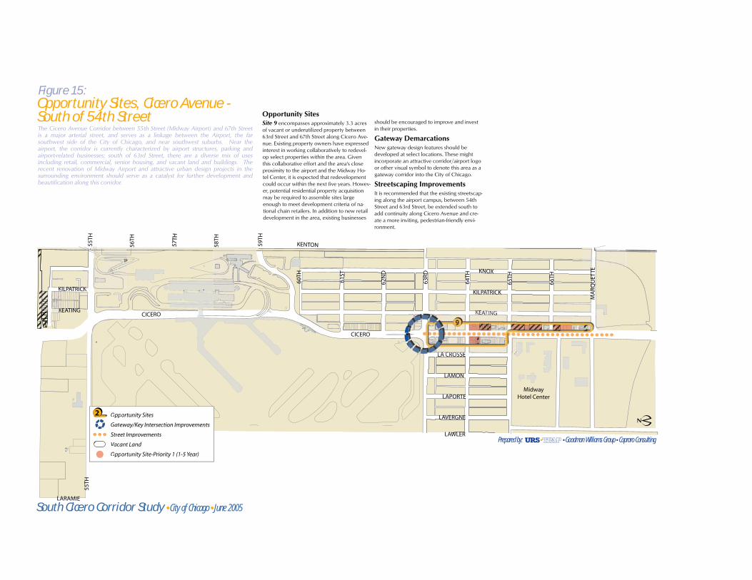
The Cicero Avenue Corridor between 55th Street (Midway Airport) and 67th Streetis a major arterial street, and serves as a linkage between the Airport, the farsouthwest side of the City of Chicago, and near southwest suburbs. Near theairport, the corridor is currently characterized by airport structures, parking andairport-related businesses; south of 63rd Street, there are a diverse mix of usesincluding retail, commercial, senior housing, and vacant land and buildings. Therecent renovation of Midway Airport and attractive urban design projects in thesurrounding environment should serve as a catalyst for further development andbeautification along this corridor.
Opportunity SitesSite 9 encompasses approximately 3.3 acresof vacant or underutilized property between63rd Street and 67th Street along Cicero Ave-nue. Existing property owners have expressedinterest in working collaboratively to redevel-op select properties within the area. Giventhis collaborative effort and the area's close proximity to the airport and the Midway Ho-tel Center, it is expected that redevelopmentcould occur within the next five years. Howev-er, potential residential property acquisitionmay be required to assemble sites largeenough to meet development criteria of na-tional chain retailers. In addition to new retaildevelopment in the area, existing businesses
should be encouraged to improve and investin their properties.
Gateway DemarcationsNew gateway design features should be developed at select locations. These might incorporate an attractive corridor/airport logo or other visual symbol to denote this area as a gateway corridor into the City of Chicago.
Streetscaping ImprovementsIt is recommended that the existing streetscap-ing along the airport campus, between 54thStreet and 63rd Street, be extended south toadd continuity along Cicero Avenue and cre-ate a more inviting, pedestrian-friendly envi-ronment.
Figure 15:Opportunity Sites, Cicero Avenue -South of 54th Street
South Cicero Corridor Study City of Chicago June 2005
Prepared by: Goodman Williams Group Capraro Consulting
10
Opportunity Sites
Gateway/Key Intersection Improvements
Street Improvements
VacVV ant Land
Opportunity Site-Priority 1 (1-5 Year)
2
KI L
PATR
ICK
KN
OX
CIC
ERO
TRIP
P
63RD
LORE
L
62ND
LAM
ON
LAPO
RTE
LAW
LER
LAV
ERG
NE
LAC
ROSS
E
LARA
MIE
LEA
MIN
GTO
N
LIN
DER
CEN
TRA
L
LEC
LAIR
E
LOC
KW
OO
D
LON
G
63RD
LATR
OB
E
63RD 63RD
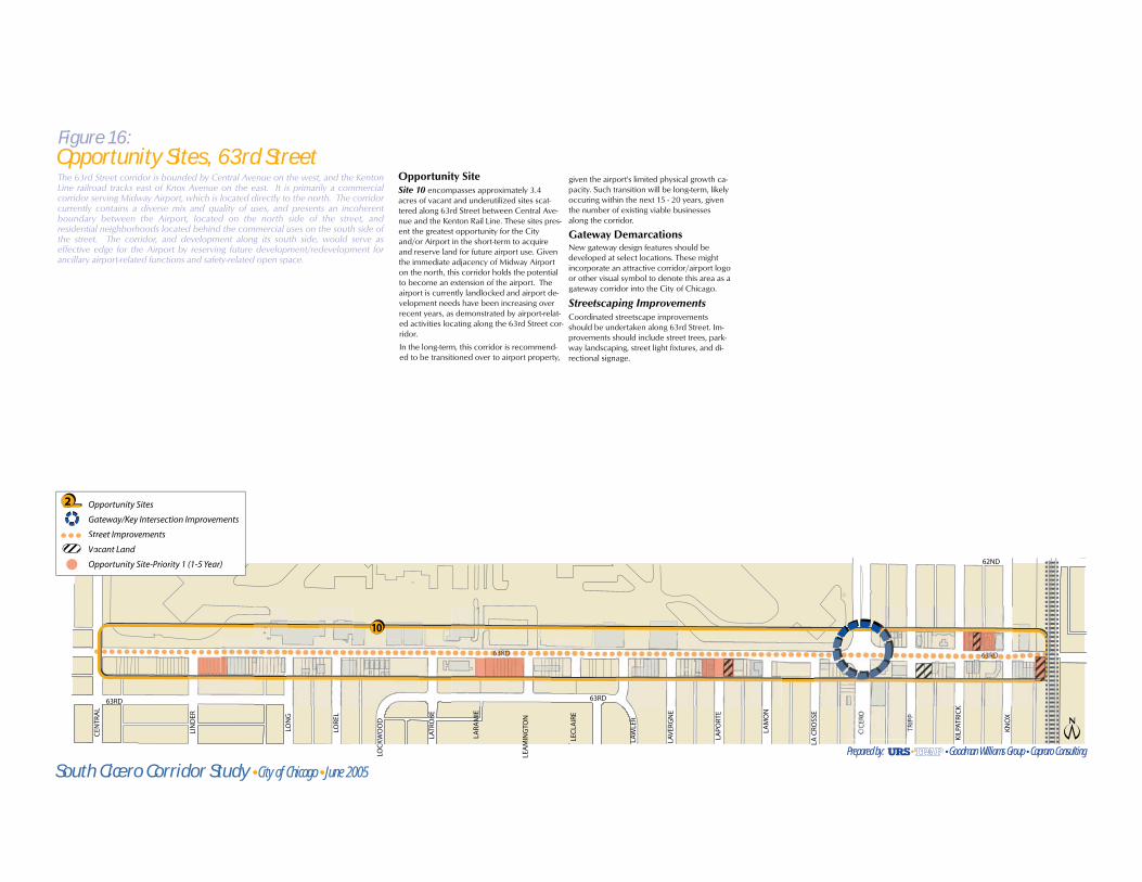
The 63rd Street corridor is bounded by Central Avenue on the west, and the KentonLine railroad tracks east of Knox Avenue on the east. It is primarily a commercialcorridor serving Midway Airport, which is located directly to the north. The corridorcurrently contains a diverse mix and quality of uses, and presents an incoherentboundary between the Airport, located on the north side of the street, andresidential neighborhoods located behind the commercial uses on the south side ofthe street. The corridor, and development along its south side, would serve aseffective edge for the Airport by reserving future development/redevelopment forancillary airport-related functions and safety-related open space.
Opportunity SiteSite 10 encompasses approximately 3.4 acres of vacant and underutilized sites scat-tered along 63rd Street between Central Ave-nue and the Kenton Rail Line. These sites pres-ent the greatest opportunity for the City and/or Airport in the short-term to acquireand reserve land for future airport use. Giventhe immediate adjacency of Midway Airporton the north, this corridor holds the potentialto become an extension of the airport. The airport is currently landlocked and airport de-velopment needs have been increasing overrecent years, as demonstrated by airport-relat-ed activities locating along the 63rd Street cor-ridor.
In the long-term, this corridor is recommend-ed to be transitioned over to airport property,
given the airport's limited physical growth ca-pacity. Such transition will be long-term, likelyoccuring within the next 15 - 20 years, giventhe number of existing viable businesses along the corridor.
Gateway DemarcationsNew gateway design features should be developed at select locations. These might incorporate an attractive corridor/airport logo or other visual symbol to denote this area as a gateway corridor into the City of Chicago.
Streetscaping ImprovementsCoordinated streetscape improvementsshould be undertaken along 63rd Street. Im-provements should include street trees, park-way landscaping, street light fixtures, and di-rectional signage.
Figure 16:Opportunity Sites, 63rd Street
South Cicero Corridor Study City of Chicago June 2005Prepared by: Goodman Williams Group Capraro Consulting

South Cicero Corridor: Final Plan Report _________________________________________________________________________________________________________________________________________________________________________________________________ Page 39June 2005
Table 1: Assessment of Opportunity Sites South Cicero Corridor Study Area, Chicago, IL
Site Number and Location Site
Size
Strengths Challenges Improvement or
Redevelopment
Future Development/
Improvement
Recommendations
Current
Zoning*
Recommend.
Zoning**
Development
Priority
Cicero Avenue Corridor – North of 51st Street
1 Underutilized
property on east side
of Cicero between
43rd and 48th
5.5
acres
Existing vacant properties
Proximity to I-55
Located on high-traffic Cicero Avenue
Located on neighborhood collector street with
bus access
Inside Cicero/Archer TIF District
Multiple property owners
Underutilized businesses currently on property
Potentially high speculative land prices
Limited depth lots
May require residential acquisition to achieve
deeper lots
Combination Neighborhood
commercial & retail
Highway commercial &
retail
B3-1
B3-3
PD-602
Same as current Depends on
site; 1 – 8 Years
2 NWC of 47th and
Cicero, including:
Cicero frontage
between 45th and 47th,
and 47th frontage
between Cicero and
Lamon
4.7
acres
Highly visible corner
Proximity to I-55
Located on high-traffic Cicero Avenue
Property owners have expressed interest in
developing
Inside Cicero/ Archer TIF District
Multiple property owners
Potentially high speculative land prices
Limited depth lots; will likely require land
assembly to achieve deeper lots
Combination Retail
Entertainment /
restaurants
Mixed-Use with residential
above
B3-1
C2-1
RS-2
B3 P3: 8+ Years
3 Underutilized
property on Cicero
between 47th and 51st
5
acres
Sites are readily available
Inside Cicero/Archer TIF District
Limited depth lots Combination Auto-oriented commercial
Limited service hotel
In some cases properties
may only require
renovation or façade
improvement
B1-1
B3-1
B3-3
C2-1
Same as current Depends on
site; 1 – 8 Years

South Cicero Corridor: Final Plan Report _________________________________________________________________________________________________________________________________________________________________________________________________ Page 40June 2005
Site Number and Location Site
Size
Strengths Challenges Improvement or
Redevelopment
Future Development/
Improvement
Recommendations
Current
Zoning*
Recommend.
Zoning**
Development
Priority
47th Street Corridor
4 Vacant Parcels along
47th between Laramie
and Kenton railroad
tracks
9
acres
Located on neighborhood collector street with
bus access
Existing vacant properties
Proximity to Hurst School
Inside Cicero/Archer TIF District
Perception of 47th Street as socio-economic
divide
Redevelopment Residential – multi-family
mixed income
Mixed use: ground floor
retail and residential above
at select intersections
B1-1
B3-1
B3-3
C2-1
M1-1
M1-2
RS-2
RS-3
RT-4
B2 in interior of
corridor
B3 at intersections
(Laramie, Cicero)
P1: 1 – 5 Years
Archer Avenue Corridor
5 Archer Avenue n/a Recent retail development at Archer & Central
Few other underutilized parcels on this sub-
corridor
Inside Cicero/Archer or Archer/Central TIF
District
Limited depth lots Improvement Renovation or façade
improvement for existing
office and retail properties
B3-1
B3-2
C1-1
C2-1
M1-1
M2-1
RT-4
Same as current P1: 1 – 5 Years
6 NEC of Archer and
Knox 2
acres
Good-sized single parcel
Inside 51st/Archer TIF District
Potential railroad and access improvements
pending under CREATE
Potential environmental contamination from
current use as trucking facility
Current access issues due to frequent train
crossings
Future access may be reduced/eliminated by
proposed CREATE grade separation
Combination Light manufacturing M1-1 Same as current P2: 6 – 8 Years
7 SEC of Archer and
Cicero, including
Cicero frontage south
to rail line and Archer
frontage east to Knox
7.3
acres
High visibility corner: gateway to/from Midway
Airport
Proximity to Airport
Inside Cicero/Archer or Midway Industrial
Corridor TIF District
Potential railroad and access improvements
pending under CREATE
Access around Knox may be reduced/
eliminated by proposed CREATE grade crossing
Requires land assembly from multiple owners to
achieve deeper lots
High freight train traffic on Kenton Line / 59th
Street Branch spur
Combination Commercial service /
office
B3-1
C2-1
M1-1
Same as current P2: 6 – 8 Years

South Cicero Corridor: Final Plan Report _________________________________________________________________________________________________________________________________________________________________________________________________ Page 41June 2005
Site Number and Location Site
Size
Strengths Challenges Improvement or
Redevelopment
Future Development/
Improvement
Recommendations
Current
Zoning*
Recommend.
Zoning**
Development
Priority
8 SWC of Archer and
Cicero, including
Midway Business
Center site, Brandy’s
Restaurant site,
Skylark Motel site, and
former Indiana Harbor
Belt right of way
51+
acres
Prime corner
Proximity to Midway Airport and future airport
shuttle
Limited number of property owners (4)
Property owners have expressed interest in
developing
Significant size: 51+ acres
Inside Midway Industrial Corridor TIF District
Will require public-private partnership for
funding of significantly-sized development
Potential business relocation
May require property acquisition
Would require building demolition
Redevelopment Hospitality
Conference / meeting
center
Airport support uses
Retail
M2-1 PD, C2, or
C3
P1: 1 – 5 Years
Cicero Avenue Corridor – South of 54th Street
9 Underutilized
property on Cicero
Avenue between 64th
Street and 67th Street
3.3
acres
Proximity to Midway Airport
Proximity to established base of hotel
customers at Midway Hotel Center
Majority of properties are currently vacant;
property owners have expressed interest in
redevelopment
Inside Archer/Central TIF District
Limited depth lots; potential residential
acquisition needed to achieve deeper lots
Multiple property owners
Combination Entertainment (restaurants)
Convenience retail
B1-1
B3-1
Same as current P1: 1 – 5 Years
63rd Street Corridor
10 63rd Street 3.4
acres
Proximity to Midway Airport
Inside Archer/Central TIF District
Noise and traffic from airport
Limited depth lots
Combination Airport-related commercial
uses
Airport-related storage
Open space
B1-1
B3-1
M1-1
PD-610
PD-584
PD or Zoning
Overlay District to
serve airport
operations
P1: 1 – 5 Years
*Current zoning is per City of Chicago Zoning Map, updated as of August 26, 2004.
** Zoning Recommendations based on new zoning classifications effective November 1, 2004.