securing pastoralism in east and west africa: protecting ...pubs.iied.org/pdfs/g03036.pdfsecuring...
TRANSCRIPT
Securing Pastoralism in East and West Africa:
Protecting and Promoting Livestock Mobility
Karamojong Cluster Desk Review:
Livestock mobility in northeast Uganda, northwest
Kenya, southwest Ethiopia and southern Sudan
October 2008
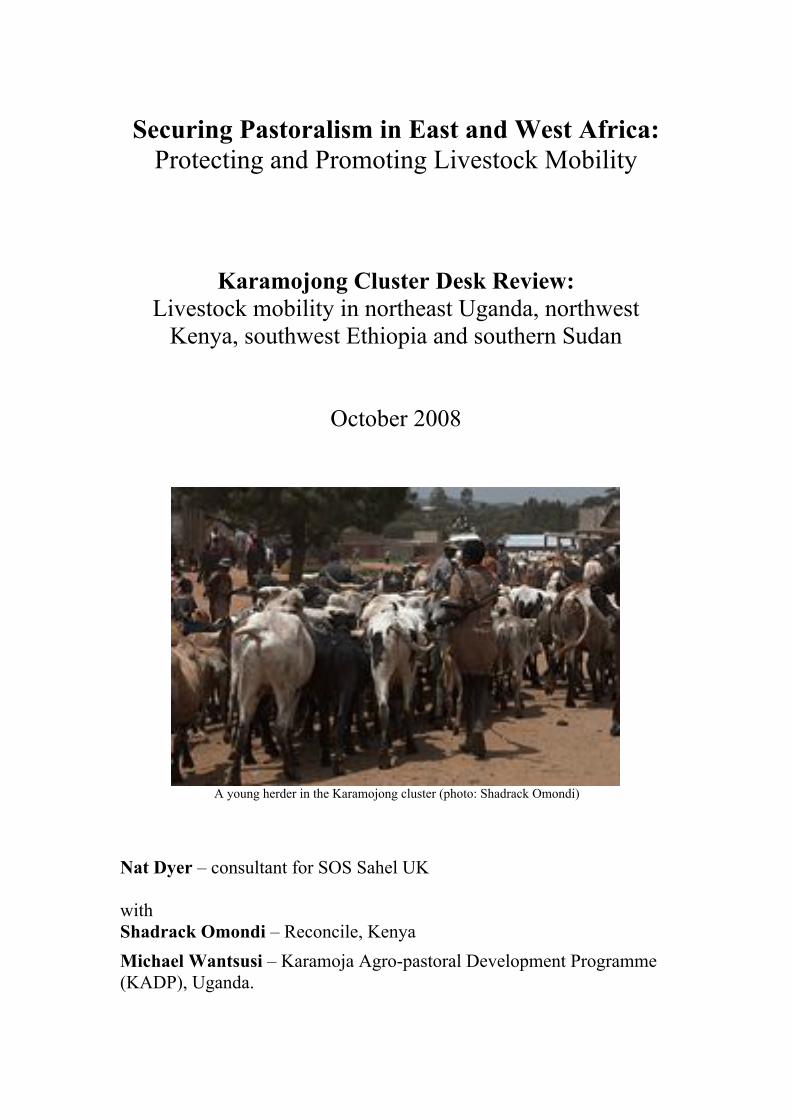
A young herder in the Karamojong cluster (photo: Shadrack Omondi)
Nat Dyer – consultant for SOS Sahel UK
with
Shadrack Omondi – Reconcile, Kenya
Michael Wantsusi – Karamoja Agro-pastoral Development Programme
(KADP), Uganda.

2
INTRODUCTION
This is one of a series of desk reviews produced as part of the project ‘Securing
Pastoralism in East and West Africa: Protecting and Promoting Livestock Mobility’.
Its focus is livestock mobility amongst the herding groups of the Karamojong1 cluster
(living in an area comprising northeast Uganda, northwest Kenya, southwest Ethiopia
and southern Sudan).
The methodology involved a review of the literature, supplemented with brief
interviews with key informants as well as small country studies in Kenya (Shadrack
Omondi) and Uganda (Michael Wantsusi). The review, carried out over a period of a
few days, was limited by the usual difficulties in accessing unpublished information.
The desk review was asked to focus on two issues:
! The context affecting livestock
mobility.
! The work of key development
and research actors involved in
promoting livestock mobility.
The report has four sections:
1. A brief overview of the nature of
pastoralism and livestock
mobility within the Karamojong
cluster.
2. An overview of the institutional
context in the four countries
where the groups of the
Karamojong cluster can be
found.
3. A summary of the main drivers
of change in the patterns of
livestock mobility within the
Karamojong cluster.
4. An overview of the work of key
development and research actors
protecting or promoting
livestock mobility, and an
indication of the issues that still
need attention.
The assistance of the SOS Sahel UK team, Izzy Birch, Jeremy Lind, and Michele
Nori, and other people who shared documents and ideas is warmly acknowledged.
Thanks also to Jess Barbier for her help in editing. Any faults or omissions, however,
remain the responsibility of the authors.
1
Also Karamajong (Gulliver, 1952) and Karimojong (Dyson-Hudson, 1958 and 1966, Novelli,
1988). Karamojong was the 'official' spelling under the colonial administration (Wayland, 1931;
Lawrance, 1952). Knighton (2005) uses 'Karimojong' to refer to the specific ethnic groups in
Uganda (Matheniko, Bokora and Pian) and 'Karamojong' to refer to the cluster of peoples speaking
Ngakaramojong.

3
1. PASTORAL PRODUCTION
The term 'Karamojong cluster' was introduced by the British colonial administration
in order to define a set of distinct ethnic groups from a shared origin and with similar
dialects, living in the territory that had been divided by the borders of Uganda, Kenya,
Ethiopia and Sudan. Early
surveys gather under this
definition Dodoth, Jie,
Karamojong and Turkana
(Gulliver, 1952), and Teso
(Lawrance, 1952). Although
these groups used the land in
different and complex ways,
they all kept livestock as an
important aspect of their
economy.
The use of the term 'Karamojong cluster' is not without problems. In contemporary
development literature the expression also refers, by extension, to the territory
comprising northeast Uganda, northwest Kenya, southwest Ethiopia and southern
Sudan. This use includes groups like the Pokot who, although key players in the
region, are not Ngakaramojong speakers. In other words, the geographical and socio-
linguistic use of the term do not entirely overlap. Further complication comes from
the parallel introduction of the expression 'Karamoja cluster' to define both the
peoples speaking the Ngakaramojong language in the Karamoja region (northeast
Uganda) and the territory itself (as a group of administrative districts).
For the sake of clarity, this desk study holds on onto the notion of 'Karamojong
cluster' in its original meaning, that is referring to peoples, not to a territory. On the
other hand, as the focus of the review is on pastoral mobility, we take a loose
approach looking at all the pastoral groups in the transnational region used by the
Karamojong cluster, therefore including the Pokot. Each group has a more or less
fixed ‘home area’. The table below gives an overview of these groups based on their
home areas. It is a highly heterogeneous collection, with deep political divisions,
different production strategies and historical as well as recent conflicts. Nevertheless,
all groups share an interest in keeping open the possibility to access areas normally
controlled by some of the others, at times across national borders. Although census
figures in these remote rural areas are typically only indicative, an estimated 1.4
million pastoralists and agro-pastoralists can be classified as part of the Karamojong
cluster (Akabawi and Ateyo, 2007).
Uganda Kaabong district:
Dototh
Kotido and Abim districts:
Jie
Moroto district:
Karimojong Matheniko
Karimojong Bokora
Tepeth
Nakapiripirit district:
Karimojong Matheniko
Karimojong Pian
Kenya Turkana district:
Turkana
West Pokot and
Trans-Nozia districts:
Pokot
Ethiopia Kuraz Woreda,
South Omo (SNNPR):
Dassanetch
Nyangatom (Toposa)
Sudan Budi & Kapoeta counties,
Eastern Equatoria Region:
Toposa (Taposa)

4
1.1 A note of caution on complex dynamics
The transnational region used by the Karamojong cluster is characterised by a highly
variable and unpredictable environment. Traditionally, administrative documents and
development literature define a dry and a wet season, respectively from October to
February-March and from March-April to September. In reality, these 'seasons'
indicate no more than periods during which one can expect somehow lower and
higher precipitation. As early as the 1950s, ecological studies in northeast Uganda
pointed out that departures from this ideal seasonal pattern are the norm rather than
the exception. Similarly, they emphasised that values for average precipitation had
little significance against very high variations from year to year (up to 200%) and
from place to place (Dyson-Hudson, 1958). The higher level of variability registered
today, following global climate change, is to be read in this perspective. The ecology
of the region belongs to the kind that is now commonly described as structurally
unpredictable or driven by stochastic events (non-equilibrium or disequilibrium
ecology). People's mobility and the dynamic differences in their use of the territory
also get in the way of standard measurements of population density based on
administrative areas.
Keeping in mind these limits, official records describe the climate in the region as
characterised by two seasons, one short and wet and one long and dry. Records from
Karamoja collected between 1939 and 1995 indicate differences in annual rainfall
between 420mm and 1260mm, with precipitation decreasing further to the west and
north of the area (Niamir-Fuller, 1999). On the other hand, most watercourses in
Karamoja run westwards (Dyson-Hudson, 1958), thus the distribution of precipitation
does not directly correspond to the aridity of the land. Ellis and Swift (1988)
estimated that the Karamoja region in Uganda has a coefficient of variation (CV) of
between 30 and 35. Regions with a CV higher than 30 are considered to be highly
variable, and ‘non-equilibrium’ ecological systems (Ellis & Swift, 1988 cited in
Niamir-Fuller, 1999: 153). Livestock mobility allows pastoralists to exploit climatic
micro-environments to the full.
The various pastoral groups of the Karamojong cluster are classified as transhumant,
nomadic, semi-nomadic, agro-pastoralists, mixed-farmers, and so on. To the extent to
which these classifications are based on the ethnic group (as it is usually the case)
they make little sense. Production strategies within the cluster are complex and highly
dynamic. Degree, patterns and, above all, strategies of mobility can be as different
within groups as between groups, and the same applies to strategies of productions.
For example, some Turkana cross the border into Uganda every year, based on long-
lasting and yet precarious alliances with groups of Karimojong (Matheniko). Others
however, leave the Turkana district only in exceptional circumstances. Most Turkana
keep cattle (together with camels, sheep, goats and donkeys), but some of them do
not, specialising instead in small stock (McCabe, 2004). Even within the same
pastoral group, some people engage in the cultivation of sorghum whilst others only
take care of livestock. Occupations may change according to age, gender or family
'style', as well as more transient conditions such as location, wealth, a climatic trend
or the restrictions in the production-strategy options face the availability of labour,
herd composition or security.
To overimpose static models of classification and explanation in order to freeze this
complex and changing reality, is terribly tempting. At times there are obvious benefits

5
in representing environment, resources and productions strategies by means of stable
models, for example for administrative and organisational purposes. However, it is
crucial not to lose sight of the circumstantial and ephemeral adequacy of such
simplifications when applied to systems that are characterised by complex dynamics.
The general overview of the pastoral production strategies within the Karamojong
cluster, in the following section, is to be read in this light.
1.2 Pastoral mobility and its purpose
A general model of production and mobility can be gathered from the extended in-
depth studies of the Karimojong and Jie (Dyson-Hudson, 1958, 1966; Gulliver, 1955;
Novelli, 1988) and Turkana (Gulliver, 1951; Dyson-Hudson, 1985; Little et al., 1999;
McCabe, 1984, 2004). A pattern that, with specific differences, can probably be
attributed to all the pastoral communities in the Karamojong cluster is the
organisation of production across three ideal ecological zones with increasing quality
of pasture: a home area, a grazing area and a grazing reserve. Whilst the home area of
a household tends to be relatively stable, the other two areas can vary greatly
according to many factors, as we will see.
With the exception of the rare periods when there is sufficient pasture in the home
area, most of the livestock is kept in the grazing area under the care of teams of men,
boys and a few girls. These teams can move as often as every few weeks. They use
local vegetation to build temporary camps (kraals)2.
About four fifths of the women and the youngest children live in semi-permanent
villages (manyattas) in the home areas, with a few milking cows and some small
stock. Today, these semi-permanent settlements have often a borehole (although this
is not so true, for example, for the Turkana territory along the border with Uganda
(McCabe, 2004). Depending on the season, kraals make use of ponds, boreholes or
traditional wells dug in dry riverbeds. Natural water points are open to all group
members, but outsiders have to ask elders for permission to use water. Man-made
water features, such as hand-dug catchment basins, are the property of those that
make them, but temporary access is usually granted when asked in the right way
(Dyson-Hudson, 1966; also Niamir-Fuller, 1999).
When distances and security allow it, there are frequent exchanges of people and
information between the two areas, with elders visiting and rotation in the teams of
girls helping at the kraal. Beside home areas and grazing areas, some areas with the
best pasture are to be kept unused, as a buffer against the ever-present possibility that
a dry period stretches into a fully fledged drought.
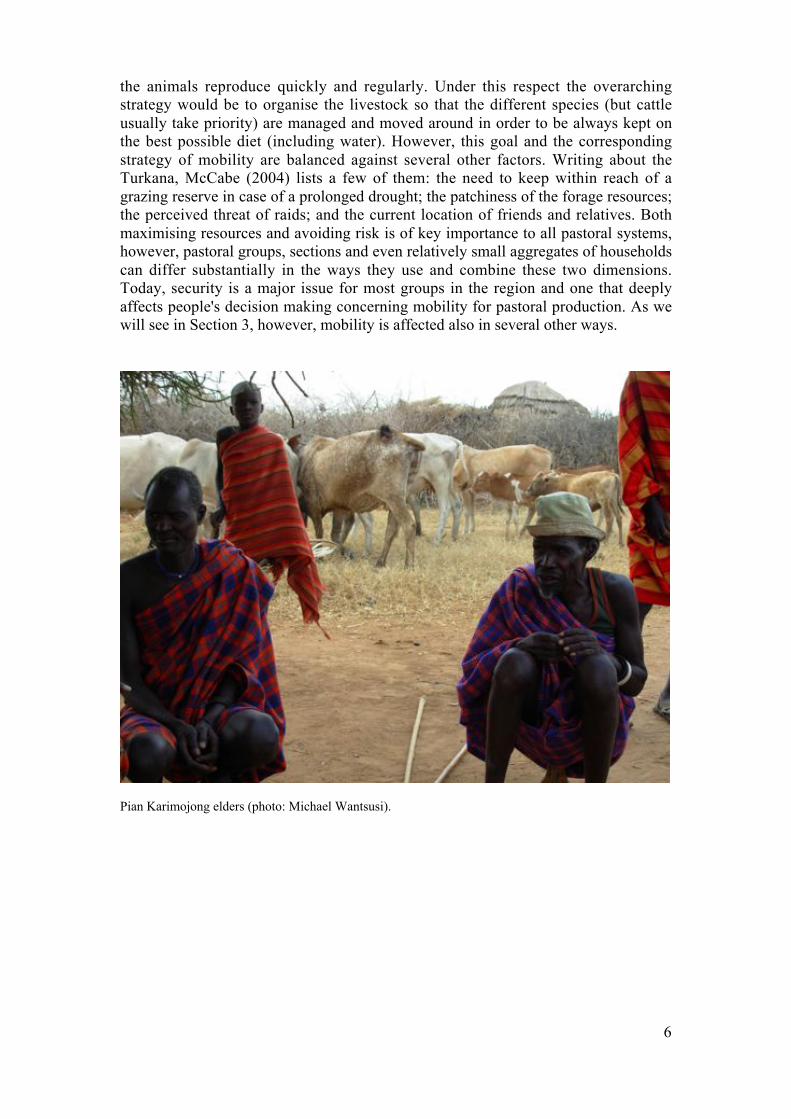
As far as production is concerned, the main objective of the herders is to ensure that
2
The adoption of the terms kraal and manyatta in this study follows the reasons nicely explained by
Stites et al. (2007: 35): ‘The terms 'manyatta' and 'kraal' are widely used in English to refer to the
settlements of the Karamjong, but are not local words. 'Manyatta' is originally a Maasai word, while
'kraal' has its roots in Afrikaans but has become widely used to describe cattle pens as well as
fortified cattle enclosures. For the purpose of consistency, we use these two terms throughout this
report. The correct Ngakaramojong terms are ere for manyatta (plural: ngirerio) and mci for kraal
(plural: ngawaim)’.
6
the animals reproduce quickly and regularly. Under this respect the overarching
strategy would be to organise the livestock so that the different species (but cattle
usually take priority) are managed and moved around in order to be always kept on
the best possible diet (including water). However, this goal and the corresponding
strategy of mobility are balanced against several other factors. Writing about the
Turkana, McCabe (2004) lists a few of them: the need to keep within reach of a
grazing reserve in case of a prolonged drought; the patchiness of the forage resources;
the perceived threat of raids; and the current location of friends and relatives. Both
maximising resources and avoiding risk is of key importance to all pastoral systems,
however, pastoral groups, sections and even relatively small aggregates of households
can differ substantially in the ways they use and combine these two dimensions.
Today, security is a major issue for most groups in the region and one that deeply
affects people's decision making concerning mobility for pastoral production. As we
will see in Section 3, however, mobility is affected also in several other ways.
Pian Karimojong elders (photo: Michael Wantsusi).

7
2. INSTITUTIONAL CONTEXT
The relationship between pastoralists and the state, in the region used by the
Karamojong cluster, has been described as 'distant and often oppositional' (HSBA,
2007: 2). This section traces the institutional and legislative environment of
pastoralists in the region. It begins with a brief look at the legacy of colonial policies,
then considers the relationship between the four states that border the Cluster and
finally gives an outline of the main legislative tools in each of the four states.
2.1 Colonial legacy
The area inhabited by people of the Karamojong cluster was originally divided up by
the British colonial government and the Ethiopian Empire. The colonial governments
of Uganda and Kenya occupied the dryland areas to the north, to act as a ‘buffer’
against what they considered as threatening nomadic groups further north. However,
the international boundaries that were drawn up separated ethnic groups from their
seasonal pastoral resources. The Kenya-Uganda border, for example, follows the
Turkana Escarpment, which separates drier plains to the east and the wetter, elevated
areas to the west, and hence cuts across the seasonal pattern of east-west migration
(USAID 2002, cited in Birch, 2006).
A succession of Turkana and British expansions during the first three decades of
1900, pushed sections of the Pokot from Kenya well into a southern Karamoja still
relatively ‘empty’ of livestock, due a slower recover from the rinderpest epidemics
(Barber, 1968; Lamphear, 1992). At the same time, the Karimojong lost rights to
fertile dry-season grazing areas in the Teso territory (Niamir-Fuller, 1999). After the
sack of Moroto arsenal in 1979, the burst of raids by Karimojong and Turkana, armed
with automatic weapons pushed large numbers of Ugandan Pokot across the border
into Kenya. Soon the Pokot managed to arm themselves with the new technology
starting new cycles of raids from the mid 1990s (Dietz, 1993; cf. also Bollig, 1990).
The most controversial colonial legacy in the area, however, is the disputed
jurisdiction of the
Ilemi Triangle, which
is claimed in part by
Kenya, Sudan and
Ethiopia. The Ilemi
(also Elemi) Triangle
is an area of between
1 4 , 0 0 0 s q u a r e
kilometres and 10,320
square kilometres of
disputed territorial claims between Kenya, Sudan and Ethiopia. The disagreement
dates back to colonial times and has not been resolved by post-independence
governments. A border set in 1902 – the straight Maud Line in the figure below –
gave Sudan control of the entire Ilemi Triangle. In 1938, the British expanded
Kenya’s territorial claims to include water points and higher grounds to the north of
Turkana – the Red Line – and to create a buffer against the raids from groups in
“[T]he area extending from the Ilemi Triangle due south
into Kenya’s Turkana and Pokot districts has become a
battleground for nomadic tribes of no specific
nationality. Due to the lack of governmental control,
each tribe has its own armies of heavily armed bandits
known as the Ngoroko that compete for the latest
technology in small arms, particularly cheap ones from
the former communist countries.” (Mburu, 1999: 98)

8
Sudan. This border was further extended north by the British in 1947 – the Blue Line
(Mburu, 2003).
In absence of official agreements, after Independence, the Kenyan governments
policed the 1938 border (Red Line). The Sudanese government, on its part, policed a
newly defined border to the north, the Patrol Line. This transformed de facto the large
territory between the two unofficial borders into no-man's land ignored by both
governments and prone to serve as a safe-zone for illegal traffic (ibid.). Formal talks
involving Ethiopia in the 1960s failed to reach a settlement. The Didinga communities
of Uganda have traditionally used the Ilemi Triangle as dry season pasture, and the
customary pastures of the Turkana also lie in the highland areas of the Ilemi Triangle.
Figure 3: The Ilemi Triangle
Source: http://upload.wikimedia.org/wikipedia/commons/a/ae/Ilemi_triangle_map.PNG
2.2 Bilateral and international agreements
State borders can cut herders off from their seasonal pastures or can act as a shield
from which bandits and other armed groups can launch raids, and behind which they
can escape afterwards (Wantsusi, 2008). Border can also fuel instability and conflict,
especially when states arm loyal groups along their borders to protect their interests.3
The borders of the region are highly porous, and it is impossible for national
governments to stop pastoralists and others crossing them. Informal, cross-border
trade in cattle has been estimated to account for 26% of the beef consumed in Kenya
(Birch, 2006). Despite this widespread trade operation, cross-border mobility of
3
In the 1990s, the Ethiopian government armed the Dassanetch with AK47, allegedly to protect them
from Turkana and Sudanese cattle thieves. In the fight against the SPLA, the Sudanese government
is estimated to have passed more than 250,000 firearms to border communities in the southern
territories, including 50,000 weapons given to the Toposa (Mburu, 2003).
9
livestock and livestock producers receives very little attention or support at
institutional level.
In contrast to the ECOWAS4 ‘Certificates of Transhumance’ in West Africa, there are
no international or bilateral agreements regulating cross-border mobility between
Uganda, Kenya, Ethiopia and Sudan. The East African Community (EAC) created in
1999 has not so far engaged with issues of transboundary pastoral mobility, not even
in the context of the 2006 EAC Protocol on Environment and Natural Resource
Management. The InterGovernmental Authority on Development (IGAD), the other
major regional organisation, has committed to local peace-building initiatives in the
region (CEWARN5) but has not produced any regional agreements specifically
regarding pastoralism.
2.3 Current government policy towards pastoralism in Karimojong Cluster
Pastoral groups are often governed by a diverse array of partially overlapping and
frequently incompatible regulations relating to land use/land tenure, forestry, water
management and customary law. A detailed survey of legislative and governmental
structures in the four countries concerned with the Karamojong cluster falls beyond
the scope of the present study. However, the structure of local governments and some
of the most relevant legislative frameworks in each country are highlighted here.
General problems shared by all four states concerned, is a lack of clear jurisdiction
across the complexity of legal plurality (state, customary and religious laws), and a
poor capacity for implementation (especially at local government level).
2.3.1 Uganda
Uganda has a local government system of Districts, Counties and Sub-Counties with
executive and legislative powers. These local governments are mandated by the
Constitution of the Republic of Uganda (1995) and the Local Governments
Amendment Act (1997). However, the management of natural resources is
prerogative of the central government in Kampala, leaving local administrations with
no decision-making power on the matter, and limited room for policy implementation.
A Land Act (1998), designed to deal with the many land disputes across the country,
offers some legal basis for pastoral land rights. On paper, the Land Act provides for
the establishment of Communal Land Associations (CLAs) that would fit well into
the social and economic relations of the Karimojong. However, implementation has
so far been disappointing (Wantsusi, 2008; Aciro-Lakor, 2008).
2.3.2 Kenya
Pastoral ethnic groups in Kenya fall under the jurisdiction of county councils. In
addition, they are governed through the provincial administration structure,
represented by the sub-chiefs at Sub-location level, the chiefs at Location level, and
by district officers and district commissioners at District level. The power-sharing
agreement following the 2008 election have opened up new possibilities for
4
Economic Community Of West African States (ECOWAS).5
Conflict Early Warning and Response Mechanism (CEWARN).

10
pastoralists in the north who have traditionally been economically and politically
marginalised. A Ministry for the Development of Northern Kenya and other Arid
Lands has been established with the mandate to remedy the long-standing neglect of
the region.
2.3.3 Sudan
The Government of Southern Sudan (GOSS), in Juba, set up by the Comprehensive
Peace Agreement (CPA) of 2005, administers the southern border areas with Uganda
and Kenya through ten decentralised states. The 1970 Unregistered Land Act allowed
the government to convert large extensions of common land to mechanised
agricultural schemes (De Wit, 2004; for a more recent overview see Pantuliano,
2007). Officially repealed, but not replaced at the national level, the Unregistered
Land Act is still the basis of tribunal judgements. There is no national legal
framework specifically addressing the matters of livestock mobility or land rights for
pastoral groups. Another outcome of the Comprehensive Peace Agreement are the
Land Commissions being set up (in collaboration with the FAO) in order to draw
different land/resource users to consensus with regard to the ownership and use of
land. This process is proving extremely slow and difficult to implement. Since
colonial times, local governance in Sudan has been in the hands of the so-called
Native Administrations (NA), which represented both the 'sedentary' and the
'transhumant' populations. The powers of the NA were hollowed out in the 1970s
through a series of laws enacted by the central government. Some of the original
powers of the NA have now been returned, also as part of the overall process o
decentralisation. Like many local governments in East Africa, however, the NAs tend
to lack the institutional capacity for effective legislative action and enforcement.
2.3.4 Ethiopia
Since its rise to power in 1991, the Ethiopian People’s Revolutionary Democratic
Front (EPRDF) government has presided over a more inclusive attitude to pastoralism
in the country. Notably the 1992 Ethiopian Constitution guarantees that pastoralists
have the right to unclaimed land for grazing and cultivation, and the right not to be
driven from their lands (Article 40(4)6). In addition, the government has recognised
the value of pastoralism to the state through a 'National Day of Pastoralism'. Despite
this general orientation, no legislation is in place to secure land and water rights of
pastoralists in Ethiopia. On the contrary, the alienation of pastoralists from their land
continues. The current policy encourages 'voluntary sedentarisation’ of pastoralists
and the expansion of agriculture on riverbanks. The 1997 Federal Land Act (Federal
Proclamation No. 89/1997 on Rural Land Administration) stipulated that land-holding
rights can be assigned to both ‘peasants and nomads [pastoralists]’ (Alden Wily,
2003: 62). However, the legal framework only allowed for individual or state rights to
be granted, and not communal rights. The Constitution introduced ‘ethnic federalism’,
with regional states, based on traditional ethnic areas, having a degree of autonomy
from the central government in Addis Ababa. Under this system, the federal
government produces a land policy, but delegates the responsibility for specific
legislation on the conditions for land access and ownership to these fledgling regional
states (Helland, 2006). These states lack both administrative capacity and financial
autonomy.
6
Article 40 (4): 'Ethiopian pastoralists have the right to free land for grazing and cultivation as well
as the right not to be displaced from their own lands. The implementation shall be specified by law'
(Constitution of the Federal Democratic Republic of Ethiopia, 1992).

11
2.3.5 Grazing grounds
Very little information is available on the number and location of grazing grounds. A
recent but not comprehensive mapping of grazing grounds in Moroto district
(Uganda) indicates 14. These areas are dotted with water ponds that are largely in
poor condition because of silting. Where there are boreholes, these are rarely in
working conditions. Both the rangeland and the infrastructure are often in a state of
abandon because of insecurity (Wantsusi, 2008). A table of grazing grounds and
livestock corridors in Moroto District is in Annex 1.
2.3.6 International corridors
Information on cross-border mobility is not readily available and comes mostly from
anecdotal evidence. Well known corridors cross the Kenya-Uganda border by Loyor
and through the Matheniko game reserve; the Uganda-Sudan border by Langili,
Makwaju (bordering Kidepo National Park) and the Kenya-Sudan border by
Nadepali.
These international corridors, maintained through kinship-based relationships, are
disappearing face to the escalation of armed conflicts and the promotion of land
privatisation (threatening the existence of communal/pastoral land rights) (Odhiambo,
2000). Recent attempts by the governments of Uganda and Kenya to regulate cross-
border mobility focus on arms traffic rather than pastoral production systems. A 2008
meeting between the governments of Uganda and Sudan focused on regulating cross-
border mobility (Omondi, 2008).
Frequent cross-border mobility takes place between Moroto and Turkana districts.
The Karimojong Matheniko have a long-standing grazing alliance with the
Ngikamatak section of the Turkana (McCabe, 2004). The Turkana can move 40-50
km into the Matheniko Northern Livestock Corridor (Rupa sub-county). The
Matheniko on the other hand, in order to enjoy more security can cross border and
descend the escarpment south of the Loima Hills. Further cross-border mobility is
frequent on the part of the Tepeth of the Katikekile sub-county (located on the slopes
of Mt Moroto in Uganda) and the Pokot of Kenya. The Tepeth cross into Kenya with
their livestock for protection against raids by the Matheniko.
12
3. CHANGES IN MOBILITY
On a level that is general enough to embrace all the groups in the Karamojong cluster,
the mobility (of people and/or livestock) associated to routine pastoral production
hinges on securing high quality feeding and on maintaining efficient channels of
exchange between the manyatta and the kraal. Two other dimensions, although not
directly involved in production, are also crucial: keeping both family and livestock
under conditions of relative security, and reaching adequate pasture in case of
prolonged drought. Although neither comprehensive nor group-specific, this section
aims at sign-posting the key drivers of change affecting these fundamental dimensions
of pastoral mobility and the way they combine with one another.
3.1 Herd size and general impoverishment
The literature consulted for this review seems prone to accept that in the course of the
twentieth century there has been an overall decrease in the number of cattle per
household. This seems also to be the impression of the people working with
pastoralists on the ground. In Karamoja, head of cattle per household may have fallen
from 100 (in 1900) to 50 (in 1950) to just 28 (in 1990) due to the increase in
population (Niamir-Fuller, 1999). To the extent to which these average figures reflect
a real decrease in herd size within the networks of producers as a whole (rather than
just a change in distribution), this has a direct impact on their capacity to run the
manyatta-kraal system of production. Herds below a certain size (keeping count of
their actual composition) are difficult or impossible to split between manyatta and
kraal, even if all the other requirements for production are met. The people working
in the kraal depend heavily on the herd for their food supply. On the other hand, the
labour necessary for the management of the herd does not decrease in proportion with
its size. A small herd is simply not able to support the labour that is necessary to its
management. This dramatically reduces the distance of the kraal from the manyatta
and can lead to the collapse of the dual system altogether. Even when there is only a
reduction of the distance, this has a significant impact on the quality of animal
nutrition and, consequently, on production (Stites et al., 2007).
3.2 Insecurity
Insecurity in the region is originated chiefly from both endemic and exogenous cattle
raiding, military conflicts and aggressive state interventions (e.g. the devastating
disarmament campaigns in Karamoja over the last ten years). A considerable amount
of academic studies and grey literature has been produced on conflict, raids and
insecurity in the region exploited by the groups of the Karamojong cluster. Drawing
on some of the most recent works (and by no means in a comprehensive way) this
section tries to highlight key processes through which pastoral mobility is affected by
insecurity:
" Loss of animals, leading to a reduction of the herd below the viable size (loss
of mobility due to impoverishment). Even if the viable herd-size is itself a
variable affected by many other factors (Devereux and Scoones, 2007), in a

13
given context households that suffer a severe reduction of the herd may be
forced to abandon (if temporarily) the manyatta/kraal system of production.
As far as mobility/production is concerned, the loss of livestock to raids can in
part be balanced by: a) livestock received from friends and relatives; and b)
counter raids. However, these practices are only partially effective. Today's
large scale raids hit large numbers of households, leaving little margin for the
working of moral economy as entire social networks suffer severe losses. On
the other hand, the possibility of 'getting the livestock back' through counter
raids is seriously jeopardised by the fact that raiding has ceased long time ago
to be an endemic practice and most stolen livestock today is simply taken out
of the pastoral economy to be sold on distant markets (cf. Krätli and Swift,
1999; Lind, 2006).
" Loss of labour/knowledge and disruption of the breeding network as people
are killed in conflicts and more flee seeking refuge in other areas. Obviously,
this is always a net loss to the production system. Over 1,200 people are
thought to have been killed and approximately 300,000 cattle stolen in the
latter half of the 1990s in Kenya alone (Human Rights Watch, cited in Birch,
2006; Nangiro, 2006).
Figure 4: Livestock losses due to cattle raiding
Source: CEWARN, 2006.
Table 2: Impact of pastoral violence in Ethiopia-Kenya-Uganda border regions (May-Aug 2006)
Country No. of incidents No. of deaths% cross-border
incidents
Ethiopia 16 21 87%
Kenya 11 31 26%
Uganda 117 147 5%Source: CEWARN, adapted from Bevan (2007).

14
" Multiplication of no-go areas because of the risk of attacks. In the short term,
this represents a net loss of access to often important resources. But there are
also long term consequences. Grazeland left unused for even just a few years
can suffer significant deterioration as a resource for pastoral production.
Similarly, lack of use impacts negatively on existing infrastructures such as
boreholes and water ponds.
" Stricter regulations and policing of state borders make standard and
exceptional patterns of transboundary mobility both more difficult and more
risky.
" Vicious circles of violence
associated with repressive
disarmament campaigns, as
erratic and antagonistic state
interventions increase the
overall level of insecurity.
O f t e n , h e a v y - h a n d e d
government disarmament
schemes focus on just
disarmament alone and leave
the social reasons underlying the spread and continued use of small arms
untouched. Little action is taken for mediation, conflict resolution or local
development, resulting in a continued cycle of violence. There are well-
reported violations of human rights during forceful disarmament (Nangiro,
2005; Akabawi and Ateyo, 2007; Bevan, 2007; Stites, 2007; McEvoy and
Murry, 2008). The failure of government to provide adequate security on the
regional level is one of the motivating factors behind the spread of small arms
in the area (Human Rights Watch, cited in Birch, 2006). The reasons for
intense cattle raiding and banditry are debated. It is clear, however, that the
spread of arms is a consequence of the climate of fear in the region: 'By far the
most effective protection against raiding is to have, and to show, as many guns
and able-bodied men as possible' (Niamir-Fuller, 1999: 161).
" Problems with inter-district mobility and deterioration of existing patterns of
co-operation and economic integration. Guerrilla groups have been active
across the border between Sudan and Uganda since the 1980s, first the Lord’s
Resistance Army (LRA) and later, since the 1990s, the People’s Liberation
Army (PLA). Before the neighbouring regions broke into armed insurgency,
the Karimojong herders used to move into the Teso, Lango and Acholi regions
with relatively few hurdles. The contiguity with a war zone, following the
insurgency, fuelled and exacerbated raiding practices involving all
neighbouring communities. Now the Bokora find it difficult to cross to Teso
(in the Amuria and Katakwi districts) for dry-period grazing. The Karimojong
are accused of raiding the Teso communities during the PLA war, and the
Acholi and Lango communities during the LRA war. These accusations tap
into pre-existing inter-tribal rivalries and raise strong emotions even among
local leaders and national politicians. Adding to the growing tension between
the Karimojong and their neighbours is the view that the government appears
to be protecting the interests of the neighbouring districts. Livestock raiding is
“Ngoroko banditry thrives in endemic
poverty that springs from neglect by the
existing state structure of Uganda, Kenya,
Sudan, and Ethiopia, where geographical
distance from each country’s capital
literally translates into distance from
consideration of the people’s economic
advancement and security.”
(Mburu, 1999: 98)
15
simply being equated to livestock mobility. Since 2001, it has been
increasingly difficult for the Karimojong herders to cross with their livestock
into the neighbouring districts (Wantsusi, 2008; on the complexity of conflict
and intratribal politics in Karamoja see Gray, 2000 and Odhiambo, 2003; for a
regional perspective on the issue see Gray et al., 2003).
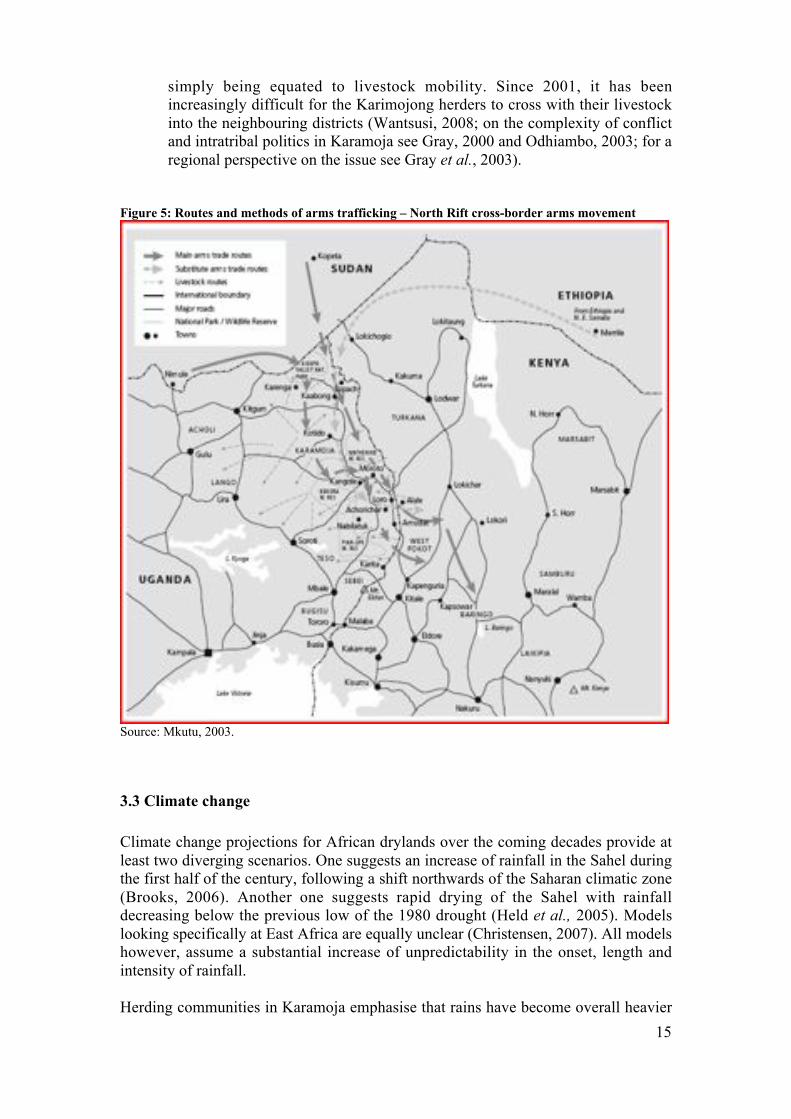
Figure 5: Routes and methods of arms trafficking – North Rift cross-border arms movement
Source: Mkutu, 2003.
3.3 Climate change
Climate change projections for African drylands over the coming decades provide at
least two diverging scenarios. One suggests an increase of rainfall in the Sahel during
the first half of the century, following a shift northwards of the Saharan climatic zone
(Brooks, 2006). Another one suggests rapid drying of the Sahel with rainfall
decreasing below the previous low of the 1980 drought (Held et al., 2005). Models
looking specifically at East Africa are equally unclear (Christensen, 2007). All models
however, assume a substantial increase of unpredictability in the onset, length and
intensity of rainfall.
Herding communities in Karamoja emphasise that rains have become overall heavier
16
and shorter, with an increased frequency of prolonged droughts. Herders also
highlight a diminished resistance to drought in their livestock, including camels
(Oxfam, 2008). According to local sources, the Karimojong Matheniko no longer
cross the Kenyan border into Turkana as the areas they used to go have become
markedly drier since the late 1990s. In other parts of Karamoja, such as the
Matheniko Southern Livestock Corridor (in the Nanduget sub-county), water sources
– especially ponds – have disappeared. Water ponds have also disappeared in other
places due to failed maintenance measures that would have prevented silting
(Wantsusi, 2008).
It is difficult to pinpoint the causes of change. For example, the phenomenon of
diminished resistance to drought in livestock could result from cumulative stress, with
the animals struggling to recover from one prolonged drought to the next. However,
there might also be different causes, including diminished mobility and the
consequent diminished quality of animal nutrition; or erosion of the breeding
networks and the consequent diminished competence/capacity of the herds to exploit
the nutritional opportunities offered by mobile strategies (Krätli, 2008; Kaufmann,
2007).
3.4 Antagonistic development policies
With government policies that are pro-sedentarisation, agricultural production has
been given the upper hand over pastoralism. Pastoralists have therefore been
encouraged to settle, in exchange for the provision of certain services, like adequate
health centres and schools. In areas where the governments have developed
intervention mechanisms to assist the pastoralists, such interventions have paid little
attention to the pastoral way of life and its mobility patterns (Catley et al., 2005). In
the bid to make water accessible to the pastoralists, for instance, providers – including
the government – have constructed water points in a haphazard manner, disrupting the
established migratory routes, which has led to intensified rivalry between the
pastoralist groups, and led to a kind of permanent settlement along the water points
that is increasing environmental degradation (Odhiambo, n/d).
3.5 Large-scale conversion of pastoral land to other uses
Given the semi-arid nature of the region exploited by the producers in the
Karamojong cluster, top-down large-scale use conversions in the past were mainly for
the creation of wildlife reserves. Today, however, the rising demand for oil and
minerals is generating new threats.
In Uganda, the creation of the Kidepo Valley National Park in the 1980s (on the
border with Sudan and Kenya), which would have stopped pastoralists from using the
territory, was somehow neutralised by a 1987 arrangement (following social unrest)
that allowed 'Ugandan pastoralists' limited access to the grazeland within the
boundaries of the park. Such arrangement is apparently still respected. The Toposa of
Sudan, however, who cross into Uganda every year in the dry period, to access
grazeland in the Kaabong district, have experienced a lot of difficulties following the

17
creation of the Park (Wantsusi, 2008). In the Kaabong district, the Dodoth herders
used the Timu forest during the wet period, before the area was declared a Forest
Reserve in 2000 and they were excluded (ibid.).
Another gazetted area is the Pian-Upe Game Reserve, on the border between Uganda
and Kenya and concerning the movement of respectively Pian Karimojong and Pokot.
The development of cross-border initiatives such a co-management framework
pulling together the interests of both pastoralists and the governments, would be very
useful.
In recent years, large-scale conversion of pastoral land has taken a new face, with a
focus on emerging opportunities for the big capital and foreign investors interested in
energy and mineral development (AllAfrica 2008; Kalua, 2008; ICBCD, 2006;
MEMD, 2002; for an overview of the topic, cf. McGahey, 2008). In Uganda, the
argument that a pacified Karamoja region would attract valuable foreign investments
has been used to legitimise the spirit of urgency and dismissal of basic human-rights
that has characterised the disarmament campaigns (Knighton, 2002). Concessions to
international players are already under way in Karamoja, for the conversion of land
from current pastoral uses to plantations of the biofuel feedstock Jatropha Curcas
(Michael Ochieng Odhiambo, RECONCILE, personal communication, 2008).
3.6 War on terrorism
The global war on terrorism, with the new American interest in the Sahel and the
Horn of Africa, offers the governments in these regions new opportunities for military
and financial assistance. However, the agenda of the war on terrorism focuses both
attention and investments on an oversimplified explanatory framework. Under the
new counter-terrorism commitment, governments can easily excuse themselves for
choosing repressive measures over constructive ones, military action over negotiation
and development, and exacerbating old and today untenable ideological positions –
such as antagonising internal mobility and closing the frontiers – based on new
rationalisations (Knighton, 2002; Stites, 2006).

18
4. KEY ACTORS (DEVELOPMENT AND RESEARCH)
This last section provides an overview of key development projects working with
pastoralists in the region. Pastoralism is rarely the core concern of development
projects, and most of the attention to pastoralists in the region has a specific focus on
conflict resolution. Relatively up to date maps of 'who is doing what' in Karamoja,
with a focus on humanitarian activities, are available on the IASC7 Clusters Approach
website (http://www.ugandaclusters.ug/index.html).
4.1 Project and Contacts
1. Pastoral Community Harmonization Initiative (PHCI) by AU-IBAR and
Practical Action
Built on informal, cross-border interaction, the AU-IBAR (Inter-African Bureau of
Animal Resources) with Practical Action (then ITDG) set up the Pastoral Community
Harmonization Initiative. The organisation first entered the region in an attempt to
protect livestock health against rinderpest, and was drawn into conflict resolution and
peace-building activities as a result of the interconnectedness of livestock health and
community management (Minear, 2002). They organised a series of meetings –
known as the Pastoral Community Harmonization Initiative (PCHI) – attended by up
to 200 people, which brought together senior government officials, elders, chiefs, and
community groups throughout 2001-2003. The meetings, which had the overall aim
of strengthening the voices of pastoral communities, helped forging personal contacts
between elders and government officials, which in turn has led to swifter dealing with
episodes of cattle theft. At the meetings, participants discussed protecting herdsmen
who graze their animals across international borders, and joint activities such as road
rehabilitation (Birch, 2006).
IBAR has also been supporting women’s choirs on ‘peace-crusades’ across the
border. Local government officials in Kotido have been reported to find that if the
current IBAR approach is addressing the most manifest dimension of conflict ('fire-
fighting'), it could engage more in tackling its deep causes (Mkutu, 2003: 35).
Further details:
Dr. Akabwai
Pastoral Community Harmonization Initiative of AU-IBAR’s Community Based
Animal Health and Participatory Epidiology (CAPE)
Box 30786, Nairobi
Tel: +254 020 211 751
7
Inter-Agency Standing Committee (IASC).

19
2. Adakar Peace and Development Initiatives (APEDI)
Peace-building between Turkana and Toposa (northwest Kenya and southern Sudan)
is primarily handled by the Adakar Peace and Development Initiatives (APEDI). This
civil society organisation promotes dialogue and conflict resolution at the local level,
aiming at reinforcing traditional and modern governance structures and dissolve
conflicts before they escalate. The APEDI works with municipal governments and
civil society organisations in Narus, southern Sudan, to prevent raiding into Kenya.
Their first intervention was in February 2005. APEDI was instrumental in negotiating
an 18-month cease-fire between sections of Turkana and Toposa, 'that, for the first
time in decades, allowed Turkana and Toposa to walk safely with their livestock
across the border'. The cease-fire ended in January 2007 when a group of Toposa
launched a raid 50 km outside Lokichoggio. APEDI lent its mediation services to help
damping the spin of retaliation (HSBA, 2007)
Further details:
Alex Losikiria
Director, APEDI
Kenya
Tel: +254 735 235928
3. CEWARN (Conflict Early Warning and Response Mechanism)
The governments of IGAD agreed to form the Conflict Early Warning and Response
Mechanism (CEWARN) in 2002. The first CEWARN Unit office opened in Addis
Ababa in June 2003. The structure monitors and shares information on cross-border
and pastoral conflict, reports are published on the CEWARN website
(www.cewarn.org). It works in Karamoja and the Somali and Afar Issa area.
CEWARN has been criticised for placing too much emphasis on imported (alien)
structures for conflict resolution rather than engaging with the traditional mechanisms
already in place (Mkutu, 2003).
Further details:
Abdelrahim Ahmad Khalil
Project Director
CEWARN
P . O . B o x 5 8 6 5 2
Addis Ababa
Tel: + 251 (11) 3728091 /93 /94
3. KADP (Karamoja Agro-pastoral Development Programme)

20
Originally established as a Lutheran World Federation programme in response to the
famine of 1979, KADP became an independent local NGO in December 2002.
KADP works with agricultures and herders in the Moroto and Nakapiripirit districts
of Uganda. It has traditionally supported herders’ livelihoods through a network of
livestock drug outlets and the training of Community Animal Health Workers. It also
operates a Resource and Policy Centre.
More recently, with funding from Danchurch Aid-Denmark, KADP has begun to
favour sedentarisation of pastoralists and encouraged them to adopt farming as an
alternative livelihood alongside more traditional activities whilst maintaining their
aim of reducing pastoral conflict. This clearly has an adverse effect on livestock
mobility as discussed in this report.
In 2008 and 2009, KADP is implementing a new Uganda – Kenya Cross Border
Drought Cycle Management Project, to contribute to alleviating the impact of drought
cycles and conflicts on agro-pastoralists in Karamoja (Uganda) and North Pokot
(Kenya) through the improvement of livestock health, water structures and early
warning systems for livestock and herders.
Further details:
Michael Wantsusi
Coordinator
Karamoja Resource and Policy Centre
PO Box 21, Moroto
Uganda
+256 774 139 445
Simon Nangiro
00256 772 472 474
4.1.2 Other projects
Peace-building in the Kenya-Uganda area is promoted by US-AID through
Development Alternatives Inc., Riam Riam (Kenya) and the Kotido Peace Initiative
(KOPEIN-Uganda). Mediation efforts were undertaken between sections of Dodoth
and Turkana during an escalation of clashes in 2004. The absence of raids between
the factions in 2005 is used in support of the argument for timely mediation.
OXFAM is believed to be active in the work of supporting livestock mobility in this
area but when contacted by researchers for this desk review maintained that they had
no documentation of this work.

21
4.2 New projects starting in 2008
1. Improved Community Response to Drought Project by VSF – Belgium
This 18-month project started in January 2008. The project works in three locations
along the Kenyan border with, respectively, Uganda (Karamoja), Ethiopia and
Somalia. The aim of the project is to secure communities' livelihood against natural
disasters and conflict. There is a focus on developing community grazing agreements
and alternative income generation opportunities. The project is committed to the
introduction of ‘holistic rangeland management systems’ through the creation of
pastoral field-schools.
Further details:
Mr. Robert Allport,
Regional Programme Manager
PO B OX 13986,00800
3RD
Floor, Titan Complex
Nairobi
Tel: +254-020-2734518 /19 /20 /24 /27
2. Mifugo Project, Institute for Security Studies (ISS)
Funded by the Federal Republic of Germany, this project aims to support the works
for the Draft Protocol on the Prevention, Combating and Eradication of Cattle
Rustling in Eastern Africa. The Protocol was agreed by the Eastern Africa Police
Chiefs Co-operation Organisation (EAPCCO) and aims to increase public awareness
of the problem, and improve the mechanisms to recover stolen cattle (Bevan, 2007).
Working with Parliament and civil society groups in Kenya, Uganda, Tanzania,
Ethiopia and Sudan, the project is preparing a regional system of livestock branding
and marking.
Further details:
Ms Augustine Muchemi
Programme coordinator (Mifugo project)
P O Box 12869 GPO (00100)
Nairobi
Email: [email protected]
Tel +254 20 3005726/28
3. Karamoja Livestock Development Programme (KLDP), VSF-Belgium
A two year project (2008-2010) implemented by VSF-Belgium and funded by the
Belgium Government and the European Commission/ECHO. It is based in Matheniko
County (Moroto District) and focuses on improving animal health, water, livestock
marketing and peace-building. Activities include the rehabilitation of boreholes and
construction of water troughs; the construction and desilting of water ponds and the
training and equipping community animal health workers. There is attention to local
knowledge.
22
Further details:
Lokii John Baptist
Uganda
Tel: +256 772 389 904
+256 751 389 904
+256 751 760 325
Conclusion and summary of issues that need to be addressed
The limitations of this desk-based review in such a complex and changeable area are
obvious. This report has shown how, by using a multiple cross-border region, the
pastoralists of the Karamojong cluster face exceptional challenges. The specific role
of conflict has been questioned, although no solutions could be firmly put forward.
Development actors have recently given great attention to conflict resolution but
results are mixed, perhaps due to a focus on symptoms (carrying small-arms, cattle
rustling) rather than on causes (for example marginalisation, resource scarcity).
In the conditions under which the pastoralists of the Karamojong cluster are
producing, mobility of people and livestock is key to production. If mobility is to be
effectively protected and promoted, the following areas will need attention.
Mapping of livestock routes
No maps of livestock corridors were found during the research for this report,
therefore the recommendation in this case is that field research should be carried out
in order to establish existing corridor locations and mapping them; this will include
mapping the length of the corridors as well as their routes and start/end points. With
the corridors effectively mapped, greater consideration can be given to the land rights
of pastoralists when planning future game reserves, national parks, and other large-
scale land division uses.
Strengthening Pastoralists’s Land Rights
In addition, the fragile land rights of the pastoralists in the Karamojong cluster need to
be strengthened. Access and right to land to graze cattle and other animals lies at the
root of pastoral livelihoods. Thus, the passing and implementation of laws which
facilitate the communal registration of pastoral rangelands (such as the Communal
Land Associations as provided in the Uganda Land Act, 1998) is a recommendation
of this review.
Building local government capacity
Another area for development is the legislative capacity of local governments in the
four countries concerned with the Karamojong cluster. This could lead to effective
advocacy for recognition of, support for, and investment into pastoralism and
23
livestock mobility.
Promoting cross-border initiatives
The Ugandan, Kenyan, Sudanese and Ethiopian Governments need to recognise the
interrelation that exists between the groups of the Karamojong cluster, so as to
develop more harmonised policies that could be applicable on both sides of a drawn
border without hindrance. Existing cross-border initiatives are greatly under-
developed.

24
REFERENCES
Aciro-Lakor R. (2008) ‘Land rights information centres in Uganda’, in Cotula L. and
Mathieu P., eds, 2008, Legal Empowerment in Practice: Using legal tools to secure
land rights in Africa, International Institute for Environment and Development(IIED), London.
Akabawi D. and Ateyo P.E. (2007.) The Scramble for Cattle, Power and Guns in
Karamoja, Feinstein International Center, Tufts University, Medford MA, and Addis
Ababa.
Alden Wily, L. (2003) Governance and Land Relations: A review of decentralisation
of land administration and management in Africa, International Institute for
Environment and Development (IIED), London.
AllAfrica (2008) 'Uganda: Country Set to Be Major Producer of Bio-Diesel', East
African Business Week (Kampala), 22 November 2008,
http://allafrica.com/stories/200811241483.html
Barber J. (1968) Imperial Frontier: a study of retaliations between the British and the
pastoral tribes of North East Uganda, East African Publishing House, Nairobi.
Bevan J. (2007) Between a Rock and a Hard Place: Armed Violence in African
Pastoral Communities. UNDP, Conference Background Paper,
http://www.undp.org/cpr/documents/armed_violence/AV_pastoral_communities.pdf
Birch, Isobel. (2006.) Political Integration: From above or from below? A perspective
from pastoralist areas of East Africa, Unpublished MSc dissertation, School of
Oriental and African Studies (SOAS), London.
Bollig M. (1990) 'Ethnic conflicts in North West Kenya: Pokot-Turkana raiding 1969-
1984'. Zeischrift für Ethnologie 115:73-90.
Brooks N. (2006) Climate change, drought and pastoralism in the Sahel, Discussion
note for the World Initiative on Sustainable Pastoralism,
www.iucn.org/wisp/documents_english/climate _changes.pdf
Catley A., T. Leyland and S. Bishop (2005) Policies, Practice and Participation in
Complex Emergencies: The Case of Livestock Intervention in South Sudan. A case
study of the Agriculture and Development economics Division of the FAO, Food and
Agriculture Organisation of the United Nations, Rome.
CEWARN (2006) 7th Regional Report on the Karamoja Cluster, May – August 2006,
Conflict Early Warning and Response mechanism Regional Reports, Addis Ababa.
Christensen J.H., B. Hewitson, A. Busuioc, A. Chen, X. Gao, I. Held, R. Jones, R.K.
Kolli, W.-T. Kwon, R. Laprise, V. Magaña Rueda, L. Mearns, C.G. Menéndez, J.
Räisänen, A. Rinke, A. Sarr, and P. Whetton (2007) ‘Regional Climate Projections’,
in Climate Change: The Physical Science Basis, contribution of Working Group I to
the Fourth Assessment Report of the Intergovernmental Panel on Climate Change [A.
Solomon, D. Qin, M. Manning, Z. Chen, M. Marquis, K.B. Averyt, M. Tignor, and

25
H.L. Miller (eds)], Cambridge: Cambridge University Press.
Constitution of the Federal Democratic Republic of Ethiopia (1992),
http://www.ethiopar.net/
Devereux S. and Scoones I. (2007) The crisis of pastoralism? A response,
http://www.future-agricultures.org/pdf%20files/the_crisis_of_pastoralism.pdf
De Wit P. (2004) Land and Property Study in Sudan. Interim Report: Scoping of
Issues and Questions To Be Addressed, Norwegian Refugee Council, UNHCR and
FAO.
Dyson-Hudson N. (1958) The Present Position of the Karimojong. A preliminary
general survey, with recommendations, produced for the Government of Uganda,
Oxford University, Institute of Social Anthropology, Oxford.
Dietz T. (1993) 'The State, the Market, and the Decline of Pastoralism: Challenging
some Myths, with Evidence from Western Pokot in Kenya/Uganda', in Markakis J.,
ed., Conflict and the Decline in Pastoralism in the Horn of Africa, Macmillian,
London.
Dyson-Hudson N. (1966) Karimojong Politics, Clarendon Press, Oxford.
Dyson-Hudson R. (1985) South Turkana Nomadism: Coping with an Unpredictably
Varying Environment, Ethnography Series F L17-001, HRAFlex Books, New Haven.
Held I.M., Delworth T.L., Lu J., Findell K. and Knutson T.R. (2005) 'Simulation of
Sahel drought in the 20th
and 21st centuries', Proc. Nat. Acad. Sci. 102: 17891-17896.
Helland J. (2006) Pastoral Land Tenure in Ethiopia, paper presented at the Colloque
international 'Les frontières de la question foncière – At the frontier of land issues',
Montpellier, France, http://www.mpl.ird.fr/colloque_foncier/Communications/
PDF/Helland.pdf
HSBA (2007) Responses to pastoral wars: A review of violence reduction efforts in
Sudan, Uganda, and Kenya, Sudan Issue Brief No. 8 (Sept.), Human Security
Baseline Assessment, Graduate Institute of International and Development Studies,
Geneva.
Gray S. (2000) A Memory of Loss: Ecological politics, local history, and the
evolution of Karimojong violence, Human Organization 59(4):401-18.
Gray S., M. Sundal, B. Wiebusch and M.A. Little, eds, (2003) 'Cattle Raiding,
Cultural Survival and Adaptability of East African Pastoralists', Current
Anthropology 44(5): 3-30.
Gulliver P.H. (1951) A Preliminary Survey of the Turkana. A Report compiled for the
Government of Kenya, Communications from the School of African Studies, New
Series No. 26, University of Cape Town, Cape Town.
Gulliver P.H. (1952) ‘The Karamajong Cluster’, Africa 22: 1-22.

26
Gulliver P.H. (1955) The Family Herds. A Study of Two Pastoral Tribes in East
Africa. The Jie and Turkana, Routledge, London.
ICBCD (2006) Acting Toghether. A Common Commitment to the Global
Environment, International Co-operation on Biodiversity, Climate Change and
Desertification, European Commission, Luxenbourg,
http://ec.europa.eu/external_relations/env/ rio_posters/02_rio _broch_en.pdf
Kalua I.P. 2008. Report on Bio-fuel (Jatropha) and Rural Development in Kenya,
GreenAfrica Foundation, http://www.greenafricafoundation.org/documents/
UNIDO%20Conference%20Report%20by%20Isaac%20P%20Kalua.pdf
Kaufmann B.A. (2007) Cybernetic Analysis of Socio-biological Systems: The Case of
Livestock Management in Resource-Poor Environments, Margraf Publishers GmbH,
Weikersheim, Germany.
Knighton B. (2002) Historical ethnography and the collapse of Karamojong culture:
Premature reports of trends, paper presented in the African Studies Seminar, St.
Antony’s College, University of Oxford, 13 June 2002, http://www.eldis.org/
fulltext/knighton_karamoja.pdf
Knighton B. (2005) The Vitality of Karamojong Religion: Dying Tradition or Living
Faith?, Ashgate, Hants, UK.
Krätli S. (2008, forthcoming) 'Cattle breeding, Complexity and Mobility in a
Structurally Unpredictable Environment', Nomadic Peoples 12(1).
Krätli S. and Swift J. (1999), Understanding and managing Pastoral Conflict in
Kenya. A literature review, Undertaken under DFID contract 98 6863, Institute of
Development Studies (IDS), Brighton, http://www.eldis.org/fulltext/pastconf.pdf
Lamphear J. (1992) The Scattering Time: Turkana Response to Colonial Rule,
Clarendon, Oxford.
Lawrance J.C.D. (1953) 'The Karamojong Cluster: A Note', Africa 23: 244-9.
Lind J. (2006) Fortune and loss in an environment of violence: living with chronic
instability in south Turkana, Kenya, Unpublished PhD thesis, King’s College London.
Little M.L. and Leslie P. W., eds (1999) Turkana Herders of the Dry Savanna.
Ecology and biobehavioral response of nomads to an uncertain environment, Oxford
University Press, New York.
Mburu N. (1999) 'Contemporary Banditry in the Horn of Africa: Causes, History and
Political Implications', Nordic Journal of African Studies 8(2): 89-107.
Mburu N. (2003) 'Delimitation of the Elastic Ilemi Triangle: Pastoral Conflicts and
Official Indifference in the Horn Of Africa', African Studies Quarterly 7(1): 15-37,
http://www.africa.ufl.edu/asq/v7/v7i1a2.htm.

27
McCabe J.T. (1984) Livestock Management among the Turkana: A Social and
Ecological Analysis of Herding in an East African Pastoral Population, Ph.D
dissertation, Department of Anthropology, State University of New York,
Binghamton, NY.
McCabe J.T. (2004) Cattle Bring Us to Our Enemies: Turkana Ecology, Politics, and
Raiding in a Disequilibrium System, Human-Environment Interactions Series,
University of Michigan Press, Ann Arbor, MI.
McEvoy C. & Murray R. (2008) Gauging Fear and Insecurity: Perspectives on
Armed Violence in Eastern Equatoria and Turkana North, Small Arms Survey,
Graduate Institute of International and Development Studies, Geneva.
McGahey D. (2008) Jatropha Development in Africa. A Major Threat or New
Opportunity for sahelian Pastoralists?, SOS Sahel International UK, Oxford.
MEMD (2002) The Renewable Energy Policy for Uganda, Ministry of Energy and
Mineral Development, Republic of Uganda, Kampala, http://www.gopa.de/uploads/
tx_bdojobopps/MoEMD_energy_policy_for_Uganda_2002.pdf
Minear L. (2002) Pastoralist Community Harmonization in the Karamoja Cluster:
Taking it to the Next Level, Feinstein International Center, Tufts University, Medford
MA and Addis Ababa.
Mkutu K. (2003) Pastoral conflict and small arms: The Kenya-Uganda border
region, report on small arms and security in the Great Lakes region and the Horn of
Africa. Saferworld, London.
Nangiro S. (2005) UNDP HDI Violent Conflict: The impact of insecurity on
livelihood and social service provision in Kotido district,Human Development Report
Office Occasional Paper, http://hdr.undp.org/en/reports/global/hdr2005/papers/
HDR2005_Nangiro_Simon_21.pdf
Niamir-Fuller M. (1999.) 'Conflict management and mobility among pastoralists in
Karamoja, Uganda', in M. Niamir-Fuller, ed., 1999, Managing Mobility in African
Rangelands: The Legitimization of Transhumance, Intermediate Technology
Publications, London.
Niamir-Fuller, Maryam, ed. (1999) Managing Mobility in African Rangelands: The
Legitimization of Transhumance, Intermediate Technology Publications, London.
Nori, M., Taylor M. and Sensi A. (2008). Pastoral land rights, livelihoods and
adaptation to climate change, IIED issue paper no. 148, International Institute for
Environment and Development (IIED), London.
Novelli B. (1988) Aspects of Karimojong Ethnosociology, Comboni, Verona, Italy.
Odhiambo, M.O. (2000) Working with customary agro-pastoral institutions in
conflict management: The KADP approach, Printing House Road, Nakuru, Kenya.
Odhiambo, M.O. (n/d) Pastoralists Land Rights under Customary Land Tenure

28
System; Proposed National Land Policy (Kenya). RECONCILE, Kenya.
Odhiambo M.O. (2003) The Karamoja Conflict: Origins, Impact and Solution,
Oxfam, Kampala.
Omondi S. (2008.) Livestock Mobility in the Karamojong Cluster: The view from
Kenya. Unpublished paper prepared for SOS Sahel UK.
Oxfam (2008) Survival of the fittest: Pastoralism and climate change in East Africa,
Oxfam Briefing Paper No. 116, Oxfam, Oxford.
Pantuliano S. (2007) The land Question: Sudan’s peace nemesis, HPG Working
Paper, Humanitarian Policy Group, Overseas Development Institute, London.
Stites E. (2006) Humanitarian Agenda 2015, Northern Uganda Country Study,
Feinstein International Center, Tufts University, Medford MA and Addis Ababa.
Stites E., Akabwai D., Mazurana D. and Ateyo P. (2007) Angering Akuj_: Survival
and Suffering in Karamoja. A Report on Livelihoods and Human Security in the
Karamoja Region of Uganda, Feinstein International Center, Tufts University,
Medford MA and Addis Ababa.
Wantsusi M. (2008) Livestock Mobility in the Karimojong Cluster: The view from
Uganda. Unpublished paper prepared for SOS Sahel UK.
Wayland E.J. (1931) 'Preliminary Studies of the Tribes of Karamoja (The Labwor, the
Wanderobo, the Dodotho and the Jie; with a note concerning the Karamojong)',
Journal of the Royal Anthropological Institute 61: 187-230.

29
Annex 1: Grazing grounds and livestock corridors in Moroto District, Uganda:
Name of
corridor or
grazing ground
Location Description /
status
Peoples Time used Estimated
Length
Naminit grazing
ground
Iriir sub-
county,
Moroto
Water ponds largely
silted up
Ngitome,
herders of
Lotome and
Lokopo sub-
counties
Dry Period
(October to
April): grazing
only; Wet
Period (April
to September):
mainly
obstructed by
crop fields
Approx. 30-40 km long
Kachalekeny
grazing ground
Iriir sub-
county,
Moroto
Water ponds largely
silted up
Ngikopo,
herders of
Lotome and
Lokopo sub-
counties
Livestock
grazing
throughout the
year
Approx. 30-40 km long
Lokitelarengan
grazing ground
Matany
sub-
county,
Moroto
Stretches from
Morulinga Hill to
Louno and Korithae
Hills
Ngimerimong
herders of
Matany
Approx. 25-40 km long
Nakichumet
grazing ground
Matany
sub-
county,
Moroto
Two water dams
largely silted up.
Area affected by
livestock raids from
the Pian of the
Nakapiripirit
district, the
Matheniko of
Moroto, and the Jie
of Kotido
Herders from
Matany,
Lokopo,
Lopeei, Iriir
and Lotome
No data Up to 45 km
Nakangolei
grazing ground
Lopeei
sub-
county,
Moroto
district
Effected by inter-
ethnic raids
Ngikopo,
Ngipeei,
Matany, the
Matheniko
from Moroto,
and the Jie of
the Kotido
district
No data Up to 45 km
Lochagar
livestock corridor
Lopeei
sub-county
of the
Moroto
district
Water ponds are
largely silted up
No data Wet season:
grazing. Dry
season:
livestock are
moved to
wetter areas,
especially in
the Iriir sub-
county
30-40 km

30
Matheniko
Northern
Livestock
Corridor (grazing
ground)
Rupa sub-
county and
Borders Mt Moroto
to the southeast, the
Uganda-Kenya
border to the east,
the Kotido and
Kaabong districts to
the north and the
Lopeei sub-county
to the west
Matheniko
and the
Turkana from
Kenya (also
the the Jie
from Kotido in
times of
peace)
Dry period
(October to
April): used
for livestock
45-50 km long
Matheniko
Southern
Livestock
Corridor
Nadunget
sub-county
Borders Mt Moroto
to the east, the
Lorengdwat sub-
county to the
southeast, Ngoleriet
sub-county to the
west and the Lopeei
and Rupa sub-
counties to the north
Matheniko,
Pian, Bokora
and Jie
peoples (when
there is peace)
Mainly used in
the wet season
No data
(Adapted from Wantsusi, 2008)