semantic geospatial data integration and mining for
TRANSCRIPT

Semantic Geospatial Data Integration and Mining
for National Security
Ashraful Alam
Bhavani Thuraisingham
Ganesh Subbiah
Latifur Khan
University of Texas at Dallas
(Funded by Raytheon Corporation)
Shashi Shekhar
University of Minnesota

Geospatial Data Integration:
Motivating Scenario
Query: “Find movie theaters
within 30 miles of 75080”
within, near, overlap – Geospatial
Operators
Theaters, Restaurants – Businesses
(Non-Geospatial data)
Miles – Distance Unit
75080 , Richardson – Geo References
Cinemark
Movies 10Radisson Hotel Dallas North-
Richardson

Key Contributions
� Query can be handled by• Traditional search engine – Google, Yahoo –Not at Semantic level
• Almost no search engine facilitates finding relevant web services (except Woogle – template matching for web services & no composition) and handle complex queries
� DAGIS – Discover geospatial semantic web services using OWL-S Service ontology coupled with geospatial domain specific ontology for automatic discovery, dynamic composition and invocation• Facilitates semantic matching of functional and non-functional services from various heterogeneous independent data sources.

Key Contributions
DAGIS DAGIS DAGIS
Query Matchmaker Composer
Agent
Client Browser
Web Service
Provider A
Web Service
Provider B
Advertise As Semantic Services
� Automatic Semantic
Query Generation by
DAGIS Query Agent
� Semantic Matching
using Matchmaker for
Functional and QoS
Parameters
� Dynamic on the Fly
Composition for
Service orchestration
using DAGIS
Composer
Semantic Query generation
Web Service
Provider Z…

DAGIS System ArchitectureDAGIS System ArchitectureDAGIS System ArchitectureDAGIS System Architecture
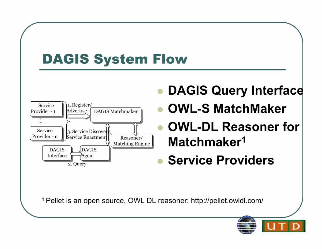
DAGIS System Flow
� DAGIS Query Interface
� OWL-S MatchMaker
� OWL-DL Reasoner for
Matchmaker1
� Service Providers
1. Register/ Advertise
3. Service Discovery,
Service Enactment
DAGIS MatchmakerDAGIS MatchmakerService
Provider - 1
ServiceProvider - 1
ServiceProvider - n
ServiceProvider - n
DAGISAgent
DAGISAgent
Reasoner/Matching Engine
Reasoner/Matching Engine
DAGISInterface
DAGISInterface
……
2. Query
1 Pellet is an open source, OWL DL reasoner: http://pellet.owldl.com/

DAGIS for Complex Queries
1. Query Profile
2. Service Discovery3. ComposeSelection
4. Construct Sequence
5.Return Dynamic Service URI
DAGISComposer
DAGISComposer
Match-Maker
Match-Maker
DAGISAgent
DAGISAgent
ClientClient
ComposerSequencer
ComposerSequencer
Find Movie Theaters within 30 Miles from Richardson, TX
TX
ZipcodeFinder
ZipcodeFinder
TheaterFinder
TheaterFinder
Richardson
30 Miles
Theaters
6. Service Invocation

Geospatial Data Mining: Case
Study: Dataset
� ASTER (Advanced Spaceborne Thermal Emission and
Reflection Radiometer)
• To obtain detailed maps of land surface temperature, reflectivity and elevation.
� ASTER obtains high-resolution (15 to 90 square meters per
pixel) images of the Earth in 14 different wavelengths of the
electromagnetic spectrum, ranging from visible to thermal
infrared light.
� ASTER data is used to create detailed maps of land surface
temperature, emissivity, reflectivity, and elevation.

ASTER Dataset: Technical
Challenges
� Testing will be done based on pixels
� Goal: Region-based classification and
identify high level concepts
� Solution
• Grouping adjacent pixels that belong to same class
• Identify high level concepts using ontology-based mining

Sketches: Process of Our
Approach
ASTER
Image
Training
Data
Features
(14/pixel)
SVM
Classifiers
Test
Data
Features
(14/pixel)
All Pixel
Data
Features
(14/pixel)
Feature
Extraction
Feature
Extraction
Feature
Extraction
Classifier
Training
Validation
Classification
High Level ConceptsPixel Grouping

Process of Our Approach
Testing Image Pixels
SVM Classifier
Pixel Merging
Ontology Driven Mining
Classified Pixels
Concepts and Classes
High Level Concepts
Training Image Pixels

Ontology-Driven Mining
� We have developed domain-dependent
ontologies
• Provide for specification of fine grained concepts
• Concept, “Residential Area” can be further categorized into concepts, “House”, “Grass”
and “Tree” etc.
� Generic ontologies provide concepts in
coarser grain

Challenges
� Region growing
• Find out regions of the same class• Find out neighboring regions• Merge neighboring regions• Not scalable• Irregular regions• Of different sizes• Hard to track boundaries or neighboring regions
� Pixel merging
• Only neighboring pixels considered• Pixels are converted into Concepts• Linear

Output:

Security and Privacy Challenges
� Security
• Policy (context, association, event, time-based)
• Access control, accountability
• Policy integration
� Privacy
• What does it mean to ensure privacy for geospatial data?
• Protect the location of an individual?
• If your residence can be captured by Google maps, then how can you protect it?