seminar - comisión nacional de actividades...
TRANSCRIPT
INSTITUTO DE ALTOS ESTUDIOS ESPACIALES “MARIO GULICH”
MAESTRIA EN APLICACIONES ESPACIALES DE ALERTA Y RESPUESTA TEMPRANA A EMERGENCIAS
SEMINAR
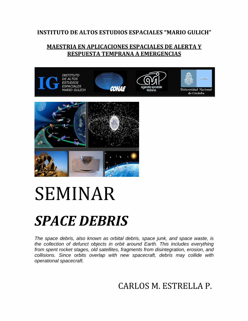
SPACE DEBRIS The space debris, also known as orbital debris, space junk, and space waste, is the collection of defunct objects in orbit around Earth. This includes everything from spent rocket stages, old satellites, fragments from disintegration, erosion, and collisions. Since orbits overlap with new spacecraft, debris may collide with operational spacecraft.
CARLOS M. ESTRELLA P.
SPACE DEBRIS 2013
1
INSTITUTO DE ALTOS ESTUDIOS ESPACIALES “MARIO GULICH”
MAESTRIA EN APLICACIONES ESPACIALES DE ALERTA Y RESPUESTA TEMPRANA A EMERGENCIAS
SPACE DEBRIS 1. BACKGROUND
A. Executive Summary B. Introduction C. The Kessler Syndrome D. Geocentric Orbit Types E. Gabbard Diagrams F. Population Orbiting the Earth G. The Debris Growth
2. CHARACTERIZATION
A. Size of the Space Debris (Objects Detection) B. Debris in LEO (Lower Earth Orbit) C. Debris at Higher Altitudes
3. SOURCES OF DEBRIS
A. Dead Spacecraft B. Lost Equipment C. Boosters D. Software. Space Track E. Software. Discos. Database and Web Interface F. Software. Master (Meteoroid and Space Debris Terrestrial Environment
Reference) G. Software. Kmz Satellite Database / Google Earth and the Space Debris
4. OPERATIONAL ASPECTS
A. Orbital Life and Risk B. Threat to Unmanned Spacecraft C. Threat to Manned Spacecraft D. Alarm in the International Space Station E. Hazard on Earth F. Operations to Destroy Obsolete Spacecraft and Satellites
5. TRACKING AND MEASUREMENT
A. Space Object Catalogues
SPACE DEBRIS 2013
2
B. Tracking Spacefaring Objects (Space Surveillance, Deteccion and Observation Systems)
C. Tracking From de Ground D. Measurement in Space E. Orbital Sentry
6. DEALING WITH DEBRIS
A. Growth Mitigation B. Self Removal C. External Removal D. Maneuvers for Destroy Spacecraft and Satellites Expired E. Debris Producing Events
7. SPACE DEBRIS INSTITUTIONS AND AGENCIES
A. IADC. Inter Agency Space Debris Coordination Committee B. ECSS.European Cooperation for Space Standarization C. UNCOPUOUS. United Nations Committee on the Peaceful Uses of Outer
Space
SPACE DEBRIS 2013
3
INSTITUTO DE ALTOS ESTUDIOS ESPACIALES MARIO GULICH
MAESTRIA EN APLICACIONES ESPACIALES DE ALERTA Y RESPUESTA TEMPRANA A EMERGENCIAS
SEMINAR SPACE DEBRIS
1. BACKGROUND
A. EXECUTIVE SUMMARY
Space activities in Earth orbit are increasingly indispensable to our civilization. Orbiting spacecraft serve vital roles as communications links, navigation beacons, scientific investigation platforms, and providers of remote sensing data for weather, climate, land use, and national security purposes. The spacecraft that perform these tasks are concentrated in a few orbital regions, including low Earth orbit (LEO), semisynchronous orbit, and geosynchronous Earth orbit (GEO). These orbital regions represent valuable resources because they have characteristics that enable spacecraft operating within them to execute their missions more effectively. Functional spacecraft share the near-Earth environment with natural meteoroids and the orbital debris that has been generated by past space activities. Meteoroids orbit the Sun and rapidly pass through and leave the near-Earth region (or burn up in the Earth's atmosphere), resulting in a fairly continual flux of meteoroids on spacecraft in Earth orbit. In contrast, artificial debris objects (including nonfunctional spacecraft, spent rocket bodies, mission-related objects, the products of spacecraft surface deterioration, and fragments from spacecraft and rocket body breakups) orbit the Earth and will remain in orbit until atmospheric drag and other perturbing forces eventually cause their orbits to decay into the atmosphere. Since atmospheric drag decreases as altitude increases, large debris in orbits above about 600 km can remain in orbit for tens, thousands, or even millions of years. Although the uncontrolled reentry of some orbital debris could potentially pose a hazard to activities on the Earth's surface, the major hazard posed by debris is to space operations.

SPACE DEBRIS 2013
4
Although the current hazard to most space activities from debris is low, growth in the amount of debris threatens to make some valuable orbital regions increasingly inhospitable to space operations over the next few decades. A responsible approach to orbital debris will require continuing efforts to increase our knowledge of the current and future debris population, the development of tools to aid spacecraft designers in protecting spacecraft against the debris hazard, and international implementation of appropriate measures to minimize the creation of additional debris.
B. INTRODUCTION The space debris, also known as orbital debris, space junk, and space waste, is the collection of defunct objects in orbit around Earth. This includes everything from spent rocket stages, old satellites, fragments from disintegration, erosion, and collisions. Since orbits overlap with new spacecraft, debris may collide with operational spacecraft.
FIG. 1 Image made of the approximately 19.000 man-made objects larger than 5 cm in Earth orbit.
Approximately the 95% of the objects are orbital debris, it means, not functional satellites, and its main concentrations of debris field are the ring of objects in the geostationary orbit (GEO), and the cloud of objects in low earth orbit (LEO).
Currently about 19,000 pieces of debris larger than 5 cm are tracked, with another 300,000 pieces smaller than 1 cm below 2000 km altitude. For comparison, the ISS (International Space Station) orbits in the 300–400 km range and both the 2009 collision and 2007 antisat test events occurred at between 800–900 km.
SPACE DEBRIS 2013
5
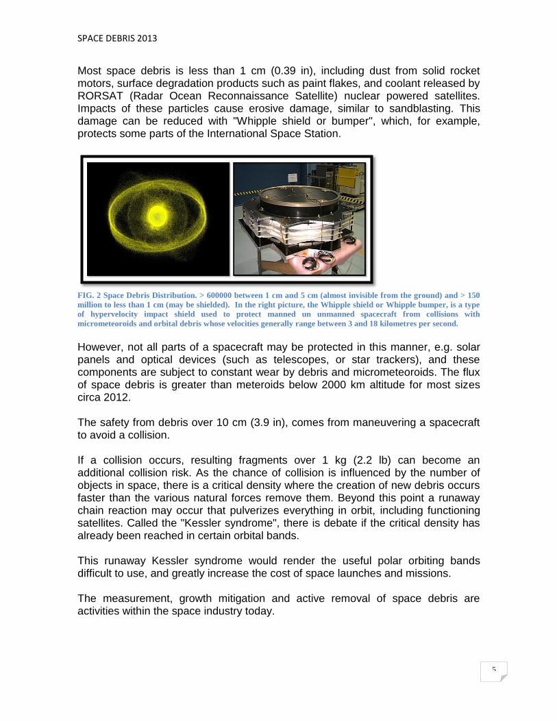
Most space debris is less than 1 cm (0.39 in), including dust from solid rocket motors, surface degradation products such as paint flakes, and coolant released by RORSAT (Radar Ocean Reconnaissance Satellite) nuclear powered satellites. Impacts of these particles cause erosive damage, similar to sandblasting. This damage can be reduced with "Whipple shield or bumper", which, for example, protects some parts of the International Space Station.
FIG. 2 Space Debris Distribution. > 600000 between 1 cm and 5 cm (almost invisible from the ground) and > 150
million to less than 1 cm (may be shielded). In the right picture, the Whipple shield or Whipple bumper, is a type
of hypervelocity impact shield used to protect manned un unmanned spacecraft from collisions with
micrometeoroids and orbital debris whose velocities generally range between 3 and 18 kilometres per second.
However, not all parts of a spacecraft may be protected in this manner, e.g. solar panels and optical devices (such as telescopes, or star trackers), and these components are subject to constant wear by debris and micrometeoroids. The flux of space debris is greater than meteroids below 2000 km altitude for most sizes circa 2012. The safety from debris over 10 cm (3.9 in), comes from maneuvering a spacecraft to avoid a collision. If a collision occurs, resulting fragments over 1 kg (2.2 lb) can become an additional collision risk. As the chance of collision is influenced by the number of objects in space, there is a critical density where the creation of new debris occurs faster than the various natural forces remove them. Beyond this point a runaway chain reaction may occur that pulverizes everything in orbit, including functioning satellites. Called the "Kessler syndrome", there is debate if the critical density has already been reached in certain orbital bands. This runaway Kessler syndrome would render the useful polar orbiting bands difficult to use, and greatly increase the cost of space launches and missions. The measurement, growth mitigation and active removal of space debris are activities within the space industry today.

SPACE DEBRIS 2013
6
C. THE KESSLER SYNDROME The Kessler Syndrome is a chain reaction set off by debris collisions that cause more debris and, therefore, more collisions. The result of this scenario is such a high risk of collision in orbit that it renders impossible many or all of the space-based activities that we currently take for granted.
FIG 3. A.Causes of know satellite breakups; B.Kessler Syndrome; C.Space debris for collision between objects;
D. SAC D (Polar, 657 Km, synchronized to go twice a day for every point on the planet
Through the 1980s, the US Air Force ran an experimental program to determine what would happen if debris collided with satellites or other debris. The study demonstrated that the process was entirely unlike the micrometeor case, and that many large chunks of debris would be created that would themselves be a collisional threat. This leads to a worrying possibility instead of the density of debris being a measure of the number of items launched into orbit, it was that number plus any new debris caused when they collided. If the news debris did not decay from orbit before impacting another object, the number of debris items would continue to grow even if there were no new launches. Kessler published, although the vast majority of tombstones in number is light, most of the mass is over 1 kg or more. This type of mass would be enough to destroy any spacecraft on impact, creating more objects in the area of critical mass. A 1 kg object impacting at 10 km/s, is probably capable of catastrophically breaking up a 1,000 kg spacecraft if it strikes a high-density element in the spacecraft. In such a breakup, numerous fragments larger than 1 kg would be created.
SPACE DEBRIS 2013
7
The Kessler's analysis led to the conclusion that, with a low enough density, the addition of debris through impacts is slower than their rate of decay, and the problem does not become significant. At densities greater than this critical point, the rate of production is greater than decay rates, leading to a "cascade", or “chain reaction” or “snowball effect” (a snowball causing larger snowfall until finally an avalanche results), that reduces the on-orbit population to small objects on the order of a few cm in size, making any sort of space activity very hazardous.
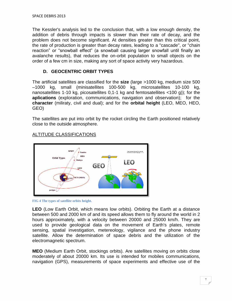
D. GEOCENTRIC ORBIT TYPES The artificial satellites are classified for the size (large >1000 kg, medium size 500 –1000 kg, small (minisatellites 100-500 kg, microsatellites 10-100 kg, nanosatellites 1-10 kg, picosatellites 0,1-1 kg and femtosatellites <100 g)); for the aplications (exploration, communications, navigation and observation); for the character (miliraty, civil and dual); and for the orbital height (LEO, MEO, HEO, GEO) The satellites are put into orbit by the rocket circling the Earth positioned relatively close to the outside atmosphere. ALTITUDE CLASSIFICATIONS
FIG 4 The types of satellite orbits height.
LEO (Low Earth Orbit, which means low orbits). Orbiting the Earth at a distance between 500 and 2000 km of and its speed allows them to fly around the world in 2 hours approximately, with a velocity between 20000 and 25000 km/h. They are used to provide geological data on the movement of Earth's plates, remote sensing, spatial investigation, metereology, vigilance and the phone industry satellite. Allow the determination of space debris and the utilization of the electromagnetic spectrum. MEO (Medium Earth Orbit, stockings orbits). Are satellites moving on orbits close moderately of about 20000 km. Its use is intended for mobiles communications, navigation (GPS), measurements of space experiments and effective use of the

SPACE DEBRIS 2013
8
electromagnetic spectrum. Your period is 6 hours and 3 or 4 satellites have global coverage. HEO (Highly Elliptical Orbit, highly elliptical orbits). These satellites do not follow a circular orbit, but its orbit is elliptical. This implies that much greater distances reached at the point furthest from the orbit. They are often used to map the surface of the Earth, as they can detect a wide angle of Earth's surface. The perigee about 500 km and apogee of 50000 km, your orbit is tilted, the period varies from 8 to 24 hours, used in communications and space surveillance and very sensitive to the asymmetry of the Earth (the orbit is stabilized if i=63.435°) GEO satellites. They have a speed equal to the speed of rotation of the earth, which means that they are suspended on a same point of the globe, on Ecuador. This situation is called geostationary satellites. For the Earth and the satellite match their speed is necessary that the latter is at a fixed distance of 35,800 km on Ecuador. They are intended for television and telephony, data transmission to long distances, fleets of communication, and the identification and dissemination of meteorological data (Meteosat). Polar covers not, high cost of launching and accumulation of space debris.
FIG 5 The space debris orbit distribution
INCLINATION CLASSIFICATIONS INCLINED ORBIT: An orbit whose inclination in reference to the equatorial plane is not 0. POLAR ORBIT: A satellite that passes above or nearly above both poles of the planet on each revolution. Therefore it has an inclination of (or very close to) 90 degrees. POLAR SUN SYNCHRONOUS ORBIT: A nearly polar orbit that passes the equator at the same local time on every pass. Useful for image-taking satellites because shadows will be the same on every pass.
SPACE DEBRIS 2013
9
ECCENTRICITY CLASSIFICATIONS CIRCULAR ORBIT: An orbit that has an eccentricity of 0 and whose path traces a circle. ELLIPTIC ORBIT: An orbit with an eccentricity greater than 0 and less than 1 whose orbit traces the path of an ellipse. HOHMANN TRANSFER ORBIT: An orbital maneuver that moves a spacecraft from one circular orbit to another using two engine impulses. This maneuver was named after Walter Hohmann. GEOSYNCHRONOUS TRANSFER ORBIT: geocentric-elliptic orbit where the perigee is at the altitude of a Low Earth Orbit (LEO) and the apogee at the altitude of a geosynchronous orbit. HIGHLY ELLIPTICAL ORBITAL (HEO): Geocentric orbit with apogee above 35,786 km and low perigee (about 1,000 km) that result in long dwell times near apogee. MOLNIYA ORBIT: A highly elliptical orbit with inclination of 63.4° and orbital period of ½ of a sidereal day (roughly 12 hours). Such a satellite spends most of its time over a designated area of the Earth. TUNDRA ORBIT: A highly elliptical orbit with inclination of 63.4° and orbital period of one sidereal day (roughly 24 hours). Such a satellite spends most of its time over a designated area of the Earth. HYPERBOLIC TRAJECTORY: An "orbit" with eccentricity greater than 1. The object's velocity at perigee reaches some value in excess of the escape velocity, therefore it will escape the gravitational pull of the Earth and continue to travel infinitely with a velocity (relative to Earth) decelerating to some finite value, known as the hyperbolic excess velocity. ESCAPE TRAJECTORY: This trajectory must be used to launch an interplanetary probe away from Earth, because the excess over escape velocity is what changes its heliocentric orbit from that of Earth. PARABOLIC TRAJECTORY: An "orbit" with eccentricity exactly equal to 1. The object's velocity at perigee equals the escape velocity, therefore it will escape the gravitational pull of the Earth and continue to travel with a velocity (relative to Earth) decelerating to 0. A spacecraft launched from Earth with this velocity would travel some distance away from it, but follow it around the Sun in the same heliocentric orbit. It is possible, but not likely that an object approaching Earth could follow a parabolic capture trajectory, but speed and direction would have to be precise.

SPACE DEBRIS 2013
10
DIRECTIONAL CLASSIFICATIONS PROGRADE ORBIT: an orbit in which the projection of the object onto the equatorial plane revolves about the Earth in the same direction as the rotation of the Earth. RETROGRADE ORBIT: an orbit in which the projection of the object onto the equatorial plane revolves about the Earth in the direction opposite that of the rotation of the Earth. GEOSYNCHRONOUS CLASSIFICATIONS SEMI SYNCHRONOUS ORBIT (SSO): An orbit with an altitude of approximately 20200 km and an orbital period of approximately 12 hours GEOSYNCHRONOUS ORBIT (GEO): Orbits with an altitude of approximately 35,786 km. Such a satellite would trace an analemma in the sky. GEOSTATIONARY ORBIT (GSO): A geosynchronous orbit with an inclination of zero. To an observer on the ground this satellite would appear as a fixed point in the sky. CLARKE ORBIT: Another name for a geostationary orbit. Named after the writer Arthur C. Clarke. EARTH ORBITAL LIBRATION POINTS: The libration points for objects orbiting Earth are at 105 degrees west and 75 degrees east. More than 160 satellites are gathered at these two points. SUPERSYNCHRONOUS ORBIT: A disposal / storage orbit above GSO/GEO. Satellites will drift west. SUBSYNCHRONOUS ORBIT: A drift orbit close to but below GSO/GEO. Satellites will drift east. GRAVEYARD ORBIT: An orbit a few hundred kilometers above geosynchronous that satellites are moved into at the end of their operation. A graveyard orbit, also called a supersynchronous orbit, junk orbit or disposal orbit, is an orbit significantly above synchronous orbit, where spacecraft are intentionally placed at the end of their operational life. It is a measure performed in order to lower the probability of collisions with operational spacecraft and of the generation of additional space debris. De-orbiting a geostationary satellite requires of a velocity of about 1500 m/s, while re-orbiting it to a graveyard orbit only requires about 11 m/s. For satellites in geostationary orbit and geosynchronous orbits, the graveyard orbit is a few

SPACE DEBRIS 2013
11
hundred kilometers above the operational orbit. The transfer to a graveyard orbit above geostationary orbit requires the same amount of fuel that a satellite needs for approximately three months of stationkeeping. While most satellite operators try to perform such a maneuver at the end of the operational life, only one-third succeed in doing so. DISPOSAL ORBIT / JUNK ORBIT: A synonym for graveyard orbit. SPECIAL CLASSIFICATIONS SUN SYNCHRONOUS ORBIT: An orbit which combines altitude and inclination in such a way that the satellite passes over any given point of the planet's surface at the same local solar time. Such an orbit can place a satellite in constant sunlight and is useful for imaging, spy, and weather satellites. MOON ORBIT: The orbital characteristics of Earth's Moon. Average altitude of 384403 kilometres, elliptical–inclined orbit.
E. THE GABBARD DIAGRAMS
FIG 6 Gabbard Diagram. The distribution can be used to infer information such as direction and point of impact.
John Gabbard developed a diagram, named after him, that is very useful for illustrating the orbital changes. A Gabbard diagram is a scatter plot of height versus period. The apogee and perigee of each ejected fragment is shown as a point on the diagram. The resultant plot looks like two asymmetrical boomerangs joined at their apices. An example is shown below:

SPACE DEBRIS 2013
12
The data used to make this plot is the data in the aforementioned example of a 1000 kg target. Only mass fragments 1 kilogram and larger have been used to compile the diagram. The catastrophic collision is assumed to have taken place at an altitude of 1000 km. The point where the two lines intersect is the original circular orbit at an altitude of 1000 km and with a period of 105 minutes. Points to the right of this location represent fragments that have been scattered in the forward direction of motion, while points to the left represent fragments scattered opposite the initial target motion. Note how the perigee heights (red points) in the first case become the apogee heights (blue points) in the second. The next diagram illustrates how the smaller fragments are scattered into larger and smaller orbits than are their more massive counterparts. In this case apogee (+) and perigee (-) points are distinguished by different symbols, and the different colours are used to indicate different masses. It can be seen that the largest masses (≥100 kg) are relatively close to the original orbit, whereas the smallest masses (≥1kg) are the most dispersed.
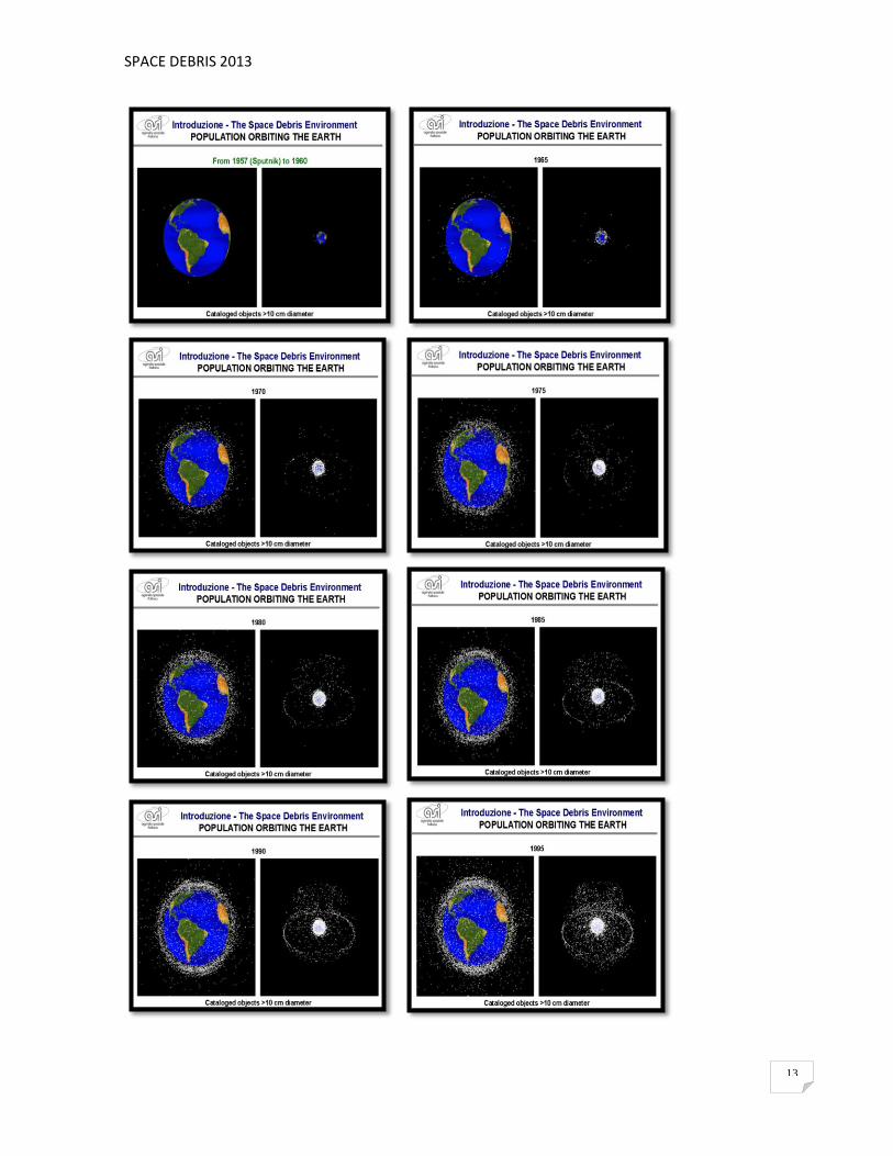
F. POPULATION ORBITING THE EARTH Since the earliest days of the space race, the North American Aerospace Defense Command (NORAD) has maintained a database of all known rocket launches and the various objects that reach orbit as a result, not just the satellites themselves, but also of the aerodynamic shields that protected them during launch, upper stage booster rockets that placed them in orbit, and in some cases, the lower stages as well. This was known as the Space Object Catalog when it was created with the launch of Sputnik in 1957.
FIG. 7 The first space debris
Population orbiting the earth, from 1957 (Sputnik) to 2010, cataloged objects of the Ufficio Qualitá – Detriti Spaziali, ASI. Claudio Portelli.
SPACE DEBRIS 2013
13

SPACE DEBRIS 2013
14
FIG. 8 Population Orbiting the Earth, from 1957 (Sputnik) to 2010. Cataloged objects. ASI (Ufficio Qualitá -
Detriti Spaziali. C. Portelli)
The trackers that fed this database were aware of a number of other objects in orbit, many of which were the result of on orbit explosions. Some of these were deliberately caused during the 1960 anti-satellite weapon (ASAT) testing, while others were the result of rocket stages that had "blown up" in orbit as leftover propellant expanded into a gas and ruptured their tanks. Since these objects were only being tracked in a haphazard manner, a NORAD employee, John Gabbard, took it upon himself to keep a separate database of as many of these objects as he could. Studying the results of these explosions, Gabbard developed a new technique for predicting the orbital paths of their products. "Gabbard diagrams" (or plots) have since become widely used. These studies were used to dramatically improve the modelling of orbital evolution and decay. Anti-satellite weapons (ASAT) are designed to incapacitate or destroy satellites for strategic military purposes. Currently, only the United States, the former Soviet Union, the People's Republic of China and India are known to have developed these weapons. CHINA: At 5:28 p.m. of the January 11, 2007, the People's Republic of China successfully destroyed a defunct Chinese weather satellite, FY-1C. The destruction was reportedly carried out by an SC-19 ASAT missile with a kinetic kill. FY-1C was a weather satellite orbiting Earth in polar orbit at an altitude of about 537 miles (865 km), with a mass of about 750 kg (1,650 lb). Launched in 1999, it was the fourth

SPACE DEBRIS 2013
15
satellite in the Feng Yun series. The missile was launched from a mobile Transporter-Erector-Launcher (TEL) vehicle at Xichang (28.247°N 102.025°E) and the warhead destroyed the satellite in a head-on collision at an extremely high relative velocity. This test raised concerns in some other countries, partly because China did not publicly confirm whether or not the test had occurred until January 23, 2007 but mainly because of fears that it could prompt or accelerate an "arms race" in space. The EU stated that "...a test of an anti-satellite weapon is inconsistent with international efforts to avert an arms race in outer space and undermines security in outer space." According to CNN, global security analysts stated at the time that the test was most likely aimed at the United States. This test was followed by another test in January 2010. The military maneuver was successful, the missile hit squarely against the satellite, but scattered them through space at least 150,000 pieces of scrap half an inch, of which about 3000 were at least the size of a ball golf. The Asian giant managed well the dubious honor of causing the incident which has generated more space junk in history.
FIG. 9 Satellite Debris Collision. Know orbit planes of Fengyun 1C debris one month after its disintegration by a
Chinese interceptor. The white orbit represents the International Space Station 24JUL2007
ESTADOS UNIDOS: USA-193 was an American spy satellite, which was launched on 14 December 2006 by a Delta II rocket, from Vandenberg Air Force Base. It was reported about a month after launch that the satellite had failed. In January 2008, it was noted that the satellite was decaying from orbit at a rate of 1,640 feet (500 m) per day. On 14 February 2008, it was reported that the U.S. Navy had been instructed to fire an SM-3 ABM weapon at it, to act as an anti-satellite weapon. According to the U.S. Government, the primary reason for destroying the satellite was the approximately 1,000 lb (450 kg) of toxic hydrazine fuel contained

SPACE DEBRIS 2013
16
on board. Although hydrazine is toxic, a small dose would not have been immediately lethal. The intercept with a cost $100 million dolars, however, was widely interpreted as a demonstration of U.S. capabilities in response to the Chinese anti-satellite test a year earlier. The intercept was different from typical ASAT missions in that it took place at a much lower altitude (133 nautical miles or 247 kilometers) than would normally be the case, and the SM-3 missile as currently deployed would not have adequate range and altitude reach for typical ASAT missions in low-Earth orbit. However, the warhead was shown capable of hitting a satellite at orbital closing speeds. While an SM-3 missile would require significant modification to fill an anti-satellite role, the test was a proof of concept, demonstrating that it can operate in such a role if required. INDIA: In a televised press briefing during the 97th Indian Science Congress announced that India was developing lasers and an exo-atmospheric kill vehicle that could be combined to produce a weapon to destroy enemy satellites in orbit. Furthermore, on February 10, 2010, DRDO Director-General and Scientific Advisor to the Defence Minister, Dr VK Saraswat stated that India had "all the building blocks necessary" to integrate an anti-satellite weapon to neutralize hostile satellites in low earth and polar orbits. He indicated, however, that the anti-satellite weapons could be developed as part of the Indian Ballistic Missile Defense Program, which will complete the development stage in totality by 2014. India had identified development of ASAT weapons "for electronic or physical destruction of satellites in both LEO (2,000-km altitude above earth's surface) and the higher GEO-synchronous orbits" as a thrust area in its long-term integrated perspective plan (2012–2027). RUSIA: Further reports in May 2010 based on statements from Col. Eduard Sigalov in Russia's air and space defense forces, indicated that Russia was "developing a fundamentally new weapon that can destroy potential targets in space." The Sokol Eshelon is a prototype laser system based on an A-60 airplane which is reported to be restarting development in 2012.
FIG 10 Anti satellite weapond (ASAT)
SPACE DEBRIS 2013
17
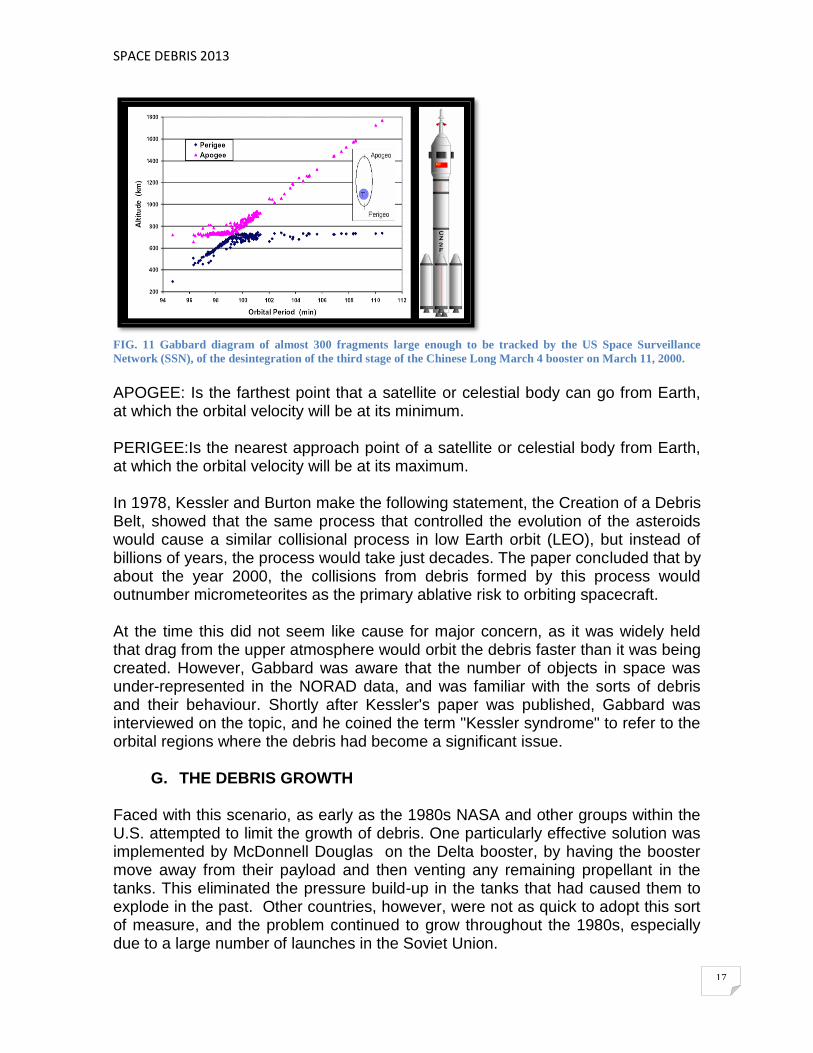
FIG. 11 Gabbard diagram of almost 300 fragments large enough to be tracked by the US Space Surveillance
Network (SSN), of the desintegration of the third stage of the Chinese Long March 4 booster on March 11, 2000.
APOGEE: Is the farthest point that a satellite or celestial body can go from Earth, at which the orbital velocity will be at its minimum. PERIGEE:Is the nearest approach point of a satellite or celestial body from Earth, at which the orbital velocity will be at its maximum. In 1978, Kessler and Burton make the following statement, the Creation of a Debris Belt, showed that the same process that controlled the evolution of the asteroids would cause a similar collisional process in low Earth orbit (LEO), but instead of billions of years, the process would take just decades. The paper concluded that by about the year 2000, the collisions from debris formed by this process would outnumber micrometeorites as the primary ablative risk to orbiting spacecraft.
At the time this did not seem like cause for major concern, as it was widely held that drag from the upper atmosphere would orbit the debris faster than it was being created. However, Gabbard was aware that the number of objects in space was under-represented in the NORAD data, and was familiar with the sorts of debris and their behaviour. Shortly after Kessler's paper was published, Gabbard was interviewed on the topic, and he coined the term "Kessler syndrome" to refer to the orbital regions where the debris had become a significant issue.
G. THE DEBRIS GROWTH Faced with this scenario, as early as the 1980s NASA and other groups within the U.S. attempted to limit the growth of debris. One particularly effective solution was implemented by McDonnell Douglas on the Delta booster, by having the booster move away from their payload and then venting any remaining propellant in the tanks. This eliminated the pressure build-up in the tanks that had caused them to explode in the past. Other countries, however, were not as quick to adopt this sort of measure, and the problem continued to grow throughout the 1980s, especially due to a large number of launches in the Soviet Union.

SPACE DEBRIS 2013
18
In 1981, it was placed at 5,000 objects,but a new battery of detectors in the Ground-based Electro-Optical Deep Space Surveillance system quickly found new objects within its resolution. By the late 1990s it was thought that the majority of 28,000 launched objects had already decayed and about 8,500 remained in orbit. By 2005 this had been adjusted upward to 13,000 objects, and a 2006 study raised this to 19,000 as a result of an ASAT test and a satellite collision. In 2011, NASA said 22,000 different objects were being tracked. The growth in object count as a result of these new studies has led to intense debate within the space community on the nature of the problem and earlier dire warnings. However, only one major incident has occurred: the 2009 satellite collision between Iridium 33 and Cosmos 2251. The lack of any obvious cascading in the short term has led to a number of complaints that the original estimates overestimated the issue.
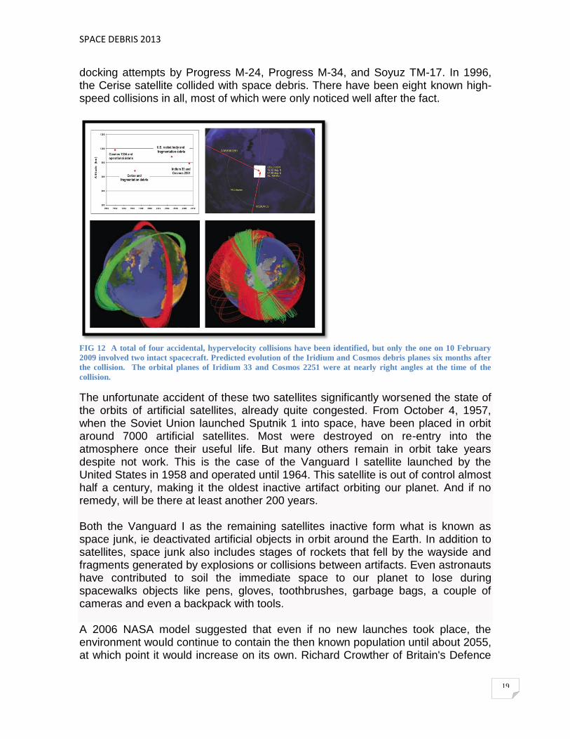
The 2009 satellite collision was the first accidental hypervelocity collision between two intact artificial satellites in Earth orbit. The collision occurred at 16:56 UTC on February 10, 2009, at 789 kilometres above the Taymyr Peninsula in Siberia, when Iridium 33 and Kosmos-2251 collided. The satellites collided at a speed of 11.7 kilometres per second. Both satellites were destroyed and the collision scattered considerable debris, which poses an elevated risk to spacecraft. The collision created a debris cloud, although accurate estimates of the number of pieces of debris is not yet available. The collision destroyed both Iridium 33 of 560 Kg (owned by Iridium Communications Inc.) and Kosmos 2251 of 950 Kg (owned by the Russian Space Forces). While the Iridium satellite was operational at the time of the collision, the Russian satellite had been out of service since at least 1995 and was no longer actively controlled. Kosmos-2251 was launched on June 16, 1993, and went out of service two years later, in 1995, according to Gen. Yakushin. Shortly thereafter, the U.S. Space Surveillance Network (SSN) began detecting numerous new objects in the paths of the two spacecraft. By the end of March, 823 of the larger debris had been identified and cataloged by the SSN with additional debris being tracked, but not yet cataloged. Special ground-based observations confirmed that a much greater number of smaller debris was also generated in the unprecedented event. Both spacecraft were in nearly circular orbits with high inclinations: 86.4 degrees and 74.0 degrees, respectively. At the time of the collision, the two orbital planes intersected at a nearly right angle, resulting in a collision velocity of more than 11 km/s. Several smaller collisions had occurred previously, during rendezvous attempts or the intentional destruction of a satellite, including the DART satellite colliding with MUBLCOM, and three collisions involving the manned Mir space station, during
SPACE DEBRIS 2013
19
docking attempts by Progress M-24, Progress M-34, and Soyuz TM-17. In 1996, the Cerise satellite collided with space debris. There have been eight known high-speed collisions in all, most of which were only noticed well after the fact.
FIG 12 A total of four accidental, hypervelocity collisions have been identified, but only the one on 10 February
2009 involved two intact spacecraft. Predicted evolution of the Iridium and Cosmos debris planes six months after
the collision. The orbital planes of Iridium 33 and Cosmos 2251 were at nearly right angles at the time of the
collision.
The unfortunate accident of these two satellites significantly worsened the state of the orbits of artificial satellites, already quite congested. From October 4, 1957, when the Soviet Union launched Sputnik 1 into space, have been placed in orbit around 7000 artificial satellites. Most were destroyed on re-entry into the atmosphere once their useful life. But many others remain in orbit take years despite not work. This is the case of the Vanguard I satellite launched by the United States in 1958 and operated until 1964. This satellite is out of control almost half a century, making it the oldest inactive artifact orbiting our planet. And if no remedy, will be there at least another 200 years. Both the Vanguard I as the remaining satellites inactive form what is known as space junk, ie deactivated artificial objects in orbit around the Earth. In addition to satellites, space junk also includes stages of rockets that fell by the wayside and fragments generated by explosions or collisions between artifacts. Even astronauts have contributed to soil the immediate space to our planet to lose during spacewalks objects like pens, gloves, toothbrushes, garbage bags, a couple of cameras and even a backpack with tools. A 2006 NASA model suggested that even if no new launches took place, the environment would continue to contain the then known population until about 2055, at which point it would increase on its own. Richard Crowther of Britain's Defence

SPACE DEBRIS 2013
20
Evaluation and Research Agency stated that he believes the cascade will begin around 2015. The National Academy of Sciences, summarizing the view among professionals, noted that there was widespread agreement that two bands of LEO space, 900 to 1000 km and 1500 km altitudes, were already past the critical density.
In the 2009 European Air and Space Conference, University of Southampton, UK researcher, Hugh Lewis predicted that the threat from space debris would rise 50 percent in the coming decade and quadruple in the next 50 years. Currently more than 13,000 close calls are tracked weekly.
A report in 2011 by the National Research Council in the USA warned NASA that the amount of space debris orbiting the Earth was at critical level. Some computer models revealed that the amount of space debris "has reached a tipping point, with enough currently in orbit to continually collide and create even more debris, raising the risk of spacecraft failures". The report has called for international regulations to limit debris and research into disposing of the debris.
FIG 13 A. Box score – Sources of Tracked Objects; B. Monthly Number ok Objects in Earth Orbit by Object
Type; C. Growth of mass of man-made objects in Earth orbit by Object Type; D.Mass distribution in LEO. The
International Space Station, with a mass of ~350 tons, is not included in the distribution.
One of the first to warn of the dangers of space junk was Donald Kessler, American scientist from NASA. In the late 1970s, Kessler predicted that if the debris was still growing at the same rate, there would come a point where the density would be so high that collisions would occur continually. These collisions generate more bits, so that the risk of further collisions would be even greater, and so on. Space junk grow exponentially if we stopped producing it. This inconvenient situation is what is known today as Kessler syndrome or ablation cascade.

SPACE DEBRIS 2013
21
The amount of space junk will grow unchecked, and calculations predict that by 2055 will be impossible to launch any space mission without encountering one of these objects, unless they develop and implement a plan to get rid of them. 2. CHARACTERIZATION
A. SIZE OF THE SPACE DEBRIS (OBJECTS DETECTION) The space debris generally categorizes large and small debris. Large is defined not by its size so much as the current ability to detect objects of some lower size limit. Generally, large is taken to be 10 cm across or larger, with typical masses on the order of 1 kg. Logically it would follow that small debris would be anything smaller than that, but in fact the cutoff is normally 1 cm or smaller. Debris between these two limits would normally be considered "large" as well, but goes unmeasured due to our inability to track them. The great majority of debris consists of smaller objects, 1 cm or less. The mid 2009 the NASA debris places the number of large debris items over 10 cm at 19000, between 1 and 10 centimetres approximately 500000, and that debris items smaller than 1 cm exceeds tens of millions. In terms of mass, the vast majority of the overall weight of the debris is concentrated in larger objects, about 1500 objects weighing more than 100 kg each account for over 98% of the 1900 tons of debris then known in low earth orbit. Since space debris comes from manmade objects, the total possible mass of debris is easy to calculate: it is the total mass of all spacecraft and rocket bodies that have reached orbit. The actual mass of debris will be necessarily less than that, as the orbits of some of these objects have since decayed. As debris mass tends to be dominated by larger objects, most of which have long ago been detected, the total mass has remained relatively constant in spite of the addition of many smaller objects. The total mass is estimated at 5400 long tons and 6100 short tons.
FIG 14 Population Orbiting the Earth. U.S. Space Surveillance Network.

SPACE DEBRIS 2013
22
B. DEBRIS IN LEO (DEBRIS IN LOWER EARTH ORBIT ) Every satellite, space probe and manned mission has the potential to create space debris. Any impact between two objects of sizeable mass can spall off shrapnel debris from the force of collision. Each piece of shrapnel has the potential to cause further damage, creating even more space debris. With a large enough collision (such as one between a space station and a defunct satellite), the amount of cascading debris could be enough to render Low Earth Orbit essentially unusable.
FIG 15 Spall are flakes of a material that are broken off a larger solid body, produced by the result of object
impact. The impact generates a large number of small fragments.
The problem in LEO is compounded by the fact that there are few "universal orbits" that keep spacecraft in particular rings, as opposed to GEO, a single widely used orbit. The closest would be the sun-synchronous orbits or helio-synchronous that maintain a constant angle between the sun and orbital plane. But LEO satellites are in many different orbital planes providing global coverage, and the 15 orbits per day typical of LEO satellites results in frequent approaches between object pairs. Since sun-synchronous orbits are polar, the polar regions are common crossing points.
FIG 16 Diagram showing the orientation of a Sun Synchronous orbit (green) in four points of the year. A non-sun-
synchronous orbit (magenta) is also shown for reference.

SPACE DEBRIS 2013
23
A Sun-synchronous orbit (sometimes called a heliosynchronous orbit) is a geocentric orbit (any object orbiting the Earth, such as the Moon or artificial satellites) which combines altitude and inclination in such a way that an object on that orbit ascends or descends over any given Earth latitude at the same local mean solar time (time based on the Sun's position in the sky). The surface illumination angle will be nearly the same every time. This consistent lighting is a useful characteristic for satellites that image the Earth's surface in visible or infrared wavelengths (e.g. weather and spy satellites) and for other remote sensing satellites (e.g. those carrying ocean and atmospheric remote sensing instruments that require sunlight). For example, a satellite in sun-synchronous orbit might ascend across the equator twelve times a day each time at approximately 15:00 mean local time. This is achieved by having the osculating orbital plane precess (rotate) approximately one degree each day with respect to the celestial sphere, eastward, to keep pace with the Earth's movement around the Sun. After space debris is created, orbital perturbations mean that the orbital plane's direction will change over time, and thus collisions can occur from virtually any direction. Collisions thus usually occur at very high relative velocities, typically several kilometres per second. Such a collision will normally create large numbers of objects in the critical size range. It is for this reason that the Kessler Syndrome is most commonly applied only to the LEO region. In this region a collision will create debris that will cross other orbits and this population increase leads to the cascade effect.
At the most commonly used low earth orbits for manned missions, 400 km and below, residual air drag helps keep the zones clear. The Collisions that occur under this altitude are less of an issue, since they result in fragment orbits having perigee at or below this altitude. The critical altitude also changes as a result of the space weather environment, which causes the upper atmosphere to expand and contract. An expansion of the atmosphere leads to an increased drag to the fragments, resulting in a shorter orbit lifetime.
FIG 17 Space weather is the concept of changing environmental conditions in near Earth space or the space from
the Sun´s atmosphere to the Earth´s atmosphere. Aurora australis / Discovery
SPACE DEBRIS 2013
24
C. DEBRIS AT HIGHER ALTITUDES At higher altitudes, where atmospheric drag is less significant, orbital decay takes much longer. Slight atmospheric drag, lunar perturbations, and solar radiation pressure can gradually bring debris down to lower altitudes where it decays, but at very high altitudes this can take millennia. Thus while these orbits are generally less used than LEO, and the problem onset is slower as a result, the numbers progress toward the critical threshold much more quickly. The issue is especially problematic in the valuable geostationary orbits (GEO), where satellites are often clustered over their primary ground "targets" and share the same orbital path. Orbital perturbations are significant in GEO, causing longitude drift of the spacecraft, and a precession of the orbit plane if no maneuvers are performed. Active satellites maintain their station via thrusters, but if they become inoperable they become a collision concern (as in the case of Telstar 401, communications satellite owned by AT&T Corporation, which was launched in 1993 to replace Telstar 301. It was destroyed by a magnetic storm in 1997. The satellite is now space debris, remaining in geosynchronous orbit, and is a hazard to other objects in space).
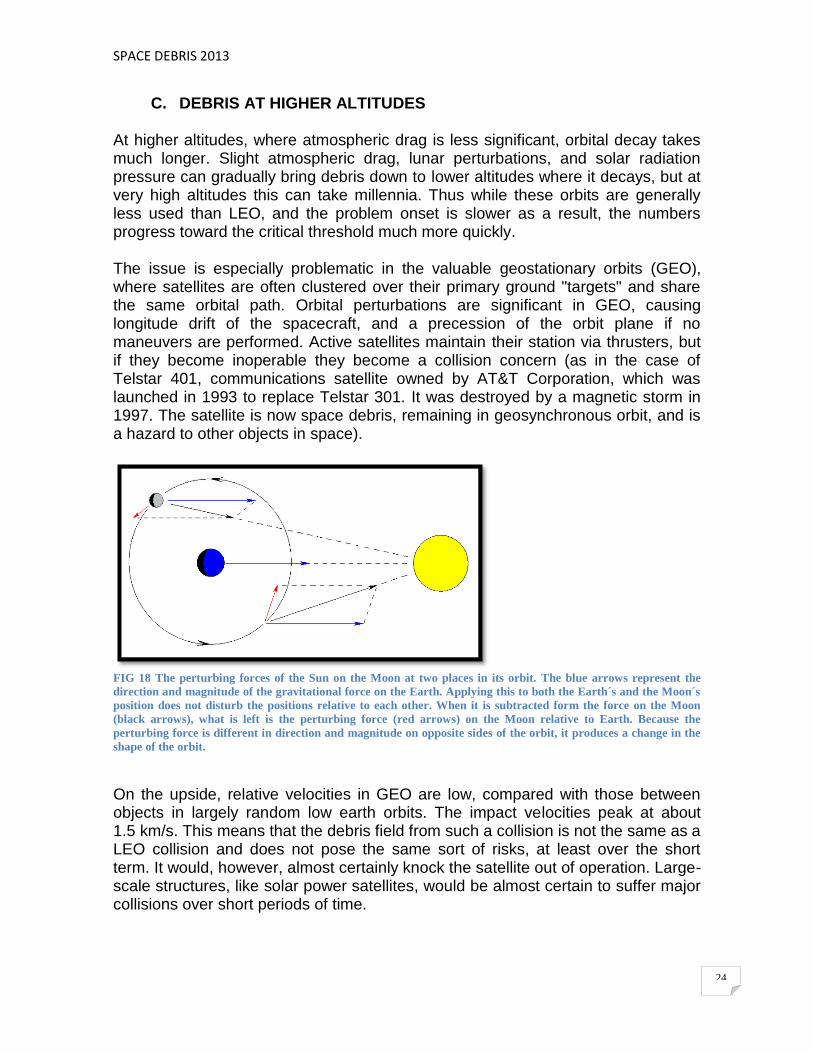
FIG 18 The perturbing forces of the Sun on the Moon at two places in its orbit. The blue arrows represent the
direction and magnitude of the gravitational force on the Earth. Applying this to both the Earth´s and the Moon´s
position does not disturb the positions relative to each other. When it is subtracted form the force on the Moon
(black arrows), what is left is the perturbing force (red arrows) on the Moon relative to Earth. Because the
perturbing force is different in direction and magnitude on opposite sides of the orbit, it produces a change in the
shape of the orbit.
On the upside, relative velocities in GEO are low, compared with those between objects in largely random low earth orbits. The impact velocities peak at about 1.5 km/s. This means that the debris field from such a collision is not the same as a LEO collision and does not pose the same sort of risks, at least over the short term. It would, however, almost certainly knock the satellite out of operation. Large-scale structures, like solar power satellites, would be almost certain to suffer major collisions over short periods of time.
SPACE DEBRIS 2013
25
In response, the ITU (International Telecommunication Union) has placed increasingly strict requirements on the station-keeping ability of new satellites and demands that the owners guarantee their ability to safely move the satellites out of their orbital slots at the end of their lifetime. However, studies have suggested that even the existing ITU requirements are not enough to have a major effect on collision frequency. Additionally, GEO orbit is too distant to make accurate measurements of the existing debris field for objects under 1 m, so the precise nature of the existing problem is not well known. Others have suggested that these satellites be moved to empty spots within GEO, which would require less maneuvering and make it easier to predict future motions. An additional risk is presented by satellites in other orbits, especially those satellites or boosters left stranded in geostationary transfer orbit, which are a concern due to the typically large crossing velocities. A geosynchronous transfer orbit or geostationary transfer orbit (GTO) is a Hohmann transfer orbit used to reach geosynchronous or geostationary orbit. PHASES FOR THE LAUNCHING OF A GEOSTATIONARY SATELLITE A_Orbit Launch and Parking It puts the satellite in low Earth orbit height. His height and parking time it depends on the launch vehicle used: Ariane, Delta, Atlas-Centaur, Space Shuttle ... The time of release is conditioned on a certain days pending the position of the Sun and Earth. They are the "launch window". B_Transfer Orbit It gets pretty eccentric elliptical and activating the 3rd stage of the launch vehicle, being an intermediate orbit that achieved an apogee of 36,000 km C_Ignition Engine and drift orbit apogee The success of the launch depends greatly on the appropriate apogee motor activation. The push allows you to transform into equatorial orbit nearly circular. The maneuvers performed in the drift orbit for the satellite to be corrected, can last up to three weeks. D_Geostationary The satellite is "fixed" in space. Introducing small drifts in length produced by the non-sphericity of the earth and all the drifts in latitude produced by the gravitational effect of the Sun and Moon. These disruptive forces must be corrected periodically during the operational life of the satellite to keep "anchored".
SPACE DEBRIS 2013
26
FIG 19 Tranfer orbit. In orbital mechanics, the Hohmann transfer orbit is an elliptical orbit used to transfer
between two circular orbits of different altitudes, in the same plane.
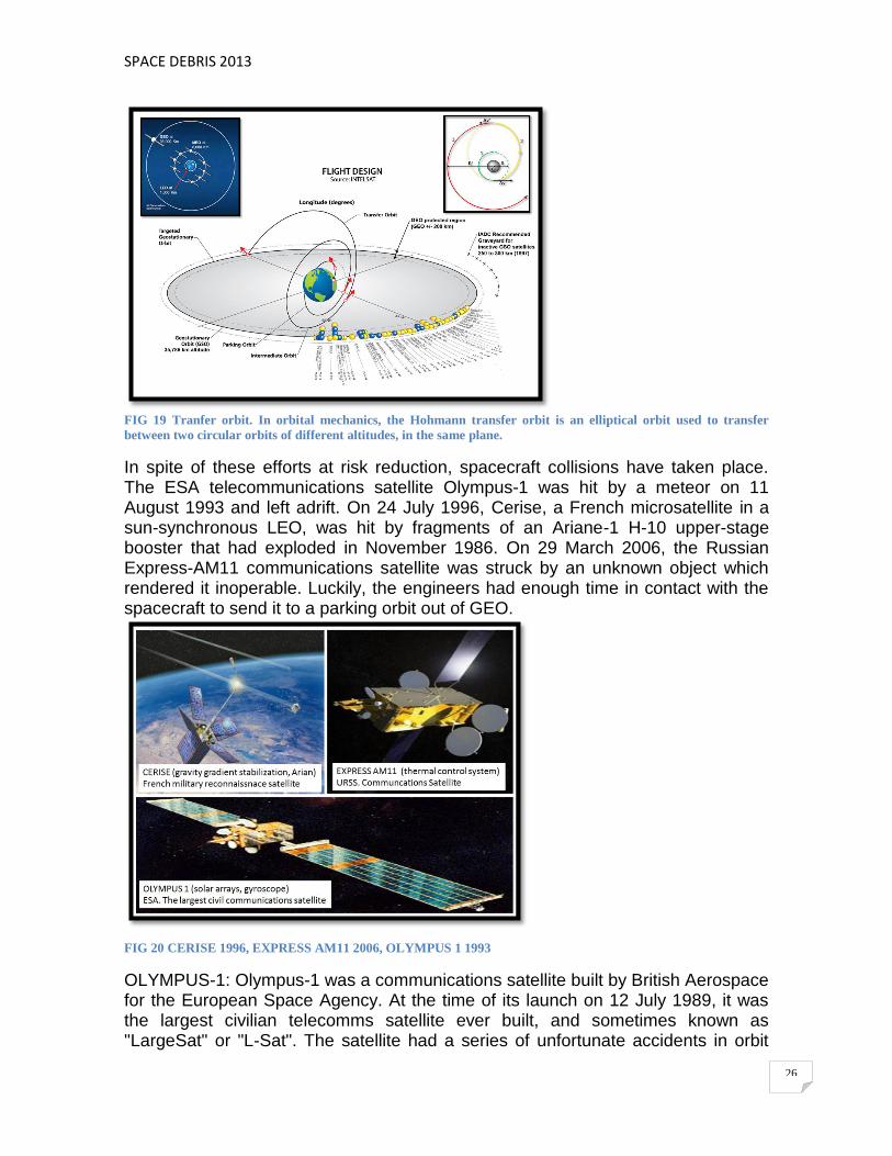
In spite of these efforts at risk reduction, spacecraft collisions have taken place. The ESA telecommunications satellite Olympus-1 was hit by a meteor on 11 August 1993 and left adrift. On 24 July 1996, Cerise, a French microsatellite in a sun-synchronous LEO, was hit by fragments of an Ariane-1 H-10 upper-stage booster that had exploded in November 1986. On 29 March 2006, the Russian Express-AM11 communications satellite was struck by an unknown object which rendered it inoperable. Luckily, the engineers had enough time in contact with the spacecraft to send it to a parking orbit out of GEO.
FIG 20 CERISE 1996, EXPRESS AM11 2006, OLYMPUS 1 1993
OLYMPUS-1: Olympus-1 was a communications satellite built by British Aerospace for the European Space Agency. At the time of its launch on 12 July 1989, it was the largest civilian telecomms satellite ever built, and sometimes known as "LargeSat" or "L-Sat". The satellite had a series of unfortunate accidents in orbit

SPACE DEBRIS 2013
27
and went out of service on 11/12 August 1993. The first accident was the loss of ability to articulate the satellite's solar arrays. This was later followed by the loss of an on board gyroscope during the height of the Perseid meteor shower. The satellite spun out of control and efforts to stabilize it resulted in the expenditure of the majority of its fuel. Subsequently, it was moved to a GEO disposal orbit and was put out of commission. CERISE: Cerise was a French military reconnaissance satellite. Its main purpose was to intercept HF radio signals for French intelligence services.[1] With a mass of 50 kg, it was launched by an Ariane rocket from Kourou in French Guiana at 17:23 UT, 7 July 1995. It was hit by a catalogued space debris object from an Ariane rocket in 1996, making it the first verified case of a collision between two objects in space. The collision tore off a 4.2-metre portion of Cerise's gravity gradient stabilization boom, which left the satellite severely damaged
EXPRESS AM-11: On March 29, 2006 at 3:41 a.m. (Moscow time) due to a sudden external impact the Express-AM11 satellite experienced failure. According to preliminary findings of NPO-PM satellite manufacturer the telemetry information showed, that failure had been caused by a sudden external impact on the spacecraft resulting in an instantaneous depressurization of the thermal control system fluid circuit followed by a sudden outburst of the heat carrying agent. Due to the external impact and outburst of the heat carrying agent from the thermal control system a significant disturbing moment was generated followed by the spacecraft orientation loss and rotation. At present, provision of services via the Express-AM11 satellite is impossible and a decision to terminate its operation was taken. 3. SOURCES OF DEBRIS
A. DEAD SPACECRAFT
In 1958 the United States launched Vanguard I into a medium Earth orbit (MEO). It became one of the longest surviving pieces of space junk and as of March 2013 is the oldest piece of junk still in orbit, but it will remain in orbit for 240 years.
FIG. 21 Vanguard 1. Satélite NASA, Cabo Cañaveral.
SPACE DEBRIS 2013
28
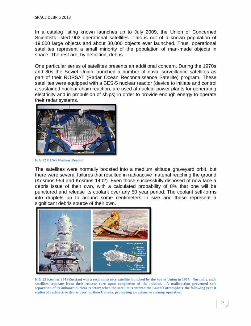
In a catalog listing known launches up to July 2009, the Union of Concerned Scientists listed 902 operational satellites. This is out of a known population of 19,000 large objects and about 30,000 objects ever launched. Thus, operational satellites represent a small minority of the population of man-made objects in space. The rest are, by definition, debris. One particular series of satellites presents an additional concern. During the 1970s and 80s the Soviet Union launched a number of naval surveillance satellites as part of their RORSAT (Radar Ocean Reconnaissance Satellite) program. These satellites were equipped with a BES-5 nuclear reactor (device to initiate and control a sustained nuclear chain reaction, are used at nuclear power plants for generating electricity and in propulsion of ships) in order to provide enough energy to operate their radar systems.
FIG 22 BES-5 Nuclear Reactor
The satellites were normally boosted into a medium altitude graveyard orbit, but there were several failures that resulted in radioactive material reaching the ground (Kosmos 954 and Kosmos 1402). Even those successfully disposed of now face a debris issue of their own, with a calculated probability of 8% that one will be punctured and release its coolant over any 50 year period. The coolant self-forms into droplets up to around some centimeters in size and these represent a significant debris source of their own.
FIG 23 Kosmos 954 (Russian) was a reconnaissance satellite launched by the Soviet Union in 1977. Normally, such
satellites separate from their reactor core upon completion of the mission. A malfunction prevented safe
separation of its onboard nuclear reactor; when the satellite reentered the Earth´s atmosphere the following year it
scattered radioactive debris over northen Canada, prompting an extensive cleanup operation.

SPACE DEBRIS 2013
29
B. LOST EQUIPMENT Space debris objects have included a glove lost by astronaut Edgar White on the first American space walk (EVA); a camera Michael Collins lost near the spacecraft Gemini-10; garbage bags jettisoned by the Soviet cosmonauts throughout the Mir space station's 15 year life; a wrench and a toothbrush. Sunita Williams of STS-116 lost a camera during EVA. In an EVA to reinforce a torn solar panel during STS-120, a pair of pliers was lost and during STS-126, Heidemarie Stefanyshyn-Piper lost a briefcase-sized tool bag in one of the mission's EVAs. EVA: Extra Vehicular Activity is any activity done by an astronaut or cosmonaut outside of a spacecraft beyond the Earth's appreciable atmosphere.
FIG 24 GEMINI TITAN-4 / Edgar While (America´s first spacewalk, EVA ExtraVehicular Activity), GEMINI-10 /
MIchael Collins (open hatch and take some photographs of stars as part of experiment), SPATIAL STATION
MIR / Sovietic Cosmonauts (garbage bags jettisoned by the Soviet cosmonauts throughout the MIR space
station's), STS-16 / Sunita Willians (Space Shuttle mission to the International Space Station (ISS) flown by Space
Shuttle Endeavour. The purpose of the mission, was to deliver equipment and supplies to the station, and repair
the problem in the starboard SARJ (Solar Alpha Rotary Joints)).
C. BOOSTERS
The stages of the solid rocket boosters lower fall exhausted to the oceans, although some of them end up in space as space junk. The satellites are usually launched with multistage rocket. The early stages arise shortly after launch and then fall to Earth (minimally there is a danger that these stages can cause damage, and everything is calculated to fall in the sea and in the event that the launch is out of control, can be detonated remotely to avoid risks), but the latter stages of the rockets, usually remain in orbit, constituting a hazard to satellites, spacecraft, astronauts and space stations.
To combat this problem, we created the International Space Debris Committee.
SPACE DEBRIS 2013
30
FIG 25 Stages of the solid rocket boosters.
Another Briz-M broke up on 16 October 2012 after failing on the Proton launch of 6 August. The amount and severity of the debris is yet to be determined. Russia left two communications satellites, the Indonesian Telkom 3 and its own Express-MD2, stranded in the wrong orbit after a perfect lift off for a Proton-M/Briz-M rocket. SpaceTrack reports that the Briz-M broke up on October 16. The same day, Spacetrack ceased to release orbital elements for it (2012-044C/38746) As of late in the day October 21, SpaceTrack had not released orbital data for any fragments.
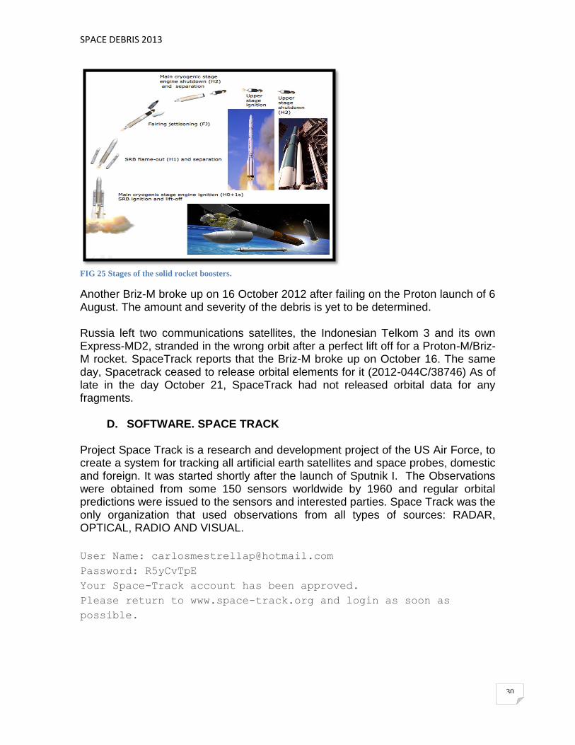
D. SOFTWARE. SPACE TRACK Project Space Track is a research and development project of the US Air Force, to create a system for tracking all artificial earth satellites and space probes, domestic and foreign. It was started shortly after the launch of Sputnik I. The Observations were obtained from some 150 sensors worldwide by 1960 and regular orbital predictions were issued to the sensors and interested parties. Space Track was the only organization that used observations from all types of sources: RADAR, OPTICAL, RADIO AND VISUAL.
User Name: [email protected]
Password: R5yCvTpE
Your Space-Track account has been approved.
Please return to www.space-track.org and login as soon as
possible.

SPACE DEBRIS 2013
31
FIG 26 SSR. SATELLITE SITUATION REPORT. SPACE TRACK.
USING THE SATELLITE SITUACION REPORT: The Satellite Situation Report is a listing of those satellites (objects) currently in orbit and those which have previously orbited the Earth. Some objects are too small or too far from the Earth's surface to be detected; therefore, the Satellite Situation Report does not include all man-made objects orbiting the Earth. Generally, satellites are classified as follows: Payloads may contain one or more functioning or non-functioning experiments. Usually only the owners of the satelllites know if the experiments are functioning, and there is no one source which indicates the operational status of all payloads and/or experiments. The Platforms are used to support a payload while it is being placed into orbit. A platform may remain in orbit long after its purpose is served, usually longer than rocket bodies. (when a platform is not used, the first object after the payload is usually the rocket body). The Rocket bodies are used to place the payloads and platform (if one is used) into orbit. Some launches may have more than one rocket body because of the payload weight or the type of orbit or experiment. Most rocket bodies decay within a short time after the payload (and platform) have achieved orbit.

SPACE DEBRIS 2013
32
Debris in orbit occurs when parts (nosecone shrouds, lens or hatch covers) are separated from the payload, when rocket bodies or payloads disintegrate or explode, or when objects are placed into free space from manned orbiting spacecraft during operations. Debris is detected by its size and distance from the Earth. The Satellite Situation Report does not attempt to classify payloads by experiment or function, such as geosynchronous satellites, communications satellites, Earth resources, and others. Certain groups of satellites, by the nature of their function, have similar inclinations, periods, and apogees. The Geosynchronous satellites have almost equal apogee and perigee, inclinations close to 0 degrees, and a period of orbit approaching 1440 minutes. These satellites are located almost directly above the Equator because they orbit at approximately the same speed that the surface of the Earth moves in relation to the Sun. The Communications satellites are usually geosynchronous. Although some are in geosynchronous orbit, most weather satellites have almost equal apogee and perigee, inclinations approaching 90 degrees, and a 90-minute period of orbit (they orbit the Earth once for each 22.5 degrees of Earth rotation). Weather satellites are only one type of Earth resources satellite. Others in the Earth resources category map the location of minerals, water, and vegetation. These satellites may have apogees and perigees that are very divergent, and the period of orbit can range from 400 to 700 minutes.
E. SOFTWARE. DISCOS DATABASE AND WEB INTERFACE. DISCOS (Database and Information System Characterising Objects in Space)
In order to support Space Debris studies the European Space Agency is maintaining a Database and Information System Characteristising Objects in Space (DISCOS), run by Space Debris Group at the Mission Analysis section of ESOC, Damstadt. This database contains characteristic information on all objects ever launched into space since Sputnik I, as well as other related information, including images, which can be accessed via a Web interface. This interface also allows users to use ESA´MASTER model an Sattrack satellite tracking tool, to download the DISPAD reports, to request solar and geomagnetic activity data or use a set of drawing tools. The latest versions of the database as well as the Web interface have been developed by GMV, Spain, with contributions from eta_max Space, Germany, and are maintained by the Space Debris Group at the Mission Analysis Section of ESOC, Darmstadt.

SPACE DEBRIS 2013
33
The database contains information on all catalogued objects ever launched into space since Sputnik 1 in 1957. These data support the DISCOS Space Data Publication System (DISPAD), which produces tabular reports of the DISCOS contents, and are also being used as part of the Common and Re-entry databases, which are provided as an ESA service in the INTER AGENCY SPACE DEBRIS COORDINATION COMMITTEE (IADC) of all major spacefaring nations. DISCOS (Database and Information System Characterising Objects in Space) has been developed using the Oracle 8i Kernel database and Orcale Internet Application Server 8in(iAS) as the web server for the user interface. Many programming languages have been used to build this system. The main ones being: SQL, PL/SQL, FORTRAN and Perl for the web interface and to insert new data into the database; DISSPLA and PV-Wave graphical tools to produce the images; LaTex-2 document processing system to produce the documentation, and latex2html for the on-line help. DISCOS contains characteristic information on more than 26500 catalogued objects, including the international designator (or COSPAR (Committe on Space Research) identification number), the NORAD (North American Aerospace Defense Command) satellite number, the name, the country it belongs to, mass, shape and dimensions, and cross-sectional areas. The type of the object (whether it is a payload or a rocket body or fragment/debris) is also stored, as well as the re-entry epoch if the objects has already decayed. In the case also available. All this data is updated on a monthly basis from different sources. At present there are about 8300 catalogued objects orbiting the Earth, whose orbital parameters are updated on a daily basis in the DISCOS database. But a historical record of each object´s orbital elements since 1990 is also maintained at a rate of approximately one element set per object per week, adding up to nearly 4 million records.
FIG 27 DISCOS (Database and Information System Characterising Objects in Space)

SPACE DEBRIS 2013
34
F. SOFTWARE. MASTER (METEOROID AND SPACE DEBRIS TERRESTRIAL ENVIRONMENT REFERENCE)
MASTER-2009 (Meteoroid and Space Debris Terrestrial Environment Reference) MASTER (Meteoroid and Space Debris Terrestrial Environment Reference) is a software that can be used to analyze space debris flux and spatial densities. The following sources of debris are considered: launch and mission-related objects, explosion and collision fragments, solid rocket motor slag and dust, NaK droplets, surface degradation products, ejecta, and meteoroids. MASTER can deliver flux and spatial density analysis for all epochs between 1957 and 2060. The analysis of the future debris environment is possible based on three different future scenarios (business as usual, intermediate mitigation, full mitigation). The MASTER-2009 software is delivered on a DVD, together with extensive documentation of the underlying models. The software is available for Windows, Linux, Solaris, and MacOS X. PROOF-2009 (Program for Radar and Observation Forecasting) PROOF (Program for Radar and Observation Forecasting) is a software for the simulation of radar and telescope based space debris observations. It is delivered together with the MASTER-2009 software. It can be applied for the validation of space debris models like MASTER against observation data. Another use is the planning of debris observation campaigns, including the derivation of neccessary sensor parameters. PROOF-2009 has been applied in the course of the MASTER-2009 validation process to properly interpret debris observations performed by the ESA Space Debris Telescope, the Liquid Mirror Telescope, the Tracking and Imaging Radar, the Goldstone, and the Haystack Radar. With the new version of PROOF, a simulation of multistatic radar observations, and of phased array radars is now possible. The software is available for Windows,Linux,Solaris,and MacOS X.
FIG 28 Meteoroid And Space debris Terrestrial Environment Reference Model (MASTER)

SPACE DEBRIS 2013
35
G. SOFTWARE. KMZ SATELLITE DATABASE / GOOGLE EARTH AND THE SPACE DEBRIS
There is a kmz (application running in the program) to Google Earth, which is a database of almost all bodies that roam the area, with filters, and the option to view them in real time. This KML network link visualizes all earth orbiting objects tracked by the United States Strategic Command (USSTRATCOM) using the satellite database processed by Analytical Graphics, Inc. using the Dynamic Geometry Library. All satellites are tracked in real-time and updated every 30 seconds. USSTRATCOM has been tracking space objects since 1957 when the Soviets opened the space age with the launch of Sputnik I. Since then, they have recorded more than 26,000 space objects orbiting Earth. There are currently more than 12,000 man-made orbiting objects, the rest have re-entered Earth's turbulent atmosphere and disintegrated, or survived re-entry and impacted the Earth. Analytical Graphics, Inc. (AGI) develops commercial to analysis software of land, sea, air and space that is relied upon by the national security and space communities. With more than 32,000 worldwide installations, the main applications of AGI technologies focus on battlespace management, geospatial intelligence, space systems and national defense programs. In addition to the STK product suite, AGI produces the desktop software applications Navigation Tool Kit and Orbit Determination Tool Kit; interactive visualization AGI Viewer software; and the embedded technology development tool 4DX.
FIG 29 A.Kmz filter showing only expelled rocket boosters and space remaining; B. Filter showing only small
objects, such as gloves and tools astronauts; C.Some objects overhead; D.Filter: Satellites inactive

SPACE DEBRIS 2013
36
FIG 30 A.Belt orbiting satellites; B.Another image that includes the belt; C.All the junk that's up, unfiltered;
D.This image shows only the debris, without satellites
4. OPERATIONAL ASPECTS A. ORBITAL LIFE AND RISK
FIG 31 In orbit, lifetime is limited by residues of atmosphere (atmospheric drag, energy decrease, re-entry on
Earth)
On orbit objects have huge kinetic energy, even a (small) debris can inflict important damages, there is no shielding able to resist to particles larger than 2 cm (ISS example), example: aluminium sphere Φ=1 mm at 10 km/seg (perforation of a 4 mm aluminium thick plate).
Probability of collision in 1 year with objects
Size of the objects >0.1 mm >1 mm >1 cm >10 cm
Probability 1 0.5 3x10^-3 2x10^-4
SPACE DEBRIS 2013
37
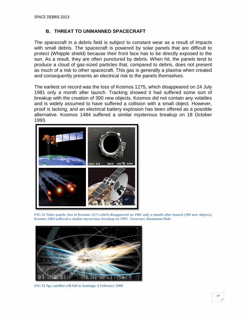
B. THREAT TO UNMANNED SPACECRAFT The spacecraft in a debris field is subject to constant wear as a result of impacts with small debris. The spacecraft is powered by solar panels that are difficult to protect (Whipple shield) because their front face has to be directly exposed to the sun. As a result, they are often punctured by debris. When hit, the panels tend to produce a cloud of gas-sized particles that, compared to debris, does not present as much of a risk to other spacecraft. This gas is generally a plasma when created and consequently presents an electrical risk to the panels themselves. The earliest on record was the loss of Kosmos 1275, which disappeared on 24 July 1981 only a month after launch. Tracking showed it had suffered some sort of breakup with the creation of 300 new objects. Kosmos did not contain any volatiles and is widely assumed to have suffered a collision with a small object. However, proof is lacking, and an electrical battery explosion has been offered as a possible alternative. Kosmos 1484 suffered a similar mysterious breakup on 18 October 1993.
FIG 32 Solar panels, loss of Kosmos 1275 which disappeared on 1981 only a month after launch (300 new objects),
Kosmos 1484 suffered a similar mysterious breakup on 1993. Structure Aluminum Hole
FIG 33 Spy satellite will fall in Santiago, 6 February 2008

SPACE DEBRIS 2013
38
The first major space debris collision was on 10 February 2009 at 16:56 UTC (Universal Time Coordinated). The deactivated 950 kg Kosmos 2251 and an operational 560 kg Iridium 33 collided 800 km over northern Siberia. The relative speed of impact was about 11.7 km/s. Both satellites were destroyed and the collision scattered considerable debris, which poses an elevated risk to spacecraft. The collision created a debris cloud, although accurate estimates of the number of pieces of debris is not yet available.
In a Kessler Syndrome cascade, the satellite lifetimes would be measured on the order of years or months. The new satellites could be launched through the debris field into higher orbits or placed in lower ones where natural decay processes remove the debris, but it is precisely because of the utility of the orbits between 800 and 1500 km that this region is so filled with debris.
C. THREAT TO MANNED SPACECRAFT
From the earliest days of the Space Shuttle missions, NASA has turned to NORAD's database (North American Aerospace Defense Command) to constantly monitor the orbital path in front of the Shuttle to find and avoid any known debris (evasives manoeuvres). The International Space Station (ISS), has made several evasive maneuvers (changing its path), not hitting the space debris. However, the ISS if you have had impacts.
FIG 34 The International Space Station

SPACE DEBRIS 2013
39
The ISS is under construction since 1998 and this is the largest man-made object in Earth orbit, completes a lap every 91 minutes. Currently about 400 km altitude, although its actual height can vary by several kilometers due to atmospheric drag and propulsion repeated. The station has reached approximate dimensions of 110 m × 100 m × 30 m, with a large living area, a mass of 420 tons, a volume of 916 cubic meters, and energy will be provided by its solar panels with a capacity of 84 kw (are the largest ever built), ie complexity surpasses everything that was conceived to date. According to plans, should be in operation at least until 2025. Thanks to the ISS, there is a permanent human presence in space, 2, 3 and up to 7 astronauts. The station is maintained primarily by the shuttles today Russian Soyuz and Progress spacecraft, and in the past thanks to the U.S. Space Shuttle, until 2011, as the space shuttle program in the U.S. has been canceled by the retrenchment of the U.S. government. Meanwhile, the ISS has been visited by 205 people from sixteen countries and has also been the target of the first space tourists. Currently has a living space comparable to a standard five-bedroom house has two bathrooms and also has a gym. From the July 17, 2012 is manned by issuing 32. JUN2011: A fragment of cosmic space junk was too close to the ISS, the crew forced to take shelter in the Soyuz spacecraft docked to the station. ENE2012: It makes a correction of the orbit of the ISS to avoid a piece of U.S. satellite Iridium-33, whose remains were scattered to Earth orbit over the February 10, 2009, after impact with the Kosmos-2251. The two artifacts were destroyed and left more than a thousand fragments. SEPT2012: A former Russian military spy satellite (Kosmos-2251), and left, threatening to hit the International Space Station (ISS), which would have to maneuver (2.8 minutes and increased platform 4.7 km) to avoid the possible impact according to the Center for Space Flight Control (CCVE) of Russia. The menacing piece was a fragment Tsiklon-3 carrier rocket, launched into space two decades ago. Both cosmic as garbage station moving at a very high speed, much higher than that of a projectile. A collision, even with a relatively small object, can be extremely dangerous. Therefore any object, however tiny, can cause serious damage to a spacecraft. The accumulation of these wastes worries most developed nations, which are threatening its future space projects. Even canceling all space activity, globally, the

SPACE DEBRIS 2013
40
amount of space junk would increase by about 20 or 30 years due to collisions between existing objects.
FIG 35 A. Uncontrolled Satellite,; B. Virtual image of space debris around Earth; C. Laboratory testing of impact
between a small sphere of aluminium, 1.2 cm in diameter and 1.7 grams moving at 6.8 km per second agains an
aluminum block 18 cm thick. ESA; D. The Discovery´s underside displays a number of new tiles, which are
darker.
One of the first events to widely publicize the debris problem was Space Shuttle Challenger's second flight on STS-7. A small fleck of paint impacted Challenger's front window and created a pit over 1 mm wide. Endeavour suffered a similar impact on STS-59 in 1994, but this one pitted the window for about half its depth: a cause for much greater concern. Post-flight examinations have noted a marked increase in the number of debris impacts since 1998 until today.
FIG. 36 Problems with the space shuttles 1981-2011. Endeavour suffered a major hit on the radiator during STS
118. The entry hole is just less than 1/2 inch. The exit hole on the rear of the panel is much larger.
SPACE DEBRIS 2013
41
At 2006, Atlantis was hit by a small fragment during STS-115, which bored a small hole through the radiator panels in the cargo bay. A similar incident followed on STS-118 in 2007, when Endeavour was hit in a similar location by unknown debris which blew a hole several centimetres in diameter through the panel. If the Kessler Syndrome comes to pass, the threat to manned missions may be too great to contemplate operations in LEO. Although the majority of manned space activities take place at altitudes below the critical 800 to 1,500 km regions, a cascade within these areas would result in a constant rain down into the lower altitudes as well. The time scale of their decay is such that the resulting debris environment is likely to be too hostile for future space use.
D. ALARM IN THE INTERNATIONAL SPACE STATION Result of international cooperation, the International Space Station (ISS) is considered one of the greatest achievements in space engineering. Like its predecessors, the ISS is in low orbit, about 380 km altitude, and has an outer shield that protects the impact of fragments up to one centimeter. Problems arise when the piece of space debris exceeds that size. Then there is no choice but to start the engines of the ISS to avoid it. That's what happened in October last year, when a piece of junk detected about 10 inches from, of course, of the clash between the Kosmos 2251 and Iridium 33. The day after the announcement, the ISS fired its engines for less than a minute and rose from its orbit about 300 meters, just enough to avoid the possibility of a collision. Since its launch into orbit in 1998, has had to perform 12 similar maneuvers, which gives an average of one per year. But the threat is not always detected in time that the ISS can change altitude. If the probability of impact is greater than 0.0001 (between 10 000 a possibility that there is a collision), starts evacuation protocol. The astronauts are introduced into the two Soyuz spacecraft docked to the ISS in charge usually fetch and carry the crew and that on these occasions serve as emergency vehicle. Once the risk has passed, is checked whether the pressure inside the ISS remains stable. If so, the astronauts are leaving the Soyuz and return to their normal duties. If one were to go ahead with the evacuation, the crew could be on Earth in less than half an hour. Although never reached Therefore, in recent years there have been a few sensitive situations. In 2009 and 2011, two small pieces of space junk caused the ISS crew took refuge for several minutes in the Soyuz spacecraft. Fortunately everything was in shock. But if we do not curb the problem of space debris, it is likely that such alarms occur more often in the future.
SPACE DEBRIS 2013
42
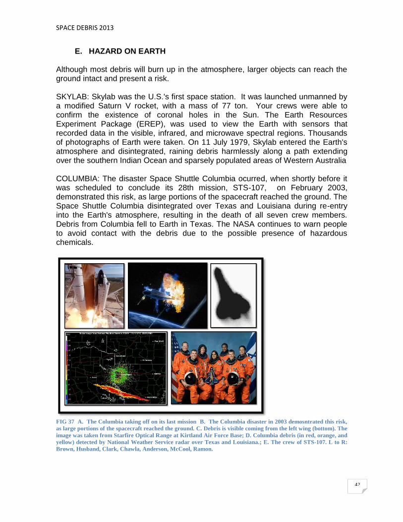
E. HAZARD ON EARTH Although most debris will burn up in the atmosphere, larger objects can reach the ground intact and present a risk. SKYLAB: Skylab was the U.S.'s first space station. It was launched unmanned by a modified Saturn V rocket, with a mass of 77 ton. Your crews were able to confirm the existence of coronal holes in the Sun. The Earth Resources Experiment Package (EREP), was used to view the Earth with sensors that recorded data in the visible, infrared, and microwave spectral regions. Thousands of photographs of Earth were taken. On 11 July 1979, Skylab entered the Earth's atmosphere and disintegrated, raining debris harmlessly along a path extending over the southern Indian Ocean and sparsely populated areas of Western Australia COLUMBIA: The disaster Space Shuttle Columbia ocurred, when shortly before it was scheduled to conclude its 28th mission, STS-107, on February 2003, demonstrated this risk, as large portions of the spacecraft reached the ground. The Space Shuttle Columbia disintegrated over Texas and Louisiana during re-entry into the Earth's atmosphere, resulting in the death of all seven crew members. Debris from Columbia fell to Earth in Texas. The NASA continues to warn people to avoid contact with the debris due to the possible presence of hazardous chemicals.
FIG 37 A. The Columbia taking off on its last mission B. The Columbia disaster in 2003 demosntrated this risk,
as large portions of the spacecraft reached the ground. C. Debris is visible coming from the left wing (bottom). The
image was taken from Starfire Optical Range at Kirtland Air Force Base; D. Columbia debris (in red, orange, and
yellow) detected by National Weather Service radar over Texas and Louisiana.; E. The crew of STS-107. L to R:
Brown, Husband, Clark, Chawla, Anderson, McCool, Ramon.
SPACE DEBRIS 2013
43
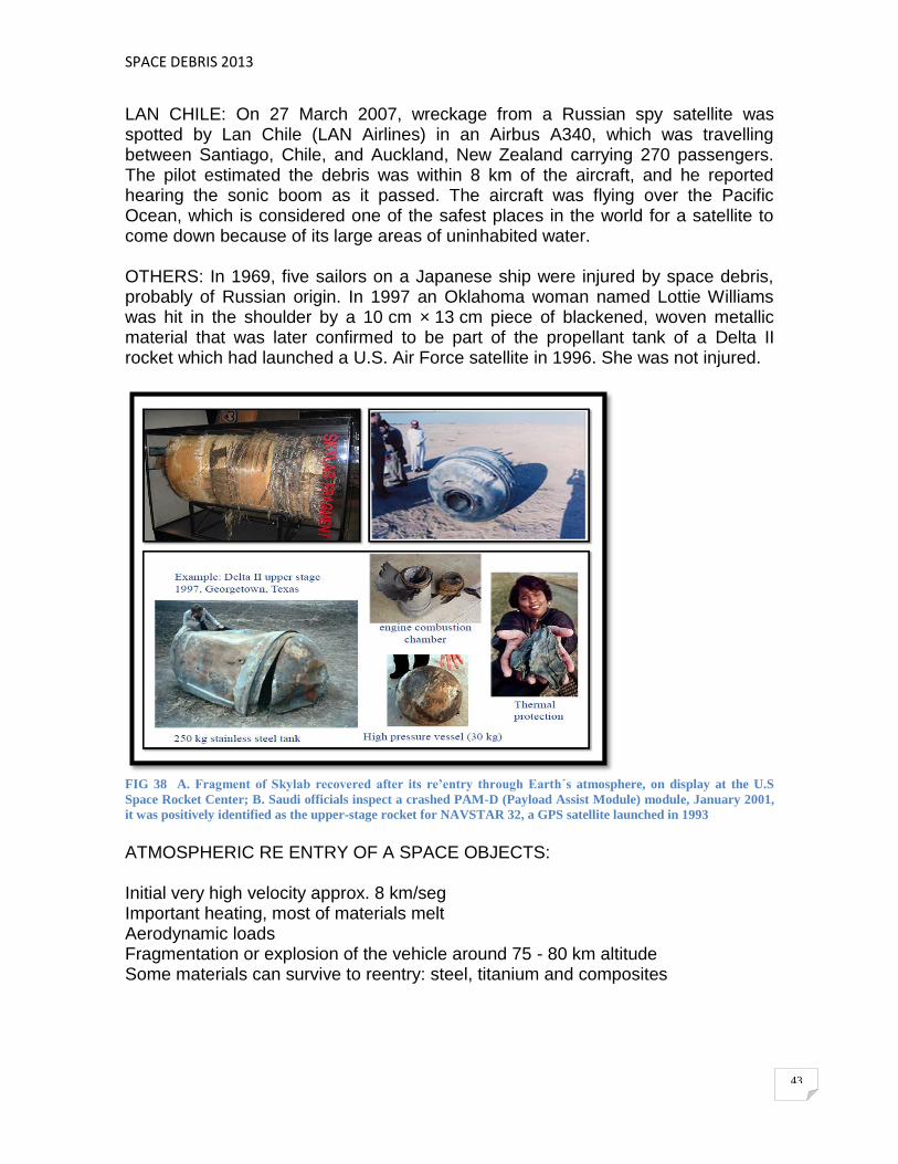
LAN CHILE: On 27 March 2007, wreckage from a Russian spy satellite was spotted by Lan Chile (LAN Airlines) in an Airbus A340, which was travelling between Santiago, Chile, and Auckland, New Zealand carrying 270 passengers. The pilot estimated the debris was within 8 km of the aircraft, and he reported hearing the sonic boom as it passed. The aircraft was flying over the Pacific Ocean, which is considered one of the safest places in the world for a satellite to come down because of its large areas of uninhabited water. OTHERS: In 1969, five sailors on a Japanese ship were injured by space debris, probably of Russian origin. In 1997 an Oklahoma woman named Lottie Williams was hit in the shoulder by a 10 cm × 13 cm piece of blackened, woven metallic material that was later confirmed to be part of the propellant tank of a Delta II rocket which had launched a U.S. Air Force satellite in 1996. She was not injured.
FIG 38 A. Fragment of Skylab recovered after its re’entry through Earth´s atmosphere, on display at the U.S
Space Rocket Center; B. Saudi officials inspect a crashed PAM-D (Payload Assist Module) module, January 2001,
it was positively identified as the upper-stage rocket for NAVSTAR 32, a GPS satellite launched in 1993
ATMOSPHERIC RE ENTRY OF A SPACE OBJECTS: Initial very high velocity approx. 8 km/seg Important heating, most of materials melt Aerodynamic loads Fragmentation or explosion of the vehicle around 75 - 80 km altitude Some materials can survive to reentry: steel, titanium and composites
SPACE DEBRIS 2013
44
5. TRACKING AND MEASUREMENT A. SPACE OBJECT CATALOGUES
Space object catalogues, as generated and maintained by space surveillance networks, are limited to larger objects, typically greater than 10cm in low Earth orbits and greater than 1m at geostationary altitudes. These sensitivity thresholds are a compromise between system cost and performance. Knowledge of the meteoroid and space debris environment at sub-catalogue sizes is normally acquired in a statistical manner through experimental sensors with higher sensitivities. Ground-based telescopes can detect GEO debris down to 10cm in size, ground-based radars can detect LEO debris down to a few mm in size, and in-situ impact detectors can sense objects down to a few micrometres in size. And while telescopes are mainly suited for GEO and high-altitude debris observations, radars are advantageous in the low-Earth orbit (LEO) regime, below 2000 km.
B. SPACE SURVEILLANCE, DETECTION AND OBSERVATION SYSTEMS (TRACKING SPACEFARING OBJECTS)
The Space surveillance is a critical part of detecting, tracking, cataloging and identifying man-made objects orbiting Earth, i.e. active/inactive satellites, spent rocket bodies, or fragmentation debris. THE SPACE SURVEILLANCE ACCOMPLISHES THE FOLLOWING: - Predict when and where a decaying space object will re-enter the Earth's
atmosphere - Prevent a returning space object, which to radar looks like a missile, from
triggering a false alarm in missile-attack warning sensors of the U.S. and other countries
- Chart the present position of space objects and plot their anticipated orbital paths
- Detect new man-made objects in space - Produce a running catalog of man-made space objects - Determine which country owns a re-entering space object - Inform NASA whether or not objects may interfere with the space shuttle and
Russian Mir space station orbits. The command accomplishes these tasks through its Space Surveillance Network (SSN) of U.S. Army, Navy and Air Force operated, ground-based radar's and optical sensors at 25 sites worldwide. The methods used to track objects orbiting the Earth include optical, radio and radar techniques. Optical techniques range from observations with the naked eye through to photographic methods. Radio tracking is any process that receives energy transmitted by the object being tracked. Radar bounces energy, from a
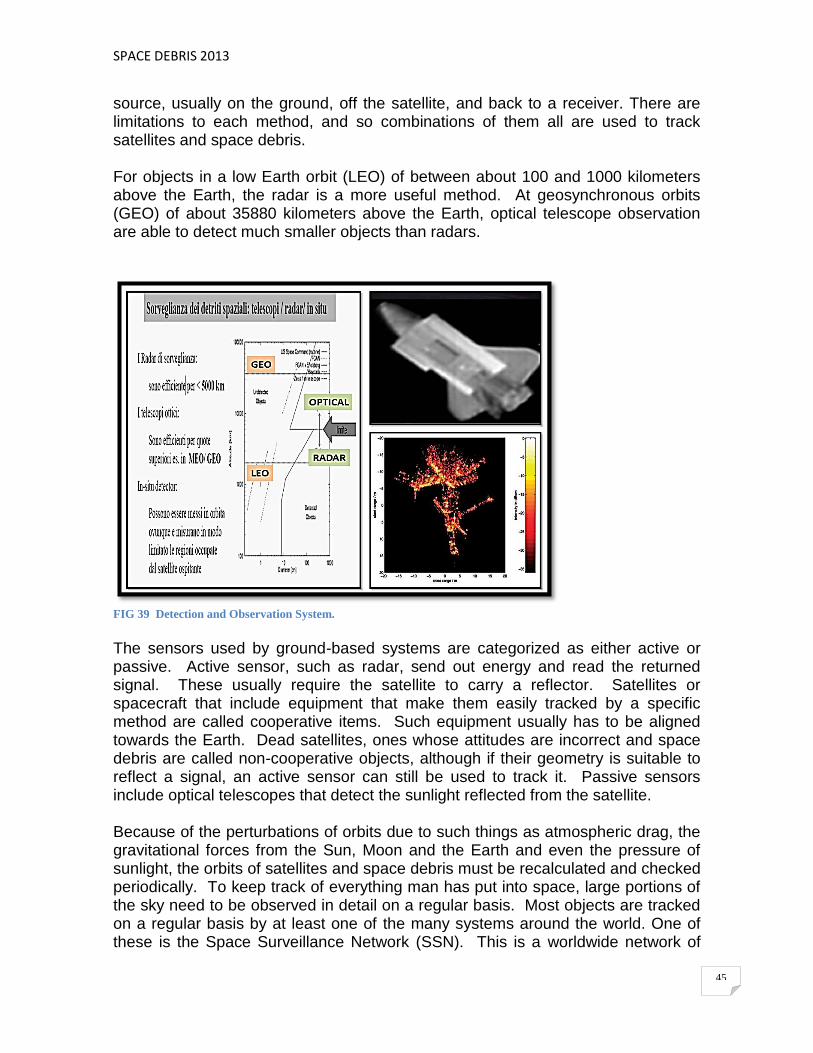
SPACE DEBRIS 2013
45
source, usually on the ground, off the satellite, and back to a receiver. There are limitations to each method, and so combinations of them all are used to track satellites and space debris. For objects in a low Earth orbit (LEO) of between about 100 and 1000 kilometers above the Earth, the radar is a more useful method. At geosynchronous orbits (GEO) of about 35880 kilometers above the Earth, optical telescope observation are able to detect much smaller objects than radars.
FIG 39 Detection and Observation System.
The sensors used by ground-based systems are categorized as either active or passive. Active sensor, such as radar, send out energy and read the returned signal. These usually require the satellite to carry a reflector. Satellites or spacecraft that include equipment that make them easily tracked by a specific method are called cooperative items. Such equipment usually has to be aligned towards the Earth. Dead satellites, ones whose attitudes are incorrect and space debris are called non-cooperative objects, although if their geometry is suitable to reflect a signal, an active sensor can still be used to track it. Passive sensors include optical telescopes that detect the sunlight reflected from the satellite. Because of the perturbations of orbits due to such things as atmospheric drag, the gravitational forces from the Sun, Moon and the Earth and even the pressure of sunlight, the orbits of satellites and space debris must be recalculated and checked periodically. To keep track of everything man has put into space, large portions of the sky need to be observed in detail on a regular basis. Most objects are tracked on a regular basis by at least one of the many systems around the world. One of these is the Space Surveillance Network (SSN). This is a worldwide network of

SPACE DEBRIS 2013
46
about twenty ground-based optical and radar sensors and one pace-based sensor. The SSN has tracked more than 26000 objects orbiting the Earth since the launch of Sputnik 1. Most of these have since re-entered as the film had to be scanned manually. This was time-consuming and open tu human error. As technology has advanced, the baker Nunn cameras have been replaced by a new system of Ground-based Electro-Optical Deep Space Surveillance (GEODSS).
FIG 40 SSN (Space Surveillance Network). (DoD)
FIG 41 Space Surveillance, Detection and Observation System
SSN (Space Surveillance Network) The Space Surveillance Network (SSN) has been tracking space objects since 1957 when the Soviets opened the space age with the launch of Sputnik I. Since then, the SSN has tracked more than 24500 space objects orbiting Earth. SSN Sensors uses a "predictive" technique to monitor space objects. This technique is used because of the limits of the SSN (number of sensors, geographic distribution, capability, and availability). Below is a brief description of each type of sensor.

SPACE DEBRIS 2013
47
Conventional radars use immobile detection and tracking antennas. The tracking antenna, then, locks its narrow beam of energy on the target and follows it in order to establish orbital data. The Ground-Based Electro-Optical Deep Space Surveillance System (GEODSS) consists of three telescope sensors linked to a video camera. The image is transposed into electrical impulses and recorded on magnetic tape. This is the same process used by video cameras. Thus, the image can be recorded and analyzed in real-time. Combined, these types of sensors make up to 80,000 satellite observations each day. This enormous amount of data comes from SSN sites such as Maui, Hawaii; Eglin, Florida; Thule, Greenland; and Diego Garcia, Indian Ocean. The data is transmitted directly to USSPACECOM's Space Control Center (SCC) via satellite, ground wire, microwave and phone. ISON (International Scientific Optical Network) – SPACE SURVEILLANCE The ISON network have following capabilities: - Global surveying of the GEO region - Processing of all obtained measurements, construction of precise orbits and
maintenance of the dynamical orbital archive - Prediction and analysis of possible dangerous situation on GEO, MEO and HEO
(space debris) - Conducting of experimental observations of LEO objects including debris of
recent fragmentations
FIG 42 ISON. International Scientific Optical Network.

SPACE DEBRIS 2013
48
C. TRACKING FROM THE GROUND
FIG 43 A. Lidar (Light Detection and Ranging); B. A liquid mirror telescope; C. The U.S Strategic Command
maintains a catalogue containing know orbital objects; D. ESA Space Debris Telescope; E. Bi-static Radar
Scanning using TIRA, Germany; F. The Observatory Goldstone, EEUU; G. The Haystack Observatory
(Massachusetts, USA) an atmospheric sciences research center.
The RADAR and OPTICAL detectors such as lidar are the main tools used for tracking space debris. Tracking objects smaller than 10 cm is difficult due to their small cross-section and reduced orbital stability, though debris as small as 1 cm can be tracked. NASA Orbital Debris Observatory tracked space debris using a 3 m liquid mirror transit telescope.
LIDaR: (LIght Detection and Ranging, or sometimes Laser Imaging Detection and Ranging) is an optical remote sensing technology that can measure the distance to, or other properties of, targets by illuminating the target with laser light and analyzing the backscattered light. The term "laser radar" is sometimes used, even though LIDAR does not employ microwaves or radio waves and therefore is not radar in the strict sense of the word. LIQUID MIRROR TELESCOPES are telescopes with mirrors made with a reflective liquid (mercurio). The rotating liquid assumes the paraboloidal shape regardless of the container's shape. The liquid mirrors can be a low cost alternative to conventional large telescopes. Compared to a solid glass mirror that must be cast, ground, and polished, a rotating liquid metal mirror is much less expensive to manufacture.
SPACE DEBRIS 2013
49
The U.S. Strategic Command (It is charged with space operations, military satellites, information warfare, missile defense, global command and control, intelligence, surveillance, and reconnaissance (C4ISR), global strike and strategic deterrence, the United States nuclear arsenal, and combating weapons of mass destruction (earth, sea, air and space) maintains a catalogue containing known orbital objects. The list was initially compiled in part to prevent misinterpretation as hostile missiles. The actual version compiled listed about 19000 objects. Observation data gathered by a number of ground-based radar facilities and telescopes as well as by a space-based telescope is used to maintain this catalogue. Nevertheless, the majority of expected debris objects remain unobserved, there are more than 600000 objects larger than 1 cm in orbit (according to the ESA Meteoroid and Space Debris Terrestrial Environment Reference, the MASTER 2005-9 model)). Other sources of knowledge on the actual space debris environment include measurement campaigns by the ESA Space Debris Telescope, TIRA (System), Goldstone radar, Haystack radar and the EISCAT radars. The data gathered during these campaigns is used to validate models of the debris environment like ESA-MASTER. Such models are the only means of assessing the impact risk caused by space debris, as only larger objects can be regularly tracked. The ESA SPACE DEBRIS TELESCOPE is located at the Teide Observatory on the island of Tenerife, Spain. The telescope is ESA's Optical Ground Station forming a part of the Artemis experiment. As a large part of the observation time is dedicated to space debris surveys, in particular the observation of space debris in the geostationary ring and in geostationary transfer orbits, the term ESA Space Debris Telescope became used very frequently. Space debris surveys are carried out every month, centered around New Moon. The German System TIRA (Tracking and Imaging Radar), has a 34 meters dish antenna operating in L-band for debris detection and tracking, conducts regular beam park experiments, where the radar beam is pointed in a fixed direction for 24 hours, so that the beam scans 360º in a narrow strip on the celestial sphere, during a full Earth rotation. TIRA can detect debris and determine coarse orbit information for objects of diameters down to 2 cm at 1000 km range. In a bi-static mode, together with the 100m receiver antenna of the nearby Effelsberg radio telescope, the overall sensitivity increases toward 1 cm objects. The Goldstone Deep Space Communications Complex (GDSCC) is located in the U.S. state of California. Operated for the Jet Propulsion Laboratory, its main purpose is to track and communicate with space missions. It includes the Pioneer Deep Space Station, which is a U.S. National Historic Landmark. The current observatory is part of NASA's Deep Space Network. EISCAT is an acronym for the European Incoherent Scatter Scientific Association. It operates three incoherent scatter radar systems, in Northern Scandinavia used to study the interaction between the Sun and the Earth as revealed by

SPACE DEBRIS 2013
50
disturbances in the ionosphere and magnetosphere. Additional receiver stations are located in Sodankylä, Finland, and Kiruna, Sweden. The EISCAT Headquarters are also located in Kiruna.
D. MEASUREMENT IN SPACE Returned space debris hardware is a valuable source of information on the (sub-millimetre) space debris environment. The LDEF satellite deployed by STS-41-C Challenger and retrieved by STS-32 Columbia spent 68 months in orbit. Close examination of its surfaces allowed an analysis of the directional distribution and composition of the debris flux. The EURECA satellite deployed by STS-46 Atlantis in 1992 and retrieved by STS-57 Endeavour in 1993 was similarly used for debris studies.
FIG. 44 Long Duration Exposure Facility (LDEF) is an important source of information on the small particle space
debris environment.
The solar arrays of the Hubble Space Telescope returned during missions STS-61 Endeavour and STS-109 Columbia are an important source of information on the debris environment. The impact craters found on the surface were counted and classified by ESA to provide a means for validating debris environment models. Similar materials returned from Mir were extensively studied, notably the Mir Environmental Effects Payload which studied the environment in the Mir area.
E. ORBITAL SENTRY On 25 April 2012, the Ecuadorian Space Agency announced a new mission to the NEE-01 Pegasus satellite, including a technological change in the video camera of the satellite which would help organizations and individuals around the world for fine tune the catalog of orbital debris by injecting the live video signal of the satellite since the Internet, thus turning the NEE-01 Pegasus into the first online, real-time video orbital sentry. This mission is currently scheduled for the first quarter of 2013.
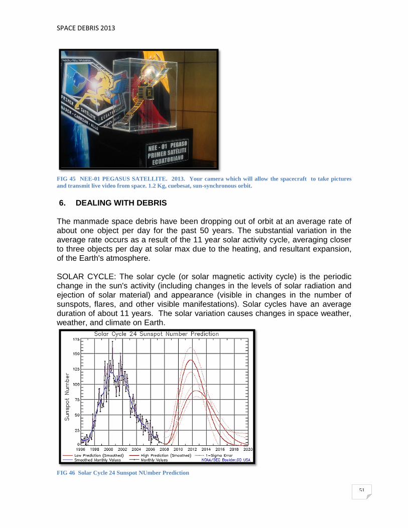
SPACE DEBRIS 2013
51
FIG 45 NEE-01 PEGASUS SATELLITE. 2013. Your camera which will allow the spacecraft to take pictures
and transmit live video from space. 1.2 Kg, cuebesat, sun-synchronous orbit.
6. DEALING WITH DEBRIS The manmade space debris have been dropping out of orbit at an average rate of about one object per day for the past 50 years. The substantial variation in the average rate occurs as a result of the 11 year solar activity cycle, averaging closer to three objects per day at solar max due to the heating, and resultant expansion, of the Earth's atmosphere.
SOLAR CYCLE: The solar cycle (or solar magnetic activity cycle) is the periodic change in the sun's activity (including changes in the levels of solar radiation and ejection of solar material) and appearance (visible in changes in the number of sunspots, flares, and other visible manifestations). Solar cycles have an average duration of about 11 years. The solar variation causes changes in space weather, weather, and climate on Earth.
FIG 46 Solar Cycle 24 Sunspot NUmber Prediction
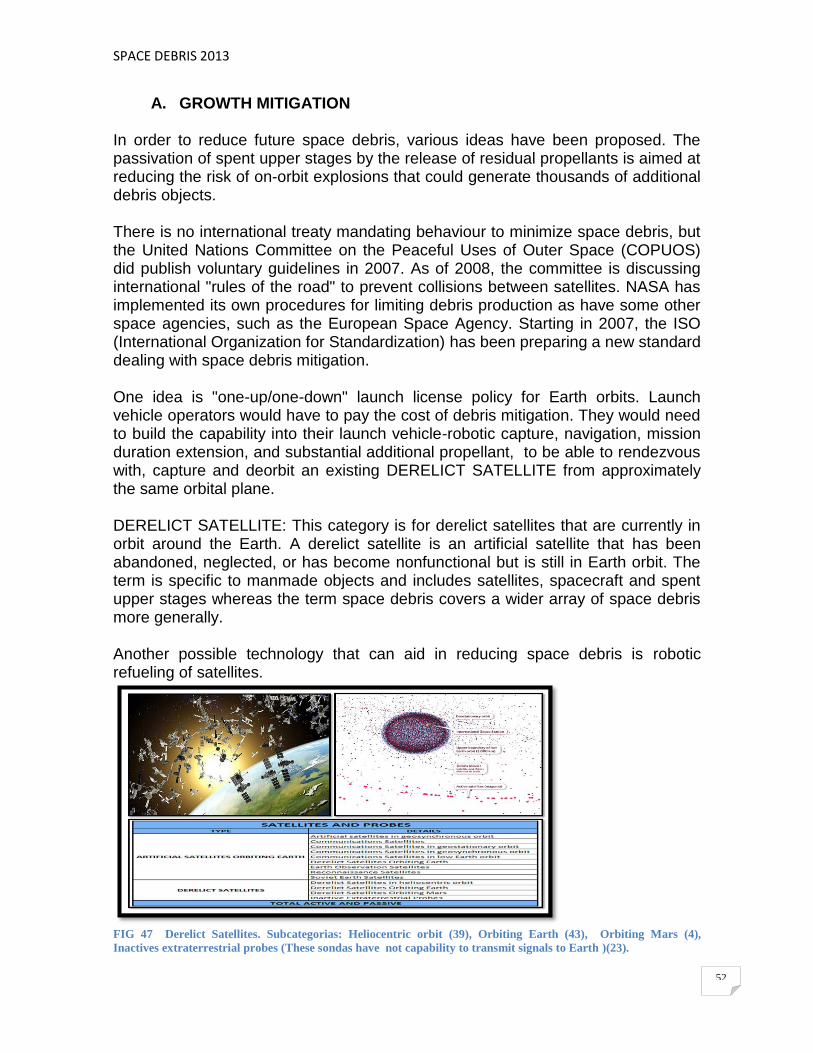
SPACE DEBRIS 2013
52
A. GROWTH MITIGATION In order to reduce future space debris, various ideas have been proposed. The passivation of spent upper stages by the release of residual propellants is aimed at reducing the risk of on-orbit explosions that could generate thousands of additional debris objects. There is no international treaty mandating behaviour to minimize space debris, but the United Nations Committee on the Peaceful Uses of Outer Space (COPUOS) did publish voluntary guidelines in 2007. As of 2008, the committee is discussing international "rules of the road" to prevent collisions between satellites. NASA has implemented its own procedures for limiting debris production as have some other space agencies, such as the European Space Agency. Starting in 2007, the ISO (International Organization for Standardization) has been preparing a new standard dealing with space debris mitigation. One idea is "one-up/one-down" launch license policy for Earth orbits. Launch vehicle operators would have to pay the cost of debris mitigation. They would need to build the capability into their launch vehicle-robotic capture, navigation, mission duration extension, and substantial additional propellant, to be able to rendezvous with, capture and deorbit an existing DERELICT SATELLITE from approximately the same orbital plane. DERELICT SATELLITE: This category is for derelict satellites that are currently in orbit around the Earth. A derelict satellite is an artificial satellite that has been abandoned, neglected, or has become nonfunctional but is still in Earth orbit. The term is specific to manmade objects and includes satellites, spacecraft and spent upper stages whereas the term space debris covers a wider array of space debris more generally. Another possible technology that can aid in reducing space debris is robotic refueling of satellites.
FIG 47 Derelict Satellites. Subcategorias: Heliocentric orbit (39), Orbiting Earth (43), Orbiting Mars (4),
Inactives extraterrestrial probes (These sondas have not capability to transmit signals to Earth )(23).

SPACE DEBRIS 2013
53
B. SELF-REMOVAL It is an ITU (International Telecommunication Union) requirement that geostationary satellites be able to remove themselves to a graveyard orbit at the end of their lives. It has been demonstrated that the selected orbital areas do not sufficiently protect GEO lanes from debris, although a response has not yet been formulated. Rocket stages or satellites that retain enough propellant can power themselves into a decaying orbit. In cases when a direct (and controlled) orbit would require too much propellant, a satellite can be brought to an orbit where atmospheric drag would cause it to de orbit after some years. Such a manoeuvre was successfully performed with the French Spot-1 satellite, bringing its time to atmospheric re-entry down from a projected 200 years to about 15 years by lowering its perigee from 830 km to about 550 km. Instead of using rockets, an electrodynamic tether (converting electrical energy to kinetic energy) can be attached to the spacecraft on launch. At the end of its lifetime it is rolled out and slows down the spacecraft. Although tethers of up to 30 km have been successfully deployed in orbit the technology has not yet reached maturity.
FIG 48 A. The geostationary satellites at the end of their lives should to remove themselves to a graveyard orbit, regardless that the selected orbital areas do not sufficiently protect GEO lanes from debris. B. Electrodynamic Tether
C. EXTERNAL REMOVAL
A well studied solution is to use a remotely controlled vehicle to rendezvous with debris, capture it, and return to a central station. The SIS (Space Infrastructure Servicing) includes the vehicle capability to "push dead satellites into graveyard orbits." The LASER BROOM uses a powerful ground-based laser to ablate the front surface off of debris and thereby produce a rocket like thrust that slows the object. With a continued application the debris will eventually decrease their altitude

SPACE DEBRIS 2013
54
enough to become subject to atmospheric drag. (The use of laser is prohibited in the space). Keeping the laser on the debris for a few hours per day could alter its course by 200 meters per day. One of the drawbacks to these methods is the potential for material degradation. The impinging energy may break apart the debris, adding to the problem. A similar proposal replaces THE LASER WITH A BEAM OF IONS.
A number of other proposals use more novel solutions to the problem, from foamy ball of aerogel or spray of water, inflatable balloons, electrodynamic tethers, boom electroadhesion, or dedicated "interceptor satellites". On 7 January 2010, Star Inc. announced that it had won a contract from Navy/SPAWAR for a feasibility study of the application of the ElectroDynamic Debris Eliminator (EDDE). In February 2012, the Swiss Space Center at École Polytechnique Fédérale de Lausanne announced the Clean Space One project, a nanosat demonstration project for matching orbits with a defunct Swiss nanosat, capturing it, and deorbiting together.
FIG 49 A. Laser Broom; A. The remotely controlled to rendezvous with debris, capture it, and return to a central
station. B. Laser Broom; C. Laser with a beam of ions; D. Aerogel.
The cost of launching any of these solutions is about the same as launching any spacecraft, therefor, none of the existing solutions are currently cost-effective. A consensus of speakers at a meeting held in Brussels on 30 October 2012, report that active removal of the most massive pieces of debris will be required to prevent the risks to spacecraft, crewed or no. However removal cost, together with legal questions surrounding the ownership rights and legal authority to remove even defunct satellites have stymied decisive national or international action to date, and as yet no firm plans exist for action to address the problem. Current space law retains ownership of all satellites with their original operators, even debris or spacecraft which are defunct or threaten currently active missions.

SPACE DEBRIS 2013
55
D. MANEUVERS FOR DESTROY SPACECRAFT AND SATELLITES EXPIRED
FIG 50 Maneuvers for destroy spacecraft and satellites expired
E. DEBRIS PRODUCING EVENTS
The major contributors to debris include the explosion of upper stages and satellite collisions. There have been 190 known satellite breakups between 1961 and 2006. There is estimated to be 500000 pieces of debris in orbit as of 2012, with 300000 pieces below 2000 km (LEO). Of the total, about 20000 are tracked. Also, dozens old Soviet nuclear space reactors have released an estimated 100000 liquid metal (NaK) droplets 800–900 km up, which range in size from 1 – 6 cm. The greatest risk to space missions is from untracked debris between 1 and 10 cm in size. Large pieces can be tracked and avoided, and impact from smaller pieces are usually survivable. NaK is an alloy of sodium (Na) and potassium (K) that may be in liquid state at room temperature. This compound is highly reactive with air and water, and must be handled with special care, because as little as one gram can cause fire or explosion.

SPACE DEBRIS 2013
56
7. SPACE DEBRIS INSTITUTIONS AND AGENCIES A. IADC. Inter-Agency Space Debris Coordination Committee
FIG 51 IACD. Inter-Agency Space Debris Coordination Committee
The Inter-Agency Space Debris Coordination Committee (IADC) is an international governmental forum for the worldwide coordination of activities related to the issues of man-made and natural debris in space. The primary purposes of the IADC are to exchange information on space debris research activities between member space agencies, to facilitate opportunities for cooperation in space debris research, to review the progress of ongoing cooperative activities, and to identify debris mitigation options. The IADC member agencies include the following: ASI (Agenzia Spaziale Italiana) CNES (Centre National d'Etudes Spatiales) CNSA (China National Space Administration) CSA (Canadian Space Agency) DLR (German Aerospace Center) ESA (European Space Agency) ISRO (Indian Space Research Organisation) JAXA (Japan Aerospace Exploration Agency) NASA (National Aeronautics and Space Administration) ROSCOSMOS (Russian Federal Space Agency) SSAU (State Space Agency of Ukraine) UKSpace (UK Space Agency)

SPACE DEBRIS 2013
57
B. ECSS. European Cooperation for Space Standarization The European Cooperation for Space Standardization is an initiative established to develop a coherent, single set of user-friendly standards for use in all European space activities.
FIG 52 ECSS. EUROPEAN COOPERATION FOR SPACE STANDARDIZATION
C. UNCOPUOUS. United Nations Committee on the Peaceful Uses of Outer Space
The United Nations Office for Outer Space Affairs (UNOOSA) is the United Nations office responsible for promoting international cooperation in the peaceful uses of outer space. UNOOSA serves as the secretariat for the General Assembly's only committee dealing exclusively with international cooperation in the peaceful uses of outer space: the United Nations Committee on the Peaceful Uses of Outer Space (COPUOS). UNOOSA is also responsible for implementing the Secretary-General's responsibilities under international space law and maintaining the United Nations Register of Objects Launched into Outer Space. Through the United Nations Programme on Space Applications, UNOOSA conducts international workshops, training courses and pilot projects on topics that include remote sensing, satellite navigation, satellite meteorology, tele-education and basic space sciences for the benefit of developing nations. It also maintains a 24-hour hotline as the United Nations focal point for satellite imagery requests during disasters and manages the United Nations Platform for Space-based Information for Disaster Management and Emergency Response (UN-SPIDER).

SPACE DEBRIS 2013
58
UNOOSA is the current secretariat of the International Committee on Global Navigation Satellite Systems (ICG). UNOOSA also prepares and distributes reports, studies and publications on various fields of space science and technology applications and international space law. Documents and reports are available in all official languages of the United Nations through this website. UNOOSA is located at the United Nations Office at Vienna, Austria.
FIG 53 UNOOSA. United Nations Office for Outer Space Affairs.
8. CONCLUSIONS
A. The space debris is not evenly distributed around the planet, but
accumulates mainly in two altitude bands: The first is the so called Low Earth Orbit (LEO). Unless the Apollo program, which took us to the moon, all manned space missions have taken place in the LEO, that's where today is the International Space Station. This orbit is also preferred for photographic reconnaissance satellites and weather observation satellites and the terrestrial environment. The second is geostationary orbit (GEO), located just over 36,000 miles high. The objects that occupy this orbit takes 24 hours to circle the planet, so they are always on the same point of the earth's surface. For this reason, in the GEO houses the vast majority of weather satellites and telecommunications satellites. (The famous GPS system consists of 24 satellites, not found in any of these two orbits, but at an intermediate call MEO at 20000 km altitude)

SPACE DEBRIS 2013
59
B. Today there are more than 1000 active satellites are spread mainly between LEO and GEO. But if we consider the space junk, is that most are accumulated in the GEO. The reason is that the greater the height at which the satellite is, the lower the friction with the upper layers of the atmosphere, since they are more faint. Therefore, increasing the time it takes for the satellite and fall to lose height denser zones of the atmosphere where destroyed just because of the friction. Below the 500 miles high, satellites last a few years without assist maneuvers. But if you are within 800 miles, then the half-life increases to several decades. Above 1000 km, a satellite can remain quietly in space centuries.
C. A substantial increase in space debris could leave useless any altitude
bands used today and cause, serious problems. In addition, other factors that can accelerate the dreaded Kessler syndrome, the fuel load that still carry many of the satellites to maneuver and change orbits. Any piece of space debris impact a fuel tank can cause a violent explosion, causing a cascade of fragments and initiating a chain reaction.
D. The States should adopt, in accordance with their national legislative
processes, the appropriate policies and procedures in order to implement the Space Debris Mitigation Guidelines of the United National Committee for the Peaceful Uses of Outer Space as endorsed by UNGA Resolution 62/217 and the registration treaty.
E. We have to ensuring secured and sustainable access to, and use of outer
space is a major issue for all, national governments and commercial operators.
F. The space debris mitigation is at the center of the initiatives that have been
taken at the international level during the last two years to improve the technical, political and legal framework of outer space activities in all world.
G. The space debris remediation is the only future solution: it foresees the
"active removal" of intact large space object which represent a high risk for operational spacecraft.
9. BIBLIOGRAFIA
A. The Threat of Orbital Debris and Protecting NASA Space Assets from Satellite Collisions (2009 B. The threat of Orbital Debris and Protecting NASA Space Assets from
Satellite Collisions (28ABR2009) C. ESA. Clean Space Team. Guaranteeing the future of space activities by
protecting the environment. (30OCT2012). Official Use. http://swfound.org/media/94532/Innocenti_RPO_Brussels_Oct2012.pdf
D. The Orbital Debris Quarterly News (Publication of The Orbital Debris Program Office NASA Johnson Space Center, Houston Texas 77058) http://orbitaldebris.jsc.nasa.gov/newsletter/pdfs/ODQNv5i2.pdf

SPACE DEBRIS 2013
60
E. Orbital Debris Quarterly News, Satellite Collision Leaves Significant Debris Clouds. Volume 13. Issue 02 of Abril 2009. http://www.orbitaldebris.jsc.nasa.gov/newsletter/pdfs/ODQNv13i2.pdf
F. NASA/TP 208856, ORBITAL DEBRIS A CHRONOLOGY, David S.F Portree and Joseph P. Loftus
G. SPACE DEBRIS. Models and Risk Analysis. (Springer Praxis Books / Astronautical Engineering) Heiner Klinkrad. (5 ENE 2006)
H. DISCOS DATABASE AND WEB INTERFACE, C. Hernández de la Torre, F. Pina Caballero, N. Sanchez Ortiz, H. Sdunnus, H. Klinkrad http://adsabs.harvard.edu/full/2001ESASP.473..803H
I. SPACE DEBRIS SYMPOSIUM (A6) Modelling and Risk Analysis. Paper ID:7795. Validation of the ESA-MASTER 2009 SPACE DEBRIS POPULATION, Germany.
J. IADC. Inter-Agency Space Debris Coordination Committee. Document Registration List. http://www.iadc-online.org/index.cgi?item=docs_pub
K. ECSS. EUROPEAN COOPERATION FOR SPACE STANDARDIZATION. 2012 http://www.ecss.nl/
L. UNITED NATIONS. Office for outer space affairs. Space Debris Mitigation Guidelines of the Committee on the Peaceful Uses of Outer Spacer. http://www.unoosa.org/pdf/bst/COPUOS_SPACE_DEBRIS_MITIGATION_GUIDELINES.pdf
M. UNOOSA. United Nations Office for Outer Space Affairs. http://www.unoosa.org/oosa/index.html
N. Physical properties and long-term evolution of the debris clouds produced by two catastrophic collisions in Earth orbit. C. Pardini, L. Anselmo, 3AGO2011.http://www.sciencedirect.com/science/article/pii/S0273117711002432
O. Note dal Master in “Istituzioni e Politiche Spaziale”. SIOI Societá Italiana per l Organizzazione Internazionale, l Agenzia Spaziale Italiana (Dr. Claudio Portelli, 2011) e I Istituto di Studi Giuridici Internazionali del CNR.
P. Note dal Agenzia Spaziale Italiana (ditriti spaziali) Q. Notes from the CONAE and International Conference "Contribution of
Space Law to Economic and Social Development and Space Debris" Bueno Aires –NOV2012
R. Notes from the United Nations Office for Outer Space Affairs (Space Debris and Registration of Objects Launched into Outer Space) http://www.oosa.unvienna.org/oosa/en/SORegister/index.html
S. It´s ONLY Rocket Science. An Introduction in Plain English. Dr Lucy Rogers CEng MIMech FRAS. Isle of Wight, UK. www.itsonlyrocketscience.com
T. Overview of the NEO-realted work of the UN Committee on the Peaceful Uses of Outer Space-STSC, WG on NEOs and AT-14. Sergio Camacho, Chair, Action Team 14 WG on NEOs. NOV-2012
U. Use of the Geostationary Orbit. Topics of Special Interest to the Cintribution of Space Law ti Economic and Social Development. Ms Montserrat Sans. (United Nations-Workshop on Space Law 2012)

SPACE DEBRIS 2013
61
V. Regional and inter-regional cooperation: the role of bilateral and multilateral agreements. Felix Clementino Menicocci. Conae – Argentina 2012.
W. ORBITAL DEBRIS. Committee on Space Debris. Aeronautics and Space Engineering Board. Commission on Engineering and Technical Systems National Research Council.(NASA-CR-198639) 211P. National Academy Press. Washington DC 1995
X. DETECTING, TRACKING AND IMAGING SPACE DEBRIS. D. Mehrholz, L. Leushacke (FGAN Research Institute for High-Frequency Physics and Radar Techniques, Wachtberg, Germany), W. Flury, R. Jehn, H. Klinkrad, M. Landgraf (European Space Operations Centre (ESOC), Darmstadt, Germany. ESA.2002
Y. THE EARTH ORBITING SPACE DEBRIS. A. Rossi. ISTI-CNR. Vía Moruzzi 1, 56124, Pisa Italy. (Abril 15, 2005)
Z. Protecting the Environment of Space for Sustainable Economic and Social Development and the Problem of Space Debris. Yaw Out Mankata Nyampong. Institute of Air and Space, McGill University. Montreal Canada, 2012.
CARLOS M. ESTRELLA P. SEMINAR. SPACE DEBRIS 2013