sen2agri field data collection campaign, 2017 mali · bozo tiema siewe bozo dogon marka bornu pana...
TRANSCRIPT

3rd Sen2Agri User Workshop - Rome 28-29 June 2017
Sen2AgriField data collection campaign, 2017
Mali
Souleymane S. TRAORE

3rd Sen2Agri User Workshop - Rome 28-29 June 2017
Mali – Sen2Agri 2016• Country size: 1 241 238 km2
•Population: 17 990 000 (WB, 2016)

3rd Sen2Agri User Workshop - Rome 28-29 June 2017
• The region covers 12% of
Malian geographical territory
and around 51% of country
population (RGPH, 2009)
• Major agricultural production
region in Mali - ~50% National
crop production (CMDT-OHVN, 2013)
• Main crops: Cotton, Sorghum,
Millet, Maize, Rice
Sen2Agri 2017 – area covered
Malian cotton belt150 000km²

3rd Sen2Agri User Workshop - Rome 28-29 June 2017
Survey using JECAM protocol
• Windshield survey using motor
bike - 3 teams
• Survey on 28 villages randomly
selected in the area
• Smart phone app “GeoODK”
for data capturing
• GeoTrace along field boundary
and GeoPoint in the field

3rd Sen2Agri User Workshop - Rome 28-29 June 2017
• 6155 GeoTraces and 2897 GeoPoints collected in 2 weeks field work
• Rice and groundnut represent respectively 32% 15% of GeoPoint
• From the 9052 samples, 6005 field were extracted for the analysis
Samples collected
GeoTraces GeoPoints
3rd Sen2Agri User Workshop - Rome 28-29 June 2017
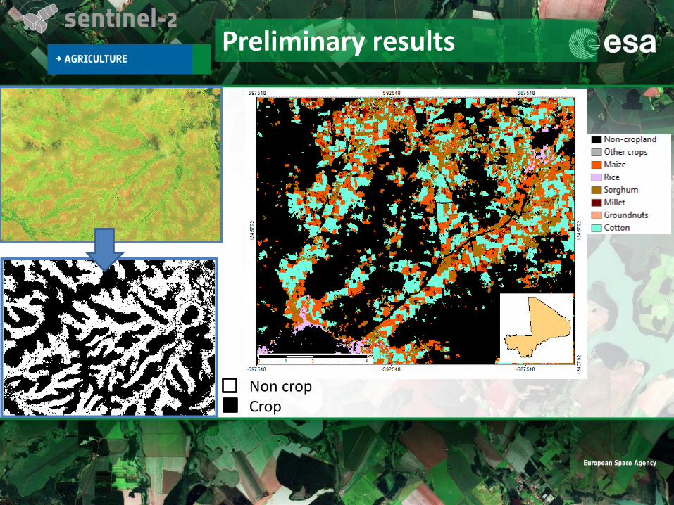
Preliminary results
Non cropCrop

3rd Sen2Agri User Workshop - Rome 28-29 June 2017
Aw ni ce…..
Thank you….