september 26, 2011 - federal aviation administration reports pdf/dr 104 waas reaction to... · waas...
TRANSCRIPT

Presented to: WAAS Team
By: Bill Wanner
Date: September 27, 2011
Federal Aviation Administration
DR #104 WAAS Reaction to Iono Activity September 26, 2011
WAAS Technical Report William J. Hughes Technical Center Pomona, New Jersey

2 Federal Aviation Administration
WAAS Reaction to Iono Activity on September 26, 2011 September 27, 2011
Background
• This presentation shows the WAAS operational system and WAAS shadow system (Release 3A) reaction to ionospheric activity on September 26, 2011
• The Planetary KP index reached 8 on this day
• WAAS coverage degradation throughout Alaska, Canada, and CONUS

3 Federal Aviation Administration
WAAS Reaction to Iono Activity on September 26, 2011 September 27, 2011
Findings
• Ionospheric activity on September 26, 2011 caused a negative impact on the WAAS operational system
• Based on data analyzed from the shadow system, WAAS Release 3A will reduce the effects of this storm – LP, LPV, and LPV 200 service would still have been negatively
impacted • But not the same extent as the current operational system
• RNP 0.1 coverage was not affected • Position accuracy for WAAS was a bit larger than
normal

4 Federal Aviation Administration
WAAS Reaction to Iono Activity on September 26, 2011 September 27, 2011
Timeline of Events (GMT)
15:51:30: Grid Points over Canada switch to storm state
16:46:15: WAAS stops providing LPV 200 service in Alaska
18:13:45: First airports in CONUS lose LPV 200 service (North central CONUS)
23:00:01: Storm continues 9/27/2011 01:01:29: Last grid point no longer in storm state
9/27/2011 00:52:15: All airports in CONUS support LPV-200

5 Federal Aviation Administration
WAAS Reaction to Iono Activity on September 26, 2011 September 27, 2011
KP Index for September 25 - 28 2011

6 Federal Aviation Administration
WAAS Reaction to Iono Activity on September 26, 2011 September 27, 2011
Area Covered vs. Time Plot for CONUS and Alaska September 26, 2011 • The next 2 slides show the area covered vs. time
plot for CONUS and Alaska – Includes LP, LPV, and LPV 200
• Operational system and shadow system are shown • Degradation in CONUS began after 18:00 GMT and
ended in the beginning of the next day (GMT time) – Note that the plots state the date as ‘Week 1655 Day 1’ – This
is the same day (in GPS nomenclature) as September 26, 2011
• Degradation in Alaska began about 16:45 GMT – Note how coverage degraded and came back several times
during the event

7 Federal Aviation Administration
WAAS Reaction to Iono Activity on September 26, 2011 September 27, 2011
Area Covered vs. Time Plot - CONUS
Operational WAAS Shadow System Release 3A

8 Federal Aviation Administration
WAAS Reaction to Iono Activity on September 26, 2011 September 27, 2011
Area Covered vs. Time Plot - Alaska
Operational WAAS Shadow System Release 3A

9 Federal Aviation Administration
WAAS Reaction to Iono Activity on September 26, 2011 September 27, 2011
LPV, LPV 200, and LP 24 Hour Coverage Plots
• The next three slides show the North American 24 hour plots for LPV, LPV 200, and LP – Plots for operational and shadow system

10 Federal Aviation Administration
WAAS Reaction to Iono Activity on September 26, 2011 September 27, 2011
LPV 24 Hour Coverage Plot
Operational WAAS Shadow System Release 3A

11 Federal Aviation Administration
WAAS Reaction to Iono Activity on September 26, 2011 September 27, 2011
LPV 200 24 Hour Coverage Plot
Operational WAAS Shadow System Release 3A

12 Federal Aviation Administration
WAAS Reaction to Iono Activity on September 26, 2011 September 27, 2011
LP 24 Hour Coverage Plot
Operational WAAS Shadow System Release 3A

13 Federal Aviation Administration
WAAS Reaction to Iono Activity on September 26, 2011 September 27, 2011
Snapshot Plots
• The following few slides show the airports in CONUS affected by ionospheric activity in the operational WAAS
– Plots also include IGP GIVEs at the time the snapshot is taken – Location of GPS satellites, identified by PRN number, also shown on the plot – Each small square is an airport that has at least a GPS published procedure
• On most days all the squares, or airports, are colored BLUE to show that LPV200 service is available from WAAS – Each larger square is an IGP
• The first plot is at the approximate beginning of the storm (15:54:37 GMT) – No ionospheric activity that affects WAAS coverage in CONUS or Alaska at this time
• WAAS Coverage in Canada is reduced at this time – The beginning of the storm is noted as the time that GIVEs for IGPs in Canada are higher than seen on
previous days • Airport Legend notes
– The legend refers to what service is supported at that airport based on the calculated VPL and HPL • This does not necessarily mean that there is a published approach for that service • For example, not all the airports in the next slide have published LPV 200 approaches
– ‘LPV 200’ = VPL is less than 35 m and HPL is less than 40 m – ‘LPV’ = VPL is between 35 m and 50 m and HPL is less than 40 m – ‘LP’ = VPL is greater than 50 m and HPL is less than 40 m – ‘LVNAV’ = VPL is less than 50 m and HPL is between 40 m and 556 m – RNP 0.1 = VPL is greater than 50 m and HPL is between 40 m and 185 m – ER/NPA = VPL is greater than 50 m and HPL is between 185 m and 556 m – ‘Not Monitored’ = VPL is greater than 50 m and HPL is greater than 556 m

14 Federal Aviation Administration
WAAS Reaction to Iono Activity on September 26, 2011 September 27, 2011
Airport
IGP
Airport Legend GIVE Legend

15 Federal Aviation Administration
WAAS Reaction to Iono Activity on September 26, 2011 September 27, 2011
Onset of Iono Activity in Alaska
• The next slide shows the effect from Ionospheric activity is first seen in Alaska at 16:46:15 GMT
• LPV and LPV 200 service is no longer available for much of Alaska
• Service in CONUS not affected…yet

16 Federal Aviation Administration
WAAS Reaction to Iono Activity on September 26, 2011 September 27, 2011
Airport Legend GIVE Legend

17 Federal Aviation Administration
WAAS Reaction to Iono Activity on September 26, 2011 September 27, 2011
CONUS Affected
• GIVEs continue to increase across the northern part of CONUS and in Canada
• As shown in the next slide, at 18:39:44 GMT a significant number of airports in northeast, north/central, and west coast CONUS has reduced WAAS service

18 Federal Aviation Administration
WAAS Reaction to Iono Activity on September 26, 2011 September 27, 2011
Airport Legend GIVE Legend

19 Federal Aviation Administration
WAAS Reaction to Iono Activity on September 26, 2011 September 27, 2011
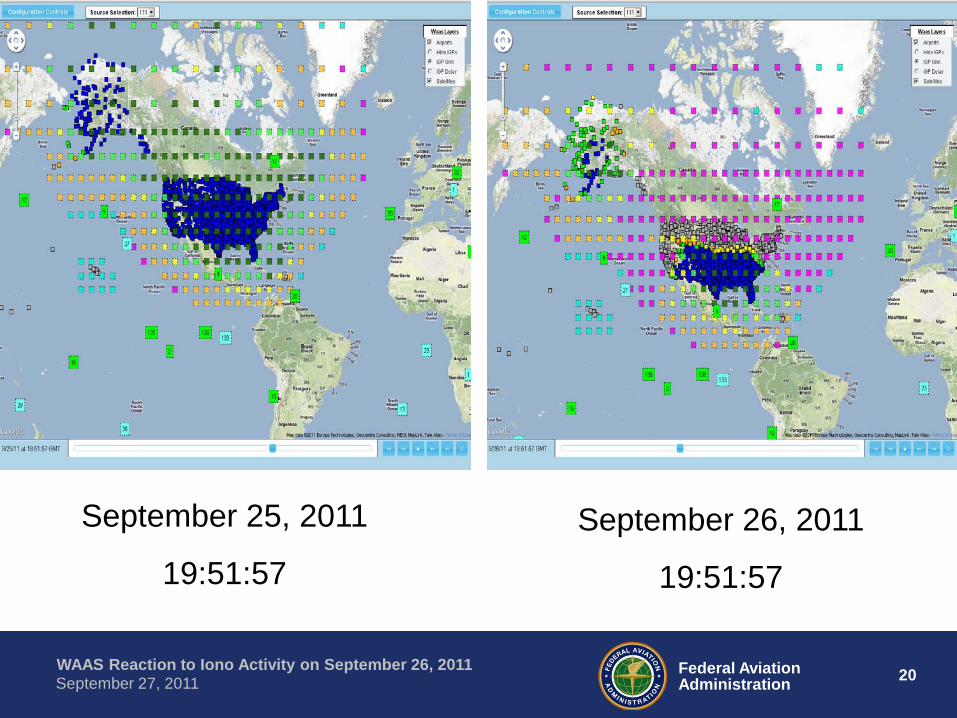
Iono Activity Continues
• At 19:51:57 most airports in Alaska and many in CONUS have reduced WAAS service – ‘Reduced’ means that on a normal day these airports would
support LPV200 service
• To better illustrate the difference between a ‘normal’ day and this storm day the next slide shows a ‘normal’ day on September 25 on the left and the storm day of September 26 on the right – The two slides show the same time…19:51:57 – Legend not shown on the next slide…see previous slides for
the legend
20 Federal Aviation Administration
WAAS Reaction to Iono Activity on September 26, 2011 September 27, 2011
September 25, 2011
19:51:57
September 26, 2011
19:51:57

21 Federal Aviation Administration
WAAS Reaction to Iono Activity on September 26, 2011 September 27, 2011
End of Event for WAAS
• As shown on the next slide, all was back to normal in CONUS on September 27 at 01:01:29 (GMT) – All airports in CONUS are colored ‘blue’ and no grid
points are unexpectedly set to storm state (45 meters GIVE)
• Total time for the event was about 9 hours – September 26 at 15:51:30 to September 27 at
01:01:29

22 Federal Aviation Administration
WAAS Reaction to Iono Activity on September 26, 2011 September 27, 2011
Airport Legend GIVE Legend
23 Federal Aviation Administration
WAAS Reaction to Iono Activity on September 26, 2011 September 27, 2011
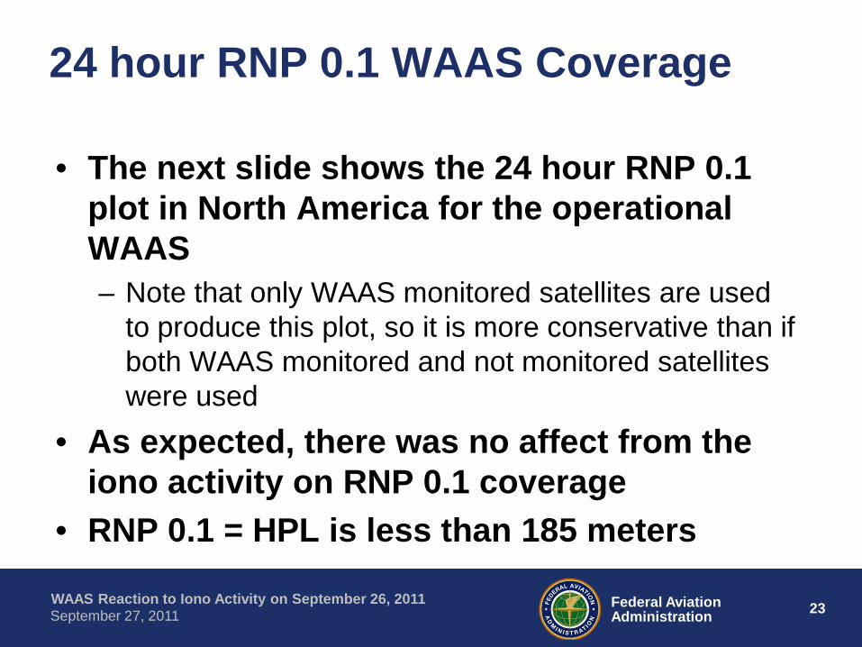
24 hour RNP 0.1 WAAS Coverage
• The next slide shows the 24 hour RNP 0.1 plot in North America for the operational WAAS – Note that only WAAS monitored satellites are used
to produce this plot, so it is more conservative than if both WAAS monitored and not monitored satellites were used
• As expected, there was no affect from the iono activity on RNP 0.1 coverage
• RNP 0.1 = HPL is less than 185 meters

24 Federal Aviation Administration
WAAS Reaction to Iono Activity on September 26, 2011 September 27, 2011
24 hour RNP 0.1 WAAS Coverage

25 Federal Aviation Administration
WAAS Reaction to Iono Activity on September 26, 2011 September 27, 2011
Accuracy
• There was an effect on position accuracy due to this ionospheric activity
• The highest horizontal position error using WAAS was at Chicago at 4.5 meters – The previous day the maximum error at Chicago was 1.3
meters • The highest vertical position error using WAAS was
at Chicago at 7.5 meters – The previous day the maximum error at Chicago was 2.2
meters • The highest GPS only horizontal position error was
at Gander at 11.5 meters

26 Federal Aviation Administration
WAAS Reaction to Iono Activity on September 26, 2011 September 27, 2011
Videos of the Event
• Matlab video can be viewed at: ftp://ftp.nstb.tc.faa.gov/pub/NSTB_data/VIDEOS/W1655D1/LPV_S
erviceArea_W1655D1.avi • Google Maps video can be downloaded at: ftp://155.178.136.52/WAAS/IonoStormWAASSept262011full.zip Note that this is a very large file (almost 700MB so it will take a
while to download) Also, the Google Maps video is updated about every three
minutes. Please let me know if a shorter update rate is desired. I tried to keep the video short enough (~4 minutes) and the file small enough so the download doesn’t take too long