serial gps user’s guide (mac) -...
TRANSCRIPT
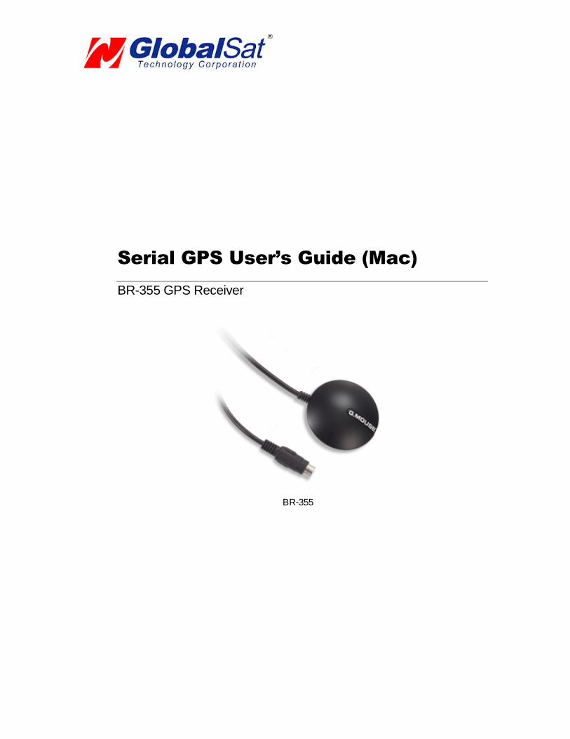
Serial GPS User’s Guide (Mac)
BR-355 GPS Receiver
BR-355

DOCUMENT REVISIONSREV NO. DATE DESCRIPTION APPROVED
1.0 02-28-2003 Initial document BRF1.2 06-08-2005 New document format NRG2.0 04-07-2006 Revision of embedded web inks AAK
© 2006 Globalsat Technology Corporation/USGlobalsat, Inc. All rights reserved. The Globalsat logo is a trademarkof Globalsat Corporation. Windows is a register trademark of Microsoft Corporation. Acrobat is a registeredtrademark of Adobe Systems Incorporated. Mac is a registered trademark of the Apple Corporation. All othertrademarks or registered trademarks are acknowledged as the exclusive property of their respective owners.
All rights reserved. No part of this manual may be reproduced, transmitted, copied, or stored in any storagemedium, for any purpose, without prior written consent from Globalsat Technology Corporation or USGlobalsat, Inc.Globalsat/USGlobalsat hereby grants the right to download one (1) copy of this manual onto a hard drive forpersonal use. This manual is copyrighted and may contain proprietary information that is subject to change withoutnotice.

PAGE 2 OF 14
USB_GPS_MAC_ v2.0
USB GPS (Mac)
Table of Contents
PACKAGE CONTENTS ..................................................................................................3
SYSTEM REQUIREMENTS............................................................................................3
WELCOME ......................................................................................................................3
1. GETTING STARTED..................................................................................................4
2. INSTALLING THE USB DRIVER TO YOUR LAPTOP..............................................4
3. VALIDATE USB DRIVER INSTALLATION ................................................................7
4. UN-INSTALL THE USB DRIVER ................................................................................7
5. INITIALIZING YOUR GPS RECEIVER......................................................................8
6. USING YOUR GPS RECEIVER.................................................................................8
7. FAQ’s ..........................................................................................................................8
8. CONTACT INFORMATION......................................................................................10
9. SAFETY AND LEGAL NOTICES.............................................................................10
10. LIMITED WARRANTY............................................................................................12
11. BU-303 SPECIFICATIONS ....................................................................................13
12. BU-353 SPECIFICATIONS ....................................................................................14

PAGE 3 OF 14
USB_GPS_MAC_ v2.0
USB GPS (Mac)
PACKAGE CONTENTS
- USB GPS Receiver- Driver CD-ROM with User’s Guide and test utility for WIN and Mac O/S*
Mac Users please refer to the Mac directory on the included CD-ROM for installation instructionsand drivers x:\Mac (The letter “x” represents your CD-ROM drive).
NOTE: Your can also download Mac driver and Installation Guides at: www.usglobalsat.com/mac
SYSTEM REQUIREMENTS
The Globalsat USB GPS receivers requires a Windows, or Macintosh laptop computer, with a CD-ROM*, USB port, and NMEA compatible navigation software. The 3
rdparty mapping/navigation
software may have its own system requirements, please check with software vendor for details.
*CD-ROM is required for USB driver installation and access to the User’s Guide. If no CD-ROM drive is available,files can be downloaded from the Internet at : www.usglobalsat.com/mac
WELCOME
Thank you for purchasing a Globalsat USB GPS receiver! Globalsat USB GPS receivers allow for real-time street
navigation by using your laptop for graphical plotting and positioning of your route. Simply load the GPS driver, plug
the GPS receiver into your computer’s USB port and install your own personal mapping software to begin to view
your position in real-time in relation to the surrounding streets in your travel area.
You’ll find that almost any NMEA compliant mapping/charting software will be compatible with your USB GPS
receiver. Visit our web-site for recommended mapping programs that you can use.
http://www.usglobalsat.com/faq_details/Mapchart.asp .

PAGE 4 OF 14
USB_GPS_MAC_ v2.0
USB GPS (Mac)
1. GETTING STARTED
These are only a few simple steps that you need to follow before using your USB GPS receiver:
Install the USB driver and onto your laptop from the included CD-ROM or download the files from our web-sitewww.usglobalsat.com/mac
Plug-in the GPS receiver into your laptop.
NOTE: From within your mapping, or navigation software (including the supplied GPS Information utility), you will
need to manually configure the selection of the COM port to what was assigned to the GPS receiver so that proper
communication between the GPS receiver and mapping program can occur. Most all software requires that you
manually configure the COM port setting for any GPS device you use.
IMPORTANT:1. You must change the default rate setting of your mapping software to 4800 if this is not currently set as such
otherwise GPS data cannot be received.2. Port: /dev/cu.usbserial3. Set Baud Rate: 4800
2. INSTALLING THE USB DRIVER INTO YOUR LAPTOP
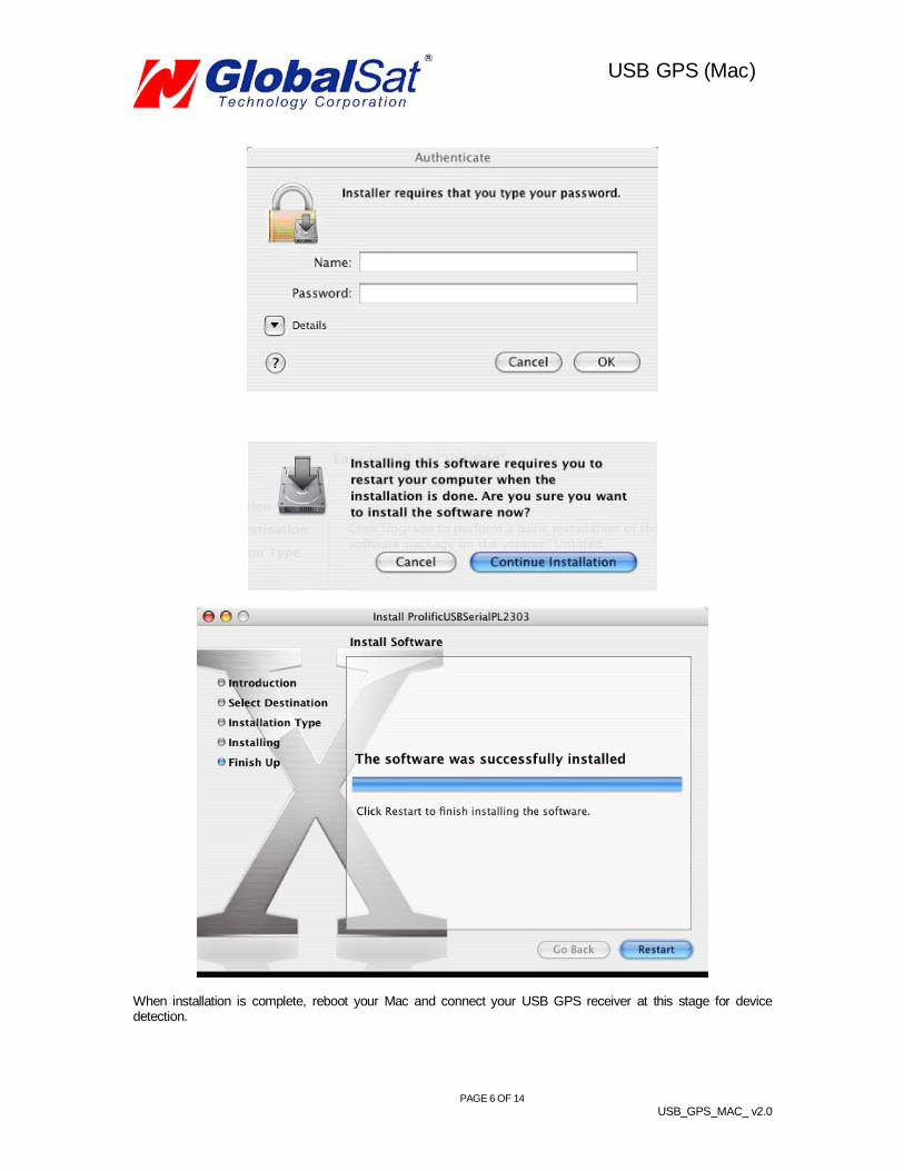
STEP 1.Expand the archive file and then run the installation by double clicking on the PL2303_1.0.966.pkg icon.
STEP 2.Next, a series of installation steps and screens will be provided for completing the driver installation process.

PAGE 5 OF 14
USB_GPS_MAC_ v2.0
USB GPS (Mac)
PAGE 6 OF 14
USB_GPS_MAC_ v2.0
USB GPS (Mac)
When installation is complete, reboot your Mac and connect your USB GPS receiver at this stage for devicedetection.

PAGE 7 OF 14
USB_GPS_MAC_ v2.0
USB GPS (Mac)
NOTE: After completing driver installation under Mac OS 10.2.X, a warning may appear stating that “ProlificUSBSerial.kext” has encountered problems. This is due to driver being compiled under OS 10.1.X. Three optionswill be provided for you to select one; however selecting the “Fix and Use” option will eliminate this conflict.
3. VALIDATE USB DRIVER INSTALLATION
To verify that your device is recognized by the Operating System you can open the System Profiler.
To access System Profiler perform the following.First, place mouse pointer and select the blue apple icon on the top left hand side of the Apple menu. Then, selectthe following “About This Mac”->”More Info…”-> Hardware->USB to display device’s detection.
Under USB Device Tree, you will view “USB Device” this pertains to your GPS USB receiver. Driver information canbe found under USB Device window.
4. UN-INSTALL THE USB DRIVER
To uninstall the Prolific USB driver, follow these steps:
1. Open "Applications-> Utilities-> Terminal". You need to create ID & password first on NetInfo Manager.2. Login to root user and type "su" and enter password.3. Type "cd /System/Library/Extensions" to go to the "Extensions" folder.4. Unload the driver (if it had been loaded) by typing "kextunload PL2303.kext" or "kextunload
ProlificUsbSerial.kext"5. Remove the driver by typing "rm -r PL2303.kext" or "rm -r ProlificUsbSerial.kext".
See FAQ below for more on “root users”

PAGE 8 OF 14
USB_GPS_MAC_ v2.0
USB GPS (Mac)
5. INITIALIZING YOUR GPS RECEIVER
Before using your USB GPS receiver for navigation (especially for the first time), the receiver mustobtain a local GPS fix (coordinates) of the current position. To do this, take your laptop (with your USBdriver and the mapping software loaded and configured) to an open area that has a clear view to thesky (such as a park or empty field). Start your software (or the included Mac_GPSutility program) andwait for initialization of the GPS to complete. This may take a few minutes depending on variousfactors such as the distance of the current coordinates from the last time the GPS receiver wasactivated, GPS signal strength and surrounding terrain (tall trees and buildings can block the satellitesignals). Once the RAW GPS data is displayed onto the screen, if applicable for your software, a fixhas been initialized (red LED on the GPS will also start to flash). In some cases initialization can takeup to several minutes depending on the conditions mentioned above before complete GPS data will bedisplayed on the screen.
Coordinates scrolling with zero’s means that the port connection is cormplete but the satellite data isnot being received yet (possibly still initializing or in a bad area for satellite reception).
6. USING YOUR GPS RECEIVER
Once the USB GPS receiver’s driver and your personal mapping software have been installed andconfigured properly, you can begin to use your navigation system by plugging the USB GPS into yourlaptop’s USB port and launching your mapping software. If you don’t have a mapping, or navigationsoftware, we’ve included a GPS test utility called “GPS Utility” so that you can test the function of yourUSB GPS receiver. This utility is located within the Mac directory on the CD-ROM or can be downloadfrom our web-site www.usglobalsat.com/mac.
GPS LED Status indicator:LED OFF: GPS receiver is off (no power).LED ON (solid): No fix, searching for GPS signals.LED FLASHING: Position fix established and GPS signals are being received.
Always select an area in the vehicle where the GPS unit will be secure and not obstruct normal driving,visibility and safety, but still maintaining a “view to the sky” in order to receive satellite data.
7. FAQ’s
How Do I Enable a Root Account?The "root" user (also known as the super user) is the most powerful UNIX account. The root accountcan do anything to any file or folder, anywhere on the system. For that reason, Globalsat/USGlobalsatcannot recommend, nor support users who attempt modifications of the ‘root user” as it's consideredquite dangerous, and only needs to be used (occasionally) by advanced users.
Because of the dangers of operating as root, Apple has chosen to hide the root account in OS X Final.However, there are a number of ways to enable it. The easiest is to boot off the install CD, and lookunder the Install menu for the "Password Reset" option. You can use this to change your ownpassword if you forget it, and to enable the root account. This utility will not run if you copy it to yourhard drive! It only works when booting from the CD.

PAGE 9 OF 14
USB_GPS_MAC_ v2.0
USB GPS (Mac)
Read the rest if you'd like to know how to do this from within OS X, and skip the CD-based reboot.
The second easiest way to enable root is to start a terminal session, and type: sudo passwd rootYou will be prompted for a new password to enable root access. Many find this easier than rebooting,but since it involves the command line, newcomers may find it a bit more intimidating.
The hardest way to enable root is to use the NetInfo Manager application (in Applications/Utilities).Here's what you do, courtesy of "anonymous":1) Open NetInfo Manager2) Select "Users" from the second list.3) Select a user you created and know the password for!4) Double-click on the value across from "passwd" and copy it. It is the encoded form of the password for that user.5) Select "root" from the list of users. Find the "passwd" value (default is "*") and paste over it.6) Exit NetInfo Manager.7) Open the Terminal and type "su root".8) Enter the password for the user chosen above.
Will the USB GPS work with other Street Mapping software?Globalsat USB GPS receivers provides standard NMEA data for mapping software to use and convertto coordinates and should work well with most any NMEA compliant software on the market today.
How accurate is the GPS?The USB GPS is WAAS/EGNOS capable, and for units sold in North America through authorizedresellers, these units are WAAS/EGNOS enabled unless otherwise stated. Accuracy can be up to 5meters 3D RMS with WAAS enabled and 10-15 meters 2D RMS WAAS disabled
What is ideal GPS environment?The GPS requires an open, clear view of the sky. Buildings, covered parking areas, tunnels and densefoliage can cause the GPS receiver to be unable to get a location fix.
If you are parked in a covered parking lot or near a tall building, it is recommended that you drive awayuntil you have a clear view of the sky before using the BU-303. You may need to give the GPS a fewminutes to find or get a fix its location.
How do I know if the GPS is ON?Your USB GPS must be plugged into your laptop’s USB port to get power. If your PC is on and theCOM port was configured properly, the GPS receiver is on and receiving the streaming GPS data. Thiscan be verified by opening your mapping software program. In addition, the Globalsat USB GPS has abuilt-in LED status indicator that shows the following:
LED OFF: GPS receiver is off (no power).LED ON (solid): No fix, searching for GPS signals.LED FLASHING: Position fix established and GPS signals are being received.
Why does the GPS not work near buildings and other tall objects?The GPS uses satellites in the space to find out where it is. Therefore it needs a clear view of the sky.Tall buildings and other objects that block the receiver’s view to the sky make it infeasible to determineyour location. Sometimes the satellites are not overhead but near the horizon. In these cases the GPSmust have a clear view of the horizon.
What driver is needed for Virtual PC?For Macintosh Virtual PC applications, you do not need any additional drivers than those already beingused for your Mac OS X applications. It is, however recommended that 1-Gigabyte of memory isavailable to run Virtual PC applications efficiently.
PAGE 10 OF 14
USB_GPS_MAC_ v2.0
USB GPS (Mac)
Other Comments-Please allow an adequate amount of time for the GPS receiver’s boot-up process to complete beforecontacting Technical Support.
Driver updates can be found at Prolific ’s web-site:http://www.prolific.com.tw/eng/downloads.asp?ID=31 (www.prolific.com.tw)
8. CONTACT INFORMATION
Globalsat Technology Corporation (Taiwan)[email protected] (pre-sales GPS product questions only)
USGlobalsat, [email protected] (pre-sales GPS product questions only)
Technical Support (North America)See our DOWNLOADS and FAQ section on our web-site for GPS solutions, driver literature updates.http://www.usglobalsat.com/custom.asp?recid=7
Pre-registration is required before receiving any type of technical support. Support issues submitted viaphone, fax or e-mail (any means outside of the recognized “Trouble Ticket” generated from your ownUSGlobalsat registered account) WILL NOT be answered.Create your account and register your products at: www.usglobalsat.com/support/custadminlogin.asp
9. SAFETY AND LEGAL NOTICES
Please read this section carefully before using the GPS receiver
Globalsat Technology Corporation / USGlobalsat, Inc. will not accept any responsibilitywhatsoever for accidents resulting from failure to observe common sense precautions. Yourpersonal judgment, traffic regulations, and common sense must always take precedence overany directions produced by GPS receiver or the mapping software
WARNING: Make sure that the GPS receiver is secure and does not interfere with drivingvisibility and safety.
It is your responsibility as the vehicle operator to securely place the GPS unit and antenna so that theywill not interfere with driving and prevent operations of any safety device (such as the Airbag) in yourvehicle. Do not mount the devices in a place where the driver or passengers may receive injury duringvehicle operation or collision. For your safety, take care to route all cables away from shifters, pedals,accessory controls and mechanisms.
WARNING: Drive safely and use common sense.
It is your responsibility as the vehicle operator to drive safely, observe all traffic rules and above all useyour own personal judgment while driving. If you feel that a route suggested by the navigation softwareinstructs you to perform an unsafe or illegal maneuver, places you in an unsafe situation, or routes youinto an area which you consider unsafe, do not follow the instructions.

PAGE 11 OF 14
USB_GPS_MAC_ v2.0
USB GPS (Mac)
WARNING: Keep your eyes on the road.
It is your responsibility as the vehicle operator to keep your eyes on the road and be an alert driver at alltimes, especially when the vehicle is moving. The vehicle’s operator should not be distracted by thenavigation equipment or software. Should there be a distraction with the ability to drive responsibly,please turn off the device. Should you want to look at the display for a prolonged time, park the carsafely, while following all traffic regulations before looking at the display.
WARNING: To reduce the risk of fire or shock hazard, do not expose this product to rain ormoisture. Do not remove covers or open housings, there are no user serviceable parts inside.Refer servicing to qualified personnel only.

PAGE 12 OF 14
USB_GPS_MAC_ v2.0
USB GPS (Mac)
10. LIMITED WARRANTY
Globalsat/USGlobalsat warrants product hardware against manufacturing defects in material and workmanshipunder normal use for a period of one (1) year from the original date of purchase (unless the product statesotherwise), and only when purchased from a recognized “authorized dealer”. Products purchased from anyunauthorized source, such as unauthorized e-Bay resellers, will not qualify for free warranty service/support andmay require the end-user to pre-pay fees associated with, but not limited to the support, repair, replacement andshipping of the product to and from the service center.Except as provided herein, Globalsat/USGlobalsat makes no express warranties’, including but not limited to anywarranties of merchantability or fitness for particular use, or non-infringement. You acknowledge that your use ofthe product or service is at your sole risk and you agree that the information provided are without warranty of anykind by Globalsat/USGlobalsat.Under no circumstances, including negligence, will Globalsat/USGlobalsat or any of its affiliates, directors, officersor employees, or any third party be liable for any direct, indirect, incidental, special or consequential damages thatresults from your use, or your inability to use, or the performance of the product(s) with respect to any liability, loss,or arising out of any breach of this warranty, including, but not limited to any damages resulting from inconvenience,loss of time, data, property, revenue, or profit or any indirect, special incidental or consequential damages. Youacknowledge that this limitation applies to all content information or other services available fromGlobalsat/USGlobalsat, and whether or not Globalsat/USGlobalsat has notice of the possibility of such damages,and whether or not to circumstances giving rise to such damages may have been within the control ofGlobalsat/USGlobalsat.Some states do not allow the exclusion of certain warranties, so some of the above exclusions may not apply toyou. In those states, liability is limited to the fullest extent allowed by law By using the product(s), you agree toindemnify Globalsat/USGlobalsat and its parents, subsidiaries, affiliates, officers and employees and hold themharmless from any and all claims and expenses, including reasonable attorney’s fees, asserted third party due to, orarising out of your use of the service and the site.
In the event of a product defect during the first 30-days of the warranty period, return product and the sales receiptas proof of purchase date to place of original purchase. Defect discovered after 30-days from date of purchase, youmust contact Globalsat/USGlobalsat’s Technical support for a Return Merchandise Authorization (RMA) number forreturn to manufacturer.
Globalsat/USGlobalsat will, at its option, unless otherwise provided by law:a.) Correct the defect by product repair without charge for parts and labor;b.) Replace the product with one of the same or similar design; or
Refund the purchase price. All replaced parts and products, and products on which a refund is made, become theproperty of Globalsat/USGlobalsat. New or reconditioned parts may be used in the performance of warrantyservice. Repaired or replaced parts and products are warranted for the remainder of the original warranty period.You will be charged for repair or replacement of the product made after the expiration of the warranty period.This warranty does not cover:
a.) Damage or failure caused by or attributable to acts of God, abuse, accident, misuse, improper orabnormal usage, failure to follow the instructions, improper installation or maintenance, alteration, lightingor other incidence of excess voltage or current;
b.) Any repairs other than those provided by Globalsat/USGlobalsat;c.) Consumables such as fuses or batteries;d.) Cosmetic damage;e.) Transportation, shipping or insurance costs;f.) Costs of product removal, installation, set-up service adjustment or reinstallation.
This warranty gives you specific legal rights, and you may also have other rights, which may vary from state tostate.
Additional products bundled in this package not manufactured by Globalsat/USGlobalsat will hold separatewarranties as expressed by the individual manufacturer of that product(s). Product specifications, functions andfeatures are subject to change without notice.
PAGE 13 OF 14
USB_GPS_MAC_ v2.0
USB GPS (Mac)
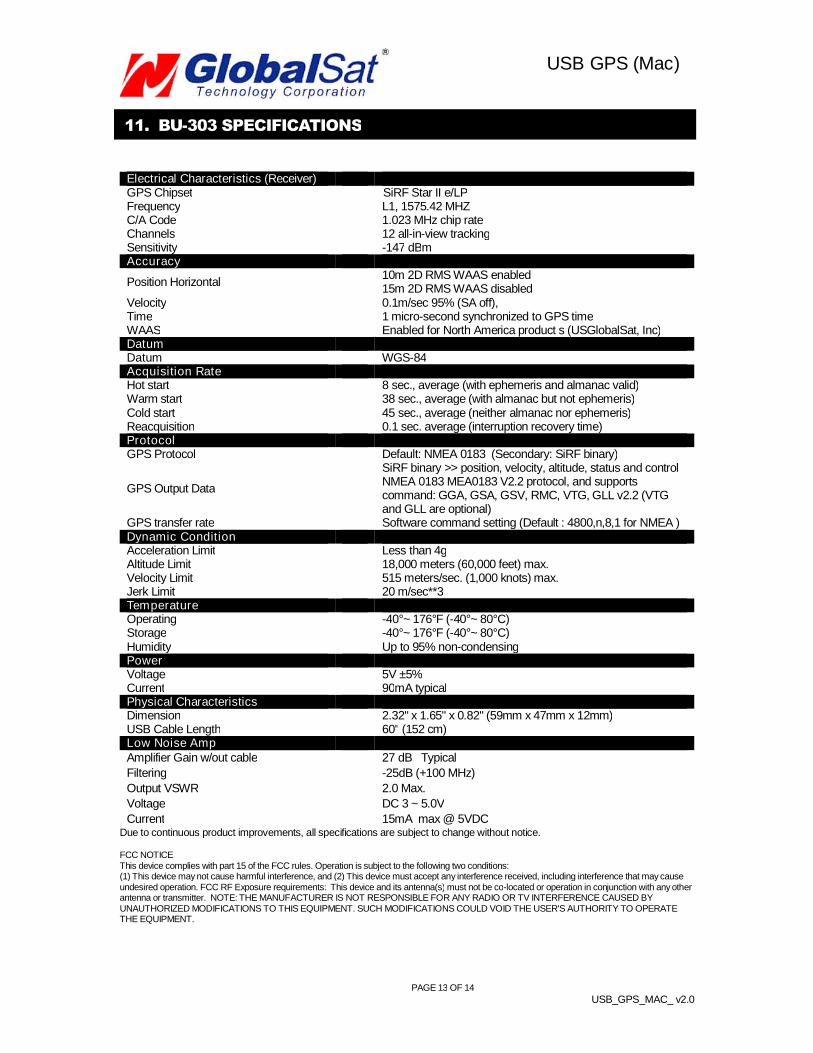
11. BU-303 SPECIFICATIONS
Electrical Characteristics (Receiver)GPS Chipset SiRF Star II e/LPFrequency L1, 1575.42 MHZC/A Code 1.023 MHz chip rateChannels 12 all-in-view trackingSensitivity -147 dBmAccuracy
Position Horizontal10m 2D RMS WAAS enabled15m 2D RMS WAAS disabled
Velocity 0.1m/sec 95% (SA off),Time 1 micro-second synchronized to GPS timeWAAS Enabled for North America product s (USGlobalSat, Inc)DatumDatum WGS-84Acquisition RateHot start 8 sec., average (with ephemeris and almanac valid)Warm start 38 sec., average (with almanac but not ephemeris)Cold start 45 sec., average (neither almanac nor ephemeris)Reacquisition 0.1 sec. average (interruption recovery time)ProtocolGPS Protocol Default: NMEA 0183 (Secondary: SiRF binary)
GPS Output Data
SiRF binary >> position, velocity, altitude, status and controlNMEA 0183 MEA0183 V2.2 protocol, and supportscommand: GGA, GSA, GSV, RMC, VTG, GLL v2.2 (VTGand GLL are optional)
GPS transfer rate Software command setting (Default : 4800,n,8,1 for NMEA )Dynamic ConditionAcceleration Limit Less than 4gAltitude Limit 18,000 meters (60,000 feet) max.Velocity Limit 515 meters/sec. (1,000 knots) max.Jerk Limit 20 m/sec**3TemperatureOperating -40°~ 176°F (-40°~ 80°C)Storage -40°~ 176°F (-40°~ 80°C)Humidity Up to 95% non-condensingPowerVoltage 5V ±5%Current 90mA typicalPhysical CharacteristicsDimension 2.32" x 1.65" x 0.82" (59mm x 47mm x 12mm)USB Cable Length 60" (152 cm)Low Noise AmpAmplifier Gain w/out cable 27 dB Typical
Filtering -25dB (+100 MHz)
Output VSWR 2.0 Max.
Voltage DC 3 ~ 5.0V
Current 15mA max @ 5VDCDue to continuous product improvements, all specifications are subject to change without notice.
FCC NOTICEThis device complies with part 15 of the FCC rules. Operation is subject to the following two conditions:(1) This device may not cause harmful interference, and (2) This device must accept any interference received, including interference that may causeundesired operation. FCC RF Exposure requirements: This device and its antenna(s) must not be co-located or operation in conjunction with any otherantenna or transmitter. NOTE: THE MANUFACTURER IS NOT RESPONSIBLE FOR ANY RADIO OR TV INTERFERENCE CAUSED BYUNAUTHORIZED MODIFICATIONS TO THIS EQUIPMENT. SUCH MODIFICATIONS COULD VOID THE USER'S AUTHORITY TO OPERATETHE EQUIPMENT.

PAGE 14 OF 14
USB_GPS_MAC_ v2.0
USB GPS (Mac)
12. BU-353 SPECIFICATIONS
Electrical Characteristics (Receiver)GPS Chipset SiRF Star III e/LPFrequency L1, 1575.42 MHZC/A Code 1.023 MHz chip rateChannels 20 all-in-view trackingSensitivity -159 dBmAccuracy
Position Horizontal5m 2D RMS WAAS enabled10m 2D RMS WAAS disabled
Velocity 0.1m/sec 95% (SA off),Time 1 micro-second synchronized to GPS timeWAAS/EGNOS Enabled for North America product s (USGlobalSat, Inc)DatumDatum WGS-84Acquisition RateHot start 1 sec., average (with ephemeris and almanac valid)Warm start 38 sec., average (with almanac but not ephemeris)Cold start 42 sec., average (neither almanac nor ephemeris)Reacquisition 0.1 sec. average (interruption recovery time)ProtocolGPS Protocol Default: NMEA 0183 (Secondary: SiRF binary)
GPS Output Data
SiRF binary >> position, velocity, altitude, status and controlNMEA 0183 MEA0183 V2.2 protocol, and supportscommand: GGA, GSA, GSV, RMC, VTG, GLL v2.2 (VTGand GLL are optional)
GPS transfer rate Software command setting (Default : 4800,n,8,1 for NMEA )Dynamic ConditionAcceleration Limit Less than 4gAltitude Limit 18,000 meters (60,000 feet) max.Velocity Limit 515 meters/sec. (1,000 knots) max.Jerk Limit 20 m/sec**3TemperatureOperating -40°~ 185°F (-40°~ 85°C)Storage -40°~ 185°F (-40°~ 85°C)Humidity Up to 95% non-condensingPowerVoltage 4.5 ~ 5.5V DC InputCurrent 80mA typicalPhysical CharacteristicsDimension 2.08" diameter x 0.75" (53mm diameter x 19.2mm)USB Cable Length 60" (152 cm)Low Noise AmpAmplifier Gain w/out cable 27 dB Typical
Filtering -25dB (+100 MHz)
Output VSWR 2.0 Max.
Voltage DC 3 ~ 5.0V
Current 15mA max @ 5VDC
Due to continuous product improvements, all specifications are subject to change without notice.
FCC NOTICE
This device complies with part 15 of the FCC rules. Operation is subject to the following two conditions:
(1) This device may not cause harmful interference, and (2) This device must accept any interference received, including interference that may cause
undesired operation. FCC RF Exposure requirements: This device and its antenna(s) must not be co-located or operation in conjunction with any other
antenna or transmitter. NOTE: THE MANUFACTURER IS NOT RESPONSIBLE FOR ANY RADIO OR TV INTERFERENCE CAUSED BY
UNAUTHORIZED MODIFICATIONS TO THIS EQUIPMENT. SUCH MODIFICATIONS COULD VOID THE USER'S AUTHORITY TO OPERATE
THE EQUIPMENT.