seychelles damage, loss, and needs assessment (dala) 2013
TRANSCRIPT

NIGERIA Post-Disaster Needs Assessment 2012 Floods A
Seychelles Damage, Loss, and Needs Assessment (DaLA)2013 FloodsA report by the Government of Seychelles
June 2013
With support from the European Union, the United Nations, and the World Bank

With financial support from:
Photos: Courtesy of the Government of Seychelles; Isabelle Forge.
Design/Layout: [email protected]
Disclaimer: (DaLA) report. The boundaries, colors, denominations and any other information shown on this map do not imply, on the part of the World Bank Group, any judgment on the legal status of any territory, or any endorsement of acceptance of such boundaries.
© 2013

i
Seychelles Damage, Loss, and Needs Assessment (DaLA)2013 FloodsA report by the Government of Seychelles
June 2013
With support from the European Union, the United Nations, and the World Bank

On January 27–28, 2013, heavy rains resulting from tropical cyclone Felleng caused severe flooding and landslides in the Seychelles, particularly in three districts on the southeast
coast of Mahé (Au Cap, Pointe Larue, and Cascade), as well as on the nearby islands of Praslin and La Digue.
Panoramic view of Seychelles. Photo: Thinkstock.com

iii
ForEWorD
Tropical Storm “Felleng”’s proximity to Seychelles on the week of the 27th Janu-ary brought with it heavy rain causing severe flooding in five districts: Anse Aux Pins, Au Cap and Pointe Larue which were declared “disaster zones” and Cas-
cade and La Digue island which were also significantly affected. Hundreds of house-holds were affected, dozens of families were displaced, infrastructure was damaged beyond repair and many farms were destroyed.
We are grateful that no one was killed or seriously injured from the disaster, but this event was a wakeup call for the entire nation and perhaps a reminder similar to that of the 2004 Indian ocean tsunami that claimed the lives of three people - a reminder that Seychelles is not safe from disasters.
This “Seychelles 2013 Post-Flood Damage, Loss and Needs Assessment” report is proof of Seychelles’ government’s resolve and commitment to ensure the safety and well-being of our people as well as the conservation of endemic flora, fauna and the country’s other limited natural resources. The Seychelles government recognizes the necessity to continuously improve disaster risk reduction and management within our country. We are responsible for safeguarding every individual citizen and visitor to our island nation.
This report provides a detailed breakdown of the sectors affected, economic losses and damages, and the equipment and manpower needs to rebuild better and to cre-ate legislation that incorporates disaster risk reduction and management throughout so that we continue to develop into a country that is more resilient to disasters – a disaster-resistant nation safe for all.
Pierre Laporte Professor Rolph PayetMinister of Finance Minister of Environment and Energy

Seychelles Damage, Loss and Needs Assessment (DaLA) 2013 Floodsiv
ACkNoWLEDGMENTS
This report reflects the relief and recovery efforts of the Government of Seychelles to lift the nation out of the economic setbacks, infrastructure destruction and social impact caused by tropical storm “Felleng” which impacted Mahé island the week of January 27, 2013.
The Government of Seychelles extends its most profound gratitude to the World Bank for having rapidly sent a team of experts to conduct a “Damage, Loss and Needs Assessment” at the request of H.E Vice President Mr. Danny Faure, in the immediate aftermath of the devastating floods.
The report is a joint collaboration of Government of Seychelles and the World Bank. This report has been produced under the guidance of Honorable Pierre Laporte, Minister of Finance, Trade and Investment, Honorable Professor rolph Payet, Minister of Environment and Energy, Louis rene Peter Larose, World Bank Alternate Executive Direc-tor, Haleh Bridi, World Bank Country Director for Madagascar, Mauritius, Comoros and Seychelles, Jamal Saghir, Director for Sustainable Development for the Africa region at the World Bank, and Benoit Bosquet, Sector Man-ager for Africa Natural resources at the World Bank.
The report has been produced by a team led Bertrand Belle (Principle Secretary, Ministry of Finance), Wills Agricole (Principle Secretary, Ministry of Environment and Energy) and a team consisting of , Elizabeth Charles (Director General, Ministry of Finance), Paul Labaleine (Director General, DrDM Seychelles), Divina Sabino (Project officer, DrDM Seychelles), supported by a World Bank team led by Jingjie Chu (Natural resource Economist), Doekle Geert Wielinga (Sr. Disaster risk Management Specialist), Isabelle Forge (Consultant), Ellen Tynan (Consultant), Isabelle kane (Disaster risk Management Specialist), Carl Christian Dingel (Disaster risk Management Specialist), and Sawkut rojid (Economist).
The authors are grateful to Cliff Alissop, regina Prosper and Veronique Baker from DrDM for their logistic sup-port, Henriette B. Mampuya and Sajid Anwar from GFDrr for their invaluable comments on an earlier draft of this report and Chalida Chararnsuk from the World Bank for providing excellent administrative support in the process of the assessment and report write up.
Last but certainly not least is to acknowledge with much appreciation the crucial role of all individuals from the Ministries, and development organizations such as the United Nations Development Program (UNDP), World Health organization (WHo), the European Union (EU), and Seychelles red Cross that have contributed their syn-ergistic participation during the preparation of this report.
The African, Caribbean and Pacific (ACP) Group of States and the European Union (EU) have provided financial support for the Damage and Loss Assessment through the Global Facility for Disaster reduction and recovery (GFDrr), in the framework of the ACP-EU Natural Disaster risk reduction Program.

v
TABLE oF CoNTENTS
FoREwoRD ...................................................................................................................................................... iii
AckNowLEDGmENtS ................................................................................................................................... iv
AbbREvIAtIoNS.............................................................................................................................................. viii
ExEcutIvE SummARy .................................................................................................................................. xi
chAPtER 1: couNtRy ovERvIEw ............................................................................................................. 1
1.1 Seychelles’ Vulnerability to Natural Hazards and Climate Change ........................................................... 1
1.2 overview of the Disaster ........................................................................................................................ 2
1.3 The Immediate response ....................................................................................................................... 2
chAPtER 2: EcoNomIc AND SEctoR ImPActS AND NEEDS .............................................................. 5
2.1 Assessment Preparation ......................................................................................................................... 5
2.1.1 Training ....................................................................................................................................... 5
2.1.2 Assessment Methodology ............................................................................................................ 6
2.2 Assessment by Sectors ........................................................................................................................... 7
2.2.1 Infrastructure ............................................................................................................................... 7
2.2.2 Productive Sectors ....................................................................................................................... 18
2.2.3 Social Sectors .............................................................................................................................. 21
2.2.4 Cross-Cutting Sectors .................................................................................................................. 28
2.3 Macroeconomic Impact .......................................................................................................................... 36
2.3.1 Macroeconomic Impact ............................................................................................................... 36
2.3.2 Personal/Household Impact.......................................................................................................... 37
chAPtER 3: coNcLuSIoN AND REcommENDAtIoNS .......................................................................... 39
3.1 Damage and Loss Summary ................................................................................................................... 39
3.2 recovery and reconstruction Summary .................................................................................................. 39
3.3 Seychelles Disaster resilience Framework ............................................................................................... 41
Appendix 1. Satellite Image of Standing Water after the Flood ...................................................................... 46
Appendix 2. DaLA Training Attendee List ...................................................................................................... 47
Appendix 3. Seychelles’ Vulnerability to Climate Change .............................................................................. 48
Appendix 4. Damages and Losses for Police Services ..................................................................................... 51

Seychelles Damage, Loss and Needs Assessment (DaLA) 2013 Floodsvi
Appendix 5. Detailed Calculation of Needs for the Education Sector ............................................................. 52
Appendix 6. DrDM Personnel Status ............................................................................................................ 53
Appendix 7. Detailed Expenses for DrDM ..................................................................................................... 54
Appendix 8. Development Policy Loan with a Catastrophe Deferred Drawdown option (CAT DDo) .............. 55
LISt oF tAbLES
Table 2.1 Estimated Damage and Losses for the Transport/road Sector .................................................... 8
Table 2.2 Estimated recovery and reconstruction Needs for the Transport/road Sector ............................ 9
Table 2.3 Estimated Damages and Losses for the Water and Sewerage Sector .......................................... 11
Table 2.4 Estimated recovery and reconstruction Needs for the Water and Sanitation Sector ................... 13
Table 2.5 Estimated Damages and Losses for the Electricity Sector ............................................................ 14
Table 2.6 Estimated reconstruction Needs for the Electricity Sector .......................................................... 14
Table 2.7 Estimated Damages and Losses for the SFrSA ........................................................................... 15
Table 2.8 Estimated recovery and reconstruction Needs for the SFrSA .................................................... 15
Table 2.9 Estimated Damages and Losses for the Police Department ........................................................ 15
Table 2.10 Estimated recovery and reconstruction Needs for the Police Department ................................. 16
Table 2.11 Estimated Damage and Losses within SPDF ............................................................................... 16
Table 2.12 Estimated Damage and Losses within the SCAA ........................................................................ 16
Table 2.13 Estimated Cost of recovery and reconstruction Needs within the SCAA (Aviation Sector) ......... 17
Table 2.14 Summary of Damage and Losses from the Agriculture Sector .................................................... 19
Table 2.15 Summary of Needs for the Agriculture Sector ............................................................................ 19
Table 2.16 Property Value Loss Due to Landslides ....................................................................................... 20
Table 2.17 Damages to Agro Industries due to the Flood ............................................................................ 21
Table 2.18 Estimated Damages and Losses for the Housing Sector ............................................................. 23
Table 2.19 Summary Needs for the Housing Sector .................................................................................... 24
Table 2.20 Number of Schools and Students in the Seychelles, 2012 .......................................................... 25
Table 2.21 Damage and Loss Estimates for the Education Sector ................................................................ 25
Table 2.22 Needs Estimates for the Education Sector .................................................................................. 26
Table 2.23 Cost for Construction of a New School for Pointe Larue Secondary ........................................... 26
Table 2.24 Disaster risks That Schools Are Facing ....................................................................................... 27
Table 2.25 Estimated Damage and Losses in the Health Sector ................................................................... 27
Table 2.26 Needs Estimation for a Suspected Dengue Epidemic Contingency response Plan ...................... 28
Table 2.27 Estimation of Damage and Losses for the Environment Sector ................................................... 29
Table 2.28 Proportion of Female-Headed Households by District ................................................................ 31
Table 2.29 Expenses Incurred by DrDM during the Flood ........................................................................... 34
Table 2.30 Needs for DrDM ....................................................................................................................... 35

viitAbLE oF coNtENtS
Table 2.31 Summary of Endorsed, Completed, and ongoing Policies related to Disaster risk Management 36
Table 2.32 Expenditure for ASP .................................................................................................................. 36
Table 2.33 Estimation of Income Loss Due to Disease ................................................................................. 37
Table 2.34 Estimation of Income Loss due to Effects of Flood (Women) ...................................................... 37
Table 3.1 Summary of Damages and Losses for All Sectors ....................................................................... 40
Table 3.2 Summary of recovery and reconstruction Needs for the Seychelles ........................................... 42
Table 3.3 Total Damages, Losses, and Needs ............................................................................................ 42
LISt oF FIGuRES
Figure 1.1 Flood Impact on the Seychelles ................................................................................................. 17
Figure 1.2 Seychelles Maximum Three-Day Consecutive Totals for January between 1972 and 2013 .......... 18
Figure 2.1 Number of Houses Affect by Flood, by District .......................................................................... 22
Figure 3.1 Damage and Losses .................................................................................................................. 39
Figure 3.2 Summary of the Total Damage and Losses by Groups ................................................................ 39
Figure 3.3 Summary of Total Damage and Losses by ownership ................................................................ 41
Figure A3.1 Satellite Imagery: Active clouds associated wit Tropical Cyclone Felleng Affecting Mahé and some of the Inner Islands on January 28, 2013 .................................................................. 48
Figure A3.2 Time Series of Pointe Larue Monthly observed Sea-Level Anomaly ............................................ 49
Figure A3.3 Time Series of Mahé Island Monthly Sea-Level Anomaly ............................................................ 5-

Seychelles Damage, Loss and Needs Assessment (DaLA) 2013 Floodsviii
ABBrEVIATIoNS
AcP African, Caribbean and Pacific
ASP Agency for Social Protection
AwS automatic weather stations
bbb build back better
cPS Civil Protection Section
DaLA Damage and Loss Assessment
DmP drainage master plan
DRDm Division of risk and Disaster Management
EEZ exclusive economic zone
GDP gross domestic product
GFDRR Global Facility for Disaster reduction and recovery
hFc Housing Finance Company
IbRD International Bank for reconstruction and Development
LwmA Landscape and Waste Management Agency
mcDSAS Ministry of Community Development, Social Affairs, and Sports
mDGs Millennium Development Goals
mEE Ministry of Environment and Energy
mFA Ministry of Foreign Affairs
mLuh Ministry of Land Use and Habitat
mNRI Ministry of Natural resources and Industry
moE Ministry of Education
moF Ministry of Finance
moh Ministry of Health
NbS National Bureau of Statistics
NcD noncommunicable disease
NDc National Disaster Committee
NDRF National Disaster relief Fund
NDRP National Disaster response Plan
NDS National Disaster Secretariat
NEoc National Emergency operations Center
NFtF National Flood Task Force
NhSF National Health Strategic Framework
Pmc Property Management Company
Puc Public Utilities Corporation
RAhSPS risk Assessment, Hazard Surveillance, and Prevention Section

ixAbbREvIAtIoNS
Rbc rotating biological contactor
RSmc regional Specialized Meteorological Centre
RSPS research and Special Projects Section
SAA Seychelles Agriculture Agency
SAcoS State Assurance Corporation of Seychelles
ScAA Seychelles Civil Aviation Authority
SFRSA Seychelles Fire and rescue Services Agency
SIA Seychelles International Airport
SLtA Seychelles Land Transport Agency
SNmS Seychelles National Meteorological Services
SoP standard operating procedure
SPDF Seychelles People’s Defense Forces
SR Seychelles rupee
tEAS Training, Education, and Awareness Section
uNDP United Nations Development Programme
vEoc Virtual Emergency operations Center
who World Health organization

On January 27–28, 2013, heavy rains resulting from tropical cyclone Felleng caused severe flooding and landslides in the Seychelles, particularly in three districts on the southeast
coast of Mahé (Au Cap, Pointe Larue, and Cascade), as well as on the nearby islands of Praslin and La Digue.
xi
ExECUTIVE SUMMAry
overview
on January 27–28, 2013, heavy rains resulting from tropical cyclone Felleng caused severe flooding and landslides in the Seychelles, particularly in three districts on the southeast coast of Mahé (Au Cap, Pointe Larue, and Cascade), as well as on the nearby islands of Praslin and La Digue. The rainfall, which represented 66% of the long-term average and was coming after heavier than normal rains for the month of January, overwhelmed existing natural and constructed drainage systems and retain-ing walls, causing floods, landslides, and rockfalls, and resulting in serious damage to homes and public buildings, roads, bridges, drainage systems, water and sanitation systems, crops, and farms.
The islands of the archipelago of the Seychelles are generally low-lying (2–6 meters above sea level on average), with the topography of Mahé dominated by a central mountainous ridge with steep slopes on both sides running down to a narrow coastal plateau. Consequently, infrastructure on Mahé, as well as on Praslin and La Digue, is concentrated on the lower slopes and coastal plateau. These patterns of develop-ment, along with the geomorphology of the islands and their location, make the is-lands vulnerable to a variety of natural hazards, including the flooding and landslides that impacted the country in late January.
The government responded rapidly to both the threat and the results of the heavy rains in January, issuing the first warning to the public on January 25, 2013. The government declared the three hardest-hit districts disaster zones, opened the Emergency operations Center, and mobilized emergency first responders. relief efforts were also generally well executed, with displaced individuals housed rapidly and key infrastructure (major drains and roads) on Mahé and La Digue pumped and cleared within days of the floods. President James Michel called an extraordinary Cabinet session in response to the floods, and quickly instituted a National Flood Task Force (NFTF), a high-level coordination body to ensure the effective and effi-cient response for the postflood needs. In addition, a National Disaster relief Fund (NDrF) was established to assist with relief and recovery operations (over US$3.1 million has been raised to date). The NFTF is the approving and management body for the relief fund.
Flood Impact Summary
The impact of the flooding and landslides was exacerbated due to the combination of both natural and anthropogenic causes. The greater than average rains had re-sulted in heavily saturated soils, but vulnerability was also increased due to a pattern

Seychelles Damage, Loss and Needs Assessment (DaLA) 2013 Floodsxii
of noncompliance with existing building and land use regulations, resulting in, inter alia, increased siltation of natural drainage, increased runoff, and poorly sited con-struction.
Utilizing the Damage and Loss Assessment (DaLA) methodology (after receiving training from the World Bank team), the various government departments in-volved have been able to aggregate key data and un-derstand the full impact of the flood in terms of both damages (impact on physical infrastructure) and losses (economic impact). Data gathering and analysis of flood impact were conducted for the following overarching sectors: (i) infrastructure—transport/roads, electricity, water supply and sanitation, and fire, police, and avia-tion; (ii) productive—agriculture and agro-industries; (iii) social—housing, health, and education; and (iv) cross-cutting—environment, gender, and disaster risk management. An analysis of the macroeconomic im-pact of the event was carried out as well.
According to the summary of the data reported from each affected sector, the January 2013 disaster in the Seychelles resulted in total damage and losses of Sr
104 million (US$8.4 million), equivalent to 0.77% of the country’s gross domestic product (GDP). Most of the flood damage was sustained by the infrastruc-ture sector (38%), followed by the productive sector (26%), the social sectors (24%), the cross-cutting sec-tors (5%), the fiscal budget (4%), and personal income (3%) (see Figure 1).
As is to be expected, the proportion of damage versus losses is greatest in the infrastructure sector and about equal in the productive and social sectors. The propor-tion of losses versus damage was greatest in the area of personal income, the environment sector, and other line ministries (see Figure 2).
Given the heavy impact on infrastructure, the public sector bore the brunt of the disaster with 70% of dam-age and losses, versus 30% for the private sector.
The following table summarizes the damage and losses for all affected sectors:
Among the subsectors, the transport/roads subsector was the most affected (35.1%), followed by agricul-
Cross-cutting 5,084,4145%
Social sectors 25,426,88024%
Productive sectors 27,532,00826%
Fiscal budget 4,351,5674%
Personal income 2,506,5863%
Infrasructure 39,592,39138%
Figure 1: Summary of the data reported from each affected sector (million SR)
Figure 2: proportion of losses versus damage
40
20
30
10
0
mill
ion
SR
Infra
sructu
re
Socia
l sec
tor
Fisca
l bud
get
Prod
uctiv
e
Cross-
cutti
ng
Perso
nal in
com
e
n Loss
n Damage

xiiiExEcutIvE SummARy
ture (17.1%), housing (14.1%), health (7.2%), land use (5%), and environment and industry (both 4.3%).
The macroeconomic impact of the flood will take lon-ger to become apparent. However, initial reports indi-cate that the immediate fiscal impact of the disaster was approximately Sr 4 million (0.03 percent of GDP or 0.08 of the recurrent budget). The increased ex-penditures were accommodated by making use of the government’s budget framework, as no allocation with respect to natural calamities was made to the budget-ed contingency fund of Sr 50 million.
Initial government expenditures included first assistance to the neediest individuals and families by the Agency for Social Protection (ASP); emergency assistance pro-vided by the Ministry of Land and Housing (MLUH) and the Seychelles Land and Transport Authority (SLTA); and, at the district level, the District Administrators have in-curred an expenditure of Sr 0.6 million for similar activi-ties. The total of Sr 4.35 million of the fiscal budget loss has been reflected in the summary table above.
While the Central Bank of Seychelles maintains its tight monetary policy, inflation rate increased by 3 ba-
Subsector, componentDisaster effects (SR) Disaster effects (uS$)
Damage Losses total Damage Losses total
Social sectors 15,231,910 10,194,970 25,426,880 1,218,553 815,598 2,034,150
Housing 12,186,910 2,534,970 14,721,880 974,953 202,798 1,177,750
Education 2,545,000 660,000 3,205,000 203,600 52,800 256,400
Health 500,000 7,000,000 7,500,000 40,000 560,000 600,000
Productive sectors 14,152,541 13,379,467 27,532,008 1,132,203 1,070,357 2,202,561
Agriculture 9,706,788 8,129,467 17,836,255 776,543 650,357 1,426,900
Industry 4,445,753 — 4,445,753 355,660 — 355,660
Land use — 5,250,000 5,250,000 — 420,000 420,000
Tourism — — — — — —
Infrastructure 36,217,940 3,374,451 39,592,391 2,897,435 267,076 3,167,391
Transport/roads 34,600,000 2,050,000 36,650,000 2,768,000 164,000 2,932,000
Aviation 20,000 — 20,000 1,600 — 1,600
Electricity 25,000 200,000 225,000 2,000 16,000 18,000
Water supply/sewerage/sanitation 985,000 750,000 1,735,000 78,800 60,000 138,800
Police Department 156,300 — 156,300 12,504 — 12,504
People’s Defense Forces (SPDF—Army) — 36,000 36,000 — — —
Fire rescue Services Agency (SFrSA) 431,640 338,451 770,091 34,531 27,076 61,607
Cross-cutting sectors — 5,084,414 5,084,414 — 406,753 406,753
Disaster risk management — 620,139 620,139 — 49,611 49,611
Environment — 4,464,275 4,464,275 — 357,142 357,142
Personal income loss — 2,506,586 2,506,586 — 200,527 200,527
Due to disease — 2,410,515 2,410,515 — 192,841 192,841
Cottage business — 96,071 96,071 — 7,686 7,686
Fiscal budget — 4,351,567 4,351,567 — 348,125 348,125
Agency for Social Protection (ASP) — 3,271,567 3,271,567 — 261,725 261,725
Ministry of Land and Housing — 480,000 480,000 — 38,400 38,400
District administration — 600,000 600,000 — 48,000 48,000
totAL 65,602,391 38,409,888 104,493,846 5,248,191 3,108,436 8,359,508

Seychelles Damage, Loss and Needs Assessment (DaLA) 2013 Floodsxiv
sis points in February (from 5.9 in January to 6.2 in February). This is a result of an increase in price indices across the board. While this increase may be associ-ated with the disaster, it may also be the effect of the Value Added Tax system introduced in January 2013. While merchandise trade cannot be measured due to limited information, tourism seems to be unaffected, with tourist arrivals continuing to increase, at an aver-age of 15 percent above the same period of 2012.
Recovery and Reconstruction Priorities
While the total damage and losses for the Seychelles amount to Sr 104 million (US$8.4 million), recovery and reconstruction needs are estimated at Sr 379 million (US$30.3 million) (see the table below). This estimate reflect costs for both the initial recovery and reconstruc-tion needs, as well as the costs of “building back bet-ter” (BBB) and mainstreaming disaster risk management throughout key sectors to reduce future disaster impacts and avoid future costs. In the education sector, for ex-ample, this approach would recommend the re-siting of the Pointe Larue School to a location less vulnerable to future floods. In the transport sector, it could include
acquisition of additional maintenance equipment. In disaster risk management, it could include additional investments in technology and infrastructure to ensure that essential communications and safeguarding of citi-zens can continue in times of disaster.
Given the overall excellent and rapid response of the government to the disaster, many of the short-term recovery (and reconstruction) needs have been or are being addressed by government. For the medium- and long-term needs, it will be essential for the government to take a broader view of disaster risk management for the country, including actions and budget allocations that mitigate future risk in all sectors.
the calamities wrought by the January floods offer an important window of opportunity to address difficult development issues. A robust recovery and reconstruction framework is therefore proposed to provide a sequenced, prioritized, program-matic, yet flexible action plan to guide the recovery and reconstruction process that is anchored in flood risk management, based upon the following recom-mendations (with more explanation in the text below):
Subsector, component
Needs for recovery and reconstruction (SR)
Recovery Reconstruction total Available Gap
Social sectors 9,998,041 160,597,654 170,595,695 — 170,595,695
Housing 9,338,041 60,206,590 69,544,631 — 69,544,631
Education 660,000 89,345,000 90,005,000 — 90,005,000
Health — 11,803,180 11,803,180 — 11,803,180
Productive sectors 8,129,467 9,708,788 17,838,255 1,909,434 15,928,821
Agriculture 8,129,467 9,708,788 17,838,255 1,909,434 15,928,821
Infrastructure sectors 52,457,940 117,011,000 169,468,940 — 169,468,940
Transport/roads 48,600,000 42,900,000 91,500,000 — 91,500,000
Aviation 20,000 706,000 726,000 — 726,000
Electricity — 20,000,000 20,000,000 — 20,000,000
Water supply/sewerage/sanitation 3,250,000 48,005,000 51,255,000 — 51,255,000
Police Department 156,300 5,400,000 5,556,300 — 5,556,300
Fire rescue Services Agency (SFrSA) 431,640 — 431,640 — 431,640
cross-cutting sectors — — 20,214,000 18,000,000 2,214,000
Division of risk and Disaster Management (DrDM)
— — 20,214,000 18,000,000 2,214,000
total (SR) 70,585,448 288,074,558 378,874,006 19,909,434 358,964,572
total (uS$) 5,646,836 23,046,965 30,309,920 1,592,755 28,717,166

xvExEcutIvE SummARy
■n Inclusion of flood risk management into national regu-lations, policies, and investments for flood prevention
■n Development of a risk-based national flood man-agement strategy
■n Prior assessment of flood risk and vulnerability■n Ensuring a balance between structural and non-structural control measures
■n Strengthening of institutional emergency coordina-tion at the government and community level and emergency preparedness and response
■n risk transfer and insurance mechanisms
Action Plan
In the body of the report, short-, medium-, and long-term recommendations are included for each sector in their respective chapters. However, the following rec-ommendations, while not exhaustive, attempt to sum-marize and prioritize recommended actions based on an overall understanding of the impact of the floods and landslides from the events of January 2013, as well as the need to reduce risk in the future.
Short-term Actions (1 year)
■n repair and clean up the damaged houses and infra-structure, including roads, drainages, schools, police station, and recover agriculture production
■n Conduct a workshop to assess the effectiveness, efficiency, strengths, and weaknesses of the Janu-ary flood response system with all the stakeholders and make improvements for the national response mechanism
■n Conduct a vulnerability assessment of existing infra-structure, such as bridges, roads, channels, and solid waste management plants
■n To reduce risk of flooding,• Developorupdatethedrainagemasterplanfor
each district for flood-prone areas • Ensure the effectiveness of operation and
maintenance of drainage network, as well as efficient coordination between agencies
■n Develop national multirisk mapping, including flood, landslide, rockslide, mudslide
■n Develop a community emergency response plan, contingency, and evacuation toolkits, including
communication strategy development and training of community-level first responders
■n Conduct institutional function review related to di-saster risk management
■n Identify legal gaps in national flood policies and laws■n Prepare and disseminate information on cost-effec-tive flood proofing techniques
■n review opportunities for flood risk financing
medium- to Long-term Actions (1–5 years)
■n Prepare an integrated national disaster risk manage-ment plan
■n Adopt revised flood management legal framework■n Invest in essential infrastructure for maintenance of transport/roads, including an upgrade of bitumen plant(s)
■n relocate key public buildings to higher ground (e.g., Pointe Larue School)
■n Conduct an assessment of the level of integration of disaster risk measures, particularly regarding climate change adaptation, into the current sectoral plans
■n Develop new risk-based building codes and strength-en training and enforcement
■n Prepare floodplain land use guidelines and laws, im-plement and enforce preventive land use plans
■n Mainstream disaster risk management in all sectoral management plans, particularly urban development and land management (the current land use zoning plan can be potentially updated after the geological risk survey is completed)
■n Prepare a report on the economic evaluation of eco-system services, particularly with regard to vulner-ability related to climate change
■n Identify capacity gaps and provide tailored training for staff in key ministries in disaster risk manage-ment and response
■n Establish additional meteorological stations outside the flood-prone area
■n Strengthen disaster monitoring and early warning systems
■n raise awareness of flood risks and vulnerabilities■n Implement risk financing mechanisms with incen-tives for compliance with flood control

The Seychelles’ location, topography, and landscape make the country vulnerable to a range of natural hazards, including tropical cyclones,
tsunamis, storm surge, extreme rainfall, flooding, landslides, rockslides, and forest fires—most of which are likely to be exacerbated
by the effects of climate change.
1
1.1 Seychelles’ vulnerability to Natural hazards and climate change
The Seychelles archipelago comprises 115 islands extending over approximately 1,374 square kilometers (including its exclusive economic zone [EEZ]) in the Indian ocean between 4 and 9 degrees south of the equator and about 1500 km east of mainland Africa. over 85% of the country’s population (87,400) resides on Mahé, the largest island in the country (148 sq. km), with most of the remaining population residing on the islands of Praslin and La Digue, both of which lie less than 45 km from Mahé. The topography of Mahé consists of a central mountainous ridge with steep slopes on both sides running down to a narrow coastal plateau. on Mahé, Praslin, and La Digue, most development, including tourism, transport, and housing, is located in the plateau area. The islands are generally low-lying with an average of 2–6 m above sea level.
The Seychelles’ location, topography, and landscape make the country vulnerable to a range of natural hazards, including tropical cyclones, tsunamis, storm surge, extreme rainfall, flooding, landslides, rockslides, and forest fires—most of which are likely to be exacerbated by the effects of climate change. The country is tectonically inactive, so earthquake is not seen as a risk. No seismic activity has been recorded since the in-stallation of the country’s seismological station in 1995. The adverse effects of climate change and sea-level rise present significant risks to the sustainable development of the Seychelles. Vulnerability characteristics such as the concentration of development on the narrow coastal zones, vulnerable populations, and ecosystems make the Sey-chelles extremely sensitive to climate change and its associated impacts. The impact of climate change as a result of sea-level rise, storm and tidal surges, and changes in rainfall patterns as well as increased coral bleaching events are likely to have serious consequences to livelihoods in the long term. The effects of climate change on tour-ism are expected to be largely negative. Adaptation to adverse impacts of climate change and sea-level rise remains a major priority for the Seychelles.
The main issues relating to climate change are the following:
■n More extreme weather events. Although the Seychelles has been relatively protected from tropical cyclones due to its location, some trends indicate the possibility that the cyclone belt and risk area is widening in the Indian ocean, potentially putting the Seychelles’ region in a more favorable position for cyclonic development. Data also shows that for the majority of the El Niño/La Niña cases, an extreme weather event occurred over the Seychelles. With global warming, El Niño may collude with the Indian ocean Dipole and other phenomena to cause extreme impacts.
■n Sea-level rise. Major economic activities, development, and infrastructure located along the coastal plains and reclaimed land makes the Seychelles highly vulnerable to sea-level rise; this will have serious consequences to livelihoods as a result of coastal erosion and flooding.
CHAPTEr 1: CoUNTry oVErVIEW
Seychelles Damage, Loss and Needs Assessment (DaLA) 2013 Floods2
■n Changes in rainfall pattern/distribution. It is important to note that although the Seychelles received excessive rains during the rainy season, water scarcity remains one of the most significant challenges for the country, which experienced low rainfall in the previous dry season. Climate change scenarios for the Seychelles indicate that rainy seasons are like to become wetter and dry seasons drier. The country is already experiencing a change in rainfall distribution—from more moderate rainfall over a two-to-three-day period to heavy, short-lived rainfall. This latter pattern is capable of causing flash floods over low-lying areas, yet is not sufficient (nor steady enough) for the best natural irrigation for agriculture or for water supply needs.
■n Coastal inundation and erosion: Studies have shown that the country is already experiencing impacts due to both natural disturbance and human activities, and with climate change and sea-level rise the damages will not only increase, but will also become more severe.
1.2 overview of the Disaster
on January 25, 2013, the Seychelles National Meteo-rological Services (SNMS) reported that the Seychelles would be within the coverage area of active clouds as-sociated with tropical depression Felleng from Monday, January 28 to Tuesday, January 29. The SNMS made a presentation to the National Disaster Committee (NDC) members, including different outcome models for the hazardous weather. In addition, the public was informed of the upcoming weather by SNMS and Divi-sion of risk and Disaster Management (DrDM) through the local media. The hazardous weather began a day earlier than expected and the tropical depression was already causing damage by the time the first bulletin was issued by the regional Specialized Meteorological Centre (rSMC) La reunion/Météo-France on the morn-ing of January 27.
Total rainfall recorded for January 27 and 28 amounted to 263 mm, representing 66% of the long-term av-erage of 400 mm per month. Three districts on the southeast coast of Mahé (Au Cap, Pointe Larue, and Cascade) were declared disaster zones due to seri-
ous damages to houses, roads, bridges, the drainage system, and farms caused by flood, landslides, and rockslides. Due to the fact that the rainfall was above normal, other districts of Mahé, as well as Praslin and La Digue, were also affected (figure 1.1).
Multiple causes potentially led to the January disas-ter. Firstly, the records show that rainfall for January 2013 hit a historical high, with a total amount of 871 mm—twice as much as the monthly average of 400 mm. Secondly, the three consecutive days of January 26–28, 2013 (during tropical depression Felleng), had the highest rainfall ever recorded, over 330 mm, sig-nificantly higher than the other maximum three-day rainfall (figure 1.2).
Thirdly, the rains coincided with a high tide, which did not allow drainage canals to deposit floodwater from the plains into the sea. The poor state of some existing drainage facilities also contributed to the floods, as did the high saturation levels of the soil due to earlier rains in the weeks preceding the tropical depression.
Based on a preliminary UN satellite image analysis, by February 16, 2013, there were still 28 separate standing water bodies, totaling 41,025 square meters and aver-aging 1,465 square meters in size (see appendix 1).
1.3 the Immediate Response
Advisories and Warnings. The Early Warning Cen-ter at the Seychelles National Meteorological Service (SNMS) issued nine advisories and warnings during the disaster to warn people of the ongoing heavy rains and of locations that were considered dangerous. Members of the public were advised to remain in their homes and refrain from making any trips except those that were essential, in order to avoid unnecessary road blockage or accidents that could have hampered the assistance being provided by the Emergency Services. Members of the public were also advised to use the La Misere route due to congestion on the east coast road. Additional staff and volunteers were mobilized to as-sess cases throughout Mahé, aside from the resources being given to the three districts in the east that had been most affected.

3chAPtER 1 CoUNTry oVErVIEW
Figure 1.1 Flood Impact on the Seychelles
Figure 1.2 Seychelles maximum three-Day consecutive totals for January between 1972 and 2013
Source: EID Section, MEE, February 2013.
Am
ou
nt
in m
m
1972
1983
1993
2004
1973
1984
1994
2005
1974
1985
1995
2006
1975
1986
1996
2007
1976
1987
1997
2008
1977
1988
1998
2009
1978
1989
1999
2010
1979
1990
2000
2011
1980
1991
2001
2012
2013
1981
1992
2002
1982
2003
350
325
300
275
250
225
200
175
150
125
100
75
50
25
0
Source: Meteorological Services 2013.

Seychelles Damage, Loss and Needs Assessment (DaLA) 2013 Floods4
National Flood Task Force (NFTF). President James Michel convened an extraordinary Cabinet meeting to review the situation on the ground. He informed the Cabinet of Ministers that the situation warranted es-tablishing a National Flood Task Force (NFTF) to enable high-level coordination among ministries and agencies and to mitigate the impact of any possible secondary disasters. It is also the approving and management body for the National Disaster relief Fund (NDrF). With the high-level involvement, it was designed to be ef-fective and efficient. The task force was composed of:
■n Mr. Vincent Meriton, the designated Minister, also the Minister of Social Affairs, Community Development, and Sport;
■n Professor rolph Payet, Minister of Environment and Energy;
■n Mr. Christian Lionnet, Minister of Land Use and Habitat;
■n Mr. Denis rose, the Principal Secretary for Community Development;
■n Mr. Steve Fanny, Permanent Secretary, Ministry of Finance;
■n Ms. Marie-Antoinette rose, head of government business in the National Assembly;
■n Mr. Parinda Herath, the chief executive of the Seychelles Land Transport Agency;
■n Mr. Marc Naiken, chief executive officer (CEo) of the Seychelles Agriculture Agency; and
■n representatives of the red Cross, Public Heath, and Ministry of Foreign Affairs.
National Disaster Relief Fund (NDRF). President James Michel also set up a National Disaster relief Fund (NDrF) in order to raise funds both locally and internationally (for both monetary and in-kind contri-butions) for the families who were left without a home during the floods, those who will need to repair their homes, as well as for the surrounding infrastructure. A transparent procedure was established and is be-ing implemented by the Fund such that all donations can be reviewed online (http://www.egov.sc/ndrf/). By March 8, 2013, a total amount of Sr 39,640,403 (US$3,171,242) had been raised. The Fund is being uti-lized for disaster recovery and reconstruction.
National Emergency Operations Center (NEOC). The NEoC was activated with all staff called in to DrDM. Calls received during the disaster effectively overloaded the DrDM lines. To address this, hotline numbers were increased from 2 to 4 for public calls and to 10 lines for key first responders, and private and parastatal sectors. A total of 14 fixed phone numbers were used throughout the disaster. To help with data collection and phone logging, the Ministry of Environ-ment’s various departments sent staff members they could spare to handle calls. (All staff involved in the disaster was on call and had standard government-issued mobile numbers paid under the budget of their departments/divisions.)
However, there were not enough staff in the Ministry to take up all the required posts. Therefore, available staff had to work over the maximum allowed compul-sory working hours of 12 hours per shift. During the disaster, most staff also had fewer than 4 hours off between shifts. Government’s response to the disaster, including that of DrDM and the emergency services was, for the most part, rapid and effective. n

5
2.1 Assessment Preparation
After the disaster of January 27–29, the government conducted an initial assessment of damages totaling approximately US$9.3 million. This early assessment of needs pointed to resources needed for the rehabilitation of infrastructure, houses, schools and other public buildings, as well as for support in the water and sanitation sector and food security. In a letter to the World Bank from January 31, 2013, HE the Vice President of the Seychelles requested the World Bank to help the government on the Damage and Loss Assessment and to support reconstruction efforts in the country.
In response to the government’s request, the World Bank assembled a team of experts arriving in the country on February 18, 2013, to assist the country in the formulation of a Postdisaster Needs Assessment through training and utilization of the Damage and Loss Assessment (DaLA) methodology in order to calculate damages and losses, as well as the social, economic, and environmental impacts of the disaster.
2.1.1 Training
■n To support capacity building within the country for postdisaster needs assessment, a one-day training on the Damage and Loss Assessment (DaLA) methodology was organized following consultations with the line ministries of the most affected sectors: land management, agriculture, transport, housing, education, health, environment, and community development (see appendix 1).
The one-day workshop, held on Friday, February 22, 2013, presented the DaLA methodology to the various partners. Thirty-seven participants attended the training, including officials of the ministries (the Ministries of Finance [MoF], Land Use and Habitat [MLUH], Education [MoE], Health [MoH], Community Development, Social Affairs, and Sports [MCDSAS], Environment and Energy [MEE], Foreign Affairs [MFA], Natural resources and Industry [MNrI], National Bureau of Statistics [NBS], Sey-chelles Fire and rescue Services Agency [SFrSA], Seychelles Land Transport Agency [SLTA], Seychelles Public Defense Force [SPDF]), representatives of the private sector, and experts from UN agencies (Public Utilities Corporation [PUC], SACoS Insurance Company, Harry Savy insurance company, United Nations Development Programme [UNDP], and World Health organization [WHo]). Two ministers attended the opening ceremony to support the training.
■n The training focused on understanding the DaLA methodology and exchanging information among the different stakeholders concerned with the January floods. Participants were given the opportunity to work as groups in quantifying the
CHAPTEr 2: ECoNoMIC AND SECTor IMPACTS AND NEEDS

Seychelles Damage, Loss and Needs Assessment (DaLA) 2013 Floods6
damage and losses under three main themes: the infrastructure sector, productive sectors, and cross-cutting sectors (disaster risk management, gender, and environment). Baseline data were assembled from reports and assessments provided by the principal officers from different sectors. In the final session of the training, each group presented their main findings and significant data gaps.
■n The training assisted participants in distinguishing the calculation of damages from those of losses (usually economic flow), as well as in estimating the disaster impact and identifying reconstruction (corresponding to damage) and recovery (corresponding to losses) needs.
2.1.2 Assessment Methodology
The DaLA methodology calculates the damage and losses as well as the social, economic, and environ-mental impacts of a disaster. The methodology was developed by the United Nations Economic Commis-sion for Latin America and the Caribbean (UN ECLAC) in the 1970s, and has been continuously revised and customized for World Bank use in different regions of the world. The DaLA provides a close approximation of damages to assets and losses to the economic flows, and summarizes total macroeconomic impacts. This constitutes the basis for evaluating the negative impact on individual and household income and on the global population welfare and for formulating a recovery and reconstruction framework.
The DaLA methodology uses the country’s system of na-tional accounts and involves all macroeconomic sectors including productive (agriculture, tourism, commerce, and industries), infrastructure (transportation, electric-ity, communication, and water supply and sanitation), social (housing, education, and health), as well as cross-cutting issues (e.g., the environment and gender).
■n Damage is defined as the monetary value of fully or partially destroyed assets. It is initially assumed that assets will be replaced to the same condition—in quantity and quality—that they had prior to the disaster.
■n Losses are defined as the changes in the flows of goods and services that will not be forthcoming in the affected area until full economic recovery and reconstruction has been achieved. They include production of goods and services that will not be obtained or provided, higher costs of operation and production, and the cost of the humanitarian/emergency assistance activities. Losses are expressed in current values.
once all sectors have been assessed in terms of dam-age and losses, the results are aggregated to obtain the total amount of disaster effects, ensuring that no double counting or major gaps exist. The impact on postdisaster macroeconomic performance is calculated based on damage and losses and using the forecasted performance for the current year. It includes possible slowdown of gross domestic production (GDP), de-terioration of the balance of payments and of fiscal sector position, as well as an increase in inflation. It also includes decline in personal or household living conditions (livelihoods and income), possible increase in costs of living, as well as poverty aggravation from the resulting losses caused by the disaster.
Finally, needs can be defined for postdisaster short-, medium-, and long-term activities, such as:
■n recovery needs: estimated on the basis of the financial resources required for rehabilitation of basic services, reactivation of productive activities, or immediate reactivation of personal or household income; or
■n reconstruction needs: estimated as the requirements for financing reconstruction and replacement or repairing of the physical assets that were destroyed by the disaster.
In the recovery/reconstruction plan, these figures also include a BBB strategy to consider quality improve-ments and disaster risk reduction measures to be im-plemented in order to increase resilience against future disasters.
All the following calculations are based on the ex-change rate of 1 Sr = US$0.08 based on February 26, 2013, rates.

7chAPtER 2 ECoNoMIC AND SECTor IMPACTS AND NEEDS
2.2 Assessment by Sectors
■n The following report is based on the new estimation from each sector following the same template and the same DaLA methodology. It will be presented by sectors under categories of Infrastructure, Productive Sectors, Social Sectors, and Cross-Cutting Sectors.
2.2.1 Infrastructure
2.2.1.1 Transport/Roads
overview
The road network in the Seychelles comprises primary, secondary, and feeder roads. There are approximately 500 km of roads, of which 250 km are primary roads, 150 km are secondary roads, and 100 km are feeder roads. The primary road network connects the main economic centers and also the different districts of the country separately on the three main islands of Mahé, Praslin, and La Digue. The secondary and feeder roads provide connectivity to the primary road network and access to smaller rural communities. The roads are constructed using either an asphalt concrete wearing course or fully concrete surface. Due to the mountain-ous nature of the country, much of the road network consists of steep winding roads with high embank-ments both above and below the roads.
The Seychelles Land Transport Agency (SLTA) is respon-sible for maintaining the road network, but not for the roadside drains, which are the responsibility of the Landscape and Waste Management Agency (LWMA) under the MEE. (Costs incurred for clearing of drains and channels are included under “Environment” be-low.) The mission of the SLTA is to provide and man-age land transport infrastructure and related services in an efficient, safe, reliable, and sustainable manner by implementing the national land transportation plans to meet the growing needs of the Seychellois society.
In order to undertake the construction and mainte-nance of the road network, the SLTA contracts out civil works and undertakes asphalting works internally. The equipment available internally includes two asphalt-producing plants (on Mahé—20 years old—and on
Praslin—30 years old) and other machinery, such as asphalt pavers and rollers. The asphalt plants are old and require regular major maintenance works that are quite costly, since they require spare parts and mechan-ical expertise from overseas. raw materials such as ag-gregates and sand are available locally, but bitumen, which is the main component of asphalt, needs to be imported from overseas.
Impact of the Floods
The road network was badly affected during the several days of heavy rainfall associated with the cyclone Fel-leng. The main roads along the east coast in low-lying areas of the three disaster zones and some stretches along the Cascade road were completely flooded and had to be closed for several hours. It should be noted that heavy rainfall was experienced throughout the country and many other districts experienced floods, although to a lesser degree compared to the above-mentioned districts. Approximately 18 km (5 km of primary roads, 10 km of secondary roads, and 3 km of feeder roads) of the road network was damaged due to the flood. The damages ranged from the stripping off of the asphalt-wearing course and formation of potholes to damages to bridges, culverts, and retain-ing structures.
Recovery Initiatives
During the disaster period, SLTA mobilized all available staff and equipment to attend to various emergency situations and liaised closely with DrDM and other government agencies and the district authorities to en-sure that the roads were cleared to facilitate the move-ment of vehicles and pedestrians safely, especially to facilitate the mobility of the emergency vehicles during that period. road blockages were mainly caused by
■n Landslides onto the road: These were removed, mostly using machinery. Some were only partly removed, since the embankments were still unstable and could have slid further if disturbed.
■n boulders from the embankments that ended up on the road and in drains: These were either pushed to the side (manually or with machinery) or demolished and removed.
Seychelles Damage, Loss and Needs Assessment (DaLA) 2013 Floods8
During the emergency and recovery phases, SLTA over-saw several types of interventions: clearing works to re-move landslide debris and fallen trees from the road and the drains; demolishing of parapet/roadside walls to cre-ate openings for water evacuation; excavating new wa-ter channels; as well as some temporary works to fix the surface of roads. Some of the works were undertaken using the resources (human and machinery) available at SLTA (Mahé and Praslin), while others were undertaken by available private civil and maintenance contractors.
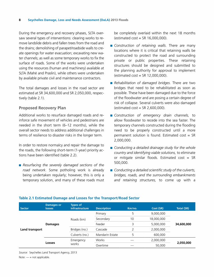
The total damages and losses in the road sector are estimated at Sr 34,600,000 and Sr 2,050,000, respec-tively (table 2.1).
Proposed Recovery Plan
Additional works to resurface damaged roads and re-inforce safe movement of vehicles and pedestrians are needed in the short term (6–12 months), while the overall sector needs to address additional challenges in terms of resilience to disaster risks in the longer term.
In order to restore normalcy and repair the damage to the roads, the following short-term (1-year) priority ac-tions have been identified (table 2.2).
■n Resurfacing the severely damaged sections of the road network. Some potholing work is already being undertaken regularly; however, this is only a temporary solution, and many of these roads must
be completely overlaid within the next 18 months (estimated cost = Sr 16,000,000).
■n Construction of retaining walls. There are many locations where it is critical that retaining walls be constructed to protect the road and surrounding private or public properties. These retaining structures should be designed and submitted to the planning authority for approval to implement (estimated cost = Sr 12,000,000).
■n Rehabilitation of damaged bridges. There are two bridges that need to be rehabilitated as soon as possible. These have been damaged due to the force of the floodwater and are posing a certain degree of risk of collapse. Several culverts were also damaged (estimated cost = Sr 2,600,000).
■n Construction of emergency drain channels, to allow floodwater to recede into the sea faster. The temporary channels constructed during the flooding need to be properly constructed until a more permanent solution is found. Estimated cost = Sr 2,000,000.
■n Conducting a detailed drainage study for the whole country and identifying viable solutions, to eliminate or mitigate similar floods. Estimated cost = Sr 500,000.
■n Conducting a detailed scientific study of the culverts, bridges, roads, and the surrounding embankments and retaining structures, to come up with a
table 2.1 Estimated Damage and Losses for the transport/Road Sector
SectorDamages or losses
types of infrastructure Description km/no. cost (SR) total (SR)
Land transport
Damages
roads (km)
Primary 5 9,000,000
34,600,000
Secondary 10 18,000,000
Feeder 3 5,000,000
Bridges (no.) Cascade 2 2,000,000
Culverts (no.) Mandarin Estate 5 600,000
Losses Emergency works
Works — 2,000,0002,050,000
overtime — 50,000
Source: Seychelles Land Transport Agency, 2013
Note: — = not applicable.

9chAPtER 2 ECoNoMIC AND SECTor IMPACTS AND NEEDS
rehabilitation, mitigation, and protection scheme. Estimated cost = Sr 400,000.
Actions needed for the medium- and long-term recon-struction phase (beyond 1 year) include the following:
■n Procure adequate road maintenance equipment such as asphalt plants (2), and other machinery such as excavators (2), an excavator/digger (1), a road grader (1), a milling machine (1), small rollers (2), and a large roller (1). Estimated cost = Sr 30,000,000.
■n Implement the proposals made from the studies and resulting plans proposed above.
■n Construct additional retaining walls to protect roads. Estimated cost = Sr 12,000,000.
2.2.1.2 Water Supply and Sanitation
overview
The Public Utilities Corporation (PUC), which reports to the Ministry of Energy and Environment, is the main
service provider in the Seychelles for the provision of electricity, water, and sanitation services, with its mis-sion focused on the following:
■n To provide an efficient, safe, and reliable supply of electricity and treated water.
■n To treat and dispose of wastewater while paying due regard to the environment and customers’ interest.
■n To keep up with changes in technology to improve services.
The Water and Sewerage Division within the PUC is re-sponsible for the production and distribution of treated water on the islands of Mahé, Praslin, La Digue, and the Inner Islands. The provision for sanitation services is also provided for Mahé Island only, in the form of four isolated sewage treatment plant systems, namely Victoria, Beau Vallon, Pointe Larue, and Anse Aux Pins (Chetty Flats) sewerage systems.
The core activities of the Water and Sewerage Division are:
table 2.2 Estimated Recovery and Reconstruction Needs for the transport/Road SectorNeeds for recovery and reconstruction
(transport/road sector)Financing needs
(SR)Financing
available (SR) Financing gap (SR) timeframe
Recovery 48,600,000 0 48,600,000
Short term 32,600,000 0 32,600,000
resurfacing of damaged roads 16,000,000 0 16,000,000 6 to 18 months
Construction of retaining walls 12,000,000 0 12,000,000 1 year
rehabilitation of damaged bridges and culverts 2,600,000 0 2,600,000 6 months
Construction of emergency drain channels 2,000,000 0 2,000,000 6 months
Medium to long term 16,000,000 0 16,000,000
resurfacing of damaged roads 16,000,000 0 16,000,000 18–36 months
Reconstruction 42,900,000 0 42,900,000
Short term 900,000 0 900,000
Drainage study 500,000 0 500,000 6 months
Study of the culverts, bridges, roads 400,000 0 400,000 6 months
Medium to long term 42,000,000 0 42,000,000
Procurement of adequate road maintenance equipment 30,000,000 0 30,000,000 1–2 years
Construction of retaining walls 12,000,000 0 12,000,000 1–3 years
totAL 91,500,000 0 91,500,000 1–3 year
Source: SLTA, 2013.
Seychelles Damage, Loss and Needs Assessment (DaLA) 2013 Floods10
■n Collection/production, treatment, and quality control of water
■n Transmission and distribution of treated water
■n operation and maintenance of treatment plants and water networks
■n Managing the water resources during the drought season
■n Managing the sewerage networks and plants
The main constraints reported by the Water and Sew-erage Division regarding the water and sanitation sec-tors are (i) the inadequate raw water storage capacity on the three main islands, (ii) the continuous change in weather patterns increasing the dry periods and the operational cost of water supply due to production by desalination plants, (iii) the islands’ topography mak-ing it costly and challenging to distribute treated water supply and also to install/replace pipe networks, (iv) the operations of isolated sewerage systems on the island of Mahé, (v) the isolation of the country warranting the need to have a significant buffer stock of chemi-cals and equipment, hence tying up the flexible funds, and (vi) limited financial capacity to invest into asset re-newal and expansion due to inadequate surplus funds generated from its operation.
Impact of the Floods
This section includes damage and loss assessment for the water and sanitation system, while the damage and loss assessment for the electricity sector will be developed in the next section.
The water treatment systems in Mahé were moderately impacted by the heavy rains that began on January 27, 2013. The majority of intake systems (barrages) were blocked with debris and soil being washed down by in-creased river flows. The water quality at the treatment plants deteriorated significantly and control measures were instituted to respond to the water quality issue. Filters were subjected to large quantities of turbid and muddy water.
The sewerage systems in the districts of Anse Aux Pins and Pointe Larue were adversely impacted. The Anse
Aux Pins (Chetty Flat) sewerage plant was flooded. The sea outfall pump and its accessories were submerged under water. Muddy water infiltrated the main rotating biological contactor (rBC) where the aerobic treatment takes place. At the Pointe Larue sewerage system, the floods impacted mainly the sewerage networks. All 400 manholes were subjected to very high inflows, with debris causing pipe blockages, damages, and wastewater overflows. The walls of 125 manholes in the upper region of Nageon Estate (Pointe Larue) were severely weakened by the flash floods.
Recovery Initiatives
The PUC technical team was called in on Sunday, Janu-ary 27, 2013, to respond to the damages and block-ages of the water and sewerage infrastructure around Mahé, in particular in the flooded areas. Two water network teams were posted in each water supply zone (four zones in total) to attend to burst pipes and block-ages. off-duty water treatment operators and laborers were called in to continuously unblock intake infra-structures and conduct repeated backwashing of the filters at all the treatment plants on Mahé. A sewerage network team was sent to the Pointe Larue area for repair works and unblocking of manholes and sewer pipes. A second team was posted at the Anse Aux Pins sewerage treatment plant to undertake continuous pumping of the muddy water in the rBC and the sea outfall pump station. The PUC electromechanical team undertook repair of the pump and auxiliaries at the plants. The associated costs of damages and losses are summarized in table 2.3.
Proposed Recovery Plan Short Term
Water Infrastructure—Mahé:■n relocate all the distribution pipes that have been installed in rivers and in drainage systems across Mahé. A recent survey puts the relocation cost near Sr 4.5 million.
■n review intake system (barrage) design and construction with the aim of minimizing blockages due to debris during high inflows, and undertake repair of weakened areas.
11chAPtER 2 ECoNoMIC AND SECTor IMPACTS AND NEEDS
■n replace media filters of almost all the small treatment plants. Filter media have to be procured internationally.
Sewerage Infrastructure—Mahé:■n At Anse Aux Pins, the housing unit of the rBC is underground and susceptible to inflows of muddy water during prolonged rainy periods. Counter–water ingress measures have to be designed and built. A spare sea outfall pump set, electrical accessories, and pipe fittings have to be procured for replacement in anticipation of increased failure rate. other spares and repairs to the housing of the rBC have to be undertaken immediately.
■n There is a need to replace the submersible pump in the main sump at Pointe Larue treatment works. It was subjected to debris and its risk of malfunction in the near future is relatively high. Urgent reconstruction of 200 manholes has to be undertaken to prevent collapse and further water ingress in the system to prevent sanitation issues. A total length of 400 m of asbestos cement pipes has to be replaced with high-
density polyethylene (HDPE) or ductile iron pipes to improve the robustness of the network.
Long Term
Water Infrastructure:■n Installation of distribution pipes in rivers and drainage systems should be avoided. It results in higher installation cost for areas where there is no service corridor between the roads and walls of property owners.
Sewerage Infrastructure:■n Anse Aux Pins system: The present rBC treatment plant arrangement has aged and deteriorated with time. It requires upgrading, replacing, and most importantly, relocation. It is presently installed in the middle of the commune area accommodating the Chetty flats (about six blocks of flats). The network also needs expansion to cater to other coastal buildings in the surrounding area.
■n Pointe Larue system: The 300 m3/day diffused aeration system consists of three interconnected
table 2.3 Estimated Damages and Losses for the water and Sewerage Sector
Sector Damages or losses Description cost (SR)
water supply
Damage Distribution pipes; 96 recorded burst in the flooded areas on January 27 and 28 125,000
Losses
Man hours (overtime) for continuous unblocking of intakes, flushing of lines, backwashing of filters, and pipe repairs.
Fuel, transportation, equipment (pipe fittings), and increased chemical usage at treatment plants.
350,000
total 475,000
Sewerage/Sanitation Systems
Pointe Larue
Damage Damaged collection pipes due to blockages by debris, manhole damages, and equipment failure at the treatment plant.
310,000
Losses Man hours (overtime) for unblocking and repair of sewer pipes and equipment at treatment plant.
Fuel, transportation, pipe fittings, and pumping activities.
200,000
Anse Aux Pins
Damage Damage to sea outfall pump and accessories, rotating biological disc, and auxiliaries. 550,000
Losses Man hours (overtime) for repair of pumps and accessories at the treatment plant.
Fuel, transportation, electrical fittings, and pumping activities.200,000
totAL (SR)
Damage 985,000
Losses 785,000
Source: PUC, 2013.

Seychelles Damage, Loss and Needs Assessment (DaLA) 2013 Floods12
tanks for repeated treatment of sewerage by pressurized air from a blower system. There is a need to rehabilitate the plant in the medium term and eventually upgrade it to cater to other low-lying areas that are highly vulnerable to high water table and flooding.
■n The network has to be reevaluated with the aim of upgrading it in certain areas due to increased inflows. Eventual relocation of manholes that are situated in the middle of the Nageon Estate roads should also be undertaken.
Estimates of the financing needs associated with the short-term and long-term recovery plans are summa-rized in table 2.4,
key Issues for consideration key challenges include the following:
■n Development taking place above catchments on river systems increases the risk of pollution during heavy rainfall.
■n Severe adverse weather conditions in the form of drought and flash floods due to change in weather patterns increasingly affects PUC’s capability to discharge its duties and responsibilities effectively.
■n Aging infrastructure and its increasing deterioration in performance adversely affects services.
■n Maintaining the production and distribution of quality treated water during periods of heavy rainfall; high risk associated with pretreatment of raw water in order to maintain the required standards. There is risk to operators when working on barrages attending to blockages in the intake during high river flows or heavy rainfall.
■n risk of accidents to personnel while undertaking repair works in severe weather conditions both at night and during the day.
■n The overflow of sewerage manholes and plants endangers people and the surrounding environment. Preventing these overflows during prolonged heavy rainfall is a challenging task for the division and the PUC management.
■n Sourcing of spare parts for aging infrastructure that have become obsolete is a continuous challenge, since renewal of these assets is not undertaken at the end of their economic life cycle.
■n Having sufficient capital funds to invest into asset renewal and upgrade is the key financial hurdle.
2.2.1.3 Electricity
overview
The Electricity Division is responsible for the generation, transmission, and distribution of the public electricity supply on the islands of Mahé, Praslin, La Digue, and the Inner Islands. There are around 305 employees and the organization structure comprises the following sections:
■n Production Section: Plants operation and Maintenance
■n Transmission and Distribution: Network operation and Maintenance Section
■n Praslin and La Digue: Production and Distribution
The core activities of the Electricity Division are as follows:
■n Generation of electricity
■n Transmission of electricity
■n Distribution of electricity
■n Inspectorate and assisting with consumer services
■n Metering, assisting in billing, and collection of revenue
■n Project planning, design, and implementation
The Section for Praslin and La Digue is responsible for the production customers. La Digue is connected to the Praslin network by an 11 kV network consisting of two submarine cables operating in a radial formation.
The key constraints of the electricity sector include the following:
■n Some 85% of the expenditure of the company relates to direct material cost. As such, the Electricity

13chAPtER 2 ECoNoMIC AND SECTor IMPACTS AND NEEDS
Division is vulnerable to delays in shipments and price rises due to external factors beyond its control (fuel prices, insurance due to piracy, and foreign exchange).
■n Essential stock levels of strategic items have to be kept in the country due to the remoteness of the islands. This limits the opportunity to have more financial capacity to invest in other areas.
■n Wayleaves for installation of new infrastructure on properties are becoming one of the main challenges in the increasing need to expand the existing network for connection of new customers.
■n Acquiring property owners’ agreements to undertake tree-cutting activities in order to maintain clearances from overhead systems and minimize damages during heavy winds.
■n Construction activities (drains, roads) in existing ser-vice corridors for underground electrical infrastruc-ture.
■n Limited service corridors for underground systems in the urban and certain rural areas.
Impact of the Floods
The heavy rains and flood of January 27, 2013, did not significantly impact the existing electrical infrastructure on Mahé, Praslin, or La Digue. There were no high-volt-age feeder outages except for localized low-voltage interruptions due to trees falling across low-voltage lines. The region most affected was the southern area, where six low-voltage poles were broken and had to be replaced.
Recovery Initiatives
In total, six teams were called in to handle low-volt-age calls. Four teams were posted in South Mahé and two teams in North Mahé. All low-voltage supply on Mahé was fully restored by January 28, 2013. The to-tal damage is estimated at Sr 25,000. The loss due to the outage, overtime work, and tree cutting totaled Sr 200,000 (table 2.5).
table 2.4 Estimated Recovery and Reconstruction Needs for the water and Sanitation Sector
Needs for recovery and reconstructionFinancing
needs (SR)Financing
available (SR)Financing
gap (SR) timeframe
Recovery 3,250,000 1,000,000 2,250,000
Short term 3,250,000 1,000,000 2,250,000
Water infrastructure 2,500,000 1,000,000 1,500,000 8–12 months
Sewerage infrastructure—Anse Aux Pins 250,000 0 250,000 6 months
Sewerage infrastructure —Pointe Larue 500,000 0 500,000 12 months
Reconstruction 48,005,000 3,300,000 45,005,000
Short term 10,300,000 3,300,000 7,000,000
Water infrastructure 4,500,000 0 4,500,000 8–12 months
Sewerage infrastructure—Anse Aux Pins 800,000 300,000 500,000 8 months
Sewerage Infrastructure—Pointe Larue (rehab and networks) 5,000,000 3,000,000 2,000,000
Medium to long term 37,705,000 0 37,705,000
Sewerage Anse Aux Pins—new plant and network expansion 15,200,000 0 15,200,000 2 years
Pointe Larue plant rehab/renewal and upgrade of network 22,505,000 0 22,505,000 3–4 years
totAL 51,255,000 4,300,000 47,255,0006 months–4
years
Source: PUC , 2013.
Seychelles Damage, Loss and Needs Assessment (DaLA) 2013 Floods14
Proposed Recovery Plan
Short Term
only the overhead infrastructure is vulnerable to heavy rains and winds. To minimize the impact of future se-vere weather conditions, the PUC is scheduling three clearance activities along all its overhead line systems.
Long Term
on a long-term basis, a proper vegetation manage-ment scheme should be developed and implemented in areas that are in close proximity to the PUC over-head electrical system. This will assist in lowering the cost and the frequent need for tree cutting on a yearly basis. A good start could be the drafting of a policy for type of vegetation allowed in service corridors. It is too early to define a cost at this stage; however, to give an overall idea of the tree-cutting activities, it will cost an estimated Sr 6 million per year to engage in complete tree-cutting activity covering all the overhead infrastructure of the electricity sector.
Another option would be to replace the high- and low-voltage bare lines with insulated lines; this would have a relatively high initial investment cost, estimated at
an approximate Sr 10 million per year for two years (table 2.6).
Alternatively, the system could be installed under-ground; this carries a heavy cost factor, since an enor-mous amount of civil works would be required. In addition, it is anticipated that wayleave issues would be a major hurdle.
2.2.1.4 Other Public Infrastructure (SFRSA, SCAA, Army, Police Department)
The impact assessment under this infrastructure sec-tion also includes damage and losses experienced in other public sectors like the Seychelles Fire and rescue Services Agency (SFrSA), the Police Department, the Seychelles People’s Defense Force (SPDF), and the Sey-chelles Civil Aviation Authority (SCAA).
Damage and Losses within the Seychelles Fire Rescue Services Agency (SFRSA)
The Seychelles Fire and rescue Services Agency (SFrSA) is dependent on the national budget and falls under the Ministry of Home Affairs. It provides fire prevention, res-cue, hazardous material mitigation, fire inspection, fire
table 2.5 Estimated Damages and Losses for the Electricity Sector
SectorDamage or losses Description total (SR)
total damage and losses (SR)
Electricity
Damage Six poles in South Mahé and low-voltage lines 25,000
225,000Losses
revenue loss, overtime to undertake repair works. Tree cutting activities by contractors called out on January 27 and 28
200,000
Source: PUC, 2013.
table 2.6 Estimated Reconstruction Needs for the Electricity Sector
Needs for ReconstructionFinancing
needs (SR)Financing
available (SR)Financing
gap (SR) timeframe
Reconstruction
Medium to Long Term
replace the high- and low-voltage bare lines with insulated lines; this will have a relatively high initial investment cost 20,000,000 0 20,000,000 2 years
Source: PUC, 2013.

15chAPtER 2 ECoNoMIC AND SECTor IMPACTS AND NEEDS
investigation, and public education to the republic of
Seychelles. It is mandated as the lead agency for land
search and rescue operations in the event of a disaster.
The SFrSA supported the operation of pumping and
rescue during recent floods in close coordination with
the DrDM. Some of the SFrSA’s equipment used dur-
ing the emergency phase was damaged and needs to be
repaired or replaced. Table 2.7 summarizes damage and
losses experienced by the SFrSA, estimated at Sr 431,640
(US$34,531) and Sr 338,349 (US$27,068), respectively.
The estimation of needs for the recovery and recon-
struction within the Seychelles Fire and rescue Servic-
es Agency (SFrSA) is summarized to be Sr 431,640
(US$34,531), as shown in table 2.8.
Damage and Losses within the Seychelles Police Department
Three police stations—in Anse Aux Pins, Pointe Larue,
and Anse royale—were severely damaged in the
floods. Furniture and equipment were damaged or de-
stroyed. The Pointe Larue Police Station operation was
transferred to the Anse Aux Pins Police Station due to
the damages experienced. The total damage was esti-
mated at Sr 156,300 (US$12,504) (Table 2.9). Detailed
calculation is in appendix 4.
table 2.7 Estimated Damages and Losses for the SFRSA
Sector Damages or losses Description cost (SR) total (SR)
Seychelles Fire and Rescue Services Agency (SFRSA)
Damages
one portable pump damaged (cost of repair) 1,500
431,640replacing 10 burst delivery hoses 30,140
Two portable pumps (cost of replacement) 400,000
Losses
Staff overtime 306,058
338,451Staff displacement allowance 23,100
Cost of fuel used in operation 9,293
Source: SFrSA, 2013.
table 2.8 Estimated Recovery and Reconstruction Needs for the SFRSA
Needs for recovery and reconstruction for the Seychelles Fire and Rescue Services Agency (SFRSA)
Financing needs (SR)
Financing available (SR)
Financing gap (SR) timeframe
recovery 431,640 0 431,640
Short term 431,640 0 431,640
Cost of repair of one portable pump damaged 1,500 0 1,500 6 months
Cost of replacing of 10 burst delivery hoses 30,140 0 30,140 6 months
Cost of replacement of two portable pumps 400,000 0 400,000 1 year
total 431,640 0 431,640 1 year
Source: SFrSA, 2013.
table 2.9 Estimated Damages and Losses for the Police Department
Sector Damages or losses Location cost (SR) total (SR) total (uS$)
Police Services Damage to the Police Station
Anse aux Pins 81,500
156,300 12,504Anse royale 24,400
Pointe Larue 50,400
Source: Seychelles Police Department, 2013.
Seychelles Damage, Loss and Needs Assessment (DaLA) 2013 Floods16
The needs for the recovery and reconstruction for the Police Department are estimated at Sr 5.4 million (US$432,000), mainly for renovation of three police stations (table 2.10).
Damage and Losses within the Seychelles People’s Defense Force (SPDF—Army)
The Seychelles People’s Defense Force (SPDF) strongly contributed to the emergency response operations by providing human resources and logistics, notably for the clearing works and logistics. No damages have been reported within this department, but losses were estimated at Sr 36,000 (US$2,880), mainly for the fuel cost to La Digue (table 2.11).
Damage and Losses within the Aviation Sector
The Seychelles Civil Aviation Authority (SCAA) is located in Pointe Larue district within the Mahé Airport space. SCAA experienced some damages on computers and some materials, estimated at Sr 20,000 (US$1,600), during the floods in January (table 2.12).
The diagnostic conducted a few days after the disas-ter by SCAA with technical support from GIBB (a civil engineering consulting firm) shows some deficiencies in the stormwater drainage system at the Seychelles International Airport (SIA). The diagnostic particular-ly recommended the assessment of the storm water
table 2.10 Estimated Recovery and Reconstruction Needs for the Police Department
Needs for recovery and reconstruction for the Police Department
Financing needs (SR)
Financing available (SR)
Financing gap (SR) timeframe
Recovery 156,300 0 156,300
Short term 156,300 0 156,300
Cost of equipment to be replaced 156,300 0 156,300 1 year
Reconstruction 5,400,000 0 5,400,000
Short term 5,400,000 0 5,400,000
renovation of the Anse royale Police Station 800,000 0 800,000 1 year
renovation of Anse aux Pins Police Station 600,000 0 600,000 1 year
rebuilding of the Pointe Larue Police Station 4,000,000 0 4,000,000 1 year
totAL 5,556,300 0 5,556,300 1 year
Source: Seychelles Police Department, 2013.
table 2.11 Estimated Damage and Losses within SPDF
Sector Damages or losses Description total (SR) total (uS$)
Seychelles Peoples Defense Force (SPDF) Losses Fuel for a one-day emergency trip to La Digue 36,000 2,880
Source: SPDF, 2013.
table 2.12 Estimated Damage and Losses within the ScAA
Sector Damages or losses Description total (SR) total (uS$)
Seychelles civil Aviation Authority (ScAA) Damages
Computers and materials damaged in flooded offices 20,000 1,600
Source: SCAA, 2013.

17chAPtER 2 ECoNoMIC AND SECTor IMPACTS AND NEEDS
drainage system at the SIA and implementation of suit-able works to correct deficiencies. The corrective mea-sures for the short and medium terms are estimated at Sr 716,000 (US$57,280), as shown in table 2.13.
urban and Storm water Drainage Issues
The rains that caused the floods in January 2013 were heavy, but deficiencies in the storm water drainage sys-tem and in land use likely contributed significantly to the impact of the disaster. The affected zones on Mahé Island were valleys located between the foothills and the road bordering the southeast coast and the airport, which also experienced some damage due to drainage system deficiencies.
■n It is essential to ensure that each inhabited area, particularly in urban zones, is well planned and drained within the context of a drainage master plan (DMP) prepared particularly for flood-prone areas.
In the Seychelles, land use and urban planning are un-der the responsibility of the Ministry of Land Use and Habitat (MLUH), which works closely with district au-thorities to regulate all issues of land management,
land administration, surveying of land, allocation of land, and land use planning. All applications for devel-opment of land in the Seychelles must also be submit-ted to the Planning Authority for review and approval. It is mandatory that each district have its own land use planning document.
The Town and Country Planning Act was the main legal binding document permitting the regulation of land use and planning since 1972. Since 2011, the act has been under revision with an aim to integrate new urban realities and context. The revised legal docu-ment, called the Physical Planning Bill, is expected to be finalized by July 2013. The new bill should include risk mapping, related mandatory settlement processes, and building measures. There is a concern that risk mapping will not be integrated into the current bill, since no mapping exercises have yet been undertaken.
■n A key recommendation, therefore, is for DrDM to take the lead in the preparation of essential risk mapping prior to July 2013 to permit integration of, at a minimum, the risk mapping process and an outline of the new urban legal framework.
table 2.13 Estimated cost of Recovery and Reconstruction Needs within the ScAA (Aviation Sector)
Needs for recovery and reconstructionFinancing
needs (SR)Financing
available (SR)Financing
gap (SR) timeframe
Recovery 20,000 0 20,000
Short term 20,000 0 20,000
replacement of computers and materials in flooded office 20,000 20,000 3 months
Subtotal 20,000 0 20,000
Reconstruction 706,000 0 706,000
Short term 706,000 0 706,000
Construction of retaining wall around offices to reduce floodwater inflow and consequential flooding 150,000 0 150,000 6 months
Gibbs study for urgent works to immediately alleviate the effects of sudden flooding 10,000 0 10,000 6 months
Enhancement of drains at the equipment parking area and along the airport fencing to facilitate flood water drainage 20,000 0 20,000 6 months
Enlargement of drains and replacement of protective grills 26,000 0 26,000 6 months
Enlargement of airport roadside drains 500,000 0 500,000 1 year
totAL 726,000 0 726,0003 months–
1 year
Source: SCAA, 2013.

Seychelles Damage, Loss and Needs Assessment (DaLA) 2013 Floods18
The Physical Planning Bill is supported by specific land use regulation at the national and district levels. While land use policy is quite good in the Seychelles, there has been a lack of enforcement, in particular with re-gard to building codes. Issues include noncompliance with proper drainage plans, building layout, etc. The MLUH manages about 2,400 requests for approval for building per year, of which 95% are approved.
■n The MLUH’s capacity in ensuring building control on the ground should be strengthened. The building code should be disseminated to permit professionals and the public to be well informed of the local requirements for construction.
■n roles and responsibilities for those involved in the maintenance and operation of drainage networks, namely the LWMA, the SLTA, the Coastal Adaptation and Management section (CAM), and the Agricultural Agency, should be clarified. Potentially, one agency should be appointed to lead and coordinate all maintenance activities, and be responsible for the overall planning and implementation of cleaning operations at country level.
2.2.2 Productive Sectors
2.2.2.1 Agriculture
The Seychelles Agriculture Agency (SAA) was created in 2009 as an agency falling under the Ministry of Natu-ral resources and Industry. The SAA has seven sections, comprising Crop and research Development, Extension, Land Management and Planning, Veterinary Services, Livestock, Plant Protection, and Administration and Fi-nance, as well as the administration of the Victoria Mar-ket. The budget comes directly from the government.
The agricultural sector produced a total of 6,147 tons (recorded in the 2011 agricultural census), with the main crops produced being banana, lettuce, Chinese cabbage, cabbage, eggplant, chilies, cucumber, toma-toes, and pawpaw. A total of 21,194 tons of fresh fruits and vegetables were being imported. This meant only 29% of crops were being produced locally. In 2011, the livestock sector recorded a total of 1,393 tons of meat being locally produced, while a total of 3,763 tons were being imported. This meant a total of
37% was being locally produced. The main livestock being produced are cattle, chicken, and beef.
Impact of the Floods
The torrential rains on the weekend of January 25–28, 2013, caused considerable damage to the farming and agricultural communities. Farms along the coast suf-fered major damages from the accumulation of water coming down from the mountainous area, whereas the farms on the hillsides suffered from erosion, land-slides, and mudslides caused by rainwater runoff.
An Agriculture Disaster Committee, comprising rep-resentatives of Agricultural Extension Services, Agri-cultural Lands Management, Statistics, Agricultural research and Development, Livestock Development, Veterinary Services, and the Department of Environ-ment (Drainage Section), was established to record and verify the extent of damage to farms and other agricultural premises and infrastructure. Every effort was made to capture as many people as possible who suffered losses.
out of a total of 593 registered farms, 293 were vis-ited. Seventy-four were recorded as suffering from on-farm damages caused by the disaster. All information collected was channeled through the Statistics Unit of SAA for compiling data and conducting analysis. The assessment was then submitted to the Ministry of Nat-ural resources and Industry, and as a Flash Appeal to the National Disaster Committee, to assist individuals who were affected by the disaster and who depend upon agriculture for their livelihoods.
The majority of farmers had lost crops in the fields with associated tools and irrigation equipment, as well as certain inputs that were in storage. The total estimated physical losses were Sr 17.84 million (US$1.43 million) (table 2.14).
Proposed Recovery Plan
The Committee decided that the most affected farms, which are located in the coastal area of Au Cap, would be compensated with 40% of their crop loss. In this category, there is a total of eight farms, namely ralph

19chAPtER 2 ECoNoMIC AND SECTor IMPACTS AND NEEDS
Hoareau, Simon Belle, Gerald Belle, Jean-Paul Desau-bin, David Marie, Luc Gedeon, Ginette Geffroy, and Sylvestre Naiken. The other 66 farms would be com-pensated at 20% of their loss. It is noted that this com-pensation is aimed at assisting the affected farms in getting their farm business back into operation. It was also decided that 50% of the compensation would be inputs and the other 50% would be in cash. The total recovery and reconstruction is the same as the above damages and losses based on SAA without additional cost, even though some challenges are listed without an associated cost (table 2.15).
There is a plan to set up agricultural insurance involv-ing the two local insurance companies (SACoS and H Savy insurance) to transfer risk of any future disaster.
key Issues for consideration
■n Proper infrastructure such as drainage and roads needs to be improved. once it is improved, the risk of flooding will be greatly reduced.
■n Lack of enumerators to collect information once disasters occur is of major concern. At least four enumerators will be needed to get better estimates and cover all the farmers.
table 2.14 Summary of Damage and Losses from the Agriculture Sector
Items
Damages Losses total damages and losses (SR)Public Private Public Private
Inputs in form of stored fertilizer, pesticide, and seeds 92,443
17,836,255
Inputs in form of U/V plastic, shade house, and shade net 982,885
other damages to terraces 5,760
Equipment damages including water pumps, electric pump, and irrigation equipment 135,700
road damage on the Au Cap plateau 2,025,000
Drainage issues 5,785,000
Irrigation barrage at Cap Sammy 680,000
Crop loss 8,086,217
Seedlings in nursery 43,250
total 8,490,000 1,216,788 — 8,129,467
Source: SAA, 2013.
Note: — = not applicable.
table 2.15 Summary of Needs for the Agriculture Sector
Needs for recovery and reconstructionFinancing
needs (SR)Financing
available (SR)Financing
gap (SR) timeframe
Recovery 8,129,467 1,909,434 6,220,033
Short term 8,129,467 1,909,434 6,220,033
Compensation for crop loss 8,129,467 1,909,434 6,220,033 6–12 months
Reconstruction 9,706,788 0 9,706,788
Short term 5,785,000 0 5,785,000
Drainage issues 5,785,000 0 5,785,000
Medium to long term 3,921,788 0 3,921,788
Damaged inputs, terraces, road damage, and irrigation barrage 3,921,788 0 3,921,788 over 1 year
total 17,836,255 1,909,434 15,926,821
Source: SAA, 2013.

Seychelles Damage, Loss and Needs Assessment (DaLA) 2013 Floods20
■n Training in collection and analysis of information is needed.
■n Lack of transportation and fuel for staff to collect the data and visit farms due to no budget support.
■n A credit line at a lower interest rate should be considered for farmers. This will enable better investment by farmers to improve infrastructure such as irrigation and shade houses.
■n No allowance was given for lunch or for overtime, as it was not budgeted.
2.2.2.2 Land Use
Landslides also created issues for future land use. Some sites became unbuildable after the disaster, which translates to a loss of property value. A rough estimate of losses conducted based on the best data available yielded a total value of Sr 5.25 million (US$420,000) of lost value due to the disaster (table 2.16).
2.2.2.3 Tourismoverview
Currently, the risk Management Section under the Seychelles Tourist Board (established in March 2012) is in charge of risk management for the industry. Its mandate is to assess and evaluate risk in the tourism industry and recommend appropriate measures, to educate and sensitize tourism service providers about risk, and to take necessary actions. This is the first time that a risk management section is being set up to ad-dress risks associated with the tourism sector.
■n Presently, the section consists of one person who is responsible for the day-to-day operation of the
section. The section has begun work on a strategic risk management plan, which is expected to be ready around July 2013, pending comments from stakeholders and final revision.
Impact of the Flood
Few major hotels were located in the flooded area. As-sessments completed by the time of the report indi-cate that one guesthouse and one golf course were affected, but no damage and loss data were collected.
hotel contingency Plan
In the previous World Bank–supported project, ho-tel contingency plans were developed, which include communication procedures, an emergency and di-saster preparedness template, and a disaster and risk preparedness manual for both small and large tourism establishments. The contingency plan, including provi-sion of guidelines and manuals, is being implemented by the large hotels in order to develop their crisis man-agement plan. Thus far, twelve large hotels have de-veloped crisis management plans, while others are in the process of finalizing their plans. As the existing manual is overly complex for small tourism establish-ments (guesthouses, self-catering businesses, restau-rants, etc.), a simpler version should be developed.
main Risks for the Seychelles tourism Industry
Although only a limited number of tourism establish-ments were affected, the social impacts of the flood were felt in the tourism sector. It is important to note that the natural environment is a strong economic asset for the Seychelles. The effect of climate change poses a
table 2.16 Property value Loss Due to Landslides
Approximate number of sites affected by landslides 150
Average plot size (m2) 700
Approximate percentage of sites to be banned from future development 10%
Cost of land (Sr/m2) 500
total loss (SR) 5,250,000
total loss (uS$) 420,000
Source: Ministry of Land Use and Housing, 2013

21chAPtER 2 ECoNoMIC AND SECTor IMPACTS AND NEEDS
significant threat to the islands’ biodiversity and land-scape with a potential eventual negative effect on the tourism industry. Safety and security, piracy, and eco-nomic crisis have compounded the environmental risks facing the tourism industry.
Potential Needs/challenges
■n Capacity building and additional staff required.
■n Budget for effective implementation of the risk man-agement plan.
■n Communication between various agencies is some-times a concern.
■n Involvement of the risk management section in ac-tivities (meetings, workshops, etc.) on issues associ-ated with risk management in the tourism sector.
2.2.2.4 Industry
Except for Agro Industries, no main industry was af-fected. Agro Industries is engaged in food processing, retail, and production, and is located near the airport in a relatively flat zone. Its main products include long- life milk, juice, and yogurt. According to the CEo of the company, the total damage due to the flood was Sr 4.4 million (US$355,660), including processing equipment, raw and packing materials, finished prod-ucts, corrugated cardboard trays, and laboratory con-sumables (table 2.17). (Economic losses are attributed to the closure of the plant in late 2012 and therefore not included here.)
2.2.3 Social Sectors
2.2.3.1 Housing
overview
Housing policy in the Seychelles has a strong focus on enhancing the supply of homes to its citizens, through the provision of land, building materials, adequate in-frastructure, and financial services. According to the National Bureau of Statistics in the Seychelles, the country has 25,929 houses—of these 85% are made of stone and blocks and 15% of wood and iron. A ma-jority of 84% are in good repair, 9% are fair, and 7% are in poor condition.
The Housing Finance Company (HFC) offers a range of products promoting housing affordability. In 2011, HFC introduced a product to promote house repairs for families earning up to Sr 8,000 (US$640) a month. Eligible households that need to repair their housing can apply for loans up to Sr 25,000 (approximately US$2,000). Loans are repayable over a period of up to seven years, at an interest rate of 3%. The product was focused on addressing the increasing cost of build-ing materials, which has risen since 2008 as a result of economic reforms introduced at that time.
Impact of the Floods
The estimated impact based on available assessment reports and data collected shows that five districts were affected by the floods (figure 2.1). out of 218 houses affected, six houses were totally destroyed, 35 were partially destroyed, and 177 were flooded. Anse Aux Pins was the most heavily impacted district. of the affected houses, 189 are privately owned, while 29 be-
table 2.17 Damages to Agro Industries due to the Flood
Items Damages (SR) Damages (uS)
Processing equipment 3,620,500 289,640
raw/packaging materials/finished products 691,156 55,292
Laboratory consumables 134,097 10,728
total 4,445,753 355,660 Source: Agro Industries, 2013

Seychelles Damage, Loss and Needs Assessment (DaLA) 2013 Floods22
long to a parastatal company (Property Management Company [PMC]). The estimation of damage is over Sr 12 million (approximately US$975,000), including damaged and destroyed household goods, which ac-counted for nearly half of the total amount (table 2.18). The total losses, mainly from the cost of demolition and rubble removal, are Sr 2.4 million (US$192,000). other losses, such as the duration of reconstruction period and cost of a temporary housing scheme, have no available data, but should be considered.
Recovery Initiatives
During the disaster, the Department of Community Development and Sports, which manages the District Administration offices in all districts, established a co-ordination center at the Department’s secretariat to register all cases reported to the District Administration offices or through the DrDM. Emergency Brigades from the affected districts were assisted by colleagues from other unaffected districts in performing rescue and re-location operations. The district administrators, district emergency brigades, and the active participation and involvement of the community at the grassroots level helped to create an effective disaster response. The Department of Community Development and Sports was actively engaged in the identification, analysis,
monitoring, and evaluation at the response stage and remains involved during the recovery process.
During the crisis, national actions focused primarily on meeting immediate lifesaving needs. Human lives were at risk and quick action was required to minimize danger and restore order. The focus was on restoring national capacities to provide a secure environment, offer services, restore livelihoods, coordinate activities, and prevent the recurrence of crisis, while creating conditions for needed future development.
The Seychelles’ early recovery had five broad aims:
■n Increase ongoing emergency assistance operations by building on social/humanitarian programs: provision of basic necessities by the Agency for Social Protection, the red Cross, and private donors, etc.
■n Support spontaneous recovery initiatives by affected communities.
■n Encourage the business sector on construction and maintenance to offer immediate help on the ground.
■n Encourage ordinary citizens to open their homes to those affected.
Anse Aux Pins Pointe Larue Bel Aire Mont BuxtonAux Cap
120
80
100
60
40
20
–
n Fully destroyed n Partially destroyed n Flooded
Figure 2.1 Number of houses Affect by Flood, by District
39
106
10
54
3
14 17
1 1

23chAPtER 2 ECoNoMIC AND SECTor IMPACTS AND NEEDS
■n Establish the foundation for longer-term recovery, including the National Task Force and the National relief Fund.
The Seychelles’ early recovery programs were aimed at providing the affected communities with safety nets, accurate information, and access to resources, oppor-tunities, and capacities to rebuild their lives at a mo-ment when they were most vulnerable.
Proposed Recovery Plan
Short-Term Needs
Estimation of the short-term needs for interventions that address emergency actions to reconstruct dam-aged infrastructure and recover losses includes the fol-lowing:
■n Support individuals and households in affected communities in maintaining and returning to self-sufficiency.
■n Affirm and fulfil fundamental disaster housing re-sponsibilities and roles.
■n Increase collective understanding and ability to meet the needs of affected households.
■n Build capacity to provide a broad range of flexible housing options including sheltering, interim housing, and permanent housing.
■n Better integrate disaster housing assistance with related functional needs support services, commu-nity support services, and long-term recovery efforts (e.g., creating a Community rehabilitation subcom-mittee under the National Task Force).
■n Improve/accelerate disaster housing planning to better recover from incidents.
• Worktorepairhouseswithminordamage.• Team up government ministries (MLUH, MCD-
SAS) in assessing major housing damages with the aim of establishing a priority list for recon-struction.
■n Provide leadership to engage and coordinate the full range of partners and stakeholders to address disaster housing efforts and ensure compliance with laws applicable to housing in the country.
• Create a Public Infrastructure subcommittee tocoordinate.
table 2.18 Estimated Damages and Losses for the housing Sector
Damages Losses
total in SR total in uS$* total in SR total in uS$
Damages
Fully destroyed 3,759,000 300,720
Partially destroyed 2,437,024 194,962
Flooded* 0 0
Household goods 5,990,886 479,271
Losses
Duration of reconstruction period, month**
b) Cost of demolition and rubble removal 2,400,000 192,000
c) Cost of temporary housing scheme** 0 0
d) Food/supplies by Seychelles red Cross Society 134,970 10,798
total 12,186,910 974,953 2,534,970 202,798
Sources: Ministry of Community Development and Seychelles red Cross Society, 2013.
Notes: *: This is a standardized form for house flood calculation. However, there is no data for this particular flood.

Seychelles Damage, Loss and Needs Assessment (DaLA) 2013 Floods24
Medium- and Long-Term Needs
Medium- to long-term assessments were conducted for every household that required long-term recon-struction. The main activities under medium- to long-term reconstruction are building of retaining walls and earth trim, building of wider channels to trap water, construction of drains, repair of houses, demolition work, and relocation of property owners. Under risk reduction, foreseen activities include relocation of flood victims, consultancy fees, capacity building for key emergency staff and emergency brigades, and conducting mock drills.
Needs include the following:
■n Capacity building and training in disaster manage-ment, shelter management, needs assessment, co-ordination, and communication for
• DistrictAdministratorsandOfficeManagers• DistrictEmergencyBrigades(volunteers)• ProjectOfficers• StaffoftheEnvironment&EmergencyUnit
■n recruitment of one (1) staff in the Environment and Emergency unit for Disaster Management.
■n Expanded training on DaLA (the one-day training was not sufficient).
As shown in table 2.19, the total housing sector needs, including those for short-, medium-, and long-term re-covery and reconstruction, as well as risk reduction, are over Sr 68 million (US$5.5 million).
key Issues for consideration
■n Many of the landslide areas have extremely high embankments and have adversely affected more than one property.
■n In some instances, retaining walls may not be feasible due to the gradient of terrain and type of soil.
■n Many of the affected areas are not accessible by vehicle or machinery.
2.2.3.2 Education
overview
The mandate of the Ministry of Education is to play a key role in shaping a high-quality education system that meets the needs of all learners, supports their par-ticipation in communities and in society, promotes and enhances lifelong learning, and contributes to the de-velopment of the knowledge society in the Seychelles. The Seychelles education system comprises different formal subsectors, which cover academic and technical training at the primary, secondary, and postsecondary institutions imparting vocational education and techni-cal training. Table 2.20 gives an overview of the number of schools and students registered for each category.
table 2.19 Summary Needs for the housing Sector
District
Recovery (SR) Reconstruction (SR) Risk reduction (SR)
totalin SR
totalin uS$Short term
medium-long term Short term
medium-long term Short term
medium-long term
Pointe Larue 1,347,390 757,116 4,943,184 200,000 950,000 8,197,690 655,815
Anse Aux Pins 6,226,721 866,600 27,093,451 400,000 1,550,000 36,136,772 2,890,942
Aux Cap 1,596,530 63,808 18,346,181 200,000 950,000 21,156,518 1,692,521
Bel Air 0 70,000 416,250 70,000 500,000 1,056,250 84,500
Mont Buxton 0 0 500,000 50,000 500,000 1,050,000 84,000
Cascade 167,400 0 1,200,000 80,000 500,000 1,947,400 155,792
total 9,338,041 1,757,524 52,499,066 1,000,000 4,950,000 69,544,631 5,563,570
Sources: Ministry of Community Development and Seychelles red Cross Society, 2013.

25chAPtER 2 ECoNoMIC AND SECTor IMPACTS AND NEEDS
Impact of the Floods
Seven schools in three districts (Anse Aux Pin, Aux Cap, and Pointe Larue), with over 2000 students, were affected by the flood. Damage was mainly to sci-ence equipment, furniture, and gutters, blocking of the sewage system, piping system, septic tanks, and boundary walls. Most of the school walls needed to be repainted. The total damages amounted to Sr 3.2 million (US$256,400) for five schools (table 2.21). De-tailed calculation can be found in appendix 5.
Proposed Recovery Plan
Short Term
Schools and surrounding areas were cleaned and fu-migated to enable students to return to class. Items damaged by the flood still need to be replaced. The to-tal estimate of short-term costs as a result of the flood is approximately Sr 2,545,000. The other Sr 660,000 was for the cleaning and fumigation.
Medium and Long Term
In the effort to minimize and prevent future disasters in the affected areas and other areas, it is estimated that the medium- and long-term costs for the educa-tion sector will be Sr 90 million (approximately US$7.2 million) (table 2.22).
This figure includes the construction of three sewage treatment plants (Anse Aux Pins, La Digue, and Anse royale), with an estimated market price of approxi-mately Sr 1,500,000 per facility; improvement of the drainage and construction of a retaining wall at Pointe Larue, with an estimated market cost of Sr 4,500,000; and improvement of the drainage of a swamp at Anse Boileau, estimated at a market cost of Sr 2,500,000. This part is not included in the transport section.
The relocation of Point Larue School will cost Sr 74.8 million (nearly US$6million). The relocation is necessary because the current school site is low-lying and prone to flooding. The option to demolish the current school, recompact the ground, and reconstruct the school is considered too expensive (table 2.23).
table 2.20 Number of Schools and Students in the Seychelles, 2012
Schools
Number of schools Number of students
Public Private total Public Private total
Crèche 24 4 28 2,523 335 2,858
Primary 24 4 28 7,832 869 8,701
Secondary 10 3 13 6,587 536 7,123
Postsecondary 8 0 8 2,196 0 2,196
total 66 11 77 19,138 1740 20,878
Source: Ministry of Education, February 2013.
table 2.21 Damage and Loss Estimates for the Education Sector
type of school Damages Losses total damage and losses
crèche Primary Secondary in SR in SR in SR in uS$
Pointe Larue 1 1 1 1,970,000 380,000 2,350,000 188,000
Anse Aux Pins 1 575,000 90,000 665,000 53,200
Aux Cap 1 190,000 190,000 15,200
total 1 3 1 2,545,000 660,000 3,205,000 256,400
Source: Ministry of Education, February 2013.

Seychelles Damage, Loss and Needs Assessment (DaLA) 2013 Floods26
Institutional Assessment
There is a lack of qualified personnel for disaster reduc-tion assessment and reporting. Education would need to build capacity in these areas to minimize any future damages and be better prepared. The education de-partment is lacking project officers to conduct proper assessment of its facilities. There is a need to recruit more personnel and also a need for capacity building for those that are already with the department.
key Issues for consideration
The following issues should be considered with regard to the education sector (table 2.24):
■n Budgetary constraints and pressures from competing needs
■n Lack of availability of qualified contractors and labor to undertake work due to a limited qualified labor pool and competition from other construction/development
■n Changes in priorities due to policy changes
2.2.3.3 Health
overview
The Ministry of Health is responsible for planning, directing, and developing the health system for the benefit of the entire population of the Seychelles. Constitutionally, the government is required to provide essential health care services to all citizens. Currently, the National Health Strategic Framework (NHSF) 2006–2016 provides the strategic direction of the health sec-tor. In NHFS 2006–2016, NCDs (noncommunicable diseases) are the highest priority because they have the largest burden of mortality in the Seychelles.
The primary health care system is based on the United kingdom model of general practice. Implementation of this model has resulted in improved health of the population and consequently attainment of Millenni-um Development Goals (MDGs). The Seychelles has a three-tier health system, consisting of one central refer-ral hospital, three cottage hospitals, one rehabilitative hospital, one mental hospital, one youth health center,
table 2.22 Needs Estimates for the Education Sector
Needs Recovery (SR) Reconstruction (SR) Risk reduction (SR) total total
District Short termMedium-
long term Short termMedium-
long term Short termMedium-
long term in SR in US$
Pointe Larue 380,000 0 2,470,000 0 4,500,000 74,800,000 82,150,000 6,572,000
Ans Aux Pins 90,000 0 575,000 0 1,500,000 0 2,165,000 173,200
La Digue 0 0 0 0 1,500,000 0 1,500,000 120,000
Anse royale 0 0 0 0 0 1,500,000 1,500,000 120,000
Anse Boileau 0 0 0 0 0 2,500,000 2,500,000 200,000
Aux Cap 190,000 0 0 0 0 0 190,000 15,200
totAL 660,000 0 3,045,000 0 7,500,000 78,800,000 90,005,000 7,200,400
Source: Ministry of Education.
table 2.23 cost for construction of a New School for Pointe Larue Secondary
total cost (SR) total cost (uS$)
Civil works 60,000,000 4,800,000
Furniture 4,000,000 320,000
Equipment 4,000,000 320,000
Contingency 6,800,000 544,000
Total 74,800,000 5,984,000
Source: Ministry of Education, February 2013.
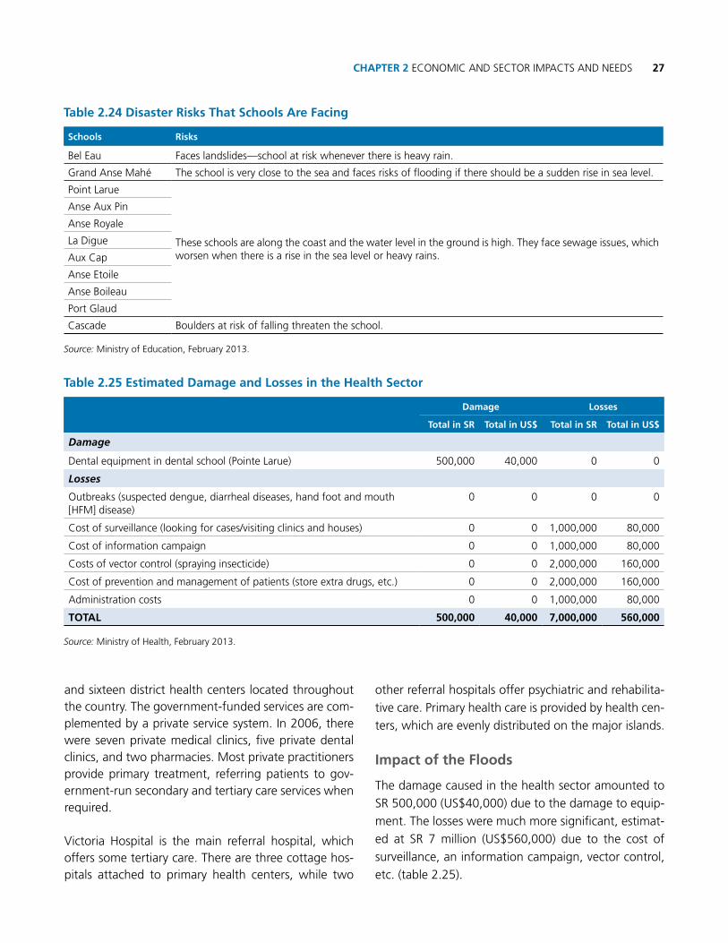
27chAPtER 2 ECoNoMIC AND SECTor IMPACTS AND NEEDS
and sixteen district health centers located throughout the country. The government-funded services are com-plemented by a private service system. In 2006, there were seven private medical clinics, five private dental clinics, and two pharmacies. Most private practitioners provide primary treatment, referring patients to gov-ernment-run secondary and tertiary care services when required.
Victoria Hospital is the main referral hospital, which offers some tertiary care. There are three cottage hos-pitals attached to primary health centers, while two
other referral hospitals offer psychiatric and rehabilita-
tive care. Primary health care is provided by health cen-
ters, which are evenly distributed on the major islands.
Impact of the Floods
The damage caused in the health sector amounted to
Sr 500,000 (US$40,000) due to the damage to equip-
ment. The losses were much more significant, estimat-
ed at Sr 7 million (US$560,000) due to the cost of
surveillance, an information campaign, vector control,
etc. (table 2.25).
table 2.24 Disaster Risks that Schools Are Facing
Schools Risks
Bel Eau Faces landslides—school at risk whenever there is heavy rain.
Grand Anse Mahé The school is very close to the sea and faces risks of flooding if there should be a sudden rise in sea level.
Point Larue
These schools are along the coast and the water level in the ground is high. They face sewage issues, which worsen when there is a rise in the sea level or heavy rains.
Anse Aux Pin
Anse royale
La Digue
Aux Cap
Anse Etoile
Anse Boileau
Port Glaud
Cascade Boulders at risk of falling threaten the school.
Source: Ministry of Education, February 2013.
table 2.25 Estimated Damage and Losses in the health Sector
Damage Losses
total in SR total in uS$ total in SR total in uS$
Damage
Dental equipment in dental school (Pointe Larue) 500,000 40,000 0 0
Losses
outbreaks (suspected dengue, diarrheal diseases, hand foot and mouth [HFM] disease)
0 0 0 0
Cost of surveillance (looking for cases/visiting clinics and houses) 0 0 1,000,000 80,000
Cost of information campaign 0 0 1,000,000 80,000
Costs of vector control (spraying insecticide) 0 0 2,000,000 160,000
Cost of prevention and management of patients (store extra drugs, etc.) 0 0 2,000,000 160,000
Administration costs 0 0 1,000,000 80,000
totAL 500,000 40,000 7,000,000 560,000
Source: Ministry of Health, February 2013.

Seychelles Damage, Loss and Needs Assessment (DaLA) 2013 Floods28
The total recovery needs for the health sector are estimat-ed at nearly Sr 12 million (approximately US$950,000), including laboratory strengthening, case management, public education, and coordination (table 2.26).
Institutional Assessment
There is approximately one doctor per 780 people and one nurse per 400 people in the Seychelles. Nurses pro-vide the family planning and maternal and child health services. Almost all nurses are Seychellois, but 75% of all physicians are expatriates. A school of nursing in the capital trains nurses, but there is no medical school and Seychellois doctors are trained abroad. Health workers regularly visit the outlying islands to provide care for the inhabitants, but when the health workers are not on the outlying islands, the inhabitants depend on a radio to communicate with the community clinics.
The majority of highly specialized treatment takes place overseas; such treatment cost Sr 5,217,000 (US$417,360) in 2005 and increased to Sr 9,871,000 (US$789,680) in 2010.
key Issues for consideration
Natural hazards as a result of climate change pose a great threat to the Seychelles. Heavy tropical rains lead to landslides and flooding with attendant increase in mosquito vectors that have led to outbreaks of den-gue fever and Chikungunya fever in the past. Since the
vector (Aedes albopictus) breeds prolifically in the Sey-chelles and is the main vector for these two diseases, this risk needs to be borne in mind in the event that the country experiences a massive downpour with flood-ing. Diarrheal diseases are also one of the major risks due to sewage contamination of underground water.
The Health Sector Emergency response Plan is not yet finalized and there is an urgent need to complete this document.
2.2.4 Cross-Cutting Sectors
2.2.4.1 Environment
■n The environmental impact of the floods and landslides of January 2013 event occurred across terrestrial, freshwater, and coastal/marine ecosystems. The most significant impacts on the environment were related to the following issues:
• Water quality (contamination from fertilizer,pesticide, and sewage)
• Waterways (natural and man-made) blockedwith silt, mud, and downed trees
• Sediment and contaminated runoff to fresh,brackish, and saltwater habitats
• Destructionofkeyhabitatforendangeredspecies(e.g., green turtle nesting area)
■n While some estimates of costs of both damage and losses can be assessed for particular activities, for
table 2.26 Needs Estimation for a Suspected Dengue Epidemic contingency Response Plan
Area of work objective Amount (SR) Amount (uS$)
Surveillance and laboratory
To strengthen early case detection at health facility and community levels; reporting, referral, and confirmation of suspected cases of dengue; and timely follow-up of affected cases/ households
1,700,000 136,000
vector control To enhance vector control through integrated vector management 3,818,000 305,440
case managementTo support prompt clinical management of suspected/probable/confirmed dengue cases in the health facilities
2,080,000 166,400
Public education/ social mobilization
To create public awareness about dengue and other vector-borne diseases—the risk factors, prevention, and control among the community 4,146,680 331,734
coordination and logistics
To ensure effective coordination of dengue outbreak response activities and strengthen logistic management
58,500 4,680
totAL 11,803,180 944,254
Source: Ministry of Health, February 2013.

29chAPtER 2 ECoNoMIC AND SECTor IMPACTS AND NEEDS
instance, cost of drainage clearance or tree removal, other costs are more difficult to quantify, at least in part due to gaps in the collection and availability of data. These costs to the long-term environmental health of the country are significant for a variety of reasons, particularly for the positive effects to the infrastructure and public expenditure sectors, from the range of services provided by healthy ecosystems. of chief concern with regard to the recent disaster in January is the key role particular ecosystems play in disaster risk reduction: for example, mangroves have been shown to offer protection against tsunami damage; coral reefs protect coasts and beaches from storm surge; wetlands act as a natural sponge
for flood waters, etc. These and other services provided by ecosystems are among the Seychelles’ most important natural assets.
Impact of the Floods
Table 2.27 attempts to clarify the broad range of po-tential damages and losses sustained by the floods of late January 2013 and the various sectors affected. As will be discussed later in the section, most of the dam-ages and losses in the environment sector have to be considered potential due to a lack of data on the base-line and after flood impact for key habitats, as well as calculations relating to valuation of a range of ecosys-tem services.
table 2.27 Estimation of Damage and Losses for the Environment Sector
Ecosystems/Zones Potential damage Potential and calculated losses Sector(s)
Land/terrestrial
a) Tree species, including mangroves destroyed or clearedb) Land—on, above, below landslide areasc) Destruction of habitat related to above
a) Cost of removal of trees
b) Property value of unbuildable land
c) Habitat
a) Public expenditure; environment
b) Productive
c) Environment
Fresh water
a) Streams, rivers, and water supply—sewage/fertilizer/pesticide/contaminants/runoff
b) Streams, rivers, wetlands—increase of sedimentation/siltation
a) Human and environmental health impact of water quality
a) Cost of water purchase
b) Cost of clearance of drains, dredging, etc.
a, b) Habitat loss
b) Potential future loss of ecosystem services
a) Social
a) Social
b) Public expenditure; environment
coastal zone/marine
a) Coral reefs and shoreline—runoff with sediment and contaminants
b) Beach erosion from flood waters
c) Mangrove—sediment buildup on aeration roots
d) Takamaka trees’ root exposure
e) Sea turtle nesting ground destroyed
f) Fish species affected
a, b, c) Potential future loss of ecosystem services
b-d) Potential impact on tourism and aesthetic value
a-e) Habitat loss
f) Potential loss of income to fishers
a) Environment, public expenditure, infrastructure
b) Tourism, environment
c) Environment, infrastructure
d) Environment, tourism
e) Environment
f) Productive

Seychelles Damage, Loss and Needs Assessment (DaLA) 2013 Floods30
Initial losses (unexpected costs) from the period of January 25–February 15, 2013, to the environment sector from the cost of cutting and removal of trees, clearing of chan-nels, removal of vegetation, blasting, etc., currently total Sr 4,464,275 (US$357,142). (These costs are included under ‘cross-cutting issues’ in table 3.1) More losses for such activities are expected in the next weeks, but they are likely to be diminishing over time, since clearing and similar activities were most intensive in the days immedi-ately preceding and following the floods and landslides.
The assessment of damage and losses from the Janu-ary 2013 floods brought to light key gaps with regard to data availability, which would allow for a more ac-curate assessment of costs as well as possible response and mitigation measures. Significant among these is an apparent lack of baseline data (or access to it across government agencies) with regard to a variety of habi-tats and species, including reef systems, mangroves, wetlands, key species of flora and fauna, etc. In addi-tion, and of significant importance to the Seychelles as it looks toward increasing its climate resilience, is a val-uation of ecosystem services provided, for example, by reef systems, natural drainage systems, and wetlands.
Current assessments of the area of the coastal zone and reefs on the east coast of Mahé are unavailable, as the number of hectares affected by runoff in the coastal zone was apparently not recorded or provided to the MEE GIS team. However, anecdotal evidence reports that significant amounts of bright red, sedi-ment-laden runoff were seen over 45 days in the most affected coastal area near Anse aux Pins. In addition, mangroves were particularly affected due to sediment accumulation as well as the necessity of clearing chan-nels to limit further flooding. In addition to the impact of sediments and contaminated runoff to the fresh-water environments, including wetlands and streams, the floods broke through to the sea at Anse aux Pins beach, destroying a nesting area for the endangered green sea turtle and undercutting the banks, expos-ing the roots of native takamaka trees (already under pressure from a fungus). These trees are important as a key component of indigenous forests and coastlines, as habitat for endemic bird species, and for their aes-thetic value along the beaches.
Recovery
In the short term, the environment department has al-ready completed extensive clearing of channels, both natural and man-made, of trees, earth, and silt. With regard to other environmental damage, an assessment of the affected reef should be considered, along with safeguarding of the takamaka trees along the beach of Anse aux Pins. In addition, an analysis of the eco-nomic valuation of ecosystems services, along with ac-cumulation of baseline data on key habitats, will assist the country in better understanding the important role these services play in protecting vital infrastructure, etc., and in better assessing the damage and losses of any future events. Finally, immediate action should be taken to strengthen enforcement of existing codes and regulations, which safeguard the terrestrial, freshwa-ter, and coastal habitats and services.
Medium- and long-term needs focus on strengthen-ing the institutional capacity of the meteorological service, which plays a key role in disaster risk reduc-tion (as described above). These steps should include the following:
■n Increase observation network to monitor climate change, including installation of automatic weather stations (AWSs) and rainfall data loggers in areas with highest risk for flooding/landslides. (Improve monitoring and forecasting systems for floods/drought.)
■n Enhance capacity relating to human resources development to increase the local knowledge base, institutional and infrastructural capacity building, access to and adequacy of methodologies, and the promotion of information sharing and networking.
■n Increase capacity in the national meteorological ser-vices, including training personnel in the installation, operation, calibration, and maintenance of meteo-rological equipment, tide gauges, and computer-based systems.
■n Build an additional meteorological station outside the flood zone to ensure operation during future disasters.

31chAPtER 2 ECoNoMIC AND SECTor IMPACTS AND NEEDS
Recommendations
The integral nature of the environment sector becomes particularly clear during a disaster event: it both affects and is affected by realities in other sectors. With regard to future needs for disaster risk mitigation, it is particu-larly important to understand the cross-cutting nature of environmental issues. So, for example, construc-tion practices of roads and housing (filling in of natu-ral waterways, poorly designed drainage systems, use of materials which increase the likelihood of runoff, etc.) have a significant effect on habitats that become more obvious at times of a significant disaster event. In addition, the role that ecosystem services can play in safeguarding infrastructure from, for example, storm surge related to climate change, becomes clearer as well. Mitigation measures for future disasters as well as long-term climate resilience will be best when these issues are mainstreamed and their cross-cutting nature taken into account.
The sector should focus on strengthening both capac-ity and the state of knowledge, and on providing as-sistance in implementing current strategies. While the state of knowledge on the effects of climate change is strong in the Seychelles, some targeted inputs could enhance the country’s ability to establish and imple-ment effective policies and strategies to enhance its resilience to current natural hazards as well as the ef-fects of climate change, particularly supporting the use of ecosystem-based adaptation.
Along with the above, in order to adapt, build resil-ience, and minimize the Seychelles’ vulnerability to the impacts, especially in critical sectors, the country should consider the following measures:
■n Develop legally binding coastal land-use plans (in-corporating the impact of climate change and natu-ral changes in coastal processes).
■n research and develop alternative coastal designs (such as elevation of buildings), which will accom-modate sea-level rise.
■n Establish long-term monitoring of oceanographic parameters, including sea-level rise and sea surface temperature.
■n Strengthen technical and institutional capacity in monitoring and research; adopt integrated coastal management.
■n Define setback lines for coastal development.
■n Undertake review of policies and institutions with a view to ensure consideration of adaptation issues.
■n Develop and implement cost-effective beach resto-ration techniques in support of the tourism industry.
■n Establish and strengthen the role of Environment Impact Assessment and Strategic Environmental As-sessment in climate change adaptation and risk/im-pact reduction.
■n Establish basic design specification, incorporating climate change considerations, into coastal drain-age, coastal protection, and road and other infra-structure development projects.
2.2.4.2 Gender
overview
According to the National Bureau of Statistics, the most recent census for the Seychelles (2010) indicates that approximately 51% of households in the Seychelles are headed by women (Table 2.28). With regard to the disaster of late January 2013, female-headed house-holds represented more than half of all households in the Point Larue, Anse aux Pins, and Au Cap (declared disaster zones) and La Digue and Cascade (considered highly affected):
table 2.28 Proportion of Female-headed households by District
DistrictProportion of Female-headed
households
Pointe Larue 53.8%
Anse aux Pins 54.5%
Au Cap 49.1%
Cascade 53.4%
La Digue 52.0%
Source: National Bureau of Statistics, 2013

Seychelles Damage, Loss and Needs Assessment (DaLA) 2013 Floods32
Impact of the Floods
Given the high number of female-headed households as well as the significant role single and elderly women play in caring for children, the disaster has had a some-what disproportionate impact on women. According to a 2008 study by the Indian ocean Commission (Na-tional Gender report for the Elaboration of a Sub-re-gional IoC Gender Strategy), childcare is a significant issue for women’s employment in the Seychelles. The disaster disrupted the childcare employment opportu-nities for both service providers and consumers.
The following statistics show the numbers of women affected by the recent floods:
■n Number of cottage industries affected: 8 farmers; 26 small cottage industries
■n Goods damaged related to cottage industries: ap-proximately a cost of Sr 500,000 (Note: these costs are counted under the Housing section above.)
■n Number of women-run cottage industries affected: 14
■n Number of women and children displaced (either single women or female-headed households): 55 women and 22 children age 0 months to 18 years)
■n Number of women losing days of work due to loss of childcare or other disaster-related issues: 55 (the number might be more, as the data represent those who were evacuated in shelters and other family members)
Some gaps in data were revealed at the time of the disaster that make it difficult to assess the full impact on women. In the short term, additional baseline data on gender, particularly with regard to vulnerability of specific populations, should be developed and made available. Potentially, the need for gender-specific safe-guards and programs to address affected cottage in-dustry and informal sector workers may be particularly important.
Recommendations
■n Integrating gender issues and gender-specific disas-ter risk mitigation plans should be part of the Gov-
ernment of Seychelles’ overall strategy of introduc-ing critical gender concerns into the policies, plans, and programs at all levels.
■n Collection of gender-specific data in additional ar-eas, particularly with regard to income generation.
■n Ensuring integration of gender issues into key disas-ter risk management–related policies in line with the goals of including gender mainstreaming in national policy guidelines.
2.2.4.3 Division of Risk and Disaster Management
overview
The Division of risk and Disaster Management (DrDM) under the Ministry of Environment and Energy is re-sponsible for promoting an integrated and coordinated system for disaster risk management to prevent and mitigate emergencies and disasters. DrDM’s mission is “to establish and continually review and improve ca-pacities, mechanisms, and procedures to enable the optimal reduction of disaster risk and vulnerability in the context of the people of the Seychelles, their secu-rity, health, and socioeconomic well-being” (National Disaster Management policy 2010). The following gives an overview of the historic background of DrDM.
The National Disaster Committee (NDC) was created in 1995 under the President’s office. Its primary function was to research all possible hazards that could affect the Seychelles and to produce a National Disaster response Plan (NDrP). Two months before the Indian ocean tsu-nami in December 2004, a National Disaster Secretariat (NDS) was formed for the NDC. The Indian ocean tsu-nami in December 2004 accelerated the decision of the government to upgrade the NDS to the Department of risk and Disaster Management by December 2006. When initially instituted, the DrDM was headed by a Principal Secretary, assisted by a Director General.
In 2009, DrDM was transferred from the President’s office to the Vice President’s office, and in July 2010, it was placed under the mandate of the Ministry of Environment and split into two divisions: the division of

33chAPtER 2 ECoNoMIC AND SECTor IMPACTS AND NEEDS
Policy, Planning, and risk Assessment (PPrM) and the division of operations, Education, and Communication (oEC). Each division had their own Director General (DG). Due to public familiarity, the division’s abbrevia-tion was retained as DrDM.”
The DrDM’s most recent restructuring was in August 2012, when the two divisions were merged into one as the “Division of risk and Disaster Management,” headed by a sole DG. This restructuring prompted in-ternal changes, including forming separate sections and units as described below.
DrDM is headed by a Director General who oversees the five sections of DrDM:
■n Administration Section (AS)
■n Training, Education, and Awareness Section (TEAS)
• TrainingUnit• EducationandAwarenessUnit
■n Civil Protection Section (CPS)
• Operations,Coordination,andPreparednessUnit• PlanningandIntelligenceUnit• LogisticsandSupportUnit
■n risk Assessment, Hazard Surveillance, and Preven-tion Section (rAHSPS)
• RiskAssessmentUnit• HazardSurveillanceUnit• HazardPreventionUnit
■n research and Special Projects Section (rSPS)
• ResearchUnit• SpecialProjectsUnit
Currently, there is one project officer for rSPS, one co-
ordinator for CPS, two senior coordinators for rAHSPS, and one senior office assistant who provides support to all sections.
The following staff positions necessary for optimal functioning of DrDM are currently unfilled:
■n Four directors, one to head each section
■n one research officer under rSPS
■n one education officer and one training officer under TEAS
■n one planning and intelligence officer, one logistics and support officer, and one administrative and fi-nance officer under CPS
When disasters occur, DrDM is absorbed by the Na-tional Disaster Committee (NDC), headed by the Presi-dent of the republic, who is in the sole position to declare a state of emergency. The DG of DrDM then serves as the technical advisor for the President of the republic.
Impact of the Flood
During the flood, DrDM activated the National Emer-gency operation Center (NEoC) in the meeting room of the office, where first responders could review the situation and manage responses cooperatively. The DrDM serves as the reimbursement center for costs incurred during the disaster. The following is a list of those expenses submitted to DrDM from different agencies and contractors for reimbursement from the National Disaster relief Fund (NDrF). The majority of the expenses is for transportation cost, food, and cer-tain equipment for the disaster investigation, recovery, and prevention. So far, Sr620million (nearly $50,000) has been disbursed (table 2.29).

Seychelles Damage, Loss and Needs Assessment (DaLA) 2013 Floods34
Institutional Assessment
key Issues
DrDM has many issues and factors impeding optimum delivery of its services. Due to a lack of staff, most staff undertake tasks intended for another full-time staff along with their own job responsibilities. Despite the request to hire at least 10 more employees, budget-ary constraints have prevented the funds from being earmarked.
Currently, the NEoC is located inside the meeting room of the DrDM office and is activated when disas-ters occur. This meeting room also serves as the gath-ering place for the NDC. During a disaster, this area becomes crowded and working conditions deteriorate. It has been proposed that a fully functional office be built, allowing for both office work and NEoC opera-tions during any given time (normal time or a disaster period). Funding is available, but the location has yet to be allocated.
Transportation was a problem during this past disaster event: there were not enough vehicles or drivers to fetch staff to be brought to the NEoC. This is due to the lack of both staff with licenses and authorization to drive government vehicles, and of available adequate vehi-cles. Currently, DrDM has four vehicles, two of which need to be replaced due to age and wear and tear.
A Virtual Emergency operations Center (VEoC) has been recommended for use between DrDM and all first-responder agencies. This would mean that high-
er-level staff unable to make it to the VEoC due to blocked roads, etc., could access the VEoC and be vir-tually involved in the decision-making processes as well as fully updated on all issues in the NEoC and in the field. Internet access and training for users would be necessary to establish the system.
It was noted that some DrDM staff and staff temporar-ily recruited during the disaster were not adequately trained to log issues and work efficiently. There were no proper standardized forms for registering, cata-loguing issues, and dealing with complaints. Training for communication and intermediate IT skills for some staff has also been identified as part of needed capac-ity building for the division.
Proposed Recovery Plan
DrDM has identified the following needs for better risk preparedness, response, and recovery:
■n The National Emergency Operations Center (dis-cussed above). As of this report, the government has not confirmed the site location. The total construc-tion cost will be Sr 18 million (US$1.44 million). Cur-rently, the budget is available, but finding a suitable site is a challenge. The negotiation and identification is ongoing between the MLUH and the Environment Department.
■n Equipment
• Approximately10desktopcomputersareneededin order to consolidate the existing system. During the most recent disaster, many computers were
table 2.29 Expenses Incurred by DRDm during the Flood
Item cost (SR) cost (uS$) Remarks
Food 104,837 8,387 Supplied to EoC and all first-responder agencies’ staff on site
Transportation 235,421 18,834 Zil Air, ferry, fuel
Equipment 121,481 9,718 raincoats, torches, batteries, boots
La Digue accommodation 53,900 4,312 SFrSA staff to La Digue
Consultant 12,500 1,000 DrDM
Coral fill 92,000 7,360 La Digue
total 620,139 49,611
Source: DrDM, 2013

35chAPtER 2 ECoNoMIC AND SECTor IMPACTS AND NEEDS
infected with viruses despite having antivirus and antispyware software. Many documents and photos from the affected areas submitted by the public were saved, but many computers had reached their capacity. Staff working under DrDM had to remove their passwords from workstations to facilitate access to computers during their absence, creating security issues.
• Ageneratorisneededtoensurepowerfurnishesthe NEoC at all times. Power outage would mean all desktops would not have power, laptops would be limited to their battery life, and there would be no internet unless it is from a phone network.
• TwinCab4x4• VirtualEmergencyOperationsCenter(VEOC)• VHFradiosandallnecessaryaccessories
■n Training needs
• Trainingstaffunderthedivisionaswellasotherstaff under the MEE who will supply DrDM during a disaster. This training should include call logging, basic communication, data collection, and intermediate IT skills.
• TrainingfortheuseoftheVEOC
Legal and Institutional Summary
The Cabinet endorsed the National Disaster Manage-ment policy on November 23, 2010. Currently, the Di-saster Management bill is being redrafted, along with the review of the draft Disaster Management Strategic Policy Framework and Color Code system, risk ma-trix, and accompanying standard operating procedure (SoP) manuals (table 2.31). These manuals will guide the staff in following all necessary protocols, assuming lack of guidance by a superior who might not be avail-able at the time decisions need to be taken. SoPs will be required for the following:
■n District Contingency Plans: All district plans exist, with the exception of one for Ile Perseverance ( a new district).
■n Sectoral Contingency Plans: To date, there are five contingency plans, namely for health, tourism, in-dustry, education, and shelter.
■n National Emergency operation Center (during nor-mal time and emergencies)
table 2.30 Needs for DRDm
category Item Quantity unit cost (SR) total (SR) Remarks
Equipment
Back-up server (rack system) to support existing PC system
1 150,000 150,000
Stand-by generator (for EoC) 1 144,000 144,000
Desktop 10 25, 000 250,000 HP touch screen
Twin cab (full-options) 2 650, 000 1,300,000
Virtual Emergency operations Center software
200,000 Multiple-license (for DrDM and all first-responder agencies)
Training
Training (local) on basic communication, call logging, intermediate IT skills
10 7,000 70,000 Staff (DrDM and MEE support)
Training for Virtual Emergency operations Center software
2 50, 000 100,000 Trained staff will eventually train other staff. The cost depends on whether training is abroad or an expert is brought in.
WorksNational Emergency operations Centre
1 18,000,000 18,000,000
total (approximate) 20,214,000
Source: DrDM, 2013
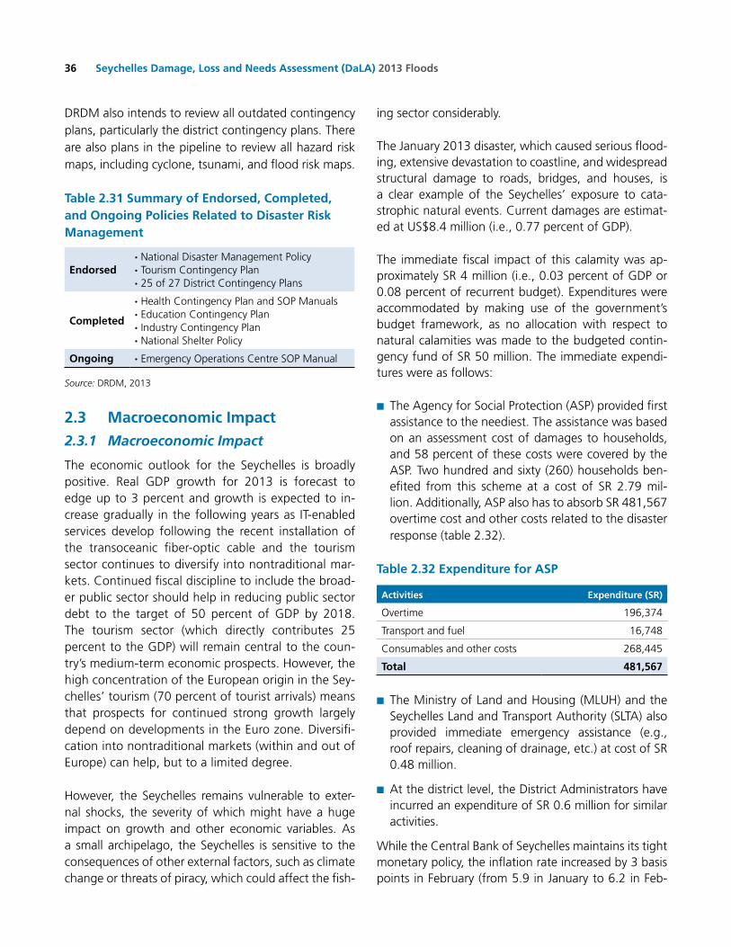
Seychelles Damage, Loss and Needs Assessment (DaLA) 2013 Floods36
DrDM also intends to review all outdated contingency plans, particularly the district contingency plans. There are also plans in the pipeline to review all hazard risk maps, including cyclone, tsunami, and flood risk maps.
table 2.31 Summary of Endorsed, completed, and ongoing Policies Related to Disaster Risk management
Endorsed· National Disaster Management Policy· Tourism Contingency Plan· 25 of 27 District Contingency Plans
completed
· Health Contingency Plan and SoP Manuals · Education Contingency Plan· Industry Contingency Plan· National Shelter Policy
ongoing · Emergency operations Centre SoP Manual
Source: DrDM, 2013
2.3 macroeconomic Impact
2.3.1 Macroeconomic Impact
The economic outlook for the Seychelles is broadly positive. real GDP growth for 2013 is forecast to edge up to 3 percent and growth is expected to in-crease gradually in the following years as IT-enabled services develop following the recent installation of the transoceanic fiber-optic cable and the tourism sector continues to diversify into nontraditional mar-kets. Continued fiscal discipline to include the broad-er public sector should help in reducing public sector debt to the target of 50 percent of GDP by 2018. The tourism sector (which directly contributes 25 percent to the GDP) will remain central to the coun-try’s medium-term economic prospects. However, the high concentration of the European origin in the Sey-chelles’ tourism (70 percent of tourist arrivals) means that prospects for continued strong growth largely depend on developments in the Euro zone. Diversifi-cation into nontraditional markets (within and out of Europe) can help, but to a limited degree.
However, the Seychelles remains vulnerable to exter-nal shocks, the severity of which might have a huge impact on growth and other economic variables. As a small archipelago, the Seychelles is sensitive to the consequences of other external factors, such as climate change or threats of piracy, which could affect the fish-
ing sector considerably.
The January 2013 disaster, which caused serious flood-ing, extensive devastation to coastline, and widespread structural damage to roads, bridges, and houses, is a clear example of the Seychelles’ exposure to cata-strophic natural events. Current damages are estimat-ed at US$8.4 million (i.e., 0.77 percent of GDP).
The immediate fiscal impact of this calamity was ap-proximately Sr 4 million (i.e., 0.03 percent of GDP or 0.08 percent of recurrent budget). Expenditures were accommodated by making use of the government’s budget framework, as no allocation with respect to natural calamities was made to the budgeted contin-gency fund of Sr 50 million. The immediate expendi-tures were as follows:
■n The Agency for Social Protection (ASP) provided first assistance to the neediest. The assistance was based on an assessment cost of damages to households, and 58 percent of these costs were covered by the ASP. Two hundred and sixty (260) households ben-efited from this scheme at a cost of Sr 2.79 mil-lion. Additionally, ASP also has to absorb Sr 481,567 overtime cost and other costs related to the disaster response (table 2.32).
table 2.32 Expenditure for ASP
Activities Expenditure (SR)
overtime 196,374
Transport and fuel 16,748
Consumables and other costs 268,445
total 481,567
■n The Ministry of Land and Housing (MLUH) and the Seychelles Land and Transport Authority (SLTA) also provided immediate emergency assistance (e.g., roof repairs, cleaning of drainage, etc.) at cost of Sr 0.48 million.
■n At the district level, the District Administrators have incurred an expenditure of Sr 0.6 million for similar activities.
While the Central Bank of Seychelles maintains its tight monetary policy, the inflation rate increased by 3 basis points in February (from 5.9 in January to 6.2 in Feb-

37chAPtER 2 ECoNoMIC AND SECTor IMPACTS AND NEEDS
ruary). This is a result of an increase in price indices across the board. While this increase may be associated with the disaster, it may also be the effect of the Value Added Tax system, which was introduced in January 2013. Taking into account the limited data availability and the international carnival that took place just after the disaster, the impact of the disaster on the foreign exchange market cannot be effectively separated out from other impacts. Again due to limited data avail-ability, the impact of the disaster on merchandise trade cannot be measured. However, tourism exports do not seem to have been affected, as tourist arrivals contin-ue to be on the increase, at an average of 15 percent above the same period of 2012.
2.3.2 Personal/Household Impact
Due to the disaster, personal incomes were affected because of illness, loss of jobs, and loss of houses. The following are three examples of personal income loss derived from available data. The average monthly sal-ary was Sr 6,987/month for all sectors in 2011, based on National Bureau of Statistics data in 2013.1
Income Loss Due to Disease
Following the flood, there was an outbreak of suspected dengue fever, hand, foot, and mouth (HFM) disease, and
1 The average for the first two quarters in 2012 was Sr 8,625/month. This report uses the lower number for 2011 to get a more conservative estimation.
diarrheal disease as a result of both the mosquito popu-lation rise and a drop in water quality. Some patients required extended hospital stays. Table 2.33 shows the estimated personal income loss due to these three dis-eases was approximately Sr 2.4 million (US$192,000), based on the assumption of average salary at Sr 6,987/month and average sick leave of one week.2
Income Loss Due to Impact on Farms
In the primary estimate of the flood, it was mentioned that 400 workers would be out of work for 10–12 weeks due to the impact on the farms. However, this informa-tion was not confirmed from the SAA. Therefore, no income loss calculation for this sector can be included.
Income Loss for women
In the gender analysis section, it was indicated that women lost days of work due to loss of childcare or other disaster-related issues, such as transport, reloca-tion, etc. Table 2.34 estimates that the total income loss for those women is approximately Sr 96,000 (approxi-mately US$7,600), based on the best available data. n
2 Usually, patients are given one week of sick leave as an average for suspected dengue cases, as well as for parents of sick children with hand, foot, and mouth disease. For diarrheal cases, patients are given 4–5 days of sick leave. Therefore, if a few cases of dengue get more than a week of sick leave, it compensates for the diarrheal cases.
table 2.33 Estimation of Income Loss Due to Disease
DiseaseNumber of
patientsAverage
sick leaveAverage salary
(SR/month)
Losses
total in SR total in uS$
Dengue 74 1 week 6,987 129,260 10,341
Hand, foot, and mouth (HFM) 1019 1 week 6,987 1,779,938 142,395
Diarrheal 287 1 week 6,987 501,317 40,105
total 2,410,515 192,841
Source: Seychelles Ministry of Health.
table 2.34 Estimation of Income Loss due to Effects of Flood (women)
Effect of flood Number of womenAverage days unable to
go to workAverage salary
(SR/month)
Losses
total in SR total in uS$
Loss of childcare or transport, relocation
55 5 6,987 96,071 7,686
Source: Seychelles Ministry of Community Development, 2013.

The proposed Recovery Framework provides a sequenced, prioritized, programmatic yet flexible approach to recovery and reconstruction,
aimed at building resilience against future floods

39
3.1 Damage and Loss Summary
According to the data reported from each affected sec-tor, the January 2013 disaster in the Seychelles resulted in Sr 65.6 million (US$5.3 million) of damages and Sr 38.9 million (US$3.1million) of losses (Table 3.1). In to-tal, the over Sr 104 million (US$8.4 million) is equiva-lent to 0.77% of the country’s GDP. The transport/road sector was affected the most (35.1%), followed by agriculture (17.1%), housing (14.1%), health (7.2%), land use (5%), and environment and industry (4.3% each).
The infrastructure sector incurred more damages than losses, as shown in figure 3.1. The social and produc-tive sectors had a similar share of damages and losses. Both personal income and cross-cutting sectors have recorded losses, but no damages.
Figure 3.1 Damage and losses
In summary, most of the flood damage was sustained by the infrastructure sector (38%), followed by produc-tive sectors (26%), social sectors (24%), cross-cutting sectors (5%), fiscal budget (4%), and personal income (3%) (figure 3.2).
Figure 3.2 Summary of the total damage and losses by groups
In terms of public and private ownership, the majority (70%) of the damage and losses is public, as the in-frastructure, education, and health sectors are publicly owned (figure 3.3). The housing sector, the industry sector, part of the agriculture sector, and income loss have been included under the private sector.
3.2 Recovery and Reconstruction Summary
The financial requirements to achieve postdisaster re-covery and reconstruction are estimated at Sr 378 mil-lion (US$30.2 million) (see table 3.2). The report makes a distinction between recovery needs and reconstruc-tion needs, with the former covering the restoration of economic flows, such as the livelihoods and gov-ernance systems and services, and the latter covering
CHAPTEr 3: CoNCLUSIoN AND rECoMMENDATIoNS
Cross-cutting 5,084,4145%
Social sectors 25,426,88024%
Productive sectors 27,532,00826%
Fiscal budget 4,351,5674%
Personal income 2,506,5863%
Infrasructure 39,592,39138%
40
20
30
10
0
mill
ion
SR
Infra
sructu
re
Socia
l sec
tor
Fisca
l bud
get
Prod
uctiv
e
Cross-
cutti
ng
Perso
nal in
com
e
n Loss
n Damage

Seychelles Damage, Loss and Needs Assessment (DaLA) 2013 Floods40
Subsector, componentDisaster effects (SR) Disaster effects (uS$)
Damages Losses total Damages Losses total
Social sectors 15,231,910 10,194,970 25,426,880 1,218,553 815,598 2,034,150
Housing 12,186,910 2,534,970 14,721,880 974,953 202,798 1,177,750
Education 2,545,000 660,000 3,205,000 203,600 52,800 256,400
Health 500,000 7,000,000 7,500,000 40,000 560,000 600,000
Productive sectors 14,152,541 13,379,467 27,532,008 1,132,203 1,070,357 2,202,561
Agriculture 9,706,788 8,129,467 17,836,255 776,543 650,357 1,426,900
Industry 4,445,753 — 4,445,753 355,660 — 355,660
Land use — 5,250,000 5,250,000 — 420,000 420,000
Tourism — — — — — —
Infrastructure 36,217,940 3,374,451 39,592,391 2,897,435 267,076 3,167,391
Transport/roads 34,600,000 2,050,000 36,650,000 2,768,000 164,000 2,932,000
Aviation 20,000 — 20,000 1,600 — 1,600
Electricity 25,000 200,000 225,000 2,000 16,000 18,000
Water supply/sewerage/sanitation 985,000 750,000 1,735,000 78,800 60,000 138,800
Police Department 156,300 — 156,300 12,504 — 12,504
People’s Defense Forces (SPDF—Army)
— 36,000 36,000 — — —
Fire rescue Services Agency (SFrSA) 431,640 338,451 770,091 34,531 27,076 61,607
Cross-cutting sectors — 5,084,414 5,084,414 — 406,753 406,753
Disaster risk management — 620,139 620,139 — 49,611 49,611
Environment — 4,464,275 4,464,275 — 357,142 357,142
Personal income loss — 2,506,586 2,506,586 — 200,527 200,527
Due to disease — 2,410,515 — 192,841 192,841
Cottage business — 96,071 96,071 — 7,686 7,686
Fiscal budget — 4,351,567 4,351,567 — 348,125 348,125
Agency for Social Protection (ASP) — 3,271,567 3,271,567 — 261,725 261,725
Ministry of Land and Housing — 480,000 480,000 — 38,400 38,400
District administration — 600,000 600,000 — 48,000 48,000
total 65,602,391 38,409,888 104,493,846 5,248,191 3,108,436 8,359,508
table 3.1 Summary of Damages and Losses for All Sectors

41chAPtER 3 CoNCLUSIoN AND rECoMMENDATIoNS
repair, rebuilding, and improvement of private and public infrastructure, as well as some investments to mainstream disaster risk management.
This estimate reflects costs for both the initial recov-ery and reconstruction needs, as well as the costs of “building back better” (BBB) and mainstreaming di-saster risk management throughout key sectors to re-duce future disaster impacts and avoid future costs. In the education sector, for example, the BBB approach would recommend the resiting of the Pointe Larue School to a location less vulnerable to future floods. In the transport sector, it could include acquisition of ad-ditional maintenance equipment. And in disaster risk management, it could include additional investments in technology and infrastructure to ensure that essen-tial communications and safeguarding of citizens can continue in times of disaster.
of the total recovery needs, the transport/road sector accounts for the most needs, with total recovery and reconstruction costs of Sr 91.5 million (US$7.3million), followed by the education sector at Sr 90 million (US$7.2million), the housing sector at Sr 70 million (US$5.6 million), and the water supply/sewerage/sani-tation sector at Sr 51.2 million (US$4.1 million).
of far greater impact for the January 2013 floods are the medium- and long-term needs for reconstruc-
tion. Here the housing and transport sectors have also borne much of the impact of the flood, though the education sector and water supply and sanitation were also seriously affected. These four sectors com-bined account for 85% of total reconstruction needs for the country. Given the need to import many goods used in reconstruction, there is expected to be a long-term impact on the economy that will not be imme-diately visible. recovery and reconstruction needs are summarized in table 3.2.
In summary, the total damages and losses for the Sey-chelles are Sr 104 million (US$8.4 million). The total needs for recovery and reconstruction are Sr 379 mil-lion (US$30.3 million) (see table 3.3).
3.3 Seychelles Disaster Resilience Framework
The current assessment indicates that the 2013 disas-ter likely occurred due to a combination of (i) changes in weather and rainfall patterns (potentially due to cli-mate change); (ii) the natural vulnerability of the coun-try due to its geomorphology; and (iii) an increased vulnerability due to a lack of compliance with and enforcement of norms and regulations, particularly in the areas of construction and land planning and use. Without clearly addressing these areas through actions to increase climate resilience, to analyze, utilize, and understand geological risk, and to enforce new and existing norms and regulations, vulnerability to future disasters will likely increase.
The assessment has confirmed the needs for the coun-try to have a more comprehensive disaster resilience program.
The calamities wrought by the January floods offer an important window of opportunity to address difficult development issues. The challenge now is to make full use of this opportunity. The Seychelles can facilitate modernization of the country, with improved living conditions for its population, or the country will be in-creasingly at risk from the impacts of floods, sea-level rise, as well as the negative impacts of possible future climate change.
Private Sr 31,020,47430%
Public Sr 73,473,37270%
Figure 3.3 Summary of total damage and losses by ownership

Seychelles Damage, Loss and Needs Assessment (DaLA) 2013 Floods42
table 3.3 total Damages, Losses, and Needs
total damages
and losses (SR) total needs (SR)
Infrastructure 39,592,391 169,468,940
Social sectors 25,426,880 171,352,811
Productive sectors 27,532,008 17,838,255
Cross-cutting sectors 5,084,414 20,214,000
Fiscal budget 4,351,567 —
Income loss 2,506,586 —
total (SR) 104,493,846 378,884,006
total (uS$) 8,359,508 30,309,920
Note: — = not applicable.
Building back better is essential, but it is not enough. While the flooding could not have been prevented, the extent of its impact could have been mitigated. reducing flood impacts in the future will require at-tention to important aspects of governance, such as land use planning, housing, water management, envi-ronmental protection, and disaster risk reduction. With more extreme weather and devastating floods likely in
the decades ahead, public safety and economic secu-rity depend on enlisting nature’s defenses along en-gineered infrastructure and strengthening vulnerable residents’ natural resource–based livelihoods and jobs.
A robust recovery and reconstruction framework is proposed to provide a sequenced, prioritized, pro-grammatic, yet flexible (living) action plan to guide the recovery and reconstruction process that is anchored in flood resilience.
To achieve this framework, it must be ensured that all stakeholders work toward a common vision for recov-ery and longer-term resilience. Guiding principles help to align recovery objectives and the actions taken to reach them. They also help to establish an overarch-ing system for recovery planning across sectors and inform the prioritization and sequencing of recovery needs. Guiding principles thus serve as a collective vi-sion of the postrecovery future and determine criteria for the recovery process. It is an opportunity to adopt best practices from past experiences. Along with the policies, standards for actions set the tone and pace for
table 3.2 Summary of Recovery and Reconstruction Needs for the Seychelles
Subsector, component
Needs for recovery and reconstruction (SR)
Recovery Reconstruction total Available Gap
Social sectors 9,998,041 160,597,654 170,595,695 — 170,595,695
Housing 9,338,041 60,206,590 69,544,631 — 69,544,631
Education 660,000 89,345,000 90,005,000 — 90,005,000
Health — 11,803,180 11,803,180 — 11,803,180
Productive sectors 8,129,467 9,708,788 17,838,255 1,909,434 15,928,821
Agriculture 8,129,467 9,708,788 17,838,255 1,909,434 15,928,821
Infrastructure sectors 52,457,940 117,011,000 169,468,940 — 169,468,940
Transport/roads 48,600,000 42,900,000 91,500,000 — 91,500,000
Aviation 20,000 706,000 726,000 — 726,000
Electricity — 20,000,000 20,000,000 — 20,000,000
Water supply/sewerage/sanitation 3,250,000 48,005,000 51,255,000 — 51,255,000
Police Department 156,300 5,400,000 5,556,300 — 5,556,300
Fire rescue Services Agency (SFrSA) 431,640 — 431,640 — 431,640
Cross-cutting sectors — — 20,214,000 18,000,000 2,214,000
Division of risk and Disaster Management (DrDM) — — 20,214,000 18,000,000 2,214,000
total (SR) 70,585,448 288,074,558 378,874,006 19,909,434 358,964,572
total (uS$) 5,646,836 23,046,965 30,309,920 1,592,755 28,717,166

43chAPtER 3 CoNCLUSIoN AND rECoMMENDATIoNS
the entire recovery process, and allow for the devolu-tion of decision making.
The formulation of guiding principles is an important part of the recovery planning exercise, and the prin-ciples identified should form the basis for recovery planning. A detailed planning exercise was not con-ducted for this particular DaLA. The principles below are adapted from other international experiences to provide a starting point for the discussion on guiding principles. Arriving at the goal of resilient recovery and resilient development involves asking a series of fun-damental questions, such as what good recovery from this disaster means and what longer-term resilience means for the Seychelles.
The following recommendations are made:
Prior assessment of flood risk and vulnerability
The first step in the flood risk management process is developing a comprehensive understanding, analysis, and assessment of flood risks and vulnerabilities that will guide flood disaster risk management strategies, urban development, and land use plans. Maps provide powerful tools to illustrate vulnerabilities and risks and assist in decision making. The assessment and maps should comprise three key elements: (i) the hazard oc-currence probability—the likelihood of experiencing any natural or technological hazard at a location or in a region; (ii) the elements at risk—identifying and mak-ing an inventory of people, buildings, or other elements that would be affected by the hazard if it occurred, and estimating their economic value where required; and (iii) the vulnerability of the elements at risk—how dam-aged the people, buildings, or other elements would be if they experienced some level of hazard.
Inclusion of flood risk management into national regulations, policies, and investments for flood prevention
Flood risk management needs to be integrated into government-financed investment programs by adopt-ing early risk identification (for instance, by applying a
quick and simple risk-screening tool) and following up throughout the design and implementation process if necessary.
It is very important that sectoral investments, especially by the government, integrate preventive risk reduction measures. This will eventually result in financial benefits.
Development of a risk-based national flood management strategy
The proposed strategy should be supported by system-atic hazard and risk exposure and vulnerability map-ping. Possible economic loss scenarios will be helpful for making decisions. Such a strategy could include the definition of resilience and resistance strategies for flood risk management. resistance strategies will aim at flood prevention, minimizing flood impacts, and en-hancing the recovery from those impacts.
Building codes could also follow risk-based assessment and “performance-based design,” which determines acceptable risk levels for different types of structures on the basis of their desired performance during and after natural hazards. risk posed by the failure of non-structural components (e.g., the loss of a facility’s ser-viceability due to damage to equipment) should also be considered. Performance-based design would result in the prioritization and more stringent design of hos-pitals, schools, and other critical infrastructure.
balance between structural and nonstructural control measures
Since structural risk mitigation alone cannot suffice for effective flood risk management and is a costly option, an integrated flood risk management strategy should be able to balance between disaster risk reduction and preparedness measures, by defining minimum or opti-mal levels of acceptable risk. Strategies should balance structural and nonstructural measures and consider the socioeconomic context in which the flood risk manage-ment occurs. Structural measures are often costly and have the potential to provide short-term protection at the cost of long-term problems. When floods occur, they tend to be of greater depth and more damag-

Seychelles Damage, Loss and Needs Assessment (DaLA) 2013 Floods44
ing than in the past. Furthermore, structural measures often provide people with a false sense of security and unawareness about the risk that remains.
Investing in nonstructural measures is often less costly and provides many additional benefits. For example, instead of investing in massive infrastructure, the city of Curitiba, Brazil, decided to implement floodplain regulations and tax incentives for protection of green space and restricted land occupation in flood-prone ar-eas of the city. It created retention ponds, parks, and recreational areas along the main river that are widely used by the population.
Institutional emergency coordination at the government and community levels
Strengthening the coordination principles for flood di-saster response and recovery focuses on the role of lo-cal authorities, communities, and other locally relevant stakeholders. In the process, it is essential to build the capacity of these stakeholders to build resilience and be able to more effectively respond to future disasters. re-ducing vulnerability to floods and disaster needs to be taken seriously by all appropriate sectoral ministries, es-pecially those involved in infrastructure investments and planning. Communities should be an integral part of any flood risk management program. The participation and involvement of the community are essential, since the ef-fects of a disaster are first felt at the level of the communi-ty, and the community is the first to respond to a disaster. Usually, the greatest numbers of lives are saved during the first few hours after a disaster occurs, before outsiders arrive. Communities that are prepared are better able to provide an effective response and to reduce the impact of a disaster. Involvement of local people promotes self-reliance and ensures that emergency management plans meet local needs and circumstances.
Emergency preparedness and response
Flood forecasts are just a small piece in the early warn-ing chain. In case of flash floods, such systems play a very crucial role in saving lives. A successful warn-ing system not only depends on forecasts, but has to connect many specialties and organizations, including
engineering, social sciences, government, news media, and the public. The melding of scientific, managerial, technological, and social components is critical. Emer-gency response education toolkits can be developed that can be easily disseminated and implemented at school and community levels, encouraging planning, simulation drills, and community participation in early warning, disaster response, and recovery.
Risk transfer and insurance mechanisms
Due to the increase in frequency and intensity of flood disasters, it is important to design mechanisms to fi-nance relief and recovery investments. opportunities can be explored for the gradual implementation of ef-fective risk transfer mechanisms to reduce impacts of disasters and to support individuals to expedite recov-ery from flood events. Insurance mechanisms should be designed in a way that they encourage beneficiaries to avoid occupation of high-risk areas, comply with build-ing standards, and further implement flood-proofing and other mitigation measures. When a disaster oc-curs, the key concern is what to do, how to do it, and how to fund it. Funds are needed immediately. Con-tingency funds enable timely and adequate financial resources for emergency purposes. In this regard, it is recommended that the government consider the es-tablishment of a Development Policy Loan with a Cata-strophic Deferred Drawdown option (CAT DDo) (see appendix 8 for more information) to ensure adequate resources are available just after the occurrence of a natural disaster.
Action Plan
Based on the above analysis and key recommenda-tions, a possible implementation plan includes the fol-lowing short- to long-term actions:
Short-term Actions (1 year)
■n repair and clean up the damaged houses and infra-structure, including roads, drainages, schools, and police station, and recover agriculture production.
■n Conduct a workshop to assess the effectiveness, efficiency, strengths, and weaknesses of the Janu-

45chAPtER 3 CoNCLUSIoN AND rECoMMENDATIoNS
ary flood response system with all the stakeholders, and make improvements for the national response mechanism.
■n Conduct a vulnerability assessment of existing infra-structure, such as bridges, roads, channels, and solid waste management plants.
■n To reduce risk of flooding,
• developorupdate thedrainagemasterplan foreach district for flood-prone areas, and
• ensure the effectiveness of operation andmaintenance of the drainage network, as well as efficient coordination between agencies.
■n Develop national multirisk mapping, including flood, landslide, rockslide, and mudslide risk.
■n Develop a community emergency response plan, a contingency plan, and evacuation toolkits, including communication strategy development and training of community-level first responders.
■n Conduct institutional function review related to di-saster risk management.
■n Identify legal gaps in national flood policies and laws.
■n Prepare and disseminate information on cost-effec-tive flood-proofing techniques.
■n review opportunities for flood risk financing.
medium- to Long-term Actions (1–5 years)
■n Prepare an integrated national disaster risk manage-ment plan.
■n Adopt a revised flood management legal frame-work.
■n Invest in essential infrastructure for maintenance of transport/roads, including upgrade of bitumen plant(s).
■n relocate key public buildings to higher ground (e.g., Pointe Larue School).
■n Conduct an assessment of the level of integration of disaster risk measures, particularly regarding climate change adaptation, into the current sectoral plans.
■n Develop new risk-based building codes and strength-en training and enforcement.
■n Prepare floodplain land use guidelines and laws; implement and enforce preventive land use plans.
■n Mainstream disaster risk management in all sectoral management plans, particularly urban development and land management (the current land use zoning plan can be potentially updated after the geological risk survey is completed).
■n Prepare a report on the economic evaluation of eco-system services, particularly with regard to vulner-ability related to climate change.
■n Identify capacity gaps and provide tailored training for staff in key ministries in disaster risk manage-ment and response.
■n Establish additional meteorological stations outside the flood-prone area.
■n Strengthen disaster monitoring and early warning systems.
■n raise awareness of flood risks and vulnerabilities.
■n Implement risk financing mechanisms with incen-tives for compliance with flood control.

Seychelles Damage, Loss and Needs Assessment (DaLA) 2013 Floods46
Appendix 1. Satellite Image of Standing water after the Flood
Source: UNoSAT.
¥¦¬
!L
!I SeychellesInternationalAirport
Estimatedwater extent
5,210 m2
Estimatedwater extent
523 m2
Estimatedwater extent10,790 m2
Estimatedwater extent
1,389 m2
Estimatedwater extent
2,486 m2
Estimatedwater extent
1,651 m2
Estimatedwater extent14,497 m2
Estimatedwater extent
2,686 m2
Estimatedwater extent
1,785 m2
AnseRoyale
Victoria
Takamaka
PortGlaud
MisereMahe
L'Esperance
De QuinceyVillage
Cascade
BelOmbre
AnseBoileau
!I
Satellite Data (1): GeoEye-1Imagery Dates: 5 February 2013Resolution: 50 cmCopyright: DigitalGlobeSource: US Geological SurveySatellite Data (2): GeoEye-1Imagery Date: 13 February 2013Copyright: DigitalGlobeSource: US Geological SurveySatellite Data (3): GeoEye-1Imagery Date: 16 February 2013Copyright: DigitalGlobeSource: US Geological SurveyRoad Data : Google Map Maker / OSM / ESRIOther Data: USGS, UNCS, NASA, NGAAnalysis : UNITAR / UNOSATProduction: UNITAR / UNOSATAnalysis conducted with ArcGIS v10.1
Coordinate System: World RobinsonProjection: RobinsonDatum: WGS 1984Units: Meter
The depiction and use of boundaries, geographicnames and related data shown here are not warrantedto be error-free nor do they imply official endorsementor acceptance by the United Nations. UNOSAT is aprogram of the United Nations Institute for Trainingand Research (UNITAR), providing satellite imageryand related geographic information, research andanalysis to UN humanitarian and developmentagencies and their implementing partners.
This work by UNITAR/UNOSAT is licensed under aCreative Commons Attribution-NonCommercial-ShareAlike 3.0 Unported License.
Contact Information: [email protected]/7 Hotl ine: +4 1 76 487 4998
www.unitar.org/unosat
This map illustrates satellite-detected areas ofstanding water observed on Mahé Island, Seychelles,in 12 separate GeoEye-1 images collected on 5February, 13 February, and 16 February 2013.Though these images were very cloudyUNITAR/UNOSAT reviewed them all for indications ofstanding water and also produced a cumulative cloudmask to indicate which portions of the island werecompletely cloud obscured. A total of 28 separatestanding water bodies were identified, totalling 41,025square meters and averaging 1,465 square meters insize. This is a preliminary analysis and has not yetbeen validated in the field. Please send groundfeedback to UNITAR / UNOSAT.
!!YSevere
Local Storm
Disaster coverage by theInternational Charter 'Space and
Major Disasters'. For moreinformation on the Charter, which
is about assisting the disasterrelief organizations with multi-
satellite data and information, visitwww.disasterscharter.org
¥¦¬Victoria
PortGlaud
AuCap
SE
YC
HE
L L ES
Production Date:07/03/2013
Version 1.0
Glide Number:ST20130212SYC
Analysis with GeoEye-1 Data Acquired 5 February, 13 February, and 16 February 2013
0 0.5 1 1.5 2 2.5 3Km
LEGEND
Map Scale for A3: 1:71,000
Map ExtentF
Primary Rd.
Secondary Rd.
Urban Rd./Footpath
!I Main Airport
!L Port
¥¦¬ Capital
Populated Place Elevation (m)High : 4000
Low : 0
Probable Standing Water
Cloud Obscured Area
Analysis Extent
STANDING WATER EXTENT ANALYSIS(Satellite-Based Analysis)
Areas of standing wateer, Mahé Island, Seychelles

47APPENDIx 2
Appendix 2. DaLA training Attendee List
ministry/ Department Name Post title Email Phone
Ministry of Social Affairs, Community Development, and Sports/Community Development
Denis rose PS [email protected] 2722600
Marie-Celine Vidot DG Community Development [email protected] 4283231
Sandra Sabury Project Superintendent [email protected] 2724169
Daniel Adeline Principal Project officer [email protected] 2722724
Davey Volcere office Manager [email protected] 2781536
robert George Attaché [email protected] 2722573
Ministry of Social Affairs, Community Development, and Sports/Gender Secretariat
Tessa Siu Senior research officer [email protected] 2571679
Ministry of Environment/EIA Section
Marie-Alise rosette Assistant Project officer [email protected] 2722486
Frank Moumou Assistant Project officer [email protected] 2722121
Ministry of Environment/CAAI
Pughazendhi Murugaiyan
Senior Project officer [email protected]
Nigel Simeon Inspector [email protected] 2723441
Ministry of Environment/ DrDM
Paul Labaleine DG [email protected] 2722101
Cliff Alissop Senior Coordinator [email protected] 2722171
regina Prosper Coordinator [email protected] 2727068
Veronique Baker Senior Coordinator [email protected] 2797305
Divina Sabino Project officer [email protected] 2722506
National Bureau of Statistics Therese Gopal Director, GIS [email protected] 4611666
Ministry of Education Charles ConfaitDG, Infrastructure and resource Planning
[email protected] 4283231
Ministry of Finance Seylina Verghese Senior Finance Analyst [email protected] 4382061
Elizabeth CharlesDirector General, External Finance Management
[email protected] 2723430
Ministry of Foreign Affairs Nan Constant Economist [email protected] 4283604
SACoS (private insurance company)
Michel Bristol Civil Engineer [email protected] 2729915
Ministry of Land Use and Habitat
Michel Laporte DCM [email protected] 2722587
Ministry of Health
Shobha Hajarnis DG Public Health [email protected] 2722298
Vincent Amelie Principal Meteorologist [email protected] 2722957
keven Furneau [email protected] 4280404
Dave Malcouzane EPr Coordinator Assistant [email protected]/ [email protected] 2595852
SFrSAJones Madeleine Station officer [email protected] 2724631
Tally Domingue Substation officer [email protected] 2594506
SPDF Franky Hoareau Captain [email protected] 2722990
SAA
Linetta Joubert (Estico)
Principal officer [email protected] 2722299
Terry Mancienne Statistician [email protected] 2778070
UNDP Preethi Nair Project officer [email protected] 2523540
Florian rock Consultant [email protected] 2548874
WHo Cornelia Atsyor WLo [email protected] 4224795
SLTA Parinda Herath CEo [email protected] 2722007

Seychelles Damage, Loss and Needs Assessment (DaLA) 2013 Floods48
Appendix 3. Seychelles’ vulnerability to climate change
Extreme Weather Events
Tropical Cyclones
Four intense tropical depressions have affected the Seychelles in recent times: tropical depression Ikonjo in May 1990, the tropical storm of September 9–12, 2002, cyclone Bondo in December 2006, and the tropical cyclone Felleng of January 27–28, 2013. The September 2002 storm had a maximum wind speed of 120 km/hr in the form of a very local ‘microburst’ on the island of Praslin and caused exceptional damage to biodiversity, general infrastructure, and houses when it made landfall. The total measurable direct and indi-
rect losses were estimated to have been in the region of US$ 86.7 million (Government of Seychelles 2004). Cyclone Bondo in 2006 had a maximum wind speed of 287 km/hr within the Farquhar island group (11.1oS). It was the first category 5 storm to make landfall in the Seychelles in 56 years. Tropical cyclone Felleng (figure A3.1) impacted primarily the islands of Mahé and La Digue and caused significant damage.
Trends
Generally, the equatorial region has been free from the impact of tropical cyclones, but it is believed that with global warming, anomalous warming will probably ex-tend into the lower latitude. Thus, conditions would become more favorable for low-latitude cyclonic devel-opment, and recent events are proof of that.
Figure A3.1 Satellite Imagery: Active clouds Associated with tropical cyclone Felleng Affecting mahé and Some of the Inner Islands on January 28, 2013
Source: Seychelles Meteorological Services 2013.
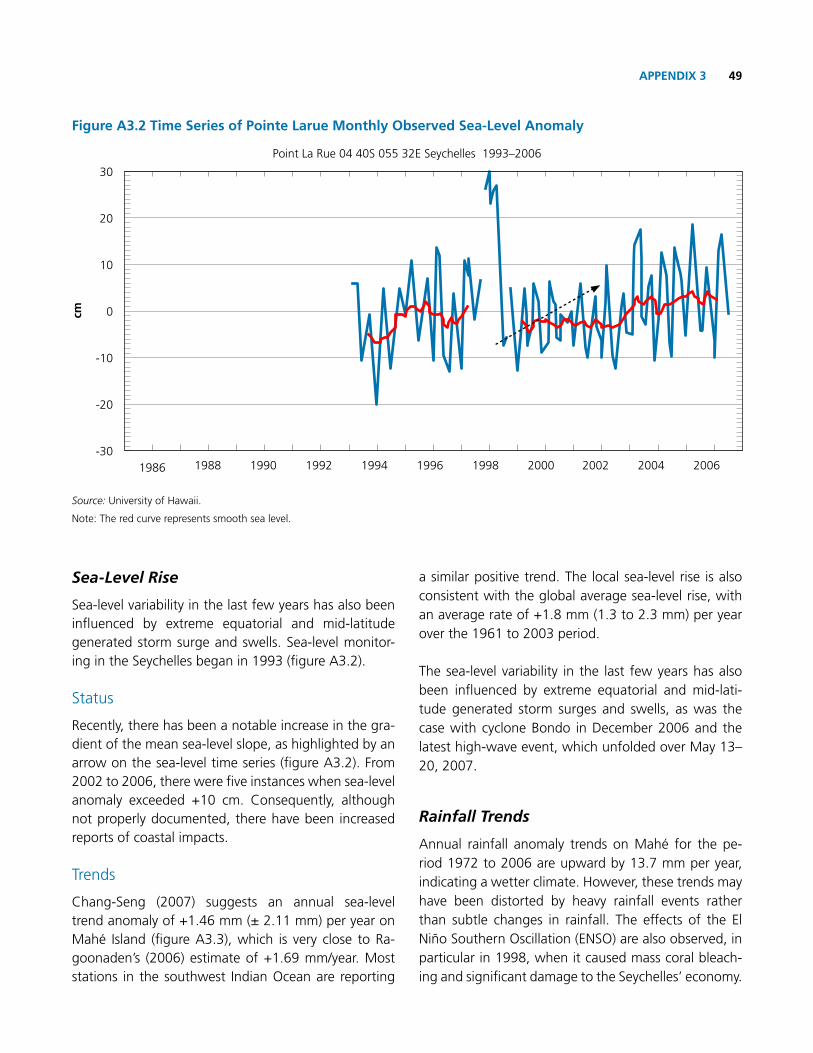
49APPENDIx 3
Sea-Level Rise
Sea-level variability in the last few years has also been influenced by extreme equatorial and mid-latitude generated storm surge and swells. Sea-level monitor-ing in the Seychelles began in 1993 (figure A3.2).
Status
recently, there has been a notable increase in the gra-dient of the mean sea-level slope, as highlighted by an arrow on the sea-level time series (figure A3.2). From 2002 to 2006, there were five instances when sea-level anomaly exceeded +10 cm. Consequently, although not properly documented, there have been increased reports of coastal impacts.
Trends
Chang-Seng (2007) suggests an annual sea-level trend anomaly of +1.46 mm (± 2.11 mm) per year on Mahé Island (figure A3.3), which is very close to ra-goonaden’s (2006) estimate of +1.69 mm/year. Most stations in the southwest Indian ocean are reporting
a similar positive trend. The local sea-level rise is also consistent with the global average sea-level rise, with an average rate of +1.8 mm (1.3 to 2.3 mm) per year over the 1961 to 2003 period.
The sea-level variability in the last few years has also been influenced by extreme equatorial and mid-lati-tude generated storm surges and swells, as was the case with cyclone Bondo in December 2006 and the latest high-wave event, which unfolded over May 13–20, 2007.
Rainfall Trends
Annual rainfall anomaly trends on Mahé for the pe-riod 1972 to 2006 are upward by 13.7 mm per year, indicating a wetter climate. However, these trends may have been distorted by heavy rainfall events rather than subtle changes in rainfall. The effects of the El Niño Southern oscillation (ENSo) are also observed, in particular in 1998, when it caused mass coral bleach-ing and significant damage to the Seychelles’ economy.
Figure A3.2 time Series of Pointe Larue monthly observed Sea-Level Anomaly
1986 1994 20021990 1998 20061988 1996 20041992 2000
Point La rue 04 40S 055 32E Seychelles 1993–2006
30
20
10
0
-10
-20
-30
cm
Source: University of Hawaii.
Note: The red curve represents smooth sea level.

Seychelles Damage, Loss and Needs Assessment (DaLA) 2013 Floods50
Projection
The Seychelles is highly vulnerable to climate change. It is concluded that it is likely (50–80%) that rainfall for the December–February season and the annual rainfall will increase, and it is unlikely to increase in the June–August season (20–40%).
In addition, as indicated by the recent event in late January, trends over the past years indicate that the Seychelles is becoming subject to more erratic rainfall patterns with short bursts of intense rain in hourly peri-ods rather than more extended periods of steady rain-fall over 2–3 days. This pattern may have contributed to the recent flooding of January 27–28, 2013, which included flooding in low-lying areas, landslides, and contaminated runoff breaking through natural barriers along the coast to the beaches and the coastal zone.
Coastal Inundation and Erosion
Seychelles’ coastal zones are under almost constant pressure from both natural and man-made causes. Anse kerlan on Praslin is a case in which human in-terference has completely destabilized the coastline. Erosion-sensitive sites on Mahé and Praslin are being lost at an average of between 1 and 3 meters per year (Tsunami Disaster Task Force 2005 and the Seychelles’
Nation 1998). Noticeable changes in the wave energy reaching the shores have occurred during the past de-cade. Greater wave energy results in greater erosion of the beaches. Climate change will exacerbate these problems and lead to further destabilization of the coastline.
Flooding in the low-lying areas is already becoming more pronounced, especially with the occurrence of storms that coincide with the spring tides. The recent floods fit within this pattern and were further com-pounded by the lack of appropriate drainage and high-density developments (as discussed in the section on damage and losses in the environment sector).
Trends
Erosion along some of the coastlines has caused the roots of existing coastal vegetation to be denuded, as is the case at Anse Sevère on La Digue, and as a result, breaks at certain spots and beach cliffs are formed. Similar effects have been seen on Mahé at Anse aux Pins beach as a result of the recent disaster.
Figure A3.3 time Series of mahé Island monthly Sea-Level Anomaly
1992 1993 1995 1997 1999 2001 20031994 1996 1998 2000 2002 2004
SLA = + 0.1426x – 284.91

51APPENDIx 4
Appendix 4. Damages and Losses for Police Services
Sector Damages or losses Location Description cost (SR) total (SR)
Police services Damage
Police Station
Anse aux Pins
Two large wooden shelves 16,000
156,300
one big wooden locker 4,000
Seven office desks 31,500
one container 9,000
one refrigerator 7,900
one deep freezer 8,000
Three wooden doors 4,500
Two extension bars 600
Subtotal 81,500
Police Station Anse royale
Fifteen corrugated iron sheets plus Screws
19,000
Twenty-seven sheets of plywood 5,400
Subtotal 24,400
Police Station
Pointe Larue
Three desks 22,500
one fridge 7,900
one wooden locker 4,000
Five wooden chairs 4,000
one large cabinet 12,000
Subtotal 50,400
SLA = + 0.1426x – 284.91

Seychelles Damage, Loss and Needs Assessment (DaLA) 2013 Floods52
Appendix 5. Detailed calculation of Needs for the Education Sector
type of school Damage Losses
crèche Primary Secondary in SR in SR
PoINtE LARuE
No. of Schools partially damaged 1 1 1
Estimation of damage 400,000 200,000 1,370,000 1,970,000
Education materials—science equipment 120,000 120,000
Furniture 450,000 450,000
Damaged wall 400,000 400,000 Damaged ground 500,000 500,000 Damaged sewage line 200,000 200,000 Damaged sewage line and piping 300,000 300,000
Estimation of losses 190,000 190,000 380,000 outsourcing extra cleaning agencies Costs for cleaning/fumigation
15,000 15,000
30,000
Unblocking of septic tank 75,000 75,000 150,000
Damaged gutters and accessories 100,000 100,000 200,000
ANSE Aux PINS
No. Schools partially damaged 1
Estimation of damage 575,000 575,000 Damaged of gutters 75,000 75,000 Damaged of septic tank 500,000 500,000
Estimation of losses 90,000 90,000 outsourcing extra cleaning agencies Costs for cleaning/fumigation
15,000 15,000
Unblocking of septic tank 75,000 75,000
Aux cAP
No. of Schools partially damaged 1
Estimation of damage Estimation of losses 190,000 190,000
outsourcing extra cleaning agencies Costs for cleaning/fumigation
15,000
15,000
Unblocking of septic tank 75,000 75,000
Damaged gutters and accessories 100,000 100,000
totAL vALuE 2,545,000 660,000
Source: Ministry of Education, 2013

53APPENDIx 6
Appendix 6. DRDm Personnel Status
Post title Qualifications work experience
Director General
CurrentlypursuingMScinDisaster&CrisisManagement
DiplomainDisaster&CrisisManagement
Senior Coordinator of DrDM 3 years
District Administrator and regional Emergency Coordinator (13 years)
Paramilitary (15 years)
Senior office Assistant
Currently pursuing certificate in office Management
City&GuildsCertificateinSecretarialStudies
Senior coordinator Diploma in Forestry Forester (14 years)
Senior coordinator
Advanced Diploma in occupational Health and Safety
Diploma in Environmental Health and Safety
Health and Safety officer (3.5 years)
Laboratory Technician (5 years)
coordinator
Emergency Care/Paramedics
Certificate in Intermediate Iridology
Paramedic (2 years)
Personal Assistant of Director General
Assistant to Doctor for alternate medicine (1 year)
Project officer
Postgraduate Certificate in Environmental Science &Technology
BSc in Geography
Project officer (1 year 6 months)
Hr supervisor (2 years)
Source: DrDM, 2013

Seychelles Damage, Loss and Needs Assessment (DaLA) 2013 Floods54
Appendix 7. Detailed Expenses for DRDmDate (Jan–Feb 2013) Item Description Qty. total (SR)
27 Lunch and dinner 8,000
28–30 Sandwiches Supplied to EoC and all first-responder agencies’ staff on site 36,950
31–4 Sandwiches Supplied to EoC and all first-responder agencies’ staff on site 21,500
5–8 Sandwiches Supplied to EoC and all first-responder agencies’ staff on site 7,475
28–29 Lunch and dinner EoC and on-site staff 98 4,900
30 Lunch and dinner EoC and on-site staff 80 4,000
27–2 Car hire Support for SLTA 3 8,100
27–7 DrDM consultant Site assessment/reports 12,500
27 Zil Air Mahé Aerial (Minister x2 persons) 17,311
31 Air Mahé–La Digue–Mahé (Minister x3 persons) 16,400
Cat Cocos Ferry Trip to Praslin 15 3,150
Groceries Tea, juices, snacks for EoC and support staff 6,056
Ferry Mahé–La Digue 315
Snacks and water on-site SFrSA staff 1,100
Fuel 145
27–28 Lunch and dinner DrDM/SFrSA and EoC 270 12,810
Boots DrDM/SFrSA and EoC 30 5,250
Torches (rechargeable/ big) DrDM/SFrSA and EoC 10 6,500
raincoats (medium) DrDM/SFrSA and EoC 10 2,250
raincoats (large) DrDM/SFrSA and EoC 10 2,750
Torches DrDM/SFrSA and EoC 10 2,500
Batteries DrDM/SFrSA and EoC 60 300
raincoats DrDM/SFrSA and EoC 30 6,725
Bottled water DrDM/SFrSA and EoC 2,046
Mosquito repellent DrDM/SFrSA and EoC 144 7,724
Long-sleeved shirts (men’s) DrDM/SFrSA and EoC 60 9,000
Gloves, raincoats, boots DrDM/SFrSA and EoC 59,932
router To increase capacity of DrDM EoC 2,500
repair of PCs DrDM 4 5,000
Fuel DrDM supply fuel coupons to all first-responder agencies 25,000
Spades/shovels DrDM/SFrSA and EoC 8,050
Peaceful sleep mosquito repellent cream
DrDM/SFrSA and EoC 243,000
La Digue accommodation
(350/day/person)
Group 1 = 350 x 9 x 7 = 22,050
Group 2 = 350 x 9 x 7 = 22,050
Group 3 = 350 x 7 x 4= 9,800
53,900
Staff round trips between Mahé and La Digue
SFrSA150,000
Coral fill SFrSA 92,000
Transportation of equipment Mahé–La Digue
SFrSA15,000
total expenses 620,139
Source: DrDM, 2013

55APPENDIx 8
Appendix 8. Development Policy Loan with a catastrophe Deferred Drawdown option (cAt DDo)
The Development Policy Loan with Catastrophe De-ferred Drawdown option (CAT DDo) is a contingent credit line that provides immediate liquidity to IBrD member countries in the aftermath of a natural di-saster. It is part of a broad spectrum of World Bank Group disaster risk financing instruments available to assist borrowers in planning efficient responses to cat-astrophic events.
The CAT DDo helps develop a country’s capacity to manage the risk of natural disasters and should be part of a broader preventive disaster risk management strat-egy. Governments determine the mix of disaster risk financing instruments based on an assessment of risks, desired coverage, available budget, and cost efficiency. The CAT DDo complements existing market-based di-saster risk financing instruments such as insurance, ca-tastrophe bonds, reserve funds, etc.
In order to gain access to financing, the borrower must implement a disaster risk management program, which the Bank will monitor on a periodic basis.
key Features
The CAT DDo offers a source of immediate liquidity that can serve as bridge financing while other sources (e.g., concessional funding, bilateral aid, or reconstruc-tion loans) are being mobilized after a natural disaster. Borrowers have access to financing in amounts up to US$500 million or 0.25% of GDP (whichever is less).3 The CAT DDo has a “soft” trigger, as opposed to a “parametric” trigger, which means that funds become available for disbursement upon the occurrence of a natural disaster resulting in the declaration of a state of emergency (Table A8.1). 3 For small island countries, the amount can be adjusted,
depending on the country conditions.
The CAT DDo has a revolving feature: amounts repaid during the drawdown period are available for subse-quent withdrawal. The three-year drawdown period may be renewed up to four times, for a total maximum period of 15 years.
Pricing considerations
The CAT DDo carries a LIBor-based interest rate that is charged on disbursed and outstanding amounts. The interest rate will be the prevailing rate for IBrD loans at the time of drawdown. A front-end fee of 0.50% on the approved loan amount and a renewal fee of 0.25% also apply.
The CAT DDo provides an affordable source of contin-gent credit for governments to finance recurrent losses caused by natural disasters. The expected net present value of the cost of the CAT DDo is estimated to be at least 30% lower than the cost of insurance for medium risk layers (that is, a disaster occurring once every three years). This cost saving can be even higher when the country’s opportunity cost of capital is greater. The CAT DDo ensures that the government will have immediate access to bridge financing following a disaster, which is when a government’s postdisaster liquidity constraints are highest. It should be complemented with disaster risk transfer instruments (such as catastrophe risk in-surance or catastrophe bonds) for high risk layers.
At a Glance
■n Provides immediate liquidity following a natural disaster, in the form of a contingent loan
■n Three-year disbursement period, renewable up to four times
■n Focuses on developing countries’ ex-ante capacity to manage natural disaster risk
■n Country must have a disaster risk management program in place

Seychelles Damage, Loss and Needs Assessment (DaLA) 2013 Floods56
table A8.1 major terms and conditions of the catastrophe Risk Deferred Drawdown option
major terms and conditions of the catastrophe Risk Deferred Drawdown option
Purpose
To enhance/develop the capacity of borrowers to manage catastrophe risk.
To provide immediate liquidity to fill the budget gap after a natural disaster.
To safeguard ongoing development programs.
Eligibility All IBrD-eligible borrowers (upon meeting pre-approval criteria)
Pre-approval criteria Appropriate macroeconomic policy framework.
The preparation or existence of a disaster risk management program.
Loan currency EUr, JPy, and USD.
Drawdown Up to the full loan amount is available for disbursement at any time within three years from loan signing. Drawdown period may be renewed up to a maximum of four extensions.
Repayment terms Must be determined upon commitment and may be modified upon drawdown within prevailing maturity policy limits.
Lending rate
Like regular IBrD loans, the lending rate consists of a variable base rate plus a spread. The lending rate is reset semi-annually, on each interest payment date, and applies to interest periods beginning on those dates. The base rate is the value of the 6-month LIBor at the start of an interest period for most currencies, or a recognized commercial bank floating rate reference for others.
Lending rate spread
The prevailing spread, either fixed or variable, for regular IBrD loans at time of each drawdown.
1. Fixed for the life of the loan: Consists of IBrD’s projected funding cost margin relative to LIBor, plus IBrD’s contractual spread of 0.50%, a risk premium, a maturity premium for loans with average maturities greater than 12 years, and a basis swap adjustment for non-USD loans.
2. Variable resets semi-annually: Consists of IBrD’s average cost margin on related funding relative to LIBor plus IBrD’s contractual spread of 0.50% and a maturity premium for loans with average maturities greater than 12 years. The variable spread is recalculated January 1 and July 1 of each year.
The calculation of the average maturity of DDos begins at loan effectiveness for the determination of the applicable maturity premium, but at withdrawal for the remaining components of the spread.
Front-end fee 0.50% of the loan amount is due within 60 days of effectiveness date; may be financed out of loan proceeds.
Renewal fee 0.25% of the undisbursed balance
currency conversions, interest rate conversions, caps, collars, payment dates, conversion fees, prepayments
Same as regular IBrD loans.
other features Country limit: maximum size of 0.25% of GDP or the equivalent of US$500 million, whichever is less.
Source: World Bank.


Seychelles Ministry of Finance Liberty House, P.O Box 313
Victoria, Mahé, Seychelles
Telephone: (+248) 38 20 00
Fax: (+248) 22 58 93
Email: [email protected]
Seychelles Division of Risk and Disaster ManagementGlobal Village, Mont Fleuri, Mahé,
Seychelles
Telephone: (+248) 467 2200
Faxt: (+248) 461 0131
Email: [email protected]
World Bank Madagascar Country Office 1 Rue Andriamifidy BP 4140
Antananarivo 101, Madagascar
Telephone: (+261) 20 22 516 73
Email: [email protected]