shell, carrington - trafford council road links, located within 2 km of the carrington spur (a6144m)...
TRANSCRIPT

SHELL, CARRINGTON
Delivery Statement
November 2009
DTZ
No. 1 Marsden Street
Manchester
M2 1HW
Tel: 0161 236 9595
Fax: 0161 835 2055

Contents
Page
1.0 Introduction ............................................................................................................................ 1
2.0 Background ............................................................................................................................ 2
3.0 The Proposals ........................................................................................................................ 4
4.0 Strategic Context ................................................................................................................. 12
5.0 Infrastructure Provision ........................................................................................................ 14
6.0 Contamination and Installations Governed by COMAH Regulations .................................. 27
7.0 Consultation Strategy .......................................................................................................... 33
8.0 Sustainability ........................................................................................................................ 35
9.0 Conclusions ......................................................................................................................... 36
Appendices
Appendix I Shell‟s Representations to the Draft Core Strategy (August 2009)
Appendix II The Carrington Masterplan
Appendix III Carrington Education and Primary Health Care Paper - DTZ (November 2009)
Appendix IV Trip Generation Tables

Page | 1
1.0 Introduction
1.1 This delivery statement has been produced in order to outline the emerging comprehensive
development proposal for Shell‟s landholding at Carrington and to demonstrate its deliverability.
1.2 It has been produced in response to Trafford MBC‟s request for further information with regard to the
deliverability of the proposals in their letter to DTZ dated 28 October 2009 and which sets-out
specific areas where detail is required following guidance from Government Office North West. This
is in the context of the emerging Core Strategy document which is currently in draft form and has
been subject to a first round of consultation. We understand that this information will be used to
assess the proposal in the light of representations made and a further round of consultation is
planned for any proposed changes to the draft.
1.3 Shell‟s representations to the draft Core Strategy document are attached at Appendix I.
1.4 This delivery statement builds on information already provided to the Council over two years of
discussions.
1.5 The structure of this document takes its lead from Trafford MBC‟s letter and is divided into a number
of sections, namely:
Background
Description of the proposal (incl. phasing and milestones)
Strategic Context/Conformity with National & Regional Policy
Infrastructure Provision (incl. community infrastructure; transportation and highways;
services)
Contamination and Installations Governed by COMAH Regulations
Consultation Strategy
Sustainability
Conclusions

Page | 2
2.0 Background
2.1 Shell are freehold owners of a significant landholding situated in Carrington, South Manchester
situated wholly within the administrative boundaries of Trafford Metropolitan Borough Council.
2.2 The site is located approximately 11 km south west of Manchester City centre and benefits from
good road links, located within 2 km of the Carrington Spur (A6144M) and 4.5 km of the M60, which
it joins at Junction 8. The site can be accessed directly from Manchester Road (A6144) via three
service roads and also from Isherwood Road to the east of the site.
2.3 The Shell Carrington Chemical works comprises approximately 126 hectares (311 acres) of former
core petrochemical manufacture and distribution (the Secure Site) together with a further 55
hectares (137 acres) which is outside the secure area and is home to a number of commercial
tenants, predominantly storage and distribution related companies (the Unsecure Site). In addition
Shell owns a further 433 hectares (1,070 acres) of agricultural land which is occupied by tenants on
farm tenancies and represents approximately 72% of Shell‟s land holdings in the area.
2.4 Much of the agricultural land to the south of the Secure Site was the subject of proposals by Shell in
conjunction with Burford Holdings for a 5 million sq ft inter-modal distribution development, including
the so called „C8 Land‟, which is potential future expansion land located to the south of the
operational site. These proposals were rejected at planning owing to the large area of green belt
that formed part of the proposed development area.
Ownership Plan
2.5 Since the 1980s Shell have been gradually scaling down their operations with the last operational

Page | 3
Shell facility closing in 2007. Two operational chemical production facilities remain and are operated
by Basell and are situated to the west of a redundant railway line which bisects the site. The
chemical plant site originally employed 3,500 workers at its peak and will soon employ in the region
of 50 workers when Basell close one the remaining facilities at the end of 2009.
2.6 Carrington Business Park situated in the former administration core of the chemical works situated
off Manchester Road comprises a cluster of office and light industrial buildings previously occupied
by Shell. These now operate as a serviced business centre. Established in the wake of a significant
reduction in manufacturing activity on site in the 1980s the business park has been a great success
currently housing 130 businesses employing in the region of 800 workers.
2.7 As a consequence of the significant reduction in the use of the site Shell are promoting a mixed use
scheme for the Carrington site which seeks to both satisfy anticipated market demand into the
medium to long term and contribute positively to the regeneration objectives of Trafford MBC in
terms of economic growth and the supply of new housing.
2.8 A masterplan has been produced by Shell‟s professional team which reflects the site‟s constraints
and builds on the opportunities that a site of this scale, in single ownership presents. This plan
identifies up to 4.5 million sq ft of employment space and up to 2,500 residential units
An indicative phasing plan based on anticipated take up and reflecting constraints, such as
achieving vacant possession on tenanted parts of the site, has been devised and these details are
outlined in more detail in Section 3.

Page | 4
3.0 The Proposals
Quantum and Mix
3.1 The proposal at Carrington is for a mixed-use development which comprises the following key
components:
Employment New employment floorspace focussing on distribution and light industrial
uses and to include a significant expansion of Carrington Business Park
Up to 4.5 million sq ft
Residential Predominantly family housing Up to 2,500 units
Ancillary Other uses that to include community facilities; local retail; schools;
health facilities; hotel; offices
Located within area
totalling 8.2 ha
Renewable Energy 50 mW bio-mass CHP Plant - Wood chip fired Up to 50 acres
Employment
3.2 The proposals for employment development recognise the site‟s location close to the M60
Manchester orbital and the relative unavailability of good quality employment/distribution sites in this
part of Manchester.
3.3 It is anticipated that heavy industry will form a small part of the scheme and will be concentrated
around the existing chemical manufacturing plant and the eventual location of a Bio-mass plant.
Residential
3.4 The mix of residential that is developed on site will be determined by local planning policy in force at
the time and market demand but it is anticipated that the mix of units will be:
2 bed mews/semis 15%
3 bed mews/semis 30%
3 & 4 bed detached 50%
Apartments 5%
3.5 This mix of units reflects the nature of the site and the anticipated market moving forwards. It also
reflects the need to provide good quality family housing in the Borough, an aspiration outlined in
Trafford 2021.
Ancillary Uses
3.6 Other uses that are anticipated will primarily relate to those uses required to service the new
housing development.
3.7 A review of the requirements for community infrastructure (education and health) has been
undertaken by DTZ and is summarised in Section 5 (reproduced at Appendix III). It is anticipated
that these users can be accommodated on approximately 3.5 hectares (8.75 acres) within a mixed-
use area identified on the masterplan.
Renewable Energy

Page | 5
3.8 The proposed 50Mw biomass plant is a proposal grounded in commercial reality - Shell and Basell
have been in discussion with potential operators who consider the Carrington site to be well served
by existing infrastructure, accessible and able to contribute to the energy needs of a growing
conurbation.
Phasing
3.9 The delivery of the proposed scheme is anticipated to take in excess of 30 years and the timing of
the proposed development is as follows:
2009 - 2012 - Preparation Phase
2013 -2028 - Phases 1- 4
2029+ - further phases (it is anticipated that further phases will be built out by 2042)
3.10 The phasing is based upon the release of land for development assuming the following take-up and
densities:
Residential - 120 units per annum (assuming 15 units per net developable acre). A slower
take-up is assumed in the first 4 years (45 units in Years 1 and 2; 99 units in Years 3 and 4)
Employment - 120,000 sq ft per annum (assuming 20,000 sq ft per net developable acre)
Ancillary - take-up based on best estimate given the progress with the scheme
3.11 In terms of the timing of the delivery of residential units the proposals envisage the following in
tranches of 5 years from 2011:
Period No Units Delivered Cumulative Total
2011 - 2016 334 334
2016 - 2021 852 1,186
2021 - 2026 852 2,038
2026 + 517 2,555
3.12 The delivery of employment floorspace is phased as follows:
Period Floorspace Delivered Cumulative Total
2011 - 2016 750,000 sq ft 750,000 sq ft
2016 - 2021 750,000 sq ft 1,500,000 sq ft
2021 - 2026 750,000 sq ft 2,250,000 sq ft
2026 + 2,000,000 sq ft 4,250,000 sq ft
3.13 The actual pace of delivery will be dictated by the level of take-up.

Page | 6
Milestones
3.14 Achieving certain milestones in line with expectations will confirm the pace of delivery as outlined
above. The masterplan as configured takes into account constraints which are timing critical and
the infrastructure that will need to be in place to release plots for development. These can be
summarised as follows:
Existing Tenancies
3.15 As outlined earlier in this document, the site is subject to a number of commercial tenancies which
are concentrated along the Manchester Road frontages (to the north of the main internal „A1‟ estate
road) and along Isherwood Road.
3.16 The masterplan is based on the assumed relocation of these predominantly storage related
business to other locations within the site. The outline phasing minimises the risk associated with
obtaining vacant possession as it recognises the expiry dates of their current leasehold interests.
Where subject to security of tenure provisions, termination of leases is anticipated to be possible
under the redevelopment ground if relocation cannot be agreed.
Relocation of Manufacturing Infrastructure
3.17 Infrastructure currently on-site which will impact on the eventual design of the overall proposals for
the site as a whole can be summarised as being:
The Flare
The remaining Basell operation utilises the flare which is located some distance to the east
of the plant at the southern edge of the secure site. The exclusion zones around this facility
are limited in their impact on employment development and the proposed residential in
earlier phases is sufficiently distant to be outside such zones. The relocation or
decommissioning of this structure is not considered to be a pre-requisite for the delivery of
the earlier phases of the masterplan and in later phases its presence or otherwise will
dictate the detailed location and design of the employment uses that are zoned for this area
of the site.
There is also potential for the eventual relocation of the flare stack closer to the remaining
manufacturing facility.
Propylene Spheres
The remaining chemical manufacturing process on site makes use of six propylene storage
spheres located along the southern edge of the Secure Site which are supplied directly
through a pipeline from the Stanlow refinery near Runcorn. The masterplan design ensures
that early phases of delivery do not require their removal or relocation. The later phases of
development will be affected by their continued presence and the detailed design will take
into account the prevailing circumstances. In general terms the areas around these facilities
are proposed for employment development which can be accommodated within the
Consultation Zones identified.
Page | 7
3.18 Further information with regard to the impact of the manufacturing infrastructure and installations
governed by COMAH regulations on the delivery of the masterplan is outlined in Section 6.
Highways Infrastructure
3.19 Details of the phasing of the highways infrastructure are outlined in Section 5. It is the intention to
significantly enhance public transport provision in the area in order that there is not an over reliance
on car borne movements. Key milestones include:
Improvements to the Flixton Road crossroads
The imminent improvements to the Flixton Road crossroads will alleviate the capacity issues
caused by this junction. Shell are co-operating in the delivery of this very important local
highway improvement as owners of land required to implement the scheme.
Construction of Link Road
Notwithstanding the Flixton Road improvements the construction of a new link road, to be
delivered across Shell owned land, is key to releasing the wider potential of the site and to
providing a wider solution for the Carrington area which will not be delivered through minor
improvements to the Flixton Road junction alone. It is anticipated that this will be required to
be delivered during the first phase of development (2013 - 2016) and being in a single
ownership is clearly deliverable.
Dualling of the Carrington Spur
It is recognised that an increase in the capacity of the Carrington Spur is required to
accommodate the increased trips generated not only by the Shell proposals but also the
other substantial development proposals proposed along the Manchester Road corridor
subject to demands on the network generated by other development. It is recognised that
this should take place during Phase 2 (in the period 2017 - 2020) to coincide with the
delivery of a certain number of dwellings and employment floorspace in line with the outline
phasing.
Public Transportation
3.20 This is seen as a key element of the overall transportation solution for the site and improvements will
be introduced throughout the development period to supplement highways improvements.
Introducing more frequent bus services will be introduced early in the process, providing links to
commercial centres and local railway and Metrolink stations, with the longer term ambition to
establish a dedicated bus-route along the route of unused railway line to run south-east towards
Timperley and Altrincham.
3.21 Further details in relation to the public transportation proposals are outlined in Section 6.

Page | 8
Urban Design
The Scale of the Challenge
3.22 The Shell site at Carrington has seen significant changes over the latter part of the 20th Century; a
contraction and consolidation of industrial chemical activity leaving substantial areas of previously
used land - now lying vacant or underused. The challenge is to define a future for the site in a way
which not only maximises the extensive brownfield land resource, but opportunities inherent within
the wider Shell landholding.
3.23 The landholding retained by Shell extends beyond the former/current operational land to encompass
surrounding countryside extending to the settlement edge of Sale West/Broadheath to the east, up
to Flixton to the north and towards the disused railway to the south, in close proximity to Partington.
Defining site potential: appreciating constraints
3.24 The scale of the opportunity provides potential to create more than simply „development‟. A new
community - a truly mixed use urban settlement - could be created here, encompassing not only
major employment uses but a substantial residential community. In masterplanning and design
terms, this potential will be determined by a number of fundamental constraints;
i. Existing occupiers
ii. Environment
iii. Infrastructure
Place making opportunities
3.25 Although constraints are significant, so is the potential to generate a scale and form of development
here that can and will create a strong, positive sense of place - an authentic and vibrant mixed use
community, comprising a network of distinctive, connected neighbourhoods.
a) A connected settlement
3.26 There is great potential to create a place that integrates with the distinctive surrounding communities
of Flixton/Urmston, Sale West/Broadheath, Altrincham and Partington. The existing Carrington site
currently creates a „void‟ between these communities, but the opportunity is to revitalise it as a
„catalyst‟ at the fulcrum of these communities. In reality there is also an opportunity and a need to
key into the social infrastructure and public transport assets already established in these locations.
It is important in particular to maximise links to train and tram links at Partington and Altrincham
respectively.
3.27 Connecting with Partington could have particularly meaningful consequences, given the ongoing
objectives to regenerate this deprived community. Benefits through literal connections (i.e.
new/improved highway and pedestrian connections) and a „connected‟ complementary land use
mix/distribution (i.e. accessible employment and training) could be significant and enduring.
b) A balanced settlement

Page | 9
3.28 The scale of development potential demands the right balance of land use, relative to strategic
policy objectives, current and future market demands, and - more fundamentally - the need to create
a sustainable place in its own right. The site is likely to play a major role in satisfying regional and
sub-regional demand for large scale employment space. However, it can also provide a significant
number of new homes. For this to be an attractive place where people would like to live and work
(and where developers would like to invest), new homes need to be balanced with local employment
opportunities, community facilities (schools, shops and healthcare) and high quality open space.
This will be a critical part of the masterplanning/place-making approach, providing a platform for a
number of different „quarters‟ and „neighbourhoods‟ which create a diverse, rich and vibrant living
environment.
c) A green settlement
3.29 With the brownfield elements being balanced by extensive Greenfield/countryside areas,
development should aim to maximise the potential for „weaving‟ green infrastructure into the urban
fabric. This can take the form of a connected green infrastructure „grid‟ - structured corridors of
green space connecting key public spaces within the development area with the open countryside
adjacent. This will be responsive to existing green elements - in particular nature reserves and
ancient hedgerows - and designed to allow different characters and functions to emerge. The scale
of opportunity and the varied land use mix envisaged establishes opportunity for a wide range of
open space and recreational functions and characters - a varied, vibrant and legible hierarchy of
spaces.
3.30 These concepts should be widened to consider opportunities on a sub-regional scale: looking at how
open spaces in and around the site relate to established strategic landscape elements such as the
Mersey Valley and the open countryside extending south towards Dunham Massey. This could
include the idea of creating a „Carrington Country Park‟ within the Shell landholding, generating a
major new open space asset for the wider community.
Above: Strategic/sub-regional open space network concept
Developing a responsive masterplan

Page | 10
3.31 An intelligent and responsive masterplan approach is needed to balance the constraints and
opportunities. The development of a number of options has helped to identify different ways in
which to achieve this balance, and understand the resulting benefits, drawbacks and consequences.
These options have been explored at a strategic level but have taken into account local, site-specific
issues - specifically considering;
The consequences of different land use permutations (including means of access/circulation
and the need for new physical infrastructure)
Scenarios for the retention and/or relocation of existing occupiers
The implications of environmental constraints (in particular the cost/benefit of land
remediation and removing industrial infrastructure such as pipelines, flare stack etc)
3.32 The options process is an integral element of the masterplanning approach; an iterative and holistic
process that provides confidence that development restrictions and opportunities have been
properly balanced, taking into account social, economic and environmental impacts, as well as the
financial and procedural aspects of delivering development (including for example planning policy
objectives).
3.33 This process has allowed a „Preferred Option‟ to emerge - an option which represents the most
beneficial balance in land use mix and distribution against the practicalities of retaining and
relocating existing occupiers, environmental constraints and opportunities and importantly the ability
to create a strong and compelling place.
3.34 The Preferred Option plan (in effect a „strategic framework‟) is attached at Appendix II. This focuses
residential development to northern and eastern edges of the site - responding to the existing
residential areas of Carrington and aiming to create a more sustainable, concentrated community
around the Manchester Road corridor, with good access to established public transport nodes in
Flixton/Sale West. There is good potential to downgrade Manchester Road and reconfigure it as a
„residential avenue‟ - a high quality, characterful and pleasant environment.
3.35 With the site likely being a focus for „strategic‟ employment development - e.g. large scale
distribution and light industrial - the approach has been to separate employment from residential
development. It is important however not to allow this to create too severe a divide - the idea must
be to promote the concept of development creating a single whole: one sustainable community.
With this in mind the transition between residential and employment is moderated by:
a) Shared green space assets - parkland that will not only provide an attractive setting for
residential and employment areas, but which will provide recreation assets for residents and
employees alike
b) Areas of more mixed, mutually compatible land use - for example an extension of the
existing business park, and a centralised „community hub‟ that could accommodate a range
of business uses, retail, education and other community/social infrastructure

Page | 11
3.36 This land use strategy has been balanced with a carefully considered highway network: a clear
hierarchy of routes (in many instances utilising existing highway infrastructure) that is not only
carefully balanced in response to land use, but has been designed to fit a logical phasing process.
With the potential to downgrade Manchester Road, its current „strategic‟ role (i.e. connecting
Partington to the main Greater Manchester Conurbation) will be transferred to other routes that are
more centrally located running through the heart of the site, for example the existing „A1‟ access
road.
3.37 The plan envisages that in latter phases - as development reaches a critical mass - it may be
desirable to implement the proposed „bypass‟ running around the southern edge of the site, linking
to a possible new Ship Canal crossing (and potentially on to a new M62 junction). This could itself
precipitate further, future development to the south - „wrapping around‟ to meet Partington, over the
long term. Such improvements are however not considered critical to the delivery of the core
masterplan proposals.
3.38 The plan includes a strong landscape structure as an integral part of the design concept. This aims
to enhance and build on existing valuable landscape features of the area as well as introducing new
high quality spaces and links. Extensive landscape serves to not only act as a buffer between
employment uses and residential areas but also provide a valuable recreational and environmental
resource that „knits together‟ the urban environment.
3.39 Furthermore, the plan incorporates a proposed biomass power plant strategically located to allow
good access but to maintain sensitive distance from proposed residential developments.

Page | 12
4.0 Strategic Context
Conformity with National and Regional Policy
4.1 The Development Plan for Carrington comprises the Regional Spatial Strategy for the North West
2008, the „saved‟ policies of the Trafford UDP, and the emerging Core Strategy. Other background
documents that have been taken into consideration in formulating the masterplan include the
Trafford Housing Strategy, the NW Economic Strategy, the Greater Manchester SHMA, the Trafford
HMA, the Trafford SHLAA and the Trafford Economic Viability Study.
National and Regional Policy
4.2 The proposals for the land at Carrington are for a mixed use sustainable community on a brownfield
site in accordance with advice and guidance in PPS1 Delivering Sustainable Development, PPS3
Housing, the consultation draft of PPS4, PPS13 Transport and PPS22 Renewable Energy. It is also
in accord with RSS Policies DP1, DP2, DP3, DP4, DP5, DP6 and DP9. The proposals for
Carrington are also in accord with Policy RDF1 and the emphasis to be placed on areas in need of
regeneration and Policy W1 strengthening the regional economy. The site will contribute to meeting
the increased housing targets for Trafford in Policy L4 and the provision of affordable housing in
Policy L5. The proposed development will deliver a Green Infrastructure to accord with Policy EM3
and contribute to Policy EM17 Renewable energy. It will meet the criteria in Policy MCR1
Manchester City Region Priorities and Policy MCR3 relating to the southern part of the Manchester
City Region.
4.3 In addition, the proposals for Carrington meet many of the objectives set out in the ODPM‟s paper -
Sustainable Communities in the North West - as it will deliver a sustainable development on
previously used land whilst not necessarily encroaching upon the countryside and green belt.
Trafford’s Economic Strategies
4.4 The proposals for Carrington will meet many of the aims of Trafford 2021: a blueprint to deliver good
quality affordable homes in a high quality safe environment with access to the surrounding
countryside, public transport and local jobs. The Council‟s Economic Assessment 2009 recognises
the potential of Carrington to deliver employment and some power/energy infrastructure
requirements for Greater Manchester and points out that improvements to public transport and some
remediation issues are not considered to be major constraints.
Core Strategy
4.5 The Core Strategy recognises Carrington as a Strategic Location for primarily employment
development. Carrington, in the broadest sense, is seen as a strategic location for development
within the timescale of the emerging Core Strategy and in accordance with Government and
Regional Policy. Shell are proposing to develop the site as a mixed use sustainable community that
will assist and promote the regeneration of the wider area.

Page | 13
Delivery of the Proposals through the Planning System
4.6 It is our view that an Area Action Plan will be the most appropriate way of bringing forward the Shell
land in a comprehensive and sustainable way as this is an area where there is a need to provide a
planning framework as significant change is proposed. The AAP can be based upon the
masterplanning, evidence base and phasing work that Shell have done to date. Such a plan will
also be a quicker way of ensuring certainty through the planning process once the land is identified
in the Core Strategy as a Strategic Site and will avoid all of delays in the statutory processes
associated with DPD‟s and SPD‟s.

Page | 14
5.0 Infrastructure Provision
Community Infrastructure
5.1 DTZ have undertaken an assessment of the requirements for Community Infrastructure on the basis
of the phased development of residential units (ranging from between approximately 1,300 to 2,400
dwellings). This assessment has concentrated on requirements for provision of education and
health and is reproduced at Appendix III.
Education
5.2 For the range identified a spatial and numerical gap analysis has identified a requirement for a
double entry primary school at the lower end of the range and an additional single entry school at
the upper end. It also identifies the need for 189 to 357 secondary school spaces.
5.3 It is anticipated that the primary schools will be located within the development itself, but that
secondary school places will be provided within a relatively short distance from the site but not
necessarily within the site itself.
Health
5.4 Again for the range identified the spatial and gap analysis identifies the need for between 2 to 3.5
General Practitioners.
5.5 For both the health and education facilities the requirements will need to be discussed with local
service providers.
Open Space
5.6 In relation to open space requirements, these will be dictated by planning policy and will be a natural
consequence of the planning application process. The masterplan includes significant areas of
open space and maintain two areas currently leased for Shell as „nature reserves‟.
5.7 In addition, as Shell‟s landholding extends to the south and east of the proposed development, the
plan offers significant opportunities to improve the quality of and access to open countryside in this
location. Improved and defined pedestrian/cycle linkages northwards to Flixton and east to Sale
West are immediate opportunities that comprehensive redevelopment bring to the area.
Transportation & Highways
Policy
5.8 The following outlines a number of relevant national and local policies which support the
development of the site in terms of transportation, accessibility and regeneration.
Planning Policy Guidance 13: Transport

Page | 15
5.9 The objective of this guidance is to integrate planning and transport at the national, regional,
strategic and local level to:
Promote more sustainable transport choices for both people and for moving freight;
Promote accessibility to jobs, shopping, leisure facilities and services by public transport,
walking and cycling; and
Reduce the need to travel, especially by car.
5.10 Paragraph 19 outlines that accessibility is a key objective to ensure that jobs, shopping, leisure
facilities and services are accessible by public transport, walking and cycling. Local planning
authorities in assessing the suitability of sites for housing development should, amongst other
things, consider their location and accessibility to jobs, shops and services by modes other than the
car, and the potential for improving such accessibility.
5.11 Paragraph 74 provides guidance on public transport to local authorities on their development plans
and determining planning applications and should include:
Identify key routes for bus improvements and priority measures;
Explore the potential and identify any proposals for improving rail travel, in liaison with the
SRA including the reopening of rail lines, or creation of new station on existing rail lines,
light rail or guided bus routes;
Identify potential for improved interchange between different transport services and between
public transport and walking and cycling; and
Negotiate for improvements to public transport as part of development proposals in order to
reduce the need to travel by car and the level of parking at such sites.
Trafford MBC UDP
5.12 The purpose of this plan is to bring forward policies and proposals for development, improvement
and conservation in a sensible, sensitive and sustainable way.
Proposal H11 - Priority Regeneration Area: Partington
5.13 The Council will take action to improve various aspects of Partington including improving the area‟s
housing stock through using derelict land for residential, community or local business use and to
improve local community transport provision and public transport links to other parts of the Borough.
Policy T1 - Sustainable Integrated Transport Network
5.14 The Council will support and encourage the development of a sustainable integrated transport
network in the Borough that is accessible and offers a choice of modes of travel to all sectors of the
local community and visitors to the Borough.
Policy T3 - Pedestrian and Cycling Route Network

Page | 16
5.15 The Council will seek to develop a network of pedestrian and cycle routes and associated facilities,
to provide convenient and safe access linking residential areas to shopping, employment,
entertainment, tourist and leisure facilities located in Town, District, Local, and Neighbourhood
Centres and other regeneration areas within the Borough that can provide an alternative means of
transport to the private car, particularly for short distance journeys.
Proposal T6 - Land Use in Relation to Transport and Movement
5.16 When considering proposals for new housing, industrial, commercial, retail, sporting, leisure,
entertainment, cultural or educational development, the Council will wish to be satisfied that it can be
made accessible to all prospective occupants and users by public bus and/or rail transport, cycling
and walking as well as by motorised traffic and does not generate a volume of motorised traffic that
would have a significant adverse impact upon the safe and efficient operation of the existing
highway network.
Policy T4 - Maintaining and Improving the Highway Network
5.17 The Council will support and encourage improvements of the Primary and Local Highway network
that will:
Modernise and improve the network to relieve congestion and improve safety on existing
roads;
Reduce the impact of motorised traffic on local roads;
Improve road safety and local conditions for pedestrians and cyclists;
Improve public transport passenger services;
Improve access, for all sectors of the local resident community, to business and leisure
opportunities; and
Open up/service development sites to encourage economic and community regeneration
particularly in Trafford Park, Old Trafford, Partington, Carrington and Broadheath.
5.18 The redevelopment of this site clearly complements these strategies and can provide a catalyst to
provide a step change in accessibility, transportation and further regeneration to the area and
provide linkages to Partington, Broadheath and Sale West.
GMPTE Land Use Planning Guide
5.19 The GMPTE have produced guidance on Land Use Planning for the Greater Manchester area, this
includes the accessibility of sites - where developments that generate significant trips, should ensure
that public transport will be provided and that walking and cycling infrastructure is provided to
encourage public transport usage by safe direct links to bus and rail stations and Metrolink stops.

Page | 17
5.20 Developers could be asked to contribute to public transport measures to: instigate new services, and
provide bus stops, busways, station improvements, information to employees/residents to promote
public transport and provisions of ticketing deals for employees/residents.
5.21 New developments should aim to ensure buses can penetrate the development and there is
convenient pedestrian access to stops and stations to ensure equal opportunities for people who do
not have access to a car and encourage people to use their cars less. The usage of services is also
dependent on frequency of services and the destinations served, links to essential facilities will
increase the catchment area of the development. In some cases additional capacity may be
required on existing public transport routes to accommodate likely demand from a new
development.
5.22 Again, investment in public transport will be a key component of the masterplan in terms of
promoting sustainable access. The scale of development and the mix of uses incorporating both
residential and employment uses support this aspiration.
Highways Agency response to the Trafford Core Strategy
5.23 The Draft Core Strategy identifies Carrington and Partington as second priority areas for locating
development to support regeneration proposals. The Highways Agency has previously commented
on the sustainability of Carrington and Partington as locations for development. If these sites can be
delivered sustainably with appropriate transport and services infrastructure to reduce the need to
travel by private car, then the Agency‟s concerns may be addressed subject to the residual car
based impact. The Agency also welcomed the development requirement for the Partington area to
improve public transport accessibility and usage in the area.
General Transportation Principles
5.24 The proposals for Carrington seek to capitalise on the need for highway infrastructure which directly
addresses the existing failings of the site. Car based commuting will consequently be discouraged
through a mixed use development which reduces the need to travel at source alongside the benefits
of improved public transport connections. The synergies associate with the mix and scale of
development facilitates the mechanisms to provide improved public transport connections. The
existing land characteristics which are defined by poor access and disconnection would be
addressed through the wider infrastructure proposals.
5.25 Smarter choices and influencing travel behaviour measures would be promoted to mitigate any
residual traffic demand. The masterplan has been developed with a phased approach to deliver the
necessary infrastructure to accommodate development. It is anticipated that there will be supporting
modelling undertaken to comprehensively assess the masterplan proposals. Initial traffic flows have
been identified and presented to the Authority for appraisal in a wider modelling and results are
awaited.
5.26 Residential would be delivered in tandem with infrastructure improvements and this use will
contribute to the financial viability of the wider employment uses and the improvement works which
are fundamental to the regeneration of Partington. The delivery of a mixed use masterplan and the
scale of development ensures that a comprehensive package of infrastructure works can be

Page | 18
delivered to benefit both existing and proposed users and helps capitalise on opportunities to
minimise car trip generation at source whilst allowing more innovative travel patterns to be
investigated, namely the conversion of the disused rail tracks to Altrincham.
Trip Generation
5.27 It was agreed at the start of Shell‟s masterplanning exercise that one of the three key development
options originally derived would be modelled by Trafford MBC/WS Atkins as a first „quantitative‟
consideration of impact upon the network of a development of this scale. The agreed trip rates used
within this scenario have been applied to the preferred option in order to provide further trip
generations. Again within this exercise a number of assumptions were made and agreed with
Trafford MBC/WS Atkins. These included the following:
Double Counting Adjustment
5.28 In order to ensure trips rates were not double counted at the site, various assumptions were made
that removed internal linked trips from the total trip rates. These internal trips were associated with
the proposed housing development, with all housing trips originating within the development itself.
Of the remaining land-uses trip rates within the development scenario, a large number of trips are
linked to the internal housing trips as will be discussed below.
5.29 Trips have been removed from the overall trip generation figure, with the assumption that 26% of
commercial generated trips will originate from within the housing on the Shell site. It is assumed
therefore that 74% of all employment will be external trips, originating outside of the development.
Public Transport Reduction
5.30 The trip rate calculations also include a 10% reduction in addition to the double counting adjustment,
to take into account the proposed public transport provisions. The proposals will include appropriate
levels of public transport to meet the demands of a development of this size, and as such reliance
on the car shall be reduced. This figure is a robust starting point, although our view is that a strong
emphasis on public/non-vehicular transport is needed to the „exemplar‟ level and therefore this
percentage could be legitimately increased with a high quality public transport oriented scheme
integral to the masterplan.
Development Scenario Testing
5.31 The masterplan development mix proposals put forward generate total 2 way car trips in the AM
peak in the order of 1,905, with this figure being around 1,895 in the PM peak. The AM peak trips
are broken down to 937 inbound and 969 outbound. In the PM peak the splits are similar with
approximately 929 inbound and 966 outbound. The trip generation table is provided as Appendix IV.
5.32 The tidal flow of the traffic is predominantly outbound in the evening. This reduces the pressures on
the exiting travel patterns where the predominant flows are traversed given the lack of existing
employment opportunities in the area. The shift of the traffic flows and the provision of employment
is of benefit to the scheme in terms of general traffic flows.

Page | 19
5.33 An important additional factor that has not yet been included in detail but has been discussed is the
trip generation potential of the site as it currently stands. In planning terms the site still has an
employment use and as such a trip generation for the site can be banked and effectively offset
against the development traffic flows described earlier.
5.34 The site previously employed 2,500-3,000 people who generated a substantial number of vehicle
trips. Whilst it may not be appropriate initially, in order to provide a robust assessment, to discount
the whole number of trips associated with this level of workforce, there would be a strong argument
that all new employment trips generated by the site under the new development mix should be
discounted. Effectively this reduces the number of trips drastically and further reduces the
pressures on the local highway network and the Carrington Spur. An estimate of the traffic flows for
the development when the new employment trips are removed indicates that the AM peak flows
would reduce to approx 773 outbound and 210 inbound. The PM peak figures would reduce to
approx 699 inbound and 343 outbound. These figures show dramatic decreases in generated trips
that in planning terms are wholly new to the network.
Highway Capacity and Public Transport Access
5.35 There is limited existing capacity on the local network and currently at peak times the area is
congested and as outlined throughout the development process it is essential to provide an extra
lane (likely each direction) on the Carrington Spur and improve the M60 at Junction 8. Each lane
has a potential „theoretical‟ capacity of 1,800 vehicles/hour. Hence supplying the above would in
theory cope with maximum „per direction‟ extra demand generated by the site. It is important to
consider however that other developments will both seek to use (and therefore have to contribute to)
such infrastructure.
5.36 Another locally focused road crossing of the Ship Canal should ideally be considered but this is not
a necessity of the scheme going forward.
5.37 Another initiative to reduce the reliance on the use of the private car and relieve the pressures on
the Carrington Spur would be the provision of an improved public transport offer. For comparison
purposes the current public transport provision to the area is outlined in the following tables:
Bus Access
5.38 There are a number of bus services providing access from the Partington area to a number of local
centres, public transport interchanges and Manchester city centre, these are shown below:
Bus Service Route Frequency
255 Partington - Flixton - Urmston - Stretford - Old Trafford - Manchester Every 30 mins
290 Partington - Flixton - Trafford Centre - Trafford Park - Manchester 1 bus per day
260 & 252 Partington - Carrington - Sale Every hour
247 Altrincham - Sinderland - Partington - Flixton - Eccles Every 30 mins
243 Partington - Urmston - Trafford Park 2 buses per day
241 Partington - Flixton - Trafford Park 1 bus per day

Page | 20
Rail Access
5.39 The closest rail station to the proposed development is Flixton, providing access to Manchester,
Warrington Central and Liverpool, local services are also accessible and include; Irlam, Glazebrook,
Birchwood, Widnes, Hough Green, Liverpool South Parkway, West Allerton, Mossley Hill, Chassen
Road, Urmston, Deansgate. The frequency of services is outlined below:
Flixton to Manchester Monday to Friday Flixton to Liverpool Monday to Friday
06.20 First Train 06.43 First Train
07.11 - 09.15 Every 30 mins 07.52
09.15 - 17.15 Every 1 hour 08.29 - 17.29 Every 1 hour
20.14 17.29 - 19.00 Every 30 mins
21.52 20.00 - 22.00 Every 1 hour
22.52 Last Train 23.43 Last Train
5.40 As shown above there are a number of services providing access to strategic locations across
Greater Manchester. However, the frequencies of these services is not adequate to supply the
development proposed, particularly in the peak periods, as the level of service is unlikely to promote
a modal shift.
Potential Improvements to Public Transport Services
5.41 As the development will provide a significant number of trips, there is an increased catchment and
demand for public transport. Outlined below are a number of improvements which can be
incorporated into the development to make the site more sustainable for other modes of transport
other than the car:
Increase Frequency on all bus routes;
Re-direct buses through the development, reducing the walking and cycling time;
Provide link buses from the new development to existing bus routes;
Express services, providing links to other public transport interchanges, e.g. Flixton Station
and metrolink stations of Altrincham, Sale and Stretford;
Improved cycle and pedestrian links to Flixton Station and local bus stops;
Increase frequency of buses to employment sites such as Trafford Park and The Trafford
Centre; and
Increased rail services at peak periods.
5.42 With these improvements the sustainability of the site will increase minimising external trips through
good land use integration on site and providing excellent public transport, walking and cycling
opportunities. The site is well placed geographically to achieve this and of a scale where such an
ethos could be created.
Committed Developments
5.43 Partington is subject to a number of committed developments around the site, these include:
Land adjoining the Manchester Ship Canal - 550 unit residential development;

Page | 21
Partington local centre;
Employment development on National Grid land; and
Paper Mill opposite National Grid land.
Gas fired power station on site of former Carrington Power Station
5.44 The applications for these committed developments include improvement to public transport through
re-routing existing services, providing new services direct to Sale Town Centre and Lymm from
Partington to increase the catchment of the services. These developments will increase the number
of residents and employees in the area therefore an increased demand for public transport services
resulting in higher increased patronage.
Phasing Delivery
5.45 Very careful consideration has been given to how such an extensive, complex development could
be phased. This is a long term project, and the masterplanning process must ensure that phasing
considerations are fully integrated. As part of the preferred option framework, phasing over a 25
year delivery programme has been considered: a time period which although long term can be
realistically visualised, and which can be aligned with Development Plan programming.
5.46 In design and masterplanning terms, phasing considerations have covered:
Development pace and capacity - how much development is likely to be built in successive
stages, and how this will affect the need to deliver complementary physical infrastructure
(especially roads);
How stages of development can maintain sense of place and integrity in their own right - i.e.
guarding against the risk that - should later phases not get developed - early phases would
not be left as „incomplete‟, compromised developments; and
Incorporating important place making elements such as green infrastructure/open
space/landscape, i.e. when and how to implement these. Developing a strong green
infrastructure network has been an important factor - especially being complementary to
development and provision of new/improvement of existing roads.
5.47 Thus the phasing rationale has been based on technical constraints, development economics and
place making objectives.

Page | 22
Phase 1 (2013 - 2016)
5.48 Phase 1 looks to establish the concept of
residential development to the north and
north east. This is about strengthening and
complementing the existing residential
community of Carrington and starting to
implement the concept of Manchester Road
being reconfigured as a more pedestrian-
friendly avenue which has a residential
character and that can become the central,
„binding‟ element of a residential community
(potentially incorporating some mixed use
elements).
As a consequence, the plan envisages a new link road from Carrington Lane to the existing „A1‟
road, meaning that Manchester Road no longer needs to function as a strategic route. First phase
employment use is located in the heart of the site - likely to be large format, distribution type uses
this would be distanced from the early residential phases yet still benefit from good access via the
improved „A1‟ road. If feasible the biomass plant would be part of this first phase.
Phase 2 (2017 - 2020)
5.49 Phase 2 looks to strengthen the
residential element through
development extending south -
maintaining proximity to existing
residential, maximising accessibility,
connecting into good quality open
space assets. Opportunities for
residential also present themselves at
the gateway to the area where the new
link road joins Manchester road. This
would see a need to further reconsider
the use of the A1, and it is proposed to
divert a new link road to free up further
employment development to the west,
connecting through with an expanded
business park. It is at this stage that
the dualling of the Carrington Spur
could take place in anticipation of the
need for more capacity as more
development is delivered on the Shell
site and elsewhere.

Page | 23
Phase 3 (2021 - 2024)
5.50 At Phase 3 it is considered that the
potential to introduce a mixed use
community hub could be realised - the
residential and employment
developments having reached a scale
that could begin to sustain such a
development. At this stage it is also
considered that complementary public
transport elements could be
strengthened due to critical mass.
Residential and employment
developments could continue to evolve,
spreading further south into a more
„green‟ setting, being sensitive to the
nature and character of the adjacent
green belt countryside. Highways
infrastructure would continue to
develop complementary to the
landscape/open space network.
Phase 4 (2025 - 2028)
5.51 At Phase 4 the pace and scale of
development may be limited to
continued expansion of employment to
the south/south west, although
additional areas of residential could be
delivered to the south east of
Partington. Complementary transport
links to enhance connectivity would
continue to develop.

Page | 24
Phase 5 (2029 +)
5.52 By this stage, development will have
generated a significant new community –
a thriving and vibrant place. Although not
essential to the delivery of the proposals
the implementation of the proposed
„bypass‟ to the south could be a
significant intervention at this stage;
creating a new sub-regional strategic
route through to and across the ship
canal. As part of this a new „country
park‟ type environment could emerge to
the east, and further development to the
south and south west could be
stimulated.
5.53 Taking into account the above we suggest the following infrastructure measures would be delivered.
Clearly we provide this as a first guide to quantum rather than detailed or assessed breakdown of
issues:
Dualling of the Carrington Spur Road and upgrading of the M60 junction 8 - the key strategic
road infrastructure needed in conjunction with the site
Busways linking Altrincham to Flixton would be the minimal likely needed. A contribution to
a segregated link to Irlam may also be appropriate
We anticipate around five key local junction upgrades and associated widening/upgrading
schemes would be delivered
Local linkage schemes would also be investigated for example linking cycle routes into
wider networks, station improvements etc
5.54 We also highlight that bearing in mind the „big item‟ nature of upgrades to the Carrington Spur and
Bus Based Transit links careful consideration of phasing will be required, since these are items that
cannot necessarily be provided piecemeal. In this respect Community Infrastructure Levy may have
a significant role to play in terms of others providing funding then development „paying back‟ for this.
Implications of this clearly need to be explored further as the scheme progresses.
Services
5.55 The capacity of existing infrastructure is a critical issue and will inform the adequacy or otherwise of
infrastructure to accommodate the scale and nature of development. Utilities companies do not give
out information on remaining „percentage capacity‟, and unlike traffic management it is not easy for
this to be considered without their input. Development of initial proposals is therefore an essential, if
somewhat iterative process with the utilities companies. At this stage the key aim has been to
establish early likelihood of fundamental problems.

Page | 25
Gas
5.56 The supply of gas to the whole site is dependent on the distribution network of National Grid. It is
not anticipated that the supply of gas to the development will present a problem, as there is a gas
works in the area with there is good distribution around the edges of the site. It is not possible to
comment on capacities for a development at this stage, but Shell should feel confident that supply to
a large residential development could be achieved. There is a medium pressure gas main that runs
along the length of the Manchester Road with low pressure gas mains from the medium pressure
main servicing housing estates and developments either side of the road. As important as the
above is the intermediate pressure main that crosses Common Lane from the gas works. This main
terminates on the development side of Common Lane and could potentially be used to supply the
site.
Electricity
5.57 The supply of electricity to the development should not present any problems. Crossing Shell‟s
wider landholding are several National Grid overhead power lines supported on pylons. These
power lines form part of the national grid distribution network across the country. Almost in the
centre of the landholding, to the east of the development proposals, is a primary substation with
supply links to the smaller substation to the north of Manchester Road. A smaller substation also
serves Carrington Business Park and also provides power supply to the surrounding area through a
network. It may be necessary to install a new substation dedicated to the development or it may be
possible to feed power to the development from the existing smaller substation on Manchester
Road.
5.58 Overhead electricity cables on pylons cross Shells‟ landholding broadly in a north-south direction
with the primary substation in the centre of the development site. Diversion of these overhead
cables are not considered necessary.
Telecommunications
5.59 The new development is likely to require significantly more telephone lines than the current capacity
of the petrochemical plant. The existing telecommunication equipment on their site is connected to
the British Telecom Exchange at Irlam and that the current incoming capacity is for 1200 lines.
AECOM experience that the telecommunications companies are more than willing to make more
lines available in today‟s competitive environment. It is possible that the provision of a large number
of telephone lines could be procured at no cost to the development.
Water
5.60 The water demands of the development may or may not exceed the spare capacity in the water
mains network. A 24 inch water main passes through their site, this is verified by the utility drawings
which indicates a trunk main at this location. The petrochemical plant‟s water demand is fed from
this water trunk main. The trunk main passes just to the west of centre from the north to the south of
the site. Record drawings also reveal that there is a second trunk main that crosses the
development site. The second trunk main starts at Manchester Road and follows the road to the
primary electricity substation on Isherwood Road and passes the primary substation and continues
across the site in a southerly direction. Although these two mains cross Shell‟s landowners, it is
impossible at this stage to know whether there is sufficient capacity in the water network to service
the development proposals from these two trunk water mains.

Page | 26
Foul Sewerage
5.61 The existing petrochemical plant feeds its sewerage to a pumping station on Manchester Road.
This pumping station not only serves the petrochemical plant but also serves Carrington Business
Park and Carrington Village. The sewerage is pumped to the Davyhulme sewerage works via a 20
inch pipe from the pumping station. The record drawings reveal that there is little foul sewer
provision across the site as a whole and that a new sewerage drainage system would need to be
installed. Whether the existing pumping station would need to be upgraded would need to be
determined. It is a possibility that a new pumping station be required for the development and if the
development is to be residential then significant foul mains will be necessary.
Surface Water
5.62 Surface water drainage is passed through oil interceptors and then discharged into the river. The
surface water for the development will also need to discharge into the river or other appropriate
water courses. The record drawings showed very little surface water drains for the area and those
that exist are highly likely to have been designed for a specific contributing area and are likely to
have no spare capacity. Within any masterplanning exercise a surface water drainage strategy will
need to consider this likelihood of limited spare capacity and work to mitigate any negative issues
arising. Once again this will be a key consideration, but something which could be developed as
part of the image and positive strategy for the site.
Petrochemical Trade Effluent
5.63 The trade effluent from the plant is currently treated on site and then sent to the pumping station on
Manchester Road. If the development is to incorporate trade effluent, this effluent would need to be
treated on site before discharging into the foul sewerage system.
Other Piped Systems on the Petrochemical Site
5.64 The following piped systems are on site: steam, firewater, instrument air, cooling water, nitrogen,
flare gas disposal and propane fuel. Useful retention of any of these would be considered
depending on retained land uses.

Page | 27
6.0 Contamination and Installations Governed by COMAH Regulations
Ground Contamination
6.1 Shell companies are committed to pursuing the goal of no harm to people and protecting the
environment. Shell advocates a tiered risk-based approach to assessing and managing impacted
soil and groundwater. The risk based approach is founded on protecting human health and
sensitive environmental habitats. It is considered best practice internationally and is the basis for
UK contaminated land legislation and regulatory guidance. It uses internationally accepted risk
assessment protocols and procedures that have levels of conservatism built into them.
6.2 Specialist advice on contamination issues at Carrington has been obtained from experts in Shell
Global Solutions International (SGSi) Soil & Groundwater team. This team of experienced
professionals provides technical advice to Shell businesses worldwide on management of
contamination issues connected with the development, operation and divestment of Shell assets
and land-holdings.
6.3 Through their involvement in the UK Sustainable Remediation Forum steering group, SGSi has
recently been instrumental in development of „A framework for assessing the sustainability of land
and groundwater remediation‟, a document sponsored by the Homes and Communities Agency,
supported by the Environment Agency and currently subject to consultation. Shell is therefore at the
forefront of current thinking on integration of sustainability principles into management of potentially
contaminated land and the Carrington masterplan has been developed with these principles in mind.
6.4 The SGSi team has been involved with soil and groundwater risk management at Carrington for
over ten years. Primarily the focus was on understanding and managing risks related to current
(and former) site operations. A Conceptual Site Model was developed which includes a high-level
understanding of the geology and hydrogeology of the site, and the likely distribution of soil and
groundwater impact. Due to the size of the site, and the fact that large areas are, or have been
occupied by operational chemical plants, detailed intrusive site investigation data is only available
for a few limited areas.
6.5 A change in use of parts of the site, as proposed in the masterplan, potentially introduces new soil
and groundwater risks which need to be managed. These have been minimised during the
masterplanning by locating residential areas away from former plant areas wherever possible.
Nevertheless, it is envisaged that additional risk management measures will be required and these
are likely to comprise a combination of source removal/treatment and pathway interception.
6.6 In support of the development proposal, SGSi used existing site information to develop an outline
risk management strategy, and high-level cost estimates. Although it is too early in the process to
define the exact scope and extent of remediation, by using conservative assumptions and taking
account of uncertainties using a probabilistic model, SGSi were able to conclude that:
i) It is technically feasible to manage the potential risks posed by contamination, and
ii) The costs involved in managing these risks are not sufficiently high to compromise the
deliverability of the scheme.

Page | 28
6.7 The potential risks presented by contamination can be considered in several categories
i. Potential risks related to direct contact with shallow soils (dermal exposure, incidental
ingestion, inhalation of dust, uptake of contaminants by edible plants etc)
6.8 It is proposed to address these risks by excavation and treatment of any shallow soils with
concentrations in excess of site specific risk based target values. The target values will be
developed by quantitative risk assessment and site investigation will be carried out to identify and
delineate any areas which need treatment. It is proposed that the bulk of soil treatment will be
undertaken on site, in a designated treatment area, using an ex-situ technique such as bio-piling.
Treated soil will be re-used within the development scheme. A small percentage of the excavated
material may be unsuitable for on-site treatment and an alternative off-site disposal route will need
to be identified.
6.9 Costs for soil treatment have been estimated using conservative assumptions about the volume of
soil which will require treatment, based on historic and proposed land use, and the likely cost per m3
of excavation, treatment and re-use of soil. A probabilistic model incorporating Monte Carlo analysis
was used to derive cost estimates. Input parameters were derived using experience and data from
Carrington and a number of similar development projects where SGSi has had involvement.
6.10 The lateral extent of soil requiring remediation was estimated as follows: For each proposed plot
included in the masterplan, the probability of contamination was ranked as low, medium or high,
based on a review of historic land use. For example
Areas ranked as „low‟ may have previously been used as agricultural land, vacant plots
within existing residential areas or as car parks
Areas ranked as „medium‟ may have previously been used as contractor‟s compounds,
boiler plants, pilot plants or laboratories. The Air Products site (situated on Manchester
Road close to Carrington Business Park) was also ranked as medium
Areas ranked as „high‟ may have previously been used as chemicals production areas, tank
farms or for other operational purposes such as flares
Where more than one category of historic land-use had occurred within a proposed plot, a
pro-rata approach was used
6.11 Assumptions were made regarding the proportion of the plot which would require remediation for
each of the categories (low/medium/high). More stringent requirements were assumed for
residential and mixed use areas than for employment and green space. For each category a low,
medium and high case was used in the model.
Residential (and mixed use) Employment (and green space)
Low
Case
Medium
Case
High
Case
Low
Case
Medium
Case
High
Case
Low contamination potential (agricultural land,
vacant plots in residential areas, car parks) 0% 5% 10% 0% 0.5% 2%
Medium contamination potential (contractors
compounds, pilot plants/labs, boiler plant, air
products)
10% 15% 20% 0% 5% 10%
High contamination potential (Production areas,
tank farms, flares etc) 50% 75% 100% 5% 10% 25%

Page | 29
6.12 In impacted areas an average excavation depth of 1m below current ground level was assumed. In
practice any impacted material at a depth of greater than 0.5m is considered unlikely to present a
risk to users. The use of a 1m average depth in the model was therefore considered to be
conservative.
6.13 The range of remediation costs produced by the model were included in the overall financial model
to demonstrate the deliverability of the development proposal.
ii. Risks related to soil vapour potentially accumulating in enclosed spaces
6.14 It is envisaged that these risks will be addressed within the development design, for example
incorporating vapour barriers within buildings and that the abnormal costs associated with this will
not be significant.
iii. Risks to groundwater and surface water bodies
6.15 Previous work at Carrington indicated that there is some hydrocarbon impact within the shallowest
water-bearing layer, generally encountered within 2m of the surface. Monitoring and modelling
indicated than the impact was confined to former production areas, and was not migrating towards
local watercourses or abstraction boreholes. In the masterplan the affected areas are proposed for
employment, rather than residential end-use.
6.16 At depth beneath the site is a sandstone which is classified as a major aquifer by the Environment
Agency. This is protected by a low permeability clay layer. Historically some hydrocarbons were
detected in the sandstone over a very limited area, at concentrations lower than those in the shallow
groundwater. Due to the limited lateral extent these substance were not deemed to pose a risk to
the aquifer resource potential in general or to specific abstractions.
6.17 It is not considered that the identified groundwater impacts present a risk to the proposed
development or the wider environment and it is therefore considered unlikely that significant
groundwater remediation work will be necessary. It should be noted that contamination
concentrations are likely to decrease over time due to natural attenuation processes. The situation
is therefore likely to have improved since the investigation was done (prior to 2005) and will improve
further over time as the development progresses towards its later phases. Some abnormal costs
may be incurred in dealing with impacted shallow groundwater encountered during construction.
6.18 A significant contingency for groundwater remediation was included in the cost model to show that
the development proposal is robust against unexpected impacts being encountered.
6.19 In the opinion of SGSi, remediation of the site, to meet risk-based criteria, is technically feasible.
The cost estimates derived for soil and groundwater remediation indicate that remediation costs will
not compromise the deliverability of the masterplan.
Installations Governed by COMAH Regulations
6.20 In establishing the redevelopment proposals for the site, Shell‟s consultancy team has had regard to
the existing installations governed by COMAH regulations that are located within Shell land holdings
and close to its boundaries. Inevitably, given the long term nature of the proposals, certain
assumptions have been made with regard to the presence or otherwise of installations into the
future.
Page | 30
6.21 Those hazardous installations defined as COMAH Top Tier sites historically identified on the Shell
owned site or in the general vicinity are:
Basell Polyolefins UK Limited
Nova Chemicals (Europe) Limited
Transco (Natural Gas) Common Lane
Transco LNG storage, Health Farm Lane
6.22 In assessing the potential impact of the various installations on development proposals we have had
regard to the following:
The HSE‟s guidance in relation to the Consultation Zones for the Carrington site (June
2001) which identifies inner, middle and outer consultation zones on a composite basis for
facilities on site
Trafford‟s own a “COMAH Off Site Emergency Plan” for Carrington (July 2001) which
identifies the various installations/operations located within the site and in the general
Carrington area and an area of risk which is informed by the various consultation zones
Trafford MBC‟s Unitary Development Plan (2006) which identifies a composite consultation
area for development control purposes
6.23 HSE Guidance identifies types of development which it would normally advise against within the
three different zones which comprise the overall consultation zone advised by them.
6.24 In summary this guidance is as follows:
Type of Development Development in
Inner Zone
Development in
Middle Zone
Development in
Outer Zone
Employment (Factory) DAA DAA DAA
Residential AA DAA DAA
Schools/Old Peoples‟ Homes AA AA DAA
Football Grounds/Large Hospitals AA AA AA
Source: PADHI - HSE‟s Land Use Planning Methodology
DAA - Do not advise against development
AA - Advise against development
6.25 In terms of the masterplan proposals, it is important to recognise the significant changes that have
taken place since the most up-to-date consultation zones were established (in 2001). The most
notable changes are:
Closure of Shell‟s manufacturing facility on site (the ODU)
Scheduled closure of Basell‟s Polyethylene Plant in December 2009
Closure of Nova Chemicals‟ facility
6.26 Basell‟s remaining activities are situated on land owned by Shell but there is a long term lease in
place and Basell‟s interests are in a continuing hazard manufacturing presence on site.

Page | 31
6.27 Updates on the Consultation Zones from the HSE which reflect these changes have not been
carried out. Trafford MBC are due to prepare an update to the COMAH Off Site Emergency Plan
which might require such updates to be undertaken.
6.28 It is considered that in terms of hazardous facilities within land owned by Shell, the situation is now
one of a stable impact with the number of installations and/or their intensity of use having declined
over time. Further changes in the extent and number of installations in the future remains a
possibility.
6.29 Basell and Shell have existing consents for the handling of certain chemicals in certain quantities.
This informs the HSE‟s determination of the consultation zone. Not all of the consents are needed
for the current operations on site. Should such consents be relinquished in whole or part, this might
reduce the extent of the Consultation Zone as far as the Carrington site is concerned. It is noted
nevertheless that the Transco Partington LNG site is a significant contributor to the consultation
zone which overlaps the Basell and Shell consents.
6.30 Looking to each of the principal uses proposed:
Residential
6.31 The residential proposals are concentrated within the area which is currently defined as being within
the Middle Zone within which HSE would not normally advise against development.
6.32 Elements of later phases of development (to be delivered in the period post 2021) are proposed
both in the eastern extent of the chemical works site (the Secure Site) and also to the south-west of
the site (close to the existing settlement of Partington). In the case of the proposals in the eastern
area of the Secure Site, parts of proposed phase are currently identified within the Inner Zone, which
we understand is established in these locations by the presence of the propylene spheres. In the
case of the longer term residential proposals located to the south-west of the Secure Site these are
located within an area of risk defined by the presence of the Transco LNG storage site.
6.33 The long term nature of the residential proposals within the currently identified Inner Zone and within
the area of risk determined by the location of the LNG storage site is such that their deliverability will
be assessed at the time. Critically the remainder of the plan is not dependent upon the delivery of
these areas of development.
Employment
6.34 The employment proposals envisage new employment development close to and immediately within
the area currently occupied by certain hazardous installations. The development of employment
uses is relatively unrestricted except for the immediate area located close to the facilities in
question. In particular, it is possible to design industrial buildings in relatively close proximity to
these facilities such that HSE concerns may be mitigated.
Page | 32
Ancillary Uses
6.35 The masterplan envisages ancillary uses particularly schools and community facilities to be situated
in a central location which currently lies within an area identified within the Middle Zone. Again, the
long term nature of these proposals is such that they will be considered on their merits at the time a
planning application is submitted. In particular, in relation to schools which are particularly sensitive
to these matters, given the relatively small land take involved, if appropriate, these facilities can be
delivered elsewhere within the plan within a less sensitive area.
Summary
6.36 In summary, the masterplan has taken into account issues concerning the impact of installations
governed by COMAH regulations and is only compromised in relation to much later phases of the
proposed scheme where the future of the relevant installations is unclear. Critically, from Trafford
MBC‟s point of view, the earlier phases of development can be delivered and detailed planning will
determine the precise configuration and location of these uses in any event.
Air Quality/Noise
6.37 Although mindful of continued (but much reduced) chemical manufacture and proposals for gas fired
electricity generation in the vicinity and our own proposals for a Bio-mass CHP Plant it is not
anticipated that air quality will be a restraining factor on the residential proposals. This is primarily
due to the strict emissions standards that are currently in force on existing and new facilities.
6.38 The proposals for employment are primarily distribution and light industrial focused. Consequently
the proposals for new non-residential development are not anticipated to adversely impact upon air
quality.
6.39 In respect of noise, again current levels and those which will arise through the development
proposals are considered to have no impact. The position is further improved through the
separation of uses and the segregation of traffic that the masterplan promotes.
Ecology
6.40 There have been no specific ecology assessments of the site in relation to the masterplan
proposals. However, the environment is such that it is not anticipated that this will be a habitat for a
wide range of wildlife. Exceptions to this may be wooded areas to the east of the site which are
leased to local environmental groups. This group (The Shell Pool Reserve Conservation Group)
undertake an annual bird survey across the whole site and the most recent of their surveys can be
made available if required.

Page | 33
7.0 Consultation Strategy
7.1 In all developments an important element to the overall success of the final scheme is the
involvement of the wider community. This is especially the case at Carrington where the masterplan
will address significant social, economic and environmental change over a long period. It will
therefore be important to ensure that the process of consultation is as inclusive and transparent as
possible and, that the masterplan has widespread support.
7.2 The planning system recognises that the involvement of communities in the design and
implementation of major regeneration schemes is a key ingredient to success and will help that plan
to have a smooth transition through the planning process. Shell recognise and understand the
importance of community engagement and their approach at Carrington reflects the realities of local
circumstances, seeking to engage with neighbours, businesses and other stakeholders at an early
stage in the process in partnership with the Council.
7.3 Key objectives for Shell as part of the consultation process at Carrington include:
Building trust and confidence amongst the local community
Drawing upon local knowledge to create a successful masterplan
Seeking consensus between the Council, local community and key stakeholders
Maintaining dialogue and communication
7.4 Integral to the overall approach will be the need to ensure that the local communities fully
understand the process of producing a masterplan for the site, the policy context within which it is
prepared and the timescales that are involved.
7.5 Shell‟s approach will:
Demonstrate a clear and transparent process
Ensure that the wider community is kept aware of the emerging proposals
Ensure that the communities views and priorities are fully understood and taken into
account
Identify and resolve any contentious issues that may arise as the masterplan develops
Make the involvement in the masterplan process both stimulating and interesting
Use whatever consultation techniques are appropriate at the time
7.6 There is a wide range of consultation techniques that can be used in the masterplanning of
Carrington and Shell have already engaged with a number of stakeholders and propose to continue
this engagement as the masterplan develops. There have been a series of one to one meetings
and presentations with Trafford Council at both Member and Officer level and a number of meetings
with Statutory Undertakers. Meetings are also planned to brief local MPs before the forthcoming
General Election in May of next year.

Page | 34
7.7 Meetings have also been held with both Carrington and Partington Parish Councils, the Carrington
Liaison Group, Carrington Business Park, Manchester United and Manchester City Football Clubs
and Sale FC. There are other meetings planned and future consultation will also be co-ordinated
with the Council‟s emerging Core Strategy proposals as part of that statutory process.
7.8 For the next few months the consultation strategy will inevitably be driven by the Council‟s
publication of their Core Strategy, however Shell will play a positive role in that overall process and
will wherever possible promote their masterplan for their land holding at Carrington.

Page | 35
8.0 Sustainability
8.1 Shell is committed as a company to sustainable regeneration and the proposed development at
Carrington will be a demonstration of that commitment. Sustainable development is one of Shell‟s
Key Business Principles.
8.2 The sustainable regeneration of Carrington as a mixed use community is a fundamental driver for
the work undertaken by Shell and their consultants to date on the development of the site and the
principles of sustainable development are embedded in the emerging masterplan.
8.3 The principles that underpin Shell‟s commitment to sustainable regeneration at Carrington include:
Maximising the beneficial use of brownfield land ensuring that well considered sustainable
and comprehensive proposals evolve, in consultation with the Council and in accord with
emerging policy to deliver physical, economic and social change
Providing new and improved infrastructure and utility platforms to create the basis for the
existing and future sustainable community at Carrington
To create a positive framework of investment to attract and stimulate other private sector
investment into the wider area
To provide real local opportunities for new and diverse jobs and to encourage commercial
activity to be created in the area
To transform the environmental quality of the area to make it a place where people will want
to live work and spend their leisure time
To strengthen local community cohesion by bringing people together and building civic pride
in the existing and emerging communities
Establishing a sustainable community with a mixed and balance population with the
appropriate levels of community and social infrastructure as the community grows
8.4 All of these aims will be delivered through the sustainable mixed use community at Carrington by the
Council and Shell working closely together to realise the opportunity and the challenge that is posed
by the landholding at Carrington.

Page | 36
9.0 Conclusions
9.1 In conclusion, the proposals represent a unique opportunity for Trafford MBC to deliver their
aspirations in terms of increasing the quantity, quality and range of housing and boosting economic
growth - through a sustainable mixed use development.
9.2 This statement outlines the deliverability of the Carrington site as the location for an employment
development of sub-regional/regional significance and an area of substantial new housing to meet
the needs of the local community in providing housing choice within a safe and attractive
environment.
9.3 The key factors that underline the deliverability of the site for the masterplan proposals are as
follows:
The site is in single ownership;
Other Shell landholdings enable the delivery of key transport infrastructure to unlock the full
potential of the site (and the potential of this area of Trafford);
The 25 year masterplan focuses on early years delivery of areas which are demonstrably
deliverable in terms of market demand, accessibility and technical feasibility;
The later phases of development build upon the successes of the earlier phases and are
similarly based on a sound assessment of market and technical issues - the detail of which
will be dictated by the circumstances prevailing at the time; and
The mix and quantum of uses are such that costly infrastructure improvements can be
funded to deliver a truly integrated mixed use scheme.
9.4 In addition to the contribution that Shell‟s site at Carrington makes to the future health and vitality of
the Borough, the opportunity exists to develop an exemplar brownfield regeneration scheme which
meets and could exceed the aspirations set-out in Government Policy;
Sustainability - Shell are committed to sustainable development and this is one of the key
Company-wide objectives
Brownfield land - the Shell land holding at Carrington is a large brownfield site in single
ownership with an owner who wishes to promote the site for a sustainable mixed use
development
Regeneration - the Shell site at Carrington is key to releasing the regeneration of both
Partington and Sale West, two areas within Trafford identified as regeneration priorities
Economic Development - the Shell land at Carrington will deliver sites that are suitable,
available and deliverable for employment uses creating both local jobs and wealth for the
Borough
Housing - the Shell site at Carrington will deliver land for a range of house types and
tenures and it is suitable, available and deliverable

Page | 37
Public Transport - the development of the Shell site as a mixed community in phases will
enable a comprehensive public transport system to be developed to serve the site and the
surrounding area improving accessibility for the whole community and overtime offering a
realistic alternative to the use of the private motor car for existing and future residents
9.5 Shell can and will deliver their Vision for Carrington as set out in this statement.

Appendix I
Shell’s Representations to the Draft Core Strategy (August 2009)

Trafford Core Strategy Further Consultation on Preferred Option
August 2009
DTZ
No. 1 Marsden Street
Manchester
M2 1HW
Tel: 0161 236 9595
Fax: 0161 835 2055

Contents
Page
1.0 Introduction ............................................................................................................................ 1
2.0 The Preferred Option ............................................................................................................. 4
3.0 Conclusions ......................................................................................................................... 13

Page | 1
1.0 Introduction
1.1 We are instructed by Shell International Ltd to act on their behalf in respect of their land holding at
Carrington, and to make representations to the further consultations on the Preferred Option Core
Strategy recently published by Trafford Borough Council. We will respond to the Preferred Option
document in the order of topics as published.
1.2 We have been in discussion and working with the Council for the last 18 months in respect of the
long term future of the land at Carrington and, in consultation with officers, have prepared a
Masterplan Vision for the site. We have recently made presentations of this Vision to the Senior
Officer Management Team, the Executive Members, the Carrington Liaison Group, Carrington
Business Park Board, Carrington and Partington Parish Councils, Basell Polyolefins and Manchester
United.
The aim of that Vision is to produce a sustainable mixed use development on this large
brownfield site at Carrington over the next 25 years that is achievable and deliverable.
1.3 To understand the context of Shell’s representation and the Council’s formulation of their Preferred
Option and the policies contained therein, it is necessary to refer to both the National and Regional
policy background as well as commenting upon the strategy itself.
National Policy Context
1.4 The National Policy context is well known, however it is worth reminding ourselves of the main thrust
of that policy is to deliver sustainable development that makes the most effective and efficient
use of land. PPS3 sets out the Government’s objective to ensure that the planning system delivers
a flexible responsive supply of land for Local Authorities to ensure that sufficient, suitable land is
available to achieve their housing and previously developed land delivery objectives. Deliverable
sites should, at the point of adoption of the relevant Local Development Document, be:
Available - the site is available now
Suitable - the site offers a suitable location for development now and would contribute to
the creation of sustainable, mixed use communities
Achievable - there is a reasonable prospect that housing will be delivered on the site within
five years
The land at Carrington within Shell’s ownership meets all of these criteria, with the added
bonus of the opportunity to create a new sustainable community around the existing housing
and employment at Carrington.

Page | 2
1.5 The recent consultation paper on Planning for Sustainable Economic Development (PPS4) points
out that the planning system affects productivity and employment, the two drivers of economic
growth, and influences wider economic objectives such as regeneration and the provision of new
housing which contribute to the quality of life. The planning system affects investment by providing
certainty of land use and improvements in infrastructure. When firms and individuals are sure of the
future use of their own and surrounding land then they are more likely to commit to investment. Well
planned infrastructure improves productivity, for example by cutting journey times and so increasing
labour mobility, and creates environments in which people want to live and work. The Government’s
key policy outcomes include delivering sustainable development and building prosperous
communities by improving the economic performance of local areas, promoting regeneration and
tackling deprivation.
1.6 The Government does, however, recognise that there is a limit to the extent local planning
authorities can predict the future of their local economies and so a flexible approach to the supply
and use of land will be important. It should also be noted that in the context of this advice, economic
development includes housing and energy production as well as major employment attractors such
as hospitals and higher and further education establishments. Local Planning Authorities are
therefore encouraged to plan positively and proactively to encourage economic development in line
with the principles of sustainable development. In particular, authorities are advised to develop
flexible policies which are able to respond to economic change and the need for co-ordination with
infrastructure and housing provision.
1.7 A recent report following research conducted by the Government’s housing advisor, the National
Housing and Planning Advice Unit, has said that Government forecasts for housing supply should
be increased by at least 6,300 extra homes a year between now and 2031. This report was
published on the 30 July 2009 and NHPAU is calling on Government to revise its housing supply by
between three and five percent. It argues that at least 237,800 new homes are needed every year
between now and 2031 and that these figures should be used to inform regional plans. Steve
Nickell, the chair of HHPAU warned of serious economic and social consequences if the backlog of
unmet housing need is not tackled. No allowance is currently made within the Core Strategy
Preferred Option for this forecast increase in demand.
Regional Policy
1.8 The principles of promoting sustainable communities and sustainable economic development
together with the marriage of opportunity and need in Policy DP1, underpin the Regional Strategy
and building sustainable communities where people want to live and work is a regional priority. The
Spatial Principles set out in the RSS apply to all plans and strategies in the North West. One of the
priorities of the Manchester City region is to accommodate housing development in locations that

Page | 3
are accessible by public transport, to areas of economic growth and in the southern part of the
Manchester City Region to create attractive and sustainable communities where residential
development is to be allowed to support local regeneration strategies and to meet identified local
needs.
Our proposals for Carrington represent an ideal marriage of opportunity and need, a large
area of brownfield land becoming available in parallel with the preparation of the Core
Strategy and an increase in housing numbers required by the Growth Point Agenda with the
delivery of a sustainable mixed use development.

Page | 4
2.0 The Preferred Option
Part B - Section 3 - The Vision for Trafford
2.1 The Council recognise that Trafford is one of the main economic drivers in Greater Manchester sub-
regional economy with major long established industrial estates at Trafford Park and Carrington.
However, the nature of these areas are rapidly changing and therefore any plan must be flexible not
only to respond to the changes that are currently taking place but also to create long term certainty
and sustainability in places like Carrington improving accessibility, choice and the quality of life.
2.2 The Council point out that spatial planning is about producing outcomes for places and they have
split Trafford into a number of places that they consider are locally distinct. Carrington is one of
those distinct areas and its spatial profile acknowledges that the existing transport infrastructure is
very limited and that it has been traditionally dominated by a long established petrochemical works
that are now in decline. The profile goes on to acknowledge the scale of the brownfield land asset
and its potential for economic regeneration. The associated ‘’place objectives’’ seek to ensure that
there is an appropriate mix of homes to meet the needs of the community, to secure improvements
to public transport and to improve accessibility of the wider area by providing a link across the Ship
Canal and improvements to the linkages to the motorway. The Council also wish to maximise the
potential of this employment area and the re-use of the under used, unused and derelict land. It is
our strongly held view that in order to achieve all of their ‘place objectives’, particularly the major
improvements to infrastructure, then these can only be delivered by a mixed use sustainable
development of the brownfield land that will also help to bring about the regeneration of Partington.
The mixed use development of Carrington is key to delivery of the regeneration of the
substantial area of brownfield land within Shell’s control but also the infrastructure required
to open up the wider area.
2.3 ‘’The Core Strategy Vision of the Council is to create vibrant and inclusive, prosperous and well
designed residential communities within the Borough. Regenerating our most deprived areas of the
Borough will play a role in supporting sustainable patterns of living and growing balanced
communities.
2.4 We will establish a range of house types and tenures in sustainable locations ensuring good access
to jobs and services appropriate to the scale of the neighbourhood..........
2.5 We will focus key commercial, business and community services in the town centres, Trafford Park
and Carrington to establish and maintain them as places to work and to support the wider City
Region economy.’’

Page | 5
It is our submission that the Council are missing a major opportunity in the Preferred Option
to create a truly sustainable, vibrant, prosperous, well designed and deliverable mixed use
community on the brownfield land at Carrington in accord with both national and regional
policy.
Section 3 - Strategic Objectives
2.6 Table 1 in the Strategy sets out the Council’s strategic objectives and it is our submission that a
mixed use development at Carrington would meet six of the eight objectives as follows:
SO1 - The site at Carrington will provide sufficient family housing throughout and beyond
the plan period to meet the Borough’s needs and will create a sustainable community linking
housing with employment and the supporting social infrastructure
SO2 - The development of a mixed use community at Carrington will have positive
regeneration benefits not only for Carrington but also for Partington creating a range and
choice of jobs and housing with improved accessibility and public transport
SO3 - Carrington can as a mixed use development deliver a range and choice of
employment opportunities in this sustainable location. It is our intention to retain all of the
existing jobs on site in addition to creating a range of new employment opportunities
SO4 - Not relevant
SO5 - The Shell ownership at Carrington includes a significant amount of green space
which through a masterplan for the wider area be protected and enhanced increasing local
accessibility but also creating linkages to the wider area
SO6 - The promotion of a ‘’significant’’ level of mixed development on the brownfield land at
Carrington will reduce the need to travel and improve accessibility
SO7 - The development at Carrington, because of its scale and the timescale for the overall
delivery, will include new technologies such as Biomass and innovative waste management
to combat climate change and to minimise the impact on Trafford’s resources
SO8 - Not relevant
2.7 The Preferred Option Spatial Strategy is, in the Council’s words, a ‘’hybrid option’’ and is being
advanced as the ‘’most deliverable’’ option concentrating growth towards the Regional Centre, the
Inner Areas, Altrincham Town Centre and the Priority Regeneration Areas. Growth will be shared
across the areas of Partington, Carrington and Sale west.

Page | 6
Carrington is deliverable as a mixed use development, as proposed by our Vision, that will
meet the majority of the Council’s strategic objectives because it will be of a scale sufficient
to generate the investment required to improve accessibility and the infrastructure in the
area, to open up Partington for regeneration and to offer a choice and range of housing and
employment opportunities within the area minimising the need to travel. Combine these
factors with the opportunities for on-site energy generation, improvements to public
transport, a green space strategy and technical innovation and the resulting development
over the next 25 years will be at the forefront of sustainability.
Part C - Section 5 - Core Policies
Policy L1 - Land for New Homes
2.8 The Council are proposing to release sufficient land to accommodate 11,800 new dwellings however
this figure would appear to exclude the four strategic sites that should, in theory, deliver an
additional 2,150 units totalling 13,950 dwellings. The forecasted numbers in Table 4 in the SHLAA
2009 review, which includes both the Strategic Sites and Strategic Locations the total number of
units is only 7,357.
2.9 It is worth noting that Table 4 in the SHLAA does not include SL6 Trafford Centre Rectangle which is
listed in Table L1 in the Core Strategy as producing 1,050 units, however even with this addition the
total figure in Table 4 only increases to 8,407, some 3,000 units less than that proposed in Policy L1.
Furthermore, there does appear to be some double counting with regard to SS4 Partington
Canalside and SL9 Partington. Table L1 lists a total number of units of 850 from SL9 (which
includes 550 from the Strategic Site SS4). Table 4 in the SHLAA appears to indicate that a total of
1,004 units will result from the development of the Strategic Location and the Strategic Site.
It is not clear from the information that is in the public domain how the site capacities have
been calculated and why there are discrepancies between the figures in the Core Strategy
and the SHLAA.
2.10 Policy L1 indicates that of the 11,800 dwellings 42% (4956) will be provided within the Regional
Centre and Inner Areas, therefore 58% (6844) will have to be provided elsewhere. Of the sites
identified in the SHLAA outside the Regional Centre and the Inner Areas the total number of
dwellings identified in Table 4 is 1,936 an apparent shortfall of 4,908 dwellings? Table 1 appears to
indicate that some 3,900 dwellings will be forthcoming from other South City Region Sites, although
these are not identified and would appear to produce a remarkably consistent 1,000 units for each
period of the plan. Even if this were to be the case there still appears to be a shortfall of 1,000
dwellings between the Table L1 and Table 4 in the SHLAA.

Page | 7
The figures in the SHLAA, that represent a 2009 Review, do not tally with the figures in the
policy and must raise questions over delivery, suitability and achievability.
2.11 In the Core Strategy the Council have identified 11 Strategic Housing locations and four Strategic
Housing sites. Of these 15 sites, seven (46%) are in the ownership or control of a single land owner
who it is anticipated will deliver 4,550 (62%) units out of the 7,300 proposed in the Strategic
Locations and 1,600 (75%) of the 2,150 units on the Strategic Sites. At the top of the housing
market, but particularly over the next three to five years, it is difficult to envisage a single landowner
wishing to bring forward seven separate sites, probably with a similar mix of units, all of which will be
in competition with each other. The Council’s anticipated commencement dates on each site must
be seriously questioned as is their ability with the current allocations to meet their 5, 10 and 15 year
targets.
Carrington will provide an alternative location for the development of housing in association
with jobs, that is achievable, available and deliverable.
Policy L2 - Meeting Housing Needs
2.12 Policy L2 requires developers to make a contribution to the creation of mixed and sustainable
communities; to be adaptable to the needs of residents overtime and; to increase the provision of
family homes in the north of the Borough, particularly larger properties of 3 or more bedrooms.
2.13 A mixed use development at Carrington will create a sustainable community that can be adaptable
to the needs of residents overtime and, whilst not located in the north has the capacity to provide a
range of family homes. It is difficult to interpret from the published information the mix of dwelling
types proposed on each site and it is difficult to calculate comparative densities however, from the
information available it would appear that in the North and Inner Areas the dwelling mix will be as
follows:
SL1 Pomona - 1,500 apartments
SL2 Trafford Wharf - 900 apartments
SL4 Lancashire County Cricket Club - 900 apartments
SL6 Trafford Centre Rectangle - mix of apartments and family housing - 500 family houses
and 500 apartments
SL7 Stretford Crossroads - mix of apartments and family housing - 125 family houses and
125 apartments
SS1 Victoria Warehouse - 400 apartments

Page | 8
SS2 Trafford Quays - mix of apartments and family housing - 525 family houses and 525
apartments
2.14 Assuming this breakdown is correct, then of the 6,000 units proposed only 1,150 (19%) will be family
housing. This hardly meets the requirements of Policy L2 which seeks to encourage a range of
family houses. The remaining 4,850 apartments will be in direct competition not only with each
other but also with the large number of apartments proposed immediately to the north in and around
the Quays in Salford. There is an existing oversupply of apartments in the Manchester City region
which is evidenced by the markets lack of appetite for apartments, the demise of many city centre
developers and the fact that none of the major housing development companies intend to construct
any apartments in the foreseeable future. In addition the large number of apartment consents in the
neighbouring area around Salford Quays that have yet to be implemented and the Banks reluctance
to fund such schemes brings into question the feasibility of these allocations and the delivery of this
large number of apartments in the northern area of Trafford.
Contrary to the claim in paragraph 7.3 of the Preferred Option the policy as drafted with the
locations and sites identified cannot and will not in our opinion deliver a balanced housing
offer.
Policy L3 - Regeneration and Reducing Inequalities
2.15 Partington is effectively at the end of a cul-de-sac and its regeneration is primarily linked to land
allocated for residential development and associated improvements to its shopping centre. There
are no employment proposals proposed as part of the regeneration and there is no possibility of
improving highway and public transport access to the area.
Carrington and its redevelopment as a mixed use sustainable community holds the key to
the successful regeneration of Partington because the scale and mix of the proposed uses at
Carrington can be delivered with the associated infrastructure improvements, community
benefits, access to green space and the improved public transport connections.
Policy L4 - Sustainable Transport and Accessibility
2.16 The Vision for Carrington will deliver a number of transport and accessibility improvements, however
we have made it clear that this site alone cannot deliver all of the improvements envisaged in the
Plan. For example the new crossing over the Ship Canal is within the gift of others and will be
dependent on links to the M62 and the release of land within Salford for development. In fact there
are a number of developments approved or proposed in and around the Carrington area that can
collective contribute to the delivery of infrastructure. However, the land within the ownership of
Shell and included within our Vision can deliver a significant element of the infrastructure
requirement that will help to regenerate Partington.

Page | 9
Policy L5 - Climate Change
A mixed use development at Carrington will be sustainable and will adopt a number of
measures to reduce carbon emissions.
2.17 As well as sustainable construction there is real potential for Biomass low carbon energy generation
on the site and this opportunity has already been discussed with Trafford and will be explored in
greater depth by Shell over the next six weeks. We understand that there is work currently taking
place on flood risk although the Shell site has not to our knowledge flooded over the past 60 years.
Policy L6 - Waste
2.18 A biomass plant has potential to use a significant amount of recycled timber and off cuts that would
otherwise go to landfill and could therefore help to reduce the amount of waste generated in the
region.
Policy L8 Planning Obligations
2.19 Any planning obligations must have regard to the economic viability of the scheme to which they
relate and cannot be imposed on an inflexible basis as this could seriously affect the delivery of a
development. The policy in paragraph L8.3 lists a large number of contributions that may be
required however the scale and nature of any contribution must be reasonable and related to the
development proposed.
Policy W1 - Economy
2.20 We support the Council’s policy to identify sufficient quality and choice of land to deliver new
employment however would suggest that the spatial distribution of employment land should be more
closely aligned to the provision of land for housing and where possible, such as at Carrington, be
linked as mixed use developments in order to create the opportunities to reduce the need to travel.
In our view this policy should be closely linked to other policies that refer to sustainability
and reducing the need to travel, two key components of our Vision for Carrington.
Policy R3 - Green Infrastructure
2.21 We support this policy and have already discussed with the Council’s Green Strategy team the
opportunity presented at Carrington as a result of our Vision for a mixed use development to open
up the site but also the adjoining open land to link into the wider Green Strategy Agenda in Trafford
linking the Mersey Valley through to Dunham Massey. Shell have already worked with the
Authorities on the Red Rose Forest initiative.

Page | 10
Our Vision for Carrington as a mixed use sustainable community presents a real opportunity
to deliver the Council’s green strategic framework for the wider area.
Policy R4 - Green Belt and Other Protected Open Land
The proposals for Carrington do not involve any encroachment upon or intrusion into Green
Belt.
2.22 However, the protected open land to the south of the Shell site is included within our long term
vision. Whilst the policy in R4.6b seems to suggest that the land to the south of Shell will remain
protected as open land it then goes on to state in paragraph 20.15 that the land could be used for
employment use. We would recommend that there should be more certainty for the long term use
of this land and provision be made in the policy wording for the open land to be include in the
masterplan Vision for the site. Partly to accommodate in an early phase the proposed Biomass
facility and to be used in the long term (20 years) for employment use. We therefore support the
retention of the majority of the open land to the south of Carrington in the long term for employment
use but would like the flexibility to accommodate the Biomass plant on part of this land in the short
term..
Part D - Strategic Locations and Sites
2.23 We have already commented on the housing allocations and the dependency of the strategy on a
single landowner for the delivery of the majority of the housing units. We have also drawn attention
to the discrepancies between the housing numbers in the Core Strategy and those in the SHLAA
and the fact that many of the sites in the north of the Borough will be delivering apartments rather
than family housing, an aim of the strategy.
2.24 In paragraph 23.5 the Council make reference to the production of planning guidance for each site
and as indicated we have already commenced work on a masterplan for Carrington in consultation
with the Council and have produced a Vision which has already been the subject of consultation with
local Stakeholders as well as Members and Chief Officers of the Council.
2.25 It is our intention to comment in detail upon the Carrington SL8 Strategic Location however in more
general terms it should be noted that seven of the Strategic Locations are to be reviewed for the
impact of flooding and this also applies to all four of the strategic housing sites. Two of the Strategic
Sites are on Greenfield land, Partington and Trafford Quays whilst the Trafford Rectangle is a partial
Greenfield site. The RSS policies seek to encourage the re-use of disused land and buildings, in
line with national policy, and see this as being critical to improving the Region’s image.

Page | 11
In particular Policy DP6 refers to the marriage of opportunity and need and we would
advance Carrington as a real, available and achievable mixed use sustainable development
on a previously used site that is within an area of need situated as it is between Partington
and Sale West.
2.26 The final general point we would make is the optimistic development phasing that the Council have
assumed for each location or site, in all but two cases the Council have indicated that development
will commence in 2010/11 and in the two exceptions commencement is delayed 2011/12. In the
current economic climate it is unlikely in our view that the housing market will recover until 2013 and,
as stated previously, this will be a cautious recovery where developers will not be producing the
historic volume of units from a site until perhaps 2015. Furthermore, the heavy reliance on sites that
will be dominated by apartments is unrealistic as the market in the Manchester sub-region already
has an oversupply of apartments and this market has collapsed.
SL8 - Carrington
2.27 Whilst we support the identification of Carrington as a strategic location, we have a number of
comments to make in relation to the uses proposed and some of the infrastructure requirements set
out in SL8.
2.28 As stated there is a real opportunity for the Council to work with a single landowner on a large (500
acre) brownfield site to deliver a sustainable community at Carrington. We have already made
representations to the Council and are preparing a masterplan in consultation with them and we are
therefore disappointed that they have not taken the opportunity offered to them and included it within
their Preferred Option. However, we continue to work on the masterplan, to consult with the local
community and stakeholders and work with officers to progress our long term sustainable Vision for
site. We are in active negotiation with a Biomass Power Generator and are pursuing a number of
other enquiries that sit within our Vision.
2.29 In detail therefore, we have already stated that a new crossing over the Ship Canal is within the gift
of others who will benefit by the release of land within Salford and whilst the provision of this bridge
link is desirable, it is our submission that it is not essential for the release of the land at Carrington
for a mixed use development. There are other more important local highway improvements and
new roads, which are included within our Vision and that can be delivered by the scale and mix of
development proposed, that will improve access into the area. We have already made the point
about the housing numbers, mix and availability and the fact that Carrington can provide a range of
family housing as part of a mixed use sustainable community. There is nowhere else within
Trafford, and perhaps the whole of the Manchester sub-region, where this opportunity exists.

Page | 12
2.30 We agree with the justification in policy SL8 and have used the same arguments to justify our Vision
for a mixed use community on the Shell land.
Once again we would emphasise that our Vision for Carrington satisfies all of the National
and Regional policies and requires the Core Strategy to be re-worded to marry the
opportunity and need by creating a positive policy framework that allows the development of
a mixed use sustainable community on the Shell owned land at Carrington over the next 25
years.
Page | 13
3.0 Conclusions
3.1 Our Vision for the land within Shell’s ownership and control at Carrington is suitable, achievable and
deliverable within the National and Regional Planning Policy Framework.
3.2 The Masterplan Vision for the site has been developed in consultation with Council Officers and
other stakeholders and represents an ideal marriage of opportunity and need to create a sustainable
mixed use community on a large brownfield site as part of the Local Development Framework
process.
3.3 Carrington is deliverable as a mixed use development ion that will meet the majority of the Council’s
strategic objectives. It will be of a scale sufficient to generate the investment required to improve
accessibility and the infrastructure in the area, to open up Partington for regeneration and to offer a
choice and range of housing and employment opportunities minimising the need to travel. Combine
these factors with the opportunities for on- site energy generation, improvements to public transport,
a green space strategy and technical innovation and the resulting development over the next 25
years will be at the forefront of sustainability.
3.4 There is, in our view, questions over the deliverability, achievability and suitability of some of the
Strategic Sites and Locations in the Preferred Option, particularly with regard to the ownership,
location and anticipated commencement dates.
Our Recommendation for Changes to the Strategic Location Policy
3.5 That the wording of SL8 is revised as follows to make reference to the opportunity to develop a
mixed use sustainable community at Carrington in accordance with the masterplan Vision produced
by Shell;
‘’Strategic Proposal
Development and redevelopment to provide;
A mixed use sustainable phased development of housing, employment, open space
and other ancillary uses
New elements of and improvements to the highway and public transport
infrastructure to improve the accessibility of the location
Development Requirements
(as drafted)
Justification for the proposal
Page | 14
(amend bullet point 2) The location will provide the opportunity to re-develop a large area of currently
under-utilised brownfield land to accommodate a mixed use sustainable development
that will support the regeneration of Carrington as an economic driver in the
Manchester sub-region
Delivery Mechanism and Funding;
(Amend point one)
The location is in a single private sector ownership
Development Phasing
(Amend bullet point)
The mixed use development can commence 2013/14 and beyond the Plan period.’’

Appendix II
Masterplan


Appendix III
Carrington Education and Primary Health Care Paper -
DTZ (November 2009)

Carrington - Education and Primary Health Care Requirements Paper
Shell November 2009
DTZ
No. 1 Marsden Street
Manchester
M2 1HW
Tel: 0161 236 9595
Fax: 0161 835 2055

Contents
Page
1.0 Introduction ............................................................................................................................ 1
2.0 Identification of Catchment Areas .......................................................................................... 4
3.0 Education ............................................................................................................................... 8
4.0 Primary Health Care ............................................................................................................ 15
5.0 Summary of Findings and Recommendations..................................................................... 19
Appendices
A - Output Areas of Secondary Catchment
B - Education Requirements: Research Sources, Findings and Calculations

Quality Assurance Record
Checked By:
Date: November 2009
Authorised By:
Date: November 2009
Ref: 06/10493-B
Disclaimer and confidentiality clause
This report should not be relied upon as a basis for entering into transactions without seeking specific, qualified, professional
advice. Whilst facts have been rigorously checked, DTZ Debenham Tie Leung can take no responsibility for any damage or
loss suffered as a result of any inadvertent inaccuracy within this report. Information contained herein should not, in whole or
part, be published, reproduced or referred to without prior approval. Any such reproduction should be credited to DTZ.

Page | 1
1.0 Introduction
1.1 As part of DTZs ongoing development advice to Shell this paper provides a review of the
requirements for education and primary health care facilities to serve the residential elements of
development on their site at Carrington, south-west Manchester. The Carrington site is located
approximately 7 miles south west of Manchester City Centre and 2.5 miles from Junction 8 of the
M60 ring road, within the Borough of Trafford. It currently comprises a largely redundant chemical
works and agricultural land.
Figure 1.1: Locational Context of Carrington Site
1.2 This assessment is in the context of a masterplan for the Carrington site which proposes a mixed-
use development over an area of approximately 600 acres comprising both residential and
employment uses. The figure above shows the locational context of the predominantly residential
part of the site.
1.3 A key component of the masterplan is the development of a mixed use sustainable community
incorporating employment and residential uses. Proximity to quality education and primary health
care facilities are important considerations for residents when making choices on where to live.
Such social planning considerations are also vital to ensuring that a sustainable community at
Carrington is achieved. This research will go some way towards giving a realistic understanding of
the education and primary health care requirements to meet the needs of the future resident
population at Carrington.

Page | 2
Figure 1.2: The Carrington Masterplan
Numerical and Spatial Gap Analysis
1.4 The social infrastructure provision considered in this paper includes:
Educational Facilities - primary and secondary school provision
Primary Health Care - General Practitioners (GPs)
1.5 In identifying the social infrastructure needs of the Carrington site, an assessment and comparison
of how the current supply of social infrastructure provision and the current and anticipated demand
differs will be required. The gap analyses consider both the numerical and spatial elements of
supply and demand:
Numerical Analysis - utilises the most up-to-date information available via desk-based
research to provide a numerical inventory and where possible an assessment of the capacity
of the existing social infrastructure provision within an appropriate catchment area of the
Carrington site in relation to existing (2008) and projected (2024) demographic figures
Spatial Analysis - reviews and maps the location of existing social infrastructure facilities
within an appropriate catchment area of the Carrington site in relation to the distance people
are likely to be prepared to travel to access such services, using national guidance where
available

Page | 3
1.6 In assessing both the current supply of social infrastructure and the potential market demand for
future provision within the Carrington development, it is important to recognise the challenges of
assessing the threshold population within a catchment area required to support a specific social
infrastructure facility. Each type of social infrastructure provision will have its own respective
catchment area required to remain viable, and for some uses, such as school catchments, it is likely
to change over time.
1.7 It should be noted here that this analysis represents a purely desk based review informed by best
practice for the purpose of supporting discussions with planners as part of the wider masterplanning
process. Consultations with service providers will be required to further understanding of the local
policy and demand context in Carrington. Following this, the exact social infrastructure requirements
will then be able to be determined through detailed discussions with the relevant planners at
Trafford.
Report Structure
1.8 The remainder of this paper is structured as follows:
Section 2: Identification of Catchment Areas
Section 3: Education - Audit of Current Supply and Gap Analysis
Section 4: Primary Health Care - Audit of Current Supply and Gap Analysis
Section 5: Summary of Findings and Recommendations

Page | 4
2.0 Identification of Catchment Areas
2.1 The primary and secondary catchment areas for the site are indentified below and are used as a
means of identifying and grouping the supply and demand for education and primary health care
provision throughout this paper. The primary catchment area represents the development site and
the needs of its new population, whilst the secondary catchment includes the existing and
anticipated population within a 10 minute drive-time of the centre of the Carrington site.
Primary Catchment Area - Carrington Development
Population Projections
2.2 The residential element of the Carrington scheme will be the largest provider of demand for any new
local service provision on the site. For this reason, an understanding of the number, type, and size
of dwellings anticipated to be developed will provide a useful estimation of the scale of the
anticipated future resident population of the site.
2.3 The residential proposals for Carrington currently remain subject to change, however the proposals
are likely to provide in the region of 1,292 to 2,400 new homes assuming densities of 37 dwellings
per hectare (net). Both scenarios will be considered within this report.
2.4 An indicative break-down of the development by the likely proportion of housing type is provided in
the table below. It indicates that the majority (50%) of dwellings will be three and four bedroom
detached residences, equating to between 646 and 1,222 homes and highlighting the family focused
nature of the residential development.
2.5 The Department of Communities and Local Government (DCLG) Survey of English Housing (2007)
provides mean household sizes by type of accommodation and number of bedrooms. The table
below shows how these statistics have been applied to the indicative housing type breakdown of the
development, and indicates a likely future population of between c. 3,333 people in the base case
and 6,306 people in the upper case scenario once the residential element of the Carrington
development is complete.
Table 2.1: Anticipated Population of Carrington Development
House Type % of
Development
Mean
Population by
Household
Type
No. of House Type Total Population by
Household Type
Base Case Upper Case Base Case Upper Case
1 & 2 bed apartment 5% 1.6 65 122 103 196
2 bed mews 15% 1.8 194 367 349 660
3 bed semi/mews 30% 2.6 388 733 1,008 1,906
3 & 4 bed detached 50% 2.9 646 1,222 1,873 3,544
Total 100% 2.2 1,292 2,444 3,333 6,306
Source: DTZ/Shell and DCLG Survey of English Housing (2007)
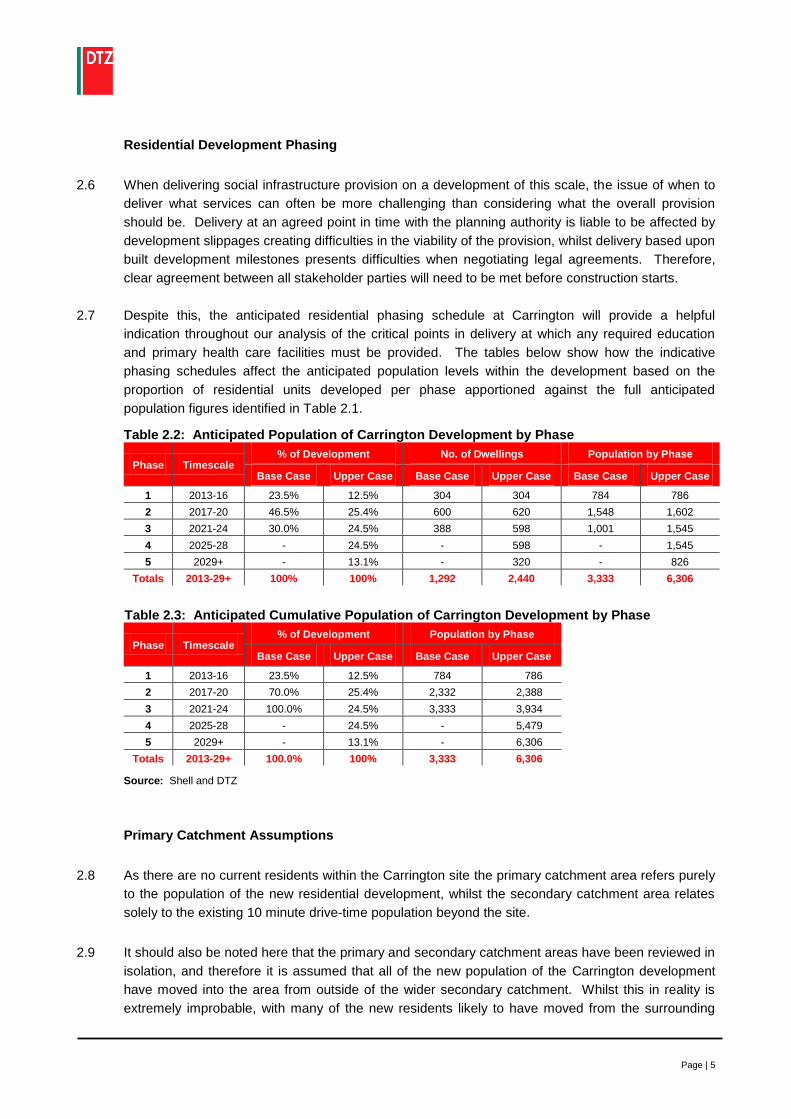
Page | 5
Residential Development Phasing
2.6 When delivering social infrastructure provision on a development of this scale, the issue of when to
deliver what services can often be more challenging than considering what the overall provision
should be. Delivery at an agreed point in time with the planning authority is liable to be affected by
development slippages creating difficulties in the viability of the provision, whilst delivery based upon
built development milestones presents difficulties when negotiating legal agreements. Therefore,
clear agreement between all stakeholder parties will need to be met before construction starts.
2.7 Despite this, the anticipated residential phasing schedule at Carrington will provide a helpful
indication throughout our analysis of the critical points in delivery at which any required education
and primary health care facilities must be provided. The tables below show how the indicative
phasing schedules affect the anticipated population levels within the development based on the
proportion of residential units developed per phase apportioned against the full anticipated
population figures identified in Table 2.1.
Table 2.2: Anticipated Population of Carrington Development by Phase
Phase Timescale % of Development No. of Dwellings Population by Phase
Base Case Upper Case Base Case Upper Case Base Case Upper Case
1 2013-16 23.5% 12.5% 304 304 784 786
2 2017-20 46.5% 25.4% 600 620 1,548 1,602
3 2021-24 30.0% 24.5% 388 598 1,001 1,545
4 2025-28 - 24.5% - 598 - 1,545
5 2029+ - 13.1% - 320 - 826
Totals 2013-29+ 100% 100% 1,292 2,440 3,333 6,306
Table 2.3: Anticipated Cumulative Population of Carrington Development by Phase
Phase Timescale % of Development Population by Phase
Base Case Upper Case Base Case Upper Case
1 2013-16 23.5% 12.5% 784 786
2 2017-20 70.0% 25.4% 2,332 2,388
3 2021-24 100.0% 24.5% 3,333 3,934
4 2025-28 - 24.5% - 5,479
5 2029+ - 13.1% - 6,306
Totals 2013-29+ 100.0% 100% 3,333 6,306
Source: Shell and DTZ
Primary Catchment Assumptions
2.8 As there are no current residents within the Carrington site the primary catchment area refers purely
to the population of the new residential development, whilst the secondary catchment area relates
solely to the existing 10 minute drive-time population beyond the site.
2.9 It should also be noted here that the primary and secondary catchment areas have been reviewed in
isolation, and therefore it is assumed that all of the new population of the Carrington development
have moved into the area from outside of the wider secondary catchment. Whilst this in reality is
extremely improbable, with many of the new residents likely to have moved from the surrounding

Page | 6
local area, these movements would be near impossible to anticipate. However, it is also likely that
as those from the secondary catchment move into the development, their vacated houses are then
re-occupied by others, meaning that the overall assumptions of our calculations in terms of
household figures are correct.
Secondary Catchment Area - 10 Minute Drive-time
2.10 There is some potential for the education and primary health care provision at Carrington to serve a
wider catchment than simply those who are resident on the new housing development, and likewise
the potential for existing underutilised facilities to help service the new development. However,
given the relative isolation of the site, this potential is likely to be limited beyond assisting to meet
local needs within the context of the residential developments phasing.
2.11 This wider secondary catchment has been taken to incorporate the existing resident population
within a 10 minute drive-time of the centre of the Carrington site - the general ‘rule of thumb’
distance people are prepared to travel to access local services. The demographic profile of the area
provided here will assist in the identification of local supply and demand standards for education and
primary health care provision.
2.12 Figure 2.1 shows the boundary of the primary catchment area of the development, together with the
secondary catchment of a 10 minute drive-time of the centre of the site which takes in Partington to
the west, Urmston to the north and parts of Sale to the east, and remains within the Trafford
borough. The unusually shaped secondary catchment area is due to the physical barrier presented
by the Manchester Ship Canal to the west and the lack of existing roads to the south of the site.
Figure 2.1: Carrington Catchment Area Boundaries

Page | 7
2.13 The 10 minute drive-time area encompasses a resident population of approximately 66,754 (ONS
2008 Estimates). A map showing the output areas used to calculate this figure can be found in
Appendix A. The table below provides a breakdown of age structure and population forecasts for
the secondary catchment area over the course of the Carrington residential development.
Population growth has been predicted using borough wide forecasts for Trafford to 2030 (mid Phase
5 and furthest projections available) as an indication of the likely future demand for education and
primary health care facilities borne from population growth.
Table 2.4: Secondary Catchment Existing and Projected Population by Age Group
Phase - 1 2 3 4 5 % Change
2008-2024
% Change
2008-2030 Estimated
Completion Year 2008 2016 2020 2024 2028 2030
0-15 Years 12,685 14,173 14,884 15,207 15,305 15,273 19.9% 20.4%
16 to Retirement* 40,785 42,260 43,537 44,840 45,847 46,151 9.9% 13.2%
Retirement Age + 13,284 14,600 15,220 16,110 17,349 18,046 21.3% 35.8%
Total 66,754 70,833 73,354 75,753 77,935 78,808 13.5% 18.1%
Source: ONS 2006 Based Population Projections for Trafford and 2008 Mid-Year Population Estimates
* Retirement Age = 60 for females and 65 for males
2.14 The figures above indicate that the population within the 10 minute drive-time secondary catchment
of the Carrington site is likely to grow by 18.1% or 12,054 people between 2008 and mid way
through the final residential phase of the upper case scenario in 2030. The largest anticipated rate
of growth is amongst those of retirement age (35.8%) which could have significant implications on
the health requirements of the Carrington site. The younger 0-14 age group, who are most likely to
demand educational services from the development are also expected to grow substantially by
20.4% 2008 to 2030.

Page | 8
3.0 Education
3.1 The provision of children’s services and in particular access to good quality educational facilities has
long been recognised as a key factor in the decision making criteria of families considering moving
to a new housing development, and is therefore a vital determinant of the performance of the local
housing market. In addition, primary schools in particular, can serve an important role in bringing a
new community together, providing opportunities to meet other residents, and creating a vibrant
neighbourhood centre with strong footfall and a sense of community safety.
Audit of Current Supply and Gap Analysis
3.2 The Department for Children, Schools and Families (DCSF) govern education through the provision
of funding and resources to each of the local authorities, who are responsible for schooling in their
respective areas, in this case Trafford Council. We would anticipate that the Education Department
at Trafford Council will have undertaken sophisticated modelling of its future education provision and
requirements. Therefore, further consultations with the Department will be required to test the
appropriateness of the desk based findings presented here within the context of their detailed local
knowledge and policy agendas.
3.3 For the purposes of this study, children’s services include the provision of public and private:
Primary Schools
Secondary Schools
3.4 Further education facilities such as universities and colleges have not been taken into consideration
as planning policy states that out-of-town, primarily residential locations such as residential area of
Carrington are inappropriate for such uses. Pre-school nurseries and children’s centres have also
not been assessed within the scope of this study.
3.5 Trafford Council do not provide a population threshold for the provision of educational facilities as
some local education authorities do, however looking at research into child yields within new
residential developments undertaken within other authorities1, provides an indication of the likely
level of school places required to be in the region of:
28 primary school pupils (age 4-10) per 100 dwellings containing 2+ bedrooms
15 secondary school pupils (age 11-15) per 100 dwellings containing 2+ bedrooms
3.6 These ratios are used throughout this section to help calculate the education requirements of the
Carrington residential development.
3.7 The spatial distribution of each of the educational facilities under investigation in relation to the
Carrington site can be seen on the map overleaf.
1 Research sources, findings and calculations for the above figures can be found at Appendix B.

Page | 9
Figure 3.1: Education Facilities within a 10 Minute Drive-time of the Carrington Site
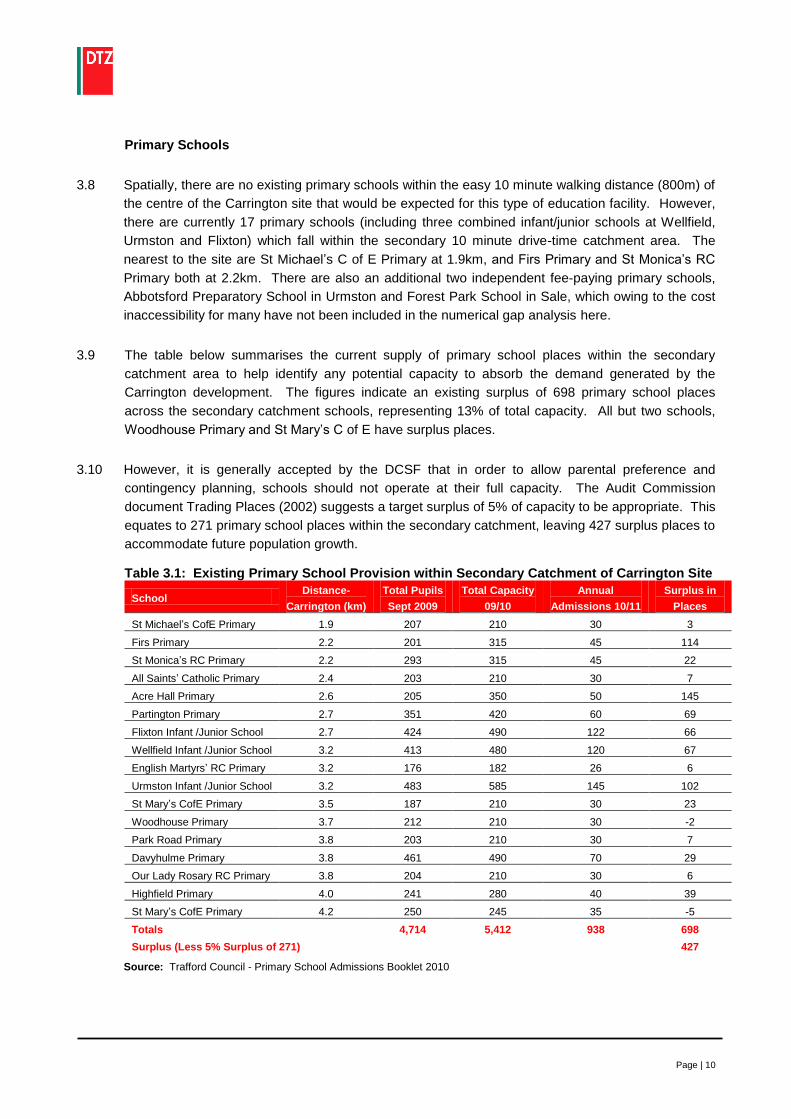
Page | 10
Primary Schools
3.8 Spatially, there are no existing primary schools within the easy 10 minute walking distance (800m) of
the centre of the Carrington site that would be expected for this type of education facility. However,
there are currently 17 primary schools (including three combined infant/junior schools at Wellfield,
Urmston and Flixton) which fall within the secondary 10 minute drive-time catchment area. The
nearest to the site are St Michael’s C of E Primary at 1.9km, and Firs Primary and St Monica’s RC
Primary both at 2.2km. There are also an additional two independent fee-paying primary schools,
Abbotsford Preparatory School in Urmston and Forest Park School in Sale, which owing to the cost
inaccessibility for many have not been included in the numerical gap analysis here.
3.9 The table below summarises the current supply of primary school places within the secondary
catchment area to help identify any potential capacity to absorb the demand generated by the
Carrington development. The figures indicate an existing surplus of 698 primary school places
across the secondary catchment schools, representing 13% of total capacity. All but two schools,
Woodhouse Primary and St Mary’s C of E have surplus places.
3.10 However, it is generally accepted by the DCSF that in order to allow parental preference and
contingency planning, schools should not operate at their full capacity. The Audit Commission
document Trading Places (2002) suggests a target surplus of 5% of capacity to be appropriate. This
equates to 271 primary school places within the secondary catchment, leaving 427 surplus places to
accommodate future population growth.
Table 3.1: Existing Primary School Provision within Secondary Catchment of Carrington Site
School Distance-
Carrington (km)
Total Pupils
Sept 2009
Total Capacity
09/10
Annual
Admissions 10/11
Surplus in
Places
St Michael’s CofE Primary 1.9 207 210 30 3
Firs Primary 2.2 201 315 45 114
St Monica’s RC Primary 2.2 293 315 45 22
All Saints’ Catholic Primary 2.4 203 210 30 7
Acre Hall Primary 2.6 205 350 50 145
Partington Primary 2.7 351 420 60 69
Flixton Infant /Junior School 2.7 424 490 122 66
Wellfield Infant /Junior School 3.2 413 480 120 67
English Martyrs’ RC Primary 3.2 176 182 26 6
Urmston Infant /Junior School 3.2 483 585 145 102
St Mary’s CofE Primary 3.5 187 210 30 23
Woodhouse Primary 3.7 212 210 30 -2
Park Road Primary 3.8 203 210 30 7
Davyhulme Primary 3.8 461 490 70 29
Our Lady Rosary RC Primary 3.8 204 210 30 6
Highfield Primary 4.0 241 280 40 39
St Mary’s CofE Primary 4.2 250 245 35 -5
Totals 4,714 5,412 938 698
Surplus (Less 5% Surplus of 271) 427
Source: Trafford Council - Primary School Admissions Booklet 2010

Page | 11
3.11 The table below uses the ratio of 28 primary school pupils per 100 dwellings of 2 beds or more to
calculate the number of primary school places required to serve the population of the Carrington
residential development, across each of the anticipated three to five phases. It assumes that half of
the 65 to 103 apartments will be 1 bed and are therefore excluded from the calculations with the
remaining 2+ bed dwellings distributed as per development phase percentages provided in Table
2.2. The demand for primary school places generated by population growth within the secondary
catchment area has been estimated using the population projections provided in Table 2.4.
However, care should be taken with these figures which, owing to the lack of available data, assume
those aged 0-15 within the secondary catchment are evenly distributed across each year age group.
Table 3.2: Anticipated Primary School Place Requirement by Phase
Phase Timescale
Additional 2+ bed
Dwellings by Phase
Additional
Pop. Age 4-10
by Phase
Primary School Place Requirement by
Phase
Base Case Upper Case Secondary Base Case Upper Case Secondary
Current 2008 - - 5,550 - - 5,500
1 2013-16 296 297 651 83 83 651
2 2017-20 586 605 311 164 170 311
3 2021-24 378 584 141 106 164 141
4 2025-28 - 584 43 - 164 43
5 2025-28 - 312 -14 - 87 -14
Totals 2029+ 1,260 2,383 1,132 353 667 1,132
Source: DTZ
3.12 The data suggests that the residential element of the Carrington development will generate a need
for between 353 (base case) to 667 (upper case) primary school places on completion, with the
majority of base case demand generated in the second phase and phases 2-4 in the upper case.
Population growth of 4-10 year olds within the secondary catchment is estimated to generate
demand for an additional 1,132 primary school places to 2030.
3.13 Bringing the numerical supply and demand together indicates that the 427 existing surplus primary
school places are likely to be taken up by the additional demand for 651 primary school places
generated by population growth within the secondary catchment by the end of the first phase in
2016. This, coupled with the spatial lack of existing provision within reasonable walking distance of
the site (800m-1km), suggests that primary education facilities to meet the demand for the 353 to
667 places generated by the development should be provided at Carrington.
3.14 Primary schools are generally either single entry, with a legally limited annual intake of up to 30
pupils per class, or double entry with 50-60 pupils per annual intake, giving a total capacity of 210 or
420 pupils respectively. Therefore, a double entry primary school will be required to serve the
Carrington site within the base case scenario. This would also allow for the addition 5% of places
recommended by the Audit Commission and would help to ensure a sustainable education provision
for the development in to the future. In the case of the upper level of housing development, the
figures suggest that both a double entry and additional single entry primary school will be required
as a minimum to serve the demand for primary school places within the scheme. Whilst this will only
generate 630 of the 667 places required (700 including 5% recommended surplus), the remaining
37-70 places demanded are insufficient to require a second double entry school.

Page | 12
3.15 Phasing of the primary education provision on a development of this scale will be a key issue, as
whilst in both case scenarios a single entry school will be required towards the end of the second
phase, a double entry school will not be required until completion of the third phase in 2024. In the
upper case, an additional single entry primary school will then be required at the start of the final fifth
phase. Developers at Buckshaw Village near Chorley have innovatively eased this challenge of
matching social infrastructure needs with the critical mass required to make the uses viable, by
developing a single entry primary school that has been designed in such a way that it can be
extended to a double entry school later on in the development. Phasing the primary school provision
in this way may also help to assess and provide for local needs on an ongoing and timelier basis.
This would be of particular benefit in the upper case scenario in which it may become apparent by
the later stages of development that the additional unmet needs are able to be met elsewhere, and
may even negate the need for the additional single entry school in the fourth or final phase.
Secondary Schools
3.16 There are a total of five secondary schools within a 10 minute drive-time of the Carrington site;
however none are within the 1.5km catchment area suggested by the Sustainable Cities Guide in
the 1999 Urban Task Force Report. The nearest secondary schools are Wellacre Technology
College in Urmston at 2.4km and Flixton Girls High School at 2.7km.
3.17 Whilst outside the scope of this study, it is also worth noting that Manor High School and Delamere
Special School are also located within 2.5km of the Carrington site. These small special schools
serve children with special needs and moderate to severe learning difficulties.
3.18 The table below analyses the existing provision of secondary school places within the 10 minute
drive-time catchment area in terms of pupil numbers, annual admissions and vacancy rates to help
inform the numerical gap analysis.
Table 3.3: Existing Secondary School Provision within Secondary Catchment of Carrington
School Age
Range
Distance-
Carrington
(km)
Total Pupils
Sept 2009
Total
Capacity
09/10
Annual
Admissions
10/11
Surplus in
Places
Wellacre Technology College 11-16 2.4 950 1,020 204 70
Flixton Girls' High School 11-16 2.7 948 1,000 200 52
Ashton-on-Mersey School 11-18 3.2 1,285 1,778 254 493
Urmston Grammar School 11-18 3.2 920 896 128 -24
Broadoak School 11-16 3.4 330 640 128 310
Totals 4,433 5,334 914 901
Surplus (Less 5% Surplus of 267) 634
Source: Trafford Council - Secondary School Admissions Booklet 2010
3.19 Three of the schools within the secondary catchment cater solely for 11-16 years olds, and two
include sixth form facilities taking the age served to 18. Whilst sixth form provision is not considered
here, it is not possible to separate out these figures through desk based research; as such they have
been included in the analysis and may therefore be considered to result in a slight over
representation of true supply.

Page | 13
3.20 The data indicates that, taking into account the recommended 5% of capacity surplus, there are
currently a total of 634 secondary school places vacant within the secondary catchment area.
However, Trafford is different to most local authorities in that it has a number of selective grammar
schools within its control, each with their own individual entrance examinations following the demise
of the borough wide 11+ examinations. This choice of high quality education has made Trafford a
popular location for families, pushing up residential values and ensuring that entrance into the
grammar schools remains highly competitive. This can be evidenced above where each of the
schools in the secondary catchment have existing spare capacity, with the exception of Urmston
Grammar School where 6 applications are received for every available place. Despite this, the
figures suggest some capacity to absorb additional future demand for secondary school places.
3.21 The table below uses the ratio of 15 secondary school pupils (aged 11-15) per 100 dwellings of 2-
beds or more and relevant age group population projections for the secondary catchment area to
calculate the likely future demand for secondary school places under the same assumptions used in
the primary school calculations above.
Table 3.4: Anticipated Secondary School Place Requirement by Phase
Phase Timescale
Additional 2+ bed
Dwellings by Phase
Additional Pop.
Aged 11-15
by Phase
Secondary School Place
Requirement by Phase
Base Case Upper Case Secondary Base Case Upper Case Secondary
Current 2008 - - 3,964 - - 3,964
1 2013-16 296 297 465 44 45 465
2 2017-20 586 605 222 88 91 222
3 2021-24 378 584 101 57 88 101
4 2025-2028 - 584 30 - 88 30
5 2029+ - 312 -10 - 47 -10
Totals 2013-29+ 1,260 2,383 809 189 357 809
Source: DTZ
3.22 The figures suggests that the residential element of the Carrington development will generate a
need for between 189 (base case) and 357 (upper case) additional secondary school places on
completion of the residential development, with the majority of demand generated within the larger
middle phases in both scenarios. Population growth of 11-15 year olds within the secondary
catchment is estimated to generate demand for an additional 809 secondary school places.
3.23 Bringing the supply and demand together indicates that the 634 existing surplus secondary school
places, whilst numerically sufficient to meet the needs of the new resident Carrington population in
both case scenarios, are spatially distant from the development and would not currently be able to
absorb the 809 place demand generated from the estimated population growth of 11-15 year olds
within the wider secondary catchment to 2030. However, experience of previous social
infrastructure analysis has indicated that further consultations will need to be held with Trafford
Council to test these findings against their detailed education modelling systems and provide further
insight on potentially hidden trends, such as falling roll numbers or planned new facilities which
could indicate that the figures presented here represent an over exaggeration of likely demand.

Page | 14
3.24 Whilst the figures presented here would suggest that supply is sufficient in both the lower and upper
case scenarios to serve all additional demands throughout the first phase and initially into the
second phase of residential development, it appears clear that an additional secondary school is
likely to be required to meet the combined future needs of the development and wider catchment
before 2020. However, the demand generated by the development itself is insufficient, even in the
upper case, to facilitate a new secondary school provision on site alone.
3.25 Therefore, detailed discussions should be held with Trafford Council to consider potential solutions
to meeting the needs of the new Carrington residents, including possible contributions to a new site
to serve both the development (i.e. within 1.5km) and existing areas within the secondary catchment
most likely to generate the greatest future demand. In this case the Urmston schools have the least
spare capacity suggesting a site between Urmston and Carrington to perhaps be potentially
appropriate.
Implications for the Carrington Scheme - Education
Spatially, education provision is clustered around existing resident population settlements and consequently
there is no primary or secondary provision within recommended distances of the Carrington site owing to its
relative current isolation. However, on family focused developments such as that proposed at Carrington,
there is great importance of getting access to educational facilities right in order to attract demand.
The numerical gap analysis indicates that there will be a demand directly generated by the Carrington
residential development for:
One double entry primary school (plus an additional single entry primary school in the upper case)
189-357 secondary school places
Whilst the primary school requirement in both cases will likely need to be met on site owing to the scale of
demand generated by the development and existing capacity within the secondary catchment area, the
secondary school demand is insufficient in itself to directly demand a secondary school be provided within
the scheme. Nevertheless, the secondary school demand is still significant and therefore discussions will
need to be held with Trafford Council to test these finding against their detailed education modelling systems
and assess the potential to meet the developments needs within a new facility which also serves the
anticipated future demand of the wider secondary catchment. A location north of the site between Carrington
and Urmston would seem most appropriate looking at current capacity levels.
It should also be noted that two independent fee-paying primary schools are also present within the
secondary catchment, which owing to the cost inaccessibility for many have not been included in the
numerical gap analysis here, but could potentially meet some of the demands of the Carrington development.

Page | 15
4.0 Primary Health Care
4.1 Access to health services is vital to the quality of life of local residents, particularly in the context of
an aging population and the focus of the Carrington development on family housing. Health and
social care in Britain is primarily provided through the National Health Service (NHS) and
Department of Health in the form of Primary and Secondary Care Trusts.
Audit of Current Supply and Gap Analysis
4.2 This section of the paper provides a gap analysis for primary health care in the form of General
Practitioners (GPs). The audit does not include other health services such as dentists and
pharmacies, or secondary care facilities such as hospitals within its scope.
4.3 Trafford PCT are responsible for primary health care throughout the Trafford borough including the
provision of GPs. Therefore it will be necessary to undertake further consultations with Trafford PCT
to test the appropriateness of the findings presented here within the context of their detailed local
knowledge and policy agendas.
4.4 Figure 4.1 overleaf shows the spatial distribution of existing GPs within a 10 minute drive-time of the
Carrington site.

Page | 16
Figure 4.1: General Practitioners within a 10 Minute Drive-time of the Carrington Site

Page | 17
General Practitioners (GPs)
4.5 The NHS and Department of Health provide the standard for the number of people required to
necessitate a GP at 1,800. The table below use this Government ratio to calculate the number of
GPs required to serve the population of both the secondary catchment area and the Carrington
residential development, across the anticipated three phase timescale.
Table 4.1: GP Requirement by Phase
Phase Timescale Additional Population by Phase GP Requirement by Phase
Base Case Upper Case Secondary Base Case Upper Case Secondary
Current 2008 - - 66,754 - - 37.1
1 2013-16 784 786 4,079 0.4 0.4 2.3
2 2017-20 1,548 1,602 2,522 0.9 0.9 1.4
3 2021-24 1,001 1,545 2,399 0.6 0.9 1.3
4 2025-28 - 1,545 2,182 - 0.9 1.2
5 2029+ - 826 872 - 0.5 0.5
Totals 2013-29+ 3,333 6,306 12,054 1.9 3.5 6.7
Source: NHS Direct and Department of Health
4.6 The figures indicate that there should be a total of 37.1 GPs present within the secondary 10 minute
drive-time catchment area. There are currently 40 GPs present within 11 practices, equating to one
per 1,670 of the population, well within the recommended ratio. Whilst each of these practices
report to be accepting new patients, the figures suggest that there cannot be considered to be
surplus in GP supply in light of the likely future requirement of an additional 6.7 GPs within the
secondary catchment by 2030.
4.7 Under the assumption that the supply of GPs within the secondary catchment will continue to be
fully utilised to 2030, and so are unlikely to be able to absorb the demands of the new residential
development at the Carrington site, the figures indicate that the new population of the primary
catchment will require in the range of 2 to 3.5 GPs. In both cases the first will be required around
half way through the second phase of development, the second by completion of the third. In the
upper case scenario, a third GP will be required by completion of the fourth residential phase and
further assessment will be required in the final phase to gauge to need for a fourth GP.
4.8 Spatially, there are no GPs within a reasonable 15 minute (1km) walk of the site, the nearest,
Urmston Group Practice (six GPs) and Bodmin Road Health Centre in Sale (four GPs) being over
2km away. Whilst each of these surgeries are accepting new patients, their distance would further
suggest that the primary health care needs of the new resident population at Carrington will need to
be served within the development itself.

Page | 18
Implications for the Carrington Scheme - Primary Health Care
The numerical gap analysis indicates that there will be a demand directly generated by the Carrington
residential development for between 2 and 3.5 General Practitioners. Whilst PCTs generally prefer to
cluster primary health care facilities and strengthen existing provision before generating new facilities, the GP
requirement at Carrington will likely need to be met on site owing to the near full utilisation of existing GP
services and anticipated population growth within the wider secondary catchment, together with the findings
of the spatial analysis indicating the lack of existing facilities within a reasonable 15 minute walking distance
(1km) of the site.

Page | 19
5.0 Summary of Findings and Recommendations
5.1 This section aims to bring together and summarise the findings of the gap analysis to identify the
education and primary health care requirements of the Carrington site. It provides an understanding
of the type and number of services which may be required as a result of population growth within the
primary catchment area of the development, and the ability of the secondary catchment area to
absorb this demand within its provision.
Summary of Findings
5.2 The spatial and numerical gap analyses presented within this report have taken into account existing
education and primary health care provision and capacity, and anticipated population growth, and
suggest that the residential element of the Carrington development will demand in the range of:
1 double entry primary school (plus an additional single entry school in the upper case)
189-357 secondary school places (preferably within 1.5km of the site)
2-3.5 General Practitioners
5.3 These initial desk based findings will need to be thoroughly tested through discussions with local
service providers and Trafford Council to determine the final agreed education and primary health
care requirements of the Carrington development.
5.4 In terms of land takes, a dual entry primary school is likely to require in the region of 1.95 to 2.15
hectares including all associated outdoor play areas2. If Trafford PCT were to confirm the need for a
health polycentre at Carrington, the land take could be to a maximum of 0.5 hectares.
Recommendations
Delivery - Timescales and Phasing
5.5 It is not uncommon for a number of challenges to be experienced with regard to the delivery of
social infrastructure provision on residential led developments of this scale. Often the issue of when
to deliver what services can be more challenging than considering what the overall provision should
be. Requesting delivery at an agreed point in time is liable to be affected by development slippages
creating difficulties in the viability of the provision, whilst delivery based upon built development
milestones presents difficulties when negotiating legal agreements. Whilst the phased nature of the
development at Carrington gives some further guidance as to when education and primary health
care facilities are likely to be required, clear agreement will need to be met with the local authority
before construction starts.
5.6 However, there are some innovative ways of easing the challenges of matching social infrastructure
requirements with the critical mass required to make the uses viable, as seen at Buckshaw Village
where a single entry primary school is being developed in such a way that it can be extended to a
double entry school later on in the development.
2 DCSF Building Bulletin: Primary School Projects (BB99) - Primary School Area based on recommended gross area: 2,230 sq m for a
420 pupil primary school plus 17,320 - 19,300 sq m external play space = 1.95-2.15ha

Page | 20
Location of facilities
5.7 Good practice guidance such as the ATLAS Social Infrastructure Topic Paper highlight the benefits
of co-locating social infrastructure provision such as health and education within close proximity of
other public uses such as retail within a ‘centre’. The most successful local centres maximise their
local catchment potential by locating where accessible by all means of transport including walking
and public transport, and should be highly visible to passing trade. The education and primary care
health requirements identified here would therefore benefit being located together towards the
centre of the residential site where most accessible to the whole development. Careful
consideration should also be given to the design and layout of the facilities to maximise visibility and
access.
Further Consultation
5.8 Whilst the catchment profiling and gap analyses presented in this report provide sensible desk
based estimates as to the education and primary health care provision required on site, Shell should
undertake further detailed discussions with Trafford PCT and Trafford Council to fully understand
current and anticipated trends in provision and policy expectations for the residential development of
the site. These discussions may reveal an over exaggeration of education and primary health care
requirements within this desk based analysis, particularly in the case of secondary school places
and PCT preference for contributions towards existing primary health care facilities rather than new
provision.
5.9 In addition, once residential development commences on site, Shell should consider engaging with
the new community as it emerges to ensure that the provision meets their needs.
Further Research Requirements
5.10 Education and primary health care provision represents just a couple of the potential social
infrastructure facilities that may be required on a residential led development of this scale. Further
research should therefore be undertaken to fully assess the developments requirements for other
key forms of social infrastructure including:
Community Facilities - meeting spaces, libraries, youth provision, places of worship
Other Health Services - hospitals, dentists, pharmacies
Other Children’s Services - pre-school provision
Open Space, Sports and Leisure - public leisure facilities and swimming pools, private
health and fitness centres, open space and outdoor sports, children’s play facilities
Aged Care - residential care homes

Appendix A
Output Areas of Secondary Catchment


Appendix B
Education Requirements: Research Sources, Findings and Calculations

Primary School Places (4-10 years)
Number of
bedrooms
Children per 100 households Overall
Average Cambourne Northamptonshire Oxfordshire Cambridgeshire
1 0 0 1 0 0
2 1.5 6 11 0 5
3 15 29 25 30 25
4+ 61 63 48 50 56
Avg 2+ beds 26 33 28 27 28
Secondary School Places (11-15 years)
Number of
bedrooms
Children per 100 households Overall
Average Cambourne Northamptonshire Oxfordshire Cambridgeshire
1 0 0 2 0 1
2 1.5 1 3 0 1
3 7 13 13 20 13
4+ 29 24 31 35 30
Avg 2+ beds 13 13 16 18 15
Sources
1) Cambourne, Cambridgeshire
Table A3.1: Children per 100 owner-occupier households
Source: Cambourne Survey 2006
2) Northamptonshire
Table A3.2: Children per 100 households living in houses
Source: Pupil Generation Survey, Northamptonshire County Council, May 2005, prepared by BMG
3) Oxfordshire
Table A3.3: Children per 100 households
Source: Oxfordshire Survey of New Housing 2004
4) Cambridgeshire
Table 1: Proposed detailed child yield multipliers for Cambridgeshire
(number of children per 100 dwellings of given size)
Source: Revisions to Child Yield Multipliers for New Developments, Cambridgeshire County Council
Research Group, March 2009

Appendix IV
Trip Generation
