short report on the archeological investigations for the
TRANSCRIPT

Volume 2015 Article 80
2015
Short Report on the Archeological Investigations for the City of Short Report on the Archeological Investigations for the City of
Dominorsquos Proposed New Water Treatment Plant Cass County Dominorsquos Proposed New Water Treatment Plant Cass County
Texas Texas
Josh Haefner
Follow this and additional works at httpsscholarworkssfasueduita
Part of the American Material Culture Commons Archaeological Anthropology Commons
Environmental Studies Commons Other American Studies Commons Other Arts and Humanities
Commons Other History of Art Architecture and Archaeology Commons and the United States History
Commons
Tell us how this article helped you
This Article is brought to you for free and open access by the Center for Regional Heritage Research at SFA ScholarWorks It has been accepted for inclusion in Index of Texas Archaeology Open Access Gray Literature from the Lone Star State by an authorized editor of SFA ScholarWorks For more information please contact cdsscholarworkssfasuedu
Short Report on the Archeological Investigations for the City of Dominorsquos Short Report on the Archeological Investigations for the City of Dominorsquos Proposed New Water Treatment Plant Cass County Texas Proposed New Water Treatment Plant Cass County Texas
Creative Commons License Creative Commons License
This work is licensed under a Creative Commons Attribution 40 International License
This article is available in Index of Texas Archaeology Open Access Gray Literature from the Lone Star State httpsscholarworkssfasueduitavol2015iss180
SHORT REPORT ON THE ARCHEOLOGICAL INVESTIGATIONS FOR THE CITY OF
DOMINOrsquoS PROPOSED NEW WATER TREATMENT PLANT CASS COUNTY TEXAS
Principal Investigator Josh Haefner
Written by Josh Haefner
Antiquities Permit 7275
Submitted to Greater Texoma Utility Authority and the City of Domino
Hicks amp Company Archeology Series 269
June 2015
Table of Contents
TABLE OF CONTENTS
PROJECT DESCRIPTION AND MANAGEMENT SUMMARY 1 ENVIRONMENTAL SETTING 5
Physiography 5 Geology and Soils 5
METHODOLOGY 9 Previous Investigations 9 Field Methodology 9
RESULTS OF FIELD INVESTIGATIONS 13 CONCLUSIONS AND RECOMMENDATIONS 19 REFERENCES CITED 21
LIST OF FIGURES
Figure 1 Project Location 3 Figure 2 Project Area Geology 7 Figure 3 Previous Sites and Surveys 11 Figure 4 Overview of Northern Boundary of Project Area Facing South from FM 3129 13 Figure 5 Overview of Inundated Area Typical of Project Area Facing Northeast from STJH11 14 Figure 6 Overview of Tributary Drainage of Baker Creek Facing Southeast from STJH4 14 Figure 7 Shovel Test Locations 17
LIST OF TABLES
Table 1 Shovel Test Data 15
LIST OF APPENDICES
Appendix A Regulatory Correspondence
Draft Archeological Survey Report ndash City of Domino Water Treatment Plant ndash June 2015 i
Table of Contents
This page intentionally left blank
Draft Archeological Survey Report ndash City of Domino Water Treatment Plant ndash June 2015 ii
Project Description and Management Summary
PROJECT DESCRIPTION AND MANAGEMENT SUMMARY
In May of 2015 on behalf of the Greater Texoma Utility Authority (GTUA) and the City of Domino (the City) Hicks amp Company conducted an intensive archeological survey for the new wastewater treatment plant facility to be located just south of Farm-to-Market Road (FM) 3129 approximately 2010 meters east of Domino in Cass County Texas The purpose of the proposed project is to upgrade current wastewater facilities with the new treatment plant servicing up to 25000 gallons of water per day as delivered by planned new sewer line The City has received funding for the proposed project through a 2014 Texas Capital Fund Grant provided by the Texas Department of Agriculture Office of Rural Affairs for Infrastructure Improvements necessitating compliance with the Antiquities Code of Texas (ACT) and coordination with the Texas Historical Commission (THC) During initial review of the proposed project the THC noted that the proposed project was located within a previously unsurveyed area with favorable conditions for past human habitation that warranted intensive archeological survey prior to construction (See Appendix A letter Martin to Linendoll March 11 2015) Following this recommendation Hicks amp Company was contracted by GrantWorks Incorporated on behalf of the GTUA and the City to continue coordination with the THC and conduct the archeological survey The proposed project was coordinated THC under Antiquities Permit 7275
Totaling approximately six field hours investigations for the archeological survey were conducted on May 28 2015 and consisted of a pedestrian survey of the entire project area approximately 60 acres in size supplemented with 13 shovel tests all of which were negative for cultural materials No artifactual materials greater than 50 years in age features or archeological sites were encountered during this investigation Based on the results of the current survey it is recommended that no archeological historic properties (36 CFR 80016(1)) or State Antiquities Landmarks (SALs) (13 TAC 2612) will be affected by the proposed project and no further archeological investigations are recommended prior to construction In the event that unanticipated archeological deposits are encountered during construction work in the immediate area will cease and THC archeological staff will be contacted to initiate post-review discovery procedures Josh Haefner was the Principal Investigator for this project performing field work and authoring the report All project notes forms drawings and photographs will be curated at the Center for Archaeological Studies (CAS) in San Marcos Texas This report is offered in partial fulfillment of Antiquities Permit 7275
Draft Archeological Survey Report ndash City of Domino Water Treatment Plant ndash June 2015 1
Project Description and Management Summary
This page intentionally left blank
Draft Archeological Survey Report ndash City of Domino Water Treatment Plant ndash June 2015 2
3129 2327
3129 poundcurren59
Copyrightcopy 2011 National Geographic Society i-cubed
Key to Features Project Area
W0 05 1
Kilometers One inch equals 1 km
Figure 1 Project Location
USGS 75-minute Topographic QuadranglesWright Patman Lake (USGS 33094-C2) TX
CASS
BOWIE ARKANSAS
Project Description and Management Summary
This page intentionally left blank
Draft Archeological Survey Report ndash City of Domino Water Treatment Plant ndash June 2015 4
Environmental Setting
ENVIRONMENTAL SETTING
Physiography The proposed project area is located in the East Texas Piney Woods This area is characterized by rolling hills that are dissected by numerous drainage courses with broad flat floodplains The wider region is drained by several well-developed creek systems that flow generally north-northeast in the Red River Basin to the north and south-southeast in the Sabine River Basin to the south Within the immediate area of the proposed project the landform slopes slightly southeast towards a tributary drainage of Baker Creek The project area is dominated by a thick stand of pine trees a component of the widespread Piney Woods region
Geology and Soils According to the Geologic Atlas of Texas Texarkana Sheet the underlying geology of the proposed project area consists of the Wilcox Group undivided formation (Barnes 2007) Dating to the Eocene which long predates human arrival in the Americas cultural deposits in such mapped areas can be expected to be contained within overlying soilssediment or the surface itself A single soil series the Metcalf silt loam 0 to 2 percent slopes is mapped for the project area (USDA NRCS 2015b) This series typically has shallow A horizons with Bt clay horizons typically occurring between 4 and 75 centimeters below the ground surface (USDA NRCS 2015a)
Draft Archeological Survey Report ndash City of Domino Water Treatment Plant ndash June 2015 5
Environmental Setting
This page intentionally left blank
Draft Archeological Survey Report ndash City of Domino Water Treatment Plant ndash June 2015 6
MiA
3129
LtB
EeD
GaA
MiA
EeB
So
So
TnD
Mf
The entire view of this map islocated within the Wilcox Groupundivided (EPAwi) geologic formation
Intesecting Soil Types MiA - Metcalf silt loam 0 to 2 percent slopes
Figure 2 Key to FeaturesProject Area W Geology and Soils within Project Area 0 50 100 Soil Type Boundaries
Meters One inch equals 100 meters
Environmental Setting
This page intentionally left blank
Draft Archeological Survey Report ndash City of Domino Water Treatment Plant ndash June 2015 8
Methodology
METHODOLOGY
During initial consultation between the GTUA the City the Texas Commission on Environmental Quality ndash Water Quality Division and the THC it was noted that the ldquoproposed project area has never been formally surveyedrdquo and that the proposed location ldquois situated in a topographic location with moderate to high potential for the presence of previously unrecorded cultural resourcesrdquo which warranted survey before initiation of construction (See Appendix A letter Martin to Linendoll March 11 2015) In preparation for survey Hicks amp Company staff conducted background research utilizing the THCrsquos Archeological Sites Atlas (the Atlas) online database in order to identify previous cultural resources survey efforts and determine locations of cultural resources within the vicinity of the proposed project
Previous Investigations
According to the Atlas no survey-level investigations had been previously conducted within the immediate area with the nearest documented archeological survey located approximately 2300 meters to the northwest This survey of the perimeter of Wright Patman Lake was conducted by the United States Army Corps of Engineers (USACE) in 1998 The nearest recorded cultural resource is Domino Cemetery also known as the Albert Richie Cemetery Predominantly comprised of African-American graves this cemetery was created between 1865 and 1900 from land donated by Albert Richie a one-time slave who acquired land in the area following the Civil War (Find a Grave 2015) Located approximately 2500 meters northwest of the proposed project area the nearest recorded archeological site recorded during the above-noted USACE survey is Site 41CS226 Other than noting that this site dates to the historic-period and is considered ineligible for listing on the National Register of Historic Places or as a SAL no data is available for this site on the Atlas (THC 2015b)
Field Methodology
During the field investigations a Hicks amp Company archeologist traversed the entirety of the project area surveying and shovel testing along the perimeter before traversing the area east to west in transects spaced 20 to 30 meters apart A total of 13 shovel tests were excavated during the survey slightly exceeding the requisite amount of shovel tests for projects this size (2 per acre) Shovel testing intervals conformed to the minimum standards outlined by the THC and the Council of Texas Archeologistsrsquo practices and procedures (13 TAC 265 and 2620) (THC 2015a) Subsurface test locations were recorded using GPS technology with sub-meter accuracy No standing structures of historic age were noted within or adjacent to the project area Hence photo-documentation of these resources is not a component of this report
Draft Archeological Survey Report ndash City of Domino Water Treatment Plant ndash June 2015 9
Methodology
This page intentionally left blank
Draft Archeological Survey Report ndash City of Domino Water Treatment Plant ndash June 2015 10
3129
County Road 3884
FM 31
29
rthstar Geographics CNESAirbus Aerogrid IGN IGP swisstopo and th
Domino Cemetery
2327
3129poundcurren59
Camp
Coun
ty Ro
ad 36
59
Coun
tyRo
ad 36
60
Coun
tyRo
ad36
73
US H
wy 59
Coun
ty Ro
ad 36
67
US H
wy 59
County Road 3559
County Road
3677
Coun
tyRo
ad 36
62
Coun
tyRo
ad36
63
Coun
tyRo
ad36
65
County Road 3784
FM 2327
FM 3129
County Road 3675
COE-FWD0898
41CS226
Source Esri DigitalGlobe GeoEye EaDS USDA USGS AEX Getmapping eGIS User Community
Key to Features Archeological Site
Project Area Previous ArcheologicalSurveyCemetery
W0 05 1
Kilometers One inch equals 1 km
Figure 3
Previously Conducted Investigations ampRecorded Cultural Resources
CASS
BOWIE ARKANSAS
Methodology
This page intentionally left blank
Draft Archeological Survey Report ndash City of Domino Water Treatment Plant ndash June 2015 12
Results of Field Investigations
RESULTS OF FIELD INVESTIGATIONS
On May 28 2015 an archeologist from Hicks amp Company conducted an intensive aerial survey of the proposed location of the City of Dominorsquos Water Treatment Plant an area approximately six acres in size During survey it was noted that the project area is thickly vegetated with pine trees with an understory comprised mainly of greenbriar and various ivies with a forest floor covered with heavy leaf-litter and intermittent pockets of standing water a result of recent torrential rains (Figures 4 and 5) Due to these conditions ground surface visibility was minimal never more than five percent at any one location The southeast corner of the project area is immediately adjacent to an unnamed tributary of Baker Creek During survey this drainage was experiencing overbank flooding with much of the immediate area inundated (Figure 6)
Figure 4 Overview of Northern Boundary of Project Area Facing South from FM 3129
Draft Archeological Survey Report ndash City of Domino Water Treatment Plant ndash June 2015 13
Results of Field Investigations
Figure 5 Overview of Inundated Area Typical of Project Area Facing Northeast from STJH11
Figure 6 Overview of Tributary Drainage of Baker Creek Facing Southeast from STJH4
Draft Archeological Survey Report ndash City of Domino Water Treatment Plant ndash June 2015 14
Results of Field Investigations
Shovel testing of the project area noted homogenous sediment that was similar in texture hue and chroma to that described for Metcalf silt loam (NRCS 2015) In general these excavations noted upper strata of highly silicated silt that ranged in color from light yellowish brown (10YR 64) to brown (75YR 54) Strata below the first were noted to be silt loams with increasing clay content that ranged in color from yellowish brown (10YR 56) to brown (75YR 44 - 75YR 53) When tests were not impended by the water table or thick pine roots gray (10YR 61) and yellowish red (5YR 56) Bt-horizon clays were encountered at depths between 50 and 70 centimeters below the ground surface (cmbs) During the investigation a total of 13 shovel tests were excavated with all negative for the presence of cultural materials Data for all shovel tests is presented below in Table 1
Table 1 Shovel Test Data Shovel
Test Level Depth (cmbs)
P=Pos N=Neg Munsell
Soil Texture Description Inclusions Notes
JH1 1 0-30 N 75YR 54 Silt Loam Rootlets
JH1 2 30-40 N 75YR 53 Loam Water table encountered at 40 cmbs
JH2 1 0-20 N 75YR 54 Silt Loam Rootlets
JH2 2 20-30 N 74YR 53 Clay Loam Water table encountered at 30 cmbs
JH3 1 0-40 N 75YR 46 Silt Rootlets
JH3 2 40-50 N 5YR 46 Silt Loam Increasing clay content
JH3 3 40+ N 10YR 61 Silt Clay High clay content ST terminated win Bt horizon clay
JH4 1 0-20 N 10YR 64 Silt Loam Rootlets Very moist sediment
JH4 2 20-55 N 10YR 56 Silt Loam Water seepage begins at 50 cmbs
JH4 3 55-60 N 10YR 61 Clay ST terminated at 60 cmbs within Bt horizon clay
JH5 1 0-20 N 10YR 64 Silt Loam Rootlets Very moist sediment
JH5 2 20-55 N 10YR 56 Silt Loam
JH5 3 55-60 N 10YR 61 Clay ST terminated at 60 cmbs within Bt horizon clay
JH6 1 0-40 N 10YR 64 Silt Loam Rootlets Very moist sediment
JH6 2 40-50 N 75YR 53 Silt Clay Loam High clay content ST terminated at thick pine root
JH7 1 0-30 N 75YR 46 Silt Loam High silicates Inundated area- water table encountered at 20 cmbs
JH8 1 0-40 N 75YR 54 Silt Loam Rootlets
JH8 2 40-60 N 10YR 56 Silt Loam Increasing clay content
JH8 1 60-70 N 10YR 62 Clay ST terminated at 70 cmbs within BT horizon clay
JH9 1 0-30 N 75YR 54 Silt Loam Rootlets
JH9 2 30-65 N 75YR 53 Loam Increasing clay content
JH9 3 65-75 N 5YR 44 Clay ST terminated at 75 cmbs within BT horizon clay
JH10 1 0-20 N 75YR 54 Silt Loam Rootlets Very moist sediment
JH10 2 20-40 N 75YR 53 Silt Clay Loam ST terminated below water table at 35 cmbs
JH11 1 0-48 N 75YR 54 Silt Loam Rootlets ST terminated at thick pine root
JH12 1 0-45 N 10YR 64 Clay Rootlets
JH12 2 45-62 N 75YR 53 Silt Clay Loam
JH12 3 62-72 N 10YR 62 Clay Shovel test terminated at 72 cmbs Bt horizon clay
JH13 1 0-40 N 75YR 46 Silt Rootlets
JH13 2 40-60 N 5YR 46 Silt Loam
JH13 3 60-70 N 10YR 62 Clay ST terminated at 70 cmbs within Bt horizon clay
Draft Archeological Survey Report ndash City of Domino Water Treatment Plant ndash June 2015 15
Results of Field Investigations
This page intentionally left blank
Draft Archeological Survey Report ndash City of Domino Water Treatment Plant ndash June 2015 16
3129
JH1
JH2
JH13
JH3
JH4
JH5
JH6
JH7
JH8
JH9
JH10 JH11
JH12
Key to Features Shovel Tests
Project Area
W 0 20 40
Meters One inch equals 40 meters
CASS
BOWIE ARKANSAS
Figure 7
Shovel Test Locations
Results of Field Investigations
This page intentionally left blank
Draft Archeological Survey Report ndash City of Domino Water Treatment Plant ndash June 2015 18
Conclusions and Recommendations
CONCLUSIONS AND RECOMMENDATIONS
Pedestrian survey and shovel testing of the proposed location for the City of Dominorsquos Water Treatment Facility Plant project revealed no archeological sites features or cultural materials greater than 50 years in age Based on the results of the current survey it is recommended that no SALs (13 TAC 2612) will be affected by the proposed project and no further cultural resource investigations are recommended for the proposed project area prior to construction In the event that unanticipated archeological deposits are encountered during construction work in the immediate area will cease and THC archeological staff will be contacted to initiate post-review discovery procedures Hicks amp Company offers this draft report in partial fulfillment of Antiquities Permit 7275 No cultural materials were collected during the survey All project related forms notes and photographs will be permanently curated at CAS in San Marcos Texas
Draft Archeological Survey Report ndash City of Domino Water Treatment Plant ndash June 2015 19
Conclusions and Recommendations
This page intentionally left blank
Draft Archeological Survey Report ndash City of Domino Water Treatment Plant ndash June 2015 20
References Cited
REFERENCES CITED
Bureau of Economic Geology (BEG) 2007 Geologic Map Database of Texas httppubsusgsgovds2005170 (May 15 2015)
Texas Historical Commission (THC) 2012a Texas Administrative Code (TAC) Chapter 26 Rules of Practice and Procedure for the Antiquities Code of Texas httpinfososstatetxusplspubreadtac$extViewTACtac_view=4ampti=13amppt=2ampch=2 6amprl=Y (June 2 2015)
2015b Texas Archeological Sites Atlas (the Atlas) httpnuecesthcstatetxus (March 13 2015)
Find a Grave 2015 Albert Richie Cemetery httpwwwfindagravecomcgishybinfgcgipage=crampCRid=3265 (June 8 2015)
United States Department of Agriculture Natural Resource Conservations Service (USDA NRCS))
2015a Metcalf Silt Loam httpssoilseriesscegovusdagovosdnameasp (June 5 2015)
United States Department of Agriculture Natural Resources Conservation Service (USDA NRCS)
2015b Soil Survey Geographic (SSURGO) database for Cass County Texas httpSoilDataMartnrcsusdagov (March 13 2015)
Draft Archeological Survey Report ndash City of Domino Water Treatment Plant ndash June 2015 21
References Cited
This page intentionally left blank
Draft Archeological Survey Report ndash City of Domino Water Treatment Plant ndash June 2015 22
APPENDIX A
REGULATORY CORRESPONDENCE
_______________________
ANTIQUITIES PERMIT APPLICATION FORM ARCHEOLOGY
GENERAL INFORMATION
I PROPERTY TYPE AND LOCATION
Project Name (andor Site Trinomial) City of Domino Water Treatment Plant
County (ies) Knox County
USGS Quadrangle Name and Number Wright Patman Lake (33094-C2)
UTM Coordinates Zone 15
Centroid E 3964629 N 3680784
Location Just west of the City of Domino off of FM 3129
Federal Involvement Yes No XX
Name of Federal Agency Agency Representative
II OWNER (OR CONTROLLING AGENCY)
Owner City of Domino
Representative
Mayor Alfred Campbell
Address City of Domino
14555 FM 3129
CityStateZip Domino TX 75572 Telephone (include area code) _____________________Email Address albdcampbellhotmailcom______
III PROJECT SPONSOR (IF DIFFERENT FROM OWNER)
Sponsor
Representative
Address
CityStateZip
Telephone (include area code) Email Address
PROJECT INFORMATION
I PRINCIPAL INVESTIGATOR (ARCHEOLOGIST)
Name Josh Haefner
Affiliation Hicks amp Company
Address 1504 W 5th Street
CityStateZip Austin Tx 78703
Telephone (include area code) 512-478-0858 Email Address jhaefnerhicksenvcom
(OVER)
ANTIQUITIES PERMIT APPLICATION FORM (CONTINUED)
II PROJECT DESCRIPTION
Proposed Starting Date of Fieldwork May 24 2015 Requested Permit Duration 2 Years Months (1 year minimum) Scope of Work (Provided an Outline of Proposed Work) Intensive Survey (see attached scope of work)
III CURATION amp REPORT
Temporary Curatorial or Laboratory Facility Hicks amp Company
Permanent Curatorial Facility Center for Archeological Studies (CAS)
IV LAND OWNERrsquoS CERTIFICATION
I Alfred Campbell as legal representative of the Land Owner
do certify that I have reviewed the plans and research design and that no investigations
will be preformed prior to the issuance of a permit by the Texas Historical Commission Furthermore I understand that
the Owner Sponsor and Principal Investigator are responsible for completing the terms of the permit
Signature Date
V SPONSORrsquoS CERTIFICATION
I as legal representative of the Sponsor
do certify that I have review the plans and
research design and that no investigations will be performed prior to the issuance of a permit by the Texas Historical
Commission Furthermore I understand that the Sponsor Owner and Principal Investigator are responsible for
completing the terms of this permit
Signature Date
VI INVESTIGATORrsquoS CERTIFICATION
I Josh Haefner as Principal Investigator employed by
Hicks amp Company (Investigative Firm) do certify that I will execute this project
according to the submitted plans and research design and will not conduct any work prior to the issuance of a permit by
the Texas Historical Commission Furthermore I understand that the Principal Investigator (and the Investigative Firm)
as well as the Owner and Sponsor are responsible for completing the terms of this permit
Signature Date 5415
Principal Investigator must attach a research design a copy of the USGS quadrangle showing project boundaries and any
additional pertinent information Curriculum vita must be on file with the Division of Antiquities Protection
FOR OFFICIAL USE ONLY
Reviewer Date Permit Issues
Permit Number Permit Expiration Date
Type of Permit Date Received for Data Entry
Texas Historical Commission
Archeology Division
PO Box 12276 Austin TX 78711-2276
Phone 512463-6096
wwwthcstatetxus
Hicks amp Companyrsquos Scope of Work for the
City of Dominorsquos Water Treatment Plant Project Cass County Texas
May 4 2015
Pursuant to the Texas Historical Commissionrsquos (THC) recommendation regarding the
Greater Texoma Utility Authority (GTUA) and City of Dominosrsquo compliance
responsibilities (Attachment 1 letter Wolfe to Linendoll March 11 2015) this scope of
work describes an archeological resources survey for the City of Dominorsquos Water
Treatment Plant Project in Rio Hike and Bike Trail Improvements Project in Cass
County Texas The proposed project consists of the construction of a new water
treatment plant on a parcel approximately six acres in size (Attachment 2 Project
Location) During review of the proposed project the THC noted that this parcel has
never before been surveyed and is located within an area determined to have good
probability to contain archeological deposits requiring archeological survey for
Antiquities Code of Texas (ACT) compliance
According to the Geologic Atlas of Texas Texarkana Sheet the underlying geology of
the proposed project areas consists of the Wilcox Group undivided formation (Barnes
1979) Dating the Eocene which long predates human arrival in the Americas cultural
deposits in such mapped areas can be expected to be contained to overlying surface
soilssediment or the surface itself A single soil series the Metcalf silt loam 0 to 2
percent slopes is mapped for the project area This series typically has shallow A
horizons with Bt clay horizons typically occurring between 4 and 75 centimeters below
the ground surface
Because there is limited potential for deeply buried archeological deposits Hicks amp
Company is proposing pedestrian survey supplemented with shovel testing as a
sufficient methodology to assess the proposed projectrsquos potential to impact archeological
resourcessites The project area will be tested at a rate of no less than 12 subsurface tests
(2 per acre) in accordance with the THCrsquos minimum standards for intensive areal survey
Investigators will record their observations and the results of shovel tests through notes
standardized shovel test forms and photographs Shovel tests will be excavated to a
depth of one meter or bedrock and sediment from all shovel tests will be screened
through frac14-inch hardware cloth Shovel test locations will be recorded utilizing GPS
technology The survey will follow a no-collection policy in which artifacts will be
recorded identified and quantified in the field but returned to their find location
Any archeological sites identified during the survey will be investigated by no fewer than
six shovel tests in order to define site boundaries relative to the project area Identified
sites will be recorded in accordance with the THCrsquos standards for site investigation
Subsurface tests within sites will be excavated at a frequency and arrangement
appropriate for assessing site size depth and significance Site locations will be
recorded utilizing GPS technology and data will be recorded on standardized forms
Documented sites will be recorded at the Texas Archeological Research Laboratory
(TARL) and new trinomials will be assigned
The results of the investigation will be compiled into a professional report as required
under Chapter 26 of the THCrsquos Rules of Practice and Procedure The report will include a
summary of background information results of field investigations and
recommendations about the need for further investigations (if any) with respect to both
historic and prehistoric sites and will be submitted to THC for review and comment In
accordance with revised ACT requirements hard copies and digital files of the final
report will be submitted to the THC and other recommended libraries and repositories
across Texas Additionally all project-generated forms notes photographs etc will be
formally curated at the Center for Archeological Studies in San Marcos Texas
REFERENCES
Barnes V E
1979 Geologic Atlas of Texas Texarkana Sheet Bureau of Economic Geology the University of Texas at Austin
United States Department of Agriculture (USDA)
2015 Web Soil Survey httpwebsoilsurveynrcsusdagovappWebSoilSurveyaspx accessed May 4 2015
ATTACHMENTS
-
3129 2327
3129 poundcurren59
Copyrightcopy 2011 National Geographic Society i cubed
Key to Features Water Treatment FacilityBoundary
W 0 05 1
Kilometers
Attachment 2Project Location
City of Domino Archeological Services
USGS 75-minute Topographic QuadranglesWright Patman Lake (USGS 33094-C2) TX
CASS
BOWIE ARKANSAS
- Short Report on the Archeological Investigations for the City of Dominorsquos Proposed New Water Treatment Plant Cass County Texas
- Short Report on the Archeological Investigations for the City of Dominorsquos Proposed New Water Treatment Plant Cass County Texas
-
- Creative Commons License
-
- PROJECT DESCRIPTION AND MANAGEMENT SUMMARY
- ENVIRONMENTAL SETTING
-
- Physiography
- Geology and Soils
-
- METHODOLOGY
-
- Previous Investigations
- Field Methodology
-
- RESULTS OF FIELD INVESTIGATIONS
- CONCLUSIONS AND RECOMMENDATIONS
- REFERENCES CITED
-

Table of Contents
This page intentionally left blank
Draft Archeological Survey Report ndash City of Domino Water Treatment Plant ndash June 2015 ii
Project Description and Management Summary
PROJECT DESCRIPTION AND MANAGEMENT SUMMARY
In May of 2015 on behalf of the Greater Texoma Utility Authority (GTUA) and the City of Domino (the City) Hicks amp Company conducted an intensive archeological survey for the new wastewater treatment plant facility to be located just south of Farm-to-Market Road (FM) 3129 approximately 2010 meters east of Domino in Cass County Texas The purpose of the proposed project is to upgrade current wastewater facilities with the new treatment plant servicing up to 25000 gallons of water per day as delivered by planned new sewer line The City has received funding for the proposed project through a 2014 Texas Capital Fund Grant provided by the Texas Department of Agriculture Office of Rural Affairs for Infrastructure Improvements necessitating compliance with the Antiquities Code of Texas (ACT) and coordination with the Texas Historical Commission (THC) During initial review of the proposed project the THC noted that the proposed project was located within a previously unsurveyed area with favorable conditions for past human habitation that warranted intensive archeological survey prior to construction (See Appendix A letter Martin to Linendoll March 11 2015) Following this recommendation Hicks amp Company was contracted by GrantWorks Incorporated on behalf of the GTUA and the City to continue coordination with the THC and conduct the archeological survey The proposed project was coordinated THC under Antiquities Permit 7275
Totaling approximately six field hours investigations for the archeological survey were conducted on May 28 2015 and consisted of a pedestrian survey of the entire project area approximately 60 acres in size supplemented with 13 shovel tests all of which were negative for cultural materials No artifactual materials greater than 50 years in age features or archeological sites were encountered during this investigation Based on the results of the current survey it is recommended that no archeological historic properties (36 CFR 80016(1)) or State Antiquities Landmarks (SALs) (13 TAC 2612) will be affected by the proposed project and no further archeological investigations are recommended prior to construction In the event that unanticipated archeological deposits are encountered during construction work in the immediate area will cease and THC archeological staff will be contacted to initiate post-review discovery procedures Josh Haefner was the Principal Investigator for this project performing field work and authoring the report All project notes forms drawings and photographs will be curated at the Center for Archaeological Studies (CAS) in San Marcos Texas This report is offered in partial fulfillment of Antiquities Permit 7275
Draft Archeological Survey Report ndash City of Domino Water Treatment Plant ndash June 2015 1
Project Description and Management Summary
This page intentionally left blank
Draft Archeological Survey Report ndash City of Domino Water Treatment Plant ndash June 2015 2
3129 2327
3129 poundcurren59
Copyrightcopy 2011 National Geographic Society i-cubed
Key to Features Project Area
W0 05 1
Kilometers One inch equals 1 km
Figure 1 Project Location
USGS 75-minute Topographic QuadranglesWright Patman Lake (USGS 33094-C2) TX
CASS
BOWIE ARKANSAS
Project Description and Management Summary
This page intentionally left blank
Draft Archeological Survey Report ndash City of Domino Water Treatment Plant ndash June 2015 4
Environmental Setting
ENVIRONMENTAL SETTING
Physiography The proposed project area is located in the East Texas Piney Woods This area is characterized by rolling hills that are dissected by numerous drainage courses with broad flat floodplains The wider region is drained by several well-developed creek systems that flow generally north-northeast in the Red River Basin to the north and south-southeast in the Sabine River Basin to the south Within the immediate area of the proposed project the landform slopes slightly southeast towards a tributary drainage of Baker Creek The project area is dominated by a thick stand of pine trees a component of the widespread Piney Woods region
Geology and Soils According to the Geologic Atlas of Texas Texarkana Sheet the underlying geology of the proposed project area consists of the Wilcox Group undivided formation (Barnes 2007) Dating to the Eocene which long predates human arrival in the Americas cultural deposits in such mapped areas can be expected to be contained within overlying soilssediment or the surface itself A single soil series the Metcalf silt loam 0 to 2 percent slopes is mapped for the project area (USDA NRCS 2015b) This series typically has shallow A horizons with Bt clay horizons typically occurring between 4 and 75 centimeters below the ground surface (USDA NRCS 2015a)
Draft Archeological Survey Report ndash City of Domino Water Treatment Plant ndash June 2015 5
Environmental Setting
This page intentionally left blank
Draft Archeological Survey Report ndash City of Domino Water Treatment Plant ndash June 2015 6
MiA
3129
LtB
EeD
GaA
MiA
EeB
So
So
TnD
Mf
The entire view of this map islocated within the Wilcox Groupundivided (EPAwi) geologic formation
Intesecting Soil Types MiA - Metcalf silt loam 0 to 2 percent slopes
Figure 2 Key to FeaturesProject Area W Geology and Soils within Project Area 0 50 100 Soil Type Boundaries
Meters One inch equals 100 meters
Environmental Setting
This page intentionally left blank
Draft Archeological Survey Report ndash City of Domino Water Treatment Plant ndash June 2015 8
Methodology
METHODOLOGY
During initial consultation between the GTUA the City the Texas Commission on Environmental Quality ndash Water Quality Division and the THC it was noted that the ldquoproposed project area has never been formally surveyedrdquo and that the proposed location ldquois situated in a topographic location with moderate to high potential for the presence of previously unrecorded cultural resourcesrdquo which warranted survey before initiation of construction (See Appendix A letter Martin to Linendoll March 11 2015) In preparation for survey Hicks amp Company staff conducted background research utilizing the THCrsquos Archeological Sites Atlas (the Atlas) online database in order to identify previous cultural resources survey efforts and determine locations of cultural resources within the vicinity of the proposed project
Previous Investigations
According to the Atlas no survey-level investigations had been previously conducted within the immediate area with the nearest documented archeological survey located approximately 2300 meters to the northwest This survey of the perimeter of Wright Patman Lake was conducted by the United States Army Corps of Engineers (USACE) in 1998 The nearest recorded cultural resource is Domino Cemetery also known as the Albert Richie Cemetery Predominantly comprised of African-American graves this cemetery was created between 1865 and 1900 from land donated by Albert Richie a one-time slave who acquired land in the area following the Civil War (Find a Grave 2015) Located approximately 2500 meters northwest of the proposed project area the nearest recorded archeological site recorded during the above-noted USACE survey is Site 41CS226 Other than noting that this site dates to the historic-period and is considered ineligible for listing on the National Register of Historic Places or as a SAL no data is available for this site on the Atlas (THC 2015b)
Field Methodology
During the field investigations a Hicks amp Company archeologist traversed the entirety of the project area surveying and shovel testing along the perimeter before traversing the area east to west in transects spaced 20 to 30 meters apart A total of 13 shovel tests were excavated during the survey slightly exceeding the requisite amount of shovel tests for projects this size (2 per acre) Shovel testing intervals conformed to the minimum standards outlined by the THC and the Council of Texas Archeologistsrsquo practices and procedures (13 TAC 265 and 2620) (THC 2015a) Subsurface test locations were recorded using GPS technology with sub-meter accuracy No standing structures of historic age were noted within or adjacent to the project area Hence photo-documentation of these resources is not a component of this report
Draft Archeological Survey Report ndash City of Domino Water Treatment Plant ndash June 2015 9
Methodology
This page intentionally left blank
Draft Archeological Survey Report ndash City of Domino Water Treatment Plant ndash June 2015 10
3129
County Road 3884
FM 31
29
rthstar Geographics CNESAirbus Aerogrid IGN IGP swisstopo and th
Domino Cemetery
2327
3129poundcurren59
Camp
Coun
ty Ro
ad 36
59
Coun
tyRo
ad 36
60
Coun
tyRo
ad36
73
US H
wy 59
Coun
ty Ro
ad 36
67
US H
wy 59
County Road 3559
County Road
3677
Coun
tyRo
ad 36
62
Coun
tyRo
ad36
63
Coun
tyRo
ad36
65
County Road 3784
FM 2327
FM 3129
County Road 3675
COE-FWD0898
41CS226
Source Esri DigitalGlobe GeoEye EaDS USDA USGS AEX Getmapping eGIS User Community
Key to Features Archeological Site
Project Area Previous ArcheologicalSurveyCemetery
W0 05 1
Kilometers One inch equals 1 km
Figure 3
Previously Conducted Investigations ampRecorded Cultural Resources
CASS
BOWIE ARKANSAS
Methodology
This page intentionally left blank
Draft Archeological Survey Report ndash City of Domino Water Treatment Plant ndash June 2015 12
Results of Field Investigations
RESULTS OF FIELD INVESTIGATIONS
On May 28 2015 an archeologist from Hicks amp Company conducted an intensive aerial survey of the proposed location of the City of Dominorsquos Water Treatment Plant an area approximately six acres in size During survey it was noted that the project area is thickly vegetated with pine trees with an understory comprised mainly of greenbriar and various ivies with a forest floor covered with heavy leaf-litter and intermittent pockets of standing water a result of recent torrential rains (Figures 4 and 5) Due to these conditions ground surface visibility was minimal never more than five percent at any one location The southeast corner of the project area is immediately adjacent to an unnamed tributary of Baker Creek During survey this drainage was experiencing overbank flooding with much of the immediate area inundated (Figure 6)
Figure 4 Overview of Northern Boundary of Project Area Facing South from FM 3129
Draft Archeological Survey Report ndash City of Domino Water Treatment Plant ndash June 2015 13
Results of Field Investigations
Figure 5 Overview of Inundated Area Typical of Project Area Facing Northeast from STJH11
Figure 6 Overview of Tributary Drainage of Baker Creek Facing Southeast from STJH4
Draft Archeological Survey Report ndash City of Domino Water Treatment Plant ndash June 2015 14
Results of Field Investigations
Shovel testing of the project area noted homogenous sediment that was similar in texture hue and chroma to that described for Metcalf silt loam (NRCS 2015) In general these excavations noted upper strata of highly silicated silt that ranged in color from light yellowish brown (10YR 64) to brown (75YR 54) Strata below the first were noted to be silt loams with increasing clay content that ranged in color from yellowish brown (10YR 56) to brown (75YR 44 - 75YR 53) When tests were not impended by the water table or thick pine roots gray (10YR 61) and yellowish red (5YR 56) Bt-horizon clays were encountered at depths between 50 and 70 centimeters below the ground surface (cmbs) During the investigation a total of 13 shovel tests were excavated with all negative for the presence of cultural materials Data for all shovel tests is presented below in Table 1
Table 1 Shovel Test Data Shovel
Test Level Depth (cmbs)
P=Pos N=Neg Munsell
Soil Texture Description Inclusions Notes
JH1 1 0-30 N 75YR 54 Silt Loam Rootlets
JH1 2 30-40 N 75YR 53 Loam Water table encountered at 40 cmbs
JH2 1 0-20 N 75YR 54 Silt Loam Rootlets
JH2 2 20-30 N 74YR 53 Clay Loam Water table encountered at 30 cmbs
JH3 1 0-40 N 75YR 46 Silt Rootlets
JH3 2 40-50 N 5YR 46 Silt Loam Increasing clay content
JH3 3 40+ N 10YR 61 Silt Clay High clay content ST terminated win Bt horizon clay
JH4 1 0-20 N 10YR 64 Silt Loam Rootlets Very moist sediment
JH4 2 20-55 N 10YR 56 Silt Loam Water seepage begins at 50 cmbs
JH4 3 55-60 N 10YR 61 Clay ST terminated at 60 cmbs within Bt horizon clay
JH5 1 0-20 N 10YR 64 Silt Loam Rootlets Very moist sediment
JH5 2 20-55 N 10YR 56 Silt Loam
JH5 3 55-60 N 10YR 61 Clay ST terminated at 60 cmbs within Bt horizon clay
JH6 1 0-40 N 10YR 64 Silt Loam Rootlets Very moist sediment
JH6 2 40-50 N 75YR 53 Silt Clay Loam High clay content ST terminated at thick pine root
JH7 1 0-30 N 75YR 46 Silt Loam High silicates Inundated area- water table encountered at 20 cmbs
JH8 1 0-40 N 75YR 54 Silt Loam Rootlets
JH8 2 40-60 N 10YR 56 Silt Loam Increasing clay content
JH8 1 60-70 N 10YR 62 Clay ST terminated at 70 cmbs within BT horizon clay
JH9 1 0-30 N 75YR 54 Silt Loam Rootlets
JH9 2 30-65 N 75YR 53 Loam Increasing clay content
JH9 3 65-75 N 5YR 44 Clay ST terminated at 75 cmbs within BT horizon clay
JH10 1 0-20 N 75YR 54 Silt Loam Rootlets Very moist sediment
JH10 2 20-40 N 75YR 53 Silt Clay Loam ST terminated below water table at 35 cmbs
JH11 1 0-48 N 75YR 54 Silt Loam Rootlets ST terminated at thick pine root
JH12 1 0-45 N 10YR 64 Clay Rootlets
JH12 2 45-62 N 75YR 53 Silt Clay Loam
JH12 3 62-72 N 10YR 62 Clay Shovel test terminated at 72 cmbs Bt horizon clay
JH13 1 0-40 N 75YR 46 Silt Rootlets
JH13 2 40-60 N 5YR 46 Silt Loam
JH13 3 60-70 N 10YR 62 Clay ST terminated at 70 cmbs within Bt horizon clay
Draft Archeological Survey Report ndash City of Domino Water Treatment Plant ndash June 2015 15
Results of Field Investigations
This page intentionally left blank
Draft Archeological Survey Report ndash City of Domino Water Treatment Plant ndash June 2015 16
3129
JH1
JH2
JH13
JH3
JH4
JH5
JH6
JH7
JH8
JH9
JH10 JH11
JH12
Key to Features Shovel Tests
Project Area
W 0 20 40
Meters One inch equals 40 meters
CASS
BOWIE ARKANSAS
Figure 7
Shovel Test Locations
Results of Field Investigations
This page intentionally left blank
Draft Archeological Survey Report ndash City of Domino Water Treatment Plant ndash June 2015 18
Conclusions and Recommendations
CONCLUSIONS AND RECOMMENDATIONS
Pedestrian survey and shovel testing of the proposed location for the City of Dominorsquos Water Treatment Facility Plant project revealed no archeological sites features or cultural materials greater than 50 years in age Based on the results of the current survey it is recommended that no SALs (13 TAC 2612) will be affected by the proposed project and no further cultural resource investigations are recommended for the proposed project area prior to construction In the event that unanticipated archeological deposits are encountered during construction work in the immediate area will cease and THC archeological staff will be contacted to initiate post-review discovery procedures Hicks amp Company offers this draft report in partial fulfillment of Antiquities Permit 7275 No cultural materials were collected during the survey All project related forms notes and photographs will be permanently curated at CAS in San Marcos Texas
Draft Archeological Survey Report ndash City of Domino Water Treatment Plant ndash June 2015 19
Conclusions and Recommendations
This page intentionally left blank
Draft Archeological Survey Report ndash City of Domino Water Treatment Plant ndash June 2015 20
References Cited
REFERENCES CITED
Bureau of Economic Geology (BEG) 2007 Geologic Map Database of Texas httppubsusgsgovds2005170 (May 15 2015)
Texas Historical Commission (THC) 2012a Texas Administrative Code (TAC) Chapter 26 Rules of Practice and Procedure for the Antiquities Code of Texas httpinfososstatetxusplspubreadtac$extViewTACtac_view=4ampti=13amppt=2ampch=2 6amprl=Y (June 2 2015)
2015b Texas Archeological Sites Atlas (the Atlas) httpnuecesthcstatetxus (March 13 2015)
Find a Grave 2015 Albert Richie Cemetery httpwwwfindagravecomcgishybinfgcgipage=crampCRid=3265 (June 8 2015)
United States Department of Agriculture Natural Resource Conservations Service (USDA NRCS))
2015a Metcalf Silt Loam httpssoilseriesscegovusdagovosdnameasp (June 5 2015)
United States Department of Agriculture Natural Resources Conservation Service (USDA NRCS)
2015b Soil Survey Geographic (SSURGO) database for Cass County Texas httpSoilDataMartnrcsusdagov (March 13 2015)
Draft Archeological Survey Report ndash City of Domino Water Treatment Plant ndash June 2015 21
References Cited
This page intentionally left blank
Draft Archeological Survey Report ndash City of Domino Water Treatment Plant ndash June 2015 22
APPENDIX A
REGULATORY CORRESPONDENCE
_______________________
ANTIQUITIES PERMIT APPLICATION FORM ARCHEOLOGY
GENERAL INFORMATION
I PROPERTY TYPE AND LOCATION
Project Name (andor Site Trinomial) City of Domino Water Treatment Plant
County (ies) Knox County
USGS Quadrangle Name and Number Wright Patman Lake (33094-C2)
UTM Coordinates Zone 15
Centroid E 3964629 N 3680784
Location Just west of the City of Domino off of FM 3129
Federal Involvement Yes No XX
Name of Federal Agency Agency Representative
II OWNER (OR CONTROLLING AGENCY)
Owner City of Domino
Representative
Mayor Alfred Campbell
Address City of Domino
14555 FM 3129
CityStateZip Domino TX 75572 Telephone (include area code) _____________________Email Address albdcampbellhotmailcom______
III PROJECT SPONSOR (IF DIFFERENT FROM OWNER)
Sponsor
Representative
Address
CityStateZip
Telephone (include area code) Email Address
PROJECT INFORMATION
I PRINCIPAL INVESTIGATOR (ARCHEOLOGIST)
Name Josh Haefner
Affiliation Hicks amp Company
Address 1504 W 5th Street
CityStateZip Austin Tx 78703
Telephone (include area code) 512-478-0858 Email Address jhaefnerhicksenvcom
(OVER)
ANTIQUITIES PERMIT APPLICATION FORM (CONTINUED)
II PROJECT DESCRIPTION
Proposed Starting Date of Fieldwork May 24 2015 Requested Permit Duration 2 Years Months (1 year minimum) Scope of Work (Provided an Outline of Proposed Work) Intensive Survey (see attached scope of work)
III CURATION amp REPORT
Temporary Curatorial or Laboratory Facility Hicks amp Company
Permanent Curatorial Facility Center for Archeological Studies (CAS)
IV LAND OWNERrsquoS CERTIFICATION
I Alfred Campbell as legal representative of the Land Owner
do certify that I have reviewed the plans and research design and that no investigations
will be preformed prior to the issuance of a permit by the Texas Historical Commission Furthermore I understand that
the Owner Sponsor and Principal Investigator are responsible for completing the terms of the permit
Signature Date
V SPONSORrsquoS CERTIFICATION
I as legal representative of the Sponsor
do certify that I have review the plans and
research design and that no investigations will be performed prior to the issuance of a permit by the Texas Historical
Commission Furthermore I understand that the Sponsor Owner and Principal Investigator are responsible for
completing the terms of this permit
Signature Date
VI INVESTIGATORrsquoS CERTIFICATION
I Josh Haefner as Principal Investigator employed by
Hicks amp Company (Investigative Firm) do certify that I will execute this project
according to the submitted plans and research design and will not conduct any work prior to the issuance of a permit by
the Texas Historical Commission Furthermore I understand that the Principal Investigator (and the Investigative Firm)
as well as the Owner and Sponsor are responsible for completing the terms of this permit
Signature Date 5415
Principal Investigator must attach a research design a copy of the USGS quadrangle showing project boundaries and any
additional pertinent information Curriculum vita must be on file with the Division of Antiquities Protection
FOR OFFICIAL USE ONLY
Reviewer Date Permit Issues
Permit Number Permit Expiration Date
Type of Permit Date Received for Data Entry
Texas Historical Commission
Archeology Division
PO Box 12276 Austin TX 78711-2276
Phone 512463-6096
wwwthcstatetxus
Hicks amp Companyrsquos Scope of Work for the
City of Dominorsquos Water Treatment Plant Project Cass County Texas
May 4 2015
Pursuant to the Texas Historical Commissionrsquos (THC) recommendation regarding the
Greater Texoma Utility Authority (GTUA) and City of Dominosrsquo compliance
responsibilities (Attachment 1 letter Wolfe to Linendoll March 11 2015) this scope of
work describes an archeological resources survey for the City of Dominorsquos Water
Treatment Plant Project in Rio Hike and Bike Trail Improvements Project in Cass
County Texas The proposed project consists of the construction of a new water
treatment plant on a parcel approximately six acres in size (Attachment 2 Project
Location) During review of the proposed project the THC noted that this parcel has
never before been surveyed and is located within an area determined to have good
probability to contain archeological deposits requiring archeological survey for
Antiquities Code of Texas (ACT) compliance
According to the Geologic Atlas of Texas Texarkana Sheet the underlying geology of
the proposed project areas consists of the Wilcox Group undivided formation (Barnes
1979) Dating the Eocene which long predates human arrival in the Americas cultural
deposits in such mapped areas can be expected to be contained to overlying surface
soilssediment or the surface itself A single soil series the Metcalf silt loam 0 to 2
percent slopes is mapped for the project area This series typically has shallow A
horizons with Bt clay horizons typically occurring between 4 and 75 centimeters below
the ground surface
Because there is limited potential for deeply buried archeological deposits Hicks amp
Company is proposing pedestrian survey supplemented with shovel testing as a
sufficient methodology to assess the proposed projectrsquos potential to impact archeological
resourcessites The project area will be tested at a rate of no less than 12 subsurface tests
(2 per acre) in accordance with the THCrsquos minimum standards for intensive areal survey
Investigators will record their observations and the results of shovel tests through notes
standardized shovel test forms and photographs Shovel tests will be excavated to a
depth of one meter or bedrock and sediment from all shovel tests will be screened
through frac14-inch hardware cloth Shovel test locations will be recorded utilizing GPS
technology The survey will follow a no-collection policy in which artifacts will be
recorded identified and quantified in the field but returned to their find location
Any archeological sites identified during the survey will be investigated by no fewer than
six shovel tests in order to define site boundaries relative to the project area Identified
sites will be recorded in accordance with the THCrsquos standards for site investigation
Subsurface tests within sites will be excavated at a frequency and arrangement
appropriate for assessing site size depth and significance Site locations will be
recorded utilizing GPS technology and data will be recorded on standardized forms
Documented sites will be recorded at the Texas Archeological Research Laboratory
(TARL) and new trinomials will be assigned
The results of the investigation will be compiled into a professional report as required
under Chapter 26 of the THCrsquos Rules of Practice and Procedure The report will include a
summary of background information results of field investigations and
recommendations about the need for further investigations (if any) with respect to both
historic and prehistoric sites and will be submitted to THC for review and comment In
accordance with revised ACT requirements hard copies and digital files of the final
report will be submitted to the THC and other recommended libraries and repositories
across Texas Additionally all project-generated forms notes photographs etc will be
formally curated at the Center for Archeological Studies in San Marcos Texas
REFERENCES
Barnes V E
1979 Geologic Atlas of Texas Texarkana Sheet Bureau of Economic Geology the University of Texas at Austin
United States Department of Agriculture (USDA)
2015 Web Soil Survey httpwebsoilsurveynrcsusdagovappWebSoilSurveyaspx accessed May 4 2015
ATTACHMENTS
-
3129 2327
3129 poundcurren59
Copyrightcopy 2011 National Geographic Society i cubed
Key to Features Water Treatment FacilityBoundary
W 0 05 1
Kilometers
Attachment 2Project Location
City of Domino Archeological Services
USGS 75-minute Topographic QuadranglesWright Patman Lake (USGS 33094-C2) TX
CASS
BOWIE ARKANSAS
- Short Report on the Archeological Investigations for the City of Dominorsquos Proposed New Water Treatment Plant Cass County Texas
- Short Report on the Archeological Investigations for the City of Dominorsquos Proposed New Water Treatment Plant Cass County Texas
-
- Creative Commons License
-
- PROJECT DESCRIPTION AND MANAGEMENT SUMMARY
- ENVIRONMENTAL SETTING
-
- Physiography
- Geology and Soils
-
- METHODOLOGY
-
- Previous Investigations
- Field Methodology
-
- RESULTS OF FIELD INVESTIGATIONS
- CONCLUSIONS AND RECOMMENDATIONS
- REFERENCES CITED
-

Project Description and Management Summary
PROJECT DESCRIPTION AND MANAGEMENT SUMMARY
In May of 2015 on behalf of the Greater Texoma Utility Authority (GTUA) and the City of Domino (the City) Hicks amp Company conducted an intensive archeological survey for the new wastewater treatment plant facility to be located just south of Farm-to-Market Road (FM) 3129 approximately 2010 meters east of Domino in Cass County Texas The purpose of the proposed project is to upgrade current wastewater facilities with the new treatment plant servicing up to 25000 gallons of water per day as delivered by planned new sewer line The City has received funding for the proposed project through a 2014 Texas Capital Fund Grant provided by the Texas Department of Agriculture Office of Rural Affairs for Infrastructure Improvements necessitating compliance with the Antiquities Code of Texas (ACT) and coordination with the Texas Historical Commission (THC) During initial review of the proposed project the THC noted that the proposed project was located within a previously unsurveyed area with favorable conditions for past human habitation that warranted intensive archeological survey prior to construction (See Appendix A letter Martin to Linendoll March 11 2015) Following this recommendation Hicks amp Company was contracted by GrantWorks Incorporated on behalf of the GTUA and the City to continue coordination with the THC and conduct the archeological survey The proposed project was coordinated THC under Antiquities Permit 7275
Totaling approximately six field hours investigations for the archeological survey were conducted on May 28 2015 and consisted of a pedestrian survey of the entire project area approximately 60 acres in size supplemented with 13 shovel tests all of which were negative for cultural materials No artifactual materials greater than 50 years in age features or archeological sites were encountered during this investigation Based on the results of the current survey it is recommended that no archeological historic properties (36 CFR 80016(1)) or State Antiquities Landmarks (SALs) (13 TAC 2612) will be affected by the proposed project and no further archeological investigations are recommended prior to construction In the event that unanticipated archeological deposits are encountered during construction work in the immediate area will cease and THC archeological staff will be contacted to initiate post-review discovery procedures Josh Haefner was the Principal Investigator for this project performing field work and authoring the report All project notes forms drawings and photographs will be curated at the Center for Archaeological Studies (CAS) in San Marcos Texas This report is offered in partial fulfillment of Antiquities Permit 7275
Draft Archeological Survey Report ndash City of Domino Water Treatment Plant ndash June 2015 1
Project Description and Management Summary
This page intentionally left blank
Draft Archeological Survey Report ndash City of Domino Water Treatment Plant ndash June 2015 2
3129 2327
3129 poundcurren59
Copyrightcopy 2011 National Geographic Society i-cubed
Key to Features Project Area
W0 05 1
Kilometers One inch equals 1 km
Figure 1 Project Location
USGS 75-minute Topographic QuadranglesWright Patman Lake (USGS 33094-C2) TX
CASS
BOWIE ARKANSAS
Project Description and Management Summary
This page intentionally left blank
Draft Archeological Survey Report ndash City of Domino Water Treatment Plant ndash June 2015 4
Environmental Setting
ENVIRONMENTAL SETTING
Physiography The proposed project area is located in the East Texas Piney Woods This area is characterized by rolling hills that are dissected by numerous drainage courses with broad flat floodplains The wider region is drained by several well-developed creek systems that flow generally north-northeast in the Red River Basin to the north and south-southeast in the Sabine River Basin to the south Within the immediate area of the proposed project the landform slopes slightly southeast towards a tributary drainage of Baker Creek The project area is dominated by a thick stand of pine trees a component of the widespread Piney Woods region
Geology and Soils According to the Geologic Atlas of Texas Texarkana Sheet the underlying geology of the proposed project area consists of the Wilcox Group undivided formation (Barnes 2007) Dating to the Eocene which long predates human arrival in the Americas cultural deposits in such mapped areas can be expected to be contained within overlying soilssediment or the surface itself A single soil series the Metcalf silt loam 0 to 2 percent slopes is mapped for the project area (USDA NRCS 2015b) This series typically has shallow A horizons with Bt clay horizons typically occurring between 4 and 75 centimeters below the ground surface (USDA NRCS 2015a)
Draft Archeological Survey Report ndash City of Domino Water Treatment Plant ndash June 2015 5
Environmental Setting
This page intentionally left blank
Draft Archeological Survey Report ndash City of Domino Water Treatment Plant ndash June 2015 6
MiA
3129
LtB
EeD
GaA
MiA
EeB
So
So
TnD
Mf
The entire view of this map islocated within the Wilcox Groupundivided (EPAwi) geologic formation
Intesecting Soil Types MiA - Metcalf silt loam 0 to 2 percent slopes
Figure 2 Key to FeaturesProject Area W Geology and Soils within Project Area 0 50 100 Soil Type Boundaries
Meters One inch equals 100 meters
Environmental Setting
This page intentionally left blank
Draft Archeological Survey Report ndash City of Domino Water Treatment Plant ndash June 2015 8
Methodology
METHODOLOGY
During initial consultation between the GTUA the City the Texas Commission on Environmental Quality ndash Water Quality Division and the THC it was noted that the ldquoproposed project area has never been formally surveyedrdquo and that the proposed location ldquois situated in a topographic location with moderate to high potential for the presence of previously unrecorded cultural resourcesrdquo which warranted survey before initiation of construction (See Appendix A letter Martin to Linendoll March 11 2015) In preparation for survey Hicks amp Company staff conducted background research utilizing the THCrsquos Archeological Sites Atlas (the Atlas) online database in order to identify previous cultural resources survey efforts and determine locations of cultural resources within the vicinity of the proposed project
Previous Investigations
According to the Atlas no survey-level investigations had been previously conducted within the immediate area with the nearest documented archeological survey located approximately 2300 meters to the northwest This survey of the perimeter of Wright Patman Lake was conducted by the United States Army Corps of Engineers (USACE) in 1998 The nearest recorded cultural resource is Domino Cemetery also known as the Albert Richie Cemetery Predominantly comprised of African-American graves this cemetery was created between 1865 and 1900 from land donated by Albert Richie a one-time slave who acquired land in the area following the Civil War (Find a Grave 2015) Located approximately 2500 meters northwest of the proposed project area the nearest recorded archeological site recorded during the above-noted USACE survey is Site 41CS226 Other than noting that this site dates to the historic-period and is considered ineligible for listing on the National Register of Historic Places or as a SAL no data is available for this site on the Atlas (THC 2015b)
Field Methodology
During the field investigations a Hicks amp Company archeologist traversed the entirety of the project area surveying and shovel testing along the perimeter before traversing the area east to west in transects spaced 20 to 30 meters apart A total of 13 shovel tests were excavated during the survey slightly exceeding the requisite amount of shovel tests for projects this size (2 per acre) Shovel testing intervals conformed to the minimum standards outlined by the THC and the Council of Texas Archeologistsrsquo practices and procedures (13 TAC 265 and 2620) (THC 2015a) Subsurface test locations were recorded using GPS technology with sub-meter accuracy No standing structures of historic age were noted within or adjacent to the project area Hence photo-documentation of these resources is not a component of this report
Draft Archeological Survey Report ndash City of Domino Water Treatment Plant ndash June 2015 9
Methodology
This page intentionally left blank
Draft Archeological Survey Report ndash City of Domino Water Treatment Plant ndash June 2015 10
3129
County Road 3884
FM 31
29
rthstar Geographics CNESAirbus Aerogrid IGN IGP swisstopo and th
Domino Cemetery
2327
3129poundcurren59
Camp
Coun
ty Ro
ad 36
59
Coun
tyRo
ad 36
60
Coun
tyRo
ad36
73
US H
wy 59
Coun
ty Ro
ad 36
67
US H
wy 59
County Road 3559
County Road
3677
Coun
tyRo
ad 36
62
Coun
tyRo
ad36
63
Coun
tyRo
ad36
65
County Road 3784
FM 2327
FM 3129
County Road 3675
COE-FWD0898
41CS226
Source Esri DigitalGlobe GeoEye EaDS USDA USGS AEX Getmapping eGIS User Community
Key to Features Archeological Site
Project Area Previous ArcheologicalSurveyCemetery
W0 05 1
Kilometers One inch equals 1 km
Figure 3
Previously Conducted Investigations ampRecorded Cultural Resources
CASS
BOWIE ARKANSAS
Methodology
This page intentionally left blank
Draft Archeological Survey Report ndash City of Domino Water Treatment Plant ndash June 2015 12
Results of Field Investigations
RESULTS OF FIELD INVESTIGATIONS
On May 28 2015 an archeologist from Hicks amp Company conducted an intensive aerial survey of the proposed location of the City of Dominorsquos Water Treatment Plant an area approximately six acres in size During survey it was noted that the project area is thickly vegetated with pine trees with an understory comprised mainly of greenbriar and various ivies with a forest floor covered with heavy leaf-litter and intermittent pockets of standing water a result of recent torrential rains (Figures 4 and 5) Due to these conditions ground surface visibility was minimal never more than five percent at any one location The southeast corner of the project area is immediately adjacent to an unnamed tributary of Baker Creek During survey this drainage was experiencing overbank flooding with much of the immediate area inundated (Figure 6)
Figure 4 Overview of Northern Boundary of Project Area Facing South from FM 3129
Draft Archeological Survey Report ndash City of Domino Water Treatment Plant ndash June 2015 13
Results of Field Investigations
Figure 5 Overview of Inundated Area Typical of Project Area Facing Northeast from STJH11
Figure 6 Overview of Tributary Drainage of Baker Creek Facing Southeast from STJH4
Draft Archeological Survey Report ndash City of Domino Water Treatment Plant ndash June 2015 14
Results of Field Investigations
Shovel testing of the project area noted homogenous sediment that was similar in texture hue and chroma to that described for Metcalf silt loam (NRCS 2015) In general these excavations noted upper strata of highly silicated silt that ranged in color from light yellowish brown (10YR 64) to brown (75YR 54) Strata below the first were noted to be silt loams with increasing clay content that ranged in color from yellowish brown (10YR 56) to brown (75YR 44 - 75YR 53) When tests were not impended by the water table or thick pine roots gray (10YR 61) and yellowish red (5YR 56) Bt-horizon clays were encountered at depths between 50 and 70 centimeters below the ground surface (cmbs) During the investigation a total of 13 shovel tests were excavated with all negative for the presence of cultural materials Data for all shovel tests is presented below in Table 1
Table 1 Shovel Test Data Shovel
Test Level Depth (cmbs)
P=Pos N=Neg Munsell
Soil Texture Description Inclusions Notes
JH1 1 0-30 N 75YR 54 Silt Loam Rootlets
JH1 2 30-40 N 75YR 53 Loam Water table encountered at 40 cmbs
JH2 1 0-20 N 75YR 54 Silt Loam Rootlets
JH2 2 20-30 N 74YR 53 Clay Loam Water table encountered at 30 cmbs
JH3 1 0-40 N 75YR 46 Silt Rootlets
JH3 2 40-50 N 5YR 46 Silt Loam Increasing clay content
JH3 3 40+ N 10YR 61 Silt Clay High clay content ST terminated win Bt horizon clay
JH4 1 0-20 N 10YR 64 Silt Loam Rootlets Very moist sediment
JH4 2 20-55 N 10YR 56 Silt Loam Water seepage begins at 50 cmbs
JH4 3 55-60 N 10YR 61 Clay ST terminated at 60 cmbs within Bt horizon clay
JH5 1 0-20 N 10YR 64 Silt Loam Rootlets Very moist sediment
JH5 2 20-55 N 10YR 56 Silt Loam
JH5 3 55-60 N 10YR 61 Clay ST terminated at 60 cmbs within Bt horizon clay
JH6 1 0-40 N 10YR 64 Silt Loam Rootlets Very moist sediment
JH6 2 40-50 N 75YR 53 Silt Clay Loam High clay content ST terminated at thick pine root
JH7 1 0-30 N 75YR 46 Silt Loam High silicates Inundated area- water table encountered at 20 cmbs
JH8 1 0-40 N 75YR 54 Silt Loam Rootlets
JH8 2 40-60 N 10YR 56 Silt Loam Increasing clay content
JH8 1 60-70 N 10YR 62 Clay ST terminated at 70 cmbs within BT horizon clay
JH9 1 0-30 N 75YR 54 Silt Loam Rootlets
JH9 2 30-65 N 75YR 53 Loam Increasing clay content
JH9 3 65-75 N 5YR 44 Clay ST terminated at 75 cmbs within BT horizon clay
JH10 1 0-20 N 75YR 54 Silt Loam Rootlets Very moist sediment
JH10 2 20-40 N 75YR 53 Silt Clay Loam ST terminated below water table at 35 cmbs
JH11 1 0-48 N 75YR 54 Silt Loam Rootlets ST terminated at thick pine root
JH12 1 0-45 N 10YR 64 Clay Rootlets
JH12 2 45-62 N 75YR 53 Silt Clay Loam
JH12 3 62-72 N 10YR 62 Clay Shovel test terminated at 72 cmbs Bt horizon clay
JH13 1 0-40 N 75YR 46 Silt Rootlets
JH13 2 40-60 N 5YR 46 Silt Loam
JH13 3 60-70 N 10YR 62 Clay ST terminated at 70 cmbs within Bt horizon clay
Draft Archeological Survey Report ndash City of Domino Water Treatment Plant ndash June 2015 15
Results of Field Investigations
This page intentionally left blank
Draft Archeological Survey Report ndash City of Domino Water Treatment Plant ndash June 2015 16
3129
JH1
JH2
JH13
JH3
JH4
JH5
JH6
JH7
JH8
JH9
JH10 JH11
JH12
Key to Features Shovel Tests
Project Area
W 0 20 40
Meters One inch equals 40 meters
CASS
BOWIE ARKANSAS
Figure 7
Shovel Test Locations
Results of Field Investigations
This page intentionally left blank
Draft Archeological Survey Report ndash City of Domino Water Treatment Plant ndash June 2015 18
Conclusions and Recommendations
CONCLUSIONS AND RECOMMENDATIONS
Pedestrian survey and shovel testing of the proposed location for the City of Dominorsquos Water Treatment Facility Plant project revealed no archeological sites features or cultural materials greater than 50 years in age Based on the results of the current survey it is recommended that no SALs (13 TAC 2612) will be affected by the proposed project and no further cultural resource investigations are recommended for the proposed project area prior to construction In the event that unanticipated archeological deposits are encountered during construction work in the immediate area will cease and THC archeological staff will be contacted to initiate post-review discovery procedures Hicks amp Company offers this draft report in partial fulfillment of Antiquities Permit 7275 No cultural materials were collected during the survey All project related forms notes and photographs will be permanently curated at CAS in San Marcos Texas
Draft Archeological Survey Report ndash City of Domino Water Treatment Plant ndash June 2015 19
Conclusions and Recommendations
This page intentionally left blank
Draft Archeological Survey Report ndash City of Domino Water Treatment Plant ndash June 2015 20
References Cited
REFERENCES CITED
Bureau of Economic Geology (BEG) 2007 Geologic Map Database of Texas httppubsusgsgovds2005170 (May 15 2015)
Texas Historical Commission (THC) 2012a Texas Administrative Code (TAC) Chapter 26 Rules of Practice and Procedure for the Antiquities Code of Texas httpinfososstatetxusplspubreadtac$extViewTACtac_view=4ampti=13amppt=2ampch=2 6amprl=Y (June 2 2015)
2015b Texas Archeological Sites Atlas (the Atlas) httpnuecesthcstatetxus (March 13 2015)
Find a Grave 2015 Albert Richie Cemetery httpwwwfindagravecomcgishybinfgcgipage=crampCRid=3265 (June 8 2015)
United States Department of Agriculture Natural Resource Conservations Service (USDA NRCS))
2015a Metcalf Silt Loam httpssoilseriesscegovusdagovosdnameasp (June 5 2015)
United States Department of Agriculture Natural Resources Conservation Service (USDA NRCS)
2015b Soil Survey Geographic (SSURGO) database for Cass County Texas httpSoilDataMartnrcsusdagov (March 13 2015)
Draft Archeological Survey Report ndash City of Domino Water Treatment Plant ndash June 2015 21
References Cited
This page intentionally left blank
Draft Archeological Survey Report ndash City of Domino Water Treatment Plant ndash June 2015 22
APPENDIX A
REGULATORY CORRESPONDENCE
_______________________
ANTIQUITIES PERMIT APPLICATION FORM ARCHEOLOGY
GENERAL INFORMATION
I PROPERTY TYPE AND LOCATION
Project Name (andor Site Trinomial) City of Domino Water Treatment Plant
County (ies) Knox County
USGS Quadrangle Name and Number Wright Patman Lake (33094-C2)
UTM Coordinates Zone 15
Centroid E 3964629 N 3680784
Location Just west of the City of Domino off of FM 3129
Federal Involvement Yes No XX
Name of Federal Agency Agency Representative
II OWNER (OR CONTROLLING AGENCY)
Owner City of Domino
Representative
Mayor Alfred Campbell
Address City of Domino
14555 FM 3129
CityStateZip Domino TX 75572 Telephone (include area code) _____________________Email Address albdcampbellhotmailcom______
III PROJECT SPONSOR (IF DIFFERENT FROM OWNER)
Sponsor
Representative
Address
CityStateZip
Telephone (include area code) Email Address
PROJECT INFORMATION
I PRINCIPAL INVESTIGATOR (ARCHEOLOGIST)
Name Josh Haefner
Affiliation Hicks amp Company
Address 1504 W 5th Street
CityStateZip Austin Tx 78703
Telephone (include area code) 512-478-0858 Email Address jhaefnerhicksenvcom
(OVER)
ANTIQUITIES PERMIT APPLICATION FORM (CONTINUED)
II PROJECT DESCRIPTION
Proposed Starting Date of Fieldwork May 24 2015 Requested Permit Duration 2 Years Months (1 year minimum) Scope of Work (Provided an Outline of Proposed Work) Intensive Survey (see attached scope of work)
III CURATION amp REPORT
Temporary Curatorial or Laboratory Facility Hicks amp Company
Permanent Curatorial Facility Center for Archeological Studies (CAS)
IV LAND OWNERrsquoS CERTIFICATION
I Alfred Campbell as legal representative of the Land Owner
do certify that I have reviewed the plans and research design and that no investigations
will be preformed prior to the issuance of a permit by the Texas Historical Commission Furthermore I understand that
the Owner Sponsor and Principal Investigator are responsible for completing the terms of the permit
Signature Date
V SPONSORrsquoS CERTIFICATION
I as legal representative of the Sponsor
do certify that I have review the plans and
research design and that no investigations will be performed prior to the issuance of a permit by the Texas Historical
Commission Furthermore I understand that the Sponsor Owner and Principal Investigator are responsible for
completing the terms of this permit
Signature Date
VI INVESTIGATORrsquoS CERTIFICATION
I Josh Haefner as Principal Investigator employed by
Hicks amp Company (Investigative Firm) do certify that I will execute this project
according to the submitted plans and research design and will not conduct any work prior to the issuance of a permit by
the Texas Historical Commission Furthermore I understand that the Principal Investigator (and the Investigative Firm)
as well as the Owner and Sponsor are responsible for completing the terms of this permit
Signature Date 5415
Principal Investigator must attach a research design a copy of the USGS quadrangle showing project boundaries and any
additional pertinent information Curriculum vita must be on file with the Division of Antiquities Protection
FOR OFFICIAL USE ONLY
Reviewer Date Permit Issues
Permit Number Permit Expiration Date
Type of Permit Date Received for Data Entry
Texas Historical Commission
Archeology Division
PO Box 12276 Austin TX 78711-2276
Phone 512463-6096
wwwthcstatetxus
Hicks amp Companyrsquos Scope of Work for the
City of Dominorsquos Water Treatment Plant Project Cass County Texas
May 4 2015
Pursuant to the Texas Historical Commissionrsquos (THC) recommendation regarding the
Greater Texoma Utility Authority (GTUA) and City of Dominosrsquo compliance
responsibilities (Attachment 1 letter Wolfe to Linendoll March 11 2015) this scope of
work describes an archeological resources survey for the City of Dominorsquos Water
Treatment Plant Project in Rio Hike and Bike Trail Improvements Project in Cass
County Texas The proposed project consists of the construction of a new water
treatment plant on a parcel approximately six acres in size (Attachment 2 Project
Location) During review of the proposed project the THC noted that this parcel has
never before been surveyed and is located within an area determined to have good
probability to contain archeological deposits requiring archeological survey for
Antiquities Code of Texas (ACT) compliance
According to the Geologic Atlas of Texas Texarkana Sheet the underlying geology of
the proposed project areas consists of the Wilcox Group undivided formation (Barnes
1979) Dating the Eocene which long predates human arrival in the Americas cultural
deposits in such mapped areas can be expected to be contained to overlying surface
soilssediment or the surface itself A single soil series the Metcalf silt loam 0 to 2
percent slopes is mapped for the project area This series typically has shallow A
horizons with Bt clay horizons typically occurring between 4 and 75 centimeters below
the ground surface
Because there is limited potential for deeply buried archeological deposits Hicks amp
Company is proposing pedestrian survey supplemented with shovel testing as a
sufficient methodology to assess the proposed projectrsquos potential to impact archeological
resourcessites The project area will be tested at a rate of no less than 12 subsurface tests
(2 per acre) in accordance with the THCrsquos minimum standards for intensive areal survey
Investigators will record their observations and the results of shovel tests through notes
standardized shovel test forms and photographs Shovel tests will be excavated to a
depth of one meter or bedrock and sediment from all shovel tests will be screened
through frac14-inch hardware cloth Shovel test locations will be recorded utilizing GPS
technology The survey will follow a no-collection policy in which artifacts will be
recorded identified and quantified in the field but returned to their find location
Any archeological sites identified during the survey will be investigated by no fewer than
six shovel tests in order to define site boundaries relative to the project area Identified
sites will be recorded in accordance with the THCrsquos standards for site investigation
Subsurface tests within sites will be excavated at a frequency and arrangement
appropriate for assessing site size depth and significance Site locations will be
recorded utilizing GPS technology and data will be recorded on standardized forms
Documented sites will be recorded at the Texas Archeological Research Laboratory
(TARL) and new trinomials will be assigned
The results of the investigation will be compiled into a professional report as required
under Chapter 26 of the THCrsquos Rules of Practice and Procedure The report will include a
summary of background information results of field investigations and
recommendations about the need for further investigations (if any) with respect to both
historic and prehistoric sites and will be submitted to THC for review and comment In
accordance with revised ACT requirements hard copies and digital files of the final
report will be submitted to the THC and other recommended libraries and repositories
across Texas Additionally all project-generated forms notes photographs etc will be
formally curated at the Center for Archeological Studies in San Marcos Texas
REFERENCES
Barnes V E
1979 Geologic Atlas of Texas Texarkana Sheet Bureau of Economic Geology the University of Texas at Austin
United States Department of Agriculture (USDA)
2015 Web Soil Survey httpwebsoilsurveynrcsusdagovappWebSoilSurveyaspx accessed May 4 2015
ATTACHMENTS
-
3129 2327
3129 poundcurren59
Copyrightcopy 2011 National Geographic Society i cubed
Key to Features Water Treatment FacilityBoundary
W 0 05 1
Kilometers
Attachment 2Project Location
City of Domino Archeological Services
USGS 75-minute Topographic QuadranglesWright Patman Lake (USGS 33094-C2) TX
CASS
BOWIE ARKANSAS
- Short Report on the Archeological Investigations for the City of Dominorsquos Proposed New Water Treatment Plant Cass County Texas
- Short Report on the Archeological Investigations for the City of Dominorsquos Proposed New Water Treatment Plant Cass County Texas
-
- Creative Commons License
-
- PROJECT DESCRIPTION AND MANAGEMENT SUMMARY
- ENVIRONMENTAL SETTING
-
- Physiography
- Geology and Soils
-
- METHODOLOGY
-
- Previous Investigations
- Field Methodology
-
- RESULTS OF FIELD INVESTIGATIONS
- CONCLUSIONS AND RECOMMENDATIONS
- REFERENCES CITED
-
Project Description and Management Summary
This page intentionally left blank
Draft Archeological Survey Report ndash City of Domino Water Treatment Plant ndash June 2015 2
3129 2327
3129 poundcurren59
Copyrightcopy 2011 National Geographic Society i-cubed
Key to Features Project Area
W0 05 1
Kilometers One inch equals 1 km
Figure 1 Project Location
USGS 75-minute Topographic QuadranglesWright Patman Lake (USGS 33094-C2) TX
CASS
BOWIE ARKANSAS
Project Description and Management Summary
This page intentionally left blank
Draft Archeological Survey Report ndash City of Domino Water Treatment Plant ndash June 2015 4
Environmental Setting
ENVIRONMENTAL SETTING
Physiography The proposed project area is located in the East Texas Piney Woods This area is characterized by rolling hills that are dissected by numerous drainage courses with broad flat floodplains The wider region is drained by several well-developed creek systems that flow generally north-northeast in the Red River Basin to the north and south-southeast in the Sabine River Basin to the south Within the immediate area of the proposed project the landform slopes slightly southeast towards a tributary drainage of Baker Creek The project area is dominated by a thick stand of pine trees a component of the widespread Piney Woods region
Geology and Soils According to the Geologic Atlas of Texas Texarkana Sheet the underlying geology of the proposed project area consists of the Wilcox Group undivided formation (Barnes 2007) Dating to the Eocene which long predates human arrival in the Americas cultural deposits in such mapped areas can be expected to be contained within overlying soilssediment or the surface itself A single soil series the Metcalf silt loam 0 to 2 percent slopes is mapped for the project area (USDA NRCS 2015b) This series typically has shallow A horizons with Bt clay horizons typically occurring between 4 and 75 centimeters below the ground surface (USDA NRCS 2015a)
Draft Archeological Survey Report ndash City of Domino Water Treatment Plant ndash June 2015 5
Environmental Setting
This page intentionally left blank
Draft Archeological Survey Report ndash City of Domino Water Treatment Plant ndash June 2015 6
MiA
3129
LtB
EeD
GaA
MiA
EeB
So
So
TnD
Mf
The entire view of this map islocated within the Wilcox Groupundivided (EPAwi) geologic formation
Intesecting Soil Types MiA - Metcalf silt loam 0 to 2 percent slopes
Figure 2 Key to FeaturesProject Area W Geology and Soils within Project Area 0 50 100 Soil Type Boundaries
Meters One inch equals 100 meters
Environmental Setting
This page intentionally left blank
Draft Archeological Survey Report ndash City of Domino Water Treatment Plant ndash June 2015 8
Methodology
METHODOLOGY
During initial consultation between the GTUA the City the Texas Commission on Environmental Quality ndash Water Quality Division and the THC it was noted that the ldquoproposed project area has never been formally surveyedrdquo and that the proposed location ldquois situated in a topographic location with moderate to high potential for the presence of previously unrecorded cultural resourcesrdquo which warranted survey before initiation of construction (See Appendix A letter Martin to Linendoll March 11 2015) In preparation for survey Hicks amp Company staff conducted background research utilizing the THCrsquos Archeological Sites Atlas (the Atlas) online database in order to identify previous cultural resources survey efforts and determine locations of cultural resources within the vicinity of the proposed project
Previous Investigations
According to the Atlas no survey-level investigations had been previously conducted within the immediate area with the nearest documented archeological survey located approximately 2300 meters to the northwest This survey of the perimeter of Wright Patman Lake was conducted by the United States Army Corps of Engineers (USACE) in 1998 The nearest recorded cultural resource is Domino Cemetery also known as the Albert Richie Cemetery Predominantly comprised of African-American graves this cemetery was created between 1865 and 1900 from land donated by Albert Richie a one-time slave who acquired land in the area following the Civil War (Find a Grave 2015) Located approximately 2500 meters northwest of the proposed project area the nearest recorded archeological site recorded during the above-noted USACE survey is Site 41CS226 Other than noting that this site dates to the historic-period and is considered ineligible for listing on the National Register of Historic Places or as a SAL no data is available for this site on the Atlas (THC 2015b)
Field Methodology
During the field investigations a Hicks amp Company archeologist traversed the entirety of the project area surveying and shovel testing along the perimeter before traversing the area east to west in transects spaced 20 to 30 meters apart A total of 13 shovel tests were excavated during the survey slightly exceeding the requisite amount of shovel tests for projects this size (2 per acre) Shovel testing intervals conformed to the minimum standards outlined by the THC and the Council of Texas Archeologistsrsquo practices and procedures (13 TAC 265 and 2620) (THC 2015a) Subsurface test locations were recorded using GPS technology with sub-meter accuracy No standing structures of historic age were noted within or adjacent to the project area Hence photo-documentation of these resources is not a component of this report
Draft Archeological Survey Report ndash City of Domino Water Treatment Plant ndash June 2015 9
Methodology
This page intentionally left blank
Draft Archeological Survey Report ndash City of Domino Water Treatment Plant ndash June 2015 10
3129
County Road 3884
FM 31
29
rthstar Geographics CNESAirbus Aerogrid IGN IGP swisstopo and th
Domino Cemetery
2327
3129poundcurren59
Camp
Coun
ty Ro
ad 36
59
Coun
tyRo
ad 36
60
Coun
tyRo
ad36
73
US H
wy 59
Coun
ty Ro
ad 36
67
US H
wy 59
County Road 3559
County Road
3677
Coun
tyRo
ad 36
62
Coun
tyRo
ad36
63
Coun
tyRo
ad36
65
County Road 3784
FM 2327
FM 3129
County Road 3675
COE-FWD0898
41CS226
Source Esri DigitalGlobe GeoEye EaDS USDA USGS AEX Getmapping eGIS User Community
Key to Features Archeological Site
Project Area Previous ArcheologicalSurveyCemetery
W0 05 1
Kilometers One inch equals 1 km
Figure 3
Previously Conducted Investigations ampRecorded Cultural Resources
CASS
BOWIE ARKANSAS
Methodology
This page intentionally left blank
Draft Archeological Survey Report ndash City of Domino Water Treatment Plant ndash June 2015 12
Results of Field Investigations
RESULTS OF FIELD INVESTIGATIONS
On May 28 2015 an archeologist from Hicks amp Company conducted an intensive aerial survey of the proposed location of the City of Dominorsquos Water Treatment Plant an area approximately six acres in size During survey it was noted that the project area is thickly vegetated with pine trees with an understory comprised mainly of greenbriar and various ivies with a forest floor covered with heavy leaf-litter and intermittent pockets of standing water a result of recent torrential rains (Figures 4 and 5) Due to these conditions ground surface visibility was minimal never more than five percent at any one location The southeast corner of the project area is immediately adjacent to an unnamed tributary of Baker Creek During survey this drainage was experiencing overbank flooding with much of the immediate area inundated (Figure 6)
Figure 4 Overview of Northern Boundary of Project Area Facing South from FM 3129
Draft Archeological Survey Report ndash City of Domino Water Treatment Plant ndash June 2015 13
Results of Field Investigations
Figure 5 Overview of Inundated Area Typical of Project Area Facing Northeast from STJH11
Figure 6 Overview of Tributary Drainage of Baker Creek Facing Southeast from STJH4
Draft Archeological Survey Report ndash City of Domino Water Treatment Plant ndash June 2015 14
Results of Field Investigations
Shovel testing of the project area noted homogenous sediment that was similar in texture hue and chroma to that described for Metcalf silt loam (NRCS 2015) In general these excavations noted upper strata of highly silicated silt that ranged in color from light yellowish brown (10YR 64) to brown (75YR 54) Strata below the first were noted to be silt loams with increasing clay content that ranged in color from yellowish brown (10YR 56) to brown (75YR 44 - 75YR 53) When tests were not impended by the water table or thick pine roots gray (10YR 61) and yellowish red (5YR 56) Bt-horizon clays were encountered at depths between 50 and 70 centimeters below the ground surface (cmbs) During the investigation a total of 13 shovel tests were excavated with all negative for the presence of cultural materials Data for all shovel tests is presented below in Table 1
Table 1 Shovel Test Data Shovel
Test Level Depth (cmbs)
P=Pos N=Neg Munsell
Soil Texture Description Inclusions Notes
JH1 1 0-30 N 75YR 54 Silt Loam Rootlets
JH1 2 30-40 N 75YR 53 Loam Water table encountered at 40 cmbs
JH2 1 0-20 N 75YR 54 Silt Loam Rootlets
JH2 2 20-30 N 74YR 53 Clay Loam Water table encountered at 30 cmbs
JH3 1 0-40 N 75YR 46 Silt Rootlets
JH3 2 40-50 N 5YR 46 Silt Loam Increasing clay content
JH3 3 40+ N 10YR 61 Silt Clay High clay content ST terminated win Bt horizon clay
JH4 1 0-20 N 10YR 64 Silt Loam Rootlets Very moist sediment
JH4 2 20-55 N 10YR 56 Silt Loam Water seepage begins at 50 cmbs
JH4 3 55-60 N 10YR 61 Clay ST terminated at 60 cmbs within Bt horizon clay
JH5 1 0-20 N 10YR 64 Silt Loam Rootlets Very moist sediment
JH5 2 20-55 N 10YR 56 Silt Loam
JH5 3 55-60 N 10YR 61 Clay ST terminated at 60 cmbs within Bt horizon clay
JH6 1 0-40 N 10YR 64 Silt Loam Rootlets Very moist sediment
JH6 2 40-50 N 75YR 53 Silt Clay Loam High clay content ST terminated at thick pine root
JH7 1 0-30 N 75YR 46 Silt Loam High silicates Inundated area- water table encountered at 20 cmbs
JH8 1 0-40 N 75YR 54 Silt Loam Rootlets
JH8 2 40-60 N 10YR 56 Silt Loam Increasing clay content
JH8 1 60-70 N 10YR 62 Clay ST terminated at 70 cmbs within BT horizon clay
JH9 1 0-30 N 75YR 54 Silt Loam Rootlets
JH9 2 30-65 N 75YR 53 Loam Increasing clay content
JH9 3 65-75 N 5YR 44 Clay ST terminated at 75 cmbs within BT horizon clay
JH10 1 0-20 N 75YR 54 Silt Loam Rootlets Very moist sediment
JH10 2 20-40 N 75YR 53 Silt Clay Loam ST terminated below water table at 35 cmbs
JH11 1 0-48 N 75YR 54 Silt Loam Rootlets ST terminated at thick pine root
JH12 1 0-45 N 10YR 64 Clay Rootlets
JH12 2 45-62 N 75YR 53 Silt Clay Loam
JH12 3 62-72 N 10YR 62 Clay Shovel test terminated at 72 cmbs Bt horizon clay
JH13 1 0-40 N 75YR 46 Silt Rootlets
JH13 2 40-60 N 5YR 46 Silt Loam
JH13 3 60-70 N 10YR 62 Clay ST terminated at 70 cmbs within Bt horizon clay
Draft Archeological Survey Report ndash City of Domino Water Treatment Plant ndash June 2015 15
Results of Field Investigations
This page intentionally left blank
Draft Archeological Survey Report ndash City of Domino Water Treatment Plant ndash June 2015 16
3129
JH1
JH2
JH13
JH3
JH4
JH5
JH6
JH7
JH8
JH9
JH10 JH11
JH12
Key to Features Shovel Tests
Project Area
W 0 20 40
Meters One inch equals 40 meters
CASS
BOWIE ARKANSAS
Figure 7
Shovel Test Locations
Results of Field Investigations
This page intentionally left blank
Draft Archeological Survey Report ndash City of Domino Water Treatment Plant ndash June 2015 18
Conclusions and Recommendations
CONCLUSIONS AND RECOMMENDATIONS
Pedestrian survey and shovel testing of the proposed location for the City of Dominorsquos Water Treatment Facility Plant project revealed no archeological sites features or cultural materials greater than 50 years in age Based on the results of the current survey it is recommended that no SALs (13 TAC 2612) will be affected by the proposed project and no further cultural resource investigations are recommended for the proposed project area prior to construction In the event that unanticipated archeological deposits are encountered during construction work in the immediate area will cease and THC archeological staff will be contacted to initiate post-review discovery procedures Hicks amp Company offers this draft report in partial fulfillment of Antiquities Permit 7275 No cultural materials were collected during the survey All project related forms notes and photographs will be permanently curated at CAS in San Marcos Texas
Draft Archeological Survey Report ndash City of Domino Water Treatment Plant ndash June 2015 19
Conclusions and Recommendations
This page intentionally left blank
Draft Archeological Survey Report ndash City of Domino Water Treatment Plant ndash June 2015 20
References Cited
REFERENCES CITED
Bureau of Economic Geology (BEG) 2007 Geologic Map Database of Texas httppubsusgsgovds2005170 (May 15 2015)
Texas Historical Commission (THC) 2012a Texas Administrative Code (TAC) Chapter 26 Rules of Practice and Procedure for the Antiquities Code of Texas httpinfososstatetxusplspubreadtac$extViewTACtac_view=4ampti=13amppt=2ampch=2 6amprl=Y (June 2 2015)
2015b Texas Archeological Sites Atlas (the Atlas) httpnuecesthcstatetxus (March 13 2015)
Find a Grave 2015 Albert Richie Cemetery httpwwwfindagravecomcgishybinfgcgipage=crampCRid=3265 (June 8 2015)
United States Department of Agriculture Natural Resource Conservations Service (USDA NRCS))
2015a Metcalf Silt Loam httpssoilseriesscegovusdagovosdnameasp (June 5 2015)
United States Department of Agriculture Natural Resources Conservation Service (USDA NRCS)
2015b Soil Survey Geographic (SSURGO) database for Cass County Texas httpSoilDataMartnrcsusdagov (March 13 2015)
Draft Archeological Survey Report ndash City of Domino Water Treatment Plant ndash June 2015 21
References Cited
This page intentionally left blank
Draft Archeological Survey Report ndash City of Domino Water Treatment Plant ndash June 2015 22
APPENDIX A
REGULATORY CORRESPONDENCE
_______________________
ANTIQUITIES PERMIT APPLICATION FORM ARCHEOLOGY
GENERAL INFORMATION
I PROPERTY TYPE AND LOCATION
Project Name (andor Site Trinomial) City of Domino Water Treatment Plant
County (ies) Knox County
USGS Quadrangle Name and Number Wright Patman Lake (33094-C2)
UTM Coordinates Zone 15
Centroid E 3964629 N 3680784
Location Just west of the City of Domino off of FM 3129
Federal Involvement Yes No XX
Name of Federal Agency Agency Representative
II OWNER (OR CONTROLLING AGENCY)
Owner City of Domino
Representative
Mayor Alfred Campbell
Address City of Domino
14555 FM 3129
CityStateZip Domino TX 75572 Telephone (include area code) _____________________Email Address albdcampbellhotmailcom______
III PROJECT SPONSOR (IF DIFFERENT FROM OWNER)
Sponsor
Representative
Address
CityStateZip
Telephone (include area code) Email Address
PROJECT INFORMATION
I PRINCIPAL INVESTIGATOR (ARCHEOLOGIST)
Name Josh Haefner
Affiliation Hicks amp Company
Address 1504 W 5th Street
CityStateZip Austin Tx 78703
Telephone (include area code) 512-478-0858 Email Address jhaefnerhicksenvcom
(OVER)
ANTIQUITIES PERMIT APPLICATION FORM (CONTINUED)
II PROJECT DESCRIPTION
Proposed Starting Date of Fieldwork May 24 2015 Requested Permit Duration 2 Years Months (1 year minimum) Scope of Work (Provided an Outline of Proposed Work) Intensive Survey (see attached scope of work)
III CURATION amp REPORT
Temporary Curatorial or Laboratory Facility Hicks amp Company
Permanent Curatorial Facility Center for Archeological Studies (CAS)
IV LAND OWNERrsquoS CERTIFICATION
I Alfred Campbell as legal representative of the Land Owner
do certify that I have reviewed the plans and research design and that no investigations
will be preformed prior to the issuance of a permit by the Texas Historical Commission Furthermore I understand that
the Owner Sponsor and Principal Investigator are responsible for completing the terms of the permit
Signature Date
V SPONSORrsquoS CERTIFICATION
I as legal representative of the Sponsor
do certify that I have review the plans and
research design and that no investigations will be performed prior to the issuance of a permit by the Texas Historical
Commission Furthermore I understand that the Sponsor Owner and Principal Investigator are responsible for
completing the terms of this permit
Signature Date
VI INVESTIGATORrsquoS CERTIFICATION
I Josh Haefner as Principal Investigator employed by
Hicks amp Company (Investigative Firm) do certify that I will execute this project
according to the submitted plans and research design and will not conduct any work prior to the issuance of a permit by
the Texas Historical Commission Furthermore I understand that the Principal Investigator (and the Investigative Firm)
as well as the Owner and Sponsor are responsible for completing the terms of this permit
Signature Date 5415
Principal Investigator must attach a research design a copy of the USGS quadrangle showing project boundaries and any
additional pertinent information Curriculum vita must be on file with the Division of Antiquities Protection
FOR OFFICIAL USE ONLY
Reviewer Date Permit Issues
Permit Number Permit Expiration Date
Type of Permit Date Received for Data Entry
Texas Historical Commission
Archeology Division
PO Box 12276 Austin TX 78711-2276
Phone 512463-6096
wwwthcstatetxus
Hicks amp Companyrsquos Scope of Work for the
City of Dominorsquos Water Treatment Plant Project Cass County Texas
May 4 2015
Pursuant to the Texas Historical Commissionrsquos (THC) recommendation regarding the
Greater Texoma Utility Authority (GTUA) and City of Dominosrsquo compliance
responsibilities (Attachment 1 letter Wolfe to Linendoll March 11 2015) this scope of
work describes an archeological resources survey for the City of Dominorsquos Water
Treatment Plant Project in Rio Hike and Bike Trail Improvements Project in Cass
County Texas The proposed project consists of the construction of a new water
treatment plant on a parcel approximately six acres in size (Attachment 2 Project
Location) During review of the proposed project the THC noted that this parcel has
never before been surveyed and is located within an area determined to have good
probability to contain archeological deposits requiring archeological survey for
Antiquities Code of Texas (ACT) compliance
According to the Geologic Atlas of Texas Texarkana Sheet the underlying geology of
the proposed project areas consists of the Wilcox Group undivided formation (Barnes
1979) Dating the Eocene which long predates human arrival in the Americas cultural
deposits in such mapped areas can be expected to be contained to overlying surface
soilssediment or the surface itself A single soil series the Metcalf silt loam 0 to 2
percent slopes is mapped for the project area This series typically has shallow A
horizons with Bt clay horizons typically occurring between 4 and 75 centimeters below
the ground surface
Because there is limited potential for deeply buried archeological deposits Hicks amp
Company is proposing pedestrian survey supplemented with shovel testing as a
sufficient methodology to assess the proposed projectrsquos potential to impact archeological
resourcessites The project area will be tested at a rate of no less than 12 subsurface tests
(2 per acre) in accordance with the THCrsquos minimum standards for intensive areal survey
Investigators will record their observations and the results of shovel tests through notes
standardized shovel test forms and photographs Shovel tests will be excavated to a
depth of one meter or bedrock and sediment from all shovel tests will be screened
through frac14-inch hardware cloth Shovel test locations will be recorded utilizing GPS
technology The survey will follow a no-collection policy in which artifacts will be
recorded identified and quantified in the field but returned to their find location
Any archeological sites identified during the survey will be investigated by no fewer than
six shovel tests in order to define site boundaries relative to the project area Identified
sites will be recorded in accordance with the THCrsquos standards for site investigation
Subsurface tests within sites will be excavated at a frequency and arrangement
appropriate for assessing site size depth and significance Site locations will be
recorded utilizing GPS technology and data will be recorded on standardized forms
Documented sites will be recorded at the Texas Archeological Research Laboratory
(TARL) and new trinomials will be assigned
The results of the investigation will be compiled into a professional report as required
under Chapter 26 of the THCrsquos Rules of Practice and Procedure The report will include a
summary of background information results of field investigations and
recommendations about the need for further investigations (if any) with respect to both
historic and prehistoric sites and will be submitted to THC for review and comment In
accordance with revised ACT requirements hard copies and digital files of the final
report will be submitted to the THC and other recommended libraries and repositories
across Texas Additionally all project-generated forms notes photographs etc will be
formally curated at the Center for Archeological Studies in San Marcos Texas
REFERENCES
Barnes V E
1979 Geologic Atlas of Texas Texarkana Sheet Bureau of Economic Geology the University of Texas at Austin
United States Department of Agriculture (USDA)
2015 Web Soil Survey httpwebsoilsurveynrcsusdagovappWebSoilSurveyaspx accessed May 4 2015
ATTACHMENTS
-
3129 2327
3129 poundcurren59
Copyrightcopy 2011 National Geographic Society i cubed
Key to Features Water Treatment FacilityBoundary
W 0 05 1
Kilometers
Attachment 2Project Location
City of Domino Archeological Services
USGS 75-minute Topographic QuadranglesWright Patman Lake (USGS 33094-C2) TX
CASS
BOWIE ARKANSAS
- Short Report on the Archeological Investigations for the City of Dominorsquos Proposed New Water Treatment Plant Cass County Texas
- Short Report on the Archeological Investigations for the City of Dominorsquos Proposed New Water Treatment Plant Cass County Texas
-
- Creative Commons License
-
- PROJECT DESCRIPTION AND MANAGEMENT SUMMARY
- ENVIRONMENTAL SETTING
-
- Physiography
- Geology and Soils
-
- METHODOLOGY
-
- Previous Investigations
- Field Methodology
-
- RESULTS OF FIELD INVESTIGATIONS
- CONCLUSIONS AND RECOMMENDATIONS
- REFERENCES CITED
-

3129 2327
3129 poundcurren59
Copyrightcopy 2011 National Geographic Society i-cubed
Key to Features Project Area
W0 05 1
Kilometers One inch equals 1 km
Figure 1 Project Location
USGS 75-minute Topographic QuadranglesWright Patman Lake (USGS 33094-C2) TX
CASS
BOWIE ARKANSAS
Project Description and Management Summary
This page intentionally left blank
Draft Archeological Survey Report ndash City of Domino Water Treatment Plant ndash June 2015 4
Environmental Setting
ENVIRONMENTAL SETTING
Physiography The proposed project area is located in the East Texas Piney Woods This area is characterized by rolling hills that are dissected by numerous drainage courses with broad flat floodplains The wider region is drained by several well-developed creek systems that flow generally north-northeast in the Red River Basin to the north and south-southeast in the Sabine River Basin to the south Within the immediate area of the proposed project the landform slopes slightly southeast towards a tributary drainage of Baker Creek The project area is dominated by a thick stand of pine trees a component of the widespread Piney Woods region
Geology and Soils According to the Geologic Atlas of Texas Texarkana Sheet the underlying geology of the proposed project area consists of the Wilcox Group undivided formation (Barnes 2007) Dating to the Eocene which long predates human arrival in the Americas cultural deposits in such mapped areas can be expected to be contained within overlying soilssediment or the surface itself A single soil series the Metcalf silt loam 0 to 2 percent slopes is mapped for the project area (USDA NRCS 2015b) This series typically has shallow A horizons with Bt clay horizons typically occurring between 4 and 75 centimeters below the ground surface (USDA NRCS 2015a)
Draft Archeological Survey Report ndash City of Domino Water Treatment Plant ndash June 2015 5
Environmental Setting
This page intentionally left blank
Draft Archeological Survey Report ndash City of Domino Water Treatment Plant ndash June 2015 6
MiA
3129
LtB
EeD
GaA
MiA
EeB
So
So
TnD
Mf
The entire view of this map islocated within the Wilcox Groupundivided (EPAwi) geologic formation
Intesecting Soil Types MiA - Metcalf silt loam 0 to 2 percent slopes
Figure 2 Key to FeaturesProject Area W Geology and Soils within Project Area 0 50 100 Soil Type Boundaries
Meters One inch equals 100 meters
Environmental Setting
This page intentionally left blank
Draft Archeological Survey Report ndash City of Domino Water Treatment Plant ndash June 2015 8
Methodology
METHODOLOGY
During initial consultation between the GTUA the City the Texas Commission on Environmental Quality ndash Water Quality Division and the THC it was noted that the ldquoproposed project area has never been formally surveyedrdquo and that the proposed location ldquois situated in a topographic location with moderate to high potential for the presence of previously unrecorded cultural resourcesrdquo which warranted survey before initiation of construction (See Appendix A letter Martin to Linendoll March 11 2015) In preparation for survey Hicks amp Company staff conducted background research utilizing the THCrsquos Archeological Sites Atlas (the Atlas) online database in order to identify previous cultural resources survey efforts and determine locations of cultural resources within the vicinity of the proposed project
Previous Investigations
According to the Atlas no survey-level investigations had been previously conducted within the immediate area with the nearest documented archeological survey located approximately 2300 meters to the northwest This survey of the perimeter of Wright Patman Lake was conducted by the United States Army Corps of Engineers (USACE) in 1998 The nearest recorded cultural resource is Domino Cemetery also known as the Albert Richie Cemetery Predominantly comprised of African-American graves this cemetery was created between 1865 and 1900 from land donated by Albert Richie a one-time slave who acquired land in the area following the Civil War (Find a Grave 2015) Located approximately 2500 meters northwest of the proposed project area the nearest recorded archeological site recorded during the above-noted USACE survey is Site 41CS226 Other than noting that this site dates to the historic-period and is considered ineligible for listing on the National Register of Historic Places or as a SAL no data is available for this site on the Atlas (THC 2015b)
Field Methodology
During the field investigations a Hicks amp Company archeologist traversed the entirety of the project area surveying and shovel testing along the perimeter before traversing the area east to west in transects spaced 20 to 30 meters apart A total of 13 shovel tests were excavated during the survey slightly exceeding the requisite amount of shovel tests for projects this size (2 per acre) Shovel testing intervals conformed to the minimum standards outlined by the THC and the Council of Texas Archeologistsrsquo practices and procedures (13 TAC 265 and 2620) (THC 2015a) Subsurface test locations were recorded using GPS technology with sub-meter accuracy No standing structures of historic age were noted within or adjacent to the project area Hence photo-documentation of these resources is not a component of this report
Draft Archeological Survey Report ndash City of Domino Water Treatment Plant ndash June 2015 9
Methodology
This page intentionally left blank
Draft Archeological Survey Report ndash City of Domino Water Treatment Plant ndash June 2015 10
3129
County Road 3884
FM 31
29
rthstar Geographics CNESAirbus Aerogrid IGN IGP swisstopo and th
Domino Cemetery
2327
3129poundcurren59
Camp
Coun
ty Ro
ad 36
59
Coun
tyRo
ad 36
60
Coun
tyRo
ad36
73
US H
wy 59
Coun
ty Ro
ad 36
67
US H
wy 59
County Road 3559
County Road
3677
Coun
tyRo
ad 36
62
Coun
tyRo
ad36
63
Coun
tyRo
ad36
65
County Road 3784
FM 2327
FM 3129
County Road 3675
COE-FWD0898
41CS226
Source Esri DigitalGlobe GeoEye EaDS USDA USGS AEX Getmapping eGIS User Community
Key to Features Archeological Site
Project Area Previous ArcheologicalSurveyCemetery
W0 05 1
Kilometers One inch equals 1 km
Figure 3
Previously Conducted Investigations ampRecorded Cultural Resources
CASS
BOWIE ARKANSAS
Methodology
This page intentionally left blank
Draft Archeological Survey Report ndash City of Domino Water Treatment Plant ndash June 2015 12
Results of Field Investigations
RESULTS OF FIELD INVESTIGATIONS
On May 28 2015 an archeologist from Hicks amp Company conducted an intensive aerial survey of the proposed location of the City of Dominorsquos Water Treatment Plant an area approximately six acres in size During survey it was noted that the project area is thickly vegetated with pine trees with an understory comprised mainly of greenbriar and various ivies with a forest floor covered with heavy leaf-litter and intermittent pockets of standing water a result of recent torrential rains (Figures 4 and 5) Due to these conditions ground surface visibility was minimal never more than five percent at any one location The southeast corner of the project area is immediately adjacent to an unnamed tributary of Baker Creek During survey this drainage was experiencing overbank flooding with much of the immediate area inundated (Figure 6)
Figure 4 Overview of Northern Boundary of Project Area Facing South from FM 3129
Draft Archeological Survey Report ndash City of Domino Water Treatment Plant ndash June 2015 13
Results of Field Investigations
Figure 5 Overview of Inundated Area Typical of Project Area Facing Northeast from STJH11
Figure 6 Overview of Tributary Drainage of Baker Creek Facing Southeast from STJH4
Draft Archeological Survey Report ndash City of Domino Water Treatment Plant ndash June 2015 14
Results of Field Investigations
Shovel testing of the project area noted homogenous sediment that was similar in texture hue and chroma to that described for Metcalf silt loam (NRCS 2015) In general these excavations noted upper strata of highly silicated silt that ranged in color from light yellowish brown (10YR 64) to brown (75YR 54) Strata below the first were noted to be silt loams with increasing clay content that ranged in color from yellowish brown (10YR 56) to brown (75YR 44 - 75YR 53) When tests were not impended by the water table or thick pine roots gray (10YR 61) and yellowish red (5YR 56) Bt-horizon clays were encountered at depths between 50 and 70 centimeters below the ground surface (cmbs) During the investigation a total of 13 shovel tests were excavated with all negative for the presence of cultural materials Data for all shovel tests is presented below in Table 1
Table 1 Shovel Test Data Shovel
Test Level Depth (cmbs)
P=Pos N=Neg Munsell
Soil Texture Description Inclusions Notes
JH1 1 0-30 N 75YR 54 Silt Loam Rootlets
JH1 2 30-40 N 75YR 53 Loam Water table encountered at 40 cmbs
JH2 1 0-20 N 75YR 54 Silt Loam Rootlets
JH2 2 20-30 N 74YR 53 Clay Loam Water table encountered at 30 cmbs
JH3 1 0-40 N 75YR 46 Silt Rootlets
JH3 2 40-50 N 5YR 46 Silt Loam Increasing clay content
JH3 3 40+ N 10YR 61 Silt Clay High clay content ST terminated win Bt horizon clay
JH4 1 0-20 N 10YR 64 Silt Loam Rootlets Very moist sediment
JH4 2 20-55 N 10YR 56 Silt Loam Water seepage begins at 50 cmbs
JH4 3 55-60 N 10YR 61 Clay ST terminated at 60 cmbs within Bt horizon clay
JH5 1 0-20 N 10YR 64 Silt Loam Rootlets Very moist sediment
JH5 2 20-55 N 10YR 56 Silt Loam
JH5 3 55-60 N 10YR 61 Clay ST terminated at 60 cmbs within Bt horizon clay
JH6 1 0-40 N 10YR 64 Silt Loam Rootlets Very moist sediment
JH6 2 40-50 N 75YR 53 Silt Clay Loam High clay content ST terminated at thick pine root
JH7 1 0-30 N 75YR 46 Silt Loam High silicates Inundated area- water table encountered at 20 cmbs
JH8 1 0-40 N 75YR 54 Silt Loam Rootlets
JH8 2 40-60 N 10YR 56 Silt Loam Increasing clay content
JH8 1 60-70 N 10YR 62 Clay ST terminated at 70 cmbs within BT horizon clay
JH9 1 0-30 N 75YR 54 Silt Loam Rootlets
JH9 2 30-65 N 75YR 53 Loam Increasing clay content
JH9 3 65-75 N 5YR 44 Clay ST terminated at 75 cmbs within BT horizon clay
JH10 1 0-20 N 75YR 54 Silt Loam Rootlets Very moist sediment
JH10 2 20-40 N 75YR 53 Silt Clay Loam ST terminated below water table at 35 cmbs
JH11 1 0-48 N 75YR 54 Silt Loam Rootlets ST terminated at thick pine root
JH12 1 0-45 N 10YR 64 Clay Rootlets
JH12 2 45-62 N 75YR 53 Silt Clay Loam
JH12 3 62-72 N 10YR 62 Clay Shovel test terminated at 72 cmbs Bt horizon clay
JH13 1 0-40 N 75YR 46 Silt Rootlets
JH13 2 40-60 N 5YR 46 Silt Loam
JH13 3 60-70 N 10YR 62 Clay ST terminated at 70 cmbs within Bt horizon clay
Draft Archeological Survey Report ndash City of Domino Water Treatment Plant ndash June 2015 15
Results of Field Investigations
This page intentionally left blank
Draft Archeological Survey Report ndash City of Domino Water Treatment Plant ndash June 2015 16
3129
JH1
JH2
JH13
JH3
JH4
JH5
JH6
JH7
JH8
JH9
JH10 JH11
JH12
Key to Features Shovel Tests
Project Area
W 0 20 40
Meters One inch equals 40 meters
CASS
BOWIE ARKANSAS
Figure 7
Shovel Test Locations
Results of Field Investigations
This page intentionally left blank
Draft Archeological Survey Report ndash City of Domino Water Treatment Plant ndash June 2015 18
Conclusions and Recommendations
CONCLUSIONS AND RECOMMENDATIONS
Pedestrian survey and shovel testing of the proposed location for the City of Dominorsquos Water Treatment Facility Plant project revealed no archeological sites features or cultural materials greater than 50 years in age Based on the results of the current survey it is recommended that no SALs (13 TAC 2612) will be affected by the proposed project and no further cultural resource investigations are recommended for the proposed project area prior to construction In the event that unanticipated archeological deposits are encountered during construction work in the immediate area will cease and THC archeological staff will be contacted to initiate post-review discovery procedures Hicks amp Company offers this draft report in partial fulfillment of Antiquities Permit 7275 No cultural materials were collected during the survey All project related forms notes and photographs will be permanently curated at CAS in San Marcos Texas
Draft Archeological Survey Report ndash City of Domino Water Treatment Plant ndash June 2015 19
Conclusions and Recommendations
This page intentionally left blank
Draft Archeological Survey Report ndash City of Domino Water Treatment Plant ndash June 2015 20
References Cited
REFERENCES CITED
Bureau of Economic Geology (BEG) 2007 Geologic Map Database of Texas httppubsusgsgovds2005170 (May 15 2015)
Texas Historical Commission (THC) 2012a Texas Administrative Code (TAC) Chapter 26 Rules of Practice and Procedure for the Antiquities Code of Texas httpinfososstatetxusplspubreadtac$extViewTACtac_view=4ampti=13amppt=2ampch=2 6amprl=Y (June 2 2015)
2015b Texas Archeological Sites Atlas (the Atlas) httpnuecesthcstatetxus (March 13 2015)
Find a Grave 2015 Albert Richie Cemetery httpwwwfindagravecomcgishybinfgcgipage=crampCRid=3265 (June 8 2015)
United States Department of Agriculture Natural Resource Conservations Service (USDA NRCS))
2015a Metcalf Silt Loam httpssoilseriesscegovusdagovosdnameasp (June 5 2015)
United States Department of Agriculture Natural Resources Conservation Service (USDA NRCS)
2015b Soil Survey Geographic (SSURGO) database for Cass County Texas httpSoilDataMartnrcsusdagov (March 13 2015)
Draft Archeological Survey Report ndash City of Domino Water Treatment Plant ndash June 2015 21
References Cited
This page intentionally left blank
Draft Archeological Survey Report ndash City of Domino Water Treatment Plant ndash June 2015 22
APPENDIX A
REGULATORY CORRESPONDENCE
_______________________
ANTIQUITIES PERMIT APPLICATION FORM ARCHEOLOGY
GENERAL INFORMATION
I PROPERTY TYPE AND LOCATION
Project Name (andor Site Trinomial) City of Domino Water Treatment Plant
County (ies) Knox County
USGS Quadrangle Name and Number Wright Patman Lake (33094-C2)
UTM Coordinates Zone 15
Centroid E 3964629 N 3680784
Location Just west of the City of Domino off of FM 3129
Federal Involvement Yes No XX
Name of Federal Agency Agency Representative
II OWNER (OR CONTROLLING AGENCY)
Owner City of Domino
Representative
Mayor Alfred Campbell
Address City of Domino
14555 FM 3129
CityStateZip Domino TX 75572 Telephone (include area code) _____________________Email Address albdcampbellhotmailcom______
III PROJECT SPONSOR (IF DIFFERENT FROM OWNER)
Sponsor
Representative
Address
CityStateZip
Telephone (include area code) Email Address
PROJECT INFORMATION
I PRINCIPAL INVESTIGATOR (ARCHEOLOGIST)
Name Josh Haefner
Affiliation Hicks amp Company
Address 1504 W 5th Street
CityStateZip Austin Tx 78703
Telephone (include area code) 512-478-0858 Email Address jhaefnerhicksenvcom
(OVER)
ANTIQUITIES PERMIT APPLICATION FORM (CONTINUED)
II PROJECT DESCRIPTION
Proposed Starting Date of Fieldwork May 24 2015 Requested Permit Duration 2 Years Months (1 year minimum) Scope of Work (Provided an Outline of Proposed Work) Intensive Survey (see attached scope of work)
III CURATION amp REPORT
Temporary Curatorial or Laboratory Facility Hicks amp Company
Permanent Curatorial Facility Center for Archeological Studies (CAS)
IV LAND OWNERrsquoS CERTIFICATION
I Alfred Campbell as legal representative of the Land Owner
do certify that I have reviewed the plans and research design and that no investigations
will be preformed prior to the issuance of a permit by the Texas Historical Commission Furthermore I understand that
the Owner Sponsor and Principal Investigator are responsible for completing the terms of the permit
Signature Date
V SPONSORrsquoS CERTIFICATION
I as legal representative of the Sponsor
do certify that I have review the plans and
research design and that no investigations will be performed prior to the issuance of a permit by the Texas Historical
Commission Furthermore I understand that the Sponsor Owner and Principal Investigator are responsible for
completing the terms of this permit
Signature Date
VI INVESTIGATORrsquoS CERTIFICATION
I Josh Haefner as Principal Investigator employed by
Hicks amp Company (Investigative Firm) do certify that I will execute this project
according to the submitted plans and research design and will not conduct any work prior to the issuance of a permit by
the Texas Historical Commission Furthermore I understand that the Principal Investigator (and the Investigative Firm)
as well as the Owner and Sponsor are responsible for completing the terms of this permit
Signature Date 5415
Principal Investigator must attach a research design a copy of the USGS quadrangle showing project boundaries and any
additional pertinent information Curriculum vita must be on file with the Division of Antiquities Protection
FOR OFFICIAL USE ONLY
Reviewer Date Permit Issues
Permit Number Permit Expiration Date
Type of Permit Date Received for Data Entry
Texas Historical Commission
Archeology Division
PO Box 12276 Austin TX 78711-2276
Phone 512463-6096
wwwthcstatetxus
Hicks amp Companyrsquos Scope of Work for the
City of Dominorsquos Water Treatment Plant Project Cass County Texas
May 4 2015
Pursuant to the Texas Historical Commissionrsquos (THC) recommendation regarding the
Greater Texoma Utility Authority (GTUA) and City of Dominosrsquo compliance
responsibilities (Attachment 1 letter Wolfe to Linendoll March 11 2015) this scope of
work describes an archeological resources survey for the City of Dominorsquos Water
Treatment Plant Project in Rio Hike and Bike Trail Improvements Project in Cass
County Texas The proposed project consists of the construction of a new water
treatment plant on a parcel approximately six acres in size (Attachment 2 Project
Location) During review of the proposed project the THC noted that this parcel has
never before been surveyed and is located within an area determined to have good
probability to contain archeological deposits requiring archeological survey for
Antiquities Code of Texas (ACT) compliance
According to the Geologic Atlas of Texas Texarkana Sheet the underlying geology of
the proposed project areas consists of the Wilcox Group undivided formation (Barnes
1979) Dating the Eocene which long predates human arrival in the Americas cultural
deposits in such mapped areas can be expected to be contained to overlying surface
soilssediment or the surface itself A single soil series the Metcalf silt loam 0 to 2
percent slopes is mapped for the project area This series typically has shallow A
horizons with Bt clay horizons typically occurring between 4 and 75 centimeters below
the ground surface
Because there is limited potential for deeply buried archeological deposits Hicks amp
Company is proposing pedestrian survey supplemented with shovel testing as a
sufficient methodology to assess the proposed projectrsquos potential to impact archeological
resourcessites The project area will be tested at a rate of no less than 12 subsurface tests
(2 per acre) in accordance with the THCrsquos minimum standards for intensive areal survey
Investigators will record their observations and the results of shovel tests through notes
standardized shovel test forms and photographs Shovel tests will be excavated to a
depth of one meter or bedrock and sediment from all shovel tests will be screened
through frac14-inch hardware cloth Shovel test locations will be recorded utilizing GPS
technology The survey will follow a no-collection policy in which artifacts will be
recorded identified and quantified in the field but returned to their find location
Any archeological sites identified during the survey will be investigated by no fewer than
six shovel tests in order to define site boundaries relative to the project area Identified
sites will be recorded in accordance with the THCrsquos standards for site investigation
Subsurface tests within sites will be excavated at a frequency and arrangement
appropriate for assessing site size depth and significance Site locations will be
recorded utilizing GPS technology and data will be recorded on standardized forms
Documented sites will be recorded at the Texas Archeological Research Laboratory
(TARL) and new trinomials will be assigned
The results of the investigation will be compiled into a professional report as required
under Chapter 26 of the THCrsquos Rules of Practice and Procedure The report will include a
summary of background information results of field investigations and
recommendations about the need for further investigations (if any) with respect to both
historic and prehistoric sites and will be submitted to THC for review and comment In
accordance with revised ACT requirements hard copies and digital files of the final
report will be submitted to the THC and other recommended libraries and repositories
across Texas Additionally all project-generated forms notes photographs etc will be
formally curated at the Center for Archeological Studies in San Marcos Texas
REFERENCES
Barnes V E
1979 Geologic Atlas of Texas Texarkana Sheet Bureau of Economic Geology the University of Texas at Austin
United States Department of Agriculture (USDA)
2015 Web Soil Survey httpwebsoilsurveynrcsusdagovappWebSoilSurveyaspx accessed May 4 2015
ATTACHMENTS
-
3129 2327
3129 poundcurren59
Copyrightcopy 2011 National Geographic Society i cubed
Key to Features Water Treatment FacilityBoundary
W 0 05 1
Kilometers
Attachment 2Project Location
City of Domino Archeological Services
USGS 75-minute Topographic QuadranglesWright Patman Lake (USGS 33094-C2) TX
CASS
BOWIE ARKANSAS
- Short Report on the Archeological Investigations for the City of Dominorsquos Proposed New Water Treatment Plant Cass County Texas
- Short Report on the Archeological Investigations for the City of Dominorsquos Proposed New Water Treatment Plant Cass County Texas
-
- Creative Commons License
-
- PROJECT DESCRIPTION AND MANAGEMENT SUMMARY
- ENVIRONMENTAL SETTING
-
- Physiography
- Geology and Soils
-
- METHODOLOGY
-
- Previous Investigations
- Field Methodology
-
- RESULTS OF FIELD INVESTIGATIONS
- CONCLUSIONS AND RECOMMENDATIONS
- REFERENCES CITED
-
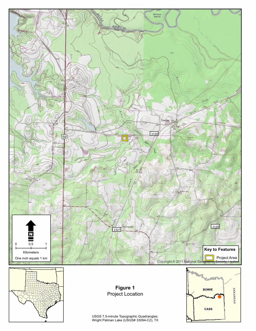

Environmental Setting
This page intentionally left blank
Draft Archeological Survey Report ndash City of Domino Water Treatment Plant ndash June 2015 6
MiA
3129
LtB
EeD
GaA
MiA
EeB
So
So
TnD
Mf
The entire view of this map islocated within the Wilcox Groupundivided (EPAwi) geologic formation
Intesecting Soil Types MiA - Metcalf silt loam 0 to 2 percent slopes
Figure 2 Key to FeaturesProject Area W Geology and Soils within Project Area 0 50 100 Soil Type Boundaries
Meters One inch equals 100 meters
Environmental Setting
This page intentionally left blank
Draft Archeological Survey Report ndash City of Domino Water Treatment Plant ndash June 2015 8
Methodology
METHODOLOGY
During initial consultation between the GTUA the City the Texas Commission on Environmental Quality ndash Water Quality Division and the THC it was noted that the ldquoproposed project area has never been formally surveyedrdquo and that the proposed location ldquois situated in a topographic location with moderate to high potential for the presence of previously unrecorded cultural resourcesrdquo which warranted survey before initiation of construction (See Appendix A letter Martin to Linendoll March 11 2015) In preparation for survey Hicks amp Company staff conducted background research utilizing the THCrsquos Archeological Sites Atlas (the Atlas) online database in order to identify previous cultural resources survey efforts and determine locations of cultural resources within the vicinity of the proposed project
Previous Investigations
According to the Atlas no survey-level investigations had been previously conducted within the immediate area with the nearest documented archeological survey located approximately 2300 meters to the northwest This survey of the perimeter of Wright Patman Lake was conducted by the United States Army Corps of Engineers (USACE) in 1998 The nearest recorded cultural resource is Domino Cemetery also known as the Albert Richie Cemetery Predominantly comprised of African-American graves this cemetery was created between 1865 and 1900 from land donated by Albert Richie a one-time slave who acquired land in the area following the Civil War (Find a Grave 2015) Located approximately 2500 meters northwest of the proposed project area the nearest recorded archeological site recorded during the above-noted USACE survey is Site 41CS226 Other than noting that this site dates to the historic-period and is considered ineligible for listing on the National Register of Historic Places or as a SAL no data is available for this site on the Atlas (THC 2015b)
Field Methodology
During the field investigations a Hicks amp Company archeologist traversed the entirety of the project area surveying and shovel testing along the perimeter before traversing the area east to west in transects spaced 20 to 30 meters apart A total of 13 shovel tests were excavated during the survey slightly exceeding the requisite amount of shovel tests for projects this size (2 per acre) Shovel testing intervals conformed to the minimum standards outlined by the THC and the Council of Texas Archeologistsrsquo practices and procedures (13 TAC 265 and 2620) (THC 2015a) Subsurface test locations were recorded using GPS technology with sub-meter accuracy No standing structures of historic age were noted within or adjacent to the project area Hence photo-documentation of these resources is not a component of this report
Draft Archeological Survey Report ndash City of Domino Water Treatment Plant ndash June 2015 9
Methodology
This page intentionally left blank
Draft Archeological Survey Report ndash City of Domino Water Treatment Plant ndash June 2015 10
3129
County Road 3884
FM 31
29
rthstar Geographics CNESAirbus Aerogrid IGN IGP swisstopo and th
Domino Cemetery
2327
3129poundcurren59
Camp
Coun
ty Ro
ad 36
59
Coun
tyRo
ad 36
60
Coun
tyRo
ad36
73
US H
wy 59
Coun
ty Ro
ad 36
67
US H
wy 59
County Road 3559
County Road
3677
Coun
tyRo
ad 36
62
Coun
tyRo
ad36
63
Coun
tyRo
ad36
65
County Road 3784
FM 2327
FM 3129
County Road 3675
COE-FWD0898
41CS226
Source Esri DigitalGlobe GeoEye EaDS USDA USGS AEX Getmapping eGIS User Community
Key to Features Archeological Site
Project Area Previous ArcheologicalSurveyCemetery
W0 05 1
Kilometers One inch equals 1 km
Figure 3
Previously Conducted Investigations ampRecorded Cultural Resources
CASS
BOWIE ARKANSAS
Methodology
This page intentionally left blank
Draft Archeological Survey Report ndash City of Domino Water Treatment Plant ndash June 2015 12
Results of Field Investigations
RESULTS OF FIELD INVESTIGATIONS
On May 28 2015 an archeologist from Hicks amp Company conducted an intensive aerial survey of the proposed location of the City of Dominorsquos Water Treatment Plant an area approximately six acres in size During survey it was noted that the project area is thickly vegetated with pine trees with an understory comprised mainly of greenbriar and various ivies with a forest floor covered with heavy leaf-litter and intermittent pockets of standing water a result of recent torrential rains (Figures 4 and 5) Due to these conditions ground surface visibility was minimal never more than five percent at any one location The southeast corner of the project area is immediately adjacent to an unnamed tributary of Baker Creek During survey this drainage was experiencing overbank flooding with much of the immediate area inundated (Figure 6)
Figure 4 Overview of Northern Boundary of Project Area Facing South from FM 3129
Draft Archeological Survey Report ndash City of Domino Water Treatment Plant ndash June 2015 13
Results of Field Investigations
Figure 5 Overview of Inundated Area Typical of Project Area Facing Northeast from STJH11
Figure 6 Overview of Tributary Drainage of Baker Creek Facing Southeast from STJH4
Draft Archeological Survey Report ndash City of Domino Water Treatment Plant ndash June 2015 14
Results of Field Investigations
Shovel testing of the project area noted homogenous sediment that was similar in texture hue and chroma to that described for Metcalf silt loam (NRCS 2015) In general these excavations noted upper strata of highly silicated silt that ranged in color from light yellowish brown (10YR 64) to brown (75YR 54) Strata below the first were noted to be silt loams with increasing clay content that ranged in color from yellowish brown (10YR 56) to brown (75YR 44 - 75YR 53) When tests were not impended by the water table or thick pine roots gray (10YR 61) and yellowish red (5YR 56) Bt-horizon clays were encountered at depths between 50 and 70 centimeters below the ground surface (cmbs) During the investigation a total of 13 shovel tests were excavated with all negative for the presence of cultural materials Data for all shovel tests is presented below in Table 1
Table 1 Shovel Test Data Shovel
Test Level Depth (cmbs)
P=Pos N=Neg Munsell
Soil Texture Description Inclusions Notes
JH1 1 0-30 N 75YR 54 Silt Loam Rootlets
JH1 2 30-40 N 75YR 53 Loam Water table encountered at 40 cmbs
JH2 1 0-20 N 75YR 54 Silt Loam Rootlets
JH2 2 20-30 N 74YR 53 Clay Loam Water table encountered at 30 cmbs
JH3 1 0-40 N 75YR 46 Silt Rootlets
JH3 2 40-50 N 5YR 46 Silt Loam Increasing clay content
JH3 3 40+ N 10YR 61 Silt Clay High clay content ST terminated win Bt horizon clay
JH4 1 0-20 N 10YR 64 Silt Loam Rootlets Very moist sediment
JH4 2 20-55 N 10YR 56 Silt Loam Water seepage begins at 50 cmbs
JH4 3 55-60 N 10YR 61 Clay ST terminated at 60 cmbs within Bt horizon clay
JH5 1 0-20 N 10YR 64 Silt Loam Rootlets Very moist sediment
JH5 2 20-55 N 10YR 56 Silt Loam
JH5 3 55-60 N 10YR 61 Clay ST terminated at 60 cmbs within Bt horizon clay
JH6 1 0-40 N 10YR 64 Silt Loam Rootlets Very moist sediment
JH6 2 40-50 N 75YR 53 Silt Clay Loam High clay content ST terminated at thick pine root
JH7 1 0-30 N 75YR 46 Silt Loam High silicates Inundated area- water table encountered at 20 cmbs
JH8 1 0-40 N 75YR 54 Silt Loam Rootlets
JH8 2 40-60 N 10YR 56 Silt Loam Increasing clay content
JH8 1 60-70 N 10YR 62 Clay ST terminated at 70 cmbs within BT horizon clay
JH9 1 0-30 N 75YR 54 Silt Loam Rootlets
JH9 2 30-65 N 75YR 53 Loam Increasing clay content
JH9 3 65-75 N 5YR 44 Clay ST terminated at 75 cmbs within BT horizon clay
JH10 1 0-20 N 75YR 54 Silt Loam Rootlets Very moist sediment
JH10 2 20-40 N 75YR 53 Silt Clay Loam ST terminated below water table at 35 cmbs
JH11 1 0-48 N 75YR 54 Silt Loam Rootlets ST terminated at thick pine root
JH12 1 0-45 N 10YR 64 Clay Rootlets
JH12 2 45-62 N 75YR 53 Silt Clay Loam
JH12 3 62-72 N 10YR 62 Clay Shovel test terminated at 72 cmbs Bt horizon clay
JH13 1 0-40 N 75YR 46 Silt Rootlets
JH13 2 40-60 N 5YR 46 Silt Loam
JH13 3 60-70 N 10YR 62 Clay ST terminated at 70 cmbs within Bt horizon clay
Draft Archeological Survey Report ndash City of Domino Water Treatment Plant ndash June 2015 15
Results of Field Investigations
This page intentionally left blank
Draft Archeological Survey Report ndash City of Domino Water Treatment Plant ndash June 2015 16
3129
JH1
JH2
JH13
JH3
JH4
JH5
JH6
JH7
JH8
JH9
JH10 JH11
JH12
Key to Features Shovel Tests
Project Area
W 0 20 40
Meters One inch equals 40 meters
CASS
BOWIE ARKANSAS
Figure 7
Shovel Test Locations
Results of Field Investigations
This page intentionally left blank
Draft Archeological Survey Report ndash City of Domino Water Treatment Plant ndash June 2015 18
Conclusions and Recommendations
CONCLUSIONS AND RECOMMENDATIONS
Pedestrian survey and shovel testing of the proposed location for the City of Dominorsquos Water Treatment Facility Plant project revealed no archeological sites features or cultural materials greater than 50 years in age Based on the results of the current survey it is recommended that no SALs (13 TAC 2612) will be affected by the proposed project and no further cultural resource investigations are recommended for the proposed project area prior to construction In the event that unanticipated archeological deposits are encountered during construction work in the immediate area will cease and THC archeological staff will be contacted to initiate post-review discovery procedures Hicks amp Company offers this draft report in partial fulfillment of Antiquities Permit 7275 No cultural materials were collected during the survey All project related forms notes and photographs will be permanently curated at CAS in San Marcos Texas
Draft Archeological Survey Report ndash City of Domino Water Treatment Plant ndash June 2015 19
Conclusions and Recommendations
This page intentionally left blank
Draft Archeological Survey Report ndash City of Domino Water Treatment Plant ndash June 2015 20
References Cited
REFERENCES CITED
Bureau of Economic Geology (BEG) 2007 Geologic Map Database of Texas httppubsusgsgovds2005170 (May 15 2015)
Texas Historical Commission (THC) 2012a Texas Administrative Code (TAC) Chapter 26 Rules of Practice and Procedure for the Antiquities Code of Texas httpinfososstatetxusplspubreadtac$extViewTACtac_view=4ampti=13amppt=2ampch=2 6amprl=Y (June 2 2015)
2015b Texas Archeological Sites Atlas (the Atlas) httpnuecesthcstatetxus (March 13 2015)
Find a Grave 2015 Albert Richie Cemetery httpwwwfindagravecomcgishybinfgcgipage=crampCRid=3265 (June 8 2015)
United States Department of Agriculture Natural Resource Conservations Service (USDA NRCS))
2015a Metcalf Silt Loam httpssoilseriesscegovusdagovosdnameasp (June 5 2015)
United States Department of Agriculture Natural Resources Conservation Service (USDA NRCS)
2015b Soil Survey Geographic (SSURGO) database for Cass County Texas httpSoilDataMartnrcsusdagov (March 13 2015)
Draft Archeological Survey Report ndash City of Domino Water Treatment Plant ndash June 2015 21
References Cited
This page intentionally left blank
Draft Archeological Survey Report ndash City of Domino Water Treatment Plant ndash June 2015 22
APPENDIX A
REGULATORY CORRESPONDENCE
_______________________
ANTIQUITIES PERMIT APPLICATION FORM ARCHEOLOGY
GENERAL INFORMATION
I PROPERTY TYPE AND LOCATION
Project Name (andor Site Trinomial) City of Domino Water Treatment Plant
County (ies) Knox County
USGS Quadrangle Name and Number Wright Patman Lake (33094-C2)
UTM Coordinates Zone 15
Centroid E 3964629 N 3680784
Location Just west of the City of Domino off of FM 3129
Federal Involvement Yes No XX
Name of Federal Agency Agency Representative
II OWNER (OR CONTROLLING AGENCY)
Owner City of Domino
Representative
Mayor Alfred Campbell
Address City of Domino
14555 FM 3129
CityStateZip Domino TX 75572 Telephone (include area code) _____________________Email Address albdcampbellhotmailcom______
III PROJECT SPONSOR (IF DIFFERENT FROM OWNER)
Sponsor
Representative
Address
CityStateZip
Telephone (include area code) Email Address
PROJECT INFORMATION
I PRINCIPAL INVESTIGATOR (ARCHEOLOGIST)
Name Josh Haefner
Affiliation Hicks amp Company
Address 1504 W 5th Street
CityStateZip Austin Tx 78703
Telephone (include area code) 512-478-0858 Email Address jhaefnerhicksenvcom
(OVER)
ANTIQUITIES PERMIT APPLICATION FORM (CONTINUED)
II PROJECT DESCRIPTION
Proposed Starting Date of Fieldwork May 24 2015 Requested Permit Duration 2 Years Months (1 year minimum) Scope of Work (Provided an Outline of Proposed Work) Intensive Survey (see attached scope of work)
III CURATION amp REPORT
Temporary Curatorial or Laboratory Facility Hicks amp Company
Permanent Curatorial Facility Center for Archeological Studies (CAS)
IV LAND OWNERrsquoS CERTIFICATION
I Alfred Campbell as legal representative of the Land Owner
do certify that I have reviewed the plans and research design and that no investigations
will be preformed prior to the issuance of a permit by the Texas Historical Commission Furthermore I understand that
the Owner Sponsor and Principal Investigator are responsible for completing the terms of the permit
Signature Date
V SPONSORrsquoS CERTIFICATION
I as legal representative of the Sponsor
do certify that I have review the plans and
research design and that no investigations will be performed prior to the issuance of a permit by the Texas Historical
Commission Furthermore I understand that the Sponsor Owner and Principal Investigator are responsible for
completing the terms of this permit
Signature Date
VI INVESTIGATORrsquoS CERTIFICATION
I Josh Haefner as Principal Investigator employed by
Hicks amp Company (Investigative Firm) do certify that I will execute this project
according to the submitted plans and research design and will not conduct any work prior to the issuance of a permit by
the Texas Historical Commission Furthermore I understand that the Principal Investigator (and the Investigative Firm)
as well as the Owner and Sponsor are responsible for completing the terms of this permit
Signature Date 5415
Principal Investigator must attach a research design a copy of the USGS quadrangle showing project boundaries and any
additional pertinent information Curriculum vita must be on file with the Division of Antiquities Protection
FOR OFFICIAL USE ONLY
Reviewer Date Permit Issues
Permit Number Permit Expiration Date
Type of Permit Date Received for Data Entry
Texas Historical Commission
Archeology Division
PO Box 12276 Austin TX 78711-2276
Phone 512463-6096
wwwthcstatetxus
Hicks amp Companyrsquos Scope of Work for the
City of Dominorsquos Water Treatment Plant Project Cass County Texas
May 4 2015
Pursuant to the Texas Historical Commissionrsquos (THC) recommendation regarding the
Greater Texoma Utility Authority (GTUA) and City of Dominosrsquo compliance
responsibilities (Attachment 1 letter Wolfe to Linendoll March 11 2015) this scope of
work describes an archeological resources survey for the City of Dominorsquos Water
Treatment Plant Project in Rio Hike and Bike Trail Improvements Project in Cass
County Texas The proposed project consists of the construction of a new water
treatment plant on a parcel approximately six acres in size (Attachment 2 Project
Location) During review of the proposed project the THC noted that this parcel has
never before been surveyed and is located within an area determined to have good
probability to contain archeological deposits requiring archeological survey for
Antiquities Code of Texas (ACT) compliance
According to the Geologic Atlas of Texas Texarkana Sheet the underlying geology of
the proposed project areas consists of the Wilcox Group undivided formation (Barnes
1979) Dating the Eocene which long predates human arrival in the Americas cultural
deposits in such mapped areas can be expected to be contained to overlying surface
soilssediment or the surface itself A single soil series the Metcalf silt loam 0 to 2
percent slopes is mapped for the project area This series typically has shallow A
horizons with Bt clay horizons typically occurring between 4 and 75 centimeters below
the ground surface
Because there is limited potential for deeply buried archeological deposits Hicks amp
Company is proposing pedestrian survey supplemented with shovel testing as a
sufficient methodology to assess the proposed projectrsquos potential to impact archeological
resourcessites The project area will be tested at a rate of no less than 12 subsurface tests
(2 per acre) in accordance with the THCrsquos minimum standards for intensive areal survey
Investigators will record their observations and the results of shovel tests through notes
standardized shovel test forms and photographs Shovel tests will be excavated to a
depth of one meter or bedrock and sediment from all shovel tests will be screened
through frac14-inch hardware cloth Shovel test locations will be recorded utilizing GPS
technology The survey will follow a no-collection policy in which artifacts will be
recorded identified and quantified in the field but returned to their find location
Any archeological sites identified during the survey will be investigated by no fewer than
six shovel tests in order to define site boundaries relative to the project area Identified
sites will be recorded in accordance with the THCrsquos standards for site investigation
Subsurface tests within sites will be excavated at a frequency and arrangement
appropriate for assessing site size depth and significance Site locations will be
recorded utilizing GPS technology and data will be recorded on standardized forms
Documented sites will be recorded at the Texas Archeological Research Laboratory
(TARL) and new trinomials will be assigned
The results of the investigation will be compiled into a professional report as required
under Chapter 26 of the THCrsquos Rules of Practice and Procedure The report will include a
summary of background information results of field investigations and
recommendations about the need for further investigations (if any) with respect to both
historic and prehistoric sites and will be submitted to THC for review and comment In
accordance with revised ACT requirements hard copies and digital files of the final
report will be submitted to the THC and other recommended libraries and repositories
across Texas Additionally all project-generated forms notes photographs etc will be
formally curated at the Center for Archeological Studies in San Marcos Texas
REFERENCES
Barnes V E
1979 Geologic Atlas of Texas Texarkana Sheet Bureau of Economic Geology the University of Texas at Austin
United States Department of Agriculture (USDA)
2015 Web Soil Survey httpwebsoilsurveynrcsusdagovappWebSoilSurveyaspx accessed May 4 2015
ATTACHMENTS
-
3129 2327
3129 poundcurren59
Copyrightcopy 2011 National Geographic Society i cubed
Key to Features Water Treatment FacilityBoundary
W 0 05 1
Kilometers
Attachment 2Project Location
City of Domino Archeological Services
USGS 75-minute Topographic QuadranglesWright Patman Lake (USGS 33094-C2) TX
CASS
BOWIE ARKANSAS
- Short Report on the Archeological Investigations for the City of Dominorsquos Proposed New Water Treatment Plant Cass County Texas
- Short Report on the Archeological Investigations for the City of Dominorsquos Proposed New Water Treatment Plant Cass County Texas
-
- Creative Commons License
-
- PROJECT DESCRIPTION AND MANAGEMENT SUMMARY
- ENVIRONMENTAL SETTING
-
- Physiography
- Geology and Soils
-
- METHODOLOGY
-
- Previous Investigations
- Field Methodology
-
- RESULTS OF FIELD INVESTIGATIONS
- CONCLUSIONS AND RECOMMENDATIONS
- REFERENCES CITED
-

MiA
3129
LtB
EeD
GaA
MiA
EeB
So
So
TnD
Mf
The entire view of this map islocated within the Wilcox Groupundivided (EPAwi) geologic formation
Intesecting Soil Types MiA - Metcalf silt loam 0 to 2 percent slopes
Figure 2 Key to FeaturesProject Area W Geology and Soils within Project Area 0 50 100 Soil Type Boundaries
Meters One inch equals 100 meters
Environmental Setting
This page intentionally left blank
Draft Archeological Survey Report ndash City of Domino Water Treatment Plant ndash June 2015 8
Methodology
METHODOLOGY
During initial consultation between the GTUA the City the Texas Commission on Environmental Quality ndash Water Quality Division and the THC it was noted that the ldquoproposed project area has never been formally surveyedrdquo and that the proposed location ldquois situated in a topographic location with moderate to high potential for the presence of previously unrecorded cultural resourcesrdquo which warranted survey before initiation of construction (See Appendix A letter Martin to Linendoll March 11 2015) In preparation for survey Hicks amp Company staff conducted background research utilizing the THCrsquos Archeological Sites Atlas (the Atlas) online database in order to identify previous cultural resources survey efforts and determine locations of cultural resources within the vicinity of the proposed project
Previous Investigations
According to the Atlas no survey-level investigations had been previously conducted within the immediate area with the nearest documented archeological survey located approximately 2300 meters to the northwest This survey of the perimeter of Wright Patman Lake was conducted by the United States Army Corps of Engineers (USACE) in 1998 The nearest recorded cultural resource is Domino Cemetery also known as the Albert Richie Cemetery Predominantly comprised of African-American graves this cemetery was created between 1865 and 1900 from land donated by Albert Richie a one-time slave who acquired land in the area following the Civil War (Find a Grave 2015) Located approximately 2500 meters northwest of the proposed project area the nearest recorded archeological site recorded during the above-noted USACE survey is Site 41CS226 Other than noting that this site dates to the historic-period and is considered ineligible for listing on the National Register of Historic Places or as a SAL no data is available for this site on the Atlas (THC 2015b)
Field Methodology
During the field investigations a Hicks amp Company archeologist traversed the entirety of the project area surveying and shovel testing along the perimeter before traversing the area east to west in transects spaced 20 to 30 meters apart A total of 13 shovel tests were excavated during the survey slightly exceeding the requisite amount of shovel tests for projects this size (2 per acre) Shovel testing intervals conformed to the minimum standards outlined by the THC and the Council of Texas Archeologistsrsquo practices and procedures (13 TAC 265 and 2620) (THC 2015a) Subsurface test locations were recorded using GPS technology with sub-meter accuracy No standing structures of historic age were noted within or adjacent to the project area Hence photo-documentation of these resources is not a component of this report
Draft Archeological Survey Report ndash City of Domino Water Treatment Plant ndash June 2015 9
Methodology
This page intentionally left blank
Draft Archeological Survey Report ndash City of Domino Water Treatment Plant ndash June 2015 10
3129
County Road 3884
FM 31
29
rthstar Geographics CNESAirbus Aerogrid IGN IGP swisstopo and th
Domino Cemetery
2327
3129poundcurren59
Camp
Coun
ty Ro
ad 36
59
Coun
tyRo
ad 36
60
Coun
tyRo
ad36
73
US H
wy 59
Coun
ty Ro
ad 36
67
US H
wy 59
County Road 3559
County Road
3677
Coun
tyRo
ad 36
62
Coun
tyRo
ad36
63
Coun
tyRo
ad36
65
County Road 3784
FM 2327
FM 3129
County Road 3675
COE-FWD0898
41CS226
Source Esri DigitalGlobe GeoEye EaDS USDA USGS AEX Getmapping eGIS User Community
Key to Features Archeological Site
Project Area Previous ArcheologicalSurveyCemetery
W0 05 1
Kilometers One inch equals 1 km
Figure 3
Previously Conducted Investigations ampRecorded Cultural Resources
CASS
BOWIE ARKANSAS
Methodology
This page intentionally left blank
Draft Archeological Survey Report ndash City of Domino Water Treatment Plant ndash June 2015 12
Results of Field Investigations
RESULTS OF FIELD INVESTIGATIONS
On May 28 2015 an archeologist from Hicks amp Company conducted an intensive aerial survey of the proposed location of the City of Dominorsquos Water Treatment Plant an area approximately six acres in size During survey it was noted that the project area is thickly vegetated with pine trees with an understory comprised mainly of greenbriar and various ivies with a forest floor covered with heavy leaf-litter and intermittent pockets of standing water a result of recent torrential rains (Figures 4 and 5) Due to these conditions ground surface visibility was minimal never more than five percent at any one location The southeast corner of the project area is immediately adjacent to an unnamed tributary of Baker Creek During survey this drainage was experiencing overbank flooding with much of the immediate area inundated (Figure 6)
Figure 4 Overview of Northern Boundary of Project Area Facing South from FM 3129
Draft Archeological Survey Report ndash City of Domino Water Treatment Plant ndash June 2015 13
Results of Field Investigations
Figure 5 Overview of Inundated Area Typical of Project Area Facing Northeast from STJH11
Figure 6 Overview of Tributary Drainage of Baker Creek Facing Southeast from STJH4
Draft Archeological Survey Report ndash City of Domino Water Treatment Plant ndash June 2015 14
Results of Field Investigations
Shovel testing of the project area noted homogenous sediment that was similar in texture hue and chroma to that described for Metcalf silt loam (NRCS 2015) In general these excavations noted upper strata of highly silicated silt that ranged in color from light yellowish brown (10YR 64) to brown (75YR 54) Strata below the first were noted to be silt loams with increasing clay content that ranged in color from yellowish brown (10YR 56) to brown (75YR 44 - 75YR 53) When tests were not impended by the water table or thick pine roots gray (10YR 61) and yellowish red (5YR 56) Bt-horizon clays were encountered at depths between 50 and 70 centimeters below the ground surface (cmbs) During the investigation a total of 13 shovel tests were excavated with all negative for the presence of cultural materials Data for all shovel tests is presented below in Table 1
Table 1 Shovel Test Data Shovel
Test Level Depth (cmbs)
P=Pos N=Neg Munsell
Soil Texture Description Inclusions Notes
JH1 1 0-30 N 75YR 54 Silt Loam Rootlets
JH1 2 30-40 N 75YR 53 Loam Water table encountered at 40 cmbs
JH2 1 0-20 N 75YR 54 Silt Loam Rootlets
JH2 2 20-30 N 74YR 53 Clay Loam Water table encountered at 30 cmbs
JH3 1 0-40 N 75YR 46 Silt Rootlets
JH3 2 40-50 N 5YR 46 Silt Loam Increasing clay content
JH3 3 40+ N 10YR 61 Silt Clay High clay content ST terminated win Bt horizon clay
JH4 1 0-20 N 10YR 64 Silt Loam Rootlets Very moist sediment
JH4 2 20-55 N 10YR 56 Silt Loam Water seepage begins at 50 cmbs
JH4 3 55-60 N 10YR 61 Clay ST terminated at 60 cmbs within Bt horizon clay
JH5 1 0-20 N 10YR 64 Silt Loam Rootlets Very moist sediment
JH5 2 20-55 N 10YR 56 Silt Loam
JH5 3 55-60 N 10YR 61 Clay ST terminated at 60 cmbs within Bt horizon clay
JH6 1 0-40 N 10YR 64 Silt Loam Rootlets Very moist sediment
JH6 2 40-50 N 75YR 53 Silt Clay Loam High clay content ST terminated at thick pine root
JH7 1 0-30 N 75YR 46 Silt Loam High silicates Inundated area- water table encountered at 20 cmbs
JH8 1 0-40 N 75YR 54 Silt Loam Rootlets
JH8 2 40-60 N 10YR 56 Silt Loam Increasing clay content
JH8 1 60-70 N 10YR 62 Clay ST terminated at 70 cmbs within BT horizon clay
JH9 1 0-30 N 75YR 54 Silt Loam Rootlets
JH9 2 30-65 N 75YR 53 Loam Increasing clay content
JH9 3 65-75 N 5YR 44 Clay ST terminated at 75 cmbs within BT horizon clay
JH10 1 0-20 N 75YR 54 Silt Loam Rootlets Very moist sediment
JH10 2 20-40 N 75YR 53 Silt Clay Loam ST terminated below water table at 35 cmbs
JH11 1 0-48 N 75YR 54 Silt Loam Rootlets ST terminated at thick pine root
JH12 1 0-45 N 10YR 64 Clay Rootlets
JH12 2 45-62 N 75YR 53 Silt Clay Loam
JH12 3 62-72 N 10YR 62 Clay Shovel test terminated at 72 cmbs Bt horizon clay
JH13 1 0-40 N 75YR 46 Silt Rootlets
JH13 2 40-60 N 5YR 46 Silt Loam
JH13 3 60-70 N 10YR 62 Clay ST terminated at 70 cmbs within Bt horizon clay
Draft Archeological Survey Report ndash City of Domino Water Treatment Plant ndash June 2015 15
Results of Field Investigations
This page intentionally left blank
Draft Archeological Survey Report ndash City of Domino Water Treatment Plant ndash June 2015 16
3129
JH1
JH2
JH13
JH3
JH4
JH5
JH6
JH7
JH8
JH9
JH10 JH11
JH12
Key to Features Shovel Tests
Project Area
W 0 20 40
Meters One inch equals 40 meters
CASS
BOWIE ARKANSAS
Figure 7
Shovel Test Locations
Results of Field Investigations
This page intentionally left blank
Draft Archeological Survey Report ndash City of Domino Water Treatment Plant ndash June 2015 18
Conclusions and Recommendations
CONCLUSIONS AND RECOMMENDATIONS
Pedestrian survey and shovel testing of the proposed location for the City of Dominorsquos Water Treatment Facility Plant project revealed no archeological sites features or cultural materials greater than 50 years in age Based on the results of the current survey it is recommended that no SALs (13 TAC 2612) will be affected by the proposed project and no further cultural resource investigations are recommended for the proposed project area prior to construction In the event that unanticipated archeological deposits are encountered during construction work in the immediate area will cease and THC archeological staff will be contacted to initiate post-review discovery procedures Hicks amp Company offers this draft report in partial fulfillment of Antiquities Permit 7275 No cultural materials were collected during the survey All project related forms notes and photographs will be permanently curated at CAS in San Marcos Texas
Draft Archeological Survey Report ndash City of Domino Water Treatment Plant ndash June 2015 19
Conclusions and Recommendations
This page intentionally left blank
Draft Archeological Survey Report ndash City of Domino Water Treatment Plant ndash June 2015 20
References Cited
REFERENCES CITED
Bureau of Economic Geology (BEG) 2007 Geologic Map Database of Texas httppubsusgsgovds2005170 (May 15 2015)
Texas Historical Commission (THC) 2012a Texas Administrative Code (TAC) Chapter 26 Rules of Practice and Procedure for the Antiquities Code of Texas httpinfososstatetxusplspubreadtac$extViewTACtac_view=4ampti=13amppt=2ampch=2 6amprl=Y (June 2 2015)
2015b Texas Archeological Sites Atlas (the Atlas) httpnuecesthcstatetxus (March 13 2015)
Find a Grave 2015 Albert Richie Cemetery httpwwwfindagravecomcgishybinfgcgipage=crampCRid=3265 (June 8 2015)
United States Department of Agriculture Natural Resource Conservations Service (USDA NRCS))
2015a Metcalf Silt Loam httpssoilseriesscegovusdagovosdnameasp (June 5 2015)
United States Department of Agriculture Natural Resources Conservation Service (USDA NRCS)
2015b Soil Survey Geographic (SSURGO) database for Cass County Texas httpSoilDataMartnrcsusdagov (March 13 2015)
Draft Archeological Survey Report ndash City of Domino Water Treatment Plant ndash June 2015 21
References Cited
This page intentionally left blank
Draft Archeological Survey Report ndash City of Domino Water Treatment Plant ndash June 2015 22
APPENDIX A
REGULATORY CORRESPONDENCE
_______________________
ANTIQUITIES PERMIT APPLICATION FORM ARCHEOLOGY
GENERAL INFORMATION
I PROPERTY TYPE AND LOCATION
Project Name (andor Site Trinomial) City of Domino Water Treatment Plant
County (ies) Knox County
USGS Quadrangle Name and Number Wright Patman Lake (33094-C2)
UTM Coordinates Zone 15
Centroid E 3964629 N 3680784
Location Just west of the City of Domino off of FM 3129
Federal Involvement Yes No XX
Name of Federal Agency Agency Representative
II OWNER (OR CONTROLLING AGENCY)
Owner City of Domino
Representative
Mayor Alfred Campbell
Address City of Domino
14555 FM 3129
CityStateZip Domino TX 75572 Telephone (include area code) _____________________Email Address albdcampbellhotmailcom______
III PROJECT SPONSOR (IF DIFFERENT FROM OWNER)
Sponsor
Representative
Address
CityStateZip
Telephone (include area code) Email Address
PROJECT INFORMATION
I PRINCIPAL INVESTIGATOR (ARCHEOLOGIST)
Name Josh Haefner
Affiliation Hicks amp Company
Address 1504 W 5th Street
CityStateZip Austin Tx 78703
Telephone (include area code) 512-478-0858 Email Address jhaefnerhicksenvcom
(OVER)
ANTIQUITIES PERMIT APPLICATION FORM (CONTINUED)
II PROJECT DESCRIPTION
Proposed Starting Date of Fieldwork May 24 2015 Requested Permit Duration 2 Years Months (1 year minimum) Scope of Work (Provided an Outline of Proposed Work) Intensive Survey (see attached scope of work)
III CURATION amp REPORT
Temporary Curatorial or Laboratory Facility Hicks amp Company
Permanent Curatorial Facility Center for Archeological Studies (CAS)
IV LAND OWNERrsquoS CERTIFICATION
I Alfred Campbell as legal representative of the Land Owner
do certify that I have reviewed the plans and research design and that no investigations
will be preformed prior to the issuance of a permit by the Texas Historical Commission Furthermore I understand that
the Owner Sponsor and Principal Investigator are responsible for completing the terms of the permit
Signature Date
V SPONSORrsquoS CERTIFICATION
I as legal representative of the Sponsor
do certify that I have review the plans and
research design and that no investigations will be performed prior to the issuance of a permit by the Texas Historical
Commission Furthermore I understand that the Sponsor Owner and Principal Investigator are responsible for
completing the terms of this permit
Signature Date
VI INVESTIGATORrsquoS CERTIFICATION
I Josh Haefner as Principal Investigator employed by
Hicks amp Company (Investigative Firm) do certify that I will execute this project
according to the submitted plans and research design and will not conduct any work prior to the issuance of a permit by
the Texas Historical Commission Furthermore I understand that the Principal Investigator (and the Investigative Firm)
as well as the Owner and Sponsor are responsible for completing the terms of this permit
Signature Date 5415
Principal Investigator must attach a research design a copy of the USGS quadrangle showing project boundaries and any
additional pertinent information Curriculum vita must be on file with the Division of Antiquities Protection
FOR OFFICIAL USE ONLY
Reviewer Date Permit Issues
Permit Number Permit Expiration Date
Type of Permit Date Received for Data Entry
Texas Historical Commission
Archeology Division
PO Box 12276 Austin TX 78711-2276
Phone 512463-6096
wwwthcstatetxus
Hicks amp Companyrsquos Scope of Work for the
City of Dominorsquos Water Treatment Plant Project Cass County Texas
May 4 2015
Pursuant to the Texas Historical Commissionrsquos (THC) recommendation regarding the
Greater Texoma Utility Authority (GTUA) and City of Dominosrsquo compliance
responsibilities (Attachment 1 letter Wolfe to Linendoll March 11 2015) this scope of
work describes an archeological resources survey for the City of Dominorsquos Water
Treatment Plant Project in Rio Hike and Bike Trail Improvements Project in Cass
County Texas The proposed project consists of the construction of a new water
treatment plant on a parcel approximately six acres in size (Attachment 2 Project
Location) During review of the proposed project the THC noted that this parcel has
never before been surveyed and is located within an area determined to have good
probability to contain archeological deposits requiring archeological survey for
Antiquities Code of Texas (ACT) compliance
According to the Geologic Atlas of Texas Texarkana Sheet the underlying geology of
the proposed project areas consists of the Wilcox Group undivided formation (Barnes
1979) Dating the Eocene which long predates human arrival in the Americas cultural
deposits in such mapped areas can be expected to be contained to overlying surface
soilssediment or the surface itself A single soil series the Metcalf silt loam 0 to 2
percent slopes is mapped for the project area This series typically has shallow A
horizons with Bt clay horizons typically occurring between 4 and 75 centimeters below
the ground surface
Because there is limited potential for deeply buried archeological deposits Hicks amp
Company is proposing pedestrian survey supplemented with shovel testing as a
sufficient methodology to assess the proposed projectrsquos potential to impact archeological
resourcessites The project area will be tested at a rate of no less than 12 subsurface tests
(2 per acre) in accordance with the THCrsquos minimum standards for intensive areal survey
Investigators will record their observations and the results of shovel tests through notes
standardized shovel test forms and photographs Shovel tests will be excavated to a
depth of one meter or bedrock and sediment from all shovel tests will be screened
through frac14-inch hardware cloth Shovel test locations will be recorded utilizing GPS
technology The survey will follow a no-collection policy in which artifacts will be
recorded identified and quantified in the field but returned to their find location
Any archeological sites identified during the survey will be investigated by no fewer than
six shovel tests in order to define site boundaries relative to the project area Identified
sites will be recorded in accordance with the THCrsquos standards for site investigation
Subsurface tests within sites will be excavated at a frequency and arrangement
appropriate for assessing site size depth and significance Site locations will be
recorded utilizing GPS technology and data will be recorded on standardized forms
Documented sites will be recorded at the Texas Archeological Research Laboratory
(TARL) and new trinomials will be assigned
The results of the investigation will be compiled into a professional report as required
under Chapter 26 of the THCrsquos Rules of Practice and Procedure The report will include a
summary of background information results of field investigations and
recommendations about the need for further investigations (if any) with respect to both
historic and prehistoric sites and will be submitted to THC for review and comment In
accordance with revised ACT requirements hard copies and digital files of the final
report will be submitted to the THC and other recommended libraries and repositories
across Texas Additionally all project-generated forms notes photographs etc will be
formally curated at the Center for Archeological Studies in San Marcos Texas
REFERENCES
Barnes V E
1979 Geologic Atlas of Texas Texarkana Sheet Bureau of Economic Geology the University of Texas at Austin
United States Department of Agriculture (USDA)
2015 Web Soil Survey httpwebsoilsurveynrcsusdagovappWebSoilSurveyaspx accessed May 4 2015
ATTACHMENTS
-
3129 2327
3129 poundcurren59
Copyrightcopy 2011 National Geographic Society i cubed
Key to Features Water Treatment FacilityBoundary
W 0 05 1
Kilometers
Attachment 2Project Location
City of Domino Archeological Services
USGS 75-minute Topographic QuadranglesWright Patman Lake (USGS 33094-C2) TX
CASS
BOWIE ARKANSAS
- Short Report on the Archeological Investigations for the City of Dominorsquos Proposed New Water Treatment Plant Cass County Texas
- Short Report on the Archeological Investigations for the City of Dominorsquos Proposed New Water Treatment Plant Cass County Texas
-
- Creative Commons License
-
- PROJECT DESCRIPTION AND MANAGEMENT SUMMARY
- ENVIRONMENTAL SETTING
-
- Physiography
- Geology and Soils
-
- METHODOLOGY
-
- Previous Investigations
- Field Methodology
-
- RESULTS OF FIELD INVESTIGATIONS
- CONCLUSIONS AND RECOMMENDATIONS
- REFERENCES CITED
-

Methodology
METHODOLOGY
During initial consultation between the GTUA the City the Texas Commission on Environmental Quality ndash Water Quality Division and the THC it was noted that the ldquoproposed project area has never been formally surveyedrdquo and that the proposed location ldquois situated in a topographic location with moderate to high potential for the presence of previously unrecorded cultural resourcesrdquo which warranted survey before initiation of construction (See Appendix A letter Martin to Linendoll March 11 2015) In preparation for survey Hicks amp Company staff conducted background research utilizing the THCrsquos Archeological Sites Atlas (the Atlas) online database in order to identify previous cultural resources survey efforts and determine locations of cultural resources within the vicinity of the proposed project
Previous Investigations
According to the Atlas no survey-level investigations had been previously conducted within the immediate area with the nearest documented archeological survey located approximately 2300 meters to the northwest This survey of the perimeter of Wright Patman Lake was conducted by the United States Army Corps of Engineers (USACE) in 1998 The nearest recorded cultural resource is Domino Cemetery also known as the Albert Richie Cemetery Predominantly comprised of African-American graves this cemetery was created between 1865 and 1900 from land donated by Albert Richie a one-time slave who acquired land in the area following the Civil War (Find a Grave 2015) Located approximately 2500 meters northwest of the proposed project area the nearest recorded archeological site recorded during the above-noted USACE survey is Site 41CS226 Other than noting that this site dates to the historic-period and is considered ineligible for listing on the National Register of Historic Places or as a SAL no data is available for this site on the Atlas (THC 2015b)
Field Methodology
During the field investigations a Hicks amp Company archeologist traversed the entirety of the project area surveying and shovel testing along the perimeter before traversing the area east to west in transects spaced 20 to 30 meters apart A total of 13 shovel tests were excavated during the survey slightly exceeding the requisite amount of shovel tests for projects this size (2 per acre) Shovel testing intervals conformed to the minimum standards outlined by the THC and the Council of Texas Archeologistsrsquo practices and procedures (13 TAC 265 and 2620) (THC 2015a) Subsurface test locations were recorded using GPS technology with sub-meter accuracy No standing structures of historic age were noted within or adjacent to the project area Hence photo-documentation of these resources is not a component of this report
Draft Archeological Survey Report ndash City of Domino Water Treatment Plant ndash June 2015 9
Methodology
This page intentionally left blank
Draft Archeological Survey Report ndash City of Domino Water Treatment Plant ndash June 2015 10
3129
County Road 3884
FM 31
29
rthstar Geographics CNESAirbus Aerogrid IGN IGP swisstopo and th
Domino Cemetery
2327
3129poundcurren59
Camp
Coun
ty Ro
ad 36
59
Coun
tyRo
ad 36
60
Coun
tyRo
ad36
73
US H
wy 59
Coun
ty Ro
ad 36
67
US H
wy 59
County Road 3559
County Road
3677
Coun
tyRo
ad 36
62
Coun
tyRo
ad36
63
Coun
tyRo
ad36
65
County Road 3784
FM 2327
FM 3129
County Road 3675
COE-FWD0898
41CS226
Source Esri DigitalGlobe GeoEye EaDS USDA USGS AEX Getmapping eGIS User Community
Key to Features Archeological Site
Project Area Previous ArcheologicalSurveyCemetery
W0 05 1
Kilometers One inch equals 1 km
Figure 3
Previously Conducted Investigations ampRecorded Cultural Resources
CASS
BOWIE ARKANSAS
Methodology
This page intentionally left blank
Draft Archeological Survey Report ndash City of Domino Water Treatment Plant ndash June 2015 12
Results of Field Investigations
RESULTS OF FIELD INVESTIGATIONS
On May 28 2015 an archeologist from Hicks amp Company conducted an intensive aerial survey of the proposed location of the City of Dominorsquos Water Treatment Plant an area approximately six acres in size During survey it was noted that the project area is thickly vegetated with pine trees with an understory comprised mainly of greenbriar and various ivies with a forest floor covered with heavy leaf-litter and intermittent pockets of standing water a result of recent torrential rains (Figures 4 and 5) Due to these conditions ground surface visibility was minimal never more than five percent at any one location The southeast corner of the project area is immediately adjacent to an unnamed tributary of Baker Creek During survey this drainage was experiencing overbank flooding with much of the immediate area inundated (Figure 6)
Figure 4 Overview of Northern Boundary of Project Area Facing South from FM 3129
Draft Archeological Survey Report ndash City of Domino Water Treatment Plant ndash June 2015 13
Results of Field Investigations
Figure 5 Overview of Inundated Area Typical of Project Area Facing Northeast from STJH11
Figure 6 Overview of Tributary Drainage of Baker Creek Facing Southeast from STJH4
Draft Archeological Survey Report ndash City of Domino Water Treatment Plant ndash June 2015 14
Results of Field Investigations
Shovel testing of the project area noted homogenous sediment that was similar in texture hue and chroma to that described for Metcalf silt loam (NRCS 2015) In general these excavations noted upper strata of highly silicated silt that ranged in color from light yellowish brown (10YR 64) to brown (75YR 54) Strata below the first were noted to be silt loams with increasing clay content that ranged in color from yellowish brown (10YR 56) to brown (75YR 44 - 75YR 53) When tests were not impended by the water table or thick pine roots gray (10YR 61) and yellowish red (5YR 56) Bt-horizon clays were encountered at depths between 50 and 70 centimeters below the ground surface (cmbs) During the investigation a total of 13 shovel tests were excavated with all negative for the presence of cultural materials Data for all shovel tests is presented below in Table 1
Table 1 Shovel Test Data Shovel
Test Level Depth (cmbs)
P=Pos N=Neg Munsell
Soil Texture Description Inclusions Notes
JH1 1 0-30 N 75YR 54 Silt Loam Rootlets
JH1 2 30-40 N 75YR 53 Loam Water table encountered at 40 cmbs
JH2 1 0-20 N 75YR 54 Silt Loam Rootlets
JH2 2 20-30 N 74YR 53 Clay Loam Water table encountered at 30 cmbs
JH3 1 0-40 N 75YR 46 Silt Rootlets
JH3 2 40-50 N 5YR 46 Silt Loam Increasing clay content
JH3 3 40+ N 10YR 61 Silt Clay High clay content ST terminated win Bt horizon clay
JH4 1 0-20 N 10YR 64 Silt Loam Rootlets Very moist sediment
JH4 2 20-55 N 10YR 56 Silt Loam Water seepage begins at 50 cmbs
JH4 3 55-60 N 10YR 61 Clay ST terminated at 60 cmbs within Bt horizon clay
JH5 1 0-20 N 10YR 64 Silt Loam Rootlets Very moist sediment
JH5 2 20-55 N 10YR 56 Silt Loam
JH5 3 55-60 N 10YR 61 Clay ST terminated at 60 cmbs within Bt horizon clay
JH6 1 0-40 N 10YR 64 Silt Loam Rootlets Very moist sediment
JH6 2 40-50 N 75YR 53 Silt Clay Loam High clay content ST terminated at thick pine root
JH7 1 0-30 N 75YR 46 Silt Loam High silicates Inundated area- water table encountered at 20 cmbs
JH8 1 0-40 N 75YR 54 Silt Loam Rootlets
JH8 2 40-60 N 10YR 56 Silt Loam Increasing clay content
JH8 1 60-70 N 10YR 62 Clay ST terminated at 70 cmbs within BT horizon clay
JH9 1 0-30 N 75YR 54 Silt Loam Rootlets
JH9 2 30-65 N 75YR 53 Loam Increasing clay content
JH9 3 65-75 N 5YR 44 Clay ST terminated at 75 cmbs within BT horizon clay
JH10 1 0-20 N 75YR 54 Silt Loam Rootlets Very moist sediment
JH10 2 20-40 N 75YR 53 Silt Clay Loam ST terminated below water table at 35 cmbs
JH11 1 0-48 N 75YR 54 Silt Loam Rootlets ST terminated at thick pine root
JH12 1 0-45 N 10YR 64 Clay Rootlets
JH12 2 45-62 N 75YR 53 Silt Clay Loam
JH12 3 62-72 N 10YR 62 Clay Shovel test terminated at 72 cmbs Bt horizon clay
JH13 1 0-40 N 75YR 46 Silt Rootlets
JH13 2 40-60 N 5YR 46 Silt Loam
JH13 3 60-70 N 10YR 62 Clay ST terminated at 70 cmbs within Bt horizon clay
Draft Archeological Survey Report ndash City of Domino Water Treatment Plant ndash June 2015 15
Results of Field Investigations
This page intentionally left blank
Draft Archeological Survey Report ndash City of Domino Water Treatment Plant ndash June 2015 16
3129
JH1
JH2
JH13
JH3
JH4
JH5
JH6
JH7
JH8
JH9
JH10 JH11
JH12
Key to Features Shovel Tests
Project Area
W 0 20 40
Meters One inch equals 40 meters
CASS
BOWIE ARKANSAS
Figure 7
Shovel Test Locations
Results of Field Investigations
This page intentionally left blank
Draft Archeological Survey Report ndash City of Domino Water Treatment Plant ndash June 2015 18
Conclusions and Recommendations
CONCLUSIONS AND RECOMMENDATIONS
Pedestrian survey and shovel testing of the proposed location for the City of Dominorsquos Water Treatment Facility Plant project revealed no archeological sites features or cultural materials greater than 50 years in age Based on the results of the current survey it is recommended that no SALs (13 TAC 2612) will be affected by the proposed project and no further cultural resource investigations are recommended for the proposed project area prior to construction In the event that unanticipated archeological deposits are encountered during construction work in the immediate area will cease and THC archeological staff will be contacted to initiate post-review discovery procedures Hicks amp Company offers this draft report in partial fulfillment of Antiquities Permit 7275 No cultural materials were collected during the survey All project related forms notes and photographs will be permanently curated at CAS in San Marcos Texas
Draft Archeological Survey Report ndash City of Domino Water Treatment Plant ndash June 2015 19
Conclusions and Recommendations
This page intentionally left blank
Draft Archeological Survey Report ndash City of Domino Water Treatment Plant ndash June 2015 20
References Cited
REFERENCES CITED
Bureau of Economic Geology (BEG) 2007 Geologic Map Database of Texas httppubsusgsgovds2005170 (May 15 2015)
Texas Historical Commission (THC) 2012a Texas Administrative Code (TAC) Chapter 26 Rules of Practice and Procedure for the Antiquities Code of Texas httpinfososstatetxusplspubreadtac$extViewTACtac_view=4ampti=13amppt=2ampch=2 6amprl=Y (June 2 2015)
2015b Texas Archeological Sites Atlas (the Atlas) httpnuecesthcstatetxus (March 13 2015)
Find a Grave 2015 Albert Richie Cemetery httpwwwfindagravecomcgishybinfgcgipage=crampCRid=3265 (June 8 2015)
United States Department of Agriculture Natural Resource Conservations Service (USDA NRCS))
2015a Metcalf Silt Loam httpssoilseriesscegovusdagovosdnameasp (June 5 2015)
United States Department of Agriculture Natural Resources Conservation Service (USDA NRCS)
2015b Soil Survey Geographic (SSURGO) database for Cass County Texas httpSoilDataMartnrcsusdagov (March 13 2015)
Draft Archeological Survey Report ndash City of Domino Water Treatment Plant ndash June 2015 21
References Cited
This page intentionally left blank
Draft Archeological Survey Report ndash City of Domino Water Treatment Plant ndash June 2015 22
APPENDIX A
REGULATORY CORRESPONDENCE
_______________________
ANTIQUITIES PERMIT APPLICATION FORM ARCHEOLOGY
GENERAL INFORMATION
I PROPERTY TYPE AND LOCATION
Project Name (andor Site Trinomial) City of Domino Water Treatment Plant
County (ies) Knox County
USGS Quadrangle Name and Number Wright Patman Lake (33094-C2)
UTM Coordinates Zone 15
Centroid E 3964629 N 3680784
Location Just west of the City of Domino off of FM 3129
Federal Involvement Yes No XX
Name of Federal Agency Agency Representative
II OWNER (OR CONTROLLING AGENCY)
Owner City of Domino
Representative
Mayor Alfred Campbell
Address City of Domino
14555 FM 3129
CityStateZip Domino TX 75572 Telephone (include area code) _____________________Email Address albdcampbellhotmailcom______
III PROJECT SPONSOR (IF DIFFERENT FROM OWNER)
Sponsor
Representative
Address
CityStateZip
Telephone (include area code) Email Address
PROJECT INFORMATION
I PRINCIPAL INVESTIGATOR (ARCHEOLOGIST)
Name Josh Haefner
Affiliation Hicks amp Company
Address 1504 W 5th Street
CityStateZip Austin Tx 78703
Telephone (include area code) 512-478-0858 Email Address jhaefnerhicksenvcom
(OVER)
ANTIQUITIES PERMIT APPLICATION FORM (CONTINUED)
II PROJECT DESCRIPTION
Proposed Starting Date of Fieldwork May 24 2015 Requested Permit Duration 2 Years Months (1 year minimum) Scope of Work (Provided an Outline of Proposed Work) Intensive Survey (see attached scope of work)
III CURATION amp REPORT
Temporary Curatorial or Laboratory Facility Hicks amp Company
Permanent Curatorial Facility Center for Archeological Studies (CAS)
IV LAND OWNERrsquoS CERTIFICATION
I Alfred Campbell as legal representative of the Land Owner
do certify that I have reviewed the plans and research design and that no investigations
will be preformed prior to the issuance of a permit by the Texas Historical Commission Furthermore I understand that
the Owner Sponsor and Principal Investigator are responsible for completing the terms of the permit
Signature Date
V SPONSORrsquoS CERTIFICATION
I as legal representative of the Sponsor
do certify that I have review the plans and
research design and that no investigations will be performed prior to the issuance of a permit by the Texas Historical
Commission Furthermore I understand that the Sponsor Owner and Principal Investigator are responsible for
completing the terms of this permit
Signature Date
VI INVESTIGATORrsquoS CERTIFICATION
I Josh Haefner as Principal Investigator employed by
Hicks amp Company (Investigative Firm) do certify that I will execute this project
according to the submitted plans and research design and will not conduct any work prior to the issuance of a permit by
the Texas Historical Commission Furthermore I understand that the Principal Investigator (and the Investigative Firm)
as well as the Owner and Sponsor are responsible for completing the terms of this permit
Signature Date 5415
Principal Investigator must attach a research design a copy of the USGS quadrangle showing project boundaries and any
additional pertinent information Curriculum vita must be on file with the Division of Antiquities Protection
FOR OFFICIAL USE ONLY
Reviewer Date Permit Issues
Permit Number Permit Expiration Date
Type of Permit Date Received for Data Entry
Texas Historical Commission
Archeology Division
PO Box 12276 Austin TX 78711-2276
Phone 512463-6096
wwwthcstatetxus
Hicks amp Companyrsquos Scope of Work for the
City of Dominorsquos Water Treatment Plant Project Cass County Texas
May 4 2015
Pursuant to the Texas Historical Commissionrsquos (THC) recommendation regarding the
Greater Texoma Utility Authority (GTUA) and City of Dominosrsquo compliance
responsibilities (Attachment 1 letter Wolfe to Linendoll March 11 2015) this scope of
work describes an archeological resources survey for the City of Dominorsquos Water
Treatment Plant Project in Rio Hike and Bike Trail Improvements Project in Cass
County Texas The proposed project consists of the construction of a new water
treatment plant on a parcel approximately six acres in size (Attachment 2 Project
Location) During review of the proposed project the THC noted that this parcel has
never before been surveyed and is located within an area determined to have good
probability to contain archeological deposits requiring archeological survey for
Antiquities Code of Texas (ACT) compliance
According to the Geologic Atlas of Texas Texarkana Sheet the underlying geology of
the proposed project areas consists of the Wilcox Group undivided formation (Barnes
1979) Dating the Eocene which long predates human arrival in the Americas cultural
deposits in such mapped areas can be expected to be contained to overlying surface
soilssediment or the surface itself A single soil series the Metcalf silt loam 0 to 2
percent slopes is mapped for the project area This series typically has shallow A
horizons with Bt clay horizons typically occurring between 4 and 75 centimeters below
the ground surface
Because there is limited potential for deeply buried archeological deposits Hicks amp
Company is proposing pedestrian survey supplemented with shovel testing as a
sufficient methodology to assess the proposed projectrsquos potential to impact archeological
resourcessites The project area will be tested at a rate of no less than 12 subsurface tests
(2 per acre) in accordance with the THCrsquos minimum standards for intensive areal survey
Investigators will record their observations and the results of shovel tests through notes
standardized shovel test forms and photographs Shovel tests will be excavated to a
depth of one meter or bedrock and sediment from all shovel tests will be screened
through frac14-inch hardware cloth Shovel test locations will be recorded utilizing GPS
technology The survey will follow a no-collection policy in which artifacts will be
recorded identified and quantified in the field but returned to their find location
Any archeological sites identified during the survey will be investigated by no fewer than
six shovel tests in order to define site boundaries relative to the project area Identified
sites will be recorded in accordance with the THCrsquos standards for site investigation
Subsurface tests within sites will be excavated at a frequency and arrangement
appropriate for assessing site size depth and significance Site locations will be
recorded utilizing GPS technology and data will be recorded on standardized forms
Documented sites will be recorded at the Texas Archeological Research Laboratory
(TARL) and new trinomials will be assigned
The results of the investigation will be compiled into a professional report as required
under Chapter 26 of the THCrsquos Rules of Practice and Procedure The report will include a
summary of background information results of field investigations and
recommendations about the need for further investigations (if any) with respect to both
historic and prehistoric sites and will be submitted to THC for review and comment In
accordance with revised ACT requirements hard copies and digital files of the final
report will be submitted to the THC and other recommended libraries and repositories
across Texas Additionally all project-generated forms notes photographs etc will be
formally curated at the Center for Archeological Studies in San Marcos Texas
REFERENCES
Barnes V E
1979 Geologic Atlas of Texas Texarkana Sheet Bureau of Economic Geology the University of Texas at Austin
United States Department of Agriculture (USDA)
2015 Web Soil Survey httpwebsoilsurveynrcsusdagovappWebSoilSurveyaspx accessed May 4 2015
ATTACHMENTS
-
3129 2327
3129 poundcurren59
Copyrightcopy 2011 National Geographic Society i cubed
Key to Features Water Treatment FacilityBoundary
W 0 05 1
Kilometers
Attachment 2Project Location
City of Domino Archeological Services
USGS 75-minute Topographic QuadranglesWright Patman Lake (USGS 33094-C2) TX
CASS
BOWIE ARKANSAS
- Short Report on the Archeological Investigations for the City of Dominorsquos Proposed New Water Treatment Plant Cass County Texas
- Short Report on the Archeological Investigations for the City of Dominorsquos Proposed New Water Treatment Plant Cass County Texas
-
- Creative Commons License
-
- PROJECT DESCRIPTION AND MANAGEMENT SUMMARY
- ENVIRONMENTAL SETTING
-
- Physiography
- Geology and Soils
-
- METHODOLOGY
-
- Previous Investigations
- Field Methodology
-
- RESULTS OF FIELD INVESTIGATIONS
- CONCLUSIONS AND RECOMMENDATIONS
- REFERENCES CITED
-
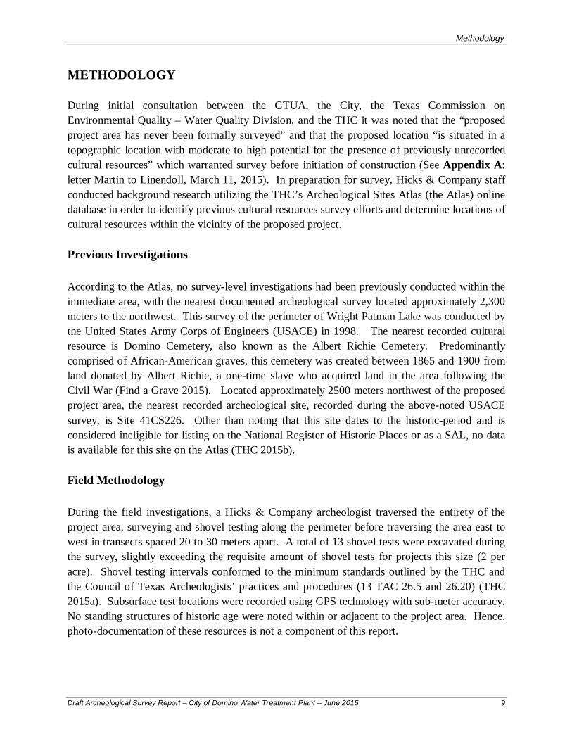
Methodology
This page intentionally left blank
Draft Archeological Survey Report ndash City of Domino Water Treatment Plant ndash June 2015 10
3129
County Road 3884
FM 31
29
rthstar Geographics CNESAirbus Aerogrid IGN IGP swisstopo and th
Domino Cemetery
2327
3129poundcurren59
Camp
Coun
ty Ro
ad 36
59
Coun
tyRo
ad 36
60
Coun
tyRo
ad36
73
US H
wy 59
Coun
ty Ro
ad 36
67
US H
wy 59
County Road 3559
County Road
3677
Coun
tyRo
ad 36
62
Coun
tyRo
ad36
63
Coun
tyRo
ad36
65
County Road 3784
FM 2327
FM 3129
County Road 3675
COE-FWD0898
41CS226
Source Esri DigitalGlobe GeoEye EaDS USDA USGS AEX Getmapping eGIS User Community
Key to Features Archeological Site
Project Area Previous ArcheologicalSurveyCemetery
W0 05 1
Kilometers One inch equals 1 km
Figure 3
Previously Conducted Investigations ampRecorded Cultural Resources
CASS
BOWIE ARKANSAS
Methodology
This page intentionally left blank
Draft Archeological Survey Report ndash City of Domino Water Treatment Plant ndash June 2015 12
Results of Field Investigations
RESULTS OF FIELD INVESTIGATIONS
On May 28 2015 an archeologist from Hicks amp Company conducted an intensive aerial survey of the proposed location of the City of Dominorsquos Water Treatment Plant an area approximately six acres in size During survey it was noted that the project area is thickly vegetated with pine trees with an understory comprised mainly of greenbriar and various ivies with a forest floor covered with heavy leaf-litter and intermittent pockets of standing water a result of recent torrential rains (Figures 4 and 5) Due to these conditions ground surface visibility was minimal never more than five percent at any one location The southeast corner of the project area is immediately adjacent to an unnamed tributary of Baker Creek During survey this drainage was experiencing overbank flooding with much of the immediate area inundated (Figure 6)
Figure 4 Overview of Northern Boundary of Project Area Facing South from FM 3129
Draft Archeological Survey Report ndash City of Domino Water Treatment Plant ndash June 2015 13
Results of Field Investigations
Figure 5 Overview of Inundated Area Typical of Project Area Facing Northeast from STJH11
Figure 6 Overview of Tributary Drainage of Baker Creek Facing Southeast from STJH4
Draft Archeological Survey Report ndash City of Domino Water Treatment Plant ndash June 2015 14
Results of Field Investigations
Shovel testing of the project area noted homogenous sediment that was similar in texture hue and chroma to that described for Metcalf silt loam (NRCS 2015) In general these excavations noted upper strata of highly silicated silt that ranged in color from light yellowish brown (10YR 64) to brown (75YR 54) Strata below the first were noted to be silt loams with increasing clay content that ranged in color from yellowish brown (10YR 56) to brown (75YR 44 - 75YR 53) When tests were not impended by the water table or thick pine roots gray (10YR 61) and yellowish red (5YR 56) Bt-horizon clays were encountered at depths between 50 and 70 centimeters below the ground surface (cmbs) During the investigation a total of 13 shovel tests were excavated with all negative for the presence of cultural materials Data for all shovel tests is presented below in Table 1
Table 1 Shovel Test Data Shovel
Test Level Depth (cmbs)
P=Pos N=Neg Munsell
Soil Texture Description Inclusions Notes
JH1 1 0-30 N 75YR 54 Silt Loam Rootlets
JH1 2 30-40 N 75YR 53 Loam Water table encountered at 40 cmbs
JH2 1 0-20 N 75YR 54 Silt Loam Rootlets
JH2 2 20-30 N 74YR 53 Clay Loam Water table encountered at 30 cmbs
JH3 1 0-40 N 75YR 46 Silt Rootlets
JH3 2 40-50 N 5YR 46 Silt Loam Increasing clay content
JH3 3 40+ N 10YR 61 Silt Clay High clay content ST terminated win Bt horizon clay
JH4 1 0-20 N 10YR 64 Silt Loam Rootlets Very moist sediment
JH4 2 20-55 N 10YR 56 Silt Loam Water seepage begins at 50 cmbs
JH4 3 55-60 N 10YR 61 Clay ST terminated at 60 cmbs within Bt horizon clay
JH5 1 0-20 N 10YR 64 Silt Loam Rootlets Very moist sediment
JH5 2 20-55 N 10YR 56 Silt Loam
JH5 3 55-60 N 10YR 61 Clay ST terminated at 60 cmbs within Bt horizon clay
JH6 1 0-40 N 10YR 64 Silt Loam Rootlets Very moist sediment
JH6 2 40-50 N 75YR 53 Silt Clay Loam High clay content ST terminated at thick pine root
JH7 1 0-30 N 75YR 46 Silt Loam High silicates Inundated area- water table encountered at 20 cmbs
JH8 1 0-40 N 75YR 54 Silt Loam Rootlets
JH8 2 40-60 N 10YR 56 Silt Loam Increasing clay content
JH8 1 60-70 N 10YR 62 Clay ST terminated at 70 cmbs within BT horizon clay
JH9 1 0-30 N 75YR 54 Silt Loam Rootlets
JH9 2 30-65 N 75YR 53 Loam Increasing clay content
JH9 3 65-75 N 5YR 44 Clay ST terminated at 75 cmbs within BT horizon clay
JH10 1 0-20 N 75YR 54 Silt Loam Rootlets Very moist sediment
JH10 2 20-40 N 75YR 53 Silt Clay Loam ST terminated below water table at 35 cmbs
JH11 1 0-48 N 75YR 54 Silt Loam Rootlets ST terminated at thick pine root
JH12 1 0-45 N 10YR 64 Clay Rootlets
JH12 2 45-62 N 75YR 53 Silt Clay Loam
JH12 3 62-72 N 10YR 62 Clay Shovel test terminated at 72 cmbs Bt horizon clay
JH13 1 0-40 N 75YR 46 Silt Rootlets
JH13 2 40-60 N 5YR 46 Silt Loam
JH13 3 60-70 N 10YR 62 Clay ST terminated at 70 cmbs within Bt horizon clay
Draft Archeological Survey Report ndash City of Domino Water Treatment Plant ndash June 2015 15
Results of Field Investigations
This page intentionally left blank
Draft Archeological Survey Report ndash City of Domino Water Treatment Plant ndash June 2015 16
3129
JH1
JH2
JH13
JH3
JH4
JH5
JH6
JH7
JH8
JH9
JH10 JH11
JH12
Key to Features Shovel Tests
Project Area
W 0 20 40
Meters One inch equals 40 meters
CASS
BOWIE ARKANSAS
Figure 7
Shovel Test Locations
Results of Field Investigations
This page intentionally left blank
Draft Archeological Survey Report ndash City of Domino Water Treatment Plant ndash June 2015 18
Conclusions and Recommendations
CONCLUSIONS AND RECOMMENDATIONS
Pedestrian survey and shovel testing of the proposed location for the City of Dominorsquos Water Treatment Facility Plant project revealed no archeological sites features or cultural materials greater than 50 years in age Based on the results of the current survey it is recommended that no SALs (13 TAC 2612) will be affected by the proposed project and no further cultural resource investigations are recommended for the proposed project area prior to construction In the event that unanticipated archeological deposits are encountered during construction work in the immediate area will cease and THC archeological staff will be contacted to initiate post-review discovery procedures Hicks amp Company offers this draft report in partial fulfillment of Antiquities Permit 7275 No cultural materials were collected during the survey All project related forms notes and photographs will be permanently curated at CAS in San Marcos Texas
Draft Archeological Survey Report ndash City of Domino Water Treatment Plant ndash June 2015 19
Conclusions and Recommendations
This page intentionally left blank
Draft Archeological Survey Report ndash City of Domino Water Treatment Plant ndash June 2015 20
References Cited
REFERENCES CITED
Bureau of Economic Geology (BEG) 2007 Geologic Map Database of Texas httppubsusgsgovds2005170 (May 15 2015)
Texas Historical Commission (THC) 2012a Texas Administrative Code (TAC) Chapter 26 Rules of Practice and Procedure for the Antiquities Code of Texas httpinfososstatetxusplspubreadtac$extViewTACtac_view=4ampti=13amppt=2ampch=2 6amprl=Y (June 2 2015)
2015b Texas Archeological Sites Atlas (the Atlas) httpnuecesthcstatetxus (March 13 2015)
Find a Grave 2015 Albert Richie Cemetery httpwwwfindagravecomcgishybinfgcgipage=crampCRid=3265 (June 8 2015)
United States Department of Agriculture Natural Resource Conservations Service (USDA NRCS))
2015a Metcalf Silt Loam httpssoilseriesscegovusdagovosdnameasp (June 5 2015)
United States Department of Agriculture Natural Resources Conservation Service (USDA NRCS)
2015b Soil Survey Geographic (SSURGO) database for Cass County Texas httpSoilDataMartnrcsusdagov (March 13 2015)
Draft Archeological Survey Report ndash City of Domino Water Treatment Plant ndash June 2015 21
References Cited
This page intentionally left blank
Draft Archeological Survey Report ndash City of Domino Water Treatment Plant ndash June 2015 22
APPENDIX A
REGULATORY CORRESPONDENCE
_______________________
ANTIQUITIES PERMIT APPLICATION FORM ARCHEOLOGY
GENERAL INFORMATION
I PROPERTY TYPE AND LOCATION
Project Name (andor Site Trinomial) City of Domino Water Treatment Plant
County (ies) Knox County
USGS Quadrangle Name and Number Wright Patman Lake (33094-C2)
UTM Coordinates Zone 15
Centroid E 3964629 N 3680784
Location Just west of the City of Domino off of FM 3129
Federal Involvement Yes No XX
Name of Federal Agency Agency Representative
II OWNER (OR CONTROLLING AGENCY)
Owner City of Domino
Representative
Mayor Alfred Campbell
Address City of Domino
14555 FM 3129
CityStateZip Domino TX 75572 Telephone (include area code) _____________________Email Address albdcampbellhotmailcom______
III PROJECT SPONSOR (IF DIFFERENT FROM OWNER)
Sponsor
Representative
Address
CityStateZip
Telephone (include area code) Email Address
PROJECT INFORMATION
I PRINCIPAL INVESTIGATOR (ARCHEOLOGIST)
Name Josh Haefner
Affiliation Hicks amp Company
Address 1504 W 5th Street
CityStateZip Austin Tx 78703
Telephone (include area code) 512-478-0858 Email Address jhaefnerhicksenvcom
(OVER)
ANTIQUITIES PERMIT APPLICATION FORM (CONTINUED)
II PROJECT DESCRIPTION
Proposed Starting Date of Fieldwork May 24 2015 Requested Permit Duration 2 Years Months (1 year minimum) Scope of Work (Provided an Outline of Proposed Work) Intensive Survey (see attached scope of work)
III CURATION amp REPORT
Temporary Curatorial or Laboratory Facility Hicks amp Company
Permanent Curatorial Facility Center for Archeological Studies (CAS)
IV LAND OWNERrsquoS CERTIFICATION
I Alfred Campbell as legal representative of the Land Owner
do certify that I have reviewed the plans and research design and that no investigations
will be preformed prior to the issuance of a permit by the Texas Historical Commission Furthermore I understand that
the Owner Sponsor and Principal Investigator are responsible for completing the terms of the permit
Signature Date
V SPONSORrsquoS CERTIFICATION
I as legal representative of the Sponsor
do certify that I have review the plans and
research design and that no investigations will be performed prior to the issuance of a permit by the Texas Historical
Commission Furthermore I understand that the Sponsor Owner and Principal Investigator are responsible for
completing the terms of this permit
Signature Date
VI INVESTIGATORrsquoS CERTIFICATION
I Josh Haefner as Principal Investigator employed by
Hicks amp Company (Investigative Firm) do certify that I will execute this project
according to the submitted plans and research design and will not conduct any work prior to the issuance of a permit by
the Texas Historical Commission Furthermore I understand that the Principal Investigator (and the Investigative Firm)
as well as the Owner and Sponsor are responsible for completing the terms of this permit
Signature Date 5415
Principal Investigator must attach a research design a copy of the USGS quadrangle showing project boundaries and any
additional pertinent information Curriculum vita must be on file with the Division of Antiquities Protection
FOR OFFICIAL USE ONLY
Reviewer Date Permit Issues
Permit Number Permit Expiration Date
Type of Permit Date Received for Data Entry
Texas Historical Commission
Archeology Division
PO Box 12276 Austin TX 78711-2276
Phone 512463-6096
wwwthcstatetxus
Hicks amp Companyrsquos Scope of Work for the
City of Dominorsquos Water Treatment Plant Project Cass County Texas
May 4 2015
Pursuant to the Texas Historical Commissionrsquos (THC) recommendation regarding the
Greater Texoma Utility Authority (GTUA) and City of Dominosrsquo compliance
responsibilities (Attachment 1 letter Wolfe to Linendoll March 11 2015) this scope of
work describes an archeological resources survey for the City of Dominorsquos Water
Treatment Plant Project in Rio Hike and Bike Trail Improvements Project in Cass
County Texas The proposed project consists of the construction of a new water
treatment plant on a parcel approximately six acres in size (Attachment 2 Project
Location) During review of the proposed project the THC noted that this parcel has
never before been surveyed and is located within an area determined to have good
probability to contain archeological deposits requiring archeological survey for
Antiquities Code of Texas (ACT) compliance
According to the Geologic Atlas of Texas Texarkana Sheet the underlying geology of
the proposed project areas consists of the Wilcox Group undivided formation (Barnes
1979) Dating the Eocene which long predates human arrival in the Americas cultural
deposits in such mapped areas can be expected to be contained to overlying surface
soilssediment or the surface itself A single soil series the Metcalf silt loam 0 to 2
percent slopes is mapped for the project area This series typically has shallow A
horizons with Bt clay horizons typically occurring between 4 and 75 centimeters below
the ground surface
Because there is limited potential for deeply buried archeological deposits Hicks amp
Company is proposing pedestrian survey supplemented with shovel testing as a
sufficient methodology to assess the proposed projectrsquos potential to impact archeological
resourcessites The project area will be tested at a rate of no less than 12 subsurface tests
(2 per acre) in accordance with the THCrsquos minimum standards for intensive areal survey
Investigators will record their observations and the results of shovel tests through notes
standardized shovel test forms and photographs Shovel tests will be excavated to a
depth of one meter or bedrock and sediment from all shovel tests will be screened
through frac14-inch hardware cloth Shovel test locations will be recorded utilizing GPS
technology The survey will follow a no-collection policy in which artifacts will be
recorded identified and quantified in the field but returned to their find location
Any archeological sites identified during the survey will be investigated by no fewer than
six shovel tests in order to define site boundaries relative to the project area Identified
sites will be recorded in accordance with the THCrsquos standards for site investigation
Subsurface tests within sites will be excavated at a frequency and arrangement
appropriate for assessing site size depth and significance Site locations will be
recorded utilizing GPS technology and data will be recorded on standardized forms
Documented sites will be recorded at the Texas Archeological Research Laboratory
(TARL) and new trinomials will be assigned
The results of the investigation will be compiled into a professional report as required
under Chapter 26 of the THCrsquos Rules of Practice and Procedure The report will include a
summary of background information results of field investigations and
recommendations about the need for further investigations (if any) with respect to both
historic and prehistoric sites and will be submitted to THC for review and comment In
accordance with revised ACT requirements hard copies and digital files of the final
report will be submitted to the THC and other recommended libraries and repositories
across Texas Additionally all project-generated forms notes photographs etc will be
formally curated at the Center for Archeological Studies in San Marcos Texas
REFERENCES
Barnes V E
1979 Geologic Atlas of Texas Texarkana Sheet Bureau of Economic Geology the University of Texas at Austin
United States Department of Agriculture (USDA)
2015 Web Soil Survey httpwebsoilsurveynrcsusdagovappWebSoilSurveyaspx accessed May 4 2015
ATTACHMENTS
-
3129 2327
3129 poundcurren59
Copyrightcopy 2011 National Geographic Society i cubed
Key to Features Water Treatment FacilityBoundary
W 0 05 1
Kilometers
Attachment 2Project Location
City of Domino Archeological Services
USGS 75-minute Topographic QuadranglesWright Patman Lake (USGS 33094-C2) TX
CASS
BOWIE ARKANSAS
- Short Report on the Archeological Investigations for the City of Dominorsquos Proposed New Water Treatment Plant Cass County Texas
- Short Report on the Archeological Investigations for the City of Dominorsquos Proposed New Water Treatment Plant Cass County Texas
-
- Creative Commons License
-
- PROJECT DESCRIPTION AND MANAGEMENT SUMMARY
- ENVIRONMENTAL SETTING
-
- Physiography
- Geology and Soils
-
- METHODOLOGY
-
- Previous Investigations
- Field Methodology
-
- RESULTS OF FIELD INVESTIGATIONS
- CONCLUSIONS AND RECOMMENDATIONS
- REFERENCES CITED
-

3129
County Road 3884
FM 31
29
rthstar Geographics CNESAirbus Aerogrid IGN IGP swisstopo and th
Domino Cemetery
2327
3129poundcurren59
Camp
Coun
ty Ro
ad 36
59
Coun
tyRo
ad 36
60
Coun
tyRo
ad36
73
US H
wy 59
Coun
ty Ro
ad 36
67
US H
wy 59
County Road 3559
County Road
3677
Coun
tyRo
ad 36
62
Coun
tyRo
ad36
63
Coun
tyRo
ad36
65
County Road 3784
FM 2327
FM 3129
County Road 3675
COE-FWD0898
41CS226
Source Esri DigitalGlobe GeoEye EaDS USDA USGS AEX Getmapping eGIS User Community
Key to Features Archeological Site
Project Area Previous ArcheologicalSurveyCemetery
W0 05 1
Kilometers One inch equals 1 km
Figure 3
Previously Conducted Investigations ampRecorded Cultural Resources
CASS
BOWIE ARKANSAS
Methodology
This page intentionally left blank
Draft Archeological Survey Report ndash City of Domino Water Treatment Plant ndash June 2015 12
Results of Field Investigations
RESULTS OF FIELD INVESTIGATIONS
On May 28 2015 an archeologist from Hicks amp Company conducted an intensive aerial survey of the proposed location of the City of Dominorsquos Water Treatment Plant an area approximately six acres in size During survey it was noted that the project area is thickly vegetated with pine trees with an understory comprised mainly of greenbriar and various ivies with a forest floor covered with heavy leaf-litter and intermittent pockets of standing water a result of recent torrential rains (Figures 4 and 5) Due to these conditions ground surface visibility was minimal never more than five percent at any one location The southeast corner of the project area is immediately adjacent to an unnamed tributary of Baker Creek During survey this drainage was experiencing overbank flooding with much of the immediate area inundated (Figure 6)
Figure 4 Overview of Northern Boundary of Project Area Facing South from FM 3129
Draft Archeological Survey Report ndash City of Domino Water Treatment Plant ndash June 2015 13
Results of Field Investigations
Figure 5 Overview of Inundated Area Typical of Project Area Facing Northeast from STJH11
Figure 6 Overview of Tributary Drainage of Baker Creek Facing Southeast from STJH4
Draft Archeological Survey Report ndash City of Domino Water Treatment Plant ndash June 2015 14
Results of Field Investigations
Shovel testing of the project area noted homogenous sediment that was similar in texture hue and chroma to that described for Metcalf silt loam (NRCS 2015) In general these excavations noted upper strata of highly silicated silt that ranged in color from light yellowish brown (10YR 64) to brown (75YR 54) Strata below the first were noted to be silt loams with increasing clay content that ranged in color from yellowish brown (10YR 56) to brown (75YR 44 - 75YR 53) When tests were not impended by the water table or thick pine roots gray (10YR 61) and yellowish red (5YR 56) Bt-horizon clays were encountered at depths between 50 and 70 centimeters below the ground surface (cmbs) During the investigation a total of 13 shovel tests were excavated with all negative for the presence of cultural materials Data for all shovel tests is presented below in Table 1
Table 1 Shovel Test Data Shovel
Test Level Depth (cmbs)
P=Pos N=Neg Munsell
Soil Texture Description Inclusions Notes
JH1 1 0-30 N 75YR 54 Silt Loam Rootlets
JH1 2 30-40 N 75YR 53 Loam Water table encountered at 40 cmbs
JH2 1 0-20 N 75YR 54 Silt Loam Rootlets
JH2 2 20-30 N 74YR 53 Clay Loam Water table encountered at 30 cmbs
JH3 1 0-40 N 75YR 46 Silt Rootlets
JH3 2 40-50 N 5YR 46 Silt Loam Increasing clay content
JH3 3 40+ N 10YR 61 Silt Clay High clay content ST terminated win Bt horizon clay
JH4 1 0-20 N 10YR 64 Silt Loam Rootlets Very moist sediment
JH4 2 20-55 N 10YR 56 Silt Loam Water seepage begins at 50 cmbs
JH4 3 55-60 N 10YR 61 Clay ST terminated at 60 cmbs within Bt horizon clay
JH5 1 0-20 N 10YR 64 Silt Loam Rootlets Very moist sediment
JH5 2 20-55 N 10YR 56 Silt Loam
JH5 3 55-60 N 10YR 61 Clay ST terminated at 60 cmbs within Bt horizon clay
JH6 1 0-40 N 10YR 64 Silt Loam Rootlets Very moist sediment
JH6 2 40-50 N 75YR 53 Silt Clay Loam High clay content ST terminated at thick pine root
JH7 1 0-30 N 75YR 46 Silt Loam High silicates Inundated area- water table encountered at 20 cmbs
JH8 1 0-40 N 75YR 54 Silt Loam Rootlets
JH8 2 40-60 N 10YR 56 Silt Loam Increasing clay content
JH8 1 60-70 N 10YR 62 Clay ST terminated at 70 cmbs within BT horizon clay
JH9 1 0-30 N 75YR 54 Silt Loam Rootlets
JH9 2 30-65 N 75YR 53 Loam Increasing clay content
JH9 3 65-75 N 5YR 44 Clay ST terminated at 75 cmbs within BT horizon clay
JH10 1 0-20 N 75YR 54 Silt Loam Rootlets Very moist sediment
JH10 2 20-40 N 75YR 53 Silt Clay Loam ST terminated below water table at 35 cmbs
JH11 1 0-48 N 75YR 54 Silt Loam Rootlets ST terminated at thick pine root
JH12 1 0-45 N 10YR 64 Clay Rootlets
JH12 2 45-62 N 75YR 53 Silt Clay Loam
JH12 3 62-72 N 10YR 62 Clay Shovel test terminated at 72 cmbs Bt horizon clay
JH13 1 0-40 N 75YR 46 Silt Rootlets
JH13 2 40-60 N 5YR 46 Silt Loam
JH13 3 60-70 N 10YR 62 Clay ST terminated at 70 cmbs within Bt horizon clay
Draft Archeological Survey Report ndash City of Domino Water Treatment Plant ndash June 2015 15
Results of Field Investigations
This page intentionally left blank
Draft Archeological Survey Report ndash City of Domino Water Treatment Plant ndash June 2015 16
3129
JH1
JH2
JH13
JH3
JH4
JH5
JH6
JH7
JH8
JH9
JH10 JH11
JH12
Key to Features Shovel Tests
Project Area
W 0 20 40
Meters One inch equals 40 meters
CASS
BOWIE ARKANSAS
Figure 7
Shovel Test Locations
Results of Field Investigations
This page intentionally left blank
Draft Archeological Survey Report ndash City of Domino Water Treatment Plant ndash June 2015 18
Conclusions and Recommendations
CONCLUSIONS AND RECOMMENDATIONS
Pedestrian survey and shovel testing of the proposed location for the City of Dominorsquos Water Treatment Facility Plant project revealed no archeological sites features or cultural materials greater than 50 years in age Based on the results of the current survey it is recommended that no SALs (13 TAC 2612) will be affected by the proposed project and no further cultural resource investigations are recommended for the proposed project area prior to construction In the event that unanticipated archeological deposits are encountered during construction work in the immediate area will cease and THC archeological staff will be contacted to initiate post-review discovery procedures Hicks amp Company offers this draft report in partial fulfillment of Antiquities Permit 7275 No cultural materials were collected during the survey All project related forms notes and photographs will be permanently curated at CAS in San Marcos Texas
Draft Archeological Survey Report ndash City of Domino Water Treatment Plant ndash June 2015 19
Conclusions and Recommendations
This page intentionally left blank
Draft Archeological Survey Report ndash City of Domino Water Treatment Plant ndash June 2015 20
References Cited
REFERENCES CITED
Bureau of Economic Geology (BEG) 2007 Geologic Map Database of Texas httppubsusgsgovds2005170 (May 15 2015)
Texas Historical Commission (THC) 2012a Texas Administrative Code (TAC) Chapter 26 Rules of Practice and Procedure for the Antiquities Code of Texas httpinfososstatetxusplspubreadtac$extViewTACtac_view=4ampti=13amppt=2ampch=2 6amprl=Y (June 2 2015)
2015b Texas Archeological Sites Atlas (the Atlas) httpnuecesthcstatetxus (March 13 2015)
Find a Grave 2015 Albert Richie Cemetery httpwwwfindagravecomcgishybinfgcgipage=crampCRid=3265 (June 8 2015)
United States Department of Agriculture Natural Resource Conservations Service (USDA NRCS))
2015a Metcalf Silt Loam httpssoilseriesscegovusdagovosdnameasp (June 5 2015)
United States Department of Agriculture Natural Resources Conservation Service (USDA NRCS)
2015b Soil Survey Geographic (SSURGO) database for Cass County Texas httpSoilDataMartnrcsusdagov (March 13 2015)
Draft Archeological Survey Report ndash City of Domino Water Treatment Plant ndash June 2015 21
References Cited
This page intentionally left blank
Draft Archeological Survey Report ndash City of Domino Water Treatment Plant ndash June 2015 22
APPENDIX A
REGULATORY CORRESPONDENCE
_______________________
ANTIQUITIES PERMIT APPLICATION FORM ARCHEOLOGY
GENERAL INFORMATION
I PROPERTY TYPE AND LOCATION
Project Name (andor Site Trinomial) City of Domino Water Treatment Plant
County (ies) Knox County
USGS Quadrangle Name and Number Wright Patman Lake (33094-C2)
UTM Coordinates Zone 15
Centroid E 3964629 N 3680784
Location Just west of the City of Domino off of FM 3129
Federal Involvement Yes No XX
Name of Federal Agency Agency Representative
II OWNER (OR CONTROLLING AGENCY)
Owner City of Domino
Representative
Mayor Alfred Campbell
Address City of Domino
14555 FM 3129
CityStateZip Domino TX 75572 Telephone (include area code) _____________________Email Address albdcampbellhotmailcom______
III PROJECT SPONSOR (IF DIFFERENT FROM OWNER)
Sponsor
Representative
Address
CityStateZip
Telephone (include area code) Email Address
PROJECT INFORMATION
I PRINCIPAL INVESTIGATOR (ARCHEOLOGIST)
Name Josh Haefner
Affiliation Hicks amp Company
Address 1504 W 5th Street
CityStateZip Austin Tx 78703
Telephone (include area code) 512-478-0858 Email Address jhaefnerhicksenvcom
(OVER)
ANTIQUITIES PERMIT APPLICATION FORM (CONTINUED)
II PROJECT DESCRIPTION
Proposed Starting Date of Fieldwork May 24 2015 Requested Permit Duration 2 Years Months (1 year minimum) Scope of Work (Provided an Outline of Proposed Work) Intensive Survey (see attached scope of work)
III CURATION amp REPORT
Temporary Curatorial or Laboratory Facility Hicks amp Company
Permanent Curatorial Facility Center for Archeological Studies (CAS)
IV LAND OWNERrsquoS CERTIFICATION
I Alfred Campbell as legal representative of the Land Owner
do certify that I have reviewed the plans and research design and that no investigations
will be preformed prior to the issuance of a permit by the Texas Historical Commission Furthermore I understand that
the Owner Sponsor and Principal Investigator are responsible for completing the terms of the permit
Signature Date
V SPONSORrsquoS CERTIFICATION
I as legal representative of the Sponsor
do certify that I have review the plans and
research design and that no investigations will be performed prior to the issuance of a permit by the Texas Historical
Commission Furthermore I understand that the Sponsor Owner and Principal Investigator are responsible for
completing the terms of this permit
Signature Date
VI INVESTIGATORrsquoS CERTIFICATION
I Josh Haefner as Principal Investigator employed by
Hicks amp Company (Investigative Firm) do certify that I will execute this project
according to the submitted plans and research design and will not conduct any work prior to the issuance of a permit by
the Texas Historical Commission Furthermore I understand that the Principal Investigator (and the Investigative Firm)
as well as the Owner and Sponsor are responsible for completing the terms of this permit
Signature Date 5415
Principal Investigator must attach a research design a copy of the USGS quadrangle showing project boundaries and any
additional pertinent information Curriculum vita must be on file with the Division of Antiquities Protection
FOR OFFICIAL USE ONLY
Reviewer Date Permit Issues
Permit Number Permit Expiration Date
Type of Permit Date Received for Data Entry
Texas Historical Commission
Archeology Division
PO Box 12276 Austin TX 78711-2276
Phone 512463-6096
wwwthcstatetxus
Hicks amp Companyrsquos Scope of Work for the
City of Dominorsquos Water Treatment Plant Project Cass County Texas
May 4 2015
Pursuant to the Texas Historical Commissionrsquos (THC) recommendation regarding the
Greater Texoma Utility Authority (GTUA) and City of Dominosrsquo compliance
responsibilities (Attachment 1 letter Wolfe to Linendoll March 11 2015) this scope of
work describes an archeological resources survey for the City of Dominorsquos Water
Treatment Plant Project in Rio Hike and Bike Trail Improvements Project in Cass
County Texas The proposed project consists of the construction of a new water
treatment plant on a parcel approximately six acres in size (Attachment 2 Project
Location) During review of the proposed project the THC noted that this parcel has
never before been surveyed and is located within an area determined to have good
probability to contain archeological deposits requiring archeological survey for
Antiquities Code of Texas (ACT) compliance
According to the Geologic Atlas of Texas Texarkana Sheet the underlying geology of
the proposed project areas consists of the Wilcox Group undivided formation (Barnes
1979) Dating the Eocene which long predates human arrival in the Americas cultural
deposits in such mapped areas can be expected to be contained to overlying surface
soilssediment or the surface itself A single soil series the Metcalf silt loam 0 to 2
percent slopes is mapped for the project area This series typically has shallow A
horizons with Bt clay horizons typically occurring between 4 and 75 centimeters below
the ground surface
Because there is limited potential for deeply buried archeological deposits Hicks amp
Company is proposing pedestrian survey supplemented with shovel testing as a
sufficient methodology to assess the proposed projectrsquos potential to impact archeological
resourcessites The project area will be tested at a rate of no less than 12 subsurface tests
(2 per acre) in accordance with the THCrsquos minimum standards for intensive areal survey
Investigators will record their observations and the results of shovel tests through notes
standardized shovel test forms and photographs Shovel tests will be excavated to a
depth of one meter or bedrock and sediment from all shovel tests will be screened
through frac14-inch hardware cloth Shovel test locations will be recorded utilizing GPS
technology The survey will follow a no-collection policy in which artifacts will be
recorded identified and quantified in the field but returned to their find location
Any archeological sites identified during the survey will be investigated by no fewer than
six shovel tests in order to define site boundaries relative to the project area Identified
sites will be recorded in accordance with the THCrsquos standards for site investigation
Subsurface tests within sites will be excavated at a frequency and arrangement
appropriate for assessing site size depth and significance Site locations will be
recorded utilizing GPS technology and data will be recorded on standardized forms
Documented sites will be recorded at the Texas Archeological Research Laboratory
(TARL) and new trinomials will be assigned
The results of the investigation will be compiled into a professional report as required
under Chapter 26 of the THCrsquos Rules of Practice and Procedure The report will include a
summary of background information results of field investigations and
recommendations about the need for further investigations (if any) with respect to both
historic and prehistoric sites and will be submitted to THC for review and comment In
accordance with revised ACT requirements hard copies and digital files of the final
report will be submitted to the THC and other recommended libraries and repositories
across Texas Additionally all project-generated forms notes photographs etc will be
formally curated at the Center for Archeological Studies in San Marcos Texas
REFERENCES
Barnes V E
1979 Geologic Atlas of Texas Texarkana Sheet Bureau of Economic Geology the University of Texas at Austin
United States Department of Agriculture (USDA)
2015 Web Soil Survey httpwebsoilsurveynrcsusdagovappWebSoilSurveyaspx accessed May 4 2015
ATTACHMENTS
-
3129 2327
3129 poundcurren59
Copyrightcopy 2011 National Geographic Society i cubed
Key to Features Water Treatment FacilityBoundary
W 0 05 1
Kilometers
Attachment 2Project Location
City of Domino Archeological Services
USGS 75-minute Topographic QuadranglesWright Patman Lake (USGS 33094-C2) TX
CASS
BOWIE ARKANSAS
- Short Report on the Archeological Investigations for the City of Dominorsquos Proposed New Water Treatment Plant Cass County Texas
- Short Report on the Archeological Investigations for the City of Dominorsquos Proposed New Water Treatment Plant Cass County Texas
-
- Creative Commons License
-
- PROJECT DESCRIPTION AND MANAGEMENT SUMMARY
- ENVIRONMENTAL SETTING
-
- Physiography
- Geology and Soils
-
- METHODOLOGY
-
- Previous Investigations
- Field Methodology
-
- RESULTS OF FIELD INVESTIGATIONS
- CONCLUSIONS AND RECOMMENDATIONS
- REFERENCES CITED
-

Results of Field Investigations
This page intentionally left blank
Draft Archeological Survey Report ndash City of Domino Water Treatment Plant ndash June 2015 16
3129
JH1
JH2
JH13
JH3
JH4
JH5
JH6
JH7
JH8
JH9
JH10 JH11
JH12
Key to Features Shovel Tests
Project Area
W 0 20 40
Meters One inch equals 40 meters
CASS
BOWIE ARKANSAS
Figure 7
Shovel Test Locations
Results of Field Investigations
This page intentionally left blank
Draft Archeological Survey Report ndash City of Domino Water Treatment Plant ndash June 2015 18
Conclusions and Recommendations
CONCLUSIONS AND RECOMMENDATIONS
Pedestrian survey and shovel testing of the proposed location for the City of Dominorsquos Water Treatment Facility Plant project revealed no archeological sites features or cultural materials greater than 50 years in age Based on the results of the current survey it is recommended that no SALs (13 TAC 2612) will be affected by the proposed project and no further cultural resource investigations are recommended for the proposed project area prior to construction In the event that unanticipated archeological deposits are encountered during construction work in the immediate area will cease and THC archeological staff will be contacted to initiate post-review discovery procedures Hicks amp Company offers this draft report in partial fulfillment of Antiquities Permit 7275 No cultural materials were collected during the survey All project related forms notes and photographs will be permanently curated at CAS in San Marcos Texas
Draft Archeological Survey Report ndash City of Domino Water Treatment Plant ndash June 2015 19
Conclusions and Recommendations
This page intentionally left blank
Draft Archeological Survey Report ndash City of Domino Water Treatment Plant ndash June 2015 20
References Cited
REFERENCES CITED
Bureau of Economic Geology (BEG) 2007 Geologic Map Database of Texas httppubsusgsgovds2005170 (May 15 2015)
Texas Historical Commission (THC) 2012a Texas Administrative Code (TAC) Chapter 26 Rules of Practice and Procedure for the Antiquities Code of Texas httpinfososstatetxusplspubreadtac$extViewTACtac_view=4ampti=13amppt=2ampch=2 6amprl=Y (June 2 2015)
2015b Texas Archeological Sites Atlas (the Atlas) httpnuecesthcstatetxus (March 13 2015)
Find a Grave 2015 Albert Richie Cemetery httpwwwfindagravecomcgishybinfgcgipage=crampCRid=3265 (June 8 2015)
United States Department of Agriculture Natural Resource Conservations Service (USDA NRCS))
2015a Metcalf Silt Loam httpssoilseriesscegovusdagovosdnameasp (June 5 2015)
United States Department of Agriculture Natural Resources Conservation Service (USDA NRCS)
2015b Soil Survey Geographic (SSURGO) database for Cass County Texas httpSoilDataMartnrcsusdagov (March 13 2015)
Draft Archeological Survey Report ndash City of Domino Water Treatment Plant ndash June 2015 21
References Cited
This page intentionally left blank
Draft Archeological Survey Report ndash City of Domino Water Treatment Plant ndash June 2015 22
APPENDIX A
REGULATORY CORRESPONDENCE
_______________________
ANTIQUITIES PERMIT APPLICATION FORM ARCHEOLOGY
GENERAL INFORMATION
I PROPERTY TYPE AND LOCATION
Project Name (andor Site Trinomial) City of Domino Water Treatment Plant
County (ies) Knox County
USGS Quadrangle Name and Number Wright Patman Lake (33094-C2)
UTM Coordinates Zone 15
Centroid E 3964629 N 3680784
Location Just west of the City of Domino off of FM 3129
Federal Involvement Yes No XX
Name of Federal Agency Agency Representative
II OWNER (OR CONTROLLING AGENCY)
Owner City of Domino
Representative
Mayor Alfred Campbell
Address City of Domino
14555 FM 3129
CityStateZip Domino TX 75572 Telephone (include area code) _____________________Email Address albdcampbellhotmailcom______
III PROJECT SPONSOR (IF DIFFERENT FROM OWNER)
Sponsor
Representative
Address
CityStateZip
Telephone (include area code) Email Address
PROJECT INFORMATION
I PRINCIPAL INVESTIGATOR (ARCHEOLOGIST)
Name Josh Haefner
Affiliation Hicks amp Company
Address 1504 W 5th Street
CityStateZip Austin Tx 78703
Telephone (include area code) 512-478-0858 Email Address jhaefnerhicksenvcom
(OVER)
ANTIQUITIES PERMIT APPLICATION FORM (CONTINUED)
II PROJECT DESCRIPTION
Proposed Starting Date of Fieldwork May 24 2015 Requested Permit Duration 2 Years Months (1 year minimum) Scope of Work (Provided an Outline of Proposed Work) Intensive Survey (see attached scope of work)
III CURATION amp REPORT
Temporary Curatorial or Laboratory Facility Hicks amp Company
Permanent Curatorial Facility Center for Archeological Studies (CAS)
IV LAND OWNERrsquoS CERTIFICATION
I Alfred Campbell as legal representative of the Land Owner
do certify that I have reviewed the plans and research design and that no investigations
will be preformed prior to the issuance of a permit by the Texas Historical Commission Furthermore I understand that
the Owner Sponsor and Principal Investigator are responsible for completing the terms of the permit
Signature Date
V SPONSORrsquoS CERTIFICATION
I as legal representative of the Sponsor
do certify that I have review the plans and
research design and that no investigations will be performed prior to the issuance of a permit by the Texas Historical
Commission Furthermore I understand that the Sponsor Owner and Principal Investigator are responsible for
completing the terms of this permit
Signature Date
VI INVESTIGATORrsquoS CERTIFICATION
I Josh Haefner as Principal Investigator employed by
Hicks amp Company (Investigative Firm) do certify that I will execute this project
according to the submitted plans and research design and will not conduct any work prior to the issuance of a permit by
the Texas Historical Commission Furthermore I understand that the Principal Investigator (and the Investigative Firm)
as well as the Owner and Sponsor are responsible for completing the terms of this permit
Signature Date 5415
Principal Investigator must attach a research design a copy of the USGS quadrangle showing project boundaries and any
additional pertinent information Curriculum vita must be on file with the Division of Antiquities Protection
FOR OFFICIAL USE ONLY
Reviewer Date Permit Issues
Permit Number Permit Expiration Date
Type of Permit Date Received for Data Entry
Texas Historical Commission
Archeology Division
PO Box 12276 Austin TX 78711-2276
Phone 512463-6096
wwwthcstatetxus
Hicks amp Companyrsquos Scope of Work for the
City of Dominorsquos Water Treatment Plant Project Cass County Texas
May 4 2015
Pursuant to the Texas Historical Commissionrsquos (THC) recommendation regarding the
Greater Texoma Utility Authority (GTUA) and City of Dominosrsquo compliance
responsibilities (Attachment 1 letter Wolfe to Linendoll March 11 2015) this scope of
work describes an archeological resources survey for the City of Dominorsquos Water
Treatment Plant Project in Rio Hike and Bike Trail Improvements Project in Cass
County Texas The proposed project consists of the construction of a new water
treatment plant on a parcel approximately six acres in size (Attachment 2 Project
Location) During review of the proposed project the THC noted that this parcel has
never before been surveyed and is located within an area determined to have good
probability to contain archeological deposits requiring archeological survey for
Antiquities Code of Texas (ACT) compliance
According to the Geologic Atlas of Texas Texarkana Sheet the underlying geology of
the proposed project areas consists of the Wilcox Group undivided formation (Barnes
1979) Dating the Eocene which long predates human arrival in the Americas cultural
deposits in such mapped areas can be expected to be contained to overlying surface
soilssediment or the surface itself A single soil series the Metcalf silt loam 0 to 2
percent slopes is mapped for the project area This series typically has shallow A
horizons with Bt clay horizons typically occurring between 4 and 75 centimeters below
the ground surface
Because there is limited potential for deeply buried archeological deposits Hicks amp
Company is proposing pedestrian survey supplemented with shovel testing as a
sufficient methodology to assess the proposed projectrsquos potential to impact archeological
resourcessites The project area will be tested at a rate of no less than 12 subsurface tests
(2 per acre) in accordance with the THCrsquos minimum standards for intensive areal survey
Investigators will record their observations and the results of shovel tests through notes
standardized shovel test forms and photographs Shovel tests will be excavated to a
depth of one meter or bedrock and sediment from all shovel tests will be screened
through frac14-inch hardware cloth Shovel test locations will be recorded utilizing GPS
technology The survey will follow a no-collection policy in which artifacts will be
recorded identified and quantified in the field but returned to their find location
Any archeological sites identified during the survey will be investigated by no fewer than
six shovel tests in order to define site boundaries relative to the project area Identified
sites will be recorded in accordance with the THCrsquos standards for site investigation
Subsurface tests within sites will be excavated at a frequency and arrangement
appropriate for assessing site size depth and significance Site locations will be
recorded utilizing GPS technology and data will be recorded on standardized forms
Documented sites will be recorded at the Texas Archeological Research Laboratory
(TARL) and new trinomials will be assigned
The results of the investigation will be compiled into a professional report as required
under Chapter 26 of the THCrsquos Rules of Practice and Procedure The report will include a
summary of background information results of field investigations and
recommendations about the need for further investigations (if any) with respect to both
historic and prehistoric sites and will be submitted to THC for review and comment In
accordance with revised ACT requirements hard copies and digital files of the final
report will be submitted to the THC and other recommended libraries and repositories
across Texas Additionally all project-generated forms notes photographs etc will be
formally curated at the Center for Archeological Studies in San Marcos Texas
REFERENCES
Barnes V E
1979 Geologic Atlas of Texas Texarkana Sheet Bureau of Economic Geology the University of Texas at Austin
United States Department of Agriculture (USDA)
2015 Web Soil Survey httpwebsoilsurveynrcsusdagovappWebSoilSurveyaspx accessed May 4 2015
ATTACHMENTS
-
3129 2327
3129 poundcurren59
Copyrightcopy 2011 National Geographic Society i cubed
Key to Features Water Treatment FacilityBoundary
W 0 05 1
Kilometers
Attachment 2Project Location
City of Domino Archeological Services
USGS 75-minute Topographic QuadranglesWright Patman Lake (USGS 33094-C2) TX
CASS
BOWIE ARKANSAS
- Short Report on the Archeological Investigations for the City of Dominorsquos Proposed New Water Treatment Plant Cass County Texas
- Short Report on the Archeological Investigations for the City of Dominorsquos Proposed New Water Treatment Plant Cass County Texas
-
- Creative Commons License
-
- PROJECT DESCRIPTION AND MANAGEMENT SUMMARY
- ENVIRONMENTAL SETTING
-
- Physiography
- Geology and Soils
-
- METHODOLOGY
-
- Previous Investigations
- Field Methodology
-
- RESULTS OF FIELD INVESTIGATIONS
- CONCLUSIONS AND RECOMMENDATIONS
- REFERENCES CITED
-
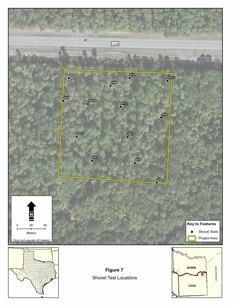

Conclusions and Recommendations
This page intentionally left blank
Draft Archeological Survey Report ndash City of Domino Water Treatment Plant ndash June 2015 20
References Cited
REFERENCES CITED
Bureau of Economic Geology (BEG) 2007 Geologic Map Database of Texas httppubsusgsgovds2005170 (May 15 2015)
Texas Historical Commission (THC) 2012a Texas Administrative Code (TAC) Chapter 26 Rules of Practice and Procedure for the Antiquities Code of Texas httpinfososstatetxusplspubreadtac$extViewTACtac_view=4ampti=13amppt=2ampch=2 6amprl=Y (June 2 2015)
2015b Texas Archeological Sites Atlas (the Atlas) httpnuecesthcstatetxus (March 13 2015)
Find a Grave 2015 Albert Richie Cemetery httpwwwfindagravecomcgishybinfgcgipage=crampCRid=3265 (June 8 2015)
United States Department of Agriculture Natural Resource Conservations Service (USDA NRCS))
2015a Metcalf Silt Loam httpssoilseriesscegovusdagovosdnameasp (June 5 2015)
United States Department of Agriculture Natural Resources Conservation Service (USDA NRCS)
2015b Soil Survey Geographic (SSURGO) database for Cass County Texas httpSoilDataMartnrcsusdagov (March 13 2015)
Draft Archeological Survey Report ndash City of Domino Water Treatment Plant ndash June 2015 21
References Cited
This page intentionally left blank
Draft Archeological Survey Report ndash City of Domino Water Treatment Plant ndash June 2015 22
APPENDIX A
REGULATORY CORRESPONDENCE
_______________________
ANTIQUITIES PERMIT APPLICATION FORM ARCHEOLOGY
GENERAL INFORMATION
I PROPERTY TYPE AND LOCATION
Project Name (andor Site Trinomial) City of Domino Water Treatment Plant
County (ies) Knox County
USGS Quadrangle Name and Number Wright Patman Lake (33094-C2)
UTM Coordinates Zone 15
Centroid E 3964629 N 3680784
Location Just west of the City of Domino off of FM 3129
Federal Involvement Yes No XX
Name of Federal Agency Agency Representative
II OWNER (OR CONTROLLING AGENCY)
Owner City of Domino
Representative
Mayor Alfred Campbell
Address City of Domino
14555 FM 3129
CityStateZip Domino TX 75572 Telephone (include area code) _____________________Email Address albdcampbellhotmailcom______
III PROJECT SPONSOR (IF DIFFERENT FROM OWNER)
Sponsor
Representative
Address
CityStateZip
Telephone (include area code) Email Address
PROJECT INFORMATION
I PRINCIPAL INVESTIGATOR (ARCHEOLOGIST)
Name Josh Haefner
Affiliation Hicks amp Company
Address 1504 W 5th Street
CityStateZip Austin Tx 78703
Telephone (include area code) 512-478-0858 Email Address jhaefnerhicksenvcom
(OVER)
ANTIQUITIES PERMIT APPLICATION FORM (CONTINUED)
II PROJECT DESCRIPTION
Proposed Starting Date of Fieldwork May 24 2015 Requested Permit Duration 2 Years Months (1 year minimum) Scope of Work (Provided an Outline of Proposed Work) Intensive Survey (see attached scope of work)
III CURATION amp REPORT
Temporary Curatorial or Laboratory Facility Hicks amp Company
Permanent Curatorial Facility Center for Archeological Studies (CAS)
IV LAND OWNERrsquoS CERTIFICATION
I Alfred Campbell as legal representative of the Land Owner
do certify that I have reviewed the plans and research design and that no investigations
will be preformed prior to the issuance of a permit by the Texas Historical Commission Furthermore I understand that
the Owner Sponsor and Principal Investigator are responsible for completing the terms of the permit
Signature Date
V SPONSORrsquoS CERTIFICATION
I as legal representative of the Sponsor
do certify that I have review the plans and
research design and that no investigations will be performed prior to the issuance of a permit by the Texas Historical
Commission Furthermore I understand that the Sponsor Owner and Principal Investigator are responsible for
completing the terms of this permit
Signature Date
VI INVESTIGATORrsquoS CERTIFICATION
I Josh Haefner as Principal Investigator employed by
Hicks amp Company (Investigative Firm) do certify that I will execute this project
according to the submitted plans and research design and will not conduct any work prior to the issuance of a permit by
the Texas Historical Commission Furthermore I understand that the Principal Investigator (and the Investigative Firm)
as well as the Owner and Sponsor are responsible for completing the terms of this permit
Signature Date 5415
Principal Investigator must attach a research design a copy of the USGS quadrangle showing project boundaries and any
additional pertinent information Curriculum vita must be on file with the Division of Antiquities Protection
FOR OFFICIAL USE ONLY
Reviewer Date Permit Issues
Permit Number Permit Expiration Date
Type of Permit Date Received for Data Entry
Texas Historical Commission
Archeology Division
PO Box 12276 Austin TX 78711-2276
Phone 512463-6096
wwwthcstatetxus
Hicks amp Companyrsquos Scope of Work for the
City of Dominorsquos Water Treatment Plant Project Cass County Texas
May 4 2015
Pursuant to the Texas Historical Commissionrsquos (THC) recommendation regarding the
Greater Texoma Utility Authority (GTUA) and City of Dominosrsquo compliance
responsibilities (Attachment 1 letter Wolfe to Linendoll March 11 2015) this scope of
work describes an archeological resources survey for the City of Dominorsquos Water
Treatment Plant Project in Rio Hike and Bike Trail Improvements Project in Cass
County Texas The proposed project consists of the construction of a new water
treatment plant on a parcel approximately six acres in size (Attachment 2 Project
Location) During review of the proposed project the THC noted that this parcel has
never before been surveyed and is located within an area determined to have good
probability to contain archeological deposits requiring archeological survey for
Antiquities Code of Texas (ACT) compliance
According to the Geologic Atlas of Texas Texarkana Sheet the underlying geology of
the proposed project areas consists of the Wilcox Group undivided formation (Barnes
1979) Dating the Eocene which long predates human arrival in the Americas cultural
deposits in such mapped areas can be expected to be contained to overlying surface
soilssediment or the surface itself A single soil series the Metcalf silt loam 0 to 2
percent slopes is mapped for the project area This series typically has shallow A
horizons with Bt clay horizons typically occurring between 4 and 75 centimeters below
the ground surface
Because there is limited potential for deeply buried archeological deposits Hicks amp
Company is proposing pedestrian survey supplemented with shovel testing as a
sufficient methodology to assess the proposed projectrsquos potential to impact archeological
resourcessites The project area will be tested at a rate of no less than 12 subsurface tests
(2 per acre) in accordance with the THCrsquos minimum standards for intensive areal survey
Investigators will record their observations and the results of shovel tests through notes
standardized shovel test forms and photographs Shovel tests will be excavated to a
depth of one meter or bedrock and sediment from all shovel tests will be screened
through frac14-inch hardware cloth Shovel test locations will be recorded utilizing GPS
technology The survey will follow a no-collection policy in which artifacts will be
recorded identified and quantified in the field but returned to their find location
Any archeological sites identified during the survey will be investigated by no fewer than
six shovel tests in order to define site boundaries relative to the project area Identified
sites will be recorded in accordance with the THCrsquos standards for site investigation
Subsurface tests within sites will be excavated at a frequency and arrangement
appropriate for assessing site size depth and significance Site locations will be
recorded utilizing GPS technology and data will be recorded on standardized forms
Documented sites will be recorded at the Texas Archeological Research Laboratory
(TARL) and new trinomials will be assigned
The results of the investigation will be compiled into a professional report as required
under Chapter 26 of the THCrsquos Rules of Practice and Procedure The report will include a
summary of background information results of field investigations and
recommendations about the need for further investigations (if any) with respect to both
historic and prehistoric sites and will be submitted to THC for review and comment In
accordance with revised ACT requirements hard copies and digital files of the final
report will be submitted to the THC and other recommended libraries and repositories
across Texas Additionally all project-generated forms notes photographs etc will be
formally curated at the Center for Archeological Studies in San Marcos Texas
REFERENCES
Barnes V E
1979 Geologic Atlas of Texas Texarkana Sheet Bureau of Economic Geology the University of Texas at Austin
United States Department of Agriculture (USDA)
2015 Web Soil Survey httpwebsoilsurveynrcsusdagovappWebSoilSurveyaspx accessed May 4 2015
ATTACHMENTS
-
3129 2327
3129 poundcurren59
Copyrightcopy 2011 National Geographic Society i cubed
Key to Features Water Treatment FacilityBoundary
W 0 05 1
Kilometers
Attachment 2Project Location
City of Domino Archeological Services
USGS 75-minute Topographic QuadranglesWright Patman Lake (USGS 33094-C2) TX
CASS
BOWIE ARKANSAS
- Short Report on the Archeological Investigations for the City of Dominorsquos Proposed New Water Treatment Plant Cass County Texas
- Short Report on the Archeological Investigations for the City of Dominorsquos Proposed New Water Treatment Plant Cass County Texas
-
- Creative Commons License
-
- PROJECT DESCRIPTION AND MANAGEMENT SUMMARY
- ENVIRONMENTAL SETTING
-
- Physiography
- Geology and Soils
-
- METHODOLOGY
-
- Previous Investigations
- Field Methodology
-
- RESULTS OF FIELD INVESTIGATIONS
- CONCLUSIONS AND RECOMMENDATIONS
- REFERENCES CITED
-

References Cited
This page intentionally left blank
Draft Archeological Survey Report ndash City of Domino Water Treatment Plant ndash June 2015 22
APPENDIX A
REGULATORY CORRESPONDENCE
_______________________
ANTIQUITIES PERMIT APPLICATION FORM ARCHEOLOGY
GENERAL INFORMATION
I PROPERTY TYPE AND LOCATION
Project Name (andor Site Trinomial) City of Domino Water Treatment Plant
County (ies) Knox County
USGS Quadrangle Name and Number Wright Patman Lake (33094-C2)
UTM Coordinates Zone 15
Centroid E 3964629 N 3680784
Location Just west of the City of Domino off of FM 3129
Federal Involvement Yes No XX
Name of Federal Agency Agency Representative
II OWNER (OR CONTROLLING AGENCY)
Owner City of Domino
Representative
Mayor Alfred Campbell
Address City of Domino
14555 FM 3129
CityStateZip Domino TX 75572 Telephone (include area code) _____________________Email Address albdcampbellhotmailcom______
III PROJECT SPONSOR (IF DIFFERENT FROM OWNER)
Sponsor
Representative
Address
CityStateZip
Telephone (include area code) Email Address
PROJECT INFORMATION
I PRINCIPAL INVESTIGATOR (ARCHEOLOGIST)
Name Josh Haefner
Affiliation Hicks amp Company
Address 1504 W 5th Street
CityStateZip Austin Tx 78703
Telephone (include area code) 512-478-0858 Email Address jhaefnerhicksenvcom
(OVER)
ANTIQUITIES PERMIT APPLICATION FORM (CONTINUED)
II PROJECT DESCRIPTION
Proposed Starting Date of Fieldwork May 24 2015 Requested Permit Duration 2 Years Months (1 year minimum) Scope of Work (Provided an Outline of Proposed Work) Intensive Survey (see attached scope of work)
III CURATION amp REPORT
Temporary Curatorial or Laboratory Facility Hicks amp Company
Permanent Curatorial Facility Center for Archeological Studies (CAS)
IV LAND OWNERrsquoS CERTIFICATION
I Alfred Campbell as legal representative of the Land Owner
do certify that I have reviewed the plans and research design and that no investigations
will be preformed prior to the issuance of a permit by the Texas Historical Commission Furthermore I understand that
the Owner Sponsor and Principal Investigator are responsible for completing the terms of the permit
Signature Date
V SPONSORrsquoS CERTIFICATION
I as legal representative of the Sponsor
do certify that I have review the plans and
research design and that no investigations will be performed prior to the issuance of a permit by the Texas Historical
Commission Furthermore I understand that the Sponsor Owner and Principal Investigator are responsible for
completing the terms of this permit
Signature Date
VI INVESTIGATORrsquoS CERTIFICATION
I Josh Haefner as Principal Investigator employed by
Hicks amp Company (Investigative Firm) do certify that I will execute this project
according to the submitted plans and research design and will not conduct any work prior to the issuance of a permit by
the Texas Historical Commission Furthermore I understand that the Principal Investigator (and the Investigative Firm)
as well as the Owner and Sponsor are responsible for completing the terms of this permit
Signature Date 5415
Principal Investigator must attach a research design a copy of the USGS quadrangle showing project boundaries and any
additional pertinent information Curriculum vita must be on file with the Division of Antiquities Protection
FOR OFFICIAL USE ONLY
Reviewer Date Permit Issues
Permit Number Permit Expiration Date
Type of Permit Date Received for Data Entry
Texas Historical Commission
Archeology Division
PO Box 12276 Austin TX 78711-2276
Phone 512463-6096
wwwthcstatetxus
Hicks amp Companyrsquos Scope of Work for the
City of Dominorsquos Water Treatment Plant Project Cass County Texas
May 4 2015
Pursuant to the Texas Historical Commissionrsquos (THC) recommendation regarding the
Greater Texoma Utility Authority (GTUA) and City of Dominosrsquo compliance
responsibilities (Attachment 1 letter Wolfe to Linendoll March 11 2015) this scope of
work describes an archeological resources survey for the City of Dominorsquos Water
Treatment Plant Project in Rio Hike and Bike Trail Improvements Project in Cass
County Texas The proposed project consists of the construction of a new water
treatment plant on a parcel approximately six acres in size (Attachment 2 Project
Location) During review of the proposed project the THC noted that this parcel has
never before been surveyed and is located within an area determined to have good
probability to contain archeological deposits requiring archeological survey for
Antiquities Code of Texas (ACT) compliance
According to the Geologic Atlas of Texas Texarkana Sheet the underlying geology of
the proposed project areas consists of the Wilcox Group undivided formation (Barnes
1979) Dating the Eocene which long predates human arrival in the Americas cultural
deposits in such mapped areas can be expected to be contained to overlying surface
soilssediment or the surface itself A single soil series the Metcalf silt loam 0 to 2
percent slopes is mapped for the project area This series typically has shallow A
horizons with Bt clay horizons typically occurring between 4 and 75 centimeters below
the ground surface
Because there is limited potential for deeply buried archeological deposits Hicks amp
Company is proposing pedestrian survey supplemented with shovel testing as a
sufficient methodology to assess the proposed projectrsquos potential to impact archeological
resourcessites The project area will be tested at a rate of no less than 12 subsurface tests
(2 per acre) in accordance with the THCrsquos minimum standards for intensive areal survey
Investigators will record their observations and the results of shovel tests through notes
standardized shovel test forms and photographs Shovel tests will be excavated to a
depth of one meter or bedrock and sediment from all shovel tests will be screened
through frac14-inch hardware cloth Shovel test locations will be recorded utilizing GPS
technology The survey will follow a no-collection policy in which artifacts will be
recorded identified and quantified in the field but returned to their find location
Any archeological sites identified during the survey will be investigated by no fewer than
six shovel tests in order to define site boundaries relative to the project area Identified
sites will be recorded in accordance with the THCrsquos standards for site investigation
Subsurface tests within sites will be excavated at a frequency and arrangement
appropriate for assessing site size depth and significance Site locations will be
recorded utilizing GPS technology and data will be recorded on standardized forms
Documented sites will be recorded at the Texas Archeological Research Laboratory
(TARL) and new trinomials will be assigned
The results of the investigation will be compiled into a professional report as required
under Chapter 26 of the THCrsquos Rules of Practice and Procedure The report will include a
summary of background information results of field investigations and
recommendations about the need for further investigations (if any) with respect to both
historic and prehistoric sites and will be submitted to THC for review and comment In
accordance with revised ACT requirements hard copies and digital files of the final
report will be submitted to the THC and other recommended libraries and repositories
across Texas Additionally all project-generated forms notes photographs etc will be
formally curated at the Center for Archeological Studies in San Marcos Texas
REFERENCES
Barnes V E
1979 Geologic Atlas of Texas Texarkana Sheet Bureau of Economic Geology the University of Texas at Austin
United States Department of Agriculture (USDA)
2015 Web Soil Survey httpwebsoilsurveynrcsusdagovappWebSoilSurveyaspx accessed May 4 2015
ATTACHMENTS
-
3129 2327
3129 poundcurren59
Copyrightcopy 2011 National Geographic Society i cubed
Key to Features Water Treatment FacilityBoundary
W 0 05 1
Kilometers
Attachment 2Project Location
City of Domino Archeological Services
USGS 75-minute Topographic QuadranglesWright Patman Lake (USGS 33094-C2) TX
CASS
BOWIE ARKANSAS
- Short Report on the Archeological Investigations for the City of Dominorsquos Proposed New Water Treatment Plant Cass County Texas
- Short Report on the Archeological Investigations for the City of Dominorsquos Proposed New Water Treatment Plant Cass County Texas
-
- Creative Commons License
-
- PROJECT DESCRIPTION AND MANAGEMENT SUMMARY
- ENVIRONMENTAL SETTING
-
- Physiography
- Geology and Soils
-
- METHODOLOGY
-
- Previous Investigations
- Field Methodology
-
- RESULTS OF FIELD INVESTIGATIONS
- CONCLUSIONS AND RECOMMENDATIONS
- REFERENCES CITED
-

-
3129 2327
3129 poundcurren59
Copyrightcopy 2011 National Geographic Society i cubed
Key to Features Water Treatment FacilityBoundary
W 0 05 1
Kilometers
Attachment 2Project Location
City of Domino Archeological Services
USGS 75-minute Topographic QuadranglesWright Patman Lake (USGS 33094-C2) TX
CASS
BOWIE ARKANSAS
- Short Report on the Archeological Investigations for the City of Dominorsquos Proposed New Water Treatment Plant Cass County Texas
- Short Report on the Archeological Investigations for the City of Dominorsquos Proposed New Water Treatment Plant Cass County Texas
-
- Creative Commons License
-
- PROJECT DESCRIPTION AND MANAGEMENT SUMMARY
- ENVIRONMENTAL SETTING
-
- Physiography
- Geology and Soils
-
- METHODOLOGY
-
- Previous Investigations
- Field Methodology
-
- RESULTS OF FIELD INVESTIGATIONS
- CONCLUSIONS AND RECOMMENDATIONS
- REFERENCES CITED
-

- Short Report on the Archeological Investigations for the City of Dominorsquos Proposed New Water Treatment Plant Cass County Texas
- Short Report on the Archeological Investigations for the City of Dominorsquos Proposed New Water Treatment Plant Cass County Texas
-
- Creative Commons License
-
- PROJECT DESCRIPTION AND MANAGEMENT SUMMARY
- ENVIRONMENTAL SETTING
-
- Physiography
- Geology and Soils
-
- METHODOLOGY
-
- Previous Investigations
- Field Methodology
-
- RESULTS OF FIELD INVESTIGATIONS
- CONCLUSIONS AND RECOMMENDATIONS
- REFERENCES CITED
-