shuhada rescue archaeological project (srap) and el-misaktab in the shendi region
DESCRIPTION
by Mohamed Faroug Abdelrahman, Ahmed Sokary and Murtada Bushara — Sudan & Nubia, No 13, published by The Sudan Archaeological Research Society, 2009TRANSCRIPT

SUDAN & NUBIA
1
2

SUDAN & NUBIA
1

2
Sudan & nubia
107
Shuhada Rescue archaeological Project (SRaP) and el-Misaktab in the Shendi regionMohamed Faroug Abdelrahman, Ahmed Sokary and Murtada Bushara
The Shuhada archaeological project, south of the modern town of Shendi, was a response, in 2005-06, to the establish-ment by the Sudan Government of an agricultural project. The team, from the national Corporation for antiquities and Museums (nCaM), surveyed the area revealing 21 sites, com-prising of either individual graves or cemeteries, apart from one Christian settlement, site SHd.16, recently completely destroyed by a new water canal’s construction. The last two seasons in 2007 and 2008 at Shuhada were funded by a small grant from the british institute in Eastern africa (biEa). We would like to express our gratitude for its assistance in reveal-ing Sudan’s cultural heritage and furthering research. The departments of archaeology in both Khartoum and Shendi universities have made a considerable contribution to the project and participated in the rescue excavation.1 Recently, in the course of the Shuhada archaeological Project’s activi-ties, together with the Director of Shendi Antiquities Office, ahmed Sokary, we conducted an excavation at el-Misaktab village, north of Shendi, investigating a partly-destroyed grave (Figure 1). This grave produced a considerable number of archaeological finds and information about Meroitic burials, being much richer than the excavated Meroitic grave from site SHd.15, in the Shuhada archaeological Project’s area.
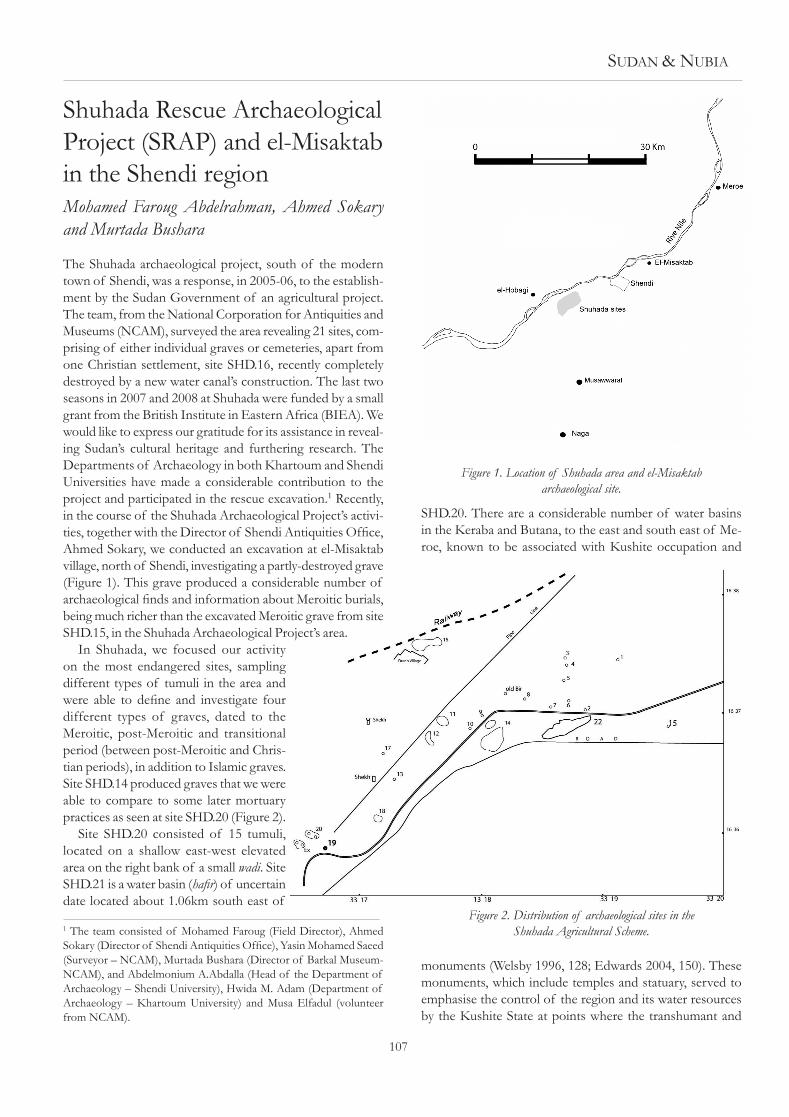
in Shuhada, we focused our activity on the most endangered sites, sampling different types of tumuli in the area and were able to define and investigate four different types of graves, dated to the Meroitic, post-Meroitic and transitional period (between post-Meroitic and Chris-tian periods), in addition to islamic graves. Site SHd.14 produced graves that we were able to compare to some later mortuary practices as seen at site SHd.20 (Figure 2).
Site SHd.20 consisted of 15 tumuli, located on a shallow east-west elevated area on the right bank of a small wadi. Site SHd.21 is a water basin (hafir) of uncertain date located about 1.06km south east of
1 The team consisted of Mohamed Faroug (Field director), ahmed Sokary (Director of Shendi Antiquities Office), Yasin Mohamed Saeed (Surveyor – nCaM), Murtada bushara (director of barkal Museum-nCaM), and abdelmonium a.abdalla (Head of the department of archaeology – Shendi university), Hwida M. adam (department of archaeology – Khartoum university) and Musa Elfadul (volunteer from nCaM).
SHd.20. There are a considerable number of water basins in the Keraba and butana, to the east and south east of Me-roe, known to be associated with Kushite occupation and
monuments (Welsby 1996, 128; Edwards 2004, 150). These monuments, which include temples and statuary, served to emphasise the control of the region and its water resources by the Kushite State at points where the transhumant and
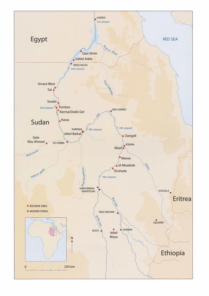
Figure 1. Location of Shuhada area and el-Misaktab archaeological site.
Figure 2. Distribution of archaeological sites in the Shuhada Agricultural Scheme.

108
nomadic population gathered. The economic system of the non-sedentary population, based on the use of hafirs has apparently continued until the present day (Welsby 1996, 128-37). Test excavation will be necessary, in order to study further the sites’ spatial distribution, their economy and the all-important water resources utilised by these populations, between the later Kushite and islamic periods.
The distribution of cemeteries and small villages at SHd.19 and SHd.20 may explain the continuity of occu-pation in the study area. Excavations at SHd.20 revealed remains dating to the post-Meroitic and Transitional periods. during its excavation it was observed that most of the burials had been heavily plundered and disturbed, except graves T. 14\d and T.15\d where the Muslim cemetery was located. These intact graves and their position suggest that the robbing began during islamic occupation in the study area.
A Meroitic grave from el-MisaktabEl-Misaktab village is located on the right bank of the River nile, at 16° 44’ 21” n and 33° 31’ 17” E about 10km north of Shendi. The archaeological site, which consists of a tumuli cemetery, was visited and described by Geus, Hinkel and Lenoble, who dated it to the Post-Meroitic period (Edwards 1989). We studied the site’s recent history by questioning some of the local inhabitants. it was clear that population growth within villages - coupled with agricultural activities - has resulted in expansion and consequent destruction of archaeological sites in many areas. The cemetery is located to the south of the village, where houses have been built which threaten the cemetery. The rescued grave was located in a house under construction. Those questioned explained that several mounds (tumuli) had been levelled at the new houses’ site, but small, elevated areas are still visible on the surface, suggesting the possible location of some tumuli. This destructive activity has brought to light the fact that the cem-etery had originally been larger than the 30 remaining tumuli. From our previous work at ed-damar, in Frai village and el-Misaktab, it is clear that some archaeological sites, stretching along the right bank of the River nile, have been replaced by new settlements and by the extension of pre-existing villages (Mohamed Faroug 2006b). We also noticed that, in some areas, previous archaeological data does not always provide an accurate or reliable estimate of the number of tumuli that form each cemetery, or of the site’s original extent. We are now able to provide a precise estimate of the damage which occurred between 1983 and 2008 at el-Misaktab and a similar situation may be assumed to have occurred at the sites of other threatened archaeological monuments, settlements and cemeteries in the region.
The excavated gravea well was excavated in a house in el-Misaktab village, reveal-ing archaeological material, consisting of human bone and complete pottery vessels. The partially-damaged grave sub-structure is located about 800mm from the eastern wall of the
house. unfortunately, the trench had been cut down through the grave entrance and part of the grave chamber, where the skeleton and some of the grave goods were deposited (Plate 1, Figure 3). Skeleton fragments were found scattered on the
surface, including the pelvis and some teeth belonging to an adult male. Fortunately, the south-western part of the burial chamber was still intact. Excavation revealed that the burial chamber was filled with compacted soil, derived either from the collapse of part of the burial chamber roof or robbing activity through the entrance. The wall to the east prevented
us from continuing the shaft’s excavation. Thus, we do not have the exact dimensions of the shaft, but its eastern profile and the remaining part of the burial chamber allowed us to reconstruct its original form, with a steeply-descending east-west shaft, from whence the burial chamber was carved, at a depth of 1.1m from the surface. The height of the cavity is about 1.1m and is approximately 2.4m long from the pre-
Plate 1. The grave goods from the damaged grave at el-Misaktab.
Figure 3. A reconstructed top plan of el-Misaktab grave (scale 1:50).
Sudan & nubia
109
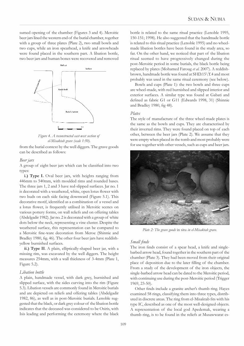
sumed opening of the chamber (Figures 3 and 4). Meroitic beer jars lined the western end of the burial chamber, together with a group of three plates (Plate 2), two small bowls and two cups, while an iron spearhead, a knife and arrowheads were found placed in the southern part. a libation bottle, two beer jars and human bones were recovered and removed
from the burial context by the well diggers. The grave goods can be described as follows:
Beer jarsA group of eight beer jars which can be classified into two types:
i.) Type I. Oval beer jars, with heights ranging from 446mm to 540mm, with moulded rims and rounded bases. The three jars 1, 2 and 3 have red-slipped surfaces. Jar no. 1 is decorated with a weathered, white, open lotus flower with two buds on each side facing downward (Figure 5.1). This decorative motif, identified as a combination of a vessel and a lotus flower, is frequently utilised in Meroitic scenes on various pottery forms, on wall reliefs and on offering tables (abdelgadir 1982). Jar no. 2 is decorated with a group of white dots below the neck, representing a vine cluster. despite the weathered surface, this representation can be compared to a Meroitic fine-ware decoration from Meroe (Shinnie and Bradley 1980, fig. 46). The other four beer jars have reddish-yellow burnished surfaces.
ii.) Type II. a plain, elliptically-shaped beer jar, with a missing rim, was excavated by the well diggers. The height measures 254mm, with a wall thickness of 3-4mm (Plate 1, Figure 5.2).
Libation bottlea plain, handmade vessel, with dark grey, burnished and slipped surface, with the sides curving into the rim (Figure 5.3). Libation vessels are commonly found in Meroitic burials and are depicted on reliefs and offering tables (abdelgadir 1982, 86), as well as in post-Meroitic burials. Lenoble sug-gested that the black, or dark grey colour of the libation bottle indicates that the deceased was considered to be Osiris, with isis leading and performing the ceremony where the black
bottle is related to the same ritual practice (Lenoble 1995, 150-151; 1998). He also suggested that the handmade bottle is related to this ritual practice (Lenoble 1995) and no wheel-made libation bottles have been found in the study area, so far. On the other hand, we noticed that part of the libation ritual seemed to have progressively changed during the post-Meroitic period in some burials, the black bottle being replaced by plates (Mohamed Faroug et al. 2007). a reddish-brown, handmade bottle was found at SHd.15\T.4 and most probably was used in the same ritual ceremony (see below).
bowls and cups (Plate 1): the two bowls and three cups are wheel-made, with red burnished and slipped interior and exterior surfaces. a similar type was found at Gabati and defined as fabric G1 or G11 (Edwards 1998, 31) (Shinnie and Bradley 1980, fig 48).
PlatesThe style of manufacture of the three wheel-made plates is the same as the bowls and cups. They are characterised by their inverted rims. They were found placed on top of each other, between the beer jars (Plate 2). We assume that they were empty when placed in the tomb and most probably were for use together with other vessels, such as cups and beer jars.
Small findsThe iron finds consist of a spear head, a knife and single-barbed arrow head, found together in the southern part of the chamber (Plate 3). They had been moved from their original place of deposition due to the later filling of the chamber. From a study of the development of the iron objects, the single-barbed arrow head can be dated to the Meroitic period, with continuing use during the post-Meroitic period (Trigger 1969, 23-50).
Other finds include a granite archer’s thumb ring. Hayes examined 58 rings, classifying them into three types, distrib-uted in discrete areas. The ring from el-Misaktab fits with his type iC, described as one of the most well-designed objects. a representation of the local god apedemak, wearing a thumb ring, is to be found in the reliefs at Musawwarat es-
Figure 4. A reconstructed east-west section of el-Misaktab grave (scale 1:50).
Plate 2: The grave goods in situ in el-Misaktab grave.

110
Sufra. The spatial study indicated that they were distributed from south of Khartoum, Jebel Haraza and abu Sofyan in northern Kordofan to Jebel adda in the north and dated to the period 100 bC to ad 500 (Hayes 1973, 113-22). The depiction of apedemak suggests the symbolic importance of these rings as part of the Meroitic warriors’ accoutrements, together with bows and other weaponry. The many thumb rings discovered since 1973 demand a revision of the spatial and chronological study of the different types.
The excavated graves from ShuhadaSHD.15\4. during the test excavation in the study area at site SHd.15, one of the four graves (T.4) was excavated. The shaft is gently sloping, east-west and measured 4.1m to the end of the burial chamber. Pottery sherds in the chamber’s opening and the dislocated burial are indicative of grave rob-ber activity. an adult female burial, oriented north-south, lay in a contracted position on her left side, head to the south and facing west. a medium-sized beer jar was found in the
northern part of the chamber, in addition to a very rusty iron ring. The beer jar is characterised by its type: vertical neck, straight sides, with a modelled rim. its height meas-ures 360mm with a rim diameter of 110mm. The body of the vessel and its lower surface are mat-impressed, while the upper part is decorated with a reddish-brown wash and a horizontal stripe (Colour plate Liii). This jar form can be compared to beer jars found at Gabati and dated to the Meroitic period (Edwards 1998, 165), despite the differences in the decoration and colour. The jar type seems to have been used for a libation ritual, connected to Osiris and isis. Future investigation at SHd.15 will enrich our knowledge regarding Meroitic mortuary practices in the study area.
SHD.20\T.15. The graves in this cemetery, designated a,
Figure 5. Pottery vessels from the el-Misaktab grave. 1 - Beer jar type I: 2 - Beer jar type II: 3 - Libation bottle (scale 1:4).
Plate 3. Small artefacts from el-Misaktab.

Sudan & nubia
111
b, C, d and E, are of post-Meroitic and islamic date. Grave T.15 was located at the north-eastern end of the cemetery, next to the houses. The superstructure is a gravel mound, measuring about 13m in diameter. Excavation here revealed four islamic burials, numbered T.20\15a, b, C and E dug into the mound.
Local acacia tree branches were discovered 400mm be-neath the mound’s surface, roofing (approximately north-south oriented) rectangular, burial pits, 200-450mm in depth. These burials had at first contained deceased children and subsequently adults. (Figure 6)
The burials are extended, lying on their right sides, with their heads to the north, facing east. No archaeological finds or grave goods were found inside these graves.
Post-Meroitic SHD.20\ T.15\D. an extended shaft, slop-ing steeply east-west, with an oval burial chamber cut at its western end. Fragments of acacia wood were found at the opening of the burial chamber, similarly to those found in situ in grave T.12 indicating a wooden, blocking wall. The adult, male burial was disturbed, due to robber activity and water penetration, with only the feet remaining in situ indicating that the burial was oriented north-south, in a contracted po-sition, with the head to the south, facing east. about 15 iron arrowheads were deposited in front of the body, while one bowl and two beer jars were located in the east and northern part of the chamber.
SHD. 20\T.14\A, B, C and D. This grave is located imme-diately west of T.20\15, in an extension of the Muslim cem-etery where three more islamic graves, designated T.14\a, b and C were dug into the post-Meroitic super-structure and substructures (T.14\d). The grave structures are the same as in the aforementioned graves. They are located west and
south west of the post-Meroitic one, while the southern part of another unexcavated grave (SHd20\14E) cuts the eastern, upper part of the post-Meroitic grave’s shaft.
SHD.20\ T.14\D. The superstructure is identical to that of grave T.15\d, measuring 3.2m in diameter, and cover-ing a trapezoidal descendary, sloping steeply east-west. a sacrificed goat was located at the end of the shaft, near the opening of the burial chamber; covered by black medium and small-sized stones and oriented approximately north-south, with its head to the south, facing the opening of the oval chamber (Plate 4). The wood fragments, having been found at the end of the shaft, indicate the original presence of a wooden blocking-wall. The burial chamber measured 2.3m in length and contained one skeleton, its upper part still undisturbed, towards the southern part of the chamber. The
lower part of the male adult was in situ, indicating that the body had lain in a north-south, contracted position, with its head to the south, facing east. The grave goods consisted of one dislocated bowl, found upon the legs and a large bowl located north east of the burial.
SHD.20\T.7\A and B. The superstructure measured 12m in diameter and was about 400mm high. a rectangular trench was dug in the middle of the superstructure, in which a later phase of activity was revealed, a north west - south east trapezoid cut (T.7\a). it is an unfurnished grave, containing an adult male, lying on his right side, in a semi-contracted position with legs flexed. The head, resting on his hands, was to the north west, facing south (Plate 5). The burial location seems to have been chosen due to its hardened soil surface and elevated position.
The substructure of the main grave T.7\b is thought to have been the largest in the cemetery. it has an east-west descendary, measuring about 4m long and 2m deep, to the floor/base of the burial chamber at its western end (Plate 6). The chamber was heavily disturbed by both the col-lapse of the blocking wall and water penetration, human bones being found scattered throughout the chamber and
Figure 6. SHD.20\T.15 showing post-Meroitic and Islamic graves (scale 1:50).
Plate 4. A sacrificed goat from SHD.20\T.14\D.

112
within the fill. The grave goods, consisting of arrowheads and an archer’s thumb ring, were found at the eastern part of the chamber.
Graves T.1, 3, 4, 5, 8, 9 and 10 were heavily disturbed, but they provided considerable amounts of information, particu-larly regarding archaeological finds and gender. The deceased were all aged between 35 and 55.2 There were no areas re-stricted to individuals of a particular age or sex. The grave goods varied from one grave to another, the largest graves were robbed with only a few artefacts being found with the burials, whilst the small graves produced considerable num-bers of objects. In order to study social stratification in the cemetery, therefore, we must expand our activities to other cemeteries to find more information to facilitate a compara-tive study of the relationship between the superstructure, substructure and grave goods, in combination with the gender of the deceased.
Archaeological findsThe archaeological finds produced from site SHD.20 and their distribution among the graves indicate use in the late post-Meroitic period. The distinctive ‘alwa ware’ is represented by beer jars from graves T.15\d, 12, 6 (Colour plate LiV), together with bowls (Edwards 2004, 189). Similar bowls from the other graves indicate the same chronological period, despite the differences in substructure size and orientation. The small finds consisted of iron, single-barbed arrowheads
2 Many thanks to dr brenda baker from arizona State university (USA), who was able to study and define ages and sex of the skeletons from the 2008 season.
from all male graves T.4, 7b, 8b and T.15\d, except for T.14\d. Personal ornaments were to be found mainly in fe-male graves and consisted of an ostrich eggshell, a bead belt found in T.10 around the individual’s waist and faience and glass beads found scattered in graves 1 and 5; male graves produced only a few beads.
SHD.14/T.10 and 8. Site SHD.14 consists specifically of hat-type tumuli (Mohamed Faroug 2006a). This site is located on an elevated area, with nubian sandstone scattered on its surface (Colour plate LV). The previous survey revealed 13 hat graves, their superstructures built from the same stones. T.10 and T.8 were selected for test excavations to allow for the investigation of tombs of different sizes and in order to recover archaeological material for dating purposes. T.10 measured about 12m in diameter and was 500mm in height at its centre, whilst the burial shaft was 1.2m deep. Grave T.8 measured 5.5m in diameter and was 200mm in height at its centre, with a burial chamber 500mm deep. burial positions
were identical in each grave, the individuals being placed in an extended position, lying on their backs, with their heads to the west, facing south in T.8 - and facing upwards in T.10. no artefacts were found in either grave. The same burial position was found in SHd.20 and supports our hypothesis that graves, under hat-type tumuli, may represent a transitional period burial type in the study area.
ConclusionThe rescue excavation and interviews with the local inhabit-ants have focused our attention on earlier archaeological documentation, which revealed considerable numbers of
Plate 5. Intact contracted grave SHD.20\T.7\A.
Plate 6. East-west descending shaft in grave SHD.20\T.7\B.

Sudan & nubia
113
archaeological sites along the nile. However, further informa-tion and details are still required to examine the archaeological remains quantitatively and qualitatively. Therefore, revising the previous surveys by conducting new work is crucial to allow a more detailed, spatial analysis and dating, as well as assessing the scale of recent damage to the archaeological sites. notably, the rapid growth of villages and development of agricultural projects has created a new threat to the docu-mented archaeological sites.
The cemeteries within the Shuhada agricultural Project are significant in terms of their different grave types. Site SHD.15 contained a Meroitic grave, with a narrow substructure and was less well-furnished with grave goods, in comparison with the excavated grave at el-Misaktab. The libation jars from the two graves may indicate the continuing importance of ritual observances to the same deity in the area, from the Meroitic into the Post-Meroitic period. additional excavated Meroitic graves from el-Misaktab and Shuhada may provide us with further information in the future regarding mortuary practices in the Shendi region.
SHd.20 provided us with considerable information regard-ing mortuary practice in the Shendi region. The goat sacrifice found in SHd.20 indicates that goats were interred in some male graves and it is possible that they bled these animals for ritual purposes during the burial ceremony documented in T.14\D and T.4. Sacrificed dogs found in a double-shaft grave in berber (Reinold and Lenoble 1990) and at akad (Mohamed Faroug et al. 2007) support a cultural affinity in the area between the Fifth and the Sixth Cataracts.
bearing in mind that arrows are synonymous with symbols of power as well as being functional weapons in the study area (Mohamed Faroug 2006c), the sheer quantity of arrowheads associated with every male grave, except one, is significant in comparison to berber (Lenoble, 1991), akad (Mohamed Faroug and Tsaxos 2005) and Gabati (Edwards 1998), which produced far fewer iron objects (Mohamed Faroug 2005).
Later activities in the cemetery are represented by east-west, shallow, grave substructures, with extended and con-tracted burials dug into the post-Meroitic grave superstruc-tures. This grave type and burial position may support our argument regarding the dating of the hat graves in the study area to the Transitional Period.
Bibliography abdelgadir, M. a. 1982. ‘Meroitic Funerary Customs and beliefs from
Text and Scenes’, in n. b. Millet and a. L. Kelley (eds), Meroitic Studies. Meroitica 6. berlin, 61-104.
Edwards, d. n. 1989. Archaeology and Settlement in Upper Nubia in the 1st Millennium A.D. baR S537. Oxford.
Edwards, d. n. 1998. Gabati: A Meroitic, Post-Meroitic and Medieval Cemetery in Central Sudan. Sudan archaeological Research Society Publication no. 3. London.
Edwards, d. n. 2004. The Nubian Past: An Archaeology of the Sudan. London - New York.
Hayes, R. O. 1973. ‘The distribution of Meroitic archer’s Rings: an Outline of Political border’, Meroitica 1, 113-122.
Lenoble, P. 1991. ‘Chiens de Païens, une Tombe Postpyramidale à dou-ble descenderie hors de Méroé’, Archéologie du Nil Moyen 5, 167-188.
Lenoble, P. 1995. ‘La Petite bouteille noire un Récipient Méroéen de la Libation Funéraire’, Archéologie du Nil Moyen 7, 143-162.
Lenoble, P. 1998. ‘Trois Tombes de la Région de Méroé. La Clôture des Fouilles Historiques d’el Kadada en 1985 et 1986’, Archéologie du Nil Moyen 8, 127-143.
Mohamed Faroug abdelrahman 2005. Evidences of the Kushite Iron Work-ing: 7th Century BC – 6th Century AD. unpublished Masters Thesis. Shendi university.
Mohamed Faroug abdelrahman 2006a. ‘The unfurnished Graves between 5th and 6th Cataract (Meroitic to islamic Period)’, 11th International Conference for Nubian Studies. Warsaw.
Mohamed Faroug abdelrahman 2006b. ‘El-Firai: a new Meroitic Habitation Site at Ed-damer’, Sudan & Nubia 10, 102-103.
Mohamed Faroug Abdelrahman, Yassin M. Saeed and A. Tsakos, 2007. ‘akad Excavation Project. Preliminary Report on the 2005 and 2006 Seasons’, Sudan & Nubia 11, 98-107.
Mohamed Faroug abdelrahman 2006c. A New Study About Napatan, Meroitic and Post-Meroitic Iron Objects. Warsaw.
Mohamed Faroug abdelrahman and a. Tsaxos 2005. ‘a Preliminary Report of Rescue Excavation at akad: The Season 2005’, Sudan and Nubia 9, 62-71.
Reinold, J. and P. Lenoble 1990. ‘El Hobagi 1990: Tumulus iii’, Nubian Newsletter 16, 5-6.
Shinnie, P. L. and R. J. bradley 1980. The Capital of Kush. I. Meroe Excava-tions 1965-72. Meroitica 4. berlin.
Trigger, b. G. 1969. ‘The Myth of Meroe and the african iron age’, International Journal of African Historical Studies 2, 23-50.
Welsby, d. a. 1996. The Kingdom of Kush: The Napatan and Meroitic Empires. London.
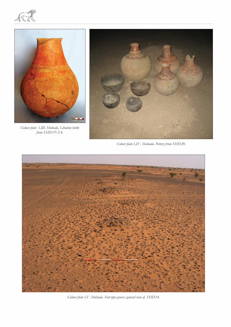
Colour plate LV. Shuhada. Hat-type graves: general view of SHD.14.
Colour plate LIII. Shuhada. Libation bottle from SHD.15\T.4.
Colour plate LIV. Shuhada. Pottery from SHD.20.

SUDAN & NUBIA
1

2