signage project in naturtejo global geopark
TRANSCRIPT

Rafael AndréRui Marques
Carlos Neto de CarvalhoJoana RodriguesArmindo JacintoCristina Preguiça
Naturtejo Geopark signage project: the structure of the touring offer in a large territory

Rota das Montanhas de OleirosGeological Heritage as tourist attractions
10th European Geoparks Conference: 16 ‐ 20 September, Langesund 2011
Geological Heritage
= innovative experiences
Geoconservation
Education
Geotourism
= simple as possible and clear interpretation

Rota das Montanhas de OleirosGeosites Signage in Naturtejo Geopark
10th European Geoparks Conference: 16 ‐ 20 September, Langesund 2011

Rota das Montanhas de OleirosGeosites Signage in Naturtejo Geopark
10th European Geoparks Conference: 16 ‐ 20 September, Langesund 2011
Maps Different road signs

Rota das Montanhas de OleirosGeosites Signage in Naturtejo Geopark
10th European Geoparks Conference: 16 ‐ 20 September, Langesund 2011
Geotrail interpretation Geocaches/Earthcaches

Rota das Montanhas de OleirosGeosites Signage in Naturtejo Geopark
10th European Geoparks Conference: 16 ‐ 20 September, Langesund 2011
Geotrail interpretation Geocaches/Earthcaches

Rota das Montanhas de OleirosGeosites Signage in Naturtejo Geopark
10th European Geoparks Conference: 16 ‐ 20 September, Langesund 2011
Electronic Welcome Panels

Rota das Montanhas de OleirosNaturtejo Geopark Signage Project
10th European Geoparks Conference: 16 ‐ 20 September, Langesund 2011
Geomonument’s interpretative panels location
• Project funded 100% by theTourism of Portugal
• 16 geomonuments, themain geopark attractions,were integrated witharriving directions and siteinterpretative panel.
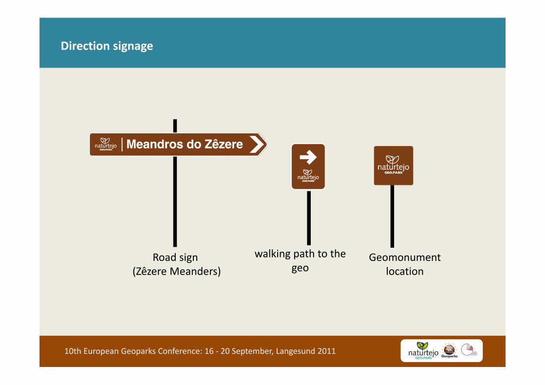
Rota das Montanhas de OleirosDirection signage
10th European Geoparks Conference: 16 ‐ 20 September, Langesund 2011
Road sign(Zêzere Meanders)
walking path to the geo
Geomonumentlocation

Rota das Montanhas de OleirosDirection signage: geomonument location
10th European Geoparks Conference: 16 ‐ 20 September, Langesund 2011

Rota das Montanhas de OleirosDirection signage: road sign
10th European Geoparks Conference: 16 ‐ 20 September, Langesund 2011
Located in the main acesses to the geomonuments, creating visitation ways

Rota das Montanhas de OleirosDirection signage: geomonument location
10th European Geoparks Conference: 16 ‐ 20 September, Langesund 2011

Rota das Montanhas de OleirosDirection signage: walking path to the geomonument
10th European Geoparks Conference: 16 ‐ 20 September, Langesund 2011
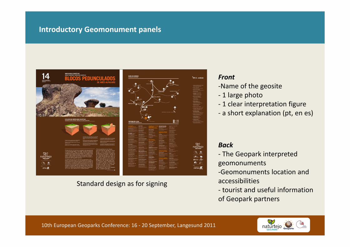
Rota das Montanhas de OleirosIntroductory Geomonument panels
10th European Geoparks Conference: 16 ‐ 20 September, Langesund 2011
Standard design as for signing
Front‐Name of the geosite‐ 1 large photo‐ 1 clear interpretation figure ‐ a short explanation (pt, en es)
Back‐ The Geopark interpretedgeomonuments‐Geomonuments location andaccessibilities‐ tourist and useful informationof Geopark partners

Rota das Montanhas de OleirosPanels
10th European Geoparks Conference: 16 ‐ 20 September, Langesund 2011

Rota das Montanhas de OleirosPanels
10th European Geoparks Conference: 16 ‐ 20 September, Langesund 2011

Rota das Montanhas de OleirosInterpretation: different approaches for different purposes but simple
10th European Geoparks Conference: 16 ‐ 20 September, Langesund 2011

Rota das Montanhas de OleirosIntegration between signage project and previous signage
10th European Geoparks Conference: 16 ‐ 20 September, Langesund 2011

Rota das Montanhas de OleirosTourist and Educational Programmes
10th European Geoparks Conference: 16 ‐ 20 September, Langesund 2011
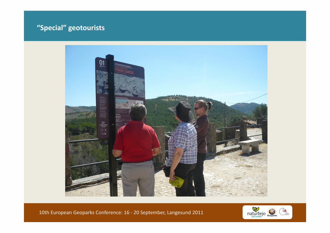
Rota das Montanhas de Oleiros“Special” geotourists
10th European Geoparks Conference: 16 ‐ 20 September, Langesund 2011
Rota das Montanhas de OleirosGeosites Signage in Naturtejo Geopark
10th European Geoparks Conference: 16 ‐ 20 September, Langesund 2011

Rota das Montanhas de OleirosDigital signage
10th European Geoparks Conference: 16 ‐ 20 September, Langesund 2011
‐ Available in www.naturtejo.com
• GPS information• Podcast with video• Short text• Photo

Rota das Montanhas de OleirosDigital Signage in Naturtejo Geopark
10th European Geoparks Conference: 16 ‐ 20 September, Langesund 2011

Rota das Montanhas de OleirosGeosites Signage in Naturtejo Geopark ‐ conclusions
10th European Geoparks Conference: 16 ‐ 20 September, Langesund 2011
‐ Naturtejo Signage Project increased thevisibility of the Geopark within the territoryallowing local people to rediscover geositesand understand the real dimension of theGeopark.
‐ Signs and interpretive panels increased thenumber of visitors to the geomonuments andfacilitated the access to the geological history
‐ Panels are useful tools for both tourism visitsand educational programmes
‐Second stage of the project include direction signage and welcome inhighways and motorways but need approval from 3 differentgovernmental entities…Naturtejo Geopark is still waiting for burocracy