siguniang - 6250m and unclimbed satellite … - 6250m and unclimbed satellite peaks qionglai shan -...
TRANSCRIPT

BRITISH QIONGLAI EXPEDITION 2004 MEF expedition reference 04/05
SIGUNIANG - 6250m AND UNCLIMBED SATELLITE PEAKS
QIONGLAI SHAN - SICHUAN PROVINCE - CHINA
Mount Everest Foundation
The Nick Estcourt
Memorial Award 2004
OUTDOOR DESIGNS
Control Risks Group
© Tom Chamberlain 2004 This report was written and compiled by Tom Chamberlain with the help of the British Qionglai Expedition 2004. All members of the expedition agree that any or all of the report may be copied for the purpose of private research. The front cover photo shows Siguniang from near to base camp. The intended line of the ‘Tackle Spur rises straight up the face in the centre of the photo. The intended west ridge route takes the right-hand skyline.
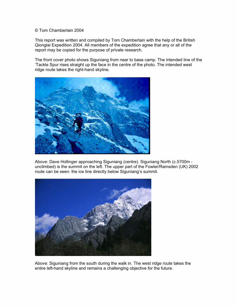
Above: Dave Hollinger approaching Siguniang (centre). Siguniang North (c.5700m - unclimbed) is the summit on the left. The upper part of the Fowler/Ramsden (UK) 2002 route can be seen: the ice line directly below Siguniang’s summit.
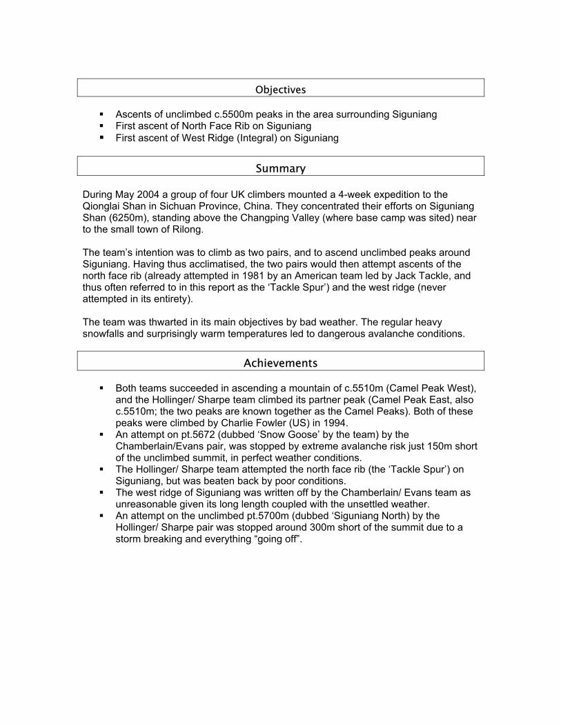
Above: Siguniang from the south during the walk in. The west ridge route takes the entire left-hand skyline and remains a challenging objective for the future.

Contents
Objectives ......................................................................................................................... 4 Summary ........................................................................................................................................ 4 Achievements ................................................................................................................................. 4 Contact Address .......................................................................................................................... 24 Map of area visited (by Tamotsu Nakamura)............................................................................. 5
Area background ............................................................................................................. 6 Expedition Members ..................................................................................................................... 7
Financial Summary ......................................................................................................... 9 Expenditure ..................................................................................................................... 9 Income............................................................................................................................. 9 Personal expenses ........................................................................................................... 9
Awards and support .................................................................................................................... 10 Sponsorship................................................................................................................... 10
Advice and information .............................................................................................................. 11 Permits and requirements.............................................................................................. 11 Baggage allowance ....................................................................................................... 11 Insurance ....................................................................................................................... 11 International travel ........................................................................................................ 11 Internal travel ................................................................................................................ 12 Hill Food ....................................................................................................................... 12 Fuel ............................................................................................................................... 13
Equipment report ........................................................................................................................ 14 Hardware....................................................................................................................... 14 Clothing......................................................................................................................... 14 Tents.............................................................................................................................. 14 Medical Kit ................................................................................................................... 14 Reading Material........................................................................................................... 14
Trip report ................................................................................................................................... 15 Part 1: ............................................................................................................................ 15 An account of the Hollinger/ Sharpe team’s activities, by Dave Hollinger.................. 15 Part 2: ............................................................................................................................ 17 An account of the Chamberlain/ Evans team’s activities, by Tom Chamberlain ......... 17 Postscriptum.................................................................................................................. 20
Weather Log ................................................................................................................................ 21 Potential........................................................................................................................................ 23 Acknowledgements ...................................................................................................................... 24
Objectives
Ascents of unclimbed c.5500m peaks in the area surrounding Siguniang First ascent of North Face Rib on Siguniang First ascent of West Ridge (Integral) on Siguniang
Summary During May 2004 a group of four UK climbers mounted a 4-week expedition to the Qionglai Shan in Sichuan Province, China. They concentrated their efforts on Siguniang Shan (6250m), standing above the Changping Valley (where base camp was sited) near to the small town of Rilong. The team’s intention was to climb as two pairs, and to ascend unclimbed peaks around Siguniang. Having thus acclimatised, the two pairs would then attempt ascents of the north face rib (already attempted in 1981 by an American team led by Jack Tackle, and thus often referred to in this report as the ‘Tackle Spur’) and the west ridge (never attempted in its entirety). The team was thwarted in its main objectives by bad weather. The regular heavy snowfalls and surprisingly warm temperatures led to dangerous avalanche conditions.
Achievements
Both teams succeeded in ascending a mountain of c.5510m (Camel Peak West), and the Hollinger/ Sharpe team climbed its partner peak (Camel Peak East, also c.5510m; the two peaks are known together as the Camel Peaks). Both of these peaks were climbed by Charlie Fowler (US) in 1994.
An attempt on pt.5672 (dubbed ‘Snow Goose’ by the team) by the Chamberlain/Evans pair, was stopped by extreme avalanche risk just 150m short of the unclimbed summit, in perfect weather conditions.
The Hollinger/ Sharpe team attempted the north face rib (the ‘Tackle Spur’) on Siguniang, but was beaten back by poor conditions.
The west ridge of Siguniang was written off by the Chamberlain/ Evans team as unreasonable given its long length coupled with the unsettled weather.
An attempt on the unclimbed pt.5700m (dubbed ‘Siguniang North) by the Hollinger/ Sharpe pair was stopped around 300m short of the summit due to a storm breaking and everything “going off”.

Map of area visited (by Tamotsu Nakamura)

The area visited is marked on the map as the Changping Valley (in the southern sector of the map). Base camp was situated at around 3700m directly below Siguniang, at the point on the marked path between Siguniang and Celestial Peak. We chose a spot about 200m away from the small wooden hut used by local Yak herders, and collectors of local fungi (‘Caterpillar-Fungus Men’). From there, we attempted the following peaks marked on the map: Siguniang (6250m), pt.5672m (dubbed ‘Snow Goose’), and probably pt.5700m (‘Siguniang North’). The Camel Peaks are in the positions occupied by pt.5202m and pt.5484m, although we reckoned their heights to be much more similar (c.5500m each). The rock peak that Dave Evans and Tom Chamberlain went up the valley to try but never managed to set foot on (dubbed ‘Paine Peak’) probably corresponds to pt.5422m (in the upper west side of the valley). Area background The area surrounding Siguniang has received relatively little attention from mountaineers. Although Siguniang has now had four ascents (Japanese in 1981 and 1990, Charlie Fowler (US) in 1991 and Mick Fowler/ Paul Ramsden (UK) in 2002), few of the peaks in the immediate vicinity have been climbed. Some of them are very impressive, their impact only suffering due to the close proximity of their awesome neighbour, Siguniang. Siguniang hit the headlines in the British climbing press when Mick Fowler and Paul Ramsden climbed a very demanding ice line on the N Face in April/ May 2002. They subsequently became the first all UK team to receive the prestigious international Piolet d’Or award for making the most outstanding alpine climb of 2002. In the 1980s, an American team climbed Celestial Peak, which stands directly opposite Siguniang across the Changping Valley and has an impressively sharp profile which viewed from down the valley, whilst appearing like a chisel from other perspectives. The other peaks that appear to have been climbed include at least one of the so-called Camel Peaks and the neighbouring pyramid peak. The peak north of Celestial Peak had also been climbed. Charlie Fowler had climbed the Camel Peaks (given as pt.5484 on Nakamura’s map – we measured both peaks at around 5510m) in 1994 and pt.5666 in 1997 The route that we were hoping to climb on the north rib of Siguniang had already been attempted by Jack Tackle and his team in 1981. This attempt had failed due to poor weather, a phenomenon experienced by most teams visiting the area. A British expedition which visited the area in October 2003 suffered such poor weather that it was unable to even set foot on the big walls it intended to climb in the area. Plenty of potential still exists in the Changping Valley, and there is almost limitless potential elsewhere in the range.

Expedition Members
Tom Chamberlain – Research Analyst Dave Evans – Mountain Instructor Dave Hollinger – Mountain Instructor Andy Sharpe – Doctor Cheng Zheng Ling (Lenny) – Interpreter, guide and cook Gao Wei – Assistant to Lenny
Our expedition had a mixture of different strengths… Dave H and Andy had been on Himalayan expeditions (including British Ama Dablam Expedition 2001 together) and Dave H had also visited the Karakoram twice (Latok 1999 and Spantik as a guide) and Nepal (Ama Dablam again, as a guide). Andy had been to Peru (Cayesh) and had just returned from a trip to Ruth Gorge in Alaska where he and Sam Chinnery had put up a new route on Mount Bradley (‘Snow Patrol’). Both Dave H and Andy have strong records on Scottish winter climbing and have both climbed some classic grande course routes in the Alps (including Dave’s ascent of the 1938 route on the Eiger in winter, and Andy’s ascents of routes such as ‘Beyond Good and Evil’ and the ‘Carrington-Rouse’ on the Aiguille des Pelerins). Dave E and Tom had been on fewer expeditions. Dave has extensive rock climbing experience from a variety of locations, including around Europe and in Utah. He has a very strong record on rock in the UK, with hard routes throughout the country and renowned levels of enthusiasm. He had also been to the Alps several times, climbing classics like the ‘Cassin route’ on Piz Badile, ‘Comici route’ on Cime Grande di Lavaredo, and the Taschorn-Dom traverse. Tom has been to Greenland (1999) climbing some difficult new routes, and had been twice to Mt Kenya. He has visited the Alps on many occasions, climbing big classic ridge traverses and easier north faces, as well as being an all-rounder on UK rock and Scottish winter climbing.
Top: Tom and Dave E; Bottom: Dave H and Andy

All members of the team were born between 1975 and 1977 and all are UK citizens. It should be noted that the expedition had a highly ‘devolved’ feel to it, with representatives of Scotland (Andy), Northern Ireland (Dave H), England (Tom) and… well, he’s called David Gareth Evans, lives in Llanberis and his forefathers were Welsh, but the gravel-gargling Kent accent spoils the effect. But for all intents and purposes, Wales had the dubious privilege of being represented by Dave E. Andy Sharpe, Dave Hollinger, Dave Evans, Tom
Chamberlain Cheng Zhenling (Lenny) Lenny was our saviour on this trip. He made organising the trip easy and stress-free, smoothed out every detail while we were in the country, delighted us with his company, jokes, stories and wealth of knowledge, fed us superb food at base camp, supplied us with tents and other equipment, showed us where to buy extra things like gas, and showed us around Chengdu on our return to the city. He even took us out to the Sichuan Opera. Lenny kept in regular email contact for the three months prior to the expedition. All details were made very clear, including a price which was agreed upon in a clear manner. On the trip, as well as speaking excellent English, Lenny spoke Khamba Tibetan with the locals. Lenny brought a helper who was also a welcome addition to the team: Gao Wei. Lenny provided us with two spacious sleeping tents. He provided his own sleeping tent and a large frame tent as a mess tent. He also provided folding chairs, a folding table, base camp stoves and all utensils, and generally equipped base camp entirely himself. We did not have to provide Lenny with anything in the way of equipment. Lenny’s food was ‘something else’. His cooking was generally Sichuan, and made with very fresh, wholesome ingredients (bought in Chengdu or at markets on the way to Rilong) under conditions of strict hygiene. He was very adaptable: he had provided an entirely vegetarian diet for the expedition before us, and when we visited a pizza place on our return to Chengdu… he insisted on seeing the kitchen and assessing whether he’d be able to make them at base camp on future trips!
Gao Wei and his cleaver Lenny
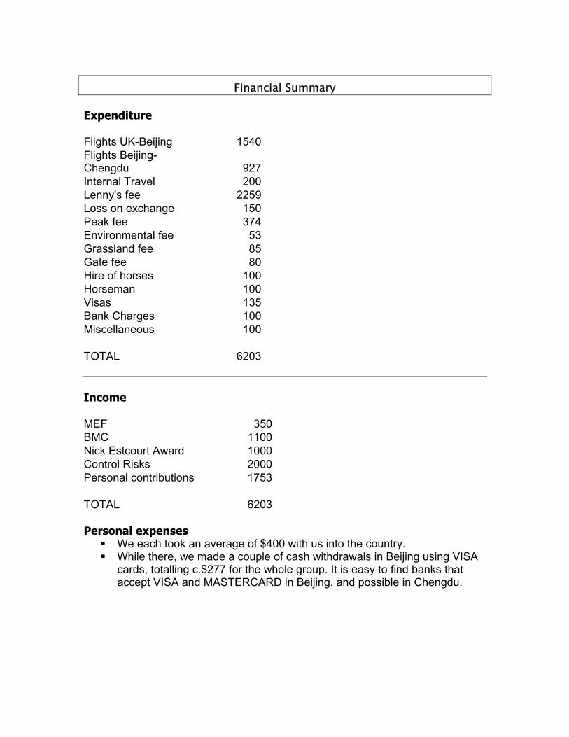
Financial Summary Expenditure Flights UK-Beijing 1540Flights Beijing-Chengdu 927Internal Travel 200Lenny's fee 2259Loss on exchange 150Peak fee 374Environmental fee 53Grassland fee 85Gate fee 80Hire of horses 100Horseman 100Visas 135Bank Charges 100Miscellaneous 100 TOTAL 6203 Income MEF 350BMC 1100Nick Estcourt Award 1000Control Risks 2000Personal contributions 1753 TOTAL 6203 Personal expenses We each took an average of $400 with us into the country. While there, we made a couple of cash withdrawals in Beijing using VISA
cards, totalling c.$277 for the whole group. It is easy to find banks that accept VISA and MASTERCARD in Beijing, and possible in Chengdu.

Awards and support1 The British Qionglai Expedition 2004 was lucky to win the support of British Mountaineering Council (BMC), the Mount Everest Foundation (MEF) and the prestigious Nick Estcourt Award. Details of how to apply to these organisations can be found on the BMC’s website at: http://www.thebmc.co.uk/world/exped/general_grants.htm Sponsorship Tom Chamberlain asked his employer, Control Risks Group, if they would provide support, and the company responded very generously, providing a sum of 2000. Control Risks Group is a leading, specialist, international business risk consultancy, which aims to enable its clients to take risks with greater certainty and precision and to solve problems that fall outside the scope of mainstream management resources. Control Risks offers a full range of value-added services to companies, governments and private clients world-wide, including:
political and security risk analysis confidential investigations pre-employment screening security consultancy crisis management and response information security and investigations
Tom Chamberlain is Research Analyst at the company, with expertise in analysing security risks and political instability in Western Europe. The expedition would like to thank Control Risks for their support. The expedition was also fortunate to receive support from Lyon Equipment, which awarded us a substantial allowance to spend on equipment, plus trade price deals on further equipments, under its Lyon Equipment Expedition Award scheme. Through Lyon, we were able to obtain equipment by Beal and Petzl Charlet. Rab provided us with trade price deals on its excellent clothing. We obtained Neutrino Endurance down jackets, Vapor-Rise tops and shell gear. Outdoor Designs (OD) provided us with trade price deals on excellent clothing, including their very warm gloves, and were kind enough to loan us a tent (the Summit Raider), which performed very well.
Our OD tent in typical conditions at 5000m 1 See also the title page for sponsors’ logos

Advice and information Permits and requirements Officially, you need a permit (known as a ‘letter of endorsement’) to climb mountains over 5000m in this area of China. Getting caught without one will potentially land you in trouble. You are also required to have a liaison officer. There are various ways of going about fulfilling these requirements. These include going through the authorities such as the Sichuan Mountaineering Association (SMA). We chose to go through Lenny because he is an accredited SMA liaison officer and came with high recommendations. He sorted everything out, buying a permit for us at the price of around $700 (374 pounds). His services were provided in conjunction with those of interpreter, cook and general fixer. Being a national park, you have to pay to enter the park (‘gate fee’ in the financial summary) and pay per night spent camping in Siguniang national park (‘grassland fee’ in the financial summary). There is also a fee levied called an environmental fee. This seems questionable, but the park does have litter pickers to remove waste from the area with varying efficiency. Baggage allowance We initially considered freighting some equipment, because we had heard nightmare stories about expeditions with far more baggage than the allowance being charged extortionate amounts on their way internally through China and on their departure. The Chinese baggage handlers, we were assured, would follow the rules to the letter and charge us excess. In the end, however, we decided that a) we would not have much more than 20kg hold luggage and 10kg cabin luggage each and b) we were prepared to chance it. In the end, our average hold luggage weight was 24kg for each of the four duffel bags, and our average cabin luggage was a rucksack weighing 12kg. None of us were charged any excess baggage, and we had no problems whatsoever. It should be noted that we travelled fairly light, and did not have to carry much in the way of base camp tent, stoves etc. because Lenny supplied everything from within the country. The other thing that should be noted is that we booked our internal flights (Beijing-Chengdu return) as 3 Economy tickets and one 1st Class ticket (which has a 40kg hold allowance, upping the overall expedition allowance). This almost certainly ironed out all problems on the Air China internal flights. Insurance We all insured ourselves through the BMC, which provided the best package for our needs. Insurance is not included in the financial summary as we all bought full year cover due to the fact that we are all undertaking several trips this year. International travel I booked flights with KLM Royal Dutch Airlines through the Opodo website in January 2004, departing from London Heathrow and arriving at Beijing Capital. These flights were refundable and changeable, although a service charge would have been required for either process.
Internal travel I booked internal flights (Beijing Capital to Chengdu) through Air China’s London office in February 2004. On arrival in Chengdu, we had a mix-up (through our own fault) and did not meet with Lenny. Instead, we offered a mini-combi taxi driver 100 RMB ($12) to take us, and all our kit to the Traffic Hotel. Once at the Traffic Hotel, we made contact with Lenny and met up later that evening. From then on, Lenny was in charge of all internal travel. He organised a driver and a minibus to take us to Rilong, plus another van to carry all our luggage. He then organised horses to get us to base camp from there. On returning to Rilong at the end of the trip, we all travelled back to Chengdu in a public bus. Lenny reserved two extra seats for our extra bags. Once back in Chengdu, we felt “hardened up” to the country and cast ourselves adrift around Chengdu, Leshan and Beijing in a mixture of taxis, rickshaws and buses, without Lenny’s guidance. Having a book or card with your destination written in Mandarin is essential unless you get good at pronouncing the words! It is especially hard to get home late at night without such visual aids! Beware of rip-off merchants around Tiananmen Square in Beijing – the rickshaw drivers are keen to take you for a ride in more ways than one. Hill Food The only food which we brought from the UK was:
A few soups A few couscous meals A large number of ‘GO’ energy gel bars (made by Science in Sport, Blackburn) A few powdered drinks
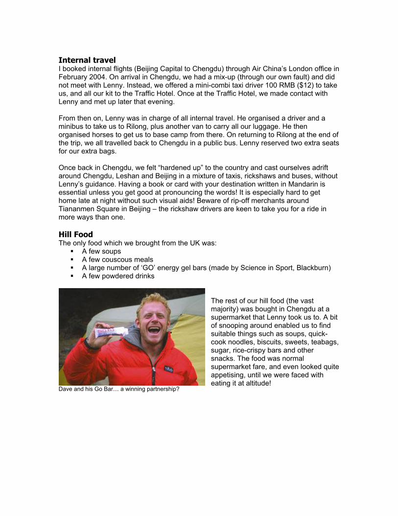
Dave and his Go Bar… a winning partnership?
The rest of our hill food (the vast majority) was bought in Chengdu at a supermarket that Lenny took us to. A bit of snooping around enabled us to find suitable things such as soups, quick-cook noodles, biscuits, sweets, teabags, sugar, rice-crispy bars and other snacks. The food was normal supermarket fare, and even looked quite appetising, until we were faced with eating it at altitude!

Dave enjoying another noodle-flavoured brew in the tent Fuel We relied on Lenny for base camp fuel (he arranged for two 20kg butane cylinders which lasted us all trip). For mountain fuel (to attach to our MSR Superfly stoves) we bought screw-on canisters in Chengdu under Lenny’s guidance at a mountain shop just down the road from Lenny’s office. The shop next to the Traffic Hotel normally has these canisters, but had run out. We were able to buy high quality MSR canisters, although these were in high demand and we had to supplement our supply with a few slightly inferior Korean canisters (which we never had to use). We bought about 25 canisters (about $1 per canister), but had several left at the end. Right: Andy climbing out leftwards on the lower part of the Tackle Spur

Equipment report Hardware Ropes: 2 x 60m Beal icelines, 2 x 60m Beal Cobra II Axes: 2 x DMM Fly, 2 x PetzlCharlet Aztar, 2 x PetzlCharlet Quark, 2 x Grivel Rambo Crampons: An assortment of Grivel, DMM and a pair of very lightweight and effective PetzlCharlet Sarken crampons, which use a sidelocking arrangement that works promisingly. Racks: per pair, we took the following from the UK 9 cams, 2 sets of nuts, c.8 pitons, 12 extenders, several slings, 6 ice screws, bulldog, warthog, abalakov threader, miscellaneous bits and pieces. Needless to say, we didn’t take this lot on every route! Clothing A wide assortment of clothing was used. We all seemed to wear power stretch tights, Rab Vapor rise tops and Rab Neutrino Endurance down jackets. Other Rab gear was also used and rated highly (see above in the Sponsorship section). Dave Hollinger had a pair of the high-spec Scarpa 8000 boots (partly as a ploy to assure the safety of his previously frostbitten feet) and rated them highly. By contrast, Tom Chamberlain’s Asolo 101s have been in action since 1996, but have probably climbed their last peak. Tents Chamberlain and Evans were loaned a Summit Raider single skin goretex tent by Outdoor Designs. Hollinger and Sharpe borrowed a homemade pertex tent from Rich Cross. Medical Kit Analgesia Paracetamol, Ibuprofen, Dihydrocodeine, Oramorph & Narcan - reverses
Morphine in case of OD Antibiotics Augmentin, Amoxycillin, Tinidazole, Clarithromycin Altitude sickness
Dexamethasone, Nifedipine
Other Steroid cream, Canestan, Mebendazole, Loperamide Reading Material We had a wide-ranging library, which was digested in its entirety by most members of the expedition, leading to the mess tent becoming a literary forum on several occasions. The library included both high-brow and ‘highly absorbent’ material: The Lonely Planet guide to South-West China Everything is Illuminated – Jonathan Safran Foer The Invisible Man – Ralph Ellison Be my Enemy – Christopher Brookmyre Strip Jack – Ian Rankin The Soddit – A.R.R.R.Roberts
Mort – Terry Pratchett The Curious Incident of the Dog in the Night time – Mark Haddon The Bonesetter’s Daughter – Amy Tan The Oxford Handbook of Accident and Emergency Medicine On the Edge – April issue FHM – Abi Titmus issue

Trip report Part 1: An account of the Hollinger/ Sharpe team’s activities, by Dave Hollinger 4th-6th May This was our first acclimatisation trip and the plan was to recce the intended route on the Tackle Spur and spend a couple of nights out at, or above, 5000m. On the 4th we left base camp and climbed towards Siguniang, bivying just beneath the moraine slopes at about 4400m. The next day we climbed to around 5000m and camped on snowy moraine underneath the North Peak of Siguniang. On 6th we walked up to the col between the North and Far North Peaks (c. 5300m), descended to the moraine spur separating these peaks from the main Siguniang peak. Unfortunately the cloud made it difficult to see much above the first 300m or so of the Tackle Spur. We returned to base camp that evening. 8th-11th May This was to be our final acclimatisation trip before getting on our main objective. We hoped to climb three peaks further up the eastern side of the valley. Tom and Dave had already climbed the western Camel Peak and we hoped to traverse the two humps as well as climb the obvious pyramid peak (pt.5666m on Nakamura’s map) a little to the east. On the 8th, we walked up to the base of the moraine at c.4700m. We enjoyed our first clear night but by morning it was cloudy again. Next morning we walked up to the col separating the eastern camel peak with the pyramid peak pt.5666 and camped at about 5200m.
Dave Hollinger walking up towards the col on 9th May. Siguniang on the right.

The 10th was again cloudy with light snow showers and we witnessed a localised slab avalanche on a steep north-easterly slope. We chose the most straightforward looking line up the east face of Camel Peak East. This was easy (Scottish grade1) snow slopes and a short snow crest to the summit (5510m). Descend was by the south-west couloir (4 x 60m rope lengths downclimbing, Scottish grade 1) to arrive beneath the col separating the camel peaks. From there we followed the same line as Tom and Dave and arrived at the west summit (5510m). To return to the tent, we descended off the south face and reclimbed deep snow (crud!) to the starting col. During the night it snowed heavily. We woke up to about 12 inches of fresh snow and pea-soup conditions. We decided to descend to base camp – an not uneventful affair with spontaneous avalanche conditions. Fortunately(!) Dave triggered most of the most dangerous slopes from the top of the glacier, but what should have been a simple descent turned into a 4/5 hour wade through deep and in places unstable snow. 15th-16th May After 4 days of continual rain and snow at base camp, we decided to go for it on the route. The weather, though hardly brilliant was at least dry. We climbed to the top of the moraine spur at 4700m, not the base of the route as intended due to Andy feeling a bit ill. Although the night started clear it was snowing (surprise, surprise!) by 1am. We got up at 3am and by 5am were postholing our way through deep snow to the base of the route (1 ½ hours). Getting onto the ridge proved very difficult due to steep unconsolidated snow sitting on steep granite slabs. Once on the crest of the ridge at about 5000m, three loose mixed pitches (Scottish 3 or 4) led to a pitch of easier ridge. Above lay much better looking rock and the next 100m or so would, given dry rock, be pleasant slabby Severe type rock climbing. Similarly, with good neve, it would have involved 50-60 degree snow/ice runnels. Covered in wet snow it was time consuming grovelling. It was clear that we were not going to make sufficiently fast progress to complete the spur itself and another deterioration in the weather prompted us to retreat from our high point of c.5200m. 7 abseils got us back to the glacier and we were back in base camp just after nightfall.
Andy climbing on the Siguniang North, 20th May 2004
19th-20th May This was to be the final foray from base camp and decided to attempt a traverse of the north peak of Siguniang. If all went well on the first day we had enough food to make an attempt on the north ridge of Siguniang itself, from a high col separating the two. We climbed to the same spot as on our earlier recce at 5000m and enjoyed only our second clear night of the trip, although it was not very cold. Next morning we climbed almost to the col before breaking out right onto the north flank of the north peak. Although not steep, the rock on this part of the mountain was very shattered and quite loose in places. Again wet snow plastered most of the face and made the climbing quite time consuming. Good névé would have improved conditions considerably and rendered the face more stable. After three pitches of poor quality climbing we decided to sack it off and retreat. As if on cue, there then followed a sustained period of snowfall and blizzard conditions which accompanied us on our descent. Our penultimate abseil took us to easier snow slopes but with regular snow sloughs coming down the face and windslab building we decided to continue abseiling from a snow bollard. Throwing the ropes onto the slopes below caused them to avalanche!! We were also caught in one or two larger sloughs which, had we not still been attached to the ropes would have swept us away. Needless to say we scarpered as quickly as possible and returned to base camp happy to ‘down tools’ but inspired by the objectives the area had to offer – given the correct conditions. Part 2: An account of the Chamberlain/ Evans team’s activities, by Tom Chamberlain 5th-7th May On 5th May we set off from base camp at around 11:30am with heavy sacks. Walked up the valley, up the moraine below the Camel Peaks, across the hillside rightwards (faint paths) and across a steep stream. Pitched camp at around 4500m. On 6th we climbed for a short time to around 4900m in a bowl below the snout of the glacier coming down from the col between the Camel Peaks. We had a bad night with wind and snow. On 7th we woke up late, but managed to rouse ourselves when the weather looked like it was improving around 07:30. Carrying light sacks and a rope, we plodded up the spur leading towards the East Camel Peak, before crossing to the col between them. Then we went round the foot of the ridge coming down from Camel West, up the snow slope beyond, and back onto the ridge, over a fore-summit and to the top (c.5510m).This had been climbed before by Charlie Fowler, but we were probably the second team on the summit. We then descended, picked up our bivvy on the way, and went all the way to base camp.

This is the view from Camel Peak West . The foresummit and Camel Peak East are in line with one another. The big peak on the left is pt.5666 (already ascended previously) 9th-11th May On 9th we set off under overcast skies, but very still air, up the streambed towards the north face of Siguniang. We reached a point on the moraine that was flattish at around 4500m, below the very large rock buttress leading up towards Siguniang North (pt.5700). On 10th we climbed up leftwards underneath the buttress of Siguniang North and placed a camp on a level area to the left at around 5000m, below the point where the glacier steepens. After placing the camp, we climbed up the steepening into the upper cwm between Siguniang North and Snow Goose (pt. 5672 on Nakamura’s map). We went to the col, and returned to camp, excited about possibly climbing Snow Goose the next morning. On 11th, after a dispiriting night being squashed under lots and lots of freshly falling snow, we evacuated and managed to avoid major avalanche risks through careful route choice, arriving back in base camp in late morning. Incidentally that evening was spent in the company of local men in the wood shack near to base camp, drinking strange brews and drying out our things.

The upper glacial cwm, looking up towards Snow Goose. Our eventual attempt route would take the triangular snow field above and left of the figure. We turned back from the top of the snowfield in dangerous avalanche conditions on 19th May. 15th-16th May On 15th, after sitting around in pouring rain and snow at BC, we walked up the main valley and round the bend, amidst clearing skies and raising hopes, planning to attempt the steep rock peak on the left (true right) side of the upper valley. The south pillar of pt. 5465 (which we had dubbed ‘Paine Peak’ – possibly an exaggeration of how spectacular it is!) looked particularly fine, and we had spied a possible way up it from the Camel Peaks. We had lots of rock gear, and were “well psyched”. We walked past a horrendous rubbish dump, presumably left by trekking groups crossing the col into the valley that leads down to Li Xian. We found a huge boulder that resembled the Bowderstone in Borrowdale, and camped under it. We awoke on 16th reflecting that it was a good job we had camped under the boulder, as about 5 inches of snow had fallen in the night. Aware of possible avalanche risk, and very unwilling to trog all the way up to the pillar to find it almost certainly covered in snow and running with water, we walked down to BC, and to add insult to injury Tom was chased by a very unhappy, large, demented yak! 17th-19th May On 17th we set off rather too late, after succumbing to the temptation of a Lenny lunch. We had intended to camp at 5000m, but got caught out by bad weather at 4700m. It continued to be bad all night and into 18th, only clearing in the early afternoon, so we sat it out at 4700m watching the view come and go. On 18th we made an alpine start, climbed up past our 5000m campsite of 10th May, up the left side of the steepening in the glacier, into the upper cwm, and onto the col at the

head of the glacier between Siguniang North and Snow Goose which we had visited on 10th May, at c.5200m. On the way up to this col there was a short steep gully of Scottish II. We set off up towards Snow Goose, on the triangular snowfield. Shortly before Tom reached the top of the snowfield, only 150m short of the unclimbed summit, the situation became unbearable. The snow was extremely unstable: windslab over air-filled pockets and ice. The prospect of climbing down it immediately was bad enough, let alone in a couple of hours after visiting the summit. We actually unroped and climbed down to the col one at a time. We then went all the way back to BC, ready to call it a day and hoping to come back at a time of year when the weather is better – if that exists!
This is the view from the c.5200m col between Snow Goose and Siguniang North, looking at Siguniang North. The Ice Line on Siguniang North is just visible on the right side of the face. The snowy eastern flank of Siguniang is visible on the left, round the ridge of Siguniang N, which was attempted by the Hollinger Sharpe team on 20th May. Postscriptum We decided to leave base camp two days early, as the weather was so continually bad. In a fitting end to proceedings, we awoke on the morning of our departure to find that so much snow had fallen that all the tents bar one at BC had been buckled, poles snapped and fabric torn! We walked to Rilong under the dripping trees, and tucked into a well-earned drink at the ‘Iced Rock’ café, joking that it was the only iced rock we’d seen during the expedition. We hope to return, however, as the area is fantastic. The weather is rumoured to be more settled in January-March, which may also provide more ice.

Topo diagram of Siguniang and neighbouring peaks Diagram looking east from imaginary viewpoint near top of Celestial Peak

Weather Log Date Weather Chamberlain/ Evans Hollinger/ Sharpe 1 May Overcast/ rainy Driving Chengdu-Rilong 2 Clear and sunny Walking Rilong-Base Camp 3 Sunny/ Föhn effect on
summits Walking up to 4100m and back to BC
4 Snow in night, then overcast
At BC Up to camp at 4500m below Siguniang
5 Overcast, some snowfall Up to camp at 4500m below Camel Peaks
To 5000m below col between Siguniang N and Snow Goose
6 Overcast Up to c.4900m below Camel Peaks
Up to col (c.5200m) and down to BC
7 Clear, becoming murky Climbed Camel W (c.5510m) and down to BC
Rest day in BC
8 Clear night, sunny day Rest day in BC Up to camp at 4500m below Camel Peaks
9 Clouding over, light rain Up to camp at 4500m below Siguniang
Up to col (c.5200m) between Camel E and pt.5666
10 Fine, then overcast, snow
Up to col (c.5200m) between Siguniang N and Snow Goose. Camp at 5000m
Ascents of two Camel Peaks (both c.5510m)
11 Heavy snow and rain Down to BC Down to BC 12 Heavy snow and rain In BC 13 Heavy snow and rain In BC 14 Sunny spells then rain In BC 15 Rain, then improvement Walked up to tributary
valley below ‘Paine Peak’ (pt. 5465)
Up to 4600m camp below Tackle Spur
16 Snowed heavily at night, overcast
Snowed out, back to BC Attempt on Tackle Spur, down
17 Sunny spells Up to camp at 4700m below Snow Goose
18 Snow til Midday, improving
Sitting at 4700m in mixed weather
19 Clear and sunny Attempt on Snow Goose (c.5672m). Retreat from above 5500m to BC
Up to 5000m camp near col below Siguniang N (visited earlier)
20 Snow and rain In BC Attempt on Siguniang N, stormed off to BC
21 Overcast, then snow In BC 22 Heavy snow in night,
then improving Walked out to Rilong
23 Sunny spells Bus from Rilong to Chengdu

Potential An attractive mountain at the head of the Changping Valley, as well as the rocky peaks along the valley wall from Celestial Peak all look highly inviting. Two peaks look particularly fine when viewed from the Camel Peaks across the valley. Evans and Chamberlain attempted to reach these peaks to make an attempt, but were thwarted even before leaving the valley, when it snowed very heavily at their advance camp at the foot of the tributary valley.
Above: Two peaks (pt.5422 and pt.5465 on Nakamura’s map) viewed from the Camel Peaks. Tom and Dave Evans especially liked the look of the left-hand skyline of the right-hand peak (pt.5465) and went up to attempt it, but after a night of heavy snow at the entrance to the tributary valley they were not prepared to run the risk of avalanches to try and climb the heavily snowed-over rock. The other lines that looked interesting included potential new routes on Celestial Peak, and the Ice Line on Siguniang North (which Dave Evans and Tom got to the foot of but never had the conditions for an attempt). In the photo to the right, Dave stands by our tent in the glacial cwm below the north face of Siguniang North, with the Ice Line rising up the right-hand side of the face. It looked to be Scottish IV-VI other than a very steep, loose exit, which looked quite hard.
Contact Addresses Tom Chamberlain (expedition leader) 87 Redway Drive, Twickenham Middlesex TW2 7NN Tel. 0797 690 6569 (mobile) 0208 893 3031 (home) [email protected]
Chinese Mountaineering Association 9 Tiyuguan Road, Beijing 100763, China Tel: +86 10 6714 3177 Fax: +86 10 6714 4859 [email protected] www.cma.com.cn
Siguniang Mountain National Park (Chengdu) 19F Honga Mansions, 2# Jinli East Road, Chengdu, Sichuan 610041, China www.eastalps.com
Siguniang Mountain National Park (Aba) Rilong Town, Xiaojin County, Aba Autonomous Prefecture, China www.eastalps.com
Cheng Zheng Ling (Lenny) #17,Entrance 5,Building 5 #15,Qing Xi Nan Jie, Fu Nan Xin Qu Western Section 2, Ring Road 2 Chengdu, Sichuan, China Tel: +86 (28) 8733 0041 [email protected]
Sichuan Mountaineering Association No 2, Section 3, South Yihuan Road Chengdu, Sichuan 610041, China Tel: +86 (28) 8558 8047 Fax: +86 (28) 8558 8042
Acknowledgements The British Qionglai Expedition would sincerely like to thank the following people and organisations for making this trip possible: Control Risks Group MEF BMC Nick Estcourt Award Alpine Club Library Mick Fowler Martin Doyle Twid Turner Louise Thomas Roger Payne Jack Tackle Tamotsu Nakamura Lenny The expedition would also like to thank Tom’s employers at Control Risks and Dave E and Dave H’s employers at Plas y Brenin for granting them leave for the course of the trip.