silkin way - cycling and walking route
TRANSCRIPT
If you would like free help to understand thisdocument in your own language, please phone
us on 01952 382121.
You can also get this informationin large print, in Braille or on
audio tape.
For other maps and transport information phone01952 200005 or visit www.telford.gov.uk
Route Description
n Commence the walk at The Gate Inn andthe Silkin Way wheel (1)
n Proceed in a southerly direction under abridge and at the fork in the road keep tothe left following the path round to the leftand past Tee Lake on your right (2)
n Pass Dothill Park to the main road, turn rightup to the crossroads and turn left in toSevern Drive. Follow the path around thehousing estate and, keeping to the left fork,cross the bridge
n Cross Apley Castle road and continuearound Apley Castle Park (3)
n Follow the path round to the right and down toLeegomery Community Centre. Keeping tothe left fork cross Leegate Avenue and followthe path through the housing estate. Followthe path to the left past the old Leegomery Milland over Hurley Brook. Continue to HadleyPark Road, turn left and follow the road
n At the end of the road cross over and followthe path through the park. Turn left to crossOakhampton Road
n Proceed past Hadley Park Lock (4) toHadley Park House Hotel (5) and HadleyPark Mill (6)
n From Hadley Park roundabout keep to theright side of the road and continue to TrenchLock Interchange, being careful crossing thebusy roads, cross the traffic lights andfollow the path crossing the next three setsof traffic lights, follow the path to the rightand under the bridge
n Cross Trench Road and follow the path tothe right and past Trench Pool (7)
n Turn right over a foot bridge to Middle Pool(8). Follow the path around the pool to theleft, through the subway and round to theright. Continue past St Mary & St Leonard'schurch cemetery on your right
n Follow the path through the subway, turn rightand continue to Stafford Road. Cross theroad and follow the path to the right. At thefork keep to the left and at the top of the hillturn right following the path to Willows Road.
n Turn right and continue to the cross roads atStation Hill. Cross the road and follow thepath to Canongate. Cross the road andcontinue along past Snedshill Trading Estate.
n At Holyhead Road, cross the road and turnright. Turn left into Hollinswood Road andcontinue through Central Park.
n At St James House follow the path round tothe right and at the fork, after the footbridge, keep to the left. !! At the foot bridgeclimb the steps and turn right
n At Ironmasters Way cross the road, turn leftto Addenbrooke House and follow the signsfor the Shopping Centre
!! Cyclists - Stay on the path and crossRampart Way at the designated place andturn left. Follow the path round to the rightand turn right on to Ironmasters Wayfollowing the path to the junction. CrossForge Gate and follow the path to the left.Follow the route alongside WoodhouseCentral, keeping the car parks to your right.
Cross the road, following the path betweenCivic Offices and the Job Centre and turn leftonto Southwater Way. Follow the path and atthe fork, before the barrier, keep to the right.Follow the path past Maxell and ChelseaGardens (9) on your left. Continue on thispath around the Town Park and at the fork inthe road keep to the right with Withy Pool onyour left. Turning right at the junction to joinDark Lane and follow route as described ##
n Cross the foot bridge following the patharound the car parks to the foot bridge atBrodie House. Cross the bridge and followthe path around the multi storey car park tothe traffic lights. Cross the lights andcontinue past the car park and through thegate in to the Town Park (10)
n Staying on this path you can access theAmphitheatre (11) and Wonderland (12)continuing past Withy Pool (13) on yourright. ## Turn left down a small hill and atthe fork in the road continue to see StirchleyChimney and Furnace (14) or turn right tocontinue along the Silkin Way. At the nextfork in the road keep to the right and at thebottom of the hill turn right and continuepast Stirchley Pools (15) and Dawley &Stirchley Railway Station (16) on your right
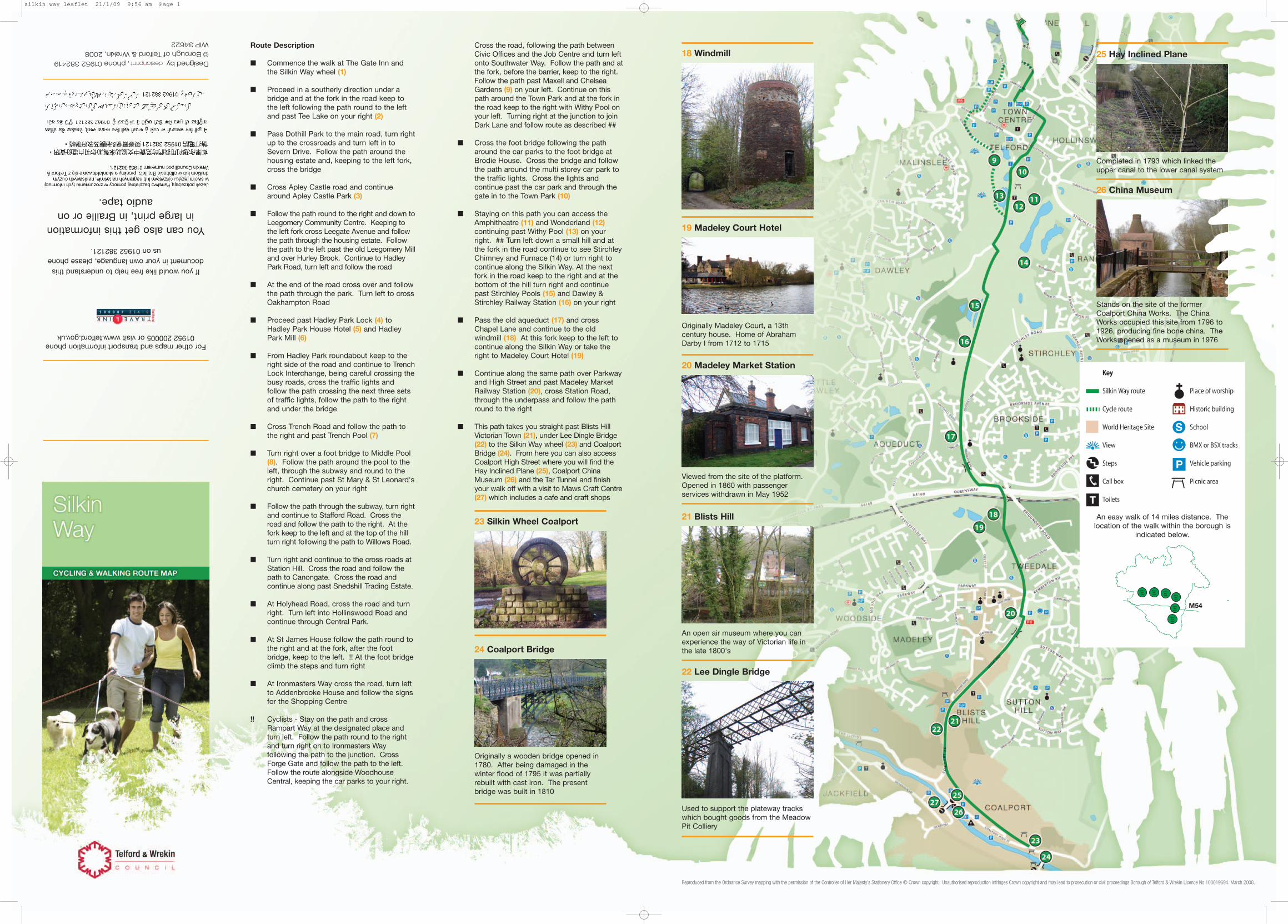
n Pass the old aqueduct (17) and crossChapel Lane and continue to the oldwindmill (18) At this fork keep to the left tocontinue along the Silkin Way or take theright to Madeley Court Hotel (19)
n Continue along the same path over Parkwayand High Street and past Madeley MarketRailway Station (20), cross Station Road,through the underpass and follow the pathround to the right
n This path takes you straight past Blists HillVictorian Town (21), under Lee Dingle Bridge(22) to the Silkin Way wheel (23) and CoalportBridge (24). From here you can also accessCoalport High Street where you will find theHay Inclined Plane (25), Coalport ChinaMuseum (26) and the Tar Tunnel and finishyour walk off with a visit to Maws Craft Centre(27) which includes a cafe and craft shops
19 Madeley Court Hotel
18 Windmill
20 Madeley Market Station
21 Blists Hill23 Silkin Wheel Coalport
24 Coalport Bridge
25 Hay Inclined Plane
26 China Museum
An easy walk of 14 miles distance. Thelocation of the walk within the borough is
indicated below.
SikkinWayWalk
SikkinWayWalk
SikkinWayWalk
SikkinWayWalk
SikkinWayWalk
SikkinWayWalk
M54
Originally Madeley Court, a 13thcentury house. Home of AbrahamDarby I from 1712 to 1715
Viewed from the site of the platform.Opened in 1860 with passengerservices withdrawn in May 1952
An open air museum where you canexperience the way of Victorian life inthe late 1800's
Used to support the plateway trackswhich bought goods from the MeadowPit Colliery
Originally a wooden bridge opened in1780. After being damaged in thewinter flood of 1795 it was partiallyrebuilt with cast iron. The presentbridge was built in 1810
Completed in 1793 which linked theupper canal to the lower canal system
Stands on the site of the formerCoalport China Works. The ChinaWorks occupied this site from 1796 to1926, producing fine bone china. TheWorks opened as a museum in 1976
22 Lee Dingle Bridge
Reproduced from the Ordnance Survey mapping with the permission of the Controller of Her Majesty's Stationery Office © Crown copyright. Unauthorised reproduction infringes Crown copyright and may lead to prosecution or civil proceedings Borough of Telford & Wrekin Licence No 100019694. March 2008.
Designed by, phone 01952 382419© Borough of Telford & Wrekin, 2008WIP 34622
silkin way leaflet 21/1/09 9:56 am Page 1

Silkin Way
A green corridor route through Telford fromBratton in the north-west corner via the TownCentre to the spectacular Ironbridge Gorge WorldHeritage Site. The route boasts great contrastswith futuristic new developments, pockets ofwoodland and meadow and mature parkland. Foralmost its entire length the route follows dry canalbeds and disused railway lines. The Silkin Waywas opened in 1977, by Prime Minister JamesCallaghan, in the presence of the Silkin family.
Lewis Silkin - making the countryside moreaccessible to everyone
A one time Member of Parliament for Peckhamand Deputy Leader of the House of Lords, LewisSilkin was instrumental in the LabourGovernment's rebuilding policy after World War II.This included the 1949 Access to theCountryside Act and New Towns Act of 1963. Asa New Town, Telford has honoured Lord Silkin bynaming this long distance path after him.
Cycling the Silkin Way
The Silkin Way is an excellent cycle route due tothe use of canal beds and extinct railway linesand for the most part the way is well surfaced.There are a few sets of steps but they are broad,shallow and easily negotiated. Please watch forwalkers and use the recommended cycle routearound Telford Town Centre as this can be a verybusy section.
Walking or cycling
At a reasonable walking pace, with a few stopsyou can do the Silkin Way in less than a day. Forboth walkers and cyclists there are numerousplaces to stop for refreshments along the way.There are so many places of interest that it isrecommended that you stop off to enjoy themrather than rushing to finish quickly. The SilkinWay is like a book - you can read it all at once orjust dip into it from time to time, digesting at yourleisure.
1 Silkin Way Wheel
2 Tee Lake
3 Apley Castle Park
4 Hadley Park Lock
5 Hadley Park House
6 Hadley Park Mill
7 Trench Pool
8 Middle Pool
9 Maxell Gardens
10 Town Park Arena
11 Town Park Amphitheatre
12 Wonderland
13 Withy Pool
14 Stirchley Chimney & Furnace
15 Stirchley Pool
16 Dawley & StirchleyRailway Station
The word Apley is Anglo-Saxon for aclearing in a forest where the applesgrow - or in other words an orchard. Inthe park you will find two small pools
Originally used as part of theShrewsbury Canal. The canal was builtfor the use of tub-boats about 20 feetlong and 6 feet wide, which werepulled along in trains. The lock was 81feet long and 6 feet 7 inches wide,which meant that it would hold fourtub-boats
A traditional manor house which datesback to the 18th century
Was powered by wind and water
Originally used as a reservoir for theShrewsbury Canal
Originally a balancing pool for theShrewsbury canal
An ornamental Flowering Cheerycollection donated by Maxell Europe inthe early 1980's
170 hectares of open space with avariety of areas to explore from playareas to landscaped gardens andgrassy banks to pools and woodlands.The park is so valuable for wildlife thatmuch of it has been designated aLocal Nature Reserve
The BIG park for the little people
Chimney and Furnace - Built in 1873by Wellington Iron and Coal Company.Due to bankruptcy in 1877 the furnacewas never fired
Connected by a stream to RandlayPool. It is the oldest pool in the TownPark and used for a feeder reservoir forthe Shropshire Canal
Originally Stirchley Station, renamedDawley & Stirchley from 9th July 1923.Passenger services withdrawn in May1952
17 Aqueduct
Built in 1792. Photo courtesy ofBritannia Historical Society
Reproduced from the Ordnance Survey mapping with the permission of the Controller of Her Majesty's Stationery Office © Crown copyright. Unauthorised reproduction infringes Crown copyright and may lead to prosecution or civil proceedings Borough of Telford & Wrekin Licence No 100019694. March 2008.
silkin way leaflet 21/1/09 9:56 am Page 2