simulation of atmospheric conditions and trajectories for ... 4/simulation... · simulation of...
TRANSCRIPT
Journal of Environmental Treatment Techniques 2014, Volume 2, Issue 4, Pages: 150-154
150
Simulation of Atmospheric Conditions and Trajectories for Dust
Storms in the Middle East
Alireza Aslemand, Ahmad Anvari*, Behrooz Yarizadeh
Graduate Faculty of Environment, University of Tehran, Tehran, Iran.
Received: 06/08/2014 Accepted: 29/08/2014 Published: 30/10/2014
Abstract Dust storms which disperse a high amount of fine particulate matters have increased exponentially in west of Iran. These fine
particulate matters cause a lot of problems on such as adverse effect on human health as well as environment. The main aim of this study is investigating the critical dust atmospheric conditions at a dust storm which was occurred in July 2009 in Mesopotamia region. Furthermore, in order to control the dust storms, hotspots were estimated by using Weather Research and Forecasting. In addition, dust storm trajectories were studied by Hybrid Single Particle Lagrangian Integrated Trajectory Model. It was found that the critical condition occurred when the critical frictional wind speed varied from 0.7 – 0.8 m/s. Besides, the origins of the Middle Eastern dust storms which frequently impact the residents of this arid region were studied. The source region limited to 33°N to 36°N and 44°E to 47°E coordinates. At six different altitudes the trajectories were studied, which had two main motion patterns. Key words: Dust storm, HYSPLIT, Iran, Mesopotamia, Trajectory, WRF. Abbreviations NCEP FNL National Center for Environmental Prediction Final Analyzes GFS Global Forecast System WPS WRF Preprocessing System ARW Advanced Research WRF HYSPLIT Hybrid Single Particle Lagrangian Integrated Trajectory Model WRF Weather Research and Forecasting NCAR National Center for Atmospheric Research NOAA National Oceanic and Atmospheric Administration GDAS Global Data Assimilation System
1 Introduction1 Fu et al. [1] showed that dust storms occur in arid and semi-arid regions of northwest china which could disperse a high volume of fine particulate matters into the atmosphere. These particles could be transported even to some hundreds of kilometers away from its source. Perez et al. [2] Tegen and Fung [3] declared that not only do dust storms cause health problems but also it would affect environmental conditions. The Middle East region has been described as a major dust source in several previous studies. Ginoux et al. [4] was conducted to find dust sources in the Middle Eastern region. Around 20% of all dust in the world is located at Middle East; therefore, studying and forecasting the dispersion of dust in this area are substantial. Tanaka and Chiba [5] said Middle East, which consists mainly of plateaus Tigris and Euphrates Basin, is one of the most
Corresponding author: Ahmad Anvari, Graduate Faculty of Environment, University of Tehran, Tehran, Iran. Email: Email: [email protected]
important areas of wind erosion and dust generation in the world. Arabian Plateau consists of the south western highlands (1,500 to 3,000 m), which is adjacent to the Red Sea with a smooth slope towards the flat lands of the north-east (with an altitude of 50 to 200 m) has been extended in the vicinity of the Persian Gulf. Shao [6] conducted one of the largest sand deserts in the world is Rub al Khali; includes of most of the southern part of the Arabic plateau. Zoljoodi et al. [7] did a research on dust events in western Iran, through this study they specified the dust source regions over Iraq and Syria and concluded that it has a significant influence on increasing the dust events in the west of Iran. According to the studies, it has been shown that major dust particles from the Western borders of the Iran are from of the Tigris and Euphrates alluvial areas [6]. This zone consists of alluvial plain of the Tigris and Euphrates in Iraq and Kuwait, which is a low flat land on the East Plateau and along the Persian Gulf and includes Arabian deserts and Rub al Khali. These alluvial plains which have the highest frequency of dust storms are located in the Middle East [6]. A dust storm occurs when wind speed is exceeded the threshold friction velocity. Stout [8]; Harris and Davidson. [9] showed that several parameters influence on threshold velocity such as the soil texture, humidity, vegetation, topography, and particle diameter. Dust storms travel by various processes including advection, diffusion, turbulence, settlement, and even chemical reactions. Givehchi et al. [10]; Tsai et al. [11] declared that dispersing of dust particles is closely related to synoptic conditions as well as the characteristics of the source area. Various tools have been developed to determine dust
Journal weblink: http://www.jett.dormaj.com
Enviro. Treat. Tech.
ISSN: 2309-1185
Journal of Environmental Treatment Techniques 2014, Volume 2, Issue 4, Pages: 150-154
151
sources and its motion. Numerical Simulation, satellite imagery and remote sensing, dust observations, and metrological data analysis can be applied as the principal methods used to investigate dust storms [12-16]. HYSPLIT is used in this study which has shown a superior potential in modeling the Middle Eastern dust particles to estimate the concentration of particulate matter in downwind receptor sites [10, 15, 17, 18]. HYSPLIT is a Hybrid model using for simulating dust dispersion, deposition, and trajectories. One of the advantages of HYSPLIT is that it could be run with a few weather parameters as an input data. Its computations are based on both Eulerian and Lagrangian observation [19]. In this study, the dust storm in July 2009 in Mesopotamia (between the Tigris and Euphrates Rivers) which is located in center of Iraq is investigated. This paper explores the critical dust atmospheric conditions. By using WRF and HYSPLIT models hotspots were estimated. 2. Materials and Methods 2.1 Study area The latitude and longitude coordinate of middle of the model was adjusted to 33° and 48°, respectively. The borders were determined according to soil type and satellite images during the dust storms. Three nests were applied and the resolutions of the grids were varying from 10 minutes (15 km) to 1 minute (5 km). 2.2 Dust emission algorithm
Previous studies show that the threshold wind speed for dust is approximating in the range of 4.92 – 8.05 m/s [20]. According to an investigation which was done at Natick laboratory, dust particles with the minimum diameters in the range of 80-100 µm disperse with a wind speed in the range of 4.92 – 13.41 m/s [20]. The threshold wind speeds for some different disposed regions are given at table 1.
Table 1: Threshold wind speed for different regions Threshold wind speed (m/s)
Disposed regions
4.48 – 6.71 Fine and moderate gravel particles at mounds 8.94 Gravel lands and weak cover 8.94 – 11.18 Fine particles, flat Plautus 13.41 – 15.65 Alluvial Fan 17.88 Desserts with modified cover
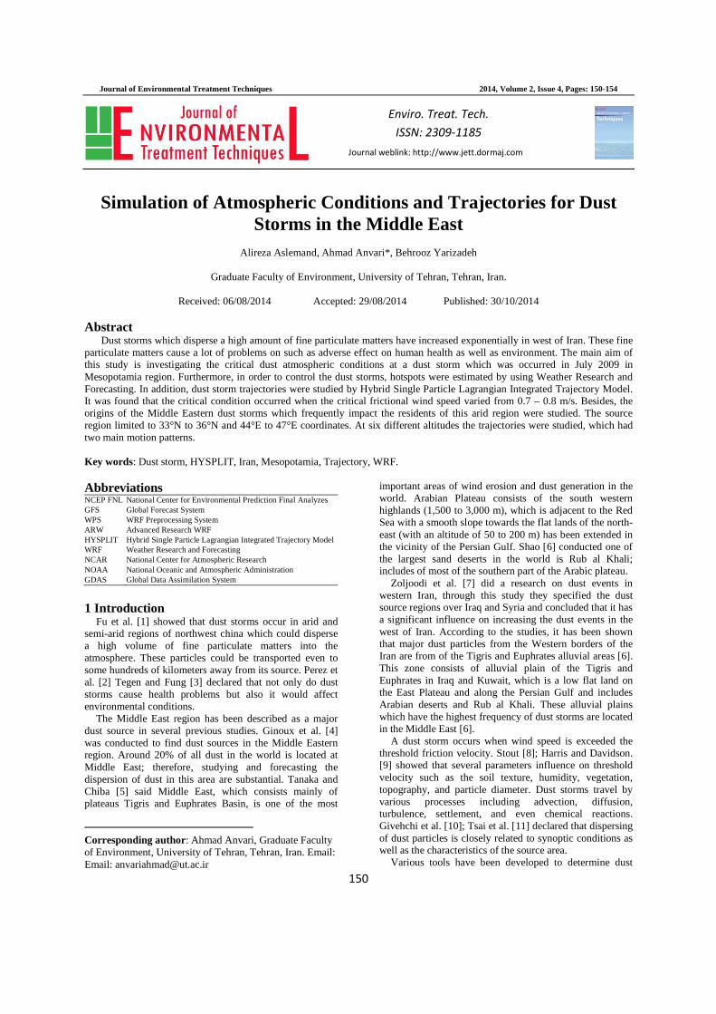
Figure 1 illustrates frictional wind speed versus dust flux for different researchers’ investigations. It shows that frictional wind speed is in the range of 0.3 – 1 (m/s) while the rate of dust emission is in the range of 3×10³ - 7×10⁵(µg/m2s) Gillette. (1979). Gillette [21] showed that dust particles which could disperse a long distance, have diameters approximately less than 20 micro-meters. In most of dust storms in the Middle East dust particles travel a long distance above the Arabian Peninsula, thus their size of diameters presumably is within this range. 2.3 WRF model The NCAR Advanced Research WRF (ARW) meso-scale model (WRF version 2.2) was used to simulate the wind stream pattern and other meteorological variables in
this study. Advanced Research WRF dynamic solver, including one-way, two-way nesting and moving nests, grid and observation nudging [22, 23].
Figure 1: Friction speed and dust flux in different researches [21].
The model consists of fully compressible non-hydrostatic equations and the prognostic variables include the three-dimensional wind, perturbation quantities of potential temperature, geo-potential, surface pressure, turbulent kinetic energy, and scalar parameters such as water vapour mixing ratio and cloud water. Vertical grid of the model is terrain following hydrostatic pressure and the horizontal grid is Arakawa C-grid staggering. A third order Runge–Khutta time integration is used in the model. The model has several alternatives for spatial domains, diffusion, nesting, and lateral boundary conditions. The model initializes with available large scale analyses meteorological data sets such as NCEP FNL, ETA, and GFS. A number of options are also available in the model for representing the sub-grid scale physical processes for convection, explicit micro-physics, atmospheric radiation, boundary layer turbulence and surface temperature/moisture treatment [22, 23]. 2.3.1 WRF Physics The physical assumptions for using in WRF model were taken from Mellor-Yamada-Janjic’s work. The other parameters such as horizontal and vertical speed, relative humidity, and geo-potential height are taken from GFS. Furthermore, WPS provides some other parameters such as soil temperature, height, classification of land, and classification of soil [22]. 2.4 HYSPLIT Model
The base of the HYSPLIT dust module is the PM10 dust storm emission algorithm for desert land use. This methodology is applied to estimate hotspots and trajectories. HYSPLIT is a hybrid model for calculating trajectory, dispersion, and simulating air pollutants. Minimum weather parameters are required in this model. HYSPLIT model developed by Air Resources Laboratory, NOAA is used to simulate the dispersion of airborne
Journal of Environmental Treatment Techniques
pollutant releases. HYSPLIT computes simple trajectories to complex dispersion and deposition simulations using puff or particle approaches [19, 24]. 2.4.1 Trajectory model calculation
The trajectory calculation in any Lagrangian models is based on the meteorological data (wind speed in 3 directions), which has been interpolated to the grids of model. Trajectories can be computed to test the advection in the model. The advection is computed from the average of the 3-D velocity vectors for the initial position P(t) and the first-guess position P’(t +∆t). The velocity vectors are linearly interpolated in both space and time
The model needs wind speed in three different directions, temperature, surface pressure, and height of the mix layer so as to calculate trajectories. Since the accuracy of results depends on the meteorological input’s accuracy, it is recommended to use continuous fields such as WRF [25]. In this research, GDAS and meteorprovided by NOAA. Trajectory simulation in this study uses forward moving from dust sources in six different heights (10, 100, 500, 1000, 2000, 3000 meters above ground level). Simulation started in 12:00 UTC 2nd July 2009 for four days. The top of the model assume to be fixed at 10,000 meters. The reason for choosing these heights for dust sources is that the height of boundary layer in those regions was about of 3,000 meters above the surface; therefore the dust could transfer from surfboundary layer.
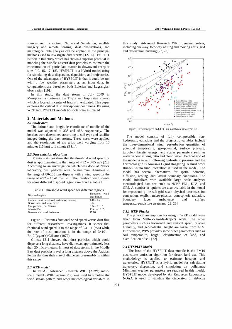
Most of the dust particles’ diameters which contain Silt are in the range of 2 – 74 µm. The study area includes Silt layers therefore the wind speed threshold should be 4.47 13.41 m/s. According to the figure 2, surface wiand surface temperature are about 7.5 48.8 °C, respectively. The high surface temperature, high convective heat, and rising the boundary layer up to 3000 meters provides a good condition for displacement of dust vertically. The dust source in this study was enclosed to 44 – 47 longitudinal and 33 – 36 latitude.
According to Figure 3, it can be concluded that frictionwind speed (U*) in this dust event is about 0.4 and critical friction speed (0.7 – 0.8) m/sthe U*
t (threshold friction speed), it would make a condition for emitting the dust. In most cases Uparticles’ diameter and turbulent parameters but generally it is approximately equal to 0.6. Furthermore, based on Gillette’s research (Figure 1) it can be concluded that in Silt soils in Yukon for U* in the range of 0.3 emission rate is 7×10⁵ – 3×10³ (µg/mYukon’s results are similar to the values of U[21].
3. HYSPLIT Results
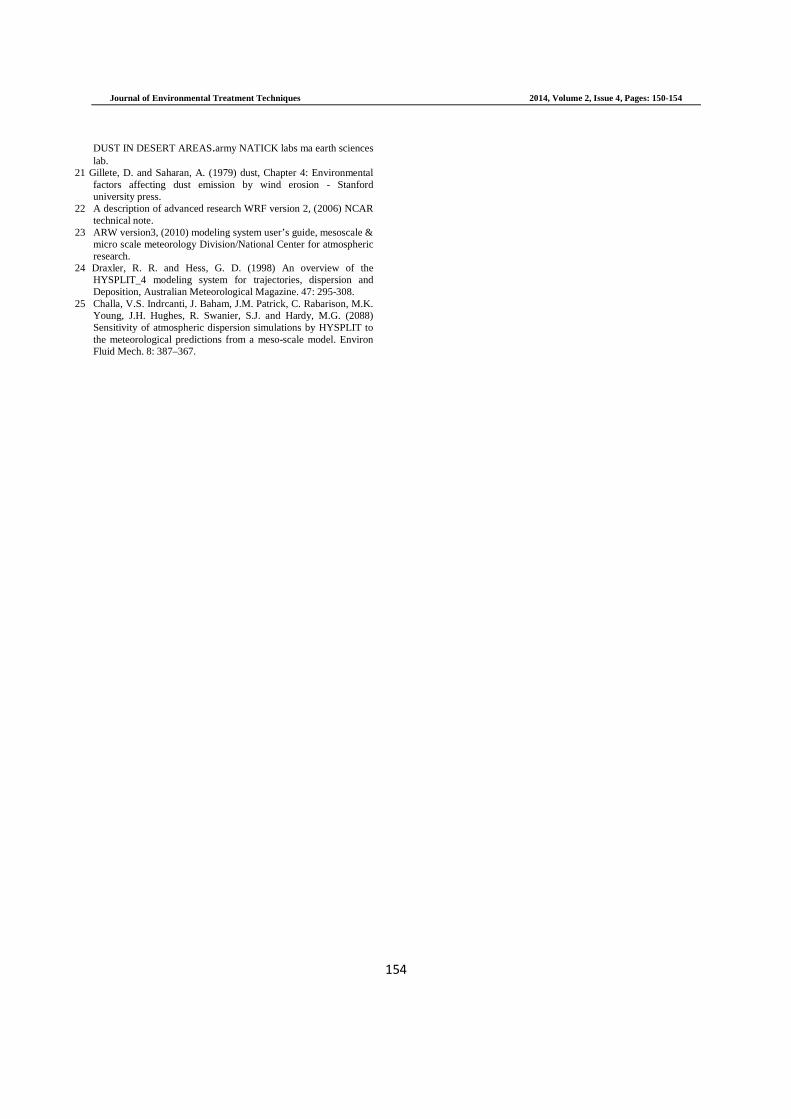
Figure 4 (a, b and c) shows that the direction of dust storm at altitudes (10, 100, 500 meters) is toward South East and at country’s border regions it breaks into two different trend lines. Above 500 meters (Figf), the trend lines at the beginning of the mass trajectories originated from higher longitudes have moved towWest to the East. The trend lines start from the lower latitudes toward the South-East and then redirected to the
Journal of Environmental Treatment Techniques 2014, Volume
152
pollutant releases. HYSPLIT computes simple trajectories to complex dispersion and deposition simulations using
The trajectory calculation in any Lagrangian models is based on the meteorological data (wind speed in 3 directions), which has been interpolated to the grids of model. Trajectories can be computed to test the advection
ted from the average D velocity vectors for the initial position P(t) and
∆t). The velocity vectors are linearly interpolated in both space and time.
The model needs wind speed in three different ure, surface pressure, and height of the
mix layer so as to calculate trajectories. Since the accuracy of results depends on the meteorological input’s accuracy, it is recommended to use continuous fields such as WRF
In this research, GDAS and meteorological data were provided by NOAA. Trajectory simulation in this study uses forward moving from dust sources in six different heights (10, 100, 500, 1000, 2000, 3000 meters above ground level). Simulation started in 12:00 UTC 2nd July
The top of the model assume to be fixed meters. The reason for choosing these heights for
dust sources is that the height of boundary layer in those meters above the surface;
therefore the dust could transfer from surface layer up to
Most of the dust particles’ diameters which contain Silt 74 µm. The study area includes Silt
layers therefore the wind speed threshold should be 4.47 – 13.41 m/s. According to the figure 2, surface wind speed and surface temperature are about 7.5 – 12 m/s and 43 – 48.8 °C, respectively. The high surface temperature, high convective heat, and rising the boundary layer up to 3000 meters provides a good condition for displacement of dust
ust source in this study was enclosed to 44
According to Figure 3, it can be concluded that friction speed (U*) in this dust event is about 0.4 – 0.8 m/s
m/s. If it is more than (threshold friction speed), it would make a condition
for emitting the dust. In most cases U*t depends on the
and turbulent parameters but generally it is approximately equal to 0.6. Furthermore, based on
1) it can be concluded that in Silt soils in Yukon for U* in the range of 0.3 – 1 m/s the dust
(µg/m2s) approximately. Yukon’s results are similar to the values of U*
t of this study
Figure 4 (a, b and c) shows that the direction of 100, 500 meters) is toward
South East and at country’s border regions it breaks into two different trend lines. Above 500 meters (Figure 4: d, e, f), the trend lines at the beginning of the mass trajectories originated from higher longitudes have moved towards the West to the East. The trend lines start from the lower
East and then redirected to the
North and North-East. The main reason for these helical movements could be cyclones in the North of Persian Gulf and South-West provinces of the country.
Figure 2: Surface wind speed in study area
Figure 3: friction wind
, Volume 2, Issue 4, Pages: 150-154
East. The main reason for these helical movements could be cyclones in the North of Persian Gulf
nces of the country.
Surface wind speed in study area
wind speed in study area

Journal of Environmental Treatment Techniques
Figure 4: Forward trajectories from dust sources in a)10d)1,000, e)2,000 and f)3,000m above ground level.
4. Conclusion
This study investigates the dust storm critical atmospheric conditions and the trajectories in Iraq and Iran. First, WRF model was applied to determine surface and threshold wind speed, as well as dust sources. According to the results of the WRF surface wind speed at the dust release time was about of 7.5–12 m/s and critical friction wind speed was about of 0.7–0.8 m/s. caused to dust emission in the central region of Iraq. Furthermore, HYSPLIT Model used to simulate the dust trajectories in the range of 10–3000 m above ground levels from the hotspots. Trajectories direction depends on the height of the sources and in the higher altitudes the horizontal dispersion of dust parcels is different than the lower levels. It was found two differeparticles trajectories. One of them was moved toward to North–East of Iran and the other one was moved toward to South–East at first and changed to North
a
c
e
Journal of Environmental Treatment Techniques 2014, Volume
153
Forward trajectories from dust sources in a)10, b)100, c)500, above ground level.
This study investigates the dust storm critical atmospheric conditions and the trajectories in Iraq and Iran. First, WRF model was applied to determine surface and threshold wind speed, as well as dust sources. According to
ind speed at the dust 12 m/s and critical friction
. These two factors caused to dust emission in the central region of Iraq. Furthermore, HYSPLIT Model used to simulate the dust
above ground levels from the hotspots. Trajectories direction depends on the height of the sources and in the higher altitudes the horizontal dispersion of dust parcels is different than the lower levels. It was found two different patterns in dust particles trajectories. One of them was moved toward to
East of Iran and the other one was moved toward to East at first and changed to North–East later.
References 1 Fu, P. Huang, J. Li, C. and Zhong, S. (2008) The prop
aerosol and reducing tendency of the dust storms in northwest China. Atmospheric Environment. 42: 5896
2 Perez, L. Tobías, A. Querol, X. Pey, J. Alastuey, A. Díaz, J. and Sunyer, J. (2012) Saharan dust, particulate matter and causespecific mortality: a case-crossover study in Barcelona (Spain). Environment International. 48: 150
3 Tegen, I. and Fung, I. (1994) Modeling of mineral dust in the atmosphere: sources, transport, and optical thickness. Journal of Geophysical Research. 99: 897-914
4 Ginoux, P. Prospero, J.M. Gill, T.E. Hsu, N.C. and Zhao, M. (2012) Global-scale attribution of anthropogenic and natural dust sources and their emission rates based on MODIS Deep Blue aerosol products. Review of Geophysics 50.
5 Tanaka, T. Y., and Chiba, M. (2006) A numerical study of the contributions of dust source regions to the global dust budget, Global and Planetary Change. 52: 88
6 Shao, Y. (2008) Physics and Modeling of Wind Erosion. Germany: Springer Press. ISBN ISBN 978-1
7 Zoljoodi, M. Didevarasl, A. and Ranjbar, A. (2013) Dust events in the western parts of Iran and the relationship with drought expansion over the dust-source areas in Iraq and Syria. Atmospheric and Climate Sciences(ACS), in press.
8 Stout, J.E. (2010) Diurnal patterns of blowing sand. Earth Surface Processes and Landforms. 35: 314
9 Harris, A.R. and Davidson, C.I. (2008) Particle resuspension in turbulentflow: a stochastic model for individual soil grains. Aerosol Science and Technology. 42:
10 Givehchi, R. Arhami, M. and Tajrishy, M. (2013) Contribution of the Middle Eastern dust source areas to PM10 levels in urban receptors: Case study of Tehran, Iran. Atmospheric Environmet. 75: 287-295.
11 Tsai, F. Chen, G.T.-J. Liu, T.-H. Lin, WCharacterizing the transport pathways of Asian dust. Journal of Geophysical Research 113, D17311
12 Escudero, M. Stein, A. Draxler, R. Querol, X. Alastuey, A. and Castillo, S. (2006) Determination of the contribution of north Afr ica dust source areas to PM10 concentrations over the central Iberian peninsula using the hybrid singleintegrated trajectory model (HYSPLIT) model. J Geophys Res (111):D06210.
13 Xuan, J. (2005) Emission inventory of eight elements, Mg, Mn, Na, Caand Ti, in dust source region of East Asia. Atmos Environ. 39: 813–821.
14 Wang, W. and Fang, Z.Y. (2006) Numerical simulation and synoptic analysis of dust emission and transport in East Asia. Glob Planet Chang, 52: 57–70.
15 Ashrafi, Kh. Shafie pour-Motlagh, M. Aslemand, A. and Ghader, S. (2014) Dust storm simulation over Iran using HYSPLIT. Journal of Environmental Health Science and Engineering 12:9.
16 Alam, K. Qureshi, S. and Blaschke, T. (2011) Monitoring Spatiotemporal aerosol patterns over Pakistan based on MODIS, TOMS and MISR satellite data and a HYSPLIT model. Atmos Environ. 45: 4641–4651.
17 Draxler, R.R. and Rolph, G.D. (2012) Evaluation of the Transfer Coefficient Matrix (TCM) approach to model the atmospheric radionuclide air concentrations from Fukushima. Journal of Geophysical Research D: Atmospheres 117.
18 Draxler, R. Gillette, A. Kirkpatrick, S. and Heller, J. (2001) Estimating PM10 air concentrations from dust storms in Iraq, Kuwait and Saudi Arabia. Atmos E
19 Draxler, R. Stunder, B. Rolph, G. Stein, A. and Taylor, A. (2009) Hybrid single-particle Lagrangian integrated trajectories_4 user's guide, NOAA Tech. Memo, ERL
20 NATICK Group: Clements, T. Stone, R. O. MEymann, J.L. (1963) A STUDY OF WINDBORNE SAND AND
b
d
f
, Volume 2, Issue 4, Pages: 150-154
Fu, P. Huang, J. Li, C. and Zhong, S. (2008) The properties of dust aerosol and reducing tendency of the dust storms in northwest China. Atmospheric Environment. 42: 5896-5904 Perez, L. Tobías, A. Querol, X. Pey, J. Alastuey, A. Díaz, J. and Sunyer, J. (2012) Saharan dust, particulate matter and cause-
crossover study in Barcelona (Spain). Environment International. 48: 150-155 Tegen, I. and Fung, I. (1994) Modeling of mineral dust in the atmosphere: sources, transport, and optical thickness. Journal of
914 Ginoux, P. Prospero, J.M. Gill, T.E. Hsu, N.C. and Zhao, M.
scale attribution of anthropogenic and natural dust sources and their emission rates based on MODIS Deep Blue aerosol products. Review of Geophysics 50.
. (2006) A numerical study of the contributions of dust source regions to the global dust budget, Global and Planetary Change. 52: 88–104. Shao, Y. (2008) Physics and Modeling of Wind Erosion. Germany:
1-4020-88. Zoljoodi, M. Didevarasl, A. and Ranjbar, A. (2013) Dust events in the western parts of Iran and the relationship with drought
source areas in Iraq and Syria. Atmospheric and Climate Sciences(ACS), in press.
010) Diurnal patterns of blowing sand. Earth Surface Processes and Landforms. 35: 314-318. Harris, A.R. and Davidson, C.I. (2008) Particle resuspension in turbulentflow: a stochastic model for individual soil grains. Aerosol Science and Technology. 42: 613-628 Givehchi, R. Arhami, M. and Tajrishy, M. (2013) Contribution of the Middle Eastern dust source areas to PM10 levels in urban receptors: Case study of Tehran, Iran. Atmospheric Environmet.
H. Lin, W.-D. and Tu, J.-Y. (2008) Characterizing the transport pathways of Asian dust. Journal of Geophysical Research 113, D17311 Escudero, M. Stein, A. Draxler, R. Querol, X. Alastuey, A. and Castillo, S. (2006) Determination of the contribution of north
ica dust source areas to PM10 concentrations over the central Iberian peninsula using the hybrid single-particle lagrangian integrated trajectory model (HYSPLIT) model. J Geophys Res
Xuan, J. (2005) Emission inventory of eight elements, Fe, Al, K, Mg, Mn, Na, Caand Ti, in dust source region of East Asia. Atmos
Wang, W. and Fang, Z.Y. (2006) Numerical simulation and synoptic analysis of dust emission and transport in East Asia. Glob Planet
Motlagh, M. Aslemand, A. and Ghader, S. (2014) Dust storm simulation over Iran using HYSPLIT. Journal of Environmental Health Science and Engineering 12:9. Alam, K. Qureshi, S. and Blaschke, T. (2011) Monitoring Spatio-
osol patterns over Pakistan based on MODIS, TOMS and MISR satellite data and a HYSPLIT model. Atmos Environ.
er, R.R. and Rolph, G.D. (2012) Evaluation of the Transfer Coefficient Matrix (TCM) approach to model the atmospheric
nuclide air concentrations from Fukushima. Journal of Geophysical Research D: Atmospheres 117. Draxler, R. Gillette, A. Kirkpatrick, S. and Heller, J. (2001) Estimating PM10 air concentrations from dust storms in Iraq, Kuwait and Saudi Arabia. Atmos Environ, 35: 4315–4330. Draxler, R. Stunder, B. Rolph, G. Stein, A. and Taylor, A. (2009)
particle Lagrangian integrated trajectories_4 user's guide, NOAA Tech. Memo, ERL-ARL-230, June, 35 pp. NATICK Group: Clements, T. Stone, R. O. Mann, J. F. and Eymann, J.L. (1963) A STUDY OF WINDBORNE SAND AND
Journal of Environmental Treatment Techniques 2014, Volume 2, Issue 4, Pages: 150-154
154
DUST IN DESERT AREAS.army NATICK labs ma earth sciences lab.
21 Gillete, D. and Saharan, A. (1979) dust, Chapter 4: Environmental factors affecting dust emission by wind erosion - Stanford university press.
22 A description of advanced research WRF version 2, (2006) NCAR technical note.
23 ARW version3, (2010) modeling system user’s guide, mesoscale & micro scale meteorology Division/National Center for atmospheric research.
24 Draxler, R. R. and Hess, G. D. (1998) An overview of the HYSPLIT_4 modeling system for trajectories, dispersion and Deposition, Australian Meteorological Magazine. 47: 295-308.
25 Challa, V.S. Indrcanti, J. Baham, J.M. Patrick, C. Rabarison, M.K. Young, J.H. Hughes, R. Swanier, S.J. and Hardy, M.G. (2088) Sensitivity of atmospheric dispersion simulations by HYSPLIT to the meteorological predictions from a meso-scale model. Environ Fluid Mech. 8: 387–367.