site 6. sanggau, west kalimantan province, indonesiapdf.usaid.gov/pdf_docs/pnact622.pdf · landsat...
TRANSCRIPT
Site 6. Sanggau, West Kalimantan Province, Indonesia
by
Mayer, J., Suratmoko, B., Ruchiat, Y., Dennis, R.A., Kurniawan, I., Stolle, F., Maus, P.
and Applegate, G.
In collaboration with Pancur Kasih West Kalimantan
Site Report
September 2000
The underlying causes and impacts of fires in South-east Asia.
Site 6. Sanggau, West Kalimantan Province, Indonesia
by
Judith Mayer1, Bagus Suratmoko2, Yayat Ruchiat3, Rona Dennis1, Iwan Kurniawan3, Fred Stolle3, Paul Maus4 and Grahame Applegate1
In collaboration with Pancur Kasih West Kalimantan
1 Center for International Forestry Research (CIFOR) 2 PPSDAK-Pancur Kasih 3 International Centre for Research in Agroforestry (ICRAF) 4 United States Forest Service (USFS)
Map and layout design: Yayat Ruchiat Copy editing: Erik Meijaard
Corresponding author and contact address: Judith Mayer
Center for International Forest Research (CIFOR) PO Box 6596 JKPWB
10065 Jakarta Indonesia
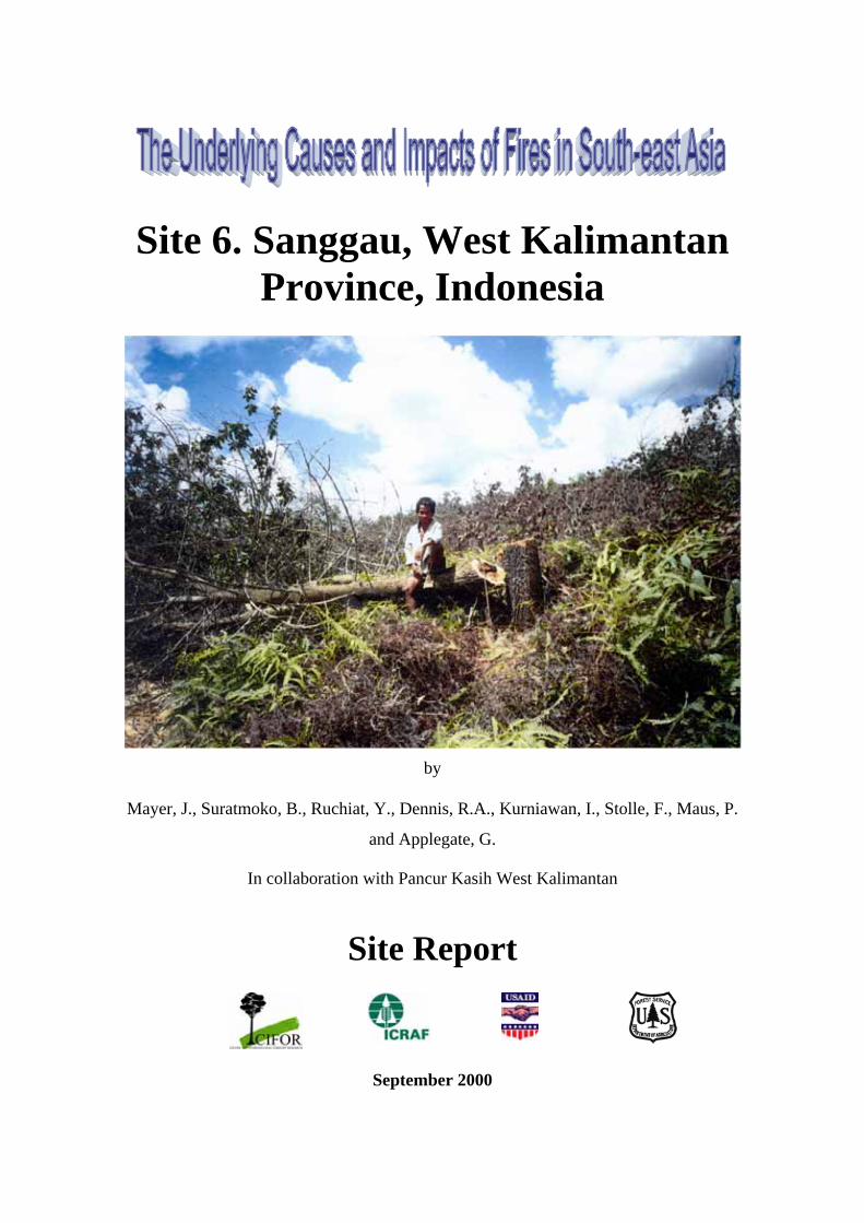
Cover photo: Reoccupation of Timber Plantation Land by People of Sungei Omang and Sebuda Village (in Desa Sape).
Photo by: Judith Mayer
Site Sanggau
The Underlying Causes and Impacts of Fires in South-east Asia Site 6, Sanggau, West Kalimantan, Indonesia
i
Table of Contents Page No.
ABBREVIATIONS AND TERMS....................................................................................................... III
ACKNOWLEDGMENTS..................................................................................................................... IV
SUMMARY ............................................................................................................................................. V
1. INTRODUCTION............................................................................................................................1
2. SITE DESCRIPTION ......................................................................................................................2
3. METHODOLOGY...........................................................................................................................5
3.1 SOCIO-ECONOMIC STUDY METHODS............................................................................................. 5 3.2 REMOTE SENSING AND GIS ........................................................................................................... 6
3.2.1 Site-wide methodology........................................................................................................ 7 3.3 INTEGRATION OF SOCIAL SCIENCE AND REMOTE SENSING.............................................................. 8
4. RESULTS........................................................................................................................................10
4.1 FIRES ......................................................................................................................................... 10 4.1.1 Landscape level ................................................................................................................ 10 4.1.2 Burn scars......................................................................................................................... 10 4.1.3 Fire information from hot-spots ....................................................................................... 11
4.2 LAND COVER AND LAND USE CHANGES....................................................................................... 14 4.2.1 Landscape level ................................................................................................................ 14 4.2.2 Quantitative landscape level changes .............................................................................. 16
4.3 SOCIAL....................................................................................................................................... 18
5. UNDERLYING CAUSES..............................................................................................................25
6. POLICY IMPLICATIONS ...........................................................................................................27
7. REFERENCES ...............................................................................................................................29
APPENDIX I: LAND COVER CHANGE MATRICES.....................................................................31
FIGURES:
Site Sanggau
The Underlying Causes and Impacts of Fires in South-east Asia Site 6, Sanggau, West Kalimantan, Indonesia
ii
FIGURE 2-1 OVERVIEW OF THE STUDY SITE ALONG WITH THE 1997 HOT-SPOTS.........................................2 FIGURE 2-2 LOCATION OF THE STUDY SITE.................................................................................................3 FIGURE 3-1 SATELLITE IMAGERY SELECTED ..............................................................................................8 FIGURE 4-1 SANGGAU STUDY SITE WITH 1997 HOT-SPOTS.......................................................................12 FIGURE 4-2 ACACIA MANGIUM TIMBER PLANTATION NEXT TO SCRUBLAND, IN DESA MENAWAI TEKAM, KECAMATAN BELITANG HILIR....................................................................................................................15 FIGURE 4-3 NEW SMALLHOLDERS RUBBER GARDEN IN PAKIT ENGKUNING .............................................16 FIGURE 4-4 LAND COVER CLASSIFICATIONS 1991 AND 2000 ...................................................................17 FIGURE 4-5 ESTABLISHMENT OF NEW OIL PALM PLANTATION AT KAMPUNG PAKIT ENGKUNING..............20 FIGURE 4-6 REOCCUPATION OF TIMBER PLANTATION LAND BY PEOPLE OF SUNGEI OMANG AND SEBUDA VILLAGE (IN DESA SAPE)...........................................................................................................................20 FIGURE 4-7 FIRE PRONE SWATHE OF GRASSLANDS AND SCRUB FOREST IN THE CONTESTED AREA IN KECAMATAN BELITANG HILIR ..................................................................................................................22 TABLES: TABLE 3-1 REMOTE SENSING IMAGERY ANALYZED.................................................................................... 7 TABLE 4-1 HOT-SPOTS DENSITIES (IN HOT-SPOTS PER 100 KM2)............................................................... 12 TABLE 4-2 CUMULATIVE LAND COVER CHANGE ESTIMATES 1991–2000 ................................................. 18
Site Sanggau
The Underlying Causes and Impacts of Fires in South-east Asia Site 6, Sanggau, West Kalimantan, Indonesia
iii
ABBREVIATIONS AND TERMS
Adat rights Customary ownership or use rights recognized by local customary law
AVHRR Advanced Very High Resolution Radiometer
ERS European Space Agency Radar Satellite
EU European Union
EU-JRC the Joint Research Centre of the European Union
GIS Geographic Information System
Ha Hectare
Kanwil Kantor Wilayah (Provincial Office)
Kecamatan Sub-district
Km Kilometer
Landsat MSS Landsat Multispectural Scanner. An imaging system found on the first five Landsat satellites. The system collects multispectral data in four non-thermal radiation bands with a spatial resolution of 79 x 79 m.
Landsat TM Landsat Thematic Mapper. A multispectral scanner imaging system on board the Landsat 4,5 and 7 satellites. The imaging system collects multispectral data in seven bands. The six non-thermal bands have a spatial resolution of 30 x 30 m, whereas the thermal band has a spatial resolution of 120 x 120 m. The temporal resolution is 16 days.
M meters
MOFEC Ministry of Forestry and Estate Crops
NES Nucleus Estate Smallholder project, a government-sponsored plantation development program in which transmigrants receive title to a portion of the developed plantation project
NOAA National Oceanic and Atmospheric Administration, USA
RTRWP Provincial land use planning
Stakeholders People or groups of people interested or responsible for forest management, including landowners, local communities, industry and government organizations.
Site Sanggau
The Underlying Causes and Impacts of Fires in South-east Asia Site 6, Sanggau, West Kalimantan, Indonesia
iv
ACKNOWLEDGMENTS
This research is supported by the United States Forest Service, CIFOR and ICRAF. We
are grateful to participants in this research in Sanggau for their cooperation in narrating
and mapping fire histories. We thank the staff of PPSDAK-Pancur Kasih for conducting
much of the field work for this study, especially Bagus Suratmoko and the PPSDAK-
Pancur Kasih field teams for their excellent work. We also thank Dr. Unna
Chokkalingam for providing insightful comments. In addition, we would like to thank
the JICA/PKA Forest Fire Prevention and Management Project in Bogor for kindly
providing the hot-spot data.
Site Sanggau
The Underlying Causes and Impacts of Fires in South-east Asia Site 6, Sanggau, West Kalimantan, Indonesia
v
SUMMARY
This report provides an analysis of causes and impacts of vegetation fires in the
Sanggau area, West Kalimantan Province, Indonesia. The Landstat TM Image level
analysis indicated that during the period 1991 – 2000 there were considerable changes
in the extent and quality of the natural forest. The reduction in total area of forest was
42% over this 9-year period, or an average of 5 % per annum. The forest type most
affected was high-density forest, which was reduced by 10,039 ha, or 44 %. Low-
density forest was also reduced by 37 % from 1991. Primary forest cover in this region
declined precipitously from the 1950’s to the 1970’s with frontier-style shifting
cultivation and settlement patterns. Fire has been a significant factor in most major
landscape transformations at the Sanggau site.
Socio-economic research at the landscape level in the Sanggau site focused on fires that
occurred during the 1990s, with background data on settlement and landscape histories
from prior periods. Fires that village residents, plantation managers, and government
officials in this area considered significant in the 1990s had various causes, according to
local accounts and narratives documented in this field research. These included (1)
accidental and generally “unwanted” fire (“kebakaran”, most often tied to agricultural
burning under high risk conditions without appropriate safeguards; (2) fire generally
recognized as “legitimate” by all parties; and (3) contested fire (fire considered
legitimate or appropriate by some people but not by others, including [a] burning for
commercial plantation land clearing, and [b] burning in retaliation for land or resource
expropriation).
Site Sanggau
The Underlying Causes and Impacts of Fires in South-east Asia Site 6, Sanggau, West Kalimantan, Indonesia
1
1. INTRODUCTION
The Sanggau site represents a region of Kalimantan that experienced a relatively large
number of hot-spots as detected by satellite imagery, but had a relatively low incidence
of reports of wildfire or accidental fire during the study period. Most of the landscape
transformation in this area to agro-industrial plantations and small-holder crops during
the 1980s and 1990s has involved burning.
Village-based incentives to control fires used in shifting cultivation remain relatively
intact, and several communities have embarked on efforts to codify, update, and
reinforce customary rules and practical norms aimed at preventing the spread of
wildfire. The largest plantation in the region, an international joint venture pulpwood
plantation, has attempted to maintain a “no burn” policy for land clearing since its
inception, in 1994. However, land reallocation in the wake of recent reform initiatives
toward devolution of land planning authority to sub-provincial levels has led to many
overlaps and conflicting land claims. The land conflicts have weakened incentives and
institutions that contribute to effective control of wildfire, undesirable fire, and
illegitimate use of fire.
Site Sanggau
The Underlying Causes and Impacts of Fires in South-east Asia Site 6, Sanggau, West Kalimantan, Indonesia
2
2. SITE DESCRIPTION
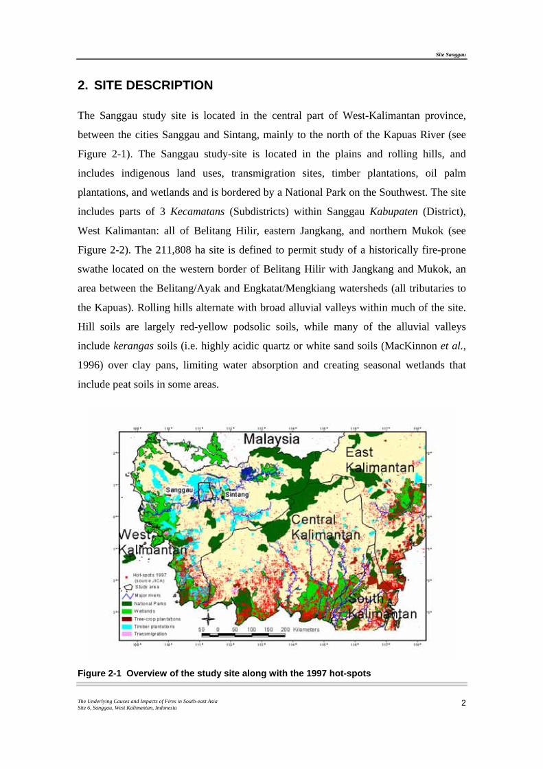
The Sanggau study site is located in the central part of West-Kalimantan province,
between the cities Sanggau and Sintang, mainly to the north of the Kapuas River (see
Figure 2-1). The Sanggau study-site is located in the plains and rolling hills, and
includes indigenous land uses, transmigration sites, timber plantations, oil palm
plantations, and wetlands and is bordered by a National Park on the Southwest. The site
includes parts of 3 Kecamatans (Subdistricts) within Sanggau Kabupaten (District),
West Kalimantan: all of Belitang Hilir, eastern Jangkang, and northern Mukok (see
Figure 2-2). The 211,808 ha site is defined to permit study of a historically fire-prone
swathe located on the western border of Belitang Hilir with Jangkang and Mukok, an
area between the Belitang/Ayak and Engkatat/Mengkiang watersheds (all tributaries to
the Kapuas). Rolling hills alternate with broad alluvial valleys within much of the site.
Hill soils are largely red-yellow podsolic soils, while many of the alluvial valleys
include kerangas soils (i.e. highly acidic quartz or white sand soils (MacKinnon et al.,
1996) over clay pans, limiting water absorption and creating seasonal wetlands that
include peat soils in some areas.
Figure 2-1 Overview of the study site along with the 1997 hot-spots
Site Sanggau
The Underlying Causes and Impacts of Fires in South-east Asia Site 6, Sanggau, West Kalimantan, Indonesia
3
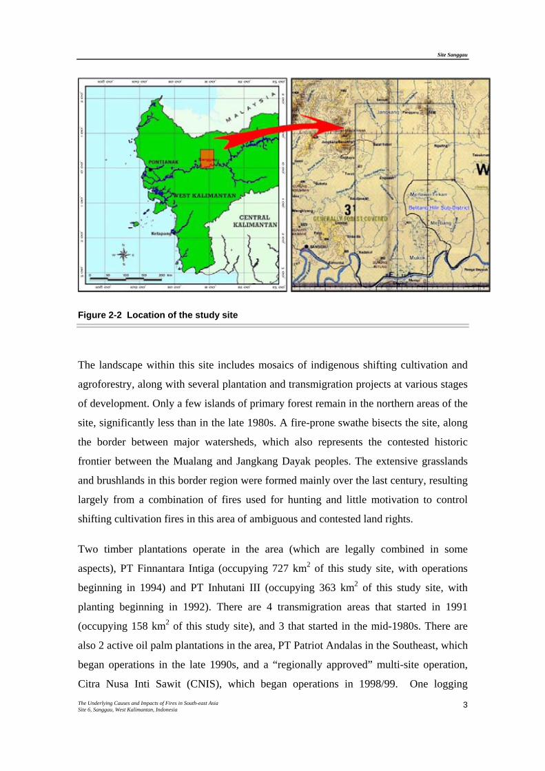
Figure 2-2 Location of the study site
The landscape within this site includes mosaics of indigenous shifting cultivation and
agroforestry, along with several plantation and transmigration projects at various stages
of development. Only a few islands of primary forest remain in the northern areas of the
site, significantly less than in the late 1980s. A fire-prone swathe bisects the site, along
the border between major watersheds, which also represents the contested historic
frontier between the Mualang and Jangkang Dayak peoples. The extensive grasslands
and brushlands in this border region were formed mainly over the last century, resulting
largely from a combination of fires used for hunting and little motivation to control
shifting cultivation fires in this area of ambiguous and contested land rights.
Two timber plantations operate in the area (which are legally combined in some
aspects), PT Finnantara Intiga (occupying 727 km2 of this study site, with operations
beginning in 1994) and PT Inhutani III (occupying 363 km2 of this study site, with
planting beginning in 1992). There are 4 transmigration areas that started in 1991
(occupying 158 km2 of this study site), and 3 that started in the mid-1980s. There are
also 2 active oil palm plantations in the area, PT Patriot Andalas in the Southeast, which
began operations in the late 1990s, and a “regionally approved” multi-site operation,
Citra Nusa Inti Sawit (CNIS), which began operations in 1998/99. One logging
Site Sanggau
The Underlying Causes and Impacts of Fires in South-east Asia Site 6, Sanggau, West Kalimantan, Indonesia
4
concession, PT AnuRaga, operates a north-south corridor road (built in 1995), which
bisects the site. PT AnuRaga has since contracted with local communities to log
remnant primary forests within the site, outside of its concession area.
Site Sanggau
The Underlying Causes and Impacts of Fires in South-east Asia Site 6, Sanggau, West Kalimantan, Indonesia
5
3. METHODOLOGY
3.1 Socio-Economic Study Methods
The Sanggau site was selected to represent an area where uncontrolled fire incidence
has been relatively low, and where commercial plantation development was not
obviously the major underlying cause of “fires” (“kebakaran”) that did occur during the
1990s1. Selection of a site in southeastern Sanggau took advantage of the existence of
previous social research and community resource mapping and landscape history
documentation in selected areas, compatible with the present research. The social
research design for the Sanggau site builds on prior work performed by academic and
project researchers, regional NGOs, and community members themselves, as well as by
timber plantation companies active in the area. Research design combined methods
developed by CIFOR and ICRAF staff in cooperation with staff of PPSDAK-Pancur
Kasih in Pontianak, and in consultation with members of communities within the study
site.
Site boundaries were extended beyond communities that had been involved in previous
research or community resource mapping for land rights advocacy to minimize bias
toward communities whose members had already engaged in unusual degrees of
collective action to defend customary land rights or reduce fire risks. This research was
also designed to obtain sufficient information to trace fire incidence within commercial
concessions where land is nominally managed by agro-industrial plantation and
resource extraction companies, though members of local communities may continue to
exercise some rights over land or resources within their customary boundaries. Thus,
information on fire in general and specific fire events within the Sanggau site is uneven,
with more detailed accounts from “core” research areas within the site, and only general
information elsewhere.
1 “Fires”, in this case, refer mainly to kebakaran, in Indonesian, in this case referring to burning which some party considers accidental, uncontrolled or illegitimate, as opposed to deliberate, controlled burning generally (pembakaran), or any burning which most parties recognize as legitimate.)
Site Sanggau
The Underlying Causes and Impacts of Fires in South-east Asia Site 6, Sanggau, West Kalimantan, Indonesia
6
Detailed information on specific “unwanted” fire events from 1990 to 1999, including
GPS points for fire locations, was collected in some 10 customary villages (kampung),
located within 3 administrative villages (desa) in Belitang Hilir and Jangkang.
Fieldwork was conducted between May 1999 and July 2000 by a CIFOR consultant,
NGO collaborators (PPSDAK-Pancur Kasih), and an ICRAF staff member.
Social research on fires at the Sanggau site highlights areas affected by fires that have
been of particular concern to local communities and to plantation companies. Early in
this research, the Sanggau site had been limited to two administrative villages within the
Kecamatan of Belitang Hilir, and small areas of two administrative villages to the west,
in Kecamatan Jangkang. The site was initially defined around places where community-
based mapping and previous research provided a baseline of landscape history, on
which the present research could build. It was later expanded to land between and
around these locations, facilitating research on underlying causes of fire in the
“frontier” areas between watersheds, ethnic/language groups, and
political/administrative boundaries, which appeared to be particularly fire-prone. This
“no-man’s land” lies within the customary boundaries of several communities which
control access to land and resources to varying degrees under local customary rights. In
the early 1990s, the government designated much of this land for conversion to
industrial timber and oil palm plantations. In addition to unwanted fires spreading from
“traditional” shifting cultivation practices, research methods aimed to document causes
of fires stemming from land use conversion and plantation development, with
associated increases in fire risks due to vegetation changes and social tensions.
Through the social research at the Sanggau site, narrative data were collected on
approximately 100 “unwanted” fire events (kebakaran) during the 1990s, from both
village residents and plantation staff. Although these fires do not form a statistically
representative sample of all fires within the study site, they do represent the major types
of fires of local concern. Narratives of underlying causes, and immediate and long-term
effects, represent a cross-section of the types of situations that should be addressed by
future fire management and wildfire prevention and response programs.
3.2 Remote Sensing and GIS
Site Sanggau
The Underlying Causes and Impacts of Fires in South-east Asia Site 6, Sanggau, West Kalimantan, Indonesia
7
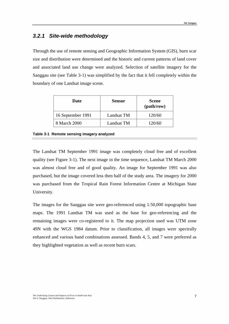
3.2.1 Site-wide methodology
Through the use of remote sensing and Geographic Information System (GIS), burn scar
size and distribution were determined and the historic and current patterns of land cover
and associated land use change were analyzed. Selection of satellite imagery for the
Sanggau site (see Table 3-1) was simplified by the fact that it fell completely within the
boundary of one Landsat image scene.
Date Sensor Scene (path/row)
16 September 1991 Landsat TM 120/60
8 March 2000 Landsat TM 120/60
Table 3-1 Remote sensing imagery analyzed
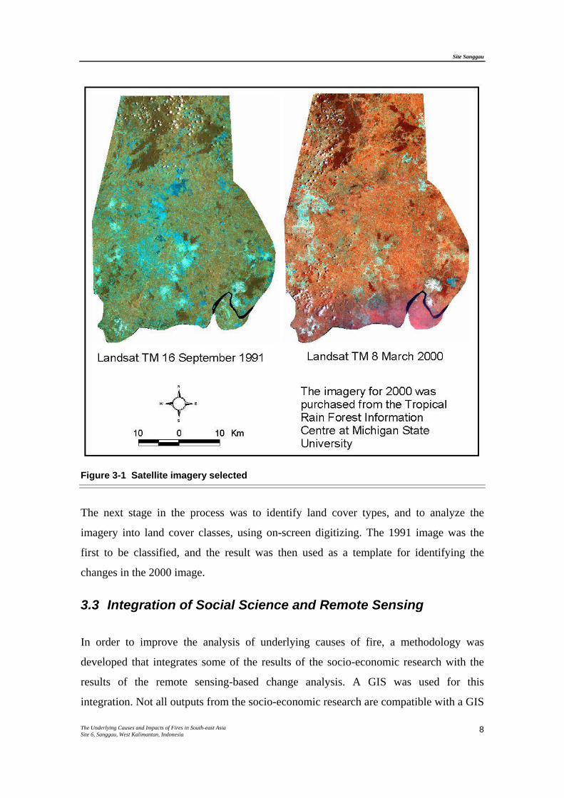
The Landsat TM September 1991 image was completely cloud free and of excellent
quality (see Figure 3-1). The next image in the time sequence, Landsat TM March 2000
was almost cloud free and of good quality. An image for September 1991 was also
purchased, but the image covered less then half of the study area. The imagery for 2000
was purchased from the Tropical Rain Forest Information Centre at Michigan State
University.
The images for the Sanggau site were geo-referenced using 1:50,000 topographic base
maps. The 1991 Landsat TM was used as the base for geo-referencing and the
remaining images were co-registered to it. The map projection used was UTM zone
49N with the WGS 1984 datum. Prior to classification, all images were spectrally
enhanced and various band combinations assessed. Bands 4, 5, and 7 were preferred as
they highlighted vegetation as well as recent burn scars.
Site Sanggau
The Underlying Causes and Impacts of Fires in South-east Asia Site 6, Sanggau, West Kalimantan, Indonesia
8
Figure 3-1 Satellite imagery selected
The next stage in the process was to identify land cover types, and to analyze the
imagery into land cover classes, using on-screen digitizing. The 1991 image was the
first to be classified, and the result was then used as a template for identifying the
changes in the 2000 image.
3.3 Integration of Social Science and Remote Sensing
In order to improve the analysis of underlying causes of fire, a methodology was
developed that integrates some of the results of the socio-economic research with the
results of the remote sensing-based change analysis. A GIS was used for this
integration. Not all outputs from the socio-economic research are compatible with a GIS
Site Sanggau
The Underlying Causes and Impacts of Fires in South-east Asia Site 6, Sanggau, West Kalimantan, Indonesia
9
and from site to site, the types of outputs vary slightly. For the Sanggau site, the focus
was on integrating local people’s narratives with land cover change and burn scar maps
at the village and plantation concession level. At the landscape level, land cover change
and burn scar analysis was carried out. The results from the village/plantation and the
landscape level were then compared. Using the GIS, it was possible to calculate the
types and size of land cover changes in relation to the territory historically used or
claimed by a village. Local people’s narratives were added to these land cover change
results to provide an insight into how and why changes occurred.
Site Sanggau
The Underlying Causes and Impacts of Fires in South-east Asia Site 6, Sanggau, West Kalimantan, Indonesia
10
4. RESULTS
4.1 Fires
4.1.1 Landscape level
Both immediate and underlying social causes of unwanted fires and resulting landscape
change at the Sanggau site show considerable variation. Since the mid-1990s, a
significant portion of serious fires have stemmed from a vacuum of effective
responsibility in areas that corporate plantations had recently negotiated to take over
from their customary owners, or which they had cleared without customary owners’
permission. Some of the fires associated with commercial plantation expansion were
deemed to be arson by local populations. Other serious fires, or concentrations of
unwanted fires, resulted from ongoing processes of “frontier” expansion by indigenous
Dayak populations, as well as from decreasingly effective accountability or liability for
damages resulting from “traditional” indigenous shifting cultivation/agroforestry fire
practices within an increasingly fire-prone landscape. While these fires represent only a
portion of those that occurred during this period in the entire study area, they appear to
be representative of the types of underlying causes encountered within the Sanggau site,
and which are also likely to operate in comparable areas.
4.1.2 Burn scars
Within the areas most thoroughly researched at this site, recent burn scars from fires
other than on the small shifting cultivation plots are concentrated along the boundary
between Kecamatan Belitang Hulu and Kecamatan Jangkang. This is also the watershed
between Engkatat/Mengkiang and Belitang River systems, as well as the historic
boundary between the Mualang and the Jangkang peoples. Much of this swathe of fire-
prone land had been taken over for timber plantation development by the year 2000,
especially in the middle/southern portion of the site. Many of the areas that burned in
the early 1990s had not been planted with industrial timber by the year 2000, since these
areas represented some of the most degraded soils in the site, and plantation companies
Site Sanggau
The Underlying Causes and Impacts of Fires in South-east Asia Site 6, Sanggau, West Kalimantan, Indonesia
11
chose to concentrate their investments in areas more likely to produce healthy timber
crops. Extensive burn scars dating from 1998 and 1999 are located in the northern part
of Kecamatan Belitang Hilir. Many of these areas had previously burned in 1991. One
very extensive area that had burned accidentally in 1991 by an escaped swidden fire
appears to have been covered with medium-aged small-holder forest gardens and timber
plantations by the year 2000.
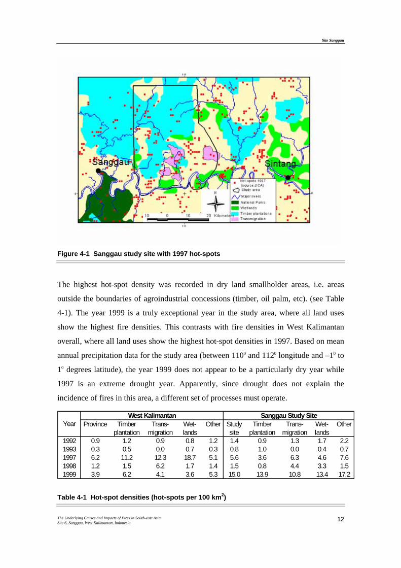
4.1.3 Fire information from hot-spots
Hot-spot data for 1992 - 1993 were obtained from European Space Agency/European
Space Research Institute (EU-ESA/ESRIN) and from the Centre National Recherches
Meteorologiques (CNRM). Data for 1997-1999 were obtained from the Japanese
International Co-operation Agency (JICA) based in Bogor, Java. There are 534 hot-
spots recorded between 1992-1993, and 1997-1999, with an overall hot-spot density of
24.3 hot-spots per 100 km2 (see Figure 4-1).
The Sanggau study site has a very high fire density compared to other sites (Danau
Sentarum site had fire density about 1.5). Among the 8 sites selected for this study, fire
densities as high as 1.5 is normally only recorded in wetland areas near the coast.
However, unlike the other sites, the most significant fire period in this area was in 1999
with almost 61 % of the hot-spots recorded in that year.
Site Sanggau
The Underlying Causes and Impacts of Fires in South-east Asia Site 6, Sanggau, West Kalimantan, Indonesia
12
Figure 4-1 Sanggau study site with 1997 hot-spots
The highest hot-spot density was recorded in dry land smallholder areas, i.e. areas
outside the boundaries of agroindustrial concessions (timber, oil palm, etc). (see Table
4-1). The year 1999 is a truly exceptional year in the study area, where all land uses
show the highest fire densities. This contrasts with fire densities in West Kalimantan
overall, where all land uses show the highest hot-spot densities in 1997. Based on mean
annual precipitation data for the study area (between 1100 and 1120 longitude and –10 to
10 degrees latitude), the year 1999 does not appear to be a particularly dry year while
1997 is an extreme drought year. Apparently, since drought does not explain the
incidence of fires in this area, a different set of processes must operate.
Province Timber plantation
Trans-migration
Wet-lands
Other Study site
Timber plantation
Trans-migration
Wet-lands
Other
1992 0.9 1.2 0.9 0.8 1.2 1.4 0.9 1.3 1.7 2.21993 0.3 0.5 0.0 0.7 0.3 0.8 1.0 0.0 0.4 0.71997 6.2 11.2 12.3 18.7 5.1 5.6 3.6 6.3 4.6 7.61998 1.2 1.5 6.2 1.7 1.4 1.5 0.8 4.4 3.3 1.51999 3.9 6.2 4.1 3.6 5.3 15.0 13.9 10.8 13.4 17.2
YearWest Kalimantan Sanggau Study Site
Table 4-1 Hot-spot densities (hot-spots per 100 km2)
Site Sanggau
The Underlying Causes and Impacts of Fires in South-east Asia Site 6, Sanggau, West Kalimantan, Indonesia
13
The Indonesian government’s policy to expand timber and other plantations in the
1990s could account for the different patterns of fire incidence in this area, where 40 %
of the study site is within timber plantation concession borders. The higher fire density
in smallholder areas may indicate that timber plantations are expanding into smallholder
lands or that timber plantations are less vulnerable to fire than smallholder areas. In
1999, it may also indicate accelerated smallholder conversion of land to perennial crops,
which would reinforce customary land claims under both local customary law and
national land use.
In 1997, 15 % of the hot-spots in smallholder areas were located within a kilometre
from the border of a timber plantation concession, while in 1999, 58 % are similarly
located. Inside the timber plantation concession, 23 % of the fires in 1997 and 17 % in
1999 are less than 1 km from a timber plantation concession border. This suggests that
fires were related to expansion of the plantation, but it indicates nothing about the
nature of these relationships. The high concentration of hot-spots in plantation border
areas could also indicate a number of other possibilities. These include deliberate
burning as a tool or “weapon” in land disputes, or fires allowed to burn out of control in
the vacuum of responsibility in areas of multiple « overlapping » claims on the borders
of the plantations. Local « re-occupation » of land formerly cleared by a timber
plantation has been another cause for fires, including some wildfires, as people re-
clearing land they had previously ceded to a plantation where operations had apparently
stopped, have little incentive to control their land clearing fires. Another cause of fires
in this area has been burning to clear land for new regionally-approved palm oil
plantations, or expansion of smallholder cash cropping (e.g., rubber) in areas near
recently-improved roads.
A significant proportion of the fires that local people and/or plantation enterprises
consider highly problematic are not represented in hot-spot locations. Examining
locations of hotspots in the late 1990s indicates that in areas of recent settlement and in
those of very recently developed plantations in the southern portion of the site, hotspots
clearly tend to be concentrated along recently constructed or recently improved roads,
such as the road between the Mukok transmigration site and Belitang Hilir.
Concentrations of fires that indigenous shifting cultivators consider to be desirable and
Site Sanggau
The Underlying Causes and Impacts of Fires in South-east Asia Site 6, Sanggau, West Kalimantan, Indonesia
14
legitimate during the traditional burning season do not necessarily show up as hot spots
in remote sensing imagery. These shifting cultivation fires are generally relatively cool,
and low (since vegetation has all been slashed or felled before burning), quickly
extinguished, and represent small burn areas of 1 to 5 ha at a time, which are usually
well-separated from one another.
4.2 Land Cover and Land Use Changes
4.2.1 Landscape level
Fire has been a significant factor in most major landscape transformations at the
Sanggau site. Fire in “traditional” shifting cultivation integrated with indigenous
agroforestry systems is used in re-clearing secondary forest fallows at various stages of
regeneration; little primary forest is directly affected. However, accidental fires
originating in shifting cultivation practices burned significant extents of land between
1991 and 1999.
From 1992 to 1995, land clearing for an industrial timber plantation employed fire,
mainly to clear relatively young secondary forest and some rubber-based agroforestry
gardens, especially in the central and northern portion of the site. Thus, from 1990 to
2000, much of the scrub forest land and some rubber gardens in the central portion of
the site were planted with fast-growing timber species, though tree survival rates for
these timber plantations have been low (see Figure 4-2). Fire was also used to clear land
for two palm oil plantations, one in the southwest part of the site, the other in the
northeast. The plantation land clearing in the southwest started in 1999, including areas
that had previously been planted as part of the industrial timber plantation project2.

Site Sanggau
The Underlying Causes and Impacts of Fires in South-east Asia Site 6, Sanggau, West Kalimantan, Indonesia
15
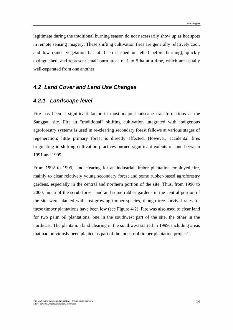
Figure 4-2 Acacia mangium timber plantation next to scrubland, in Desa Menawai Tekam, Kecamatan Belitang Hilir
From 1992 to 2000, much of the land on the borders between Kecamatan Belitang Hilir,
Jangkang, and Mukok was “filled in” with industrial timber plantation development and
agricultural plantings associated with the transmigration settlements at the southern end
of the Sanggau site. Large-scale oil palm planting began at the far north of the site. In
much of the remainder of the site, managed under local customary land and resource
tenure, the ongoing trend of converting land from relatively short-term shifting
cultivation cycles to long-term agroforestry continued (especially mixed-species
gardens dominated by rubber) (see Figure 4-3). Primary forest cover in this region
declined precipitously from the 1950s to the 1970s, with “frontier” style shifting
cultivation and settlement patterns. By 1990, the largest primary forest expanses were
already limited to a few areas of 300 ha to 2,000 ha, in the northern part of the site. By
the year 2000, these forest “islands” had been even further cleared for cultivation. Many
2 The legality of these uses of fire was a “gray area” in 1999 and 2000, since plantation companies contracted land clearing out to local residents, including customary land owners who clear and burn their own land immediately before ceding it to the plantation.
Site Sanggau
The Underlying Causes and Impacts of Fires in South-east Asia Site 6, Sanggau, West Kalimantan, Indonesia
16
remnant primary forest “islands” had been seriously degraded by the commercial
logging facilitated by road development, plantation expansion, and development of
government public works.
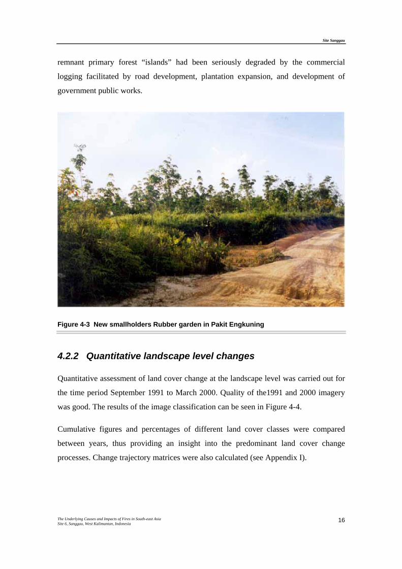
Figure 4-3 New smallholders Rubber garden in Pakit Engkuning
4.2.2 Quantitative landscape level changes
Quantitative assessment of land cover change at the landscape level was carried out for
the time period September 1991 to March 2000. Quality of the1991 and 2000 imagery
was good. The results of the image classification can be seen in Figure 4-4.
Cumulative figures and percentages of different land cover classes were compared
between years, thus providing an insight into the predominant land cover change
processes. Change trajectory matrices were also calculated (see Appendix I).
Site Sanggau
The Underlying Causes and Impacts of Fires in South-east Asia Site 6, Sanggau, West Kalimantan, Indonesia
17
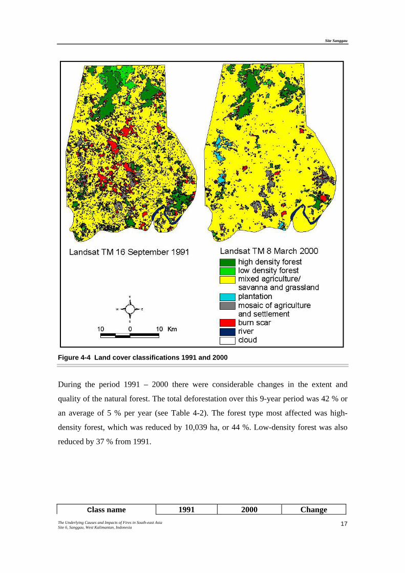
Figure 4-4 Land cover classifications 1991 and 2000
During the period 1991 – 2000 there were considerable changes in the extent and
quality of the natural forest. The total deforestation over this 9-year period was 42 % or
an average of 5 % per year (see Table 4-2). The forest type most affected was high-
density forest, which was reduced by 10,039 ha, or 44 %. Low-density forest was also
reduced by 37 % from 1991.
Class name 1991 2000 Change
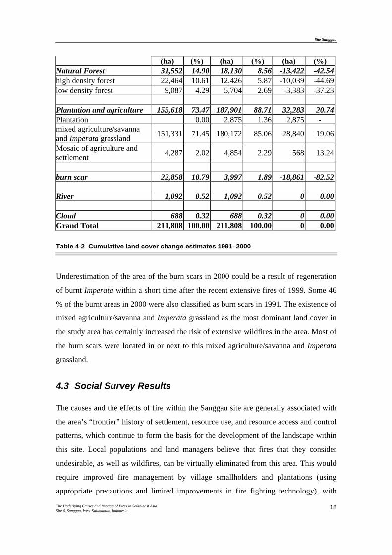
Site Sanggau
The Underlying Causes and Impacts of Fires in South-east Asia Site 6, Sanggau, West Kalimantan, Indonesia
18
(ha) (%) (ha) (%) (ha) (%) Natural Forest 31,552 14.90 18,130 8.56 -13,422 -42.54high density forest 22,464 10.61 12,426 5.87 -10,039 -44.69low density forest 9,087 4.29 5,704 2.69 -3,383 -37.23
Plantation and agriculture 155,618 73.47 187,901 88.71 32,283 20.74Plantation 0.00 2,875 1.36 2,875 - mixed agriculture/savanna and Imperata grassland 151,331 71.45 180,172 85.06 28,840 19.06
Mosaic of agriculture and settlement 4,287 2.02 4,854 2.29 568 13.24
burn scar 22,858 10.79 3,997 1.89 -18,861 -82.52
River 1,092 0.52 1,092 0.52 0 0.00
Cloud 688 0.32 688 0.32 0 0.00Grand Total 211,808 100.00 211,808 100.00 0 0.00
Table 4-2 Cumulative land cover change estimates 1991–2000
Underestimation of the area of the burn scars in 2000 could be a result of regeneration
of burnt Imperata within a short time after the recent extensive fires of 1999. Some 46
% of the burnt areas in 2000 were also classified as burn scars in 1991. The existence of
mixed agriculture/savanna and Imperata grassland as the most dominant land cover in
the study area has certainly increased the risk of extensive wildfires in the area. Most of
the burn scars were located in or next to this mixed agriculture/savanna and Imperata
grassland.
4.3 Social Survey Results
The causes and the effects of fire within the Sanggau site are generally associated with
the area’s “frontier” history of settlement, resource use, and resource access and control
patterns, which continue to form the basis for the development of the landscape within
this site. Local populations and land managers believe that fires that they consider
undesirable, as well as wildfires, can be virtually eliminated from this area. This would
require improved fire management by village smallholders and plantations (using
appropriate precautions and limited improvements in fire fighting technology), with
Site Sanggau
The Underlying Causes and Impacts of Fires in South-east Asia Site 6, Sanggau, West Kalimantan, Indonesia
19
more effective and just allocation and enforcement of land and resource rights. This
understanding of fire as a largely manageable phenomenon contrasts sharply with some
of the more seriously affected sites in this research project.
Social research concerning the Sanggau site has focused on fires during the 1990s, with
background data on settlement and landscape histories from prior periods. Fires that
village residents, plantation managers, and government officials in this area considered
significant in the 1990s had various causes, according to local accounts and narratives
documented in this field research. These included (1) accidental and generally
“unwanted” fire (most often tied to agricultural burning under high risk conditions
without appropriate safeguards, or to “unknown causes” such as local informants’
occasional suggestions of cigarette butt ignition); (2) fire generally recognized as
“legitimate” by all parties; and (3) contested fire (fire considered legitimate or
appropriate by some people but not by others, including [a] burning for plantation land
clearing, and [b] burning in retaliation for land or resource expropriation, or to reassert
customary claims over land previously ceded to plantations).
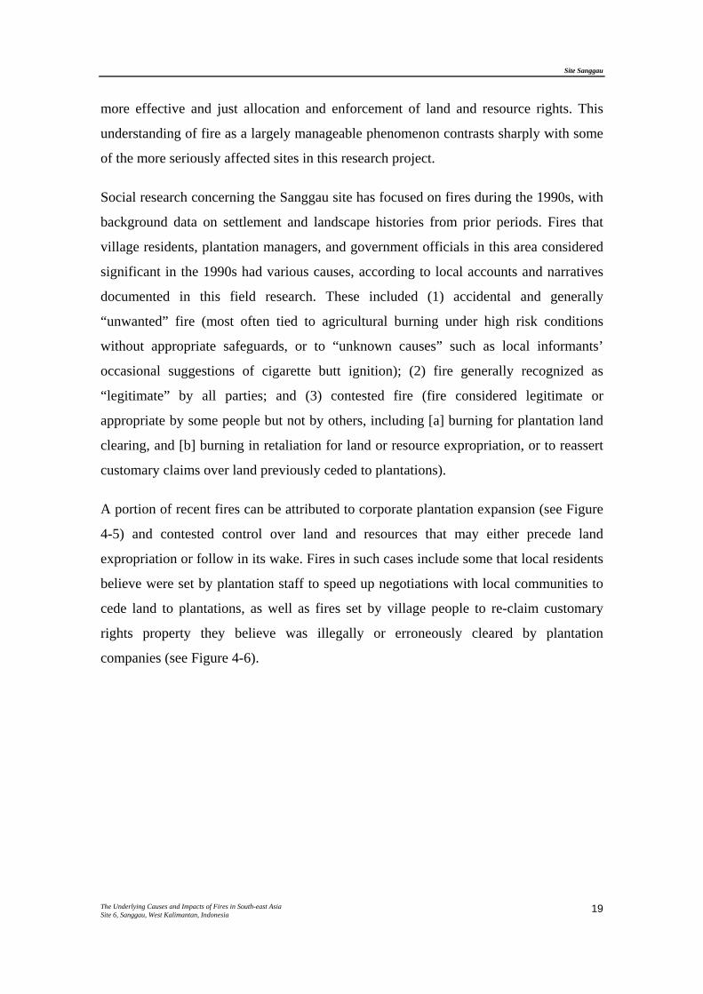
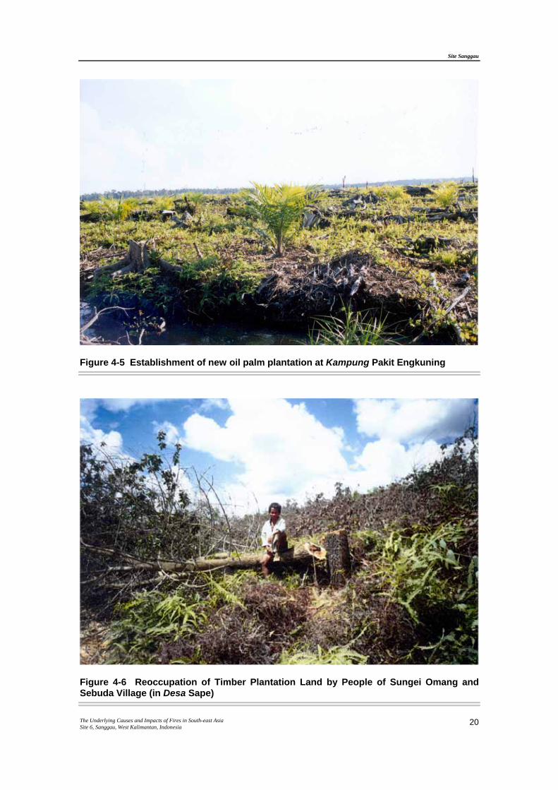
A portion of recent fires can be attributed to corporate plantation expansion (see Figure
4-5) and contested control over land and resources that may either precede land
expropriation or follow in its wake. Fires in such cases include some that local residents
believe were set by plantation staff to speed up negotiations with local communities to
cede land to plantations, as well as fires set by village people to re-claim customary
rights property they believe was illegally or erroneously cleared by plantation
companies (see Figure 4-6).
Site Sanggau
The Underlying Causes and Impacts of Fires in South-east Asia Site 6, Sanggau, West Kalimantan, Indonesia
20
Figure 4-5 Establishment of new oil palm plantation at Kampung Pakit Engkuning
Figure 4-6 Reoccupation of Timber Plantation Land by People of Sungei Omang and Sebuda Village (in Desa Sape)
Site Sanggau
The Underlying Causes and Impacts of Fires in South-east Asia Site 6, Sanggau, West Kalimantan, Indonesia
21
However, others are rooted in “traditional” indigenous agroforestry practices associated
with shifting cultivation. Village residents attributed the majority of the wildfires as
originating from swidden fires, which spread out of control under exceptionally dry
conditions and to ill-guided household decisions to burn under high-risk weather
conditions. This was exacerbated by increasingly fire-prone vegetation, inadequate
safety measures during and immediately after burning, and weakened customary
controls that no longer effectively define strict liability or enforce strong sanctions for
damage due to negligent burning. Village people note customary sanctions imposed for
accidentally burning neighboring agroforestry property, but acknowledge that
enforcement of these sanctions is uneven, weighed in light of perpetrators’ intentions,
and their ability to offer compensation to parties seeking a redress of damages.
Some communities within the study site have recently attempted to document and
reinforce customary rules and sanctions concerning burning, and sanctions for damages
caused by inadequately controlled fires. However, neither customary nor formal
government sanctions respond to burning that damages land that is already seriously
degraded by local standards (grasslands dominated by alang-alang [Imperata
cylindrica], or scrub forest not yet planted with rubber, illipe nuts, fruit trees, or other
economically valuable perennial crops), or that consumes common property old growth
forests, unless perpetrators are from a neighboring community.
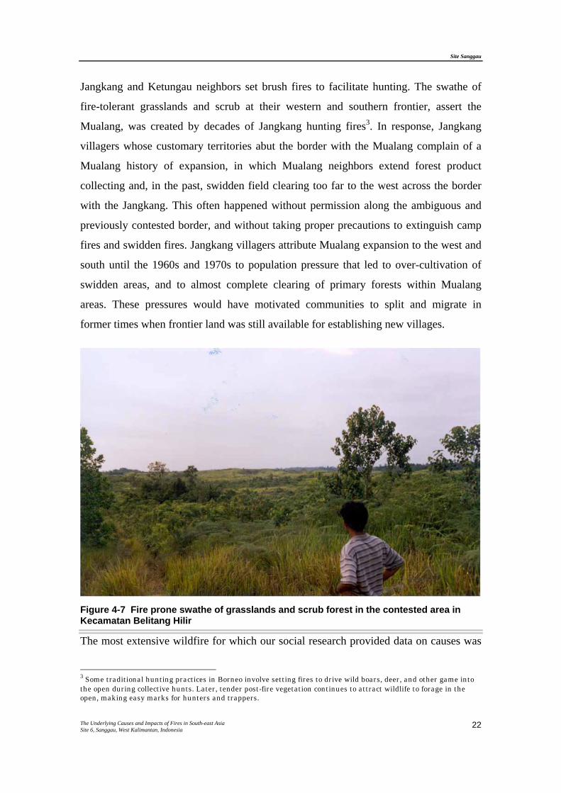
Some of the most extensive fires in this site during the 1990s burned grasslands and
scrub forest in areas that had become increasingly fire-prone since the 1930s, after
repeated burning and wildfires. In effect, this defined the frontier between the Mualang
and their neighbors the Jangkang and Ketungau peoples, along the western border of
what is now Kecamatan Belitang Hilir (Figure 4-7). The historical origins of the swathe
of grasslands and scrub forest that skirts south/north through the middle of this site,
along the customary border between Mualang and Jangkang areas, remains a bone of
contention, but most parties to the debate agree that fire played an important role in its
formation. Much of this area was designated for plantation development since the early
1990s, and some had been a focus of failed government “regreening” efforts before that.
Some local residents, especially in Mualang villages adjacent to Jangkang areas, believe
that wildfire risks are actually lower now than they were a generation ago, when their
Site Sanggau
The Underlying Causes and Impacts of Fires in South-east Asia Site 6, Sanggau, West Kalimantan, Indonesia
22
Jangkang and Ketungau neighbors set brush fires to facilitate hunting. The swathe of
fire-tolerant grasslands and scrub at their western and southern frontier, assert the
Mualang, was created by decades of Jangkang hunting fires3. In response, Jangkang
villagers whose customary territories abut the border with the Mualang complain of a
Mualang history of expansion, in which Mualang neighbors extend forest product
collecting and, in the past, swidden field clearing too far to the west across the border
with the Jangkang. This often happened without permission along the ambiguous and
previously contested border, and without taking proper precautions to extinguish camp
fires and swidden fires. Jangkang villagers attribute Mualang expansion to the west and
south until the 1960s and 1970s to population pressure that led to over-cultivation of
swidden areas, and to almost complete clearing of primary forests within Mualang
areas. These pressures would have motivated communities to split and migrate in
former times when frontier land was still available for establishing new villages.
Figure 4-7 Fire prone swathe of grasslands and scrub forest in the contested area in Kecamatan Belitang Hilir
The most extensive wildfire for which our social research provided data on causes was
3 Some traditional hunting practices in Borneo involve setting fires to drive wild boars, deer, and other game into the open during collective hunts. Later, tender post-fire vegetation continues to attract wildlife to forage in the open, making easy marks for hunters and trappers.
Site Sanggau
The Underlying Causes and Impacts of Fires in South-east Asia Site 6, Sanggau, West Kalimantan, Indonesia
23
over 1,000 ha, and began with a swidden fire that spread out of control in 1991 across
the border area between Menawai Tekam village (Belitang Hilir) and Jangkang. A few
of the fire events accounted for in village people’s narratives were considered to be a
result of arson by one plantation company in an attempt to pressure villagers to cede
customary rights land to the plantation. At least one fire in 1998 was a swidden fire that
villagers in Sungkap customary village (Desa Semadu, in Belitang Hilir) openly set to
protest labor practices by the neighboring timber plantation.
Information on fires that burned commercial timber plantings in Kecamatan Belitang
Hilir, Jangkang, and Mukok was provided in detail by staff of PT Finnantara Intiga.
This joint venture company is developing a pulpwood plantation in Kabupaten Sanggau
and Sintang, with plans to plant 100,000 ha of mainly fast-growing trees in and near its
300,000 ha concession area. PT Finnantara Intiga’s parent corporations are Swedish-
Finnish timber conglomerate Stora-Enso, and Indonesian state forestry corporation PT
Inhutani III. This plantation is remarkable in Indonesia since, from its inception in 1994,
managers promised that its land would be cleared and prepared for planting without
burning (pioneering no-burn techniques now universally required by law), and that no
mature forest or forest gardens would be converted for the plantation (which they would
have been permitted to do in the 1990s for pulp plantation development). Several fires
burned significant parts of the Finnantara plantation in 1997, when drought in Sanggau
was serious, and when Finnantara’s operations there had been in hiatus due to
uncertainty about whether the company would continue operations in Sanggau. In 1999,
Finnantara reported 53 fire events at their Sanggau sites. The estimated costs to the
company from these fires were Rp. 1,200,000 per hectare burned (US$ 150 at mid-1999
exchange rates). Most of the fires were traced to escape shifting cultivation burning by
adjacent smallholders. However, the most serious fire, by assessment of company staff,
was actually caused by a new oil palm plantation that had contracted for land clearing
with members of a local community who had previously ceded parts of their customary
land to the timber plantation, but who were re-clearing the timber plantings to make
way for the new oil palm plantation. Local village populations believed that the new
plantation concession had legitimately taken over the land previously allocated to the
timber plantation. Plantation managers note that this reallocation had not yet been
Site Sanggau
The Underlying Causes and Impacts of Fires in South-east Asia Site 6, Sanggau, West Kalimantan, Indonesia
24
officially approved at all levels, in their reckoning, at the time when the plantation
actually began land clearing operations.
Site Sanggau
The Underlying Causes and Impacts of Fires in South-east Asia Site 6, Sanggau, West Kalimantan, Indonesia
25
5. UNDERLYING CAUSES
Causes of fires in the 1990s are consistent with a broader landscape history of this
“frontier” region in Sanggau. Uncontrolled fires were concentrated along boundaries
that simultaneously represented divisions between Mualang and Jangkang
ethnic/linguistic groups; between Belitang and Mengkiang watersheds; between
Belitang Hilir and Jangkang administrative/political jurisdictions; and between long-
standing Dayak communities and new timber and oil palm plantations. Landscapes in
these boundary lands, where land and resource rights have been contested, have
gradually become more fire-prone over the past century, and especially in the past 25
years.
The Mualang people of Belitang Hilir attribute the swathe of fire-prone grassland and
scrub forest that bisects the Sanggau site to deliberate burning for hunting by the
Jangkang people to the west. Some Jangkang people attribute it to aggressive expansion
of shifting cultivation by the Mualang to the east. The national government originally
targeted this swathe of fire-prone degraded land for “regreening” in the 1970s,
Transmigration in the 1980s, and an Industrial Timber Plantation in the 1990s, with
little understanding of the underlying causes of continuing land degradation and
recurring fires.
Local customary law sanctions for damages to agroforestry property due to negligent
use of fire are being reinforced in many communities. They seem to be effective on a
small scale, but perpetrators never have the resources to restore or compensate for
extensive damages. Village residents have not been eager to help suppress fires on
former customary lands that they have already released to timber or oil palm
plantations, unless those fires threaten their own remaining forest gardens or houses.
Primary forests have been seriously degraded during the 1990s, as competition for
resources between local people and “outsiders” licensed by government authorities has
increased. Yet, in most indigenous communities the total area covered by mixed-species
forest gardens has increased in the last generation, as forest farmers have planted rubber
and fruit trees in former shifting cultivation fields. The forest garden matrix has created
Site Sanggau
The Underlying Causes and Impacts of Fires in South-east Asia Site 6, Sanggau, West Kalimantan, Indonesia
26
relatively fireproof community landscapes.
In a few cases, villagers accuse oil palm plantation staff, or people associated with
them, of deliberately burning villagers’ agroforestry property to coerce village people
into ceding land to the plantation. In a few cases, village shifting cultivators have
allowed their slash fires to spread to commercial plantation areas to protest plantation
labor practices, or land expropriation.
Finally, members of long-standing local communities and managers of new commercial
plantations all believe that fire in this area can be effectively controlled, with provision
of appropriate materials and skills, and with improved and more just institutions
controlling land use and resource access. None believe that the fires their region has
experienced in recent years are an inevitable force of nature, or inevitable consequences
of drought.
Site Sanggau
The Underlying Causes and Impacts of Fires in South-east Asia Site 6, Sanggau, West Kalimantan, Indonesia
27
6. POLICY IMPLICATIONS
Communities where fire research was conducted at the Sanggau site have generally
resisted demands to cede land to timber and oil palm companies, though they are
located within these companies’ concession areas. They have also been relatively free
of fire. These two facts are related. Communities that have been cohesive and confident
in the viability of their own land use systems, and who have maintained or developed
their own customary or locally-based governance institutions, are most likely to be able
to resist land encroachment and expropriation by politically powerful companies. These
same characteristics are also likely to boost the effectiveness of local practices and
institutions to prevent wildfire and to collectively suppress uncontrolled fires.
Villages that have been involved in community empowerment and customary land
rights advocacy activities (including community mapping) have tended to be relatively
capable of voluntarily initiating proactive steps to prevent the spread of future fires.
Any local institutional developments that reinforce community cohesion to facilitate
wildfire prevention and suppression should be encouraged by government recognition,
and assistance if requested, directly or through representative NGOs.
Any effort to prohibit burning by indigenous smallholder shifting cultivators and forest
gardeners will undermine broader fire control efforts. While material assistance to
prevent swidden fires from getting out of control may be effective, in the form of
equipment and training of village fire users, an outright prohibition or cumbersome
government-administered burn permit system would be unlikely to gain acceptance, and
thus would be impossible to enforce.
Government assistance to prevent and suppress fires must be prompt and respectful of
local communities’ existing resources, values, knowledge, and capabilities.
Large enterprises with well-developed infrastructure, such as timber and oil palm
plantations, can be foci for regional efforts to prevent, contain, and suppress wildfires.
Site Sanggau
The Underlying Causes and Impacts of Fires in South-east Asia Site 6, Sanggau, West Kalimantan, Indonesia
28
The wide variety of fire causes in this site, even within areas that are nominally within
the borders of government-granted land development concessions, indicates that
commercial concession-holders should not be assumed to be responsible for all fires on
any land within their concessions, regardless of whether or not they are actively
managing particular areas. Identifying “hotspots” from remote sensing imagery within
the borders of a particular company’s concession should also not be considered
sufficient evidence alone of a company’s illegal burning. If such a system were
consistently imposed, as implied by recent policy reforms, concession-holders wishing
to avoid accusations of illegal burning could legally attempt to prohibit all burning
within their concession boundaries, including burning by customary land holders
cultivating land in traditional manners. If such total responsibility and liability for fire
within a concession is to be imposed, government agencies granting commercial
concessions should delineate boundaries carefully, at appropriate scales, and in
consultation with local communities, to ensure that only areas that the company will
actively manage will be included within the concession. This could only come about
through major reform in the concession-granting process.
Site Sanggau
The Underlying Causes and Impacts of Fires in South-east Asia Site 6, Sanggau, West Kalimantan, Indonesia
29
7. REFERENCES
ADB and BAPPENAS (1999). Causes, extent, impact and costs of 1997/98 fires and
drought. Final report, Annex 1 and 2. Planning for fire prevention and drought
management project. Asian Development Bank TA 2999-INO. Fortech, Pusat
Pengembangan Agribisnis, Margueles Pöyry, Jakarta, Indonesia.
Antikidis, E., Arino, O., Janodet, E. & Achard, F. (1999). Development of a new
method for burned forest area assessment in Borneo during the 1997 exceptional fire
event. In: Proceedings of the FIMP-INTAG International Conference: Data
management and modelling using remote sensing and GIS for tropical forest land
inventory. 26-29 October 1998 (L. Y., B. King, C. Legg and K. Rennolls, eds.), Jakarta,
Indonesia.
Barber, C.V. & Schweithelm, J. (2000). Trial by fire. Forest fires and forestry policy in
Indonesia's era of crisis and reform. World Resources Institute (WRI), Forest Frontiers
Initiative. In collaboration with WWF-Indonesia and Telapak Indonesia Foundation,
Washington D.C, USA.
Bureau of Statistic Tumbang Titi sub-district (1999). Tumbang Titi in Figure, 1999.
Biro Pusat Statistik (BPS) Province, Ketapang, Indonesia.
Dennis, R.A. (1999). A review of fire projects in Indonesia 1982 - 1998. Center for
International Forestry Research, Bogor.
EUFREG (European Union Fire Response Group) (1998). Assessment of the 1997 fires
in Indonesia. European Union, Ministry of Forestry and Estate Crops, Jakarta,
Indonesia.
Hoffmann, A.A., Hinrichs, A. & Siegert, F. (1999). Fire damage in East Kalimantan in
1997/98 related to land use and vegetation classes: Satellite radar inventory results and
proposal for further actions. IFFM-SFMP Report No.1a. MOFEC, GTZ and KfW,
Samarinda, East Kalimantan.
Site Sanggau
The Underlying Causes and Impacts of Fires in South-east Asia Site 6, Sanggau, West Kalimantan, Indonesia
30
Liew, S.C., Lim, O.K., Kwoh, L.K. & Lim, H. (1998). A study of the 1997 forest fires
in South East Asia using SPOT quicklook mosaics. In: 1998 International Geoscience
and Remote Sensing Symposium, 6-10 July 1998, Seattle, USA.
Lillesand, T.M. & Kiefer, R.W. (1994). Remote Sensing and Image Interpretation,
Wiley, USA.
MacKinnon, K., Hatta, G., Halim, H. & Mangalik, A. (1996). The ecology of
Kalimantan, Periplus Editions, Singapore.
Pereira, J.M.C., Chuvieco, E., Beaudoin, A. & Desbois, N. (1997). Remote sensing of
burned areas: a review. In: A review of remote sensing methods for the study of large
wildland fires (E. Chuvieco, ed.), pp. 127-183, Universidad de Alcalá, Alcalá, Spain.
Siegert, F. & Hoffmann, A.A. (1998). Evaluation of the 1998 forest fires in East
Kalimantan (Indonesia) using multitemporal ERS-2 SAR images and NOAA-AVHRR
data. In: Proceedings of the FIMP-INTAG International Conference: Data management
and modelling using remote sensing and gis for tropical forest land inventory. 26-29
October 1998 (L. Y., B. King, C. Legg and K. Rennolls, eds.), Jakarta, Indonesia.
Suyanto, S., Tomich, T. & Otsuka, K. (In press). Land Tenure and farm management
efficiency: The case of smallholder rubber production in customary land areas of
Sumatra. Agroforestry System.
Site Sanggau
The Underlying Causes and Impacts of Fires in South-east Asia Site5, Sanggau, West Kalimantan, Indonesia
31
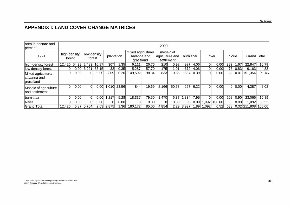
APPENDIX I: LAND COVER CHANGE MATRICES
area in hectare and percent 2000
1991 high density forest
low density forest plantation
mixed agriculture/ savanna and
grassland
mosaic of agriculture and
settlement burn scar river cloud Grand Total
high density forest 12,426 54.39 2,483 10.87 307 1.35 6,111 26.75 210 0.92 927 4.06 0 0.00 382 1.67 22,847 10.79 low density forest 0 0.00 3,221 35.15 32 0.35 5,287 57.70 175 1.91 372 4.06 0 0.00 76 0.83 9,163 4.33 Mixed agriculture/ savanna and grassland
0 0.00 0 0.00 309 0.20 149,592 98.84 833 0.55 597 0.39 0 0.00 22 0.01 151,354 71.46
Mosaic of agriculture and settlement
0 0.00 0 0.00 1,010 23.56 844 19.69 2,166 50.53 267 6.22 0 0.00 0 0.00 4,287 2.02
burn scar 0 0.00 0 0.00 1,217 5.28 18,337 79.50 1,470 6.37 1,834 7.95 0 0.00 208 0.90 23,066 10.89 River 0 0.00 0 0.00 0 0.00 0 0.00 0 0.00 0 0.00 1,092 100.00 0 0.00 1,092 0.52 Grand Total 12,426 5.87 5,704 2.69 2,875 1.36 180,172 85.06 4,854 2.29 3,997 1.89 1,092 0.52 688 0.32 211,808 100.00