site assessment and cleanup of the youngs road small arms ... · county, maine. the small arms...
TRANSCRIPT

U.S. FISH AND WILDLIFE SERVICE MAINE FIELD OFFICE
SPECIAL PROJECT REPORT: FY09-MEFO-1-EC
Site Assessment and Cleanup of the Youngs Road Small Arms Firing Range at Moosehorn NWR
Baring, Washington County, Maine
December 2008

Mission Statement U.S. Fish and Wildlife Service
“Our mission is working with others to conserve, protect, and enhance the nation’s fish and wildlife and their habitats for the continuing
benefit of the American people.”
Suggested citation: Mierzykowski S.E. 2008. Site assessment and cleanup of the Youngs Road small arms range at Moosehorn National Wildlife Refuge. USFWS. Spec. Proj. Rep. FY09-MEFO-1-EC. Maine Field Office. Old Town, ME. 28 pp.

U.S. FISH AND WILDLIFE SERVICE MAINE FIELD OFFICE
SPECIAL PROJECT REPORT: FY09-MEFO-1-EC
Final Report
Site Assessment and Cleanup of the Youngs Road Small Arms Firing Range at Moosehorn NWR
Baring Plantation, Washington County, Maine Study ID: 1261-5C32
Prepared by:
Steven E. Mierzykowski Senior Fish & Wildlife Biologist
Certified Wildlife Biologist
U.S. Fish and Wildlife Service Maine Field Office - Ecological Services
1168 Main Street Old Town, ME 04468
December 17, 2008

- 2 -
EXECUTIVE SUMMARY
A former small arms firing range was located adjacent to Youngs Road in an upland portion of the Baring Division of Moosehorn National Wildlife Refuge, Washington County, Maine. The small arms range had been used for decades by federal, state, and local law enforcement personnel, and refuge staff for weapons qualification and target practice. Although principally used for small arms practice, shell casings and wads at the firing line and on the range floor indicate that shotguns and rifles may have also been used at the site. The range was closed to all shooting activities in 2005. A site assessment of the range floor, berm, and nearby areas was conducted in late 2005. Soil samples from the range berm indicated highly elevated levels of lead (Pb). The maximum Pb concentration detected in soil from the range berm was 12,400 parts-per-million (ppm) on a dry weight basis, a concentration nearly 250 times higher than the normal background Pb level in Maine. Soil samples analyzed for Toxicity Characteristic Leaching Procedures (TCLP) from the berm also exceeded the regulatory criterion and indicated that the Pb-contaminated soil had to be classified as hazardous waste. Only low, near background levels of Pb were detected from the range floor and at the firing line. Surface water and sediment samples collected from a brook about 100 yards from the range did not contain elevated levels of lead. A two-phase soil cleanup of the range berm was conducted in 2008. Approximately 100 tons of Pb-contaminated soil were excavated and disposed off-site at a licensed hazardous waste facility in New York. Following excavations, two rounds of confirmatory soil and TCLP samples were submitted for laboratory analyses. The average Pb levels in all final soil and TCLP samples were 52 ppm (range: 9.9 – 164 ppm) and 2.2 ppm (range: 0.40 – 3.98 ppm), respectively. These levels are below the State of Maine remedial action guidelines of 375 ppm for Pb in soils and 5.0 ppm for Pb in TCLP solution. The range berm was re-graded and will be allowed to naturally re-vegetate. The project was completed in December 2008 and the final cost was approximately $96,600.

- 3 -
PREFACE This report provides documentation of a refuge site assessment and cleanup to remove lead-contaminated soil from a former small arms range at Moosehorn National Wildlife Refuge in Baring Plantation, Maine. The project identification number is 53411-1261-5C32. Questions, comments, and suggestions related to this report are encouraged. Written inquiries should refer to report number FY09-MEFO-1-EC and be directed to:
Steve Mierzykowski U.S. Fish and Wildlife Service
1168 Main Street Old Town, Maine 04468
The U.S. Fish and Wildlife Service requests that no part of this report be taken out of context, and if reproduced, the document should appear in its entirety. This report complies with the peer review and certification provisions of the Information Quality Act (Public Law 106-554, Section 515). ACKNOWLEDGEMENTS Funding for this work was provided through the USFWS refuge cleanup program administered by the Division of Environmental Quality in Arlington, Virginia. Additional funding to complete the project was secured by Jeff Momot, R5 Refuges. This project could not have been completed without the assistance of Bill Kolodnicki, Mike Krug, Peggy Sawyer, Lori Lauer, and Andy Weik from Moosehorn NWR; Don Lima from R5 Refuge Law Enforcement; Chris Murphy from Region 5 CGS; Timothy Fannin Ph.D., from R5 Ecological Services; Dave Washburn from R5 Engineering (retired); Jeff Momot from R5 Refuges; and Ed Vigneault from the Maine Department of Environmental Protection. Peer review of this report was provided by Timothy Fannin Ph.D. and Susan Lingenfelser Ph.D., USFWS. Editorial review was provided by Wende Mahaney of USFWS.

- 4 -
TABLE OF CONTENTS
Page Title Page 1 Executive Summary 2 Preface and Acknowledgements 3 Table of Contents 4 Lists of figures, tables, photos, and appendices 5 Acronyms and Abbreviations 6 1. Background 7 2. Site Assessment 8 3. Cleanup goals 9 4. Range Cleanup 9 4.1 Round 1 4.2 Round 2 4.3 Cleanup results 5. Expenditures 11 6. Lessons Learned 12 6.1 Intra-agency coordination 6.2 Inter-agency coordination 6.3 XRF screening 6.4 Soil weight vs. soil volume 6.5 Scope of services 6.6 Smooth-edge bucket 6.7 Diesel range organics 6.8 Document retention 6.9 Contingency funds 6.10 Off-site disposal vs. on-site stabilization 7. Summary and Management Recommendations 15 8. Literature Cited 17 List of Figures List of Tables List of Photos List of Appendices

- 5 -
List of Figures Figure 1. Location of Youngs Road range Figure 2. Schematic of XRF sampling grid and screening results Figure 3. Sampling locations, sample codes, and laboratory analytical data – Round 1 Figure 4. Sampling locations, sample codes, and laboratory analytical data – Round 2 List of Tables Table 1. MEDEP XRF Pb screening data for Moosehorn NWR Table 2. Sample codes, locations, and rationale for sampling (laboratory analyses) Table 3. Results of laboratory analyses of soil and TCLP samples – Rounds 1 and 2 List of Photos Photo #1. Range before cleanup - 2004 Photo #2. Range after cleanup - 2008 Photo #3. Sampling locations for 2005 site assessment Photo #4. Bullets on face of berm Photo #5. Smooth-edge ditch bucket Photo #6. Loading dump truck Photo #7. Loading transport truck Photo #8. Lined and loaded transport truck List of Appendices (included in a separate pdf; 122 pp. 7.2 MB) Appendix A – Terranear PMC. Site Assessment Report. 2/09/06. Appendix B – Katahdin Analytical Services. Analytical Report SB4697. 9/04/08. Appendix C – Katahdin Analytical Services. Analytical Report SB5603. 10/13/08. Appendix D – Waste Disposal Documentation
Generator’s Hazardous Waste Profile Sheet, 8/15/08
Uniform Hazardous Waste Manifest – Tracking No. 002982303 JJK, 8/21/08 Land Disposal Notification and Certification Form – Manifest Doc. No. 002982303JJK Certificate of Disposal #321101 – Shipping Doc. No. 002982303JJK, 9/08/08
Uniform Hazardous Waste Manifest – Tracking No. 002982312 JJK, 8/21/08 Land Disposal Notification and Certification Form – Manifest Doc. No. 002982312JJK Certificate of Disposal #321100 – Shipping Doc. No. 002982312JJK, 9/08/08
Uniform Hazardous Waste Manifest – Tracking No. 002982308 JJK, 10/02/08 Land Disposal Notification and Certification Form – Manifest Doc. No. 002982308JJK Certificate of Disposal #323551 – Shipping Doc. No. 002982308JJK, 10/22/08
Uniform Hazardous Waste Manifest – Tracking No. 002982306 JJK, 10/02/08 Land Disposal Notification and Certification Form – Manifest Doc. No. 002982306JJK Certificate of Disposal #323550 – Shipping Doc. No. 002982306JJK, 10/22/08
Appendix E - CWM Chemical Services. Model City, NY.
Waste Analytical and Stabilization Reports – 9/04/08, 10/20/08

- 6 -
Acronyms and Abbreviations Ag silver As arsenic Ba barium Cd cadmium CGS Contracting and General Services (USFWS) Cr chromium DEQ Division of Environmental Quality (USFWS) DRO diesel range organics dw dry weight ES Ecological Services (USFWS) FY fiscal year Hg mercury MB megabyte MEDEP Maine Department of Environmental Protection MEFO Maine Field Office – Ecological Services (USFWS) mg/kg milligram per kilogram (parts-per-million) NWR National Wildlife Refuge Pb lead pdf portable document format pH negative logarithm of the hydrogen ion concentration ppm parts-per-million QA/QC quality assurance / quality control RAG Remedial Action Guideline (MEDEP) RO Regional Office (USFWS) Sb antimony Se selenium TCLP toxicity characteristic leaching procedure USFWS U.S. Fish and Wildlife Service WGS World Geodetic System WO Washington Office (USFWS) XRF x-ray fluorescence spectrometer

- 7 -
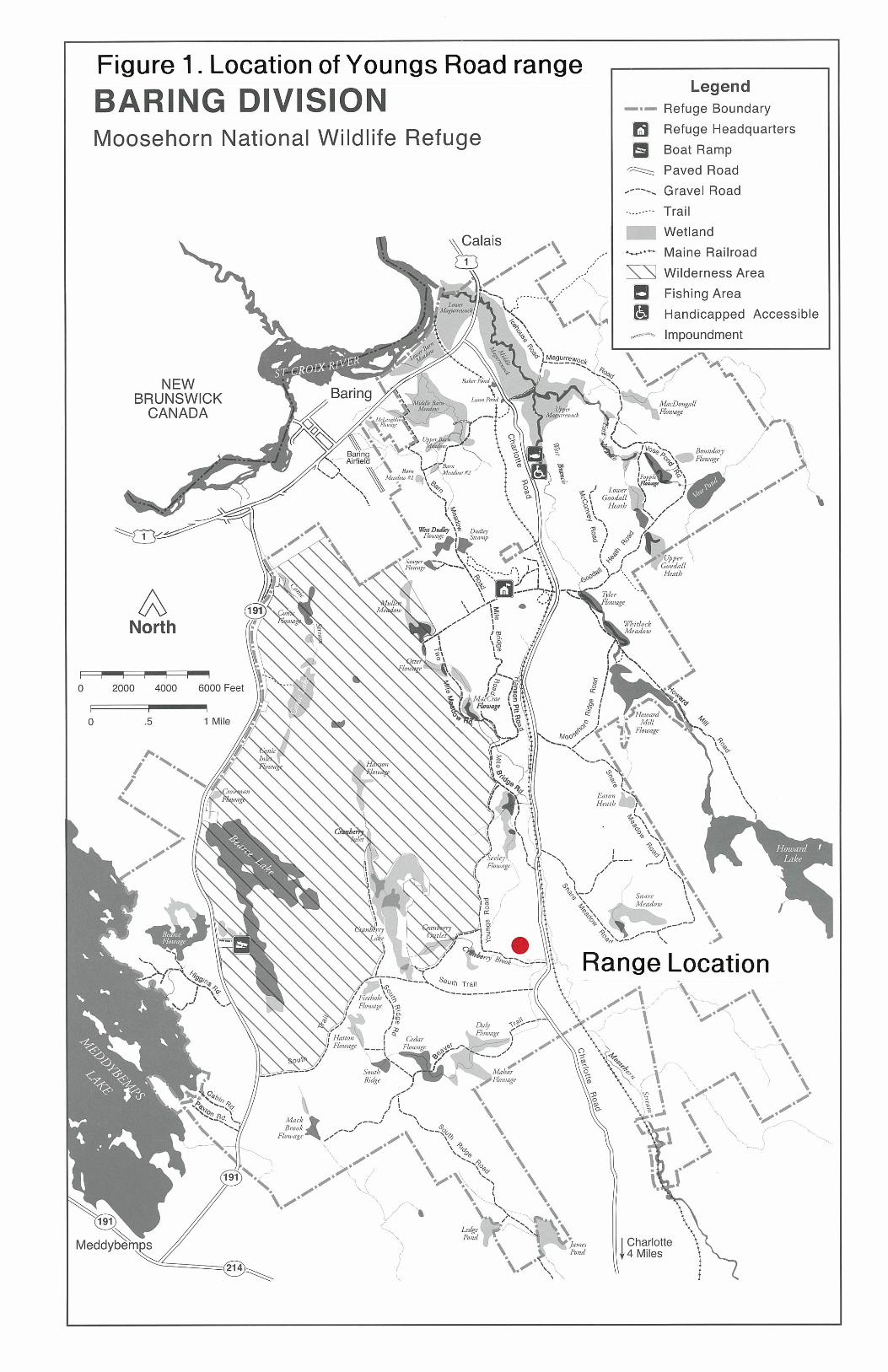
1. Background A former small arms firing range was located adjacent to Youngs Road in an upland portion of the Baring Division of Moosehorn National Wildlife Refuge, Washington County, Maine (Figure 1). Coordinates for the range are North 45o 04’ 08.1” / West 067o 16’ 32.8” – map datum WGS 84. The small arms range had been used for decades by federal, state, and local law enforcement personnel, and refuge staff for weapons qualification and target practice (Photo #1). Although principally used for small arms practice, shell casings and wads at the firing line and on the range floor indicate that shotguns and rifles may have also been used at the site. The range is now closed to all shooting activities. The Youngs Road small arms range is within an area dominated by softwoods and mixed hardwoods. The range site is approximately 100 yards upgradient from Cranberry Brook. The purpose of this Refuge Cleanup Project was to characterize the nature and extent of lead (Pb) contamination at the firing range site during a site assessment, and to remediate and restore the site. The principal contaminant of concern at the site is Pb. Lead is a particularly hazardous element for fishery and wildlife resources. The ecological and toxicological aspects of Pb in the environment have been extensively studied and reported in the scientific literature (Eisler 1988). In soils, Pb concentrates in organic-rich surface horizons and may be mobilized through exposure to acidic rainwater and groundwater (EPA 2005). Lead is neither essential nor beneficial to living organisms, and measured effects to biota are adverse (Eisler 1988). Lead is toxic in most of its chemical forms. In plants, excessive Pb levels can cause growth inhibition, as well as reduced photosynthesis, mitosis, and water absorption (Demayo et al. 1982). Lead is toxic to all phyla of aquatic biota (Eisler 1988). Long-term exposure to Pb causes severe spinal deformities and reduced weight in brook trout (Holcombe et al. 1976). In animals, Pb is a nonspecific toxicant at the molecular level and inhibits the activities of many enzymes necessary for normal biological functions (Pattee and Pain 2003). Mortality, neurological disfunctions, immune suppression, and reproductive impairment are documented effects of Pb exposure in birds (Kendall et al. 1996). Lead can be incorporated into the body by inhalation, ingestion, dermal absorption, and placental transfer to the fetus. An accumulative metabolic poison, Pb affects behavior as well as the vascular, nervous, renal, and reproductive systems. Lead is known to be fetotoxic and teratogenic. Ingestion of Pb-contaminated soil and prey are principal pathways for wildlife exposure (Kendall et al. 1996, Pattee and Pain 2003). Lethal or sublethal effects of Pb gunshot and bullets in birds depends on shot retention, Pb absorption and distribution within the body and other factors including age, sex, environment and diet (Pattee and Pain 2003). The purpose of this site assessment and refuge cleanup was to characterize and remove a potential contaminant source on a national wildlife refuge.

- 8 -
2. Site Assessment On November 17 and 18, 2005, personnel from Terranear PMC and USFWS collected soil, sediment, and surface water samples for the site assessment of the Youngs Road small arms range. A total of 24, sifted, surface soil and nine subsurface soil samples were collected from the range floor and berm using a decontaminated hand auger (Photo #3). Two composite soil samples, one composite from the range floor and one composite from the berm, were collected for Toxicity Characteristic Leaching Procedure1 metals analyses. Surface water and sediment samples were collected in three Cranberry Brook locations - adjacent to the site, upstream, and downstream. Duplicate, rinsate, and field blanks were also collected for quality assurance/quality control (QA/QC). All soil, surface water, and sediment samples were analyzed for Pb and antimony (Sb). The pH was determined in ten soil samples. Sample and QA/QC analyses were conducted by Katahdin Analytical Services in Westbrook, Maine. Lead and bullet fragments were not observed during visual inspections of the surface soils collected from the range floor or in surface and subsurface soils from the toe of the range berm. Bullet fragments were clearly visible in the surface samples from bore holes across the middle of the berm (Photo #4), but no fragments were found in subsurface samples. No bullet fragments were observed in the soil boring from the top of the berm. The Youngs Road small arms range is approximately 225 feet from Cranberry Brook and no defined drainage pathway to the waterway was observed. A slightly elevated gravel road and woodlands comprised of mixed hardwoods and softwoods occur between the brook and range site. Based on the microtopography and soil types at the range site, it appeared unlikely that contaminant transport to the brook would occur via overland flow. Surface water and sediment samples were collected in the brook nearest to the site, at a location approximately 300 feet upstream, and at a point 150 feet downstream. The site assessment determined that 1) Pb-contaminated soil was present at the site, 2) the soils were categorized as hazardous (i.e., failed Toxicity Characteristic Leaching Procedures, TCLP), and 3) that slightly elevated levels of diesel range organics occur (> 10 mg/kg). In the SI, Pb in soil samples ranged from 1,080 to 12,400 mg/kg, dry weight, and Pb in TCLP samples ranged from 0.02 to 128 mg/L. Migration of range-related contaminants to Cranberry Brook was not found. The site assessment determined that approximately 30 to 50 cubic yards of hazardous soil would need to be excavated from the range berm, transported off-site, and disposed at a licensed out-of-state hazardous waste facility. After soil excavation, the site would be re-graded and allowed to re-
1 TCLP is the measure of a contaminant in solution, in this case Pb, to simulate leaching in the environment or through a landfill. Under certain pH or other environmental conditions, Pb in soil will change into a liquid phase and mobilize into groundwater or nearby surface waters. If Pb leaches from soil above the regulatory criterion of 5 mg/L, the soil is considered a hazardous material and triggers additional disposal and regulatory conditions. Soil concentrations of Pb in this report are expressed as mg/kg and TCLP solution concentrations of Pb are expressed as mg/L.

- 9 -
vegetate through natural means. Confirmatory post-excavation sampling (Pb and diesel range organics, DRO) would also be required. The Terranear PMC site assessment report is located in Appendix A. 3. Cleanup Goals The Maine Department of Environmental Protection (MEDEP) Remedial Action Guidelines (RAG) for Pb in soils in a residential setting (375 mg/kg, dw) and for TCLP (5 mg/L) were the cleanup goals for the project (MEDEP 1997). 4. Range Cleanup Based on the results of the site assessment, additional funds were sought through the USFWS Division of Environmental Quality for a refuge cleanup. A Scope of Services was prepared by USFWS with the input of the MEDEP. After two rounds of solicitation (see Section 5 Expenditures), a contract was awarded for the cleanup.
4.1 Round 1. The first segment of the cleanup began on August 20, 2008. Equipment and personnel were mobilized at the site and a safety briefing was conducted. All personnel were in compliance with hazardous waste training and medical monitoring requirements. A soil stockpile area lined with geotextile fabric and polyethylene sheets was placed on a nearby field approximately 50 yards from the range. All excavation and sampling equipment was decontaminated with Alconox soap, tap water, and deionized water. A decontamination area was set up adjacent to the excavation area. All personnel in the work area wore hardhats, Tyvek suits, overboots, and nitrile or Solvex gloves. Contractors working on the berm during excavation and offloading of soil to the stockpile area or transport trucks wore cartridge respirators.
An excavator with a smooth-edge ditch bucket was used to excavate the first one foot layer of the range berm (Photo #5). Material was placed into a dump truck (Photo #6), transported to the soil stockpile area, and dumped onto the geotextile fabric. Following the first soil lift, USFWS and MEDEP personnel collected eight soil samples (each approx. 500 grams) from the range berm at a depth of 0 to 6 inches for screening with a portable x-ray fluorescence spectrometer (XRF). The XRF sample locations were selected using a pre-determined grid pattern of eight 8’ x 8’ cells (Figure 2). XRF soil samples were placed in labeled, polyethylene bags and analyzed by MEDEP personnel for Pb. Each soil sample was screened twice with the soil bag being shaken between screenings. After the first lift, soil cleanup levels based on the XRF results were exceeded in five of the 8’ x 8’ cells. Three cells had XRF concentrations well below the target cleanup level (Figure 2). A second foot of soil was removed from the five cells with elevated levels. No further excavation was done in the three cells below the target cleanup level. After the second lift, soil samples were collected from the five cells excavated to the two foot depth and analyzed with the XRF. Three cells were still above cleanup levels and a third

- 10 -
foot of soil was removed from those areas. XRF results are listed in Table 1 and Figure 2. On August 21, two trucks from the waste disposal facility arrived on-site. Three trucks were expected, but due to miscommunication between the contractor and hazardous waste facility only two trucks arrived. Soil was transferred from the stockpile area into the two trucks and transported off-site (Photos #7 and #8). Traffic control was provided by Moosehorn NWR staff and R5 Refuges Law Enforcement personnel. Due to highway weight limitations, the entire soil stockpile could not be loaded onto the trucks and a portion of the pile was left at the stockpile area and covered with polyethylene sheets. Manifests and documents associated with the first round of soil transport to the hazardous waste facility are located in Appendix D. After the excavation, nine soil samples and two TCLP samples were collected from the range berm by the contractor and USFWS personnel. Sampling locations were determined by MEDEP staff. At each location (Figure 3), surficial soil samples were collected using a decontaminated stainless steel spoon. For soil analyses, there were four surficial grabs per location. For TCLP analyses, there were six surficial grabs per location. All sampling equipment was decontaminated with Alconox soap, tap water, and deionized water between individual sample collections. Soil and TCLP samples were placed in chemically-clean jars, and shipped overnight under chain-of-custody procedures for laboratory analysis (Figure 3). The Katahdin Analytical Services report for the first round of soil and TCLP sampling is located in Appendix B. Chain-of-custody documentation and laboratory QA/QC information are also included in Appendix B. The analytical report indicated that three soil samples and one TCLP sample exceeded the cleanup goals (Table 3) and additional excavation would be required. R5 CGS and R5 Refuges were able to acquire additional funds to amend the cleanup contract so the project could be completed (See Section 5 Expenditures).
4.2 Round 2. The second segment of the project began on October 2, 2008. Mobilization and decontamination procedures were identical to the first round. Additional soil was removed from the top of the berm and to other portions of the berm that exceeded cleanup goals. MEDEP personnel were not available for the second round of excavation and none of the samples were screened with an XRF. Two trucks from the hazardous waste facility arrived the same day and the entire soil stockpile was loaded and transported off-site. Traffic control was provided by Moosehorn NWR personnel. Manifests and documents associated with the second round soil transport to the hazardous waste facility are located in Appendix D. The soil from the second round required additional stabilization by the hazardous waste facility and additional costs were incurred (See Section 5 Expenditures and Appendix E). After the excavation, three soil samples and one TCLP sample were collected from the range berm by the contractor and USFWS personnel. Sampling locations were selected by USFWS staff based on previous consultations with MEDEP. At each location (Figure 4), surficial soil samples were collected using a decontaminated stainless steel spoon. Individual samples were sieved with a #12 (1.7 mm mesh) decontaminated stainless steel

- 11 -
sieve into a decontaminated stainless steel pail. The sieved material was thoroughly mixed before a sample was collected. For soil analyses, there were four surficial grabs per location. For TCLP analyses, there were six surficial grabs per location. All sampling equipment was decontaminated with Alconox soap, tap water, and deionized water between individual sample collections. Sieved soil and TCLP samples were placed in chemically-clean jars, and shipped overnight under chain-of-custody procedures for laboratory analysis (Figure 4). The Katahdin Analytical Services report for the second round of soil and TCLP sampling is located in Appendix C. Chain-of-custody documentation and laboratory QA/QC information are also included in Appendix C. All samples from the second round were below cleanup goals (Figure 4, Table 3).
4.3 Cleanup results. All cleanup goals were met. After the excavations, the maximum recorded Pb content in soil was 168 mg/kg in sample NWR 8 (Round 1) and the highest TCLP amount was 3.98 mg/L in sample TCLP Shallow (Round 1). The mean Pb levels in all final soil and TCLP samples were 52.0 mg/kg and 2.19 mg/L, respectively. Final soil and TCLP results from the analytical laboratory are listed in Table 3. 5. Expenditures FY05 - Approximately $18,000 was used for contract development, the site assessment contract ($14,990), intra-agency coordination, and USFWS oversight. FY06 - Approximately $4,000 was used for review of the site assessment report, intra-agency coordination, a meeting (6/12/06) and site visit (10/20/06) with MEDEP staff, development of a cost estimate for site remediation and restoration, and preparation of the FY06 progress report and FY07 cleanup proposal. FY07 - In June 2006, a cleanup proposal requesting $43,500 of FY07 funds was submitted to the RO and WO. After a reduction for R5 Refuges overhead, funds in the amount of $40,527 were received in FY07 by the Maine Field Office – Ecological Services. A Statement of Services was prepared by R5 Engineering, ES-Maine Field Office, and Moosehorn NWR in consultation with the MEDEP. R5 Contracting and General Services (CGS) posted a solicitation for services (No. 501817Q115) on June 19, 2007 and the contract was awarded on August 21, 2007 in the amount of $22, 015 to a contractor from Maine. In pre-construction conference calls with the contractor, however, it was determined that the contractor had never worked on hazardous waste projects, did not understand State of Maine or Federal hazardous waste transportation and disposal laws, and significantly underbid the contract. After consultations between R5 CGS and the Solicitor, it was decided to withdraw the contract, reimburse the contractor for costs expended (approx. $3,000), clarify and revise the Statement of Services, and re-advertise the solicitation. A second solicitation for quotes was issued on November 20, 2007. FY08 - Quotations for the second contract solicitation were due December 12, 2007. The contract (No. 501818C067) was awarded to an experienced hazardous material cleanup

- 12 -
firm from Massachusetts for $38,385.00. Several conference calls were held with the contractor and MEDEP prior to the cleanup. Refuge personnel brought the contractor to the site for a scoping visit. The excavation portion of the project was begun on August 20, 2008. The contract was modified on September 26, 2008 for the additional amount of $24,833.83. These funds covered the second round of excavation, off-site disposal, and laboratory analyses. FY09 – Approximately $3000 was obtained by R5 CGS and R5 Refuges to cover the costs for additional stabilization costs at the hazardous waste facility. MEFO also requested $3300 in FY09 funds for final report preparation. Approximate total cost of the project: $96,600. 6. Lessons Learned
6.1 Intra-agency Coordination. Coordination among USFWS divisions (e.g., CGS, Refuges, Engineering, Ecological Services, Moosehorn NWR) was good. Close contact was accomplished through emails, conference calls, site visits, and telephone calls. Coordination and collaboration could be improved. 1) CGS was the contracting officer and the primary contact with the contractor. There were a couple of instances when Moosehorn NWR and MEFO were not notified of exchanges or decisions between CGS and the contractor or the hazardous waste disposal facility for several days or weeks. Some information could not be shared immediately by CGS with the refuge or MEFO due to confidentiality requirements and government procedures associated with contracts. So, one lesson is for ES personnel coordinating refuge cleanup projects to maintain regular contacts with CGS to find out what decisions have been made so that all parties are kept informed. 2) The involvement of R5 Engineering was sporadic. Initially, Dave Washburn, a R5 engineer, was a full participant in the project. He was experienced in refuge cleanups, including small arms range cleanups, and was instrumental during the scoping phase of the contact. However, after his retirement, involvement by R5 engineers in the project was minimal. Participation of USFWS engineers, particularly staff with experience in other refuge cleanups, for the duration of the project would have been helpful.
6.2 Inter-Agency Coordination. Early notification and involvement of the Maine DEP was a great benefit to the project. Diane McKenzie, the first MEDEP contact, left the agency early in the process but during her brief involvement, she was extremely helpful in tailoring the project to meet MEDEP needs. The next MEDEP contact assigned to the project was very experienced with these types of cleanup and particularly helpful during the development of the scope of services and later phases of the project. The MEDEP’s willingness to employ their XRF unit was extremely helpful in characterizing the extent of contamination and limiting the amount of material for off-site disposal. The value of having close contact and coordination with MEDEP early in the cleanup process and during its execution cannot be overstated.

- 13 -
6.3 XRF Screening. As noted above, the XRF unit was important in directing the
first round of the excavation and identifying the material that needed off-site disposal. There are limitations, however, with XRF:
XRF determines total contaminant mass including moisture. Since the Maine
Remedial Action Guideline criterion for lead is expressed on a dry weight basis, the XRF with its wet weight measurements is useful primarily as a screening tool. MEDEP estimates that total solids (dry mass) of soil samples run approximately 80 to 90% (E. Vignealt. 2008. Personal communication). So, when comparing the XRF results to the RAG criterion, only a general comparison can be made due to the difference in wet weight versus dry weight expressions.
During the XRF screening of soil layers, Pb levels in our samples were either at
extremely high concentrations (i.e., needed to be excavated) or at extremely low concentrations (i.e., no further excavation required) compared to the 375 mg/kg cleanup criterion. Consequently, we were never in a position to dig or not dig because the XRF results were around 375 mg/kg. It is an important issue, however, that others must consider when using XRF and have samples approaching the cleanup criterion. Our position in the field was that if the XRF showed Pb levels at or slightly below the 375 mg/kg criterion, we would have excavated additional material. The take-home message is that XRF is primarily a screening tool.
Finally, experience in using the XRF is essential. Although the MEDEP operator
was certified on the XRF unit, excavation was delayed for over an hour during the first round when the operator had difficulty re-setting the unit.
6.4 Soil weight vs. volume. In the estimation of the amount of soil that would need to be remediated, soil volume was determined (e.g., 30 to 50 cubic yards) during the site assessment. Waste disposal facilities and transport trucks, however, deal in soil weight. Our estimate of disposal and transport costs and number of trucks required for the cleanup would have been more accurate if we had converted soil volume to soil weight. According to the contractor, this could have been accomplished by weighing a couple of five gallon buckets of the soils from the berm.
6.5 Scope of Services. Our original Scope of Services could have been written better. In hindsight, we should have required sieving of samples destined for laboratory analysis and tighter requirements on contractor eligibility (e.g., past experience with hazardous waste disposal operations, references). In the draft Scope of Services, R5 Engineering suggested that contractors be required to screen Pb from soils for recycling. After consulting with potential contractors, the cost of screening large amounts of soil was outweighed by the Pb recovery benefit. Subsequently, the requirement for sieving and recycling Pb was dropped from the final Scope of Services.
6.6 Smooth-edge ditch bucket. During the development of the Scope of Services, MEDEP strongly suggested the use of a smooth-edge bucket on the excavator (Photo #5).

- 14 -
The rationale was that excavation of specific soil layers (e.g., 1 foot, 2 foot, etc.) could be accomplished with greater precision with a smooth-edged bucket rather than a tooth-edged bucket. In the field, the utility of the smooth-edge bucket was clearly demonstrated, particularly when under the control of an experienced heavy equipment operator. The soil lifts at one-foot intervals across the face of the berm were very precise and spillage during offloading to the dump truck and to the transport trucks was negligible.
6.7 Diesel Range Organics (DRO). DRO measurements in soil samples were required by MEDEP. DRO includes a range of petroleum hydrocarbon products such as diesel fuels. While DRO may be a contaminant of concern at large, established firing ranges such as the ones found at military installation, it was never fully explained to USFWS why the analyses were necessary for a remote, walk-in firing range like the Youngs Road small arms range. These DRO analyses only added to the cost of the project, albeit only a small amount (~ $1,200) relative to the cost of the entire project.
6.8 Document Retention. Compiling all the documents associated with the project was a bit of a challenge. Some documents are received by CGS as the contracting office, others are received by Moosehorn NWR as the waste generator, and others are received by Ecological Services as the project coordinator and MEDEP point-of-contact. It is important that all USFWS activities maintain close coordination throughout the project to ensure all records are kept and shared. A “master” project file should be maintained at the refuge headquarters.
6.9 Contingency Funds. A generous contingency allocation should be allowed in all refuge cleanup proposals. During this project several unanticipated costs occurred. These costs included cancelling the original contract and paying the expenses of the first contractor, the second round of excavation and transport, a MEDEP hazardous waste fee, and additional stabilization costs by the hazardous waste disposal facility. Considerable effort was expended locating and obtaining authorizations for additional funds for these unanticipated costs. A contingency fund allocation in the refuge cleanup budget would have eliminated the need to search for these additional funds. The doubling of fuel costs between the time of the final cleanup contract being issued and the time of the actual cleanup (about 8 months) was a point of great consternation for the contractor. This was an unanticipated cost for the contractor, but one that caused USFWS concern should the contractor have decided to default on the contract.
6.10 Off-site disposal vs. on-site stabilization. Fewer and fewer hazardous waste disposal facilities will accept Pb-contaminated soil. During the development of the Scope of Services, several potential contractors asked why we were not considering on-site stabilization. Other field office and refuges considering cleanups of small arms ranges should consider the logistical considerations and costs of off-site disposal versus on-site stabilization.

- 15 -
7. Summary and Management Recommendations A former small arms firing range was located adjacent to Youngs Road in an upland portion of the Baring Division of Moosehorn National Wildlife Refuge, Washington County, Maine. The small arms range had been used for decades by federal, state, and local law enforcement personnel, and refuge staff for weapons qualification and target practice. Although principally used for small arms practice, shell casings and wads at the firing line and on the range floor indicate that shotguns and rifles may have also been used at the site. The range was closed to all shooting activities in 2005. A site assessment of the range floor, berm, and nearby areas was conducted in late 2005. Soil samples from the range berm indicated highly elevated levels of Pb. The maximum Pb concentration detected in soil from the range berm was 12,400 mg/kg, a concentration nearly 250 times higher than the normal background Pb level in Maine. Soil samples analyzed for TCLP from the berm also exceeded the regulatory criterion (5 mg/L) and indicated that the Pb-contaminated soil had to be classified as hazardous waste. Only low, near background levels of Pb were detected from the range floor and at the firing line. Surface water and sediment samples collected from Cranberry Brook about 100 yards from the range did not contain elevated levels of lead. A two-phase soil cleanup of the range berm was conducted in 2008. Approximately 100 tons of Pb-contaminated soil were excavated and disposed off-site at a licensed hazardous waste facility in New York. Following excavations, two rounds of confirmatory soil and TCLP samples were submitted for laboratory analyses. The mean Pb levels in all final soil and TCLP samples were 52.0 mg/kg (range: 9.9 – 164 mg/kg) and 2.19 mg/L (range: 0.40 – 3.98 mg/L), respectively. These levels are below the respective State of Maine remedial action guidelines of 375 mg/kg and 5.0 mg/L. The range berm was re-graded and will be allowed to naturally revegetate (Photo #2). The project was completed in December 2008 and the final cost was approximately $96,600. Management recommendations include: ● The access trail to the range from Youngs Road should be blocked off with large boulders to discourage any new shooting at the former range. The range floor in front of the berm should be allowed to revegetate or planted with shrubs in 2009 to further discourage use of the range. ● The range berm on Youngs Road at Moosehorn NWR is no different from hundreds of other berms and gravel pits used for recreational target shooting in Maine. The striking aspects of this cleanup were the amount and severity of lead contamination and the high cost associated with removing the contamination from such a small area. Refuge managers in Maine should use landscaping techniques and administrative controls to make these berms and pits less attractive to shooters.
- 16 -
● Due to the expense of this site assessment and cleanup, any target shooting on NWRs should be carefully re-evaluated. If shooting ranges are required for law enforcement personnel, the ranges should be designed with easily-cleaned backstops, use “green” ammunition, and employ best management practices (EPA 2005). Several NWRs do not allow target shooting. In light of the cost and expense of this cleanup project, the prohibition of recreational target shooting on NWRs appears to be an attractive compatibility determination. ● Fewer licensed hazardous waste disposal facilities appear willing to take Pb-contaminated soils. If other refuges attempt small arm range cleanups, additional investigation is recommended involving the use and costs of on-site soil stabilization methods. These stabilization methods use fly ash, phosphorus, cement, or other materials and may also involve soil screening to remove bullets and Pb fragments (Gavaskar et al. 1996, Colorado DPHE 2005, EPA 2005). These on-site treatment options, however, should first be discussed with the appropriate state environmental protection regulatory agency.

- 17 -
8. Literature Cited Colorado DPHE (Department of Public Health and Environment). 2005. Corrective action at outdoor shooting ranges guidance document. Hazardous Materials and Waste Management Division. Denver, CO. 12 pp. Demayo, A., M.C. Taylor, K.W. Taylor, and P.V. Hodson. 1982. Toxic effects of lead and lead compounds on human health, aquatic life, wildlife plants, and livestock. CRC Crit. Rev. Environ. Control 12:257-305. Eisler, R. 1988. Lead hazards to fish, wildlife, and invertebrates: a synoptic review. U.S. Fish & Wildl. Serv. Biol. Rep. 85(1.14). 134 pp. EPA (U.S. Environmental Protection Agency). 2005. Best management practices for lead at outdoor shooting ranges. EPA Region 2. EPA-902-B-01-001. Gavaskar A.R., J.L. Means, J.C. Heath and B. Nelson. 1996. Remediation of lead (Pb) at small arms ranges. Pages 209-223 in Gilliam T.M. and C.C. Wiles (eds.). Stabilization and solidification of hazardous, radioactive, and mixed wastes. 3rd Volume. ASTM 1240. 731 pp. Holcombe G.W., D.A. Benoit, E.N. Leonard and J.M. McKim. 1976. Long-term effects of lead exposure on three generations of brook trout (Salvelinus fontinalis). J. Fish. Res. Board Can. 33:1731-1741. Kendall R.J., T.E. Lacher, Jr., C. Bunck, B. Daniel, C. Driver, G.E. Grue, F. Leighton, W. Stansley, P.G. Watanabe and M. Whitworth. 1996. An ecological risk assessment of lead shot exposure in non-waterfowl avian species: upland game birds and raptors. Environ. Toxicol. Chem. 15(1):4-20. MEDEP (Maine Department of Environmental Protection). 1997. Remedial action guidelines. http://maine.gov/dep/rwm/vrap/remactionguidelines.htm Pattee O.H. and D.J. Pain. 2003. Lead in the environment. Pages 373 - 408 in Hoffman D.J., B.A. Rattner, Jr., G.A. Burton, Jr. and J. Cairns, Jr. (eds.). Handbook of ecotoxicology, 2nd edition. Lewis Publishers, Inc. Boca Raton, FL. 1290 pp.
— ?a— -‘NN —
-
\~
—&kerl’o,’d
L,jnnpond ~‘ ç)a’ W4(e Rn~, —.Meadow
(- I
Figure 1. Location of Youngs Road rangeBARING DIVISIONMoosehorn National Wildlife Refuge
a Ia is
LegendRefuge Boundary
O Refuge HeadquartersD Boat Ramp
Paved Road----- Gravel Road
TrailWetland
-.-.— Maine Railroad
NS Wilderness AreaFishing Area
~ Handicapped Accessible~— Impoundment
NEWBRUNSWICK
CANADA
---a-
N _____
Baring
• Nl~gt
‘
~0~
—
Barii
•0~
-.
Un.,
/—
MacDougallFlowage
0;
C
I
a—
0~
a)
BosanSvyFlowage
-I-
ANorth
—a—.—
a—.
1•~•~
¼
4000
• UpperGoodallHeath
—ç
6000 Feet
.5
‘S
Mile
I
WhitlockMeadow
• Ilicin
4%
an
0 2000
0
N’
4’
~0
“S
I..-—
‘‘
“N
Ha’rwg
I’
an
4.a
.
4%
I
f Hanoi:: Fiowage
,
Range Location
Ut
L —,
4
/A—ì
.—.-/----/--- ~
/
SouthRidge
MackBrook
Plo wage
34
Fiowage
C)I,
0
C,
4c C
‘S‘S
‘I
I
7—.-/
•1 4~
—a
I
~1
‘S
\.~• \I Charlotte+4 Miles

Figure 2. Schematic of XRF sampling scheme, sample codes, and results (mg/kg ww)Cleanup goal exceedances in red. Cells with two number separated by / indicate first XRF reading and second XRF reading
2A 4A 6A 8A1st Lift 1035 / 1222 1043 / 929 23 / 44 90 / 61
0 to 12"1A 3A 5A 7A
247 / 1769 1651 / 1603 93 / 883 45 / 74
2B 4B 6B 8B2nd Lift 2235 2354 NM NM
12- 24"
1B 3B 5B 7B65 / 71 499 / 764 19 / 16 NM
2C 4C 6C 8C3rd Lift 20 / 17 3043 / 1187 NM NM
24 - 36"
1C 3C 5C 7CNM NM NM NM
Eight cells; toe cells odd numbered and top cells even numbered. Each cell roughly 8' x 8'
First lift (A) removed from berm surface to 12" depthSecond lift (B) removed from the 12" depth to 24" depthThird and final lift (C) removed to the 36" depth
NM = Not measured
Toe of Berm
Top of Berm
Toe of Berm
Top of Berm
Toe of Berm
Top of Berm

NWS 8(Pb 168 mg/kg)
MSN 1-24”(Pb 41.8 mg/kg)
MSN 2-36”(Pb 22.5 mg/kg)
MSN 3-24”(Pb 542 mg/kg)
TOE 9(Pb 1000 mg/kg)
MSN 6-12”(Pb 14.0 mg/kg)
MSN 5-12”(Pb 30.3 mg/kg)
NES 7(Pb 1120 mg/kg)
MSN 4-24”(Pb 9.9 mg/kg)
Figure 3. Sampling locations, sample codes, and laboratory analytical results (Round 1, 8/21/2008).
Soil Sampling Locations - Selected by MEDEP (4 surficial grabs per sample; samples above the 375 mg/kg threshold in red)
MSN 1-24” MSN 3-24” MSN 5-12” NES 7 (northeast sidewall) TOE 9 (toe of berm)MSN 2-36” MSN 4-24” MSN 6-12” NWS 8 (northwest sidewall)
Toxicity Characteristic Leaching Procedure (TCLP) Samples (6 surficial grabs per sample; samples above the 5 mg/L threshold in red)
TCLP Deep (left face of berm)TCLP Shallow (right face of berm)
Soil concentrations expressed as dry weight.
TCLP – Deep (Pb 73 mg/L) TCLP – Shallow (Pb 3.98 mg/L)

NES #2
1st Round - Pb 1120 mg/kg2nd Round – Pb 91.2 mg/kg
MSN 3-50” & TCLP Deep 50”
1st Round - Pb 542 mg/kg, TCLP – Pb 73 mg/L2nd Round – Pb 25.1 mg/kg, TCLP – Pb 0.40 mg/L
TOE #2
1st Round - Pb 1000 mg/kg2nd Round – Pb 17.2 mg/kg
Figure 4. Sampling locations, sample codes, and laboratory analytical results (Round 2, 10/2/2008).
All post-excavation composite Pb soil and TCLP samples sieved with a #12 (1.7 mm mesh) stainless steel sieve. Soil concentrations expressed as dry weight.

Table 1. MEDEP XRF lead screening data for Moosehorn National Wildlife Refuge - Young's Road Small Arms Range
Date Reading Mode LiveTime Match1 MN1 Pass/Fail Pass Fail Standard Pb (mg/kg) Pb +/- OPERATOR MEDIA SAMPLE METHOD SAMPLE # DEPTH COMMENT20-Aug-08 1 Standardization 36.59 0.019772 217 -0.005861 PASS20-Aug-08 2 Soil 39.34 (1162 + 31 ug/g) 1143 20 VIGNEAULT SOIL PREPARED STANDARD MED20-Aug-08 3 Soil 40.18 247 8 VIGNEAULT SOIL SHOVEL/TROWEL 1-A 0-2 INCH 1 FOOT LIFT20-Aug-08 4 Soil 38.48 1035 19 VIGNEAULT SOIL SHOVEL/TROWEL 2-A 0-2 INCH 1 FOOT LIFT20-Aug-08 5 Soil 38.88 1222 21 VIGNEAULT SOIL SHOVEL/TROWEL 2-A DUP 0-2 INCH 1 FOOT LIFT20-Aug-08 6 Soil 38.7 1651 26 VIGNEAULT SOIL SHOVEL/TROWEL 3-A 0-2 INCH 1 FOOT LIFT20-Aug-08 7 Soil 38.73 1043 19 VIGNEAULT SOIL SHOVEL/TROWEL 4-A 0-2 INCH 1 FOOT LIFT20-Aug-08 8 Soil 39.36 93 6 VIGNEAULT SOIL SHOVEL/TROWEL 5-A 0-2 INCH 1 FOOT LIFT20-Aug-08 9 Soil 38.68 23 4 VIGNEAULT SOIL SHOVEL/TROWEL 6-A 0-2 INCH 1 FOOT LIFT20-Aug-08 10 Soil 38.35 45 4 VIGNEAULT SOIL SHOVEL/TROWEL 7-A 0-2 INCH 1 FOOT LIFT20-Aug-08 11 Soil 38.75 90 5 VIGNEAULT SOIL SHOVEL/TROWEL 8-A 0-2 INCH 1 FOOT LIFT20-Aug-08 12 Soil 38.77 1603 26 VIGNEAULT SOIL SHOVEL/TROWEL 3-A DUP 0-2 INCH 1 FOOT LIFT20-Aug-08 13 Soil 38.9 929 18 VIGNEAULT SOIL SHOVEL/TROWEL 4-A DUP 0-2 INCH 1 FOOT LIFT20-Aug-08 14 Soil 38.71 883 17 VIGNEAULT SOIL SHOVEL/TROWEL 5-A DUP 0-2 INCH 1 FOOT LIFT20-Aug-08 15 Soil 39.09 44 4 VIGNEAULT SOIL SHOVEL/TROWEL 6-A DUP 0-2 INCH 1 FOOT LIFT20-Aug-08 16 Soil 38.45 74 5 VIGNEAULT SOIL SHOVEL/TROWEL 7-A DUP 0-2 INCH 1 FOOT LIFT20-Aug-08 17 Soil 39.1 61 5 VIGNEAULT SOIL SHOVEL/TROWEL 8-A DUP 0-2 INCH 1 FOOT LIFT20-Aug-08 18 Soil 38.04 1769 27 VIGNEAULT SOIL SHOVEL/TROWEL 1-A DUP 0-2 INCH 1 FOOT LIFT20-Aug-08 19 Soil 38.76 65 5 VIGNEAULT SOIL SHOVEL/TROWEL 1-B 0-2 INCH 2 FOOT LIFT20-Aug-08 20 Standardization 36.09 0.019771 217 -0.005085 PASS20-Aug-08 21 Soil 38.17 2235 32 VIGNEAULT SOIL SHOVEL/TROWEL 2-B 0-2 INCH 2 FOOT LIFT20-Aug-08 22 Soil 38.82 499 12 VIGNEAULT SOIL SHOVEL/TROWEL 3-B 0-2 INCH 2 FOOT LIFT20-Aug-08 23 Soil 38.57 2354 34 VIGNEAULT SOIL SHOVEL/TROWEL 4-B 0-2 INCH 2 FOOT LIFT20-Aug-08 24 Standardization 37.76 0.019768 218 -0.006314 PASS20-Aug-08 25 Soil 39.43 19 4 VIGNEAULT SOIL SHOVEL/TROWEL 5-B 0-2 INCH 2 FOOT LIFT20-Aug-08 26 Soil 39.49 20 3 VIGNEAULT SOIL SHOVEL/TROWEL 2-C 0-2 INCH 3 FOOT LIFT20-Aug-08 27 Soil 37.73 3043 41 VIGNEAULT SOIL SHOVEL/TROWEL 4-C 0-2 INCH 3 FOOT LIFT20-Aug-08 28 Soil 38.49 1187 21 VIGNEAULT SOIL SHOVEL/TROWEL 4-C DUP 0-2 INCH 3 FOOT LIFT20-Aug-08 29 Soil 38.02 17 3 VIGNEAULT SOIL SHOVEL/TROWEL 2-C DUP 0-2 INCH 3 FOOT LIFT20-Aug-08 30 Soil 38.37 71 5 VIGNEAULT SOIL SHOVEL/TROWEL 1-B DUP 0-2 INCH 2 FOOT LIFT20-Aug-08 31 Soil 38.27 764 15 VIGNEAULT SOIL SHOVEL/TROWEL 3-B DUP 0-2 INCH 2 FOOT LIFT20-Aug-08 32 Soil 38.93 16 3 VIGNEAULT SOIL SHOVEL/TROWEL 5-B DUP 0-2 INCH 2 FOOT LIFT
Final screening concentrations mg/kg = parts-per-million XRF results expressed on a wet weight basis

Table 2. Sample codes, locations, and rationale for sampling (laboratory analyses)
Sample Code Location a Rationale for sampling
Round 1MSN 1-24" XRF grid cell 1B Confirm XRF results at 24" depthMSN 2-36" XRF grid cell 2C Confirm XRF results at 36" depthMSN 3-24" XRF grid cell 3B Confirm XRF results at 24" depthMSN 4-24" XRF grid cell 5B Confirm XRF results at 24" depthMSN 5-12" XRF grid cell 6A Confirm XRF results at 12" depthMSN 6-12" XRF grid cell 7A Confirm XRF results at 12" depthNES 7 northeast sidewall of excavation Check extent of contaminationNWS 8 northwest sidewall of excavation Check extent of contaminationTOE 9 toe of range berm Check extent of contaminationTCLP Deep left side of berm Determine TCLP concentrationTCLP Shallow right side of berm Determine TCLP concentration
Round 2MSN 3-50" XRF grid cell 3B Determine Round 2 resultsNES #2 northeast sidewall of excavation Determine Round 2 resultsTOE #2 toe of range berm Determine Round 2 resultsDeep 50" (TCLP) left side of berm Determine Round 2 results
a See Figure 2 for grid cell schematicXRF = x-ray fluorescence spectrometerTCLP = toxicity characteristic leaching procedure

Table 3. Results of laboratory analyses of soil and TCLP samples - Rounds 1 and 2
Soil Analyses in mg/kg dry weight
ROUND 1 ROUND 2DRO Pb Pb
Location LocationMSN 1-24 5.4 41.8MSN 2-36 5.9 22.5MSN-3 24 6.1 542 MSN 3-50 25.1MSN 4-24 6.0 9.9MSN 5-12 6.2 30.3MSN 6-12 6.2 14NES 7 6.2 1120 NES #2 91.2NWS 8 7.3 164TOE 9 5.9 1000 TOE #2 17.2
TCLP Analyses in mg/L
Ag As Ba Cd Cr Pb Hg Se
ROUND 1TCLP Deep 0.0750 U 0.040 U 0.258 0.0500 U 0.0750 U 73.00 0.20 U 0.050 UTCLP Shallow 0.0750 U 0.040 U 0.184 0.0500 U 0.0750 U 3.98 0.20 U 0.050 U
ROUND 2Deep 50 0.0750 U 0.040 U 0.122 0.0500 U 0.0750 U 0.40 0.20 U 0.050 U
U indicates the compound was analyzed for but not detected above the laboratory Practical Quantitation LimitThe laboratory's Practical Quantitation Level could not be achieved for this parameter due to sample composition, matrix effects,
sample volume, or quantity used for analysis.

Photo #1. Range before cleanup - 2004
Photo #2. Range after cleanup - 2008

Photo #4. Bullets on face of berm
Photo #3. Sampling locations for 2005 site assessment

Photo #6. Loading dump truck
Photo #5. Smooth-edge bucket

Photo #7. Loading transport truck
Photo #8. Lined and loaded transport truck