site c clean energy project - agence canadienne … · 2013-01-28 · site c clean energy project...
TRANSCRIPT
SITE C CLEAN ENERGY PROJECT
VOLUME 5 APPENDIX A15 PART 1
COMMUNITY SUMMARY:
MCLEOD LAKE INDIAN BAND
FINAL REPORT
Prepared for: BC Hydro Power and Authority
333 Dunsmuir Street Vancouver, B.C.
V6B 5R3
Prepared by: Fasken Martineau
2900-550 Burrard Street Vancouver, B.C.
V6C 0A3
January 2013
Site C Clean Energy Project
Volume 5 Appendix A15 Part 1
Community Summary: McLeod Lake Indian Band
1 of 3
McLeod Lake Indian Band
McLeod Lake Indian Band (“MLIB”) has 21 reserves with a combined area of more than 20,000 hectares.1 These are:
Arctic Lake No. 10
Blue Lake No. 24
Carp Lake No. 3
Davie Lake No. 28
Finlay Bay No. 21
Hominka No. 11
Kerry Lake East No. 9
Kerry Lake West No. 8
Mackenzie No. 19
McIntyre Lake No. 23
McLeod Lake No. 1
McLeod Lake No. 5
Pack River No. 2
Quaw Island No. 25
Sas Mighe No. 32
Tacheeda Lake No. 14
Tom Cook No. 26
War Lake No. 4
Weedon Carp No. 6
Weedon Lake No. 27
Weston Bay No. 20
The main community is located near the unincorporated village of McLeod Lake, about 150 km north of Prince George.2 In 2010, the band had 491 registered members.3 McLeod
1 Government of Canada, Aboriginal Canada Portal.2012. McLeod Lake. Available at:
http://www.aboriginalcanada.gc.ca/acp/community/site.nsf/eng/fn618.html. Accessed: December 2012. 2 McLeod Lake Indian Band, Statement of Intent, online: BC Treaty Commission
<http://bctreaty.net/nations/agreements/McLeod%20LakeSOI.pdf> 3 Ministry of Aboriginal Relations and Reconciliation (MARR). 2012. Treaty 8 First Nations. Available at:
http://www.gov.bc.ca/arr/firstnation/treaty_8/default.html. Accessed: December 2012.
Site C Clean Energy Project
Volume 5 Appendix A15 Part 1
Community Summary: McLeod Lake Indian Band
2 of 3
Lake has a Chief and six Councillors (two on-reserve, two off-reserve, an elder Councillor, and a youth councillor).4
MLIB owns and manages Duz Cho Logging Ltd., one of the largest logging contractors in northern B.C., and Duz Cho Construction LP, which specializes in site development, road access, and reclamation for oil and gas, energy, and mining projects.5 It is also the majority owner of Summit Pipeline Services Ltd., which specializes in the construction and repair of pipelines for the oil and gas industry.6
History
MLIB members are culturally Sekani (Tse’khene).7 The Sekani consider themselves to be the original inhabitants of the Rocky Mountain Trench, a valley formed by the eastern and central ranges of the Rocky Mountains.8 The Tse’khene language is a part of the Beaver-Sarcee Tse’khene branch of Athapaskan.9
MLIB is the most recent adherent to Treaty 8. The band expressed its intention to join Treaty 8 in 1987 and began formal negotiations toward that ended in 1992. In 2000, MLIB, Canada, and the Province completed the Treaty No. 8 Adhesion and Settlement Agreement. Under this agreement, MLIB was provided with a reserve land entitlement of 20,047 ha, consisting of 237 ha already set aside as reserves, and 19,810 ha in provincial Crown land to be used for new reserves.10
MLIB has expressed an intention to pursue self-government over its reserve lands through the B.C. treaty process.11 In 2003, MLIB submitted a Statement of Intent to enter the B.C. Treaty Process and has reached Stage 2 of that process (preparation for negotiations).12
4 McLeod Lake Indian Band (MLIB). 2012. About Us. Available at: http://www.mlib.ca/?page_id=15. Accessed:
December 2012 (“MLIB, About Us”). 5 MLIB, About Us.
6 MLIB, About Us.
7 There are numerous other variants of this word. “Sekani” was adopted at the beginning of the 1900s and
continues to be used by anthropologists. “Tse’khene” is used by the McLeod Lake Indian Band. See: MLIB, About Us. 8 Littlefield, L., L. Dorricott and D. Cullon. 2007. Tse Keh Nay Traditional and Contemporary Use and
Occupation at Amazay (Duncan Lake), Draft Submission to the Kemess North Joint Review Panel. Prepared for Kwadacha First Nation, Tsay Kay Dene, and Takla Lake First Nation. Available at: http://www.ceaa.gc.ca/050/documents_staticpost/cearref_3394/hearings/SM01.pdf. Accessed: December 2012 (“Tse Keh Nay Traditional and Contemporary Use and Occupation at Amazay”) at 4-5. 9 MLIB, About Us.
10 Ministry of Aboriginal Relations and Reconciliation (MARR). 2012. McLeod Lake Indian Band Treaty No. 8
Adhesion and Settlement Agreement. Available at:
http://www.gov.bc.ca/arr/firstnation/nisgaa/down/mcleod_lake_indian_band_settlement_vol1.pdf. Accessed: December 2012 at s. 4.4. 11
BC Treaty Commission. 2012. McLeod Lake Indian Band, Statement of Intent Available at:
http://bctreaty.net/nations/agreements/McLeod%20LakeSOI.pdf. Accessed: December 2012. 12
BC Treaty Commission. 2012. McLeod Lake Indian Band, Treaty Negotiations. Available at: http://www.bctreaty.net/nations/mcleod.php. Accessed: December 2012.
Site C Clean Energy Project
Volume 5 Appendix A15 Part 1
Community Summary: McLeod Lake Indian Band
3 of 3
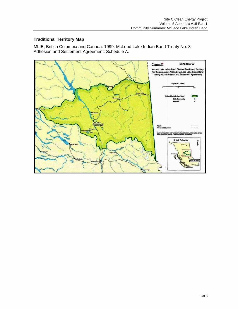
Traditional Territory Map
MLIB, British Columbia and Canada. 1999. McLeod Lake Indian Band Treaty No. 8 Adhesion and Settlement Agreement: Schedule A.
SITE C CLEAN ENERGY PROJECT
VOLUME 5 APPENDIX A15 PART 2
BC HYDRO CONSULTATION SUMMARY:
MCLEOD LAKE INDIAN BAND
FINAL REPORT
Prepared for:
BC Hydro Power and Authority 333 Dunsmuir Street
Vancouver, B.C. V6B 5R3
Prepared by:
Site C First Nations Engagement Team
Suite 1100, Four Bentall Centre 1055 Dunsmuir Street
P.O. Box 49260 Vancouver, B.C.
V7X 1V5
January 2013
Site C Clean Energy Project
Volume 5 Appendix A15 Part 2
BC Hydro Consultation Summary: McLeod Lake Indian Band
1 of 53
Volume 5 Appendix A, Part 2, provides a summary of consultation activities undertaken by BC Hydro with each of the 29 Aboriginal groups listed in Table 9.1 of the EIS, as required pursuant to section 7.2.1 of the EIS Guidelines. This summary describes consultation activities that took place between November 1, 2007 and November 30, 2012, including meetings, phone calls, letters and emails, and consists of a high-level description of “key events” followed by a chronological summary of the consultation process during the above time period.
Volume 5 Appendix A, Part 2, will be updated with new or additional information prior to the submission of the EIS to the Joint Review Panel.
MCLEOD LAKE INDIAN BAND
CONSULTATION SUMMARY
Defined Terms
“AIA” Archaeological Impact Assessment
“AMEC” AMEC Earth & Environmental, consultant for BC Hydro
“AOA” Archaeological Overview Assessment
“BCEAO” Environmental Assessment Office, Province of British
Columbia
“CEA Agency” Canadian Environmental Assessment Agency
“EIS” Environmental Impact Statement
“GIS” Geographic Information Systems
“Golder” Golder Associates Ltd., consultant for BC Hydro
“historical grievances” Allegations of damages arising from the construction and
operation of BC Hydro’s existing facilities on the Peace River
“IBA” Impact Benefit Agreement
“ILMB” Integrated Land Management Bureau, Province of British
Columbia
“McLeod Lake” McLeod Lake Indian Band
“McLeod Lake Treaty 8
Adhesion Agreement”
McLeod Lake Indian Band Treaty No. 8 Adhesion and
Settlement Agreement, between Canada, the Province of

Site C Clean Energy Project
Volume 5 Appendix A15 Part 2
BC Hydro Consultation Summary: McLeod Lake Indian Band
2 of 53
Defined Terms
British Columbia and the McLeod Lake Indian Band, effective
March 23, 2000
“MEMPR” Ministry of Energy, Mines and Petroleum Resources, Province
of British Columbia
“the Province” Province of British Columbia
“Site C” or “the Project” The proposed Site C Clean Energy Project
“Stage 2 Consultation
Agreement”
Stage 2 – Proposed Site “C” Project Agreement for
Consultation and Collaboration, between McLeod Lake Indian
Band and BC Hydro, dated June 22, 2009
“Stage 3 Consultation
Agreement”
Site C Clean Energy Project Stage 3 Consultation Agreement,
between McLeod Lake Indian Band and BC Hydro, dated
December 30, 2011
“TLUS” traditional land use study
Key Events
November 1, 2007 to December 31, 2007
BC Hydro made initial contact with McLeod Lake and expressed its commitment to
effective consultation with respect to the Project.
January 1, 2008 to April 30, 2008
Representatives of BC Hydro and McLeod Lake met for the first time on March 11. BC
Hydro provided a high level introduction to the Project and offered capacity funding to
cover the costs of initial consultations. McLeod Lake accepted that offer on April 17
and received the funding on May 2.
BC Hydro met with McLeod Lake’s Chief and Council on April 11 and April 17 for
discussions regarding the structure of the consultation process, engineering referrals,
and historic grievances. McLeod Lake advised that BC Hydro would need to address
its grievances related the W.A.C. Bennett Dam and the Williston Reservoir before
consultation on the Project could occur. BC Hydro acknowledged McLeod Lake’s
historic grievances, but advised that the Project would be the focus of its current
consultation.

Site C Clean Energy Project
Volume 5 Appendix A15 Part 2
BC Hydro Consultation Summary: McLeod Lake Indian Band
3 of 53
May 1 to September 30, 2008
McLeod Lake’s Chief wrote to BC Hydro on May 29 stating that consultation related to
the Project would have to be broad enough to discuss all issues of importance to
McLeod Lake, including high level energy policy, revenue sharing and historical
grievances, or would not occur at all.
BC Hydro wrote to McLeod Lake on June 17 to welcome the newly elected Chief and
Council, and requested an introductory meeting.
BC Hydro met with McLeod Lake on August 14 to provide a Project overview to the
newly elected Chief and Council. McLeod Lake expressed interest in working towards
completing a consultation agreement, and requested that BC Hydro provide a draft
agreement. A representative from MEMPR was in attendance to respond to questions
regarding provincial energy policy.
September 1 to December 31, 2008
BC Hydro attended an open house in the McLeod Lake community on September 23,
which involved a Project overview and a question/answer session.
BC Hydro invited McLeod Lake to participate in the Technical Advisory Committee
process on September 28.
McLeod Lake wrote to BC Hydro on October 28 and advised that it maintained the
position conveyed in its letter of May 29 signed by the former Chief, and would not
participate in consultations until BC Hydro had addressed the issues raised in the
letter. BC Hydro responded on November 28 and sought to address three issues
identified in the letter: consultation on high level energy policy, compensation for
historical grievances, and revenue sharing.
January 1 to April 30, 2009
No key events
May 1 to September 30, 2009
BC Hydro and McLeod Lake finalized the Stage 2 Consultation Agreement, which
established the principles, process and scope for consultation and collaboration
between McLeod Lake and BC Hydro for Stage 2 and provided McLeod Lake with
funding to participate in the consultation process. The term of the agreement extended
from June 25, 2009 to March 31, 2010.
BC Hydro provided McLeod Lake with a complete set of Stage 1 studies (July 21), and

Site C Clean Energy Project
Volume 5 Appendix A15 Part 2
BC Hydro Consultation Summary: McLeod Lake Indian Band
4 of 53
nine Stage 2 studies (September 4).
Representatives of BC Hydro and McLeod Lake met on July 22, August 19 and
September 15; the parties engaged in discussion about engineering referrals,
procurement opportunities, the structure of the consultation process, and the proper
forum for addressing McLeod Lake’s historical grievances. The parties agreed to work
together to develop a TLUS agreement.
BC Hydro hosted a community meeting on September 15. BC Hydro provided a
Project overview, presented information on species of interest identified by McLeod
Lake, and responded to questions.
October 1 to December 31, 2009
BC Hydro met with representatives of McLeod Lake (legal counsel, Site C Coordinator,
Councillor) on October 6, November 10, December 15; the parties engaged in
discussions regarding a potential TLUS and alternatives to the Project. BC Hydro
tabled a draft TLUS agreement on November 10. A representative of MEMPR
attended on December 15, at McLeod Lake’s request, and responded to questions
about provincial energy policy.
January 1 to April 30, 2010
Representatives of BC Hydro and McLeod Lake met on February 17 to discuss the
proposed TLUS. McLeod Lake expressed its intention to secure a contractor to
complete a TLUS under the sole control of McLeod Lake, with the scope being
expanded to include the cumulative effects of BC Hydro’s existing facilities. BC Hydro
advised that a TLUS would not be considered an eligible expense under the Stage 2
Consultation Agreement unless it was focused on collecting Project-related
information.
McLeod Lake wrote to BC Hydro on March 29 requesting to an extension for spending
the remaining capacity funding under the Stage 2 Consultation Agreement, and
attached list of proposed uses of the funding which included site visits and community
meetings. BC Hydro responded via letter on April 9 and suggested that the remaining
funds be allocated towards the TLUS, but indicated that other activities proposed by
McLeod Lake could be undertaken in the context of the TLUS.
BC Hydro advised McLeod Lake of the Province’s announcement that the Project
would move forward to Stage 3, and provided a link to a website containing the Stage
2 Report and 35 appended studies and reports.
Site C Clean Energy Project
Volume 5 Appendix A15 Part 2
BC Hydro Consultation Summary: McLeod Lake Indian Band
5 of 53
May 1 to September 30, 2010:
Representatives of BC Hydro and McLeod Lake (legal counsel, Site C Coordinator,
Councillor) met on May 6. McLeod Lake (legal counsel) explained that due to the
announcement that the Project would move forward to Stage 3, he would need to seek
direction and a further mandate from McLeod Lake’s Chief and Council. McLeod Lake
expressed concern about the consultation process for the TLUS agreement, and
suggested that the Province intended to push it through no matter what occurred in
consultations with First Nations. McLeod Lake (legal counsel) ended the meeting
prematurely, with BC Hydro requesting to meet with McLeod Lake’s Chief and Council
as soon as possible.
McLeod Lake wrote to BC Hydro (President and Chief Executive Officer) on July 22
and formally expressed its opposition to the Project. The letter enclosed the unspent
portion of the funding provided under the Stage 2 Consultation Agreement. The letter
stated that McLeod Lake would continue to communicate with BC Hydro, but expected
that consultation-related expenses would be paid according to a fee schedule which
McLeod Lake had developed. BC Hydro responded on August 13, confirming its
commitment to engage in meaningful consultation with McLeod Lake and expressing a
desire to continue to develop an agreement for a TLUS that would meet the needs of
both parties. The letter explained that from BC Hydro’s perspective, the consultation in
Stage 2 had been very useful in understanding McLeod Lake’s issues and concerns
about the Project.
BC Hydro met with representatives of McLeod Lake (Chief, Band Manager) on
September 22. McLeod Lake expressed its opposition to the Project and advised that it
had aligned with the Treaty 8 Tribal Association due to their common views on the
Project. McLeod Lake advised that it had a TLUS underway, and BC Hydro expressed
interest in partnering or providing funding to support the initiative. McLeod Lake was
not inclined to accept funding from BC Hydro, but indicated that it would consider a
proposal outlining BC Hydro’s objectives for a TLUS.
October 1 to December 31, 2010
BC Hydro met with representatives of McLeod Lake (Chief, Band Manager, others) on
November 15. McLeod Lake stated that while community members had stringent and
dedicated views regarding the Project, it was willing to look for a way to move forward.
BC Hydro also expressed interest in moving forward, and suggested that the parties
discuss possible next steps for completing a TLUS and a Stage 3 consultation
agreement. BC Hydro clarified that the Project was not a “done deal” and noted that
the structure of the environmental assessment process had yet to be decided
Site C Clean Energy Project
Volume 5 Appendix A15 Part 2
BC Hydro Consultation Summary: McLeod Lake Indian Band
6 of 53
BC Hydro attended a community meeting to hear the community’s concerns about the
effects of the W.A.C. Bennett Dam and the Williston Reservoir, and the potential
impacts of the Project.
January 1, 2011 to April 30, 2011
BC Hydro held an Integrated Resource Plan workshop on March 17, with
representatives from McLeod Lake in attendance. The workshop included a
description of the Integrated Resource Plan, an overview of how an Integrated
Resource Plan is developed, and a presentation and facilitated discussion on various
topics related to the Integrated Resource Plan.
BC Hydro met with McLeod Lake’s Chief and Council on April 20, with discussion
focused on the input received from the McLeod Lake community on November 15
regarding historical grievances. McLeod Lake declined BC Hydro’s offer to provide
funding support for the TLUS work being undertaken by McLeod Lake, advising that it
preferred to keep the study within its community. BC Hydro advised that it was
developing a mandate for IBA negotiations.
May 1 to September 30, 2011
BC Hydro sent a letter to McLeod Lake on May 26, 2011, advising that it had retained
Golder to conduct the Socio-economic Assessment for the Project, and invited McLeod
Lake to work with BC Hydro to involve community members in a First Nations
Community Assessment.
BC Hydro advised McLeod Lake on May 18 that it had submitted the Project
Description Report and provided a link to the report.
McLeod Lake (legal counsel) and BC Hydro exchanged correspondence on July 24
and July 29 regarding the parties’ interpretation of releases in the McLeod Lake Treaty
8 Adhesion Agreement. BC Hydro reiterated its interest in developing a forward-
looking relationship with McLeod Lake, and listed a number of items that it wished to
pursue in the consultation process.
October 1 to December 31, 2011
BC Hydro met with McLeod Lake (Chief, legal counsel) on November 14. The parties
addressed the recent exchange of correspondence respecting the McLeod Lake
Treaty 8 Adhesion Agreement, and agreed to pursue the initiatives set out in BC
Hydro’s letter of July 29, rather than get caught up in a legal debate. BC Hydro tabled
a draft Stage 3 consultation agreement and a revised TLUS agreement. McLeod Lake
expressed interest in carrying out a TLUS and committed to reviewing the draft
Site C Clean Energy Project
Volume 5 Appendix A15 Part 2
BC Hydro Consultation Summary: McLeod Lake Indian Band
7 of 53
agreements. The parties discussed the draft work plan for a First Nations Community
Assessment.
January 1 to April 30, 2012
On January 12, 2012, BC Hydro met with McLeod Lake’s Chief and Council, with
discussions focused on the process for reviewing the draft EIS Guidelines, McLeod
Lake’s comments on the TLUS agreement, and BC Hydro’s trades training initiative.
McLeod Lake signed the Stage 3 Consultation Agreement, dated December 20, 2011.
The agreement established the principles, processes and scope for consultation
between McLeod Lake and BC Hydro in Stage 3, and provided McLeod Lake with
capacity funding to participate in the consultation process.
BC Hydro participated in a community meeting on February 2, and responded to
questions and concerns raised by the approximately 35 community members in
attendance.
BC Hydro wrote to McLeod Lake on February 6 to provide an update on BC Hydro's
proposed approach to procurement and contracting work.
BC Hydro attended quarterly meetings of McLeod Lake’s off-reserve community on
March 23 (Prince George) and March 24 (Vancouver). At both meetings, BC Hydro
provided an overview of the Project, including an update on the status of the
environmental assessment process, and potential business opportunities, and
responded to questions. BC Hydro also met separately with McLeod Lake’s Chief on
March 24. BC Hydro advised that it had received a mandate from the Province to enter
into IBA negotiations and described the potential elements of an IBA.
BC Hydro met via teleconference with McLeod Lake (legal counsel, Band Manager) on
April 18 to discuss the next steps in proceeding with a First Nations Community
Assessment.
May 1 to September 30, 2012
BC Hydro wrote to McLeod Lake regarding the process and rationale for identifying the
proposed Valued Components and spatial boundaries in the draft EIS Guidelines, and
expressed interest in receiving feedback from McLeod Lake.
BC Hydro wrote to McLeod Lake on September 21 advising that the EIS Guidelines
had been issued by the BCEAO and the CEA Agency on September 7. BC Hydro
highlighted the areas of the EIS Guidelines that specifically addressed the
incorporation of information from Aboriginal groups, and invited McLeod Lake to
provide additional information for BC Hydro’s consideration in preparing the EIS. The
Site C Clean Energy Project
Volume 5 Appendix A15 Part 2
BC Hydro Consultation Summary: McLeod Lake Indian Band
8 of 53
letter included a specific request for a traditional territory map, as well as requests for
information regarding McLeod Lake’s current use of lands and resources for hunting
fishing and trapping, and other purposes, and information regarding how the Project
would affect McLeod Lake’s current use of lands and resources, and their exercise of
asserted or established Aboriginal rights and treaty rights. BC Hydro followed up in late
October and advised that it remained interested in receiving additional information to
support the preparation of the EIS.
BC Hydro met with representatives of McLeod Lake (Chief, two Councillors, others) on
September 21, with discussion focusing on a Project update, possible topics of future
consultations, and next steps in preparing McLeod Lake’s Community Baseline Profile.
BC Hydro explained that it remained interested in supporting a TLUS, but given the
time available, any information arising from a TLUS would likely not be included in the
EIS at the time of filing. However, BC Hydro advised that such information could still
be incorporated later on. McLeod Lake stated that it had engaged an anthropologist to
review to review existing records on the history of the Sekani people in the Project
area. BC Hydro confirmed that McLeod Lake could recover the costs of this work
through the Stage 3 Consultation Agreement.
October 1 to November 30, 2012
BC Hydro sent a letter to McLeod Lake on October 24 which advised that BC Hydro
had updated the Project footprint map for Site C, and provided a link to the updated
map and associated shape file data. The letter attached a memorandum outlining the
specifics of the new and amended information, which identified, among other things, a
reduction in the area of the proposed Site C dam site from 3907 hectares (April 2012)
to 2025 hectares (October 2012).
BC Hydro met with representatives of McLeod Lake on October 26, November 13 and
November 23, for negotiations on the terms of a potential IBA. BC Hydro tabled an
initial offer sheet on November 23, and McLeod Lake indicated that it would respond in
writing. Other items of discussion included:
- October 26: McLeod Lake expressed a desire to move forward with the
consultation process despite continued concerns in the community related to
historical grievances. BC Hydro acknowledged these concerns and suggested that
McLeod Lake outline its concerns in writing and provide them to BC Hydro’s
Aboriginal Relations and Negotiations department.
- November 13: McLeod Lake advised that it had identified a consultant to carry out
a technical review of Project-related studies and EIS materials. The parties agreed
to an amount of capacity funding for this work, to be confirmed by a Letter of
Site C Clean Energy Project
Volume 5 Appendix A15 Part 2
BC Hydro Consultation Summary: McLeod Lake Indian Band
9 of 53
Understanding. BC Hydro provided McLeod Lake with a draft Letter of
Understanding on November 27. Big Sky Consulting Ltd., a consultant for BC
Hydro, attended for a discussion of the Community Baseline Profile. Big Sky
explained that Golder had prepared a draft Community Baseline Profile, based on
publicly available information, which had been provided to McLeod Lake, and
expressed interest in hearing from McLeod Lake with respect to the accuracy of
the report, possible information gaps, or other concerns about the report. McLeod
Lake provided preliminary feedback on the report.
McLeod Lake wrote to BC Hydro on November 23 and attached a proposal prepared
by McLeod Lake’s heritage consultant, to conduct oral history documentation
(interviews) and heritage research contributing to McLeod Lake’s TLUS.
BC Hydro wrote to McLeod Lake on November 28 attaching a draft Letter of
Understanding which outlined the parties’ understanding with respect to the TLUS,
including capacity funding, deliverables, information sharing and financial reporting.
McLeod Lake responded on November 30, 2012 and provided suggested revisions.
Chronology of Events
November 1 to December 31, 2007
On November 21, 2007, BC Hydro sent an introductory letter McLeod Lake regarding the
Project. The letter introduced BC Hydro’s senior advisor responsible for First Nations
consultation, and expressed BC Hydro’s commitment to effective consultation with First
Nations should the Project proceed further through BC Hydro’s multi-stage decision making
process.
January 1 to April 30, 2008
On February 18, 2008, BC Hydro hand-delivered a letter to McLeod Lake introducing BC
Hydro’s senior negotiator and inviting McLeod Lake to an introductory meeting to review the
Project scope, discuss capacity funding and develop a schedule of future consultation
meetings. The letter enclosed the Stage 1 Summary Report.
On February 21, 2008, BC Hydro sent a letter to McLeod Lake providing notice of proposed
technical work for the Project. The letter explained that technical, environmental and social
studies would be conducted during Stage 2, and that applications for permits and licenses
on Crown land would result in referrals to McLeod Lake. The letter attached five initial
engineering referrals for McLeod Lake’s review and input. The letter also addressed BC
Site C Clean Energy Project
Volume 5 Appendix A15 Part 2
BC Hydro Consultation Summary: McLeod Lake Indian Band
10 of 53
Hydro’s desire to explore opportunities with McLeod Lake to monitor and participate directly
in any work that may arise from these applications and BC Hydro’s commitment to inviting
First Nations to participate on technical committees to inform environmental and social
economic studies. In the letter, BC Hydro also committed to discussing the design of the
broader consultation and engagement process with McLeod Lake at an upcoming
introductory meeting, where technical advisors would be on hand to answer preliminary
questions. BC Hydro sent a disk to McLeod Lake on February 26, 2008, containing data
related to BC Hydro’s permit applications for the Project.
On March 11, 2008, BC Hydro met with McLeod Lake (Lands Manager) to provide a high
level introduction to the Project. BC Hydro made an offer of interim capacity funding to
cover the costs of initial consultations, and McLeod Lake indicated that it would seek
direction from Chief and Council regarding the offer.
On March 20, 2008, FrontCounter BC sent a letter to McLeod Lake advising that BC Hydro
had submitted five applications to the ILMB and the Ministry of Forestry and Range
pertaining to the occupation of Crown land and removal of Crown timber for the Project.
The letter enclosed materials related to five referrals (see table), and requested that
McLeod Lake review the referrals and provide any comments within 45 days.
File # Proposed type of tenure and estimated period of use
8005604 amendment to Licence of Occupation; authority for tree removal
8005664 amendment to Licence of Occupation; authority for tree removal
8014907 Investigative Use Permit (2 years); authority for tree removal
8014908 Licence of Occupation (10 years); authority for tree removal
8014909 Licence of Occupation (10 years); authority for tree removal
On April 3, 2008, BC Hydro sent an email to McLeod Lake providing a link to the Stage 1
Summary Report.
On April 11, 2008, BC Hydro met with McLeod Lake’s Chief and Council to provide an
overview of the Project. Discussion focused on McLeod Lake’s general questions about the
Project, such as the size of the reservoir, number of turbines, how much energy would be
produced, electricity trading, and consideration of alternatives to the Project. The parties
also discussed how BC Hydro would be engaging with First Nations in relation to the
Project.
On April 17, 2008, BC Hydro met with McLeod Lake (Chief, Councillor, Lands Manager,
legal counsel) to provide an overview of the Project and review the engineering referrals

Site C Clean Energy Project
Volume 5 Appendix A15 Part 2
BC Hydro Consultation Summary: McLeod Lake Indian Band
11 of 53
sent to McLeod Lake on March 20, 2008. McLeod Lake advised that BC Hydro would need
to address historical grievances related the W.A.C. Bennett Dam and the Williston
Reservoir before consultation on the Project could occur. BC Hydro acknowledged McLeod
Lake’s historical grievances, but indicated that the Project would be the focus of its current
consultation. McLeod Lake accepted BC Hydro’s offer of interim capacity funding, and
committed to responded to the engineering referrals once it had developed an internal
process.
May 1 to September 30, 2008
On May 2, 2008, BC Hydro sent a letter to McLeod Lake enclosing a payment for interim
capacity funding. The letter outlined BC Hydro’s understanding that the capacity funding
would enable McLeod Lake to continue meeting with BC Hydro while the parties developed
a consultation agreement, and enable McLeod Lake’s technical advisors to work with BC
Hydro’s engineering team or the ILMB in responding to the engineering referrals.
On May 23, 2008, McLeod Lake (legal counsel) called BC Hydro to advise that due to
elections, McLeod Lake would not be available to meet on May 29, 2008.
On May 28, 2008, BC Hydro called McLeod Lake (legal counsel) advising that BC Hydro
had prioritized referral #8014909 and requested approval from FrontCounter BC. BC Hydro
described the planned activity and previous work completed in the 1970s and 1980s.
McLeod Lake indicated that it would review referral #8014909 in the next couple of days.
McLeod Lake advised that it would be writing to BC Hydro to express its thoughts about the
Project, and would expect a response from BC Hydro before scheduling further meetings.
On May 29, 2008, McLeod Lake (Chief, Alec Chingee) sent a letter to BC Hydro with
respect to the consultation process for the Project. The letter stated that McLeod Lake had
been severely affected by the W.A.C. Bennett Dam, and therefore the prospect of a new
dam on the Peace River was of grave concern to the community. The letter stated that
consultation related to the Project would have to be broad enough to discuss all issues of
importance to McLeod Lake, including high level energy policy, revenue sharing and
historical grievances, or they would not occur at all.
On May 30, 2008, BC Hydro sent a letter to McLeod Lake providing additional information
about the engineering referrals described in FrontCounter BC’s letter of March 20, 2008.
The letter described BC Hydro’s proposal for an incremental approach to approving the five
referrals, with referral #8014909 given priority. The letter indicated that the incremental
approach would enable critical field work to begin in the summer, while proving additional
opportunities for consultation on the remaining four referrals.
On June 17, 2008, BC Hydro sent a letter to McLeod Lake to welcome the newly elected
Chief, Derek Orr, and to request an introductory meeting with the new Council to provide an

Site C Clean Energy Project
Volume 5 Appendix A15 Part 2
BC Hydro Consultation Summary: McLeod Lake Indian Band
12 of 53
overview of the Project and follow up on concerns expressed by McLeod Lake’s previous
Chief in his letter of May 29, 2008. The letter enclosed the Stage 1 Summary Report.
On August 14, 2008, BC Hydro met with McLeod Lake’s new Chief and Council to provide
an overview of the Project. A representative of MEMPR attended (by telephone) to respond
to questions about provincial energy policy. McLeod Lake expressed interest in working
with BC Hydro towards completing a consultation agreement, and requested that BC Hydro
provide a draft agreement for McLeod Lake to review. McLeod Lake also indicated that it
would review the outstanding engineering referrals.
On August 22, 2008, BC Hydro sent a letter to McLeod Lake enclosing a draft Stage 2
consultation agreement, as well as the Stage 1 Summary Report, the Pre-Consultation
Summary Report (related to the public consultation program), and an information package
regarding the Technical Advisory Committees.
September 1 to December 31, 2008
On September 23, 2008, BC Hydro participated in a community meeting at McLeod Lake,
which was attended by McLeod Lake’s Chief and 20 to 30 community members. BC Hydro
provided an overview of the Project and responded to questions from the community
members on a number of topics, including the size of the reservoir, potential impacts to
wildlife and fish, alternatives to the Project, and the historical grievances related to the
W.A.C. Bennett Dam.
On September 29, 2008, BC Hydro sent a letter to McLeod Lake inviting McLeod Lake to
participate in the Technical Advisory Committee process. The letter advised that the
Technical Advisory Committee process would allow for sharing of information, interests and
perspectives regarding the Project with BC Hydro, other First Nations and relevant federal,
provincial and municipal agencies. BC Hydro indicated that Technical Advisory Committee
participants would be invited to review materials and provide input and advice to BC Hydro
on: potential issues and topics for assessment; potential effects of the Project on the
human, physical and biological environment; the nature, scope and extent of information
required to assess the potential effects of the Project on environment; the design of studies
proposed for 2009; and, preliminary ideas for mitigation measures. The letter included a list
of the proposed dates for the Technical Advisory Committee meetings.
On October 20, 2008, McLeod Lake sent a letter to BC Hydro requesting that all land-
related applications be sent to McLeod Lake’s Land Referral Office.
On October 28, 2008, McLeod Lake sent an email to BC Hydro in response to BC Hydro’s
inquiry regarding the draft Stage 2 consultation agreement. McLeod Lake advised that it
maintained the position conveyed in the letter of May 29, 2008 signed by the previous
Chief, Alec Chingee. McLeod Lake further advised that it would not participate in

Site C Clean Energy Project
Volume 5 Appendix A15 Part 2
BC Hydro Consultation Summary: McLeod Lake Indian Band
13 of 53
consultation related to the Project until BC Hydro had addressed the issues raised in the
letter.
On November 28, 2008, BC Hydro sent a letter to McLeod Lake which sought to address
the three concerns identified in McLeod Lake’s letter of May 29, 2008. Regarding the
development of provincial energy policy, BC Hydro explained that it had invited a
representative from MEMPR to attend the meeting of August 14 in order to address
McLeod Lake’s questions on this issue. While McLeod Lake had not raised concerns with
MEMPR at that meeting, BC Hydro offered to schedule a follow up meeting to allow for an
additional opportunity to discuss provincial energy policy. Regarding compensation for
historical grievances, BC Hydro expressed the view that the McLeod Lake Treaty 8
Adhesion Agreement had released the Province from historical grievances, including those
related to the W.A.C. Bennett Dam. Regarding revenue sharing and other benefit options,
BC Hydro explained that the consultation process would enable the parties to assess
potential impacts that the Project might have on McLeod Lake, and this would precede a
later process of discussing accommodation and potential benefit options.
January 1 to April 30, 2009
Between January 21 and March 6, 2009, BC Hydro contacted McLeod Lake by telephone
and email and attempted to schedule a follow up meeting.
On March 11, 2009, McLeod Lake called BC Hydro and expressed interest in receiving
capacity funding to organize a meeting with Elders to discuss the Project. BC Hydro
advised that capacity funding would be available under BC Hydro proposed Stage 2
consultation agreement, and agreed to re-send the draft agreement. BC Hydro provided
McLeod Lake with a draft agreement on March 12, 2009.
On March 16, 2009, BC Hydro sent an email to McLeod Lake advising of potential contract
opportunities associated with early exploratory work for the Project. It provided a link to
three requests for proposals for environmental services, archaeological services, and
noxious weed control services, and indicated that responses were due by March 27, 2009.
On March 23, 2009, BC Hydro provided McLeod Lake with registration forms for the Site C
Business Directory.
May 1 to September 30, 2009
On June 10, 2009, BC Hydro sent an email to McLeod Lake advising that BC Hydro had
posted a request for proposals for a fencing program.
On June 16, 2009, BC Hydro sent a letter to McLeod Lake providing the work plan for
engineering work in the upcoming field season. The letter advised of a pump test that BC
Hydro planned to conduct under Permit #814589 on the north bank of the Peace River from
Site C Clean Energy Project
Volume 5 Appendix A15 Part 2
BC Hydro Consultation Summary: McLeod Lake Indian Band
14 of 53
mid-July to December, 2009, and indicated that BC Hydro was seeking to amend the permit
to allow drilling in a “T” shape alignment. The letter attached the amendment application,
and requested that any comments be provided by June 30, 2009.
On June 22, 2009, McLeod Lake faxed a signed copy of the Stage 2 Consultation
Agreement to BC Hydro, along with the Band Council Resolution authorizing the Chief to
sign the agreement on behalf of the band.
The Stage 2 Consultation Agreement established the principles, process and scope for
consultation and collaboration between McLeod Lake and BC Hydro for Stage 2, and
provided McLeod Lake with funding to participate in the consultation process. The
agreement outlined the respective responsibilities of the parties, specifying that BC
Hydro would be responsible for providing McLeod Lake with information about the
Project including employment and business opportunities, that McLeod Lake would be
responsible for providing BC Hydro with information regarding the community’s
concerns about the Project, and that BC Hydro and McLeod Lake would be jointly
responsible for identifying strategies to avoid, mitigate, manage, and accommodate
interests, concerns or potential adverse impacts of the Project on McLeod Lake’s
section 35(1) rights. The agreement addressed confidentiality, budgeting and work
planning, funding and payment schedules, and communication between the parties.
The agreement included a provision under which either party may invite a
representative of the Province to attend any meeting, including a meeting to discuss the
B.C. Energy Plan, and appended a letter from MEMPR to McLeod Lake, dated May 28,
2009, confirming that representatives of MEMPR would be available to meet with
McLeod Lake to discuss the Project, including the B.C. Energy Plan. The term of the
agreement extended from June 25, 2009 to March 31, 2010.
On June 25, 2009, BC Hydro sent a letter to McLeod Lake attaching an application for a
Licence of Occupation, which BC Hydro had submitted to FrontCounter BC on June 23,
2009. The letter noted that the Licence of Occupation would allow for continued
geotechnical investigations at the proposed dam site focused on gathering information on
the dam foundation and abutment slopes. It requested that McLeod Lake provide
comments by July 31, 2009.
On June 30, 2009, BC Hydro sent a letter to McLeod Lake enclosing a capacity funding
cheque issued pursuant to the Stage 2 Consultation Agreement.
On July 21, 2009, BC Hydro sent a letter to McLeod Lake enclosing a disk containing the
complete set of Stage 1 studies, as follows:
Peace River Fisheries Investigations - Peace River Tributary Spring Spawning
Migration, Tributary Summer Juvenile Rearing and Radio Telemetry Studies 2006.
Site C Clean Energy Project
Volume 5 Appendix A15 Part 2
BC Hydro Consultation Summary: McLeod Lake Indian Band
15 of 53
Peace River Fish and Aquatics Investigations - Peace River Tributary Summer Fish
Distribution, Habitat Assessment and Radio Telemetry Studies 2005.
Peace River Fisheries Investigations - Peace River and Pine River Radio Telemetry
Study 2007.
Peace River Wildlife Studies - Preliminary Inventory of Bat Species in the Peace River
Corridor 2005.
Peace River Wildlife Surveys - Inventory and Habitat Use of Bat Species in the Peace
River Corridor.
Terrestrial Ecosystem Mapping of the Peace River Study Area: Baseline Inventory
Surveys 2007.
Peace River Wildlife Surveys Summary Report - Winter Baseline Inventory Surveys
2006.
Peace River Fisheries and Aquatic Resources Literature Summary, September 2008.
Small Fish Surveys in the Peace and Halfway Rivers 2006.
Peace River Wildlife Surveys - Baseline Inventory Surveys 2006.
Expanded Legend for the Peace River Terrestrial Ecosystem Mapping Project 2007.
Water Quality, River Sediment, Soil, and Vegetation Samples from the Peace River
Watershed 2007.
The letter also enclosed a disk with materials from the meetings of the Technical Advisory
Committees.
On July 22, 2009, BC Hydro met with representatives of McLeod Lake (legal counsel,
Councillor) to provide an update on the planned technical work, and discuss the possibility
of McLeod Lake undertaking a traditional use study. BC Hydro provided information on the
process for planning and completing a traditional use study. McLeod Lake suggested that
community members be involved in coordinating the study. McLeod Lake identified band
owned companies with interest in undertaking Project related work and the parties
discussed the possibility of scheduling an information session on procurement and training.
On August 13, 2009, BC Hydro sent a letter to McLeod Lake advising of planned fisheries
work in the Moberly River. The letter advised that BC Hydro would be installing a fish fence
in the Moberly River that would temporarily obstruct the navigable channel for boaters.
Site C Clean Energy Project
Volume 5 Appendix A15 Part 2
BC Hydro Consultation Summary: McLeod Lake Indian Band
16 of 53
On August 18, 2009, BC Hydro and Mainstream Aquatics sent a letter to McLeod Lake
providing further information regarding planned fisheries studies in the Moberly River. The
letter advised that a temporary fish fence would be installed across the wetted channel of
the Moberly River from September 30 to October 29, 2009. The fish fence would assist in
the counting of adult mountain whitefish moving upstream to spawn in the Moberly River,
and the recording of fish species moving downstream to over winter in the Peace River. BC
Hydro was providing notice to local First Nations and public users as part of its application
for an approval under the Navigable Waters Protection Act.
On August 19, 2009, BC Hydro met with representatives of McLeod Lake (legal counsel,
Land Manager, Councillor). Discussion items included:
Historical grievances: McLeod Lake expressed the view that the releases in the McLeod
Lake Treaty 8 Adhesion Agreement were given to the Province and did not apply to BC
Hydro. BC Hydro explained the Province’s view that BC Hydro benefitted from the
releases as an agent of the Crown, and that discussions about the interpretation of the
McLeod Lake Treaty 8 Adhesion Agreement would need to take place in a different
forum. McLeod Lake cautioned that no progress could be made in the consultation
process without first addressing McLeod Lake’s historical grievances related to existing
projects.
Traditional use study: The parties discussed undertaking of traditional use study and
agreed to work together to develop a TLUS agreement.
Referrals: BC Hydro provided an update on the timeline and process for Project-related
engineering work. The parties discussed opportunities for McLeod Lake members to be
involved in monitoring the work. BC Hydro agreed to follow up on a question about the
filling of boreholes after investigative drilling.
Procurement: BC Hydro suggested setting up a workshop in the McLeod Lake
community with BC Hydro’s Aboriginal Procurement Advisor.
Fish and wildlife studies: McLeod Lake expressed interest in studies on caribou
(mountain and inland) and Arctic grayling. BC Hydro agreed to determine if any studies
on those species had been completed.
On August 21, 2009, BC Hydro provided a written response to McLeod Lake’s question
about the filling of boreholes.
On August 26, 2009, BC Hydro sent an email to McLeod Lake responding to McLeod
Lake’s inquiry regarding studies undertaken on caribou and Artic grayling. BC Hydro
advised that it had completed studies on Arctic grayling in Stage 1 which had been provided
to the McLeod Lake on July 21, 2009. BC Hydro explained that it had not initiated studies

Site C Clean Energy Project
Volume 5 Appendix A15 Part 2
BC Hydro Consultation Summary: McLeod Lake Indian Band
17 of 53
on caribou because a determination had been made that the Project area did not contain
suitable habitat for caribou.
On August 26, 2009, BC Hydro sent an email to McLeod Lake requesting a list of species of
interest to be included in a presentation to McLeod Lake community members. McLeod
Lake replied by email and provided a list of species it considered to be of high importance.
On September 3, 2009, McLeod Lake (Site C Coordinator, Land Referrals Officer) met with
representatives of the ILMB. Discussion topics included BC Hydro’s permit applications for
geotechnical investigations, the ILMB’s approach to consultation with First Nations,
introduction of the “rolling work plan” concept, and scheduling of a site visit. BC Hydro did
not attend the meeting.
On September 4, 2009, BC Hydro sent a letter to McLeod Lake enclosing a disk containing
the following Stage 2 studies:
Peace River Fisheries Investigation Peace River and Pine River Radio Telemetry Study
2008. AMEC Earth & Environmental and LGL Limited.
Baseline Data Collection - Peace River Watershed Water Quality and Dinosaur Lake
Limnology Sampling - 2008. Golder Associates Ltd.
Peace River Site C Hydro Project Stage 2 - Baseline Greenhouse Gas Emissions
Report. Jacques Whitford AXYS (Stantec).
Peace River Site C Hydro Project Stage 2 Baseline Vegetation and Wildlife Report.
Keystone Wildlife Research Ltd.
Peace River Angling and Recreational-Use Creel Survey Interim Year 1 Report. LGL
Limited.
Site C Fisheries Studies - Baseline Peace River Tributaries Fish Use Assessments in
Spring and Fall 2008. Mainstream Aquatics Ltd.
Site C Fisheries Studies - Juvenile Fish and Fish Habitat Inventory of Peace River
Tributaries in Summer 2008. Mainstream Aquatics Ltd.
Site C Peace River - Mercury Levels in Peace River Fish Tissue – Data Report 2008.
Mainstream Aquatics Ltd.
Site C Fisheries Study Upper Halfway River Watershed Bull Trout Spawning Survey
2008. Mainstream Aquatics Ltd.
BC Hydro indicated that further Stage 2 studies would be provided once available, and
offered to meet with McLeod Lake to discuss the enclosed materials.
Site C Clean Energy Project
Volume 5 Appendix A15 Part 2
BC Hydro Consultation Summary: McLeod Lake Indian Band
18 of 53
On September 8, 2009, McLeod Lake sent an email to BC Hydro attaching a list of
traditional plants of interest to be included in BC Hydro’s presentation at an upcoming
community meeting.
On September 15, 2009, BC Hydro participated in a community meeting at the McLeod
Lake band office, which was attended by 22 community members. BC Hydro provided a
Project overview which included information on species of interest identified by McLeod
Lake, and took questions.
On September 15, 2009, BC Hydro met with McLeod Lake (Site C Coordinator). The parties
discussed BC Hydro’s proposal to move forward with three levels of consultation: a
Technical Committee, a Steering Committee and a Main Table. The Site C Coordinator
confirmed that she would be the technical lead for McLeod Lake, and that the Steering
Committee would be comprised of herself, legal counsel and a Councillor. The Site C
Coordinator agreed that a Main Table was a good idea and BC Hydro committed to drafting
a letter to McLeod Lake outlining its proposal for three levels of consultation. BC Hydro
provided an overview of the Technical Advisory Committee (TAC) process and described
the seven areas of focus for the TACs (fish, wildlife, recreation, infrastructure, heritage,
greenhouse gases and human health). BC Hydro committed to providing McLeod Lake with
the TAC materials. The parties discussed the next steps for initiating a TLUS.
On September 16, 2009, McLeod Lake participated in site visit to the South Bank Island
with representatives from BC Hydro, Golder, and the ILMB, to discuss ongoing engineering
work.
On September 22, 2009, BC Hydro sent a letter to McLeod Lake in follow up to the meeting
of September 15, 2009, which summarized a proposed consultation process involving three
levels of consultation: Technical Committee, Steering Committee and Main Table. The letter
suggested that the Main Table meet three or four times a year in order to confirm decisions
made by the Steering Committee, and to make decisions that require elevation from the
steering committee or the technical level. The letter suggested that the parties confirm the
structure of the consultation process at the next meeting.
On September 30, 2009, BC Hydro sent an email to McLeod Lake responding to questions
raised at the community meeting (September 15, 2009) regarding kokanee and lake trout.
October 1 to December 31, 2009
On October 6, 2009, BC Hydro met with representatives of McLeod Lake (legal counsel,
Site C Coordinator, Councillor). The parties reviewed the outcomes of the community
information session held on September 15, 2009, with McLeod Lake emphasizing the need
for continued community engagement. McLeod Lake advised that it would seek direction
from Chief and Council regarding the structure of the consultation process at the next band
Site C Clean Energy Project
Volume 5 Appendix A15 Part 2
BC Hydro Consultation Summary: McLeod Lake Indian Band
19 of 53
council meeting. BC Hydro committed to tabling a draft TLUS agreement for McLeod Lake’s
review.
On October 8, 2009, Golder sent a letter to McLeod Lake which summarized proposed
geotechnical engineering work on the western end of the South Bank Island within the
application area for Licence of Occupation #8015149.
On October 20, 2009, BC Hydro sent copies of the Stage 1 Summary Report and the Stage
1 Completion Report by mail to McLeod Lake, in follow up to a request made at the meeting
of October 6, 2009. BC Hydro sent additional copies of the two reports to McLeod Lake on
November 20, 2009, as requested by McLeod Lake.
On October 27, 2009, BC Hydro sent an email to McLeod Lake attaching a draft work plan
for a study of ungulate movement and habitat use. The letter stated that BC Hydro would
welcome McLeod Lake’s input and advice regarding the draft work plan.
On October 30, 2009, McLeod Lake sent a letter to Golder providing comments on Rolling
Work Plan #1 (South Bank Island) under License of Occupation #8015149. The letter
outlined McLeod Lake’s expectation that the work plan would be followed diligently, and
that notice would be provided to McLeod Lake if any problems arose with the work. The
letter highlighted the community’s use of rare plants for medicinal purposes and
emphasized the importance of compliance with mitigation measures in these sensitive
areas. The letter requested that an environmental monitor from McLeod Lake be present
during the geotechnical drilling work.
On November 4, 2009, BC Hydro sent an email to McLeod Lake attaching the registration
form for enrolment in the Site C Business Directory. McLeod Lake responded via email on
November 5, 2009, attaching completed forms for Duz Cho Construction Ltd., a band-
owned business.
On November 5, 2009, Golder sent a letter in response to McLeod Lake’s letter of October
30, 2009, providing comments on Rolling Work Plan #1. Golder committed to hiring McLeod
Lake members as environmental monitors.
On November 10, 2009, BC Hydro met with representatives of McLeod Lake (legal counsel,
Site C Coordinator, Councillor) for a discussion focused on the development of a TLUS. BC
Hydro tabled a draft TLUS agreement for discussion, and the parties discussed related
issues including options for joint oversight, the geographic scope of the study, and access
to confidential data. McLeod Lake requested a presentation from MEMPR on the B.C.
Energy Policy. McLeod Lake expressed interest in hearing directly from the Province about
the development of the policy, and, in particular, how the Project was selected as an option
to meet energy demands.
Site C Clean Energy Project
Volume 5 Appendix A15 Part 2
BC Hydro Consultation Summary: McLeod Lake Indian Band
20 of 53
On November 10, 2009, BC Hydro sent an email to McLeod Lake attaching a Quarterly
Joint Report for the period ending September 30, 2009, prepared pursuant to the Stage 2
Consultation Agreement.
On November 13, 2009, BC Hydro sent an email to McLeod Lake attaching an outline for a
proposed Socio-economic Baseline and Gap Analysis Study, and sought input from
McLeod Lake.
On December 15, 2009, BC Hydro met with representatives of McLeod Lake (legal counsel,
Councillor) and a representative from MEMPR, who attended at McLeod Lake’s request to
provide information and field questions on the development of the B.C. Energy Plan. The
parties discussed MEMPR’s position on possible alternatives to the Project, including
energy conservation, nuclear, coal and wind. McLeod Lake expressed concern that it had
not been consulted on policies which resulted in certain energy sources being excluded
from consideration, and the Project being made a priority. McLeod Lake asserted that a
preliminary decision had been made by the Province to build the Project. The parties
agreed that a community meeting should be held, with representatives of MEMPR and BC
Hydro, to explain to community members how choices related to high level energy policy
are made. BC Hydro and McLeod Lake reviewed the latest draft of the TLUS agreement,
and McLeod Lake expressed concern about maintaining control over the scope of the study
and the final product of the study. McLeod Lake provided BC Hydro with a revised draft on
February 2, 2010.
January 1 to April 30, 2010
On January 7, 2010, BC Hydro sent an email to McLeod Lake attaching a draft of the Joint
Quarterly Report for the period ending December 31, 2009, prepared pursuant to the Stage
2 Consultation Agreement.
On January 12, 2010, BC Hydro sent an email to McLeod Lake providing notification of a
request for proposal for Environmental Support Services, with a closing date of February 1,
2010.
On February 3, 2010, BC Hydro called McLeod Lake’s Chief to provide an update on the
Project, and expressed interest in meeting with McLeod Lake’s Chief and Council.
On February 4, 2010, Golder sent a letter to McLeod Lake providing information related to
Rolling Work Plan #1 (South Bank Island) under License of Occupation #815149, including
updated maps of the permit area, access roads and borehole location, and a Danger Tree
Assessment Report. The letter advised that work would commence on or before April 1,
2010.

Site C Clean Energy Project
Volume 5 Appendix A15 Part 2
BC Hydro Consultation Summary: McLeod Lake Indian Band
21 of 53
On February 15, 2010, McLeod Lake sent an email to BC Hydro attaching Quarterly
Financial Reports for the periods ending September 30, 2009 and December 31, 2009,
prepared pursuant to the Stage 2 Consultation Agreement.
On February 17, 2010, BC Hydro met with McLeod Lake (legal counsel, Councillor, Site C
Coordinator) to discuss the revised draft of the TLUS agreement provided by McLeod Lake.
McLeod Lake expressed its intention to secure a contractor to complete a TLUS under the
sole control of McLeod Lake, with the scope being expanded to include the cumulative
effects of BC Hydro’s existing facilities. McLeod Lake stated that it was not interested in
joint oversight, but would share its findings with BC Hydro and make best efforts to include
information that BC Hydro required. BC Hydro responded that a TLUS would not be
considered an eligible expense under the Stage 2 Consultation Agreement, unless it was
focused on collecting Project-related information. As a way to move forward, BC Hydro
agreed to reconfirm its information requirements for the TLUS and follow up with McLeod
Lake. The parties finalized the Joint Quarterly Reports for the periods ending September
30, 2009 and December 31, 2009, prepared pursuant to the Stage 2 Consultation
Agreement.
On March 1, 2010, BC Hydro sent two letters to McLeod Lake enclosing capacity funding
cheques issued pursuant to the Stage 2 Consultation Agreement.
On March 3, 2010, BC Hydro sent an email to McLeod Lake attaching a revised draft of the
TLUS agreement, which clarified BC Hydro’s information requirements for the study, and
attempted to incorporate provisions from McLeod Lake’s previous draft.
On March 22, 2010, BC Hydro sent a letter to McLeod Lake advising of its preparations for
the field season of environmental work associated with the Project. The letter advised that
although no decision had been made to proceed to Stage 3, BC Hydro was maintaining its
current work on the Project on an interim basis to preserve the project schedule. The letter
sought McLeod Lake’s input on work plans for environmental studies proposed for 2010.
The letter attached the following studies:
Site C Fisheries Studies - 2010 Major Tributary Fish Inventory
Site C Aquatic Productivity Study - Preliminary Scope of Work
Site C Preliminary Mercury Modeling and Planning - Preliminary Scope of Work (March
2010)
Peace River Ungulate Monitoring Study Status: March 18, 2010
Site C Wildlife Studies - Preliminary Scope of Work - March 18, 2010
Site C Clean Energy Project
Volume 5 Appendix A15 Part 2
BC Hydro Consultation Summary: McLeod Lake Indian Band
22 of 53
Ecosystem and Habitat Mapping Update - Peace River Baseline Inventory Workplan –
2010
Site C Heritage and Archaeology Studies - Preliminary Scope of Work.
On March 29, 2010, McLeod Lake sent a letter to BC Hydro requesting an extension on the
deadline in which to spend the capacity funding provided for under the Stage 2
Consultation Agreement. The letter attached a list of proposed uses of the funding including
a site visit, a helicopter fly over, and three community gatherings.
On April 7, 2010, BC Hydro and Mainstream Aquatics sent a letter to McLeod Lake advising
of planned fisheries studies on the Peace and Moberly rivers. The letter advised that
temporary rotary screw fish traps would be placed in the water and provided a description
of the temporary fish trap operation. The rotary screw traps would assist in obtaining
baseline data with respect to the downstream movement of juvenile fish through the project
site and outmigration of juvenile fish from the Moberly River. The temporary rotary screw
traps were scheduled to operate on week days from May 1 to October 29, 2010.
On April 9, 2010, BC Hydro responded to McLeod Lake’s letter of March 29, 2010. BC
Hydro proposed that remaining funding under the Stage 2 Consultation Agreement be used
to complete a TLUS, and explained that activities such as field studies and community
gatherings outlined McLeod Lake’s letter, could then be undertaken in the context of the
TLUS.
On April 13, 2010, BC Hydro sent an email to McLeod Lake attaching a draft of the latest
Joint Quarterly Report for March 31, 2010, prepared pursuant to the Stage 2 Consultation
Agreement.
On April 19, 2010, BC Hydro sent an email to McLeod Lake advising that the Province had
announced that the Project would move forward to Stage 3, the Environmental and
Regulatory Review Stage. The email also provided a link to the Project website where the
final Stage 2 Report and 35 appended studies and reports had been posted.
On April 28, 2010, McLeod Lake sent an email to BC Hydro and inquired if a BC Hydro
representative would be available to speak about the Williston Reservoir and the W.A.C.
Bennett Dam at an upcoming meeting. BC Hydro responded via email stating that given the
parties’ differing views on the interpretation of releases in the McLeod Lake Treaty 8
Adhesion Agreement, BC Hydro would need to complete a legal review prior to engaging in
further discussion of this issue. BC Hydro offered to facilitate a meeting between McLeod
and legal counsel for the Ministry of Attorney General, if McLeod Lake wished to pursue
such a discussion.
Site C Clean Energy Project
Volume 5 Appendix A15 Part 2
BC Hydro Consultation Summary: McLeod Lake Indian Band
23 of 53
May 1 to September 30, 2010
On May 6, 2010, BC Hydro met with representatives of McLeod Lake (legal counsel, Site C
Coordinator, Councillor). McLeod Lake (legal counsel) explained that due to the
announcement that the Project would move forward to Stage 3, he would need to seek
direction and a further mandate from McLeod Lake’s Chief and Council. McLeod Lake
advised that it planned to submit a request to extend the time for using the outstanding
funds available under the Stage 2 Consultation Agreement. BC Hydro agreed to consider
such a request if it was received. McLeod Lake provided a revision of the Joint Quarterly
Report for the period ending March 31, 2010, expressing the view that BC Hydro’s original
draft had misrepresented the facts surrounding the TLUS negotiations. McLeod Lake stated
that the parties had completely different view of the TLUS and that BC Hydro’s
consultations related to the TLUS had been biased and self-serving. BC Hydro disagreed
with McLeod Lake’s interpretation of events, and indicated that it remained interest in
completing a TLUS. However, BC Hydro emphasized that the purpose of a TLUS would be
to contribute to an assessment of the effects of the Project on McLeod Lake’s treaty rights.
McLeod Lake suggested that the direction taken by BC Hydro had foreclosed any
meaningful discussion. McLeod Lake described the Project as a “done deal” and expressed
the view that the Province would push it through no matter what occurred in in the course of
consultations. BC Hydro suggested that the parties’ caucus to discuss a possible extension
of funding under the Stage 2 Consultation Agreement, but McLeod Lake stated the meeting
was over. BC Hydro requested a meeting with McLeod Lake’s Chief and Council as soon
as possible.
On May 10, 2010, Golder sent an email to McLeod Lake advising that the following Stage 2
interim archaeology reports have been uploaded to the FTP site for McLeod Lake’s review:
Interim Report: AIA for proposed upgrades to the Left Bank Hill Road (Permit #2009-
0262)
Interim Report: AIA of portions of the area containing 17 Pump-Test boreholes (Permit
#2009-0262)
Interim Report: AIA of proposed boreholes and access trails (revision 1) on the South
Bank Island (Permit #2009-0262)
Interim Report: AIA of archaeological sites HbRf-59, HbRf-61, HbRf-65 and HbRf-67,
located along the South (Right) Bank access road (Permit #2009-0262)
On June 21, 2010, BC Hydro sent a letter to McLeod Lake advising that Golder had been
awarded the contract to conduct the Heritage Impact Assessment for the Project, and that
Golder would be holding a five day heritage training program in Fort St. John. Golder would
Site C Clean Energy Project
Volume 5 Appendix A15 Part 2
BC Hydro Consultation Summary: McLeod Lake Indian Band
24 of 53
be looking for McLeod Lake to identify interested community members to attend this
training, with a view to providing employment opportunities to community members.
On June 24, 2010, BC Hydro sent a letter to McLeod Lake advising that BC Hydro had
engaged Golder to conduct a heritage assessment for the Project. The letter advised that
the Golder team would be responsible for securing a Heritage Conservation Act permit from
the Archaeology Branch, and a copy of the permit application would be forwarded to
McLeod Lake. The letter included an offer of capacity funding to facilitate McLeod Lake's
review of the permit application.
On June 30, 2010, Golder sent a letter to McLeod Lake advising that Golder would be
conducting an AIA for BC Hydro in relation to the 2010 Geotechnical Investigations:
Proposed Left Bank (North) and Right Bank (South) (Permit #2009-0262), with work
scheduled to commence on July 7, 2010.
On July 9, 2010, BC Hydro, Golder and representatives of McLeod Lake (Lands Manager,
Site C Coordinator) attended a site visit to the South Bank of the Peace River to discuss
geotechnical investigations under Rolling Work Plan #2. McLeod Lake provided feedback
and suggestions on the work.
On July 16, 2010, Golder sent a letter to McLeod Lake attaching: Rolling Work Plan #2:
2010 Geotechnical Investigations (Licence of Occupation #814864) (July 16, 2010). Golder
requested that comments be submitted by August 6, 2010.
On July 20, 2010, Golder sent a letter to McLeod Lake attaching:
Technical Memorandum: AOA of Select Portions of BC Hydro's Proposed 2010
Geotechnical Investigations within the Proposed Site C Dam Area (July 16, 2010)
Interim Report: AIA of Proposed 2010 Geotechnical Investigations Within The Proposed
Site C Dam Area (Permit #2009-0262) (July 16, 2010)
On July 22, 2010, McLeod Lake sent a letter to BC Hydro (President and Chief Executive
Officer) and formally expressed its opposition to the Project. The letter expressed concern
that McLeod Lake had not been afforded meaningful consultation regarding the
development of the Project to date, and highlighted a lack of consultation with respect to the
Clean Energy Act and other decisions by the Province not to pursue alternative energy
sources. Regarding the consultation process, the letter expressed concern that BC Hydro
representatives had repeatedly characterized issues of interest to McLeod Lake as being
beyond their mandate, and had attempted to dictate the terms of a proposed TLUS. The
letter described the consultation process as “wholly inadequate” and enclosed the unspent
portion of the funding provided by BC Hydro under the Stage 2 Consultation Agreement.
The letter stated that McLeod Lake would continue to communicate with BC Hydro, but

Site C Clean Energy Project
Volume 5 Appendix A15 Part 2
BC Hydro Consultation Summary: McLeod Lake Indian Band
25 of 53
expected that any consultation-related expenses would be paid according to a fee schedule
which McLeod Lake had developed.
On July 26, 2010, the Archaeology Branch sent a letter to McLeod Lake advising that
AMEC had applied for a Heritage Inspection Permit under the Heritage Conservation Act to
conduct an archaeological impact assessment for the Project. This would involve assessing
potential impacts on archaeological resources arising from the construction of dams and
related facilities, quarry and borrow pit locations, temporary construction facilities, highway
realignments, flooded areas and erosion zones, transmission lines and other related works
that might be identified as planning progresses. The letter advised that the Crown had also
received an application for an Investigative Use Permit under the Land Act to enable
access to Crown Land for activities under the Heritage Inspection Permit.
On July 30, 2010, AMEC sent an email to McLeod Lake advising that AMEC had applied for
a Heritage Inspection Permit on behalf of BC Hydro to conduct an AIA for the Project (File
#10A0284). The field program aimed to identify archaeological sites that might be affected
by the development of the Project. AMEC indicated that it would follow up with McLeod
Lake to arrange a face-to-face meeting or other forum to discuss the application. AMEC
attached a copy of the application for McLeod Lake’s reference. Golder called McLeod Lake
on August 12, 2010, in follow up to the letter. McLeod Lake stated that it was not in a
position to discuss Project-related matters at the time.
On August 13, 2010, BC Hydro (President and Chief Executive Officer) sent a letter to
McLeod Lake in response to the McLeod Lake’s letter of July 22, 2010, and acknowledged
McLeod Lake’s return of the unspent portion of the funding under the Stage 2 Consultation
Agreement. The letter confirmed BC Hydro’s commitment to engage in meaningful
consultation with McLeod Lake and explained that from BC Hydro’s perspective, the
consultation in Stage 2 had been very useful in understanding McLeod Lake’s issues and
concerns about the Project. The letter advised that while the Site C team did not have a
mandate to fully explore McLeod Lake’s concerns about the impacts of the existing
facilities, BC Hydro was prepared to facilitate a meeting with appropriate government and
BC Hydro staff to discuss those concerns. The letter expressed a desire to continue to work
on an agreement for a TLUS that would meet the needs of both parties, and confirmed that
BC Hydro would provide appropriate capacity funding for future consultation activities.
On August 20, 2010, Golder sent a letter to McLeod Lake regarding Rolling Work Plan #2
(Licence of Occupation #814864). The letter advised that BC Hydro was planning to
proceed with the geotechnical investigation program under Rolling Work Plan #2 during the
week of August 23, 2010, and explained that the scope of the work included various drilling,
test pit excavations, and exploration activities along the north and south banks of Peace
River. The letter provided Golder’s contact information if McLeod Lake had any questions
Site C Clean Energy Project
Volume 5 Appendix A15 Part 2
BC Hydro Consultation Summary: McLeod Lake Indian Band
26 of 53
On August 23, 2010, Golder sent a letter to McLeod Lake providing notification that Golder
would be conducting an AIA of the South Bank Laydown Area and the South Bank Access
Road, commencing on August 24, 2010 (Permit #2009-0262).
On August 30, 2010, Golder sent a letter to McLeod Lake attaching:
Technical Memorandum: AOA of BC Hydro South Bank Bedrock Mapping Program
within the proposed Site C Dam Area (August 18, 2010).
On September 2, 2010, Golder sent a memorandum via fax to McLeod Lake advising that it
would be conducting an AIA of the proposed Left Bank Hill drill location, commencing on
September 2, 2010 (Permit #2009-0262)..
On September 22, 2010, BC Hydro met with representatives of McLeod Lake (Chief, Band
Manager). McLeod Lake opened the meeting by expressing its opposition to the Project
and advised that it had aligned with Treaty 8 Tribal Association due to their common views
on the Project. McLeod Lake advised that it was conducting research with Elders regarding
promises of free power made by BC Hydro during the construction of the W.A.C. Bennett
Dam. BC Hydro expressed interest in hearing directly from the Elders about what had been
promised. BC Hydro advised that it was open to expanding the geographic scope of the
TLUS and asked if McLeod Lake would be interested in pursuing a study. McLeod Lake
advised that it already had a TLUS underway. BC Hydro expressed interest in partnering or
providing funding to support McLeod Lake’s initiative. McLeod Lake advised that it was not
inclined to accept funding support from BC Hydro, but indicated that it would be prepared to
consider a proposal outlining BC Hydro’s objectives for a TLUS.
On September 30, 2010, the Archaeology Branch sent an email to McLeod Lake (cc:
Golder, AMEC) regarding AMEC’s application for a Heritage Inspection Permit, and
attached:
Letter from the Archaeology Branch to AMEC (September 30, 2010) advising that
AMEC had been granted Heritage Inspection Permit #2010-0378, but that the permit
had been reduced in scope in order to address concerns raised by some of the Treaty 8
First Nations. The permit only authorized activities related to model testing. Once AMEC
had achieved sufficient progress with model testing, it could seek to amend the permit
to include other activities (inventory and impact assessment).
Heritage Inspection Permit #2010-0378 issued to AEMC “to conduct an archaeological
inventory for the purpose of testing and improving the archaeological potential model
prepared for BC Hydro's proposed Site C Clean Energy Project…” (September 30,
2010)
Site C Clean Energy Project
Volume 5 Appendix A15 Part 2
BC Hydro Consultation Summary: McLeod Lake Indian Band
27 of 53
Letter from AMEC (on Golder letterhead) to the Archaeology Branch responding to
questions from First Nations regarding AMEC’s application for a Heritage Inspection
Permit (September 9, 2010)
On September 30, 2010, Golder sent an email to McLeod Lake attaching a draft report
documenting Golder's 2010 annual field assessment of the existing North Bank access
road located within site HbRf-40 (in partial fulfillment of the terms and conditions of Site
Alteration Permit #2009-0297). Golder requested that comments be provided by October
15, 2010.
October 1 to December 31, 2010
On October 8, 2010, Golder sent a fax to McLeod Lake advising that Golder would be
conducting an AIA of the proposed South Bank Access Road under Permit #2009-0262.
Golder advised that work was tentatively scheduled to commence on October 14, 2010. On
October 12, 2010, Golder sent a fax to McLeod Lake attaching a revised notification of
Golder’s AIA of the proposed South Bank Access Road. Golder advised that Test Pit U
would also be assessed.
On October 15, 2010, Golder sent an email to McLeod Lake attaching letter notification of
an AIA on the proposed exploratory Adit #5 on the South Bank of the Peace River.
On October 25, 2010, Golder sent an email to McLeod Lake attaching:
Interim report: AIA for proposed access road upgrades on the left (north) bank of the
Peace River.
Golder advised that no archaeological sites were identified during the AIA. Golder
requested that any comments be provided by November 9, 2010.
On November 9, 2010, BC Hydro sent an email to McLeod Lake attaching a draft Stage 3
consultation agreement to be discussed at the meeting of November 15, 2010.
On November 15, 2010, BC Hydro met with representatives of McLeod Lake (Chief, Band
Manager, Legal Counsel, Site C Coordinator, Lands Manager and others). McLeod Lake
advised that while community members had stringent and dedicated views regarding the
Project, it was willing to look for a way to move forward. McLeod Lake suggested that the
parties work towards a different method of communicating. BC Hydro also expressed
interest in moving forward and suggested that the parties discuss McLeod Lake’s concerns
and possible next steps for a TLUS. McLeod Lake identified three issues raised in the letter
of July 22 as being particularly important to the community: promises made and not met
with respect to the W.A.C. Bennett Dam, the lack of compensation provided in relation to
the W.A.C. Bennett Dam, and the pre-determined nature of the approval process for the
Project. McLeod Lake described a number of impacts arising from the W.A.C. Bennett

Site C Clean Energy Project
Volume 5 Appendix A15 Part 2
BC Hydro Consultation Summary: McLeod Lake Indian Band
28 of 53
Dam, and explained that it wanted to ensure that members’ lifestyles were not further
eroded by the Project. BC Hydro suggested that the parties consider a consultation
agreement as an option to explore the kinds of topics being discussed in the meeting, and
to work together to identify potential impacts of the Project. BC Hydro clarified that the
Project was not a “done deal” and noted that the structure of the environmental assessment
process had yet to be decided. McLeod Lake agreed to review the draft Stage 3
consultation agreement tabled by BC Hydro. BC Hydro expressed interest in pursuing a
TLUS as it would assist BC Hydro in understanding the potential effects of the Project on
McLeod Lake. BC Hydro advised that it was now willing to consider a broader geographic
scope for the TLUS. McLeod Lake advised that it had been working on a TLUS focused on
the cumulative impacts of oil and gas, forestry, and other projects including the W.A.C.
Bennett Dam.
On November 15, 2010, BC Hydro attended a community meeting at the McLeod Lake
community hall, which was attended by members of Chief and Council and approximately
25 community members and Elders. McLeod Lake’s Chief indicated the purpose of the
meeting was to provide BC Hydro with an opportunity to hear directly from the community
with respect to their concerns about past events and the potential impacts of the Project.
Community members and Elders described their experience of the effects of the W.A.C.
Bennett Dam and the Williston Reservoir, and their concerns included impacts on fishing,
trapping and hunting practices, changes to local climate, sloughing of the reservoir, social
disruption, and unfulfilled commitments for inexpensive power. BC Hydro thanked all the
speakers who had shared their concerns, and committed to returning to the community for
further discussion.
On November 22, 2010, BC Hydro sent a letter to McLeod Lake providing an overview of a
planned Fisher Telemetry Study, and included descriptions of two job opportunities with
Keystone Wildlife as part of the study (field technicians).
On November 22, 2010, Golder sent an email to McLeod Lake attaching the following:
Interim Report: AIA for the Attachie Flat Upper Terrace Climate Station (permit #2009-
0262).
Golder advised that it had identified archaeological material associated with two sites
(HbRi-33 and HbRi-49). It further advised that Archer CRM Partnership (Archer) had also
carried out additional archaeological work at the same locations and that a draft report
documenting Archer’s work would be forwarded separately. Golder requested that any
comments be provided by December 7, 2010.
On November 24, 2010, BC Hydro sent an email to McLeod Lake summarizing the key
issues recorded in the meetings held on November 15, 2010.

Site C Clean Energy Project
Volume 5 Appendix A15 Part 2
BC Hydro Consultation Summary: McLeod Lake Indian Band
29 of 53
On December 17, 2010, Golder sent an email to McLeod Lake attaching:
Interim report: AIA for the proposed South Bank Moberly bedrock investigations (Permit #2009-0262).
Golder advised that one new site (HbRf-91) was identified in the AIA and a second site
(HbRf-43) was revisited. Golder asked that comments be provided by January 25, 2011.
On December 20, 2010, Golder sent an email to McLeod Lake attaching Rolling Work Plan
#3 (Licence of Occupation #814864).
On December 24, 2010, the Archaeology Branch sent an email to McLeod Lake advising
that Golder had applied to amend Heritage Inspection Permit 2009-0262 to expand the
study area.
January 1 to April 30, 2011
On January 27, 2011, BC Hydro sent a letter to McLeod Lake advising that Golder had
completed Stage 1 model testing for the Archaeology Impact Assessment (Permit #2010-
0378), and that McLeod Lake would be provided with a copy of Golder’s report. The letter
further advised that Golder would be applying to amend the permit to complete Stage 2 of
the AIA. The letter included an offer of capacity funding to facilitate the review of the report
and the permit application.
On January 31, 2011, Golder sent a letter to McLeod Lake enclosing the following report on
archaeological work conducted in 2010:
Heritage Program Year 1 (2010) Summary Report, Draft, Version 1 (Permit #2010-
0378).
On February 4, 2011, BC Hydro called McLeod Lake (Site C Coordinator) to follow up on
possible dates for a meeting, and to discuss the availability of funding for the review of
permit applications related to the engineering work for the upcoming field season. McLeod
Lake asked that BC Hydro forward the correspondence related to the applications.
On February 4, 2011, Golder sent an email to McLeod Lake attaching:
Interim Report: AIA of Proposed Upgrades to the South Bank Access Road Between
KM 4.4 and KM 8.0, South of Fort St. John (Permit #2009-0262) (February 4, 2011)
Golder advised that a new archaeological site (HbRf-90) had been identified during the
assessment, and requested that comments on the report be provided to the Archaeological
Branch before February 25, 2011.

Site C Clean Energy Project
Volume 5 Appendix A15 Part 2
BC Hydro Consultation Summary: McLeod Lake Indian Band
30 of 53
On February 7, 2011, BC Hydro sent an email to McLeod Lake providing brief descriptions
of the following three permit applications related to geotechnical investigations planned in
the upcoming field season, as requested by McLeod Lake on February 4, 2011.
File No. 8015393, Application for a Licence of Occupation for Geotechnical
Investigations near the Proposed Reservoir and application for an Occupant Licence to
Cut for the same proposed activities;
File No. 8015314, Application for a Temporary Use Permit for South Bank Access Road
Maintenance and Upgrades and an application for an Occupant Licence to Cut for the
same proposed activities; and,
File No. 8003167 and File No. 8003168, Application for Map Reserves at the
Lemoray/West Pine Quarry.
BC Hydro advised that capacity funding was available, and suggested that the funding
could be used for internal review of the applications, site visits, or any monitoring that
McLeod Lake may wish to carry out with respect to the work, should the permits be issued.
On February 15, 2011, BC Hydro sent an email to McLeod Lake with additional information
regarding permit application #8015393.The letter explained that BC Hydro was revisiting
the access plans for the South Bank investigations, and would be looking at opportunities to
reduce the footprint of the investigations and to lessen the potential impact on harvesting
and section 35(1) rights. The letter provided background information on the investigation
program, and listed the factors that considered by BC Hydro in evaluating access options
(road or helicopter).
On February 17, 2011, Golder sent a letter to McLeod Lake regarding the 2011 Heritage
Assessment field program. Golder indicated that it was currently preparing a request to the
Archaeology Branch for an amendment of the existing Heritage Conservation Act permit. In
anticipation of receiving the permit, Golder was preparing to include potential participation
from McLeod Lake in the field work and analysis. Golder provided the preliminary details
and advised that AMEC would be in touch to arrange the sub-consultant agreements and
task orders required for the program should McLeod Lake show interest.
On February 18, 2011, Golder sent an email to McLeod Lake attaching the following report:
Interim Report: AIA of Proposed Exploratory Adit 5 and Spoil Stockyard Area, South of
Fort St. John, BC (Permit 2009-0262) (February 18, 2011)
Golder advised that no archaeological sites were identified in the assessment, and
requested that comments be provided to the Archaeology Branch by March 15, 2011.
Site C Clean Energy Project
Volume 5 Appendix A15 Part 2
BC Hydro Consultation Summary: McLeod Lake Indian Band
31 of 53
On February 18, 2011, Golder sent an email to McLeod Lake attaching a revised version of
the following:
Interim Report: AIA of Proposed Access Road Upgrade and Revised Drill Hole C
Location East of the North (Left) Bank Road, Fort Saint John, BC (Permit #2009-0262)
Golder advised that the report had been revised to clarify the details of the assessment
conducted.
On February 21, 2011, Golder sent an email to McLeod Lake attaching:
Letter Report: Planned alterations and archaeological monitoring of archaeological
sites; HbRf-59, HbRf-61, HbRf-65 and HbRf-67 located on the South Bank access road,
south of Fort Saint John, British Columbia (Permit #2010-0238).
Golder requested that comments be provided to the Archaeology Branch by March 15,
2011.
On February 22, 2011, BC Hydro sent an email to McLeod Lake advising that it intended to
file the Project Description Report in March, which would initiate the environmental
assessment process. BC Hydro expressed interest in meeting with McLeod Lake to discuss
how the parties could work together during the formal environmental assessment process.
BC Hydro advised that it was also looking for input and ideas from McLeod Lake on
capacity development, training, and economic development opportunities, and for further
thoughts on a traditional land use study.
On February 22, 2011, Golder sent an email to McLeod Lake attaching:
Draft report: Alterations to Archaeological Sites HbRh-33 and HbRi-10, BC Hydro
Fence Replacement Program (Permit #2009-0219) (February 22, 2011)
Golder advises that it had conducted subsurface testing at two archaeological sites (HbRh-
33 and HbRi-10) and evaluated impacts resulting from BC Hydro’s fence replacement
program. Golder requested that comments be provided to the Archaeology Branch by
March 15, 2011.
On February 24, 2011, BC Hydro sent a letter to McLeod Lake regarding access options for
proposed geotechnical investigations at five sites on the south bank of Peace River (Land
Act application #8015393). The letter advised that in response to First Nations’ concerns,
BC Hydro had reconsidered a number of access options and reached the following
decisions:
sites opposite Farrell and Lynx Creeks (helicopter access);

Site C Clean Energy Project
Volume 5 Appendix A15 Part 2
BC Hydro Consultation Summary: McLeod Lake Indian Band
32 of 53
sites opposite Bear Creek and at the Attachie Slide (seismic line upgrade and
construction of 1 km of new road); and
site at kilometer 95 (already accessible by road).
On March 1, 2011, BC Hydro sent an email to McLeod Lake attaching a link to the following
Stage 2 studies and reports, completed between January and August 2010, related to fish
and aquatics.
Peace River Fisheries Investigation Peace River and Pine River Radio Telemetry Study
2009. AMEC Earth & Environmental and LGL Limited. 2010.
Site C Fisheries Studies Halfway River and Moberly River Fall Mountain Whitefish
Migration and Spawning Study 2009. Mainstream Aquatics Ltd. 2010.
Site C Fisheries Studies Halfway River and Moberly River Summer Fish Survey (2009).
Mainstream Aquatics Ltd. 2010.
Site C Fisheries Studies Peace River Fish Inventory 2009. Mainstream Aquatics Ltd.
2010.
On March 2, 2011, AMEC called McLeod Lake (Lands Manager) to discuss the introductory
letter regarding the Heritage Assessment, dated February 17, 2011, including potential
participation by McLeod Lake in the field work and analysis. The Lands Manager was
unsure about McLeod Lake’s position on participating in the Heritage Assessment and
committed to following up with the Chief.
On March 3, 2011, BC Hydro sent a letter to McLeod Lake advising that Mainstream
Aquatics Ltd. would be conducting a fisheries study in the Peace, Halfway, and Moberly
rivers. The letter indicated that temporary rotary screw fish traps would again be placed in
Peace River and lower Moberly River (at the same locations as the previous year) with the
addition of two rotary screw traps being placed in the lower Halfway River. The letter
advised that notice was being provided as a requirement of the application process under
the Navigable Waters Protection Act.
On March 11, 2011, BC Hydro sent a letter to McLeod Lake advising that BC Hydro was
engaged in planning for the upcoming field season of environmental work associated with
the Project. The letter indicated that, in order to engage Aboriginal groups in discussion of
this work, BC Hydro had prepared summary documents that described proposed studies for
the 2011 field season. The letter enclosed study outlines and work plan summaries in the
following topic areas:
Environmental Program: Fish and Aquatics;

Site C Clean Energy Project
Volume 5 Appendix A15 Part 2
BC Hydro Consultation Summary: McLeod Lake Indian Band
33 of 53
Environmental Program: Wildlife;
Environmental Program: Physical Environment;
Heritage Assessment; and,
Socio-Economic Assessment.
The purpose of the proposed studies was to characterize baseline environmental
conditions. The letter explained that the baseline data would be used to inform the
assessment of potential environmental effects associated with the Project. The letter
requested input from McLeod Lake regarding the proposed studies, and explained that they
could be changed or revised in scope or timing based on input from the Aboriginal groups.
On March 11, 2011, BC Hydro sent a letter to McLeod Lake advising that geotechnical
engineering field work under Rolling Work Plan #3 would commence on April 1, 2011. The
letter indicated that Golder had originally sent a letter and information package regarding
this work to McLeod Lake on December 20, 2010 and advised that BC Hydro would still be
interested in receiving feedback from McLeod Lake on the planning and execution of the
work.
On March 17, 2011, McLeod Lake participated in a workshop conducted by BC Hydro with
respect to the Integrated Resource Plan. The purpose of the workshop was to provide a
description of the Integrated Resource Plan, an overview of how an Integrated Resource
Plan is developed and a presentation and facilitated discussion on various topics related to
the Integrated Resource Plan. One of the objectives of the workshop was to consult with
First Nations on three example portfolio options for meeting increased demand for
electricity; a renewable mix without Site C, a renewable mix with Site C, or a mix of
renewables with Site C and gas-fired generation. Potential resource options explored
included biomass, wind, geothermal, thermal (such as natural gas and coal), hydro (such as
run of river, pump storage, and Site C), ocean (wave and tidal), hydrokinetic, and solar.
On April 20, 2011, BC Hydro met with representatives of McLeod Lake (Chief, two
Councillors, Band Manager). Topics of discussion included:
BC Hydro provided an overview of the environmental assessment process, and
indicated that the next milestone would be the submission of the Project Description
Report, likely in the next three to four weeks.
BC Hydro distributed a document titled “BC Hydro Follow-up with McLeod Lake First
Nation: Feedback Received November 15 at Community Meeting”. BC Hydro advised
that the document was intended to reflect the issues raised by community members,
and to initiate a discussion about those issues. BC Hydro also distributed a set of
documents, collected from its internal files, respecting compensation paid to McLeod

Site C Clean Energy Project
Volume 5 Appendix A15 Part 2
BC Hydro Consultation Summary: McLeod Lake Indian Band
34 of 53
Lake for loss of trap lines due to effects of the Williston Reservoir. McLeod Lake
inquired about BC Hydro’s plans with respect to compensation and benefit options for
the Project. BC Hydro indicated that it was currently developing a mandate to engage
in benefit discussions, and that McLeod Lake would likely be engaged in those
discussions should a mandate be confirmed. BC Hydro followed up via email on May
12, 2011, and attached electronic copies of the documents provided in the meeting.
BC Hydro asked if it would be helpful for BC Hydro to provide capacity funding for the
TLUS work being undertaken by McLeod Lake. McLeod Lake advised that it preferred
to keep the study within its community, and therefore declined BC Hydro’s offer of
funding.
Regarding the release in the McLeod Lake Treaty 8 Adhesion Agreement, McLeod
Lake asked whether BC Hydro interpreted the release as covering the impacts of the
W.A.C. Bennett Dam after 2000. BC Hydro indicated that it would be willing to
coordinate a session with representatives of the Ministry of the Attorney General and
the Ministry of Aboriginal Relations and Reconciliation to discuss the scope of the
release.
Regarding the ongoing relationship between McLeod Lake and BC Hydro, BC Hydro
expressed interest in meeting to discuss capacity building and training opportunities,
and indicated that it was open to ideas on how to proceed.
May 1 to September 30, 2011
On May 6, 2011, Golder sent a technical memorandum to McLeod Lake advising of
proposed work under Permit #2009-0262 for the following projects:
As-yet unspecified archaeological assessments related to tasks proposed in Rolling
Work Plan #4, beginning in the near future with scoping to commence May 9;
Preliminary Field Reconnaissance of selected proposed drill hole locations in support of
Reservoir Slopes Geotechnical Investigation Program, scheduled to commence on May
10; and,
As-yet unspecified archaeological assessments related to select proposed drill hole
locations in support of the Reservoir Slopes Geotechnical Investigation Program,
beginning in the near future with scoping to commence on May 9.
Golder attached several maps of the project location, including drill holes, test pits, and
access roads.
Site C Clean Energy Project
Volume 5 Appendix A15 Part 2
BC Hydro Consultation Summary: McLeod Lake Indian Band
35 of 53
On May 18, 2011, BC Hydro sent a letter to McLeod Lake advising that BC Hydro had
submitted the Project Description Report to the BCEAO and the CEA Agency, and provided
a link to the report.
On May 26, 2011, BC Hydro sent a letter to McLeod Lake advising that BC Hydro had
retained Golder to conduct the Socio-Economic Assessment for the Project, and that a First
Nations Community Assessment would be a component of the Socio-Economic
Assessment. The letter proposed an approach for the First Nations Community Assessment
involving the following five steps:
develop a Community Assessment work plan for each community;
gather, compile and validate community baseline data and information through focus
groups and interviews;
identify and confirm community VCs through community meetings;
assess potential Project-related community effects; and,
identify and evaluate mitigation measures to reduce unwanted effects on, and enhance
benefit opportunities to, the community.
The letter advised that typical topics in a community assessment would include:
demographics, economic activities, natural resource use, community and social services,
housing, public infrastructure and political structure. The letter advised that BC Hydro would
like to hire community members to provide research assistance, and would also provide
training as necessary. The letter noted that some communities might wish to provide
consulting services to BC Hydro, and provided contact information for the person who
would be accepting proposals.
On June 10, 2011, Golder sent an email to McLeod Lake advising that the Rolling Work
Plan #4, under Licence of Occupation #814864, had been uploaded to a secure file transfer
website for review.
On June 16, 2011, Golder sent an email to McLeod Lake advising that Golder would be
conducting archaeological work under Permit #2009-0262 for the following projects:
Tasks proposed in Rolling Work Plan #3, including Adit 3 and borehole drilling at Left
Bank Adit 4 Test Chamber and associated road upgrading; and
Left Bank Instrumentation Holes.
On June 17, 2011, Golder sent six emails to McLeod Lake attaching the following
archaeological impact assessment reports completed under Permit #2009-0262.

Site C Clean Energy Project
Volume 5 Appendix A15 Part 2
BC Hydro Consultation Summary: McLeod Lake Indian Band
36 of 53
Rolling Work Plan #4: AOA (June 9, 2011)
Rolling Work Plan #4: Adit 5 (June 9, 2011)
Rolling Work Plan #4: Right Bank Construction Materials Test Pitting (June 9, 2011)
Rolling Work Plan #4: Liquefaction Investigations AIA (June 9, 2011) (request for
comments by July 15, 2011)
Rolling Work Plan #4: Right Bank Seismic Investigation (June 9, 2011) (request for
comments by July 15, 2011)
Rolling Work Plan #4: Right Bank Structures Investigation (June 9, 2011) (request for
comments by July 15, 2011)
On June 22, 2011, Golder sent an email to McLeod Lake attaching the following:
AOA: Adit #4 Chamber and Associated Road Upgrades (Permit #2009-0262) (June 21,
2011).
Golder requested that comments be provided to Archaeology Branch by July 14, 2011.
On June 23, 2011, Golder sent an email to McLeod Lake attaching the following materials
related to archaeological work done under Permit #2009-0262:
AIA, Interim Report, Rolling Work Plan #3 – Adit 3 (June 21, 2011)
AOA Rolling Work Plan #3 – Adit 3 (June 21, 2011)
Golder requested that comments be provided to the Archaeology Branch by July 15, 2011.
On June 24, 2011, McLeod Lake (legal counsel) sent a letter to BC Hydro regarding its
position with respect to the infringement of its Aboriginal and treaty rights by BC Hydro
when the W.A.C. Bennett dam was constructed, and the Williston Reservoir was created.
The letter acknowledged that BC Hydro, as an agent of the provincial Crown, benefited
from the releases contained in articles 11.4 (m) and (n) of the McLeod Lake Treaty 8
Adhesion Agreement, but expressed the view that the releases only applied to acts or
omissions which occurred before the effective date of the agreement (March 23, 2000). The
letter suggested that the releases could not be construed as putting to rest the concerns of
McLeod Lake, because they do not purport to deal with infringements continuing after the
effective date, or with ongoing infringements necessary to maintain the Williston Reservoir
and the W.A.C. Bennett Dam. The letter asserted that BC Hydro had an obligation to (a)
ensure that the ongoing impairment was minimized, (b) consult and accommodate McLeod
Lake's treaty rights with respect to the ongoing infringement, and (c) compensate McLeod
Lake for the continuing impairment of its treaty rights.

Site C Clean Energy Project
Volume 5 Appendix A15 Part 2
BC Hydro Consultation Summary: McLeod Lake Indian Band
37 of 53
On July 13, 2011, Golder sent an email to McLeod Lake attaching:
AOA: Rolling Work Plan #4 – Right Bank Structures Investigation Borehole H – Revised
Location (Permit #2009-0262) (July 12, 2011).
Golder noted that one borehole location within the proposed investigation program had
been revised, and the attached cover letter described the proposed location change. Golder
requested that input be provided on the borehole revision by July 22, 2011.
On July 15, 2011, Golder sent an email to McLeod Lake attaching a notification of
upcoming archaeological work to be completed under permit #2009-0262 for the following
projects: Highway 29 geotechnical investigations on the north bank of the Peace River;
West Pine Quarry; Bullhead Mountain.
On July 15, 2011, BC Hydro sent an email to McLeod Lake attaching notification of the
Noxious Weed Control Program, 2011 season.
On July 22, 2011, Golder sent an email to McLeod Lake attaching a revised copy of Rolling
Work Plan #4: Right Bank Seismic Investigation originally provided on June 17, 2011,
correcting and clarifying a mathematical error.
On July 29, 2011, BC Hydro sent a letter to McLeod Lake in response to McLeod Lake’s
letter dated June 24, 2011. The letter expressed the view that the release in favour of the
Province contained in the McLeod Lake Treaty 8 Adhesion Agreement released BC Hydro
from all claims associated with the development, construction, operation, maintenance and
repair of the Williston Reservoir and W.A.C. Bennett Dam (“Hydro Works”). The letter
explained that the Hydro Works and their operation were not an act or omission occurring
post-March 23, 2000, having been constructed and placed in operation long before that
date, and specifically contemplated by and addressed in the McLeod Lake Treaty 8
Adhesion Agreement. Setting aside the parties’ respective positions regarding the
interpretation of the releases, the letter reiterated BC Hydro’s interest in developing a
forward-looking relationship with McLeod Lake and BC Hydro’s commitment to consulting
with McLeod Lake on the Project. To that end, the letter expressed BC Hydro’s interest in
arranging a meeting with McLeod Lake to discuss various issues including:
Negotiation of a Stage 3 consultation agreement and a TLUS Agreement;
Carrying out consultations with respect to key components of the Project, such as
development of the transmission line, and sourcing off-site construction materials, and
with respect to alternative sites considered for the Project, and alternatives to the
Project;
Site C Clean Energy Project
Volume 5 Appendix A15 Part 2
BC Hydro Consultation Summary: McLeod Lake Indian Band
38 of 53
Involvement of McLeod Lake in a socio-economic study being conducted for the
Project;
Engagement of McLeod Lake in discussions about potential opportunities that may
arise from the Project, including capacity development and training, procurement,
employment and other opportunities;
Supporting McLeod Lake in its review of investigative permits that BC Hydro may
require for studies that will support the environmental assessment; and,
Provision of updated mapping data for the Project footprint.
On August 3, 2011, Golder sent an email to McLeod Lake attaching updated information
regarding Golder’s work under Temporary Use Permit #815098.
On August 29, 2011, Golder sent an email to McLeod Lake attaching the following:
AOA - Construction Material Investigations at Old Fort (Permit #2009-0262) (August 29,
2011);
AOA - Construction Material Investigations at Bullhead Mountain (Permit #2009-0262)
(August 29, 2011); and,
AOA - Construction Materials Geotechnical Investigations at Pine Pass (Permit #2009-
0262) (August 29, 2011).
Golder requested that comments be provided to the Archaeology Branch by September 20,
2011.
On August 29, 2011, Golder sent an email to McLeod Lake Indian Band attaching:
AOA – BC Hydro Reservoir Slopes Geotechnical Investigations ADHB-5 and ADHB-6)
(August 29, 2011).
On September 1, 2011, Golder sent an email McLeod Lake attaching the following:
Alterations to Archaeological Sites HbRi-10 and HbRh-33 - BC Hydro Fence
Replacement Program (Permit 2009-0219)
On September 23, 2011, Golder sent an email to McLeod Lake attaching a notification of
upcoming archaeological work at the revised location of Adit 5, to be completed under
permit #2009-0262.
Site C Clean Energy Project
Volume 5 Appendix A15 Part 2
BC Hydro Consultation Summary: McLeod Lake Indian Band
39 of 53
On September 27, 2011, McLeod Lake (Lands Manager) called BC Hydro requesting to
access the Site C dam site. BC Hydro agreed to provide McLeod Lake with a tour of the
dam site, and requested one to two days advance notice to allow for scheduling.
On September 30, 2011, BC Hydro sent an email to McLeod Lake advising that the federal
and provincial governments had announced a draft harmonization agreement that would
refer the Project to a Joint Review Panel. BC Hydro noted that the regulators would be
inviting written public comments on the draft agreement and provided links to the CEA
Agency and BCEAO websites.
October 1 to December 31, 2011
On October 3, 2011, Golder sent an email to McLeod Lake attaching a Quarterly Progress
Report, for the period of July 1 to September 30, 2011, for archaeological work completed
under permit #2009-0262.
On October 4, 2011, Golder sent an email to McLeod Lake attaching:
2011 Assessment of the Existing Access Road Located within Archaeological Site
HbRf-040, North (Left) Bank of the Peace River, Northeast BC (October 4, 2011)
(Permit# 2009-0267)
On October 18, 2011, Golder sent an email to McLeod Lake providing notification of
upcoming archaeological work at the location of proposed or existing flood forecasting
stations, to be completed under permit #2009-0262.
On November 14, 2011, BC Hydro met with representatives of McLeod Lake (Chief, legal
counsel). BC Hydro provided an update on the regulatory process and advised that the
Project Description report had been accepted in August 2011, with a harmonized approach
between the BCEAO and the CEA Agency currently under review. The parties addressed
the recent exchange of correspondence respecting the McLeod Lake Treaty 8 Adhesion
Agreement, and agreed to pursue the initiatives set out in BC Hydro’s letter of July 29,
2011, rather than get caught up in a legal debate. BC Hydro tabled a draft Stage 3
consultation agreement, and agreed to forward an electronic copy to McLeod Lake. BC
Hydro tabled a revised TLUS agreement, and clarified that BC Hydro’s objective was to
understand where McLeod Lake exercised their rights, both historically and currently.
McLeod Lake indicated that it had interest in carrying out a TLUS and committed to
reviewing the draft agreement. BC Hydro provided McLeod Lake with a work plan for the
First Nations Community Assessment, and McLeod Lake indicated that it would like to be
involved in the process. BC Hydro advised that McLeod Lake would be eligible for a benefit
agreement if BC Hydro received a mandate, and invited McLeod Lake to provide its views
on elements that could be included. Other topics of discussion included: the Project

Site C Clean Energy Project
Volume 5 Appendix A15 Part 2
BC Hydro Consultation Summary: McLeod Lake Indian Band
40 of 53
footprint map, permit authorizations for investigative work, alternative sites and capacity
development / training.
On November 15, 2011, BC Hydro sent an email to McLeod Lake attaching the following
three documents tabled by BC Hydro on November 14: draft Stage 3 consultation
agreement (November 10, 2011), draft TLUS agreement (November 10, 2011) and draft
First Nations Community Assessment work plan (November 2011). BC Hydro asked that
McLeod Lake review the documents and respond with comments and suggested
amendments.
On November 23, 2011, BC Hydro sent an email to McLeod Lake attaching the updated
Project footprint map, as requested in the meeting of November 14, 2011.
On December 2, 2011, Golder sent an email to McLeod Lake advising that BC Hydro had
submitted a series of applications under the Land Act for investigative work at Portage
Mountain East, and attached the application materials. On December 21, 2011, Golder sent
a follow-up email advising that the Land Act application for Portage Mountain East had
been revised. Golder attached a revised application package.
On December 13, 2011, Golder sent an email to McLeod Lake advising that BC Hydro had
applied for six permits (Licences of Occupation) related to the construction of six climate
monitoring stations. The email provided links to related files, including permit applications,
Management Plans, an Environmental Overview Assessment, and, associated GIS shape
files.
On December 21, 2011, McLeod Lake sent an email to BC Hydro advising that the Stage 3
Consultation Agreement had been approved by McLeod Lake’s Chief and Council.
January 1 to April 30, 2012
On January 12, 2012, BC Hydro met with McLeod Lake’s Chief, Council and legal counsel.
McLeod Lake’s Chief signed the Stage 3 Consultation Agreement, dated December 20,
2011.
The Stage 3 Consultation Agreement established the principles, process and scope for
consultation between BC Hydro and McLeod Lake for Stage 3 and provided funding to
participate fully in the consultation process. The agreement outlined the respective
responsibilities of the parties, specifying that McLeod Lake would be responsible for
identifying potential impacts of the Project on McLeod Lake’s section 35(1) rights, and
that BC Hydro and McLeod Lake would be jointly responsible for identifying strategies
to avoid, mitigate, manage or accommodate those potential adverse impacts. The
agreement also addressed confidentiality, budgeting and work planning, funding and
payment schedules, and communication between the parties. completion of any
“Assessment and Application Processes”, defined as including British Columbia's
Site C Clean Energy Project
Volume 5 Appendix A15 Part 2
BC Hydro Consultation Summary: McLeod Lake Indian Band
41 of 53
environmental assessment process, Canada's environmental assessment process, and,
any applications by BC Hydro for permits, authorizations and approvals, for which the
review and approval of the applications by a regulatory authority requires First Nation
consultation. The agreement is subject to termination by either party upon 90 days
written notice.
McLeod Lake advised that it had reviewed the draft TLUS agreement and provided
comments with respect to terms related to the geographic scope, information
sharing/confidentiality, proposed oversight by BC Hydro, and use of oral history. BC Hydro
responded to the comments and committed to preparing a revised draft based on the
discussion. BC Hydro provided an update on the regulatory process, including the process
for reviewing the draft EIS Guidelines. With respect to future consultations with McLeod
Lake, BC Hydro advised that it had prepared presentations on key Project components
including off-site construction materials, Highway 29 realignment, reservoir clearing, and
the transmission line, and had also developed a presentation on alternative sites. BC Hydro
advised that it was engaged in developing a trades training program with the North East
Native Advancing Society and Northern Lights College.
On January 16, 2012, BC Hydro sent an email to McLeod Lake in follow up to the meeting
of January 12, 2012, and attached a revised version of the TLUS agreement incorporating
feedback given by McLeod Lake, as well as comments from BC Hydro’s TLUS advisor on
“lessons learned” from his TLUS experience to date. BC Hydro also attached a copy of the
latest work plan for the Socio-economic Assessment and expressed interest in engaging in
discussions toward developing a Community Baseline Profile.
On January 18, 2012, Golder sent an email to McLeod Lake attaching the following reports
completed under Permit #2009-0262.
Interim Report, AIA - Rolling Work Plan #4: Right Bank Structures Investigation
(January 17, 2012) (revised to address comments during the review period)
Quarterly Progress Report, October 1, 2011 - December 31, 2011 (January 17, 2012)
On January 20, 2012, Golder sent a courier package to McLeod Lake enclosing a copy of
Draft Technical Report (Version 2) of the 2011 Heritage Program Year 2 Summary Report,
including a report of archaeology work conducted in 2011 under Permit #2010-0378.
On January 20, 2012, Golder sent an email to McLeod Lake attaching the following:
Annual Report, Field Inspections at Archaeological Sites HbRf-59, HbRf-61, HbRf-65
and HbRf-67, located at the South Bank Access Road (Permit #2010-0238).
Site C Clean Energy Project
Volume 5 Appendix A15 Part 2
BC Hydro Consultation Summary: McLeod Lake Indian Band
42 of 53
On January 23, 2012, BC Hydro sent a letter to McLeod Lake enclosing a copy of the Stage
3 Consultation Agreement signed by BC Hydro, and two capacity funding cheques issued
pursuant to the agreement.
On February 2, 2012, BC Hydro participated in a community meeting, which was attended
by McLeod Lake’s Chief and approximately 35 community members. BC Hydro presented
information on the current status of the Project, opportunities for First Nations to participate
in the regulatory process, field work completed in 2011, and, Project-related procurement.
BC Hydro responded to questions and concerns raised by community members on various
topics, including: historical grievances; contracting and training opportunities; mercury
contamination; potential impacts of the Project on fish, heritage sites, and hunting lands;
alternatives to hydroelectric power; electricity exports; power outages in the community;
and, potential changes in local climate. McLeod Lake’s Chief concluded the meeting by
stating that a consultation agreement had been reached with BC Hydro, and clarified that
the agreement did not indicate McLeod Lake’s support for the Project.
On February 6, 2012, BC Hydro sent an email to McLeod Lake attaching the following two
documents intended to provide an update on BC Hydro's proposed approach to
procurement and contracting work:
Examples of Potential Contracting Work Related to Construction (January 24, 2012)
Site C Procurement Update for First Nations (January 24, 2012)
The email also provided web links to information presented at the Site C Business
Information Session in fall 2011.
On February 9, 2012, Golder sent an email to McLeod Lake attaching:
Letter Report, AIA of Proposed Exploratory Adit 5 and Spoil Stockyard Area, South of
Fort St. John, BC (Permit #2009-0262)
Interim Report, BC Hydro Reservoir Slopes North Bank Preliminary Field
Reconnaissance (Permit #2009-0262)
Letter Report, 2011 Assessment of Archaeological Sites HbRf-43 and HbRf-90, South
(Right) Bank of the Peace River (Site Alteration Permit #2011-0102).
On February 10, 2012, the Archaeology Branch sent a letter via fax to McLeod Lake
advising that AMEC had requested an amendment to Heritage Inspection Permit #2010-
0378, to include any potential outlying project quarries, borrow areas or access roads that
had not been captured within the current study area. The letter requested that any
comments be provided in writing by March 12, 2012.

Site C Clean Energy Project
Volume 5 Appendix A15 Part 2
BC Hydro Consultation Summary: McLeod Lake Indian Band
43 of 53
On February 13, 2012, the Archaeology Branch sent a letter via fax to McLeod Lake
advising that Golder had requested an amendment to Heritage Inspection Permit #2009-
0262. The letter requested that any comments be provided by March 14, 2012.
On February 20, 2012, BC Hydro sent a letter to McLeod Lake attaching a report titled,
Field Season Summary, 2011 Engineering Field Investigations. The report provides an
overview of investigative work completed in 2011, including investigations at the proposed
dam site (north and south banks), the proposed reservoir slopes (north and south banks),
Highway 29, and the Halfmoon Lake gravel pit.
BC Hydro and McLeod Lake corresponded on the following dates with respect to the
content of a draft TLUS Agreement: February 20, Feb 23, March 2, March 7, March 16,
March 22, March 27, March 30, April 4, April 10, and June 25.
On February 23, 2012, BC Hydro sent an email to McLeod Lake advising that it was in the
process of identifying First Nations’ companies involved in logging and clearing operations,
and requesting that McLeod provide the names of band-owned business engaged in that
type of work. McLeod Lake responded by email and provided the names of three band-
owned businesses: Duz Cho Logging Limited Partnership, Duz Cho Construction Limited
Partnership and Summit Pipeline Services. McLeod Lake committed to providing BC Hydro
with company profiles and contact information for each of the businesses.
On February 24, 2012, Golder sent an email to McLeod Lake attaching Rolling Work Plan
#5 under Licence of Occupation #814864. Golder requested that any comments be
provided by March 16, 2012.
On February 24, 2012, Golder sent an email to McLeod Lake attaching:
AOA: Adit 5 (Revision 1) (Permit 2009-026) (February 22, 2012).
On February 24, 2012, Golder sent an email to McLeod Lake providing a link to the
following:
Annual Report for 2009, 2010 and 2011 (Permit #2009-0262) (February 23, 2012).
On March 4, 2012, McLeod Lake sent an email to BC Hydro advising that it had provided
the draft TLUS agreement to a consultant from Archaeo Research Limited who had raised a
number of concerns. BC Hydro and McLeod Lake (legal counsel) met via teleconference on
March 6 to discuss the concerns.
On March 7, 2012, BC Hydro called McLeod Lake to discuss BC Hydro’s interest in carrying
out a First Nations Community Assessment study as part of the environmental assessment
process for the Project. BC Hydro indicated that employment opportunities would likely be
Site C Clean Energy Project
Volume 5 Appendix A15 Part 2
BC Hydro Consultation Summary: McLeod Lake Indian Band
44 of 53
available for band members. BC Hydro followed up with an email to McLeod Lake attaching
the following two documents:
First Nations Community Assessment Overview – Draft for Discussion
First Nations Community Assessment Work Plan Activity Summary
On March 23 and 24, 2012, BC Hydro attended quarterly meetings of McLeod Lake’s off-
reserve communities in Prince George and Vancouver. At both meetings, BC Hydro
provided an overview of the Project, including an update on the status of the environmental
assessment process and potential business opportunities, and responded to questions. BC
Hydro also met separately with McLeod Lake’s Chief on March 24 in Vancouver. BC Hydro
advised that it had received a mandate from the Province to enter into IBA negotiations with
McLeod Lake. BC Hydro described the potential elements of an IBA, confirming that historic
grievances would not be dealt with through IBAs, and that equity interests would not be
included in IBAs. McLeod Lake committed to reviewing BC Hydro’s proposed approach to
IBA negotiations with Council and following up with BC Hydro. The meeting also included a
discussion of a trades training initiative that McLeod Lake hoped to implement in
partnership with Prince George Nechako Aboriginal Employment and Training Association.
On March 26, 2012, BC Hydro sent a letter to McLeod Lake in follow up to the discussion
on March 24, 2012, regarding BC Hydro’s mandate for IBA negotiations. The letter attached
a summary of BC Hydro’s proposed approached to IBA negotiations, including potential
elements of an IBA and the timing of negotiations. BC Hydro expressed interest in meeting
with McLeod Lake for discussions regarding a potential IBA.
On March 28, 2012, Golder sent an email to McLeod Lake attaching the following:
AIA Report, Rolling Work Plan #4, Liquefaction Investigations (Permit #2009-0262)
(March 22, 2012).
On April 3, 2012, Golder sent an email to McLeod Lake attaching the following
archaeological reports completed under Permit #2009-0262:
Reservoir Slopes Geotechnical Investigations ADHB-5 and ADHB-6 (March 27, 2012)
(revised report addressing comments received by T8TA and the Archaeology Branch)
Highway 29 Geotechnical Investigations (ADHBF-3) (March 30, 2012)
Post-Impact Assessment Report, Geotechnical Investigations ADHG-5 (March 30,
2012)
On April 3, 2012, BC Hydro met with representatives of McLeod Lake (Councillor, legal
counsel) and Archaeo Research Limited to discuss Archaeo Research Limited’s comments

Site C Clean Energy Project
Volume 5 Appendix A15 Part 2
BC Hydro Consultation Summary: McLeod Lake Indian Band
45 of 53
on the draft TLUS agreement. McLeod Lake informed BC Hydro that it had struck a
committee to deal with Project-related issues, including discussions related to a potential
IBA.
On April 4, 2012, BC Hydro sent a letter to McLeod Lake providing notification of BC
Hydro’s fisheries study activities in the Peace, Halfway, Pine and Moberly rivers. The letter
stated that as part of BC Hydro’s fisheries program, temporary rotary screw fish traps would
be placed in Peace, lower Moberly and Halfway rivers at the same locations as last year, as
well as two rotary screw traps in the lower Pine River. The letter provided the schedule and
description of the temporary fish trap operations, including navigation mitigation measures.
On April 10, 2012, the Archaeology Branch sent a letter to AMEC (cc: McLeod Lake)
advising that it had granted AMEC’s application to amend Heritage Inspection Permit
#2010-0378 to expand the study area, and attached the amended permit.
On April 13, 2012, BC Hydro sent an email to McLeod Lake providing links to each of the
following:
Project Definition Consultation, April 10 - May 31, 2012, Discussion Guideline and
Feedback Form (prepared for upcoming public consultation sessions)
Information Sheet: Preliminary Impact Lines and Land Use (Update April 2012).
Preliminary Impact Lines and Preferred Highway 29 Realignment Maps
On April 18, 2012, BC Hydro met via teleconference with McLeod Lake (legal counsel,
Band Manager) to discuss the next steps in proceeding with a First Nations Community
Assessment. BC Hydro explained that the First Nations Community Assessment was a
requirement of the environmental assessment process, and described the interview process
that would lead to the development of a Community Baseline Profile. BC Hydro advised that
representatives from Golder and/or Big Sky Consulting Ltd. would be conducting interviews
with community members and that there was a potential role for a community coordinator to
assist with the interview process. McLeod Lake agreed to pass along the information to
McLeod Lake’s Chief and Council at an upcoming meeting. BC Hydro sent an email to
McLeod Lake on April 20, 2012, attaching:
Updated information requirements for Community Baseline Profiles;
Proposed table of contents for a Community Baseline Profile;
Proposal for a team to conduct the First Nations Community Assessment Team,
including descriptions of potential roles for community members.
May 1 to September 30, 2012
Site C Clean Energy Project
Volume 5 Appendix A15 Part 2
BC Hydro Consultation Summary: McLeod Lake Indian Band
46 of 53
On May 1, 2012, BC Hydro sent an email to McLeod Lake further to the meeting of April 18,
and inquired if the First Nations Community Assessment had been discussed with McLeod
Lake’s Chief and Council. McLeod Lake replied via email stating that an official response to
BC Hydro on this matter was being prepared.
On May 8, 2012, BC Hydro called McLeod Lake to check on the status of McLeod Lake’s
response to BC Hydro’s proposal to conduct a First Nations Community Assessment.
McLeod Lake explained that unrest in the community had delayed its response, but hoped
that a letter would be forthcoming soon. McLeod Lake advised that it was currently in the
process of establishing a committee to deal with Project-related matters, including IBA
negotiations.
On May 9, 2012, BC Hydro sent a letter to McLeod Lake which attached the updated
Potential Downstream Changes Report, and requested input regarding the results. The
letter offered to arrange a meeting with BC Hydro’s subject matter expert in hydrology to
discuss the report’s findings.
On May 9, 2012, Golder sent an email to McLeod Lake attaching the following report:
AIA, Interim Report, South Bank Moberly Bedrock Mapping (Revision 1) (Permit #2009-
0292) (April 12, 2012)
On May 23, 2012, BC Hydro sent a letter to McLeod Lake regarding the identification of
Valued Components and spatial boundaries for the Environmental Assessment, and
expressed its desire to consult further with McLeod Lake on these issues. The letter
explained the process and rationale used to identify Valued Components in the draft EIS
Guidelines, and attached a graphic representation of the Valued Component identification
methodology. The letter also explained the process of defining spatial boundaries for each
Valued Component. The letter expressed interest in receiving feedback from McLeod Lake
regarding the proposed Valued Components and related spatial boundaries.
On May 25, 2012, BC Hydro sent a letter to McLeod Lake advising that BC Hydro had
created a secured file transfer website for Aboriginal groups containing commonly
requested Project documents (e.g., environmental reports, maps and presentations). The
letter provided a link to the website and access information.
On May 28, 2012, BC Hydro received a call from McLeod Lake (legal counsel). McLeod
Lake advised that Project-related work was at a standstill due to an occupation of McLeod
Lake’s Administrative Offices. McLeod Lake further advised that planned work with Archaeo
Research Limited on the design of the TLUS had been postponed.
On May 29, 2012, Golder sent an email to McLeod Lake attaching the Quarterly Progress
Report Q1: January 1 to March 31, 2012 for work completed under Permit #2009-0262
(May 22, 2012).
Site C Clean Energy Project
Volume 5 Appendix A15 Part 2
BC Hydro Consultation Summary: McLeod Lake Indian Band
47 of 53
On June 6, 2012, McLeod Lake sent a letter to McLeod Lake members and business
partners, including BC Hydro, advising that McLeod Lake had returned to “business as
usual” following a blockade which had denied access to McLeod Lake’s Administrative
Offices from May 24 to June 4, 2012.
On June 11, 2012, Golder sent an email to BC Hydro advising that Golder had sent the
following report to McLeod Lake:
Rolling Work Plan 6, Licence of Occupation 814864 (June 11, 2012).
On July 5, 2012, Golder sent an email to McLeod Lake attaching: AIA Report, Rolling Work
Plan #6 – Right (South) Bank Drill Locations (Permit #2009-0262) (July 2, 2012). Golder
sent emails to McLeod Lake on August 8, 2012, attaching Version 2 of the report, and on
August 21, 2012, attaching Version 3 of the report.
On July 13, 2012, Golder sent an email to McLeod Lake attaching:
AIA Report: Site C Clean Energy Project: Portage Mountain East Geotechnical
Investigations (2009-0262)
On August 21, 2012, Golder sent an email attaching Site C Clean Energy Project:
Portage Mountain East Geotechnical Investigations Version 2
On July 23, 2012, Golder sent an email to McLeod Lake attaching:
AIA, Climate Monitoring Stations (Permit #2009-0262) (July 19, 2012)
On August 14, 2012, Golder sent a letter to McLeod Lake attaching:
Archaeological Quarterly Progress Report Q2: April 1 to June 30, 2012 (Permit #2009-
0262) (August 14, 2012).
On August 21, 2012, BC Hydro sent a letter to McLeod Lake advising that Golder had
prepared a Management Plan to support investigative work at “Site C Road” (a proposed 34
km route that would parallel the existing transmission corridor for approximately 27 km and
then farther east, parallel the CN Rail right-of-way for another 7 km). BC Hydro advised that
the Management Plan supported a concurrent application for a Section 16 Map Reserve to
temporarily withdraw Crown land from disposition under the Land Act, while confirming the
suitability of the proposed road access along the existing transmission corridor and
obtaining necessary tenure and other approvals. BC Hydro attached a copy of the
Management Plan, and advised that Golder had submitted the tenure application that day
to FrontCounter BC. BC Hydro advised that it was prepared to meet with the First Nations
to provide information about the proposed investigations, and to discuss capacity funding
and potential site visits.
Site C Clean Energy Project
Volume 5 Appendix A15 Part 2
BC Hydro Consultation Summary: McLeod Lake Indian Band
48 of 53
On August 27, 2012, BC Hydro sent a letter to McLeod Lake enclosing a table titled
“Preliminary Summary of Construction Phase Workforce” which summarized the timing,
type of jobs and number of opportunities that BC Hydro anticipated would be needed to
construct the Project. The letter provided a link to secured file transfer website where
additional information regarding project opportunities had been posted.
On September 21, 2012, BC Hydro met with representatives of McLeod Lake (Chief, two
Councillors, legal counsel, Band Manager, Comptroller, Elder). Discussion topics included:
Project update: BC Hydro provided an update on the Project and advised that the EIS
would be filed in early 2013. McLeod Lake inquired about the availability of funding to
review the EIS, and BC Hydro explained that the Stage 3 Consultation Agreement
would support McLeod Lake’s participation in the environmental assessment process,
including hiring of technical experts to review the EIS.
TLUS: BC Hydro advised that it remained interested in supporting a TLUS, but given
the time available, any information arising from a TLUS would likely not be included in
the EIS at the time of filing. However, BC Hydro advised that such information could still
be incorporated later on. McLeod Lake advised that it had started collecting existing
information, and had engaged Robin Ridington, an anthropologist, to review his material
from the Hudson Bay records on the history of the Sekani people in the Project area.
BC Hydro confirmed that McLeod Lake would be able to recover the costs of Robin
Ridington’s work through the Stage 3 Consultation Agreement.
Future consultations: BC Hydro advised that it had developed presentations on a
number of topics including fish, wildlife, and off-site materials, which could be presented
to the McLeod Lake community, and suggested that McLeod Lake provide a list of
priority topics for future consultations.
Potential IBA: BC Hydro advised that it remained prepared to negotiate an IBA with
McLeod Lake, and outlined the potential elements of such an agreement. McLeod Lake
advised that the band council would be discussing whether to engage in IBA
discussions, and would follow up with BC Hydro.
Community Baseline Profile: BC Hydro explained that, earlier in the year, the parties
had discussed developing a Community Baseline Profile as part of the Socio-economic
Assessment of the Project. Since that time, BC Hydro had compiled a draft Community
Baseline Profile using existing public information, and would be able to share that
information with McLeod Lake. BC Hydro advised that as a next step, it would be
interested in having its socio-economic staff come to the community to work through
any gaps in the information so that the baseline could be finalized. McLeod Lake agreed
to coordinate this work with BC Hydro.

Site C Clean Energy Project
Volume 5 Appendix A15 Part 2
BC Hydro Consultation Summary: McLeod Lake Indian Band
49 of 53
On September 21, 2012, BC Hydro sent a letter to McLeod Lake advising that the EIS
Guidelines had been issued by the CEA Agency and the BCEAO on September 7, and
provided a link to where the document was available online. The letter highlighted the areas
of the EIS Guidelines that specifically addressed the incorporation of information from
Aboriginal groups. The letter requested any additional information such as mapping of
traditional territories, traditional knowledge, concerns regarding potential for adverse effects
on the various components of the environment as identified by McLeod Lake, current land
use information, including reasonably anticipated future use of lands and resources, current
use of lands and resources for hunting, fishing and trapping, and current use of lands and
resources for activities other than hunting, fishing and trapping. The letter advised that BC
Hydro would like to continue to receive information with respect to any asserted or
established Aboriginal rights and treaty rights of the community that may be adversely
affected by the Project, and in particular information concerning hunting, fishing, and
trapping. The letter expressed interest in understanding how the environment was valued
by the community for current use of lands and resources for traditional purposes, including
activities conducted in the exercise of asserted or established Aboriginal rights and treaty
rights, and how current use may be affected by the Project. The letter invited McLeod Lake
to continue to identify any interests the community may have had with respect to potential
social, economic, health and physical and cultural heritage effects of the Project.
On September 21, 2012, Golder sent a letter to McLeod Lake attaching:
Rolling Work Plan #7 - Licence of Occupation #814864 - Geotechnical Test Pit
Investigations on the South (Right) Bank of the Peace River (September 21, 2012).
Golder advised that the work plan included information on the scope of the investigations,
environmental and archaeological resources in the work areas, mitigation measures, and
permitting considerations for the work. Golder requested that comments be directed to BC
Hydro or Golder by October 12, 2012.
On September 27, 2012, BC Hydro sent an email to McLeod Lake providing a link to list of
presentations prepared by BC Hydro for consultation with First Nations. BC Hydro
requested that McLeod Lake prioritize the presentations of most interest to the community.
BC Hydro also provided a link to a press release which announced BC Hydro’s support for
a trades training program with Northern Lights College.
October 1 to November 30, 2012
On October 5, 2012, BC Hydro sent an email to McLeod Lake attaching a “save the date”
sheet which outlined the dates for Site C Business Sessions to be held in November, 2012.
BC Hydro explained that the sessions were to provide information on procurement strategy
and potential contracting opportunities related to the Project.

Site C Clean Energy Project
Volume 5 Appendix A15 Part 2
BC Hydro Consultation Summary: McLeod Lake Indian Band
50 of 53
On October 17, 2012, BC Hydro sent an email to McLeod Lake advising that approved
McLeod Lakes Quarterly Financial Reports for the periods ending December 31, 2011,
March 31, 2012, and June 30, 2012, prepared pursuant to the Stage 3 Consultation
Agreement, and advised that it would process capacity funding payments.
On October 18, 2012, Golder sent an email to McLeod Lake attaching:
2012 Assessment of the Existing Access Road Located within Archaeological Site
HbRf-040, North (Left) Bank of the Peace River, Northeast BC (HCA Section 12 Site
Alteration Permit 2009-0267)
On October 19, 2012, Golder sent an email to McLeod Lake attaching:
Rolling Work Plan #7 – Geotechnical Test Pit Investigations on the South Bank of the
Peace River: Phase 1- Version 2
On October 24, 2012, BC Hydro sent a letter to McLeod Lake advising that BC Hydro had
updated the Project footprint map for Site C. The letter noted that in April 2012, BC Hydro
had provided McLeod Lake with the GIS shape file data and/or a PDF map of the Project
footprint. The letter advised that the information had since been updated and provided a
link to a secured file transfer website containing the updated map of the Project footprint,
and associated shape files. The letter also attached a memorandum outlining the specifics
of the new and amended information, which included a reduction in the area of the
proposed Site C dam site from 3907 hectares (April 2012) to 2025 hectares (October 2012).
On October 25, 2012, BC Hydro sent a letter to McLeod Lake in follow up to BC Hydro’s
letter of September 21, 2012, which had invited McLeod Lake to provide any relevant
information for consideration in preparing the EIS. The letter advised that BC Hydro
remained interested in receiving information from McLeod Lake to support the preparation
of the EIS.
On October 26, BC Hydro met with representatives of McLeod Lake (Chief, legal counsel, 3
Councillors, Band Manager, others). McLeod Lake expressed a desire to move forward with
the consultation process despite continued concerns in the community related to historical
grievances. BC Hydro acknowledged these concerns and suggested that McLeod Lake
outline its concerns in writing and provide them to BC Hydro’s Aboriginal Relations and
Negotiations department. BC Hydro and McLeod Lake engaged in negotiations regarding
the terms of a potential IBA, and McLeod Lake explained that the persons present at the
meeting would be leading the negotiations for McLeod Lake. McLeod Lake advised that it
had developed a proposal for a TLUS, and would provide it to BC Hydro in the near future.
BC Hydro distributed copies of McLeod Lake’s Community Baseline Profile, which BC
Hydro had developed based on publically available information, and expressed interest in
having further discussions with McLeod to verify and supplement the information. BC Hydro

Site C Clean Energy Project
Volume 5 Appendix A15 Part 2
BC Hydro Consultation Summary: McLeod Lake Indian Band
51 of 53
agreed to follow up with McLeod Lake to discuss next steps. BC Hydro presented McLeod
Lake with two capacity funding cheques issued pursuant to the Stage 3 Consultation
Agreement.
On October 30, 2012, BC Hydro sent a letter to McLeod Lake enclosing a capacity funding
cheque issued pursuant to the signed Stage 3 Consultation Agreement.
On November 1, 2012, BC Hydro sent an email to McLeod Lake re-attaching a list of
Project presentations (originally provided on September 27, 2012), and inquiring if McLeod
Lake had interest in scheduling meetings on the topics identified in the presentations.
On November 13, 2012, BC Hydro met with representatives McLeod Lake (Chief, three
Councillors, Band Manager, legal counsel, other members of the IBA Negotiation
Committee). The parties discussed the terms of a potential IBA and agreed that BC Hydro
would table an initial offer for McLeod Lake’s consideration. McLeod Lake advised that it
had identified a consultant to carry out a technical review of Project-related studies and EIS
materials. The parties agreed to a capacity funding arrangement for this work, to be
confirmed by a Letter of Understanding. The parties also agreed in principle to a funding
amount to support McLeod Lake’s TLUS. Big Sky Consulting Ltd. (“Big Sky”), a consultant
for BC Hydro, attended for a discussion of the Community Baseline Profile. Big Sky
explained that Golder had prepared a draft Community Baseline Profile, based on publicly
available information, which had been provided to McLeod Lake, and this meeting was the
first opportunity to discuss the report. Big Sky expressed interest in hearing from McLeod
Lake with respect to the accuracy of the report, possible information gaps, or other any
concerns about the report. McLeod Lake provided preliminary feedback on the report and
agreed to have it reviewed in greater detail.
On November 15, 2012, BC Hydro sent an email to McLeod Lake (TLUS consultant)
providing a link to the Project activity zone map, as requested. BC Hydro followed up on
November 18, 2012, and provided a link to the draft maps for all Local Assessment Areas
and Regional Assessment Areas, available on the CEA Agency website.
On November 15, 2012, BC Hydro sent a letter to McLeod Lake which sought to address
potential gaps in the information exchange between the parties. The letter requested that
McLeod Lake notify BC Hydro of instances where information requested in meetings or
consultations to date had not been provided, and committed to following up on outstanding
information requests as soon as possible.
On November 20, 2012, McLeod Lake sent an email to BC Hydro attaching the following
documents:
A proposal for oral history and heritage research, prepared by McLeod Lake’s heritage
consultant, dated November 11, 2012, which stated that the contractor would (a)
Site C Clean Energy Project
Volume 5 Appendix A15 Part 2
BC Hydro Consultation Summary: McLeod Lake Indian Band
52 of 53
conduct oral history documentation (interviews) and heritage research contributing to
McLeod Lake’s TLUS, and, (b) assist McLeod Lake in evaluating impacts of the
proposed development activities on its traditional lifeways, heritage resources (including
archaeological sites), and Aboriginal and treaty rights, and suggest strategies for the
mitigation of adverse effects if the Project were to proceed.
A TLUS participation form for distribution to McLeod Lake members
A Letter of Engagement for McLeod Lake’s heritage consultant
On November 21, 2012, BC Hydro held a conference call with McLeod Lake (Chief,
Councillor, legal counsel) to review McLeod Lake’s email of November 20, 2012. With
respect to McLeod Lake’s proposed TLUS, it was agreed that BC Hydro would draft a Letter
of Understanding setting out the terms for completing a TLUS, including the deliverables
that BC Hydro could expect to receive from McLeod Lake, BC Hydro’s ability to use the
information in the EIS, and a payment schedule for the study. With respect to the funding to
support McLeod Lake’s technical review of Site C reports and EIS materials, the parties
agreed that BC Hydro would draft a Letter of Understanding under which funding would be
provided to McLeod Lake as a defined consultation project pursuant to the Stage 3
Consultation Agreement. With respect to the draft Community Baseline Profile that BC
Hydro had tabled with McLeod Lake, McLeod Lake’s preferred approach was to not include
the draft report in the EIS submitted in January 2013. McLeod Lake suggested that a note
be included in the EIS clarifying that while a draft Community Baseline Profile was prepared
using publicly-available information, McLeod had requested additional time to validate the
information and seek community input on the draft.
On November 23, 2012, McLeod Lake sent an email to BC Hydro attaching a Quarterly
Financial Report for the period ending September 30, 2012, prepared pursuant to the Stage
3 Consultation Agreement.
On November 23, 2012, BC Hydro met with representatives of McLeod Lake (Chief, four
Councillors, Band Manager, legal counsel, other members of the IBA Negotiation
Committee). BC Hydro tabled an initial offer sheet for a potential IBA. The parties reviewed
the offer and McLeod Lake indicated that it would respond in writing.
On November 27, 2012, Golder sent an email to McLeod Lake attaching:
Archaeology Quarterly Progress Report: July 1 to September 30, 2012 (Permit #2009-
0262) (November 14, 2012).
On November 27, 2012, BC Hydro sent an email to McLeod Lake attaching a draft Letter of
Understanding which outlined funding arrangements for McLeod Lake’s technical review of
Site C reports and EIS materials, as discussed in the meeting of November 13, 2012. BC
Site C Clean Energy Project
Volume 5 Appendix A15 Part 2
BC Hydro Consultation Summary: McLeod Lake Indian Band
53 of 53
Hydro indicated that if McLeod Lake agreed to the terms, it could sign the document and
return it to BC Hydro.
On November 28, 2012, BC Hydro sent an email to McLeod Lake attaching a draft Letter of
Understanding which outlined the parties’ understanding with respect to the TLUS,
including capacity funding, deliverables, information sharing and financial reporting. BC
Hydro indicated that if McLeod Lake agreed to the terms, it could sign the document and
return it to BC Hydro. McLeod Lake responded to BC Hydro on November 30, 2012, and
provided suggested revisions.
Distribution of Field Studies Overview
BC Hydro sent emails to McLeod Lake providing the Field Studies Overview outlining the
field studies taking place in the coming month. Emails were sent on the following dates:
2009: Feb 17, May 13, July 2, August 4, Sept 4, October 2, November 3, December 2
2010: February 1, March 3, April 6, May 4, June 2, July 2, August 3, September 1,
November 2, December 3, December 30
2011: January 27, February 4, March 4, March 24, April 4, April 29, June 1, June 28,
July 29, August 12, August 22, September 30, October 24, November 28
2012: January 27, March 2, October 5, October 18,
Distribution of Weekly Environmental and Archaeological Reports
Golder sent emails to McLeod Lake providing the Weekly Environmental and
Archaeological Reports. The reports summarize Golder’s investigation and monitoring
activities, identifying any environmental and archaeological issues or incidents, as well as
any mitigation measures implemented to address the issues/incidents. Emails were sent on
the following dates:
2010: April 6, April 8, June 7, June 8, June 28, July 6, September 20, September 28,
October 12, October 26
2011: June 27, June 30, July 15, July 29, August 8, August 15, October 3, October 7,
October 14, October 25, November 3
2012: July 24, July 26, August 1, August 8, August 31
SITE C CLEAN ENERGY PROJECT
VOLUME 5 APPENDIX A15 PART 3
ABORIGINAL LAND AND RESOURCE USE
SUMMARY:
MCLEOD LAKE INDIAN BAND
FINAL REPORT
Prepared for:
BC Hydro Power and Authority
333 Dunsmuir Street Vancouver, B.C.
V6B 5R3
Prepared by:
Traditions Consulting Services, Inc. 1163 Jolivet Crescent
Victoria, B.C. V8X 3P3
January 2013

Site C Clean Energy Project
Volume 5 Appendix A15 Part 3
Aboriginal Land and Resource Use Summary: McLeod Lake Indian Band
1 of 13
McLeod Lake Indian Band (MLIB)
In preparing responses to these questions, information on current and past McLeod Lake Indian Band (MLIB) use of lands and resources was derived from a limited number of publicly available published and unpublished studies.1 MLIB submitted a report that reviews ethnohistoric and ethnographic records documenting the relationship of the MLIB to the Project area. MLIB later provided a second report from 1997 on the history and current situation of the Sekani Indians of McLeod Lake. MLIB will be submitting a third report on current MLIB use of lands and resources for the Project in the near future. This response report will be revised at that time. The MLIB is the southernmost of the Tse’Khene (Sekani) people. Ridington stated that the Sekani view themselves as belonging to overlapping circles of people who are related by kinship and language.2 On the MLIB website, MLIB present an overview history of the Tse’khene which is summarized below. The Tse’khene were hunters who lived primarily on moose, caribou, bear, and beaver. The Tse’khene traditional economic pattern was to hunt big game in the fall, trap in the winter and spring, and pick berries, hunt birds, and fish in the summer. Prior to the establishment of the fur trade posts, the Tse’khene traded moose and caribou skins to the Carrier, their neighbours to the west, for salmon and other products. When the trading post was established at McLeod Lake in 1905, the Tse`khene established traplines and sold the furs to the new post. This traditional economy continued into the 1960s when construction of the railway and John Hart Highway into MLIB territory opened up the land to non-aboriginal settlement and industrial forestry operations.3 Sekani territories are defined as the areas where the various groups of Sekani people normally hunted, fished, trapped, and gathered.4 The claimed traditional territory of the MLIB, as depicted on the map in Schedule A of the MLIB Treaty No. 8 Adhesion and Settlement Agreement and described on the MLIB website, is an area of approximately 108,000 square kilometres. The boundaries are: “to the south, the height of land separating the Arctic and Pacific watersheds near Summit Lake; to the east, following that height of land to the border of British Columbia and Alberta; to the north, following the border to the Peace River, west, following the southern bank of the Peace River to Williston Lake, south, following the western bank of Williston Lake to the western bank of Manson Arm, south, along the west bank of Manson Arm , southwest and west, along the height of land between Manson River and Eklund Creek and Jackfish Creek, southwest; and, to the west, along the
1 The sources consulted for this study are set out in the References.
2 Ridington, Robin (1997). The Sekani Indians of McLeod Lake, British Columbia: Their Linguistic and Cultural Affiliations,
Traditional Territories, Social and Cultural Adaptations, History, and Present Situation. Manuscript prepared for McLeod Lake Indian Band, revised July 1997: 126. 3 McLeod Lake Indian Band (2012). MLIB Profile 2012 http://www.mlib.ca/?page_id=15. Accessed December 2012.
4 Ridington, Robin (1997). The Sekani Indians of McLeod Lake, British Columbia: Their Linguistic and Cultural Affiliations,
Traditional Territories, Social and Cultural Adaptations, History, and Present Situation. Manuscript prepared for McLeod Lake Indian Band, revised July 1997: 126.
Site C Clean Energy Project
Volume 5 Appendix A15 Part 3
Aboriginal Land and Resource Use Summary: McLeod Lake Indian Band
2 of 13
height of land between the Nation River watershed and the Omineca River watershed, south and east along the height of land separating the Arctic and Pacific watersheds to the commencement point”(Figure 1).5 The main MLIB community is located on Indian Reserves No. 1 and No. 5, located on opposite banks at the north end of McLeod Lake. MLIB has 21 reserves (Figure 2). In 2012, the band had 491 registered members.6 In terms of the Project, the areas of the Current Use of Lands and Resources (Wildlife Resources) and Current Use of Lands and Resources (Fish and Fish Habitat) LAAs and RAAs located on the south side of the Peace River are within claimed MLIB traditional territory depicted in Schedule A of the MLIB Treaty No. 8 Adhesion and Settlement Agreement. 1. What is the MLIB’s current use of lands and resources for hunting, fishing and
trapping activities, including the location of the activity, the species targeted, and the traditional uses of the harvested animals within the Current Use of Lands and Resources (Wildlife Resources) and Current Use of Lands and Resources (Fish and Fish Habitat) LAAs and RAAs?
MLIB members hunt and trap throughout their traditional territory. Species hunted include moose, elk, deer, bear, marmot, beaver and rabbit. Birds hunted include grouse, ptarmigan, geese, and ducks. Species trapped include beaver, squirrel, marten, mink, fisher, otter, lynx, wolves, coyote and fox.7 MLIB members also fish at numerous lakes and streams throughout their traditional territory.8 No specific information was identified that described or documented current use by MLIB members of lands and resources within the Current Use of Lands and Resources (Wildlife Resources) and Current Use of Lands and Resources (Fish and Fish Habitat) LAAs or RAAs for hunting, fishing or trapping activities. MLIB will be submitting a report on current MLIB use of land and resources relating to the Project in the near future.
2. What is the MLIB’s current use of lands and resources for activities other than hunting, fishing and trapping, including the nature, location and traditional use purpose within the Current Use of Lands and Resources (Wildlife Resources) and Current Use of Lands and Resources (Fish and Fish Habitat) LAAs and RAAs?
5 McLeod Lake Indian Band (2012). MLIB Profile 2012 http://www.mlib.ca/?page_id=15; Map from Schedule A.
McLeod Lake Indian Band Treaty No. 8 Adhesion and Settlement Agreement. 6 Ministry of Aboriginal Relations and Reconciliation (MARR). 2012. Treaty 8 First Nations. Available at:
http://www.gov.bc.ca/arr/firstnation/treaty_8/default.html. Accessed: December 2012. 7 FMA Heritage Inc. (2010). Aboriginal Traditional Knowledge Community Report McLeod Lake Indian Band (Tse’Khene
Nation). Report for Enbridge Northern Gateway Project Application. July 2010. Calgary. Appendix B of Affidavit of Derek Orr to Enbridge Northern Gateway Project Joint Review Panel, 16 April 2012. Sec. 7-8. This list is not exhaustive of current MLIB harvesting of wildlife. 8 FMA Heritage Inc. (2010): Sec. 7-14.
Site C Clean Energy Project
Volume 5 Appendix A15 Part 3
Aboriginal Land and Resource Use Summary: McLeod Lake Indian Band
3 of 13
MLIB undertake a number of other activities within their traditional territory, including berry and plant harvesting. MLIB members pick blueberries, soapberries, huckleberries, low bush and high bush cranberries, saskatoon berries, strawberries, raspberries, chokecherries, currants and gooseberries. The berries are either put in jars or frozen for later consumption.9 Plants, including Labrador tea, mint tea, devil’s club, strawberries, juniper, violet, fireweed, red willow, jack pine, balsam, pine bark and pine sap, are harvested for medicinal purposes, primarily from wetlands.10 In the past, trees were blazed or modified as markers on trails.11 MLIB members have a number of cabins and camping areas located throughout their traditional territory that are used when undertaking traditional activities, particularly trapping and hunting.12 No specific information was identified that described or documented current use by MLIB members of lands and resources within the Current Use of Lands and Resources (Wildlife Resources) and Current Use of Lands and Resources (Fish and Fish Habitat) LAAs or RAAs for other traditional activities including those listed above.
2. What is your understanding of the exercise of asserted Aboriginal rights or treaty rights by the MLIB within the Current Use of Lands and Resources (Wildlife Resources) and Current Use of Lands and Resources (Fish and Fish Habitat) LAAs and RAAs? MLIB adhered to Treaty No. 8 by terms of the McLeod Lake Indian Band Treaty No. 8 Adhesion and Settlement Agreement which was signed by Canada, British Columbia and the McLeod Lake Indian Band on March 27, 2000. As part of the Agreement, MLIB received 198.1 square kilometres of provincial Crown land as Indian Reserves as well as other benefits.13
4. Identify past, current and reasonably anticipated future use of lands and resources by MLIB members for traditional purposes who may be adversely impacted by the project within the Current Use of Lands and Resources (Wildlife
9 FMA Heritage Inc. (2010): Sec. 7-15, 16.
10 FMA Heritage Inc. (2010): Sec. 7-16. This list is not exhaustive of current MLIB harvesting of plants.
11 FMA Heritage Inc. (2010): Sec. 7-19.
12 FMA Heritage Inc. (2010): Sec. 7-17, 18.
13British Columbia. Ministry of Aboriginal Relations and Reconciliation (2012). Website
http://www.gov.bc.ca/arr/firstnation/tsekani/default.html; Canada, British Columbia and McLeod Lake Indian Band
(1999). McLeod Lake Indian Band Treaty No. 8 Adhesion and Settlement Agreement, 3 volumes.
Site C Clean Energy Project
Volume 5 Appendix A15 Part 3
Aboriginal Land and Resource Use Summary: McLeod Lake Indian Band
4 of 13
Resources) and Current Use of Lands and Resources (Fish and Fish Habitat) LAAs and RAAs. In 1883, Tolmie and Dawson depicted Sekani territory as being located west of the Rocky Mountains and extending down the Peace River as far as Hudson’s Hope (Figure 3). On the map is the notation on the eastern boundary of Beaver territory, “Cree Indians encroaching westwards.”14 As the Cree pushed the Dane-zaa from the northern prairies to the area of northwestern Alberta and northeastern British Columbia, the Dane-zaa in turn pushed the Sekani from the Rocky Mountain foothills into the mountains.15 On the 1900 Treaty 8 map, the Sicannies are depicted along the Finlay and Parsnip Rivers (Figure 4). In 1937, Jenness noted that the Sekani recognized four bands, one of which, the Tsekani, “rock or mountain people”, occupied the country from McLeod Lake south to the divide, and east to the edge of the prairies (Figure 5).16 Jenness also described the eastern origins of the Sekani based on the observations of Mackenzie in 1793, Fraser in 1806, and Harmon in 1810.17 Jenness concluded that the distinction between the Sekani and Beaver was largely arbitrary, and that many centuries ago they were one people divided into many bands.18 In 1981, Denniston summarized the socioterritorial alignments of the Sekani through the historic period as marked by movement, splitting, amalgamation, regroupings, and intermarriage with other tribes.19 In a 1997 report, Ridington stated that Athapaskan people of the Arctic drainage (which includes the Sekani) defined territory by the areas where they hunted, fished, trapped and gathered. The different Sekani kin-related groups pursued these economic activities over wide areas that often overlapped with one another, as well as areas used by the Beaver20. Ridington concluded based on the ethnohistoric, ethnographic and Indian Affairs documents that he studied that the Sekani were a nomadic people whose seasonal rounds took them between the Rocky Mountains and the lowlands on either side of the mountains.21
14
Tolmie, W.F. and G.M. Dawson (1883). Map shewing [sic] the distribution of the Indian tribes of British Columbia. Geological and Natural History Society of Canada. Geological Survey of Canada, Multicoloured Geological Map, no.455. Published in Tolmie, W.F. and G.M. Dawson (1884). Comparative Vocabularies of the Indian Tribes of British Columbia with a Map Illustrating Distribution. 15
Jenness, Diamond (1937). The Sekani Indians of British Columbia: 5, 6; Fladmark, Knut (1975). Peace Past: Report on an Archaeological Reconnaissance of the Peace River Basin, British Columbia, 1974. Report submitted to BC Hydro and the Archaeological Sites Advisory Board, February 1975: 18-20; Weinstein, Martin (1979). “Indian Land Use and Occupancy in the Peace River Country of Northern British Columbia”: 49. 16
Jenness 1937: 10, 11. 17
Jenness 1937: 1. 18
Jenness 1937: 6, 7, 8. 19
Denniston, Glenda (1981). “Sekani.” In June Helm, editor. Subarctic. Volume 6, Handbook of North American Indians. Washington, D.C.: Smithsonian Institution: 433-4. 20
Ridington, Robin 1997: 126, 136. 21
Ridington, Robin 1997: 306.
Site C Clean Energy Project
Volume 5 Appendix A15 Part 3
Aboriginal Land and Resource Use Summary: McLeod Lake Indian Band
5 of 13
In 2000, a map of MLIB claimed traditional territory was attached as Schedule A to the MLIB Treaty No. 8 Treaty Adhesion and Settlement Agreement (Figure 1). Areas of the Current Use of Lands and Resources (Wildlife Resources) and Current Use of Lands and Resources (Fish and Fish Habitat) LAAs and RAAs located on the south side of the Peace River and eastern arm of Williston Lake are within claimed MLIB traditional territory. In a 2012 report, Ridington and Ridington review ethnographic and ethnohistoric documents relating to Sekani presence in the Peace River region. The authors conclude that the Sekani historically moved between the Rocky Mountains, the Peace River valley, and eastward into Alberta. The Sekani also traded at several fur trade forts in the Peace River region in the nineteenth century including Rocky Mountain fort at the mouth of the Moberly River. The authors conclude further that the MLIB self-designation as Danne-zaa places them within a continuum of related bands familiar with the territory as far east as Peace River, Alberta.22 MLIB are concerned about being able to maintain access to, and the integrity of, traditional activities including traplines, hunting, fishing, gathering areas, camping and cabin locations in the face of industrial developments in their traditional territory. MLIB is also concerned about the potential impacts of any project on the traditional resources on which they depend (wildlife, plants, etc.). Industrial developments have already caused habitat fragmentation and destruction leading to changes in traditional resource distribution. Environmental areas of particular concern are waterways and wetlands. Industrial developments have also led to an increase in non-Aboriginal presence in the bush for hunting and recreational activities that have compromised MLIB traditional use activities.23
5. In the TLUS, is there any information relating to the exercise of asserted Aboriginal or treaty rights outside the Current Use of Lands and Resources (Wildlife Resources) and Current Use of Lands and Resources (Fish and Fish Habitat) LAAs or RAAs?
One report was identified that provided detailed information on current MLIB use of specific areas within their traditional territory. This report relates to potential impacts on traditional activities of the proposed Enbridge Northern Gateway pipeline, crossing approximately 275 kilometres of the southern part of MLIB territory.24 A number of areas were identified as significant for hunting, fishing, trapping and/or gathering including Bear Lake, the Parsnip-Chuchinka Creek area, Arctic Lake, and Merton Lake.
22
Ridington, Robin and Jillian Ridington (2012). McLeod Lake Indian Band’s Historical Relationship to Lands Affected by the Proposed Site C Development. Paper prepared for McLeod Lake Indian Band and BC Hydro. 23
FMA Heritage Inc. (2010): Sec. 8. 24
This area is south of the Current Use of Lands and Resources (Wildlife Resources) and Current Use of Lands and Resources (Fish and Fish Habitat) LAAs and RAAs.

Site C Clean Energy Project
Volume 5 Appendix A15 Part 3
Aboriginal Land and Resource Use Summary: McLeod Lake Indian Band
6 of 13
The reports by Ridington and Ridington and Ridington, although not a TLUS, provided ethnohistoric and ethnographic information relating to the general exercise of asserted Aboriginal or treaty rights by ancestors of the MLIB. MLIB will be submitting a report on current MLIB use of land and resources relating to the Project in the near future.
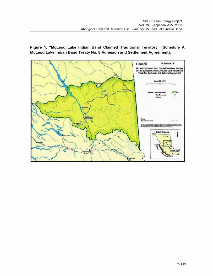
Site C Clean Energy Project
Volume 5 Appendix A15 Part 3
Aboriginal Land and Resource Use Summary: McLeod Lake Indian Band
7 of 13
Figure 1. “McLeod Lake Indian Band Claimed Traditional Territory” (Schedule A.
McLeod Lake Indian Band Treaty No. 8 Adhesion and Settlement Agreement).

Site C Clean Energy Project
Volume 5 Appendix A15 Part 3
Aboriginal Land and Resource Use Summary: McLeod Lake Indian Band
8 of 13
Figure 2. Map depicting locations of the 21 McLeod Lake Indian Band Indian
Reserves (Figure 3-1. FMA Heritage Inc. (2010). Aboriginal Traditional Knowledge
Community Report McLeod Lake Indian Band (Tse’Khene Nation).
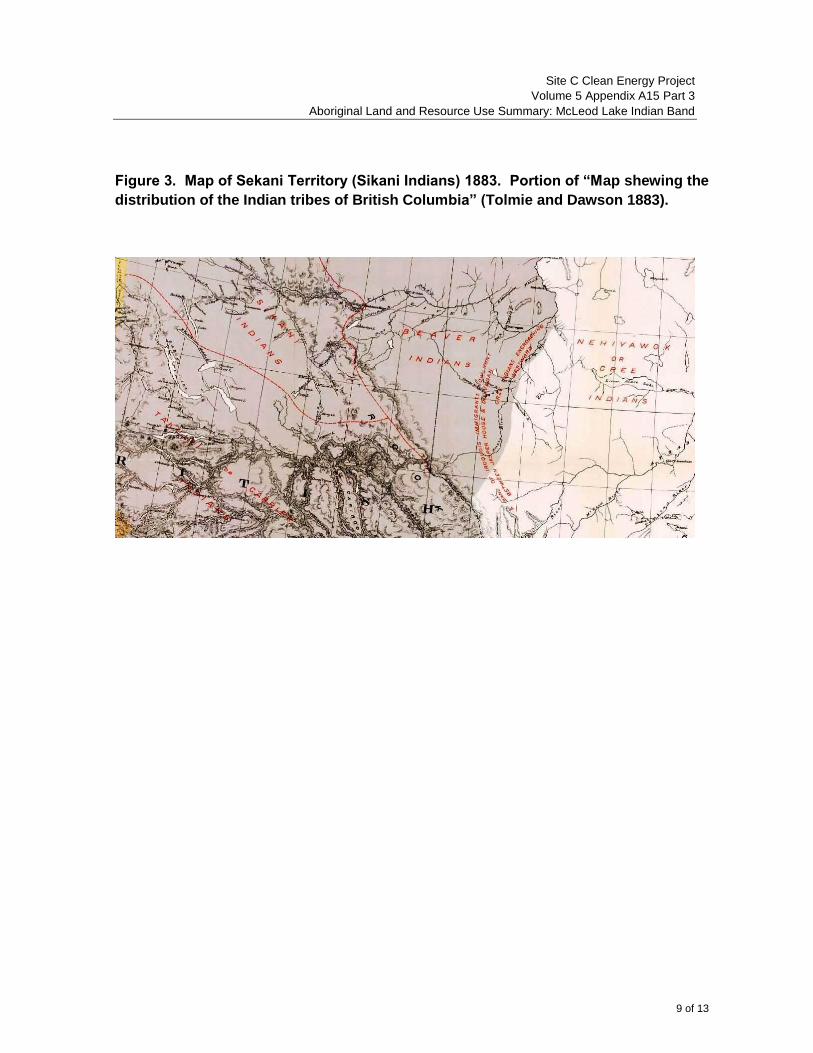
Site C Clean Energy Project
Volume 5 Appendix A15 Part 3
Aboriginal Land and Resource Use Summary: McLeod Lake Indian Band
9 of 13
Figure 3. Map of Sekani Territory (Sikani Indians) 1883. Portion of “Map shewing the
distribution of the Indian tribes of British Columbia” (Tolmie and Dawson 1883).

Site C Clean Energy Project
Volume 5 Appendix A15 Part 3
Aboriginal Land and Resource Use Summary: McLeod Lake Indian Band
10 of 13
Figure 4: Territory of the “Sicannies” depicted on the western edge of the 1900
Treaty 8 “Map showing the territory ceded under treaty No. 8 and the Indian tribes
therein” (Canada. Department of Indian Affairs 1900).
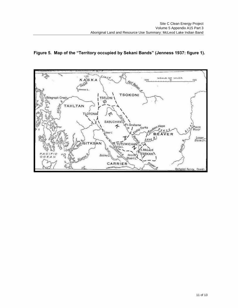
Site C Clean Energy Project
Volume 5 Appendix A15 Part 3
Aboriginal Land and Resource Use Summary: McLeod Lake Indian Band
11 of 13
Figure 5. Map of the “Territory occupied by Sekani Bands” (Jenness 1937: figure 1).

Site C Clean Energy Project
Volume 5 Appendix A15 Part 3
Aboriginal Land and Resource Use Summary: McLeod Lake Indian Band
12 of 13
References
British Columbia. Ministry of Aboriginal Relations and Reconciliation (2012). Website
http://www.gov.bc.ca/arr/firstnation/tsekani/default.html.
Canada. Department of Indian Affairs (1900). “Map showing the territory ceded under treaty
No.8 and the Indian tribes therein.” In Report of the Commissioner for Treaty No.8. Annual
Report of the Department of Indian Affairs for year ended June 30, 1900. Sessional Paper
No. 27, Ottawa. [Colour digital copy at LAC, microfilm NMC 12240, Ottawa] Canada, British
Columbia and McLeod Lake Indian Band (1999). McLeod Lake Indian Band Treaty No. 8
Adhesion and Settlement Agreement, 3 volumes.
By the terms of this agreement, McLeod Lake adhered to Treaty 8.
Denniston, Glenda (1981). “Sekani.” In June Helm, editor. Subarctic. Volume 6, Handbook
of North American Indians. Washington, D.C.: Smithsonian Institution, pages 433-441.
Overview anthropological article on the Sekani based largely on the work of
Jenness.
Fladmark, Knut (1975). Peace Past: Report on an Archaeological Reconnaissance of the
Peace River Basin, British Columbia, 1974. Report submitted to BC Hydro and the
Archaeological Sites Advisory Board, February 1975.
FMA Heritage Inc. (2010). Aboriginal Traditional Knowledge Community Report McLeod
Lake Indian Band (Tse’Khene Nation). Report for Enbridge Northern Gateway Project
Application. July 2010. Calgary. Appendix B of Affidavit of Derek Orr to Enbridge Northern
Gateway Project Joint Review Panel, 16 April 2012. Website. https://www.neb-one.gc.ca/ll-
eng/livelink.exe/fetch/2000/90464/90552/384192/620327/624910/709403/809068/D132-4-1_-
_McLeod_Lake_Indian_Band_-_Affidavit__of_Derek_Orr_April_16,_2012_-
_A2S3A3.pdf?nodeid=808979&vernum=0.
This study documents MLIB traditional knowledge and uses in the area of the route
of the proposed pipeline for the Enbridge Northern Gateway Project.
Jenness, Diamond (1937). The Sekani Indians of British Columbia. Anthropological Series
20, National Museum of Canada Bulletin 84, Ottawa: 8.
The major ethnography of the Sekani based on field study in the summer of 1924,
including three weeks at Fort McLeod.
McLeod Lake Indian Band (2012). MLIB Profile 2012 http://www.mlib.ca/?page_id=15.

Site C Clean Energy Project
Volume 5 Appendix A15 Part 3
Aboriginal Land and Resource Use Summary: McLeod Lake Indian Band
13 of 13
Ridington, Robin (1997). The Sekani Indians of McLeod Lake, British Columbia: Their
Linguistic and Cultural Affiliations, Traditional Territories, Social and Cultural Adaptations,
History, and Present Situation. Manuscript prepared for McLeod Lake Indian Band, revised
July 1997. Submitted by MLIB legal counsel to BC Hydro, 1 January 2013. [The page
numbers of the report are in increments of 10]
Ridington, Robin and Jillian Ridington (2012). McLeod Lake Indian Band’s Historical
Relationship to Lands Affected by the Proposed Site C Development. Paper prepared for
McLeod Lake Indian Band and BC Hydro (nd). Submitted by MLIB legal counsel to BC
Hydro 14 December 2012.
Tolmie, W.F. and G.M. Dawson (1883). Map shewing [sic] the distribution of the Indian
tribes of British Columbia. Geological and Natural History Society of Canada. Geological
Survey of Canada, Multicoloured Geological Map, no.455. Published in Tolmie, W.F. and
G.M. Dawson (1884). Comparative Vocabularies of the Indian Tribes of British Columbia
with a Map Illustrating Distribution. Geological and Natural History Survey of Canada.
Montreal: Dawson Brothers.
Weinstein, Martin (1979). “Indian Land Use and Occupancy in the Peace River Country of
Northern British Columbia.” Appendix to 1980 UBCIC Report, “Final Submission on the
Northeast B.C. Land Use and Occupancy Study.”
SITE C CLEAN ENERGY PROJECT
VOLUME 5 APPENDIX A15 PART 4
ABORIGINAL SUMMARY:
MCLEOD LAKE INDIAN BAND
FINAL REPORT
Prepared for:
BC Hydro Power and Authority 333 Dunsmuir Street
Vancouver, BC V6B 5R3
Prepared by:
Site C First Nations Engagement Team
Suite 1100, Four Bentall Centre 1055 Dunsmuir Street
P.O. Box 49260 Vancouver, BC
V7X 1V5
January 2013
Site C Clean Energy Project
Volume 5 Appendix A15 Part 4
Aboriginal Summary: McLeod Lake Indian Band
1 of 5
McLeod Lake Indian Band
As required by Section 20.8 of the EIS Guidelines, the following summary presents BC Hydro’s understanding of McLeod Lake Indian Band’s asserted or established Aboriginal rights and treaty rights, and other Aboriginal interests potentially impacted by, and concerns with respect to, the Project. The summary also provides BC Hydro’s understanding of the potential adverse effects of the Project on the treaty rights and interests of McLeod Lake Indian Band.
McLeod Lake Indian Band’s Treaty Rights
Section 35(1) of the Constitution recognized and affirmed treaty rights of Aboriginal groups. Treaty 8 was entered into in 1899 and guarantees the First Nation signatories the “right to pursue their usual vocations of hunting, trapping and fishing throughout the tract surrendered” subject to two limitations: (i) “such regulations as may from time to time be made by the Government of the country,” and (ii) “saving and excepting such tracts as may be required or taken up from time to time for settlement, mining, lumbering, trading or other purposes.”
The following Aboriginal groups listed in Table 34.1 of Volume 5 Section 34 Asserted or Established Aboriginal Rights and Treaty Rights, Aboriginal Interests and Information Requirements are signatories or adherents to Treaty 8: Blueberry River First Nations, Fort Nelson First Nation, McLeod Lake Indian Band, Saulteau First Nations, Doig River First Nation, Halfway River First Nation, Prophet River First Nation, West Moberly First Nations, Athabasca Chipewyan First Nation, Beaver First Nation, Dene Tha' First Nation, Duncan's First Nation, Horse Lake First Nation, Little Red River Cree Nation, Mikisew Cree First Nation, Smith's Landing First Nation, Sturgeon Lake Cree Nation, Tallcree First Nation, Woodland Cree First Nation, Deninu K'ue First Nation, Salt River First Nation.
For a more thorough discussion of rights under Treaty 8, see Section 34.3.2.1 of Volume 5 Section 34 Asserted or Established Aboriginal Rights and Treaty Rights, Aboriginal Interests and Information Requirements. McLeod Lake Indian Band’s Concerns with Respect to the Project
The following table presents a high-level description of the concerns identified by McLeod Lake Indian Band in consultation activities with BC Hydro between November 1, 2007 and November 30, 2012, including those identified in meetings, phone calls, letters, emails, reports, and any submissions made during the comment periods for the EIS Guidelines.
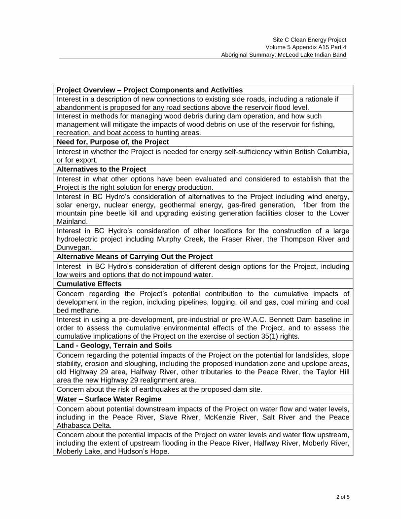
Site C Clean Energy Project
Volume 5 Appendix A15 Part 4
Aboriginal Summary: McLeod Lake Indian Band
2 of 5
Project Overview – Project Components and Activities
Interest in a description of new connections to existing side roads, including a rationale if abandonment is proposed for any road sections above the reservoir flood level.
Interest in methods for managing wood debris during dam operation, and how such management will mitigate the impacts of wood debris on use of the reservoir for fishing, recreation, and boat access to hunting areas.
Need for, Purpose of, the Project
Interest in whether the Project is needed for energy self-sufficiency within British Columbia, or for export.
Alternatives to the Project
Interest in what other options have been evaluated and considered to establish that the Project is the right solution for energy production.
Interest in BC Hydro’s consideration of alternatives to the Project including wind energy, solar energy, nuclear energy, geothermal energy, gas-fired generation, fiber from the mountain pine beetle kill and upgrading existing generation facilities closer to the Lower Mainland.
Interest in BC Hydro’s consideration of other locations for the construction of a large hydroelectric project including Murphy Creek, the Fraser River, the Thompson River and Dunvegan.
Alternative Means of Carrying Out the Project
Interest in BC Hydro’s consideration of different design options for the Project, including low weirs and options that do not impound water.
Cumulative Effects
Concern regarding the Project’s potential contribution to the cumulative impacts of development in the region, including pipelines, logging, oil and gas, coal mining and coal bed methane.
Interest in using a pre-development, pre-industrial or pre-W.A.C. Bennett Dam baseline in order to assess the cumulative environmental effects of the Project, and to assess the cumulative implications of the Project on the exercise of section 35(1) rights.
Land - Geology, Terrain and Soils
Concern regarding the potential impacts of the Project on the potential for landslides, slope stability, erosion and sloughing, including the proposed inundation zone and upslope areas, old Highway 29 area, Halfway River, other tributaries to the Peace River, the Taylor Hill area the new Highway 29 realignment area.
Concern about the risk of earthquakes at the proposed dam site.
Water – Surface Water Regime
Concern about potential downstream impacts of the Project on water flow and water levels, including in the Peace River, Slave River, McKenzie River, Salt River and the Peace Athabasca Delta.
Concern about the potential impacts of the Project on water levels and water flow upstream, including the extent of upstream flooding in the Peace River, Halfway River, Moberly River, Moberly Lake, and Hudson’s Hope.
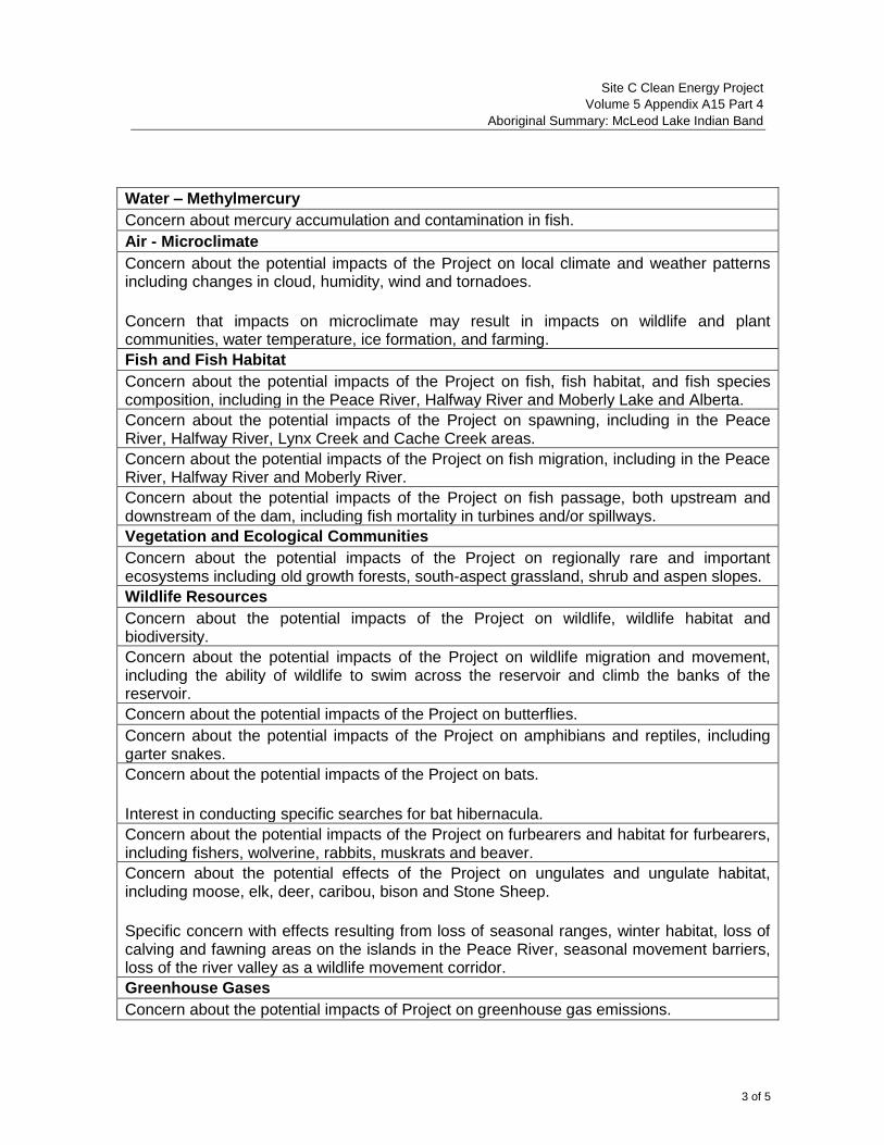
Site C Clean Energy Project
Volume 5 Appendix A15 Part 4
Aboriginal Summary: McLeod Lake Indian Band
3 of 5
Water – Methylmercury
Concern about mercury accumulation and contamination in fish.
Air - Microclimate
Concern about the potential impacts of the Project on local climate and weather patterns including changes in cloud, humidity, wind and tornadoes.
Concern that impacts on microclimate may result in impacts on wildlife and plant communities, water temperature, ice formation, and farming.
Fish and Fish Habitat
Concern about the potential impacts of the Project on fish, fish habitat, and fish species composition, including in the Peace River, Halfway River and Moberly Lake and Alberta.
Concern about the potential impacts of the Project on spawning, including in the Peace River, Halfway River, Lynx Creek and Cache Creek areas.
Concern about the potential impacts of the Project on fish migration, including in the Peace River, Halfway River and Moberly River.
Concern about the potential impacts of the Project on fish passage, both upstream and downstream of the dam, including fish mortality in turbines and/or spillways.
Vegetation and Ecological Communities
Concern about the potential impacts of the Project on regionally rare and important ecosystems including old growth forests, south-aspect grassland, shrub and aspen slopes.
Wildlife Resources
Concern about the potential impacts of the Project on wildlife, wildlife habitat and biodiversity.
Concern about the potential impacts of the Project on wildlife migration and movement, including the ability of wildlife to swim across the reservoir and climb the banks of the reservoir.
Concern about the potential impacts of the Project on butterflies.
Concern about the potential impacts of the Project on amphibians and reptiles, including garter snakes.
Concern about the potential impacts of the Project on bats.
Interest in conducting specific searches for bat hibernacula.
Concern about the potential impacts of the Project on furbearers and habitat for furbearers, including fishers, wolverine, rabbits, muskrats and beaver.
Concern about the potential effects of the Project on ungulates and ungulate habitat, including moose, elk, deer, caribou, bison and Stone Sheep.
Specific concern with effects resulting from loss of seasonal ranges, winter habitat, loss of calving and fawning areas on the islands in the Peace River, seasonal movement barriers, loss of the river valley as a wildlife movement corridor.
Greenhouse Gases
Concern about the potential impacts of Project on greenhouse gas emissions.
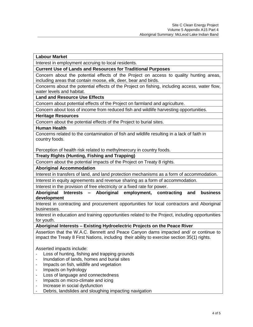
Site C Clean Energy Project
Volume 5 Appendix A15 Part 4
Aboriginal Summary: McLeod Lake Indian Band
4 of 5
Labour Market
Interest in employment accruing to local residents.
Current Use of Lands and Resources for Traditional Purposes
Concern about the potential effects of the Project on access to quality hunting areas, including areas that contain moose, elk, deer, bear and birds.
Concerns about the potential effects of the Project on fishing, including access, water flow, water levels and habitat.
Land and Resource Use Effects
Concern about potential effects of the Project on farmland and agriculture.
Concern about loss of income from reduced fish and wildlife harvesting opportunities.
Heritage Resources
Concern about the potential effects of the Project to burial sites.
Human Health
Concerns related to the contamination of fish and wildlife resulting in a lack of faith in country foods.
Perception of health risk related to methylmercury in country foods.
Treaty Rights (Hunting, Fishing and Trapping)
Concern about the potential impacts of the Project on Treaty 8 rights.
Aboriginal Accommodation
Interest in transfers of land, and land protection mechanisms as a form of accommodation.
Interest in equity agreements and revenue sharing as a form of accommodation.
Interest in the provision of free electricity or a fixed rate for power.
Aboriginal Interests – Aboriginal employment, contracting and business development
Interest in contracting and procurement opportunities for local contractors and Aboriginal businesses.
Interest in education and training opportunities related to the Project, including opportunities for youth.
Aboriginal Interests – Existing Hydroelectric Projects on the Peace River
Assertion that the W.A.C. Bennett and Peace Canyon dams impacted and/ or continue to impact the Treaty 8 First Nations, including their ability to exercise section 35(1) rights.
Asserted impacts include: - Loss of hunting, fishing and trapping grounds - Inundation of lands, homes and burial sites - Impacts on fish, wildlife and vegetation - Impacts on hydrology - Loss of language and connectedness - Impacts on micro-climate and icing - Increase in social dysfunction - Debris, landslides and sloughing impacting navigation
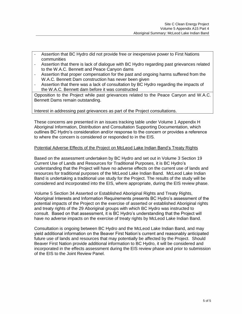
Site C Clean Energy Project
Volume 5 Appendix A15 Part 4
Aboriginal Summary: McLeod Lake Indian Band
5 of 5
- Assertion that BC Hydro did not provide free or inexpensive power to First Nations communities
- Assertion that there is lack of dialogue with BC Hydro regarding past grievances related to the W.A.C. Bennett and Peace Canyon dams
- Assertion that proper compensation for the past and ongoing harms suffered from the W.A.C. Bennett Dam construction has never been given
- Assertion that there was a lack of consultation by BC Hydro regarding the impacts of the W.A.C. Bennett dam before it was constructed
Opposition to the Project while past grievances related to the Peace Canyon and W.A.C. Bennett Dams remain outstanding.
Interest in addressing past grievances as part of the Project consultations.
These concerns are presented in an issues tracking table under Volume 1 Appendix H Aboriginal Information, Distribution and Consultation Supporting Documentation, which outlines BC Hydro’s consideration and/or response to the concern or provides a reference to where the concern is considered or responded to in the EIS.
Potential Adverse Effects of the Project on McLeod Lake Indian Band’s Treaty Rights
Based on the assessment undertaken by BC Hydro and set out in Volume 3 Section 19 Current Use of Lands and Resources for Traditional Purposes, it is BC Hydro’s understanding that the Project will have no adverse effects on the current use of lands and resources for traditional purposes of the McLeod Lake Indian Band. McLeod Lake Indian Band is undertaking a traditional use study for the Project. The results of the study will be considered and incorporated into the EIS, where appropriate, during the EIS review phase. Volume 5 Section 34 Asserted or Established Aboriginal Rights and Treaty Rights, Aboriginal Interests and Information Requirements presents BC Hydro’s assessment of the potential impacts of the Project on the exercise of asserted or established Aboriginal rights and treaty rights of the 29 Aboriginal groups with which BC Hydro was instructed to consult. Based on that assessment, it is BC Hydro’s understanding that the Project will have no adverse impacts on the exercise of treaty rights by McLeod Lake Indian Band. Consultation is ongoing between BC Hydro and the McLeod Lake Indian Band, and may yield additional information on the Beaver First Nation’s current and reasonably anticipated future use of lands and resources that may potentially be affected by the Project. Should Beaver First Nation provide additional information to BC Hydro, it will be considered and incorporated in the effects assessment during the EIS review phase and prior to submission of the EIS to the Joint Review Panel.