site specific final report - united states army · site specific final report non-time critical...
TRANSCRIPT

SITE SPECIFIC FINAL REPORTNon-Time Critical Removal Action (NTCRA)
Culebrita and Culebra BeachesMunicipality of Culebra, Puerto Rico
Contract No. W912DY-04-D-0006Task Order No. 0012
Project No. I02PR00682
Prepared For
U.S. Army Engineering and Support Center, Huntsvilleand
U.S. Army Corps of Engineers, Jacksonville District
Prepared By
USA Environmental, Inc.720 Brooker Creek Boulevard, Suite 204
Oldsmar, Florida 34677
4 June 2009
The views, opinions, and/or findings contained in the report are those of the author(s) and should not be construed as an official Department of the Army position, policy, or
decision, unless so designated by other documentation.
VOLUME 1

SITE SPECIFIC FINAL REPORTNon-Time Critical Removal Action (NTCRA)
Culebrita and Culebra BeachesMunicipality of Culebra, Puerto Rico
Contract No. W912DY-04-D-0006Task Order No. 0012
Project No. I02PR00682
Prepared For
U.S. Army Engineering and Support Center, Huntsvilleand
U.S. Army Corps of Engineers, Jacksonville District
Prepared By
USA Environmental, Inc.720 Brooker Creek Boulevard, Suite 204
Oldsmar, Florida 34677
4 June 2009
The views, opinions, and/or findings contained in the report are those of the author(s) and should not be construed as an official Department of the Army position, policy, or
decision, unless so designated by other documentation.
VOLUME 2

USA Environmental, Inc.720 Brooker Creek Boulevard, Suite 204, Oldsmar, FL 34677Telephone: (813) 343-6336 FAX: (813) 343-6337
USA Environmental, Inc.

Site Specific Final Report Non-Time Critical Removal Action Culebrita and Culebra Beaches
Contract No. W912DY-04-D-0006; Task Order No. 0012 Page i 4 June 2009
TABLE OF CONTENTS
CHAPTER 1. INTRODUCTION ................................................................................................................. 1-1
1.1 GENERAL ........................................................................................................................ 1-1 1.2 AIMS AND OBJECTIVES ............................................................................................... 1-1 1.3 TASK ORDER PERFORMANCE WORK STATEMENT ................................................ 1-1 1.4 TECHNICAL INSTRUCTIONS ........................................................................................ 1-1 1.5 PREVIOUSLY RELATED SUBMITTALS........................................................................ 1-2
CHAPTER 2. DISCUSSION ...................................................................................................................... 2-1
2.1 GENERAL ........................................................................................................................ 2-1 2.1.1 Site Visit ............................................................................................................. 2-1 2.1.2 Development of the Non-Time Critical Removal Action
(NTCRA) Work Plan .......................................................................................... 2-1 2.1.3 DGM Field Operations ...................................................................................... 2-1 2.1.4 Subcontractors .................................................................................................. 2-2 2.1.5 Intrusive Operations ......................................................................................... 2-2
2.2 PERSONNEL ................................................................................................................... 2-2 2.3 EQUIPMENT .................................................................................................................... 2-3 2.4 FACILITIES ...................................................................................................................... 2-3 2.5 PROCEDURES ................................................................................................................ 2-3
2.5.1 Setup .................................................................................................................. 2-3 2.5.1.1 Magazines .............................................................................................. 2-3 2.5.1.2 Control Monuments and Location Surveys ............................................ 2-3 2.5.1.3 Vegetation Removal ............................................................................... 2-4
2.5.2 Geophysical Prove-Out .................................................................................... 2-4 2.5.3 Geophysical Survey Methods .......................................................................... 2-4
2.5.3.1 Detection Sensor ................................................................................... 2-5 2.5.3.2 Positioning System and Geodetic Locations ......................................... 2-5 2.5.3.3 Sensor – Positioning System Platform .................................................. 2-5
2.5.4 DGM Surveys ..................................................................................................... 2-6 2.5.4.1 Field Activities ........................................................................................ 2-6 2.5.4.2 Cultural Features ................................................................................... 2-7
2.5.5 Processing Activities ........................................................................................ 2-7 2.5.5.1 Data Preprocessing ............................................................................... 2-7 2.5.5.2 Data Processing ..................................................................................... 2-7 2.5.5.3 Anomaly Selection ................................................................................. 2-8 2.5.5.4 Dig Sheet Generating ............................................................................ 2-8 2.5.5.5 Corrective Action Requests (CARs) ...................................................... 2-8
2.6 REACQUISITION ............................................................................................................. 2-9 2.7 ANOMALY INVESTIGATION ........................................................................................ 2-11
2.7.1 Flamenco Beach Anomaly Investigation ...................................................... 2-11 2.7.2 Culebrita, Beach A Anomaly Investigation .................................................. 2-11 2.7.3 Culebrita, Beach B Anomaly Investigation .................................................. 2-12 2.7.4 Culebrita, Beach C Anomaly Investigation .................................................. 2-12 2.7.5 Culebrita, Beach D Anomaly Investigation .................................................. 2-12 2.7.6 Culebrita, Beach E Anomaly Investigation ................................................... 2-12

Site Specific Final Report Non-Time Critical Removal Action Culebrita and Culebra Beaches
Contract No. W912DY-04-D-0006; Task Order No. 0012 Page ii 4 June 2009
2.8 ANOMALY RANKING ASSESSMENT ......................................................................... 2-12 2.9 BLIND SEED ITEM EVALUATION ............................................................................... 2-13
CHAPTER 3. DOCUMENTATION ............................................................................................................. 3-1
3.1 GENERAL ........................................................................................................................ 3-1
CHAPTER 4. TESTS ................................................................................................................................. 4-1
4.1 CONTRACTOR QUALITY CONTROL (QC) TESTS AND RESULTS ........................... 4-1 4.1.1 EM61-MK2 Equipment Tests ............................................................................ 4-1 4.1.2 Equipment / Electronics Warm-Up .................................................................. 4-1 4.1.3 Recording Relative Sensor Positions ............................................................. 4-1 4.1.4 Static Background, Static Response (Spike), Vibration
(Cable Shake), Personnel Test ........................................................................ 4-2 4.1.5 Six Line Test (Start of Project) ......................................................................... 4-2 4.1.6 Two Line Latency Test ..................................................................................... 4-2 4.1.7 Repeat Line Data ............................................................................................... 4-2 4.1.8 Positioning System Checks ............................................................................. 4-3 4.1.9 Quality Control Deliverables ............................................................................ 4-3 4.1.10 Additional Project Data Quality Objectives .................................................... 4-3 4.1.11 Quality Control Inspections ............................................................................. 4-3
4.2 GOVERNMENT QUALITY ASSURANCE (QA) TESTS AND RESULTS ...................... 4-3 4.2.1 Non-Conformance Reports or Records .......................................................... 4-3
CHAPTER 5. FINANCIAL BREAKDOWN ................................................................................................ 5-1
5.1 GENERAL ........................................................................................................................ 5-1
CHAPTER 6. SUMMARY .......................................................................................................................... 6-1
6.1 GENERAL ........................................................................................................................ 6-1
CHAPTER 7. CONCLUSION AND LESSONS LEARNED ....................................................................... 7-1
7.1 GENERAL ........................................................................................................................ 7-1 7.2 LESSONS LEARNED ..................................................................................................... 7-1
7.2.1 Location of Geophysical Prove Out ................................................................ 7-1 7.2.2 Laws in the Commonwealth of Puerto Rico for
Explosive Operations ....................................................................................... 7-1 7.2.3 DGM Survey and Intrusive Operations ........................................................... 7-2 7.2.4 Rapid DGM Survey of the Beaches ................................................................. 7-3 7.2.5 Excavations and the Water Table .................................................................... 7-4 7.2.6 Holidays for DGM and MEC Operations ......................................................... 7-4 7.2.7 Impact of Anomalies near Known Turtle Nests ............................................. 7-5 7.2.8 Weather/Ocean Impacts ................................................................................... 7-5
APPENDIX A MAPS
APPENDIX B QC/QA RECORDS
APPENDIX C MUNITIONS DEBRIS DISPOSITION RECORDS
APPENDIX D EXPLOSIVES ACCOUNTABILITY RECORDS
APPENDIX E PHOTOGRAPHS

Site Specific Final Report Non-Time Critical Removal Action Culebrita and Culebra Beaches
Contract No. W912DY-04-D-0006; Task Order No. 0012 Page iii 4 June 2009
APPENDIX F DAILY SUXOS REPORTS AND LOG BOOKS
APPENDIX G MEC DATABASE
APPENDIX H FINAL DIG SHEETS AND RESULTS
APPENDIX I GPO REPORT
APPENDIX J CAR RESPONSES
APPENDIX K PWS
APPENDIX L SAFETY
APPENDIX M GIS DATA
APPENDIX N DGM DATA
LIST OF TABLES
Table 2-1: Anomaly Categorization Protocol ............................................................................................. 2-4
Table 2-2 : Culebra and Culebrita DGM Acres .......................................................................................... 2-7
Table 2-3: Dig List Summary by Beach ..................................................................................................... 2-9
Table 2-4: Flamenco Beach Intrusive Results Summary ......................................................................... 2-11
Table 2-5: Culebrita Beach A Intrusive Results Summary ....................................................................... 2-11
Table 2-6: Culebrita Beach B Intrusive Results Summary ....................................................................... 2-12
Table 2-7: Culebrita Beach C Intrusive Results Summary ...................................................................... 2-12
Table 2-8: Culebrita Beach D Intrusive Results Summary ...................................................................... 2-12
Table 2-9: Culebrita Beach E Intrusive Results Summary ....................................................................... 2-12
Table 2-10: Anomaly Categorization Summary ....................................................................................... 2-13
Table 4-1: Geophysical Instrument Standardization Tests and Acceptance Criteria ................................ 4-1
Table 6-1: Intrusive Results Summary by Beach ....................................................................................... 6-2

Site Specific Final Report Non-Time Critical Removal Action Culebrita and Culebra Beaches
Contract No. W912DY-04-D-0006; Task Order No. 0012 Page iv 4 June 2009
LIST OF FIGURES
Figure 2-1: USA Field Team Organization Chart ....................................................................................... 2-2
Figure 2-2 : EM61 Wheel Mode at Culebrita Beach E (Handle modification needed for small wheels) .... 2-6
Figure 2-3: Flamenco Beach GPO Feb 2009 .......................................................................................... 2-10
Figure 2-4: Original Flamenco Beach GPO Nov 2008 ............................................................................. 2-10
Figure 7-1: Flamenco Beach GPO February 2008 .................................................................................... 7-1
Figure 7-2: Flamenco Beach GPO November 2009 .................................................................................. 7-1
Figure 7-3: Number of No Finds on Culebrita Beaches ............................................................................. 7-2
Figure 7-4: Example of Flamenco Beach with Impact of Water on DGM Survey ...................................... 7-3
Figure 7-5: Attempting to Perform Reacquire on Anomalies in the Surf .................................................... 7-4
Figure 7-6: Water Intrusion ........................................................................................................................ 7-4
Figure 7-7: Turtles Hatching....................................................................................................................... 7-5
Figure 7-8: Turtle Nest on Culebrita ........................................................................................................... 7-5
This space is intentionally left blank.

Site Specific Final Report Non-Time Critical Removal Action Culebrita and Culebra Beaches
Contract No. W912DY-04-D-0006; Task Order No. 0012 Page v 4 June 2009
LIST OF ACRONYMS
AOI Area of Interest bgs Below Ground Surface BIP Blow-in-Place BSI Blind Seed Item DGM Digital Geophysical Mapping DGPS Differential Global Positioning System DID Data Item Description DQO Data Quality Objectives EM Electromagnetic FIDS Fiducials ft foot FTP File Transfer Protocol GIS Geographical Information System GPO Geophysical Prove-Out GPS Global Positioning System HE High Explosive in. inch ITS Instrument Test Strip MC Munitions Constituents MEC Munitions and Explosives of Concern MPPEH Material Potentially Presenting an Explosive Hazard NAD North American Datum PLS Professional Land Surveyor PTTF Powder Train Time Fuze PR Puerto Rico PWS Performance Work Statement QA Quality Assurance QASP Quality Assurance Surveillance Plan QC Quality Control SSFR Site Specific Final Report SUXOS Senior UXO Supervisor TDEM Time Domain Electromagnetic USA USA Environmental, Incorporated USACE U.S. Army Corps of Engineers USAESCH U.S. Army Engineering and Support Center, Huntsville UTM Universal Transverse Mercator UXO Unexploded Ordnance UXOQCS UXO Quality Control Specialist UXOSO UXO Safety Officer UXOTI/II UXO Technician I/II UXOTIII UXO Technician III

Site Specific Final Report Non-Time Critical Removal Action Culebrita and Culebra Beaches
Contract No. W912DY-04-D-0006; Task Order No. 0012 Page 1-1 4 June 2009
CHAPTER 1. INTRODUCTION
1.1 GENERAL
This Site Specific Final Report summarizes the methods, procedures, and personnel that USA Environmental, Incorporated (USA) used to perform Task Order operations on Culebrita and Culebra, Puerto Rico (PR) during a Non-Time Critical Removal Action under contract number W912DY-04-D-0006, Task Order number 0012, Project Number I02PR006802. USA has prepared this document in accordance with current United States Army Engineering and Support Center, Huntsville (USAESCH) Data Item Description (DID) MR-030 and the Scope of Work (SOW), dated 30 August 2006, and revision dated 5 Jul 2007.
USA developed this Site Specific Final Report (SSFR) in accordance with the guidance provided in the U.S. Army Corps of Engineers (USACE) Data Item Description (DID) MR-030 to document the results of the removal action at Culebrita and Culebra Beaches.
1.2 AIMS AND OBJECTIVES
The purpose of this project is to provide munitions response services to remove Munitions and Explosives of Concern (MEC), Material Potentially Presenting an Explosive Hazard (MPPEH), munitions debris, and range-related debris from the specified areas on Culebrita and Culebra Beaches. Munitions and explosives of concern (MEC) is a safety hazard and may constitute a threat to site personnel and the general public.
1.3 TASK ORDER PERFORMANCE WORK STATEMENT
The scope of Task Order No. 0012 includes the following tasks: (1) project preparation and planning under Task 1; (2) provide the munitions response Work Plan under Task 2; (3) perform Digital Geophysical Mapping(DGM) investigation and evaluation under Task 3; (4) conduct anomaly resolution and intrusive activities work under Task 4; (5) provide geospatial data to update and maintain the existing Geographical Information System (GIS) database under Task 5; and (6) generate a SSFR under Task 6.
Revision 05 December 2007 changed Task 3 Digital Geophysical Mapping, Paragraph 3.3.1.33 to include requirements for a temporary fence around the GPO area and addition of Task 8 Beach Monitoring, Paragraph 3.7 to include requirements for monitoring of beaches prior to intrusive ordnance activities.
1.4 TECHNICAL INSTRUCTIONS
• Contracting Officer, Letter Approval of Abbreviated Accident Prevention Plan (AAPP) and all Tasks except for Task 4, October 26, 2006.
• Contracting Officer, Letter, Clarification of the requirement for 5 additional acres of clearance adjacent to the beach areas, dated February 1, 2007.
• U.S. Army Technical Center for Explosive Safety (USATCES) Approval for Initiating Amendment 1, Conventional Explosive Safety Submission (ESS), Munitions and Explosives of Concern Removal Action, Culebra Island, Puerto Rico, dated February 5, 2007.
• Contracting Officer, Letter Notice to Proceed for Task 4, dated September 20, 2008 • Letter from Municipal De Culebra, Permission to work on Flamenco Beach, dated 7 November
2008 • Project Manager, Results of Negotiations held on January 7, 2008, for addition of fence and Task
8 Beach Monitoring. USA will proceed with mobilization to perform DGM of the beaches in February 2008.

Site Specific Final Report Non-Time Critical Removal Action Culebrita and Culebra Beaches
Contract No. W912DY-04-D-0006; Task Order No. 0012 Page 1-2 4 June 2009
1.5 PREVIOUSLY RELATED SUBMITTALS
• Final AAPP, Contracting Officer Approval October 26, 2006 • Draft Final Work Plan, July 27, 2007 • Minutes of On Board Review, September 18, 2007 • Acceptance of Final Work Plan, December 21, 2007 • Geophysical Prove-Out, February 2008 • Geophysical Dig List, March 2008
This space is intentionally left blank.

Site Specific Final Report Non-Time Critical Removal Action Culebrita and Culebra Beaches
Contract No. W912DY-04-D-0006; Task Order No. 0012 Page 2-1 4 June 2009
CHAPTER 2. DISCUSSION
2.1 GENERAL
2.1.1 Site Visit
USA performed the Site Visit on October 30 – November 2, 2006. The purpose was to gather data for work plan preparation for removal operations on Task Order (TO) 0012, Performance Work Statement. Prior to mobilization USA submitted, and had approved, an Abbreviated Accident Prevention Plan (AAPP) to the USAESCH. Personnel, under control of unexploded ordnance (UXO) qualified technicians, walked and surveyed the site. Using hand-held Global Positioning System (GPS) USA identified and verified the site’s boundary and captured locations of residences, and any other locations that could impact site operations. No UXO was encountered during the site visit.
USA personnel mobilized to the site on Monday, October 30, 2006. USA supplied equipment to perform magnetometer (Schonstedt) and metal detector (MineLab Explorer II) sweeps of the beaches to determine which instrument could be used on the islands beaches and the approximate number of anomalies that could be located to help determine density. The Schonstedt can be used on Culebra but cannot be used on Culebrita because of the amount of volcanic rock near the surface.
USA was able to visit the five beaches located on Culebrita on October 31 and November 1, 2006. Four of the beaches are accessible by boat. Beach D is not accessible by boat due to the waves breaking over the beach. Access to Beach D had to be accomplished by overland from Beach E. USA team returned to Culebrita and walked three trails on the island between beaches B, C, D, and E. In the afternoon USA visited Flamenco Beach on Culebra. See Appendix A for maps.
November 2, 2006, USA team met with the Mayor’s office, the State Police of Puerto Rico, and the Tourism Office to discuss the GPO and project issues. The issue of a location for the Geophysical Prove-Out was discussed with the City. USA did locate and visit Ellis Environmental project office to ask questions concerning their operations on the islands for coordination purposes.
2.1.2 Development of the Non-Time Critical Removal Action (NTCRA) Work Plan
USA submitted the Draft Work Plan on 9 November 2006. The Draft Final Work Plan was submitted on 7 July 2007 in 20 copies for regulatory review. USA attended an On Board Review in Culebra, PR on 13 September 2007. Changes to the WP were incorporated and a Final Work Plan was published and accepted by the Contracting Officer in December 2007.
The following were issues raised during the meeting that were resolved before the WP was approved:
• Government Draft SOP Endangered Species Conservation and their Habitat • Requirements for authorization by the FWS Refuge Manager for access to Culebrita • Addressing procedures to be followed to train personnel to minimize the impacts to listed species
and their habitats in addition to training personnel in safety related subjects to the protection of listed species, this included boat access to Culebrita.
• Time for field operations was agreed on November – April timeframe which allowed both the sand transport patterns on the beach and the sea turtle nesting to be considered.
2.1.3 DGM Field Operations
The USA DGM team mobilized to the project site on 2 February 2008, to begin the field work on Culebra and Culebrita beaches. The DGM team began installation of a ¼ acre GPO test plot on 4 February 2008, and began digital geophysical surveying of the project beaches on 8 February 2008. The USA DGM team

Site Specific Final Report Non-Time Critical Removal Action Culebrita and Culebra Beaches
Contract No. W912DY-04-D-0006; Task Order No. 0012 Page 2-2 4 June 2009
completed the field work in accordance with the PWS on 27 February 2008 and demobilized on 28 February 2008.
2.1.4 Subcontractors
USA subcontracted with Sea Ventures to provide boat transport for personnel and equipment to Culebrita. USA subcontracted a Project Biologist, who began monitoring the designated beaches on Culebra and Culebrita on 11 October 2008 for signs of turtle nesting activities.
2.1.5 Intrusive Operations
The USA Intrusive team mobilized 16 November 2008 and conducted anomaly investigation on Flamenco Beach using the Real Time Kinematic Differential GPS (RTK DGPS), EM61-MK2, and the Personal Data Assistant (PDA) for recording the anomaly investigation results. USA completed intrusive work on Flamenco Beach on 3 December 2008. Three personnel were demobilized to Vieques, PR, and the remainder of personnel went on stand by while the lack of turtle activity on Culebrita Beach E was reviewed.
USA continued intrusive work on Culebrita Beach E on 10 December 2008, all USA personnel demobilized on 13 December 2008 for the holidays. USA mobilized all intrusive personnel on 5 January 2009 to complete intrusive work on Culebrita. The USA team completed the field work in accordance with the PWS on 20 January 2009. With approval from USAESCH, USA demobilized on 21 January 2009.
Figures A-1 and A-2 in Appendix A depict the location of the Culebrita and Culebra Beaches and boundary of the investigation areas, respectively. Figures A-3, A-4, A-5, A-6, A-7 and A-8 depict the investigation area boundaries and investigation results for this project. Quality control (QC) and quality assurance (QA) documents are provided in Appendix B. The MEC Removal Team certified, verified, and turned-in recovered munitions debris to Timberline Environmental Services located in Cold Springs, California. Munitions debris disposition records are provided in Appendix C.
2.2 PERSONNEL
USA fielded one 4-person DGM Team and one 6-person Reacquire/Intrusive Team at the Culebra and Culebrita project site. The DGM Team consisted of one Geophysical Team Leader, one Geophysical Operation under the direction of the Project Geophysicist and a dual-hatted UXO Safety Officer (UXOSO)/UXO Quality Control Specialist (UXOQCS). The Reacquire/Intrusive Team consisted of one UXO Technician III (UXOTIII or Team Leader), two UXO Technicians II (UXOTII), and three UXO Technicians I (UXOTI) under the direction of the Senior UXO Supervisor (SUXOS) and dual-hatted UXO Safety Officer (UXOSO)/UXO Quality Control Specialist (UXOQCS).
Figure 2-1: USA Field Team Organization Chart
SUXOS
James Paksi
UXOSO/UXOQCS Franklin Province - DGM Gerry Base – Intrusive 1
Jeff Barefield – Intrusive 2
Intrusive Team
1 – UXOTIII 2 – UXOTII 3 – UXOTI
Project Geophysicist
Al Crandall
Geophysical Survey Team
1 – Geo Team Lead 1 – Geo Equip Operator
Project Biologist
Rosarito Morales

Site Specific Final Report Non-Time Critical Removal Action Culebrita and Culebra Beaches
Contract No. W912DY-04-D-0006; Task Order No. 0012 Page 2-3 4 June 2009
2.3 EQUIPMENT
The DGM Team utilized the following equipment for this project:
• Team Vehicles (2) • Geonics EM61-MK2 TDEM System (1) • Trimble RTK/DGPS (2) • Metal Detector, Minelab Explorer II (1) • Magnetometer, Schonstedt GA-52Cx (1) • Tape Measures and line • GPO and QC Seed Items
The Intrusive Team utilized the following equipment for this project:
• Team Vehicles (2) • Global Positioning System (GPS)/Data Collection Tools, Trimble GeoXT (2) • Geonics EM61-MK2 TDEM System (1) • Trimble RTK/DGPS (1) • Minelab Explorer II (3) • Magnetometer, Schonstedt GA-52Cx (2)
2.4 FACILITIES
USA rented one office space/storage space through Posada La Hamaca, Culebra, PR.
2.5 PROCEDURES
2.5.1 Setup
2.5.1.1 Magazines
USA purchased an ATF Type II magazine with an attached cap box sited in the approved Amendment 1 to the Explosives Safety Submission (ESS). Prior to using the magazines, USA performed vegetation clearance 25 ft around the magazine as required by the Puerto Rico State Police. Grounding inspection was conducted by Rod Rodder Electric Company. The Puerto Rico State Police conducted the magazine inspection and certification on 5 November 2008. During the NTCRA USA opted not to store explosives in the magazine, but relied on delivery of explosives “as needed” by helicopter on two occasions. This approach saved money by eliminating the need for a 24/7 guard on the magazine, which Commonwealth law requires any time explosives are stored.
2.5.1.2 Control Monuments and Location Surveys
USA used a survey control monument at the Desalinization Plant to bring survey control to Flamenco Beach (Flamenco Base) and a high point on eastern Culebra (Culebra East) with a clear view of Culebrita. A series of back check points were also measured to insure proper GPS base station setup and RTK DGPS performance within project metrics (0.152cm). There was some issue with the location information for the Desalinization Plant control monument provided in UTM 18N when in fact, the control point is in UTM 20N. USA utilized the Latitude and Longitude coordinates for the control point to calculate the UTM20N coordinates and confirmed at two back check points. The Culebrita East GPS base station was used to bring control and back check points to Culebrita Beach E. All coordinates were in World Geodetic System 1984 (WGS84) UTM meters, Zone 20N. The coordinates for all GPS base stations, check points, and daily GPS checks are included in Appendix B (GPS Checks.xls).

Site Specific Final Report Non-Time Critical Removal Action Culebrita and Culebra Beaches
Contract No. W912DY-04-D-0006; Task Order No. 0012 Page 2-4 4 June 2009
2.5.1.3 Vegetation Removal
The PWS authorized 5 acres on Culebrita to be cleared of vegetation to facilitate Digital Geophysical Mapping. During the On Board Review in September of 2007, the Fish and Wildlife Service (FWS) agreed not to clear any of the vegetation along the beaches. This decision was made to restrict access and help keep tourist from getting closer to the nesting areas of the turtles.
2.5.2 Geophysical Prove-Out
In accordance with the PWS, USA established a Geophysical Prove-Out (GPO) Test Plot. The size of the GPO test plot was approximately ¼ acre. The GPO test plot was established in an open sandy area on Beach F, no vegetation clearance was required.
Subsequent to the GPO, a study of the affects of Signal to Noise Ration (SNR) data window size was performed on the GPS-positioned GPO data with the small wheels. The results of this study are summarized in Appendix I in Excel file GPOGPSLO_SNR Window Size Study.xls. The GPO and the SNR window study resulted in a final anomaly categorization protocol detailed in Table 2-1. The GPO site was staked out, and a background survey was completed on 5 February 2008. The background survey indicated that the GPO site was free of background anomalies and was then seeded with 16 MEC simulant seed items. The DGM Team surveyed the seeded GPO with the standard EM61 wheels and then with a set of small wheels. The smaller wheels were used at the request of the USAESCH Project Geophysicist. Sensor positioning with RTK/DGPS and line/station/fiducials were demonstrated. GPO data was processed and analyzed on-site and reviewed with the USAESCH Project Geophysicist on-site. Initial data leveling, processing, and anomaly analysis methods were established, along with initial project metrics for velocity and sample density. The DGM survey of the GPO was conducted by the DGM team on 6-7 February 2008 using the 100% grid-pattern survey method. Approval to proceed to production DGM was given by the Corps’ project geophysicist using the small wheels. The GPO Report is provided in Appendix I. During the GPO activity, the UXOSO/QCS seeded Flamenco Beach with 20 Blind Seed Items (BSIs).
Table 2-1: Anomaly Categorization Protocol
Category Size Signal Strength Represents 1 Must be greater than
1.25m2 Must be greater than 1,050
Large item, indistinguishable from 75mm or larger, any depth
2 Must be greater than 0.5m2 and not meet Category 1 criteria
Must be greater than 205 and not meet Category 1 criteria
Small item, indistinguishable from 20mm or 37mm, any depth
3 Does not meet Category 1 or 2 criteria
Does not meet Category 1 or 2 criteria
Suspected small, background anomalies or false positives. May include small MEC at depths where Pd is low.
2.5.3 Geophysical Survey Methods
The DGM team acquired production DGM data on Flamenco Beach, Culebra 8 – 15 February 2008, as demonstrated at the approved GPO. The DGM team then mobilized to Culebrita on 18 February to establish survey control. The UXOSO/QCS seeded each beach with BSIs. DGM operations on Culebrita were performed from 19 through 27 February 2008. Over 12 acres were surveyed using an EM61-MK2 sensor on with smaller wheels in conjunction with RTK DGPS positioning to detect anomalous responses. Upon completion of all field DGM surveys, USA demobilized the DGM team on 28 February 2008. The DGM data were processed and analyzed using the anomaly categorization protocol established at the GPO. A total of 790 anomalies were identified and classified as either “Cat 1,” “Cat 2,” or “Cat 3,” based

Site Specific Final Report Non-Time Critical Removal Action Culebrita and Culebra Beaches
Contract No. W912DY-04-D-0006; Task Order No. 0012 Page 2-5 4 June 2009
on the individual response characteristics. The prioritization was based on the individually captured response characteristics from each anomaly in comparison to known items seeded within the GPO. Additionally 34 polygon areas around high density areas were identified. Finally, data was uploaded to USA’s File Transfer Protocol (FTP) site, including all raw, processed data, maps, and dig sheets for future analyses and intrusive investigations. Daily DGM instrument checks were delivered as Excel files (Data Tracking Form.xls, GPS Checks.xls, Latency Checks.xls, and Static Check Statistics.xls) and are included in Appendix B.
2.5.3.1 Detection Sensor
Geophysical data were collected using a single Geonics EM61-MK2 Electromagnetic system (referred to hereafter as the EM61) on small (10-inch) wheels, set to collect data in “4 channel” mode at 10 Hz. The EM61 is a Time Domain Electromagnetic (TDEM) system that generates 150 electromagnetic (EM) pulses per second and measures during the off time between pulses. After each pulse, secondary EM fields are introduced, briefly in moderately conductive soils and for a longer time in metallic objects. Between each pulse, the EM61 waits until the response from the conductive earth dissipates and then measures the prolonged buried metal response. This response is recorded in millivolts (mV). The EM61 measures multiple time gates (216, 366, 660, and 1,266 μs) to provide a more complete measurement of the response decay rate.
2.5.3.2 Positioning System and Geodetic Locations
USA utilized the Trimble 4700 base and R8 rover RTK DGPS for real time data positioning with the GPS antennae mounted directly over the center of the EM61 coil. Positions were streamed in real time to the EM61 data logger at a rate of 1 Hz. The coordinate system utilized for generating all maps was WGS84, UTM Zone 20 North with units in meters. Survey control and back check points and all GPS checks are provided in the Excel file GPS Check.xls in Appendix B.
2.5.3.3 Sensor – Positioning System Platform
Data was collected with the EM61 in “wheel” mode due to the smooth, slightly undulating ground surface and lack of surface debris (stumps, roots, etc). The wheel mode required two people to maneuver the EM61 (one to pull and one to push), with the rover GPS attached above the center of the coil. Using the wheels allowed the coil to be maintained at the operational height of 10 inches in order to adequately detect all targets of interest. The EM61 amplitude data readings were recorded at 10 Hz and were interleaved with the 1-Hz GPS position data by EM61MK2A on an Allegro data logger. The operators in the field monitored the EM and GPS values displayed within the data logger at regular intervals in order to “field-check” for any dramatic changes in data quality, e.g. loss of GPS or excessive EM response values.. Figure 2-2 shows EM61 data collection in conjunction with GPS positioning to adequately sample the work areas.
This space is intentionally left blank.

Site Specific Final Report Non-Time Critical Removal Action Culebrita and Culebra Beaches
Contract No. W912DY-04-D-0006; Task Order No. 0012 Page 2-6 4 June 2009
Figure 2-2 : EM61 Wheel Mode at Culebrita Beach E (Handle modification needed for small wheels)
2.5.4 DGM Surveys
2.5.4.1 Field Activities
The DGM team mobilized three personnel, consisting of a Project Geophysicist and two data collectors, to Culebra on 2 and 3 February 2008. Following the completion of the GPO demonstration and on-site approval from the USAESCH representative, the DGM survey of Flamenco Beach commenced on 8 February 2008 and continued until completed on 15 February 2008. Line spacing was kept at 2-feet to help insure 100% coverage and detection of 20mm projectiles. The small 10-inch wheels were used to optimize detection depths. Sea Ventures then mobilized the DGM team and equipment to Culebrita daily. Culebrita Beaches (Beach A, Beach B, Beach C, Beach D, and Beach E) were also mapped with 2-foot line spacing and the small 10-inch wheels. Survey operations on Culebrita were performed from 19 through 27 February 2008. All QC tests were completed and reviewed at the beginning and end of each day. The Data Quality Objectives (DQOs) for down line sampling and coverage were also checked daily by the Project Geophysicist. Once DGM surveys of all beaches were completed, interpretation commenced in order to prioritize the anomalies for intrusive investigation.
The area covered totaled 12.3 acres. Survey coverage for each beach is summarized in Table 2-2.

Site Specific Final Report Non-Time Critical Removal Action Culebrita and Culebra Beaches
Contract No. W912DY-04-D-0006; Task Order No. 0012 Page 2-7 4 June 2009
Table 2-2 : Culebra and Culebrita DGM Acres
Beach Acreage Flamenco Beach 7.429391
Culebrita Beach A 1.366365
Culebrita Beach B 0.265413
Culebrita Beach C 0.392224
Culebrita Beach D 1.152289
Culebrita Beach E 1.661653
Total 12.27
See Appendix I for data showing the coverage and response of the EM61 SUM channel of all 4 time gates are shown.
2.5.4.2 Cultural Features
Cultural Features included beach signs, an old concrete pier on eastern Flamenco Beach, the Beach Resort on Flamenco Beach, several board walks and life guard towers. There was also a large utility culvert on Flamenco Beach that passed under the beach. This is the only feature that significantly affected the DGM by introducing a large linear anomaly that extended across the beach from the land side to the water. There was an old stone pier and sea wall at Beach C on Culebrita.
2.5.5 Processing Activities
2.5.5.1 Data Preprocessing
Data was directly downloaded from the Allegro field computer and transferred to the on-site processor’s computer for preliminary processing and the subsequent advanced processing to follow. Pre-processing consisted of converting the raw *.R61 files into XYZ files in Dat6MK2 and then checking the data for any amplitude noise, positional drop-outs, or any failures in the data density / data coverage metrics prior to continuing with further processing. Once the data had undergone preliminary processing and passed QA checks, advanced processing and interpretation methods were commenced in order to meet the goal of providing a list of prioritized anomalies with their response characteristics captured and catalogued for future reference.
2.5.5.2 Data Processing
Upon importing the data into Geosoft, the following general data processing steps were performed:
1. Import data and set projection to WGS84, UTM 20N, meters
2. Offset the GPS antenna 0.12m forward of coil center for pulling
3. Latency correct database, typically from morning (AM) and afternoon (PM) latency checks
4. Median filter the database with the script (Med_filter.gs). This uses a median filter window of 800 that levels the data with minimum alteration of the anomaly response.
5. Calculate and grid the filtered SUM channel. Minimum Curvature gridding parameters were:
a. Cell size: 0.1m
b. Log option: Linear

Site Specific Final Report Non-Time Critical Removal Action Culebrita and Culebra Beaches
Contract No. W912DY-04-D-0006; Task Order No. 0012 Page 2-8 4 June 2009
c. Log min: 1
d. Blanking distance: 1
e. % Pass: 99.99
f. Max iterations: 500
g. Start coarse grid: 16
h. Start search radius: 0.75
i. Internal tension: 0
j. Cells to extend: 1
k. Weight power: 2
l. Slope: 0.0
6. Each grid was displayed using the Culebra_3mV.itr (included in data delivery). This color scheme highlights anomalies in blue between 3 and 4 mV blue. USA understands that this color scheme may need to be changed to show anomaly characteristics, based on production dataset background.
7. Check Sample Separation >0.1524cm is less than 1.5%.
8. Check Footprint coverage for gaps > 0.6096m.
2.5.5.3 Anomaly Selection
Anomalies were selected using Geosoft’s UX-Detect module. All anomalies on the SUM Channel above 5 mV were picked and then the targets were added, moved, or removed manually, as necessary. As demonstrated at the GPO, and subsequent Signal to Noise Ratio (SNR) window study, the SNR, Signal Strength, and Size anomaly characteristics were determined using Geosoft’s’ Target Analysis tool with a window size of 3 square meters. The target list was ranked using the anomaly categorization established at the GPO and detailed in Table 2-1. Overall, 4,869 single anomaly picks were selected above the 5-mV threshold, of which 798 were recommended for intrusive investigation. In areas where anomaly densities were too high to discriminate individual anomalies with certainty, a polygon around that area was created. Table 2-3 summarizes the anomaly selection and ranks by beach.
2.5.5.4 Dig Sheet Generating
Dig sheets, containing the anomaly identifier, the position, and the captured anomaly response characteristics of each location in a given beach, were generated in the USACE standard format. As stated above, all anomalies were placed into one of three categories for prioritization of intrusive activities. All generated dig sheets were then posted on USA’s FTP site for USAESCH’s review and approval.
2.5.5.5 Corrective Action Requests (CARs)
During the course of data processing and analysis, USA received three CARs. All three CARs were reviewed and responded to without any need for changes in the way project data was processed or analyzed. USA’s response to each CAR is included in Appendix J.

Site Specific Final Report Non-Time Critical Removal Action Culebrita and Culebra Beaches
Contract No. W912DY-04-D-0006; Task Order No. 0012 Page 2-9 4 June 2009
Table 2-3: Dig List Summary by Beach
Beach Approved Digs Polygon
Areas Flamenco Beach Category 1 digs 138 15
Category 2 digs 178
Category 3 digs 17
Corps Additions 4
Subtotal 337
Culebrita Beach A Category 1 digs 59 4
Category 2 digs 109
Category 3 digs 27
Subtotal 195
Culebrita Beach B Category 1 digs 17 2
Category 2 digs 7
Category 3 digs 5
Subtotal 29
Culebrita Beach C Category 1 digs 25 3
Category 2 digs 27
Category 3 digs 2
Corps Additions 8
Subtotal 62
Culebrita Beach D Category 1 digs 24 2
Category 2 digs 45
Category 3 digs 7
Subtotal 76
Culebrita Beach E Category 1 digs 44 8
Category 2 digs 69
Category 3 digs 4
Subtotal 117
Total 816 34 Polygons
2.6 REACQUISITION
USA performed anomaly resolution of the final approved dig list in two mobilizations, one in November 2008, and the second in January 2009.
During the first mobilization, anomaly reacquisition, using the RTK DGPS and EM61-MK2 with small wheels, was demonstrated to the Site Geophysicist at the remaining portion of the GPO on Flamenco Beach. The GPO was also remapped documenting that only 5 of the 16 GPO seed items remained. The

Site Specific Final Report Non-Time Critical Removal Action Culebrita and Culebra Beaches
Contract No. W912DY-04-D-0006; Task Order No. 0012 Page 2-10 4 June 2009
8 small GPO seed items (20mm and 37mm simulants) and three large GPO seed items (75mm simulants) are gone. The reasons for this may include the dynamic nature of the beach site exposed to all natural and storm events, as well as public access that is both random access (sun bathers using the GPO and digging holes in the sand) and intentional treasure hunting with all metals detectors. Even though the GPO seed items were tagged, none were reported or returned to USA.
Figure 2-3: Flamenco Beach GPO Feb 2009
Figure 2-4: Original Flamenco Beach GPO Nov 2008

Site Specific Final Report Non-Time Critical Removal Action Culebrita and Culebra Beaches
Contract No. W912DY-04-D-0006; Task Order No. 0012 Page 2-11 4 June 2009
2.7 ANOMALY INVESTIGATION
Acceptance of the project “Dig List” was not received from USAESCH until August 2008 and Task 4 for Intrusive Operations was negotiated with USAESCH and USA in September 2008. This along with the restrictions on when intrusive operations could be conducted due to tourist season, beach monitoring for nesting turtles prevented operations until November 2008.
All accessible anomalies on Flamenco Beach and Beaches A through E on Culebrita were relocated and refined with the EM61-MK2 configured, as the original survey, with 10-inch wheels. Reacquisition of ano-malies that were now underwater was attempted, but no investigations were made. All Flamenco Beach and the Culebrita Beaches intrusive results are included in Appendix H. MEC and MD was recovered and disposed of only on Flamenco Beach (1 each 5” Projectiles, and 6 pieces of MD) and Beach A on Cule-brita (13 each 20mm projectiles, and 12 pieces of 20mm and 75mm MD). Table 2-4 through Table 2-9 provide intrusive result summaries for each beach. The high percentages of “No Finds” are due to the long time gap between DGM and intrusive operations (9 to 11 months). Natural changes to each beach also made access to some anomalies impossible, as they were now underwater. As expected in popu-lated beaches, the percentage of Cultural Debris (CD) was high. The report comment “In Poly” refers to objects recovered from a high density areas whose boundary was defined by a polygon. Anomalies that were recorded as “No Finds” were investigated to a depth of 2 ft or water level, and the hole and spoils pile were checked with the EM61-MK2 to ensure there was no remnant signature above background.
Intrusive recovery of BSIs suffered the same consequences of other selected anomalies on these beaches. Normal weather, tides, currents, storms, as well as random access by visitors or intentional access by treasure hunters using all metals detectors are reasons many of these BSIs were not recov-ered or some other object was now at a BSI location. (Table 2-4 through Table 2-9 include the number and percentage of BSIs recovered on each beach. These range from a low of 0% to a high of 100%.). The number in parentheses next to “Seed Items” records the number of BSIs seeded on each beach.
2.7.1 Flamenco Beach Anomaly Investigation
Table 2-4: Flamenco Beach Intrusive Results Summary
# of Anomalies Report Comment 123 No Finds21 Underwater
1 In Poly 6 MD
170 CD 14 Seed Items (20 each)
2 5" projectile UXO Total Anomalies = 337
2.7.2 Culebrita, Beach A Anomaly Investigation
Table 2-5: Culebrita Beach A Intrusive Results Summary
# of Anomalies Report Comments 106 No Finds
1 Underwater 12 MD (3, 20mm & 9, 75mm) 64 CD
0 Seed Items (4 each) 6 20mm Projectile, UXO 6 20mm Projectile, MPPEH
Total Anomalies = 195

Site Specific Final Report Non-Time Critical Removal Action Culebrita and Culebra Beaches
Contract No. W912DY-04-D-0006; Task Order No. 0012 Page 2-12 4 June 2009
2.7.3 Culebrita, Beach B Anomaly Investigation
Table 2-6: Culebrita Beach B Intrusive Results Summary
# of Anomalies Report Comments 3 No Finds3 Underwater
21 CD 2 Seed Items (2 each)
Total Anomalies = 29
2.7.4 Culebrita, Beach C Anomaly Investigation
Table 2-7: Culebrita Beach C Intrusive Results Summary
# of Anomalies Report Comments 39 No Finds
0 Underwater
22 CD
1 Seed Items (2 each)
Total Anomalies = 62
2.7.5 Culebrita, Beach D Anomaly Investigation
Table 2-8: Culebrita Beach D Intrusive Results Summary
# of Anomalies Report Comments 28 No Finds
0 Underwater
48 CD
0 Seed Item (4 each)
Total Anomalies = 76
2.7.6 Culebrita, Beach E Anomaly Investigation
Table 2-9: Culebrita Beach E Intrusive Results Summary
# of Anomalies Report Comments 31 No Finds
31 Underwater
48 CD
5 Seed Items (6 each)
2 Utility
Total Anomalies = 117
2.8 ANOMALY RANKING ASSESSMENT
USA performed an assessment of the anomaly categorization protocol established through the GPO process (see Table 2-1: Anomaly Categorization Protocol).

Site Specific Final Report Non-Time Critical Removal Action Culebrita and Culebra Beaches
Contract No. W912DY-04-D-0006; Task Order No. 0012 Page 2-13 4 June 2009
As shown in Table 2-10, the results were analyzed for Flamenco Beach, for all five beaches on Culebrita, then for all beaches combined. Many of the same environmental and cultural issues that resulted in a significantly high percentage of “No Finds” also complicated this assessment. Some of the reported objects are likely different objects now close to the original anomaly location. The project geophysicist assessed each dig report (Weight, Depth, and Comments) against the anomaly category and assigned a Good, Poor, or Uncertain Fit to each anomaly with an associated object. It would have been helpful to have object length reported by the intrusive team, but the largest factor affecting this assessment was the length of time (9 to 11 months) between DGM and intrusive operations. If the intrusive operations followed immediately, the anomaly categorization could have been refined, based on incremental intrusive results. From this assessment, the utility of the anomaly categorization is uncertain.
Table 2-10: Anomaly Categorization Summary
Beach # Cat 1 Cat 1 Fit Percentage # Cat 2 Cat 2 Fit Percentage # Cat 3 Cat 3 Fit Percentage
Flamenco 67 Good 71% 42 Good 46% 7 Good 78%
26 Poor 27% 14 Poor 15% 1 Poor 11%
2 Uncertain 2% 35 Uncertain 38% 1 Uncertain 11%
95 Total 91 Total 9 Total
Culebrita 63 Good 63% 75 Good 69% 11 Good 69%
32 Poor 32% 20 Poor 19% 4 Poor 25%
5 Uncertain 5% 13 Uncertain 12% 1 Uncertain 6%
100 108 Total 16 Total
All 130 Good 67% 117 Good 59% 18 Good 72%
58 Poor 30% 34 Poor 17% 5 Poor 20%
7 Uncertain 4% 48 Uncertain 24% 2 Uncertain 8%
195 Total 199 Total 25 Total
2.9 BLIND SEED ITEM EVALUATION
Blind seed items (BSIs) were used to assure site coverage and to confirm objects of interest, at or near their typical maximum detection depths, were reliably detected and included on the dig lists. The USAESCH Project Geophysicist and USA’s UXOSO/QCS seeded Flamenco Beach with BSIs. All but two BSIs were detected and included on the Flamenco Beach Dig List. The two USA BSIs that were not detected were on a portion of the beach north of the GPO that experienced significant beach growth over the course of the week, burying the BSIs below maximum detection depth. These BSIs were visible in the DGM data, but were below anomaly selection and categorization criteria. All BSIs on Culebrita were successfully detected and included on Dig Lists.
This space is intentionally left blank.

Site Specific Final Report Non-Time Critical Removal Action Culebrita and Culebra Beaches
Contract No. W912DY-04-D-0006; Task Order No. 0012 Page 3-1 4 June 2009
CHAPTER 3. DOCUMENTATION
3.1 GENERAL
Throughout the execution of the field investigation, the field management team prepared and maintained a detailed accounting of field activities. These records included information pertaining to the following:
• Date and time operations began
• Date and time operations were completed
• Location, quantity, type, and description of MEC encountered in each beach
• Number of digs per beach
• Estimated weight, in pounds, of the munitions debris removed from each beach
• Munitions debris certification and turn-in
• Results of QC and QA inspections
• Major problems or issues encountered, with supporting documentation (if available).
The USA Geographical Information System (GIS) Manager incorporated this data into the Culebra GIS project to aid in the graphic representation of the investigation results. These maps are provided in Appendix A of this SSFR.
Additional documentation is provided in Appendices B through I of this report and includes:
• QC/QA Records (Appendix B)
• Munitions Debris Disposition (Appendix C)
• Explosives Accountability Records (Appendix D)
• Photographs (Appendix E)
• Daily SUXOS Reports (Appendix G)
• Final Dig Sheets and Results (Appendix H)
• GPO Report (Appendix I)
USA retains a copy of these records at the USA Corporate Office in Oldsmar, Florida.
This space is intentionally left blank.

Site Specific Final Report Non-Time Critical Removal Action Culebrita and Culebra Beaches
Contract No. W912DY-04-D-0006; Task Order No. 0012 Page 4-1 4 June 2009
CHAPTER 4. TESTS
4.1 CONTRACTOR QUALITY CONTROL (QC) TESTS AND RESULTS
To ensure the quality of the anomaly investigation relative to anomaly detection, the USA team utilized the GPO plot for the initial evaluation and daily tests of the Minelab Explorer II and the EM61-MK2.
4.1.1 EM61-MK2 Equipment Tests
Standard QC procedures and tests were conducted at the start of the project. Additionally, daily QC tests by means of field testing and checking of the sensor and navigation system in the absence of and against a known test item to ensure correct operation of the equipment were performed. These procedures and tests are listed in Table 4-1 and summarized in the paragraphs below.
Table 4-1: Geophysical Instrument Standardization Tests and Acceptance Criteria
Test # Test Description Acceptance Criteria Frequency 01 Equipment /
Electronics Warm-up 5 minute duration Beginning of day
02 Recording Relative Sensor Positions
< 1 inch variation Beginning of day
03 Static Background & Spike
± 20% mV variation Start & end of day
04 Vibration (Cable Shake) Test
Does not exhibit data spikes
Beginning of day
05 Personnel Test < 2mV p-p, assessed in field
Beginning of day
06 Six Line Test ±20% mV, ±20 cm variation
Start of project
07 Two Line Latency Test
±20% mV, ±20 cm variation
Start & end of day
08 Repeat Lines ±20% mV, ±20 cm variation
% of each area
09 Positioning Device Check
Manufacturer’s specification
Beginning of day
4.1.2 Equipment / Electronics Warm-Up
The equipment was switched on and allowed to run for 5 minutes or longer to acclimatize to local conditions in order to minimize sensor drift due to thermal stabilization. The warm-up duration typically ran in excess of 15 minutes while the GPS was being configured for the local coordinate system for each day’s work area.
4.1.3 Recording Relative Sensor Positions
The recording of relative navigation and sensor offsets from each other and the ground surface was required for repeatable co-location of the sensor data with the navigational data streamed into the data collection logger. The relative offsets were fixed (and did not change for the duration of the project) at standard operating metrics due to the position of the GPS (over the center of the coil) and use of the

Site Specific Final Report Non-Time Critical Removal Action Culebrita and Culebra Beaches
Contract No. W912DY-04-D-0006; Task Order No. 0012 Page 4-2 4 June 2009
wheels (stabilizing a constant height above ground surface). The Rover GPS was 12cm ahead of coil center for all DGM surveying. This represented a 12cm forward offset.
4.1.4 Static Background, Static Response (Spike), Vibration (Cable Shake), Personnel Test
Static/Spike/Vibration/Personnel tests were conducted to quantify instrument background readings, measure electronic drift, locate potential interference, and determine response and repeatability of the instrument to a standard test item each survey morning. Improper instrument function and the presence of local sources of ambient noise (such as thunderstorm activity) are potential causes of inconsistent, non-repeatable readings. A minimum of 3 minutes of static background data (after instrument warm-up) was collected, followed by 1 minute of standard (spike) data against a known object, followed by 1 minute of static background, 30 seconds of vibration (cable shake), and 30 seconds of personnel check. The operators reviewed the readings to confirm their stability prior to continuing with the geophysical survey. Repeatability of the spike test was observed by means of a jig built to ensure the test item was in the same position relative to the instrument for all tests. Average static and spike values of each AM and PM test were tracked across the project to ensure consistency. To meet Project DQOs, spike values for the AM/PM tests had to be within 20% of each other; no day’s spike data varied by more than 8%, with the average being on the order of 2%. A shake test was conducted to identify and replace shorting cables or broken pin-outs on connectors prior to survey data being recorded; if and when data spikes were observed, cables were immediately repaired or replaced. The tests were logged as the 4th line in each morning's Static Test and were reviewed in profile mode using Geosoft’s Oasis Montaj software. The personnel test was conducted to ensure lack of an EM response from personnel conducting surveys as a result of metal carried about the person that may mask potential or real anomalies in the field. Personnel checks were performed as the 5th line in each morning’s static test. The statistics for each static test (test # 3 through 5 in Table 4-1) are included in Appendix B, “Static Statistics.xls.”
4.1.5 Six Line Test (Start of Project)
A Six Line Test was conducted at the start of the project in order to document lag / latency of the navigational system, repeatability of response amplitude to a standard test object, and positional accuracy. The test line (50 ft) was marked to facilitate data collection over the exact same line for each of the six required portions for the test:
• Line 1 – Positive direction, normal survey pace, no test item • Line 2 – Negative direction, normal survey pace, no test item • Line 3 – Positive direction, normal survey pace, test item in place at 25 ft • Line 4 – Negative direction, normal survey pace, test item in place at 25 ft • Line 5 – Positive direction, faster than normal survey pace, test item in place at 25 ft • Line 6 – Negative direction, slower than normal survey pace, test item in place at 25 ft.
The six line test results are included in Appendix I with the GPO results.
4.1.6 Two Line Latency Test
An abbreviated form of the six-line test, comprising lines 3 and 4, was conducted twice daily to document any changes during or between each day’s activities. Geosoft’s 6-line test was used to assess latency to each test. The latency value that aligned both peaks was used to correct production data. The latency checks are summarized in Appendix B, “Latency Checks.xls.”
4.1.7 Repeat Line Data
A portion of each survey area was re-collected as a QC repeat in order to document the ability of the system to respond consistently and the positional accuracy of the data. Targets selected from the original

Site Specific Final Report Non-Time Critical Removal Action Culebrita and Culebra Beaches
Contract No. W912DY-04-D-0006; Task Order No. 0012 Page 4-3 4 June 2009
data were overlain on the repeat data to qualitatively assess repeatability. Repeat lines were overlaid onto production data for assessment and are included in Appendix B as *.tif images.
4.1.8 Positioning System Checks
At the beginning of each survey day, or when the GPS base station was moved, a known local survey point was surveyed and the position compared to the known position. The sensor position accuracy test was assessed in the field by comparing to the known coordinates. All measured coordinates were within the project requirements of +/- 0.152m, with the average offset of 0.03m and are provided in Appendix B as “GPS Checks.xls.”
4.1.9 Quality Control Deliverables
All Quality Control raw data by date, preprocessed data by date, and processed data by date were previously provided via the FTP site for review. See Appendix I for results of DGM including the GPO Report, Appendix B for QC/QA Records, and Appendix F for Log Books.
4.1.10 Additional Project Data Quality Objectives
The primary objective of the project was to identify metallic anomalies in the area that may represent MEC or MPPEH. The specific DQOs, measurement performance criteria, and test methods that were used include the QC tests summarized previously plus a few additional tests (pertaining more to QA) such as down-line data density, cross-line data coverage, speed calculations, and monitoring of data for overall quality. The ultimate QA of detection quality, related to both position and response, is verified by the previously constructed GPO results and by USA Environmental’s Blind Seed Item (BSI) program, both of which demonstrate results of 100% detection rates for the items that meet the 11-times diameter detection requirements.
4.1.11 Quality Control Inspections
Following completion of the selected anomaly investigation efforts on each beach, the UXOSO/UXOQCS conducted an EM-assisted QC inspection of all dig holes to confirm that the MEC Team removed all detectable subsurface items and confirm that no detectable items were left in the hole. All completed beaches passed USA’s QC inspection. QC Inspection Records are provided in Appendix B.
4.2 GOVERNMENT QUALITY ASSURANCE (QA) TESTS AND RESULTS
Once the DGM surveys, anomaly reacquisition, and intrusive operations passed contractor QC inspections, the USACE OE Safety Specialist performed QA of the beaches using the method of surveillance specified in the Government’s Quality Assurance Surveillance Plan (QASP) to ensure that the removal action complied with the PWS and met all project objectives. All completed subsurface clearance beaches passed Government QA. Government QA Forms are provided in Appendix B.
4.2.1 Non-Conformance Reports or Records
During this period of performance USA received three Corrective Action Requests (CAR) detailing requests for a review of data processing and analysis of DGM related issues. Each of the CARs was specifically addressed and actions noted back to the issuing authority resulting in no change to the process or procedure. USA’s response to each CAR is included in Appendix J.
This space is intentionally left blank.

Site Specific Final Report Non-Time Critical Removal Action Culebrita and Culebra Beaches
Contract No. W912DY-04-D-0006; Task Order No. 0012 Page 5-1 4 June 2009
CHAPTER 5. FINANCIAL BREAKDOWN
5.1 GENERAL

Site Specific Final Report Non-Time Critical Removal Action Culebrita and Culebra Beaches
Contract No. W912DY-04-D-0006; Task Order No. 0012 Page 6-1 4 June 2009
CHAPTER 6. SUMMARY
6.1 GENERAL
The USA team mobilized to the project site on Saturday and Sunday, 2-3 February 2008, to begin the field work at Culebra, PR on Monday, 4 February 2008. The team utilized DGM using EM61-MK2 with 10-inch wheels for anomaly investigation at Flamenco Beach on Culebra and the 5 beaches (A-E) on Culebrita. The USA team completed the DGM field work in accordance with the PWS on 27 February 2008. The intrusive teams mobilized on 9 November 2008 and completed operations on Flamenco Beach, Culebra and most of Beach E on Culebrita on 12 December 2008, as the turtle monitoring program indicated that these two beaches were largely free of active turtle nests (Figures A-9 through A-14 in Appendix A). The intrusive team remobilized on 4 January 2009 and completed intrusive operations on Beaches A through E on Culebrita, PR on 20 January 2009. All completed investigation areas passed contractor QC and Government QA tests. With approval from USAESCH, USA personnel demobilized on 21 January 2008.
The MEC team performed a total of 816 isolated anomaly investigations and 34 polygon areas using hand excavations. Throughout the field operations, the MEC team recovered one blow-in -place and thirteen acceptable to move MEC items, which included one fuzed 5” projectile filled with approximately 7.86 lbs of high explosives (Target ID #2077/2078 at Flamenco Beach) and thirteen 20mm projectiles (Target ID #s 201/303/414/456/488/442/268/327/407/408/425/450 at Beach A). The rest of the findings were various munitions debris items and 430 lb of cultural debris items. The MEC team inspected, verified, and certified 70 lb of munitions debris items and shipped them to Timberline Environmental Services located in Cold Springs, CA. Below is a list of identifiable munitions debris items recovered under this project. Table 6-1 below summarizes the intrusive results at each beach.
• Fired 20mm Projectile (1 each) • Fired 20mm cartridge case (2 each) • Powder Train Time Fuze (3 each) • Fired 75mm Shrapnel Projectile (1 each) • Fired 75mm Shrapnel Projectile/Pusher Plates (5 each) • Fired 5” Illumination Projectile (1 each) • Fragments (5 each)
The MEC team did not encounter any archaeological sites or environmentally sensitive areas during the anomaly investigation at any of the Culebra/Culebrita investigation areas. The investigation did not result in damage to utilities or facilities. No revegetation or reseeding of the site was required under this project. However, all excavations were backfilled and the excavated areas restored as closely as possible to the original condition. No soil sampling was required under this project.
This space is intentionally left blank.

Site Specific Final Report Non-Time Critical Removal Action Culebrita and Culebra Beaches
Contract No. W912DY-04-D-0006; Task Order No. 0012 Page 6-2 4 June 2009
Table 6-1: Intrusive Results Summary by Beach
Beach # No Finds
# Under-water # CD # BSI # Utility # UXO # MPPEH MD
Flamenco 123 21 170 14 of 20 0 2 each 5" Projectiles 0 72 lbs
Culebrita A 106 1 64 0 of 4 0 6 each 20mm Projectiles
6 each 20mm Projectiles 19.1 lbs
Culebrita B 3 3 21 2 of 2 0 0 0 0
Culebrita C 39 0 22 1 of 2 0 0 0 0
Culebrita D 28 0 48 0 of 4 0 0 0 0
Culebrita E 31 31 48 5 of 6 2 0 0 0
This space is intentionally left blank.

Site Specific Final Report Non-Time Critical Removal Action Culebrita and Culebra Beaches
Contract No. W912DY-04-D-0006; Task Order No. 0012 Page 7-1 4 June 2009
CHAPTER 7. CONCLUSION AND LESSONS LEARNED
7.1 GENERAL
Based on the results of USA’s QC and Government’s QA inspections, as documented in Appendix B, USA has successfully completed the Non-Time Critical Removal Action on Culebrita and Culebra Beaches, thus meeting the requirements delineated in the PWS.
7.2 LESSONS LEARNED
7.2.1 Location of Geophysical Prove Out
Issue: Locating a GPO Site on a dynamic Beach
Discussion: USA contacted the City of Dewey, the Fish and Wildlife Service (FWS), and the Department of Environmental and Natural Resources to locate an area for the GPO. USA explored the possibility of leasing land, until approval to locate the GPO on Flamenco Beach was received from DNER (see Figure 7-1: Flamenco Beach GPO February 2008and Figure 7-2: Flamenco Beach GPO November 2009). In the period between February 2008 and November 2008 the majority of the GPO disappeared. This was probably due to beach erosion and tourists using metal detectors or just digging in the sand.
Lesson Learned: If a GPO must be placed in a dynamic site, it should be recovered shortly after the GPO is complete. Otherwise, it should be located in a less dynamic environment.
Figure 7-1: Flamenco Beach GPO February 2008
Figure 7-2: Flamenco Beach GPO November 2009
7.2.2 Laws in the Commonwealth of Puerto Rico for Explosive Operations
Issue: Complying with the Laws of the Commonwealth of Puerto Rico
• Obtaining Explosive License to Order, Store, and Use Explosives in Puerto Rico • Certifying the Type II Magazine • Complying with Commonwealth Laws Governing the Storage of Explosives

Site Specific Final Report Non-Time Critical Removal Action Culebrita and Culebra Beaches
Contract No. W912DY-04-D-0006; Task Order No. 0012 Page 7-2 4 June 2009
Discussion: Performing MMRP operations in Puerto Rico requires an in depth knowledge of Puerto Rican specific laws and regulations for explosive disposal of MEC.
Lesson Learned: The Lessons Learned for explosive operations in Puerto Rico:
• USA applied for Explosive License from the Commonwealth in January 2008 and it required personnel to appear in Puerto Rico on two occasions before the licenses were issued in May 2008.
• By Commonwealth law the Magazine must be certified by the State Police before any explosives are stored. This inspection is dependent on the availability of the Police Inspector and was delayed twice.
• The Commonwealth requires 24/7 security of any magazine containing explosives. USA coordinated for locals to provide security if explosives were delivered.
7.2.3 DGM Survey and Intrusive Operations
Issue: Lag Time between DGM survey of beaches in February 2008 and Intrusive Operations in Nov 08 – Jan 09. Acceptance of the project “Dig List” was not received from USAESCH until August 2008 and Task 4 for Intrusive Operations was negotiated with USAESCH and USA in September 2008. This along with the restrictions on when intrusive operations could be conducted due to tourist season, beach monitoring for nesting turtles prevented operations until November 2008.
Discussion: The DGM survey was performed in February 2008 and the Intrusive Operations did not commence until November 2008. The long lag between DGM and Intrusive Operations proved problematic. This needs to be shortened to “next day approval” to minimize adverse natural and cultural effects. (See Figure 7-3: Number of No Finds on Culebrita Beaches)
Lesson Learned: Given what we know now, USA would recommend that beaches needing removal actions be cleared using analog and dig techniques. If DGM is required, it should follow the analog and dig immediately to document clearance effectiveness. Intrusive investigation of any remaining DGM anomalies should be investigated immediately.
Figure 7-3: Number of No Finds on Culebrita Beaches

Site Specific Final Report Non-Time Critical Removal Action Culebrita and Culebra Beaches
Contract No. W912DY-04-D-0006; Task Order No. 0012 Page 7-3 4 June 2009
7.2.4 Rapid DGM Survey of the Beaches
Issue: Rapid Collection of Data for DGM survey
Discussion: USA experienced numerous incidences of collecting data on a beach and returning the next day to see the areas worked under water or the beach may have increased in size. (See Figure 7-4: Example of Flamenco Beach with Impact of Water on DGM Survey and Figure 7-5: Attempting to Perform Reacquire on Anomalies in the Surf) The performance of field operations at “low tide” can be used in some incidences to reacquire anomalies or perform intrusive operations but it is mainly due to the time of the month for the height of the tides and whether access to previously surveyed areas can be gained.
Lesson Learned: If DGM is required, it needs to be rapid DGM (e.g. use of a towed array) to maximize production at low tides and minimize the environmental and cultural impacts during each beach survey.
Figure 7-4: Example of Flamenco Beach with Impact of Water on DGM Survey

Site Specific Final Report Non-Time Critical Removal Action Culebrita and Culebra Beaches
Contract No. W912DY-04-D-0006; Task Order No. 0012 Page 7-4 4 June 2009
Figure 7-5: Attempting to Perform Reacquire on Anomalies in the Surf
7.2.5 Excavations and the Water Table
Issue: Performing excavations with high water table.
Discussion: No acceptable solution was found during this project, resulting in many anomalies left uninvestigated because they could not be safely accessed and identified. This issue includes the invasion of water at the bottom of the excavation but also includes the sides of the excavation collapsing into the hole because of the water.
Lesson Learned: No effective solution was found for this problem. USA would suggest experimenting with an additional excavation to the side of the anomaly and to attempt pumping to temporally reduce the level of the water during excavation of the anomaly and/or use of coffer dams of PVC pipe (2’ by 3’) if teams are allowed to dig over the anomaly.
7.2.6 Holidays for DGM and MEC Operations
Issue: Schedule of DGM and MEC Operations around Holidays
Discussion: Scheduling both the DGM and intrusive operations around holidays and periods of high public access and around sensitive turtle habitat was a schedule driver.
Figure 7-6: Water Intrusion

Site Specific Final Report Non-Time Critical Removal Action Culebrita and Culebra Beaches
Contract No. W912DY-04-D-0006; Task Order No. 0012 Page 7-5 4 June 2009
Lesson Learned:
a. Holidays and peak tourist seasons must be accounted for in the project schedule. The Island of Culebra and the Department of Natural Environmental Resources (DNER) did not want any intrusive operations performed in the summer of 2008 due to the Puerto Rican tourist season on the island.
b. This was evident on Flamenco Beach when both Intrusive operations could not be performed around the Thanksgiving, Christmas, and New Year’s holiday period.
7.2.7 Impact of Anomalies near Known Turtle Nests
Issue: Beach Monitoring Identified Turtle Nest near Subsurface Anomalies. Certain turtle nest all through the year which impacts any time for intrusive operations.
Discussion: The U.S. Army Corps of Engineers and FWS need to agree to a solution for anomalies near turtle nest other than avoiding staked turtle nesting areas needs to be implemented, otherwise those areas remain uncleared.
Lesson Learned: USA would suggest that qualified turtle nest relocation would be a practical solution, insuring that all accessible property is cleared. FWS and the U.S. Navy have an agreement on the island of Vieques, Puerto Rico for this issue.
Figure 7-7: Turtles Hatching
Figure 7-8: Turtle Nest on Culebrita
7.2.8 Weather/Ocean Impacts
Issue: Severe and even moderate weather greatly affects the ocean, and subsequently beach areas, sometimes adding sand, and sometimes taking sand away.
Discussion: There were four major storms that passed near Culebra between the time the beaches were mapped and time the DGM anomalies were investigated. Several other storms affected ocean water levels, which affected the beaches.
Lesson Learned: Plan beach projects out of hurricane season and minimize the time between DGM and Intrusive operations.
This space is intentionally left blank.

Site Specific Final Report Non-Time Critical Removal Action Culebrita and Culebra Beaches
Contract No. W912DY-04-D-0006; Task Order No.0012 Page A-1 4 June 2009
APPENDIX A
A.0 SITE MAPS
This appendix contains the following maps and drawings for the Non-Time Critical Removal Action Culebrita and Culebra:
• Figure A-1: Location Map
• Figure A-2: Site Map
• Figure A-3: Flamenco Beach, Culebra
• Figure A-4: Beach A, Culebrita
• Figure A-5: Beach B, Culebrita
• Figure A-6: Beach C, Culebrita
• Figure A-7: Beach D, Culebrita
• Figure A-8: Beach E, Culebrita
• Figure A-9: Turtle Nesting Map, Flamenco Beach
• Figure A-10: Turtle Nesting Map, Culebrita Beach A
• Figure A-11: Turtle Nesting Map, Culebrita Beach B
• Figure A-12: Turtle Nesting Map, Culebrita Beach C
• Figure A-13: Turtle Nesting Map, Culebrita Beach D
• Figure A-14: Turtle Nesting Map, Culebrita Beach E.

USAEnvironmental, Inc.
Drawn By:
Checked By:
Submitted By:
Scale:
Date Drawn:
Revision Date:
Path:
Rev:
Data is projected to the UTM Coordinate System:Zone 20, NAD83, Units in Meters.
JAL Varies
2-11-2009
NTCRACulebra/ Culebrita Beaches
S:\Culebra\report\location map.mxd
DR
Location Map
Scale Varies
US Army EngineeringAnd Support CenterHuntsville, Alabama
Figure A-1Vieques
Puerto Rico
Culebra/Culebrita
San Juan
Ponce
Carolina
Caguas
Guaynabo Trujillo Alto
AreciboArecibo
FajardoFajardo
CatañoCatañoVega BajaVega Baja
HumacaoHumacao
GuayamaGuayama
Culebra
Culebrita
P u e r t o R i c oP u e r t o R i c o
C u l e b r a / C u l e b r i t aC u l e b r a / C u l e b r i t a
C u l e b r a B e a c h e sC u l e b r a B e a c h e s
30 0 3015Miles
2 0 21Miles
C u l e b r i t a B e a c h e sC u l e b r i t a B e a c h e s
LegendProject Locations
Beaches
AC

USAEnvironmental, Inc.
Drawn By:
Checked By:
Submitted By:
Scale:
Date Drawn:
Revision Date:
Path:
Rev:
Data is projected to the UTM Coordinate System:Zone 20, NAD83, Units in Meters.
JAL Varies
2-11-2009
NTCRACulebra/ Culebrita Beaches
S:\Culebra\report\Site map.mxd
DR
Site Map
Scale Varies
US Army EngineeringAnd Support CenterHuntsville, Alabama
Figure A-2
FlamencoFlamencoBeachBeach
C u l e b r a B e a c h e sC u l e b r a B e a c h e s
AA
DD
EE
CC
BB
C u l e b r i t a B e a c h e sC u l e b r i t a B e a c h e s
LegendBeaches
AC
300 0 300150Meters
320 0 320160Meters

USAEnvironmental, Inc.
Drawn By:
Checked By:
Submitted By:
Scale:
Date Drawn:
Revision Date:
Path:
Rev:
Data is projected to the UTM Coordinate System:Zone 20, NAD83, Units in Meters.
SPC 1" = 80 m
1-29-2009
NTCRACulebra/ Culebrita Beaches
S:\Culebra\Report\Culebra_Intrusive_Results.mxd
DR
Intrusive Results23502312
2077
80 0 8040
Meters
LegendUXO
Munitions Debris
No Dig/ Underwater
Still Hot/ Below water table
Flamenco Beach Boundary
US Army EngineeringAnd Support CenterHuntsville, Alabama
Flamenco Beach
� 0
24542452
2537
TargetID Anom Type Anom Class Comments0 MD MD POLY 12. Multiple pieces of frag and CD.
2077 5'' projo UXO 5'' projo, fired, fuzed.2312 MD MD large projo frag2350 MD MD 5'' illum. expended.2452 MD MD in poly 122454 MD MD One piece of MD removed. More too far below water table to recover.2537 MD MD Small pieces of frag and a tent stake.
Figure A-3

USAEnvironmental, Inc.
Drawn By:
Checked By:
Submitted By:
Scale:
Date Drawn:
Revision Date:
Path:
Rev:
Data is projected to the UTM Coordinate System:Zone 20, NAD83, Units in Meters.
SPC
2-11-2009
NTCRACulebra/ Culebrita Beaches
S:\Culebra\Report\Culebrita_A_Intrusive_Results.mxd
DR
Intrusive Results
Figure A-4
488 480
414
329327 312303
268236
209
201
198
134
425408
407
307
143 142
40 0 4020
Meters
LegendUXO
MPPEH
Munitions Debris
No Dig/Underwater
Still Hot/Below water table
Culebrita Beach Boundaries
US Army EngineeringAnd Support CenterHuntsville, Alabama
Culebrita Beach A
1 inch = 40 meters
Anomaly ID Anomaly Type Anomaly Class Description134 75mm Base MD base of 75mm projo142 75mm Base MD 75mm base. Also: section of rebar and thin metal rod.143 Fuze MD Piece of PTTF fuze.198 75mm MD lead balls from 75mm projo201 20mm Projo MPPEH 20mm projo, unfuzed, unknown filler209 75mm Base MD 75mm projo base236 75mm Projo MD 75mm projo, unfuzed, expended 268 20mm Projo UXO 20mm HE projo, fuzed303 20mm Projo MPPEH 20mm projo, unfuzed, unknown filler.307 75mm Base MD Base of 75mm. POLY 4312 Fuze MD PTTF fuze, expended.327 20mm Projo UXO 20mm HE projo, fuzed.329 Fuze MD PTTF fuze, expended407 20mm Projo UXO 20mm HE projo, fuzed.408 20mm Projo UXO 20mm HE projo, fuzed. Also large piece of fence.414 20mm Projo MPPEH 20mm projo, unfuzed, unknown filler.425 20mm Projo UXO 20mm HE projo, fuzed. Also 5 lbs of rebar taken from same target.438 20mm cartridge MD 20mm cartridge case, expended.442 20mm Projo MPPEH 2ea 20mm projos. One unfuzed, unknown filler. One TP.450 20mm Projo UXO 20mm HE projo, fuzed.456 20mm Projo MPPEH 20mm projo, unknown filler.459 20mm Cartridge MD 20mm cart, expended.480 20mm Projo MD 20mm projectile, empty, unfuzed488 20mm Projo MPPEH 20mm projo, unknown filler, unknown fuzing
459 456
438
450
442

USAEnvironmental, Inc.
Drawn By:
Checked By:
Submitted By:
Scale:
Date Drawn:
Revision Date:
Path:
Rev:
Data is projected to the UTM Coordinate System:Zone 20, NAD83, Units in Meters.
SPC
2-11-2009
NTCRACulebra/ Culebrita Beaches
S:\Culebra\Report\Culebrita_B_Intrusive_Results.mxd
DR
Intrusive Results
Figure A-5
14 0 147
Meters
LegendUXO
MPPEH
Munitions Debris
No Dig/Underwater
Still Hot/Below water table
Culebrita Beach Boundaries
US Army EngineeringAnd Support CenterHuntsville, Alabama
Culebrita Beach B
1 inch = 14 meters

USAEnvironmental, Inc.
Drawn By:
Checked By:
Submitted By:
Scale:
Date Drawn:
Revision Date:
Path:
Rev:
Data is projected to the UTM Coordinate System:Zone 20, NAD83, Units in Meters.
SPC
2-11-2009
NTCRACulebra/ Culebrita Beaches
S:\Culebra\Report\Culebrita_C_Intrusive_Results.mxd
DR
Intrusive Results
Figure A-6
25 0 2512.5
Meters
LegendUXO
MPPEH
Munitions Debris
No Dig/Underwater
Still Hot/Below water table
Culebrita Beach Boundaries
US Army EngineeringAnd Support CenterHuntsville, Alabama
Culebrita Beach C
1 inch = 25 meters

USAEnvironmental, Inc.
Drawn By:
Checked By:
Submitted By:
Scale:
Date Drawn:
Revision Date:
Path:
Rev:
Data is projected to the UTM Coordinate System:Zone 20, NAD83, Units in Meters.
SPC
2-11-2009
NTCRACulebra/ Culebrita Beaches
S:\Culebra\Culebrita_A_DGM.mxd
DR
Intrusive Results
Figure A-7
35 0 3517.5
Meters
LegendUXO
MPPEH
Munitions Debris
No Dig/Underwater
Still Hot/Below water table
Culebrita Beach Boundaries
US Army EngineeringAnd Support CenterHuntsville, Alabama
Culebrita Beach D
1 inch = 35 meters

USAEnvironmental, Inc.
Drawn By:
Checked By:
Submitted By:
Scale:
Date Drawn:
Revision Date:
Path:
Rev:
Data is projected to the UTM Coordinate System:Zone 20, NAD83, Units in Meters.
SPC
2-11-2009
NTCRACulebra/ Culebrita Beaches
S:\Culebra\Report\Culebrita_E_Intrusive_Results.mxd
DR
Intrusive Results
Figure A-8
42 0 4221
Meters
LegendUXO
MPPEH
Munitions Debris
No Dig/Underwater
Still Hot/Below water table
Culebrita Beach Boundaries
US Army EngineeringAnd Support CenterHuntsville, Alabama
Culebrita Beach E
1 inch = 42 meters

USAEnvironmental, Inc.
Drawn By:
Checked By:
Submitted By:
Scale:
Date Drawn:
Revision Date:
Path:
Rev:
Data is projected to the UTM Coordinate System:Zone 20, NAD83, Units in Meters.
SPC 1" = 80 m
2-11-2009
NTCRACulebra/ Culebrita Beaches
S:\Culebra\Report\Culebra_Turtle.mxd
DR
Turtle Nesting Map
Figure A-9
80 0 8040
Meters
US Army EngineeringAnd Support CenterHuntsville, Alabama
Flamenco Beach
LegendTurtle Nest Locations
Flamenco Beach Boundary
Note: There has beenno nesting activityon Flemenco Beach.

USAEnvironmental, Inc.
Drawn By:
Checked By:
Submitted By:
Scale:
Date Drawn:
Revision Date:
Path:
Rev:
Data is projected to the UTM Coordinate System:Zone 20, NAD83, Units in Meters.
SPC
1-28-2009
NTCRACulebra/ Culebrita Beaches
S:\Culebra\Report\Culebrita_A_Turtle.mxd
DR
Turtle Nesting Map
Figure A-10
40 0 4020
Meters
US Army EngineeringAnd Support CenterHuntsville, Alabama
Culebrita Beach A
1 inch = 40 meters
LegendTurtle Nest Locations
Culebrita Beach Boundaries

USAEnvironmental, Inc.
Drawn By:
Checked By:
Submitted By:
Scale:
Date Drawn:
Revision Date:
Path:
Rev:
Data is projected to the UTM Coordinate System:Zone 20, NAD83, Units in Meters.
SPC
2-11-2009
NTCRACulebra/ Culebrita Beaches
S:\Culebra\Report\Culebrita_B_Turtle.mxd
DR
Turtle Nesting MapFigure A-11
Hatched - 11/26/2008
Hatched - 12/10/200820 0 2010
Meters
US Army EngineeringAnd Support CenterHuntsville, Alabama
Culebrita Beach B
1 inch = 20 meters
LegendTurtle Nest Locations
Culebrita Beach Boundaries

USAEnvironmental, Inc.
Drawn By:
Checked By:
Submitted By:
Scale:
Date Drawn:
Revision Date:
Path:
Rev:
Data is projected to the UTM Coordinate System:Zone 20, NAD83, Units in Meters.
SPC
2-11-2009
NTCRACulebra/ Culebrita Beaches
S:\Culebra\Report\Culebrita_C_Turtle.mxd
DR
Turtle Nesting Map
Figure A-12
Hatched- 10/11/08
Hatched- 10/11/08
Hatched- 10/11/08
Hatched- 11/16/08
30 0 3015
Meters
US Army EngineeringAnd Support CenterHuntsville, Alabama
Culebrita Beach C
1 inch = 30 meters
LegendTurtle Nest Locations
Culebrita Beach Boundaries

USAEnvironmental, Inc.
Drawn By:
Checked By:
Submitted By:
Scale:
Date Drawn:
Revision Date:
Path:
Rev:
Data is projected to the UTM Coordinate System:Zone 20, NAD83, Units in Meters.
SPC
2-11-2009
NTCRACulebra/ Culebrita Beaches
S:\Culebra\Report\Culebrita_D_Turtle.mxd
DR
Turtle Nesting Map
Figure A-13Hatched- 11/1/08
Hatched- 11/7/08
Hatched- 11/20/08
Hatched- 12/5/08
Hatched- 12/3/08
8 nests in closeproximity
Hatched- 12/21/08
Hatched- 11/23/08
Hatched- 12/28/08
Hatched- 1/14/09
40 0 4020
Meters
US Army EngineeringAnd Support CenterHuntsville, Alabama
Culebrita Beach D
1 inch = 40 meters
LegendTurtle Nest Locations
Culebrita Beach Boundaries

USAEnvironmental, Inc.
Drawn By:
Checked By:
Submitted By:
Scale:
Date Drawn:
Revision Date:
Path:
Rev:
Data is projected to the UTM Coordinate System:Zone 20, NAD83, Units in Meters.
SPC
2-11-2009
NTCRACulebra/ Culebrita Beaches
S:\Culebra\Report\Culebrita_E_Turtle.mxd
DR
Turtle Nesting MapFigure A-14
50 0 5025
Meters
US Army EngineeringAnd Support CenterHuntsville, Alabama
Culebrita Beach E
1 inch = 50 meters
LegendTurtle Nest Locations
Culebrita Beach Boundaries

Site Specific Final Report Non-Time Critical Removal Action Culebrita and Culebra Beaches
Contract No. W912DY-04-D-0006; Task Order No. 0012 Page B-1 4 June 2009
APPENDIX B
B.0 QUALITY CONTROL DOCUMENTATION
This appendix contains the following quality control documentation for the Non-Time Critical Removal Action at the Culebrita and Culebra Beaches.
• Quality Control - Blind Seed Program Documentation - Flamenco Beach - Culebrita Beaches - Operator Instrument Test Forms for MEC Operations (January 2009)
• Quality Control Reports (by date) - November 2008 - December 2008 - January 2009.
NOTE: DGM QC is included in Appendix N.

USAE ConfidentialQuality Control Blind Seed Program
Non‐Time Critical Removal ActionCulebrita and Culebra Beaches
W912DY‐04‐D‐0006Task Number 0012
Municipality of Culerba, PR
Seed # X Y Hight Meters GPS Depth Actual Depth Seed Item
254684.855 2028386.153 4.147 1' 7" 37mm Simulant254684.841 2028386.154 4.55 0.403
254715.274 2028349.876 4.094 1' 10" 37mm Simulant254715.276 2028349.866 4.592 0.498
254745.465 2028324.371 4.344 2' 0" 37mm Simulant254745.456 2028324.35 4.804 0.46
254774.994 2028310.517 3.494 1' 7" 37mm Simulant254774.999 2028310.529 4.008 0.514
254810.599 2028223.674 4.035 1' 9" 37mm Simulant254810.619 2028223.66 4.583 0.548
254906.424 2028116.372 4.61 2' 0" 37mm Simulant254906.441 2028116.392 5.153 0.543
255009.06 2028083.395 4.859 1' 8" 37mm Simulant255009.062 2028083.413 5.3 0.441
255008.906 2028084.307 4.786 1' 9" 37mm Simulant255008.901 2028084.287 5.223 0.437
255043.06 2028071.415 5.616 1' 8" 37mm Simulant255043.076 2028071.429 5.984 0.368
255069.413 2028072.482 5.153 1' 7" 37mm Simulant255069.41 2028072.469 5.543 0.39
255112.771 2028082.23 4.235 2' 0" 37mm Simulant255112.764 2028082.218 4.729 0.494
255196.961 2028070.628 5.221 1' 10" 37mm Simulant255196.974 2028070.623 5.671 0.45
255234.566 2028080.663 4.123 1' 7" 37mm Simulant255234.579 2028080.641 4.495 0.372
255351.372 2028088.416 5.113 2' 0" 37mm Simulant255351.389 2028088.429 5.128 0.015
255411.321 2028120.301 4.881 2' 0" 37mm Simulant255411.331 2028120.315 4.894 0.013
255523.735 2028258.721 3.509 1' 9" 37mm Simulant255523.721 2028258.718 3.969 0.46
255523.86 2028259.52 3.486 1' 7" 37mm Simulant255523.838 2028259.52 3.992 0.506
255547.365 2028304.587 4.246 1' 6" 37mm Simulant255547.363 2028304.603 4.613 0.367
255018.724 2028098.5 3.423 1' 7" 37mm Simulant255018.638 2028098.468 3.774 0.351
255093.38 2028091.862 3.263 1' 8" 37mm Simulant255093.384 2028091.855 3.628 0.365
101112
123456789
1920
131415161718
Flamenco Beach USAE Confidential 1 of 1

USAE ConfidentialQuality Control Blind Seed Program
Non‐Time Critical Removal ActionCulebrita and Culebra Beaches
W912DY‐04‐D‐0006Task Number 0012
Municipality of Culerba, PR
Seed # X Y Hight Meters GPS Depth Actual Depth Seed Item
264258.037 2026822.592 ‐40.662 1' 9" 37mm Simulant264258.054 2026822.678 ‐40.233 0.429
264378.677 2026777.37 ‐40.482 1' 7" 37mm Simulant264378.554 2026777.379 ‐40.002 0.48
264378.993 2026777.121 ‐40.458 1' 10" 37mm Simulant264378.94 2026777.186 ‐39.999 0.459
264456.646 2026781.156 ‐39.856 1' 8" 37mm Simulant264456.608 2026781.217 ‐39.479 0.377
264642.407 2026896.149 ‐39.649 1' 10" 37mm Simulant264642.34 2026896.18 ‐39.256 0.393
264714.689 2027016.955 ‐40.254 1' 8" 37mm Simulant264714.73 2027016.977 ‐39.892 0.362
264711.856 2026635.002 ‐39.264 1' 10" 37mm Simulant264711.822 2026634.995 ‐38.854 0.41
264711.844 2026635.464 ‐39.25 1' 10" 37mm Simulant264711.802 2026635.464 ‐38.839 0.411
264723.972 2026730.496 ‐39.563 1' 11" 37mm Simulant264723.818 2026730.618 ‐39.067 0.496
264749.584 2026773.844 ‐40.43 1' 8" 37mm Simulant264749.539 2026773.899 ‐40.039 0.391
264259.09 2026205.181 ‐40.656 1' 11" 37mm Simulant264259.091 2026205.219 ‐40.234 0.422
264260.819 2026130.341 ‐40.437 1' 9" 37mm Simulant264260.81 2026130.309 ‐40.098 0.339
264094.047 2026559.385 ‐40.971 1' 8" 37mm Simulant264094.089 2026559.423 ‐40.633 0.338
264052.879 2026588.789 ‐40.992 1' 7" 37mm Simulant264052.859 2026588.793 ‐40.586 0.406
263489.842 2027161.392 ‐40.005 1' 10" 37mm Simulant263489.818 2027161.336 ‐39.586 0.419
263489.768 2027161.004 ‐40.047 1' 11" 37mm Simulant263489.759 2027160.974 ‐39.578 0.469
263538.482 2027187.585 ‐40.165 1' 7" 37mm Simulant263538.457 2027187.678 ‐39.8 0.365
263566.259 2027199.415 ‐40.483 2' 0" 37mm Simulant263566.267 2027199.334 ‐40.028 0.455
2122232425
38
27
323334353637
26
28293031
Culebrita Beaches USAE Confidential 1 of 1

DATE; 1-{v -09 TIME: ogoo I NAME: {,-. <;.o fl..p c LYl i---·
INSTR.lTMENT/SERHAlL #: {YJ 11'1€- lab TEAM#: l xa lo3. i 'i:t ·-· ~
SITE NAME AND LOCATION: Cule!!Jrn, J?R !------- ·--- ---·------
WEATHER CONDJ!TIONS: dear cloudy - ----· -----·----·
TEST AREA (Lis< by grid number, lane, marker number, or other identifier):
TIF$f J!TEM(S) (List test item by type, depth, and quanlity):
BLIJ~D SEED ITEM(S) (List type, depth~ &id quantity):
~TEST RESULTS ---
!----------ltem Description Pass Item Description Pass
··--·------ ---· .. 9. Operator Familia1.'with WP Procedures I YES L Instrument Checked for Broken/Missing Components YES .. - -
2 Instrument Serviceability Check Performed YES 10. Instrument Trained Operator YES -----
'orrect Settings Selected for lhe Insh""l.l.l1ent YES II. Instnnnen! Passed Test Area YES
orrect Survey/Sweep Teclmiques Empioyed YES 12. Operator Passed Test Area YES
strurnerrl Responsive to Test Item(s) YES .. ,_ . .,
6. Operator Responsiw to lnsln.1ment Signal/Sound YES Was a Blind Se~d ltem (BSI) Employed NO ·---·----· ...... __
7. Operator Locates Point of Origin tor Test ltem(s) YES Did the Instrument Locate the BSI NO ----- .. 8 Operator Familiar with Pass/Fail Criteria YES Did the Operator L<Y..late the BSI Origin NO
SUMMARY OJF DEFJCJENCIJES NOTED (IdentifY if procedural, proC"..ess, instrument, or operator):
None
CORRECTiVE ACTl!ONS RECOMMENDED (As required):
None
Instruments failing the test \vi.ll tagged and removed from St.'TVice until repaired or replaced.
Individuals \\rill be corrected on deficient procedures, processes, techniques, and/or re-trained to acceptable standards.
VI. SIGNATURES: I acknowledge that I have been briefed on the results of this test and
;z::;l _, will~$"{'[;.{;.~m, QC ~'~'~ UXOQCS/UXOT III TRillAENT OPERA TOR
L' Note: QC tcs! ;u-c lobe conduct.:..>d "'u-lhe mstnun<ml and operator each day ID'Id docum~lcd on tlus fQ!'!'n. Tht.• form will also b<l used to document tlze current
Slatus of deficiencies noted during daily tes!.". Any daily lest fonr.> where dl!ficiencies have been ooted will be fon'~<a.rded to the Project Manager and to the USAE QCManagi.lL

Operator!Instrument
Ji'or MEC Operations
DATE: j- (o- 0 9 Tll:MJE= ogoo I NAiYlli: ;;: lt6-o ~.:m --TEAM#: l INSTIUJJ\'!ENT/SEIUAL #: /!J/YJe }a b X CikJS11 I
·- -·· SITE NAME AND LOCATION: Odcbra,PR
W!EA TfffiR CONDITIONS: clear cloudy
TEST AIR.EA (List by grid number, lane, marker number, or other identifier):
TEST ITEM(S} (List test item by type, depth, and quantity):
l!U .. n:ND SJEEIIJlllTEM(S} (List ty-pe, depth, and quantity):
--c--···-ll. TEST RESULTS ~··r--~ - Item Description Item Description Pass Pass
l. l:nstrument Checked for Broken/Missing Components YES 9 .. Operator Familiar with WP. Procedures YES r---~-
YES YES 2. Instrument Serviceability Check Perlormed 10. Instrument Trained Operator ·-~ --
l:~· Jnst;·ument Passed Te.st Area 3. Correct Settings Selected for the Instmment YES YES ,.._,__, ___ -·--·
~ 4. Conect Survey/Sweep Techniques Employed 'lES 12. Operator Passed Test Area ..
5. Instru..rnent H.esponsive to Test Itcm(s) YES --
6. Operator Responsive to li"lstrument Signal!Sm.md YES Was a Blind &."'Cd ltem (BS!) Employr;:d NO
7. Operator Locates Point of Origin ior Test ltem(s) YES Did the Instmment Locate the BSl NO -~ ..
8 Operator Familiar with Pass/Faii Criteria YES I Did the Operator Locate the BSI Origin NO
SUMMARY OJF DlEJFli:CIENCIES NOTED (Identify if procedural, process, mstrument, or operator):
None
CORRECTiVE ACTiONS RECOMMENDED {As required):
Nolille
Instrument.'> failing the test will tagged and removed from service tmtil repaired or replaced.
Individuals will be corrected on deficient procedures, processes, techniques, and/or re-trained to acceptable standanL'>.
VI. SIGNATURES: I acknowledge that I have been briefed on the results of this test and
-7..:>z. will take corrcc! ve actions as identified by the QC .~
- "'\ fL ~ > tJ/-/Vt!J.J ' UXOQCS/UXOT In \_ ) INSTRu-'MttN-:roP~TOR- ··-
Note: QC test are lo be conducted lor the mstrum;:nt <tnd operator c.•ch day and documented onli1is form. ThJs form will also be used to document the current
status of deficiencies 11oted during daily t.:sts. :illy daily lest fonns wh<:rc deficiencies have b.."'!l.l noted will be forvvarded to tl;c Proj;:ct Manager and to the USAE
(:!C Manager-
!

DATIE~ J ~ 7- 09 ~ tJ{o()j 1 NAME• c~ .. c.(} f(pL\ LA:: TJEAM#: ! TRUMENTJSERfiAL #: fYh t1eJab _iQ I ry '5&:. _02 I_:...._ ·-SiTE NAME AND LOCA 'IION: Clllliebr.a, JP'R
-~ ·- ----· '"
WIEA THER CON.DmONS: clear cloiiidy - ·---
TEST AREA (List by grid nu1nber, hme, marker nwnbe1·, or other identifier):
U',ST llTEM(S) (Lh.i test item by type, depth, and quantily):
B.LiND SEED ITEM(S) (List type, depth, and quantity):
.. J!JI. TEST RlESlJLTS
Item Description Pass Item Desl.nption Pass -· -·· -·-1. Instrument Checked for Broken/Missing Components YES 9 .. Operator Familiar with W.P. Procedures YES
·--.. 2. lnstnm1ent Serviceability Check Petformed YES 10. InstrumeJ.lt Trained Operator YES
-... Correct Settings Selected t()r !he lnsl>urneJ.lt YES II Instmmenl Passed Test Area YES . ).
4. Correct Survey/Sweep Techniques Employed YES 12. Opt;'rator Passed Test Area YES - ---- --
5 .. Instrument Hesponsive to Test Item(s) YES - "
, __ ,. _____ 6. Operator Responsive to Instrument Sif,:rnai/Sound YES Was a Blind Se:::d Item (BSI) Empioyed NO
-·- - "
7. Operator Locates Point of Origin for Test Hem(s) YES Did the Im;trument Locate the BSI NO ·-I! Operator Familiar with Pass/Fail Criteria YES Did the Operator Locate the BSf Origin NO
SUMMARY O!F DEFICIENCIES NOTED (Identity if procedural, process, instrument, or operator):
None
CORRECTiVE ACTIONS RECOMMENDED (A.:; required):
None
Instruments failing the test \'>'ill tagged and removed from service until repaired or replaced.
Individuals \:vii! be corrected on deiicieJ.lt procedures, processes, techniques, and/or re-trained to acceptable standards.
Vl!. SlGNATlURES: [ acknowledge that I have been briefed on the results of this test and
-~--v.il&=c:;c!itX:1~~y the
Section.
UXOQCS/UXOT HI . (}I (}NSTRUl\t1ENT OPERATOR
Note: QC test ;uc lobe cO!JductL'd for the lllsl.rumi!lll =cl op<:r.~lar each day .md docurnc!IIed on th1.' form. This torm \•ill also be US<.-d to do<;ument ll<e current
status of deficiencies not.->d during daily tests .. Any daily test forms wlv.':re deficiencies have been nolzd will be fon;;arded to th~ Project Manager and to the USA.E
QC Manag~'T~

Operator/Instrument Fornli
For MEC Operations
TE: 1-7- ag TIME: oro o o I ~AME: :r:.. 1/6-cJ ~ m ·-AM#: l L~STRUl\fENTISJKRIAI, #: !lJine Ja b x G. /Os7 ; 1
-·----· .. ··-----·-SUE NAME AND LOCA Tll.ON: Culein·a, PR
-WEA TJ!IE.R CONDITIONS: dea• dOIJ!i!Jiy -- .. TEST AREA (List by grid number, lane, marker number, or other identifier):
TlEST ITEM(S) (List test item by type, depth, and quantity):
BLIND SE.Ell)J JITJEJ\'I(S) (List t;'J)e, depth, and quantity):
i-· --~-
lli. TEST RESULTS - ·--· ,_ -· - ·-·-
Item Description Pass Item Description Pass
I. Instrument Checked for BrokenJM:issing Components YES 9. Operator Familiar wi!.h W.P. Procedures '{ES
·- ·-2. Instrument Seniceability Check Performed YES 10. Instrument Trained Operator n:s ---·~ -3. Correct Settjngs Selected for the Instmment YES 1. lnstrumen! Passed Test Area YES
-.. ----4. Correct SuiTey/Sweep Techniques Employed 'I'ES 12. Operamr Passed Test Area YES
5. Instrument Responsive to Test Itcm(s) YES
~6 Operatm Reo·pmrrtive t~ fu<trurr=l SignMISound -- f----
YloS Was a Blind Seed Item (BSI) Employed NO
YES Did the Instru..-nent Locate lhe J3Sl NO 7. Operator Locates Poi11t of Origin for Test Ilem(s)
8 Operator Familiar v;rith Pass/Fail Criteria YES Did !:he Operator Locate fue BSI Origin NO
SUMMARY OJF DlEFIClfENCIES NOTED (Identify if procedural, process, instrument, or operator):
None
CORRECTIVE ACTIONS .RECOMMENDED {As required):
N(llne
In::;truments Jailing the test will tagged and removed from service until repaired or n:.,>placed
Individuals wiD be corrected on deficient procedures, processes, leclmiqucs, and/or re-trained to acceptable standards.
Vl. SIGNATURES: J acknowledge that I have been briefed on the results of!his test and
-~- \\qlll~;;:_ ac;:;:.~;z:; -~~ UXOQCS/UXOT III ~J JNSTRUMENTOI>~ATOR
. Note: QC lest are to be conoucted for the mstrum~'lll and op<:mlor e>~ca day and documented on this form. T'nfs fonn \\ill also he used to document the cum:nt
status of det1ciendes noted during daily t.:sts. /\.ny daily test forms where deficiencies have b~;noh.-d will k fonvarded to the Proj~t Manager and to the USAE
QC Manager.
I 1

Operator/Instrument Test Form
Fow MEC Operations
DATE: i- 'i?-Q._j"----·--+-T-~E= oc.ooo 1 NAMJE: .T /}fro~·m TEAM#: ! lfNSTRUMENTisF,R.LI\.t,#: /)/1J1e Jab X:G IOs--n;
---·-----------~1 . SJITE NAME AND LOCATION: Culeblfa, PR
WEA Ul!JER CONDl!TiONS: dear doudy
TEST AR.JEA (List by grid number, lane, marker mnnber, or other idcnti11er):
TJEST ITEM(S) (List test item by type, depth, and quantity):
JBLlfN'D SEED !'JfEM(S) (List type, depth, and quantity):
lfD". TEST RESULTS
Item Description Pass Item D(.-scription Pass
1. Instrument Checked for Broken/Missing Components YES 9. Opemtor Familiar with WP Procedures YES
2. Instrument Serviceability Check Perfonned YES
3. Correct Settings Selected for the In51rwnen~ YES
YES 4. CmTect Survey/Sweep Technique..:;: Employed
I 0. Instrument Trained Operator YES
1 J .. Instrument Passed Test Area YES
12. Operator Passed Test Area YES ------------~--------~.-------------------------·------~--~1
5, Instrument Responsive to Test Item(s) '[ES I 6,. Operator Responsive to Instrument Signal/Sound YES Wecs a Blind &.'ed ltem (BSI) Employed NO
--------~--~----+-------------------------+---~1 7. Operator Locates Point of Origin for Test Item(s) \'TIS Did the Instrument Locate the BSl NO
8 Operator Familiar with Pass/Fail Criteria YES J Did the Operator Locate the BSI Origin NO
SUMMARY OF DEJFICBENCIES NOTED (Identify if procedural, process, instrument, or operator):
None
CORRECTIVE ACTllONS RECOMMJE:N'DED (As requil\."11):
Nol!lle
I Instruments failing ll1e test will tagged and removed from service until repaired or replaced.
Individuals will be corrected on deficient procedures, processes, techniques, and/or re-trained to acceptable sta.11dards.
V]. SIGNATURES:
~·-· ~ --_--------UXOQCS/UXOT III
r acknowledge that I have been briefed on the results of this test and will take corree} ve actions as iden~Ved fly the QC ~tion. _
-\VI/ ~./f-/1-:~ ~-\_ ) INS OPE~TOR ..........
Note: QC test are to b<: conducted (Or the mslrumcnt and operator each aay and document-:d on tins frnm. 11ris tonn will «lso be u.<;e<# Ia dactmrerrl ill~ current
status of deftciencii!S noted during daily t.::.~t<:. Any daily lest lbnns where ddiciencies have been noted will be forwarded to tl1e Project Manager and to the USAE
QC lvl<magcL

DATJE: /-S-O?
Operatorllnst:nnJru~nt Tesd: Form
For MEC Operations
TIME: Q(OOC) I NAMJE: . (-. c(} Ttj;J r; Ll':l: 1-"--·-·--· TJEAM#: ~ JINSTRIJMENT/SJER.IAL #: mine_ falo xa lr_··<1 i 'i ij:. SITE NAMJE AND LOCATION: Cadebra, PR
"
WEATHER CONDITlONS: dear cloudy t-·· -TEST AREA (List by grid number, lane, marker number, or other identifier):
TEST UEM(S) (List lest item hy type, depth, and quantity):
.BU:ND SEED ITEM(S) (List type, depth, and quantity):
" -U. TEST RES1ULTS --· -
Item Deseription Pass Item Description
1 Instrument Checked for Broken/Missing Components YES 9. Oper-dtor Familiar vvith W.P. Procedures "
2. Jnstrumcnl Serviceability Check Perfonned YES lO. Instrum(.'1lt Trained Operator .
3. Co1rect Settings Selcct::.-xl for lhe Instrum(.:nt YES 1 J. Instrument Passed TesL.t\rea
4. Correct Survey/Sweep Techniques Employed YES 12. Operator Passed Test Area - ·-
5. lnslnnnent Responsive to Test Item(s) YES . ...
6. Operator Responsive to Instrument Signal/SoU\1d YES Was a Blind Seed item Q3SI) Employed
7. Operator Locates Point of0ri!f.n1or Test Hem(s) YES Did the Instnu:nent Locate the BSI
8 Operator Familiar with Pass/Fail Criteria YES Did the Operator Locate the BS[ Origin
SUMMARY OF DEFICIENCIJES NOTED (IdentiiJ ifprocedtu·al, process, instrument, or operator):
None
CORRJEC'l'WJE ACTIONS RECOMMENDED (As required):
No we
Instruments failing tile test will tagged and removed from service until repaired or replaced.
Individuals will be corrected on deficient procedures, processes, techniques, and/or re-trained to acceptabk standards
Pass
YES
YES
YES
YES
NO
NO
NO
V.fi. SIGNATURES: I acknmvlcdge that I have bceil briefed on the results ofthis test and
-~-~ ~" ~•;' I' iJJ'tifiol by tho QC Sootion.
$. t(J/u[hry .. _ UXOQCSIUXOT ill STRIJMENT OPERA TOR
Note: QC test are to be conducted for the instrument and operator each day and documented on ihis form. Tilis form will afso be used Co do~-um~il( Che current
stalus of deficiencies noted during daily kst~ Any daily test fonns wh-.. '1'>! dclicienci.;:s have IA.'Cl> noted will 1Ji, forwarded to the Project Manager and to tho USAE
QC Manager

Operator/!Instmment Test Fol!'m F(er Operations
DATE: l .- 9- ocr TIME: OGOO I NAME: ;y. l}frrJ f.. 77) t---·------· -
TEAM#: 1 1
YNSTRUMENT/SERL!\L #: /jJ/YJe. }a b )(I§ fOS1 i i
I Si!TE NAMJE AND LOCATION: Cv.delmt, PR
WEATHER CONJinTnONS: dear cloudy 1--·------ ·-----
TEST AREA (List by grid number, lane, marker number, or other identifier):
TEST ITEM(S) (List test item by type, depth, and quantity):
BL.!ll\ID SEED rll.'El\'J(S) {List type, depth, and quantity):
---lflf. TEST RESULTS r---
Hem Description Pass Item Description Pass -
I. Instrument Checked for Broken/Missing Componenl"l YES 9. Operator Familiar with W.P. Procedures '--· ··------·
YJ:"£s 2. Instrument Serviceability Check Perfonned YES 10. Instrument Trained Operator
3. Correct Settings Selected for the Instrument YES 11. !nstmment Passed Test r\rea YES
4. Conect Survey/Sweep Technique.-; Employed YES ' 12. Operator Passed Test Area YES - --
5. Instmment Responsive to Test Item(s) YES -
6. Operator Respon.<>ive to Instrument Signat/Sow1d YES Was a Blind S<:.-ed Item (BSI) Employed NO
! 7 Operator Locates Point of Origin for Test Hcm(s) 'l'ES Did the Instrument Locate the BSI NO ,... ----8 Operator Familiar with Pass/Fail Criteria YES Did the Operator Locate the BSI Origin NO
SUMMARY OJF DEJFlCliENC!ES NOTED (Identify ifprocedural, process, instrument, or operator):
None
I
CORRECTIVE ACTllONS !RiEOGMMENDED (As required):
Nmu:;
I
Instruments failing the test will tagged and removed from service until repaired or replaced.
Individuals will be corrected on deficient procedures, processes, tech.t:riques, and/or re-trained to acceptable standards.
Vl. S.Y"GNATllTRES: I acknowledge that I have been briefed on the results of this !est and
~-- \~U~~;;:_act;:~;;;;)~~QC~~ ·--- c= ) 1NSTRU'MiNT ()})~TOR UXOQCS/UXOT III
. . Non~: QC tesl are to be conducted for I he mslrum~'111 and operator cacn <t."ly and documented on tlil> fourL Tirrs fonn wdl «fro be c~e>cd to document tire current
status of deficiencies noted during daily t.::sts. Any daily test forms wh~rc dcficicncic:s have been noted ·will be forwarded to the Project Manager and to the USAE
QCMlmagcr.

Operatorflnstnnmenlt Tesll: Form
For Operations
lDJA TE: 1- '1- oLt • TIME: ()(oOO I NAME: {,_. (_() Ttp c LV} Tll.\,AM#: ll l!NSTIWMENT/SEJUAJL #: {Yh ndalo X !J I~'"" '? i tJ i..f SITE NAME AND JLOCATWN: Cu~ebra, PR.
'---· -WEATHER CONDITll:ONS: dear dm.!ldy
TEST AREA (List by grid number, lane, marker number, or other identifier):
TEST ['fEM(S) (List te...;;t item by ty-pe, depth, and quantity):
l!U .. IND SEED ITEM(S) (List type, dept..'!, and qua.1tity):
·--ll. TEST R.ESl!JLTS
Item Description Pass Item Description Pass
1 Instrument Checked fbr Broken/Missing Components YES 9_ Operator Familiar with W.P. Procedures YES
2. Instrument Serviceability Check Performed YES 10 .. Ins!rumt-'Tit Trained Operator YES
3 Correct Settings Selectt.>d for the Instrument YES 1 L Instrument Pa..~'led TesU\rea YES :---
YES 12. Operator Passed Test Area YES 4. Com;ct Survey/SweL.~ Techniques Employed '-·
5. Instnm1ent Responsive to Test Item(s) YES --··· -----6. Operator Responsive to Instrument Signal/Sollild YES Was 8. Blind Seed Item (BSI) Employed
I 7. Operator Locates Point of Origin for Test Item(s) YES Did '!he Instrument Locate the BSI NO I
js Operator Familiar with Pass/Fail Criteria YES Did !he Operator Locate the BSI Origin ~
!
SUMl'\iAR.Y OF DEFIC][ENCJiJES NOTED (Identii)' if procedural, prOCl;..--ss, instrument, or operator):
Nmrne
CORRECTIVE AC'nONS RECOMMENDED {A-::; required):
None
Instruments failing !he test will tagged and removed from servit:-e until repaired or replaced.
Individuals will be corrected on deficient procedures, processes, teclmiques, and/or re--trained to acet.>ptable standard:$.
VI. SIGNATURES: I acknowk-dge that I have been briefed Oil the results of this test and
~ •A ~$."{'W;.'";:~QC ~non --- --UXOQCS/UXOT HI STRUMENT OPERATOR
-Note: QC test are to be conducted for lhe mslrument and oper.~!Ol'" each <lay and do-."Umente<! on tbiS form. Tfois fonn wHi afso be used !o docum~'llt the cum;nt statuH of deficiencies noted during daily tests. Any daily test fonns v.-here delici.:ncies ha v~ been noted will be forvvarded to the Project Manager and to th0 USAE
QCManagcr

Operator/Instrument Test Form For Operations
DATE: f -:__) :Z_:_O ~--·--- TI~E: CJ{p()Q NAME: ;I: /){rO ~.7?) TEAM#: 1 L"4STRUMENTISERIAL #: Jni1e Jab K & 16S1 ii
Jr---------------------------~---------------------SliTE NAME AND LOCATION: Ornleln-a.,PR
WIJ~ATlH!JE,R. CONDJITWNS: dear doudy lf--------~-----------·----·-------------·---------------11
TEST AREA (List by grid number, lane, marker number, or other id<..'ntifier):
TEST llTEM(S) (List test item by type, depth, and quantity):
BLIND SEED HEM(S) (List type, depth, and quantity):
~T-E-S~T-R--ES--U-L_T_S---·----·····-·-·---·- -----------
r-·------·--·------Item Description I
1. Instrument Checked t()r Broke~---.-ss-ii-lg._C_o_m_p_o_n-en-ts--f------+--------_..:.-
L lnstrument Serviceability Check Performed
3. Correct Settings Selected for the Instrument -·----1---·-·+---------------+---!J
4. Correct Survey/Sweep Techniques Empioyed --~----~-------4--------~--------------------·----~--~~
5. Instrument Responsive to Test Itern(s) ·---·-----+--:-:::::-=---+:::---:::::-:::--::-::::--::-::---=:::-::---=----::-1-:-:-:--ll
6 .. Operator Responsive to Instrument Signal/Sound
7. Opemtor Locates Point of Origin for Test Item(s)
8 Operator Familiar with Pass/Fail Criteria 1
SUMMAR\' OF DEFICHJENCIJES NOTED (Identity if procedural, proces...;;, instrument, or operator):
None
CORRECTIVE ACTllONS RECOMMENDED (As required):
None
Instmments failing the test will tagged a.'1d removed from service until repaired or replaced.
Indiv-iduals will be corrected on deficient procedures, proc..esses, tedmiques, and/or re-trained to acceptable standards.
VB. SIGNATlTR.ES:
:7~-- -------~-UXOQCS/UXOT III
I acknowledge that I have been briefed on the results of this test and
\\~H take corr~Vve ac~ as iden~~ed.oy t~e QC ~tion_
--'\-·vuL ~ -//1-/i~ .c;;;. Note: QC t..:st are to be conducted LOT: the mstrurncr;t and operator each a. ... y ttnd documcnt.;d on tfus form" This term mll ,1lsa be used lo docunrem the cum:nt
status of de!ici~ncies noted during daily t<:st~ Any daily tc.st forms where deficiencies hav~ been noted will be forv::mied to the Project Manager and to the USAE
QC ManagcL

Operator/instrument Test Form
Foli Opeli.ations
DATE: J- i/J. -qj___ TIME: Cfoe>o I NAME: {.;. Cofl..peLvt -----INSTRUMENT/SERIAL#: {YJindab TEAM#: 1 XG lo1i5i -
SITE NAME AND LOCATION: Crtdebra, PR !--· -
WEA THJF,JR. CONDITIONS: cllear dm.!!dy t--· -- -TEST AREA (List by grid number, lane, marker number, or other identiller):
TEST HTEM(S} (List test item by type, depth, and quantity):
BLIND SEED ITEM(S) (List type, depth, and qu&1tiiy):
!-· " ------JUl. TEST RESULTS
,.
Item Description Pass Item Description Pass ~
L Instrument Checked fl.lr Brokcn/Mis..c:ing Components YES 9. Opemtor Familiar with W.P .. Procedures YES ----- -
!10. Instnn:nent Tr~ined Operalor 2 Instrument Serviceability Check Performed YES YES -·
rl L Instrument Pa.'l.<>ed Te:.-1 .. Area .3.. CoiTect Settings Selected for the Instrurm .. 'Ilt YES YI.JS
4. Correct Survey/Sweep Techniques Employed YES 11:2. Uperator Passed Test Area YES , __ , 5. lnstnunent Responsive to Test Item( s) YES
-6 .. Operator Responsive to Instmmcnt Signal/SoU£'1d YES Was a Blind Se~ Item ('dSI} Empioyed NO ~
7. Operator Locates Point ofOrigi.• ibr Test Item(s) 'tl~S Did ilie Instnm1en1 Locate the BSI NO
8 Operator Familiar with Pass/Fail Criteria YES I Did the Operator Locate the BS[ Origin ~ SUM.IWMJRY OF DEFiCll:iENClllES NOTED (Identity ifproC~..-~mal, prOt~ess, instrument or operator):
None
I
CORRECTJiVJE ACTIONS RECOMMENDED (As required):
Noi!Re
Instruments :tillling i.he test 'Nill tagged and removed from service until repaired or replaced.
Individuals will be corrected on deficient procedures, processes, techniques, and/or re-trained to aecepiable standards.
VI. S!GNA'FtJRES: I acknowledge that I have bet:n briefed on the results of this test and
cz;a_ .- wil;q;:ct:ycti2X~£~~~Y lhe QC Section.
-- ·- ' {)I CftrSTRUMENT OPERATOR ·----
UXOQCSIUXOT Ill
No!c: QC tes! arc to be conducted for the mslrument and O('<-T.ltor ca.:..il day and do..."Um.::rrtecf on ritis form. This f<)rm wifl aiso be used to docum~'llt rll<: c(rrrenr
stnt\!s of deficienci.:s noted during daily t<:sls. Any daily test fonns \\'here de!ici.mcies have been noted will be fciWarded to the l'rojecl Manager and to the USAE
QC Manager

: 1- 13-09 ..
Operator/lnstrument Test Form For MEC Operations
TIME: orooo I NAME: ( ... Co fZ.t; t_~ LV} TEAM#: 1 llNSTR.lJMENT/SERIAL#: fYl ,neJab £{ (J.fr"'J '? i CJ '+ SITE NAME AND !LOCATION: Cl.debll"a, PR.
.. WEA 11HllER CONDI'lf'IONS: dear doudy
·-· -----· TJEST AREA (List by grid number, liille, marker number, or other identifier):
TJEST ITEM(S) (List test ite~n by type, depth, and quantity):
.BUND SJEJED ITEM(S) (Lisllype, dcplh, and quantity):
l!Jl. TJEST RESULTS
Item Description Pass Item Description
1. lnstnnnent Checked for Broken/Missing f'i ls 9. Operator Familiar with W.P. Procedures -. ~ Instrument Serviceability Check Performed YES
-I(} Instrument Trained Operator
3 .. CmTect Settings Selected for !he Instrument YES 1 L .!nstmment Passed Tesu\rea ,__,.... YES l2 Operator Passed Test Ar\'!a 4. Correct Survey/Sweep Techniques Employed
-· 5. Instrument Responsive to Test Item(s) YES -~ ·-~---
6. Operator Responsive to Instrument Signai/Solli"1d YES Was a Blind Seed Item (BSI)- Employed -
7. Operator Locates Point ofOri!f.n for Test Item(s) YES Did llie Instnrrnent Locate the BSI --8 Operator Familiar with Pass/Fail Criteria YES Did the Operator Locate the BS[ Origin
SUMl\lllAJRY OF DlEFICIENCl!JES NOTED (Identify if procedural, process, instrument, or operator):
None
COR.l!tJECTIVE ACTJ!ONS RECOMMENDED (As required):
Nollile
Instmments failing llie test \Yill tagged and removed from service until repaired or replaced.
Individuals will be corrected on deficient procedures, processes, teclmiques, and/or re-trained to acceptable standards.
""
·---
Pass
\'ES
YES
YES
YES
NO
NO
NO
VI. SiGNATURES: I acknowledge that 1 have been briefed on the results of this test and
~--~ ----wil~=-ct$cti2XL1~:v tfie QC Section.
UXOQCSIUXOT ill ' {)I CJNSTRUMENT OPERA TOR
Note: QC test are to be conducted for the im;trumcn! and <1pt.--.ator each day and docum~nted on lbL~ form. This form will also be us.;.-d Co do~'1.1.rn<.:nt the ccrm:nl
st:ltus of deficiencies noted during daily lest>. Any daily test forms where delici.:ncies h:we b~11mtcd will be forv.-ardcd to the: Project Mam1ger tmd tolh0 USA.E
QC Manager

DATE: i- 13- D'l jTil1\1fE: oeooo I NAME: .J. /J6-cJ ~:· -rl) L TEAM#: 1 -~~TRUMEI\'T/SER!AL #: /fl/;1e_ Jab X& /051 il
I SUJE NAME AN!Dl JLOCATWN: Cuii!eln-a, PR ·-----·
WEATIHIJER CONDXTmNS: dea!!" doudy .. .
TEST AREA (List by grid number, lane, marker number, or other identitier):
TEST ITEM(S) (List lest item by type, depth, and quantity):
JBUND SEED ITEM(S) (List type, depth, and quantity):
~-··
lll. TEST RESULTS r---·
Item Dest,nption Pass Item Dt-"S<-'Tiption I Pass
1. Instrument Checked for Brokcn/tiAissing Components YES 9. Operator Familiar witl1 WP Procedures YES - --
2. Instrument Serviceability Check Perfom1ed YES 10. Instrument Trai..Tted Operator YES --
3. Correct Settings Se.lected for the Instrument YES 11 Jnslmment Passed Test Area YES
4. Correct Survey/Sweep Techniques Employed YES 12. Operator Passed Test Area YES ··-
5. Instrument Responsive to Test Ilem(s) 'l'ES -·-
6. Operator Responsive to Instrument Signal/Sound YES Was a Blind Seed Item (BSI) .Employed NO -----
' 7, Operator Locates Point of Origin for Test Itcm(s) i )'ES Did the Instrument Locate the BSI NO
I
r-· -8 Operator Familiar with Pass/Fail Criteria YES Did the Operator Locate the BSI Origin NO
SUMMARY OF DEFiCRJENCiES NOTED (IdentifY if procedural, process, instrument, or operator):
None
CORRECTIVE AC1'llONS RF.COMMJE]\.Il)JED (As required):
None
Instruments failing the test will tagged and removed from service tmtil repaired or replaced.
Individuals will be corrected on deficient procedures, processes, techniques, and/or re-trained to acceptable standards.
VI. SlfGNA TIJRES: I acknowledge that I have been briefed on the results of this test and
/~ :_t:J:_ ac;:~;4:;):; QC~ UXOQCS/UXOT lli \ .. ) INSTRtTMEl'i'f OPE~ TOR"""'
No!e: QC test are to be conducted f<.>r lhe mstrumcn! and operator each day :md documen!oo on !f:n~ fomt, This tmm \'!II also be u.<;e<i lo doa:m:en! the c!Irr<.'Tlt
status of deficiilficies noted during daily test'<- Any daily test lhmlS where defici~cks have been noted will be fonvarded to the Pr~ject Manager and to the USAE
QC M:rnager

Operator/InstnHment Test Form
For Operations
DATE: 1-1~- 0.1 TIME: orooa I NAME: f!::.:._ L(} flp {.\ LV} t--·---TEAM#: 1 J!NSTRUMENT/SJERIAJL#: fYl ;r"li.-lab X tJ I,, ~ I CJ 4--
1-·--· SITE NAME AND LOCA TJrON: Culebra, PR. '---~
WEATJHIER CON]!)ITJrONS: dear doudy - ·-··
TJEST AREA (LisL by grid number, lane, marker number, or other identifier):
TJEST ITEM(S) (List test item by type, depth, and quantity):
JBLllND SEED HJEM(S) (List tyvc, dept.'-!, and quantity):
-· IJIJJ.. TEST IR.ESlULTS -
Item Descnpuuu Pa...;;s Item Description Pass
1. 1nsirutnent Checked for Broken/Missing r. 9. Operator Familiar with W.P .. Procedures 'YES .. 2. Instrument Serviceability Check Performed YES 10. Instrumt..'!lt Trained Operator YES
3. Con·ect Settings Selected for lhe Ins!rumt.':!lt YES 11. Instrument Passed T e:-1 .. Area YES -· 4. CoiTcct Survey/Sweep Techniques Employed YES 12. Operator Passed Test Area YES
-5. Instrument I~esponsive to Test Item(s) YES
6, Operator Responsive to Instrument Signal!Sou.."1d YES Was B Blind Seed Item {BSI) Employed NO
7. Operator Locates Point ofOri!fw for Test Item(s) : YES Did the Instmment Locate the BSI NO r--8 Operator Familiar with Pass/Fail Criteria YES Did the Operator Locate the BSl Origin NO
SlJMt"viARY OF DEF.iCilENClilES NOTED (Idenli(y if procedural, process, instrurmmt, or operator);
None
CORRECTIVE ACTJfONS RECOMMENDED (As require.d):
None
Instruments failing the test will tagged and removed from service ur1til repaired or replaced ..
Individuals will be corrected on deficient procedures, proeesses, techniques, andior re-trained to acceptable standards.
VI. SJGNATUR.JE.S: I acknowledge that I have been briefed on the results of this test and
22__ 1A:'ill ta 7 corrective actions as idcptified by the QC Section.
·~;~ $. t~u~~~ J ( !/ ()iNsTRUMENT OPERATOR
·--UXOQCS/UXOT Ill
Note: QC test are to be conducted for fuc mstrument and op<:l.l[orca<::n day and document.::d' on this form. This Corm wifl:~lso l.te uso"d co dm:um~'llt chc current sta!lLq of deficiencii..-s not~d during daily Jests. Any daily lest fornlS \\il.~m dclicienci~ h:we b.::e~1nol.cd will be fon,vardcd to the Project Manager and to the OS . .olli
QC lvlanager

Operatorllilllstrument Test Form
For Operations
DATE: i :. IY- 04 TlME: 000D I NAME: ~J: l.f6o f2J)_ TEAM#: 1 liNSTRUMEl\TT/sEiu .. ~~ ... L #: lfJIYJe Ia b )( iilo s1 n SUE NAME AND lLOCATION: Cul.ebnt,PR --· -WEA 'I'HER CONJlJITIONS: dear doudy -·---· -
TIES'JI' AREA (List by grid number, lane, marker nmnber, or other identifier):
'JI'IEST UEM(S) (Lisl test item by type, depth, a.11d quantity):
JBJL:mD SEED HEM(S) (List t:ype, depL~ and quantity):
----· ---~------ ··----lllf. TEST RESULTS '
Item Description Pa...;;s Item Description -·--:-·---
Pass -YES 1. Instrument Checked for Broken/Mi::.-sing Components YES 9. Operator Familiar with W.P .. PrCY0e~~:es -
~ 2. Instrument Serviceability Check Pc-rfonned YES jiO .. Inst.-ument Trained Operator - ' --3. Correct Settings Selected for the Int.'trUment YE.S 1 J .. Jnstni!Ileni Passed Test /\rea
4. Cmrect Survey/Sweep Techniques Employed YES 12. Operator Passed Test Area YES -
5. Instnm1en1 Responsive toTe..~ Item(s) YbS --6. Operator Responsive to Instrmnent Signal/Sound YES Was a Blind S<::ed Item (BSI) Employed NO
7. Operator Locates Point of Origin for Te&'t Item(s) 'Y'ES Did the Instrument Locate the BSI NO -8 Operator Familiar with Pa..<>s/Fail Criteria YES Did the Operator Locate the BSI Origin NO
SUMMARY OF DEFKCllENCliES NOTED (ldenliiy if procedural, process, instrument, or operator):
None
l
CORRECTIVE ACTliONS RECOMMJEI"'tlJED (A<> required):
N()Jne
Instruments failing the test will tagged and removed from service until repaired or replaeed.
Individuals will be corrected on deficient procedures, processes, techniques, and/or re-trained to acceptable standards.
VD. S][GNATlTRJES: I acknowledge that I have been briefed on the resuns of this lest and
::z>z-. will take correct ve actions as i:dentifleci by the QC ~on.
"'\ " ~ r/1-/id).;_ - #l, ,, __ 1(. \ ' ':J :
UXOQCS/UXOT Ill \_ ) INSTRU'MENT O~WA TOR
Note: QC t<!Si are to be conducted !br the instrument and operntor each day and 00.-ument~ on tbis form. ·nns Rrrm ~'i/laisa be tt~ed to document the current status of deficienci~ noted during daily !.::st.<;. Any daily test fonns \mere ddiciencics have been noted \\~ll be forwarded to tl1e Proj.::ct Manager and to the USAE
QC Manager.

Operator/Instrument Tes1t Form
For .MEC Open·ations
. ..:...........---=------+'riM~= o ::-=-. L(} Rpr:..' uA: __ ._ INSTRUMENT/SERllAL#: /Y)il"ldalo X a lc: ., i $ 't
Ct~~lebra, lPR
cloudy
TIEST AREA (List hy grid number, Ja11c, marker number, or other identifier):
TEST llTJEM(S) (List test item by type, depth, and quantity):
BJL!IND S!EIED llTEM(S) (List ty-pe, deplh, and quantity):
!r---------------------------------------------------~--------------------------~1 U. TEST RESULTS
Item Description Pass Item Des,:ription
cnt Checked i~)r Broken/Missing Componcnl<s YES 9. Operator Familiar with W.P .. Procedures
~~::::::::~: ~:': ::::, 14. Correct Survey/Sweep Tedtiliqucs Employed
YES 10. Instrument Trained Operator
'iES I 1. Instmmcn! PilS;)--ed T cs1 Area
YES 12. Operator Passed Test Area
5. Instrument Responsive to Test Item(s) YES
YES NO
SUMMARY OJF DEFICIENCIES NOTED (IdentifY if procedural, process, instrument, or operator):
None
CORRECTIVE ACTIONS RECOMMENDED (As required):
N«H1lC
Instrumenl<; failing the lest vvill tagged and removed from service until repaired or replaced.
Individuals will be corrected on deficient proeedures, processes, techniques, and/or re-trained to acceptable standards.
VI. SiGNATURES= I acknowledge that I have been brie.tea on the results of this test and
·will ta ·s correcti.v{-)clio~s ps ide¥tifie.·d by the QC Section,
7 ,)!'. tcJ/ut8'-7/t.-- STRUMENT OPERA TOR
Not.:; QC test <.rc to be conduct<.:d ~or tile instrument and operator each day a.;d docum~nted on this form. This torm will also be used to document the current
~1atus of de!ickncks nol.:!d during daily test" Any daily lest fonns when: dcfici.:ncies have been noted >vill he torwan.k:d to the l'rojct!L J'.·lanag.:r and to the USAE
QCManager

I I I
DATE: 1-- )S -09 ---·--
Oper21tor/instrumen1t Test Form
For MEC Operall:nons
UM!E: [kQ() I NAME: .T I:J{rr) (' 77J TEAM#: n JrNSTRUMENT/SERlAL #: /lJJj)e_ Jc1b x& Jos-;u
"'-~-~·
SUE NAME AN!I) \LOCATION: Culelbra, PR. ~
WEATlHiER. CON!rHTIONS: dear doudy ·-----··--- .. ··--·- _,...,,
TEST AREA (List hy grid number, lane, marker number, or other identifier):
TEST RTEM(S) (List test item hy type, depth, and quantity):
RlLiiND SEED llTEM:(S) (List tJ1Je, depth, and quantity):
ifif. TEST RIESU!LTS ... ~ ... ·-·--- -.. ~·---
-
I ! Itt."ln Des~1iption Pass Item Description ... ·-~-·-
~!:'slrum,nl Checked t<>r Bmkon/Mi,ing Componen~ YES 9. Operator Familiar with W.P. Procedures _ ..
.. Instrument Serviceability Check Pcrfonned YES 10. Ins"'ll111Tlent Trained Operator ~-· ... -·------·--· . Con·ect Settings Selected for the lnslrument '{ES 1 J. 1<stmment Passed Test Area
14. Con-cct Survey/Sweep Techniques Employed YES 12. Opt.-rator Passed Test Area ~ .... -~----
5. lnstnJ.:'Tient Responsive to Test Jtem(s) YES 1----· -·-6. Operator Responsive to Instnm1ent Signal/Sound YES \Vas a Blind Sct~d ltcm (BSI) Employed
i-· .. -~
7. Operator Locates Point of Origin 1or Test Item(s) YES Did the instnunent Locate the BSI
8 Operator Familiar 'Nith Pass/Fail Criteria YES Did the Operator Locate the BSI Origin
I SlJJMMAR.Y OF DEFIC!IJENCJIES NOTED (Identify if procedural, process, instrument, or operator):
I Nt!)ne
I
CORRECTIVE ACTIONS R.EOOiMMENDED (As required):
Nolllle
I
Jnstmments failing the test ,:viii lagged an.d removed !rom service 1mtii repaired or replaced.
Individuals vvill he Gorrected on deficient procedures, processes, techniques, and/or re-trained to acceptable standard..;;.
Pass
YES
YES
YES
YES
NO
NO
NO
Vll. SIGNA TURJES: I acknowledge that I have been briefed on rhe results of this !est and
~- :l t~c:~a~t~~;;;:;;:;; QC~on~ ---
lJXOQCS/UXOT Ill "' ) INSTRUMEN"f OPEifo\,TOR-
Note: QC 1L-sl are to be conducted tor the instnnncnt and operator each day and documented on this form. This i(mn will also he used to document the cum..-nt
status of defic!cnci~s noted during daily ksts. Any daily test limns wh<!rc defici<!Ilcics hav.:; b~.:n notM will be forwarded to the Proj~ct Manager and to the USAE
QC l\:hmager
I
I
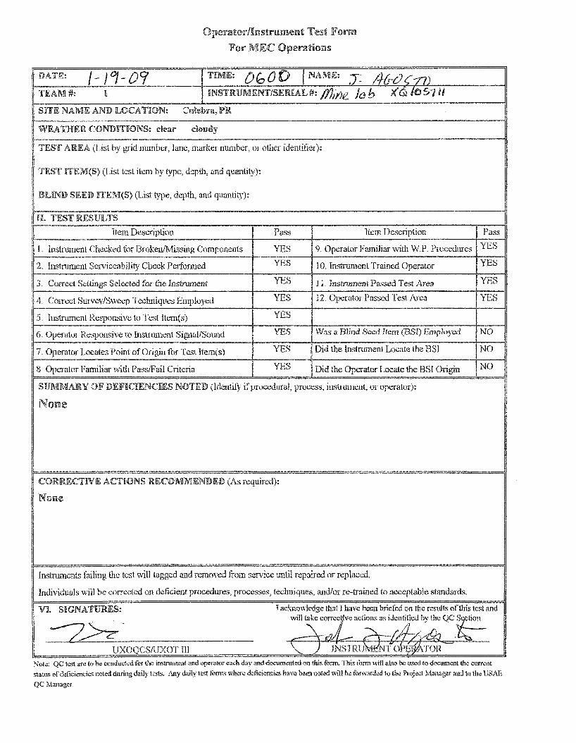
TEAM#:
Sl!lfE NAME AND lLOCA TION:
Operator/Instrument Test Fmrm
Fm· MEC Operations
1~--------------------------------------------------------------------------------~l WEA TlHiER CONliliTKONS: clear doudy
~" ··----------------------------·-------------------------------------------·-11 TEST AREA (Lis1. by 11umber, lane, marker number, or other identilier):
TEST ITEM(S) (List test item by type, depth, and quantity):
JEIJND SEED ITEM(S) (List type, depth, and quantity):
H. TEST llUSULTS ~~-------·---------------------.----:-----;----------:-~------..----!1
Hem DesL'1iption Pas::; Item Description Pass
lnstrumen~ CI~eeked i()r Broke~~~!v1i_:;sing Components--+---':'~_s ____ 9. Op~:ator Familiar vvith WP. l~r~ocedurcs Y11S YES 10. In,-.+,-,'t~ enl 'I.'ral·ned C)~, .·.rator Yl~:s Instmment Serviceability Check Petfonned . ;:}U um " !':;: -
J. Con·ect Settings Selected for thc 1;strument S 1 11. lnstrumen! Passed Test Area YES
12. Operator Passed Test Area YES E·S 4. Con·ect Survey/Sweep Techniques Employed ----------------~--YE~·S~.--~------------------------~r-~1
5. lnstm;·nenl Respon..<;ive to Test ltem(s) -~----r--Yiss---tw.;;;;;Bir;;;;:u-----------:7·-:;-- ,_ __
6. Operator Responsive to Instrument Signal/Sound YES l.ind Seed item (BSI) r::. 'J' ".1 NO
7. Operator Locates Point of Origin for Test Hcm(s) YES Did the lnstnunent Locate the BSI NO
8 Operator Familiar with Pass/Fail Criteria YES Did the ()pt.--rator Locate the BSI Origin NO
SUMMARY OF DEFlC[ENCJDES NOTED (ldentil)' if procedural, process, instrument, or operator):
None
CORRECTIVE AC'BONS RECOMMENDED (As requirt.'!.i):
Nolilte
Instruments failing lhe test will tagged at!.d removed from service 1111tii repaired or replaced.
Individuals vvill be corrected on deficient procedures, processes, techniques, anJJor re-trained to acceptable standal'ds.
VI. SIGNATURES: I acknowledge thai I have lr...cr~ briefed on the resn!ts ofthis test and wi!l!akc com .. "C ve adions as idcntitled bv the QC .S~'' tion.
"" 1. r/J-/~.. "' \. "' . ! - {ll/-- ~-t '
UXOQCSIUXOT Ill
Note: QC Jest arc to be conduct.:d t'Or the instn•menl ID>d operator each day a.<'ld documented on this form. This tonn will aLso be used lo document the current
status of deficiem;ks noted during daily tests. Any daily k-st fonns where ddkicnci.:s have b~ noted '-'ill w furward.:d to the Project Manager and to the lJSAE
QC Manager

Operator/Instrumen\1: Test Form
For MEC Operations
DATE: J.-lg-o:t_ TIME: Dc,C() I NAME: {or-. CoRor.!Lz± TEAM#: i ff"JSTRUMENT/SERIA'L#: /Y)il'"leJaia x f.! ''" 1/.'i Y= .. Sri'iE NAME AND lLOCATl!ON: Claiebra, JPR
- -WEATHER CONDJ!'HONS: cftear cloudy
:---·· .• TEST AREA (List by grid nurnber, lane, marker number, or other identifier):
TIEST RTEM(S} (List test item by type, depth, and quantity):
BUND SIEED RTEM(S) (List type, depU1, and quantity):
II H. TEST RESULTS··--
-Item D"""'"Pt.;uu Pass I Item Description
l Instrument Checked for Broken/Missing Componcnl<> YES 9. Opcwtor Familiar ,-vith W.P Procedures -·
YES [..:..~~tmment Serviceability Check Performed l 0 Instrument Trained Operator - ...
, 3. Correct Settings Selected for the Instrument l!"ES 11 .. Inslrmnmt Passed Test Area
14. Correct SurveyiSwecp Techniques Employed YES 12. Operator Passed Test Area --·
js. Instrument Responsive to Test Hem(s) YES ·--
6. Operator Responsive to Instrument Signal/Sound YES Was a Blind Seed Item (!3SI) Employed
'7, Operator Locates Point of Origin j"Qr Itern(s) YES Did the Instrument Locate Lhc BSI ---1-·----- ------·
~~or Familiar v..ith Pass/Fail Criteria YES Did !he Operator Locate the !3SI Origin
SlUMMAJRY OJF DEFICl!ENCIJES NOTED (ldenti~y if pro~"'rlural, process, instrument, or operator):
No:ne
CORRECTIVE ACTIONS !P'J:COMMENDED (A.s required):
Nmnc
Instruments failing the lest \~ill tagged and removed trom sen:ice until repaired or 1·eplaced.
Individuals will be corrected on delicient procedures, processes, tec!miques, andior re-trained to acceptable standards.
·---
.. -Pass
YES
YES
YES
YES
NO
NO --
NO
VI. SIGNATURES: I acknowledge that I have been brieted on the: results of this test and
~~~ will ~"·corr.;cti:;:rtio~s 11s iderticd by the oc Section,
~ rf!.tvk;, ' t(Yu&n"'(._ UXOQCSIUXOT m . (}I (JNSTRUMENT OPERA TOR
Note: QC te;i arc lobe eonduckd for t.'lc instrument and op-erator each day W."ld documented on this fonn, This fmm will also be used to docum~'111 i11c current
>1a1us of defic!~ncies nok<l during <laity test:;, i\ny daily t.:s1 fcnn> when: d!!!lciencies have b"'-"ll noted will h-;, t<mvardcd to the Proje.:l Manag~r and to the USA.E
QCManag~

USA Environmental;, Inc4 NON-TIME CRITICAL REMOVAL ACTION
CULEBRITA AND CULEBRA BEACHES
MUNICIPALITY OF CULEBRA, PUERTO RICO
F.6 QUALITY CONTROL REPORT
USA Environmental, Inc.
DAILY QUALITY CONTROL REPORT
Date: -•-• _I..L:!..).=...:r._ Contract#: 1¢ 'l Pl't. flit) '' z. Task Order#: ,..o ,z;t '2
Site/Location: C~LI.(IO&L-Jl.
p- CL..,..,..d~
Weather: ~ Temperature: & <..t "
1. Preparatory Inspection:--------·
Rainfall: . '-{ :::::> 2-. = .... -- .._ .....
Results:-----------------------~----
2. QC Audits Performed
a. Operations:
Results:------·----------------·------
b. Safety: f·, 1-z C f?' «.., /-. ~·
r~~~~~P~P~~=~~~~~~~~~-~~~~~~~~v~··~/Lr~~~-~k~·~4~~==c-~~~--
c. Administrative: _A~/(::__· .,.Lf'_<..Y_r:_"'_v-_ ... _JL-=-· __ L._~ __ .;._h_<:._ ... =-,._-_':l=-·-'-'>lcc_..~:.P-=il'-'c::"-=-r-="-:.:::IU':-_.
Results:
Contract No. W912DY-04-D-0006; Task Order No .. 0012 Original: 18 June 2007
F-'14

USA Environmentafr Inc NON·TIME CRITICAL REMOVAL ACTION
CULEBRITA AND CULEBRA BEACHES
MUNICIPALITY OF CULEBRA, PUERTO RICO
Daily Quality Control Report Con 't:
3. QC Performed (Grids)
Results: # Pass --- #Fail ---Number of Grids QC'd: ___ _
4. Follow Up Inspections and Results
Section(s): -------------------------
Results: -----------------------------------5. Instructions Received: ---------------------------------
Remarks: ------------------·-------------------·-------------
Printed Name:
Contract No. W912DY-04·D-0006; Task Order No. 0012 Original: 18 June 2007
F-15

USA Envlronmenta!r Inc NoN-TIME CRITICAL REMOVAL ACTION
CULEBRIT A AND CULEBRA BEACHES
MUNICIPALITY OF CULEBRA, PUERTO RICO
F.6 QUALITY CONTROL REPORT .. USA Environmental, Inc.
DAILY QUALITY CONTROL REPORT
Date: _jJ_}.:l::&}_.!l)L Contract#:(;?H.P~t..St..;p t.<2.. Task Order#: I,<:.«~ I~
1. Preparatory Inspection:------------------
Results:
2. QC Audits Performed
a. Operations:--------------------------
Results:-------------------
b. Safety:--~ ., "'"'ts= r ._ f~j i:l.-vrc-1-.""VJ
Results: a 1<.
Results: __ .=;._,;c..=_ _____________________ _
Contract No. W912DY-04-D-0006; Task Order No 0012 Original: 18 June 2007
F-14

USA Environmentaf;, Inc# NON-TIME CRITICAL REMOVAL ACTION
CULEBRITA AND CULEBRA BEACHES
MUNICIPALITY OF CULEBRA, PUERTO RICO
Daily Quality Control Report Con 't:
3. QC Performed (Grids)
Results: _.-r·· #Pass #Fail ---
II 2 (,. /1 :;l-2..._,
4. Follow Up Inspections and Results
Section(s): -------------------------
ResulG: __________________________________________ __
5. Instructions Received: ----------------------------~----
Remarks: ____________________________________________ ___
Printed N arne:
Contract No. W912DY-04-D-0006; Task Order No. 0012 Original: 18 June 2007
F-15

liSA Environmental, Inc. NoN-TIME CRITICAL REMOVAL ACTION
CULEBRITA AND CULEBRA BEACHES
MUNICIPALITY OF CULEBRA, PUERTO RICO
F.6 QUALITY CONTROL REPORT .. USA Environmental, Inc.
DAILY QUALITY CONTROL REPORT
Date: _J_, _/3:.!_}.J:2....L Contract#: I~ "'2 J' n.. s -D <> t z Task Order#: ..z? n / 2.
Site/Location :
Weather: fJ- ~- L = u J :J 1. Preparatory Inspection:
Results:
2. QC Audits Performed
Results: o 1<:....
b. Safety:_
T t !,._,a empera ure: --'=a'---"/-
, ' r-c.
Results: f'J-""""'fl-<:.>.0.<---_; t..~ ~~..._,,) .. _( Go .._J ~k..--L.....£ ~\} _r~)~ r•v·v~
d. Equipment:-------------------------
Results:--------------------- _____ _
Contract No. W912DY-04-D-0006; Task Order No. 0012 Original: 18 June 2007
F-14

USA Environmentaft Inc. NON-TIME CRITICAL REMOVAL ACTION
CULEBRITAAND CULEBRA BEACHES
MUNICIPALITY OF CULEBRA, PUERTO RICO
Daily Quality Control Report Con't:
3. QC Performed (Grids)
Results: (/ILl #Pass Number of Grids QC'd: ___ _ #Fail ---
Commen~:--~~~~~~--~~~~~~+-~~~~~~~~~--
/f$ -'= l I (;, 2. ~ I '7' Y '11-t' / 3 3. f -+t , Lt I s- -'*
4. Follow Up Inspections and Results
Section(s): --------------------------
Resillts: ______________________________________ __
5. Instructions Received: -----------------------------------------
Remarks: __________________________________________________ ___
Printed Name:
Contract No. W912DY-04-D-0006; Task Order No. 0012 Original: 18 June 2007
Date:
F-15

USA Environmental, Inc. NoN-TIME CRITICAL REMOVAL ACTION
CULEBRIT A AND CULEBRA BEACHES
MUNICIPALITY OF CULEBRA, PUERTO RICO
F .6 QUALITY CONTROL REPORT
USA Environmental, Inc.
DAILY QUALITY CONTROL REPORT
Date: _l_'_l "2 !.(./.a g Contract#: Lp·u·'l'<..tl>tJ 't2- Task Order#: ®'iZ>I z
Site/Location :
Rainfall: '-+a :.rz,
1. Preparatory Inspection:----------------
Results:
2. QC Audits Performed
Results:--·-=;;...::__""------------------------
b. Safety:
Results: __ <...::::>.........:. _________________ , ___________ _
c. Administrative: u.,.,....,~t;; d..,r:;:, .... .,.._;.,y..t: ... b"""-.. :.;)/. J'/i..tr:.-'1J ,n::..M.
1'2-t!!..C,;::>v"-~1 ----------------------
Results: c:. ""'--
d. Equipment: _........c.H;.!..!::.:..,-""J:2,..____.7'--'"'==-""5.Ul{;..IL,.,-_______________ _
Results: o "'-
Contract No. W912DY-04-D-0006; Task Order No. 0012 Original: 18 June 2007
F-14

USA Envin:mmenta~ Inc. NON-TIME CRITICAL REMOVAL ACTION
CULEBRITA AND CULEBRA BEACHES
MUNICIPALITY OF CULEBRA, PUERTO RICO
Daily Quality Control Report Con 't:
3. QC Performed (Grids)
/}.,.., II"-, l; ...-~-
Number o£:6rids QC'd: l-t .J Results: 1..1 J #Pass ,a #Fail --"==--
Comments:
I I . ;: i
/7-'7'1-/ z..rG'-1,. ;·-:;,.:t>i..f, 167-~ •• lt.'i/2..; lt.i'f::,, /t.12, 1/P?/
171o(rrr.,z:14 / . ..r"o~""'-, /2-#0,., tz:,2c:.Q~£r.;.O? ......... 2'::l.M-0/
<f (, 7/ ~.;: /.) 7 /~ 10 .M-.v) "2. I '7-] 1 '7 I 7 J-' "2 1 ,rd r ·2 2 71 "2 3 :.1'2) / ,.. , --
4. Follow Up Inspections and Results ·~~ t: 2~ ,., r0-..}._ L- 22 ~ ..-1-rr..g ... '2 I a}-~ ~.o<),., 7 .z, f' c
Section(s): --------------------------
Results: ____________________________ _
5. Instructions Received: -------------------------------------~~~-----
'7L Jl!. "'<:...tc vJ ;..,., ~ .... .._6o"'r 9111 op~~"': .... c:J 6'../'L
Remarks: ------------------------------------------------------------
QC Signature:~:,...,~~-=--· _________ _
Printed Name:
Contract No. W912DY-04-D-0006; Task Order No. 0012 Original: 18 June 2007
F-15

USA Environmental, Inc NON-TIME CRITICAL REMOVAL ACTION
CULEBRITA AND CULEBRA BEACHES
MUNICIPALITY OF CULEBRA, PUERTO RICO
F.6 QUALITY CONTROL REPORT
USA Environmental, Inc.
DAILY QUALITY CONTROL REPORT
Date: ...!..L) ~ ~ Contract #: \I> 2 en..g>;z, t 1-, Task Order #: ~ K::l t 2.
Site/Location: CLJL~ t3r<..;~ @c..,..... c..v-c:a~
Weather:~ f' L1 a.u..l'i Temperature:....!..l..l--
1. Preparatory Inspection:
Results: ---------------------------
2. QC Audits Performed
a. Operations:
C- L....c.c::.Js:: .. a..J
Results:_--=.:::;...::=--------------------.. -------
b. Safety: --1-f.!..-P....::f£:=:__~l..-=:_!...•~...=;..:"7~c.-=--------------~-
Results:--~~----------·----·---------
c.
d. Equipment:
Results:-~==:----------------·--------
Contract No. W912DY-04-D-0006; Task Order No. 0012 Original: 18 June 2007
F-14

USA Environmenta~ Inc. NON-TIME CRITICAL REMOVAL ACTION
CULEBRITA AND CULEBRA BEACHES
MUNICIPALITY OF CULEBRA, PUERTO RICO
Daily Quality Control Report Con 't:
3. QC Performed (Grids)
;-f .. <j ..... -">b...-v G ~- A-.A.. / --:?. F-:; l'1) Number of .Gfttls QC'd: ___ _ Results: v.ll # Pass #Fail
Comments: I L II c. , I \- ~~
I l..f "'2 ' , 1 z.; 2 K ,; 1 --L tb ~., 1 ZtJ <-~ • :21 8 ¢ / "2- ' ' t .• 2.- , r r, ·2 , 'l' t,
?-'?24 I!!J._,5', ,~.._,'~~>, 1.;Dtt 1.;z:.t~:..~ z.rc?, zr<s-<..,
C[f'/:)'2 'lkL-f "2..-. {(2...~ ~~:;;,I~. >.)•-:3L';"':.. i;,l J?J"l:;;;, 7 > ; ,.
4. Follow Up Inspections and Results
Section(s):
Results: --------------------------------------------------------
5. Instructions Received: --------·--------------------------------~-----
QC Signature: ----zL:=-='~:;__-___________ _
Printed Name:
Contract No. W912DY-04-D-0006; Task Order No. 0012 Original: 18 June 2007
F-15

USA Environmental, Inc NoN-TIME CRITICAL REMOVAL ACTION
CULEBRITA AND CULEBRA BEACHES
MUNICIPALITY OF CULEBRA, PUERTO RICO
F.6 QUALITY CONTROL REPORT
USA Environmental, Inc.
DAILY QUALITY CONTROL REPORT
Date: Jj_/.1::.£_1 <2 Y Contract#: l:trl.t'fttll ~!H • 1- Task Order#: ~ ¢ l '-
Site/Location: C: 1.1\...i!'Oil.H @w...e. .... .._-::>)
Weather:-------· Temperature: ......,.,!...,..;;..._' F-
1. Preparatory Inspection:
Results:-------------------------
2. QC Audits Performed
a. Operations: __ .t_<J_ ..... _..,.._<-:J_,·+-_,;;;;,.C!::[,-t;,."""""---l •. t"-'u---=:..;.........t;_:_ __ o_~_"'---'-'""-~...;;.;;;=,r--.,_J,.._..;;.....~==J=-~/-
A-<>...0.l~ c...L._::.-~Ji 7 (3s ~l., ........ >? ....... l~)
Results: OA.
b. Safety:
Results: ~ ----------------
Contract No. W912DY-04-D-0006; Task Order No. 0012 Original: 18 ,June 2007
F·14

USA Emtironmentat Inc NON-TIME CRITICAL REMOVAL ACTION
CULEBRITAAND CULEBRA BEACHES
MUNICIPALITY OF CULEBRA, PUERTO RICO
Daily Quality Control Report Con 't:
3. QC Performed (Grids)
Jl.,..,., ,..._~(;...,_ Number of~ QC'd: I t -t- Results: t:;tl/ # Pass #Fail ---
4. Follow Up Inspections and Results
Section(s): ------------------------
Results:----------------------------
5. Instructions Received: ------------------------
Remarks:
Printed N arne:
Contract No. W912DY-04-0-0006; Task Order No. 0012 Original: 18 June 2007
Date: _jj_J 7-t /._@_£___
F-15

USA Environmental, Inc. NON-TIME CRITICAL REMOVAL ACTION
CULEBRIT A AND CULEBRA BEACHES
MUNICIPALITY OF CULEBRA, PUERTO RiCO
F.6 QUALITY CONTROL REPORT
USA Environmental, Inc.
DAILY QUALITY CONTROL REPORT
Site/Location :
Weather: P " C.:.J. "' "' Temperature: i 2.. ::> Rainfall: '2 !6
1. Preparatory Inspection:----------------------
----------------··----
Results:---------------------------
2. QC Audits Performed
a. Operations:
. ' ....
Results: ___________________ ........__
Results:--------------------------
Contract No. W912DY-04-D-0006, Task Order No. 0012 Original: 18 June 2007
F-·14

NON-TIME CRITICAL REMOVAL ACTION
CULEBRITAAND CULEBRA BEACHES
MUNICIPALITY OF CULEBRA, PUERTO RICO
Daily Quality Control Report Con't:
3. QC Performed (Grids) .0 V' J l-<><..<>..t-.,..J c-; ;+_. "' ,._ "'l::: ..... 2 a~+/7-,;tJ?ZJ'
r '" J'..-. -,- :71 ;~ C:...p
lt.._~.......t!=..._,.
Number of~ QC'd: 19 Results: #Pass S2) #Fail
Comments:
z._ '3 '2. 2.. ' 2 '2. G. .-;.') I L. '> I z; ([€-::"' 7.. , > , o ,._, •• ), 2. 1. 2.. r t '!t. "'"<. ,If" 2 <.t c;: <.,,...
_ '£'-1'-{ -:;:z../?='3.~:;:) <E':_;;,.tt=-.._J"-~ t<...Lut-0,~ '2...?~1 ~c:>::~ 2.' "~t>)
. "?-s !l•(i ... "'-..- N-e..-r.:.l L(q:2) 2 rt.,.T-, 24:b'-T,. 2..'1 '-t 21
"LS<.,k1
z_y.yl.
t 1'>::. s (!: ll_)
4. Follow Up Inspections and Results
Section(~):-------------------------
Reslliffi: __________ . ____________________ __
5. Instructions Received: ---------------------------------~-----
Remarks: _______ _
Printed N arne:
Contract No. W912DY-04-D-0006, Task Order No. 0012 18 June 2007
F-15

USA Environmenta~ Inc. NON-TIME CRITICAL REMOVAL ACTION
CULEBRIT A AND CULEBRA BEACHES
MUNICIPALITY OF CULEBRA, PUERTO RiCO
F .6 QUALITY CONTROL REPORT
USA Environmental, Inc.
DAILY QUALITY CONTROL REPORT
Date:~/ .Q/'2/ 2> :{ Contract#: L~'Z..t>R@ ~ '17 Task Order #:.0 rot "2.
Site/Location :
Weather: c. i::. ~ "J Temperature: ~ 2 ::;, Rainfall: )... 6 llh
1. Preparatory Inspection:---------------------
Results:----------------------·----
2. QC Audits Performed
Results: .P ~
c.
Results:----------------------·-----
Contract No. W912DY-04-D-0006; Task Order No. 0012 Original: 18 June 2007
F-14

USA Environments~ Inc. NoN-TIME CRITICAL REMOVAL ACTION
CULEBRIT A AND CULEBRA BEACHES
MUNICIPALITY OF CULEBRA, PUERTO RICO
Daily Quality Control Report Con't:
3. QC Performed (Grids)
4 """0 ..._,.. l.; '-G.
Number ofGrids...QC'd: _7=---- Results: 7- # Pass #Fail ..:;_____ __
4. Follow Up Inspections and Results
Section(~?):------------------------
Results: -----------------------------·------------------------5. Instructions Received:
-------------------------------------~-----
Remarks:
Printed Name:
Contract No. W912DY-04-D-0006; Task Order No. 0012 Original·. 18 June 2007
F-15

USA Environmenta~ Inc. NoN-TIME CRITICAL REMOVAL ACTION
CULEBRITAAND CULEBRA BEACHES
MUNICIPALITY OF CULEBRA, PUERTO RICO
F .6 QUALITY CONTROL REPORT
USA Environmental, Inc.
DAILY QUALITY CONTROL REPORT
Date: ..!:!::..J.!l!.:!JGZJL_ Contract#: 1 ~7...,• iL if.> 7>~•?- Task Order#: _o_· ..;.,__
Site/Location : __ c:...___;.v_'-_JZ:...;;~'l.'-•t..-'1.._1-......,(:i===t::-.=-~-<::...!-'""-<!:--'==>-).__
if l.,..li.._.( /(,., ... ,~....
Weather: /'- L..l o u J.;; Temperature: & .,__2 Rainfall: -.~.,...c_c:s.f+e_-t. J
1. Preparatory Inspection:---------------------
Results: __ _
2. QC Audits Performed
Results:-->=:::...=--------------·----------
b. Safety: //fW
Results: c::> k
c. Administrative:
Results:
Contract No. W912DY-04-D-0006; Task Order No. 0012 Original: 18 ,June 2007
F-'14

USA Environmental, Inc. NoN~ TIME CRITICAL REMOVAL ACTION
CULEBRITA AND CULEBRA BEACHES
MUNICIPALITY OF CULEBRA, PUERTO RICO
Daily Quality Control Report Con't:
3. QC Performed (Grids)
NUI11ber of Grids QC'd: ___ _ Results: # Pass --- #Fail ----Comments: ___ r_l'-. "':.:..:::..:'-"c.:.-1 __ /=---.. _,' t_' <-..e..-_-'-,.,..,.!:..'..::...;::__c: ... _..Q:::.....!!.+ __ :.;;_;:J_"-~~ .!:::"'""'==-............!'.....:-~~t:!.-.5...:~---
4. Follow Up Inspections and Results
Section(s): ------------------------
Results:------------------------------
5. Instructions Received: --------------------~----
Remarks: -----------------------
Printed Name:
Contract No. W912DY-04-D-0006; Task Order No. 0012 Original: 18 June 2007
F-15

F .6 QUALITY CONTROL REPORT
USA Environmental, Inc.
NON·· TIME CRITICAL REMOVAL ACTION
CULEBRITA AND CULEBRA BEACHES
MUNICIPALITY OF CULEBRA, PUERTO RICO
DAILY QUALITY CONTROL REPORT
Date: .l2:.J ... ~.2.J...2J::_ Contract#: lr02.pn_ @;t> 6, 7 Task Order#: sP ~ 1 2..
Site/Location : C v '--I! d JLII c&:_ ..... L.- ~ iJ;C..~ ~~
Weather: J..·c_ '"="'-'~~- Temperature:-"----.::-
1. Preparatory Inspection:·--------------·-------
Results:
2. QC Audits Performed
a. Operations:
Results:
b. Safety: __ ,()_..::>_o-~r ___ r_,.;;;.......~_:;.-c:.J+--c:---t'Z"'"..._____,~/''--"(M..;:-=-c.......;~__,_t- ·~...-.......:.n_;;_·~_.,.__._ __ F~-'---"-· ..r.· _
I: I <:.J." v~-_ '?
c. Administrative:-----------------------
Results:----------~----------------
d. Equipment:
Results: __ .........::=--------------------------
Contract No. W912DY-04-D-0006; Task Order No. 0012 Original 15 June 2007

Daily Quality Control Report Con 't:
3. QC Performed (Grids)
lt"'-0 .,__,L 'it:..([ Number of Grids QC'd: __ ?.!:_Lt_ Results:
s .,. "2. ' s-~ l I ~~ 3 I' J :;1 2 ,I i '-t ( lib
4. Follow Up Inspections and Results
NONwTIME CRITICAL REMOVAL ACTION
CULEBRITAAND CULEBRA BEACHES
MUNICIPALITY OF CULEBRA, PUERTO RICO
...
~Pass #Fail ---.. - .. c...(.- N~ ... r~fi>--.J .. ":"
Section(s): --------------------------
Results:----------------------------
5. Instructions Received: ---------------------'-------
Remarks:------------------------------
QC
Printed N~me:
Contract No. W912DY-04-D-0006, Task Order No. 0012 18 Ji.lll8 2007

USA Envin:;nmentaft Inc.
F .6 QUALITY CONTROL REPORT
NON-TIME CRITICAL REMOVAL ACTION
CULEBRITA AND CULEBRA BEACHES
MUNICIPALITY OF CULEBRA, PUERTO RICO
r--------------------------------------------------------------------------~ USA Environmental, Inc.
DAILY QUALITY CONTROL REPORT
Date: 11- lj_j_J.QL Contract#: I pz.Pn. It! o:tu .. r1- Task Order#: ¢5Z> I <..
Site/Location: c....u t.....i""~ ~l (.c....vL-t;:Jd ~''")
Weather: ~ c.... r f.....".. ...., c~. Temperature: )'= 2;;) Rainfall: 4-:::> ""'<'"" ... L <;....., ...- c:....
1. Preparatory Inspection: ---'p,-'. ";......;.." L."-'~·.::..'!'_:;_r_<:.-f_,__.· ........!IAa,,p.a __ _,.,::..· LI __ __:_J_-"" __ -'l_v__;;;=J-+------
2. QC Audits Performed
a. Operations: __ 1-n ,z r--.I..J I"'" G--vh.?"'- ..., d v!<!. c..~c.-<;......._ ,_
Results: __ 2..=--"-f"-£-'"5--'1()=--_t_tr:_._e..._.....__ . .-___ l_..,_ . ....;;c:...;:;...G>--'-r_·'"'-'..;;...J-'-----'------
b. Safety:
H.c-1r /1., J:Z_ j! ,..._...A,...._ (;_ - I
Results:
c. Administrative:
Results: t.c:-
d. Equipment: )-{<O; ... J 7oc:o./ 1
' ~--------------------------------------------------------------------------~
Contract No. W9'12DY-04-D-0006; Task Order No .. 0012 Original· 18 June 2007
F-14

USA Envin:mmenta~ .li'Jc. NON-TIME CRITICAL REMOVAL ACTION
CULEBRITAAND CULEBRA BEACHES
MUNICIPALITY OF CULEBRA, PUERTO RICO
Daily Quality Control Report Con 't: .----------------------·---·-------
3. QC Performed (Grids)
Number ofGH4&QC'd: 2 o Results: t:../' #Pass #Fail
Comments:
AV\.., .... ,;pl~.,_.. C:..i...-c_Lk--1 : seu' I?-1,. (,tJ 3 ,...r?t/ ter"'' J-.rg..
c 4 s , r 4 7- / l- Y 1 ·' p- I 7 2 1 t.; t.t z , If r 7 ,. 9 3 r " Lt 3 ' ,
4. Follow Up Inspections and Results
Section(s): --------------------------
Results:----------------------------
5. Instructions Received: -----------------------~----
Remarks: -----------------------------------
QC Signature: _7~~""'~"--------------
Printed Name:
Contract No. W912DY-04-D-0006, Task Order No. 0012 Original 18 June 2007
F-15

F.6 QUALITY CONTROL REPORT
USA Environmental, Inc.
NON-TIME CRITICAL REMOVAL ACTION
CULEBRITA AND CULEBRA BEACHES
MUNICIPALITY OF CULEBRA, PUERTO RICO
DAILY QUALITY CONTROL REPORT
Date: J...:b_/__!3_} o,t Contract#: /'t>Z PIZ.¢:> 0 ' 1 9- Task Order#: fD t:;l 2....
Site/Location: C;.; 1..-1: iJ ..... ~ (c.• .. u ... E".3·'Lir~)
Weather: .:...::::.....:.r..:../-t-=-""...::~,....::....:.:~::..."'-_-_• _ Temperature: & '2r..:> Rainfall: 4.-:;z.%
1. Preparatory Inspection:
Results:-------------- --------------
2. QC Audits Performed
a. Operations: /t ........... .. l.·.....- c.....J,._ ~
Results: ~· 12- rr ,., - ~ . (p ,K:.. ) ~-----------
c. Administrative:------------------------
Results:-------------'----------------
Results: --~C::.,.;Jui.C.s..... ______________________ _
L_ _____________________________________________________________________ ~
Contract No. W912DY-04-D-0006; Task Order No 00·12 Original· 18 .June 2007
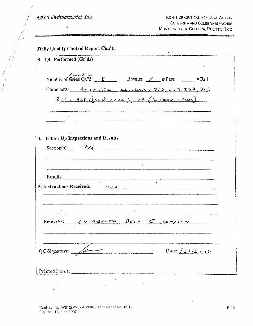
NoN-TIME CRITICAL REMOVAL ACTION
CULEBRITAAND CULEBRA BEACHES
MUNICIPALITY OF CULEBRA, PUERTO RICO
Daily Quality Control Report Con 't:
3. QC Performed (Grids)
A""",._.\:~
Number of 6ricls QC'd: --=----
4. Follow Up Inspections and Results
...
Results: · tf #Pass --'---
#Fail ---
Section(s): -------'-~-'-----------------------
Resul~: ___________________________________________ __
5. Instructions Received: ____ ___:_::..£._....a_ ________________ -'----
Printed Name:
Contract No. W9'12DY-04-D-0006, Task Order No. 0012 Original \8 June 2007
F-15

Date: __ / I~ (£ Contract#: wcm.l>'I·Dif- D-DD~Task Order#: J::Z
Temperature: 81.- RainfalL Q
1. Preparatory Inspection:-----·----------------
Results: ---------------------------
2. QC Audits Performed
a. Operations: ________________________ _
Results: ------------------------------
c. Administrative: -------------------------------
Results: ----------------------------
Page 1 of2

I Daily Quality ControB Report Con't:
3. QC Performed (Grids) f'l C\<j~
Number of 6ricls QC'cl: ---ffl-- Results: _!j_ # Pass 0 #Fail
4. Follow Up Inspections and Results
Section(s): ------------------------
Results:-------------------------
~------------------------------------.
5. Instructions Received:---------------------
Remarks: _____________________________________________ _
·-----------------·--·-·-
QC Signature: C)ff.a~ Printed Name: _Jg_ffie 1 6o.re£1! JJ
Page 2 of2
Date: _j_;_b_; eFt

Date: _I _I _l_! J2l Contract#: W9r1. M-ot;-!) .. ~ Task Order#: .:::...:.....:;;.............._
Sitefl,ocation: Cvle be\}"' + Cule/o;rq Weather: C Le .. cur Temperature: ~ Rainfall: Q __
1. Preparatory Inspection:------------------
Results:-----------------------
2. QC Audits Performed
a. Operations:----------------------
Results: --------------------------
c. Administrative: ------------------------
Results: ---------------------------
Page 1 of2

3. QC Performed (Grids}'
tl 0\ <j-5> Number of Grids QC~ /9 _ __,__.__ Results: _j!j_ #Pass
Comments ;;:j ~ : ~~ ! k~
4. Follow Up Inspections and Results
0 #Fail
Section(s): -------------------------
Results: ---------------------------------
5. Instructions Received: --------------------------------------
Remarks: --------------------------------------------------------------------------
QC Signature: ~~ . Printed Name: Je&-e.'4 &'{€£ e }of
Page 2 of2
Date: _}_; .:1_1 09

I USA Environmental, Inc.
DAILY QUALITY CONTROL REPORT
Date: -' _I _B_I _{f)_ Contract#: w9111J y. 04- P-a'lf,Task Order#: I z Site/Location: C vt}okr j}q t w}Q brOJ Weather: CJ.£o.rr Temperature: 2.2 Rainfall: Q
1. Preparatory Inspection:-------------------
Results:-----------------------
2. QC Audits Performed
a. Operations:----------------------
Results: -----------------------------------
Results: Oct5S -~,~~~--------------------
c. Administrative: ----------------------------------
Results: ----------------------------
Results: a /1 OCI75 {)
Page 1 of2
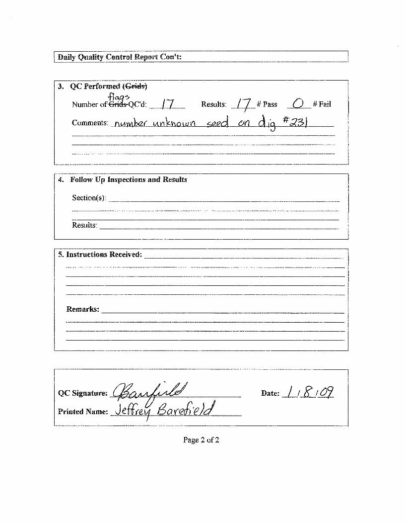
3. QC Performed (~
·frt~.q:7 Number of-Brim-QC'd: _ _,_/]_,.__ Results: __fJ_ # Pass Q #Fail
Comments: ntAvvtber VtnknowV'I seed o•1 d'S #';<3}
4. Follow lJp Inspections and Results
Section(s): ---------------------------
Results: -----------------------------
5. Instructions Received: -----------------------------
QC Signature: {lfj'a~ ____ _ Printed Name: Jefte'f f3.Mer£_·eJJ
Date: _}_t _K_t jf}_
Page 2 of2

I USA Environmental, Inc.
DAILY QUALITY CONTROL REPORT
Date: _j_!_9_!_J_ Contract#: W'JJ:iOY- D4-D-0Cfo Task Order#: /;2
Site/Location : C,\A )e br I ha
Weather: CLeo. C
~lebec
Temperature: 8a Rainfall: ()
1. Preparatory Inspection: _________________ _
Results: -----------------------
2. QC Audits Performed
a, Operations:---------------------
Results: ------------------------
Results: /2&22 I
c. Administrative: -+-/""'"o=-JB'----'b""-''CJ""'C>.,_,t~? _ _,_c-"k.........,c=k=e""-'J=:I-_______ _
I Results: pa>-sed
d, Equipment: f!.Tk., /1uef/ £in- fe/,
Results: ___,q~· .._} ~f _1'"""o_...(J'~--'z""",S..£ ______________ _
Page 1 of2

I Daily Quality Control Report Con't:
3. QC Performed (-Gt ids)
Number of·fttf QC'd: -~S?,___ Results: _g_ #Pass Q #Fail
4. Follow Up Inspections and Results
Section(s): _______________________ _
Results: ---------------------------
5. Instructions Received: ------------------------
Remarks: -----------------------------------
QC Signature: CJ&t:...~ . Printed Name: Je~ l3o.r:_e{irzLd_
Page 2 of2
Date:_/_;_!]_; _J_

Date: _j_j_jJJJ:fl_ Contract#: W'!J:J.DY-{}-1-J)-t::C/o Task Order#: 0/'Z-
Site/Location : G.A \_e. b f' ,· .J-o, +- GA_ f .Q b rCI
Weather: C.J.a.Ar Temperature: 8'/ Rainfall:-~-
l. Preparatory Inspection:------------------
Results: -------------------------
2. QC Audits Performed
a. Operations:-------------------------
Results:----------------------
c. Administrative: -------------------------
Results: ------------------------
Page 1 of2

3. QC Performed (Grids)
bj~ Number of · QC'd: ---~./_.,3:::.___
4. Follow Up Inspections and Results
Results: ----------------
QC Signature: ~ _
Printed Name: JeJfrtLf 8areh
Results:
£8'~ '-!;!. ' r
5'94
e!J
Pa ge 2 of2
/:3 #Pass #Fail -
526. 1 5Z2; 'iG~ ~~~
Date: I I IZtO? ---

I USA Environmental, Inc.
DAILY QUALITY CONTROL REPORT
Date: _1_1 _l2j _QJ_ Contract#: W912DY-04-D-0006 Task Order#: 012
Site/Location : Culebrita and Culebra
Weather: C, le..a f Temperature: 8' 3 Rainfall: Q
1. Preparatory Inspection:-------------------·----
Results:--------------------------
2. QC Audits Performed
a. Operations:--------------------------
Results: -----------------------------
h. safety: ---"[h~i\'-"<t~_____,s""--"'·0\"-"'-~-'-"'-eJ-'-"il~T~Yl..L.lsp~e.c:=-'.f..!..::!,o:::..!..n-'-------
Resuits: --iPF=~=5-=7=----------------------
c. Administrative: ____________________ _
Results: -------------------------------
Results: q ·11 pa.$5
Page 1 of2

I Daily Quality Control Report Con 't:
3. QC Performed (Flags)
Number of Flags Grids QC'd: t< / Results: OZ } # Pass ~G..,__#Fail
4. Follow Up Inspections and Results
Results: -------------------------------------------------
QC Signature:% ~~~ Date: _/_1 I~ I .!!1_
Printed Name: Jeffrey Barefield
Page 2 of2

I USA Environmental, Inc.
DAILY QUALITY CONTROL REPORT
Date: _)_! _l.!:/__; _1?_1_ Contract#: W912DY-04-D-0006 Task Order#: 012
Site/I,ocation : Culebrita and Culebra
Weather: __ c--"<..k.:;_c...=-=-'V __ _ Temperature: ~ Lj Rainfall: {)
L Preparatory Inspection: ___________________ _
Results: --------------------------
2. QC Audits Performed
a. Operations: _______________________ _
Results: -------------------------------------
Results: D<l '7 S --~,~~-------------------------
c. Administrative: -----------------------
Results: ---------------------------------
Results: 0 )} pa $5
Page 1 of2

I Daily Quality Control Report Con't:
3. QC Performed (Flags)
Number of Flags Grids QC'd: / S Results: /5 # Pass () #Fail
4. Follow Up Inspections and Results
Section(s): f)C) til{
Results: ----------------------------------------------
5. Instructions Received: ---=-n-'-"""0'-Lilf-""\--------------------------------
Remarks:
QC Signature: {}1f1/lt:M-rv Date: _L__! J Y I_ 0:_cj
Printed Name: Jeffrey Barefield
Page 2 of2

I USA Environmental, Inc.
DAILY QUALITY CONTROL REPORT
Date: _1_; _l5_j iii Contract#: W912DY-04-D-0006 Task Order#: 012
Site/Location : Culebrita and Culebra
Weather: cbv Temperature: g 3 Rainfall: 0
1. Preparatory Inspection: __________________ _
Results:-----------------------
2. QC Audits Performed
a. Operations:----------------------
Results: ---------------------------
/nsoecfion I
Results: -+p~a.~s=-S~-------------------
c. Administrative: __,._c"""~j~·A~Q . .._C.,.k---f/-~..otlo!B'f-Lb.Lclo..l.l...<o'-J:.k::::;.;s..L-----------
Results: --#0-o....0'~--1 7L~ _,S~------------------1
d. Equipment: _Jt_K..:>..._DL..l.__2_c f-' ~fo~v~e:.!-,r{--, ....:.!.!l2...tLnt:.J,t.'1£ ~!a~· b~~::::.--__:s;+~£a_,l21~-{cfC.J.~L:.___ __ _ I I I
Results: oZJ pass I
Page 1 of2

ILD_a_i~cy_Q=u_a_l_icy~C_o_nt_r_oi_R_e~p_o_rt_C_~_on_'_t: ______________________________ ~
3. QC Performed (Flags)
Number of Flags 6fitis QC'd: /( Results: ) / #Pass Q #Fail
# Com/3~ ~71 i2k ~1 ~-:1§}251 /;l~ 212;
4. Follow Up Inspections and Results
Section(s): /}O r1f
Results: -----------------------------------------------
5. Instructions Received: _.!_f1-'-'0=---Lf1_..J2,___ ___________________________ _
Remarks: --------------------------------------------------
QCSignature:~~Printed Name: Jeffrey Barefield
Page 2 of2
Date: J_!l.5_!_{£}

Contract#: W912DY-04-D-0006 Task Order#: 012
Site/Location : Culebrita and Culebra
Weather: c k.uc Temperature: ~ lf Rainfall: {)
1. Preparatory Inspection:-------------------
Results:-----------------------
2. QC Audits Performed
a. Operations:-----------------------
Results:
b. Safety: dg!}~
Results:
c. Administrative: ----------------------
Page 1 of2

3. QC Performed (Flags)
Number of Flags Grids QC'd: 5 Results: 5 #Pass 0 #Fail
Comments: _..L_}ll-!;{5~1 ___.....j/Lli:::.~!.!::::3+-1 ___,/.~~=-if),+-' __!..([L-~l--f------'5~8!!.:!:..· ____ _
4. Follow Up Inspections and Results
Results:-------------------------
Remarks:
------------~----------------------------------------
--------------·--~-------·-
QCSignature:.~ ~ Printed Name: Jeffrey Barefield
Page 2 of2

Site Specific Final Report Non-Time Critical Removal Action Culebrita and Culebra Beaches
Contract No. W912DY-04-D-0006; Task Order No.0012 Page C-1 4 June 2009
APPENDIX C
C.0 MUNITIONS DEBRIS DISPOSAL RECORDS
This appendix contains munitions debris disposition records for the Non-Time Critical Removal Action at the Culebrita and Culebra Beaches.

11213 41516 7 ~~~ ~~~1~1w ~sf~r tttos1 Ff' s4 s' sa s~s4s~ s~s1sf,e4a+er~ets:rc 111 1 r 47~7~7~787~80 1. TOTAl.PRICE 2.SHIPFROM 3. SHIP TO 3 4 5 6 7 8 9
Dl Ff6M ~ Ul QUANtiTY ~.~~ ! " ~ :~; • m ! ru 98 ~ UNIT PRICE DOLl.AKS CTS
8~ NS s fS ADDRESS G ~ N I SL~ v p~ DOLLARS CTS T
4. MARK FOR
lffi
. SCR-sf> (w, .}<.e.l ,mfr./) S.DOCDATE 6. NMFC 7. FRT RATE ,8. TYPE CARGO ,9. PS
lCD~ Basic Material Content; fYJ [) j::Ei
~~ 10. QTY. REC'D 11.UP 112. UNIT WEIGHT l13. UNIT CUBE 14.UFC r5.SL '~ze EstimateWeight(lbs): 70 1'-l !UJ!S Seal ID No.: J:1G;,d..SS' bs &~Sft. ,::;u..
.:::>~ Container ID No.: oa~ 16. FREIGHT Cl.ASSIFICATION NOMENCl.A TURE ,gcn lo"'
·~ --- ~
Site Address: C...t ) )-t bfu ) \' j< 17. ITEM NOMENCl.A TURE
:a!"'!S §@.., ~--~~
~~~ ~en
\Net. tc2 .Dy-c "{- .t>- Do eo To1t oo 1,).. 18. TV CONT 19. NO CONT 120. TOTAL WEIGHT r· TOTAL CUBE
~ 13- '/a.~- dY,I.:L Site Telephone No.: 22. RECEIVED BY 123. DATE RECEIVED
Certify By:
This certifies and verifies that the material listed has been! 00 percent inspected and to the best of our knowledge and belief, are inert and/or free of el'plosives or related materials.
.
I I
Va~~ • ~~Date:ft ~at ~E S::Specialist
USA Environmental, lnc., 720 Brooker Creek Boulevard, Suite 204, Oldsmar, Florida 34677, Telephone: 813.343.6336, fa~(; 813.343.637

Certificate of Destruction
CJ?sfeasing fienerator_,....:;:;..U...;..:=..S.;:,_;:;A;:._::::E=n::..;_;vrr=-· o=m=n::::...;;:e.;;;;;.::;:..nt;;..;;..;::.a;;:::._l ____ _
fiross WeiiJht =8~1-..:::...Ib;:._:;::_s"'=. =====
[I ce1·tify that the items/assets listed were demilitarized in accordance with guidelines in DoD 4160.21-M-1 and have been smelted or sbredded and are only identifiable by their basic content.]
CO(}) # :--0 1_2_80_9 _____ _ (})ate 1/28/09
:Name Terry Northcutt 'Iitfe =-c.;;;._o.;;;._o--"'-=====
Signature C/7~~/ C

Site Specific Final Report Non-Time Critical Removal Action Culebrita and Culebra Beaches
Contract No. W912DY-04-D-0006; Task Order No.0012 Page I-1 4 June 2009
APPENDIX I
I.0 GPO REPORT
This appendix contains the following documents for the Non-Time Critical Removal Action at the Culebrita and Culebra Beaches:
• Culebra GPO Letter Report • As Built GPO • 6 Line Test Map • GPO GPSLO SNR Window Size Study • GPO DGM (provided electronically on the enclosed DVD).

GPO Letter Report for Culebra GPO 2/4/08 staked out potential GPO roughly 180 feet long by 50 feet wide. Collected background data with Corps' EM61-MK2 positioned with line/station/fiducials. Results indicated the GPO site was usable with no significant background anomalies. 2/5/08 Brought survey control to Flamenco Beach over a survey nail in the north end of a circular concrete pad in the camp ground. A white triangle is painted around the nail. The control point is:
WGS84 UTM Zone 20N, with units in meters Northing Easting Elevation (ellipsoidal) 2028196.961m 254734.937m -38.969m
Also established a GPS check point at Flamenco Beach, a 10" survey nail on a sand dune marked with wooden stake as a witness pole. This point was measured each day the GPS base station was set up a Flamenco Beach (see GPS Reoccupation Checks.xls). The GPS check point is:
WGS84 UTM Zone 20N, with units in meters Northing Easting Elevation (ellipsoidal) 2028208.308m 254796.792m -38.087m
Acquired GPO background data with standard sensor height. Database GPOBK.gdb confirmed suitability of GPO area (see GPOBK_SUM.map). 2/6/08 Placed GPO seed items flush with the surface and acquired data over them to gauge maximum response of SUM channel at standard sensor height (SURFACE.gdb). This database was not adjusted for offset or latency, but the channels were leveled and summed:
Seed Item Orientation Peak SUM (mV) 20mm across track 70.9820mm across track 63.2120mm along track 84.3920mm along track 77.7937mm across track 389.4337mm across track 349.6937mm along track 436.6237mm along track 429.2775mm across track 2129.0275mm across track 1938.8675mm along track 2488.8175mm along track 2800.675" Rocket across track 9840.555" Rocket along track 6086.515" Warhead across track 4797.785" Warhead along track 9042.27
Seeded the GPO with targets on 10-foot line and 30-foot line. Had to move two 75mm simulants from the 30-foot line to the 10-foot line in order to bury them deeper without hitting water. The "As Built" GPO is provided (As Built GPO.xls). Photos of the GPO seed items are delivered with this report. Surveyed the seeded GPO with standard sensor height (GPOSDGPS.gdb). This database detects all of the GPO seed

items, but at lower SNR to the survey acquired at a lower sensor height (see GPOSDGPS_SUM_Lev.grd.map). 2/7/08 Acquired seeded GPO surveys at a lower sensor height, positioned with GPS (GPOGPSLO_Final.gdb), and with Line/Station/Fiducials (GPOLSFLO_Final.gdb). These databases detected all seed items at significantly greater SNR. It was decided to perform production DGM with the lower sensor height. General data processing steps:
1. Import data and set projection to WGS84, UTM 20N, meters 2. Offset the GPS antenna 0.12m forward of coil center for pulling 3. Latency correct database, typically from morning (AM) and afternoon (PM) latency checks 4. Median filter the database with the script (Med_filter.gs). This uses a median filter window of 800
that levels the data with minimum alteration of the anomaly response. 5. Grid the filtered SUM channel. Gridding parameters are:
a. Cell size: 0.1m b. Log option: Linear c. Log min: 1 d. Blanking distance: 1 e. % Pass: 99.99 f. Max iterations: 500 g. Start coarse grid: 16 h. Start search radius: 0.75 i. Internal tension: 0 j. Cells to extend: 1 k. Weight power: 2 l. Slope: 0.0
6. Each grid was displayed using the Culebra_3mV.itr (included in data delivery). This color scheme highlights anomalies in blue between 3 and 4 mV blue.
7. Check Sample Separation >0.1524m is less than 1.5%. Other than the first production file, part of which was repeated, all data passes this metric. The GPOGPSLO_Final.gdb documents a data separation > 0.1524m at 0.2%. The GPOLSF_Final.gdb had a sample separation > 0.1524m at 16.5%. Even at this higher apparent speed, all of the seed items are detected.
8. Check Footprint coverage for gaps > 0.6096m. The GPOGPSLO_Final.gdb demonstrated that the GPO coverage at this metric was 98.78%. At a line spacing > 0.762m, the GPO coverage was 100%. These performance metrics were achieved on a relatively flat GPO. There are portions of each beach that include a bench along the sand, vegetation (grasses and low vegetation, bushes, and trees), and slopes. These all complicate the footprint coverage. It is recommended that the first two or three production surveys be used to set achievable footprint metrics.
Anomaly Selections: As discussed with the USAESCH Geophysicist, the initial anomaly selection threshold should be based on the statistical mean of the GPO background plus 3 to 3.5 times the standard deviation of the background. Selected a large polygon to calculate the GPO background. The statistics on the background polygon are: Mean: -0.55 mV Std. Dev: 1.67 mV A selection threshold of mean + 3 times Std. Dev = 4.46 mV A selection threshold of mean + 3.5 times Std. Dev = 5.29 mV Based on the above analysis, USA decided to set the initial anomaly selection threshold at 5 mV.
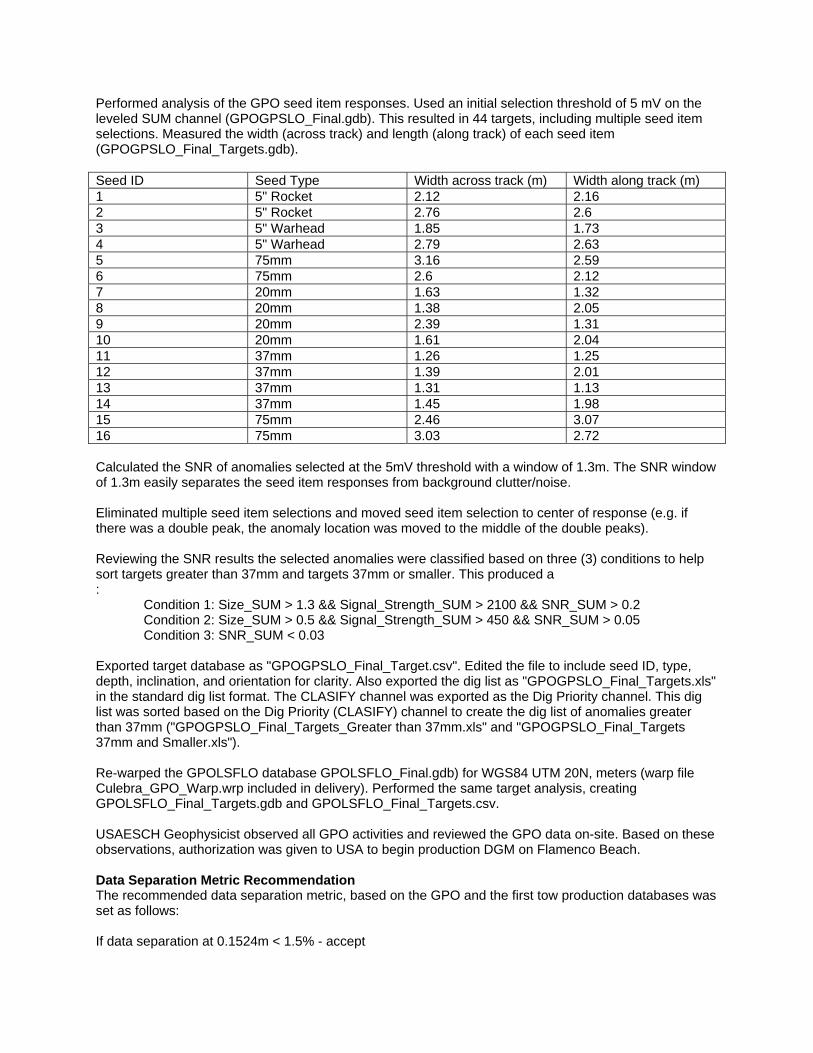
Performed analysis of the GPO seed item responses. Used an initial selection threshold of 5 mV on the leveled SUM channel (GPOGPSLO_Final.gdb). This resulted in 44 targets, including multiple seed item selections. Measured the width (across track) and length (along track) of each seed item (GPOGPSLO_Final_Targets.gdb). Seed ID Seed Type Width across track (m) Width along track (m) 1 5" Rocket 2.12 2.16 2 5" Rocket 2.76 2.6 3 5" Warhead 1.85 1.73 4 5" Warhead 2.79 2.63 5 75mm 3.16 2.59 6 75mm 2.6 2.12 7 20mm 1.63 1.32 8 20mm 1.38 2.05 9 20mm 2.39 1.31 10 20mm 1.61 2.04 11 37mm 1.26 1.25 12 37mm 1.39 2.01 13 37mm 1.31 1.13 14 37mm 1.45 1.98 15 75mm 2.46 3.07 16 75mm 3.03 2.72 Calculated the SNR of anomalies selected at the 5mV threshold with a window of 1.3m. The SNR window of 1.3m easily separates the seed item responses from background clutter/noise. Eliminated multiple seed item selections and moved seed item selection to center of response (e.g. if there was a double peak, the anomaly location was moved to the middle of the double peaks). Reviewing the SNR results the selected anomalies were classified based on three (3) conditions to help sort targets greater than 37mm and targets 37mm or smaller. This produced a : Condition 1: Size_SUM > 1.3 && Signal_Strength_SUM > 2100 && SNR_SUM > 0.2 Condition 2: Size_SUM > 0.5 && Signal_Strength_SUM > 450 && SNR_SUM > 0.05 Condition 3: SNR_SUM < 0.03 Exported target database as "GPOGPSLO_Final_Target.csv". Edited the file to include seed ID, type, depth, inclination, and orientation for clarity. Also exported the dig list as "GPOGPSLO_Final_Targets.xls" in the standard dig list format. The CLASIFY channel was exported as the Dig Priority channel. This dig list was sorted based on the Dig Priority (CLASIFY) channel to create the dig list of anomalies greater than 37mm ("GPOGPSLO_Final_Targets_Greater than 37mm.xls" and "GPOGPSLO_Final_Targets 37mm and Smaller.xls"). Re-warped the GPOLSFLO database GPOLSFLO_Final.gdb) for WGS84 UTM 20N, meters (warp file Culebra_GPO_Warp.wrp included in delivery). Performed the same target analysis, creating GPOLSFLO_Final_Targets.gdb and GPOLSFLO_Final_Targets.csv. USAESCH Geophysicist observed all GPO activities and reviewed the GPO data on-site. Based on these observations, authorization was given to USA to begin production DGM on Flamenco Beach. Data Separation Metric Recommendation The recommended data separation metric, based on the GPO and the first tow production databases was set as follows: If data separation at 0.1524m < 1.5% - accept

If data separation at 0.1524m > 1.5% but < 2% AND if data separation at 0.2032m < 0.2% - accept If data separation > 2% - redo Footprint Coverage Metric Recommendation The recommended footprint coverage metric, based on the GPO and the first two production databases (FLAM1_Final.gdb and FLAM2_Final.gdb) is as follows: If footprint at 0.6096m > 95.00% - accept If footprint at 0.6096m < 95.00% but > 93.4% AND footprint at 0.762m > 99.00% AND footprint at 0.9144m > 99.9% (except around known obstacles) - accept If footprint < 93.4% - redo or fill in data gaps GPO QC A 6-line test was performed 2/5/08, but the target location was not surveyed. This test was repeated on 2/6/08 (6Line2.gdb). The results are shown in 6Line2_Test.map. Morning and afternoon static test results are summarized and delivered as "Static Check Statistics.xls". Morning and afternoon latency test results are summarized and delivered as "Latency Checks.xls" GPS reoccupation checks at a known point were performed each morning aster the base station was set up to confirm proper set up. The results are delivered as "GPS Checks.xls". Databases were checked for sample separations greater than 0.524m (see section 7.0 above) and for footprint coverage at a line spacing of 0.6096m and at 0.762m (see section 8.0 above). See delivered maps GPOGPSLO_DATASEP.map and GPOLSFLO_DATASEP.map for sample separations and GPOGPSLO_Final_uaceFootprintCov_0.6096.map, and GPOGPS_Final_uaceFootprintCov_0.762.map. Footprint maps were not generated for the Line/Station/Fiducial data because the 0.6096m line spacing was dictated. All QC checks indicated that the equipment was performing properly and capable of meeting project requirements, except the GPOLSFLO survey demonstrated a need to slow down.
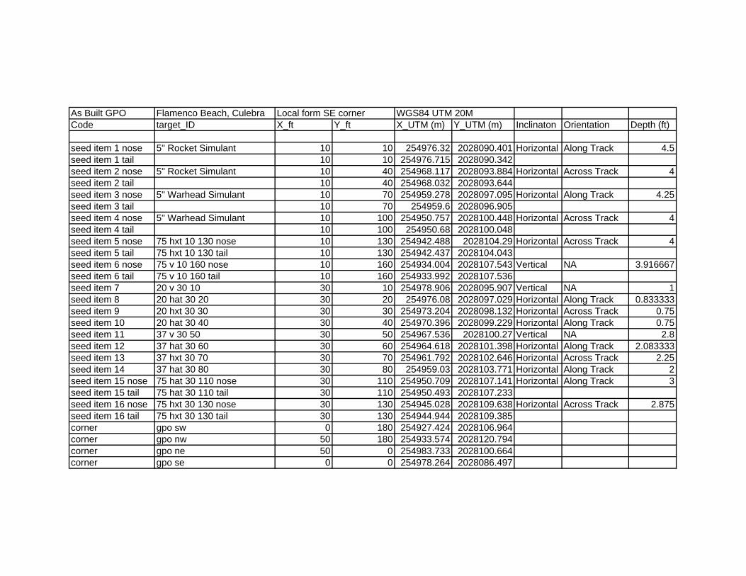
As Built GPO Flamenco Beach, CulebraCode target_ID X_ft Y_ft X_UTM (m) Y_UTM (m) Inclinaton Orientation Depth (ft)
seed item 1 nose 5" Rocket Simulant 10 10 254976.32 2028090.401 Horizontal Along Track 4.5seed item 1 tail 10 10 254976.715 2028090.342seed item 2 nose 5" Rocket Simulant 10 40 254968.117 2028093.884 Horizontal Across Track 4seed item 2 tail 10 40 254968.032 2028093.644seed item 3 nose 5" Warhead Simulant 10 70 254959.278 2028097.095 Horizontal Along Track 4.25seed item 3 tail 10 70 254959.6 2028096.905seed item 4 nose 5" Warhead Simulant 10 100 254950.757 2028100.448 Horizontal Across Track 4seed item 4 tail 10 100 254950.68 2028100.048seed item 5 nose 75 hxt 10 130 nose 10 130 254942.488 2028104.29 Horizontal Across Track 4seed item 5 tail 75 hxt 10 130 tail 10 130 254942.437 2028104.043seed item 6 nose 75 v 10 160 nose 10 160 254934.004 2028107.543 Vertical NA 3.916667seed item 6 tail 75 v 10 160 tail 10 160 254933.992 2028107.536seed item 7 20 v 30 10 30 10 254978.906 2028095.907 Vertical NA 1seed item 8 20 hat 30 20 30 20 254976.08 2028097.029 Horizontal Along Track 0.833333seed item 9 20 hxt 30 30 30 30 254973.204 2028098.132 Horizontal Across Track 0.75seed item 10 20 hat 30 40 30 40 254970.396 2028099.229 Horizontal Along Track 0.75seed item 11 37 v 30 50 30 50 254967.536 2028100.27 Vertical NA 2.8seed item 12 37 hat 30 60 30 60 254964.618 2028101.398 Horizontal Along Track 2.083333seed item 13 37 hxt 30 70 30 70 254961.792 2028102.646 Horizontal Across Track 2.25seed item 14 37 hat 30 80 30 80 254959.03 2028103.771 Horizontal Along Track 2seed item 15 nose 75 hat 30 110 nose 30 110 254950.709 2028107.141 Horizontal Along Track 3seed item 15 tail 75 hat 30 110 tail 30 110 254950.493 2028107.233seed item 16 nose 75 hxt 30 130 nose 30 130 254945.028 2028109.638 Horizontal Across Track 2.875seed item 16 tail 75 hxt 30 130 tail 30 130 254944.944 2028109.385corner gpo sw 0 180 254927.424 2028106.964corner gpo nw 50 180 254933.574 2028120.794corner gpo ne 50 0 254983.733 2028100.664corner gpo se 0 0 254978.264 2028086.497
Local form SE corner WGS84 UTM 20M

6 Line Test
250.00~---------+---------1---------~---------r---------+---------1----------~--------+-------~
200.00~--------1---------~----------+---------~--------~----------+----------+----------~--------~
150 .00~---------1---------~----------+---------~--------~----------+----------+----------~--------~
100.00~---------1---------~----------+-------~~--------~----------+----------+----------~--------~
50 .00~--------+---------1---------~------~~~-------+---------1----------~--------+-------~
0 2 4 6 8 10 12 14 16 18
database: c:\documents and settings\acrandal\desktop\cu/ebra dgm\gpo\ Channel: zPistance
MAP 6 line test
LEGEND
-----7 '~ormal Pace
f--- Normal Pace
'lormal Pace witl1 oQject
f--- 'lormal Pace witl1 oQjeot
-----7 ~ast Pace with ObJect
f--- Slow PaGe With object
.& Target positlon
~ Lateral tol. exc.
Proposed distance lag= -0.014 Proposed time lag = -0.032 sec
Scale 1:100
Map Scale:
Client:
Project:
Contractor:
~.1 I liiiiiiiijil"'-------(!!!tltfl l
hi
! Grid Nonh: o~O'O" Mag North: 0"0'0"
Created by: I Verified by:
Dilte: I File: 6Line_6LineTest
Page number: I Approved:

GPOGPSLO_SNR Window Size Study.xls
X Y Mas
k
Targ
et_I
D
GPO
#
Seed
Typ
e
Incl
inat
on
Orie
ntat
ion
Dep
th (f
t)
Grid
_val
ue
SNR
_3.5
Sign
al_S
treng
th_3
.5
Size
_3.5
CLA
SSIF
Y_3.
5
SNR
_3.0
Sign
al_S
treng
th_3
.0
Size
_3.0
CLA
SSIF
Y_3.
0
SNR
_2.7
5
Sign
al_S
treng
th_2
.75
Size
_2.7
5
CLA
SSIF
Y_2.
75
SNR
_2.5
Sign
al_S
treng
th_2
.5
Size
_2.5
CLA
SSIF
Y_2.
5
SNR
_2.2
5
Sign
al_S
treng
th_2
.25
Size
_2.2
5
CLA
SSIF
Y_2.
25
SNR
_2.0
Sign
al_S
treng
th_2
.0
Size
_2.0
CLA
SSIF
Y_2.
0
SNR
_1.5
Sign
al_S
treng
th_1
.5
Size
_1.5
CLA
SSIF
Y_1.
5
254976.6 2028090.5 1 1 1 5" Rocket Horizontal Along Track 4.50 14.09 9.03 5192.79 2.02 2 9.44 5264.01 1.99 2 8.36 4973.71 2.00 2 8.8 5102.61 2 2 8.68 5000.65 1.99 2 9.1 4874.4 1.82 2 10.32 4531.76 1.55 1254976.6 2028091.2 2 1 5" Rocket Horizontal Along Track 4.50 11.64 9.2 5187.67 1.98 2 9.22 5268.01 2.03 2 8.44 4974.01 1.94 2 9.5 5073.34 1.8 2 9.56 4907.09 1.69 2 9.8 4676.47 1.57 2 7.83 2424.81 1.07 2254968.2 2028094.2 1 3 2 5" Rocket Horizontal Across Track 4.00 29.76 46.32 52497.78 4.09 1 47.45 52810.26 4.09 1 45.19 51585.29 3.97 1 47.1 52061.67 3.94 1 48.88 51582.50 3.74 1 54.1 51340.16 3.3 1 83.04 48834.55 1.92 1254959.5 2028097.2 1 9 3 5" Warhead Horizontal Along Track 4.25 11.42 3.85 1681 1.55 2 4.05 1716.87 1.56 2 3.62 1578.56 1.50 2 3.77 1638.25 1.53 2 3.66 1595.60 1.51 2 3.67 1600.67 1.5 2 3.97 1629.68 1.46 1254950.8 2028100.4 1 17 4 5" Warhead Horizontal Across Track 4.00 28.29 37.37 38098.6 3.72 1 38.21 38242.19 3.73 1 35.63 37274.21 3.68 1 36.55 37798.49 3.72 1 36.44 37407.60 3.65 1 40.45 37326.56 3.17 1 63.79 35900.28 1.92 1254942.4 2028104.7 1 29 5 75mm Horizontal Across Track 4.00 9.88 2.31 1372.05 2.14 1 2.38 1410.36 2.18 1 2.16 1265.32 2.01 2 2.27 1327.29 2.04 2 2.24 1282.31 1.99 2 2.2 1288.21 1.98 1 2.94 1289.12 1.56 1
254934 2028107.7 1 35 6 75mm Vertical NA 3.92 18.38 12.65 10124.29 2.87 1 13 10238.71 2.88 1 12.03 9799.28 2.81 1 12.21 9990.11 2.87 1 12.18 9851.81 2.81 1 12.77 9849.31 2.64 1 18.05 9648.09 1.86 1254979 2028096 1 6 7 20mm Vertical NA 1.00 60.85 177.72 66154.16 1.33 2 182.41 66336.81 1.32 2 170.72 65613.25 1.33 2 173.17 65933.45 1.33 2 168.50 65716.70 1.34 2 169.8 65733.97 1.32 2 188.8 65883.08 1.23 2
254976.4 2028097 8 8 20mm Horizontal Along Track 0.83 31.51 58.42 27589.43 1.71 2 61.48 27737.65 1.67 2 57.27 27142.33 1.66 2 56.74 27408.11 1.72 2 56.62 27275.24 1.65 2 61.04 27008.07 1.53 2 65.99 23395.35 1.3 2254975.9 2028097.3 1 10 8 20mm Horizontal Along Track 0.83 30.37 58.42 27589.43 1.71 2 59.68 27743.19 1.71 2 57.62 27141.16 1.66 2 56.74 27408.11 1.72 2 57.18 27217.37 1.69 2 58.76 27197.47 1.59 2 68.18 26089.76 1.34 2
254973 2028097.8 12 9 20mm Horizontal Across Track 0.75 20.54 32.28 17124.9 1.87 2 35.6 17231.74 1.74 2 31.52 16758.95 1.80 2 35.13 16768.29 1.63 2 35.29 15279.47 1.50 2 31.26 10827.51 1.17 2 25.4 6790.7 0.98 2254973.4 2028098.6 1 14 9 20mm Horizontal Across Track 0.75 28.37 32.27 17121.84 1.89 2 33.55 17248.38 1.86 2 32.40 16759.59 1.78 2 32.07 16946.79 1.83 2 32.79 16453.13 1.74 2 31.85 15945.9 1.69 2 34.74 13001.72 1.37 2254970.7 2028099.2 1 15 10 20mm Horizontal Along Track 0.75 46.41 73 43191.29 2.1 2 77 43373.78 2.08 2 69.53 42594.57 2.07 2 70.97 42953.82 2.1 2 72.27 42689.75 2.08 2 75.53 42656.66 1.92 2 98.57 40216.21 1.42 2254970.1 2028099.4 16 10 20mm Horizontal Along Track 0.75 26.67 74.01 43172.09 2.07 2 77 43373.78 2.08 2 69.53 42594.57 2.07 2 71.95 42934.1 2.07 2 69.92 42710.14 2.10 2 76.84 42051.71 1.8 2 81.16 32198.52 1.4 2254967.6 2028100.5 1 18 11 37mm Vertical NA 2.80 12.03 5.31 1077.17 0.74 2 5.03 1099.23 0.77 2 4.54 1022.62 0.75 2 5.08 1053.56 0.74 2 4.61 1031.86 0.76 2 4.56 1035.08 0.75 2 5.05 1051.13 0.74 2254964.9 2028101.3 20 12 37mm Horizontal Along Track 2.08 9.14 8.13 2732.67 1.22 2 8.07 2781.43 1.25 2 7.68 2618.05 1.19 2 7.75 2686.81 1.23 2 8.12 2632.81 1.14 2 8.16 2636.6 1.09 2 9.49 2055.85 0.77 2254964.3 2028101.7 1 21 12 37mm Horizontal Along Track 2.08 15.86 8.2 2734.15 1.21 2 8.26 2776.67 1.24 2 7.79 2612.43 1.16 2 7.88 2687.35 1.21 2 7.78 2634.02 1.18 2 8 2586.36 1.1 2 8.68 2515.44 1.04 2254961.8 2028102.4 1 24 13 37mm Horizontal Across Track 2.25 8.29 1.31 284.23 0.79 2 1.35 292.56 0.82 2 1.19 253.44 0.74 2 1.23 273.21 0.79 2 1.19 258.72 0.76 2 1.21 259.84 0.74 2 1.29 271.66 0.73 2254961.7 2028103.3 25 13 37mm Horizontal Across Track 2.25 5.8 1.35 280.29 0.78 2 1.39 296.22 0.79 2 1.18 253.39 0.72 2 1.35 265.33 0.69 2 1.29 229.20 0.59 3 1.09 149.2 0.47 3 0.28 19.21 0.24 3254959.4 2028103.6 1 26 14 37mm Horizontal Along Track 2.00 14.75 6.33 2444.57 1.39 2 6.54 2485.05 1.38 2 5.84 2328.88 1.34 2 6.42 2391.07 1.31 2 5.96 2343.23 1.33 2 6.21 2333.62 1.27 2 7.04 2178.16 1.07 2254958.7 2028103.9 28 14 37mm Horizontal Along Track 2.00 10.38 6 2450.84 1.46 2 6.54 2485.48 1.39 2 5.89 2330.03 1.36 2 5.83 2403.03 1.43 2 5.89 2349.13 1.37 2 6.37 2223.77 1.18 2 4.39 1112.43 0.89 2254950.7 2028107.3 1 32 15 75mm Horizontal Along Track 3.00 28.19 50.44 58429 4.21 1 51.03 58742.72 4.18 1 50.60 57170.94 3.90 1 54.2 57439.56 3.72 1 55.83 56190.62 3.58 1 59.96 55855.92 3.14 1 85.03 50007.67 1.93 1254944.9 2028109.6 1 39 16 75mm Horizontal Across Track 2.88 33.08 56.25 76092.66 4.85 1 59.06 76390.18 4.74 1 55.89 74773.74 4.63 1 60.77 74589.61 4.41 1 61.02 74013.35 4.15 1 72.1 71364.41 3.3 1 114.6 63496.12 1.93 1254978.3 2028095 1 4 background 5.29 191.97 66126.45 1.23 2 243.43 64566.54 0.93 2 230.32 63893.41 0.92 2 279.65 49264.49 0.66 3 276.22 46734.03 0.58 3 122.8 8936.75 0.25 3 4.54 38.32 0.02 3254977.8 2028095.2 1 5 background 5.84 195.08 66114.57 1.28 2 279.06 61807.86 0.79 2 259.08 53156.23 0.67 3 225.91 26959.39 0.42 3 288.12 36353.70 0.39 3 27.89 811.77 0.09 3 24.2 136.19 0.02 3254981.8 2028096.3 1 7 background 5.53 0.84 58.4 0.24 3 0.98 50.81 0.17 3 0.86 44.88 0.16 3 0.7 12 0.07 3 0.06 7.04 0.37 3 0.07 7.83 0.39 3 0.08 9.21 0.4 3254978.2 2028097.7 1 11 background 5.93 139.68 28324.83 0.73 2 108.66 18420.59 0.61 3 19.16 1661.37 0.33 3 9.78 527.75 0.19 3 2.59 119.04 0.15 3 1.06 12.3 0.06 3 0.25 32.6 0.44 3254977.7 2028098 1 13 background 6.05 42.13 4447.45 0.39 3 57.44 12251.35 0.73 3 52.10 5419.86 0.37 3 37.78 2683.57 0.28 3 16.12 739.71 0.15 3 2.06 6 0.01 3 0.25 31.37 0.43 3254967.9 2028102 1 22 background 5.24 6.03 1039.05 0.61 3 4.87 519.32 0.37 3 2.39 138.25 0.23 3 2.44 180.15 0.26 3 2.77 214.77 0.25 3 1.79 52.05 0.09 3 1.01 42.43 0.15 3254967.3 2028102.1 1 23 background 5.38 5.43 738.5 0.52 3 3.69 313.16 0.29 3 2.59 209.74 0.27 3 2.63 201.89 0.28 3 2.61 172.25 0.25 3 1.71 59.64 0.11 3 0.84 37.69 0.16 3254966.1 2028103.6 1 27 background 8.02 3 0.87 54.9 0.22 3 0.80 52.98 0.20 3 0.82 53.66 0.19 3 0.72 53.82 0.24 3 0.79 53.21 0.22 3 0.83 53.6 0.19 3254960.4 2028105 1 30 background 5.5 8.39 2119.86 0.94 2 9.76 1628.02 0.56 3 4.99 346.16 0.24 3 2.32 118.78 0.16 3 0.64 18.26 0.10 3 0.48 7 0.06 3 0.59 34.85 0.2 3254956.4 2028106.8 1 31 background 5.95 0.5 33.31 0.24 3 0.58 39.96 0.24 3 0.50 34.55 0.22 3 0.49 33.5 0.23 3 0.50 33.13 0.22 3 0.58 40.86 0.22 3 0.5 33.51 0.23 3254955.4 2028107.3 1 33 background 5.78 0.5 33.31 0.24 3 0.58 39.96 0.24 3 0.50 34.55 0.22 3 0.49 32.11 0.23 3 0.50 31.62 0.21 3 0.84 17.15 0.07 3 0.38 31.22 0.3 3254954.5 2028107.5 1 34 background 5.9 0.72 92.08 0.44 3 0.94 103.11 0.38 3 0.56 40.60 0.26 3 0.66 41.55 0.21 3 0.42 15.76 0.13 3 1.14 69.94 0.21 3 0.42 17.67 0.18 3
254954 2028107.8 1 36 background 5.89 0.7 92.96 0.46 3 0.8 109.14 0.49 3 0.49 60.02 0.43 3 0.56 68.53 0.41 3 0.56 59.42 0.37 3 0.59 61.98 0.35 3 0.79 40.06 0.17 3254953.3 2028108.3 1 37 background 7.14 3.48 270.39 0.26 3 0.81 109.17 0.47 3 0.48 64.98 0.46 3 0.54 69.19 0.44 3 0.47 62.27 0.45 3 0.5 66.29 0.46 3 0.55 68.49 0.43 3254952.6 2028108.6 1 38 background 5.68 50.22 12276.89 0.87 2 2.29 100.08 0.16 3 0.19 2.20 0.05 3 3 0.07 0.61 0.02 3 3 0.36 25.63 0.24 3
254942 2028112.2 1 40 background 5.35 0.99 63.12 0.22 3 0.84 50.75 0.23 3 0.82 50.00 0.21 3 0.95 64.89 0.2 3 0.87 44.68 0.18 3 0.63 10.97 0.08 3 0.46 18.19 0.16 3254941.1 2028113.1 1 41 background 7.53 0.85 49.7 0.22 3 0.87 49.75 0.22 3 0.88 56.09 0.21 3 0.83 49.74 0.21 3 0.98 64.41 0.21 3 0.82 49.88 0.21 3 0.84 49.76 0.21 3254940.6 2028113.3 1 42 background 8.05 0.85 49.7 0.22 3 0.92 55.05 0.22 3 0.97 64.73 0.21 3 0.83 49.74 0.21 3 0.81 51.22 0.22 3 0.83 50.81 0.2 3 0.8 44.91 0.18 3254939.8 2028113.8 1 43 background 5.23 0.81 45.1 0.21 3 0.64 19.29 0.12 3 0.56 58.57 0.33 3 0.59 58.75 0.34 3 0.58 61.96 0.33 3 0.65 47.35 0.24 3 0.14 3.66 0.11 3254938.8 2028114.1 1 44 background 6.1 0.15 1.28 0.02 3 0.41 30.54 0.26 3 0.41 31.91 0.26 3 0.41 31.12 0.26 3 0.41 34.13 0.26 3 0.4 31.58 0.26 3 0.41 31.17 0.26 3254933.5 2028116.1 1 45 background 6.32 0.3 13.19 0.19 3 0.55 18.12 0.1 3 0.76 21.92 0.11 3 0.28 12.89 0.19 3 0.69 21.64 0.13 3 0.77 13.37 0.04 3 0.87 58.95 0.24 3254972.7 2028101.2 1 19 QA seed 21.47 28.74 7186.38 0.92 2 32.4 7530.38 0.86 2 30.50 7932.35 0.90 2 28.94 6990.67 0.85 2 32.43 7812.75 0.83 2 32.45 6989.72 0.72 2 33.82 4853.97 0.54
Class 1:Class 2:Class 3:
Size > 2.1 && SS > 1307Size > 0.70 && SS > 280Size < 0.70 || SS < 280
Size > 2.09 & SS > 1400Size > 0.70 & SS > 292Size < 0.70 || SS < 292
Size > 2.1 & SS > 1250Size > 0.70 & SS > 250Size < 0.70 || SS < 250
Size > 2.1 & SS > 1320Size > 0.66 & SS > 260Size < 0.66 || SS < 260
Size > 1.4 & SS > 1280Size > 0.73 & SS > 270Size < 0.73 || SS < 270
Size > 2.1 && SS > 1250Size > 0.70 & SS > 250Size < 0.70 || SS < 250
Size > 1.95 & SS > 1280Size > 0.73 & SS > 255Size < 0.73 || SS < 255

Site Specific Final Report Non-Time Critical Removal Action Culebrita and Culebra Beaches
Contract No. W912DY-04-D-0006; Task Order No. 0012 Page K-1 4 June 2009
APPENDIX K
K.0 PERFORMANCE WORK STATEMENT (PWS)
This appendix contains a copy of the PWS plus revisions.

1
Performance Work Statement Non Time Critical Removal Action
Culebrita and Culebra Beaches Municipality of Culebra, Puerto Rico
PROJECT NO. I02PR006802 30 August 2006
Revision: 28 September 2006 Revision: 05 JUL 2007 Revision: 05 DEC 2007
Summary of 05 DEC 2007 changes: 1. Revise Task 3 Digital Geophysical Mapping, Paragraph 3.3.1.3 to include requirement for a temporary fence around the GPO area. 2. Add Task 8, Beach Monitoring, Paragraph 3.7 to include requirement for monitoring of beaches prior to intrusive ordnance activities. 1.0 PERFORMANCE OBJECTIVE: The objective of this task order is for the contractor to perform Digital Geophysical Mapping (DGM) and a removal action (RA) to remove and dispose of all explosive hazards within the selected beach areas at Isla Culebrita and Culebra, Puerto Rico. The RA shall be in accordance with the signed Action Memorandum. 1.1 Regulatory Guidelines: The work required under this Performance Work Statement (PWS) falls under the Defense Environmental Restoration Program - Formerly Used Defense Sites (DERP-FUDS). 1.1.1 The work associated with this Task Order shall be performed in accordance with the Comprehensive Environmental Response, Compensation, and Liability Act (CERCLA), Section 104, and the National Contingency Plan (NCP), Sections 300.120(d) and 300.400(e) as described in ER 200-3-1 and other USACE implementing guidance. 1.1.2 All activities involving work in areas potentially containing unexploded ordnance hazards shall be conducted in full compliance with Department of Defense (DoD), Department of Army (DA), US Army Corps of Engineers (USACE), state and local requirements regarding personnel, equipment, and procedures. 29 CFR 1910.120 shall apply to all actions taken at this site. 1.2 Chemical Warfare Materiel (CWM): This site is not suspected of containing CWM. However, during conventional MEC operations, if the contractor identifies or suspects CWM, the contractor shall immediately withdraw upwind from the work area and contact the contracting officer and the appropriate point of contact in their Work Plan (WP)/Accident Prevention Plan (APP). The contractor shall secure the area and provide two personnel located upwind of the suspect CWM to secure the site until relieved by the Department of the Army emergency response personnel. Additional support may be required by the emergency response personnel, e.g., construction of blast mitigation controls. Additional reporting instructions are contained in CEMP-CE Memorandum, Notification Procedures for Discovery of Recovered Chemical Warfare Materiel (RCWM) During United States Army Corps of Engineers (USACE) Projects: http://www.hnd.usace.army.mil/oew/policy/IntGuidRegs/. 1.3 Quality Control: 1.3.1 Quality Management: The Contractor shall implement quality control processes as defined in a Quality Control Plan (QCP). The Contractor is responsible for ensuring that all work under the contract is of the quality that meets or exceeds contract requirements. The Government will implement quality assurance (QA) processes as defined in a Quality Assurance Surveillance Plan (QASP) to assure that contractor QC methods are effective and that task order objectives and defined quality standards are met or exceeded. 1.3.2 Quality Control (QC) Plan: The Contractor shall implement an acceptable Quality Control (QC) Plan. The Quality Control Plan shall be detailed and comprehensive and shall cover all aspects of the task order activities

2
impacting quality of deliverables and services. The Contractor shall ensure that QC documentation is maintained and provided on a weekly basis when in the field and included in the Site Specific Final Report. The contractor’s QCP shall be included in the Work Plan. 1.3.3 Quality Assurance: The Government will perform quality assurance (QA) of the Contractor's performance under this task order using the method of surveillance specified in the Quality Assurance Surveillance Plan (QASP). The specific surveillance tasks performed under the surveillance plan will be defined following acceptance of the QC Plan. The Government reserves the right to modify the surveillance tasks in the QASP at any time. The Government reserves the right to perform QA inspections at any time. QA failure can be defined as workmanship or work products not complying with the WP, PWS, QC Plan, or not meeting project objectives. Failure can also be defined as workmanship not complying with basic safety concepts and other industry safety practices. If any government QA review identifies a process failure or a work product failure, the contractor will be issued a Corrective Action Request (CAR). The Contractor shall provide full documentation detailing the root cause of the failure, why it was not detected in the Contractor’s QC Program, and how the problem was corrected to prevent repetitive or future occurrences. 1.3.3.1 Re-performance: Any service or submittal performed that does not meet task order requirements shall be corrected or re-performed by the Contractor and at no additional cost to the Government. The Government reserves its rights under FAR clause 52.246-4, Inspection of Services – Fixed Price, for further remedies concerning a Contractor’s failure to perform in conformance with contract requirements. 2.0 BACKGROUND: Culebra came under Navy control in 1901, and the Navy built a small base that same year and an airfield about 20 years later. The Navy used the area for fleet exercises from 1902 until 1975. The Navy began surface and aerial bombing of the Flamenco Peninsula in 1935, and expanded the range to include eastern and western cays (small island surrounding Culebra) in the early 1960s. Ordnance firing ended in September 1975. Culebra Island National Wildlife consists of Culebra Island and about 20 cays surrounding Culebra Island which are owned by the Fish and Wildlife Service (FWS). Total land area is about 7300 acres, and the FWS owns approximately 1500 of these acres. The rest is owned by the Commonwealth of Puerto Rico (about 1200 acres), primarily the Department of Natural and Environment Resources (DNER). Historical documentation indicates that Isla Culebrita was use by the Marine Corps as an artillery impact area and a boat gun firing site for training exercises at Culebra. Historical documentation indicates that Flamenco Beach is immediately adjacent to a heavily used Navy gunnery and bombardment area that was used mainly from 1934 to 1975. Isla Culebrita is approximately 1 mile east of Culebra Island. The locations considered within this PWS are five beach areas, Areas A – E. These areas are shown on the attached map 1.
Area A 1.69 acres Area B 0.28 acres Area C 0.50 acres Area D 1.24 acres Area E 0.87 acres
Approximately five additional acres will be identified adjacent to Areas A – E. These five acres will be identified by the Fish and Wildlife Service based on locations which employees need to access due to the presence of threatened/endangered turtles. Flamenco Beach: Flamenco Peninsula is on the northwest end of Culebra Island and includes Flamenco Beach. Flamenco Beach is shown on the attached map 2.
Area F 11.83 acres The cumulative area for beaches and adjacent areas is 21 acres.

3
A detailed archives search was conducted in 1994 and the Archives Search Report (ASR) completed in February 1995. A Time Critical Removal Action (TCRA) was conducted at the campground area of Flamenco Beach in 1995. Eleven UXO items were removed and disposed of. An EE/CA for the Former Culebra Island Naval Facility began in 1995 and was final in March 1997. In June 2004, the Department of the Army directed the US Corps of Engineers to re-investigate the information available concerning the military’s use of Culebra. The Supplemental ASR was completed in September 2005. Two endangered species of turtles, the Hawksbill and the Leather Back, are found at Culebra. In addition, there are two species that have been proposed for threatened status: the Loggerhead and the Green sea turtles. All four of these species use the Culebra area and most of the beaches for nesting sites. 3.0 SPECIFIC TASKS: All tasks listed in this section shall be performed as defined, and in accordance with Section 4.0 GENERAL REQUIREMENTS. Methods to be used to achieve the specified level of performance shall be determined by the Contractor. The Contractor will be evaluated periodically during each of the following tasks to ensure compliance with the PWS and to document that quality objectives, delivery schedule, and the overall completion date are being met. Failure to adequately complete any task to the required level of quality or in a timely manner may result in a repeat of the work at the Contractor’s expense, a poor performance evaluation, and/or a reduction in the Contractor’s payment to cover additional expenses incurred by the Government for the Contractor’s delay. 3.1 (TASK 1) PROJECT PREPARATION AND PLANNING: This Task is Firm Fixed Price. The contractor is authorized a post award site visit. The contractor shall notify the Huntsville Engineering & Support Center Project Manager (PM) 14 days prior to a planned site visit. The contractor shall submit for approval and Abbreviated Accident Prevention Plan (AAPP) prior to the site visit. The contractor shall not visit the site until receipt of approval of the AAPP. The contractor shall provide a trip report to the PM 7 days after conclusion of the site visit. Performance Metric: Successful completion of this task will be government acceptance of the AAPP. Measurement Method: The Government will review the AAPP for its ability to meet project objectives and provide for proper and safe application of procedures and equipment. Remedy: The Contractor shall revise and resubmit the AAPP to address all comments requiring resolution. Incentives/Disincentives: If the initial submission of the AAPP is submitted and accepted as the Final version in one (1) submission, the Contractor will receive consideration for an exceptional performance rating under Quality of Product or Service. 3.2 (TASK 2) WORK PLAN (WP): This Task is Firm Fixed Price. The WP shall be prepared following the general format described in data item description (DID) MR-005-01. The WP shall contain, at a minimum, a Technical Management Plan (DID MR-005-02), Explosives Siting Plan (DID MR-005-04), Accident Prevention Plan (APP), which includes a Site Safety and Health Plan (SSHP) (EM 385-1-1 and DID MR 005-06), Environmental Protection Plan (DID MR-005-12), and a Quality Control Plan (QCP). The QCP shall be a detailed and comprehensive plan covering all aspects of the response. Other sub plans or elements shall be required as necessary to support the contractor’s technical approach. The contractor shall attend an On Board Review after receiving comments on the Draft Final Work Plan. The On Board Review shall be held in San Juan, Puerto Rico with Stakeholders in attendance. Contractor shall allocate four (4) days, inclusive of travel time, for this event. Hard copies of the Final Work Plan shall be submitted 14 days after the conclusion of the On Board Review.

4
A Property Management Plan is required if the contractor has Government furnished equipment. A Work, Data, and Cost Management Plan is required for any T&M task. Performance Metric: Successful completion of this task will be government acceptance of the WP. Measurement Method: The Government will review the WP for its ability to meet project objectives and DQOs and for proper and safe application of procedures and equipment. Remedy: The Contractor shall revise and resubmit the work plan to address all comments requiring resolution. Incentives/Disincentives: If the draft version of the WP is submitted and approved as the Final version in one (1) submission, the Contractor will receive an exceptional performance rating under Quality of Product or Service and will not be required to attend the On Board Review. If the On Board Review is required and all issues resolved and the WP accepted then a satisfactory rating will be given. If the draft WP is rejected without comments, or the Contractor fails to submit an acceptable Work Plan following the On Board Review, an unsatisfactory performance rating will be given. 3.3 REMOVAL ACTION: The contractor shall provide the necessary personnel and equipment to safely destroy and/or remove and dispose of all MEC and explosive hazards IAW the Action Memorandum(s) for the beaches of Isla Culebrita and Flamenco Beach, Culebra. The removal action is divided into two tasks, Digital Geophysical Mapping (DGM) and intrusive operations. The contractor is expected to find all items 20mm and larger to depth of detection. The Areas of concern and acreages are listed in Table 3-1 below. The site “TBD” is an additional 5 acres to be located adjacent or near the beaches. The location of the 5 acres and the exact boundaries of the beaches on Culebrita will be determined in coordination with United States Fish and Wildlife Service (USFWS). The 5 acres may be used as a whole or divided amongst the 5 beach areas or any combination necessary to meet the objectives of this PWS. The contractor can expect vegetation clearance on 4 acres or less. Table 3-1 Areas of Concern:
SITE DESCRIPTION ACREAGE A Beach on Culebrita 1.69 acres B Beach on Culebrita 0.28 acres C Beach on Culebrita 0.50 acres D Beach on Culebrita 1.24 acres E Beach on Culebrita 0.87 acres TBD TBD on Culebrita 5.00 acres F Flamenco Beach 11.83 acres
3.3.1 (TASK 3) Digital Geophysical Mapping (DGM): This is a Firm Fixed Price Task. Performance Metric: Successful completion of this task will be government acceptance of the work product. The final work product (deliverable) from this task shall be an anomaly dig list based upon the anomaly selection criteria. Measurement Method: The Government will perform QA of this task IAW the QASP. The geophysical mapping quality requirements shall be included in the measurement method. Remedy: The Contractor shall re-perform any work element that does not pass Government QA.

5
Incentives/Disincentives: Failure to successfully complete task will preclude Notice to Proceed (NTP) for Task 4 Anomaly Resolution and Intrusive Activities (removal action). Successful completion of this task with no CARs may result in an exceptional performance rating under Quality of Product or Service. 3.3.1.1 Geophysical Investigations: The contractor shall identify all needs specific to the geophysical system that is required to successfully detect all range-specific MEC with high confidence. The purpose of the data quality objectives for geophysical operations and related operations shall be to demonstrate that all definable features of work support and meet (or exceed) project objectives. The QCP for geophysics and related operations shall be designed to verify that the definable features of work products meet the design criteria that will be developed in the Work Plan. The design of the geophysical investigation must be able to unambiguously detect each target objective listed in Table 3-2 to the depths listed in the table. The contractor should note that Table 3-2 is not a complete list of items that may be found on Culebra or Culebrita. These depths are based on removal actions performed at sites other than Culebrita, as well as other Government sources. If these required detection depths can not be achieved using currently available geophysical technologies, the Government will adjust these requirements using contractor-supplied geophysical data, Government geophysical data, or both. This list is designed to specify geophysical detection requirements only. The Government does not know what all of the actual target objectives are, or will be, for Culebrita. In the event that an item not listed is discovered, it shall be added to the QC/QA detection depth criteria. TABLE 3-2 MEC Detection Depths:
MEC Item Required Detection Depth (feet below ground surface)
20mm Projectile 0.6 Hand grenade 1.5 37mm Projectile 1.3 2.36” rocket 1.9 MK23 practice bomb 1.5 60mm mortar 1.8 81mm mortar 2.8 75mm projectile 2.5 105mm projectile 4.0 155mm projectile 5.0 6-inch naval projectile 5.0 8-inch naval projectile 7.0
The requirements specified above do not supersede the stated objective of this PWS. These requirements are incorporated in this PWS to define the basis for non-conformance or non-compliance criteria and to define the basis for the Geophysical QA criteria related to anomaly detection. Line Spacing Objective: The line spacing objective for all survey data under this task shall be the lesser of 0.6m or the minimum spacing required to unambiguously detect the smallest known or suspected MEC item for a given site, as defined during the GPO. Anomaly Selection Characteristics: The Contractor shall develop anomaly selection criteria that are a function of all available anomaly characteristics. The Government anticipates these criteria will be developed in collaboration between the Contractor and United States Army Engineering and Support Center, Huntsville (USAESCH), as well as local, state, and/or federal regulatory agencies. Anomaly characteristics shall include, but not be limited to, centroid location, area of contiguous above-background measurements, peak responses of all channels of data collected, and the signal to noise ratio (calculated as signal power above estimated background power) based upon all above-background measurements. The Contractor shall develop two (2) anomaly dig lists: the first shall list all anomalies suspected of being larger than a 37 mm item; the second list shall list all anomalies suspected of being items 37mm or smaller. The contractor is encouraged to include in their proposal additional characteristics that they believe will
6
benefit the Government in reducing the number of anomalies associated with non-hazardous items that are placed on dig lists. 3.3.1.2 Geophysical Mapping Quality Requirements: Pass/Fail criteria. The following Geophysical Quality Assurance (GQA) criteria are defined based upon the current knowledge of Culebrita. The GQA criteria may be revised in the event MEC smaller than those listed are discovered. 1) All “positioning seed items” (8 to 10-inch nails) shall be detected and their locations interpreted within .3 meter of their burial points. 2) All inert MEC seeds and simulated MEC seeds shall be detected, their locations interpreted within .3 meter of their burial points, and selected for placement on dig lists. 3) DGM maps shall represent as best as possible the actual potential field as it existed at the time of data collection. [This statement is intended to capture all the QC we know needs to be done to address all the known failure modes for any given geophysical system.] 4) Discovery of undocumented or unresolved non-conformance or non-compliance as defined in the accepted QC plan. 5) All anomalies shall be selected and loaded into dig lists. 6) All above-background anomalies shall be uniquely identified, with the following anomaly characteristics calculated: centroid location, area of contiguous above-background measurements, peak responses and the SNR (calculated as signal power above estimated background power) based upon all above-background measurements. 7) Detection of a geophysical anomaly that was not detected by the Contractor, and which has characteristics similar to, or greater than, any target objective known to exist in each sub-task range. The characteristics will be defined based on target objectives buried at depths specified in Table 3-2 of this PWS. Initial anomaly characteristics will be based on the GPO and may include signal-to-noise ratios, spatial extent of above background measurements as represented on a map of geophysical data, fit-coefficients from modeling software, peak amplitude responses, and any other quantifiable measure of anomaly characteristics developed by the Government. These characteristics will not be limited to simple threshold characteristics of peak amplitude response. Specific values for anomaly characteristics will be defined in the quality assurance surveillance plan. Initial criteria will use data acquired by the contractor and/or by the Government. 8) No line spacing gaps exceed 1m, excluding areas not accessible due to obstructions. Minor spacing gaps of up to 1m will be accepted if the area for any one data gap area does not exceed 2m2 and the total area of all gaps does not exceed 0.2% of the total area mapped, excluding inaccessible areas such as trees, etc. The final measurement methods for this task will be defined in the QASP, which will be developed as a function of the Contractor’s procedures defined in their Work Plan(s) and Quality Control Plan. The measurement method will include the GQA criteria listed above, as appropriate. 3.3.1.3 Specific Geophysical Investigation Requirements: Task Products: The products for this task shall include: All geophysical data delivered in accordance with Section 5.0 of this PWS, Maps showing the interpreted geophysical data displayed using spatial scales and color scales that clearly display the data and the interpretations, Complete dig list(s) tabulating all anomalies meeting selection criteria, Complete anomaly list(s) tabulating unique anomaly identifier, centroid location, area of contiguous above-background measurements, peak responses of all channels of data collected, and the signal to noise ratio (calculated as signal power above estimated background power) based upon all above-background measurements. Additional anomaly information may be required if advanced processing is used to define anomalies, which may include, but not be limited to, calculated magnetic moment, estimated anomaly depth, fit coefficients, modeling results. Geophysical Prove Out. The contractor shall perform a geophysical prove-out. The purpose of the GPO shall be to: 1) demonstrate the effectiveness of the geophysical system(s) to meet project objectives, 2) define initial anomaly characteristics, 3) define quality control procedures required to monitor the efficacy and quality of the geophysical system, 4) optimize data quality objectives to reliably detect MEC and meet the GQA listed above. A USAESCH geophysicist will conduct an on-site evaluation of the contractor’s equipment and methodology. The contractor will proceed with further mapping operations only after receiving the approval of this geophysicist. Written confirmation

7
of this approval will be delivered later in a letter from the Contracting Officer. The Contractor shall provide all inert MEC items required for the GPO. The Government anticipates between 2 to 4 of each item listed in the MEC Detection Depths Table will be required, with the exception of the 2.36-inch rocket, the 155mm projectile and the naval projectiles. If inert ordnance items are not available the Contractor shall provide approved surrogates. Contractor shall provide a temporary fence around the GPO (such as four foot plastic construction fence) to keep visitors from disturbing the GPO during placement of items therein. Contractor shall coordinate specific configuration and alignment of fencing with local representative of the Fish and Wildlife Service, Culebra Conservation Authority, etc. to avoid conflicts with endangered species. 3.3.2 (TASK 4) ANOMALY RESOLUTIONS AND INTRUSIVE ACTIVITIES: This task is to be awarded as Time and Materials (T&M), but will be converted by negotiation to Firm Fixed Price following execution and final deliverable of Task 3, Digital Geophysical Mapping. The Contractor shall identify all needs specific to their anomaly resolution process that are required to successfully reacquire, excavate, or otherwise positively resolve all anomalies tabulated on dig lists. The purpose of the data quality objectives for anomaly resolution shall be to define what is meant by “resolved anomaly” and verify and/or confirm each anomaly is unambiguously resolved. The QCP for anomaly resolution and related operations shall be designed to verify the work products meet the stated objective(s) for anomaly resolutions. A minimum of 25% of excavated anomaly locations will require post excavation verification. Dig result findings shall be reviewed and approved by a qualified Geophysicist. A thorough and inclusive process for managing false positive, no contact, “hot-rock”, “geology” and “Nothing Found” results shall be included as part of the geophysical anomaly resolution program. The contractor is encouraged to include in their proposal additional anomaly verification requirements and/or innovative anomaly resolution procedures that they believe will benefit the Government in reducing the ambiguity of anomaly resolutions. Performance Metric: Successful completion of this task will be government acceptance of the work product. The final product is the successful resolution of all anomalies on the dig list. Measurement Method: The Government will perform QA of this task IAW the QASP. Remedy: The Contractor shall re-perform any work element that does not pass Government QA. Incentives/Disincentives: Successful completion of this task with no CARs or Form 948 deficiencies issued will result in consideration for an exceptional performance rating for this task under Quality of Product or Service and Safety. 3.3.2.1 Backfilling Excavations: All access/excavation/detonation holes shall be backfilled by the contractor. The contractor shall restore such areas to their prior condition. 3.3.2.2 MEC Accountability: The contractor shall maintain a detailed accounting of all MEC items/components encountered. This accounting shall include the amounts of MEC, the identification, condition, depth, disposition, and location. This accounting shall be a part of an appendix to the Site Specific Final Report. 3.3.2.3 Disposal of Munitions Debris: All munitions debris shall be handled in accordance with Attachment A of this PWS. In the event that a USACE OE Safety Specialist is not on site to sign as the verifier, then the contractor’s UXOQCS or UXOSO shall verify the munitions debris in accordance with Attachment A of this PWS. 3.3.2.4 Geophysical Anomaly Resolution Quality Requirements: Pass/Fail criteria: 1) Discovery of any ferrous object with a width and diameter inclusive of the smallest target objective and larger at a depth of less than 11 diameters of the object found, at any location within 1m of an anomaly placed on a dig list. Discovery of such an object at a distance greater than 1m from an anomaly placed on a dig list will not constitute a QA failure if the contractor can unambiguously demonstrate the finding is not the result of a non-conformance or non-compliance. Any such item that is MEC and is demonstrated not to be a QA failure shall be reported to the Contracting Officer, the USACE Project Manager and the USACE project geophysicist.

8
2) Discovery of an unresolved anomaly listed on a dig list. The term unresolved is defined as 1) a geophysical signature of unknown source is still present at a location specified on a dig list after it has been declared complete and accepted by the project QC personnel, 2) an anomaly is reported as no-contact, false positive, hot-rock, geology or nothing found but does not meet the requirements for such under the false-positives, no-contact, hot-rock, geology and nothing found management plan. 3) Discovery of undocumented or unresolved non-conformance or non-compliance as defined in the accepted QC plan. 3.4 (TASK 5) GEOGRAPHIC INFORMATION SYSTEM (GIS): This Task is Firm Fixed Price. The contractor develop a GIS in accordance with DID MR-005-07. The coordinate system for this project shall be in the Universal Transverse Mercator (UTM) coordinate system. All geo-referenced data shall be submitted in UTM Coordinates. The initial GIS files shall be submitted on CD/DVD with the Draft WP. The final GIS files shall be submitted with the draft Site Specific Final Report (SSFP) Performance Metric: Successful performance will be based on meeting format requirements, completeness of information, maintenance of the system, value added to the project and usability of data. Completion of this task will be Government acceptance of the final GIS CD/DVD(s). Measurement Method: The government will spot check the GIS data at various stages of the project. Inspections may be on-site or may be review of required submittals. Remedy: If additional work is required to bring the GIS system into compliance with project objectives and requirements, The Contractor shall make corrections at no additional expense to the government. Incentives/Disincentives: If, as part of the Site Specific Report, the initial submission of the GIS data is accepted as the final version, the Contractor will receive consideration for an exceptional performance rating under this task for Quality of Product or Service. 3.5 (TASK 6) SITE SPECIFIC REPORT (SSR): This Task is Firm Fixed Price. The Contractor shall prepare a final report in accordance with DID MR-030. In addition to the DID requirements, the contractor shall include all QC documentation in the Final Report. The contractor shall also include a cover letter signed by an authorized person (preferably the person who signed the Task Order) of the company certifying, on behalf of the company, that the requirements of this Task Order have been met. Performance Metric: Successful completion of this task is the acceptance of the Site specific Final Report by the government. Measurement Method: The Government will review the Final Report using DID MR-030 Remedy: The Contractor shall revise the report as needed at no additional cost to the government. Incentives/Disincentives: If the draft version of the SSFP is submitted and accepted as final in one (1) submission, the Contractor will receive an exceptional performance rating under Quality of Product or Service. If there are 2 submissions and the SSFP is accepted then a satisfactory rating will be given. IF there are 3 or more submissions before the SSFP is accepted then and unsatisfactory rating will be given. If the draft SSFP is rejected without comments on the initial submission, an unsatisfactory performance rating will be given. 3.6 (TASK 7) CONSTRUCTION SUPPORT: These tasks are Fixed Unit Price. The contractor shall provide two qualified personnel for construction support on an as-needed basis. The contractor shall propose a mobilization / demobilization unit cost each (subtask 7A), and a unit cost per week (40 hours) for two personnel (subtask 7B).

9
Performance Metric: Successful completion of this task is the completion of construction support requirement. Measurement Method: The Government will verify the personnel on site are qualified. Remedy: The Contractor shall replace any unqualified personnel. Incentives/Disincentives: If response time is delayed or found to be unreasonable from that stated in the contractor’s proposal, consideration for an unsatisfactory rating under Quality of Product or Services will be result. Likewise, if response time exceeds that listed in the proposal, consideration for an exceptional rating will be given. These same criteria will apply to Management of Key Personnel and Resources. 3.7 Task 8 – Beach Monitoring These tasks are Fixed Unit Price. At the direction of the Contracting Officer, the Contractor shall provide a qualified Project Biologist for daily beach monitoring prior to intrusive ordnance activities as described in the Standard Operation Procedure for Endangered Species Conservation, USACE, Jacksonville District, issued under Modification 1. Project Biologist qualifications shall reflect 2-4 years experience in related work, working independently under general supervision (equivalent to industry Biologist II). Provide a Fixed Unit Price for Project Biologist: Project Biologist, per week: estimated quantity: 3. Price is not to include mob/de-mobilization. Project Biologist, per month: estimated quantity: 2. Price is not to include mob/de-mobilization. Project Biologist, mobilization/demobilization, EA: estimated quantity: 2. Performance Metric: Successful completion of this task is the completion of beach monitoring. Measurement Method: The Government will verify personnel on site are qualified. Contractor shall submit Project Biologist qualifications and resume for review. Remedy: The Contractor shall replace any personnel found to be unqualified. Incentives/Disincentives: Past Performance evaluation under criteria of Management of Key Personnel and Resources. 4.0 GENERAL REQUIREMENTS: All work under SECTION 3.0 SPECIFIC TASKS of this Performance Work Statement is subject to the following general requirements: Project Management: The Contractor shall provide a single point of contact (POC), who is responsible for the entire project and coordination of team activities. The POC shall serve as a liaison/planner/consultant with the Government staff. The POC shall perform project activities necessary to maintain project control, to include, but not be limited to the following: Schedule: The Contractor shall develop and submit, for approval, a comprehensive project schedule for this task order. The schedule shall be updated weekly in accordance with DID MR-085 Project Status Report with changes sent directly to the USAESCH PM by e-mail in Microsoft Project. Reports/Minutes, Record of Meetings: The Contractor shall prepare and submit a report/minutes of all meetings attended in accordance with DID MR-045. Telephone Conversations/Correspondence Records: The Contractor shall keep a record of significant telephone conversations and written correspondence, in accordance with DID MR-055. A copy of this record shall be attached to the Project Status Report.

10
Project Status Reports: The Contractor shall prepare and submit a project status report IAW DID MR-085 and include any other items required in this PWS. Public Affairs: The Contractor shall not publicly disclose any data generated or reviewed under this contract. The Contractor shall refer all requests for information to the local Corps of Engineers Public Affairs Office (Jacksonville District) with a copy furnished to the USAESCH PM. Reports and data generated under this contract are the property of the DoD and distribution to any other source by the Contractor, unless authorized by the Contracting Officer, is prohibited. 5.0 SUBMITTALS AND CORRESPONDENCE: 5.1 Computer Files: All text files generated by the Contractor under this contract shall be furnished to the Contracting Officer on CD ROM/DVD in Microsoft Word 2000 or higher software. Spreadsheets shall be in Microsoft EXCEL. All CADD drawings shall be compatible with Microstation 95 or higher. Any GIS data shall be compatible with ESRI (Arcview/Arcinfo) format. 5.1.1 Raw Geophysical Field Data Format and Storage. Raw field data will be stored in a logical file directory (folder) structure to facilitate its management and dissemination to PDT members. Raw field data is defined as all digital data generated from the geophysical system, and includes positioning, heading, tilt, and any other peripheral or instrument measurements collected or recorded during data acquisition. All raw field data shall have a time stamp associated with each measurement event. Metadata, either in the form of a read-me file or information recorded in the project GIS, will be generated for each logical grouping of raw field data (e.g., names and contents of all files generated to map a grid, or names and contents of all files generated from a towed platform during a mapping session.) Metadata shall fully describe all measurements recorded in each data file. Metadata shall include all information necessary to successfully associate all geophysical system measurements to their correct geographical location. At the discretion of the PDT, the metadata can be limited to provide references to where this information is located. This option would typically be reserved for line and fiducial surveys where numerous field notes are required to properly position all data, and including the field notes in a digital metadata file would be time consuming and unnecessary to meet project objectives. At the discretion of the PDT, raw field data may include geophysical system data that has been checked, corrected and processed into ASCII files, either individually by instrument or merged with positioning data. Metadata shall include instructions for generating ASCII formatted data from all raw data for use in computer processing systems. 5.1.2 Final Processed Data Format and Storage. Final processed data shall be produced and presented in ASCII formatted files and/or native geophysical processing software formats; the PDT will establish which type(s) are required. Final processed data is defined as data that represents, to the best of the PDT’s ability, the true potential field that exists at each actual location measured by the geophysical system. Final processed data shall have all corrections applied needed to correct for positioning offsets, instrument bias (including instrument latency), instrument drift, yaw-angle offsets, and diurnal magnetic variations. Final processed data shall not be filtered or normalized (filtered or normalized data is addressed under Advanced Data below). All corrections will be documented. Data within the files will be delineated into individual fields for each value reported. ASCII data files shall be delineated using standard delineation protocols such as a comma (e.g. a “csv” format), a tab, or a white space. The PDT will determine which delineation protocol shall be used. Native geophysical processing software often manage and display data in spreadsheet formats not requiring specified delineation standards. Values reported in data files shall include local, geographic and/or projected coordinates for each measurement event (often referred to as x/y, latitude/longitude or easting/northing coordinates), one or more “z” values, which are the data associated with each measurement event, and a time stamp for each measurement event. Projected coordinates shall be reported in UTM/metric or State Plane/US Survey Feet coordinates and units, as determined by the PDT. Unless agreed upon otherwise by the PDT, header or metadata information shall be included in each file and describe the contents of each value field and specify its units. Data file size should be limited to 100 megabytes or less, and the file length should be limited to 600,000 lines or less. Each data file will be logically and sequentially named so that the file name can be easily correlated with the project-specific naming conventions being used by the PDT.

11
5.1.3 Advanced Processed Data Format and Storage. All advanced processed data shall be produced and presented in ASCII formatted files and/or native geophysical processing software formats; the PDT will establish which type(s) are required. Advanced processed data is defined as Final Processed data that has been subjected to advanced processing techniques, such as filtering or normalizing, and was used in part or in whole in the anomaly selection process. Data within the files will be delineated into individual fields for each value reported. ASCII data files shall be delineated using standard delineation protocols such as a comma (e.g. a “csv” format), a tab, or a white space. The PDT will determine which delineation protocol shall be used. Native geophysical processing software often manage and display data in spreadsheet formats not requiring specified delineation standards. Values reported in data files shall include local, geographic and/or projected coordinates for each measurement event (often referred to as x/y, latitude/longitude or easting/northing coordinates), one or more “z” values, which are the advanced-processed data associated with each measurement event, and a time stamp for each measurement event. Projected coordinates shall be reported in UTM/metric or State Plane/US Survey Feet coordinates and units, as determined by the PDT. Unless agreed upon otherwise by the PDT, header or metadata information shall be included in each file and describe all advanced processing that was applied to each value field. The Metadata shall specify the units of each value field. Data file size should be limited to 100 megabytes or less, and the file length should be limited to 600,000 lines or less. Each data file will be logically and sequentially named so that the file name can be easily correlated with the project-specific naming conventions being used by the PDT 5.2 PDF Deliverables: In addition to the paper copies of submittals, uncompressed digital copies on CD ROM/DVD of all versions of submittal shall be provided in PDF format. The documents shall be complete with a linked table of contents, tables, photographs, graphs, figures, and appendices all of which shall be suitable for viewing on the Internet. PDF files shall be created from source documents whenever possible. 5.3 Review Comments: Various reviewers will have the opportunity to review submittals made by the Contractor under this contract. The Contractor shall review all comments received through the USAESCH Project Manager (PM) and evaluate their appropriateness based upon their merit and the requirements of the PWS. The Contractor shall issue to the USAESCH Project Manager a formal, annotated response to each in accordance with the established schedule in this PWS. The Contractor shall not non-concur with a comment without discussing the comment with the USAESCH PM. If the PM is not available then the Contractor shall contact the Technical Manager. 5.4 Identification of Responsible Personnel: Each report shall identify the specific members and title of the Contractor's staff and subcontractors that had significant and specific input into the preparation or review of the report. 5.5 Public Affairs: The Contractor shall not publicly disclose any data generated or reviewed under this contract. The Contractor shall refer all requests for information concerning site conditions to the local Corps of Engineers Public Affairs Office with a copy furnished to the USAESCH PM. Reports and data generated under this contract are the property of the DOD and distribution to any other source by the Contractor, unless authorized by the Contracting Officer, is prohibited. 5.6 Submittals: The Contractor shall furnish copies of the plans, maps, and reports as identified in this paragraph, or as specified otherwise in this PWS, to each addressee listed below in the quantities indicated. The Contractor shall submit a CD for each copy of the Final accepted version of all submittals (WP, reports, plans, etc.) in accordance with Computer Files paragraph. The Contractor shall submit the designated number of copies on CD of the Final accepted version of all submittals (WP, Reports, Plans, etc) in accordance with PDF Deliverables paragraph, to all addressees provided below, at the completion of the Task Order. For purposes of the PWS all days are considered calendar days. ADDRESSEE COPIES Commander 4 US Army Engineering and Support Center, Huntsville Attn: CEHNC-OE-DC (Brendan Slater)

12
4820 University Square Huntsville, AL 35816-1822 (256) 895-1788 Commander 20 – Draft Final Work Plan, Draft US Army Corps of Engineers, Jacksonville District Final Site Specific Report, and ATTN: CESAJ-DP-S (Michael Ornella) All Final Submittals listed below 701 San Marco Blvd 8 - All Other submissions Jacksonville, FL 32207 For purposes of the PWS all days are considered calendar days. Draft Work Plan 15 days after post-award site visit and NLT 45 days from award date Draft Final Work Plan Final Work Plan 14 days after on board review Draft GPO Plan 15 days after post-award site visit and NLT 45 days from award date Final GPO Plan 5 days after receipt of comments Draft GPO Letter Report Final GPO Letter Report 5 days after receipt of comments DGM Dig List Upon completion of DGM activities GIS Data Included with Site Specific Report Draft Site Specific Report 21 days after completion of field activities (excluding construction support) Final Site Specific Report 15 days after receipt of comments. 6.0 PERIOD OF PERFORMANCE: Initial period of performance will be from date of award to 30 March 2008. 7.0 GOVERNMENT FURNISHED EQUIPMENT / PROPERTY (GFE / GFP): None. 8.0 PAYMENTS: 8.1 Payments subject to FAR for firm fixed price payments. Payment milestones and invoice submission shall be in accordance with the schedule contained in contractor’s proposal. Milestones will be a definable product or service provided to the government under this task order contract. 8.2 Milestones will be considered met / completed when the appropriate QC documentation has been submitted, government QA completed and the submittal and/or product is accepted by the Contracting Officer or duly appointed representative. Any payment vouchers submitted for a milestone that has not met these requirements will be rejected. 9.0 GENERAL CONDITIONS: a. Government acceptance of the proposed technical approach and/or price does not relieve the Contractor from full responsibility for the viability of the approach used to perform the work or for meeting the performance requirements of the Performance Work Statement at the price proposed. b. The Contractor has been provided data during the proposal process to include, but not limited to, answers to specific questions and any site data included in previous project documents. Specifically, the Contractor has been provided with a range survey report that documents conditions at the site as gathered and interpreted by a third party Contractor. The Government makes no claims as to the accuracy of the site data supplied and/or the actual working conditions to be encountered. The actual conditions that the Contractor experiences may differ from the conditions reported in the data. The Contractor shall be responsible for interpreting the data provided in context of the conditions under which the survey was conducted and the data analysis and extrapolation limitations typical of site assessment efforts. The Contractor attests that they have gathered the information necessary to fully understand the

13
conditions they will encounter during execution of this task order, and have used any data provided by the Government at the contractors own risk. c. The Contractor is expected to apply due diligence to the development of their proposal and to know or estimate the conditions to be encountered that will affect the cost, quality, or schedule of the work included in this task order. Requests for an equitable price adjustment or claim of changed site conditions will not be allowable for conditions that the Contractor could reasonably be expected to know, anticipate, or assume, or any of the following specific conditions: - PPE requirements including all effects on cost or production due to the requirement to use PPE. - Exclusion zone requirements. Exclusion zone requirements include all affects and costs of implementing and enforcing exclusion zones or complying with the exclusion zone of other neighboring operations to include, but not limited to, live fire training and the exclusion zones of neighboring UXO clearance operations. The Contractor is responsible for evaluating, identifying the requirements of, and implementing/complying with all exclusion zone requirements. - DoD, Army, US Army Corps of Engineers, or Installation regulations or guidance in effect at the time of contract signature. The Contractor is responsible for understanding and implementing the installations’ safety and access control requirements and factoring them into their approach and price. - Weather conditions such as temperature, humidity, and rain that are within the norms for the area during the time the work is executed. - Vegetation type, height, density, or distribution. - Terrain, topography, soil, rock, geological conditions or the distribution of each. - The quantity, type, distribution or depth of cultural debris, cultural features, site construction features, discarded military munitions, material potentially presenting and explosive hazard (MPPEH), military munitions, burial pits, munitions and explosives of concern (MEC), munitions constituents, munitions debris, MEC, MEC scrap, MPPEH, munitions debris, range-related debris, small arms ammunition, unexploded ordnance, hot rocks, metallic debris, and/or other anomalies encountered. [If recovered chemical warfare material (RCWM) or radioactive material is encountered, this will be grounds for an equitable adjustment]. Note that the number of anomalies investigated by the Contractor and the time it takes to achieve the performance requirements of this task is solely controlled by the Contractor (except for Government induced delays). The fact that the Contractor excavates more anomalies or takes more time than expected to perform the work is not grounds for an equitable adjustment. The Contractor is expected to apply the most appropriate technology to locate and discriminate between items that meet the QA failure criteria and all other anomalies. - Availability or cost of qualified labor, material, and/or equipment. - Availability or cost of scrap disposal outlets. - Reasonable delays due to Government review and quality assurance of contractor work products. - Availability or cost of housing for on-site personnel. - Availability or location of explosives storage. - The viability, productivity, and efficiency of the contractor’s approach to performance of the work. - No adjustments to price or schedule based on the above criteria, or any unexpected requirement reasonably associated with standard industry practices for the services performed, will be entertained. d. The Contractor certifies that their proposal is not qualified or contingent upon any of the above conditions. Any estimates of such conditions included in the data provided to the Contractor by the Government or included in the Contractor’s proposal are not binding contractual conditions. The act of signing this task order signifies that the Contractor has been given amply opportunity to assess the conditions under which the work will be performed and the contractor fully understands those conditions. The contractor shall execute the performance of work for the price proposed regardless of the conditions encountered. The Contractor accepts full and sole responsibility for identifying and considering all factors that may affect the cost to execute the work. The Contractor attests that it has had sufficient opportunity to do so and has used any data or information provided to them by any party at their own risk. e. The Contractor attests that exceptions to any of the conditions of the Performance Work Statement were clearly marked in the proposal in bold type as “Exception to the PWS.” The order of precedence in case there are any ambiguities or contradictions shall be as follows:

14
- Basic Military Munitions Response Program (MMRP) contract, - Project-specific Performance Work Statement, - Contracting Officer approved Work Plan, and Site Safety and Health Plan, - Written answers to questions during the proposal phase, and - The Contractor’s written proposal. 10.0 REFERENCES: Standard operating Procedures for Endangered Species Conservation and Their Habitat, Draft, DERP-FUDS Project Culebra, Puerto Rico, US Army Corps of Engineers, Jacksonville District.

15
Attachment A CHAPTER 12 EM 1110-1-4009 CORPS OF ENGINEERS CONTRACTORS MPPEH INSPECTION, CERTIFICATION, AND FINAL DISPOSITION PROCEDURES 12-1. MPPEH – Contractor Responsibilities and Procedures a. The U.S. Army Corps of Engineers (USACE) contractors executing projects will comply with the following procedures for processing MPPEH for final disposition. The objective of these procedures is to ensure that an inspection procedure of the exterior and interior surfaces of all recovered MPPEH is in place to ensure these items do not present an explosive hazard. These USACE contractor responsibilities and procedures will be contained, or referenced, in the project work plan.
(1) Unexploded Ordnance (UXO) Sweep Personnel will only mark suspected items and will not be allowed to perform any assessment of a suspect item to determine its status.
(2) Unexploded Ordnance (UXO) Tech I can tentatively identify a located item as MPPEH, followed by a required confirmation by a UXO Tech II or III
(3) UXO Technician II will: (a) Perform a 100% inspection of each item as it is recovered and determine the following: Is the item a UXO, a DMM, munitions debris, or range related debris? Does the item contain explosives hazards or other dangerous fillers? Does the item require detonation? Does the item require demilitarization (demil) or venting to expose dangerous fillers? Does the item require draining of engine fluids, illuminating dials and other visible liquid
hazardous, toxic or radiological waste (HTRW) materials? (b) Segregate items requiring demil or venting procedures from those items ready for
certification. (c) Items found to contain explosives hazards or other dangerous fillers will be processed in
accordance with applicable procedures. (4) UXO Technician III will:
Perform a 100% re-inspection of all recovered items to determine if free of explosives hazards or other dangerous fillers and engine fluids, illuminating dials and other visible liquid HTRW materials.
Supervise detonation of items found to contain explosive hazards or other dangerous fillers and venting/demil procedures.
Supervise the segregation, containerization and sealing of Munitions Debris and Range-related Debris. (5) UXO Quality Control (QC) Specialist will:
Conduct daily audits of the procedures used by UXO teams and individuals for processing MPPEH.
Perform and document random sampling ( by pieces, volume or area ) of all MPPEH collected from the various teams to ensure no items with explosive hazards, engine fluids, illuminating dials and other visible liquid HTRW materials are identified as munitions debris or range-related debris as required for completion of the Requisition and Turn-in Document, DD Form 1348-1A. (6) UXO Site Safety Officer (UXOSO) will:
Ensure the specific procedures and responsibilities for processing MPPEH for certification as munitions debris or range-related debris specified in the work plan are being followed.
All procedures for processing MPPEH are being performed safely and consistent with applicable regulations. (7) Senior UXO Supervisor will:
Be responsible for ensuring work and Quality Control (QC) Plans specify the procedures and responsibilities for processing MPPEH for final disposition as UXO, DMM, munitions debris or range-related debris.
Ensure a Requisition and Turn-in Document, DD Form 1348-1A is completed for all munitions debris and range-related debris to be transferred for final disposition.

16
Perform random checks to satisfy that the munitions debris and range -related debris is free from explosive hazards necessary to complete the Form, DD 1348-1A.
Certify all munitions debris and range-related debris as free of explosive hazards, engine fluids, illuminating dials and other visible liquid HTWR materials.
Be responsible for ensuring that inspected debris is secured in a closed, labeled and sealed container and documented as follows;
The container will be closed and clearly labeled on the outside with the following information: The first container will be labeled with a unique identification that will start with USACE/Installation Name/Contractor’s Name/0001/Seal’s unique identification and continue sequentially.
The container will be closed in such a manner that a seal must be broken in order to open the container. A seal will bear the same unique identification number as the container or the container will be clearly marked with the seal’s identification if different from the container.
A documented description of the container will be provide by the contractor with the following information for each container; contents, weight of container; location where munitions or range-related debris was obtained; name of contractor, names of certifying and verifying individuals; unique container identification; and seal identification, if required. The contractor in a separate section of the final report will also provide these documents.
12-2. MPPEH Certification and Verification a. The contractor will ensure that MPPEH is properly inspected in accordance with the procedures in 12-1 above. Only personnel who are qualified UXO personnel will perform these inspections. The Senior UXO Supervisor will certify and the USACE OE Safety Specialist will verify that the debris is free of explosive hazards. b. DD form 1348-1A will be used as certification/verification documentation. All copies of DD Form 1348-1A must clearly show the typed or printed names of the contractor’s Senior UXO Supervisor and the USACE OE Safety Specialist, organization, signature, and contractor’s home office and field office phone number(s) of the persons certifying and verifying the debris as free of explosive hazards.
(1) Local directives and agreements may supplement these procedures. Coordination with the local concerns will identify any desired or requested supplementation to these procedures.
(2) In addition to the data elements required and any locally agreed to directives, the DD Form 1348-1A must clearly indicate the following for scrap metal:
Basic material content (Type of metal; e.g., steel or mixed). Estimated weight. Unique identification of each of the containers and seals being turned over for processing. Location where munitions debris or range-related debris was obtained. Seal identification, if different from the unique identification of the sealed container.
(3) The following certification/verification will be entered on each DD Form 1348-1A for turn over of Munitions debris or range-related debris and will be signed by the Senior UXO Supervisor and the USACE OE Safety Specialist. This statement will be used on any ranges where Range Related Debris is being processed along with munitions debris: "This certifies that the material listed has been 100 percent properly inspected and, to the best of our knowledge and belief, are free of explosive hazards, engine fluids, illuminating dials and other visible liquid HTWR materials.
(4) The following certification/verification will be entered on each DD Form 1348-1A for turn over of munitions debris and will be signed by the Senior UXO Supervisor on properties where only munitions debris is being processed: “This certifies and verifies that the material listed has been 100 percent inspected and to the best of our knowledge and belief, are inert and/or free of explosives or related materials.” 12-3. Maintaining The Chain of Custody and Final Disposition. a. The contractor, in coordination with the Corps of Engineers, will arrange for maintaining the chain of custody and final disposition of the certified and verified materials. The certified and verified material will only be released to an organization that will:
(1) Upon receiving the unopened labeled containers each with its unique identified and unbroken seal ensuring a continued chained of custody, and after reviewing and concurring with all the provided supporting

17
documentation, sign for having received and agreeing with the provided documentation that the sealed containers contained no explosive hazards when received. This will be signed on company letterhead and stating that the contents of these sealed containers will not be sold, traded or otherwise given to another party until the contents have been smelted and are only identifiable by their basic content.
(2) Send notification and supporting documentation to the sealed container-generating contractor documenting the seal containers have been smelted and are now only identifiable by their basic content.
(3) This document will be incorporated by the contractor into the final report as documentation for supporting the final disposition of munitions debris and range-related debris.
(4) If the chain of custody is broken, the affected MPPEH must undergo a second 100 percent inspection, a second 100 percent re-inspection, and be documented to verify its explosives safety status (identified as either munitions debris or range related debris). b. Material that has been documented as safe is no longer considered MPPEH as long as the chain of custody remains intact. A legible copy of inspection, re-inspection, and documentation must accompany the material through final disposition and be maintained for a period of 3 years thereafter. 12-4. Material that is still MPPEH after inspection may be released only to a qualified receiver. The following must be accomplished prior to release of the property: a. Ensure that MPPEH that has been documented as hazardous is only transferred or released to those entities that:
(1) Have the licenses and permits required to receive, manage, or process the materials. (2) Have technical experts about the known or suspected explosive hazards associated with the
MPPEH. (3) Are qualified to receive, manage, and process MPPEH in accordance with DoD Instruction
4140.62. (4) Have personnel who are:
(a) Experienced in the management and processing of hazardous materials equivalent to the MPPEH.
(b) Trained and experienced in the identification and safe handling of used and unused military and/or any potential explosive hazards that may be associated with the specific MPPEH.
b. The receiver must be advised of all of the potential hazards associated with the MPPEH and agree to receive and process the material IAW with DoD Instruction 4140.62. c. All MPPEH shipments over public transportation routes must comply with DoD guidance that implements hazardous material transportation regulations. d. Ensure that chain of custody and accountability records are maintained through final disposition of MPPEH. A legible copy of inspection, re-inspection, and documentation must accompany MPPEH through final disposition and be maintained for a period of 3 years thereafter.