sitecheck assess - amazon web services · flood risk screen none identified ... is not considered...
TRANSCRIPT

Sitecheck Assess
This report is issued for the property described as:Testing House, Testing Avenue, Testinghampton, Testinghamshire, TE1 1ST
Report Reference:140644243
National Grid Reference:463650 102140
Customer Reference:INT Test 005 21/11/17_SAS
Report Date:21 November 2017
CONTACT DETAILS------------------------------------------------If you require any assistance pleasecontact our customer support team on:
0844 844 9966------------------------------------------------or by email at:
Contaminated Land FURTHER ACTION
Plausible contaminant linkages have been identified at the site. As such, potential liabilities have been identified under the relevant contaminated land legislation. Please refer to the next section for further information.
Flood Risk Screen NONE IDENTIFIED
We have not identified an elevated flood risk at your property. A full flood risk report is not considered necessary.
Energy & Infrastructure Screen IDENTIFIED
A screening of Energy & Infrastructure projects has identified a project/s at or close to the property. You should purchase an Energy & Infrastructure report to better understand the potential impact on the property. Please refer to the next section for further information.
Radon NONE IDENTIFIED
The property is not considered to be within a radon affected area. No further action is considered necessary.
Environmental Constraints IDENTIFIED
One or more environmental constraints have been identified within 250m of the property. Please refer to the next section for further information.

Professional Opinion and Recommendations
Please see below our recommendations and next steps. These may be copied into your Report on Title if you wish. No physical site inspection has been carried out or is proposed.
Section 1: Contaminated Land FURTHER ACTION
Professional OpinionIn the professional opinion of Landmark Information, potential Liabilities have been identified under Part 2A of the Environmental Protection Act 1990. To quantify these, you may decide to undertake a more detailed assessment following the recommendation(s) set out below.
You should be aware of the following:
A review of the available historical mapping has identified that the site is on or within 25 metres of Military Land shown on 1898-1991 edition maps.
As part of this assessment, we have considered sensitive receptors and human health, as this information is considered as part of the Local Authorities Part 2A inspection strategy.
Please see section 1 for further information. Alternatively, please contact your professional advisor or Landmark Customer Services on 0844 8449966.
RecommendationsLandmark Information may be able to revise the risk assessment by reviewing additional information. To take advantage of the free re-review service, please forward relevant information to: [email protected]
This should include:A written comment from the Environmental Health Department (Local Authority) including the following:A comment on the Property’s potential to be investigated under Part 2A of the Environmental Protection Act, 1990. The comment needs to include whether or not the Property is likely to be investigated under this legislation, if so what priority it has been given, and a reason for this priority status. Please note that Local Authorities can take up to20 working days to provide this information.
Or, if the Site has recently been redeveloped, planning information may be available from the Planning Department (Local Authority):Planning permission for the Property including contaminated land conditions, with written confirmation from the Local Authority that these have been fully discharged. Please note, planning permission without contaminated landconditions will not be accepted.
Alternatively, we can collect and review this additional information on your behalf at a cost of £450 + VAT.
If the Property is operational, you should consider undertaking an Environmental Audit in order to investigate current operational environmental liabilities, compliance issues and any historical legacy that the Property owner may be exposed to. We can offer a contaminated land, compliance and other environmental audits from £950 + VAT.
Report Reference:140644243 Landmark Information // Sitecheck Assess 1Testing House, Testing Avenue, Testinghampton, Testinghamshire, TE1 1ST
A warranty or similar guarantee, environmental indemnity or Contaminated Land insurance Policy would transfer risk identified in the context of the report, subject to its validity, wording and terms.
Please call 0845 4585250 for further information.

Professional Opinion and Recommendations
Section 2: Flood Risk Screen NONE IDENTIFIED
Landmark Information have not identified an elevated flood risk at your property. A full flood risk report is not considered necessary.
Section 3: Energy & Infrastructure Screen IDENTIFIED
Landmark Information have identified Energy or Infrastructure projects at or close to the property. In order to gain more detailed information regarding the projects and the potential impact, it is recommended that you purchase an Argyll Energy & Infrastructure report. If you would like more information, please contact your Search Provider or our Customer Services Team on 0844 844 9966 or email [email protected].
Section 4: Radon NONE IDENTIFIED
The property is in a lower probability radon area as less than 1% of homes are estimated to be at or above the action level for radon gas.
Radon Protection Measures: No radon protective measures are necessary in the construction of new dwellings or extensions to existing buildings.
Section 5: Environmental Constraints IDENTIFIED
Landmark Information have identified the following environmental constraints at or close to the property: Sites of Special Scientific Interest, Ramsar Sites and Special Protection Areas.
Please refer to section 5 of this report for more details. If you would like more information, please contact your professional advisor or Landmark Customer Services on 0844 8449966.
Next StepsIf you require any assistance, please contact our Customer Services Team on:0844 844 9966 or [email protected]
Report Reference:140644243 Landmark Information // Sitecheck Assess 2Testing House, Testing Avenue, Testinghampton, Testinghamshire, TE1 1ST

Property Location
Location PlanThe map below shows the location of the property.
Report Reference:140644243 Landmark Information // Sitecheck Assess 3Testing House, Testing Avenue, Testinghampton, Testinghamshire, TE1 1ST
Contains Ordnance Survey data © Crown copyright and database right 2017.
Site
Search Radii

Property Purchaser Guide
Understanding this report
The purpose of this report is to highlight any potential risk of contaminated land, as defined under Part 2A of the Environment Protection Act 1990. The report also examines whether the property is atrisk from other specified environmental factors that may impact the future intended use and saleability of the property.
For contaminated land, we will state 'Passed' on the front page if our environmental consultants consider there to be no risk to the property. If a potential risk of contaminated land is found, the report front page will state 'Further Action'. In this case, we will include our recommendations and next steps.
For all other environmental factors, we will state 'None Identified' if no potential risk is found and 'Identified' if a potential risk is found. In this case, we will provide recommendations or details of further information required to explore this potential risk.
Section 1: Contaminated Land
In this section, we highlight on a map, and within our findings pages, if there are any potential contaminated land risks at or around the property. Contaminated land contains substances that are actually or potentially hazardous to health or the environment.
Section 2: Flood Risk Screen
This section is a flood screen. This means that if we highlight a flood risk at the property, a further report will be required in order to understand the full details and possible impact on the property. Within the section, we consider River, Coastal, Surface water, groundwater and other flood risks.
Section 3: Energy & Infrastructure Screen
This section is an Energy and Infrastructure projects screen. This means that if we identify any projects at or close to the property, a further report will be required in
order to understand the full details and possible impact on the property. Within the section, we considerprojects such as High Speed Rail (HS2), Crossrail, Oil and Gas Exploration (Fracking), Solar and Wind farms, etc. (only wind and solar farms with a capacity to produce over 1MW of power are considered).
Section 4: Radon
In this section, we identify if the property is located in a radon affected area. Radon is a radioactive gas, which occurs naturally in rocks and soils and may be harmful to health. Employers have duty of care to mitigate the build up of radon gas in higher risk areas.
Section 5: Environmental Constraints
In this section, we identify factors that may have an influence on the property or surrounding area, such as environmental constraints. These include things like national parks or conservation areas.
Next StepsIf you require any assistance, please contact our customer service team on:0844 844 9966 or [email protected]
Report Reference:140644243 Landmark Information // Sitecheck Assess 4Testing House, Testing Avenue, Testinghampton, Testinghamshire, TE1 1ST

Contaminated Land
Section 1a: Historical Land UsesThe map below shows the location of potentially contaminative historical land uses that have been identified from historical maps and other sources. Further details are shown on the following pages.
Report Reference:140644243 Landmark Information // Sitecheck Assess 5Testing House, Testing Avenue, Testinghampton, Testinghamshire, TE1 1ST
Contains Ordnance Survey data © Crown copyright and database right 2017.
Map ID
Potentially Infilled Land (Non-Water)Multiple Features Present
Historical Tanks And Energy Facilities
Potentially Contaminative Industrial Uses (Past Land Use) Potentially Infilled Land (Water)

Contaminated Land
Section 1a: Historical Land Uses
This section describes historical activity at and around the property, which could be considered to be contaminative. The information is taken from a variety of sources including Landmark's extensive historical map collection and analysisof historic activity. Records are highlighted due to the potential for contamination to exist.
Question Response
Have any historical potentially contaminative land uses been identified within 250m of the property?
Yes
Map ID Details Distance Contact
Potentially Contaminative Industrial Uses (Past Land Use)
1 Class: Military LandMap Published Date: 1898-1991
On Site 1
Historical Tanks And Energy Facilities
4 Type: TanksDate Of Mapping: 1968
102m 1
4 Type: TanksDate Of Mapping: 1952-1971
101m 1
Potentially Infilled Land (Non-Water)No features identified for this property.
Potentially Infilled Land (Water)
2 Details: Unknown Filled Ground (Pond, marsh, river, stream, dock etc)Map Published Date: 1870
On Site 1
3 Details: Unknown Filled Ground (Pond, marsh, river, stream, dock etc)Map Published Date: 1870
14m 1
5 Details: Unknown Filled Ground (Pond, marsh, river, stream, dock etc)Map Published Date: 1898
136m 1
Report Reference:140644243 Landmark Information // Sitecheck Assess 6Testing House, Testing Avenue, Testinghampton, Testinghamshire, TE1 1ST

Contaminated Land
Section 1b: Incidents and Enforcements
The data within this section tells you whether your property or surrounding area has been identified by the Local Authority as “Contaminated Land” under Part 2A of the Environmental Protection Act 1990 or if there have been any other pollution incidents, prosecutions or enforcements. Should there be an indication of contamination, it is not necessarily a cause for concern. Your report will be assessed by our professional environmental consultants who will advise you what, if any, considerations need to be made should you proceed with the property purchase.
Question Response
Have any incidents or enforcements been identified within 250m of the property? No
Map ID Details Distance Contact
Contaminated Land Register Entries and NoticesNo features identified for this property.
Environmental Pollution IncidentsNo features identified for this property.
Prosecutions Relating to Controlled WatersNo features identified for this property.
Prosecutions Relating to Authorised ProcessesNo features identified for this property.
Enforcement and Prohibition NoticesNo features identified for this property.
Planning Hazardous Substance EnforcementsNo features identified for this property.
Local Authority Pollution Prevention and Control EnforcementsNo features identified for this property.
Report Reference:140644243 Landmark Information // Sitecheck Assess 7Testing House, Testing Avenue, Testinghampton, Testinghamshire, TE1 1ST

Contaminated Land
Section 1c: Landfill and Waste Sites
The information in this section is telling you about active and historic landfill and waste sites within 250 metres of the property. Having a landfill or waste site near your property does not necessarily mean that you or the property will be affected. However, it is something you need to be aware of, because landfill and waste can have a detrimental effect on the surrounding environment, property value and health. A closed landfill/waste site should be given equal consideration to an active site, because of landfill by-products. For instance, landfill with lots of organic material can continue to produce odours and gas for many years.
Question Response
Have any landfill and waste sites been identified within 250m of the property? No
Map ID Details Distance Contact
Historic LandfillNo features identified for this property.
Registered Landfill SitesNo features identified for this property.
Local Authority Recorded Landfill SitesNo features identified for this property.
BGS Recorded Landfill SitesNo features identified for this property.
Permitted Waste Sites - Authorised Landfill Site BoundariesNo features identified for this property.
Integrated Pollution Control Registered Waste SitesNo features identified for this property.
Registered Waste Treatment or Disposal SitesNo features identified for this property.
Environmental Permitting Regulations - Waste SitesNo features identified for this property.
Registered Waste Transfer SitesNo features identified for this property.
Report Reference:140644243 Landmark Information // Sitecheck Assess 8Testing House, Testing Avenue, Testinghampton, Testinghamshire, TE1 1ST

Contaminated Land
Section 1d: Authorised Industrial ProcessesThe map below shows the location of any current or recent land uses that could have the potential to cause contamination. Further details are shown on the following pages.
Report Reference:140644243 Landmark Information // Sitecheck Assess 9Testing House, Testing Avenue, Testinghampton, Testinghamshire, TE1 1ST
Contains Ordnance Survey data © Crown copyright and database right 2017.
Map ID Fuel Station Entries Contemporary Trade Directory Entries
Multiple Features Present Local Authority Pollution Prevention and Controls Explosive Sites
Planning Hazardous Substance Consents
Control of Major Accident Hazards Sites (COMAH)
Notification of Installations Handling Hazardous Substances (NIHHS)
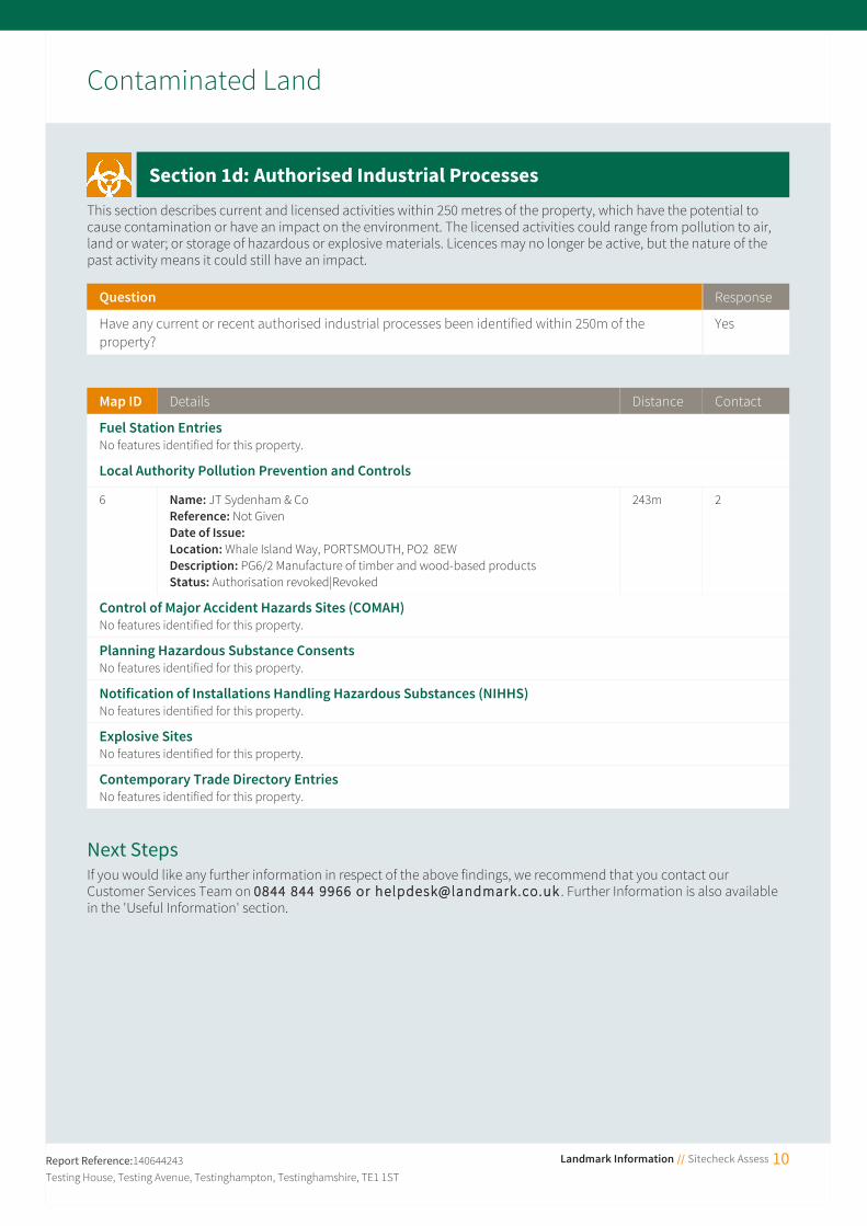
Contaminated Land
Section 1d: Authorised Industrial Processes
This section describes current and licensed activities within 250 metres of the property, which have the potential to cause contamination or have an impact on the environment. The licensed activities could range from pollution to air, land or water; or storage of hazardous or explosive materials. Licences may no longer be active, but the nature of the past activity means it could still have an impact.
Question Response
Have any current or recent authorised industrial processes been identified within 250m of the property?
Yes
Map ID Details Distance Contact
Fuel Station EntriesNo features identified for this property.
Local Authority Pollution Prevention and Controls
6 Name: JT Sydenham & CoReference: Not GivenDate of Issue: Location: Whale Island Way, PORTSMOUTH, PO2 8EWDescription: PG6/2 Manufacture of timber and wood-based productsStatus: Authorisation revoked|Revoked
243m 2
Control of Major Accident Hazards Sites (COMAH)No features identified for this property.
Planning Hazardous Substance ConsentsNo features identified for this property.
Notification of Installations Handling Hazardous Substances (NIHHS)No features identified for this property.
Explosive SitesNo features identified for this property.
Contemporary Trade Directory EntriesNo features identified for this property.
Next StepsIf you would like any further information in respect of the above findings, we recommend that you contact our Customer Services Team on 0844 844 9966 or [email protected] . Further Information is also available in the 'Useful Information' section.
Report Reference:140644243 Landmark Information // Sitecheck Assess 10Testing House, Testing Avenue, Testinghampton, Testinghamshire, TE1 1ST

Flood Risk Screen
Section 2a: River and Coastal Flooding
River flooding occurs when rivers and streams are unable to carry away floodwaters within their usual drainage channels. River flooding can cause widespread and extensive damage because of the sheer volume of water.Coastal flooding results from a combination of high tides, low lying land and sometimes stormy conditions. Coastal flooding can cause widespread and extensive damage because of the sheer volume of water.
Question Response
Is there a potential risk of river or coastal flooding at the property? No
Section 2b: Surface Water Flooding
Surface water flooding is common during prolonged or exceptionally heavy downpours, when rainwater does not drain away into the normal drainage systems or soak away into the ground
Question Response
Is there a potential risk of surface water flooding at the property? No
Section 2c: Groundwater Flooding
Groundwater flooding generally occurs during long and intense rainfall when underground water levels rise above surface level. Groundwater flooding may last for weeks or several months.
Question Response
Is there a risk of groundwater flooding at the property? No
Section 2d: Other Flood Risks
We analyse any historic flood events records, the proximity of the property to surface water features and the elevation ofthe property above sea level to enhance our overall analysis of the property.
Question Response
Are there other flood risks identified that could impact the property? No
Next StepsIf you would like any further information in respect of the above findings, we recommend that you contact our Customer Services Team on 0844 844 9966 or [email protected] .
Report Reference:140644243 Landmark Information // Sitecheck Assess 11Testing House, Testing Avenue, Testinghampton, Testinghamshire, TE1 1ST

Energy and Infrastructure Screen
Section 3a: Oil and Gas Exploration and Production
Any areas to be explored for their energy potential by the oil & gas industry must be licensed by the Oil and Gas Authority. Such exploration includes areas subject to hydraulic fracturing ("fracking") investigation.
Question Response
Is the property within 4km of any licences or drilling wells that could indicate that onshore oil and gas exploration and production operations are or could happen in the area?
No
Section 3b: Existing or Proposed Wind Farms and Wind Turbines
Wind energy is one of several alternative energy sources; however, the location of wind farms or turbines can be contentious due to visual and auditory impact on the surrounding area. The information in this section gives insight intowhether there are wind farms or turbines (planned or existing) in the vicinity of the report location. We only search thosewind power developments which generate between 1MW and 50MW of power.
Question Response
Is the property within 4km of existing or proposed wind farms or wind turbines? No
Section 3c: Existing or Proposed Solar Farms
Solar energy is one of several alternative energy sources; however, the location of a solar farm can be contentious due to its visual impact on the surrounding area. The information in this section gives insight into whether there are solar farms (planned or existing) in the vicinity of the report location. We only search those solar developments which generate between 1MW and 50MW of power.
Question Response
Is the property within 2km of existing or proposed solar farms? Yes
Section 3d: Other Renewable Power Plants
As well as wind and solar power there are a variety of other renewable power sources in the UK. This section identifies planning applications associated with these other types of renewable energy (BEIS only provides data relating to developments which have a capacity to generate over 1MW of power).
Question Response
Is the property within 2km of any other existing or proposed renewable power plant? No
Report Reference:140644243 Landmark Information // Sitecheck Assess 12Testing House, Testing Avenue, Testinghampton, Testinghamshire, TE1 1ST

Energy and Infrastructure Screen
Section 3e: Infrastructure
This section identifies if there are any Infrastructure projects, such as the High Speed 2 Rail Link (HS2) and Crossrail at orclose to the property. HS2 is a proposed railway line between London and the North of England. Trains along this route will operate at speeds of up to 250mph. Proximity to the route is likely to have an impact on the surrounding areas. The Crossrail 1 project is a rail project stretching from Reading and Heathrow in the west to Shenfield and Abbeywood in theeast. It will improve journey times across London, ease congestion and improve connections.
Question Response
Is the property located in an area that could be impacted by the development of either HS2 or Crossrail 1?
No
Next StepsWe have identified energy or infrastructure projects that may impact the property. We recommend you purchase a SiteSolutions Energy & Infrastructure report to gain further information on the type and location of the project. Please contact your Search Provider or our Customer Services Team on 0844 844 9966 or email [email protected] .
Report Reference:140644243 Landmark Information // Sitecheck Assess 13Testing House, Testing Avenue, Testinghampton, Testinghamshire, TE1 1ST

Radon
Section 4: Radon Findings
The information within this section tells you whether the property is located in a radon affected area. Radon is a radioactive gas which occurs naturally in rocks and soils. You cannot see, hear, feel or taste it. Exposure to particularly high levels of radon may increase the risk of developing lung cancer, and is therefore something you need to be aware of.
Question Response
Is the property in a radon affected area? The property is in a Lower probability radon area (less than 1% of homes are estimated to be at or above the Action Level).
What level of radon protection measures for new dwellings or extensions to existing ones is required for the property?
No radon protective measures are necessary in the construction of new dwellings or extensions to existing buildings.
Next StepsThe Ionising Radiation Regulations, 1999, require employers to take action when radon is present above a defined level in the workplace. Advice may be obtained from your local Health and Safety Executive Area Office or the Environmental Health Department of your local authority. The Building Research Establishment (BRE) publishes a guide (BR293): Radon in the workplace. Advice on radon in the workplace can be obtained from the Public Health England.For further information, please contact Public Health England (see Contacts section) or go to www.ukradon.org.
Report Reference:140644243 Landmark Information // Sitecheck Assess 14Testing House, Testing Avenue, Testinghampton, Testinghamshire, TE1 1ST

Environmental Constraints
Section 5: Environmental Constraints
This section provides information on areas which have been designated as having environmental or historical importance; as such there may be constraints on property or land developments or alterations.
Question Response
Is the property within 250m of an area likely to be impacted by Environmental Constraints? Yes
Details Distance Contact
National Nature ReservesNo features identified for this property.
Local Nature ReservesNo features identified for this property.
Marine Conservation ZonesNo features identified for this property.
Sites of Special Scientific Interest
Name: Portsmouth HarbourReference: 1003174Total Area: 12642544.62m²
108m 3
Ramsar Sites
Name: Portsmouth HarbourReference: UK11055Designation Date: Total Area: 12496431.87m²
108m 3
Special Areas of ConservationNo features identified for this property.
Special Protection Areas
Name: Portsmouth HarbourReference: UK9011051Designation Date: Total Area: 12496431.87m²
108m 3
Nature Improvement AreasNo features identified for this property.
Environmentally Sensitive AreasNo features identified for this property.
World Heritage SitesNo features identified for this property.
Ancient WoodlandNo features identified for this property.
Country ParksNo features identified for this property.
Areas of Outstanding Natural BeautyNo features identified for this property.
Forest ParksNo features identified for this property.
Report Reference:140644243 Landmark Information // Sitecheck Assess 15Testing House, Testing Avenue, Testinghampton, Testinghamshire, TE1 1ST

Environmental Constraints
Details Distance Contact
National ParksNo features identified for this property.
Next StepsIf you would like any further information in respect of the above findings we recommend that you contact our CustomerServices Team on 0844 844 9966 or [email protected] .
Report Reference:140644243 Landmark Information // Sitecheck Assess 16Testing House, Testing Avenue, Testinghampton, Testinghamshire, TE1 1ST

Useful Information
Limitations and Terms & Conditions This report has been published by Landmark Information Group Limited (“Landmark”) and is supplied subject to our Terms and Conditions of Business, which can be found at www.landmarkinfo.co.uk/Terms/Show/515. It has been prepared on the understanding that it is to be used for an individual residential property transaction and should not be used or relied upon in a commercial property transaction. This report is neither a guarantee of the physical condition of the subject property nor a substitute for any physical investigation or inspection. Whilst every effort is made to ensure the details in the report are correct, Landmark cannot guarantee the accuracy or completeness of such information or data, nor identify all the factors that may be relevant. If you are a private individual using this report Landmark recommends that you discuss its contents in full with your professional advisor.
Copyright Statement The data supplied for this Sitecheck Assess report falls under the following copyrights: Contains Historic Environment Scotland and Ordnance Survey data © Historic Environment Scotland - Scottish Charity No. SC045925 © Crown copyright and database right 2017; Contains Natural Resources Wales information © Natural Resources Wales and Database Right. All rights Reserved; Contains Natural Resources Wales information © Natural Resources Wales and Database Right. All rights Reserved. Contains Ordnance Survey Data. Ordnance Survey Licence number 100019741. Crown Copyright and Database Right; Contains Natural Resources Wales information © Natural Resources Wales and Database Right. All rights Reserved. Some features of this information are based on digital spatial data licensed from theCentre for Ecology & Hydrology © NERC (CEH). Defra, Met Office and DARD Rivers Agency © Crown copyright. © Cranfield University. © James Hutton Institute. Contains OS data © Crown copyright and database right 2017. Land & Property Services © Crown copyright and database right; Contains public sector information licensed under the Open Government Licence v3.0; Contains, or is based on, information supplied by the Forestry Commission. © Crown copyright and database right 2017 Ordnance Survey [100021242] ; Copyright© 2017 Scottish Environment Protection Agency (SEPA); Designated Historic Asset GIS Data, The Welsh Historic Environment Service (Cadw), 2017, licensed under the Open Government Licence http://www.nationalarchives.gov.uk/doc/open-government-licence/version/3/; Flood data provided by JBA Risk Management Limited. © Copyright JBA Risk Management Limited 2008-2017; Ordnance Survey © Crown copyright and/or Database Right. All rights reserved. Licence 100022432 ; Some of the responses contained in this section are based on data and information provided by the Natural Environment Research Council (NERC) or its component bodies the British Geological Survey (BGS). Your use of any information contained in this report which is derived from or based upon such data and information is at your own risk. Neither NERC, BGS nor Public Health England where applicable, gives any warranty, condition or representation as to the quality, accuracy or completeness of such information and all liability (including liability for negligence) arising from its use is excluded to the fullest extent permitted by law; © Crown Copyright and Landmark Information Group Limited 2017. All rights reserved; Contains SNH information licensed under the Open Government Licence v3.0; © Environment Agency and database right 2017 ; © Experian Ltd 2017; © GeoSmart Information Ltd; © Historic England 2017. Contains Ordnance Survey data © Crown copyright and database right 2017; © RenewableUK 2017; © Thomson Directories Ltd 2017; ©Landmark Information Group and/or its Data Suppliers 2017.
Report Reference:140644243 Landmark Information // Sitecheck Assess 17Testing House, Testing Avenue, Testinghampton, Testinghamshire, TE1 1ST
Landmark works in association with:

Useful Contacts
Please see below the contact details of the suppliers referred to within this report. For all queries please contact:
Landmark Information GroupImperiumImperial WayReadingRG2 0TD
If you require assistance please contact our customer services team on:
0844 844 9966Or by email at:[email protected]
Contact Name Address Contact Details
Public Health England
Centre for Radiation Chemical and Environmental HazardsChiltonDidcotOxonOX11 0RQ
T: 01235 822622F: 01235 833891E: [email protected]: www.ukradon.org
1 Landmark Information Group Limited
ImperiumImperial WayBerkshireRG2 0TD
T: 0844 844 9966E: [email protected]: www.landmark.co.uk
2 Portsmouth City Council, Environmental HealthDepartment
Civic OfficesGuildhall SquareHampshirePO1 2AZ
T: 023 92822251W: www.portsmouth.gov.uk
3 Natural England County HallSpetchley RoadWR5 2NP
T: 0300 060 3900E:
W: www.naturalengland.org.uk
4 British Geological Survey, Enquiry Service
British Geological SurveyKingsley Dunham CentreKeyworthNottinghamshireNG12 5GG
T: 0115 936 3143E: [email protected]: www.bgs.ac.uk
Please note that if you choose to contact any of the above organisations, they may have a charging policy in place for enquiries.
Report Reference:140644243 Landmark Information // Sitecheck Assess 18Testing House, Testing Avenue, Testinghampton, Testinghamshire, TE1 1ST

Useful Information
Information for Professional AdvisersThis report is designed to satisfy the concerns raised by the Law Society Practice Note and has been prepared to assist conveyancing professionals who may be advising clients when they sell or buy a property. It is designed to bring information to their attention and help them decide whether they need to seek any further specialist advice. The report gives details of any issues that we have identified as affecting the property or located nearby, and our recommendations on what to do in relation to these issues. You are authorised to copy the recommendations on the Professional Opinion and Recommendations page into any report on title that you provide to your client.
Other InformationPositional AccuracyWe locate data in a variety of ways according to information provided to us and subsequent in-house research. If data is provided as a point on the ground, we provide a "positional accuracy" which tells you how confident we are of the actual location.
Landfill and WasteAt present no complete national data set exists for landfill site boundaries, therefore, a point grid reference, provided bythe data supplier, is used for some landfill sites. In certain cases the point grid references supplied provide only an approximate position, and can vary from the site entrance to the centre of the site. Where the exact position of the site isunclear for Registered Landfill data, Landmark construct either a 100 metre or 250 metre buffer around the point to warn of the possible presence of landfill. The size of this 'buffer' relates to the positional accuracy that can be attributed to the site. For further information regarding landfill sites identified in the report, please contact the relevant agency or authority referenced in the Useful Contacts section.
The BGS holds records of over 3,000 landfill sites that accepted waste prior to the Control of Pollution Act (COPA) 1974. These were not subject to any strict regulation or monitoring.
Permitted Waste Sites and Environmental Permitting Regulations - Waste cover current or recently current consents issued for landfill sites, waste transfer, treatment or disposal sites by the relevant agency, under Section 64 of the Environmental Protection Act 1990 (Part 2) and prescribed by regulation 10 of SI No. 1056 of the Waste Management Licensing Regulations 1994.
Authorised Industrial ProcessesData supplied for Explosive Sites, Control of Major Accident Hazards Sites (COMAH) and Notification of Installations Handling Hazardous Substances (NIHHS) contains public sector information published by the Health and Safety Executive and licensed under the Open Government Licence.
Historical Land UsesThis section relates to categories of potentially contaminative land uses that have been identified by the analysis of selected Ordnance Survey historical mapping. The published date (range of dates) of the map(s) and the distance from the centre of search to the nearest point of the feature is given. Further details of the extent of the site or its activities arenot available. Should you wish to examine the Ordnance Survey maps these are normally available for public inspectionat the local archive or local major library. Alternatively, extracts of editions of Ordnance Survey maps are available on www.old-maps.co.uk
Potentially infilled land has been identified when a 'cavity' (a hole made by an extractive industry or natural occurrence e.g. pond) was indicated on a historic map but there was no evidence of its existence in the last available map for the area. No details of what may have been used to fill the cavity or exactly when or if it was filled are available from the mapping.
The point locations of historical tanks and energy facilities are identified from the text on Ordnance Survey 1:1250 and 1:2500 scale mapping published between 1943 and 1996, based upon a predetermined list of abbreviations, e.g. El Sub (Electricity Sub-station) and F Stn (Filling Station). The position of the point has been located at the centre of the identified text so that it would be within approximately 30 meters of the feature it was describing. The features themselves are related to energy and petroleum storage and cover the following: tanks, petrol storage, potential tanks
Report Reference:140644243 Landmark Information // Sitecheck Assess 19Testing House, Testing Avenue, Testinghampton, Testinghamshire, TE1 1ST

Useful Information
(at depots etc.), electricity sub stations and related features, gas and gas monitoring related features, oil related features and miscellaneous power features. NB: It should be noted that the Ordnance Survey abbreviation for tank (tk) is the same as that for tracks. Therefore some of the captured text may relate to tracks and not tanks when the exact nature of the feature is not clear from the mapping.
Other InformationRadonRadon is a natural radioactive gas, which enters buildings from the ground. It is the geological conditions in certain areas that can lead to higher than average volumes (some of the highest radon levels have been found in the southwest,but levels well above average have been found in some other parts of the UK).
Radon has no taste, smell or colour and special devices are needed to measure it. The gas is diluted to harmless levels out in the open but has the potential to build up to higher concentrations indoors. Exposure to high concentrations of Radon gas can pose a health risk and studies have shown that it increases the risk of lung cancer.
This report informs you whether the property is in a radon Affected Area and the percentage of homes that are estimated to be at or above the radon Action Level. This does not necessarily mean there is a radon problem in the property; the only way to find out whether it is above or below the Action Level is to carry out a radon measurement in an existing property. Due to the nature of the way the information is gathered, your property/site may have more than one probability of radon attributed to it. We report the worst case scenario on the property/site you have provided. This information is an estimate of the probability that a property/site in Great Britain is at or above the "Action Level" for radon (the level at which Public Health England recommends that radon levels should be reduced, those with an average of 200 Bq m-3 or more). This information satisfies CON29 Standard Enquiry of Local Authority; 3.13 Radon Gas: Location of the Property in a Radon Affected Area. Where the property/site is a new build, this information provides information on the level of protection required for new buildings under BR211 (Scivyer, 2007).
Disclaimer: "Some of the responses contained in this section are based on data and information provided by the Natural Environment Research Council (NERC) or its component bodies the British Geological Survey (BGS). Your use of any information contained in this report which is derived from or based upon such data and information is at your own risk. Neither NERC, BGS nor Public Health England where applicable, gives any warranty, condition or representation as to the quality, accuracy or completeness of such information and all liability (including liability for negligence) arising from its use is excluded to the fullest extent permitted by law.
Environmental ConstraintsThe Local Nature Reserves national dataset is "indicative" not "definitive". Definitive information can only be provided by individual local authorities and you should refer directly to their information for all purposes that require the most upto date and complete dataset.
Report Reference:140644243 Landmark Information // Sitecheck Assess 20Testing House, Testing Avenue, Testinghampton, Testinghamshire, TE1 1ST

Search Code
Important Consumer Protection InformationThis search has been produced by Landmark Information Group Ltd, Imperium, Imperial Way, Reading, Berkshire, RG2 0TD, Tel: 0844 844 9966 Fax: 0844 844 9980 Email: [email protected] Landmark Information Group Ltd is registered with the Property Codes Compliance Board (PCCB) as a subscriber to the Search Code. The PCCB independently monitors how registered search firms maintain compliance with the Code.
The Search Code:• provides protection for homebuyers, sellers, estate agents, conveyancers and mortgage lenders
who rely on the information included in property search reports undertaken by subscribers on residential and commercial property within the United Kingdom
• sets out minimum standards which firms compiling and selling search reports have to meet• promotes the best practice and quality standards within the industry for the benefit of consumers
and property professionals• enables consumers and property professionals to have confidence in firms which subscribe to the
code, their products and services.By giving you this information, the search firm is confirming that they keep to the principles of the Code. This provides important protection for you.
The Code's core principlesFirms which subscribe to the Search Code will:
• display the Search Code logo prominently on their search reports• act with integrity and carry out work with due skill, care and diligence• at all times maintain adequate and appropriate insurance to protect consumers• conduct business in an honest, fair and professional manner• handle complaints speedily and fairly• ensure that products and services comply with industry registration rules and standards and
relevant laws• monitor their compliance with the Code
ComplaintsIf you have a query or complaint about your search, you should raise it directly with the search firm, and if appropriate ask for any complaint to be considered under their formal internal complaints procedure. If you remain dissatisfied withthe firm’s final response, after your complaint has been formally considered, or if the firm has exceeded the response timescales, you may refer your complaint for consideration under The Property Ombudsman scheme (TPOs). The Ombudsman can award up to £5,000 to you if the Ombudsman finds that you have suffered actual financial loss and/or aggravation , distress or inconvenience as a result of your search provider failing to keep to the Code.Please note that all queries or complaints regarding your search should be directed to your search provider in the first instance, not to TPOs or to the PCCB.TPOs Contact Details:
The Property Ombudsman schemeMilford House43-55 Milford StreetSalisburyWiltshire SP1 2BPTel: 01722 333306Fax: 01722 332296Web site www. tpos.co.uk Email: [email protected]
Report Reference:140644243 Landmark Information // Sitecheck Assess 21Testing House, Testing Avenue, Testinghampton, Testinghamshire, TE1 1ST

Search Code
You can get more information about the PCCB from www.propertycodes.org.ukPLEASE ASK YOUR SEARCH PROVIDER IF YOU WOULD LIKE A COPY OF THE SEARCH CODE
Complaints procedureIf you want to make a complaint, we will:
• Acknowledge it within 5 working days of receipt• Normally deal with it fully and provide a final response, in writing, within 20 working days of
receipt• Keep you informed by letter, telephone or e-mail, as you prefer, if we need more time• Provide a final response, in writing, at the latest within 40 working days of receipt• Liaise, at your request, with anyone acting formally on your behalf
Complaints should be sent to:Landmark Information Group LtdLandmark UK PropertyImperiumImperial WayReadingRG2 0TD Tel: 0844 844 9966Email: [email protected]: 0844 844 9980
If you are not satisfied with our final response, or if we exceed the response timescales, you may refer the complaint to The Property Ombudsman scheme (TPOs): Tel: 01722 333306, Email: [email protected]
We will co-operate fully with the Ombudsman during an investigation and comply with his final decision.
Report Reference:140644243 Landmark Information // Sitecheck Assess 22Testing House, Testing Avenue, Testinghampton, Testinghamshire, TE1 1ST