site/risk assessment and cleanup guidelines for
TRANSCRIPT
Oklahoma Corporation Commission Page 1 of 59
The Oklahoma Corporation Commission July 2014
Pollution Abatement Department, Oil and Gas Conservation Division,
Guardian Guidance For the Assessment and Cleanup of Complex Crude Oil,
Condensate, and Other Hydrocarbon Release Sites, Including Historically
Impacted Sites
Includes Appendix on Produced Water/Brine Assessment and Cleanup
Replaces Guardian Assessment and Cleanup Guidance Effective June 1, 2008
“I am the Guardian…And I will stand guard here,
over our great state, over our majestic land, over our values.”
Senator Kelly Haney, sculptor of the Guardian statue that stands atop the new State Capital dome.
Oklahoma Centennial Commemorative Medallion
Design by Betty Price, Executive Director
Oklahoma Arts Council
Oklahoma Corporation Commission Page 2 of 59
Table of Contents
SUMMARY PURPOSE, SUMMARY TABLE, AND SIMPLIFIED FLOW CHART 3
STEPS 1-4 STANDARD CATEGORIZATION AND CLEANUP PATHWAY 5
STEP 5 OPTIONAL RBCA PATHWAY 8
STEP 6 PERFORM A CLEANUP OR RESTORE SITE AS NECESSARY 12
STEP 7 DATA SUBMISSION AND CLOSURE REQUEST 13
APPENDIX I PA’s PETROLEUM RISK FACTOR INDEX TABLE, CATEGORY 14
(Steps 1-7) CLEANUP TABLE, SUBMITTAL CHECKLIST, DECISION TREE
(Complete Flow Chart)
APPENDIX II SITE ASSESSMENT GUIDANCE 19
APPENDIX III DATA SOURCES AND RELATED ENVIRONMENTAL RESOURCES 24
APPENDIX IV HYDROLOGICALLY SENSITIVE AREAS and RAINFALL MAP OF
OKLAHOMA 29
APPENDIX V GLOSSARY AND ACRONYMS 34
APPENDIX VI OPTIONAL FORMS FOR STEPS 1-7 43
APPENDIX VII GUIDANCE FOR SPILLS OF OTHER MATERIALS FROM PIPE- 51
LINES, TANK FARMS, AND PRODUCTION/TREATMENT EQUIPMENT
APPENDIX VIII GUIDELINES AND NUMERICAL CRITERIA FOR NEW OR HISTORIC
PRODUCED WATER/BRINE SPILLS 53
This document does not have the compliance requirements of a Commission rule. See:
OAC 165:10-7, 1 through 31, for the Division’s Pollution Abatement rules and
OAC 165:10-10, 1-15, for the Division’s Brownfields rules.

Oklahoma Corporation Commission Page 3 of 59
PURPOSE AND SUMMARY TABLE
Most oil and gas field hydrocarbon or brine spills in Oklahoma are to soil near the wellhead, flowlines,
or tanks. These spills are reported to and cleaned up in consultation with a Field Inspector in one of the
Commission’s Oil and Gas Conservation Division’s (O&G) Field Operations Department District
Offices. Appendix III details how to obtain spill reporting requirements and other District information.
However, complex and/or unusually extensive1 (see footnote) spills and historic pollution cases at oil
and gas sites, pipelines, and tank farms in Oklahoma, especially those involving ground water or
surface water, are managed in consultation with the O&G Division’s Pollution Abatement (PA)
Department. The step-by-step process an operator follows to assess, clean up if necessary, and close
these sites is summarized below in Steps 1-7, and is explained in more detail in subsequent pages.
SUMMARY TABLE OF STEPS, AND ACTIONS TO BE TAKEN BY OPERATOR
Step Descriptive Title Actions (May choose to follow RBCA or Admin. Law
Hearing pathway from Step 1 onward)
1 Consult with Poll. Abatement
Dept.; categorize site.
Categorize site, discuss future actions.
Choose pathway -Category ( Steps 1-4, 6); RBCA
( Step 5); or Administrative Law Hearing.
2 Limited Site Assessment Collect soil/water/other site data (page 6); Step 3.
3 Are category cleanup levels
met?
If yes, confirm with PA, then Step 6B (beneficial use
restoration), and then request Closure Step 7.
If no, Step 4 or Step 5.
4 Consult with PA Dept. staff
Plan to perform a cleanup and/or
show stabilization or use RBCA.
Discuss with PA; choose what actions are to be done.
Step 6 A and B, or
RBCA path Step 5, or Hearing.
5 Optional RBCA (risk based
corrective action)
Prepare conceptual site model (see page 9). Consider:
Chemicals of concern, especially benzene and TPH;
Possible pathways/transport mechanisms to receptors;
Site beneficial use(s), state standards; and then
Develop RBSLs or SSTLs for site cleanup criteria.
If criteria met, Closure Step 7. If not, Step 6.
6 A. Perform cleanup or provide
stabilization data.
B. Restore site beneficial use(s)
(example: site revegetation)
A. Remove/remediate soil/water to meet Category or
RBCA cleanup levels, or Demonstrate stabilization;
B. Restore site beneficial use(s).
If done, Operator requests Closure Step 7.
If cannot do this, consider Hearing.
7 Operator submits data to PA and
Requests case closure.
Submit final report (see Submittal Checklist, App. I).
Request Closure.
1 Complex and/or unusually extensive sites are those that
a) involve several different polluting substances; and/or
b) involve impacts to surface water or ground water or bedrock, not just soil; and/or
c) affect a relatively large area (e.g. from a large tank or pipeline break, or the fluid flowed a long way downhill).
Oklahoma Corporation Commission Page 4 of 59
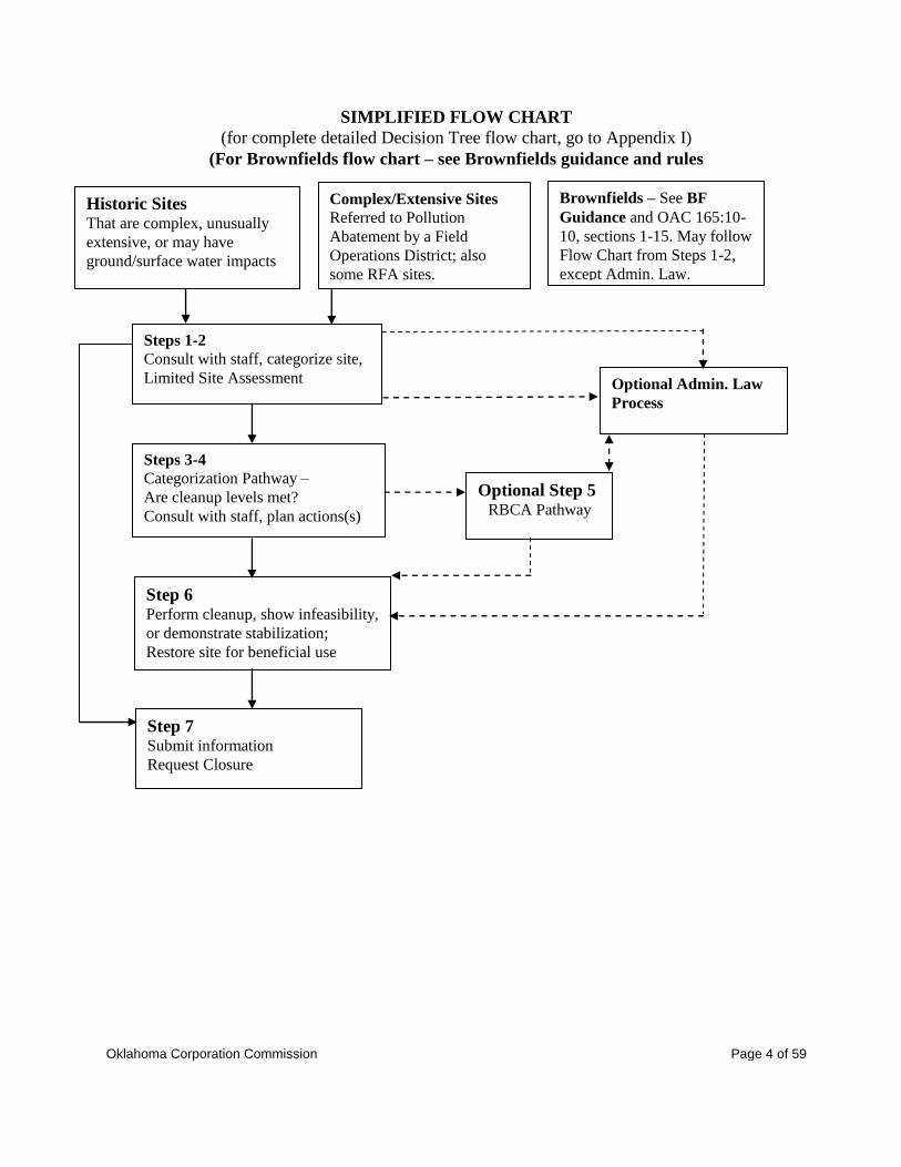
SIMPLIFIED FLOW CHART
(for complete detailed Decision Tree flow chart, go to Appendix I)
(For Brownfields flow chart – see Brownfields guidance and rules
Complex/Extensive Sites
Referred to Pollution
Abatement by a Field
Operations District; also
some RFA sites.
Steps 1-2
Consult with staff, categorize site,
Limited Site Assessment
Steps 3-4
Categorization Pathway –
Are cleanup levels met?
Consult with staff, plan actions(s)
Step 6 Perform cleanup, show infeasibility,
or demonstrate stabilization;
Restore site for beneficial use
Step 7 Submit information
Request Closure
Optional Step 5 RBCA Pathway
Optional Admin. Law
Process
Brownfields – See BF
Guidance and OAC 165:10-
10, sections 1-15. May follow
Flow Chart from Steps 1-2,
except Admin. Law.
Historic Sites That are complex, unusually
extensive, or may have
ground/surface water impacts
Oklahoma Corporation Commission Page 5 of 59
STANDARD CATEGORIZATION AND CLEANUP PATHWAY
This guidance is intended to cover sites that are overseen by the Oklahoma Corporation Commission
Oil and Gas Conservation Division’s Pollution Abatement (PA) Department. The two main types of
sites/cases overseen by PA include:
Complex And/Or Unusually Extensive Sites
Recent spill sites where the assessment and/or remediation are likely to be complex and/or unusually
extensive, and sites that have known or likely impacts to ground water or surface water, are often
assigned (referred) by a Field Operations District Office to the (PA) Department. In addition, some
complex request-for-assistance (RFA) sites (which are those sites that are handled by a Field Inspector
with the requested assistance of a PA Hydrologist) may also be subject to all or part of this guidance as
appropriate.
Historically Impacted Sites
A historically impacted site is not the result of a recent spill. It can be 1) an old spill site that was not
adequately cleaned up, or 2) one that has site impacts resulting from practices that once were legal but
which have resulted in a pollution problem(s), or 3) one that has pollution from an unknown source.
Although not subject to the 24-hour spill/release reporting rule, these sites still should be reported
when found, and must be cleaned up and/or restored to beneficial use. Sites that have only soil
impacts are reported to the District Office, which will assign an incident number. Complex and/or
unusually extensive sites/cases, and those likely to have impacts to ground water or surface water, may
be reported directly to the PA Department (see Appendix III), which will assign the incident number.
PA staff prefers a voluntary, consultative process to formal hearings, and will provide guidance. There
may be regulatory or other requirements to be met before a site/case is finished (see closure, in
glossary). However, if there is disagreement over what should be done at a site, an Administrative Law
Hearing may be requested by Pollution Abatement or an operator or a complainant (OAC 165:10-7-
4(e)). In addition, the RBCA pathway may be chosen anytime from Step 1 onward.
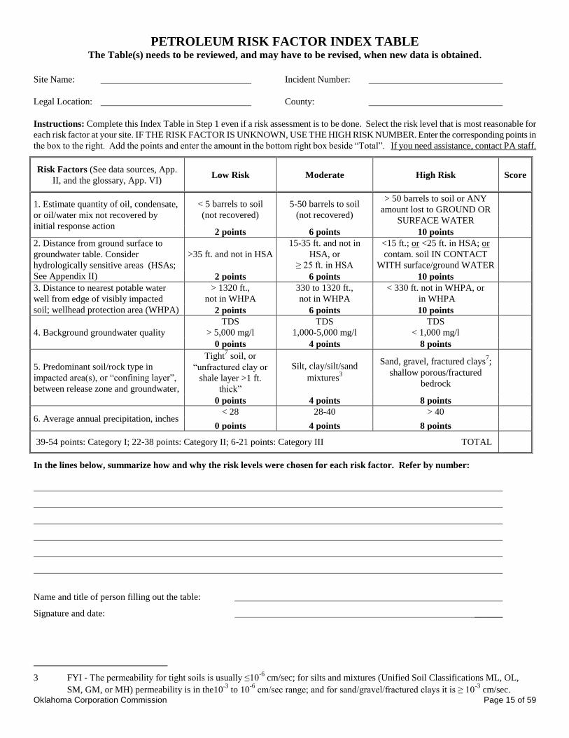
STEP 1 – Consult with PA Staff about the Site, and
Complete the Initial Site Categorization using the Petroleum Risk Factor Index Table
in Appendix I:
Complete, sign, and submit the Index Table in Appendix I to PA with a brief explanation of how the
risk factors (e.g. volume lost, distance to water well, etc.) were determined. Operators may wish to
consult with PA staff prior to completing the table(s), especially if there is more than one (different
type of) impacted area at a site necessitating the submission of more than one Table. The table(s)
should be reviewed and, if necessary, revised and resubmitted whenever new site information is
obtained. Basic site and release/impacted area information may also be requested in this step by PA
staff for sites lacking full documentation by the Field Inspector (Form 1085, usually). See the optional
Initial Site Evaluation Report, Appendix VI, for the types of information that may be requested.
Choose either the PA category cleanup/stabilization or the RBCA pathway (see flow chart).
Oklahoma Corporation Commission Page 6 of 59
STEP 2 – Limited Site Assessment to Collect Needed Site Data:
The purpose of a limited site assessment is to document whether or not there is impact at/from the site
that could cause a significant risk to human health or the environment requiring a cleanup. For
guidance on what information (maps, reports, sampling data, etc) needs to be submitted, refer to the
submittal checklist for Step 7 in Appendix I. The optional forms in Appendix VI may be used instead
of the submittal checklist. See Appendix II for Site Assessment Guidance.
A list of environmental consultants and laboratories is provided in the Environmental Directory under
oil and gas information – Pollution Abatement on our website, occeweb.com.
If there could be additional site impacts in the release area from other sources (e.g. heavy metals from
tank bottoms and sludges, old refining activities, former gas plants, mud pits; excess soil or water
salinity from brine spills or old brine pits; glycol from a natural gas dehydrator), operators can refer to
Appendices VII and VIII, consult with PA staff, request one of the Commission’s other guidance
documents, and/or look up one of the many guidance documents available from the American
Petroleum Institute
(API; http://www.api.org/ehs)
See Brownfields guidance and rules for Brownfields-specific assessment requirements such as EPA’s
All-Appropriate Inquiry (AAI) rules (40 CFR Part 312, Nov. 1, 2005).
STEP 3 – Have the Appropriate Category Levels Been Met? See the Category Cleanup Table in
Appendix I and, if the impacted site is in a Sensitive Area, the bulleted guidance below:
Make any necessary revisions to the Index Table score and appropriate Category determination
following the Site Assessment (for example, if impacts exceeding Category I cleanup criteria to
water are found, or if ground water was found at a different depth than predicted, the points
assigned to risk factors #1 and/or #2 may change, changing the Category of the site). Then
compare the sample concentrations from the assessment to background and to the appropriate
Category cleanup levels in the Category Cleanup Table (Appendix I), or the Sensitive Area criteria
below.
If cleanup criteria are met, confirm with PA, then go to Step 6. If cleanup criteria are not met, go
to Step 4 or follow the RBCA pathway, Step 5.
“Sensitive Areas” with high soil contact uses (includes residential):
1. Sensitive Areas are the yards and gardens of homes (see glossary, Appendix V,) plus
the grounds of schools, day care centers, sports fields, playgrounds, and similar areas,
if frequently accessed by vulnerable groups with high soil contact uses.
2. Because of the potential for residents and children to have increased exposure levels
via a direct soil contact pathway in these areas, the following soil cleanup criteria
should be applied in or within 330 feet of Sensitive Areas.
Oklahoma Corporation Commission Page 7 of 59
“Sensitive Area” soil cleanup criteria (based on the lowest of the human health risk,
plant tolerance, and/or mobility limit numbers)
1. Benzene – 3 mg/kg in shallow groundwater/Category I areas; 5 mg/kg otherwise.
2. TPH - 3000 mg/kg for condensate; 2600 mg/kg for crude oil.
3. Lower levels may be necessary if these levels create offensive odors or other nuisance
problems.
4. These criteria apply only to the shallow soil(s) that people are likely to touch. For
deeper subsurface soils, see the Category Cleanup Table or perform a RBCA analysis.
STEP 4 - Consult With Pollution Abatement Staff and Decide:
Discuss what additional cleanup and/or restoration work needs to be done. Then:
Plan to clean up to Category levels, or
Demonstrate plume stabilization, with MNA as the “cleanup” option (see glossary, Appendix
V, and Step 6), or
Choose the RBCA pathway (see Step 5).
If all of the work necessary to close a site cannot be done within one year, interim data, reports,
and/or other information (see the submittal checklist, Appendix I) will probably be requested.
When there are groundwater impacts above Category cleanup levels this usually includes
quarterly groundwater monitoring for plume movement and concentration changes.

Oklahoma Corporation Commission Page 8 of 59
OPTIONAL RBCA PATHWAY
STEP 5 - RBCA:
A risk-based corrective action (RBCA) approach is an option for determining cleanup levels at any
time in the Step 1 through Step 4 process for any or all pollutants (state explicitly which, and why). If
the RBCA approach is used, it should follow established methodologies, such as ASTM RBCA
(E1739), which considers a full range of petroleum constituents including both BTEX and TPH as
necessary. The PA Department strongly recommends the use of the American Petroleum Institute’s
RBCA spreadsheet, which has been customized for the risk assessment of crude oil and condensates
(http://www.occeweb.com/Divisions/OG/newweb/tph_ss 6-25.xls) The Petroleum Storage Tank
Division’s ORBCA method, which does not consider impacts from TPH, will no longer be accepted.
In general, the traditional RBCA approach is a tiered method in which the level of effort is tailored to
the needs of a particular site in question. The general process steps outlined below should be followed
when using the traditional RBCA approach. For Sensitive Areas as defined in Step 3, assume a
residential land use for RBCA purposes. Consider:
Chemicals of concern (COCs), especially benzene and TPH (and fractions, as necessary).
Refer to Step 2 for basic site assessment guidelines on identifying COCs for crude oil and
condensate, and Appendix VII for other material(s);
Possible migration pathways to receptors (see Figure 1 page 13 and the glossary, App. VI);
Possible receptor exposure points (see glossary). Include direct contact with soil or water;
surface water or ground water ingestion; and dust/air inhalation in a confined space, as in
buildings and trenches, but not in open air;
State water quality standards, to be met at the receptor exposure point (see the WQSIP);
Site/area conditions including land use, topography, soil (type(s), fraction organic carbon);
Plume stabilization, similar to Step 6, can be considered as part of a RBCA;
Beneficial use(s) of the site (or immediate future use if transferring control of the site); and
Other factors as necessary.
If there is more than one impacted area(s) within a large site, different RBCA evaluations may be
appropriate for each one.
The default tables assume that the plume length will not exceed 300 feet, which is the case for most
groundwater plumes (Characteristics of Dissolved Petroleum Hydrocarbon Plumes, Results From Four
Studies, API Bulletin No. 8, December 1998). However, if the plume exceeds or is likely to exceed
300 feet, other criteria may be applied on a case-by-case basis.
The amount of cleanup and/or monitoring required depends upon the results of the RBCA.
Compare the appropriate RBSL or SSTL levels to site COC levels. Are criteria met?
If additional work is needed to meet the RBCA-calculated RBSLs or SSTLs, submit a plan to
do the cleanup work necessary and go to Step 6.
If the site can be closed without additional work, go to Step 7.

Oklahoma Corporation Commission Page 9 of 59
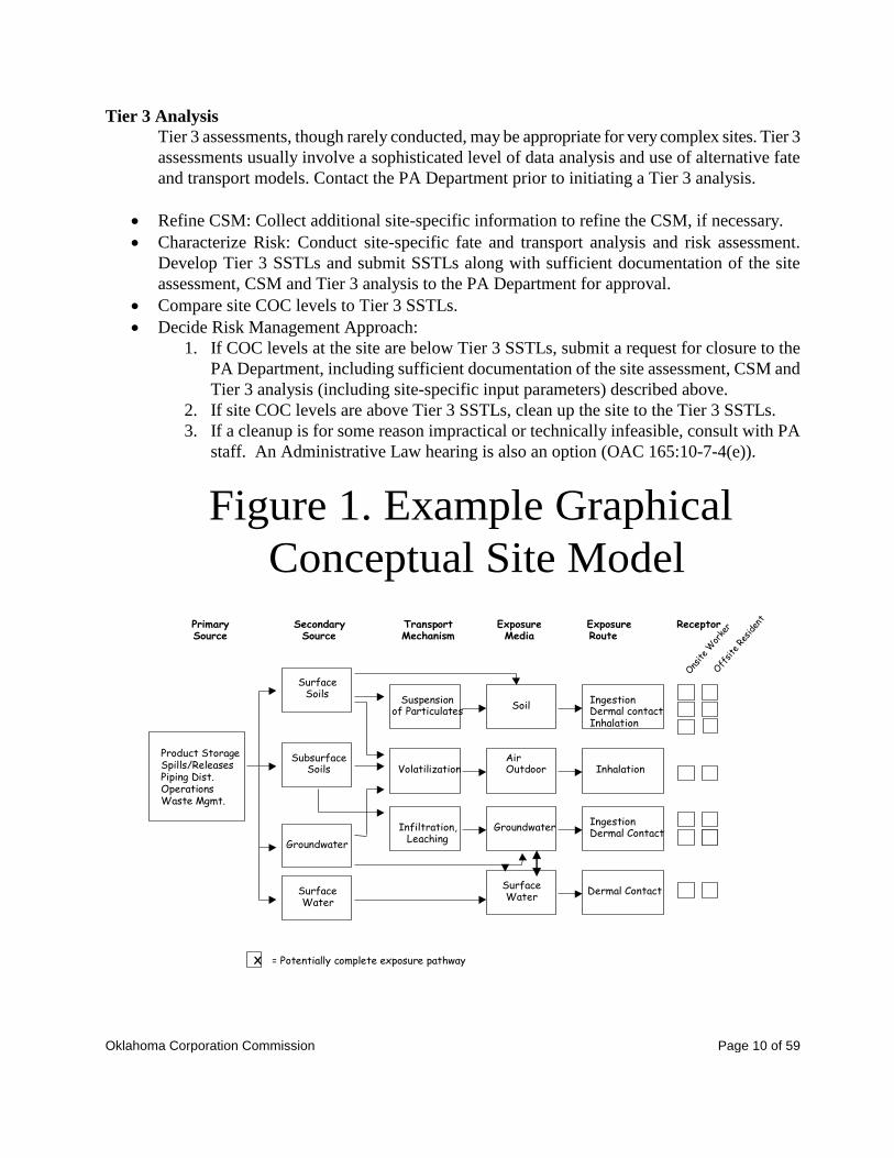
Tier 1 Analysis
Develop the Conceptual Site Model (see Figure 1, and CSM in the glossary, App. V):
1. Conduct a site assessment to gather all necessary information.
2. Prepare a Conceptual Site Model (CSM) to describe the site situation. The CSM may
be graphical and/or narrative. An example of a graphical CSM is shown in Figure 1.
a. The CSM describes all pathways through which receptors might be exposed to
chemicals of concern at the site. Examples of exposure pathways include direct
contact and groundwater ingestion. Other pathways may be relevant, and must
be included if appropriate.
b. Use realistic land uses (e.g., commercial, industrial, residential, agricultural).
c. Evaluate transport mechanisms. If necessary, collect information to verify
NAPL (see glossary, App. V) immobility, dissolved plume stability and/or the
presence or absence of preferential flow pathways (e.g., utility conduits,
abandoned well bores, fractured clay, etc.).
Characterize Risk:
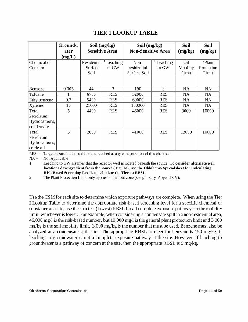
1. Compare site COC levels to risk-based screening levels (RBSLs) in the Tier 1 Lookup
Table. If the CSM includes any exposure pathways or receptors not included in the
Table, propose and provide justification for additional RBSLs.
2. For the soil leaching to groundwater pathway, the default Tier 1 Lookup Table
assumes that the nearest water well is in the impacted area. The OK RBCA
Spreadsheet may be used for calculating an alternative Tier 1 RBSL for this pathway,
by setting an alternative distance to a downgradient receptor well. This would be a
Modified Tier 1. No other parameters may be changed in Tier 1.
Decide Risk Management Approach:
1. If levels of COCs at the site are below Tier 1 RBSLs, submit a request for closure to
the PA Department, including sufficient documentation of the site assessment, CSM
and Tier 1 analysis described above.
2. If levels of COCs are above Tier 1 RBSLs, either clean up the site to Tier 1 levels, or
do a Tier 2 analysis.
Tier 2 Analysis
Refine CSM: Collect additional site-specific information, if necessary, to refine the CSM
developed in Tier 1 analysis.
Characterize Risk: Calculate Tier II Site-Specific Target Levels (SSTLs). The OK RBCA
Spreadsheet may be used to calculate TPH, benzene, and BTEX Tier 2 SSTLs.
Compare site COC levels to Tier 2 SSTLs.
Decide Risk Management Approach:
1. If COC levels at the site are below Tier 2 SSTLs, submit a request for closure to the
PA Department, including sufficient documentation of the site assessment, CSM and
Tier 2 analysis (including site-specific input parameters) described above.
2. If levels of COCs are above Tier 2 SSTLs, either clean up site to Tier 2 levels, or do a
Tier 3 analysis.
Oklahoma Corporation Commission Page 10 of 59
Tier 3 Analysis
Tier 3 assessments, though rarely conducted, may be appropriate for very complex sites. Tier 3
assessments usually involve a sophisticated level of data analysis and use of alternative fate
and transport models. Contact the PA Department prior to initiating a Tier 3 analysis.
Refine CSM: Collect additional site-specific information to refine the CSM, if necessary.
Characterize Risk: Conduct site-specific fate and transport analysis and risk assessment.
Develop Tier 3 SSTLs and submit SSTLs along with sufficient documentation of the site
assessment, CSM and Tier 3 analysis to the PA Department for approval.
Compare site COC levels to Tier 3 SSTLs.
Decide Risk Management Approach:
1. If COC levels at the site are below Tier 3 SSTLs, submit a request for closure to the
PA Department, including sufficient documentation of the site assessment, CSM and
Tier 3 analysis (including site-specific input parameters) described above.
2. If site COC levels are above Tier 3 SSTLs, clean up the site to the Tier 3 SSTLs.
3. If a cleanup is for some reason impractical or technically infeasible, consult with PA
staff. An Administrative Law hearing is also an option (OAC 165:10-7-4(e)).
Figure 1. Example Graphical
Conceptual Site Model
PrimarySource
SecondarySource
TransportMechanism
ExposureMedia
ExposureRoute
Receptor
Product StorageSpills/ReleasesPiping Dist.OperationsWaste Mgmt.
SurfaceSoils
SubsurfaceSoils
Groundwater
Suspensionof Particulates
Volatilization
Infiltration,Leaching
Soil
AirOutdoor
Groundwater
IngestionDermal contactInhalation
Inhalation
IngestionDermal Contact
Ons
ite
Wor
ker
SurfaceWater
Dermal ContactSurfaceWater
X = Potentially complete exposure pathway
Off
site
Res
iden
t
Oklahoma Corporation Commission Page 11 of 59
TIER 1 LOOKUP TABLE
Groundw
ater
(mg/L)
Soil (mg/kg)
Sensitive Area
Soil (mg/kg)
Non-Sensitive Area
Soil
(mg/kg)
Soil
(mg/kg)
Chemical of
Concern
Residentia
l Surface
Soil
1 Leaching
to GW
Non-
residential
Surface Soil
1 Leaching
to GW
Oil
Mobility
Limit
2Plant
Protection
Limit
Benzene 0.005 44 3 190 3 NA NA
Toluene 1 6700 RES 52000 RES NA NA
Ethylbenzene 0.7 5400 RES 60000 RES NA NA
Xylenes 10 21000 RES 100000 RES NA NA
Total
Petroleum
Hydrocarbons,
condensate
5 4400 RES 46000 RES 3000 10000
Total
Petroleum
Hydrocarbons,
crude oil
5 2600 RES 41000 RES 13000 10000
RES = Target hazard index could not be reached at any concentration of this chemical.
NA = Not Applicable
1 Leaching to GW assumes that the receptor well is located beneath the source. To consider alternate well
locations downgradient from the source (Tier 1a), use the Oklahoma Spreadsheet for Calculating
Risk Based Screening Levels to calculate the Tier 1a RBSL.
2 The Plant Protection Limit only applies in the root zone (see glossary, Appendix V).
Use the CSM for each site to determine which exposure pathways are complete. When using the Tier
I Lookup Table to determine the appropriate risk-based screening level for a specific chemical or
substance at a site, use the strictest (lowest) RBSL for all complete exposure pathways or the mobility
limit, whichever is lower. For example, when considering a condensate spill in a non-residential area,
46,000 mg/l is the risk-based number, but 10,000 mg/l is the general plant protection limit and 3,000
mg/kg is the soil mobility limit. 3,000 mg/kg is the number that must be used. Benzene must also be
analyzed at a condensate spill site. The appropriate RBSL to meet for benzene is 190 mg/kg, if
leaching to groundwater is not a complete exposure pathway at the site. However, if leaching to
groundwater is a pathway of concern at the site, then the appropriate RBSL is 5 mg/kg.

Oklahoma Corporation Commission Page 12 of 59
STEP 6 - A. Perform a Site Cleanup or Demonstrate Stabilization as Necessary:
B. Restore the site as necessary to ensure that site beneficial uses are met:
A. Clean up – remove or remediate - the soil and/or water until the Category Cleanup Table
levels (see Appendix I), or the calculated RBCA RBSLs/SSTLs, are met, to ensure that
standards are met at the point of compliance (see glossary Appendix V). Additional site
assessment work to document that the requisite cleanup levels have been met may be
necessary. Soil/water disposal may require permits. If there is more than one release or
impacted area(s) within a large site, different levels of cleanup and/or restoration may be
appropriate for each.
Or
If a full cleanup is impractical/technically infeasible2, consult PA staff or request an
Administrative Law hearing.
Or
Demonstrate stabilization (see glossary), with further remediation by natural attenuation.
1. Fully document the extent of the impacted area(s), as in Step 2.
2. Long term monitoring can show that a groundwater plume is stable, or shrinking with
natural attenuation. See EPA’s OSWER Directive 9200.4-17P, and the Monitored
Natural Attenuation references in the Data Sources (Appendix III).
3. Stabilization alone is not appropriate if there are pollutant levels that could pose a
health risk, or which prevent beneficial use of the site. To ensure public safety,
stabilization is often combined with site institutional controls, such as a fence or deed
restriction, to help prevent access to, and thus contact with, impacted soil or water.
4. The Commission is more likely to accept the “demonstrate stabilization” option if one
or more of the following is documented:
a. Natural microbial activity and biodegradation can:
i. sometimes be shown to be occurring at a site by sampling and analyzing for
changes in water chemistry that are consistent with biodegradation as
described in the Natural Attenuation references (Appendix III), or
ii be more definitively demonstrated through the use of Bio sampling (see
glossary) or other biologic testing.
b. A lack of migration pathways (see definition and examples in the glossary,
Appendix V), making movement toward possible receptors very unlikely.
c. The absence of human or other receptors in the area, based on a receptor study,
as well as no likely land/crop damage.
B. Once approved site cleanup and/or stabilization efforts have been completed, the site must be
restored to beneficial use(s). To get plants to grow, this may include reducing/removing toxic
materials and/or making nutrients available (e.g. by applying fertilizer).
An operator may then request that a No Further remedial Action (NFA) letter be issued.
However, final site closure is dependent upon completing all regulatory (e.g. monitoring) or
2 Example - if an aquifer is impacted near a well and cannot feasibly be cleaned up to drinking water standards
before the well is likely affected, providing a new water supply may be the best short-term solution.

Oklahoma Corporation Commission Page 13 of 59
consent order (following a hearing) requirements, or other agreed upon actions (see closure,
hearing, and monitoring in the glossary, App. VI). Interim reports and/or photographs may be
requested.
When the site is ready for closure, go to Step 7.
DATA SUBMISSION AND CLOSURE REQUEST
STEP 7 – Submit Information, Request Closure. Submit necessary maps and information to the PA
Department (the optional forms in Appendix VI may be used):
A copy of the completed/revised Index Table.
A copy of the basic site and assessment information (see checklist Appendix I).
Monitoring information, if any
The data supporting closure due to:
1. meeting category cleanup levels, or
2. meeting the stabilization option, or
3. meeting RBCA guidelines, without or following a cleanup.
A request for closure stating why no further remedial action is needed at the site.
Documentation that the site has been restored to applicable beneficial use(s).
Documentation that all regulatory (e.g. monitoring, proper abandonment of borings and
monitoring wells), consent order, and/or other agreed upon requirements are met.
Any other necessary information.
Oklahoma Corporation Commission Page 14 of 59
APPENDIX I
PA’s PETROLEUM RISK FACTOR INDEX TABLE (STEP 1)
CATEGORY CLEANUP TABLE (STEP 3)
SUBMITTAL CHECKLISTS (STEPS 1 AND 7)
DECISION TREE (Complete Flow Chart)
Oklahoma Corporation Commission Page 15 of 59
PETROLEUM RISK FACTOR INDEX TABLE The Table(s) needs to be reviewed, and may have to be revised, when new data is obtained.
Site Name: Incident Number:
Legal Location: County:
Instructions: Complete this Index Table in Step 1 even if a risk assessment is to be done. Select the risk level that is most reasonable for
each risk factor at your site. IF THE RISK FACTOR IS UNKNOWN, USE THE HIGH RISK NUMBER. Enter the corresponding points in
the box to the right. Add the points and enter the amount in the bottom right box beside “Total”. If you need assistance, contact PA staff.
Risk Factors (See data sources, App.
II, and the glossary, App. VI) Low Risk Moderate High Risk Score
1. Estimate quantity of oil, condensate,
or oil/water mix not recovered by
initial response action
< 5 barrels to soil
(not recovered)
5-50 barrels to soil
(not recovered)
> 50 barrels to soil or ANY
amount lost to GROUND OR
SURFACE WATER
2 points 6 points 10 points
2. Distance from ground surface to
groundwater table. Consider
hydrologically sensitive areas (HSAs;
See Appendix II)
>35 ft. and not in HSA
15-35 ft. and not in
HSA, or
≥ 25 ft. in HSA
<15 ft.; or <25 ft. in HSA; or
contam. soil IN CONTACT
WITH surface/ground WATER
2 points 6 points 10 points
3. Distance to nearest potable water
well from edge of visibly impacted
soil; wellhead protection area (WHPA)
> 1320 ft.,
not in WHPA
330 to 1320 ft.,
not in WHPA
< 330 ft. not in WHPA, or
in WHPA
2 points 6 points 10 points
4. Background groundwater quality
TDS
> 5,000 mg/l
TDS
1,000-5,000 mg/l
TDS
< 1,000 mg/l
0 points 4 points 8 points
5. Predominant soil/rock type in
impacted area(s), or “confining layer”,
between release zone and groundwater,
Tight7 soil, or
“unfractured clay or
shale layer >1 ft.
thick”
Silt, clay/silt/sand
mixtures3
Sand, gravel, fractured clays7;
shallow porous/fractured
bedrock
0 points 4 points 8 points
6. Average annual precipitation, inches < 28 28-40 > 40
0 points 4 points 8 points
39-54 points: Category I; 22-38 points: Category II; 6-21 points: Category III TOTAL
In the lines below, summarize how and why the risk levels were chosen for each risk factor. Refer by number:
Name and title of person filling out the table:
Signature and date: ______
3 FYI - The permeability for tight soils is usually ≤10
-6 cm/sec; for silts and mixtures (Unified Soil Classifications ML, OL,
SM, GM, or MH) permeability is in the10-3
to 10-6
cm/sec range; and for sand/gravel/fractured clays it is ≥ 10-3
cm/sec.

Oklahoma Corporation Commission Page 16 of 59
CATEGORY CLEANUP TABLE1
Category III
Category II
Category I
Index Table Score 6-21 points 22-38 points 39-54 points
Chemical of
Concern
Maximum levels for NonSensitive Area/NonResidential Soils236
Benzene4
31 mg/kg if ≤ 330 ft. to
drinking water (DW) supply
310 mg/kg if > 330 ft. to DW
supply
23 mg/kg if ≤ 330 ft. to DW
supply
230 mg/kg if > 330 ft. to DW
supply
3 mg/kg
TPH from
Condensate
10,000 mg/kg ≤ 2 ft. deep,
20,000 mg/kg > 2 ft. deep
(Total TPH)
5,000 mg/kg ≤ 3 ft. deep,
10,000 mg/kg > 3 ft. deep
3,000 mg/kg
TPH from crude oil 10,000 mg/kg 5,000 mg/kg
Chemical of
Concern Maximum levels, for Groundwater5
The Category I criteria for water apply to all Categories when in an aquifer within 330 ft.
of a drinking water well.
Benzene or BTEX 0.5 mg/l benzene
0.05 mg/l benzene
MCLs B/T/E/X mg/l
0.005/1/0.7/10
Maximum TPH
De minimis measurable free
product
25 mg/l
5 mg/l7
1. Alternate levels are acceptable under special circumstances, with Commission concurrence. For example,
less stringent cleanup limits for soils at historic pollution sites that have stabilized and are naturally
attenuating, if beneficial uses are met. However, more stringent limits may be requested if the defined
category cleanup levels create nuisance or other problems.
2. For Sensitive Areas (homes, schools, etc.) with high soil contact uses, see Step 3 page 10. 3. If impacted soil is in contact with ground water or surface water (excepting unused perched non-aquifer
zones), lower soil concentrations of TPH or benzene are appropriate.
4. No levels are set for toluene, ethylbenzene, or xylenes in soils since risk-based criteria for these compounds
are above what would be present from all oils and condensates analyzed at the benzene and TPH levels
listed.
5. Surface waters must meet OWRB standards. See the Oil & Gas Division’s Water Quality Standards
Implementation Plan (WQSIP) guidance (see glossary Appendix V).
6. 1000 mg/kg TPH is the usual limit for soil to be taken off-site to a landfill or used within the lease for berms
etc.
7. For taste and odor, not health based, reasons, the Commission may request a cleanup down to the EPA’s drinking
water SNARL (see glossary, App. VI) limit of 0.1 mg/l for petroleum/TPH from a fresh source affecting a well
or other DW supply

Oklahoma Corporation Commission Page 17 of 59
GUARDIAN -OPERATOR’S SUBMITTAL CHECKLIST (FOR STEPS 1 AND 74)
Place a check mark beside each item submitted (or completed, even if no written submittal is needed)
Step Submitted/Completed Report
Reference
1 Petroleum Risk Factor Index Table, with explanations and signature.
Notify PA staff as to path chosen (Category, RBCA, Hearing).
7 BASIC SITE AND ASSESSMENT INFORMATION FOR MOST SITES
Index Table, if modified after initial submission or not previously submitted.
Information from initial spill & cleanup (information not already on Field Ops 1085 form).
Site map with facilities, utilities, pipelines, impacted area, etc. shown.
Area maps and photos available – mark the site location on one map that shows section #s.
__ topographic ___ soil ___ hydrogeological ___ wellhead protection area
__ aerial photo ___other:
Written narrative covering site/area activities and observations (description of land use;
wells/surface waters; soils; stains, odors, or other, impacts to soil/water/plants/animals.)
Map showing sampling locations. Include screening information, observations, rationale.
Table (preferred) or listing of soil and water analytical results, and copies of lab analyses.
Boring/excavation logs. Cross-sections if made.
Other relevant information.
IF SALINE WATER IS/WAS PRODUCED/HANDLED AT THE SITE AND IMPACTS ARE APPARENT
Have likely produced water/brine impacts been evaluated? See Appendix VIII
IF MONITORING WELLS ARE INSTALLED
Well installation information.
Table (preferred) or listing of water sample analytical results, and copies of lab analyses.
Groundwater elevation measurements, and a map showing flow direction(s).
Free product information and measurements, and a plan to deal with it.
TDS or TSS for waters sampled.
Contoured groundwater plume map(s); depth/time/concentration graphs as necessary.
FOR CATEGORY PATHWAY SITES
Compare Category cleanup levels to site impact levels. Are numerical criteria met? or
Data to show plume is stable (sample all around to background/Category level). Options:
Bioenhancement activities or evidence of remediating bacteria/byproducts
Institutional controls, if any Absence of receptors or pathways.
FOR RBCA PATHWAY SITES
Data documenting the RBCA processes, how RBSLs or SSTLs were calculated.
RBSLs and/or SSTLs comparison to site COC levels.
IF A CLEANUP AND/OR RESTORATION FOR BENEFICIAL USE WAS DONE
Cleanup information, if any, with post-completion sampling results to show the site now
meets appropriate Category or RBCA calculated levels.
Post-action monitoring, if needed to document cleanup conditions and/or restoration.
INFORMATION AND DOCUMENTATION NEEDED TO ACHIEVE CLOSURE
A request for closure stating why no further action is needed at the site.
Documentation that the site has been restored to beneficial use(s).
Documentation that all regulatory (e.g. monitoring, proper abandonment of borings and
monitoring wells), consent order, and/or other agreed upon requirements are met.
4 Data and reports will be requested prior to Step 7 if all of the work required to close a site cannot be done within one year.
Oklahoma Corporation Commission Page 18 of 59
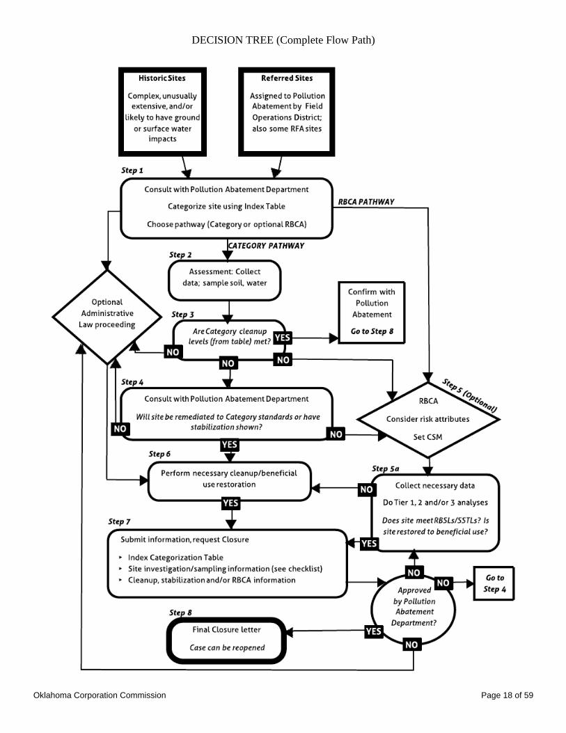
DECISION TREE (Complete Flow Path)
Oklahoma Corporation Commission Page 19 of 59
APPENDIX II
SITE ASSESSMENT GUIDANCE
Oklahoma Corporation Commission Page 20 of 59
Typically, the following basic site and assessment information is necessary:
Requested background data and maps (contact PA staff for assistance, guidance).
1. Specify the site legal location (qtr-qtr-qtr, Sec-Twp-Rng), and street address (if any).
2. Show the location on an aerial photo or a topographic, county road, or other
appropriate map that is labeled with the site’s section, township, and range.
3. Include the Latitude/Longitude from GPS readings or other sources when available.
4. Include a Topographic map, and area geological and hydrological data (including
water table depth and water quality) if available, to help in determining possible
migration pathways (see glossary Appendix V). Soils information can be obtained
from the USDA-NRCS soil survey maps and descriptions.
5. Provide site historical data relevant to the pollutants found onsite, including materials
used, transported, and/or produced in specific locations onsite (insofar as it is known)
and analytical records on materials released, if available.
Site information - Provide a short, written narrative and a site map for the following:
1. A visual site inspection at and near the spill/impacted area (e.g. impairments seen,
including damage to crops or pasture; surface soil type; hydrocarbon stains, odors,
and seeps; buildings, equipment, and power lines; evidence of underground utilities
or pipelines). Draw structure and observation locations on a site map.
2. Include any relevant information from the initial spill cleanup, and/or other pertinent
information, that is not included on a Field Inspector’s 1085 form (PA will have a
copy of the 1085 if the case originated as a new release/spill).
3. Observable area information (e.g. agricultural or other land use; all wells and water
bodies within 1320 feet; known and flagged oil and gas lines).
4. Obtainable records, such as data on rural water lines, Oklahoma Water Resources
Board (OWRB) water well records, and wellhead protection area (WHPA) maps.
Sampling data - delineate the horizontal and vertical extent and concentration(s) of pollutants
in the impacted area(s) by taking samples in, around, and under the affected soil and/or
groundwater plume(s). Compare the pollutant concentrations to background or the
appropriate Category level, whichever is higher.
1. All sampling shall be:
a. Performed or witnessed by Commission personnel (prior notification to the
Commission of sampling events is strongly encouraged), or
b. Performed by or under the oversight of a qualified geoscientist (see glossary), or
c. Performed by other qualified person(s) with appropriate and documented soil
and/or water sampling training and/or experience; attach a statement on their
training/experience to reports submitted.
2. The Commission may request a copy of acceptable sampling procedures followed or
to be followed during the sampling event.
3. A field kit, field GC, soil gas analyses, or other on-site testing/screening methodology
may be used to identify the impacted versus unimpacted areas, and to pinpoint the
areas with the highest concentrations. However, field analysis alone is not sufficient
to demonstrate whether or not Category or RBSL (risk based screening levels) or
Oklahoma Corporation Commission Page 21 of 59
SSTL (site specific target levels – see glossary Appendix V) cleanup levels are met;
confirming laboratory analytical samples are necessary (see 5a).
4. The Commission recommends that one or more soil and water background sample(s)
(unimpacted by the release – upgradient for water samples) be taken. The
Commission does not require a cleanup more stringent than background levels.
5. Sampling includes borings (or other excavations) in the site area(s) most likely to be
impacted based on site screening data, visual and olfactory criteria, normal
movement of liquid contaminants downhill/downgradient, and/or other information.
There may be more than one release and/or impacted area per site. Sample in,
around, and beneath any obvious surface contamination or pipeline break down into
material that has insignificant contamination levels (background or to below the
appropriate site category standard, whichever is higher), or to groundwater.
a. The soil or bedrock sample in each boring or grab sampling area which seems
the most contaminated, based on PID/FID data, staining, and/or other
information, should be analyzed at a laboratory for:
Benzene (DEQ’s GRO method or other approved EPA method);
TPH as per Texas method 1005 extended to C35 for most crudes, and
condensates; and
Other appropriate constituents5 (for example, analyze for glycol if there are
indications of a spill near a glycol dehydrator unit).
b. If an excavation below 3 feet is necessary to remove pollutants in the soil,
samples from the sides and floor of an excavation, after impacted soil is removed,
are necessary to determine concentrations in affected soil remaining on site.
Take one sample on each side and from the floor in small (less than 10’X10’X6’
deep) excavations. For much larger and/or deeper excavations:
Take multiple samples from each of the sides and from the base, 1 in each
distinct area when there are clear lithologic or staining/odor/PID/FID changes
within/across the excavation and, if field screening is utilized, analyze the
sample(s) from each side and floor that appear to be the most contaminated as
in 5a, or
When there are no clear lithologic or staining/odor/PID/FID changes
within/across the excavation, take and analyze composited samples from each
side and the bottom, being depth zone consistent.
For disposal or treatment of large volumes of excavated soil, analyze at least
one composite sample per 50 – 100 cubic yards.6
5 TPH method 1005 is normally sufficient for fresh crude and condensate. However, an analysis for PAHs and other
chemicals may be needed for heavy and/or old crude oil spills when the 1005 test shows C28+ to be proportionately high.
You can use either EPA method 8260 or 8270.
6 Note – many rural landfills can only take soils up to 1000 mg/kg TPH.
Oklahoma Corporation Commission Page 22 of 59
c. A detailed descriptive log for each boring or excavation from the surface to total
depth (TD), including changes in soil (using sand-silt-clay percentages) and/or
rock types and apparent degree of contamination. We recommend the use of a
standard classification system such as the Unified Soil Classification System or
Wentworth, and the Munsel color charts.
d. Cross-sections made from these logs showing changes across the site in soil/rock
type, and contamination with depth and relative to the water table, will make the
site evaluation easier.
e. Sampling for geotechnical parameters, for data needed for RBCA or remediation
(e.g. fraction organic carbon (foc), permeability), can be collected now or in
Steps 5 and 6.
f. Submit a table of sampling data with a map showing sampling locations.
g. Borings not converted to monitoring wells must be properly plugged back to
surface using cement, bentonite, or other means as required by the OWRB.
6. Groundwater sampling (by qualified personnel):
a. Unless c.i., c.ii., c.iii., or c.iv. below apply, install and sample at least three
properly constructed monitoring wells7,8
in a triangular pattern to determine both
the groundwater flow direction and the extent of the plume. Sample in, around,
and downgradient to any groundwater plume found down to background level, or
to below the appropriate site category standard.
b. Because there could be more than one release/impacted area per site, additional
wells must be installed where needed to insure that there are at least two wells for
each separate area within a site likely to be contaminated (one in/adjacent, one
downgradient).
c. Wells do not have to be installed if:
i. The groundwater table is not reached during boring/excavation, and there is
at least five feet of tight clay or shale beneath the soil contamination
(document the lithology and lack of permeability), or
ii. The groundwater table is not reached during boring/excavation, and PID/FID
or analytical data for hydrocarbons (PHCs) from at least two soil/rock
samples taken at least five feet (vertically) apart beneath the contamination
zone show unimpacted materials, or
iii. The groundwater table is reached, the site is classified as a Category II or III
site, pollutants have not impacted an aquifer or hydrologically sensitive area
(HSA), and no contamination above (the higher of) natural background or the
appropriate Category II or III levels is found in groundwater grab samples
(see 6. d., below) in any of the borings, or
iv. The groundwater table is reached and the site is Category I or has impacted
an aquifer zone or other HSA; however, no contamination above (the higher
of) natural background or Category I levels is found in groundwater grab
7 All wells must be installed according to OWRB's rules by a driller holding a current OWRB Drilling/Pump
Contractor's License to drill and complete geotechnical borings and monitoring wells.
8 Monitoring wells can be completed in geoprobe holes if they are properly cased, screened, sand packed as
necessary, sealed, and developed.
Oklahoma Corporation Commission Page 23 of 59
samples in any of the borings.
d. Grab water samples may be taken for screening purposes from borings,
geoprobe holes, and other probes or excavations if groundwater is reached,
but be aware that contaminated soil may slough into uncased holes to cause
cross-contamination.
e. Water samples should be analyzed for Benzene or BTEX9 (using DEQ’s
GRO method or other approved EPA method), TPH (see 5a), and other
appropriate constituents.
f. A background TDS (total dissolved solids) or TSS (total soluble salts)
measurement, to determine the likely assigned or default groundwater
beneficial use (OAC 785:45-7-3), is necessary.
g. If free product has been discovered, it must be considered in any cleanup or
closure proposal. An operator may choose to remove free product
immediately without waiting for concurrence with a remediation proposal.
h. If groundwater monitoring is done, reports submitted need to include:
i. a comparison of the depth to groundwater/NAPL with the screened
interval, to ensure that the most likely impacted zone is sampled;
ii. contoured plume pollutant concentration map(s);
iii. a groundwater flow direction map based on measured groundwater
elevations in at least three wells which form a triangle; and
iv. if monitoring will likely exceed 1 year, submit graph(s) of
groundwater elevation vs. contaminant concentrations in monitoring
wells over time, annually or at requested intervals.
i. Before a site can be finally closed, all monitoring wells will have to be
plugged and abandoned according to OWRB rules.
7. As per OWRB rules and the WQSIP (see glossary, Appendix V):
a. If a surface water body (see Waters of the State/Waters of the US in the
glossary) is potentially impacted, water and sediment samples, as necessary,
should be taken and analyzed for BTEX (using DEQ’s GRO method or other
approved EPA method), TPH (see 5a) and/or other appropriate constituents.
Visual inspection (for oil sheen or rainbow) is also necessary.
b. The TDS or TSS should also be measured, and compared to OWRB surface
water quality standards (OAC 785:45-5). Agricultural uses have numerical
salinity standards (OWRB rules Appendix F); there is also the OWRB’s
narrative standard “Increased mineralization from other elements such as
calcium, magnesium, sodium, and their associated anions shall be maintained
at or below a level that will not restrict any beneficial use” (including fish and
wildlife).
9 BTEX if in an aquifer within 330 feet of a well, or otherwise potentially endangering a water supply source.

Oklahoma Corporation Commission Page 24 of 59
APPENDIX III
DATA SOURCES AND RELATED ENVIRONMENTAL RESOURCES
Oklahoma Corporation Commission Page 25 of 59
DATA SOURCES AND RELATED ENVIRONMENTAL RESOURCES
District Information and Reporting Spills:
Spill reporting and immediate cleanup guidance is covered in the “Guidelines for Responding
to and Remediating New or Historic Brine Spills” packet, available here:
http://www.occeweb.com/og/abatement.html “Guidelines for Responding
and Remediating New or Historic Brine Spills”
To determine the appropriate district for reporting a spill or soil-only historically impacted site:
Go to ftp://204.87.70.98/OCCFILES/Responseteam/spill(c).html
To obtain field inspector areas and pager numbers for reporting:
Go to http://www.occeweb.com/og/ogdistricts.htm
Scroll down to the map, and then click on the appropriate District.
To report historically impacted sites that are complex and/or unusually extensive, or that involve
possible surface water or ground water impacts:
Pollution Abatement Department, OCC, Oklahoma City office: 405-521-4172
For spills to navigable Waters of the US:
U.S. Coast Guard National Response Center (24 hour):
800-424-8802
For spills that affect surface water in the watershed of a water supply lake:
OK Department of Environmental Quality (24 hour):
800-522-0206
For spills affecting fish or wildlife:
OK Department of Wildlife Conservation:
405-521-4616 (8:00 AM - 4:30 PM)
405-990-5048 (after hours)
Aerial Photographs:
The Oklahoma Corporation Commission now has an extensive collection of scanned
aerial photographs gathered from various sources across the state, including everything
from the Oklahoma Department of Librariers, Oklahoma Geological Survey, and
Department of Environmental Quality.
Contact: Madeline Dillner, (405) 522-2750, [email protected]
Photocopies can be obtained from the local USDA-Farm Service Agency at a cost of
$1.00 each. Local offices can be found at:
http://www.fsa.usda.gov/FSA/apfoapp?area=apfohome&subject=landing&topic=landing
Oklahoma Corporation Commission Page 26 of 59
Print them from the Terraserver website:
http://www.terraserver.com/
Download them from Geo Information Systems website (.bil or .sid files; need software
such as ArcView or Mr. Sid Geoviewer or the USGS dlgv32 to view):
http://geo.ou.edu/cgi-bin/redesign.cgi?ft=db&template=DataImageName.htm
Ace Aerial Photography
132 N.W. 67th
St.
Oklahoma City, OK 73116
(405) 842-3456
USGS - order online at:
http://www.usgs.gov/pubprod/aerial.html#aerial
National Archives and Records Administration, Cartographic and Architectural Branch.
http://www.archives.gov/research/order/maps.html#arc
E-mail Address: [email protected]
Phone: (301) 837-3200
Fax: (301) 837-3622
Note: when submitting a request via e-mail, please include a regular mail address.
Cartographic and Architectural Reference Staff often have to send researchers hardcopy
finding aids or reproduction ordering information.
Hard copies are available at the Oklahoma Department of Libraries
200 NE 18th St
Oklahoma City, Oklahoma 73105
State Archives: (405) 522-3579
http://www.odl.state.ok.us/oar/resources/aerial.htm
Hard copies are available at the Oklahoma Geological Survey
http://www.ogs.ou.edu/contact.php
Hard copies are available at the Oklahoma Department of Environmental Quality
http://www.deq.state.ok.us/

Oklahoma Corporation Commission Page 27 of 59
American Petroleum Institute Environmental Guidance Documents:
http://www.api.org/ehs
Average Annual Precipitation:
See Appendix IV
Bio-Trap, Bio-Sep (included for information only; specific methods are NOT endorsed by the
Commission)
http://www.microbe.com/index.php/Bio-Trap-Samplers/bio-trap-samplers.html
Phone: 865-573-8188
Email: [email protected]
Environmental Consultants and Laboratories:
A list of environmental consultants and laboratories is available at
ftp://204.87.70.98/OCCFILES/Responseteam/Switch(y).html
GIS; viewing maps and other images:
http://www.grime.net lists a wide variety of maps and images available, and tells you what
programs are needed to view each type of map/format.
Hydrologic Atlases (for area groundwater depths and quality, and geologic information):
Download from the Oklahoma Geological Survey website:
http://www.ogs.ou.edu/pubsDLHAs.php
Latitude and Longitude Information:
Make field readings on a GPS unit.
Obtain the lat/long of a wellsite from Geo Information Systems website; you need to
know the name of the well or its legal description (qtr-qtr-qtr, Sec-Twp-Rng format):
http://csa.ou.edu/outreach.php (subscription required)
Lat/long of the center of a section is available by converting from legal description (Sec,
Twp, Rng) on the TRS-data website:
http://www.esg.montana.edu/gl/trs-data.html
Find your location using Bing maps and right click the exact location to get the GPS
coordinates:
http://www.bing.com/maps/
Natural Attenuation References:
Air Force Center for Environmental Excellence. 1998. Technical Protocol For Implementing
Intrinsic Remediation With Long-Term Monitoring For Natural Attenuation Of Fuel
Contamination, Volumes I and II (A324248, A324247a, A324247b): Technology Transfer
Division, San Antonio, Texas. http://www.lm.doe.gov/cercla/documents/rockyflats_docs/sw/sw-
a-005904.pdf

Oklahoma Corporation Commission Page 28 of 59
American Society for Testing and Materials, 1998. Standard Guide for Remediation of Ground
Water by Natural Attenuation at Petroleum Release Sites. ASTM E-1943-98. pp. 875-916.
Buscheck, Timothy E.; O'Reilly, Kirk T.; Nelson, Sheldon N. 1993. Evaluation Of Intrinsic
Bioremediation At Field Sites. Proceedings: Petroleum hydrocarbons and organic chemicals in
ground water; prevention, detection, and restoration. Houston, TX; Nov. 10-12.
Buscheck, Timothy E.; Alcantar, Celia M. 1995. Regression Techniques And Analytical
Solutions To Demonstrate Intrinsic Bioremediation. Bioremediation. 3 Vol. 1. Battelle Press,
Columbus, OH, United States. pp. 109-116.
U. S. Environmental Protection Agency. 1999. Final OSWER Monitored Natural Attenuation
Policy (OSWER Directive 9200.4-17P). United States Environmental Protection Agency, Office
of Solid Waste and Emergency Response.
http://www.epa.gov/swerust1/directiv/d9200417.htm
United States Environmental Protection Agency, Office of Solid Waste and Emergency Response
(US EPA OSWER). April 1999. Use of Monitored Natural Attenuation at Superfund, RCRA
Corrective Action, and Underground Storage Tank Sites. OSWER Directive 9200.4-17P.
http://www.epa.gov/swerust1/directiv/d9200417.htm
OWRB:
Aquifer maps; water quality; boring and monitoring well/driller rules.
Go to your local OWRB office, or
http://www.owrb.ok.gov/
Rainfall Data:
Free data for the general public is at:
http://www.mesonet.org/
Detailed data and maps, and historic data, is by account only. To set up an account, click above
link and then click data tab.
RBCA Spreadsheet:
http://www.occeweb.com/og/abatement.html
Click on “RBCA Tier 1 Spreadsheet (Effective 07-10-2002)” link
Soil Surveys:
Soil surveys are available at the regional offices of the USDA-NRCS (
http://www.nrcs.usda.gov/wps/portal/nrcs/main/soils/survey/office/) or data can be viewed and
downloaded by Area of Interest (AOI) online for free at the NRCS’s data viewer:
http://websoilsurvey.nrcs.usda.gov/app/WebSoilSurvey.aspx

Oklahoma Corporation Commission Page 29 of 59
Topographic Maps:
Purchase from Triangle A&E, 7201 Broadway Extension, Oklahoma City, OK 73116,
(405) 848-4661.
Purchase from USGS on their website:
http://topomaps.usgs.gov/ordering_maps.html
Download from USGS for free:
http://store.usgs.gov/b2c_usgs/b2c/display/(layout=6_1_61_50_2&uiarea=2&ctype=area
Details&carea=0000000015)/.do
Print from the Topozone or Terraserver websites:
www.topozone.com (search by name, decimal degree or degree/min/sec
latitude/longitude, UTM coordinates) or
Download from Geo Information Systems website (.tif files; can be viewed using Word
2000, Paint, PowerPoint, ArcView, or the USGS dlgv32)
Unified Soil Classification System tables:
a) ASTM:
http://itd.idaho.gov/enviro/Stormwater/Design/Unified_Soil_Classification_System.pdf
b) US Army Corps of Engineers:
http://www.publications.usace.army.mil/Portals/76/Publications/EngineerManuals/EM_1110-1-
1804.pdf
WHPAs (Wellhead Protection Areas):
Obtainable from your local water system office or the area DEQ office, and viewable on DEQ’s
Flex data viewer: http://gis.deq.ok.gov/flexviewer/
WQSIP (Water Quality Standards Implementation Plan):
On the Commission’s web site at
http://www.occeweb.com/og/wqsip_05c.htm
Oklahoma Corporation Commission Page 30 of 59
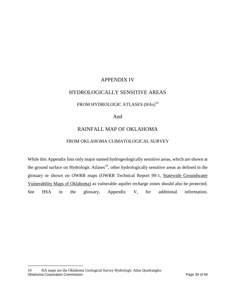
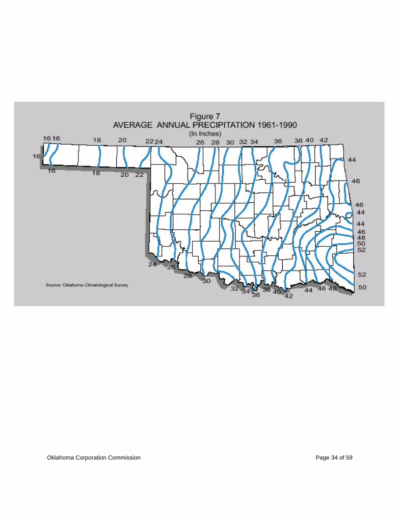
APPENDIX IV
HYDROLOGICALLY SENSITIVE AREAS
FROM HYDROLOGIC ATLASES (HAs)
10
And
RAINFALL MAP OF OKLAHOMA
FROM OKLAHOMA CLIMATOLOGICAL SURVEY
While this Appendix lists only major named hydrogeologically sensitive areas, which are shown at
the ground surface on Hydrologic Atlases10
, other hydrologically sensitive areas as defined in the
glossary or shown on OWRB maps (OWRB Technical Report 99-1, Statewide Groundwater
Vulnerability Maps of Oklahoma) as vulnerable aquifer recharge zones should also be protected.
See HSA in the glossary, Appendix V, for additional information.
10 HA maps are the Oklahoma Geological Survey Hydrologic Atlas Quadrangles
Oklahoma Corporation Commission Page 31 of 59
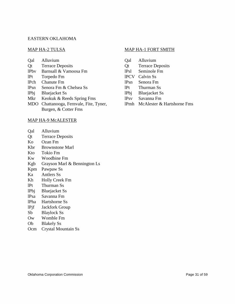
EASTERN OKLAHOMA
MAP HA-2 TULSA
Qal Alluvium
Qt Terrace Deposits
lPbv Barnsall & Vamoosa Fm
lPt Torpedo Fm
lPch Chanute Fm
lPsn Senora Fm & Chelsea Ss
lPbj Bluejacket Ss
Mkr Keokuk & Reeds Spring Fms
MDO Chattanooga, Fernvale, Fite, Tyner,
Burgen, & Cotter Fms
MAP HA-9 McALESTER
Qal Alluvium
Qt Terrace Deposits
Ko Ozan Fm
Kbr Brownstone Marl
Kto Tokio Fm
Kw Woodbine Fm
Kgb Grayson Marl & Bennington Ls
Kpm Pawpaw Ss
Ka Antlers Ss
Kh Holly Creek Fm
lPt Thurman Ss
lPbj Bluejacket Ss
lPsa Savanna Fm
lPha Hartshorne Ss
lPjf Jackfork Group
Sb Blaylock Ss
Ow Womble Fm
Ob Blakely Ss
Ocm Crystal Mountain Ss
MAP HA-1 FORT SMITH
Qal Alluvium
Qt Terrace Deposits
lPsl Seminole Fm
lPCV Calvin Ss
lPsn Senora Fm
lPt Thurman Ss
lPbj Bluejacket Ss
lPsv Savanna Fm
lPmh McAlester & Hartshorne Fms

Oklahoma Corporation Commission Page 32 of 59
CENTRAL OKLAHOMA
MAP HA-4 OKLAHOMA CITY
Qal Alluvium
Qt Terrace Deposits
Pm Marlow Fm
Pd Duncan Ss
Pch Cedar Hills Ss
Pp Purcell Ss
Pk Kingham Slt
Pg Garber Ss
Pw Wellington Fm
lPv Vanoss Group
lPa Ada Group
1Pva Vamoosa Fm
lPta Tallant Fm
lPbd Barnsdall Fm
lPch Chanute Fm
1Ps Seminole Fm
1Pw Wewoka Fm
1Pca Calvin Ss
1Pse Senora Fm
1Pt Thurman Ss
MAP HA-7 ENID
Qal Alluvium
Qt Terrace Deposits
Pch Cedar Hills Ss
Pbi Bison Fm
Psp Salt Plains Fm
Pk Kingman Silt
MAP HA-7 ENID
Pg Garber Ss
Pw Wellington Fm
lPa Ada Group
1Pva Vamoosa Group
lPt Tallant Fm
lPbd Barnsdall Fm
lPch Chanute Fm
MAP HA-3 ARDMORE
Qal Alluvium
Qt Terrace Deposits
Kw Woodbine Fm
(Kwt Templeton)
(Kwr Red Branch)
(Kwd Dexter)
Ka Antlers Sd
Pr Rush Springs Fm
Pm Marlow Fm
Pd Duncan Ss
Pp Purcell Ss
Pg Garber Ss
Pw Wellington Fm
lPa Ada Fm
(Collins Ranch Cgl)
lPva Vamoosa Fm
lPca Calvin Ss
lPse Senora Fm
lPt Thurman Ss
lPbj Bluejacket Ss
lPsa Savanna Fm
lPha Hartshorne Ss
lPjf Jackfork Ss
Oklahoma Corporation Commission Page 33 of 59
WESTERN OKLAHOMA
MAP HA-8 WOODWARD
Qal Alluvium
Qt Terrace Deposits
To Ogallala Fm
Kk&Kd Kiowa Fm and Dakota Group
Pdy Doxey Fm
Pcc Could Chief Fm
Fwh White Horse Group
(Pr Rush Springs Fm)
(Pm Marlow Fm)
Pch Cedar Hills Ss
Pbi Bison Fm
Psp Salt Plains Fm
Pk Kingman Fm
MAP HA-5 CLINTON
Qds Dune Sand
Qal Alluvium
Qt Terrace Deposits
To Ogallala Fm
Kk&Kd Kiowa Fm and Dakota Group
Pec Elk City Ss
Pdy Doxey Fm
Pcc Cloud Chief Fm
Pwh White Horse Group
(Pr Rush Springs Fm)
(Pm Marlow Fm)
Pch Cedar Hills Ss
Pd Duncan Ss
Pbi Bison Fm
MAP HA-6 LAWTON
Qal Alluvium
Qds Dune Sand
Qt Terrace Deposits
Pwh White Horse Group
Psa San Angelo Ss
Ppo Post Oak Cgl
Pg Garber Ss
MAP HA-450 BEAVER CO.
Qd Dune Sand
Qa Alluvium
To Ogallala Fm
MAP HA-373 CIMARRON CO.
Qd Dune Sand
Qa Alluvium
To Ogallala Fm
KC Greenhorn Ls
(Colorado Group)
Kd Dakota Ss
Kp Cheyenne Ss
(Purgatuire Fm)
Jm Morrison Fm
Je Exeter (Entrada) Ss
Td Dockum Group
MAP HA-250 TEXAS CO.
Qd Dune Sand
Qa Alluvium
To Ogallala and Laverne Fms
Oklahoma Corporation Commission Page 34 of 59
Page 34 of 59

Oklahoma Corporation Commission Page 35 of 59
Page 35 of 59
APPENDIX V
GLOSSARY AND ACRONYMS
Oklahoma Corporation Commission Page 36 of 59
Page 36 of 59
GLOSSARY AND ACRONYMS
While most technical terms used by the Commission are defined in the rules (OAC 165: 10-1-2), this
guidance document uses some that are not. A list of these is below.
API American Petroleum Institute.
API Gravity The American Petroleum Institute method for identifying the specific gravity of
crude oil or condensate.
Aquifer A geological formation or part of a formation or sedimentary zone or fracture
system that is capable of yielding a significant amount of water to a well or a spring
(commonly > 1 gallon per minute sustained yield) that is sufficient for year-round
daily domestic use, or for seasonal agricultural use.
Bio Sampling Bio-sampling methods (including trademarked Bio-Trap and Bio-Sep beads11)
capture (usually using a growth medium) the active components of a subsurface
microbial community, which can now be identified by various rapid DNA analyses.
Some methods can also use samplers spiked with small amounts of 13
C enriched
petroleum compounds to demonstrate uptake by active petroleum degraders. By
actually capturing and identifying microbes including known petroleum degraders,
and when possible showing petroleum uptake and/or degradation by microbes,
biologic activity that will attenuate the petroleum pollutants can be demonstrated.
BTEX Benzene, toluene, ethylbenzene, and xylenes, which are often the main chemicals of
concern at petroleum release sites. The EPA sets the maximum contaminant levels
(MCLs) allowed in drinking water for these compounds.
Closure Occurs when all assessment, cleanup, and restoration activities at a site are
complete, with documentation showing that all 1) regulatory requirements (e.g.
monitoring if needed to demonstrate that cleanup or restoration activities have been
effective (OAC 165:10-7-4(d)); the plugging of wells and borings (if any) to
OWRB standards; copies of land application permits or waste disposal run tickets
for soil and/or water removed from the site (OAC 165:10-7-24, 10-7-26, 10-7-27)),
2) hearing consent orders (OAC 165:10-7-4(e)), or 3) other agreed upon actions
have been met/complied with. PA will issue a closure letter upon request when it
concurs.
COC
(Chemical
of Concern)
A chemical that has the potential to negatively impact human health and/or the
environment at a site (a.k.a. pollutant).
11 Names included for information only; specific methods are NOT endorsed by the Commission
Oklahoma Corporation Commission Page 37 of 59
Page 37 of 59
Complex and/or
unusually
extensive
Spills at most sites involve limited petroleum hydrocarbon or brine impacts to
soil near the wellhead, flowlines, or tanks. Complex and/or unusually extensive
sites are those that a) involve several different substances; and/or b) involve
impacts to surface water or ground water or bedrock, not just soil; and/or c) affect
a relatively large area (e.g. from a large volume tank or pipeline break, or the
fluid flowed a long way downhill).
Consent Order See Hearing
CSM Conceptual Site Model. This describes the site in a graphical and/or narrative
fashion, taking into consideration site conditions and the likely fate and transport
of the COCs. A CSM identifies the potential ways that people may be exposed to
COCs.
CWA The federal Clean Water Act and amendments thereto. Section 303(d) requires
states to identify waters of the US that do not and are not expected to meet
applicable water quality standards, and report them to EPA; this is sometimes
referred to as the 303(d) List. States must also establish priority rankings for the
listed waters, taking into account impact severity and designated beneficial uses
of the waters.
DEQ The Oklahoma Department of Environmental Quality
DRO Diesel Range Organics, a measure of the Total Petroleum Hydrocarbons in the
C11-C28 range. DEQ’s extraction procedure is method 8000/8100M; see
http://www.deq.state.ok.us/CSDnew/LabCert/DEQDROv4.1.pdf
DW supply Drinking water supply
EPA The United States Environmental Protection Agency
Exposure
Assessment
A three-step process in which the exposure setting is characterized, complete
exposure pathways are identified, and the magnitude of the potential exposure is
estimated.
Exposure
Pathway
The path via which a person or other receptor may be exposed to a chemical of
concern; see migration pathway. Examples include inhalation of vapors, direct
contact with contaminated soil, and swimming in or drinking polluted water.
Dust/air inhalation is usually considered only in a confined space (building,
trench) where it can concentrate instead of dispersing as it does in open outdoor
air.

Oklahoma Corporation Commission Page 38 of 59
Page 38 of 59
FID Flame Ionization Detector. Gas is drawn into the instrument, which
responds to any molecule with a carbon-hydrogen bond. A flame in the
instrument ionizes the molecules. Negative ions are attracted to a collector
electrode, producing a signal that is read as a concentration level.
foc fraction organic carbon in soil – see organic carbon.
Free product A measurable level of petroleum hydrocarbon on the ground surface or on
surface water, or on ground water.
GC Gas Chromatograph, equipment used for the separation of mixtures of
compounds by partition between a mobile gas phase and a stationary liquid
phase.
Geoscientist A degreed geologist (defined 25 O.S. § 35), soil scientist (meeting OAC
165:10-7-19), or engineer (defined 59 O.S. Sup. 1999 Sections 475.1-
475.22b) with appropriate soil science and/or geology and/or ground water
hydrology education and training, plus appropriate experience, for soil and/or
water sampling.
GRO Gasoline Range Organics, a measure of the TPH in the C6-C11 range,
measured according to EPA method 8015/8020M.
Ground water Water found under the Earth’s surface in soil or rock pores and fractures.
Not all ground water is found in aquifers, and not all ground water receives
the same protection or cleanup efforts.
HA Hydrologic Atlas, a compendium of maps in specific geographic areas that
delineate the groundwater depths, water quality, and geologic information
about the area. Published by the Oklahoma Geological Survey.
Hearing, a.k.a.
Administrative
Law Hearing
A hearing held before a Commission Administrative Law Judge, as called for
in OAC 165:10-7-4(e), when there is disagreement over what should be done
at a site. Pollution Abatement or an operator or a complainant may request a
hearing. This usually results in a consent order delineating the work that
must be done at a site.
Oklahoma Corporation Commission Page 39 of 59
Page 39 of 59
Historically
Impacted Site
A site that is not the result of a recent spill. It can be 1) an old spill site that
was not adequately cleaned up, or 2) one that has site impacts resulting from
practices that once were legal but which have resulted in a pollution
problem(s), or 3) one that has pollution from unknown sources. Although not
subject to the 24-hour spill/release reporting rule, these sites still should be
reported and must be cleaned up and/or restored to beneficial use.
Homes Single and multifamily houses, condominiums, apartments, nursing homes,
manufactured homes, etc. occupied more than 8 hours per day, 300 days per
year, by adults and/or children.
HSA Hydrologically Sensitive Area, a.k.a. Hydrologically Vulnerable Area. An
HSA is an area in which the ground water or surface water could easily be
impacted by a spill. HSAs include 1) a principal bedrock aquifer, the
recharge or potential recharge area of a principal bedrock aquifer, or an
unconsolidated alluvium or terrace deposit, according to the Oklahoma
Geological Survey "Maps Showing Principal Groundwater Resources and
Recharge Areas in Oklahoma"; 2) small undefined or unnamed
sensitive/vulnerable alluvium & terrace deposits near streams (potential
migration pathways to streams); and/or 3) the vulnerable aquifer recharge
zones defined by the OWRB in OWRB Technical Report 99-1, Statewide
Groundwater Vulnerability Maps of Oklahoma.
Liner Compacted soil/clay or an artificial geomembrane thick enough and
impermeable enough that fluids will not likely go through it. Similar to soil
or geomembrane liner for a pit [OAC 165: 10-9-1 (e)(7, 8)].
MCL The Maximum Contaminant Level allowed in drinking water, as defined by
the EPA. http://www.epa.gov/safewater/contaminants/index.html
Migration
Pathway
A route by which substances can move from a source to a receptor. A
pathway can be a) natural, such as movement with groundwater through
interconnected soil or bedrock pores and fracture zones, or b) a man-made
conduit, such as along an underground utility line. Examples of possible
migration pathways include adjacent surface water, groundwater in local
aquifer zones, abandoned well bores, porous soil, or fractured bedrock zones,
shrink/swell clay cracks or fissures, underground utility line/pipeline
underflow, etc.
Oklahoma Corporation Commission Page 40 of 59
Page 40 of 59
Monitoring Collecting evidence, including sampling data and/or photographs as
necessary, for ±1 year (OAC 165:10-7-4(d)), to ensure and document that
cleanup and/or restoration actions taken have been effective and that the site
is ready for closure.
NAPL Nonaqueous phase liquid, a liquid other than water that exists in the
subsurface environment, and does not all dissolve into the water. See free
product.
No further
action (NFA)
Status given to site when all necessary assessment, cleanup, and restoration
actions are complete. PA will issue an NFA letter to an operator upon
request when it concurs. However, final site closure is dependent on meeting
all regulatory, consent order, or other agreed upon requirements (see
Closure).
Oil and Grease An analysis of the amount of relatively nonvolatile hydrocarbons (as well as
vegetable oils, animal fats, waxes, soaps, greases, and related materials) in a
sample. The analysis is performed using a solvent on an aqueous or solid
sample (water or soil sample, usually), extracting a solute, which is then
measured by gravimetric analysis.
Organic Carbon The quantity of organic carbon in a soil sample as measured by wet oxidation
of the sample. Once the total organic carbon is known, the weight percent or
fraction organic carbon (foc) used in RBCA calculations can be determined.
OWRB The Oklahoma Water Resources Board, the state agency that sets the
Oklahoma water quality standards the Commission must enforce. The
OWRB also sets the rules for borings, monitoring and water wells, and
licenses those persons allowed to drill, install, and properly abandon them.
PA The Pollution Abatement Department within the Oil & Gas Conservation
Division.
PID Photo-ionization Detector. Gas is drawn into the instrument, where an
ultraviolet bulb at a specific ev (electro-volt) level excites and ionizes the
atoms of volatile organic compounds. Ions are attracted to a collector
electrode, producing a signal that is read a concentration level.
Plume The pollutant’s impact area. Most commonly applied to the area of an
impacted ground water or surface water body that is generally moving
downstream or downgradient from the source.
Oklahoma Corporation Commission Page 41 of 59
Page 41 of 59
Pollutant Any material or substance that is present in water or soil at levels that may
cause pollution impact(s). COCs (chemicals of concern) are often the
pollutants referred to in a RBCA.
Pollution (From Corp Comm O&G rules) the “contamination of fresh water or soil,
either surface or subsurface, by salt water, mineral brines, waste oil, oil, gas,
and/or other deleterious substances produced from or obtained or used in
connection with the drilling, development, producing, refining, transporting,
or processing of oil or gas within the State of Oklahoma”.
Point of
Compliance
The spill source area for the cleanup standards (Category cleanup levels or
RBCA calculated RBSL/SSTLs); also means the receptor point for the
Commission’s enforcement of the state water quality standards.
Potable water Water from wells or other sources usable for human consumption. By
OWRB rules (OAC 785:45-7-3), PPWS (public and private water supply)
wells includes those from ground water with TDS <3000 mg/l (ppm), and
water from Special Source Aquifers regardless of TDS.
RBCA Risk Based Corrective Action, a tiered decision-making approach for site
assessment, risk assessment, and site management. This is a methodology
for 1) determining the health risks from specific (analytically measured)
concentrations of petroleum compounds in various media (soil, water, and
air) at specified locations, and 2) determining the cleanup standards to be
used, and the remediation necessary, at impacted sites.
RBSL Risk-Based Screening Level, the chemical-specific concentration in
environmental media that is considered to be protective of human health and
the environment.
Receptor A human or critical (essential) animal that can be sickened, injured or killed
by any potentially harmful substance(s) released.
Receptor point
(Receptor
exposure point)
The location in space [e.g., point, area, or critical (essential) animal habitat],
where a receptor may come in contact with a potentially harmful substance
by, for example, inhaling vapors, touching or ingesting contaminated soil, or
swimming in or drinking polluted water.
Release See spill.
Remediation The removal of pollutants from soil and/or water by adsorption, excavation,
pumping, biological, chemical, or other means or combination of methods.

Oklahoma Corporation Commission Page 42 of 59
Page 42 of 59
Request-for-
Assistance
(RFA) site
Those sites that are handled by a Field Inspector with the assistance of a PA
Hydrologist. These sites may also be subject to all or part of this guidance,
as appropriate.
Risk
Characterization
The final step of a risk evaluation, which combines the results of the
exposure and toxicity assessments in order to quantify the potential risks to
human health and the environment.
Root Zone The depth of soil which plant roots readily penetrate and in which the
predominant root activity occurs. Vegetables typically have very shallow
roots, while Bermuda grass, wheat, and alfalfa often have much deeper ones.
For this guidance, PA considers only the upper 2 to 3 feet of soil where most
plants roots grow.
Sensitive Areas Residential areas (the yards and gardens of homes, as defined above) plus the
grounds of schools, day care centers, sports fields and playgrounds, and
similar areas with potentially high soil contact uses, if they are frequently
accessed by vulnerable adults or children.
Site All area(s) impacted by a particular spill, or by multiple spills and leaks in a
given vicinity related to a specific production or treatment facility or
pipeline, and/or related historic site impacts. A site may consist of more than
one impacted area.
SNARL The EPA’s Suggested No Adverse Response Level. This is the concentration
of a chemical in water expected to not cause an adverse effect. For TPH
affecting a well or other drinking water supply, the SNARL is set at the lowest of
either health effect or taste and odor criteria. Petroleum can usually be
smelled and/or tasted at levels far below those where adverse health effects
will occur, so the SNARL for petroleum/TPH from a fresh source can be as
low as 0.1 mg/l to preclude bad taste and/or smell.
Spill The unpermitted or unauthorized surface or subsurface release, usually
accidental, of substances including, but not limited to, petroleum
hydrocarbons (gasoline, diesel, crude oil and/or condensate), brine, or
drilling mud.
SSTL Site Specific Target Level (as defined by the American Society for Testing
and Materials), a risk-based remedial action target level for a chemical(s) of
concern developed for a particular site under the Tier 2 and Tier 3 RBCA
SSTL evaluations.
Oklahoma Corporation Commission Page 43 of 59
Page 43 of 59
Stabilization Implies that the area of petroleum hydrocarbons in the soil or ground water is
not expanding (is not moving, or has natural remediation equaling or
exceeding the rate of plume movement so that there is no net soil or
groundwater plume migration), and poses no significant risk to receptors.
Most commonly used at historic and other sites where problems related to
COCs have been present for years.
TDS Total Dissolved Solids, measured as mg/l in a laboratory analytical test from
a sample dried at 180 oC, or measured in the field with a conductivity meter
which reads as TDS (based on a standard conversion factor).
TPH Total Petroleum Hydrocarbons, the quantity of extractable compounds
detected in a sample of soil or water as measured by a detection method (GC,
infrared, gravimetric) in a solvent extract of soil or water using DEQ’s
method(s) or TX 1005 (see TCEQ Method 1005 - Texas Commission on
Environmental Quality - www.tceq.state.tx.us), extended to C35; EPA
method 418 is not acceptable12
.
TSS Total Soluble Salts, the total amount of salts, expressed as ppm (mg/kg or
mg/l), dissolved in water or in soil according to laboratory testing. This is
approximately equivalent to TDS in water if the dissolved solids are salts.
VCP Voluntary Cleanup Program
Waters of the
State/Waters of
the US
All “streams, lakes, ponds, marshes, watercourses, waterways, wells, springs,
irrigation systems, drainage systems, and all other bodies or accumulations of
water, surface and underground, natural or artificial, public or private, which
are contained within, flow through, or border upon this State or any portion
thereof.” As defined in OWRB rules, this includes all federally defined
Waters of the US within Oklahoma’s boundaries. As per the Federal Clean
Water Act, impacts to the waters of the US that cannot be readily remediated
must be placed into the CWA 305(b) report and/or on the CWA 303(d) list.
WHPA Wellhead protection area, delineated by DEQ. The WHPA must be of
sufficient size, as calculated by likely groundwater travel time via an aquifer
to a public drinking water supply well, to protect the well from possible
harmful substances in an aquifer.
12 TPH – DEQ’s GRO and DRO analyses are often approximately summed as TPH, even though there is a
potential overlap in their analytical ranges and higher carbon number compounds above C28 are not included in
most DRO analyses. The OK DEQ is establishing a new total TPH GC method, similar to Texas Method 1005,
which will cover the current GRO plus DRO extent and more (C6 to C38), reported by at least three distinct
ranges. This will become the method accepted by the Commission, Oil and Gas Division, when it is developed.
Oklahoma Corporation Commission Page 44 of 59
Page 44 of 59
WQS The Oklahoma Water Quality Standards, established pursuant to Section 303
of the CWA, which serve as goals for water quality management planning
and benchmark criteria for the NPDES/OPDES permitting process. Water
Quality Standards consist of beneficial use classifications for navigable
waters, water quality criteria to support those uses, and an antidegradation
policy statement. Oklahoma’s Water Quality Standards are found at OAC
785:45 or http://www.owrb.ok.gov/util/rules/pdf_rul/current/Ch45.pdf.
WQSIP Water Quality Standards Implementation Plan. This document outlines how
the Oil and Gas Conservation Division goes about enforcing the WQS
established by the OWRB. It is available by calling the Pollution Abatement
Department, or is downloadable at
http://www.occeweb.com/og/wqsip_05c.htm.

Oklahoma Corporation Commission Page 45 of 59
Page 45 of 59
APPENDIX VI
OPTIONAL FORMS
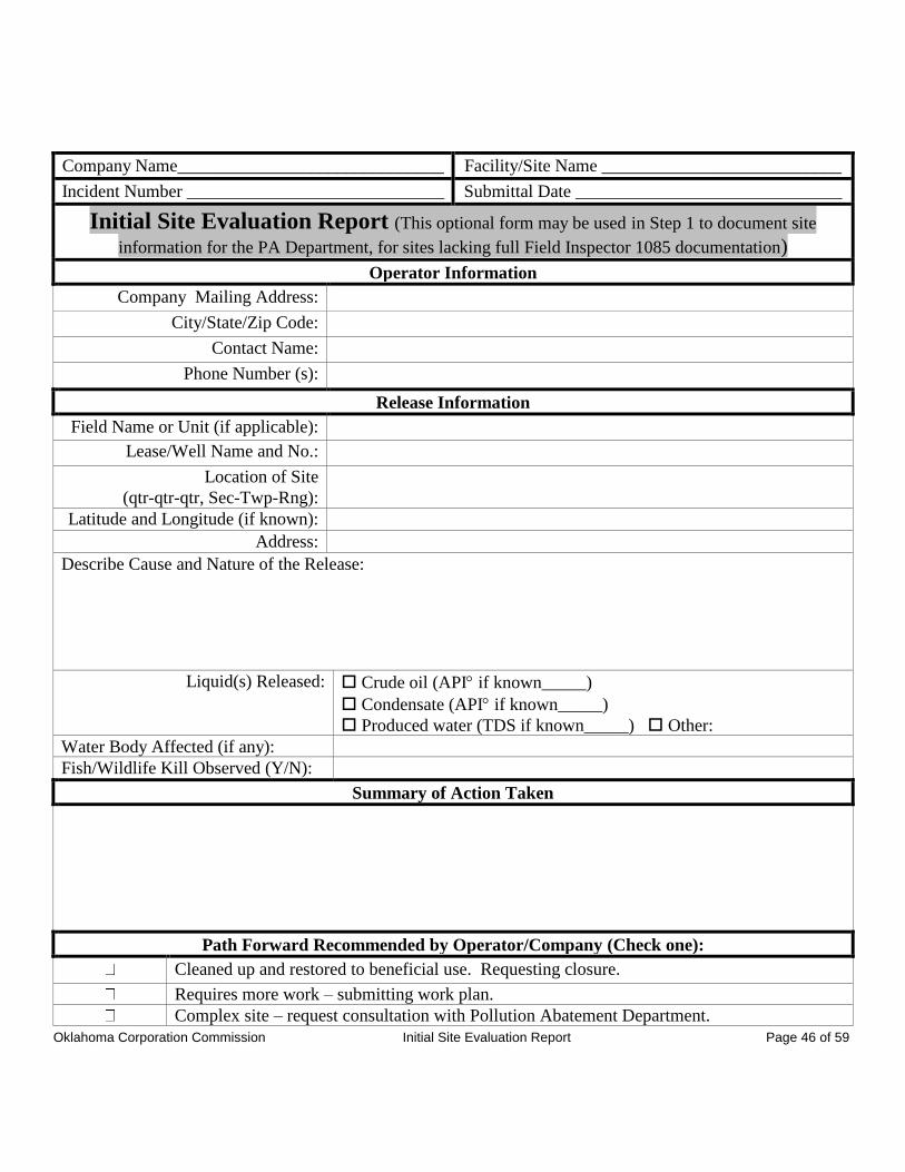
Oklahoma Corporation Commission Initial Site Evaluation Report Page 46 of 59
Company Name______________________________ Facility/Site Name ___________________________
Incident Number _____________________________ Submittal Date ______________________________
Initial Site Evaluation Report (This optional form may be used in Step 1 to document site
information for the PA Department, for sites lacking full Field Inspector 1085 documentation)
Operator Information
Company Mailing Address:
City/State/Zip Code:
Contact Name:
Phone Number (s):
Release Information
Field Name or Unit (if applicable):
Lease/Well Name and No.:
Location of Site
(qtr-qtr-qtr, Sec-Twp-Rng):
Latitude and Longitude (if known):
Address:
Describe Cause and Nature of the Release:
Liquid(s) Released: Crude oil (API if known_____)
Condensate (API if known_____)
Produced water (TDS if known_____) Other:
Water Body Affected (if any):
Fish/Wildlife Kill Observed (Y/N):
Summary of Action Taken
Path Forward Recommended by Operator/Company (Check one):
Cleaned up and restored to beneficial use. Requesting closure.
Requires more work – submitting work plan.
Complex site – request consultation with Pollution Abatement Department.
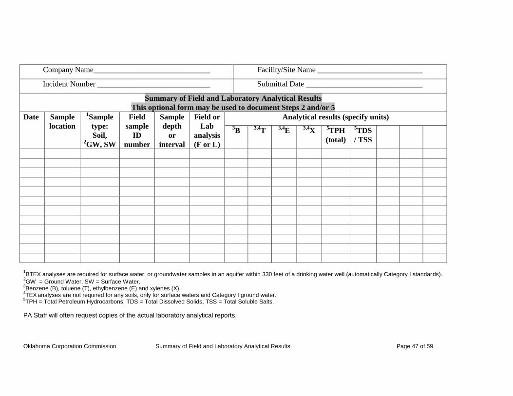
Oklahoma Corporation Commission Summary of Field and Laboratory Analytical Results Page 47 of 59
Company Name______________________________ Facility/Site Name ___________________________
Incident Number _____________________________ Submittal Date ______________________________
Summary of Field and Laboratory Analytical Results
This optional form may be used to document Steps 2 and/or 5
Date Sample
location
1Sample
type:
Soil, 2GW, SW
Field
sample
ID
number
Sample
depth
or
interval
Field or
Lab
analysis
(F or L)
Analytical results (specify units)
3B
3,4T
3,4E
3,4X
5TPH
(total)
5TDS
/ TSS
1BTEX analyses are required for surface water, or groundwater samples in an aquifer within 330 feet of a drinking water well (automatically Category I standards).
2GW = Ground Water, SW = Surface Water.
3Benzene (B), toluene (T), ethylbenzene (E) and xylenes (X).
4TEX
analyses are not required for any soils, only for surface waters and Category I ground water.
5TPH = Total Petroleum Hydrocarbons, TDS = Total Dissolved Solids, TSS = Total Soluble Salts.
PA Staff will often request copies of the actual laboratory analytical reports.
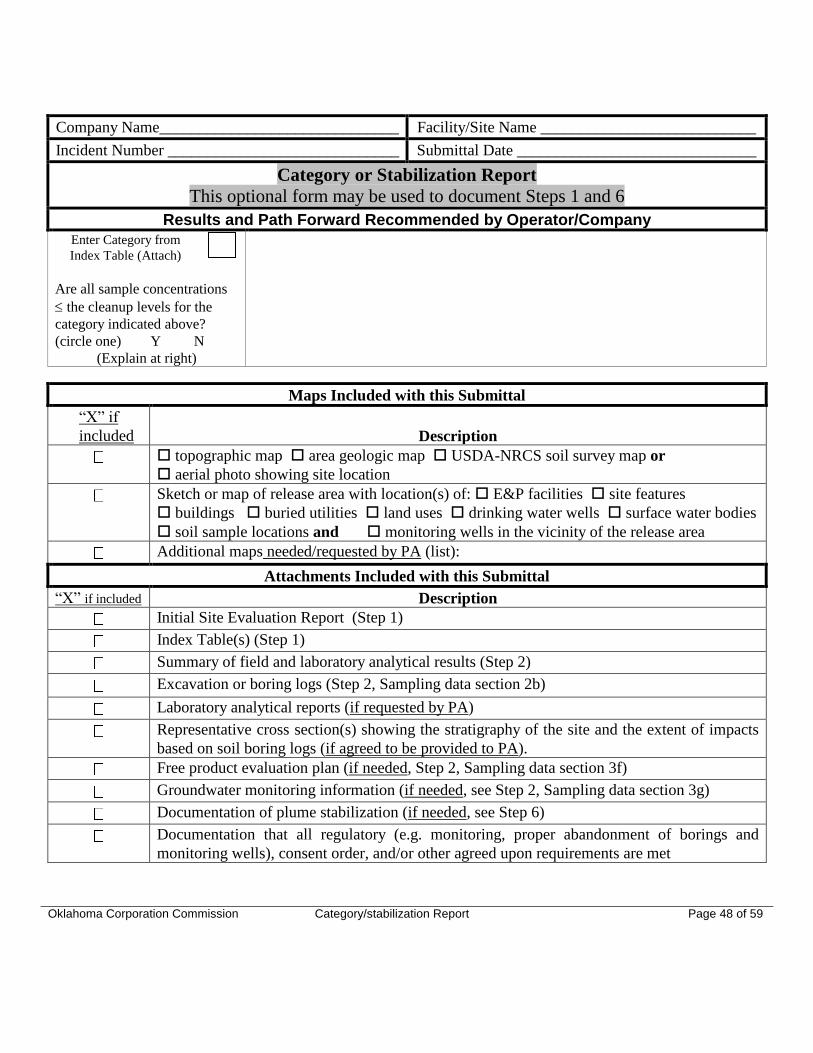
Oklahoma Corporation Commission Category/stabilization Report Page 48 of 59
Company Name______________________________ Facility/Site Name ___________________________
Incident Number _____________________________ Submittal Date ______________________________
Category or Stabilization Report
This optional form may be used to document Steps 1 and 6
Results and Path Forward Recommended by Operator/Company
Enter Category from
Index Table (Attach)
Are all sample concentrations
the cleanup levels for the
category indicated above?
(circle one) Y N
(Explain at right)
Maps Included with this Submittal
“X” if
included Description
topographic map area geologic map USDA-NRCS soil survey map or
aerial photo showing site location
Sketch or map of release area with location(s) of: E&P facilities site features
buildings buried utilities land uses drinking water wells surface water bodies
soil sample locations and monitoring wells in the vicinity of the release area
Additional maps needed/requested by PA (list):
Attachments Included with this Submittal
“X” if included Description
Initial Site Evaluation Report (Step 1)
Index Table(s) (Step 1)
Summary of field and laboratory analytical results (Step 2)
Excavation or boring logs (Step 2, Sampling data section 2b)
Laboratory analytical reports (if requested by PA)
Representative cross section(s) showing the stratigraphy of the site and the extent of impacts
based on soil boring logs (if agreed to be provided to PA).
Free product evaluation plan (if needed, Step 2, Sampling data section 3f)
Groundwater monitoring information (if needed, see Step 2, Sampling data section 3g)
Documentation of plume stabilization (if needed, see Step 6)
Documentation that all regulatory (e.g. monitoring, proper abandonment of borings and
monitoring wells), consent order, and/or other agreed upon requirements are met
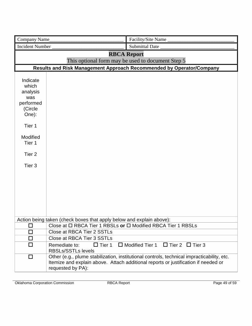
Oklahoma Corporation Commission RBCA Report Page 49 of 59
Company Name______________________________ Facility/Site Name ___________________________
Incident Number _____________________________ Submittal Date ______________________________
RBCA Report
This optional form may be used to document Step 5
Results and Risk Management Approach Recommended by Operator/Company
Indicate which
analysis was
performed (Circle One):
Tier 1
Modified
Tier 1
Tier 2
Tier 3
Action being taken (check boxes that apply below and explain above):
Close at RBCA Tier 1 RBSLs or Modified RBCA Tier 1 RBSLs
Close at RBCA Tier 2 SSTLs
Close at RBCA Tier 3 SSTLs
Remediate to: Tier 1 Modified Tier 1 Tier 2 Tier 3
RBSLs/SSTLs levels
Other (e.g., plume stabilization, institutional controls, technical impracticability, etc. Itemize and explain above. Attach additional reports or justification if needed or requested by PA):
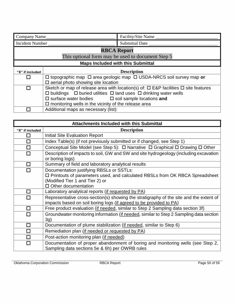
Oklahoma Corporation Commission RBCA Report Page 50 of 59
Company Name______________________________ Facility/Site Name ___________________________
Incident Number _____________________________ Submittal Date ______________________________
RBCA Report
This optional form may be used to document Step 5
Maps Included with this Submittal
“X” if included Description
topographic map area geologic map USDA-NRCS soil survey map or aerial photo showing site location
Sketch or map of release area with location(s) of: E&P facilities site features buildings buried utilities land uses drinking water wells
surface water bodies soil sample locations and monitoring wells in the vicinity of the release area
Additional maps as necessary (list):
Attachments Included with this Submittal
“X” if included Description
Initial Site Evaluation Report
Index Table(s) (if not previously submitted or if changed, see Step 1)
Conceptual Site Model (see Step 5): Narrative Graphical Drawing Other
Description of impacts to soil, GW and SW and site hydrogeology (including excavation or boring logs)
Summary of field and laboratory analytical results
Documentation justifying RBSLs or SSTLs: Printouts of parameters used, and calculated RBSLs from OK RBCA Spreadsheet (Modified Tier 1 and Tier 2) or Other documentation
Laboratory analytical reports (if requested by PA)
Representative cross-section(s) showing the stratigraphy of the site and the extent of impacts based on soil boring logs (if agreed to be provided to PA)
Free product evaluation (if needed, similar to Step 2 Sampling data section 3f)
Groundwater monitoring information (if needed, similar to Step 2 Sampling data section 3g)
Documentation of plume stabilization (if needed, similar to Step 6)
Remediation plan (if needed or requested by PA)
Post-action monitoring plan (if needed)
Documentation of proper abandonment of boring and monitoring wells (see Step 2, Sampling data sections 5e & 6h) per OWRB rules

Oklahoma Corporation Commission RBCA Report Page 51 of 59
Company Name______________________________ Facility/Site Name ___________________________
Incident Number _____________________________ Submittal Date ______________________________
RBCA Sampling Report - This optional form may be used to document Step 5
Chemical
of
concern
Media
type1
Concen-
tration
(indicate
units)
Land
use2
RBSL/
SSTL
Exposure
Pathway(s)
Method used to determine RBSL/SSTL
1Surface soil (SS), Subsurface soil (SB), Ground water (GW) Surface water (SW) 2 Commercial (C), Industrial (I), Residential (R), Agricultural (A), Other (O) (list others)
Note: For all sensitive areas as defined in Step 3, use residential land use. PA Staff will often request copies of the lab analytical reports.
Oklahoma Corporation Commission RBCA Report Page 52 of 59
Oklahoma Corporation Commission Page 53 of 59
APPENDIX VII
GUIDANCE FOR SPILLS OF OTHER MATERIALS FROM PIPELINES, TANK
FARMS, AND PRODUCTION/TREATMENT EQUIPMENT
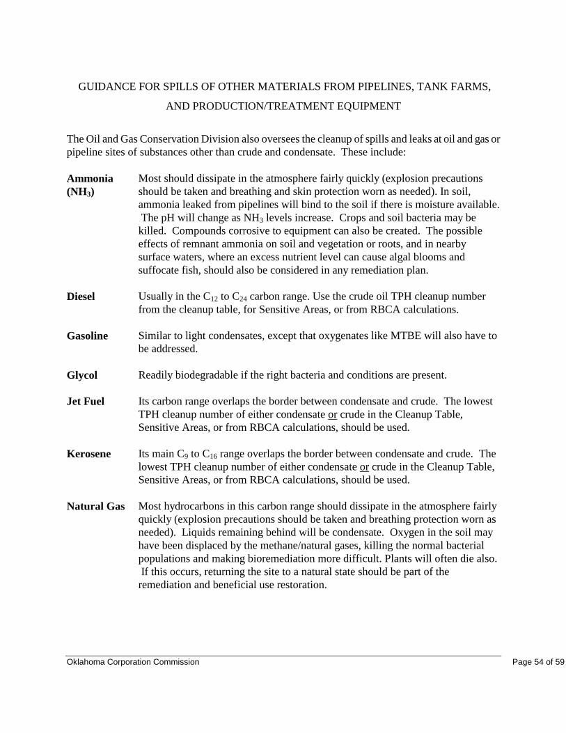
Oklahoma Corporation Commission Page 54 of 59
GUIDANCE FOR SPILLS OF OTHER MATERIALS FROM PIPELINES, TANK FARMS,
AND PRODUCTION/TREATMENT EQUIPMENT
The Oil and Gas Conservation Division also oversees the cleanup of spills and leaks at oil and gas or
pipeline sites of substances other than crude and condensate. These include:
Ammonia
(NH3)
Most should dissipate in the atmosphere fairly quickly (explosion precautions
should be taken and breathing and skin protection worn as needed). In soil,
ammonia leaked from pipelines will bind to the soil if there is moisture available.
The pH will change as NH3 levels increase. Crops and soil bacteria may be
killed. Compounds corrosive to equipment can also be created. The possible
effects of remnant ammonia on soil and vegetation or roots, and in nearby
surface waters, where an excess nutrient level can cause algal blooms and
suffocate fish, should also be considered in any remediation plan.
Diesel Usually in the C12 to C24 carbon range. Use the crude oil TPH cleanup number
from the cleanup table, for Sensitive Areas, or from RBCA calculations.
Gasoline Similar to light condensates, except that oxygenates like MTBE will also have to
be addressed.
Glycol Readily biodegradable if the right bacteria and conditions are present.
Jet Fuel Its carbon range overlaps the border between condensate and crude. The lowest
TPH cleanup number of either condensate or crude in the Cleanup Table,
Sensitive Areas, or from RBCA calculations, should be used.
Kerosene Its main C9 to C16 range overlaps the border between condensate and crude. The
lowest TPH cleanup number of either condensate or crude in the Cleanup Table,
Sensitive Areas, or from RBCA calculations, should be used.
Natural Gas Most hydrocarbons in this carbon range should dissipate in the atmosphere fairly
quickly (explosion precautions should be taken and breathing protection worn as
needed). Liquids remaining behind will be condensate. Oxygen in the soil may
have been displaced by the methane/natural gases, killing the normal bacterial
populations and making bioremediation more difficult. Plants will often die also.
If this occurs, returning the site to a natural state should be part of the
remediation and beneficial use restoration.

Oklahoma Corporation Commission Page 55 of 59
APPENDIX VIII
ASSESSMENT AND CLEANUP GUIDELINES FOR NEW OR HISTORIC
PRODUCED WATER/BRINE SPILLS
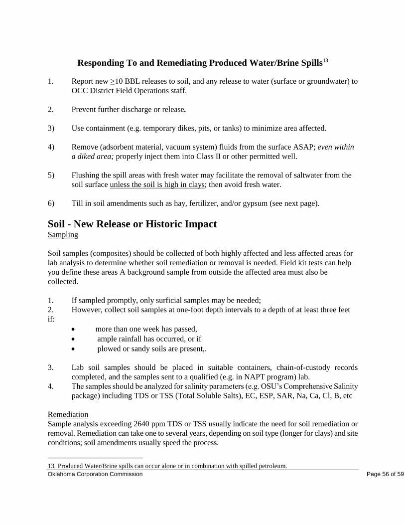
Oklahoma Corporation Commission Page 56 of 59
Responding To and Remediating Produced Water/Brine Spills13
1. Report new >10 BBL releases to soil, and any release to water (surface or groundwater) to
OCC District Field Operations staff.
2. Prevent further discharge or release.
3) Use containment (e.g. temporary dikes, pits, or tanks) to minimize area affected.
4) Remove (adsorbent material, vacuum system) fluids from the surface ASAP; even within
a diked area; properly inject them into Class II or other permitted well.
5) Flushing the spill areas with fresh water may facilitate the removal of saltwater from the
soil surface unless the soil is high in clays; then avoid fresh water.
6) Till in soil amendments such as hay, fertilizer, and/or gypsum (see next page).
Soil - New Release or Historic Impact Sampling
Soil samples (composites) should be collected of both highly affected and less affected areas for
lab analysis to determine whether soil remediation or removal is needed. Field kit tests can help
you define these areas A background sample from outside the affected area must also be
collected.
1. If sampled promptly, only surficial samples may be needed;
2. However, collect soil samples at one-foot depth intervals to a depth of at least three feet
if:
more than one week has passed,
ample rainfall has occurred, or if
plowed or sandy soils are present,.
3. Lab soil samples should be placed in suitable containers, chain-of-custody records
completed, and the samples sent to a qualified (e.g. in NAPT program) lab.
4. The samples should be analyzed for salinity parameters (e.g. OSU’s Comprehensive Salinity
package) including TDS or TSS (Total Soluble Salts), EC, ESP, SAR, Na, Ca, Cl, B, etc
Remediation
Sample analysis exceeding 2640 ppm TDS or TSS usually indicate the need for soil remediation or
removal. Remediation can take one to several years, depending on soil type (longer for clays) and site
conditions; soil amendments usually speed the process.
13 Produced Water/Brine spills can occur alone or in combination with spilled petroleum.
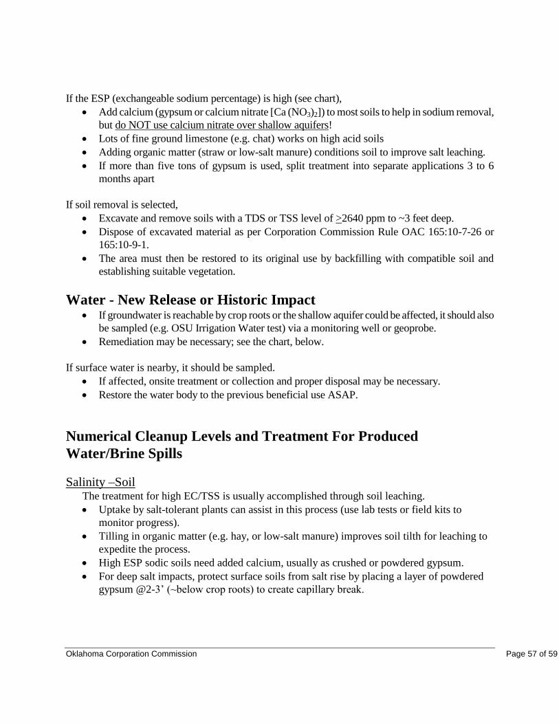
Oklahoma Corporation Commission Page 57 of 59
If the ESP (exchangeable sodium percentage) is high (see chart),
Add calcium (gypsum or calcium nitrate [Ca (NO3)2]) to most soils to help in sodium removal,
but do NOT use calcium nitrate over shallow aquifers!
Lots of fine ground limestone (e.g. chat) works on high acid soils
Adding organic matter (straw or low-salt manure) conditions soil to improve salt leaching.
If more than five tons of gypsum is used, split treatment into separate applications 3 to 6
months apart
If soil removal is selected,
Excavate and remove soils with a TDS or TSS level of >2640 ppm to ~3 feet deep.
Dispose of excavated material as per Corporation Commission Rule OAC 165:10-7-26 or
165:10-9-1.
The area must then be restored to its original use by backfilling with compatible soil and
establishing suitable vegetation.
Water - New Release or Historic Impact If groundwater is reachable by crop roots or the shallow aquifer could be affected, it should also
be sampled (e.g. OSU Irrigation Water test) via a monitoring well or geoprobe.
Remediation may be necessary; see the chart, below.
If surface water is nearby, it should be sampled.
If affected, onsite treatment or collection and proper disposal may be necessary.
Restore the water body to the previous beneficial use ASAP.
Numerical Cleanup Levels and Treatment For Produced
Water/Brine Spills
Salinity –Soil The treatment for high EC/TSS is usually accomplished through soil leaching.
Uptake by salt-tolerant plants can assist in this process (use lab tests or field kits to
monitor progress).
Tilling in organic matter (e.g. hay, or low-salt manure) improves soil tilth for leaching to
expedite the process.
High ESP sodic soils need added calcium, usually as crushed or powdered gypsum.
For deep salt impacts, protect surface soils from salt rise by placing a layer of powdered
gypsum @2-3’ (~below crop roots) to create capillary break.
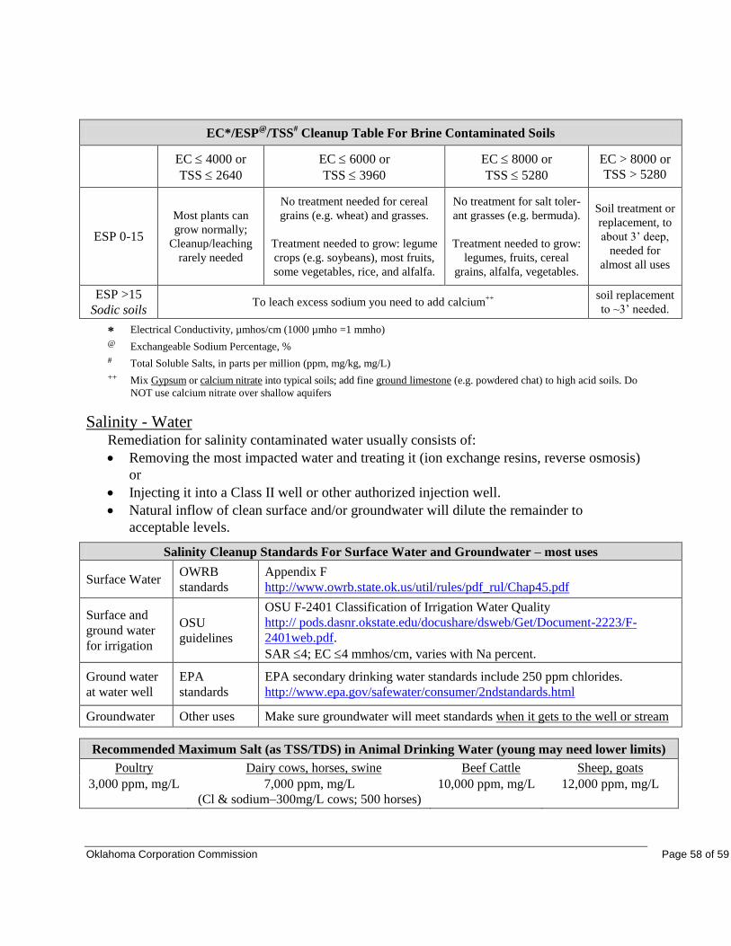
Oklahoma Corporation Commission Page 58 of 59
EC*/ESP@
/TSS# Cleanup Table For Brine Contaminated Soils
EC 4000 or
TSS 2640
EC 6000 or
TSS 3960
EC 8000 or
TSS 5280
EC > 8000 or
TSS > 5280
ESP 0-15
Most plants can
grow normally;
Cleanup/leaching
rarely needed
No treatment needed for cereal
grains (e.g. wheat) and grasses.
Treatment needed to grow: legume
crops (e.g. soybeans), most fruits,
some vegetables, rice, and alfalfa.
No treatment for salt toler-
ant grasses (e.g. bermuda).
Treatment needed to grow:
legumes, fruits, cereal
grains, alfalfa, vegetables.
Soil treatment or
replacement, to
about 3’ deep,
needed for
almost all uses
ESP >15
Sodic soils To leach excess sodium you need to add calcium
++
soil replacement
to ~3’ needed.
* Electrical Conductivity, µmhos/cm (1000 µmho =1 mmho)
@ Exchangeable Sodium Percentage, %
# Total Soluble Salts, in parts per million (ppm, mg/kg, mg/L)
++ Mix Gypsum or calcium nitrate into typical soils; add fine ground limestone (e.g. powdered chat) to high acid soils. Do
NOT use calcium nitrate over shallow aquifers
Salinity - Water Remediation for salinity contaminated water usually consists of:
Removing the most impacted water and treating it (ion exchange resins, reverse osmosis)
or
Injecting it into a Class II well or other authorized injection well.
Natural inflow of clean surface and/or groundwater will dilute the remainder to
acceptable levels.
Salinity Cleanup Standards For Surface Water and Groundwater – most uses
Surface Water OWRB
standards
Appendix F
http://www.owrb.state.ok.us/util/rules/pdf_rul/Chap45.pdf
Surface and
ground water
for irrigation
OSU
guidelines
OSU F-2401 Classification of Irrigation Water Quality
http:// pods.dasnr.okstate.edu/docushare/dsweb/Get/Document-2223/F-
2401web.pdf.
SAR 4; EC 4 mmhos/cm, varies with Na percent.
Ground water
at water well
EPA
standards
EPA secondary drinking water standards include 250 ppm chlorides.
http://www.epa.gov/safewater/consumer/2ndstandards.html
Groundwater Other uses Make sure groundwater will meet standards when it gets to the well or stream
Recommended Maximum Salt (as TSS/TDS) in Animal Drinking Water (young may need lower limits)
Poultry Dairy cows, horses, swine Beef Cattle Sheep, goats
3,000 ppm, mg/L 7,000 ppm, mg/L
(Cl & sodium–300mg/L cows; 500 horses)
10,000 ppm, mg/L 12,000 ppm, mg/L
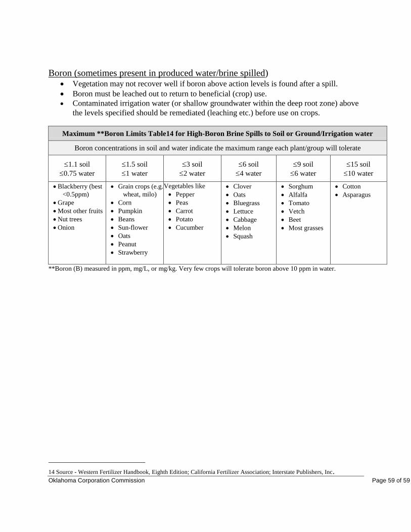
Oklahoma Corporation Commission Page 59 of 59
Boron (sometimes present in produced water/brine spilled) Vegetation may not recover well if boron above action levels is found after a spill.
Boron must be leached out to return to beneficial (crop) use.
Contaminated irrigation water (or shallow groundwater within the deep root zone) above
the levels specified should be remediated (leaching etc.) before use on crops.
Maximum **Boron Limits Table14 for High-Boron Brine Spills to Soil or Ground/Irrigation water
Boron concentrations in soil and water indicate the maximum range each plant/group will tolerate
1.1 soil
0.75 water
1.5 soil
1 water
3 soil
2 water
6 soil
4 water
9 soil
6 water
15 soil
10 water
Blackberry (best
<0.5ppm)
Grape
Most other fruits
Nut trees
Onion
Grain crops (e.g.
wheat, milo)
Corn
Pumpkin
Beans
Sun-flower
Oats
Peanut
Strawberry
Vegetables like
Pepper
Peas
Carrot
Potato
Cucumber
Clover
Oats
Bluegrass
Lettuce
Cabbage
Melon
Squash
Sorghum
Alfalfa
Tomato
Vetch
Beet
Most grasses
Cotton
Asparagus
**Boron (B) measured in ppm, mg/L, or mg/kg. Very few crops will tolerate boron above 10 ppm in water.
14 Source - Western Fertilizer Handbook, Eighth Edition; California Fertilizer Association; Interstate Publishers, Inc.