sixth five year review report for lee's lane landfill ... · table 7: groundwater sampling...
TRANSCRIPT

SIXTH FIVE-YEAR REVIEW REPORT FOR LEE’S LANE LANDFILL SUPERFUND SITE
JEFFERSON COUNTY, KENTUCKY
$<5o\
&
UJO
AUGUST 2018
Prepared by
U.S. Environmental Protection Agency Region 4
Atlanta, Georgia
. Franklin E. Hill, Director Superfund Division
D^e '

Table of ContentsLIST OF ABBREVIATIONS AND ACRONYMS..........................................................................................ivI. INTRODUCTION................................................................................................................................................I
Site Background................................................................................................................................................... 1FIVE-YEAR REVIEW SUMMARY FORM................................................................................................. 3
II. RESPONSE ACTION SUMMARY................................................................................................................3Basis for Taking Action..................................................................................................................................... 3Response Actions................................................................................................................................................ 4Status of Implementation................................................................................................................................... 6Systems Operations/Operation and Maintenance (O&M)...........................................................................10
III. PROGRESS SINCE THE PREVIOUS REVIEW......................................................................................10IV. FIVE-YEAR REVIEW PROCESS..............................................................................................................13
Community Notification, Community Involvement and Site Interviews..................................................13Data Review....................................................................................................................................................... 13Site Inspection.................................................................................................................................................... 19
V. TECHNICAL ASSESSMENT.......................................................................................................................19QUESTION A: Is the remedy functioning as intended by the decision documents?............................. 19QUESTION B: Are the exposure assumptions, toxicity data, cleanup levels and RAOs used at thetime of the remedy selection still valid?........................................................................................................20QUESTION C: Has any other information come to light that could call into question the protectiveness of the remedy?......................................................................................................................... 20
VI. ISSUES/RECOMMENDATIONS.............................................................................................................. 20OTHER FINDINGS..........................................................................................................................................21
VII. PROTECTIVENESS STATEMENT.........................................................................................................22VIII. NEXT REVIEW..........................................................................................................................................22APPENDIX A - REFERENCE EIST.............................................................................................................. A-1APPENDIX B - CURRENT SITE STATUS................................................................................................B-1APPENDIX C - SITE CHRONOLOGY......................................................................................................... C-1APPENDIX D - SITE MAPS........................................................................................................................... D-1APPENDIX E - PRESS NOTICE.................................................................................................................... E-1APPENDIX F - INTERVIEW FORMS.......................................................................................................... F-1APPENDIX G - SITE INSPECTION CHECKLIST.................................................................................... G-1APPENDIX H - SITE INSPECTION PHOTOS............................................................................................H-1APPENDIX I - ADDITIONAL SITE BACKGROUND INFORMATION............................................... I-l
Tables
Table 1: Groundwater MCLs and Health Risk-Based Levels......................................................................... 5Table 2: Summary of Planned and/or Implemented Institutional Controls (ICs)..........................................7Table 3: Impacted Parcels - Owners....................................................................................................................7Table 4: O&M Costs Over the FYR Period..................................................................................................... 10Table 5: Protectiveness Determinations/Statements from the 2013 FYR Report....................................... 11Table 6: Status of Recommendations from the 2013 FYR Report............................................................... 11Table 7: Groundwater Sampling Data for Five Metals, 2012 to 2017..........................................................16Table C-1: Site Chronology............................................................................................................................. C-1

Figures
Figure 1: Vicinity Site Map..................................................................................................................................2Figure 2: Parcel Identification Map.....................................................................................................................9Figure 3: Detailed Site Map................................................................................................................................18Figure D-1: 2011 mid 2013 Soil Sampling Locations..................................................................................D-1Figure D-2: Copy Summary of EPA Vapor Intrusion Results - November 2014....................................D-2

LIST OF ABBREVIATIONS AND ACRONYMS
AOC Administrative Order on ConsentCERCLA Comprehensive Environmental Response. Compensation, iind Liability Act CFR Code of Federal RegulationsCOC Contamimint of ConcernCSM Conceptual Site ModelEPA Ihhted States Environmental Protection AgencyFVR Five-Year ReviewIC Institutional ControlKDEP Kentucky Department for Environmental ProtectionKDHMWM Kentucky Department of Hiizardous Materials iind Waste MiinagementLEE Lower Explosive LimitLEG Landfill Gaspg L Micrograms per Literpg nr^ Micrograms per Meter Cubedmg kg Milligrams per KilogramMCL Maximum Contaminant LevelMSD Louisville and JetTerson County Metropolitan Sewer DistrictNA Not .AnalyzedND Not DetectedNS Not SampledNCP National Contingency PhinNPL National Priorities ListO&M Operation and MaintenanceOV Operable IhiitPH.A Public Health .AssessmentppmV Piu1s per Million by VolumePRP Potentially Responsible Piu1yR.AO Remedial .Action ObjectiveROD Record of DecisionRPM Remedial Project ManagerRSL Regional Screening LevelW IT Ihilimited INe iind Ihirestricted ExposureVOC Volatile Organic Compound
I. INTRODUCTIONTlie puipose of a five-yeiii* review (FVR) is to evaluate the implementation and perfonmince of a remedy to detennine if the remedy is and will continue to be protective of human health and the environment. Tlie methods, findings and conclusions of reviews are documented in FVR reports such as this one. In addition. FVR reports identify issues found during the review, if any. and document recommendations to address them.
Tlie IfS. Environmental Protection .Agency is preparing this FVR pursiuint to the Comprehensive Environmental Response. Compensation, and Liability .Act (CERCL.A) Section 121. consistent with the National Contingency Plan (NCP) (40 Code of Federal Regulations (CFR) Section 300.430(f)(4)(ii)). and considering EP.A policy.
Tins is the sixth FVR for the Lee's Lane Landfill Superfund site (the Site). The triggering action for this policy review is the completion date of the previous FVR. Tlie FVR has been prepared because hiizardous substances, pollutiints or contamimints remain at the Site above levels that allow for unlimited use iind uni'estricted exposure (IT^ IT).
Tlie Site consists of one operable unit (OlO- OIU addresses the soil and groundwater remedy. This FVR addresses Ol^ 1.
EP.A Remedial Project Miinager (RPM) Donna Seadler led the PVR. Participiints included EP.A Community Involvement Coordinator .Angela Miller. Jim Kirby from the Kentucky Department for Environmental Protection (KDEP). and Jolmny Zimmennan-Ward iind Kirby Webster from Skeo (EP.A PVR support contractor). The Louisville and JetTerson County Metropolitan Sewer District (MSD). one of the Site's potentially responsible parties (PRPs). was notified of the initiation of the PVR. Tlie review began on 10 4 2017. .Appendix .A includes a list of documents reviewed. .Appendix B includes Site status infonnation. .Appendix C includes the Site's clu'onology of events.
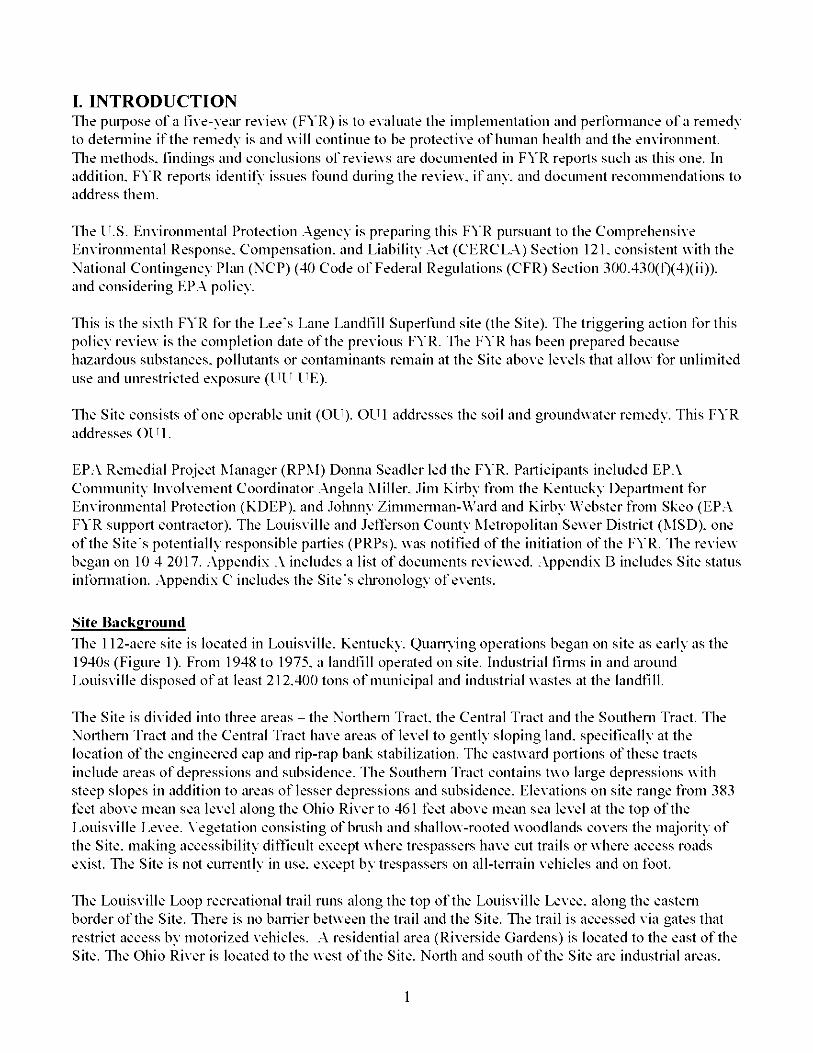
Site BackgroundTlie 112-acre site is located in Louisville. Kentucky. Quany ing operations began on site as early as the 1940s (figure 1). Prom 1948 to 1975. a landfill operated on site. Industrial finns in and iu'ound Louisville disposed of at least 212.400 tons of municipal iind industrial wastes at the landfill.
Tlie Site is divided into tlu*ee areas - the Northern Tract, the Central Tract and the Southern Tract. The Northern Tract and the Central Tract have areas of level to gently sloping land, specifically at the location of the engineered cap iind rip-rap bank stabilization. The eastward portions of these tracts include areas of depressions and subsidence. The Southern Tract contains two large depressions with steep slopes in addition to iu*eas of lesser depressions iind subsidence. Elevations on site range from 383 feet above nieiin sea level along the Ohio River to 461 feet above nieiin sea level at the top of the Louisville Levee. Vegetation consisting of brush and shallow-rooted woodlands covers the majority of the Site, milking accessibility dilTicult except where trespassers have cut trails or where access roads exist. Tlie Site is not cuiTently in use. except by trespassers on all-teiTain vehicles iind on foot.
Tlie Louisville Loop recreational trail runs along the top of the Louisville Levee, along the eastern border of the Site. Tliere is no bamer between the trail and the Site. Tlie trail is accessed via gates that restrict access by motorized vehicles. .A residential area (Riverside Gardens) is located to the east of the Site. Tlie Ohio River is located to the west of the Site. North and south of the Site are industrial areas.
1

Figure 1: Vicinity Site Map
Louisville, KY
750
Lee's Lane LandfillSuperfund Site l^Qiiiisville
'^adcl iff--E I izajjethtown
//
jNorthern
iGentral Tr^
hsm \
f»m-r
■'’ i
1,500 3,000Feet
Sources: 2016 Conceptual Site Model, 2013 FYR, Esri, DeLorme, AND, Tele Atlas, First American, UNEP-WCMC, uses, DigitalGlobe, GeoEye, Earthstar Geographies, CNES/Airbus DS, USDA, AEX, Getmapping, Aerogrid, IGN, IGP and swisstopo.
Legend
Approximate Site Boundary ■ ■ ■ Louisville Loop
NORTH
Lee’s Lane Landfill Superfund SiteCity of Louisville, Jefferson County, Kentucky
Disclaimer: This map and any boundary lines within the map are approximate and subject to change The map is not a survey. The map is for informational purposes only regarding the EPA’s response actions at the Site.

Tlie water table is approximately 40 feet below the surtace. The alluvial aquifer is unconfined. Shale fonns an aquitard between the alluvial aquifer and the deep limestone aquifers. Flow in the aquifer is predomimintly towiu'd the Ohio River. During periods of high river flow, groundwater flow direction may reverse. The Site lies within the 100-yeiu* floodplain of the Ohio River. Tlie EP.A has identified more tluin 30 PRPs at the Site, including the Hofgesang Foundation. Louisville Jeflerson County Metropolitiin Sewer District. Louisville County Metro Government, iind a number of businesses.
FIVE-VE.\R REVIEW SUM^URV FORM
SITE IDENTIFICATION
Site Name: Lee's Lane Landfill
EPA ID: KTD980557052
Region: 4 State: Kentuclcv City/County: Louisville Jeflerson
SITE STATUS
NPL Status: Deleted
Multiple OUs?No
Has the Site achieved construction completion?Yes
REVIEW STATUS
Lead agency: EP.\
Author name: Donna Seadler (EP.\) and Jolinnv Zimmennan-Ward and Kirbv Webster (Skeo)
Author affiliation: EP.\and Skeo
Review period: 10 4 2017 - 8 1 2018
Date of site inspection: 1 17 2018
Type of review : Policy
Review number: 6
Triggering action date: 9 25 2013
Due date (fiveyears after triggering action date): 9 25 2018
II. RESPONSE ACTION SUMMARY
Basis for Taking .Action
In 1974. the Lee's Lane Liindflll pennit expired. Due to repeated compliance violations, it was not renewed. In 1975. nearby residents reported flash fires in their basements: methiine. appiU'cntly from the landfill, was being ignited by the pilot lights of their hot water heaters. Tlie Commonwealth of Kentucky closed the hindflll and local authorities evacuated and purchased seven nearby homes because of the
presence of explosive levels of methane. Tlie EPA proposed the Site for listing on the Superfund National Priorities List (NPL) in December 1982. The EP.A finalized the Site's listing on the NPL in September 1983. .Appendix I provides additional site background infonnation.
Tlie Site's Remedial Investigation Report, finalized in .April 1986. identified two potential public health concerns: 1) elevated chromium levels in the groundwater at and upgradient of the Site: iind 2) the potential release of methiine and hazardous gases to the air and subsurtace. Since elevated chromium concentrations were detected in upgradient wells and no downgradient otT-site impacts were evident, groundwater remediation was not considered at that time.
Based on the detection frequency iind chemical, biological iind toxicological properties of contiiminants identified b\ the remedial investigation, lead, arsenic, benzene and chromium were selected as critical contaminants for further evaluation.
Tlie Remedial Investigation Report concluded that concentrations of critical contaminants do not represent a significant tlu'eat to the environmental receptors at the Site. Biota in continued direct contact with elevated contaminant levels in selected "hot spot" soil areas could experience symptoms of chronic toxicity. However, no acute toxicological elTects would be expected at contaminant levels documented at that time.
Response .ActionsIn October 1980. the JetTerson County Depiulment of Public Works designed and installed a landfill gas (LEG) collection system between the landfill and Riverside Gardens.
In Eebriuu'y 1980. Kentucky Department of Hiizardous Materials iind Wa.ste Management (KDHMWM) discovered approximately 400 drums within the hindfill about 100 feet from the Ohio River bank on a 10-foot vertical rise above the river. In September iind October 1981. landfill owners removed the drums under a court order. Tlie wastes were renio\ ed from the drums and transported to an appro\ ed haziii'dous waste disposal tacility. Tlie remaining non-hazardous drummed materials and empty drums were buried on site in the landfill.
Tlie EP.A signed the Site's Enlbrcement Decision Document iind the Site's Record of Decision (ROD) on September 25. 1986. While the ROD did not define remedial action objectives (R.AOs). it did define public health objectives:
1. Construct a groundwater monitoring program that will serve as iin early wiu'iiing system should site conditions change.
2. Control the vertical and lateral subsurface migration of methane iind other gases.3. Institute a routine monitoring program that will serve to detect any undesirable and possibly
diingerous levels of methane iind or toxic vapors migrating into the Riverside Gardens neighborhood.
4. Institute an ambient air monitoring program.
Tlie EP.A's 1986 Enlbrcement Decision Document and 1986 ROD selected the following remedy:
1. Provision for a properly operating gas collection system.2. Consideration of a possible future alternate water supply.3. Cleanup of surtace waste area.4. Bank protection controls.
4

5. Establishment of an alternate cleanup limit for the groundwater at the Site.6. Institutional controls, which will be fully identified during remedial design, will be implemented.
These controls may include, but will not be limited to:a. Cautionary signs.b. Installation of a gate at the Putnam Street access point.
Note: These physical access controls were referred to as institutional controls in RODs issued during this time. However, the EPA currently has a more limited institutional control definition which includes only legal and administrative measures.
7. Operation and maintenance activities, which will include:a. Groundwater, gas and air monitoring.b. Inspection of the gas monitoring wells, gas collection system, capped waste areas and the
rip-rap along the Ohio River bank.
No groundwater remedy was selected in the 1986 Enforcement Decision Document. In previous reports, groundwater concentrations had been compared to alternate concentration limits. In the 2013 FYR, the EPA determined groundwater concentrations would be compared to groundwater maximum contaminant levels (MCLs) and other EPA health risk-based levels to establish whether groundwater is capable of posing a risk for ingestion, inhalation and dermal contact. Table 1 lists the current groundwater MCLs for Site COCs, or health-risk based levels where MCLs were not available. Since 2013, toxicity values have not changed for these compounds. While some EPA default exposure inputs for drinking water have been updated, the EPA has determined that the MCLs and health-risk based levels are all still health protective.
Table 1: Groundwater MCLs and Health Risk-Based Levels
Groundwater Contaminant of Concern (COC) 2018 EPA Groundwater MCLs and2013 Health Risk-Based Levels (|ig/L)
Arsenic 10“Barium 2,000“Beryllium 4“Cadmium 5“Chromium (Total) 100“Copper 1,300“Iron 24,000'’Lead 15“Manganese 900'’Mercury 2“Seleniimi 50“Zinc 10,000'’Benzene 5“Notes:
a. National Primary Drinkins Water Regulations, located at: httDs://www.eDa.gov/sround-water-and-drinking- water/national-Drimarv-drinkina-water-reeulations ^accessed 4/20/20181
b. EPA Region 4 site-specific health risk-based level, as listed in the 2013 FYR. ua/L = microarams per liter

Status of InipleinentationIn 1988. the EPA prepared a Close-Out Report for deletion of the Site from the NPL. Tlie report doeumented that remedial aetions at the Site began in Mareh 1987 and finished in Oetober 1987. Tlie aetions summarized in the report ineluded:
• Surtaee Waste Cleanup Implementation of Institutional ControlsNumerous site reeords eontain referenee to "hot spots." .An .August 9. 2018 review of historieal doeuments by the EP.A identified that the 1986 Remedial Investigation Report speeifies the surtaee soil sampling loeations whieh eontain elevated levels of elu'omium as "hot spots." Tliese loeations. shown on a map in the Remedial Investigation Report, are not in the area with the engineered eap. It is likely that these areas only reeeived a eovering of elay soil (not eapped by EP.A definition). Tlie earlier doeuments also state that the drums found were to be disposed of otT-site. Tliere is an engineered eap of about 3 aeres on the Site, where the drums that were found during investigations were buried. Seeurity gates were installed at the tloodwall entranee and at Putniiin Lime. Cautionaiy signs were posted at the entranee points to the Site.
• Construetion of the Rip-rap SlopeBased on additional site investigation, it was deeided to limit the horizontal extent of the rip-rap to the boundiu'ies of the eentral traet.
• Monitoring Well InstallationTen gas monitoring wells and two groundwater monitoring wells were installed at or in the vieinity of the Site.
• Gas Colleetion System Inspeetion and RepairTlie gas eolleetion system was inspeeted mid evaluated. Repair refurbishment needed was eompleted.
• .Alternate Water Supply HookupBased on groundwater modeling by the EP.A. the EP.A eoneluded that all private wells within a 1.500-foot zone around the Site should be abandoned. Tlie EP.A reeommended eoimeeting all residents using private wells within 1.500 feet of the Site to im alternate water supply, field surveys eonfinned there were two operating private wells within the 1.500-foot zone. Tliese wells were eonneeted to the existing munieipal water supply in the subdivision.
In July 1991. the EP.A signed an .Administrative Order on Consent (.AOC) with MSD to eonduet remedy operation and maintenanee (O&M) aetivities. Tlie EP.A deleted the Site from the NPL in .April 1996.
Reeuiring issues with the LEG eolleetion system have been doeumented in previous EAR reports. In 2010. the LEG system was deemed inoperable, having exeeeded its useful life.
In eiU'ly .April 2011. the EP.A eolleeted soil samples from four on-site loeations to detennine if haziu'dous eonstituents were present at levels exeeeding EP.A regional sereening levels (RSLs) for residential soils. .All reported arsenie values exeeeded the residential RSL for iU'senie (0.39 milligrams per kilogram, or mg kg). Tlie range of deteetions for arsenie was 2.9 mg kg to 4.5 mg kg. Tlie report stated that the deteeted arsenie eoneentration range is typieal for soils derived from weathered sedimentiU'y roek and is not thought to be indieative of eontamination at the Site. Tliree of the four loeations had eontamination above residential RSLs of other eontiuninants. Tlie EP.A eoneluded that more Siunpling is neeessaiy to identify remaining eontamination.
In .April 2012. MSD eondueted a gas monitoring well one-year review. MSD evaluated gas eoneentration trends from siimples eolleeted in the gas monitoring wells. The report eoneluded that eonsistent methane levels below the lower explosive limit (LEE) in the monitoring wells indieated that

operation of the landfill’s gas collection system was not required at that time to prevent migration of methane gas at dangerous levels. However, the EPA and KDEP were uncertain regarding the conclusiveness of the evaluation. No action was taken and the system remained in place and operating.
The 2013 FYR Report identified eight items requiring further evaluation. Data collected in response to these items is summarized in the data review section of this FYR and in the 2016 Conceptual Site Model (CSM), prepared by the Lee’s Lane Landfill Group and MSD. The CSM is further discussed in the data review section.
Institutional Control (TO ReviewThe 1986 Enforcement Decision Document referred to institutional controls and the 1986 ROD mentioned institutional considerations. However, the controls mentioned are physical access controls of the Site, which do not meet the definition of institutional controls as legal and administrative instruments. The 2016 CSM recommended the implementation of use restrictions prohibiting the development of the landfill for residential purposes. Table 2 summarizes the status of institutional controls at the Site and Table 3 lists the Site parcels and owners. In 2015, Hofgesang Foundation stated that it is willing to work with the EPA to establish institutional controls for the Site.
Table 2: Summary of Planned and/or Implemented Institutional Controls (ICs)Media, Engineered
Controls, and Areas That Do Not
Support UU/UE Based on Current
Conditions
ICsNeeded
ICs Called for in the Decision
Documents
ImpactedParcel(s)
ICObjective
Title of IC Instrument Implemented and Date
(or planned)
Groundwater Yes No All{see Table 3)
Preclude drilling wells or using groundwater. To be determined
Soil Yes No All(see Table 3)
Restrict activities that could impair the
integrity of the remedy and restrict land use.
To be determined
Table 3: Impacted Parcels - OwnersImpacted Parcel Owner Impacted Parcel Owner
113500010000 The Hofgesang Foundation 113501110000 Louisville/Jefferson County Metro Go
113500620000 Greater City Realty Corp. 113500060000 Louisville/Jefferson County Metro Go
113500310000 Louisville/Jefferson County Metro Go 101100260001 The Hofgesang Foundation
113500050069 Greater City Realty Corp. 101100640000 Hofgesang Foundation Inc
113500300000 Louisville/Jefferson County Metro Go 101100030001 Gemert C T Inc

1 Louisville Jefferson crounh’ Melro Go 1()17()()19()()()() Louisville Gas &. Eleclric (?o
Grealer (?il\’ Reall\’ (?oq:i. 1()11()()()7()()()() Louisville Jefferson (Jounl}’ Melro Go
113500030000 Grealer (?il\’ Reall\’ (?oq:i. lol 17()()()()()()() Louisville Jefferson (Jounl}’ Melro Go
1135()()()2()()()() Grealer Cil\’ Reall\’ Corp
Source: blips: www.lojic.org lojic-online (Accessed 7 1() 2()1S)

Figure 2: Parcel Identification Map
7 113500620000
Ji;i35003'10000r 4
1J3500050069iT^^nnsnnnnh
i W____
m.
iW. 7 ■'• / . .9
i '''
■ 7^^m _ ' <p
m' '•
,10117.0000
500 1,000 2,000Feet
Sources: LOJIC Online. 2016 Conceptual Site Model, 2013 FYR, Esri, DeLorme, AND, Tele Atlas, First American, UNEP-WCMC, USGS, DigitalGlobe, GeoEye, Earthstar Geographies, CNES/Airbus DS, USDA, AEX, Getmapping, Aerogrid, IGN, IGF and swisstopo.
Legend
Approximate Site Boundary Parcels
NORTH
Lee’s Lane Landfill Superfund SiteCity of Louisville, Jefferson County, Kentucky
Disclaimer: This map and any boundary lines within the map are approximate and subject to change. The map is not a survey. The map is for informational pmposes only regarding the EPA’s response actions at the Site.

Systems Operations/Operation and Maintenance (O&M)The July 1991 O&M Plan for Post Removal Site Control designated the O&M activities for the Site. These activities were anticipated to be conducted quarterly, unless otherwise specified in the O&M Plan. Activities include:
• Site Inspectionso Gas collection system o Groundwater monitoring wells o Gas monitoring wells o Institutional controlso Area-wide site conditions (i.e., settlement, erosion, unauthorized dumping)
• Air Quality Monitoringo Ambient air sampling o Gas monitoring well sampling
• Gas Collection System Balancing and Maintenance• Groundwater Quality Monitoring
o Groundwater monitoring well sampling o Private well sampling
• River Bank Protection Controlso Rip-rap slope and drainage swales o Surveying
• Landfill Surface and Cap Monitoring and Maintenanceo Capped area adjacent to Ohio River and “hot spot” areas o Mowing
The EPA performed O&M activities from July 1988 to June 1989. In July 1991, the EPA issued an AOC under which MSD agreed to perform certain O&M activities at the Site for 29 years. In April 1994, KDEP entered into an Intergovernmental Response Agreement with the EPA. Under the agreement, KDEP assumed responsibility for oversight of MSD’s O&M activities. MSD is conducting all required O&M activities. The 1986 Enforcement Decision Document estimated annual O&M costs of $188,667. Table 4 shows the O&M expenses reported by MSD since the 2013 FYR Report. The increased costs in 2015 are primarily associated with the preparation of the CSM. Based on the CSM, some O&M activities may be altered. Current O&M activities should be summarized in an updated O&M Plan.
Table 4: O&M Costs Over the FYR PeriodYear Total Cost (rounded to the nearest $1,000)2013 $63,0002014 $77,0002015 $147,0002016 $69,0002017 $75,000
III. PROGRESS SINCE THE PREVIOUS REVIEW
This section includes the protectiveness determinations and statements from the previous FYR as well as the recommendations from the previous FYR and the status of those recommendations.

Table 5: Protectiveness Determinations/Statements from the 2013 FYR Report
ou#ProtectivenessDetermination Protectiveness Statement
1 Protectiveness Deferred
A protectiveness determination of the remedy cannot be made at this time without further information. Recommended actions to obtain this information include: obtaining additional soil and groundwater data to update the Site characterization; and, completing a data review and evaluation to evaluate health risks associated with current site conditions. Additionally, the LFG collection system needs to be functional in order to remove landfill gases. It is expected that these actions will take approximately 12 months to complete, at which time a protectiveness determination will be made.
Table 6: Status of Recommendations from the 2013 FYR ReportOU
# Issue Recommendations CurrentStatus Current Implementation Status Description Completion Date {if
applicable)
1The 1986 ROD did not identify a groundwater remedy.
Review groundwater data and determine if a groundwater remedy needs to be established, along with groundwater cleanup goals, in a decision docmnent.
Completed
The 2016 CSM review of groimdwater data and data from new groundwater wells confirms that no
groundwater remedy is necessary and the current monitoring is sufficient.
4/1/2016
1
The 1986 ROD did not identify Resource Conservation and Recovery Act capping requirements.
Evaluate capping requirements and incorporate them into a decision document, if necessary.
Completed
The 2016 CSM evaluated capping requirements. It recommended a one-time, detailed inspection of the
full Site to inventory and delineate locations of exposed waste, which was completed as summarized in
the Site Inspection Completion Report. No new decision document is needed.
7/27/2017
1
The LFG collection system is currently not working as designed and may no longer be in an optimal location. Also, it was not selected as the remedy in the 1986ROD.
Determine next steps for installing an updated LFG collection system and install the new system. Select the LFG collection system as the remedy if it was meant to be the remedy.
Ongoing
The methane data review conducted during the CSM process confirmed there has been no new release of methane from the Site. The LFG system does not appear to be necessary any longer. The EPA will
initiate shutoff of the system, and monitor for rebound over a two year period. As long as results remain below
the LEL, no additional action is required.
NA
1The 1986 ROD did not include institutional controls.
Evaluate the need for institutional controls in conjunction with current groundwater sampling efforts. Consider institutional controls for the capped landfill area.
UnderDiscussion
As noted in the 2016 CSM, groundwater and land use institutional controls are necessary, but recreational use
does not need to be restricted.NA
11

ou# Issue Recommendations Current
Status Current Implementation Status Description Completion Date (if applicable)
Identify institutional control requirements in an enforceable document, if necessarv.
1
Although prior risk assessments indicated minimal risk, data gaps have been identified that suggest a re-evaluation is needed.
Conduct an updated data review and evaluation. Completed
The 2016 CSM reevaluated risk and found that there is no adverse human health or ecological risk present
under the modified trespasser scenario.4/1/2016
1
Groundwater is not adequately characterized and new wells are needed to obtain sufficient data.
Install new groundwater wells to appropriately characterize contamination and groundwater flow.Address contamination as appropriate. Evaluate contaminant levels and ecological impacts at the discharge point to theOhio River. Evaluate data to determine if additional sampling needs to be conducted for soil vapor intrusion.
Completed
KDEP installed five new wells in 2014. The 2016 CSM summarized groundwater monitoring data to date and
confirmed that groundwater quality has remained stable and the potential for groundwater exposure by any identifiable receptors has been eliminated. The
2016 CSM also summarized data collected to evaluate the soil vapor intrusion pathway.
4/1/2016
1Soil contamination isinsufficientlycharacterized.
Identify location of any remaining soil contamination through soil sampling and address contamination, as appropriate.
Completed
KDEP conducted soil sampling in 2013. The detailed site inspection by the PRP contractor with KDEP and EPA oversight confirmed that no additional soil cover
is needed.
7/27/2017
1Trespassing results in surface erosion and exposure.
Identify whether additional measures are needed to discourage trespassers and implement as appropriate.
Completed Between 2012 and 2014, MSD installed additional fencing, signage and a locked gate to deter trespassing. 4/1/2016
IV. FIVE-YEAR REVIEW PROCESS
Coimnuiiitv Notification. Conunuiiitv In\ oheinent and Site Intei’\ ie>\sA public notice was made available by a posting in the Louisville Courier-Journal, on 3 16 2018 (Appendix E). It stated that the FVR was undenvay and invited the public to submit any comments to the EPA. Tlie results of the review and the report will be made available at the Site's infonnation repository. Shively Library, located at 3920 Dixie Highway in Louisville. Kentucky.
During the EVR process, interviews were conducted to document any perceived problems or successes with the remedy that has been implemented to date. Tlie interviews are summarized below. Completed interview fonns are included in .Appendix E.
Interviewees included EP.A stalT Donna Seadler and Kevin Koporec. Jim Kirby with KDEP. iind Heather Dodds with MSD. Interviewees generally agree that the cleanup iind maintemince at the Site has progressed as phinned. MSD appropriately maintains the capped areas, wells, the gas collection system, rip-rap iind signage. Despite actions to deter trespassing, trespassing continues to occur. EP.A stalTstated that it would be ideal to have a reuse that involved an owner or tenant being at the Site regularly to keep trespassers from frequenting the Site, and especially areas of buried waste. KDEP stalT stated that the Site is not ready for reuse at this time and that further assessment of the gas collection system should be conducted to detennine if it needs to be updated or removed. KDEP stiilT also stated that a detennination of the source of carbon tetrachloride vapors should be identified and that they recommend an Environmental Covenant be placed on the Site under state law.
Data Re\ ienTliis section summarizes data collected since the previous EVR.
SoilIn an effort to identify remaining soil contiimination. KDEP collected 31 surtace iind subsurtace soil samples from 28 locations on the Site in .April 2013 (see Figure D-1). Tlie soil samples included five from the Northern Tract. 11 from the Central Tract and 15 from the Southern Tract. CSM Table 4.2 provides the 2013 soil siimpling results. Four locations had surtace soil (0-0.05 inches) contiiniinant concentrations above the recreational trespasser risk-based screening levels. Site-specific cleanup levels for soil were developed by site PRPs in response to the EP.A iind KDEP comments on the draft CSM. Tlie contaminants that exceeded the screening levels were polycyclic aromatic hydrocarbons, a polychlorinated biphenyl, a phthalate and lead. Tlie 2017 Site Inspection Completion Report updated the human health risk assessment presented in the CSM. Tlie 2017 site inspection confimied that the iu*eas where exceedances of risk-based screening levels were observed iu*e difficult to access, so the likely frequency of any potential exposure would be much less tliiin the previously agreed upon 58 days per year for the trespasser scenario and the 50 days per year for the recreational scenario. .As such, the 2017 Site Inspection Completion Report revised the risk evaluation using 12 days per year exposure under both scemu'ios. INing these agreed upon exposure assumptions, no soil data locations exceed the EP.A's health risk range for either excess ciincer risk or nonciincer luizard quotient. INing an updated (2017) EP.A cancer slope for benzo[a]pyrene. the excess ciincer risk is even lower than previously stated.
.Ambient .AirMSD monitors iimbient air twice per year at the locations shown on Figure 3. Table 6.3 in the CSM sumniiu'izes iimbient air monitoring from 2012 to 2015. Carbon tetrachloride exceeded the EP.A's RSL in .April 2015 at air monitoring station V\. No other contamimints that were measured and have RSLs
13
exceeded RSLs during this time. April 2016 to October 2017 ambient air reports indicate that methylene chloride, toluene, vinyl chloride and total xylenes have not exceeded RSLs at iiny location during this time period. Benzene slightly exceeded the RSL at air monitoring station A2 in .April 2016.
Soil GasMSD monitors soil gas twice per year at the locations shown on Figure 3. Table 6.2 in the CSM summiU'izes volatile organic compound (VOC) results for gas probes from September 2012 to .April 2015. Chlorofonn exceeded the EP.A's soil gas RSL during every event at locations G-1 and G-4.Carbon tetrachloride exceeded the EP.A's RSL during every event at location G-4. Chlorofonn and tetrachloroethene exceeded the EP.A's RSL sporadically during this time at location GM\V-1. Tetrachloroethene exceeded EP.A's RSL in 2012 at location GMW-2. Table 6.7 in the CSM summarizes ciU'bon tetrachloride results for gas probes. Between 2012 iind 2015. four probes exceeded RSLs at lea.st once. The maximum exceediince during this period was 15.727 micrograms per meter cubed (pg nr^) at G-4R in tall of 2013. .April 2016 to October 2017 soil gas summaries were reviewed using the semiannual reports. No exceedances were observed during this time for the chemicals that iu*e reported
on.
Table 5.1 in the CSM summarizes methiine concentrations at gas probes until .April 2015. In addition. .April 2016 to October 2017 soil gas summaries were reviewed using the semiannual reports. Tlie Kentucky .Action Level of 5®o LEL. which is 50.000 parts per million by volume (ppmV). has not been exceeded during this EVR period. Tlie last time the LEL was exceeded was at G-1 in .April 2007. with a measured value of 86.900 ppmV. GMW-3 had a value of 26.606 ppmV in .April 2016. but the value has since decreased.
In 2013. the EP.A conducted vapor intrusion analysis using data from the 13 existing gas probes iind five temporary gas probes LLL-1 through LLL-5 located ea.st of the Site between the Site and Riverside Gardens. This sampling is further discussed in the nexi section.
Vapor IntrusionIn an effort separate from the regular MSD soil gas monitoring, the EP.A's June 2013 soil gas siimpling along the site perimeter identified 7 constituents above screening levels which, if found at those levels in residential homes, would be health risk-based levels: benzene. 1.3-butadiene, carbon tetrachloride, chlorofonn. tetrachloroethylene. trichloroethylene, and vinyl chloride. In response, the EP.A conducted several rounds of vapor intrusion sampling (from June 2014 to July 2015) at 33 homes in the adjacent Riverside Gardens community to detennine whether gases from the landfill were migrating into homes. While some of the air samples had exceediinces of preliminary screening levels, further assessment of air concentrations from inside, outside, iind beneath the houses showed that there were no unacceptable health risks due to vapor intrusion.
GroundwaterIn 2014. KDEP installed five new groundwater monitoring wells (MW-101 through MW-105). The Site now has seven groundwater monitoring wells (see figure 3). MW-4 and MW-5 are adjacent to MW-104 and MW-105. respectively. MW-4 and MW-5 iu*e screened in the deeper part of the aquifer: MW-104 and MW-105 are screened in the upper part of the same aquifer.
Tlie three monitoring wells (MW-.A. MW-B and MW-2) in the residential area of Riverside Gardens were closed and properly abiindoned in 2010 after municipal water service was provided to the neighborhood. Sampling conducted prior to the wells' closure found that none of the 13 contiiminants of concern (COCs) were present at concentrations exceeding their cuirent MCLs or health risk-based
14
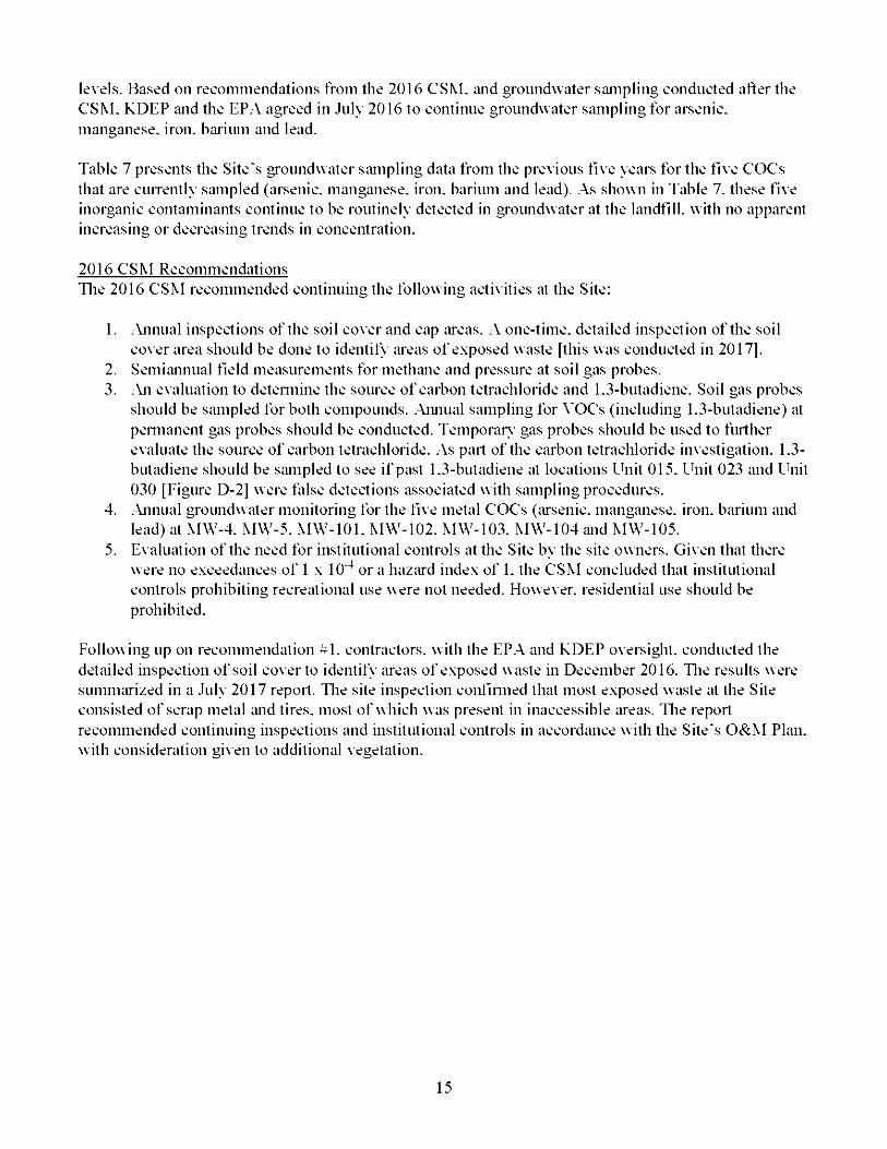
levels. Based on recommendations from the 2016 CSM. iind groundwater siimpling conducted after the CSM. KDEP iind the EPA agreed in July 2016 to continue groundwater sampling for arsenic, manganese, iron, biu'ium and lead.
Table 7 presents the Site's groundwater siimpling data from the previous five years for the five COCs that are cuirently siimpled (arsenic, manganese, iron, barium and lead). .As shown in Table 7. these five inorganic contaminants continue to be routinely detected in groundwater at the landfill, with no apparent increasing or decreasing trends in concentration.
2016 CSM RecommendationsTlie 2016 CSM recommended continuing the following activities at the Site:
1. .Annual inspections of the soil cover and cap iu*eas. .A one-time, detailed inspection of the soil cover area should be done to identify iu*eas of exposed waste [this was conducted in 2017].
2. Semiiinnual field measurements for methiine and pressure at soil gas probes.3. .An evaluation to detennine the source of carbon tetrachloride and 1.3-butadiene. Soil gas probes
should be sampled for both compounds. .Annual sampling for VOCs (including 1.3-butadiene) at pennanent gas probes should be conducted. Temporaiy gas probes should be used to fuilher evaluate the source of carbon tetrachloride. .As pail of the carbon tetrachloride investigation. 1.3- butadiene should be siimpled to see if pa.st 1.3-butadiene at locations Vn'iX 015. Vn'iX 023 and Ihiit 030 [figure D-2] were talse detections associated with sampling procedures.
4. .Annual groundwater monitoring for the five metal COCs (iU'senic. manganese, iron, barium and lead) at MW-4. MW-5. MW-lOl. MW-102. MW-103. MW-104 and MW-105.
5. Evaluation of the need for institutional controls at the Site by the site owners. Given that there were no exceedances of 1 x 10'^ or a haziU'd index of 1. the CSM concluded that institutional controls prohibiting recreational use were not needed. However, residential use should be prohibited.
following up on recommendation contractors, with the EP.A and KDEP oversight, conducted the detailed inspection of soil coverto identify areas of exposed waste in December 2016. Tlie results were summiU'ized in a July 2017 report. Tlie site inspection coiifinned that most exposed wa.ste at the Site consisted of scrap metal iind tires, most of which was present in inaccessible iu*eas. Tlie report recommended continuing inspections and institutional controls in accordance with the Site's O&M Plan, with consideration given to additional vegetation.
15
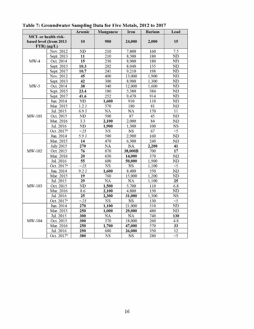
Table 7: Groundwater Sampling Data for Five Metals, 2012 to 2017Arsenic Manganese Iron Barium Lead
MCL or health risk- based level (from 2013
FYR) (iig/L)10 900 24,000 2,000 15
MW-4
Nov. 2012 ND 210 7,800 160 7.5Sept. 2013 11 210 8,500 180 NDOct. 2014 15 230 8,900 180 NDSept. 2015 10.3 202 8.040 155 NDSept. 2017 10.7 241 9,210 198 ND
MW-5
Nov. 2012 45 400 13,000 1,900 NDSept. 2013 42 300 8.900 1,300 NDOct. 2014 38 340 12,000 1,600 NDSept. 2015 23.4 180 5,380 384 NDSept. 2017 41.6 252 9.470 914 ND
MW-101
Jim. 2014 ND 1,600 910 110 NDMar. 2015 1.2 J 370 180 81 NDJul. 2015 6.9 J NA NA 170 11Oct. 2015 ND 500 87 45 NDMar. 2016 3.3 2,100 2,000 84 NDJul. 2016 ND 1,900 1.300 100 NS
Oct. 2017^ <25 NS NS 67 <5
MW-102
Jim. 2014 5.9 J 500 2,900 160 NDMar. 2015 14 470 6.300 240 NDJuly 2015 270 NA NA 2,200 41Oct. 2015 76 870 38,000B 700 17Mar. 2016 20 630 14,000 370 NDJul. 2016 55 600 50,000 1,900 ND
Oct. 2017^ <25 NS NS 1,100 <5
MW-103
Jim. 2014 9.2 J 1,600 8.400 550 NDMar. 2015 19 760 15,000 1,200 NDJul. 2015 29 NA NA 1,100 25Oct. 2015 ND 1,500 5,700 110 6.8Mar. 2016 8.6 2,100 4,800 150 NDJul. 2016 25 2,300 31,000 1,300 NS
Oct. 2017^ <25 NS NS 130 <5
MW-104
Jim. 2014 270 1,100 21,000 310 NDMar. 2015 250 1,000 29,000 480 NDJul. 2015 300 NA NA 740 130Oct. 2015 300 370 18,000 260 4.8Mar. 2016 250 1,700 47,000 570 33Jul. 2016 290 680 26,000 350 12
Oct. 2017^ 380 NS NS 280 <5
Arsenic Manganese Iron Barium LeadMCL or health risk-
based level (from 2013 FYR) Oig/L)
10 900 24,000 2,000 15
Jun. 2014 8.2 J 7,300 17,000 190 NDMar. 2015 2.7 4,200 6,300 580 NDJul. 2015 16 NA NA 1,100 17
MW-105 Oct. 2015 3.3 3,900 50,000 530 9.9Mar. 2016 10 4,000 130,000 2,700 NDJul. 2016 1.6 4,500 36,000 250 ND
Oct. 2017^ <25 NS NS 210 <5Notes:
a. The 2017 October Report uses a different numbering nomenclature for identifying monitoring well samples. This table assumes MW-1 in the report is the sample from well MW-101, MW-2 is from MW-102, MW-3 is from MW-103, MW-4 is from MW-104 and MW-5 is from MW-105
For samples with duplicates, the value recorded in this table is the higher of the two values.Bold = values that exceed the cleanup goal.Italics = detection limit is greater than cleanup goal.J = estimated valueNA = not analyzedNS = not sampledND = not detectedB = blank contamination Hg/L = micrograms per liter
KDEP’s 2016 Groundwater Report indicated that groundwater monitoring wells MW-102 and MW-103 continue to off-gas VOCs at levels of 100 percent of the LEL, thus making the use of electronic instruments down the monitoring well hole unsafe. The 2017 Groundwater Report indicates that low- flow sampling techniques would be accomplished using a bladder pump to avoid the possibility of igniting explosive gasses and to ensure the water was representative of actual groundwater conditions before sampling.
17
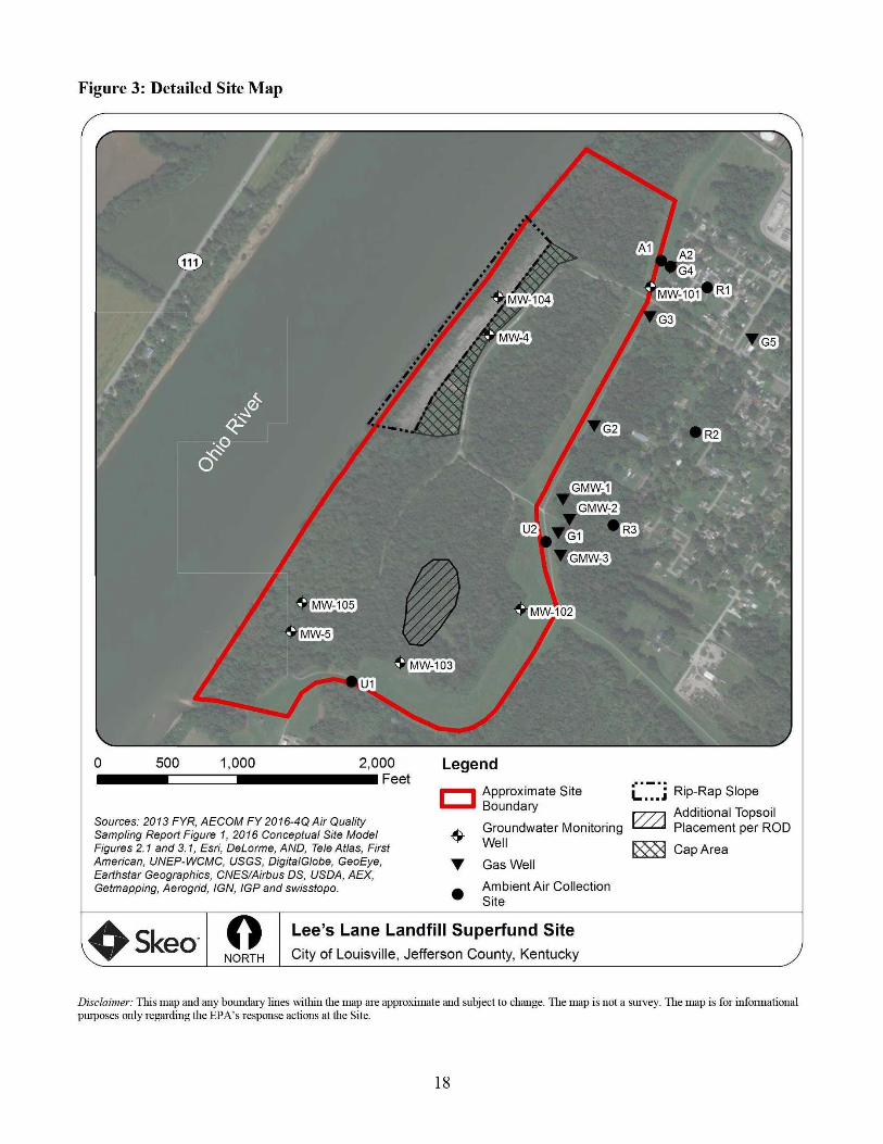
Figure 3: Detailed Site Map
m ■/
MW-105
% '■ - ■
m/. ' ;
•Bipi IB'- a.,-Cs‘?U>'
.4\ -r^Vv'■■' Cl' V
MW-1031
L:>
500 1,000 2,000Feet
LegendApproximate Site Boundary
Sources: 2013 FYR, AECOM FY 2016-4Q Air Quality Sampling Report Figure 1, 2016 Conceptual Site Model Figures 2.1 and 3.1, Esri, DeLorme, AND, Tele Atlas. First American. UNEP-WCMC, USGS, DigitalGlobe, GeoEye, Earthstar Geographies, CNES/Airbus DS, USDA, AEX, Getmapping, Aerogrid, IGN, IGP and swisstopo.
T
L... J R'P'Rsp Slope ryyy\ Additional Topsoil
Groundwater Monitoring Placement per RODWell
Gas Weil
Ambient Air Collection Site
[XXN Cap Area
keo NORTH
Lee’s Lane Landfill Superfund SiteCity of Louisville, Jefferson County, Kentucky
Disclaimer: This map and any boundary lines within the map are approximate and subject to change. The map is not a survey. The map is for informational purposes only regarding the EPA’s response actions at the Site.

Site InspectionTlie site inspection took place on 1 17 2018. Participants included EPA RPM Donna Seadler. KDEP project niiinager Jim Kirby, iind Johnny Zimmennan-Ward and Kirby Webster from Skeo (EPA PVR support contractor). Tlie puipose of the inspection was to assess the protectiveness of the remedy. Tlie site inspection checklist is included in .Appendix G. Site inspection photos are included in .Appendix H.
Tlie Site was accessed from Lee's Lane, which is peipendicular to the Site. .Access to the Site from Lee's Lane was restricted by a locked security gate. Tlie Site can also be accessed from the south. Tlie southern access is fenced, gated and controlled by Louisville Gas and Electric Company. Tlie Site is accessed frequently by MSD for maintenance as well as by pedestrians using the Louisville Loop Trail, the paved trail that traverses the levee along the eastern edge of the Site. Vehicle tratTic is limited, although all-teirain vehicle use appears to tiike place across the Site.
During the site inspection, piulicipiints toured the capped landfill iu*ea and rip-rap along the Ohio River, viewed the LEG collection system's wells and blower house, and drove tlu'oughout the Site to view groundwater siimpling wells and the status of site vegetation. Tlie Site was in good condition. Vehicle marks were noted in the snow. Trespassing and use of on-site trails has been reduced by MSD actions to intentionally reduce trespassing such as felling trees across trails. Potential reuse conversations are ongoing. MSD perfonns annual groundwater sampling at the Site and is responsible for site maintemince and inspections.
Site inspection participants visited the Site's document repositoiy . Shively Libraiy . located at 3920 Dixie Highway in Louisville. Kentucky. No documents related to the Site were identified at the library.
V. TECHNICAL ASSESSMENT
QUESTION .A: Is the remedy functioning as intended by the decision documents?
Question .A SunnnaiT:
Tlie review of documents, applicable or relevant and appropriate requirements, risk assumptions iind the site inspection indicate that the Site's remedy was constructed in accordance with the requirements of the Site's EnJbrcement Decision Document. Tlie LEG collection system function iind necessity are cuirently unknown. Due to low levels of methiine being detected over the last 10 years, the system should be shutdown but closely monitored for rebound for a period of time. Groundwater cleiinup goals have not been documented in a decision document. Tlie 2016 CSM review of groundwater data and data from new groundwater wells confinns that no groundwater remed\ is necessar\ and the cuirent monitoring is sulTicient. Tlie PRP Group prepared a 2016 CSM that summarized historical data iind reviewed issues brought up during the 2013 PVR. It recommends continuing inspections iind institutional controls in accordance with the Site's O&M Plan and giving consideration to additional vegetation. In addition, the source of the 1.3-butadiene and ciU'bon tetrachloride concentrations in soil gas needs to be identified.
KDEP's 2016 Groundwater Report indicated that groundwater monitoring wells MW-102 and MW-103 continue to otT-gas VOCs at levels of 100 percent of the LEE. thus making the use of electronic instruments down-hole unsafe. Tlie 2017 Groundwater Report indicates a bladder pump was used to avoid the possibility of igniting explosive gases.
Site conditions do not allow for unrestricted use. Institutional controls are needed to restrict the use of groundwater on the Site and to restrict land use.
QUESTION B: Are the exposure assumptions, toxicity data, cleanup levels and RAOs used at the time of the remedy selection still valid?
Question B Summary:
The exposure assumptions, toxicity data, cleanup levels and RAOs used at the time of the remedy selection are still valid. The EPA toxicity values for benzo[a]pyrene were revised in 2017, and thus the cancer risks shown in the 2016 carcinogenic polycyclic aromatic hydrocarbons would be about 7-fold lower based on the 2017 Integrated Risk Information System assessment. The risks were already within the EPA’s risk range, and now would be somewhat lower. Groundwater monitoring reports compare groundwater data to current MCLs, or risk-based screening levels. The 2016 CSM and 2017 Site Inspection Completion Report reviewed ecological and human health risk from exposure to soil for recreational users and trespassers.
The EPA completed a vapor intrusion study during this FYR period and determined that there are no unacceptable health risks from vapors migrating from beneath homes to indoor air. Vapors migrating from the landfill should probably be monitored periodically for some period of time to ensure that there continues to be no contribution to unacceptable risks from this exposure.
Trespassing has been an ongoing issue at the Site. Trespassing results in surface erosion and exposure of waste. Additional measures have been taken to discourage trespassers. Ongoing site inspections will determine if additional measures need to be taken.
QUESTION C: Has any other information come to light that could call into question the protectiveness of the remedy?
No other information has come to light that could call into question the protectiveness of the remedy.
VI. ISSUES/RECOMMENDATIONS
Issues/Recommendations
OU(s) without Issues/Recommendations Identified in the FYR:
None
Issues and Recommendations Identified in the FYR:
OU(s): 1 (sitewide)
Issue Category: Institutional Controls
Issue: Site conditions do not allow for unresfricted use.
Recommendation: Inclement groundwater and land use institutional controls.
Affect Current Protectiveness
Affect Future Protectiveness
PartyResponsible
Oversight Party Milestone Date
No Yes PRP EPA/State 7/1/2020
OU(s): 1 (sitewide)
Issue Category: Changed Site Conditions
Issue: Groundwater monitoring wells MW-102 and MW-103 were off-gassing VOCs at levels of 100 percent of the LEE in 2016.
Recommendation: Identify the source of VOCs and determine if additional measures need to be taken.
Affect Current Protectiveness
Affect Future Protectiveness
PartyResponsible
Oversight Party Milestone Date
No Yes EPA EPA 7/1/2020
OU(s): 1 (sitewide)
Issue Category: Changed Site Conditions
Issue: Airborne contamination (vapor intrusion) is not currently posing unacceptable health risks, but could do so if more contaminated vapors migrate from the landfill toward the residential neighborhood.
Recommendation: Monitor, for some period of time, the vapors migrating from the landfill toward the residential area.
Affect Current Protectiveness
Affect Future Protectiveness
PartyResponsible
Oversight Party Milestone Date
No Yes EPA EPA 7/1/2020
OTHER FINDINGSSeveral additional recommendations were identified during the FYR. These recommendations do not affect current and/or future protectiveness.
• Measures to reduce the frequency of trespassing would be helpful to limit long-term site management costs.
• Update the site repository with recent site documents and reports.• Identify the source of the 1,3-butadiene and carbon tetrachloride concentrations in soil gas.• Summarize current O&M activities in an updated O&M Plan.
VII. PROTECTIVENESS STATEMENT
Sitewide Protectiveness Statement
Protectiveness Determination:Shoi1-teiTn Piotective
Protectiveness Statement:The remedy at the Site currently protects human health and tlie env iionment because tliere are cunently no completed exposure patliways. However, in order for the remedy to be protective in tlie long teiTn. the following actions need to be taken: implement groundwater and land use institutional controls, identifv tlie source of \'(!)Cs and monitor soil vapor levels migrating from tlie landfill for eflect on shutdown, and for each of tliese. deteiTnine il'additional measures need to be taken.
VIII. NEXT REVIEW
Tlie next FVR Report for the Lee's Lane Landfill Superfund site is required five years from the completion date of this review.

APPENDIX A - REFERENCE LIST
AECOM. SummaiT .Anal\lical Report for .Ambient .Air and Gas Monitoring Siimpling Event 59. Lee's Lane Landfill site. July 18. 2016.
.AECOM. Summaiy .Anal\lical Report for .Ambient .Air and Gas Monitoring Siimpling Event 60. Lee's Lane Landfill site. Januaiy 5. 2017.
.AECOM. Summaiy .Anal\lical Report for .Ambient .Air and Gas Monitoring Siimpling Event 61. Lee's Lane Landfill site. July 25. 2017.
.AECOM. Summaiy .Anal\lical Report for .Ambient .Air and Gas Monitoring Siimpling Event 62. Lee's Lane Landfill site. December 21. 2017.
Certificate of .Analysis. Kentucky Depiulment of \Va.ste Management. Lees Liine LE Superfund Project. Date reported: November 18. 2015.
Close-Out Report for Deletion of Lee's Lane Landfill Site. Louisville. Kentucky. Ihiited States Environmental Protection .Agency. March 18. 1988.
Conceptual Site Model. Lee's Lane Landfill Site. Louisville. Kentucky. PrepiU'ed by Lee's Liine Landfill Group and the Louisville iind JetTerson County Metropolitiin Sewer District. .April 1. 2016.
fifth five-Year Review Report for Lee's Lane Landfill. Louisville. JetTerson County. Kentucky. Ihiited States Environmental Protection .Agency. Region 4. September 25. 2013.
Groundwater Siimpling Report October 2017 Sampling Event. Lee's Lane Landfill. Lee's Lane. Louisville. JetTerson County. Kentucky. Kentucky Depiulment for Environmental Protection. March 2018. Revision 2.
Lees Lane Landfill Groundwater Sampling Report March 15. 2016 Sampling Event. Prepared by federal Section. Superfund Branch. Division of Waste Miinagement. March 30. 2016.
Lees Lane Landfill Groundwater Sampling Report October 27. 2015 Sampling Event. PrepiU'ed by federal Section. Superfund Branch. Division of Waste Miinagement. Jiimuii'y 11. 2016.
Lees Lane Landfill Groundwater Sampling Report July 19. 2016 Siimpling Event. PrepiU'ed by federal Section. Superfund Branch. Division of Wa.ste Management. .August 30. 2016.
Pace .Anal\lical. .Annual Groundwater. Louisville and JetTerson Co MSD. September 21. 2017.
Record of Decision. EP.A Region 4. September 25. 1986.
Site Inspection Completion Report. Lee's Lane Landfill Site. Louisville. Kentucky. Prepared by Lee's Lane Landfill Group and the Louisville and JetTerson County Metropolitan Sewer District. July 27.2017.
.A-1
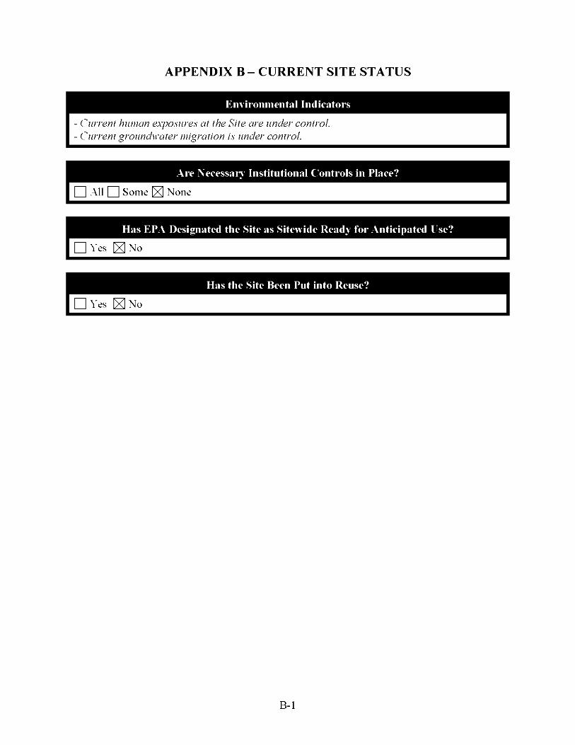
APPENDIX B- CURRENT SITE STATUS
En\ iroiuiiental Indicators
- Current huuan exposures at the Site are tinder control.- Current groundM'ater migration is under control.
Are Necessan Institutional Controls in Place?I O All Q Some ^ None
Has EPA Designated the Site as Sitewide Ready for Anticipated INe?I □ Yes ^ No
I □ Yes K NoHas the Site Been Put uito Reuse?
B-1

APPENDIX C - SITE CHRONOLOGY
Table C-1: Site Chronology
Event DateResidents complained of flash fires around water heaters due to migration of methane gas from the landfill
1975
The EPA conducted an initial site inspection November 1, 1978State installed the LEG collection system October 1980Landfill owners removed drums under court order September and October 1981The EPA proposed the Site for listing on the NPL December 30, 1982Site listed on the NPL September 8, 1983The EPA began the Site’s combined remedial investigation/feasibility study September 27, 1983State conducted preliminary assessment August 1, 1984The EPA completed health assessment November 25, 1985The EPA completed combined remedial investigation/feasibility studyThe EPA signed Enforcement Decision Document and the ROD
September 25, 1986
The EPA began the remedial actionThe EPA began the first removal action
March 16, 1987
The EPA began the remedial design March 20, 1987The EPA completed the remedial actionThe EPA completed the first removal action
October 27, 1987
The EPA completed the Site’s Close-Out Report March 18, 1988The EPA completed the remedial design March31, 1988The EPA began the second removal action September 14, 1988The EPA completed the second removal action September 27, 1988The EPA signed an AOC that transferred O&M responsibilities to MSD July 16, 1991The EPA signed Site’s first FYR Report May 25, 1993Consent decrees entered bv court August 4, 1993Oversight of MSD’s O&M activities transferred to Kentucky Environmental and Public Protection Cabinet
April 7, 1994
Site deleted from the NPL April 25, 1996Consent Decree entered by court January 9, 1997The EPA signed Site’s second FYR Report July 1, 1998The EPA signed Site’s third FYR Report July 2, 2003The EPA signed Site’s fourth FYR Report September 25, 2008The EPA signed Site’s fifth FYR Report September 25, 2013KDEP installed five new groundwater monitoring wells 2014Lee’s Landfill Group and MSD prepared a CSM April 1,2016Lee’s Lane Landfill Group and MSD prepared the Site Inspection CompletionReport
July 27, 2017
C-1

APPENDIX D - SITE MAPS
Figure D-1: 2011 and 2013 Soil Sampling Locations^
Leaend
4 -• \' caao ■-KTHSRnTMCT^
fmm.
:ERSIJ3EtGARDEN5^
m .J;*' y ’
• 2011 Soil Sample Locations• 2013 Soil Sample Locations• Screening Level Exceedance
I I Site Boundary
vi'i''-' -eE®-r—
iMii
r>^r'-'-
, • . v,( • ."•,
: ■V.'V'V'-.
mm./mikniQc NMt'Vnw'VdKcnliKKv.20M-US PWJtnw<tfWggtfV(V50A)HnrSgvrcgAgtncy,AqglPngtcgr^phyMBWOlw
''■■ ::.i' rk: -d0 SS 6S0 EpTS
CooniinstoSvsteni NAD 19H3 sale Plano Kwuety
FIPS 1fn0 Feel
LEE’S LANE LANDFILL LOUISVILLE. KY
2011 AND 2013 SOIL SAMPLE LOCATIONS
0B9257 Dec 1. 2015
FIGURE 4.1ms FR q<«wuecT8«aoi>n88asnijyquBwaio»M»7-ot(waiw www aiw
’ Figure 4.1 from the 2016 CSM.D-1
Figure D-2: Copy Summary of EPA Vapor Intrusion Results — November 2014^
UNIT 015W-2une2ai4
Semple * Locetlon 1.3-Bute t^D(!A 1239-0614-W24 CS 1.4 0.44 1
Vl-WoramberjOld 1I 2391114-OOSS FF 0.46 11 11 239-1114-OOS6 FF-CO 0.47J 0993 239-1114-OOS7 CS ao6i a066 1
239 1214-0070f
/* unitrao 1Vl-lune20U 1
samole U Location 1.3-Buia X4-DC6 1239-0614-0043 CS
0-04 U 78 1
lv'l-NoiV'nb«r20J4 1239-1114-0049 FF 0.11 18 1239-1114-C050
CS . OM. 1|So;i Go 5- OerembfrZ014 11 239-1214-0073 1 1 W 1 1 3] 1 o.ssu ■
lunilim
1W - AioireffllKr 2034
Sample P Location 1.3-Buta239-1114-0059 CS O0S3 IT A239-ni4-0060 CS-CO 0.061 K M23?-ni4-0^_ FF 1 014 TwJHI
|Soil Goi - CtKember 2D14 UK1 239-1314-0078 I SG
|28
__J
? rjf P. i ;
....fSf.:
Unitim
SoU Gas • DecembtrZOH
''03J^
iVT-lu/»2014
sample 4 location X3-Buta X2-OCA L4-0CB239-0614-003S CS ao4u C33 4.9
W - Wevember 2014239-1114-0061 FF 0.12 1.2 14239-1114-0062 CS 0.12 ao6i 0.2S
Soil Cos • December 2014239-1214-0072 SC 3S as2u 0.52 U
lample * Locaiion 1.3-Buta 1.2-DCA 1.4-DCS239-1214-0076 SG 56
27 U 27U
'si#
Uni(0(B V^-2unc2(U4
&l«ii Lomlon L2-0CA |239-0614-0X8 CS I.SW3-Movem6er2IM«
239-1114-0063 CS ftOSS239-1114-0064 FF 1.2
UNIT 032 Vl-ianeZin4 Sample* Location 1.3-Buta 1,4-DCB |239 0614-0047 AMB O.S2 13239-06144X146 SS 0.04 U 14 V7-lV0vember2O14
239-1114-0054 AMB 0.15 0.052Soil <901 ■ OKcrnlwr 2014
239'1214'0075 SO 2S 0.14U
Uf»nd
l,^Butt 1,3-But4(iin« FF Tint Floor1,2-OCA X2-0IUiloro«thane SO Soil GailADCB X4-OleMorob«fU«n« AMB AmbientBenz Benzene CS Crawl Space
Not Detected SS Sob-SlabResult units are in p£lm*Red indicates result emeeded saeenlng level
Analyle
17-Oicliloia ethane 13-R ulacbie
(4 OicWorobofueno Benaine
Screening Level Air (foi AMB. CS, FF)
oat2.6
31
Screer^mg Level .Soil Ces I
(lor SCendSS) I
4^' Sample s 1 Location 1.3-Buta Location 1.3-Buta 1.2-DCA Beni 1239-0614-0020 1 CS 2.S IP 239-0614-0008 CS 6.9 aes 1
W-NOwm6er20I4 -1 V’/-Wovernber2(n4 |239-1114-ODSl 1 CS ai3 239-1114-0066 FF 6.7 16 63 ■239-1114-0052 1 (F 0.98 ■J 239-1114-0068 CS 0.21 a097 0.59 H
ISeiiCei- 0eeatibef2024 A SoU Goi • Ommbec20141 239-m4-0078 1 S<3 1 1 0.69 239-1214-0077 SG 23 0.13U 42 n
Aene Knage. ESBI basemap imagny. Acqwsewn Dale wenoxn. Accessed 2CnS.
Cooidnete System NAO 1963 SUilePlane Kentucky
FIPS 1C00 Foet
LEE’S LANE LANDFILL LOUISVILLE. KY
COPY SUMMARY OF EPA VI RESULTS - NOVEMBER 2014
089257 Dec 1.2015
FIGURE 6.6on Fie. O.vaS>PROJECTa«9090>ya2$rAayDii>'<Ka«e»Sr-0l<0(l2)aiS4WW9jiDd
Figure 6.6 from the 2016 CSM.D-2
APPENDIX E - PRESS NOTICE
courier journalPART THE USA TODAY NETWORK
A GANNETT COMPANY
Advertiser:
EPA61 FORSYTH ST.
ATLANTA GA 30303
State of Wisconsin County of Brown
RE: Order # 0002783893
AFFIDAVIT OF PUBLICATIONLEGAL NOTICE
ATTACHED
Account#; 4045628502EPA Total Cost of the Ad: .506.78
I, of The Courier-Journal, a newspaper published and printed in the State of Kentucky, County of Jefferson, and having general circulation In the Countyof Jefferson, who being duly sworn, deposeth and saith that the advertisement of which the annexed is a true copy and has been published in the said newspaper, once in each issue as follows;
03/16/18
iff/M nA A (/^im(ASubscribed ^nd:
c>worn t^ 5
i/iftfore/ne this 16th dav of March. 2018
Notary P i ?lic
Commission expires
I /■ ^OTAftj. \ I
......
E-1

Ad»iimb«r: 0002783893 03/16/18
The U.S. Environmental Protec* tion Agency. Region 4
Announces the Sixth Five-Year Review for the Lee’s Lane Land*
fill Superfund Site, Louisville, Jefferson County,
KentuckyPurpose/Objective; The EPA is conducting a Five-Year Review of the remedy for the Lee's Lane Landfill Superfund site the Site) in Louisville, Kentucky,
"he purpose of the Five-Year Review IS to make sure the selected cleanup actions effectively protect human health and the environment.Site Background; The 112-acre Site is located in southwest Louisville, Kentucky, next lo the Ohio River. A sand and gravel quarry operated on site in the 1940s and 1950s. From the 1940s until 1975, a iandfill at the Site accepted domestic, commercial and industrial wastes. Landfill operations resulted in the contamination of groundwater, surface water, sediment, soil and air. The EPA placed the Site on the Superfund program’s National Priorities List (NPL) in 1983, Following cleanup, the EPA look the Site ofl the NPL in 1996. Cleanup Actions: The Site'slong-term remedy, selected in 1986, included gas and air monitoring to address the potential release of methane and hazardous gases. Groundwater monitoring established baseline conditions at the Site and sen/es as an early warning for any contamination migration. Ceanup efforts also put riprap in place to prevent erosion along the banks of the Ohio River, capped "hot spot” areas and removed exposed drums.Five-Year Review Schedule: The National Contingency Plan requires review of remedial actions that result in any hazardous substances, pollutants or contaminants remaining at the Site above levels that allow for unlimited use and unrestricted exposure every five years to ensure the protection of human health and the environment. The sixth of the Five-Year Reviews for the Site will be completed by September 2018.EPA Invites Community Participation in the Five-Year Review Process: The EPA is conducting this Five-Year Review to evaluate the effectiveness of the Site's remedy and to ensure that the remedy remains protective of human health and the envi-
E-3

ronment. As part of the Hive- Year Review process, ERA staff is available to answer any questions about the Site. Community members who have questions about the Site or the Five-Year Review process, or who would like to participate in a community interview, are asked to contact:Donna Seadter, ERA Remedial Rroject ManagerAngela Miller, ERA Community Involvement Coordinator Phone: (404) 562-8870Phone: (404) 562-8561 | (800) 241-1754 (toll-free)Email: [email protected]
Email: [email protected] Mailing Address: U.S. ERA Region 4, 61 Forsyth Street, S.W., 11th Floor, Atlanta. GA 30303- 8960A copw of the completed Five- Year Review will be made available at the Site’s local document repository, the Shively Branch of the Louisville Free Public Library. located at 3920 Dixie Highway in Louisville, Kentucky, and online at whttp://www.epa. gov/superfund/lee-iane-landlil.
E-4

APPENDIX F - INTERVIEW FORMS
Lee’s Lane LandHll Superfund Site Five-Year Review Interview FormSite Name: Lee’s Lane Landfill EPA ID No.: KYD980557052
Subject Name: Donna Seadler. RPM Affiliation: U.S. EPA. Region 4Subject Contact Information: [email protected]: 10:00 a.m. Date: 01/22/2018
Interview Format (circle one): Email
Interview Category: EPA Remedial Project Manager
1. What is your overall impression of the project, including cleanup, maintenance and reuse activities (as appropriate)?
Cleanup: From a Superfund perspective, looking at human health risk and ecological risk, it appears that work done under the cleanup was sufficient to manage the risk.
Maintenance: Louisville MSD has satisfactorily maintained the capped areas, wells, gas collection system, rip-rap, and signage at the site according to the 1991 agreement with EPA. MSD limits access via a locked gate, but the site is attractive to trespassers, who produce the primary maintenance issues at the site. MSD has also undertaken several measures not specifically required by the 1991 agreement, in order to deter the trespassers. These include installing a stretch of fencing (which was repeatedly cut through), and currently periodically felling trees across the site trails to limit accessibility.
Reuse: The site is located in a lovely riverfront location, and is adjacent to the Louisville Loop bicycle trail. If the city or state were willing to take ownership to develop a reuse, such as a recreational site, solar field or other appropriate use (or uses, since it’s 112 acres), then it would be an incredible asset not just to the immediate community but to the City as well. It would also remove the stigma associated with the landfill.
2. What have been the effects of this Site on the surrounding community, if any?
I cannot say what the impacts of the Site were on the surrounding community at the time the landfill was active, but at this time the landfill contains physical hazards from exposed solid waste and is an eyesore in certain places. Trespassing on the site is discouraged, but difficult to prevent due to the size and location. There is a stigma for the community from the landfill which will not end unless the site is given a positive reuse.
3. Are you aware of any complaints or inquiries regarding site-related environmental issues or remedial activities since the implementation of the cleanup?
This site received a Record of Decision (ROD) in 1986 and the cleanup was implemented in this time frame. I became the Remedial Project Manager (RPM) for the site in 2012.1 held a public meeting in July of 2012 to learn more about the public’s thoughts and at the time there were significant questions. However, as EPA and KDEP have worked to gather data and answer questions
F-1
with tact sheets, community meetings, and community infonnation sessions, very little is heiU'd from the community anymore.
4. What is your assessment of the cuirent perfonnance of the remedy in place at the Site?
I believe my iinswerto Question 1 responds to this.
5. .Aj*e you comfortable with the status of the institutional controls at the Site? If not. what are the associated outstanding issues?
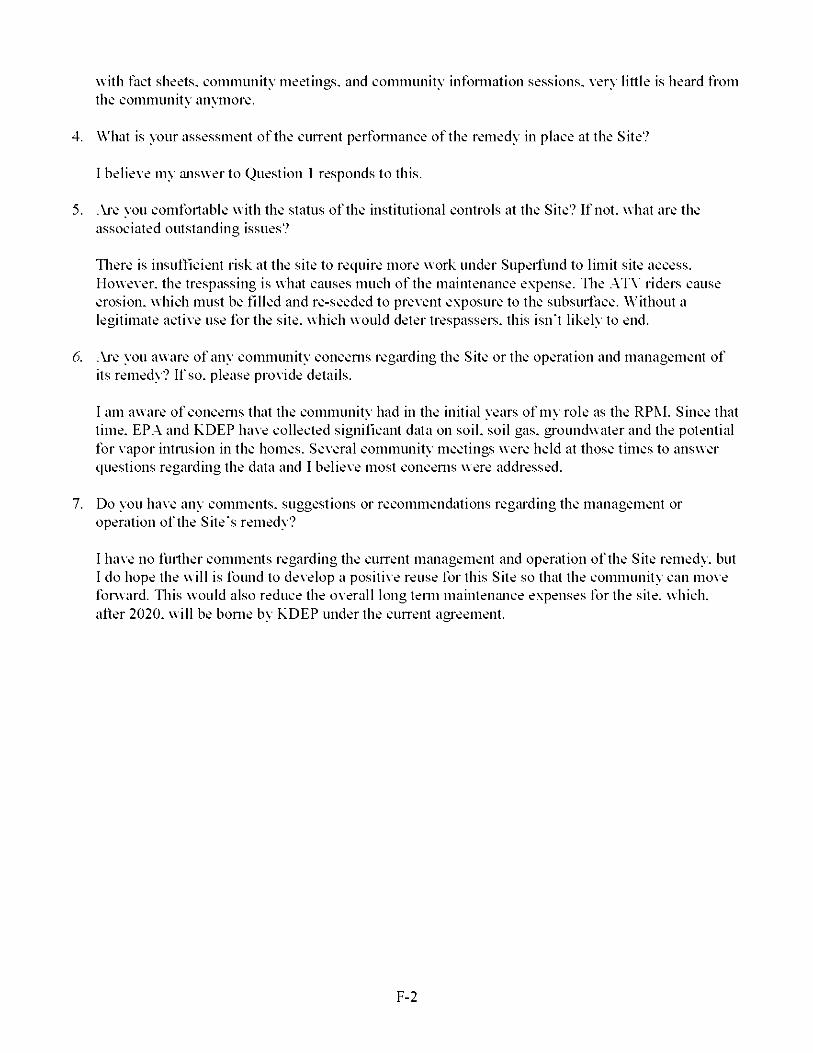
Tliere is insuITicient risk at the site to require more work under Superfund to limit site access. However, the trespassing is what causes much of the maintenance expense. Tlie .ATV riders cause erosion, which must be filled and re-seeded to prevent exposure to the subsurtace. Without a legitimate active use for the site, which would deter trespassers, this isn't likely to end.
6. .Aj*e you aware of any community concerns regiU'ding the Site or the operation and management of its remedy? If so. please provide details.
I am aware of concerns that the community had in the initial years of my role as the RPM. Since that time. EP.A and KDEP have collected significant data on soil, soil gas. groundwater and the potential for vapor intrusion in the homes. Several community meetings were held at those times to answer questions regiU'ding the data and I believe most concerns were addressed.
7. Do you have any comments, suggestions or recommendations regiU'ding the management or operation of the Site's remedy?
I have no further comments regarding the cuirent miinagement and operation of the Site remedy, but I do hope the will is found to develop a positive reuse for this Site so that the community can move fonvard. Tins would also reduce the overall long tenn maintemince expenses for the site, which, after 2020. will be borne by KDEP under the cuirent agreement.
E-2
Lee's Lane Landfill Superfund Site Five-Year Review Interview FormSite Name: Lee's Lane Landfill EPA ID No.: KVD980557052
Subject Name: Subject Contact Infonnation: Time: 04:30 p.iii.
Intei’\iew Format:
Ke\ ui Koporec Affiliation: U.S.EPA Region 4
Date: 02/16/2018
Intei’\ iew Categon: EPA
1. What is your overall impression of the project, including cleiinup. maintenance iind reuse activities (as appropriate)?
From my review of site reports and my few site visits, it appears to me that the cleiinup and maintenance of the site has progressed as planned. From my knowledge of the site, it doesn't really have a reuse yet other than being a closed hindfill. It would be ideal to have a reuse that involved iin owner or tenant being at the site regularly to keep trespassers from frequenting the site especially in areas of buried waste.
2. What have been the etTects of this Site on the suirounding community, if any?
Based on the chemical concentration data I have reviewed, there should not be any site-related adverse health effects for people who occasionally (once per month) trespass onto the site especially if they stay on the paved asphalt trail that is on the flood wall. [A risk evaluation was perfomied by a Responsible Party consultant with close oversight by IfS.EP.A and KDEP]
3. What is your assessment of the cuirent perfomiance of the remedy in place at the Site?
It appears to me that the buried waste has stayed where it was placed (as expected for a closed landfill). Despite the presence of locked gates at the paved entmnce and clear signage stating not to trespass onto the buried waste areas of the landfill, there appears to have been some erosion of vegetation soil cover caused by trespassers on .ATVs or on foot.
4. .Ai*e you comfortable with the status of the institutional controls at the Site? If not. what are the associated outstanding issues?
Tlie primaiy institutional controls should be to prevent development of the site as residential or other land uses which would have people on the landfill iu*eas of the site on a daily, chronic basis. .Also prevent use of groundwater for any use. Erom my observations of the site, these hind uses and groundwater uses are being appropriately prevented.
I do not know what ICs (if any) are fomially in place to prevent discourage trespassing onto the site, but as I stated above, it would be ideal to have a site owner or operator more present on the site in the future to help prevent trespassing. There has been some discussion between the PRPs iind the regulators that placement of strategic plants and or large tallen trees at openings to obvious trails can help to reduce trespassing into interior areas of the closed hindfill. Even though a low frequency of trespassing does not pose an unacceptable health risk, preventing trespassing altogether would reduce the need for site maintemince.
E-3
5. Do you have any comments, suggestions or recommendations regiU'ding the management or operation of the Site's remedy?
Ihitil this closed landfill site property is more regularly frequented by a site owner or tenant (that would help to prevent site trespassing), periodic inspection should continue to occur to look for erosion in iu*eas of buried waste, and to address those areas identified.
F-4

Lee's Lane Landfill Superfund Site Five-Year Review Interview FormSite Name: Lee's Lane Landfill EPA ID No.: KVD980557052
Subject Name: Subject Contact Infonnation: Time: 9:02 a.ni.
.Jim Kirbv Affiliation: Kentucky DEP.Jini.Kirbv'V>'kv.go\
Date: 3/22/18
Intei’\ ie>\ Format (circle one): In Person Phone MaU Other:
Intei’\ iew Categon: State
1. What is your overall impression of the project, including cleiinup. maintenance iind reuse activities (as appropriate)?
Lee's Lane Landfill has had numerous unresolved issues from the start. Access control measures are inadequate or nonexistent, (i.e. Tlie Louisville Loop triinsects the property). Tlie majority of the site does not have an engineered cap. but is covered in thick, shallow-rooted vegetation. Tlie etTiciency of the gas collection system is unknown. Tins site is not ready for reasonably anticipated reuse at this time.
2. What is your assessment of the cuirent perfonnance of the remedy in place at the Site?
Tlie remedy selected in the ROD was ALTERNATIVE 3 - SfTREACE WASTE AREA CLEANfiP. BANK PROTECTION CONTROLS. GAS COLLECTION AND VENTING SYSTEM. AND MONITORING. Tlie Gas Collection iind Venting System were working at 50®o etTiciency at that time. It is cuirently unclear how etTiciently the system is working. .Vs such it is uncleiu* what the cuirent perfonnance of the remedy is. .Additional sampling conducted after the last Eive Vein* Review produced soil gas concentrations which may indicate the remedy employed to mitigate vapor migration may not be sutTicient. Eurther assessment of the gas collection system should be conducted.
3. .Ai*e you aware of any complaints or inquiries regarding site-related environmental issues or remedial activities from residents in the pa.st five yeiU's?
Yes. Numerous complaints at public meetings and via emails.
4. Has your otTice conducted any site-related activities or communications in the past five years? If so. please describe the puipose and results of these activities.
Yes. Groundwater siimpling and soil sampling. Results have been provided under separate cover. We have had numerous communications with l^SEP.A technical issues iind the feasibility of redevelopment.
5. .Ai*e you aware of any chiinges to state laws that might aftect the protectiveness of the Site's remedy?
No.
6. .Ai*e you comfortable with the status of the institutional controls at the Site? If not. what are the associated outstanding issues?
E-5
No. .Aji Environmental Covenant should be in place and is not.
7. .Aj*e you aware of any cluinges in projected hind use(s) at the Site?
Tliere have been discussions about redeveloping the site: however, at this time there is no specific changes planned.
8. Do you have any comments, suggestions or recommendations regiU'ding the management or operation of the Site's remedy?
Tlie teclmical issues with the site should be addressed. Specifically a determination if the gas collection system needs to be updated or removed and a detennination of the source of the CiU'bon Tetrachloride vapors.
9. Do you consent to have your name included along with your responses to this questionnaire in the FVR report?
Yes.
F-6

Lee's Lane Landfill Superfund Site Five-Year Revie^Y Intervie^Y Form Site Name: Lee's Lane Landfill
Subject Name: Subject Contact Infonnation: Time: 10:04 am
Heather Dodds
EPA ID No.: KVD980557052
______ Affiliation: Louisville MSP5026898284 / lieatlier.dodds'Vrlouis\ illenisd.org
Date: 02/01/2018
lntei’\ ie>\ Format (circle one): In Person Phone MaU Other: email
lntei’\ iew Categon: O&M
1. What is your overall impression of the project, including cleiinup. maintenance iind reuse activities (as appropriate)?
Tlie project appears to have successfully improved conditions at the site.
2. What is your assessment of the cuirent perfonnance of the remedy in place at the Site?
Tlie project seems to be protective of humiin health iind the environment.
3. What iu*e the findings from the monitoring data? What are the key trends in contiiminant levels that are being documented overtime at the Site?
Methane continues to test below the LEL of 5®o. Groundwater quality has not cluinged significantly since the project was instituted.
4. Is there a continuous on-site O&M presence? If so. please describe stalT responsibilities and activities. .Alternatively, please describe stiilY responsibilities iind the frequency of site inspections and activities if there is not a continuous on-site O&M presence.
Site-specific monthly and quarterly inspections are scheduled iind perfomied. Monthly, the blower building is PM'd according to the O&M manual and documented in MSD's asset niiinagement system. Quarterly, a field inspection is conducted iind the results sent to l^SEP.A iind KDEP: iiny follow-up work required is documented in MSD's asset niiinagement system. .Additionally. MSD maintains the flood protection system in Louisville, including the levee which runs through the site and the flood pump station at the southern end of the site. MSD mainteniince and operations stafl' use the paved levee trail on top of the levee as access to the flood pump station and routinely report issues with the site when they are observed.
5. Have there been iiny significant chiinges in site O&M requirements, maintenance schedules or sampling routines since start-up or in the la.st five years? If so. do they aflect the protectiveness or eflectiveness of the remedy? Please describe chiinges and impacts.
No changes have been made.
6. Have there been unexpected O&M dilTiculties or costs at the Site since stiu1-up or in the last five years? U'so. please provide details.
E-7
Site security continues to be an issue. Details of evidence of trespassing have been provided in quailerly field observations.
7. Have there been opportunities to optimize O&M activities or sampling etTorts? Please describe changes and any resulting or desired cost savings or improved efficiencies.
O&M activities iind sampling etTorts continue in accordance with the O&M manual iind the agreed order.
8. Do you have any comments, suggestions or recommendations regiU'ding O&M activities iind schedules at the Site?
No.
9. Do you consent to have your name included along with your responses to this questionnaire in the FVR report?
Yes.
F-8
APPENDIX G- SITE INSPECTION CHECKLIST
FIVE-YEAR REVIEW SITE INSPECTION CHECKLIST
I. SITEINFORAUTIONSite Niinie: Lee's Lane Landfill Date of Inspection: i)l 17 2(il 8
Location and Region: Louis> ille, Kentucky 4 EPA ID: K\D980557052Agency, Office or Company Leading the Ei>e-Vear Re> iew: EPA Weather/Temperature: l(i degrees Fahrenheit
Remedy Includes: (crheck all that appK’)^ Landfill cover conlaimnenl ^ Access controls ^ Institutional controls I I Groundwater pump and treatment I I Surface water collection and treatment
I I Monitored natural attenuation I I Groundwater contaimnent I I \'ertical barrier walls
^ (!)ther: Groundwater monitoring and nronerK’ functioning uas collection s\’stem
Attachments: Q Inspection team roster attached I I Site map attached
II. INTERVIEWS (check all that appl\’)1. O&M Site Manager
Name TitleInten’iewed Q at site Q at office Q b\’phone Phone: Problems, suggestioas O Report attached:
Date
: O&M staffName Title
Inten’iewed Q at site Q at office Q b\’phone Phone: Problems suggestions Q Report attached:
Date
Local Regulators Authorities and Response Agencies (i.e.. state and tribal offices. emergenc\ response office, police department, office of public health or enviromnental health, zoning office, recorder of deeds, or other cit\’ and count}’ offices). Fill in all that appK’.
Agenc}’ KDEP (?ontact .Tim Kirb\’ 03 22 2018
Name Title DateProblems suggestions ^ Report attached: See Appendix F
Phone No.
Agenc}’(?ontact Name
Title Date Phone No.Problems suggestions Q Report attached:
Agenc}’(?ontact
Name TitleProblems suggestions Q Report attached:
Agenc}’(?ontact
Date Phone No.
Name TitleProblems suggestions O Report attached:
Asenc\’_____
Date Phone No.
G-1

(ronlacl _____ ____Name Title
Problems suggeslioas Q Report attached:Date Phone No.
4. Other Inter> lews (optional) CH Report attached:
Donna Seadler. EPA RPM: Kevin Koporec. EPA
Heather Dodds. MSD
III. ON-SITE DOCITMENTS AND RECORDS VERIFIED (check all that apply)
1. O&M Documents
1 1 (!)&M manual 1 1 ReadiK’ available □ Vp to date KiN A
1 1 As-built drawings 1 1 ReadiK’ available □ Vp to date IE|N A
1 1 Maintenance logs 1 1 ReadiK’ available □ Vp to date KiN A
Remarks: The (!)^&M Plan needs to be undated to reflect current site conditions.
Site-Specific Health iind Safety Plan
1 1 (?ontingenc\’ plan emergenc\’ response plan
Remarks:
1 1 ReadiK’ available
1 1 ReadiK’ available
□ Vp to date
□ Vp to date
KiN A
IE|N A
3. O&M and OSH.A Training Records 1 1 ReadiK’ available □ Vp to date IE|N A
Remarks:
4. Permits and Ser> ice Agreements
1 1 Air discharge pemiit 1 1 ReadiK’ available □ Vp to date IE|N A
1 1 Effluent discharge 1 1 ReadiK’ available □ Vp to date KiN A
1 1 Waste disposal. P(!)TW 1 1 ReadiK’ available □ Vp to date IE|N A
1 1 (!)ther permits: 1 1 ReadiK’ available □ Vp to date IE|N A
Remarks:
5. Gas Generation Records 1 1 ReadiK’ available □ Vp to date IE|N A
Remarks:
6. Settlement Monument Records 1 1 ReadiK’ available □ Vp to date IE|N A
Remarks:
7. Groundwater Monitoring Records 1 1 ReadiK’ available □ Vp to date IE|N A
Remarks:
S. Leachate Extraction Records 1 1 ReadiK’ available □ Vp to date IE|N A
Remarks:
9. Discharge Compliance Records
1 1 Air Q ReadiK’ available □ Vp to date IE|N A
□ Water (effluent) □ ReadiK’ available □ Vp to date IE|N A
Remarks:
10. Daily .Access/Security Logs 1 1 ReadiK’ available □ Vp to date IE|N A
G-2

Remarks:
r\ . O&M COSTS
O&M Organization
I I Stale in-house
I I PRP in-house
I I Federal tacilil\’ in-house
M MSP
I I cronlraclor for stale
□ (?ontractor for PRP
I I cronlraclor for Federal facilil\’
O&M Cost RecordsI I ReadiK’ available Q l^p to dale
I I Funding mechanism agreement in place Q ITnavailable
(!)riginal (!)&M cost estimate: Q Breakdown attached
Total annual cost b\’ \’ear for review period if available
From: 01 01 2013 To: 1231 2013 S63.000 1 1 Breakdown attached
Date Date Total cost
From: 01 01 2014 To: 1231 2014 S77.000 1 1 Breakdown attached
Date Date Total cost
From: 01 01 2015 To: 1231 2015 SI 47.000 1 1 Breakdown attached
Date Date Total cost
From: 01 01 2016 To: 1231 2016 S69.000 1 1 Breakdown attached
Date Date Total cost
From: 01 01 2017 To: 1231 2017 S75.000 1 1 Breakdown attached
Dale Dale Total cost
3. Ihianticipated or Ihiusually High O&M Costs during Re> iew PeriodDescribe costs and reasons: The increased costs in 2(il5 are primariK’ associated with the preparation of
the CSM.
V. ACCESS AND INSTITUTIONAL CONTROLS [^Applicable DNA
A. Fencing
1. Fencing DoimigedRemarks:
I I Location shown on site map ^ Gales secured I I N A
B. Other Access Restrictions
1. Signs and Other Security Measures O Location shown on site map
Remarks: Siunaue is in good condition and widespread.
□ N A
C. Institutional Controls (ICs)
G-3

Iniplenientiition ;ind EnforcenientSite conditions impK’ K7S not proper!}’ implemenled
Site conditions imp!}’ K7S not being full}’ enforced
T\’pe of monitoring (e.g.. self-reporting, drive b\’): _ Frequenc}’:Responsible part}’ agenc}’:
(?ontact
□ Yes □ No ^ N A
□ Yes □ No ^ N A
Name Title Date Phone no.
Reporting is up to date □ Yes □ No □N A
Reports are verified b}’ the lead agenc}’ □ Yes □ No □ naSpecific requirements in deed or decision documents have been met □ Yes □ No □ na\’iolations have been reported □ Yes □ No □ na(!)ther problems or suggestions: Q Report attached
2. .Adequacy □ K2S are adequate □ K2S are inadequate | | N .A
Remarks: Restrictions nrohibitinu the development of the landfill for residential purposes are necessar\’.
D. General
1. X’andallsm/Trespassing □ Location shown on site map □ No vandalism evident
Remarks: Trespassing is evident sitewide.
2. Land INe Changes On Site I IN .A
Remarks: None.
3. Land INe Changes Off Site I IN .A
Remarks: None.
\1. GENERAL SITE CONDITIONS
.A. Roads □ .Applicable I IN .A
1. Roads Damaged □ Location shown on site map □ Roads adequate I I N .A
Remarks:
B. Other Site Conditions
Remarks:
\TL L.ANDFILL COVERS □.Applicable □NA
.A. Landfill Surface
Settlement (low spots) O Location shown on site map
.Area extent:
I I Settlement not evident
Depth:
Remarks: The capped area is well maintained. Historical landfill is wooded with uneven ground surface.
Cracks
Lengths:
Remarks:
I I Location shown on site map
Widths:
(?racking not evident
Depths:
G-4

3. Erosion 1 1 Location shown on site map ^ Erosion not evident
.Area extent: Depth:
Remarks:
4. Holes 1 1 Location shown on site map ^ Holes not evident
.Area extent: Depth:
Remarks:
5. \’egetiitl> e Co> er ^ Grass ^ (?over proper!}’ established
1 1 No signs of stress 1 1 Trees shrubs (indicate size and locations on a diagram)
Remarks: Historical landfill soil cover was not nronerK’ established. Material from historical dumninuhas been uncovered.
6. .AlteriiiitBe Co>er (e g . armored rock, concrete) □ N A
Remarks: Rip-rap slope IS functioning as designed.
7. Bulges 1 1 Location shown on site map ^ Bulges not evident
.Area extent: Heiuht:
Remarks:
S. Wet .AreosAViiter Doimige ^ Wet areas water damage not evident
1 1 Wet areas 1 1 Location shown on site map .Area extent:
1 1 Ponding 1 1 Location shown on site map .Area extent:1 1 Seeps 1 1 Location shown on site map .Area extent:
1 1 Soft subgrade 1 1 Location shown on site map .Area extent:
Remarks:
9. Slope InstobIMty 1 1 Slides 1 1 Location shown on site map
^ No evidence of slope instabilit\’
.Area extent:
Remarks:
B. Benches O .Applicable ^ N .A
(HorizontalK’ constructed mounds of earth placed across a steep landfill side slope to interrupt the slope in order to slow down the velocit\’ of surface runoff and intercept and conve\’ the runoff to a lined channel.)
1. Flows Bsposs Bench 1 1 Location shown on site map 0 N .A or oka\’
Remarks:
Bench Breached 1 1 Location shown on site map 0 N .A or oka\’
Remarks:
3. Bench O>ertopped 1 1 Location shown on site map □ N .A or oka\’
Remarks:
C. Letdown Chiinnels I I Applicable ^ N A
((rhannel lined with erosion control mats, riprap, grout bags or gabions that descend down the steep side slope of the cover and will allow the runoff water collected b\’ the benches to move off of the landfill
G-5
cover w’ithout creating erosion gullies.)
1. Settlement (Low’ spots)
.Area extent:
Remarks:
1 1 Location show’n on site map 1 1 No evidence of settlement
Depth:
Material Degradation
N’laterial t\’ne:
Remarks:
1 1 Location show’n on site map 1 1 No evidence of degradation
.Area extent:
3. Erosion
.Area extent:
Remarks:
1 1 Location show’n on site map 1 1 No evidence of erosion
Depth:
4. Ihidercutting
.Area extent:
Remarks:
1 1 Location show’n on site map 1 1 No evidence of undercutting
Depth:
Obstructions T\pe:
I I Location shown on site map
Size:
Remarks:
I I No obstructions
.Area extent:
Excessbe X’egetatbe Growth T\ pe:
I I No evidence of excessive growth
I I \'egetation in channels does not obstruct flow
I I Location shown on site map .Area extent:
Remarks:
D. Co> er Penetriitlons ^ .Applicable ^ N .A
1. Giis \’ents I I .Active
I I ProperK’ secured locked O Functioning
I I Evidence of leakage at penetration
Remarks: Not present in capped area.
I I Passive
I I Routine!}’ sampled O Good condition
I I Needs maintenance I I N .A
Giis Monitoring ProbesI I Proper!}’ secured locked Q Functioning
I I Evidence of leakage at penetration
Remarks: Not present in capped area.
I I Routine!}’ sampled
I I Needs maintenance
I I Good condition
□ na
Monitoring Wells (Avithin surface area of landfill)
Proper!}’ secured locked Q Functioning Q Routine!}’ sampled ^ Good condition
I I Evidence of leakage at penetration Q Needs maintenance I I N .A
Remarks:
Extriiction Wells LeiichiiteI I Proper!}’ secured locked Q Functioning Q Routine!}’ sampled Q Good condition
G-6
I I Evidence of leakage at penetration
Remarks:
I I Needs maintenance ^ N A
5. Settlement Monuments
Remarks:
I I Located n Routine!}’ sun’e\’ed ^ N A
E. Gas Collection and Treatment ^Applicable | | N A
Remarks: Gas collection s\’stem is present and operating, but effectiveness of function is uncertain.
1. Gas Treatment Facilities
□ FlaringI I Good condition
Remarks:
I I Thermal destruction
I I Needs maintenance
I I crollection for reuse
Gas Collection Wells, Manifolds and PipingI I Good condition Q Needs maintenance
Remarks:
3. Gas Monitoring Facilities (e.g.. gas monitoring of adjacent homes or buildings)
I I Good condition Q Needs maintenance I I N A
Remarks:
F. Co>er Drainage Layer 1 1 .Applicable □ N A
1. Outlet Pipes Inspected
Remarks:
1 1 Functioning □ na
2. Outlet Rock Inspected
Remarks:
1 1 Functioning □ na
G. Detention/Sedimentation Ponds 1 1 .Applicable □ N A
1. SMtation .Area extent:
I I Siltation not evident
Remarks:
Depth: □ N A
Erosion .Area extent:
I I Erosion not evident
Remarks:
Depth:
3. Outlet Works
Remarks:
I I Functioning □ na
4. Dam
Remarks:
I I Functioning □ na
H. Retaining Walls I I .Applicable □ N .A
1. Deformations □ Location shown on site map I I Deformation not evident
Horizontal displacement:_____ \’ertical displacement:
Rotational displacement:
Remarks:
G-7
Degradation
Remarks:
1 1 Location shown on site map 1 1 Degradation not evident
I. Perimeter Ditches/Off-Site Discharge 1 1 Applicable IEIn.a1. Siltation 1 1 Location shown on site map 1 1 Siltation not evident
.Area extent: Depth:
Remarks:
\’egetati> e Growth 1 1 Location shown on site map □ N A1 1 \'egelalion does not impede flow
.Area extent: Type:
Remarks:
3. Erosion 1 1 Location shown on site map 1 1 Erosion not evident
.Area extent: Depth:
Remarks:
4. Discharge Structure 1 1 Functioning □ naRemarks:
\in. \ ERTICAL BARRIER WALLS □ Applicable IE|N A1. Settlement 1 1 Location shown on site map 1 1 Settlement not evident
.Area extent: Depth:
Remarks:
Perforniiince Monitoring T\ pe of monitoring:
I I Performance not monitored
Frequenc}’:
Head differential:
Remarks:
I I Evidence of breaching
IX. GROUNDWATER/SITRFACE WATER REMEDIES ^ Applicable □ N A
A. Groundwater Extraction Wells, Pumps and Pipelines I I Applicable ^ N A
1. Pumps, Wellhead Plumbing and ElectricalI I Good condition O All required wells proper!}’ operating O Needs maintenance I I N A
Remarks:
Extraction System Pipelines, \’al>es, \’al>e Boxes and Other AppurtenancesI I Good condition O Needs maintenance
Remarks:
3. Spare Parts and EquipmentI I Readil}’ available Q Good condition
Remarks:
I I Requires upgrade Q Needs to be provided
B. Surface Water Collection Structures, Pumps and Pipelines O Applicable ^NA
G-8

1. Collection Structures, Pumps ;ind ElectricolI I Good condition O Needs maintenance
Remarks:
Surface Water Collection System Pipelines, \’al> es, \’al> e Boxes and Other AppurtenancesI I Good condition O Needs maintenance
Remarks:
3. Spare Parts and EquipmentI I ReadiK’ available Q Good condition
Remarks:
I I Requires upgrade Q Needs to be provided
C. Treatment System I I Applicable ^ N A
Treatment Train (check components that appK’)
I I Metals removal Q (!)il water separation
I I .Air stripping Q (?arbon adsorbers
□ Filters:
I I .Additive (e.g.. chelation agent, flocculent):
I I (!)thers:
I I Good condition Q Needs maintenance
I I Sampling ports proper!}’ marked and functional
I I Sampling maintenance log displa\’ed and up to date
I I Equipment proper!}’ identified
I I (i^uantit}’ of groundwater treated annual!}’:
I I (i^uantit}’ of surface water treated annual!}’:
Remarks:
I I Bioremediation
Electrical Enclosures and Panels (proper!}’ rated and functional)
n N .A n Good condition Q Needs maintenance
Remarks:
Tanks, V aults, Storage Vessels
n N .A n Good condition
Remarks:
I I Proper secondary’ contaim’nent Q Needs I’naintenance
Discharge Structure and .Appurtenances
n N .A n Good conditionRei’narks:
I I Needs I’naintenance
Treatment Building(s)0 N .A O Good condition (esp. roof and doorwa}’s)
1 I (rhemicals and equipment proper!}’ stored
Remarks:
I I Needs repair
6. Monitoring Wells (pump and treatment reined}’)
G-9
0 ProperK’secured locked O Functioning O RoulineK’sampled 1 1 Good condition
1 1 All required wells located O Needs maintenance 1 1 N A
Remarks:
D. Monitoring Data
1. Monitoring Data^ Is routineK’ submitted on time ^ Is of acceptable qualit\’
2. Monitoring Data Suggests:^ Groundwater plume is effectiveK’ contained ^ (?ontaminant concentrations are declining
E. Monitored Natural Attenuation1. Monitoring Wells (natural attenuation remed\’)
n Proper!}’secured locked Q Functioning Q Routine!}’sampled 1 1 Good condition
1 1 All required wells located Q Needs maintenance ^ N A
Remarks:X. OTHER REMEDIES
If there are remedies applied at the site and not covered above, attach an inspection sheet describing the ph}’sical nature and condition of an\’ facilit\’ associated with the remed\’. .An example would be soil vapor extraction.
XL OVERALL OBSERV ATIONS.A. Iniplenientation of the Remedy
Describe issues and obsen’ations relating to whether the rented}’ is effective and functioning as designed. Begin with a brief statement of what the rented}’ is designed to accomplish (e.g.. to contain contaminant plume, minimize infiltration and gas emissions).The rented\’ was designed to monitor uroundwater and air contamination and collect LFGs. Groundwater, soil uas and air monitoring are onuoinu.
B. .Adequiicv of O&MDescribe issues and obsen’ations related to the implementation and scope of (!)^&NI procedures. In particular, discuss their relationship to the current and long-term protectiveness of the rented}’.N’ISD conducts (!)^&NI activities adeauateK’. The (!)^&NI Plan needs to be updated to reflect current site conditions.
C. Eiirlv Indicators of Potential Remedy ProblemsDescribe issues and obsen’ations such as unexpected changes in the cost or scope of (!)^&NI or a high frequenc}’ of unscheduled repairs that suggest that the protectiveness of the rented}’ itta}’ be compromised in the future.None.
D. Opportunities for OptimizationDescribe possible opportunities for optimization in monitoring tasks or the operation of the rented}’. (!)nuoinu discussions include opportunities for optimization.
G-10
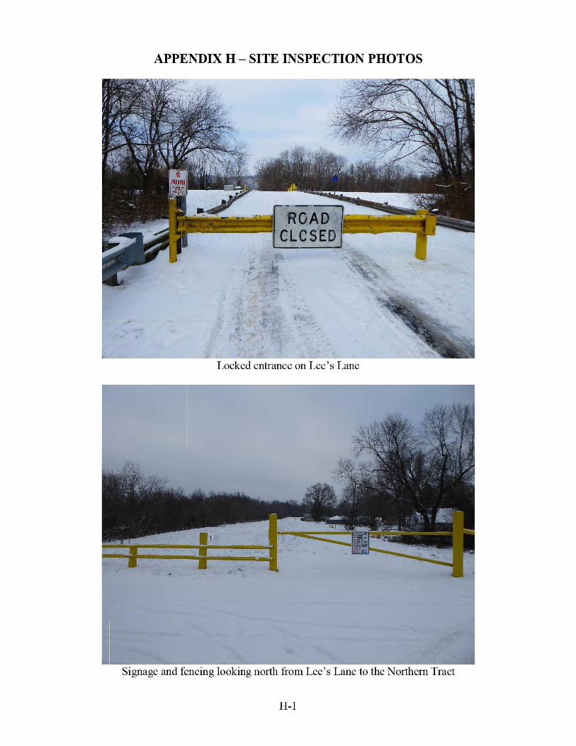
APPENDIX H - SITE INSPECTION PHOTOS
CLOSED
S ^ '-4 ji. ■ \Locked entrance on Lee’s Lane
Ff TT
.. ■»^,"
Signage and fencing looking north from Lee’s Lane to the Northern Tract
H-1

Capped area with Ohio River beyond rip-rap and tree line
^ IlM ^ I
«iil:Jikl
'4^Signage and trespassing trail on the northern end of the Central Tract
H-2

LHES LANE LANDFILL ERA SUPERFliND SITE
CAUTION, HAZ;,;<DS MAY BT PRESENTNO TRESPASSING
I " ‘A,-/■%'r- *- ®.iLi''0
Example of site signage
..V- n,. .■ • "...
.. •■ - -'«5 . ■ • • ■
'■a'4 '■
Monitoring well on capped area with Ohio River beyond the tree line
H-3

til mi
wmSa
»" 'S
iiiiis
Trail on the Central Tract, seen from the southern end of the Central Tract
H-4

■F
Eastern side of the Southern Tract, seen from the levee
r fM
C :.r
T**. ' *; ;• • ’M'A
*v r---» V i -HiJH i|:'i W:.'_‘-Jj;V|»Hi'?-' " -!5r^.^w
-- -■;
' !■*'
* I . I ~ ••
-T:' '■
Blower house for gas extraction system near Lee’s Lane, on northeast comer of the Central Tract
H-5

"1W'? 'V •
Wrr ; ■/
Louisville Loop on levee looking south from Lee’s Lane; Site on right with Louisville Gas & Electricstack in background
H-6

APPENDIX I - ADDITIONAL SITE BACKGROUND INFORMATION
In 1971. Kentucky pennitted the Southern Tract of the landfill under its Solid Waste Progmin.
Tlie EPA identified approximately 30 PRPs. Tliis list of PRPs includes MSD. In November 1978. the Surveilhince iind .Analysis Division of the Kentucky Division of Waste Management collected samples from residential wells in Riverside Gardens to detennine the potential elTects of the landfill on groundwater quality. .As a result of the study, the Division reported that there was no indication of contaminated groundwater migration from the hindfill to the residential wells near the landfill.
Between 1975 iind 1979. 44 gas observation wells were installed in and iu'ound the landfill and in Riverside Gardens. Samples from these wells indicated that the source of the methiine and associated toxic gas was the decomposition of landfill wa.stes.
In eiU'ly 1981. the Kentucky Natural Resources iind Environmental Protection Cabinet installed 11 shallow groundwater monitoring wells at the Site. Tlie EP.A later siimpled five of these wells. .Analyses of the samples indicated that on-site groundwater contained inorgiinic contaminants, including arsenic, lead iind chromium, at elevated concentrations. However, the results were believed to be alTected by the presence of sediment in the wells, apparently due to improper well installation.
During the Site's remediation investigation and feasibility study, the EP.A developed a public health assessment (PH.A) in 1985. It concluded that the priniiU'y public health concern at the Site was elevated clu'omium levels found in on-site groundwater. It also concluded that there was no evidence of an offsite public health or environmental problem related to the Site at that time. The PH.A did not indicate the need for groundwater remediation. It did identify the need for long-temi groundwater monitoring and ambient air monitoring to establish baseline conditions and to serve as an eiU'ly detection system if site conditions chiinged. Tlie PH.A recognized that the existing gas collection system was mitigating gas migration while noting the potential need for system repair or replacement. Tlie PH.A recommended implantation of a routine subsurtace gas monitoring prognim outside the collection system and in Riverside Gardens (the residential iu*ea to the east of the Site). Tlie PH.A also noted that unless access to the Site was controlled, surtace wa.stes should be removed and soils containing elevated levels of clu'omium and lead should be covered.
Tlie EP.A's 1986 Remedial Investigation Report described contiiniinant distribution as follows:
• On-site surtace water contained veiy low levels of contiiniinants.• On-site soils and sediments were siniihu* to the otT-site background sample collected in Riverside
Gardens, suggesting the use of local soils as cover material. In two iu*eas where "hot spot" soil samples were collected, the estimated concentrations of lead and clu'omium were 2.000 mg kg each. These areas were located along the access road in the Central Tract and are believed to be the result of indiscriminate dumping, since the concentrations found were not representative of overall soil concentrations. Soil siuiiples were collected to identify contaminants posing direct contact and runolT hazards. Eight of the 11 soil sampling locations were selected because the surtace was crusted, discolored or moist, or because the iu*ea showed iui obvious lack of vegetation.
• On-site groundwater contained low levels of organic compounds and some inorgiuiic contaminants. The major inorgiuiic contaniimuits included arsenic (87 micrograms per liter, or pg L). barium (1.100 pg L). cadmium (22 pg L). chromium (640 pg L). lead (150 pg L). manganese (44.000 pg L) and iron (190.000 pg L). The otT-site concentrations of these
I-l

contaminants were all below the MCL set in the Interim Primaiy Drinking Water Regulations. Two metal contamimints - manganese and iron - were found at levels above MCLs. Miinganese was detected at 610 ^g L in the Louisville Gas and Electric well iind at 370 ^g L in iin Indiana public water supply well. Ii'on was detected at 8.900 pg L in an Indiana public water supply well, but was below background in both industrial wells. Neither manganese nor iron is considered to have significant health elTects.
Because of community concerns regiU'ding health issues, the .Agency for Toxic Substiinces iind Disease Registry requested that the Kentucky Depailment for Public Health review cancer morbidity rates in the area suirounding the Site in .August 2011. Tlie Kentucky Depailment for Public Health review looked at ciincer rates from 1999 to 2008 in the 40216 zip code. Zip code 40216 covers over 14 square miles in JetTerson County, of which a small portion is Riverside Gardens. Based on 2000 Census data, approximately 2.074 cases of cancer would be expected. The number of cancers observed was 2.963.Tlie Centers for Disease Control and Prevention guidelines recommend an expected cancer exceedance rate of 2 to 3 times before iin environmental investigation is considered. Tlie ratio in this case was 1.43. While somewhat elevated, it did not meet the threshold for further investigation.
1-2