sj figure1 location02 - santa clara county, california -...
TRANSCRIPT

·|}þ87
·|}þ17
·|}þ237
§̈¦880
§̈¦680
§̈¦680
§̈¦280
tu101
San Jose International AirportLocation Map
Figure 1


SAN JOSE
MILPITAS
SAN JOSE
SAR
ATOG
A
SAN JOSE
CAMPBELL
SAN JOSE
SAN
TA C
LAR
ASU
NN
YVA
LE
SANTA CLARASAN JOSE
SUNNYVALE
§̈¦680
§̈¦280
§̈¦880
EL CAMINO REAL
BERRYESSA RD
HEDDING ST
ALM
ADEN
EXPY
SIERRA RD
LAW
RE
NC
E E
XP
Y
MONTEREY RD
PIEDMONT RD
CENTRAL EXPY
CALAVERAS BLVD
SAN
TOM
AS EX
PY1ST
ST
QU
ITO R
D
·|}þ85
·|}þ17
·|}þ87
·|}þ237
(/101
FlightpathsFlightpath
Runway
±0 5,000 10,0002,500Feet
This map created by Santa Clara County Planning Office. The GIS data was compiledfrom various sources. While deemed reliable, the Planning Office assumes no liability.
4/7/2009 - Y:\Matt\ALUC\projects\SJ\SJ_figure3a_flights_v1.mxd
San Jose International Airport
Aircraft Flight TracksFigure 3a

§̈¦680
§̈¦880
§̈¦280
1ST ST
MARKET ST
BERRYESSA RD
ALM
ADEN
EXPY
SIERRA RD
HEDDING
ST
MONTAGUE EXPY
STEVENS CREEK BLVD
LAW
REN
CE
EXPY
CENTRAL EXPY
SAN
TOM
AS EX
PY
EL CAMINO REAL
(/101
·|}þ237
·|}þ17
·|}þ87
MILPITAS
SAN JOSE
CAMPBELL
SA
N JOSE
SAN
TA C
LAR
ASU
NN
YVA
LE
SANTA CLARA
SAN JOSE
FlightpathsFlightpath
Runway
±0 5,000 10,0002,500Feet
This map created by Santa Clara County Planning Office. The GIS data was compiledfrom various sources. While deemed reliable, the Planning Office assumes no liability.
4/7/2009 - Y:\Matt\ALUC\projects\SJ\SJ_figure3b_flights_v1.mxd
San Jose International Airport
Aircraft Flight TracksFigure 3b

SANTA CLARA
SAN
JOSE
±0 4,000 8,0002,000
Feet
This map created by Santa Clara County Planning Office. The GIS data was compiledfrom various sources. While deemed reliable, the Planning Office assumes no liability.
1/25/2010 - Y:\Matt\ALUC\projects\SJ\SJC_figure4a_landuse_SJ04.mxd
San Jose International Airport
General Plan Land UseCity of San Jose
Figure 4a
General Plan Land Use Designations
" " " " "
" " " " "
" " " " " Industrial Park
Industrial Park/General Commercial
Industrial Park/Preferred Hotel Site
No Underlying Designation
XW XW XW
XW XW XWPublic Park and Open Space
XW XW XW
XW XW XW
XW XW XW
XW XW XWXW XW XWXW XW XW
Public/Quasi-Public
General Commercial
) ) ) )
) ) ) )
) ) ) )
Neighborhood/Community Commercial
Medium Low Density Residential (8.0 DU/AC)
" " " " "
" " " " "
" " " " "
Medium Density Residential (8-16 DU/AC)
Medium High Density Residential (12-25 DU/AC)
High Density Residential (25-50 DU/AC)
Residential Support for the Core Area (30+ DU/AC)
Transit Corridor Residential (30+ DU/AC)
Transit Corridor Residential (25-65 DU/AC)
Transit Corridor Residential (25-65 DU/AC)/General Commercial
Office
Core Area
Industrial Core Area
Combined Industrial/Commercial
Light Industrial
" " " " "
" " " " "
" " " " "
Heavy Industrial

§̈¦8
·|}þ87
STEN
CE
EX
PY
CENTRAL EXPY
EL CAMINO REAL
THE ALAMEDA
SAN
TOM
AS EX
PY
HEDDING ST
MONTAGUE EXPY
LAW
RE
NC
E E
XP
Y
MILPITAS
SAN JOSE SAN JOSE
SAN
TA C
LAR
ASU
NN
YVA
LE
SAN
TA C
LARA SA
N JO
SE
SUNNYVALE
§̈¦880
(/101
·|}þ237
·|}þ87
±0 4,000 8,0002,000
Feet
This map created by Santa Clara County Planning Office. The GIS data was compiledfrom various sources. While deemed reliable, the Planning Office assumes no liability.
4/15/2009 - Y:\Matt\ALUC\projects\SJ\SJC_figure4b_landuse_SC02.mxd
San Jose International Airport
General Plan Land UseCity of Santa Clara
Figure 4b
General Plan Land Use Designations
YYYYYYYYY
Education
((((((((Gateway Thoroughfare
) ) )
) ) )
Community & Regional Shopping
Y Y YY Y YY Y YY Y YMixed Use
Single Family Detached (8 DU/Acre Max)
" " " "
" " " " Single Family Attached (16 DU/Acre Max)
Moderate Density Residential (25 DU/Acre Max)
High Density Residential
Institutional
Industrial Transition
Light Industrial
" " " "
" " " " Heavy Industrial
None
Office/Research & Development
Open Space
XW XW
XW XW XWParks & Recreation
Tourist Commercial
" "
" "
" "
" "
" " Transit-Oriented Mixed Use
X XX X X
X X X
Transit/Station/Airport

MATHEW ST
CLI
FTO
N AV
E
PALM DR
RIO
CT
PAG
E S
T
THEO
DR
2ND ST
BAS
CO
M AV
EJAZZ
CT
COLE PL
LAKESIDE
DR
MO
NR
OE
ST
JILL
AVE
LYLE CT
IRENE ST
FISK
PL
KIEL
Y BL
VD
FAIRWAY GLEN DR
ALTA C
T
POST STTAFT CT
REED ST
KING RD
TRIM
BLE
RD
TAIDA ST
ROSA CT
26TH ST
BETH CT
ALDO AVE
SARA
TOGA
AVE
KOLB
PL
19TH ST
OLGA DR
AUTOMATION PKW
Y
BIKE PATH
MAI
N ST
ALVISO ST
AMETHYST DR
ORI AVE
DE
LA C
RU
Z BLVD
2ND ST
TULIP RD
ON
YX
CT
OLIVE AVE
DUANE AVE
CAPITOL AVE
CIR
O AV
E
MC
CARTHY BLVD
HARRISON ST
REED ST
SC
OTT
BLV
D
CALABAZAS BLVD
CENTRAL EXPY
GREAT MALL PKWY
WOZ WAY
BENTON ST
OAK ST
PATR
ICK
HE
NR
Y D
R
BARBER LN
LEON DR
GIN
GER
LN
TASMAN DR
VIA PISA
PAULA ST
21ST ST
RUTH CT
WACO
ST
SIERRA
RD
FOX LN
EDW
ARD
AVE
SPRING ST
TAYLOR ST
OLIN AVE
ELM ST
PLUM ST
JURY CT
OLSEN DR
GISH RD
DR
AKE
ST
SN
ELL
PL
AGNEW RD
FORD AVE
RUFF DR
COOK ST
MIL
AN D
R
COE AVE
VIC
AR
LN
FUMIA CT
24TH ST
BAH
RF LN
ANNA DR
15TH ST
MORSE ST
AND
REA
PL
OAK
LAN
D R
D
AVIS DR
8TH ST
ALAM
O DR
LICK AVE
UNION ST
HIKI
DO DR
GO
RD
Y D
R
ANZA RD
ZAR
ICK
DR
CER
A D
R
ASH ST
OYAMA DR
CURCI DR
7TH ST
14TH ST
12TH ST
LIS
A LN
COLEMAN AVE
OPA
L D
RCORY AVE
LELONG
ST
FOX AVE
LEO
DR
PARKER ST
KESEY LN
LA
NE F
RIVER STDANA
AVE
23RD
STO
LD IR
ON
SID
ES D
R
KAY DR
MOORPARK AVE
EMORY ST
VINE ST
SUSAN DR
FATJO PL
EWER
T R
D
16TH ST
3RD ST
20TH ST17TH
ST4TH ST
18TH ST
13TH ST
15TH ST
11TH ST
22ND ST
6TH ST
TISCH WAY
LEIG
H AV
E
PARK AVE
VILLA AVE
CATALA
CT
CLARK ST
AU
TUM
N S
T
ZANKER RD
BIRD
AVE
PEDRO ST
BLA
KE AV
E
TRIMBLE RD
SU
NLI
TE D
R
T IM
OTH
Y DR
TOPEKA AVE
WALSH AVE
TASMAN DR
GEO
RGE ST
ARROYO
DR
CUCIZ LN
DANIEL W
AY
9TH ST
7TH ST
5TH ST
DAVI
S ST
5TH
ST
LESTER AVE
GATEWAY PL
DON
AVE
HOOVE
R DR
KOLL CIR
JAY
ST
MAIN ST
VIA
DEL SOL
QU
ME
DR
MARIA
ST
HULL AVE
KIFER RD
BROKAW RD
LAIRD CIR
LINCO
LN ST
WYATT DR
CO
AKLEY D
R
BERING DR
MEAD AVE
ROYAL DR
CECIL AVE
GAR
RET
T DR
BUCKEYE DRCHEENEY
ST
BUTTE ST
OLC
OTT
ST
VICTOR
ST
ELLI
OT
ST
LAFAYETTE ST
CROPLEY AVE
O'TO
OLE
AVE
JULIETTE
LN
MAG
NOLIA
AVE
NORMAN AVE
LUNDY AVE
NE
WH
ALL
ST
BU
CH
AN
AN
DR
10TH ST
FOREST AVE
WO
OD
HAM
S R
D
BERG
ER DR
AVIATION AVE
BRENNAN ST
ORCHAR
D PKW
Y
SPACE PARK DR
REEVE ST
ROSI
TA AV
E
JUNCTION AVE
ROGERS AVE
EASTWOOD CIR
RICHARD AVE
BRAY AVE
CIS
CO
WAY
MONROE ST
PARK AVE
ORTHELLO WAY
AGATE DR SOUTH D
R
AIRPORT BLVDMARTIN AVE
WILLOWLEAF DR
SOUTHWEST EXPY
PAR
AG
ON
DRD
ADO
ST
STARLITE DR
HOPE DR
STEVENS CREEK BLVD
CENTRAL EXPY
HEDDING ST
THE ALAMEDA
1ST ST
MONTAGUE EXPYSA
RAT
OG
A AV
E
EL CAMINO REAL
HEDDING ST
BERRYESSA RD
MONTAGUE EXPY
SAN
TOM
AS
EXPY
1ST ST
SAN CARLOS ST
1ST ST
SantaClara
SanJose
Milpitas
tu101
tu101
·|}þ237
·|}þ87
·|}þ87
·|}þ17
§̈¦880
§̈¦280
§̈¦680
CNEL (dB)Runway
65
70
75
City Limits
Unincorporated_Areas
±0 4,000 8,0002,000Feet
This map created by Santa Clara County Planning Office. The GIS data was compiledfrom various sources. While deemed reliable, the Planning Office assumes no liability.
02/18/2010 - Y:\Matt\ALUC\projects\SJ\SJ_figure5v3_sound.mxd
San Jose International Airport
2022 Aircraft Noise ContoursFigure 5

62
112
112
612
162
612
162
212
212262
239
312262
312
362
362
412
412
562
562
512
512
462
62
462
112
162212
212262312362412
tu101
·|}þ17
·|}þ237
·|}þ87
·|}þ87
§̈¦680§̈¦880
§̈¦280
Maximum Structure Height (feet above MSL)Runway
Ground Level
62
112
162
212
239
262
266
312
362
412
462
512
562
612
±0 4,000 8,0002,000Feet
This map created by Santa Clara County Planning Office. The GIS data was compiledfrom various sources. While deemed reliable, the Planning Office assumes no liability.
12/30/2009 - Y:\Matt\ALUC\projects\SJ\SJ_figure6_part77_v4.mxd
San Jose International Airport
FAR Part 77 SurfacesFigure 6

SAN JOSE
SANTA CLARA
MARTIN AVE
PAR
AG
ON
DR
PALM DR
ALVISO ST
BURTON DR
DADO ST
CHESTNUT ST
MATHEW STLIN
DEN
DR
AIRPORT BLVD
GUADALUPE PKW
Y
COMSTOCK ST
BELLOMY ST
MO
NR
OE
ST
MARKET ST
CABRILLO AVE
LAU
RIE
AVE
JACKSON
ST
MAD
ISON
ST
OAKLAN
D R
D
LAN
E B
REED ST
LAURELWOOD RD
SARA
TOGA
AVE
BURR
ELL CT
CENTRAL EXPY
ALDO AVE
MAIN ST
JEFFERSON
ST
FREMONT ST
VIS
O C
T
FOX LN
DON CT
LEWIS ST
CIVIC CENTER DR
DUANE AVE
RITA
CT
WARBURTON AVE
HARRISON ST
BENTON ST
YOUNGER AVE
JULIAN ST
THE
ALAMEDA
GIS
H RD
CARL
ST
HAIG ST
DAVIS ST
PARK AVE
EDWARD
AVE
SPRING ST
TAYLOR ST
CHAPMAN ST
MORSE ST
RUFF DR
ELM ST
AYER AVE
AVIL
A AV
E
LANE E
MILLER
ST
AZA DR
FINLEY PL
COOK ST
FUMIA CT
IDAH
O ST
BROKA
W RD
BAHR
F LN
ARM
ANIN
I AVE
SC
OTT
BLV
D
FUMIA DR
ASBURY ST
KEITH LN
2ND ST
ANNA DR
ASH ST
MISSION ST
BEL AIR AVE
7TH ST
5TH ST2ND
ST4TH
ST6TH
ST
ROCK AVEAU
TUM
N ST
KINGS ROW
FOX AVE
PARKER ST
MO
NTY
CIRLA
NE F
ALIC
E D
R
RIVER ST
SHERMAN
ST
RYLAND ST
CAR
MEL
WAY
NELO ST
DEVCON DR
BELICK ST
BASSETT ST
EWERT RD
NAGLEE AVE
DAHLIA LOOP
3RD ST
HARDING AVE
SCHIELE AVE
ATMEL WAY
STARDUST CT
CORY AVE
MCKAY DR
KELLER ST
CH
APEL
DR
DOLORES AVE
VILLA AVE
PARK CT
CLYDE
AVE
REMUDA LN
BELLWOOD DR
ISABELLA ST
CHARCOT AVE
MALARIN
AVE
RO
BIN DR
TULIP RD
SU
NLI
T E D
R
MCDANIEL AVE
FRANKLIN ST
COLEMAN AVE
EMORY ST
WALSH AVE
BOXWOOD DR
RUSSELL AVEW
INC
HES
TER
BLVD
METRO DRPLU
MERIA DR
GEO
RG
E ST
ARRO
YO
DR
SKYPORT DR
RAY
MO
ND
ST
KRUSE DR
BRAY AVE
SU
NS
ET
DR
ROYAL DR
CAMPBELL AVE
NEW STREET
DAVIS ST
GATEWAY PL
DON AVE
HESTER AVE
OAKWOOD DR
THOM
AS R
D
TRIMBLE RD
FOX
DR
KOLL CIR
MURGUIA AV
E
JAY
ST
CIRCLE DR
TERMINAL
AVE
RID
DE
R PA
RK
DR
DE LA PENA AVE
STANLEY AVE
ZANKER RD
KERLEY DR
FAIR
FIEL
D AV
E
BROKAW
RD
ANITA
ST
ALF
RED
ST
WYATT DR
LENZEN
AVE
WASH
INGTO
N ST
BE
RING
DR
NEWHALL ST
ROBERT AVE
DE
LA C
RU
Z BLVD
CLAY ST
WO
ODW
ARD AVE
MAGNOLIA AVE
HOMESTEAD RD
BAIR
D AV
E
POPLAR ST
AIRPORT PKW
Y
ORK
NE
Y AV
E
LEIT
H AV
E
VICTOR
ST
O'NEL DR
BER
GER
DR
LAFAY
ETTE ST
TALI
A AV
E
BASSETT ST
AGNEW RD
GRAN
T ST
LEXINGTON ST
O'TO
OLE
AVE
NORMAN AVE
HARTOG DR
10TH ST
PIERCE ST
AVIATION AVE
BRENNAN ST
OR
CH
ARD
PKWY
SPACE PARK DR
REEVE ST
BOHA
NNON DR
ROSI
TA AV
E
JUNCTION
AVE
ROGERS AVE
MEMOREX DR
CAMINO DR
EASTWO
OD
CIR
TERMINAL DR
LINCOLN
ST
RICHARD AVE
HILMAR S
T
ARNOLD
AVE
SAN JUAN
AVE
FORRESTAL
AVE
THE ALAMEDA
1ST ST
1ST ST
HEDDING ST
EL CAMINO REAL
MONTAGUE EXPY
tu101
·|}þ87
§̈¦880
Safety ZonesRunway
Proposed Runway
Runway Protection Zone
Inner Safety Zone
Turning Safety Zone
Outer Safety Zone
Sideline Safety Zone
Traffic Pattern Zone
±0 2,000 4,0001,000Feet
This map created by Santa Clara County Planning Office. The GIS data was compiledfrom various sources. While deemed reliable, the Planning Office assumes no liability.
8/3/2009 - Y:\Matt\ALUC\projects\SJ\SJ_figure7_sz_5.mxd
San Jose International Airport
Airport Safety ZonesFigure 7

SAN JOSESANTA CLARA
HEDDING ST
1ST ST
THE ALAMEDA
1ST ST
HEDDING ST
MONTAGUE EXPY
SAN T OMAS
EXPY
EL CAMINO REAL
£¤101
£¤101·|}þ87
§̈¦880
Safety ZonesRunway
Displaced Threshold
Runway Protection Zone
Inner Safety Zone
Turning Safety Zone
Outer Safety Zone
Sideline Safety Zone
Traffic Pattern Zone
±0 2,000 4,0001,000Feet
This map created by Santa Clara County Planning Office. The GIS data was compiledfrom various sources. While deemed reliable, the Planning Office assumes no liability.
1/27/2010 - Y:\Matt\ALUC\projects\SJ\SJ_figure7_sz_vacant_1.mxd
San Jose International Airport
Airport Safety ZonesFigure 7
SZ Parcels AcInner Safety Zone - South 6 1.47Outer Safety Zone - North 4 9.28Outer Safety Zone - South 12 9.49Runway Protection Zone - North 2 4.14Traffic Pattern Zone - Mid 21 9.23Traffic Pattern Zone - North 22 29.61Traffic Pattern Zone - South 83 17.44Turning Safety Zone - Northeast 3 2.49Turning Safety Zone - Northnorthwest 3 4.93Turning Safety Zone - Northwest 1 0.75Turning Safety Zone - Southeast 3 1.03Turning Safety Zone - Southsouthwest 9 4.84Turning Safety Zone - Southwest 6 1.50
Vacant ParcelsInner Safety Zone - South
Outer Safety Zone - North
Outer Safety Zone - South
Runway Protection Zone - North
Traffic Pattern Zone - North
Traffic Pattern Zone - Mid
Traffic Pattern Zone - South
Turning Safety Zone - Northeast
Turning Safety Zone - Northnorthwest
Turning Safety Zone - Northwest
Turning Safety Zone - Southeast
Turning Safety Zone - Southwest
Turning Safety Zone - Southsouthwest

!5
!5!5
!5!5
!5!5
!5!5
!5!5
!5!5
!5!5
!5
!5!5
!5!5
!5!5
!5
!5
!5!5
!5
!5
!5!5
!5!5
!5
!5
!5
!5
!5
!5
!5!5
!5!5
!5 !5
!5
!5
!5!5
!5
!5
!5
!5
!5
SAN JOSE
SAN JOSE
SANTA CLARA
MILPITAS
1ST ST
1ST ST
SAN
TOM
AS EX
PY
CENTRAL EXPY
SAR
ATO
GA
AVE
STEVENS CREEK BLVD
THE ALAMEDA MARKET ST
BERRYESSA RD
HEDDING ST
HEDDING ST
1ST ST
MONTAGUE EXPY
EL CAMINO REAL
tu101
·|}þ87
·|}þ87
·|}þ237
·|}þ17
·|}þ237
§̈¦680
§̈¦280
§̈¦880
22
23
24
25
2627
28
29
3031
3233
34
35
3637
39
12
41
4243
44 45
46
47
48 49
50
345
678
910
1113
14
1516
17
18
40
19
20
38
21
1
5352
51
2
Airport Influence Area!5 SJ_AIA_intersections
SJC
±0 4,000 8,0002,000Feet
This map created by Santa Clara County Planning Office. The GIS data was compiledfrom various sources. While deemed reliable, the Planning Office assumes no liability.
6/24/2008 - Y:\Matt\ALUC\projects\SJ\SJ_figure8_aia_v3.mxd
San Jose International Airport
Airport Infuence AreaFigure 8
Intersection1 South First St and Floyd St 2 Floyd St and Vine St 3 Vine St and Goodyear St 4 Goodyear St and Locust St 5 Locust St and Willow St 6 Willow St and Palm St 7 Palm St and West Virginia St 8 West Virginia St and Highway 87 9 Highway 87 and Auzerais Ave
10 Auzerias Ave and Delmas Ave 11 Delmas Ave and San Carlos St 12 San Carlos St and Gifford Ave 13 Gifford Ave and West San Fernando St 14 West San Fernando St and Montgomery St 15 Montgomery St and The Alameda 16 The Alameda and Stockton Ave 17 Stockton Ave and Villa St 18 Villa St and Elm St 19 Elm St and Taylor St 20 Taylor St and The Alameda 21 The Alameda and Emory St 22 Emory St and Morse St 23 Morse St and University Ave 24 University Ave and Park Ave 25 Park Ave and McKendrie St 26 McKendrie St and Katherine St 27 Katherine St and Davis St 28 Davis St and Dana St 29 Dana St and Alviso St 30 Alviso St and College Ave 31 College Ave and Washington St 32 Washington St and Homestead 33 Homestead and Monroe St 34 Monroe St and Scott Blvd 35 Scott Blvd and San Tomas Expy 36 San Tomas Expy and Highway 101 37 Highway 101 and San Tomas Aquino Creek 38 San Tomas Aquino Creek and Mission College Blvd 39 Mission College Blvd and Great America Pkwy 40 Great America Pkwy and Patric Henry Dr 41 Patrick Henry Dr and Old Ironsides Dr 42 Old Ironsides Dr and Bunker Hill Lane 43 Bunker Hill Lane and Betsy Ross Dr 44 Betsy Ross Dr and Old Mountain View Alviso Rd 45 Old Mountain View Alviso Rd and San Tomas Aquino Creek46 San Tomas Aquino Creek and Highway 237 47 Highway 237 and Guadalupe River 48 Guadalupe River and Montegue Expy 49 Montegue Expy and Orchard Dr 50 Orchard Dr and Orchard Pkwy 51 Orchard Pkwy and O’Nel Dr 52 O'Nel Dr and Karina Ct 53 Karina Ct and North First St

SANTA CLARASAN JOSE
SAN
TA C
LARASAN
JOSE
MON
TA
GUE EXPY
HEDDING ST
EL CAMINO REAL
ALMA AVE
1ST ST
HEDDING ST
THE ALAMEDA
BERRYESSA RD
SAN CARLOS ST
MONTAGUE EXPY
1ST ST
STEVENS CREEK BLVD
CENTRAL EXPY
SAN
TOM
AS
EXPY
tu101
·|}þ237
·|}þ87
·|}þ87
·|}þ17
§̈¦280
§̈¦680
§̈¦880
§̈¦880
AIRPORTSJC
CNEL (dBs)657075
±0 4,000 8,0002,000Feet
This map created by Santa Clara County Planning Office. The GIS data was compiledfrom various sources. While deemed reliable, the Planning Office assumes no liability.
8/18/2010 - Y:\Matt\ALUC\projects\SJC\SJC_sound_landuse_01.mxd
San Jose International Airport
Landuse and Noise
Santa Clara LanduseYYYYYY
Education
( (( (( (
Gateway Thoroughfare
) ) )
) ) ) Community & Regional Shopping
Y Y YY Y YY Y YMixed Use
Single Family Detached (8 DU/Acre Max)
" " " " Single Family Attached (16 DU/Acre Max)
Moderate Density Residential (25 DU/Acre Max)
High Density Residential
Institutional
Industrial Transition
Light Industrial
" " "
" " " Heavy Industrial
None
Office/Research & Development
Open Space
XW XW
XW XW XW
XW XW XWParks & Recreation
Tourist Commercial
" "
" "" "
" "Transit-Oriented Mixed Use
X X
X X XTransit/Station/Airport
San Jose Landuse" " " Industrial Park
Industrial Park/General Commercial
Industrial Park/Preferred Hotel Site
No Underlying Designation
XW XWPublic Park and Open Space
XW XWXW XW
XWXW Public/Quasi-Public
General Commercial
) ) Neighborhood/Community Commercial
Medium Low Density Residential (8.0 DU/AC)
" " " Medium Density Residential (8-16 DU/AC)
Medium High Density Residential (12-25 DU/AC)
High Density Residential (25-50 DU/AC)
Residential Support for the Core Area (25+ DU/AC)
Transit Corridor Residential (20+ DU/AC)
Transit Corridor Residential (25-65 DU/AC)
Transit Corridor Residential (25-65 DU/AC)/General Commercial
Office
Core Area
Industrial Core Area
Combined Industrial/Commercial
Light Industrial
" " "
" " "
Heavy Industrial

TABLE 1
General Plan Designation
Total Acreage Affected Existing CLUP Policies Proposed CLUP Policies Discussion
Potential for Displacement
Combined Industrial/Commercial
463.51
Commercial: Caution, Review Noise Insulation needs carefully. Industrial:
Satisfactory.
Commercial: Conditionally Acceptable. Industrial: Generally Acceptable
Policies regarding Commercial and Industrial Development do not substantially change with
adoption of new CLUP. Uses are either acceptable (Industrial) or require evaluation for noise insulation
(Commercial)
None
Public Parks and Open Space
253.71Public Parks: Caution, Review
Noise Insulation needs carefully.
Public Parks: Generally Unacceptable. New Construction or development should
be discouraged. If new construction or development does proceed, a detailed
analysis of the noise reduction requirements must be made and needed noise insulation features included in the
design. Outdoor activities are likely to be adversely affected.
Existing CLUP Noise Policies for this zone require noise insulation. The new CLUP discourages parks within the 65 CNEL contour, requiring noise analysis and insluation, acknwoledging outddor activiteis will
be adversely impacted. While the new CLUP has stronger language discouraging neighborhood parks,
both Land Use Plans acknowledge noise impacts within this zone. In
summary, while neighborhood parks and playgrounds are strongly discouraged under the new CLUP, the acknowledgement of noise impacts has
not substantially changed.
Low
Public/Quasi-Public 254.3Avoid Land Use Unless related
to Airport ServiceUnacceptable. New Construction or
development shall not be undertaken.
Under both existing and proposed CLUP policies, land uses within this Genral Plan designation are not
allowedNone
Residential 395.94Avoid Land Use Unless related
to Airport Serviced
Generally Unacceptable. New construction or development should be discouraged. If
new construction or development does proceed, a detailed analysis of the noise
reduction requirements must be made and needed noise attenuation features included in the design. Outdoor activities are likely
to be adversely affected.
Under the existing CLUP, Residential uses are not allowed. Under the new CLUP, residential uses are discouraged however could be allowed with noise
analysis and attenuation.
None
Education 6.09Avoid Land Use Unless related
to Airport ServiceUnacceptable. New Construction or
development shall not be undertaken.
Educational uses cannot be esablished in the existing CLUP and cannot be established in the
proposed CLUP.None
65 dBA CNEL Coutour - Displacemnt Analysis

Downtown Core 112.62
Commercial: Caution, Review Noise Insulation Carefully.
Residential: Avoid Land Use Unless related to Airport
Service
Commercial: Generally Acceptable. Residential: Generally Unacceptable.
The Downtown Core General Plan Designation allows several types of land uses. Noise policies
affecting typical uses within this zone (Commercial, Residential) are less stringent under the proposed
CLUP.
None
70 dBA CNEL Coutour - Displacemnt AnalysisLand use Total Acreage Existing CLUP Proposed CLUP Narrative
Potential for Displacement
Light Industrial 194.38Caution, Review noise
insulation needs carefully
Generally Unacceptable. New construction or development should be discouraged. If
new construction or development does proceed, a detailed analysis of the noise
reduction requirements must be made and needed noise attenuation features included in the design. Outdoor activities are likely
to be adversely affected.
Both the Existing CLUP and the Proposed CLUP requrie a review of noise insulation for industrial uses witin this zone. Although the new CLUP
policies are more specific in discouragiing Industrial uses, they could stil be allowed with noie insulation
features incorporated into the design.
Low
Heavy Industrial 129.66Caution, Review noise
insulation needs carefully
Generally Unacceptable. New construction or development should be discouraged. If
new construction or development does proceed, a detailed analysis of the noise
reduction requirements must be made and needed noise attenuation features included in the design. Outdoor activities are likely
to be adversely affected.
Both the Existing CLUP and the Proposed CLUP requrie a review of noise insulation for industrial uses witin this zone. Although the new CLUP
policies are more specific in discouragiing Industrial uses, they could stil be allowed with noie insulation
features incorporated into the design.
Low
Combined Industrial/Commercial
49.68Industrial / Commercial:
Caution, Review noise insulation needs carefully
Industirial /Most Commercial: Generally Unacceptable. Transient lodging:
Unacceptable.
Both the Existing CLUP and the Proposed CLUP requrie a review of noise insulation for industrial and most commercial uses witin this zone. Although the
new CLUP policies are more specific in discouragiing these uses, they could stil be allowed with noise insulation features incorporated into the design.
Some types of uses within the Commercial Zone, such as Transiet lodging and Auditoriums would not
be allowed.
Certain Uses (Lodging): Yes
Other Uses: Low

Public Parks and Open Space
136.28Caution, Review noise
insulation needs carefully
Playgrounds, Neighborhood Parks: Unacceptable. New Construction or
development shall not be undertaken. Golf courses, riding stables, water
recreation, cemeteries: Conditionally Acceptable.
Policies preventing neighborhood recreation uses (neighborhood parks, playgrouds) are much stronger under the proposed CLUP. However other recreation related uses such as golf courses, stables, and open
space are deemed "Conditionally Acceptable". Portions of land within this Parks designation are within Guadalupe Creek and thus not subject to
development. Majority of lands are in Guadalupe Gardens and were partially acquired with intent to
serve as buffer zone for the Airport. Application of the new CLUP noise policies could partially desplace
certain new recreational uses, such as neighborhood parks and playgrounds.
Partial
Public/Quasi-Public 209.82Avoid Land Use unless related
to airport serviceUnacceptable. New Construction or
development shall not be undertaken.
Under both existing and proposed CLUP policies, land uses within this Genral Plan designation are not
allowedNone
Residential 29.69Avoid Land Use unless related
to airport service
Generally Unacceptable. New construction or development should be discouraged. If
new construction or development does proceed, a detailed analysis of the noise
reduction requirements must be made and needed noise attenuation features included
in the des
Under both existing and proposed CLUP policies, Residenail uses within this Genral Plan designation
are not allowedNone
75 dBA CNEL Coutour - Displacement Analysis
Land use Total Acreage Existing CLUP Proposed CLUP NarrativePotential for
Displacement
Light Industrial 4.39Caution, Review noise
insulation needs carefully
Generally Unacceptable. New construction or development should be discouraged. If
new construction or development does proceed, a detailed analysis of the noise
reduction requirements must be made and needed noise attenuation features included in the design. Outdoor activities are likely
to be adversely affected.
Both the Existing CLUP and the Proposed CLUP requrie a review of noise insulation for industrial uses witin this zone. Although the new CLUP
policies are more specific in discouragiing Industrial uses, they could stil be allowed with noise insulation
features incorporated into the design.
Low

Heavy Industrial 0.11Caution, Review noise
insulation needs carefully
Generally Unacceptable. New construction or development should be discouraged. If
new construction or development does proceed, a detailed analysis of the noise
reduction requirements must be made and needed noise attenuation features included in the design. Outdoor activities are likely
to be adversely affected.
Both the Existing CLUP and the Proposed CLUP requrie a review of noise insulation for industrial uses witin this zone. Although the new CLUP
policies are more specific in discouragiing Industrial uses, they could stil be allowed with noise insulation
features incorporated into the design.
Low
Combined Industrial/Commercial
82.35
Industrial: Caution, Review noise insulation needs carefully. Commercial: Avoid Land Use
unless related to airport service
Industrial: Generally Unacceptable. Commercial: Unacceptable. New
Construction or development shall not be undertaken.
Policies regarding Insustrial Uses are discussed above under Heavy and Light Industrial.
Commercial development cannot be established in the both the existing and proposed CLUP.
Industrial: Low Commercial:
None
Public Parks and Open Space
11.36Avoid Land Use unless related
to airport serviceUnacceptable. New Construction or
development shall not be undertaken.New Public Parks cannot be established in the
existing and proposed CLUP.None
Public/Quasi-Public 547.61Avoid Land Use unless related
to airport serviceUnacceptable. New Construction or
development shall not be undertaken.The acreage within the 75 CNEL noise contour is all
Airport property.None

TABLE 2
CLUP Safety Zones - Displacement Analysis
Safety ZoneGeneral Plan Designation
Existing CLUP Policies
Proposed SJC CLUP Policies
Acreage Affected Narrative
Potential For Displacement
Runway Protection Zone (RPZ) (Equal to the area of the Inner Safety Zone in the existing CLUP)
100% No Structures Allowed
100% No People Allowed
No development allowed in both the currentand proposed CLUP. none
Public Park and Open Space
Allowed subject to the 10/25 rule limitation*
Allowed with a maximum of 120
people per acre and 30 percent of gross acreage open. No
structures within 100 feet of the runway
145
Safety Policies regarding population density under the new CLUP are not more stringent than the existing CLUP.
none
Public / Quasi Public
Allowed subject to the 10/25 rule limitation*
Allowed with a maximum of 120
people per acre and 30 percent of gross acreage open. No
structures within 100 feet of the runway
71.25
Most of the 71.25 acres is owned by the Airport in close proximity to the runways. Safety Policies regarding populaiton density under the new CLUP are not more stringent than the existing CLUP.
none
Inner Safety Zone (ISZ) (Equal to the area of the Outer Safety Zone in the existing CLUP)

Light IndustrialAllowed subject to the 10/25 rule limitation*
Allowed with a maximum of 120
people per acre and 30 percent of gross acreage open. No
structures within 100 feet of the runway
165.85
Safety Policies regarding population density under the new CLUP are not more stringent than the existing CLUP.
none
Heavy IndustrialAllowed subject to the 10/25 rule limitation*
Allowed with a maximum of 120
people per acre and 30 percent of gross acreage open. No
structures within 100 feet of the runway
42.74
Safety Policies regarding population density under the new CLUP are not more stringent than the existing CLUP.
none
Combined Industrial / Commercial
Allowed on a small scale
subject to the 10/25 rule limitation*
Offices would have to be
constructed to widely
distribute employees and avoid a grouple
of people concentrated
together
Allowed with a maximum of 120
people per acre and 30 percent of gross acreage open. No
structures within 100 feet of the runway.
No shopping centers, restaurants, theaters, stadiums, multi-story
office buildings, educational facilities,
daycare facilities, nursing homes and
hospitals are allowed.
36.75
Some commercial uses (shopping centers, restaurants, etc,) would not be allowed. However, other industrial and commercial uses could be established within the 120 people per acre cap.
Partial
Residential Not allowed Not allowed 9.71No residential development is allowed under the existing and the proposed CLUP.
none
* The 10/25 requires that no more than 10 persons on an annual average and no more than 25 people at any one time on each net acre.
Inner Safety Zone (ISZ) (Equal to the area of the Outer Safety Zone in the existing CLUP)

Safety Zone
General Plan Land Use
Designation Existing CLUP Proposed CLUP Acreage DiscussionPotential for Displacement
Public Parks and Open Space N/A
Non-residential, maximum 200 people
per acre, with 20 percent open space
and minimumum dimensions of 300
feet by 75 feet parallel to the
runways
29.40
Public Parks are allowed within this safety zone subject to meeting
the density and open space requirements.
none
Public/Quasi-Public N/A
Non-residential, maximum 200 people
per acre, with 20 percent open space
and minimumum dimensions of 300
feet by 75 feet parallel to the
runways
68.50
Public Uses are allowed in this safety zone, subject to meeting
the density and open space requirement.
none
Light Industrial N/A
Non-residential, maximum 200 people
per acre, with 20 percent open space
and minimumum dimensions of 300
feet by 75 feet parallel to the
runways
148.73
Industrial uses are allowed in this safety zone, subject to meeting
the density and open space requirement.
None
Turning Safety
Zone(TPZ)

Heavy Industrial N/A
Non-residential, maximum 200 people
per acre, with 20 percent open space
and minimumum dimensions of 300
feet by 75 feet parallel to the
runways
122.13
Industrial uses are allowed in this safety zone, subject to meeting
the density and open space requirement.
None
Industrial Park N/A
Non-residential, maximum 200 people
per acre, with 20 percent open space
and minimumum dimensions of 300
feet by 75 feet parallel to the
runways
9.62
Industrial uses are allowed in this safety zone, subject to meeting
the density and open space requirement.
None
Combined Industrial/ Commercial
N/A
Non-residential, maximum 200 people
per acre, with 20 percent open space
and minimumum dimensions of 300
feet by 75 feet parallel to the
runways. No regional shopping centers,
theaters, gas stations or similar activites.
64.16
Some commercial uses (shopping centers, gas stations, etc,) would not be allowed. However, other industrial and commercial uses could be established within the safety zone subject to meeting
the density and open space requirements.
Partial
Turning Safety
Zone(TPZ)

Single Family ResidentialN/A
Nonresidential. Maximum 200 people
per acre. If non-residential uses are not feasible, allow residential infill to existing density.
18.51
Affected areas consist of existing single family development (8 du/acre) . The proposed CLUP
policies allow for residential infill development on parcels less than
a quarter acre in size.
None
High Density Residential N/A
Nonresidential. Maximum 200 people
per acre. If non-residential uses are not feasible, allow residential infill to existing density
6.40
Although lands with this General Plan designation are currently developed. Redevelopment of
these areas would be prohibited under the new CLUP
Yes
Education N/A
Non-residential, maximum 200 people
per acre, with 20 percent open space
and minimumum dimensions of 300
feet by 75 feet parallel to the
runways No schools or day care centers
allowed.
3.42
Schools would not be allowed in this safety zone. Althouh only a
portion of this General Plan designation is witin this safety zone, the new CLUP policies
would not allow new development or redevelopment.
Yes
Office N/A
Non-residential, maximum 200 people
per acre, with 20 percent open space
and minimumum dimensions of 300
feet by 75 feet parallel to the
runways
10.8
Office uses are allowed in the proposed CLUP, subject to
meeting the density and open space requirements.
None
Safety ZoneGeneral Plan
Land Use Existing CLUP Proposed CLUP Acreage Narrative Displacement
Turning Safety
Zone(TPZ)

Public Parks and Open Space N/A
Nonresidential, Maximum of 300
people per acre with 20% of the gross
area open
51.62 Parks are allowed subject to meeting the density requirements. None
Public/Quasi-Public N/A
Nonresidential, Maximum of 300
people per acre with 20% of the gross
area open
22
Public / Quasi Public uses are allowed in the proposed CLUP, subject to meeting the density and open space requirements.
None
Light Industrial N/A
Nonresidential, Maximum of 300
people per acre with 20% of the gross
area open
40.05
Industrial uses are allowed in this safety zone, subject to meeting
the density and open space requirement.
None
Heavy Industrial N/A
Nonresidential, Maximum of 300
people per acre with 20% of the gross
area open
50.17
Industrial uses are allowed in this safety zone, subject to meeting
the density and open space requirement.
None
Combined Industrial/ Commercial
N/A
Nonresidential, Maximum of 300
people per acre with 20% of the gross
area open. No Regional Shopping
Centers, theaters, or meeting halls.
95.10
Some Commercial uses such as regional shopping centers and theaters are not allowed within this safety zone,however other industrial and commercial uses
could be developed subject to the density and open space
requirements.
Partial
Single Family Residential N/A
Nonresidential, Maximum of 300
people per acre with 20% of the gross
area open. Residential - if non-residential
uses are not feasible, allow residential infill to existing density
52
Affected areas consist of existing single family development (8 du/acre) . The proposed CLUP policies allow for residential infill development on parcels less than a quarter acre in size.
None
Outer Safety Zone(OSZ)

Medium Density ResidentialN/A
Nonresidential, Maximum of 300
people per acre with 20% of the gross
area open. Residential - if non-residential
uses are not feasible, allow residential infill to existing density
13
Although lands with this General Plan designation are currently
developed (type of development unknown), Redevelopment of
these areas would be prohibited under the new CLUP
Yes
Downtown Core N/A
Nonresidential, Maximum of 300
people per acre with 20% of the gross
area open
6.36
This General Plan designation is intended for high density
commercial and residential development. Under the new
CLUP policies, population density is limited to 300 persons per acres and certain uses (new
residential) are not allowed. As such, development could occur in this zone, abet at lower densities than perscribed under the General
Plan
Partial
Office Research and Development
N/A
Nonresidential, Maximum of 300
people per acre with 20% of the gross
area open
5.98
Although large-scale Office R&D development would be
inconsistent with the proposed CLUP, smaller scale Office R&D development could occur within
this safety zone per the population density requriements.
None
Safety ZoneGeneral Plan
Land Use Existing CLUP Proposed CLUP Acreage Narrative Displacement
Public/Quasi-Public N/A
Nonresidential, Maximum of 300
people per acre with 30% of the gross
area open
125.46 All the land located within this safety zone is on Airport property. None
Outer Safety Zone(OSZ)
Sideline Safety
Zone(SSZ)
Combined Industrial/ Commercial
N/A
Nonresidential, Maximum of 300
people per acre with 30% of the gross
area open
,21 acres
Combined Industrial / Commercial uses could be allowed subject to meeting the density and open space requirements within this
zone.
None
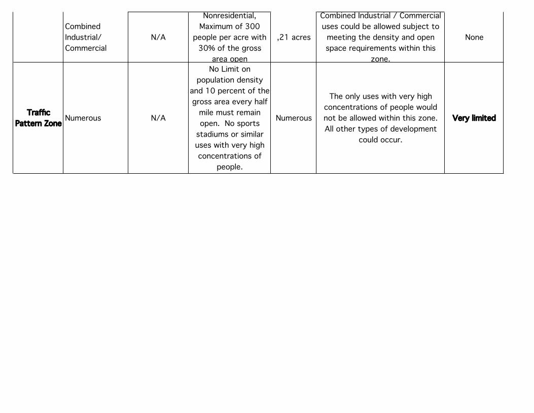
Traffic Pattern Zone Numerous N/A
No Limit on population density
and 10 percent of the gross area every half
mile must remain open. No sports
stadiums or similar uses with very high concentrations of
people.
Numerous
The only uses with very high concentrations of people would not be allowed within this zone. All other types of development
could occur.
Very limited
Sideline Safety
Zone(SSZ)