snoqualmie corridor recreation plan - washington · david kappler sarah krueger. ... concept map of...
TRANSCRIPT
N
A
T
U
R
A
L
R
E
S
O
U
R
C
E
S
Snoqualmie Corridor Recreation Plan
..............................................
March 2015

This publication is available from:
Washington State Department of Natural ResourcesRecreation ProgramPO Box 470141111 Washington St. SEOlympia, WA [email protected]
Persons needing this information in an alternative format may contact DNR at the listing above.
AcknowledgmentsThe Snoqualmie Corridor Recreation Plan was created through a public planning process that brought together users, neighbors, interest groups, citizens, and staff from the Washington State Department of Natural Resources (DNR) to develop a comprehensive plan to direct future recreation use and public access within the area. The following individuals and organizations contributed to the development of this document.
DEPARTMENT OF NATURAL RESOURCESPeter Goldmark, Commissioner of Public Lands
DEPARTMENT OF NATURAL RESOURCES SNOQUALMIE CORRIDOR PROJECT TEAM
Doug McClelland, South Puget Sound Assistant Region ManagerLisa Anderson, Statewide Recreation Planning and Policy ManagerBrock Milliern, Assistant Division Manager- Statewide Recreation Program ManagerKelly Heintz, South Puget Sound Region, Natural Areas ManagerSam Jarrett, South Puget Sound Region, Snoqualmie Unit, Recreation ManagerPene Speaks, Assistant Division Manager- Natural Heritage Conservation SectionCurt Pavola, Natural Areas Program ManagerCynthia Comfort, Environmental Planner- Conservation, Recreation & Transactions Tyler Traweek, South Puget Sound Region, Snoqualmie Forest Manager
UNIVERSITY OF WASHINGTON - PROJECT TEAM
Gordon Bradley, Professor, School of Environmental and Forest SciencesLaura Cooper, Research Assistant, School of Environmental and Forest Sciences and DNR Recreation Planner
DNR STATE ENVIRONMENTAL POLICY ACT (SEPA) CENTER
Karen Arnold, SEPA Environmental Review Program LeadFred Greef, SEPA Consultant
PLANNING COMMITTEE MEMBERSThe committee provided valuable and diverse input throughout the planning process. The final concept map being recommended by DNR is based on considerable input from the committee, the public, and information learned during the planning process. Committee members include:
Jim BerryMark BoyarAmy BrockhausJenni CrevelingHarold ErlandRobert EversoleGlenn GloverTed JacksonDavid KapplerSarah KruegerMire LevyRick McGuireRebecca NeedhamThomas O’KeefeRobert Pattie Ann ShillingMike Town
DNR COMMUNICATIONS AND PRODUCT DEVELOPMENTJason Goldstein, Geographic Information Systems AnalystJessica Payne, Recreation Communications & Outreach Coordinator
Cover photo credits to Washington State DNR


Snoqualmie Corridor Recreation Plan
..............................................
March 2015
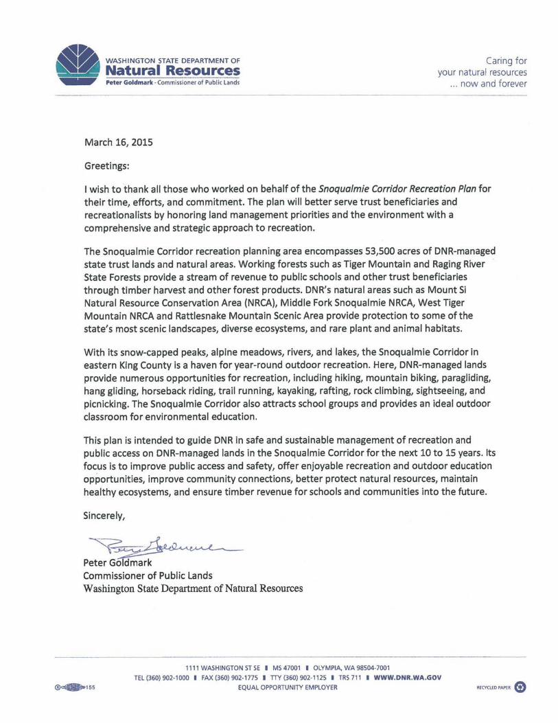
Table of Contents Letter from Commissioner of Public Lands Peter Goldmark
15 Introduction
17 The Washington State Department of Natural Resources18 Agency Mission18 Agency Vision18 Our Guiding Principles19 State Trust Lands19 DNR Natural Areas Program20 DNR Statewide Recreation Program
21 Project Overview
23 Recreation Planning Area Description 26 Recreation Planning Area Context29 Current Recreation Opportunities in the Recreation Planning Area29 Summary of Current Recreation Opportunities
33 The Plan
35 Recreation Plan Purpose and Use35 Other Planning Efforts36 Concept Maps39 Objectives and Strategies39 Recreation Planning Units40 Recreational Facilities43 Recreational Trails46 Dispersed Recreation Management47 Managed Access & Group Events47 Restoration49 Partnerships and Volunteer Coordination50 Education and Enforcement52 Adaptive Management52 Sustainable Funding53 Implementation
55 Planning Area Background
57 South Puget Sound Region and Recreation59 Ecological Description of the Snoqualmie Corridor Recreation Planning Area62 The Mountains to Sound Greenway62 Snoqualmie Unit Advisory Committee
63 The Planning Process
65 Developing the Snoqualmie Corridor Recreation Plan67 Recreation Land Suitability
PART I
PART II
PART III
PART IV
71 Public Involvement71 The Project “Kick-Off” Public Meeting72 User Survey72 Recreation Planning Committee73 Field Data Collection and Mapping74 In Closing
75 Regulations and Policy Information
79 References
83 Appendices 85 Appendix A: Glossary of Terms 90 Appendix B: Recreation Planning Committee Meetings91 Appendix C: Recreation Planning Committee Field Trips92 Appendix D: Public Kick-off Meeting Summary of Comments98 Appendix E: State Route 18 – Issaquah Hobart Road to I-90 Improvement Project99 Appendix F: Existing Recreation Trails in the Recreation Planning Area100 Appendix G: Certificate of Adoption
Figures
17 Figure 1. DNR Regions and Project Location24 Figure 2. Snoqualmie Corridor Recreation Planning Units25 Figure 3. Recreation Planning Unit Landtype Designations27 Figure 4. Recreation Planning Area Context31 Figure 5. Current Recreation Opportunities: Recreation Planning Area – West32 Figure 6. Current Recreation Opportunities: Recreation Planning Area – East37 Figure 7. Concept Map of Snoqualmie Corridor Recreation Planning Area - West38 Figure 8. Concept Map of Snoqualmie Corridor Recreation Planning Area - East58 Figure 9. Service Area and Proximity to Urban Growth Areas60 Figure 10. Recreation Planning Area Elevation Bands68 Figure 11. Recreation Land Suitability: Hiking Trails69 Figure 12. Recreation Land Suitability: Non-Motorized Trails70 Figure 13. Recreation Land Suitability: Recreation Facilities
Tables
28 Table 1. Nearby and Adjacent Public Lands30 Table 2. Existing DNR-managed Facilities in the Recreation Planning Area39 Table 3. Recreation Planning Unit Management Objectives53 Table 4. Implementation Priorities and Phases 54 Table 5. Implementation Priorities and Phases Continued67 Table 6. Suitability Criteria 90 Table 7. Recreation Planning Committee Meetings and Main Agenda Items 91 Table 8. Recreation Planning Committee Field Trips99 Table 9. Existing Designated Trails in Recreation Planning Area
PART V
APPENDICES
LIST OF FIGURES
AND TABLES
REFERENCES


Snoqualmie Corridor Recreation Plan | March 201515
Intr
oduc
tion

Snoqualmie Corridor Recreation Plan | March 201516
Snoqualmie Corridor Recreation Plan | March 201517
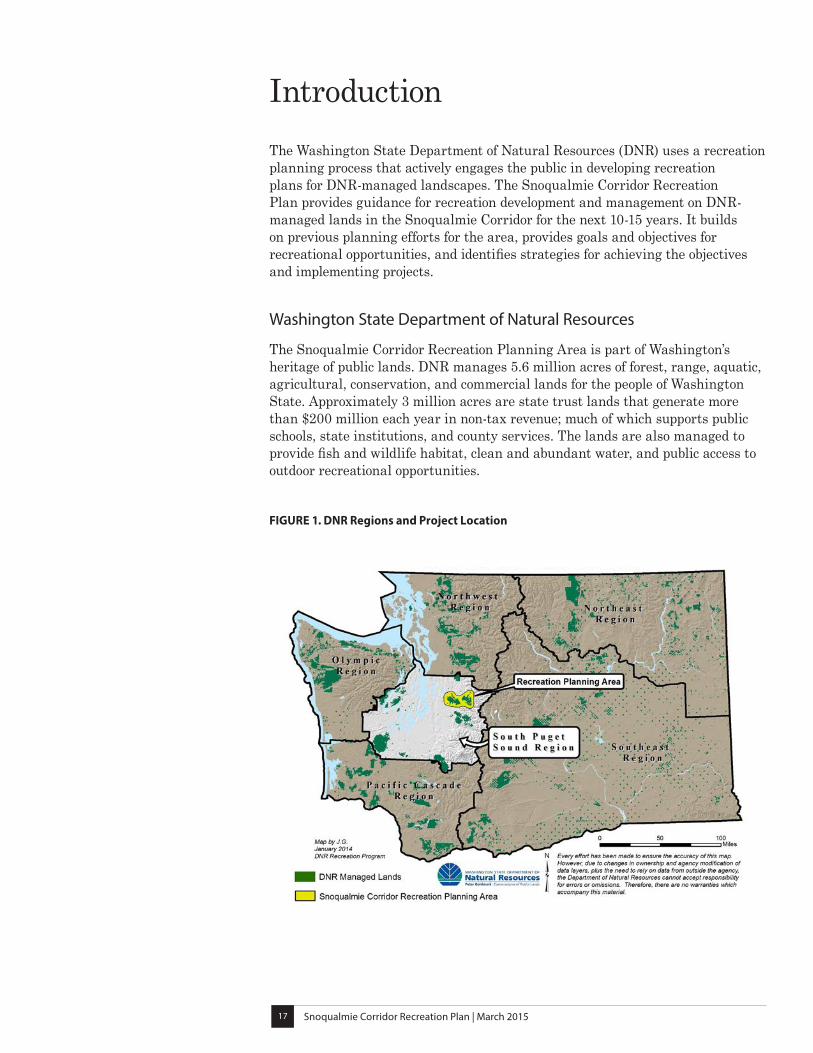
IntroductionThe Washington State Department of Natural Resources (DNR) uses a recreation planning process that actively engages the public in developing recreation plans for DNR-managed landscapes. The Snoqualmie Corridor Recreation Plan provides guidance for recreation development and management on DNR-managed lands in the Snoqualmie Corridor for the next 10-15 years. It builds on previous planning efforts for the area, provides goals and objectives for recreational opportunities, and identifies strategies for achieving the objectives and implementing projects.
Washington State Department of Natural Resources
The Snoqualmie Corridor Recreation Planning Area is part of Washington’s heritage of public lands. DNR manages 5.6 million acres of forest, range, aquatic, agricultural, conservation, and commercial lands for the people of Washington State. Approximately 3 million acres are state trust lands that generate more than $200 million each year in non-tax revenue; much of which supports public schools, state institutions, and county services. The lands are also managed to provide fish and wildlife habitat, clean and abundant water, and public access to outdoor recreational opportunities.
FIGURE 1. DNR Regions and Project Location
Snoqualmie Corridor Recreation Plan | March 201518
DNR also fights wildfires on public and private lands, helps communities with fire prevention and urban forestry resources, manages a Natural Areas program that protects native species and ecosystems, administers state forest practices rules, provides geological services, regulates surface mine reclamation, and supplies knowledge about forestry, mining, rare native plant species, ecosystems, and geologic hazards.
DNR-managed lands are organized into six geographic regions. Each region manages the day-to-day operations involved in protecting and managing the public lands. The Snoqualmie Corridor Recreation Planning Area is located in the South Puget Sound Region (see Figure 1).
Agency Mission
In partnership with citizens and governments, DNR provides innovative leadership and expertise to ensure environmental protection, public safety, perpetual funding for schools and communities, and a rich quality of life.
Agency Vision
Our decisions and hard work on the ground leave a legacy of healthy forests, clean water, thriving ecosystems, and a vibrant natural resource-based economy.
Our Guiding Principles
MANAGE THE STATE’S RESOURCES SUSTAINABLY
Through our sustainable management of resources entrusted to our care, future generations will have ample opportunities to enjoy and benefit from Washington’s rich natural heritage. We will also ensure that revenues for our trusts will be stable or growing and that associated industries will thrive for generations to come.
MAKE DECISIONS BASED ON SOUND SCIENCE
Using sound science, data, and information to guide our decisions will result in the best possible outcomes for the State of Washington.
MAKE DECISIONS IN THE PUBLIC INTEREST AND WITH THE PUBLIC’S KNOWLEDGE
Transparency and accountability are vital to earn the public’s trust and appropriately manage shared resources. Decisions should be made for the benefit of current and future generations.
Snoqualmie Corridor Recreation Plan | March 201519
State Trust Lands
By law, state trust lands are to be held in trust and managed to sustainably produce income for schools, universities, state institutions, and county services. Statewide, approximately 2.1 million acres of the state trust lands are forested, many of which are working forests. Working forests are managed to provide a continuous supply of wood products and non-wood products and forest ecosystem services such as carbon sequestration, water filtration, and habitat for flora and fauna. In addition, as directed by the Multiple Use Concept (RCW 79.10), DNR provides recreation and public access opportunities on state trust lands throughout Washington where such uses are compatible with trust obligations. Responsibly managed working forests provide a number of environmental, economic, and social benefits for current and future generations.
By managing state forests as working forests, DNR strives to balance the following goals:
• Responsibly generate revenue for the trust beneficiaries
• Protect the forest’s long-term ecological health
• Provide safe and sustainable recreation opportunities where they are consistent with trust responsibilities
• Support economic activity in local communities
The average timber harvest cycle for DNR working forests is 60 years in length. Forest management activities, including timber harvest, have the potential to affect recreational use through temporary closures of roads, trails, trailheads, and other facilities.
DNR Natural Areas Program
DNR manages more than 152,000 acres of natural areas throughout Washington, including 38,000 acres of natural area preserves (NAPs) and 114,000 acres of natural resources conservation areas (NRCAs). NAPs were established in accordance with the Washington State Natural Area Preserves Act of 1972 (RCW 79.70) in order to protect the highest quality examples of native ecosystems and rare plant and animal species, as well as other natural features of state or regional significance. DNR currently manages 55 NAPs statewide to help maintain Washington’s native biological diversity and provide opportunities for education and scientific research.
In 1987, the legislature passed the Natural Resources Conservation Areas Act (RCW 79.71) to create an additional state land designation for conservation. NRCAs protect natural and cultural resources including, but not limited to, high quality native plant communities, suitable habitat for sensitive, threatened and endangered species, examples of natural ecosystems, archeological and culturally significant sites and resources, and exceptionally scenic landscapes.
NRCAs also provide opportunities for sustainable, low-impact recreation as well as environmental education where such uses do not detract from the area’s long-term ecological processes and leave vegetation, wildlife, soil, and water
Snoqualmie Corridor Recreation Plan | March 201520
relatively unaltered. Low-impact public use includes, but is not limited to, hiking, picnicking, bird watching, environmental education, scientific research, and other uses consistent with the conservation purposes of each site.
The State of Washington Natural Resources Conservation Areas Statewide Management Plan was written with the assistance of a citizen advisory committee and finalized in 1992 in order to help DNR implement the new NRCA statute. The plan governs all NRCAs without site-specific management plans and provides policy direction for development of site-specific plans. DNR currently manages 36 NRCAs statewide, four of which are located in the Recreation Planning Area: Mount Si NRCA, Middle Fork Snoqualmie NRCA, West Tiger Mountain NRCA, and Rattlesnake Mountain Scenic Area.
DNR Statewide Recreation Program
DNR provides trails and facilities such as campgrounds and trailheads in primitive and natural settings. The DNR Recreation Program manages more than 1,100 miles of designated trails, 143 recreation sites, and provides access for a variety of dispersed recreation opportunities in an assortment of landscapes across the state. Recreation on DNR-managed lands includes, but is not limited to, hiking, mountain biking, horseback riding, camping, off-road vehicle (ORV) riding, cross-country skiing, snowmobiling, snowshoeing, hunting, fishing, paragliding and hang-gliding, nature and wildlife viewing, rock climbing, target shooting, picnicking, and boating.
DNR recognizes the diverse interests and values of the recreating public and the importance of connecting people with Washington’s landscapes. DNR envisions a future in which the lands it manages offer distinct and diverse outdoor recreation opportunities within the overall fabric of recreation in Washington. By building solid partnerships and a strong stewardship ethic among user groups, recreationists, private landowners, and government agencies, DNR strives to provide enjoyable and safe outdoor experiences for everyone.
DNR Recreation Program vision statement for recreation and public access:
Manage public and trust lands in a manner that provides quality, safe recreational experiences that are sustainable and consistent with DNR’s environmental, financial and social responsibilities.
The goals for managing statewide recreation are:
Goal 1: Uphold the safety of the public, DNR employees, and volunteers.
Goal 2: Support recreation that is consistent with trust management and natural areas obligations.
Goal 3: Provide recreation opportunities consistent with resource protection.
Goal 4: Provide quality recreation experiences that can be sustained over time.

Proje
ct O
verv
iew
Part
I

Snoqualmie Corridor Recreation Plan | March 201523
Project Overview
Recreation Planning Area Description
Located in the western foothills of the Cascade Mountains, overlooking the communities and farmlands of the upper Snoqualmie River Valley, the Snoqualmie Corridor Recreation Planning Area offers tremendous opportunities for outdoor recreation within easy reach of the Seattle and east King County metropolitan areas.
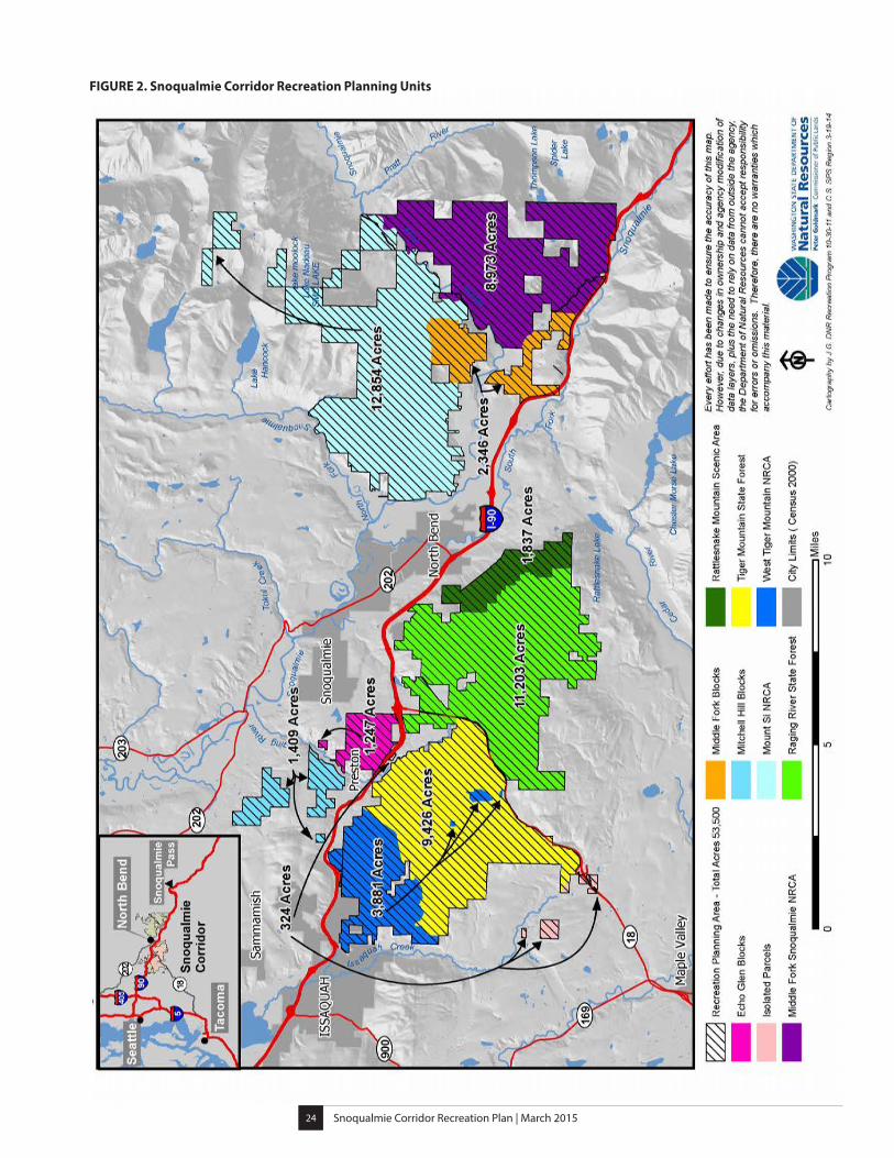
The Recreation Planning Area is approximately 53,500 acres and is composed of 10 blocks of DNR-managed lands, which are referred to in this plan as Recreation Planning Units (see Figure 2). Nearly half of these lands, 25,955 acres, are designated state trust lands, and the remaining 27,545 acres, are managed as NRCAs (see Figure 3).
Together these lands contribute to the forested landscape along a 24 mile stretch of Interstate 90 (I-90), between Exit 18 and 42. The Recreation Planning Units are described below, starting in the west and moving east.
West Tiger Mountain NRCA was established in 1989 and occupies the northern and western slopes of Tiger Mountain. The NRCA’s forested slopes provide an important scenic backdrop to the City of Issaquah, rising up 2,855 feet to a cluster of three peaks known as West Tiger Summit. Distinctive physical features of the area include talus rock caves, two lakes, forested wetlands, several stream systems, and forest stands exhibiting old-growth characteristics.
Tiger Mountain State Forest was established in 1981 and occupies the remaining southern and eastern portions of Tiger Mountain, including three additional peaks: Middle Tiger, South Tiger and East Tiger, the tallest at 3,004 feet. These forested state trust lands contain several small lakes, stream corridors, and forest stands ranging in age from 0 to 80 years. There are also several small blocks of land within the forest containing older forest remnants that are managed as part of the West Tiger Mountain NRCA.
Raging River State Forest was acquired by DNR in 2009 and is located on the south side of I-90, just east of State Route 18 (SR 18). It occupies a basin formed by the western slopes of Rattlesnake Mountain and the northern slopes of Taylor Mountain and contains the headwaters of the Raging River. This working forest has been actively managed for timber production and is mostly composed of younger stands between 0 and 40 years old.
Rattlesnake Mountain Scenic Area was established in 1993 and is co-owned and co-managed by DNR and King County as an NRCA. Much of the east face of Rattlesnake Mountain (a 3,500-foot ridge) comprises the scenic area, with rocky cliffs, steep ravines, and stream corridors that drop rapidly to form waterfalls. The scenic area lies directly adjacent to Raging River State Forest.
Snoqualmie Corridor Recreation Plan | March 201524
FIGURE 2. Snoqualmie Corridor Recreation Planning Units
Snoqualmie Corridor Recreation Plan | March 201525
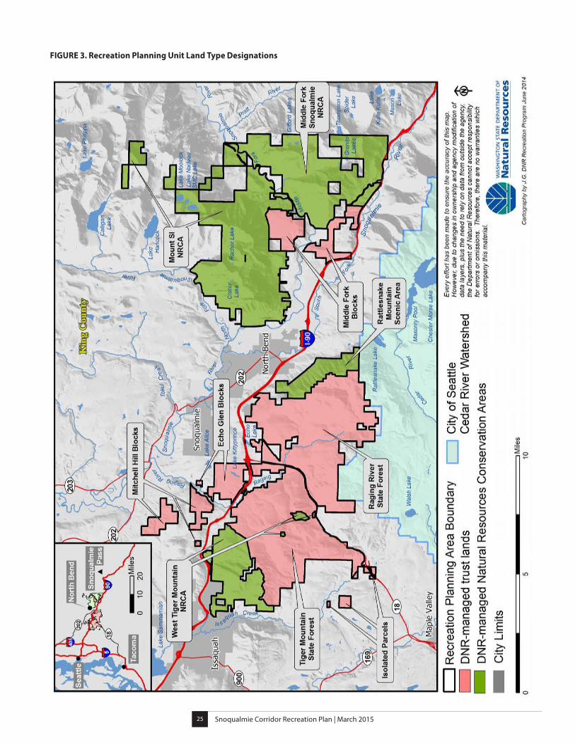
FIGURE 3. Recreation Planning Unit Land Type Designations
Snoqualmie Corridor Recreation Plan | March 201526
Mitchell Hill Blocks consist of three parcels of state trust land in the Mitchell Hill area of the Preston community. The blocks are surrounded by private rural homes. The lowland terrain of the area is hilly and includes ravines, streams, and wetlands. A plateau in the northern block provides views of the Snoqualmie Valley.
Echo Glen Blocks include two parcels of forested state trust land located in the lowlands on the north side of I-90. Within the larger block is a youth correctional facility.
Isolated parcels include several smaller units of state trust land. Seven are located near the southern tip of Tiger Mountain State Forest and one is located just to the north of the forest. These units are surrounded by private rural residences.
Mount Si NRCA was established in 1987 and includes Mount Si, an iconic 4,043-foot mountain landmark, which towers over the nearby city of North Bend. The NRCA occupies the high ridges between the North Fork and Middle Fork of the Snoqualmie River. This includes Little Si, Mount Teneriffe, and Green Mountain; as well as several alpine lakes and stretches of riparian forest along the rivers. Portions of the Middle Fork Snoqualmie River are currently under review by the U.S. Congress for designation as a National Wild and Scenic River.
Middle Fork Snoqualmie NRCA lies directly across the Middle Fork Snoqualmie River Valley from Mount Si NRCA between the Middle and South Forks of the Snoqualmie River. The NRCA was established in 2009 and features high rocky ridges (including Mailbox Peak at 4,841 feet) as well as several alpine lakes and creeks, and stretches of riparian forest along the Middle Fork of the Snoqualmie River.
Middle Fork Blocks consist of two blocks of state trust land, on either side of the Middle Fork Snoqualmie River. These lowland areas are within the Middle Fork Snoqualmie River Valley and lie directly adjacent to both the Mount Si NRCA and the Middle Fork Snoqualmie NRCA.
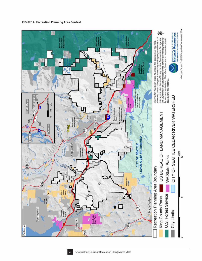
Recreation Planning Area Context
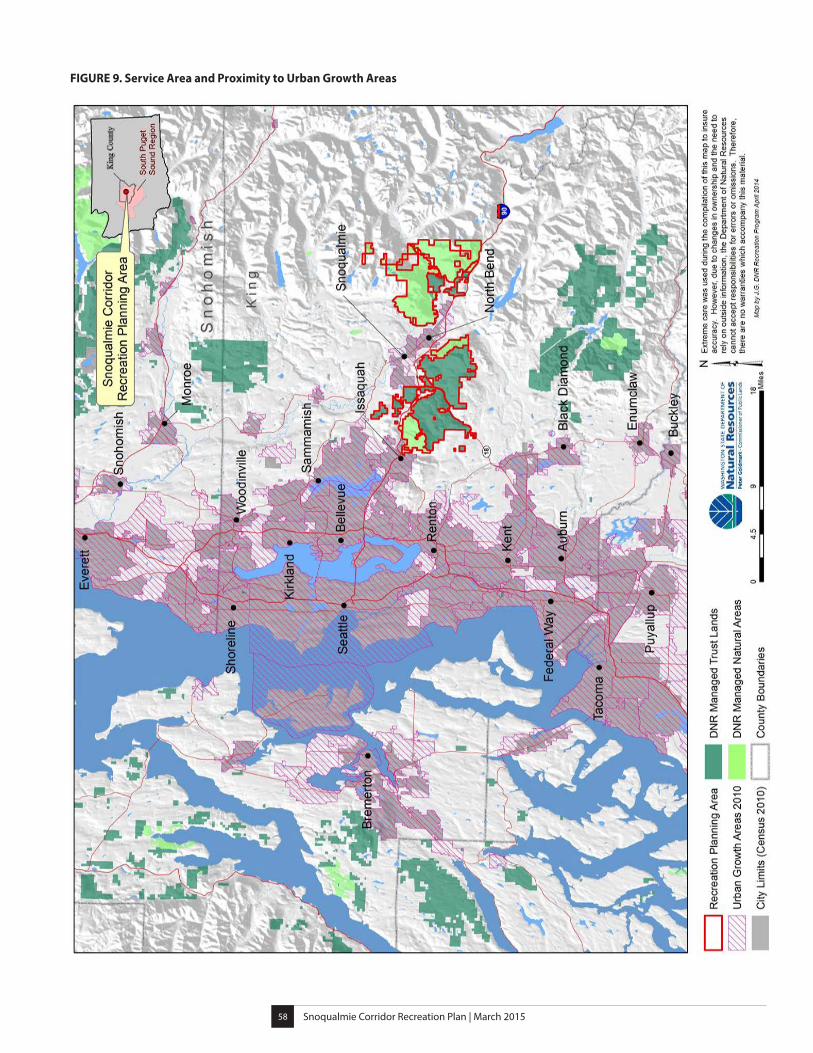
The Recreation Planning Area is located in eastern King County and is influenced by numerous surrounding land uses with multiple ownerships and purposes including municipalities, rural communities, and forested and agricultural lands (see Figure 4).
King County spans 50 miles east from the Puget Sound into the central Cascade Mountains. King County contains the Seattle metropolitan area, is the 14th most populous county in the nation, and the most populous county in Washington State. The census reported 1.9 million residents in 2010, and the population of King County is expected to grow to 2.8 million by 2030. (King County 2011; State of Washington 2012).
Snoqualmie Corridor Recreation Plan | March 201527
FIGURE 4. Recreation Planning Area Context
Snoqualmie Corridor Recreation Plan | March 201528
Nearby municipalities include Issaquah, Snoqualmie, North Bend, and the rural community Preston. Each of these nearby communities have economic ties to the recreation that occurs in the Recreation Planning Area, and several of the Recreation Planning Committee members live and work in these communities. DNR staff worked to incorporate values from these communities into the planning process in many ways, including holding community meetings to provide information about the planning process and receiving input from community members.
Nearby and Adjacent Public Lands create the framework surrounding the DNR-managed Recreation Planning area (see Table 1). These state trust lands contain a system of non-motorized trails that link to regional trails; creating a connection between communities and public lands. Examples of these regional trails are the Issaquah-Preston Trail, the Preston-Snoqualmie Trail, and the Snoqualmie Valley Regional Trail.
PUBLIC LAND MANAGER LANDSCAPE
US Forest Service Mount Baker-Snoqualmie National Forest Alpine Lakes Wilderness
Washington State Parks Squak Mountain State Park Olallie State Park Iron Horse State Park and John Wayne Pioneer Trail
King County Grand Ridge and Duthie Hill Parks Taylor Mountain Forest Three Forks Natural Area Tanner Landing Park Middle Fork Snoqualmie Natural Area
City of Seattle Cedar River Watershed* Rattlesnake Lake Recreation Area
City of Issaquah Tradition Plateau NRCA**City of Snoqualmie Snoqualmie Point ParkCities of Snoqualmie and North Bend Meadowbrook FarmCity of North Bend and King County Tollgate Farm*Cedar River Watershed: South of Raging River State Forest and Rattlesnake Mountain Scenic area is 90,638 acres of forest and
riparian land in the Cedar River Watershed. This heavily protected area is the source of high quality drinking water for the City of
Seattle.
** Tradition Plateau NRCA is located directly north of the West Tiger Mountain NRCA and is managed cooperatively by the City
of Issaquah and DNR under the West Tiger Mountain NRCA Management Plan.
Private lands with an array of land uses exist around and within the Recreation Planning Area. The surrounding parcels include managed forests, residential developments, light industrial areas, and mining operations. Within the Recreation Planning Area boundaries are several parcels of leased and privately owned lands. Currently, these private lands include uses such as utility sites and corridors, a youth correctional facility, and rock quarries.
Table 1. Nearby and Adjacent Public Lands
Snoqualmie Corridor Recreation Plan | March 201529
Current Recreation Opportunities in the Recreation Planning AreaDNR-managed lands within the Recreation Planning Area provide numerous opportunities for non-motorized day-use recreation and include activities such as hiking, mountain biking, horseback riding, trail running, kayaking, rafting, paragliding, hang gliding, rock climbing, sight-seeing, and picnicking.
Developed recreation occurs at a designated site or location built or improved for recreation on DNR-managed land such as a trailhead, vista, parking area, picnic area or designated trails. For the purposes of this plan trailheads typically provide parking, restrooms, information, and access to a developed trail system. Day-use areas generally provide limited parking and facilities to support daytime recreational activities in small areas such as river access points or picnic areas.
Dispersed recreation on DNR-managed land occurs outside of developed recreation facilities and often includes activities such as nature observation, rock climbing, geocaching, birding, hunting, fishing, and mushroom and berry picking.
Current developed recreation facilities and trails in the Recreation Planning Area include:
• Six trailheads
• Two day-use areas
• Approximately 100 miles of designated non-motorized trails
• Approximately 20 miles of non-motorized trails under construction (as of summer 2014)
Summary of Current Recreation Opportunities The following sections provide a table summarizing the current developed recreation facilities (see Table 2), written descriptions of recreation opportunities, and maps of those opportunities in the Recreation Planning Area. The maps illustrating current recreation opportunities are organized into Recreation Planning Area-West and Recreation Planning Area-East (see Figures 5 & 6).
West Tiger Mountain NRCA has approximately 41 miles of designated trails, of which about 34 miles are hiking trails. There are a limited number of opportunities for biking and horseback riding on designated trails. The NRCA also includes an education shelter and accessible interpretive trails. Primary access for the NRCA is the High Point Trailhead, which is located off I-90 Exit 20.
Tiger Mountain State Forest offers approximately 36 miles of trails for hiking, mountain biking, and horseback riding and an accessible interpretive loop. An additional eight miles of trails primarily for mountain biking are under construction as of summer 2014. Not every use is allowed on every trail. Primary access to the forest is from the Tiger Summit Trailhead along SR 18. Hang gliding and paragliding launches occur at Poo-Poo Point.
Raging River State Forest contains the Rattlesnake Mountain Trailhead and a 2.6-mile segment of the Rattlesnake Mountain Trail; an eleven mile hiking trail which runs along Rattlesnake Ridge. The rest of the forest currently has no designated trail system. There is also some non-motorized recreational use on gated forest roads.
Rattlesnake Mountain Scenic Area includes a 5.4-mile segment of the Rattlesnake Mountain Trail, which connects to Rattlesnake Lake in the Rattlesnake Lake Recreation Area.
Snoqualmie Corridor Recreation Plan | March 201530Burnt Hill Recreation Trail Plan30
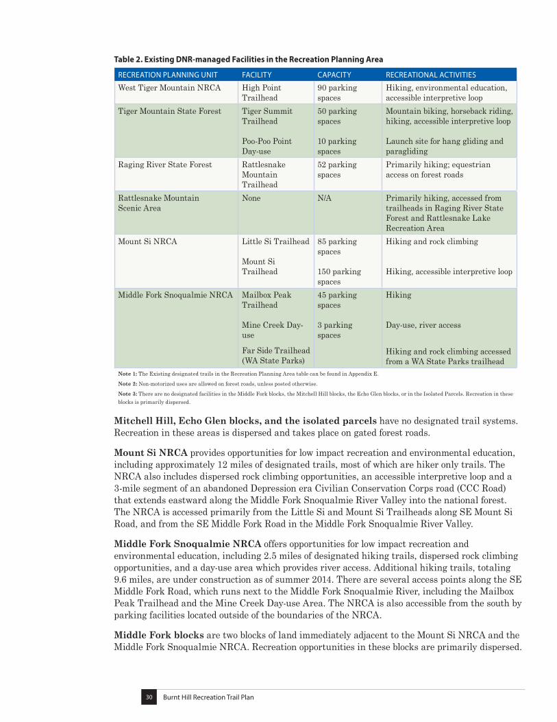
Table 2. Existing DNR-managed Facilities in the Recreation Planning Area
RECREATION PLANNING UNIT FACILITY CAPACITY RECREATIONAL ACTIVITIES
West Tiger Mountain NRCA High Point Trailhead
90 parking spaces
Hiking, environmental education, accessible interpretive loop
Tiger Mountain State Forest Tiger Summit Trailhead Poo-Poo Point Day-use
50 parking spaces 10 parking spaces
Mountain biking, horseback riding, hiking, accessible interpretive loop Launch site for hang gliding and paragliding
Raging River State Forest Rattlesnake Mountain Trailhead
52 parking spaces
Primarily hiking; equestrian access on forest roads
Rattlesnake Mountain Scenic Area
None N/A Primarily hiking, accessed from trailheads in Raging River State Forest and Rattlesnake Lake Recreation Area
Mount Si NRCA Little Si Trailhead Mount Si Trailhead
85 parking spaces 150 parking spaces
Hiking and rock climbing Hiking, accessible interpretive loop
Middle Fork Snoqualmie NRCA Mailbox Peak Trailhead Mine Creek Day-use
Far Side Trailhead (WA State Parks)
45 parking spaces 3 parking spaces
Hiking Day-use, river access
Hiking and rock climbing accessed from a WA State Parks trailhead
Note 1: The Existing designated trails in the Recreation Planning Area table can be found in Appendix E.
Note 2: Non-motorized uses are allowed on forest roads, unless posted otherwise.
Note 3: There are no designated facilities in the Middle Fork blocks, the Mitchell Hill blocks, the Echo Glen blocks, or in the Isolated Parcels. Recreation in these blocks is primarily dispersed.
Mitchell Hill, Echo Glen blocks, and the isolated parcels have no designated trail systems. Recreation in these areas is dispersed and takes place on gated forest roads.
Mount Si NRCA provides opportunities for low impact recreation and environmental education, including approximately 12 miles of designated trails, most of which are hiker only trails. The NRCA also includes dispersed rock climbing opportunities, an accessible interpretive loop and a 3-mile segment of an abandoned Depression era Civilian Conservation Corps road (CCC Road) that extends eastward along the Middle Fork Snoqualmie River Valley into the national forest. The NRCA is accessed primarily from the Little Si and Mount Si Trailheads along SE Mount Si Road, and from the SE Middle Fork Road in the Middle Fork Snoqualmie River Valley.
Middle Fork Snoqualmie NRCA offers opportunities for low impact recreation and environmental education, including 2.5 miles of designated hiking trails, dispersed rock climbing opportunities, and a day-use area which provides river access. Additional hiking trails, totaling 9.6 miles, are under construction as of summer 2014. There are several access points along the SE Middle Fork Road, which runs next to the Middle Fork Snoqualmie River, including the Mailbox Peak Trailhead and the Mine Creek Day-use Area. The NRCA is also accessible from the south by parking facilities located outside of the boundaries of the NRCA.
Middle Fork blocks are two blocks of land immediately adjacent to the Mount Si NRCA and the Middle Fork Snoqualmie NRCA. Recreation opportunities in these blocks are primarily dispersed.
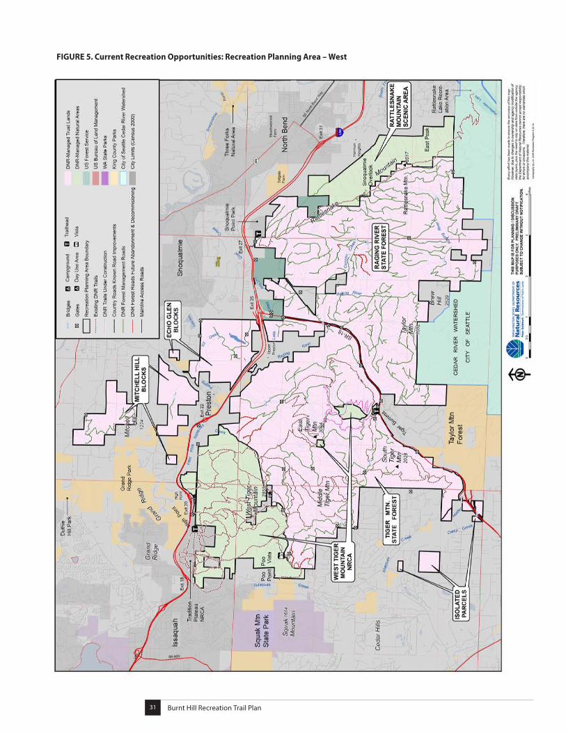
Snoqualmie Corridor Recreation Plan | March 201531Burnt Hill Recreation Trail Plan31
FIGURE 5. Current Recreation Opportunities: Recreation Planning Area – West
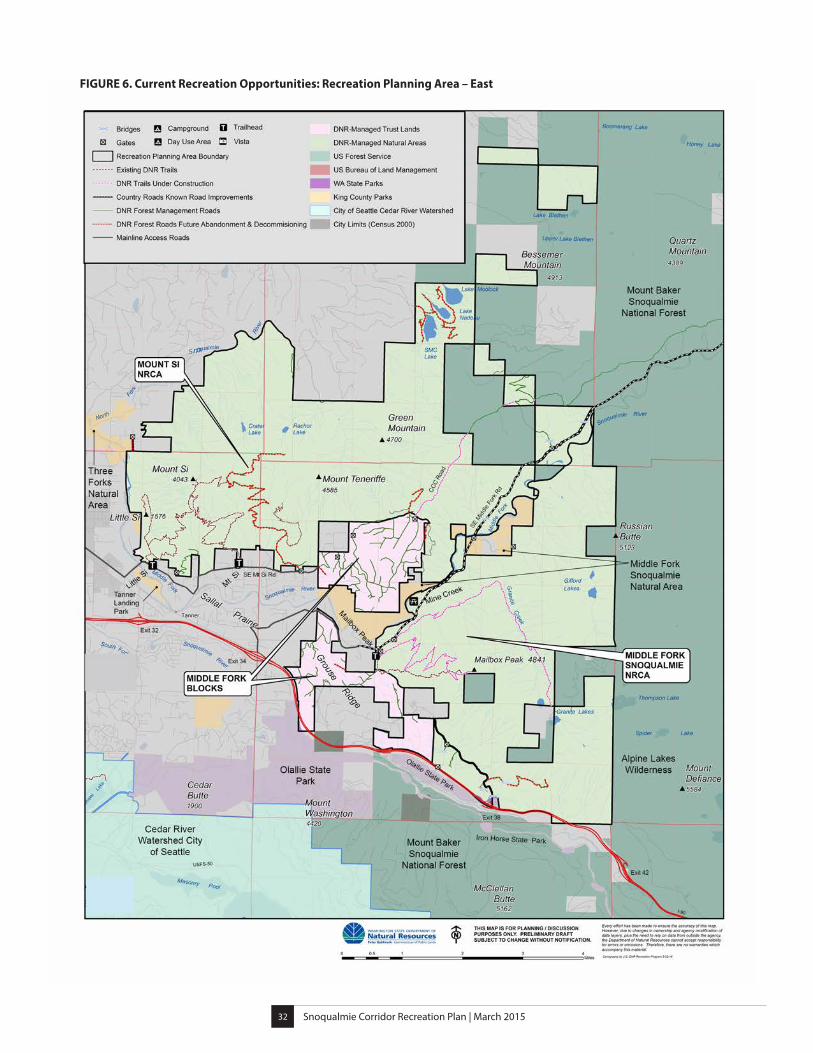
Snoqualmie Corridor Recreation Plan | March 201532
FIGURE 6. Current Recreation Opportunities: Recreation Planning Area – East

Snoqualmie Corridor Recreation Plan | March 201533
The
Plan
Part
II

Snoqualmie Corridor Recreation Plan | March 201534
Snoqualmie Corridor Recreation Plan | March 201535
The Plan
Recreation Plan Purpose and Use
This plan is intended to guide DNR in developing and managing recreation and public access on DNR-managed lands in the Snoqualmie Corridor for the next 10 to 15 years. It outlines DNR’s recreation strategies, objectives, and identifies priorities for implementation. The use of the plan is two-fold:
• Outline a 10- to 15-year vision for recreation and public access in the planning area by developing recreation management concepts.
• Present specific objectives and strategies for implementing the concepts and to guide recreation and access management over the next 10 to 15 years.
Other Planning Efforts
The Snoqualmie Corridor Recreation Plan builds on other planning efforts and provides a recreation plan for landscapes without previous planning as described below:
• Landscapes without previous planning which are guided by this plan include Raging River State Forest, Middle Fork Blocks, Mitchell Hill Blocks, Echo Glen Blocks, and the isolated parcels
• This plan replaces the Tiger Mountain Recreation Plan (1991) for Tiger Mountain State Forest.
• The existing management plans for the NRCAs in the planning area remain in effect including the plans for West Tiger Mountain NRCA (1997), Mount Si NRCA (Management and Public Use Plans, 1997), and the Rattlesnake Mountain Scenic Area (1998). The NRCA Statewide Management Plan (1992) guides public use in the Middle Fork Snoqualmie NRCA. The Snoqualmie Corridor Recreation Plan is supplemental to and guided by these existing NRCA management plans as it updates public use recommendations in response to new conditions.
• This plan also draws from previous conceptual planning efforts for the Middle Fork Snoqualmie River Valley (1997, 2004, 2005), which involved public and private stakeholders.
Snoqualmie Corridor Recreation Plan | March 201536
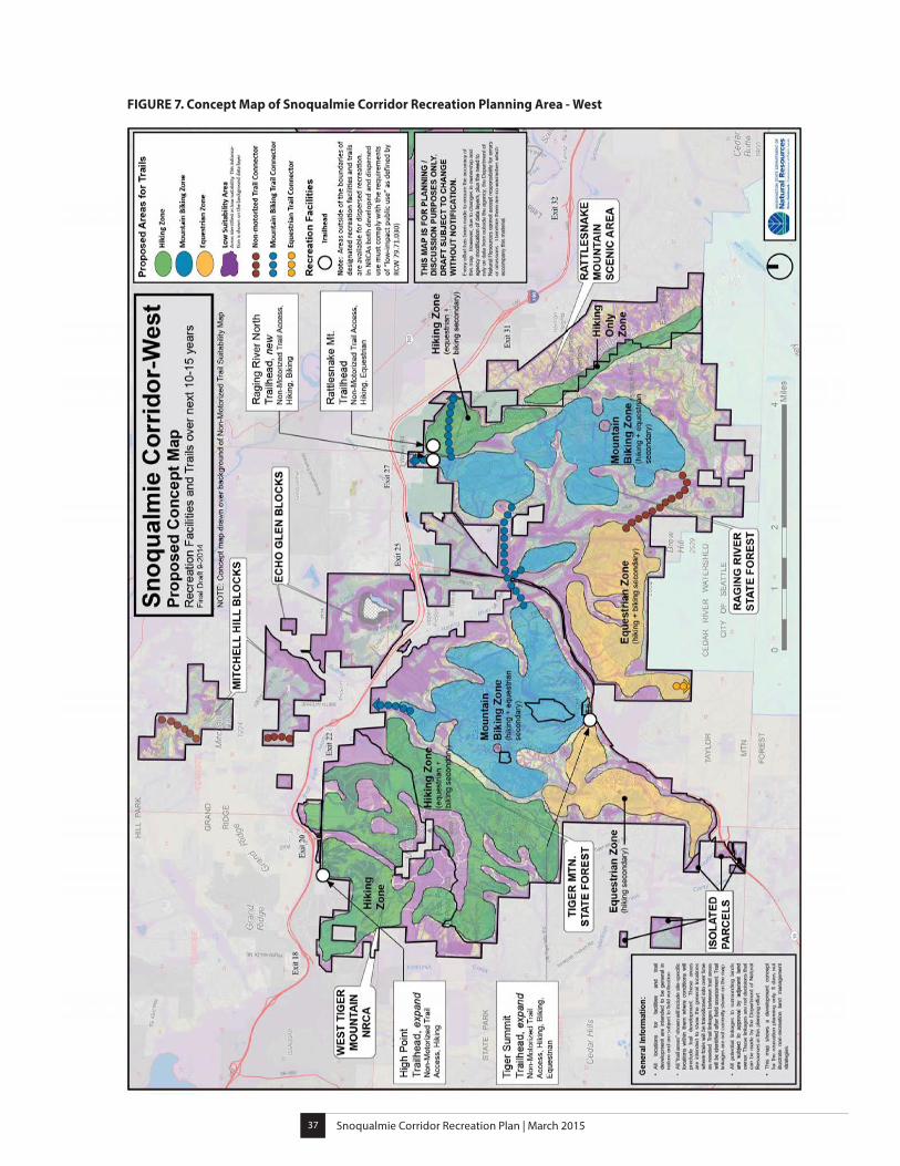
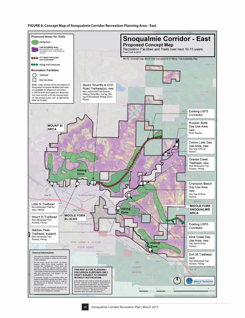
Concept Maps
One key outcome of the planning process is the development of concept maps for the Recreation Planning Area. These maps show the general locations of proposed recreation management concepts within the Recreation Planning Area. DNR developed the concept maps with involvement and feedback from a Recreation Planning Committee (see page 72). DNR also convened a series of collaborative group meetings with adjacent public land managers and municipalities to address common issues and consider connections between the landscapes based on the committee’s recommendations.
Recreation planning was also guided by a land suitability assessment based on biological, geological, soil, and management criteria. The assessments resulted in composite maps that helped to identify and map areas with long-term limiting factors that could affect recreation planning. The land suitability analysis and composite maps are described in further detail in Part IV of this document.
The concept maps are based on broad scale mapping information. Exact locations and site specific details related to the proposed projects will be generated from on-the-ground site assessments to ensure safety, sustainability, and a positive user experience. These concept maps show the general locations of proposed recreational uses as the plan is implemented over the next 10 to 15 years.
The Recreation Planning Area concept maps are organized in two parts, Recreation Planning Area-West and Recreation Planning Area-East. (See Figures 7 and 8.)
Snoqualmie Corridor Recreation Plan | March 201537
FIGURE 7. Concept Map of Snoqualmie Corridor Recreation Planning Area - West
Snoqualmie Corridor Recreation Plan | March 201538
FIGURE 8. Concept Map of Snoqualmie Corridor Recreation Planning Area - East
Snoqualmie Corridor Recreation Plan | March 201539
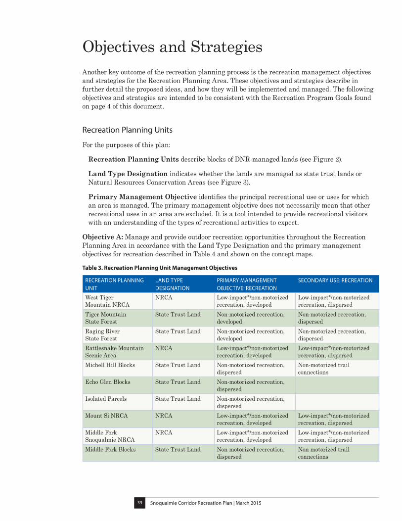
Objectives and StrategiesAnother key outcome of the recreation planning process is the recreation management objectives and strategies for the Recreation Planning Area. These objectives and strategies describe in further detail the proposed ideas, and how they will be implemented and managed. The following objectives and strategies are intended to be consistent with the Recreation Program Goals found on page 4 of this document.
Recreation Planning Units
For the purposes of this plan:
Recreation Planning Units describe blocks of DNR-managed lands (see Figure 2).
Land Type Designation indicates whether the lands are managed as state trust lands or Natural Resources Conservation Areas (see Figure 3).
Primary Management Objective identifies the principal recreational use or uses for which an area is managed. The primary management objective does not necessarily mean that other recreational uses in an area are excluded. It is a tool intended to provide recreational visitors with an understanding of the types of recreational activities to expect.
Objective A: Manage and provide outdoor recreation opportunities throughout the Recreation Planning Area in accordance with the Land Type Designation and the primary management objectives for recreation described in Table 4 and shown on the concept maps.
Table 3. Recreation Planning Unit Management Objectives
RECREATION PLANNING UNIT
LAND TYPE DESIGNATION
PRIMARY MANAGEMENT OBJECTIVE: RECREATION
SECONDARY USE: RECREATION
West Tiger Mountain NRCA
NRCA Low-impact*/non-motorized recreation, developed
Low-impact*/non-motorized recreation, dispersed
Tiger Mountain State Forest
State Trust Land Non-motorized recreation, developed
Non-motorized recreation, dispersed
Raging River State Forest
State Trust Land Non-motorized recreation, developed
Non-motorized recreation, dispersed
Rattlesnake Mountain Scenic Area
NRCA Low-impact*/non-motorized recreation, developed
Low-impact*/non-motorized recreation, dispersed
Michell Hill Blocks State Trust Land Non-motorized recreation, dispersed
Non-motorized trail connections
Echo Glen Blocks State Trust Land Non-motorized recreation, dispersed
Isolated Parcels State Trust Land Non-motorized recreation, dispersed
Mount Si NRCA NRCA Low-impact*/non-motorized recreation, developed
Low-impact*/non-motorized recreation, dispersed
Middle Fork Snoqualmie NRCA
NRCA Low-impact*/non-motorized recreation, developed
Low-impact*/non-motorized recreation, dispersed
Middle Fork Blocks State Trust Land Non-motorized recreation, dispersed
Non-motorized trail connections
Snoqualmie Corridor Recreation Plan | March 201540
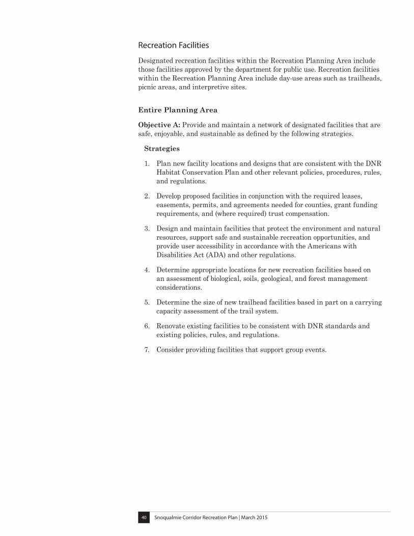
Recreation Facilities
Designated recreation facilities within the Recreation Planning Area include those facilities approved by the department for public use. Recreation facilities within the Recreation Planning Area include day-use areas such as trailheads, picnic areas, and interpretive sites.
Entire Planning Area
Objective A: Provide and maintain a network of designated facilities that are safe, enjoyable, and sustainable as defined by the following strategies.
Strategies
1. Plan new facility locations and designs that are consistent with the DNR Habitat Conservation Plan and other relevant policies, procedures, rules, and regulations.
2. Develop proposed facilities in conjunction with the required leases, easements, permits, and agreements needed for counties, grant funding requirements, and (where required) trust compensation.
3. Design and maintain facilities that protect the environment and natural resources, support safe and sustainable recreation opportunities, and provide user accessibility in accordance with the Americans with Disabilities Act (ADA) and other regulations.
4. Determine appropriate locations for new recreation facilities based on an assessment of biological, soils, geological, and forest management considerations.
5. Determine the size of new trailhead facilities based in part on a carrying capacity assessment of the trail system.
6. Renovate existing facilities to be consistent with DNR standards and existing policies, rules, and regulations.
7. Consider providing facilities that support group events.
Snoqualmie Corridor Recreation Plan | March 201541
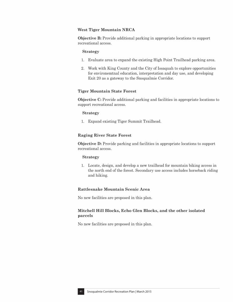
West Tiger Mountain NRCA
Objective B: Provide additional parking in appropriate locations to support recreational access.
Strategy
1. Evaluate area to expand the existing High Point Trailhead parking area.
2. Work with King County and the City of Issaquah to explore opportunities for environemtnal education, interpretation and day use, and developing Exit 20 as a gateway to the Snoqualmie Corridor.
Tiger Mountain State Forest
Objective C: Provide additional parking and facilities in appropriate locations to support recreational access.
Strategy
1. Expand existing Tiger Summit Trailhead.
Raging River State Forest
Objective D: Provide parking and facilities in appropriate locations to support recreational access.
Strategy
1. Locate, design, and develop a new trailhead for mountain biking access in the north end of the forest. Secondary use access includes horseback riding and hiking.
Rattlesnake Mountain Scenic Area
No new facilities are proposed in this plan.
Mitchell Hill Blocks, Echo Glen Blocks, and the other isolated parcels
No new facilities are proposed in this plan.
Snoqualmie Corridor Recreation Plan | March 201542
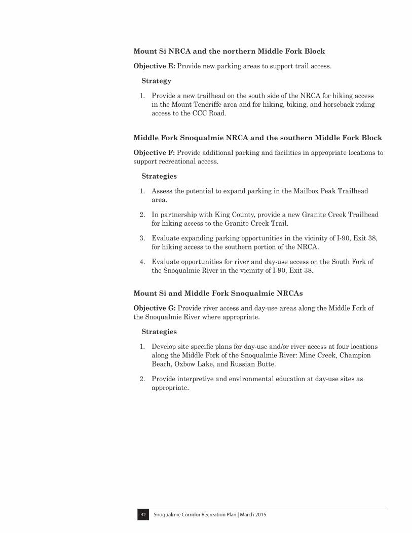
Mount Si NRCA and the northern Middle Fork Block
Objective E: Provide new parking areas to support trail access.
Strategy
1. Provide a new trailhead on the south side of the NRCA for hiking access in the Mount Teneriffe area and for hiking, biking, and horseback riding access to the CCC Road.
Middle Fork Snoqualmie NRCA and the southern Middle Fork Block
Objective F: Provide additional parking and facilities in appropriate locations to support recreational access.
Strategies
1. Assess the potential to expand parking in the Mailbox Peak Trailhead area.
2. In partnership with King County, provide a new Granite Creek Trailhead for hiking access to the Granite Creek Trail.
3. Evaluate expanding parking opportunities in the vicinity of I-90, Exit 38, for hiking access to the southern portion of the NRCA.
4. Evaluate opportunities for river and day-use access on the South Fork of the Snoqualmie River in the vicinity of I-90, Exit 38.
Mount Si and Middle Fork Snoqualmie NRCAs
Objective G: Provide river access and day-use areas along the Middle Fork of the Snoqualmie River where appropriate.
Strategies
1. Develop site specific plans for day-use and/or river access at four locations along the Middle Fork of the Snoqualmie River: Mine Creek, Champion Beach, Oxbow Lake, and Russian Butte.
2. Provide interpretive and environmental education at day-use sites as appropriate.
Snoqualmie Corridor Recreation Plan | March 201543
Recreation Trails
A main component of all trail projects will include an evaluation of existing trails for their sustainability and desired user experience, and ensuring that new trails are properly located and built to provide a safe recreation experience while protecting the area’s natural resources. Trail work will include restoring areas with known resource and environmental damage, relocating and developing trails in long-term sustainable locations, and restoring abandoned trail locations.
Designated trails within the recreational planning area include those trails planned for and managed by DNR. Trail connections are trail segments that are intended to link two existing sites, trails, or points of interest.
Entire Planning Area
Objective A: Provide and maintain a network of safe, enjoyable, and sustainable recreational trails consistent with the following strategies:
Strategies
1. Locate, design, and develop trails consistent with DNR standards, stewardship responsibilities, suitability criteria, safety and risk management, and desired user experience.
2. Evaluate existing trail network and upgrade, relocate, or decommission trail segments as appropriate to ensure the trail network’s long-term sustainability.
3. Create and maintain trail systems that minimize long term maintenance and prevent or minimize the potential for erosion and sediment delivery into nearby water bodies.
4. As trail projects are implemented, add new trails where appropriate, existing trails will be evaluated and improved where possible, and unsustainable trails will be decommissioned and/or relocated to new long term locations, with old locations restored.
5. Identify and evaluate existing undesignated trails for safety, sustainability, and resource protection to determine whether they should be designated, rerouted, restored, or decommissioned.
6. Maintain separate use trails, where appropriate, for safety of users and/or enhanced user experience.
7. Establish trail management objectives for designated trails. Trail management objectives describe standards for planning, construction, and maintenance of new trails and trail segments.
Snoqualmie Corridor Recreation Plan | March 201544
West Tiger Mountain NRCA
Objective B: Maintain and improve trail hiking opportunities.
Strategy
1. Improve trail connections and signs to direct hikers from the High Point Trailhead to the variety of hiking trails in West Tiger Mountain NRCA.
Tiger Mountain State Forest
Objective C: Improve trail opportunities for hikers, mountain bikers, and equestrians.
Strategy
1. Develop a mountain biking and hiking trail connection from the community of Preston to Tiger Mountain State Forest and through to the Raging River State Forest by utilizing the underpass under SR 18.
2. Improve and expand mountain biking opportunities in the eastern part of Tiger Mountain State Forest.
3. Maintain a clear separation between hiking and mountain biking zones.
4. Improve existing trail connections and signage to direct the public from the existing Tiger Summit Trailhead to nearby hiking, biking, and equestrian opportunities.
Raging River State Forest
Objective D: Develop trail opportunities for mountain biking, horseback riding, and hiking.
Strategies
1. Develop mountain biking recreation opportunities in the mountain biking zone in the northeastern part of the forest. Allow hiking and horseback riding as secondary uses where compatible.
2. Work with King County to develop equestrian trail connections from the equestrian zone in Raging River State Forest to Taylor Mountain Forest. Allow hiking and mountain biking as secondary uses where compatible.
3. Develop trails within the equestrian zone that are compatible with connections to the adjacent lands. Allow hiking and mountain biking as secondary uses in the equestrian zone where appropriate.
4. Provide trail connections between the mountain biking and equestrian zones to allow long distance opportunities for hikers, mountain bikers, and equestrians where appropriate.
5. Locate trails in a manner that limits the potential for users to trespass into the City of Seattle’s Cedar River Watershed to the south.
6. Design and manage new mountain biking trails in the Raging River State Forest in a manner that keeps mountain bike trails separate from the existing “hiker only” trail in the Rattlesnake Mountain Scenic Area.
7. Provide clear signage and connections that direct users to the appropriate recreation
Snoqualmie Corridor Recreation Plan | March 201545
Rattlesnake Mountain Scenic Area
No new trails are proposed in this plan.
Mitchell Hill Blocks
Objective E: Consider allowing for non-motorized trail connections and low density loop opportunities through the Mitchell Hill blocks for regional trail systems.
Strategy
1. Work with surrounding landowners and area land management agencies to develop an access strategy through the Mitchell Hill blocks. Intensive trail development within the blocks is not planned.
Echo Glen Blocks and other isolated parcels
No new trails are proposed in this plan.
Mount Si NRCA and the northern Middle Fork Block
Objective F: Expand and enhance opportunities for hiking.
Strategy
1. Develop a new hiking trail from the proposed new Mount Teneriffe Trailhead to the Mount Teneriffe summit area using the existing roadbed where practical.
Objective G: Provide regional connections along the historical CCC Road.
Strategies
1. Improve hiking, biking, and horseback riding opportunities along the existing CCC Road.
2. Construct a trail connection for hiking, biking, and horseback riding from the proposed new Mount Teneriffe Trailhead, through the northern Middle Fork Block, to the CCC Road.
Middle Fork Snoqualmie NRCA and the southern Middle Fork Block
Objective H: Expand and enhance hiking trail opportunities.
Strategies
1. Construct a hiking trail connection from the new Granite Creek Trailhead to the existing Granite Creek Trail.
2. Evaluate the Granite Creek Trail for improvements, required bridges, and further development where appropriate
3. Develop hiking trails in the hiking zone at the south end of the NRCA near I-90, Exit 38.
Snoqualmie Corridor Recreation Plan | March 201546
Mount Si NRCA and Middle Fork Snoqualmie NRCA
Objective I: Provide limited trail opportunities along the Middle Fork Snoqualmie River.
Strategy
1. Evaluate trail needs at day-use sites and develop trail connections from parking areas to designated opportunities where appropriate.
Objective J: Evaluate rock climbing areas on Little Si and at Exit 38 on I-90
Strategy
1. Work with users to evaluate trail access and signage needs at rock climbing areas to reduce resource damage and to improve the user experience.
2. Work with users to encourage leave-no-trace practices and to monitor climbing areas for resource damage.
Dispersed Recreation Management
Activities that occur outside the boundaries of designated recreational facilities and trails are considered “dispersed recreation.” On DNR-managed state trust lands dispersed recreation includes, but is not limited to, geocaching, rock climbing, mushroom picking, nature viewing, hunting, and fishing. In NRCAs both dispersed and developed recreation must comply with the requirements of “low-impact public use” as defined by RCW 79.71.030. Supplemental dispersed recreation regulations may also be identified in the NRCA Statewide Management Plan or in area-specific NRCA management plans. Dispersed recreation in the Recreation Planning Area is limited to day-use.
Objective A: Provide dispersed recreation opportunities.
Strategies
1. Manage dispersed use on state trust lands and NRCAs in accordance with Washington Administrative Code (WAC) 332-52: Public Access and Recreation.
2. Manage dispersed use on NRCAs in accordance with the language in the NRCA Statewide Management Plan or area-specific NRCA management plans as applicable. In the event that a pre-existing plan allows for dispersed activities that are more permissive than WAC 332-52, the WAC language will be enforced.
3. Comply with the current applicable local regulations that govern dispersed recreation within the planning area.
Snoqualmie Corridor Recreation Plan | March 201547
Managed Access and Organized Group Events
Managed access refers to access requiring the issuance of permits and/or gate keys for large groups, specialized uses, or events.
Objective A: Provide public access and organized events in the Recreation Planning Area.
Strategies
1. Manage access in accordance with WAC 332-52: Public Access and Recreation.
2. Manage access in NRCAs and State Trust Lands that complies with the statewide and area-specific management plans.
3. Continue to work with recreation groups and agency staff to determine how group events are managed in specific areas including considerations such as safety, capacity, staffing needs, sanitation, resource protection, and access.
4. Engage the Snoqualmie Unit Advisory Committee in the continued development of organized event strategies.
Restoration
For the purposes of this document, restoration implies repairing resource damage that has occurred due to past recreational use. Fundamental to restoration is redirecting recreational access away from areas that are unsustainable, correcting erosion and sediment delivery issues, and supporting re-vegetation as necessary.
Objective A: Identify and restore areas that have been impacted by past recreational use.
Strategies
1. Evaluate existing trail systems utilizing suitability criteria and field verification in order to determine optimal long-term trail routes.
2. Relocate trails or facilities that are located in unsustainable locations.
3. Identify and evaluate existing undesignated trails for safety, sustainability, and resource protection to determine whether they should be designated, rerouted, restored, or decommissioned.
4. Once relocated or removed, restore old trail routes or recreation sites and limit access to prevent further resource damage.
5. Implement restoration efforts based on the following priorities: a. Address public health and safety concerns. b. Reduce or eliminate sediment delivery to streams. c. Stabilize stream banks. d. Restore soil and vegetation on impacted wetland and riparian buffers.
Snoqualmie Corridor Recreation Plan | March 201548
e. Remediate habitat-related issues in areas with sensitive, threatened, or endangered species, species listed in the Habitat Conservation Plan, or native plant or animal species managed for in NRCAs.
6. Implement secondary priorities that include: a. Restore other resource damage. b. Re-vegetate areas with native vegetation as needed. c. Repair areas that have compacted soils.
Objective B: Protect areas that have been restored.
Strategies
1. Use barriers (fencing, eco-blocks, boulders, stumps, etc.), signs, and public education to support restoration efforts.
2. Establish and implement monitoring protocols that document restoration efforts.
3. Manage restored areas as needed to ensure long-term viability of restoration actions..
Objective C: Communicate and educate the public on restoration objectives.
Strategies
1. Use a variety of communication tools that could include signs, public meetings, brochures, and the DNR web site to inform the public about the location of restoration efforts and to re-direct access to appropriate areas.
2. Develop an easy-to-use toolset and electronic interface using smartphones and the Internet to encourage on-site reporting of invasive species locations and resource damage.
3. Encourage participation in restoration efforts by individual volunteers and user groups.
Snoqualmie Corridor Recreation Plan | March 201549
Partnerships and Volunteer Coordination
Partnerships with public agencies, user groups, and citizen volunteers are an important component of ongoing education and DNR site maintenance programs. Partnerships that facilitate access to DNR-managed lands are also an important component of this plan.
Objective A: Maintain existing partnerships and encourage new volunteer participation.
Strategies
1. Continue to partner with volunteer groups and non-profit organizations for on-the-ground maintenance, development, and re-development projects.
2. Encourage local non-profit organizations, community groups, and recreation clubs to engage members in organized volunteer activities on DNR-managed lands.
3. Support partnerships that connect local schools and youth groups with recreation opportunities and environmental education on DNR-managed lands.
4. Promote youth and community awareness by partnering with schools, youth groups, and service clubs in maintenance, education, and restoration activities within the Recreation Planning Area.
5. Conduct outreach with users at organized events to encourage participants to volunteer through DNR’s Forest Watch Program and on trail and facility maintenance or development projects.
6. Incorporate the entire Recreation Planning Area into the structure of the existing Snoqualmie Unit Advisory Committee (see page 62) in order to include a broad spectrum of users, perspectives, and stakeholders.
7. Increase outreach to new potential volunteer populations using technology and media such as social media, blogs, e-newsletters, website, email, and participatory GIS, as practical.
Objective B: Develop partnerships with local communities and other agencies to develop long-term alternative transportation strategies and provide linkages to regional trail networks.
Strategies
1. Explore opportunities for a shuttle service or similar public transportation between local communities and DNR-managed lands.
2. Work with other agencies and neighboring communities to identify and consider connections to the network of non-motorized regional trails.
3. Work with other agencies and neighboring communities to coordinate messaging, access points, trailheads, and signage for the multiple recreation opportunities that are accessed from the interchanges along I-90 in the Snoqualmie Corridor.
Snoqualmie Corridor Recreation Plan | March 201550
Objective C: Partner with adjacent public land managers to coordinate and improve efficiencies on management issues.
Strategies
1. Work with adjacent public land managers to develop compatible management strategies where appropriate, such as coordinated signage, education and enforcement, maintenance, and sharing of resources.
2. Coordinate with adjacent land managers to construct or expand parking facilities serving multiple landscapes.
3. Coordinate with adjacent land managers to address and manage trails and trail connections that span accross multiple landscapes.
Education and Enforcement
Education and enforcement efforts are essential to meet DNR’s environmental stewardship responsibilities and trust mandate obligations while also providing quality, safe recreational opportunities to the public. For the purpose of this plan, "education and enforcement” refers to measures taken to inform the public about the rules of conduct on DNR-managed lands. Education in a broader sense also includes outdoor environmental education as an essential component in the stewardship of public lands.
Objective A: Promote a more active education and enforcement presence.
Strategies
1. Employ an integrated enforcement strategy that establishes a routine presence through DNR Law Enforcement officers, recreation wardens, DNR recreation staff, and Forest Watch Program volunteers.
2. Coordinate with law enforcement for King County, U.S. Forest Service, Washington State Parks, Washington Department of Fish and Wildlife, and area municipalities as appropriate.
3. Develop tools and partnerships to increase security on trails and at trailheads to protect property and resources.
4. Conduct outreach with local organizations, community members, and recreationists to share recreation safety information, as practical.
5. Explore the feasibility of using electronic media, such as cell phones and the Internet, to support on-site reporting by recreation users, volunteers, and DNR staff.
Objective B: Increase the availability of educational information about the area through signs, maps, and on-line information.
Strategies
1. Provide consistent signage that complies with agency standards and educates the public about allowed uses, existing regulations, fire danger
Snoqualmie Corridor Recreation Plan | March 201551
awareness, limitations on adjoining watershed lands, and other applicable rules and regulations.
2. Install signs with contact information for reporting illegal behavior, as appropriate.
3. Increase signage and outreach in areas where mixed land ownership occurs to reduce potential of trespass.
4. Clearly communicate information related to trail closures through DNR’s websites, social media, signs, and outreach; explain the reasons for enforcement and management activities when practical.
5. Update web-based resources to include maps of the area, recreation rules, and recreation access information.
Objective C: Discourage the creation of new unauthorized trails, including trails originating from adjacent private property.
Strategies
1. Implement projects to remove undesignated trails, restore damaged areas, and provide signage as appropriate.
2. Increase efforts to educate the public about the potential for resource damage caused by unauthorized trails
3. Reach out to users, recreation groups, and nearby residents to encourage reporting of unauthorized trails.
Objective D: Increase public understanding and awareness of the agency vision, trust mandate, conservation land management, and appropriate recreational public uses.
Strategies
1. Expand signage at trailheads and day-use areas, including information and interpretation about DNR-managed state trust lands and natural areas. Signs may include site-specific environmental or historical information.
2. Provide additional information about DNR’s land management responsibilities and public access programs, as well as the unique features of the planning area, through the DNR website, maps, blogs, social media, and coordination with local businesses.
3. Support the use of the Recreation Planning Area as an outdoor classroom for environmental education.
Objective E: Enhance emergency access to the developed areas of the forest.
Strategies
1. Work with local emergency responders and jurisdictions to develop an emergency access plan for lands in the Recreation Planning Area.
2. Evaluate the feasibility of creating trailhead-specific emergency response plans in partnership with other public agencies and the public as practical.
Snoqualmie Corridor Recreation Plan | March 201552
Adaptive Management
Adaptive management provides for ongoing modifications of management practices in order to respond to new information, changes in circumstances on the ground, changes in laws, new recreational use patterns and trends, and new scientific and technological developments.
Objective A: Employ adaptive management practices when implementing this recreation plan.
Strategies
1. Evaluate site-specific conditions when implementing projects on the ground.
2. Respond and adapt to new or changing information and variable site conditions.
3. Consider proposals submitted to DNR by others that are consistent with achieving recreation plan concepts, goals, strategies and objectives, and are compatible with agency requirements.
4. Evaluate new or emerging recreation activities and use patterns for compatibility with the management objectives laid out in this plan and the vision and management goals of DNR’s statewide Recreation and Natural Areas Programs.
Sustainable Funding
Sustainable funding is essential to meeting agency goals of providing quality public recreation opportunities. It supports facility and trail maintenance, development, and improvements as well as education and enforcement efforts.
Objective A: Pursue sustainable funding opportunities that allow for education and enforcement activities, ongoing maintenance of facilities and trails, as well as capital projects including new construction and renovation.
Strategies
1. Continue to apply for grant funding for operating and maintenance activities, education and enforcement efforts, and construction and renovation projects.
2. Work to increase public understanding of the costs associated with maintaining and operating trails and facilities.
3. Encourage public participation by incorporating volunteer work into funding strategies
4. Identify and consider alternative funding sources for accomplishing plan objectives.
5. Encourage public compliance with Discover Pass vehicle parking requirements, where applicable.
6. Work with partner organizations to identify and apply for funding.
Snoqualmie Corridor Recreation Plan | March 201553
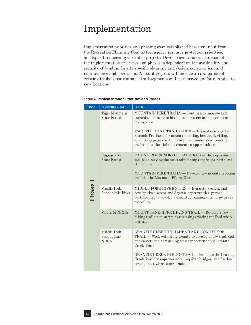
ImplementationImplementation priorities and phasing were established based on input from the Recreation Planning Committee, agency resource protection priorities, and logical sequencing of related projects. Development and construction of the implementation priorities and phases is dependent on the availability and security of funding for site-specific planning and design, construction, and maintenance and operations. All trail projects will include an evaluation of existing trails. Unsustainable trail segments will be removed and/or relocated to new locations
Table 4. Implementation Priorities and Phases
PHASE PLANNING UNIT PROJECT
Pha
se I
Tiger Mountain State Forest
MOUNTAIN BIKE TRAILS — Continue to improve and expand the mountain biking trail system in the mountain biking zone. FACILITIES AND TRAIL LINKS — Expand existing Tiger Summit Trailhead for mountain biking, horseback riding, and hiking access and improve trail connections from the trailhead to the different recreation opportunities.
Raging River State Forest
RAGING RIVER NORTH TRAILHEAD — Develop a new trailhead serving the mountain biking zone in the north end of the forest. MOUNTAIN BIKE TRAILS — Develop new mountain biking trails in the Mountain Biking Zone.
Middle Fork Snoqualmie River
MIDDLE FORK RIVER SITES — Evaluate, design, and develop river access and day-use opportunities; pursue partnerships to develop a consistent management strategy in the valley.
Mount Si NRCA MOUNT TENERIFFE HIKING TRAIL — Develop a new hiking trail up to summit area using existing roadbed where practical.
Middle Fork Snoqualmie NRCA
GRANITE CREEK TRAILHEAD AND CONNECTOR TRAIL — Work with King County to develop a new trailhead and construct a new hiking trail connection to the Granite Creek Trail. GRANITE CREEK HIKING TRAIL— Evaluate the Granite Creek Trail for improvements, required bridges, and further development where appropriate.
Snoqualmie Corridor Recreation Plan | March 201554
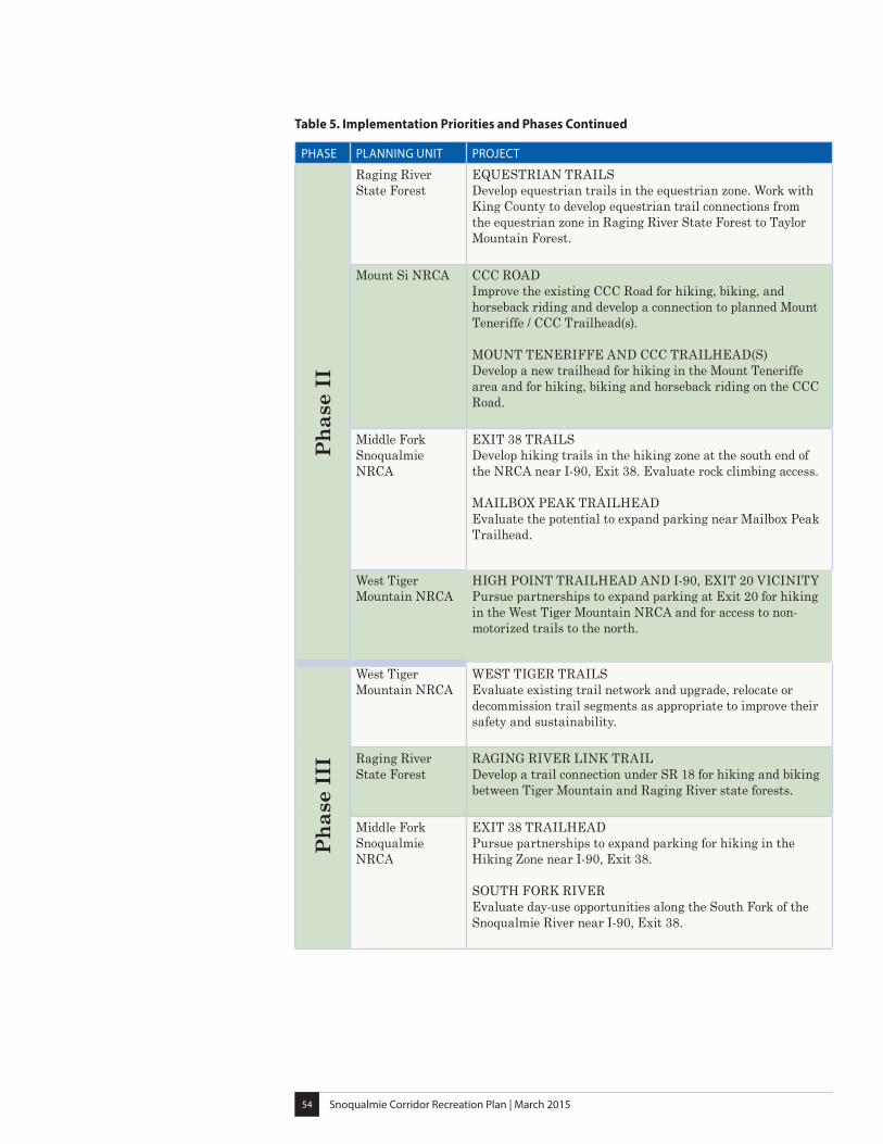
PHASE PLANNING UNIT PROJECT
Pha
se I
I
Raging River State Forest
EQUESTRIAN TRAILS Develop equestrian trails in the equestrian zone. Work with King County to develop equestrian trail connections from the equestrian zone in Raging River State Forest to Taylor Mountain Forest.
Mount Si NRCA CCC ROAD Improve the existing CCC Road for hiking, biking, and horseback riding and develop a connection to planned Mount Teneriffe / CCC Trailhead(s). MOUNT TENERIFFE AND CCC TRAILHEAD(S) Develop a new trailhead for hiking in the Mount Teneriffe area and for hiking, biking and horseback riding on the CCC Road.
Middle Fork Snoqualmie NRCA
EXIT 38 TRAILS Develop hiking trails in the hiking zone at the south end of the NRCA near I-90, Exit 38. Evaluate rock climbing access. MAILBOX PEAK TRAILHEAD Evaluate the potential to expand parking near Mailbox Peak Trailhead.
West Tiger Mountain NRCA
HIGH POINT TRAILHEAD AND I-90, EXIT 20 VICINITY Pursue partnerships to expand parking at Exit 20 for hiking in the West Tiger Mountain NRCA and for access to non-motorized trails to the north.
Pha
se I
II
West Tiger Mountain NRCA
WEST TIGER TRAILS Evaluate existing trail network and upgrade, relocate or decommission trail segments as appropriate to improve their safety and sustainability.
Raging River State Forest
RAGING RIVER LINK TRAIL Develop a trail connection under SR 18 for hiking and biking between Tiger Mountain and Raging River state forests.
Middle Fork Snoqualmie NRCA
EXIT 38 TRAILHEAD Pursue partnerships to expand parking for hiking in the Hiking Zone near I-90, Exit 38. SOUTH FORK RIVER Evaluate day-use opportunities along the South Fork of the Snoqualmie River near I-90, Exit 38.
Table 5. Implementation Priorities and Phases Continued
Plan
ning
Are
a Ba
ckgr
ound
Part
III

Snoqualmie Corridor Recreation Plan | March 201557
Planning Area Background
South Puget Sound Region and Recreation
DNR’s South Puget Sound (SPS) Region is located between the Olympic Mountains and the central Cascade Mountains, and is divided in half by Hood Canal, Puget Sound, and Lake Washington. It includes all of Kitsap, King, Pierce, and Thurston Counties, most of Mason County, and a small portion of Lewis, Snohomish, and Grays Harbor Counties. The region office is located in Enumclaw.
SPS Region manages approximately 323,610 acres of trust forestland, 36,660 acres of conservation land, and regulates forest practices and provides forest fire protection on approximately 2.5 million acres of state and private forestland. SPS Region also manages aquatic lands, such as state-owned tidelands and bedlands. SPS Region manages recreation and public access in conjunction with DNR’s Recreation Program and Natural Areas Program, both based in Olympia. Recreation in SPS Region is guided by planning efforts as well as regional and statewide guidelines.
This region is distinct in that much of the landscape is a rural-urban interface, with over sixty percent of the state’s population residing here. Levels of recreation use on state trust lands and natural areas have increased over time and are expected to continue to rise. Popular recreation areas in SPS Region include Green Mountain, Tahuya, Elbe, Tahoma, and Capitol State Forests, as well as the lands in the Snoqualmie Corridor Recreation Planning Area.
SPS region currently offers the developed recreation amenities listed below*:
• 54 Recreational Sites: - 27 trailheads - 11 campgrounds - 13 day-use sites such as picnic areas, vista points, and water access sites - 3 ski huts
• 14 Trail Systems: - 281 miles of multiple use trails - 245 non-motorized trails - 100 miles of winter trails
*These figures are as of March 2015
Snoqualmie Corridor Recreation Plan | March 201558
FIGURE 9. Service Area and Proximity to Urban Growth Areas
Snoqualmie Corridor Recreation Plan | March 201559
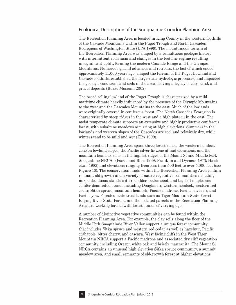
Ecological Description of the Snoqualmie Corridor Planning Area
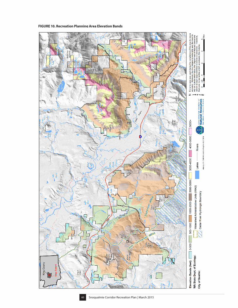
The Recreation Planning Area is located in King County in the western foothills of the Cascade Mountains within the Puget Trough and North Cascades Ecoregions of Washington State (EPA 1999). The mountainous terrain of the Recreation Planning Area was shaped by a tumultuous geologic history with intermittent volcanism and changes in the tectonic regime resulting in significant uplift, forming the modern Cascade Range and the Olympic Mountains. Numerous glacial advances and retreats, the last of which ended approximately 11,000 years ago, shaped the terrain of the Puget Lowland and Cascade foothills, established the large-scale hydrologic processes, and impacted the geologic conditions and soils in the area, leaving a legacy of clay, sand, and gravel deposits (Burke Museum 2002).
The broad rolling lowland of the Puget Trough is characterized by a mild maritime climate heavily influenced by the presence of the Olympic Mountains to the west and the Cascades Mountains to the east. Much of the lowlands were originally covered in coniferous forest. The North Cascades Ecoregion is characterized by steep ridges in the west and a high plateau in the east. The moist temperate climate supports an extensive and highly productive coniferous forest, with subalpine meadows occurring at high elevations. Summers in the lowlands and western slopes of the Cascades are cool and relatively dry, while winters tend to be mild and wet (EPA 1999).
The Recreation Planning Area spans three forest zones, the western hemlock zone on lowland slopes, the Pacific silver fir zone at mid elevations, and the mountain hemlock zone on the highest ridges of the Mount Si and Middle Fork Snoqualmie NRCAs (Fonda and Bliss 1969; Franklin and Dyrness 1973; Hawk et.al. 1982) and elevations ranging from less than 500 feet to over 5,000 feet (see Figure 10). The conservation lands within the Recreation Planning Area contain remnant old growth and a variety of native vegetative communities including mixed deciduous stands with red alder, cottonwood, and big leaf maple; and conifer dominated stands including Douglas fir, western hemlock, western red cedar, Sitka spruce, mountain hemlock, Pacific madrone, Pacific silver fir, and Pacific yew. Forested state trust lands such as Tiger Mountain State Forest, Raging River State Forest, and the isolated parcels in the Recreation Planning Area are working forests with forest stands of varying age.
A number of distinctive vegetative communities can be found within the Recreation Planning Area. For example, the clay soils along the floor of the Middle Fork Snoqualmie River Valley support a unique forest community that includes Sitka spruce and western red cedar as well as hazelnut, Pacific crabapple, bitter cherry, and cascara. West facing cliffs in the West Tiger Mountain NRCA support a Pacific madrone and associated dry cliff vegetation community, including Oregon white oak and bristly manzanita. The Mount Si NRCA contains an unusual high elevation Sitka spruce community, a summit meadow area, and small remnants of old-growth forest at higher elevations.
Snoqualmie Corridor Recreation Plan | March 201560
FIGURE 10. Recreation Planning Area Elevation Bands
Snoqualmie Corridor Recreation Plan | March 201561
The diverse terrain of the Recreation Planning Area supports a rich assortment of wildlife. Deer, elk, bear, cougar, beaver, mountain goats, hawks, herons, song birds, bats, and many other species inhabit the wide variety of forests, meadows, wetlands, lakes, streams, cliffs, balds, talus rocks, and caves. The Recreation Planning Area also provides habitat for several federally and state listed sensitive, threatened, and endangered species (WDFW, n.d.). The Recreation Planning Area contains habitat for the federally listed endangered gray wolf, as well as the following federally listed threatened species; marbled murrelet, northern spotted owl, fisher, and grizzly bear. Federally threatened fish such as steelhead trout, coho salmon, chinook salmon, and bull trout are supported by the streams in the Recreation Planning Area. The Recreation Planning Area also contains habitat for several Washington State listed species of concern including birds, such as Vaux’s swift, the pileated woodpecker, the peregrine falcon, the northern goshawk, and the golden eagle; amphibians such as the western toad and the tailed frog; and insects, such as Johnson’s hairstreak and the great arctic butterfly.
The creeks, streams, and rivers within the Recreation Planning Area ultimately feed into the Snohomish River and Lake Washington watersheds (USGS, n.d.). Most of the Recreation Planning Area is part of the Snohomish watershed including Mount Si NRCA, Middle Fork Snoqualmie NRCA, Rattlesnake Mountain Scenic Area, Raging River State Forest, and parts of Tiger Mountain State Forest. These areas drain into the Snoqualmie River, a major tributary of the Snohomish River. The Raging River, which joins the Snoqualmie River below Snoqualmie Falls, is an important salmon bearing stream. Several creeks in the Tiger Mountain State Forest and West Tiger Mountain NRCA drain into Issaquah Creek which feeds into Lake Sammamish, the Sammamish River, and finally Lake Washington.
The Recreation Planning Area contains several high elevation lakes. Mount Si NRCA encompasses Rechor Lake, Crater Lake, SMC Lake, Lake Nadeau, and Lake Moolock. Middle Fork Snoqualmie NRCA contains Gifford Lake and Granite Lake. Tiger Mountain State Forest holds five lakes and ponds, including Tradition lake, Round Lake, Beaver Valley, Otter Lake, and Double Beaver Wetland. Numerous wetlands are located throughout the Recreation Planning Area.
Snoqualmie Corridor Recreation Plan | March 201562
The Mountains to Sound Greenway
The nearly continuous landscape of federal, state, and county forests that characterize the corridor today was once a checkerboard of isolated parcels. These were ultimately assembled into larger blocks through land exchanges and acquisitions as part of a vision developed by the Mountains to Sound Greenway Trust. Starting in 1990 with an 80-person march from Snoqualmie Pass to Puget Sound that called for the protection of the natural beauty of the I-90 Corridor, the Mountains to Sound Greenway has grown into a broad based alliance of environmentalists, timber companies, developers, farmers, businesses, non-profits, and public agencies working together to build a continuous greenway from Puget Sound to Ellensburg. In 1998, 100 miles of I-90 were designated a National Scenic Byway. The Mountains to Sound Greenway Trust is currently leading a campaign to officially recognize the 1.5-million acre landscape along I-90 from Puget Sound to Ellensburg as a National Heritage Area (Mountains to Sound Greenway Trust, n.d.).
Snoqualmie Unit Advisory Committee
A diverse group of stakeholders was assembled to develop the Tiger Mountain State Forest Management Plan in 1985. Since that time, DNR has maintained a committee of citizen stakeholders to ensure continuing public participation in agency management and planning activities in the Snoqualmie Corridor. This committee, known today as the Snoqualmie Unit Advisory Committee, includes representatives from local communities, natural resource professionals, environmental organizations, and recreation groups.
Plan
ning
Pro
cess
Part
IV

Snoqualmie Corridor Recreation Plan | March 201565
Planning ProcessThe Snoqualmie Corridor Recreation Plan was developed with input and assistance from individuals and organizations representing a wide range of interests and backgrounds. The public planning process included public meetings, Recreation Planning Committee meetings, an online user survey, and public ideas and suggestions submitted through the DNR website, email, phone calls, and letters.
The Recreation Planning Committee was a vital component of the overall process. This group of volunteers consisted of 17 community members who represented a wide variety of user interests and helped to guide the course of the planning effort and offered input and suggestions. In addition to the Recreation Planning Committee, DNR convened a series of collaborative meetings with the adjacent public land-managers to address common issues and improve connections between the landscapes, based on the Recreation Planning Committee’s recommendations.
This collaborative process yielded a plan that is consistent with the DNR trust mandate on state trust lands and conservation objectives in NRCAs, addresses environmental responsibilities, provides for continued public access, and offers safe and sustainable recreational opportunities.
Developing the Snoqualmie Corridor Recreation Plan
The process to develop this plan included the following seven phases:
Phase 1: Pre-planning
• Develop project scope
• Identify data collection needs
• Create a stakeholder involvement plan
Phase 2: Recreation Land Sustainability
• Identify and map areas with long-term limiting factors for recreational use
Snoqualmie Corridor Recreation Plan | March 201566
Phase 3: Inventory and Public Involvement
• Identify public issues and concerns
• Hold public meetings
• Establish a Recreation Planning Committee
• Conduct field inventory
• Begin an online user survey
Phase 4: Assessment
• Evaluate and discuss biological, geological/soils, and management suitability data with Recreation Planning Committee
• Compile the data from the online user survey
• Develop preliminary concepts for recreation management
Phase 5: Alternatives
• Refine recreation concepts into one recommended plan
• Develop objectives and strategies for the plan
• Develop implementation priorities
• Complete a draft write up of the plan
Phase 6: State Environmental Policy Act (SEPA) Review
• Formal State Environmental Policy Act (SEPA) Review for the proposed plan
Phase 7: Plan Completion
• Finalize the plan for publication
• DNR adopts the final plan
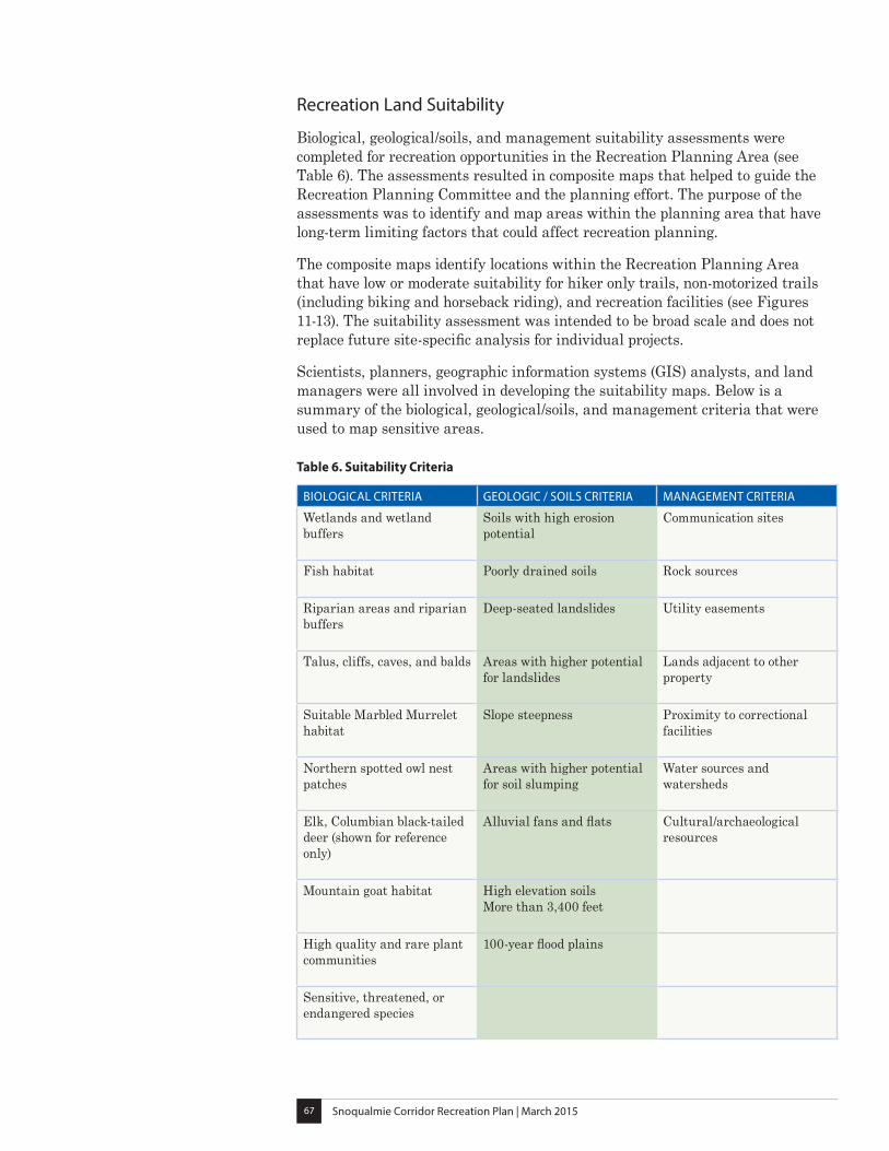
Snoqualmie Corridor Recreation Plan | March 201567
Recreation Land Suitability
Biological, geological/soils, and management suitability assessments were completed for recreation opportunities in the Recreation Planning Area (see Table 6). The assessments resulted in composite maps that helped to guide the Recreation Planning Committee and the planning effort. The purpose of the assessments was to identify and map areas within the planning area that have long-term limiting factors that could affect recreation planning.
The composite maps identify locations within the Recreation Planning Area that have low or moderate suitability for hiker only trails, non-motorized trails (including biking and horseback riding), and recreation facilities (see Figures 11-13). The suitability assessment was intended to be broad scale and does not replace future site-specific analysis for individual projects.
Scientists, planners, geographic information systems (GIS) analysts, and land managers were all involved in developing the suitability maps. Below is a summary of the biological, geological/soils, and management criteria that were used to map sensitive areas.
BIOLOGICAL CRITERIA GEOLOGIC / SOILS CRITERIA MANAGEMENT CRITERIA
Wetlands and wetland buffers
Soils with high erosion potential
Communication sites
Fish habitat Poorly drained soils Rock sources
Riparian areas and riparian buffers
Deep-seated landslides Utility easements
Talus, cliffs, caves, and balds
Areas with higher potential for landslides
Lands adjacent to other property
Suitable Marbled Murrelet habitat
Slope steepness Proximity to correctional facilities
Northern spotted owl nest patches
Areas with higher potential for soil slumping
Water sources and watersheds
Elk, Columbian black-tailed deer (shown for reference only)
Alluvial fans and flats Cultural/archaeological resources
Mountain goat habitat
High elevation soils More than 3,400 feet
High quality and rare plant communities
100-year flood plains
Sensitive, threatened, or endangered species
Table 6. Suitability Criteria
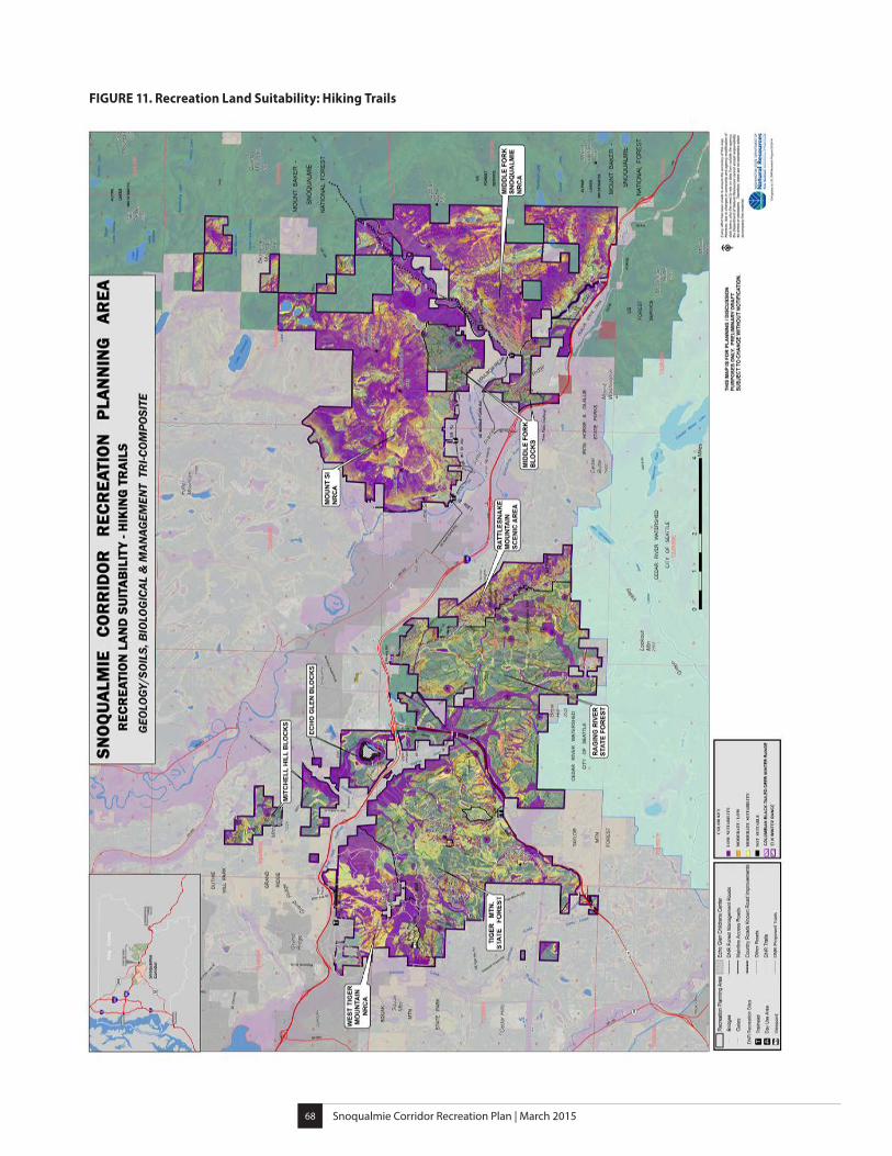
Snoqualmie Corridor Recreation Plan | March 201568
FIGURE 11. Recreation Land Suitability: Hiking Trails
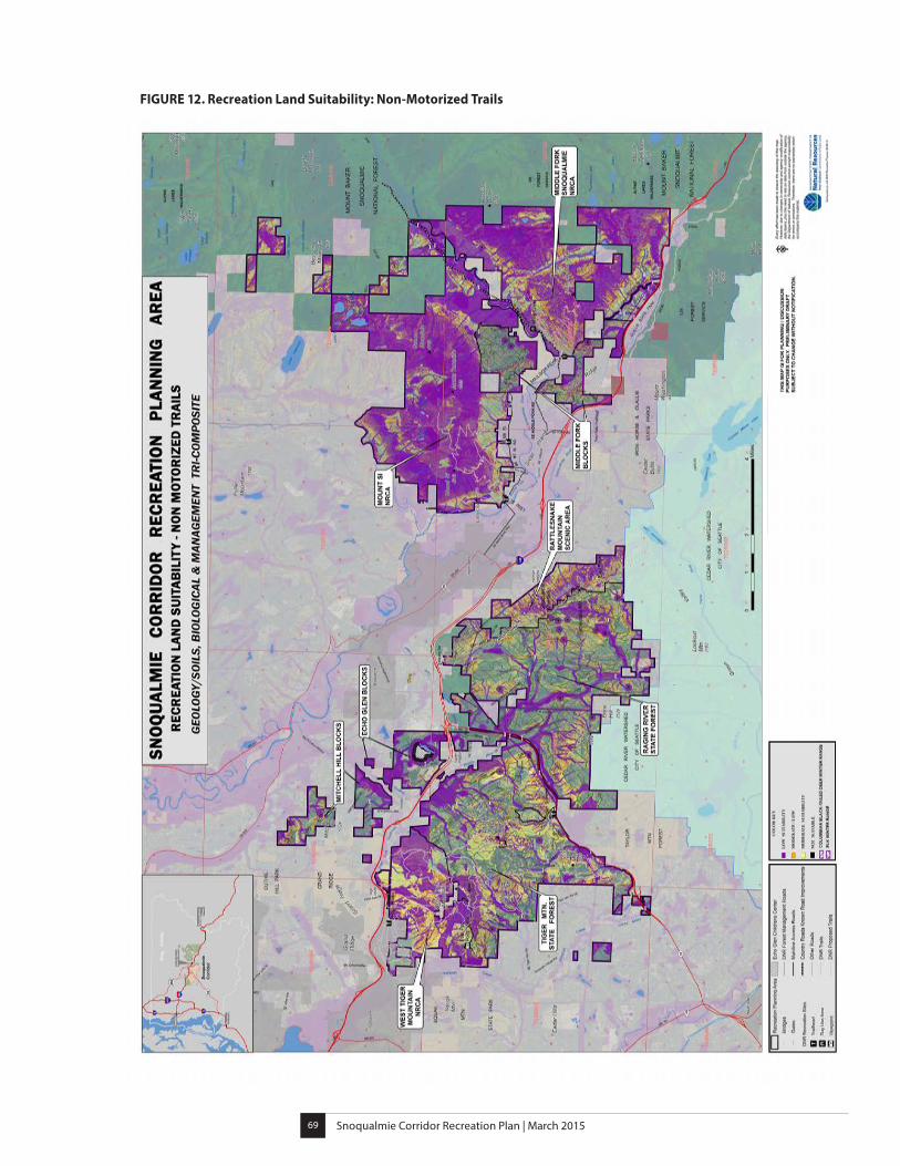
Snoqualmie Corridor Recreation Plan | March 201569
FIGURE 12. Recreation Land Suitability: Non-Motorized Trails
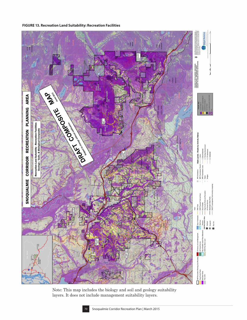
Snoqualmie Corridor Recreation Plan | March 201570
FIGURE 13. Recreation Land Suitability: Recreation Facilities
Note: This map includes the biology and soil and geology suitability layers. It does not include management suitability layers.
Snoqualmie Corridor Recreation Plan | March 201571
Public InvolvementPublic participation in the planning process was an integral part of creating this plan. The outreach process included several main components:
• A project “kick-off” public meeting to introduce the project and collect public input
• Formation of a citizen-based Recreation Planning Committee to work with staff to discuss challenges and recommend improvements within the Recreation Planning Area
• External information gathering and issue identification from a variety of sources
• Creation of a web page to provide general information on the planning process and solicit comments
• E-news updates and blogs to inform the public on the progress of planning efforts
• Participation in a web based user survey
• Public comments on the draft plan as a part of the SEPA review process
The Project “Kick-Off” Public Meeting
To “kick-off” the planning process, DNR invited the public to an open house held on February 1, 2012, at Snoqualmie Middle School in the City of Snoqualmie. The open house provided an opportunity for the public to learn about the planning process, ask questions and provide input on ways to improve recreation in the Recreation Planning Area. Approximately 120 people attended the meeting.
Participants were asked to share feedback about:
• Opportunities for connections between communities, DNR-managed lands, and other public lands
• Enjoyable recreation activities in the Snoqualmie Corridor
• Missing recreation opportunities in the Snoqualmie Corridor
• Favorite places to visit
• Concerns about the future of recreation management in the Recreation Planning Area
Snoqualmie Corridor Recreation Plan | March 201572
User Survey
In the summer of 2012, DNR conducted an online user survey to gather information about recreation in the Snoqualmie Corridor Recreation Planning Area. More than 2,500 people responded and contributed information about current recreational use, concerns, and the opportunities they would like to see provided. The survey was not intended to be a statistical representation of use; it was utilized as a tool to gain additional information about how the Recreation Planning Area is being used for recreation.
Recreation Planning Committee
A committee of 17 citizen volunteers with diverse recreational interests was selected to assist in the recreation planning process. These volunteers committed to a 14 month planning process consisting of monthly meetings, field trips, and outreach with various user groups for input and ideas. The committee was guided by a Recreation Planning Committee charter that described DNR’s mission, guiding principles, vision, and goals as well as the Committee’s mission, commitment, and authority.
Committee members came from communities in Auburn, Seattle, Issaquah, Preston, Snoqualmie, North Bend, Duvall, and Renton. They included resource and wildlife professionals, community leaders, recreation user group members, and local residents. Committee member recreational interests included hiking, mountain biking, cycling, horseback riding, trail running, kayaking, fishing, hunting, rock collecting, environmental education, restoration, and others.
Committee meetings provided a forum for exchanging knowledge and ideas. DNR shared information with the committee regarding trust obligations, natural area land management, environmental and resource responsibilities, and funding limitations. Committee members provided information about various recreation interests in the Recreation Planning Area. The collective information was critical in making recreational use recommendations within the Recreation Planning Area.
The first meetings provided an introduction to DNR’s mission and responsibilities,; an overview of the Recreation Planning Area and the history of use; and information on developed and dispersed recreation, current use patterns, and illegal or inappropriate use. Committee members were asked to share their own knowledge about the Recreation Planning Area and surrounding lands. Members also shared descriptions of recreational activities they pursued in the area.
Several meetings were dedicated to presentations that provided critical information about biological, geological, soil, and management criteria as they relate to land suitability for recreational use. Suitability maps were developed to help identify general areas that are less suitable for recreation. These maps
Snoqualmie Corridor Recreation Plan | March 201573
provided a foundation for the development of recreational use recommendations. Specific locations of all proposed facilities and trails were not identified as part of this process, but will be determined by site-based assessments.
Committee members spent much of the summer in the field with staff, exploring the planning area, and identifying issues and opportunities. With the additional first-hand knowledge gained in the field, and results from a public survey, the committee and DNR staff dedicated the remaining meetings to discussing issues and ideas and exploring alternatives.
The committee spent a large amount of time reviewing and discussing various recreational use draft concepts for the Recreation Planning Area, with an objective of finding a concept that they all could support. Historic uses, past planning efforts, current conditions, land suitability, resource protection, public use needs, and other identified issues were taken into consideration during the process.
The Recreational Concept Maps reflect the comprehensive planning process and are supported by the majority of the Recreation Planning Committee.
Field Data Collection and Mapping
DNR staff conducted an inventory of existing trails in the Recreation Planning Area and committee members helped survey undesignated trails. These locations were mapped and shared with the Recreation Planning Committee.

Snoqualmie Corridor Recreation Plan | March 201574
In Closing
This plan is intended to guide recreation and public access opportunities for the next 10-15 years within the Recreation Planning Area. Objectives, strategies, implementation priorities, and phasing were developed with the active participation of the Recreation Planning Committee and public input.
Implementation of individual projects is contingent on acquiring adequate funding, and future development of facilities and trails will undergo site specific analysis. This plan will be evaluated periodically as part of adaptive management, and changes will be made as necessary to ensure compatibility with trust obligations and forest management objectives.
Regu
latio
ns a
nd P
olicy
Info
rmat
ionPa
rt V

Snoqualmie Corridor Recreation Plan | March 201577
Regulations and Policy InformationDNR is required to comply with all local, state, and federal laws. Important components of the legal and policy framework that apply to recreation on DNR-managed trust lands include the following:
DNR Trust Mandate
Washington State’s public trust lands are managed by DNR for the trust beneficiaries. DNR is guided by a “trust mandate” that is a legal obligation to manage state lands to generate sustainable revenue for the beneficiaries, which include counties and designated state institutions. The role of trustee directs DNR to act with undivided loyalty to the trust beneficiaries, manage the trust assets prudently, preserve the trust property (the “corpus” of the trust), make the trust property productive, deal impartially with beneficiaries, and consider the interests of successive beneficiaries.
Public Lands Act (Title 79 RCW)
Many DNR obligations and authorities as a land manager are established in the state Public Lands Act. This statute defines “multiple-use,” “state lands,” and “sustainable harvest,” which are key concepts that help shape the Policy for Sustainable Forests.
The Multiple Use Concept (79.10 RCW)
This Chapter authorizes DNR to manage the lands for multiple uses that are compatible with those basic activities necessary to fulfill the financial obligations of trust management. Additionally, DNR is authorized to construct, operate, and maintain primitive outdoor recreation and conservation facilities to achieve maximum effective development consistent with the purposes for which the lands are held.
Natural Areas Preserve Act (79.70 RCW)
The Natural Areas Preserve Act was approved by the Washington State Legislature in 1972, in order to protect the highest quality examples of native ecosystems, rare plant and animal species, as well as other natural features of state, regional, or national significance. The preserves are used for education, scientific research, and to maintain Washington's native biological diversity.
Natural Resources Conservation Areas Act (79.71 RCW)
The Washington Natural Resources Conservation Areas (NRCA) Act was approved by the Washington State Legislature in 1987 as a new concept, blending public use and natural resource protection goals. The Act codifies the creation of NRCAs to protect outstanding examples of native ecosystems,
Snoqualmie Corridor Recreation Plan | March 201578
habitat for threatened, endangered and sensitive plants and animals, and scenic landscapes while developing opportunities for environmental education and low impact recreation. A fundamental principle of the NRCA program is that natural resource protection has the highest priority. Public use may be accommodated within conservation areas where such uses do not adversely affect the resource values the area was intended to protect. The NRCA Statewide Management Plan governs all NRCAs without site-specific management plans and provides the policy direction for individual plans.
State Environmental Policy Act – SEPA (43.21C RCW)
SEPA is a state policy that requires state and local agencies to consider the likely environmental consequences of a proposal before approving or denying the proposal.
DNR State Trust Lands Habitat Conservation Plan (HCP) 1997
This plan guides management of approximately 1.8 million acres of forested state trust lands within the range of the northern spotted owl. This HCP is a partnership between the National Oceanic and Atmospheric Administration (NOAA) Fisheries Service, the United States Fish and Wildlife Service, and DNR. This plan guides the management of forested state trust lands and enables compliance with the Endangered Species Act requirements.
The Policy for Sustainable Forests
Adopted in 2006, the purpose of this policy is to conserve and enhance the natural systems and resources of forested state trust lands managed by DNR. Under the policy, these state trust lands are managed to produce long-term, sustainable trust income, and environmental and other benefits for the people of Washington. Recreational opportunities are provided where such uses are compatible with trust objectives and natural resource protection needs.
The South Puget HCP Planning Unit Forest Land Plan – Final EIS (January 2010)
The purpose this plan was to develop management strategies that will provide guidance in forest land management at the operational level. The strategies are based on local conditions and issues (ecological, socio-cultural, and economic) and are implemented throughout the South Puget Sound Planning Unit over the long-term. Management strategies are designed to implement Board of Natural Resources policies, which ensure revenue to trust beneficiaries, habitat for multiple species, and other benefits.
DNR Public Access and Recreation Rules (332-52 WAC)
The purpose of these rules is to set standards for public use on lands managed by DNR. These rules promote public health and safety, and protect DNR-managed lands, property, and resources. All persons who use DNR-managed lands should know and follow the department’s rules.

Snoqualmie Corridor Recreation Plan | March 201579
Refr
ence
s

Snoqualmie Corridor Recreation Plan | March 201580
Snoqualmie Corridor Recreation Plan | March 201581
RefrencesBiology online. (n.d.) Retrieved December, 11, 2013 from http://www.biology-online.org/dictionary/
Burke Museum. (2002). The Cascade Episode (37 million years ago to present), Evolution of the Modern Pacific Northwest. Retrieved March 16, 2014 from http://www.burkemuseum.org/static/geo_history_wa/Cascade%20Episode.htm
Environmental Protection Agency (EPA). (March 1999). Primary Distinguishing Characteristics of Level III Ecoregions of the Continental United States. EPA Western Ecology Division – Level III Ecoregions. Retrieved March 16, 2014 from http://www.hort.purdue.edu/newcrop/cropmap/ecoreg/descript.html
Fonda, R.W. and Bliss, L.C. (1969). Forest Vegetation of the Montane and Subalpine Zones, Olympic Mountains, Washington. Ecological Monographs, 39: 271-301.
Franklin, J.F. and Dyrness, C.T. (1973). Natural Vegetation of Oregon and Washington. (USDA Forest Service General Technical Report PNW-8). Portland, OR: Pacific Northwest Forest and Range Experimental Station Forest Service, U.S. Department of Agriculture.
Hawk, G.M. et. al. (1982). Relations Between Vegetation and Environment. In Edmonds, R. (Ed.), Analysis of Coniferous Forest Ecosystems in the Western United States (pp. 28-44). Stroudsburg, PA: Hutchinson Ross Publishing Co.
King County, Washington. (February 2011). Executive News. King County experiences strong population growth according to 2010 census results. Retrieved August 30, 2013 from: http://www.kingcounty.gov/exec/news/release/2011/February/24Census.aspx
Landscope America. (n.d.). Ecoregions in Washington. Retrieved February 23, 2014 from http://www.landscope.org/washington/natural_geography/ecoregions/
Mountains to Sound Greenway Trust. (n.d.). About Us, the Greenway connects it all. Retrieved March 16, 2014 from http://mtsgreenway.org/about.
State of Washington, Office of Financial Management. (August 2012). Washington State Growth Management Population Projections for Counties: 2010-2040 – 2012 Projections. Retrieved December 17, 2012 from: http://www.ofm.wa.gov/pop/gma/projections12/projections12.asp
(USGS) United States Geological Survey. (n.d.) Hydrography, What is the WBD. Retrieved March 18, 2014 from: http://nhd.usgs.gov/wbd.html
(WDFW) Washington Department of Fish and Wildlife. (n.d.). Washington State Species of Concern. Retrieved April 14, 2014 from http://wdfw.wa.gov/conservation/endangered/lists/search.php
Snoqualmie Corridor Recreation Plan | March 201582
(WSDOT) Washington State Department of Transportation. (March 2014). SR 18-Issaquah Hobart Road to I-90, March 2014 Update. Retrieved March 16, 2014 from http://www.wsdot.wa.gov/projects/sr18/auburntoi90/ihobart_i90/
Other Management and Concept Plans
Middle Fork Steering Committee, Middle Fork Task Force. (September 1997). Middle Fork of the Snoqualmie River Valley Phase I River Corridor Public Use Concept.
Middle Fork Steering Committee, Middle Fork Task Force. (September 1997). Middle Fork of the Snoqualmie River Valley Phase II River Corridor Public Use Concept. Retrieved April 22, 2014 from: http://www.americanwhitewater.org/content/Document/view/documentid/187/
National Parks Service. (2005). Middle Fork of the Snoqualmie River Access Final Concept Plan. Retrieved April 22, 2014 from: http://www.americanwhitewater.org/content/Document/view/documentid/188/
University of Washington, Department of Landscape Architecture. (March 2004). Middle Fork of the Snoqualmie River Valley Interpretive Plan. Retrieved April 22, 2014 from: https://www.americanwhitewater.org/content/Document/view/documentid/189/
Washington State Department of Natural Resources. (June 1997). Mount Si NRCA Management Plan. Retrieved April 22, 2014 from: http://www.dnr.wa.gov/Publications/amp_na_mt_si_mgt_plan_1997.pdf
Washington State Department of Natural Resources. (June 1997). Mount Si NRCA Public Use Plan. Retrieved April 22, 2014 from: http://www.dnr.wa.gov/Publications/amp_na_mt_si_public_use_plan_1997_final.pdf
Washington State Department of Natural Resources. (January 1998). Rattlesnake Mountain Scenic Area Management Plan. Retrieved April 22, 2014 from: http://www.dnr.wa.gov/Publications/amp_na_rattlesnake_mgtplan1998.pdf
Washington State Department of Natural Resources. (September 1992). State of Washington Natural Resources Conservation Areas Statewide Management Plan.
Washington State Department of Natural Resources. (June 1991). Tiger Mountain State Forest Recreation Plan.
Washington State Department of Natural Resources. (July 1997). West Tiger Mountain Natural Resources Conservation Area Management Plan. Retrieved April 22, 2014 from: http://www.dnr.wa.gov/Publications/amp_tiger_mt_NRCA_plan1997.pdf

Snoqualmie Corridor Recreation Plan | March 201583
Appe
ndice
s

Snoqualmie Corridor Recreation Plan | March 201584
Snoqualmie Corridor Recreation Plan | March 201585
Appendix AGlossary of Terms
For the purposes of this Recreation Plan, the terms below have the following meanings:
Adaptive Management – a concept that provides for ongoing modifications of management practices in order to respond to new information, changes in circumstances on the ground, changes in laws, and new scientific developments.
Alluvial fans – fan-shaped deposits of water-transported materials, typically formed at the base of topographic features where there is a marked break in the slope. As water flows down a slope it can pick up sand and other materials. As it reaches the base and spreads onto flat lands, the material is deposited and over time an alluvial fan is created.
Balds – open spaces within forests which support a very different suite of plants and animals than the surrounding forest communities; typically found in rocky areas with shallow soils.
Buffer – an area that surrounds and protects an environmentally sensitive area from adverse impacts to the functions and values of that area.
CCC Road – depression era Civilian Conservations Corps road located within the Recreation Planning Area.
Cultural resources – archaeological and historic sites and artifacts.
Day-use area – an area which supports day-time recreational activities but is not designed for overnight camping activities.
Deep-seated landslides – a slow but continuous movement of a large volume of soil and rock, that sometimes transforms into a catastrophic movement. Depths of deep-seated landslides are usually more than 10 meters and generally mobilize the bedrock underneath. Most deep-seated landslides tend to fail incrementally. Movement is usually triggered by cumulative rainfall over long periods or by high ground accelerations experienced during large magnitude earthquakes.
Designated trails – trails that have been approved by the department for public use.
Developed recreation – recreation that occurs at a designated site or location, built or improved for recreation on DNR-managed land such as a trailhead, vista, parking area, boat launch, picnic area, campground, or water trail site.
Snoqualmie Corridor Recreation Plan | March 201586
Dispersed recreation – recreation that occurs on department-managed lands outside of a developed recreation facility or trail. Examples of dispersed use include, but are not limited to, nature observation, rock climbing, geocaching, birding, hunting, and mushroom, and berry picking.
Ecoregion – an area on the landscape characterized by a distinctive pattern of plant and animal species distribution shaped by abiotic factors such as climate, landform, soil and hydrology.
Ecosystem – A system that includes all living organisms (biotic factors) in an area as well as its physical environment (abiotic factors) functioning together as a unit.
Education and Enforcement – measures taken to inform the public about the rules of conduct on DNR-managed lands.
Endangered species – a federally or state listed species which is likely to become extinct throughout all or a significant portion of its range.
Forest Stand – a basic unit of forest mapping; a group of trees that are more or less homogenous with regard to species composition, density, size, age, and sometimes habitat.
Forest Zones – forest community types organized along climatic gradients such as moisture, temperature, snow depth and snow duration.
Flood plains – flat or nearly flat land adjacent to a stream or river that experiences occasional or periodic flooding.
Integrated Enforcement Strategy – a comprehensive plan to provide safe and sustainable recreation opportunities while enforcing rules and regulations such as the Discover Pass. It includes the participation and cooperation of DNR’s Law Enforcement Services and the Recreation Program, consistent implementation of policies and procedures, regular staff presence on the landscape, coordination of program activities, and management support.
Invasive species – any non-native species of plant or animal that commonly compete with and replace native species.
Low-impact public use – includes public recreation uses and improvements that do not adversely affect the resource values, are appropriate to the maintenance of the site in a relatively unmodified natural setting, and do not detract from long-term ecological processes (RCW 79.71.030 Definitions).
Maritime climate – a temperate regional climate that is under the predominant influence of the ocean, characterized by a narrow annual range of temperatures.

Snoqualmie Corridor Recreation Plan | March 201587
Monitoring – the collection and analysis of data by various methods for the purposes of understanding and documenting changes in natural ecosystems and features.
Mountain Hemlock Zone – located at high elevations (above 1,300 meters) in the subalpine zone, mostly west of coastal mountains from British Columbia to Oregon where the biogeoclimate is cool and wet with significant snowfall. Major tree species in this zone are mountain hemlock and Pacific silver fir, as well as subalpine fir and lodgepole pine, which become more dominant in drier areas.
Multiple use recreation (shared use) – trails and facilities that allow and support different kinds of non-motorized trail use. Recreational activities may include any combination of hiking, mountain biking, equestrian, etc.
Natural Areas – state-managed land that has been identified and designated as having high ecological, scenic, and/or historical value and is managed under the DNR Natural Areas Program. These lands include Natural Area Preserves and Natural Resource Conservation Areas and are managed to maintain the conservation values.
Natural Area Preserves (NAP) – DNR-managed state lands, which are managed as conservation lands in order to maintain Washington’s native biological diversity. These lands protect the highest quality examples of native ecosystems and rare plant and animal species as well as other natural features of state, regional or natural significance while providing opportunities for environmental education and scientific research.
Native vegetation – vegetation existing on a site, or plant species which are indigenous to the area in question.
Natural Resources Conservation Areas (NRCA) – DNR-managed state lands, which are managed as conservation lands. These lands protect outstanding examples of native ecosystems, habitat for threatened, endangered and sensitive plants and animals and scenic landscapes while providing opportunities for environmental education and low-impact recreation.
Old Growth Characteristics – forest stands dominated by trees of advanced age and generally containing two or more species in a range of ages and sizes, deep multilayered canopies, snags and downed logs.
Pacific Silver Zone – a biogeoclimate that experiences significant rainfall and is characterized by cool dry summers and wet winters with snow at higher elevations. The Pacific Silver Zone is located on upland slopes (600-1300 meters), in the montane zone between lowland and subalpine elevations, mostly west of coastal mountains from British Columbia to Oregon. Major tree species in this zone include Pacific silver fir, the major climax specie as well as western hemlock, noble fir, Douglas fir, western red.
Snoqualmie Corridor Recreation Plan | March 201588
Perched water tables – an accumulation or pooling of ground water that is above the main groundwater table. The ground water becomes trapped above an impermeable layer, such as clay, and forms a layer of saturated ground material separate from the ground water table below.
Primary Management Objective – the principal use for which an area or facility is managed. A primary management objective does not necessarily mean that other uses in the areas are excluded. It is a tool intended to provide recreational visitors with an understanding of the type of recreational activities to expect.
Recreation Planning Area – the DNR-managed lands that are included in the planning process for this plan. Included are West Tiger Mountain NRCA, Tiger Mountain State Forest, Raging River State Forest, Rattlesnake Mountain Scenic Area, Mount Si NRCA, Middle Fork Snoqualmie NRCA, Mitchell Hill blocks, Echo Glen blocks, Middle Fork blocks and isolated parcels near the Community of Preston and south of the City of Issaquah.
Recreation Planning Committee – a committee of 17 citizen volunteers with diverse recreational interests, selected to assist in the recreation planning process.
Recreation Planning Unit – a block of DNR-managed land, which is managed under a particular set of recreational objectives.
Restoration – an intentional activity that initiates or accelerates the recovery of an ecosystem with respect to its health, integrity, and sustainability. For the purposes of this plan, restoration implies repairing resource damage that has occurred due to past recreational use. Fundamental to restoration is redirecting recreational access away from areas that are unsustainable, correcting erosion and sediment delivery issues, and supporting re-vegetation as necessary.
Sensitive species – a federally or state listed species which is vulnerable or declining and likely to become threatened or endangered in a significant portion of its range without cooperative management or the removal of threats.
Staging area – a developed recreation facility that can be used for parking, picnicking, and activity set-up prior to accessing trails.
State trust lands – DNR-managed state lands held as a fiduciary (financial) trust and managed to benefit specific trust beneficiaries such as public K-12 schools and universities, capitol buildings, counties, and local services such as libraries.
Recreation land suitability assessment – a process where biological, geological, soils, and management data were applied in geographic layers and overlaid to produce composite maps. These maps assisted the committee in identifying areas with long-term limiting factors that would alter or affect recreation planning in the Recreation Planning Area.
Snoqualmie Corridor Recreation Plan | March 201589
Suitability criteria – characteristics used to identify locations within the Recreation Planning Area that have low or moderate suitability for recreational facilities or trails.
Sustainable recreation – recreation which is managed to minimize maintenance and the environmental impacts associated with outdoor recreation by directing public use into areas and onto trails which are safe and well designed, constructed, and suited to a particular use or experience.
Threatened species – a federally or state listed species which is likely to become endangered within the foreseeable future.
Trail connections – trail segments that are intended to link two existing sites, trails, or points of interest, with the intended purpose of providing increased access.
Trailhead – a developed recreation facility that provides parking, restrooms, maps and information, and access to a developed trail system.
Trail Management Objective – a description of the planned purpose for a specific trail or trail segment. Trail management objectives include information such as the primary recreational use of the trail as well as any other allowed uses, design criteria, and any special considerations.
Undesignated trails – trails that have not been developed or managed by DNR. They are not formally recognized, managed, or signed to support sustainable recreation opportunities on DNR-managed lands.
WAC – Washington Administrative Code. Regulations of executive branch agencies are issued by authority of statutes. Like legislation and the Constitution, regulations are a source of primary law in Washington State. The WAC codifies the regulations and arranges them by subject or agency.
Watershed – an area of land where all the water that is under it or drains off of it goes to the same place.
Western Hemlock Zone – a biogeoclimate that experiences significant rainfall and is characterized by cool dry summers and moist mild winters. The Western Hemlock Zone occurs at low to middle elevations (often below 600 meters), mostly west of coastal mountains along the entire British Columbia coast and into Alaska, Washington, and Oregon. Major tree species in this zone include Douglas fir, western red cedar and western hemlock, the major climax specie for which the zone is named.
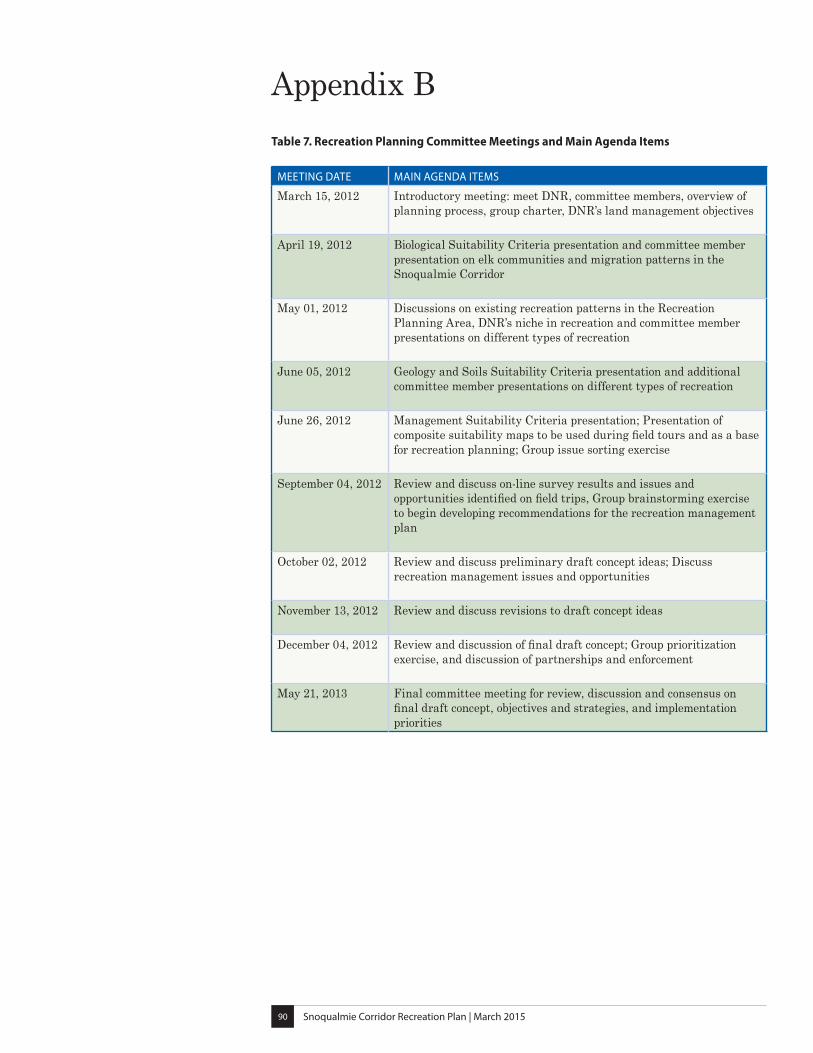
Snoqualmie Corridor Recreation Plan | March 201590
Appendix BTable 7. Recreation Planning Committee Meetings and Main Agenda Items
MEETING DATE MAIN AGENDA ITEMS
March 15, 2012 Introductory meeting: meet DNR, committee members, overview of planning process, group charter, DNR’s land management objectives
April 19, 2012 Biological Suitability Criteria presentation and committee member presentation on elk communities and migration patterns in the Snoqualmie Corridor
May 01, 2012 Discussions on existing recreation patterns in the Recreation Planning Area, DNR’s niche in recreation and committee member presentations on different types of recreation
June 05, 2012 Geology and Soils Suitability Criteria presentation and additional committee member presentations on different types of recreation
June 26, 2012 Management Suitability Criteria presentation; Presentation of composite suitability maps to be used during field tours and as a base for recreation planning; Group issue sorting exercise
September 04, 2012 Review and discuss on-line survey results and issues and opportunities identified on field trips, Group brainstorming exercise to begin developing recommendations for the recreation management plan
October 02, 2012 Review and discuss preliminary draft concept ideas; Discuss recreation management issues and opportunities
November 13, 2012 Review and discuss revisions to draft concept ideas
December 04, 2012 Review and discussion of final draft concept; Group prioritization exercise, and discussion of partnerships and enforcement
May 21, 2013 Final committee meeting for review, discussion and consensus on final draft concept, objectives and strategies, and implementation priorities
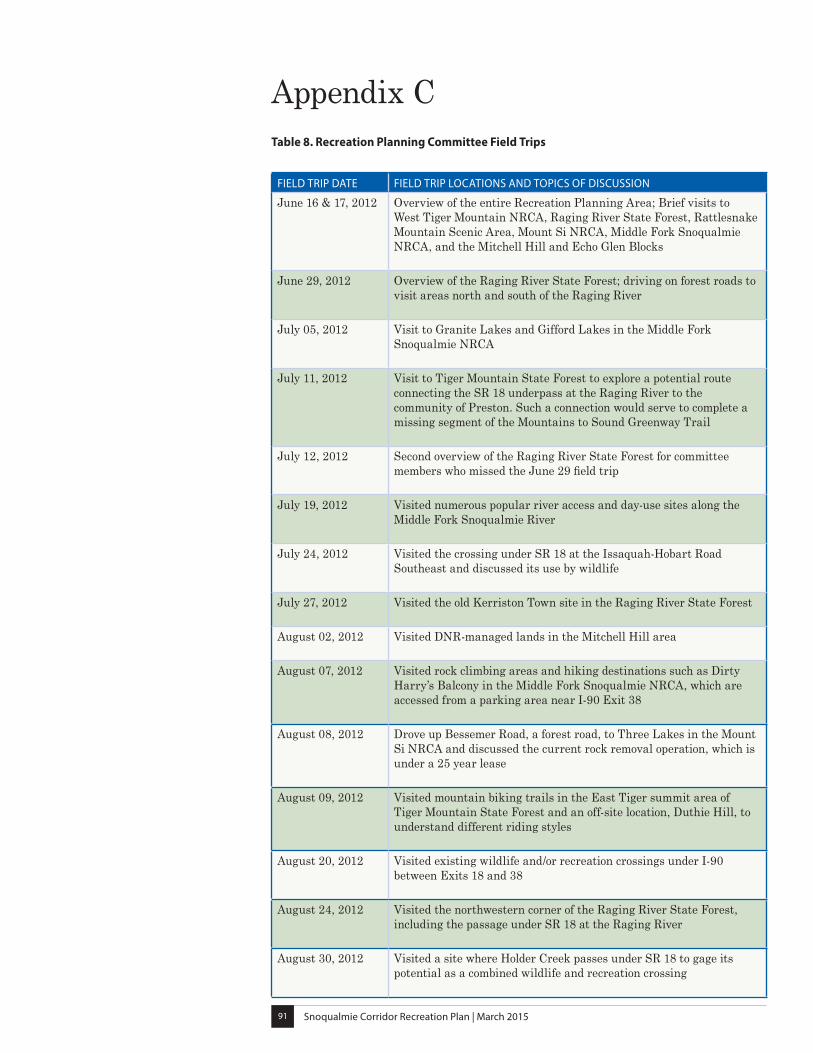
Snoqualmie Corridor Recreation Plan | March 201591
Appendix C Table 8. Recreation Planning Committee Field Trips
FIELD TRIP DATE FIELD TRIP LOCATIONS AND TOPICS OF DISCUSSION
June 16 & 17, 2012 Overview of the entire Recreation Planning Area; Brief visits to West Tiger Mountain NRCA, Raging River State Forest, Rattlesnake Mountain Scenic Area, Mount Si NRCA, Middle Fork Snoqualmie NRCA, and the Mitchell Hill and Echo Glen Blocks
June 29, 2012 Overview of the Raging River State Forest; driving on forest roads to visit areas north and south of the Raging River
July 05, 2012 Visit to Granite Lakes and Gifford Lakes in the Middle Fork Snoqualmie NRCA
July 11, 2012 Visit to Tiger Mountain State Forest to explore a potential route connecting the SR 18 underpass at the Raging River to the community of Preston. Such a connection would serve to complete a missing segment of the Mountains to Sound Greenway Trail
July 12, 2012 Second overview of the Raging River State Forest for committee members who missed the June 29 field trip
July 19, 2012 Visited numerous popular river access and day-use sites along the Middle Fork Snoqualmie River
July 24, 2012 Visited the crossing under SR 18 at the Issaquah-Hobart Road Southeast and discussed its use by wildlife
July 27, 2012 Visited the old Kerriston Town site in the Raging River State Forest
August 02, 2012 Visited DNR-managed lands in the Mitchell Hill area
August 07, 2012 Visited rock climbing areas and hiking destinations such as Dirty Harry’s Balcony in the Middle Fork Snoqualmie NRCA, which are accessed from a parking area near I-90 Exit 38
August 08, 2012 Drove up Bessemer Road, a forest road, to Three Lakes in the Mount Si NRCA and discussed the current rock removal operation, which is under a 25 year lease
August 09, 2012 Visited mountain biking trails in the East Tiger summit area of Tiger Mountain State Forest and an off-site location, Duthie Hill, to understand different riding styles
August 20, 2012 Visited existing wildlife and/or recreation crossings under I-90 between Exits 18 and 38
August 24, 2012 Visited the northwestern corner of the Raging River State Forest, including the passage under SR 18 at the Raging River
August 30, 2012 Visited a site where Holder Creek passes under SR 18 to gage its potential as a combined wildlife and recreation crossing
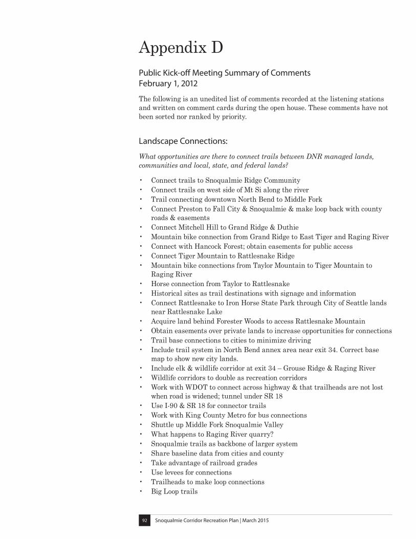
Snoqualmie Corridor Recreation Plan | March 201592
Appendix DPublic Kick-off Meeting Summary of Comments February 1, 2012
The following is an unedited list of comments recorded at the listening stations and written on comment cards during the open house. These comments have not been sorted nor ranked by priority.
Landscape Connections:
What opportunities are there to connect trails between DNR managed lands, communities and local, state, and federal lands?
• Connect trails to Snoqualmie Ridge Community• Connect trails on west side of Mt Si along the river• Trail connecting downtown North Bend to Middle Fork• Connect Preston to Fall City & Snoqualmie & make loop back with county
roads & easements• Connect Mitchell Hill to Grand Ridge & Duthie• Mountain bike connection from Grand Ridge to East Tiger and Raging River• Connect with Hancock Forest; obtain easements for public access• Connect Tiger Mountain to Rattlesnake Ridge• Mountain bike connections from Taylor Mountain to Tiger Mountain to
Raging River• Horse connection from Taylor to Rattlesnake• Historical sites as trail destinations with signage and information• Connect Rattlesnake to Iron Horse State Park through City of Seattle lands
near Rattlesnake Lake• Acquire land behind Forester Woods to access Rattlesnake Mountain• Obtain easements over private lands to increase opportunities for connections• Trail base connections to cities to minimize driving• Include trail system in North Bend annex area near exit 34. Correct base
map to show new city lands.• Include elk & wildlife corridor at exit 34 – Grouse Ridge & Raging River• Wildlife corridors to double as recreation corridors• Work with WDOT to connect across highway & that trailheads are not lost
when road is widened; tunnel under SR 18• Use I-90 & SR 18 for connector trails• Work with King County Metro for bus connections• Shuttle up Middle Fork Snoqualmie Valley• What happens to Raging River quarry?• Snoqualmie trails as backbone of larger system• Share baseline data from cities and county• Take advantage of railroad grades• Use levees for connections• Trailheads to make loop connections• Big Loop trails
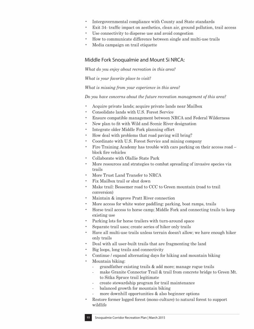
Snoqualmie Corridor Recreation Plan | March 201593
• Intergovernmental compliance with County and State standards• Exit 34- traffic impact on aesthetics, clean air, ground pollution, trail access• Use connectivity to disperse use and avoid congestion• How to communicate difference between single and multi-use trails• Media campaign on trail etiquette
Middle Fork Snoqualmie and Mount Si NRCA:
What do you enjoy about recreation in this area?
What is your favorite place to visit?
What is missing from your experience in this area?
Do you have concerns about the future recreation management of this area?
• Acquire private lands; acquire private lands near Mailbox• Consolidate lands with U.S. Forest Service• Ensure compatible management between NRCA and Federal Wilderness• New plan to fit with Wild and Scenic River designation• Integrate older Middle Fork planning effort• How deal with problems that road paving will bring?• Coordinate with U.S. Forest Service and mining company• Fire Training Academy has trouble with cars parking on their access road –
block fire vehicles• Collaborate with Olallie State Park• More resources and strategies to combat spreading of invasive species via
trails• More Trust Land Transfer to NRCA• Fix Mailbox trail or shut down• Make trail: Bessemer road to CCC to Green mountain (road to trail
conversion)• Maintain & improve Pratt River connection• More access for white water paddling: parking, boat ramps, trails• Horse trail access to horse camp; Middle Fork and connecting trails to keep
existing use• Parking lots for horse trailers with turn-around space• Separate trail uses; create series of hiker only trails• Have all multi-use trails unless terrain doesn’t allow; we have enough hiker
only trails• Deal with all user-built trails that are fragmenting the land• Big loops, long trails and connectivity• Continue / expand alternating days for hiking and mountain biking• Mountain biking:
- grandfather existing trails & add more; manage rogue trails - make Granite Connector Trail & trail from concrete bridge to Green Mt. to Sitka Spruce trail legitimate - create stewardship program for trail maintenance - balanced growth for mountain biking - more downhill opportunities & also beginner options
• Restore former logged forest (mono-culture) to natural forest to support wildlife
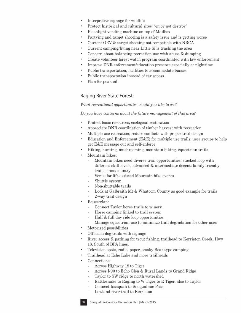
Snoqualmie Corridor Recreation Plan | March 201594
• Interpretive signage for wildlife• Protect historical and cultural sites: “enjoy not destroy”• Flashlight vending machine on top of Mailbox• Partying and target shooting is a safety issue and is getting worse• Current ORV & target shooting not compatible with NRCA• Current camping/living near Little Si is trashing the area• Concern about balancing recreation use with abuse & dumping• Create volunteer forest watch program coordinated with law enforcement• Improve DNR enforcement/education presence especially at nighttime• Public transportation; facilities to accommodate busses• Public transportation instead of car access• Plan for peak oil
Raging River State Forest:
What recreational opportunities would you like to see?
Do you have concerns about the future management of this area?
• Protect basic resources; ecological restoration• Appreciate DNR coordination of timber harvest with recreation• Multiple use recreation; reduce conflicts with proper trail design• Education and Enforcement (E&E) for multiple use trails; user groups to help
get E&E message out and self-enforce • Hiking, hunting, mushrooming, mountain biking, equestrian trails• Mountain bikes:
- Mountain bikes need diverse trail opportunities: stacked loop with different skill levels, advanced & intermediate decent; family friendly trails; cross country - Venue for lift-assisted Mountain bike events - Shuttle system - Non-shuttable trails - Look at Galbraith Mt & Whatcom County as good example for trails - 2-way trail design
• Equestrian: - Connect Taylor horse trails to winery - Horse camping linked to trail system - Half & full day ride loop opportunities - Manage equestrian use to minimize trail degradation for other uses
• Motorized possibilities• Off-leash dog trails with signage• River access & parking for trout fishing, trailhead to Kerriston Creek, Hwy
18, South of BPA lines.• Television spots, radio, paper, smoky Bear type camping• Trailhead at Echo Lake and more trailheads• Connections:
- Across Highway 18 to Tiger - Across I-90 to Echo Glen & Rural Lands to Grand Ridge - Taylor to SW ridge to north watershed - Rattlesnake to Raging to W Tiger to E Tiger, also to Taylor - Connect Issaquah to Snoqualmie Pass - Lowland river trail to Kerriston
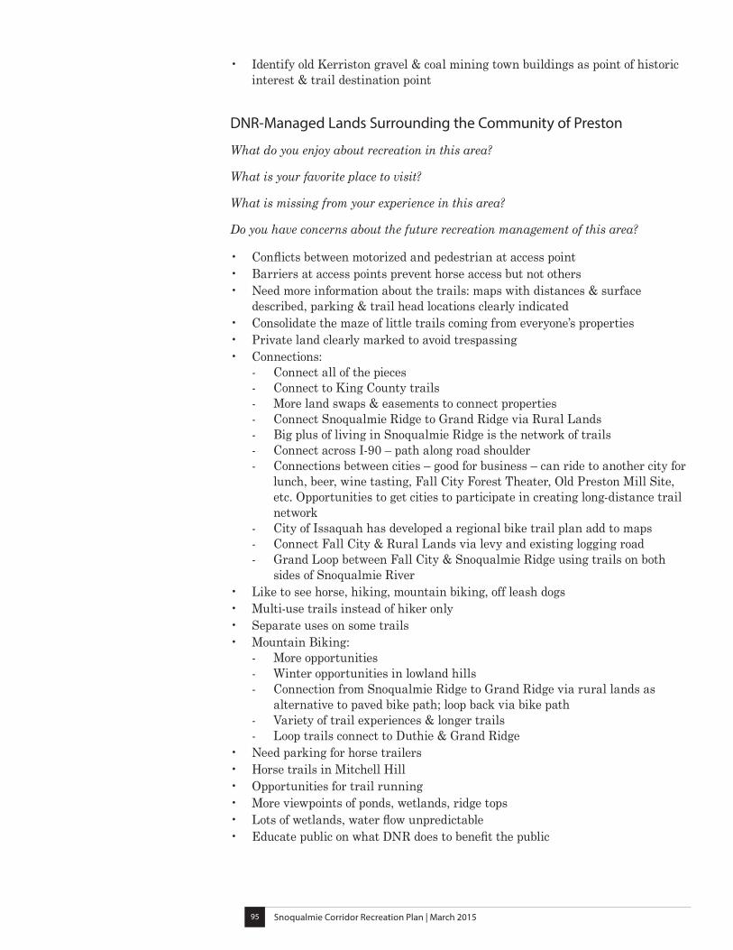
Snoqualmie Corridor Recreation Plan | March 201595
• Identify old Kerriston gravel & coal mining town buildings as point of historic interest & trail destination point
DNR-Managed Lands Surrounding the Community of Preston
What do you enjoy about recreation in this area?
What is your favorite place to visit?
What is missing from your experience in this area?
Do you have concerns about the future recreation management of this area?
• Conflicts between motorized and pedestrian at access point• Barriers at access points prevent horse access but not others• Need more information about the trails: maps with distances & surface
described, parking & trail head locations clearly indicated• Consolidate the maze of little trails coming from everyone’s properties• Private land clearly marked to avoid trespassing• Connections:
- Connect all of the pieces - Connect to King County trails - More land swaps & easements to connect properties - Connect Snoqualmie Ridge to Grand Ridge via Rural Lands - Big plus of living in Snoqualmie Ridge is the network of trails - Connect across I-90 – path along road shoulder - Connections between cities – good for business – can ride to another city for lunch, beer, wine tasting, Fall City Forest Theater, Old Preston Mill Site, etc. Opportunities to get cities to participate in creating long-distance trail network - City of Issaquah has developed a regional bike trail plan add to maps - Connect Fall City & Rural Lands via levy and existing logging road - Grand Loop between Fall City & Snoqualmie Ridge using trails on both sides of Snoqualmie River
• Like to see horse, hiking, mountain biking, off leash dogs• Multi-use trails instead of hiker only• Separate uses on some trails• Mountain Biking:
- More opportunities - Winter opportunities in lowland hills - Connection from Snoqualmie Ridge to Grand Ridge via rural lands as alternative to paved bike path; loop back via bike path - Variety of trail experiences & longer trails - Loop trails connect to Duthie & Grand Ridge
• Need parking for horse trailers• Horse trails in Mitchell Hill• Opportunities for trail running• More viewpoints of ponds, wetlands, ridge tops• Lots of wetlands, water flow unpredictable• Educate public on what DNR does to benefit the public
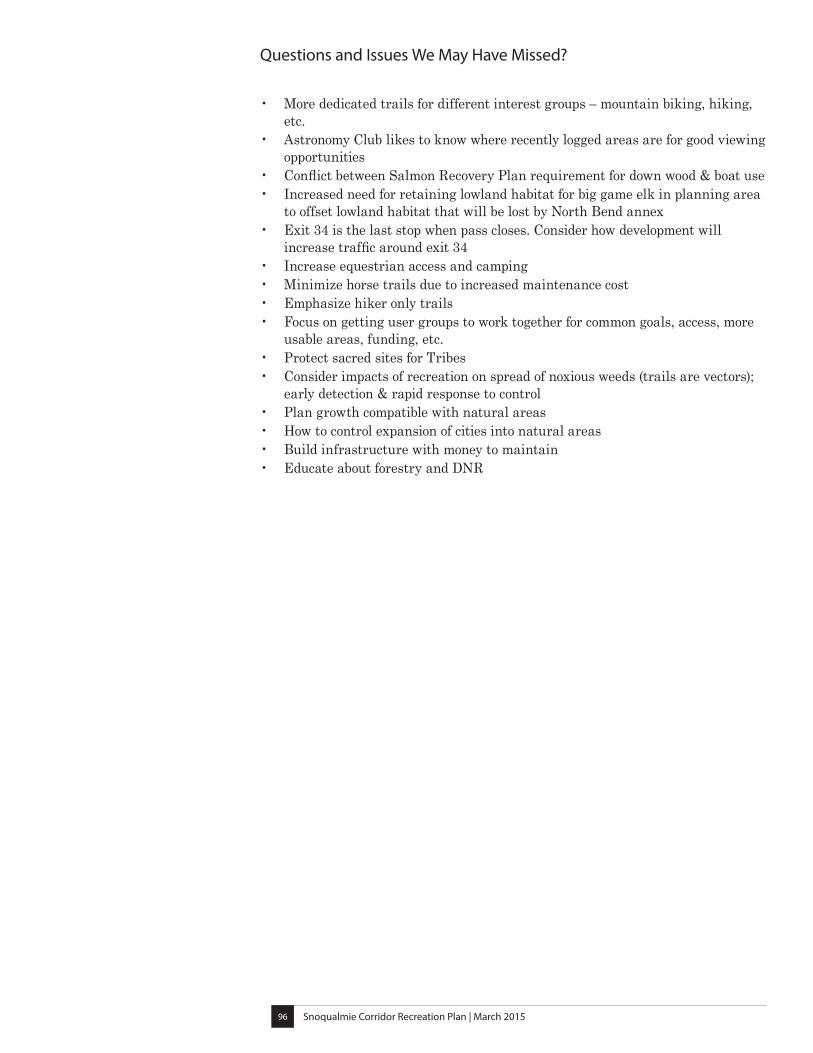
Snoqualmie Corridor Recreation Plan | March 201596
Questions and Issues We May Have Missed?
• More dedicated trails for different interest groups – mountain biking, hiking, etc.
• Astronomy Club likes to know where recently logged areas are for good viewing opportunities
• Conflict between Salmon Recovery Plan requirement for down wood & boat use• Increased need for retaining lowland habitat for big game elk in planning area
to offset lowland habitat that will be lost by North Bend annex• Exit 34 is the last stop when pass closes. Consider how development will
increase traffic around exit 34• Increase equestrian access and camping• Minimize horse trails due to increased maintenance cost• Emphasize hiker only trails• Focus on getting user groups to work together for common goals, access, more
usable areas, funding, etc.• Protect sacred sites for Tribes• Consider impacts of recreation on spread of noxious weeds (trails are vectors);
early detection & rapid response to control• Plan growth compatible with natural areas• How to control expansion of cities into natural areas• Build infrastructure with money to maintain• Educate about forestry and DNR
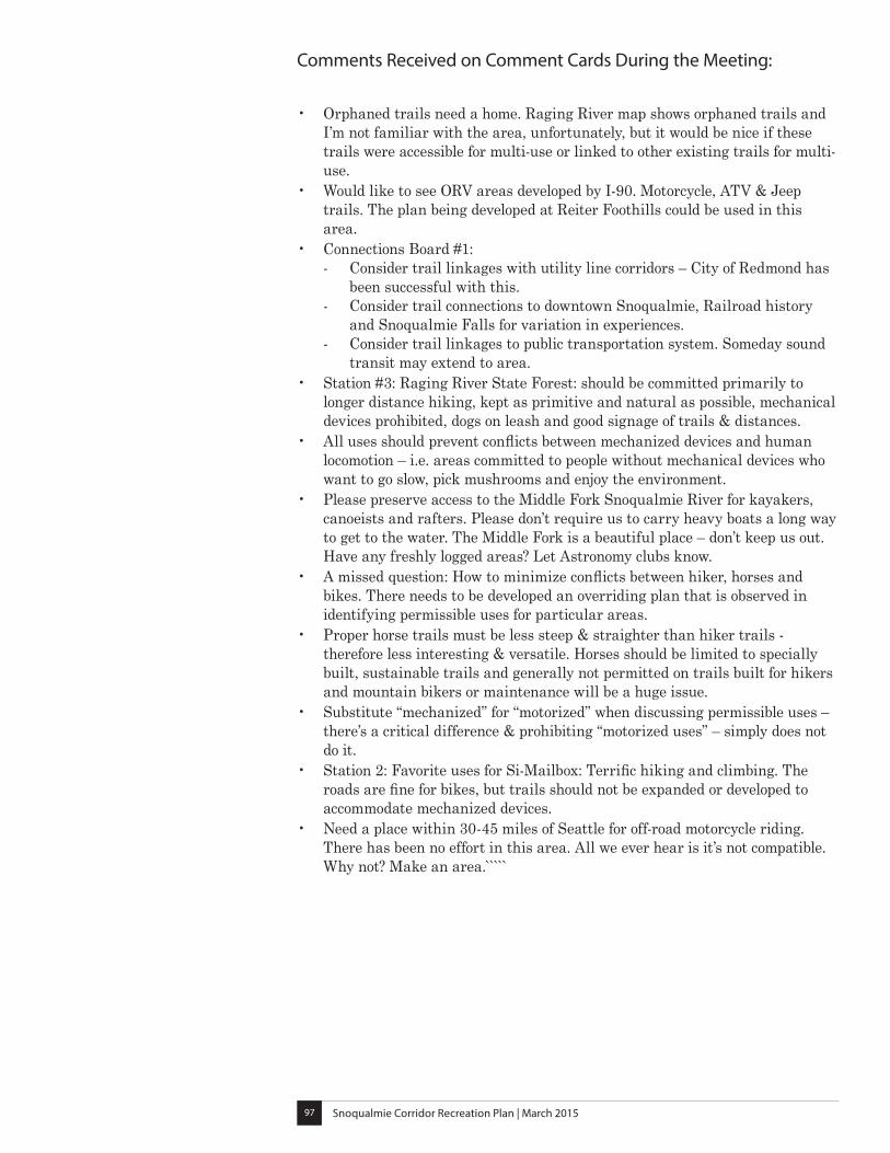
Snoqualmie Corridor Recreation Plan | March 201597
Comments Received on Comment Cards During the Meeting:
• Orphaned trails need a home. Raging River map shows orphaned trails and I’m not familiar with the area, unfortunately, but it would be nice if these trails were accessible for multi-use or linked to other existing trails for multi-use.
• Would like to see ORV areas developed by I-90. Motorcycle, ATV & Jeep trails. The plan being developed at Reiter Foothills could be used in this area.
• Connections Board #1: - Consider trail linkages with utility line corridors – City of Redmond has been successful with this. - Consider trail connections to downtown Snoqualmie, Railroad history and Snoqualmie Falls for variation in experiences. - Consider trail linkages to public transportation system. Someday sound transit may extend to area.
• Station #3: Raging River State Forest: should be committed primarily to longer distance hiking, kept as primitive and natural as possible, mechanical devices prohibited, dogs on leash and good signage of trails & distances.
• All uses should prevent conflicts between mechanized devices and human locomotion – i.e. areas committed to people without mechanical devices who want to go slow, pick mushrooms and enjoy the environment.
• Please preserve access to the Middle Fork Snoqualmie River for kayakers, canoeists and rafters. Please don’t require us to carry heavy boats a long way to get to the water. The Middle Fork is a beautiful place – don’t keep us out. Have any freshly logged areas? Let Astronomy clubs know.
• A missed question: How to minimize conflicts between hiker, horses and bikes. There needs to be developed an overriding plan that is observed in identifying permissible uses for particular areas.
• Proper horse trails must be less steep & straighter than hiker trails - therefore less interesting & versatile. Horses should be limited to specially built, sustainable trails and generally not permitted on trails built for hikers and mountain bikers or maintenance will be a huge issue.
• Substitute “mechanized” for “motorized” when discussing permissible uses – there’s a critical difference & prohibiting “motorized uses” – simply does not do it.
• Station 2: Favorite uses for Si-Mailbox: Terrific hiking and climbing. The roads are fine for bikes, but trails should not be expanded or developed to accommodate mechanized devices.
• Need a place within 30-45 miles of Seattle for off-road motorcycle riding. There has been no effort in this area. All we ever hear is it’s not compatible. Why not? Make an area.̀ ````
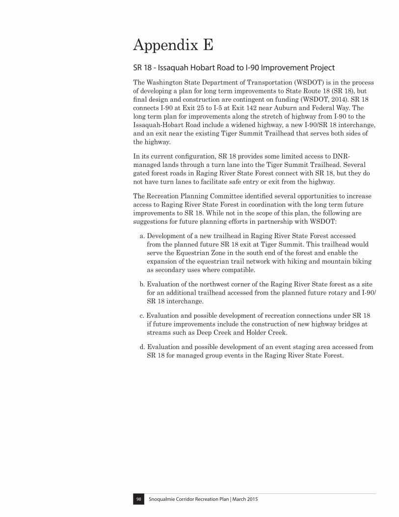
Snoqualmie Corridor Recreation Plan | March 201598
Appendix ESR 18 - Issaquah Hobart Road to I-90 Improvement Project
The Washington State Department of Transportation (WSDOT) is in the process of developing a plan for long term improvements to State Route 18 (SR 18), but final design and construction are contingent on funding (WSDOT, 2014). SR 18 connects I-90 at Exit 25 to I-5 at Exit 142 near Auburn and Federal Way. The long term plan for improvements along the stretch of highway from I-90 to the Issaquah-Hobart Road include a widened highway, a new I-90/SR 18 interchange, and an exit near the existing Tiger Summit Trailhead that serves both sides of the highway.
In its current configuration, SR 18 provides some limited access to DNR-managed lands through a turn lane into the Tiger Summit Trailhead. Several gated forest roads in Raging River State Forest connect with SR 18, but they do not have turn lanes to facilitate safe entry or exit from the highway.
The Recreation Planning Committee identified several opportunities to increase access to Raging River State Forest in coordination with the long term future improvements to SR 18. While not in the scope of this plan, the following are suggestions for future planning efforts in partnership with WSDOT:
a. Development of a new trailhead in Raging River State Forest accessed from the planned future SR 18 exit at Tiger Summit. This trailhead would serve the Equestrian Zone in the south end of the forest and enable the expansion of the equestrian trail network with hiking and mountain biking as secondary uses where compatible.
b. Evaluation of the northwest corner of the Raging River State forest as a site for an additional trailhead accessed from the planned future rotary and I-90/SR 18 interchange.
c. Evaluation and possible development of recreation connections under SR 18 if future improvements include the construction of new highway bridges at streams such as Deep Creek and Holder Creek.
d. Evaluation and possible development of an event staging area accessed from SR 18 for managed group events in the Raging River State Forest.
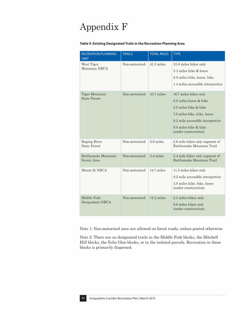
Snoqualmie Corridor Recreation Plan | March 201599
Appendix FTable 9. Existing Designated Trails in the Recreation Planning Area
RECREATION PLANNING UNIT
TRAILS TOTAL MILES TYPE
West Tiger Mountain NRCA
Non-motorized 41.3 miles 33.8 miles hiker only
3.3 miles hike & horse
2.8 miles hike, horse, bike
1.4 miles accessible interpretive
Tiger Mountain State Forest
Non-motorized 43.7 miles 16.7 miles hiker only
6.8 miles horse & hike
5.0 miles bike & hike
7.0 miles bike, hike, horse
0.2 mile accessible interpretive
8.0 miles bike & hike (under construction)
Raging River State Forest
Non-motorized 2.6 miles 2.6 mile hiker only segment of Rattlesnake Mountain Trail
Rattlesnake Mountain Scenic Area
Non-motorized 5.4 miles 5.4 mile hiker only segment of Rattlesnake Mountain Trail
Mount Si NRCA Non-motorized 14.7 miles 11.5 miles hiker only
0.2 mile accessible interpretive
3.0 miles hike, bike, horse (under construction)
Middle Fork Snoqualmie NRCA
Non-motorized 12.2 miles 2.5 miles hiker only
9.6 miles hiker only (under construction)
Note 1: Non-motorized uses are allowed on forest roads, unless posted otherwise
Note 2: There are no designated trails in the Middle Fork blocks, the Mitchell Hill blocks, the Echo Glen blocks, or in the isolated parcels. Recreation in these blocks is primarily dispersed.

Snoqualmie Corridor Recreation Plan | March 2015100
Appendix GCertificate of Adoption
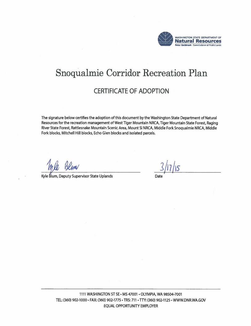
Snoqualmie Corridor Recreation Plan | March 20151


Cons
erva
tion,
Rec
reat
ion,
and
Tra
nsac
tions
Div
isio
nRe
crea
tion
Prog
ram
11
11 W
ashi
ngto
n ST
SE
Oly
mpi
a, W
A 9
8504
-701
4
ww
w.d
nr.w
a.go
v