snowflake/taylor multijurisdictional transportation plan ... · snowflake/taylor...
TRANSCRIPT
Snowflake/Taylor Multijurisdictional Transportation Plan Final Report – July 2011
Snowflake/Taylor Multijurisdictional Transportation Plan
Final Report
Prepared for:
Town of Snowflake, Arizona 81 West 1st South Snowflake, AZ 85937 Town of Taylor, Arizona P.O. Box 158 Taylor, AZ 85939 Arizona Department of Transportation Multi-Modal Planning Division 206 S. 17th Avenue Phoenix, AZ 85007
Prepared by:
Wilson & Company, Inc., Engineers and Architects 410 N. 44th Street, Suite 460 Phoenix, AZ 85008
July 19, 2011
Snowflake/Taylor Multijurisdictional Transportation Plan Final Report – July 2011
ii
Table of Contents 1.0 Introduction ....................................................................................................................... 1-1
1.1 Project Overview ........................................................................................................... 1-1
1.2 Previous Studies ............................................................................................................ 1-1
1.3 Study Process ................................................................................................................ 1-2
1.4 Study Area ..................................................................................................................... 1-2
2.0 Travel Demand Model Assumptions ................................................................................ 2-1
2.1 Model Constraints ......................................................................................................... 2-1
2.2 Model Development Process ......................................................................................... 2-1
2.3 Travel Model Validation ............................................................................................... 2-3
2.4 Travel Model Transportation Analysis Zones ............................................................... 2-3
2.5 Future Year Socioeconomic Data ................................................................................. 2-3
2.5.1 Household and Employment Data ......................................................................... 2-5
3.0 Transportation System Definition ..................................................................................... 3-1
3.1 Roadway Functional Classification ............................................................................... 3-1
3.2 Functional Classification Capacities ............................................................................. 3-5
3.3 Roadway Cross Sections ............................................................................................... 3-6
4.0 Transportation Networks .................................................................................................. 4-1
4.1 Travel Demand Model Networks .................................................................................. 4-1
4.2 Transporation Network Traffic Forecasts ..................................................................... 4-1
4.3 Transportation Network Performance ........................................................................... 4-7
4.3.1 Short-Term Forecast Network Performance .......................................................... 4-7
4.3.2 Mid-Term Forecast Network Performance ............................................................ 4-7
4.3.3 Long-Term Forecast Network Performance .......................................................... 4-7
4.3.4 Long-Term Forecast Network Performance with Proposed Roadways ................ 4-8
5.0 Multi-Modal Elements ...................................................................................................... 5-1
5.1 Sidewalks ...................................................................................................................... 5-1
5.2 Bicycle Facilities ........................................................................................................... 5-1
5.3 Transit............................................................................................................................ 5-3
6.0 Environmental Considerations .......................................................................................... 6-1
6.1 Environmental Justice Overview .................................................................................. 6-1

Snowflake/Taylor Multijurisdictional Transportation Plan Final Report – July 2011
iii
6.1.1 Study Community Demographics .......................................................................... 6-2
6.2 Environmental Overview .............................................................................................. 6-2
6.2.1 Natural Resource Overview ................................................................................... 6-2
7.0 Concept Alignments.......................................................................................................... 7-1
7.1 Concept layouts ............................................................................................................. 7-2
7.2 Cost Estimates ............................................................................................................... 7-2
7.3 Corridor Summaries ...................................................................................................... 7-2
8.0 Implementation Program and Next Steps ......................................................................... 8-1
8.1 Future roadway functional classification Plan .............................................................. 8-1
8.2 Roadway improvement plan.......................................................................................... 8-1
8.3 Implementation Action Items ........................................................................................ 8-2
Snowflake/Taylor Multijurisdictional Transportation Plan Final Report – July 2011
iv
List of Figures Figure 1-1 Study Area ................................................................................................................. 1-3Figure 2-1 Travel Demand Model Development Process ........................................................... 2-2Figure 2-2 Traffic Analysis Zones .............................................................................................. 2-4Figure 2-3 Aztec Land and Cattle Company Proposed Entitlement Plan ................................... 2-5Figure 2-4 Snowflake-Taylor Area Long-Term Development Assumptions ............................. 2-7Figure 2-5 Year 2006 Household Density .................................................................................. 2-8Figure 2-6 Year 2006 Employment Density ............................................................................... 2-9Figure 2-7 Short-Term Future Household Density ................................................................... 2-10Figure 2-8 Short-Term Future Employment Density ................................................................ 2-11Figure 2-9 Mid-Term Future Household Density ..................................................................... 2-12Figure 2-10 Mid-Term Future Employment Density ................................................................ 2-13Figure 2-11 Long-Term Future Household Density ................................................................. 2-14Figure 2-12 Long-Term Future Employment Density .............................................................. 2-15Figure 3-1 Existing Roadway Functional Classification ......................................................... 3-3Figure 3-2 Long-Term Roadway Functional Classification .................................................... 3-4Figure 3-3 2-Lane Collector Roadway (rural section without curb and gutter) ...................... 3-8Figure 3-4 2-Lane Collector Roadway (Minor Collector) ....................................................... 3-9Figure 3-5 3-Lane Collector Roadway (includes center left-turn lane) (Major Collector) ... 3-10Figure 3-6 5-Lane Arterial Roadway (with center left-turn lane) ......................................... 3-11Figure 3-7 4-Lane Arterial Roadway (with median) ............................................................. 3-12Figure 4-1 Year 2006 Traffic Volumes ................................................................................... 4-2Figure 4-2 Short-Term Travel Demand Forecast .................................................................... 4-3Figure 4-3 Mid-Term Travel Demand Forecast ...................................................................... 4-4Figure 4-4 Long-Term Travel Demand Forecast ..................................................................... 4-5Figure 4-5 Long-Term Travel Demand Forecast with Proposed Roadway Network ............. 4-6Figure 4-6 Short-Term Forecast Volume-Capacity Ratios ...................................................... 4-9Figure 4-7 Mid-Term Forecast Volume-Capacity Ratios ...................................................... 4-10Figure 4-8 Long-Term Forecast Volume-Capacity Ratios .................................................... 4-11Figure 4-9 Long-Term Forecast Build-Out Network Volume-Capacity Ratios .................... 4-12Figure 5-1 Bicycle User Map .................................................................................................. 5-2Figure 5-2 Rural Transit Needs Study Recommendations ...................................................... 5-3Figure6-1 Environmental Considerations ............................................................................... 6-4Figure 6-2 Wildlife Linkages ................................................................................................... 6-5Figure 7-1 Concept Alignments ............................................................................................... 7-1 List of Tables Table 2.1 Study Area Household and Employment: Year 2006 and Future Conditions ...... 2-6Table 3.1 Characteristics of Roadway Functional Classifications ......................................... 3-2Table 3.2 Roadway Capacity Guidelines ............................................................................... 3-6Table 6.1 Environmental Justice Socioeconomic Characteristics ......................................... 6-2
Snowflake/Taylor Multijurisdictional Transportation Plan Final Report – July 2011
1-1
1.0 INT R ODUC T ION This Snowflake-Taylor Multi-Jurisdictional Transportation Plan under the ADOT Planning Assistance for Rural Areas (PARA) will seek to define an optimal multi-modal transportation network that balances local and regional multi-modal transportation needs with available investment funds, while addressing environmental and area goals. This Plan will provide a common direction for the community, agencies and funding partners towards implementation of safe and efficient multi-modal mobility elements. Ultimately, this guiding document will provide direction for future infrastructure investments in both Snowflake and Taylor.
The Town of Snowflake and the Town of Taylor are primarily residential areas located in central Navajo County. These two communities host residents, businesses and land owners that are very passionate about where they live, the quality of life that they enjoy and the environment that surround them. Both towns are historic in nature, and are located in a pristine area of Arizona. The transportation system must work in conjunction with the varying environmental and cultural resources in the area, while protecting the long standing heritage that Snowflake and Taylor are known for.
This chapter provides background information, an overview of the study process and defines the study area. Chapter 2 provides model information regarding the existing and proposed roadway networks and potential new roadways for future year roadway improvements. Chapters 3 and 4 discuss the transportation system regarding functional classification and the future traffic forecasting for the transportation network. Chapter 5 provides information regarding multi-modal elements considered throughout the study area. Chapter 6 identifies environmental considerations including areas that might impact future improvements. Chapter 7 describes future roadway concepts that have been proposed to accommodate the area’s future growth and economic development projections. Chapter 8 reviews strategies to implement future improvements.
1.1 P R OJ E C T OV E R VIE W Navajo County is located in northeastern Arizona. This region of the State includes one of Arizona’s major destinations – the White Mountains. This area has historically experienced rapid population and employment growth. Snowflake and Taylor are located within the White Mountains and are preparing for future growth. This Plan will allow the Town of Snowflake and the Town of Taylor to better provide coordinated planning activities as they relate to transportation and future growth. This planning process will help to prioritize already identified future transportation corridors, establish multi-modal roadway cross-section needs by functional classification, identify probable alignments for future proposed roadways, and identify right-of-way needs for those future improvements.
1.2 P R E V IOUS S T UDIE S Navajo County recently completed, in cooperation with Apache County, the Southern Navajo County/Apache County Sub-Regional Transportation Plan. That plan addressed growing transportation issues and challenges facing southern Navajo County and the County’s White Mountain communities of Snowflake, Taylor, Show Low and Pinetop-Lakeside.
Snowflake/Taylor Multijurisdictional Transportation Plan Final Report – July 2011
1-2
Recent intensification of development activity in other parts of the County, coupled with anticipated natural regional growth led to the need for a broader Regional Transportation Study. During 2010, the Navajo County Central Region Transportation Study comprehensively addressed a range of transportation issues and identified infrastructure needs associated with County communities outside of the southern Plan area, particularly in Holbrook, Winslow and Heber-Overgaard. It also addressed the connectivity of these southern and central population centers. Together, these two plans provide high-level transportation planning direction for all of unincorporated Navajo County and the incorporated communities within Navajo County, excluding the reservation lands of the Indian communities.
1.3 S T UDY P R OC E S S This study was guided by a Technical Advisory Committee (TAC) that included representatives from the Town of Snowflake, the Town of Taylor, Navajo County, and ADOT (both Multi-modal Planning Division and District staff). The role of the TAC is to provide technical guidance, to serve as a communication stream to the management and elected officials for the agencies they represent, to offer insight and suggestions regarding local technical issues, to perform document reviews and to provide input throughout the study process. During the conduct of the study, an open-house and joint council workshop was conducted to provide an overview of the study and present the recommendations.
1.4 S T UDY AR E A Navajo County encompasses 9,969 square miles, 67 percent of which is occupied by Indian reservation land. The White Mountains are generally situated approximately 30 minutes south and west of the two towns.
During the winter months visitors can enjoy sledding or tobogganing, snowboarding, ice-fishing, and, of course, world-class downhill skiing and cross-country skiing. Miles of groomed trails and first-rate facilities draw enthusiasts from around the world. During the spring, frozen lakes and streams open themselves to fishermen, boaters, hikers and sightseers. Meadow grasses turn green and wildflowers draw visitors. During the summer, the White Mountains offer visitors a variety of scenic attractions and an unlimited array of outdoor activities. Some 50 alpine lakes and 800 miles of cold, crystal clear rivers and springs draw visitors throughout the season to this region of Arizona. During autumn, the area tourists and owners of 2nd homes visit to enjoy the change of colors, fall fishing, hunting and hiking. During the conduct of the Southern Navajo/Apache County Sub-Regional Transportation Plan, the study team found that only 57 percent of the total dwelling units were occupied on census day, identifying that more than 40 percent of the homes in the White Mountains are vacation/seasonal homes.
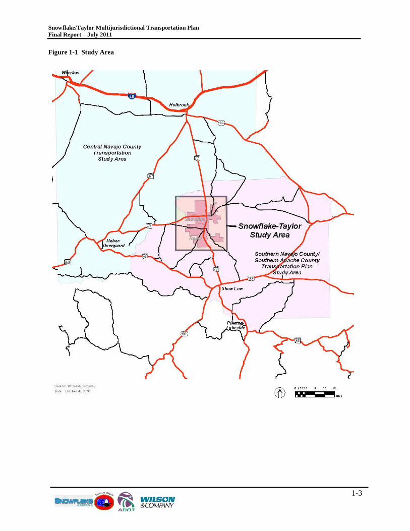
The Study Area as it relates to regional mobility is shown in Figure 1-1, located in the central region of Navajo County. The Town of Snowflake is situated in the vicinity of SR-77 and SR-277 with the commercial center focused along SR-77. The Town of Taylor, located south of the Town of Snowflake is also situated along SR-77. SR-77 is the primary arterial route between the White Mountain communities to the south and I-40, located approximately 30 miles north of Snowflake.
Snowflake/Taylor Multijurisdictional Transportation Plan Final Report – July 2011
1-3
Figure 1-1 Study Area
Snowflake/Taylor Multijurisdictional Transportation Plan Final Report – July 2011
2-1
2.0 T R AV E L DE MAND MODE L AS S UMP T IONS During September 2007, Navajo County developed a travel demand model for the Southern Navajo/Apache County Sub-Regional Transportation Plan. During 2009, ADOT completed the development of a statewide travel demand model which incorporated the network and socioeconomic data from the Southern Navajo model. This new travel demand model uses TransCAD, a transportation modeling software platform. The statewide model was then used as the framework to build the Navajo County central region travel demand model, which will be used for this study. The ADOT statewide model provides background statewide travel demand as a background to build upon so to fully include other statewide growth and improvement assumptions. The assumptions regarding network and anticipated development forecasted from the Southern Navajo/Apache County Sub-Regional Transportation Plan and the Central Navajo County Transportation Study are integrated into this Snowflake-Taylor TransCAD model.
2.1 MODE L C ONS T R AINT S The TransCAD model used for the Snowflake-Taylor Multijurisdictional Transportation Plan is a roadway-only travel demand forecasting tool. Although TransCAD has the capacity to provide a multi-modal evaluation, the transit in the region is not extensive enough to warrant a modal split evaluation.
Also, it is important to note that the travel demand model developed for this study is not responsive to radical changes in traffic during the peak tourism season. The adopted model replicates average daily traffic (ADT) conditions on roadway segments, as represented by available current year (2006) traffic counts. ADT conditions are consistent seasonal dwelling unit occupancy patterns identified by Census 2000 population data.
It should be recognized that a seasonal model could be developed to replicate the radical travel demand changes that occur with the tourism season. Although transportation improvements should not be focused solely upon seasonal or peak hour needs, additional perspective or understanding can be gained to help prioritize project implementation.
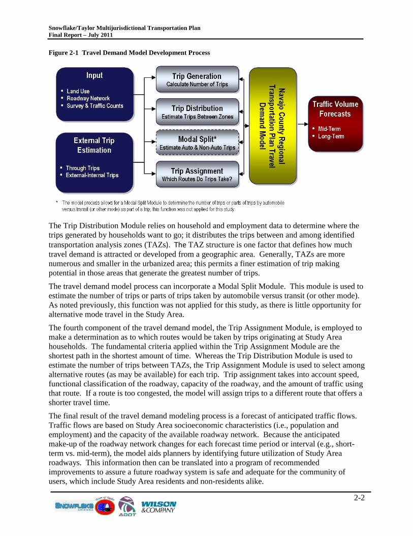
2.2 MODE L DE VE L OP ME NT P R OC E S S Figure 2-1 depicts the principal elements of the travel demand model development process. A discussion of the modeling process used for estimating future travel demand and forecasting traffic volumes on streets and highways for this regional study is presented follows.
The travel demand model is based on a four-step process employed to determine/forecast traffic volumes for a defined roadway network based on specified inputs and estimates of external trips. The Trip Generation Module converts available census information and growth projections, specifically number of dwelling units (DUs), households (HHs) and population, into the total vehicle trips expected to occur in the region at a given point in time. For this study, trip making estimates were prepared for the year 2006, and for Short-Term, Mid-Term, and Long-Term planning horizons. Total vehicle trips are based on an assumption that each HH generates an average of approximately ten trips daily – five separate round-trips.
Snowflake/Taylor Multijurisdictional Transportation Plan Final Report – July 2011
2-2
Figure 2-1 Travel Demand Model Development Process
The Trip Distribution Module relies on household and employment data to determine where the trips generated by households want to go; it distributes the trips between and among identified transportation analysis zones (TAZs). The TAZ structure is one factor that defines how much travel demand is attracted or developed from a geographic area. Generally, TAZs are more numerous and smaller in the urbanized area; this permits a finer estimation of trip making potential in those areas that generate the greatest number of trips.
The travel demand model process can incorporate a Modal Split Module. This module is used to estimate the number of trips or parts of trips taken by automobile versus transit (or other mode). As noted previously, this function was not applied for this study, as there is little opportunity for alternative mode travel in the Study Area.
The fourth component of the travel demand model, the Trip Assignment Module, is employed to make a determination as to which routes would be taken by trips originating at Study Area households. The fundamental criteria applied within the Trip Assignment Module are the shortest path in the shortest amount of time. Whereas the Trip Distribution Module is used to estimate the number of trips between TAZs, the Trip Assignment Module is used to select among alternative routes (as may be available) for each trip. Trip assignment takes into account speed, functional classification of the roadway, capacity of the roadway, and the amount of traffic using that route. If a route is too congested, the model will assign trips to a different route that offers a shorter travel time.
The final result of the travel demand modeling process is a forecast of anticipated traffic flows. Traffic flows are based on Study Area socioeconomic characteristics (i.e., population and employment) and the capacity of the available roadway network. Because the anticipated make-up of the roadway network changes for each forecast time period or interval (e.g., short-term vs. mid-term), the model aids planners by identifying future utilization of Study Area roadways. This information then can be translated into a program of recommended improvements to assure a future roadway system is safe and adequate for the community of users, which include Study Area residents and non-residents alike.
Snowflake/Taylor Multijurisdictional Transportation Plan Final Report – July 2011
2-3
2.3 T R AV E L MODE L V AL IDAT ION Before a forecast of future traffic volumes can be prepared, a current year model must be built and calibrated to existing traffic counts. Model validation or calibration is a process involving repeated adjustment of model parameters until model-simulated traffic volumes reasonably agree with actual traffic counts. Several measures to evaluate model performance are provided in the Federal Highway Administration’s (FWHA) Travel Model Validation and Reasonableness Checking Manual, February, 1997.
For this study, the calibrated 2008 Central Navajo County Transportation Study model was used to perform all evaluations. The study team coordinated with ADOT regarding revalidation effort requirements for this study. The study team and ADOT concluded that a new validation effort was not necessary because the regional changes in traffic volumes and patterns had not changed substantially since 2008. Additionally, no new major developments had occurred between 2008 and the onset of this study that would have impacted regional or sub-regional travel demands. Working Paper 1 contains the Model Validation and Calibration Report that defines the network attributes, capacities, trip rates and generation rates used for this study. It also analyzes the model integrity based on model calculations of percent root mean square error. Overall, the model performs at a 28 percent root mean square error which is within a high degree of accuracy. Additionally, an R-squared value of 0.94 was reported also showing a high degree of accuracy to reflect year 2008 traffic counts.
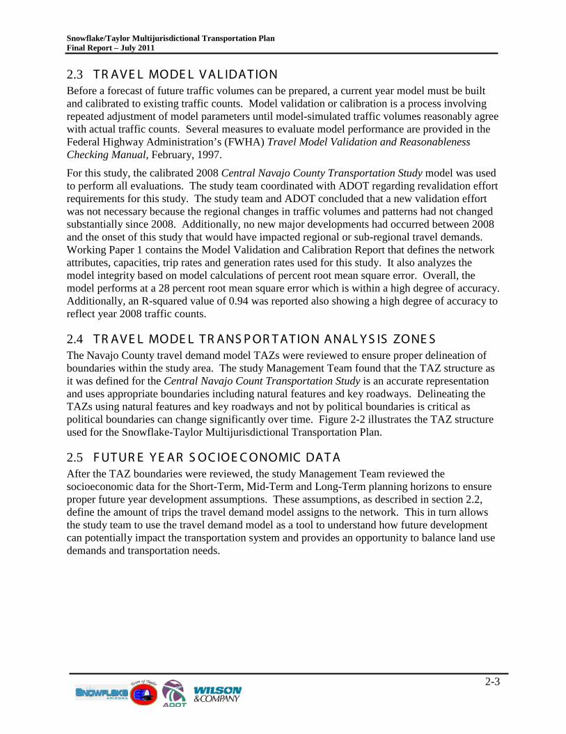
2.4 T R AV E L MODE L T R ANS P OR T AT ION ANAL Y S IS ZONE S The Navajo County travel demand model TAZs were reviewed to ensure proper delineation of boundaries within the study area. The study Management Team found that the TAZ structure as it was defined for the Central Navajo Count Transportation Study is an accurate representation and uses appropriate boundaries including natural features and key roadways. Delineating the TAZs using natural features and key roadways and not by political boundaries is critical as political boundaries can change significantly over time. Figure 2-2 illustrates the TAZ structure used for the Snowflake-Taylor Multijurisdictional Transportation Plan.
2.5 F UT UR E Y E AR S OC IOE C ONOMIC DAT A After the TAZ boundaries were reviewed, the study Management Team reviewed the socioeconomic data for the Short-Term, Mid-Term and Long-Term planning horizons to ensure proper future year development assumptions. These assumptions, as described in section 2.2, define the amount of trips the travel demand model assigns to the network. This in turn allows the study team to use the travel demand model as a tool to understand how future development can potentially impact the transportation system and provides an opportunity to balance land use demands and transportation needs.
Snowflake/Taylor Multijurisdictional Transportation Plan Final Report – July 2011
2-4
Figure 2-2 Traffic Analysis Zones
Snowflake/Taylor Multijurisdictional Transportation Plan Final Report – July 2011
2-5
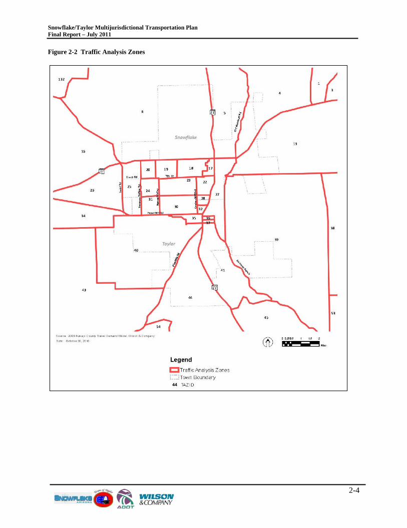
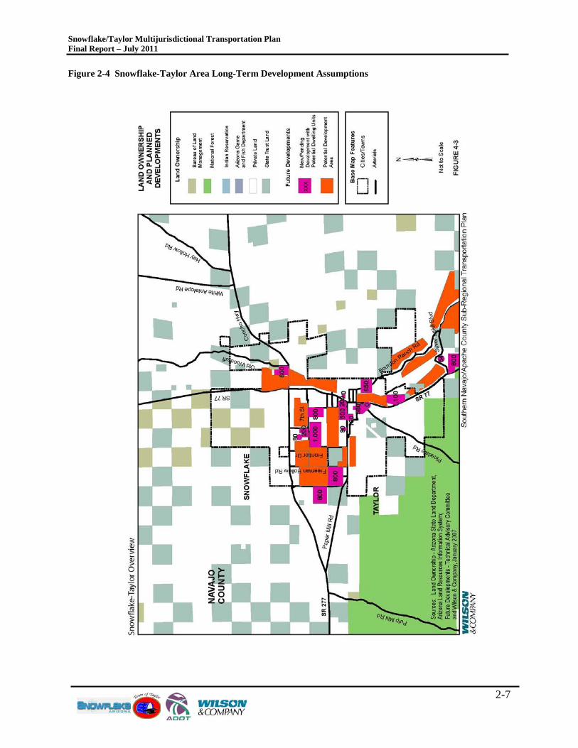
During the conduct of the Central Navajo County Transportation Study, the study team was informed of an entitlement plan being developed by Aztec Land and Cattle Company for approximately 220,000 acres of land generally located north of Snowflake and south of I-40. Aztec Land And Cattle Company provided year 2030 (20-year) development assumptions based on a longer term development build-out, and assigned anticipated development to the Study Area TAZs. The development assumptions provided by Aztec Land and Cattle Company are included in the model for this study, and only reflect a portion of the total Aztec proposed development at build-out. Figure 2-3 illustrates the latest plan developed for Aztec Land and Cattle Company. Figure 2-3 Aztec Land and Cattle Company Proposed Entitlement Plan
2.5.1 HOUS E HOL D AND E MP L OY ME NT DAT A The urbanization process and general population growth is expected to add significantly to the number of households and employees in the Study Area through the planning horizons. Household and employment growth will be driven by a rising demand for the lifestyle and recreational opportunities offered by the White Mountains communities within and south of the Study Area and the Cities of Holbrook and Winslow north of the Study Area, which are located on busy I-40. The household and employment projections for 2015, 2020, and 2030 were developed during a period when the area was experiencing growth that had not been seen in the past. Between 2006 and year 2010, development in Navajo County has greatly slowed. The Study Team and TAC had some concerns regarding the high amount of growth, particularly with the slowdown in the economy. Since this study is for transportation planning purposes, the TAC agreed that the future year socioeconomic data assumptions should not have specific years associated with the data, but to reflect short- mid- and long-range planning horizons.
Snowflake/Taylor Multijurisdictional Transportation Plan Final Report – July 2011
2-6
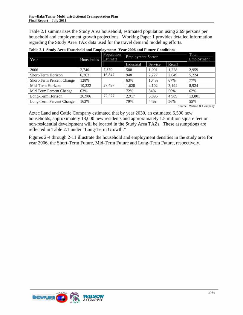
Table 2.1 summarizes the Study Area household, estimated population using 2.69 persons per household and employment growth projections. Working Paper 1 provides detailed information regarding the Study Area TAZ data used for the travel demand modeling efforts. Table 2.1 Study Area Household and Employment: Year 2006 and Future Conditions
Year Households Population Estimate Employment Sector Total
Employment Industrial Service Retail
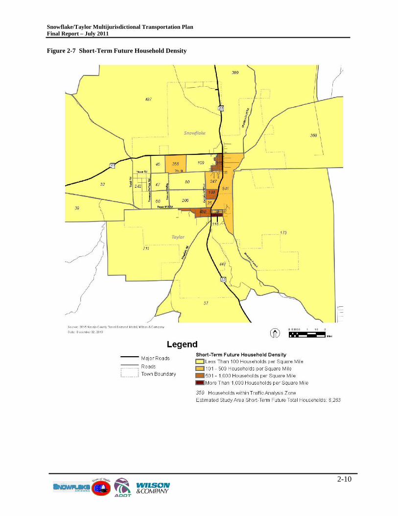
2006 2,740 7,370 580 1,091 1,228 2,959 Short-Term Horizon 6,263 16,847 948 2,227 2,049 5,224 Short-Term Percent Change 128% 63% 104% 67% 77% Mid-Term Horizon 10,222 27,497 1,628 4,102 3,194 8,924 Mid Term Percent Change 63% 72% 84% 56% 62% Long-Term Horizon 26,906 72,377 2,917 5,895 4,989 13,801 Long-Term Percent Change 163% 79% 44% 56% 55%
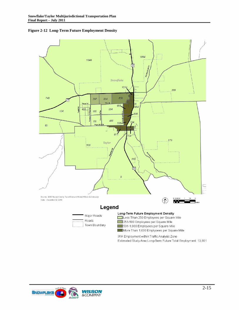
Source: Wilson & Company Aztec Land and Cattle Company estimated that by year 2030, an estimated 6,500 new households, approximately 18,000 new residents and approximately 1.5 million square feet on non-residential development will be located in the Study Area TAZs. These assumptions are reflected in Table 2.1 under “Long-Term Growth.”
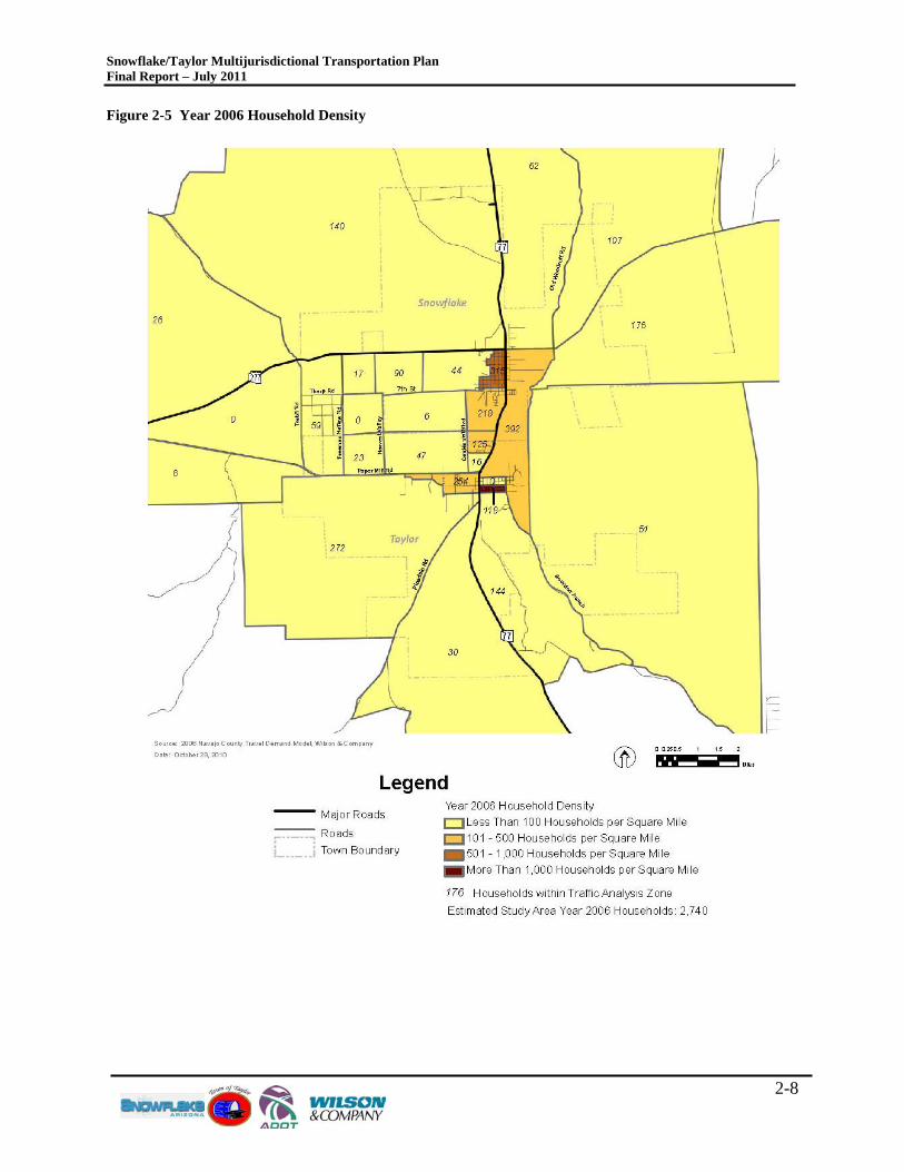
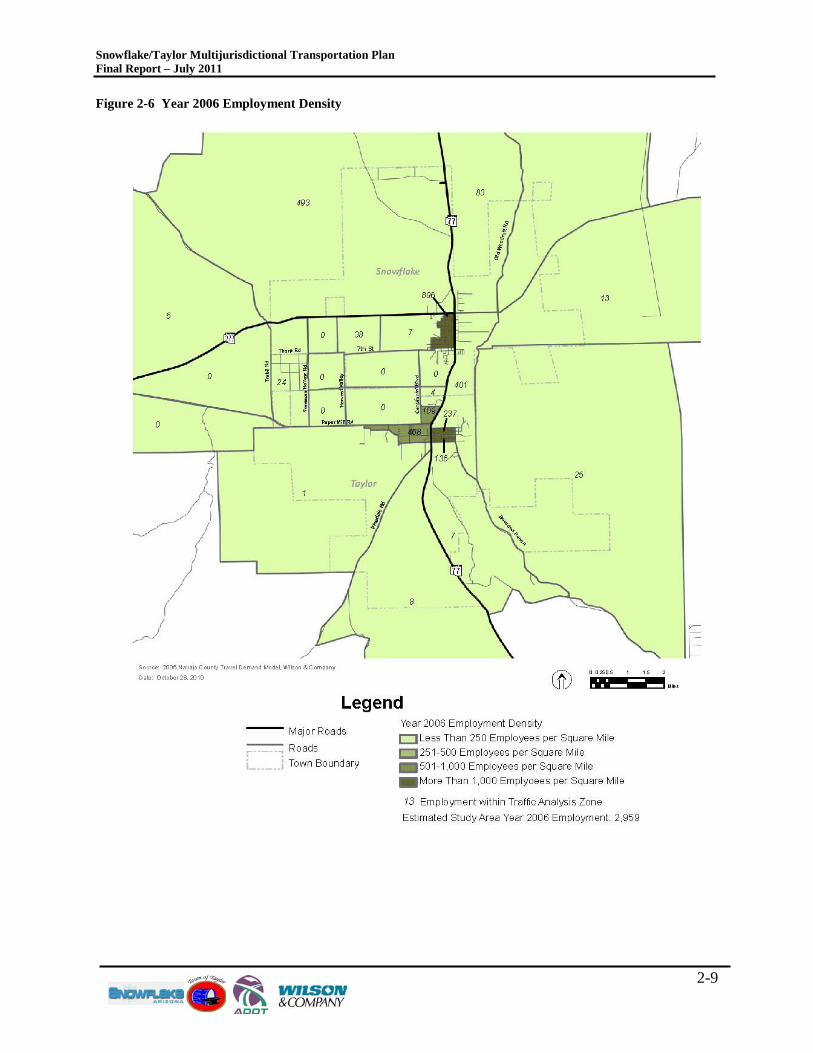
Figures 2-4 through 2-11 illustrate the household and employment densities in the study area for year 2006, the Short-Term Future, Mid-Term Future and Long-Term Future, respectively.
Snowflake/Taylor Multijurisdictional Transportation Plan Final Report – July 2011
2-7
Figure 2-4 Snowflake-Taylor Area Long-Term Development Assumptions
Snowflake/Taylor Multijurisdictional Transportation Plan Final Report – July 2011
2-8
Figure 2-5 Year 2006 Household Density
Snowflake/Taylor Multijurisdictional Transportation Plan Final Report – July 2011
2-9
Figure 2-6 Year 2006 Employment Density
Snowflake/Taylor Multijurisdictional Transportation Plan Final Report – July 2011
2-10
Figure 2-7 Short-Term Future Household Density
Snowflake/Taylor Multijurisdictional Transportation Plan Final Report – July 2011
2-11
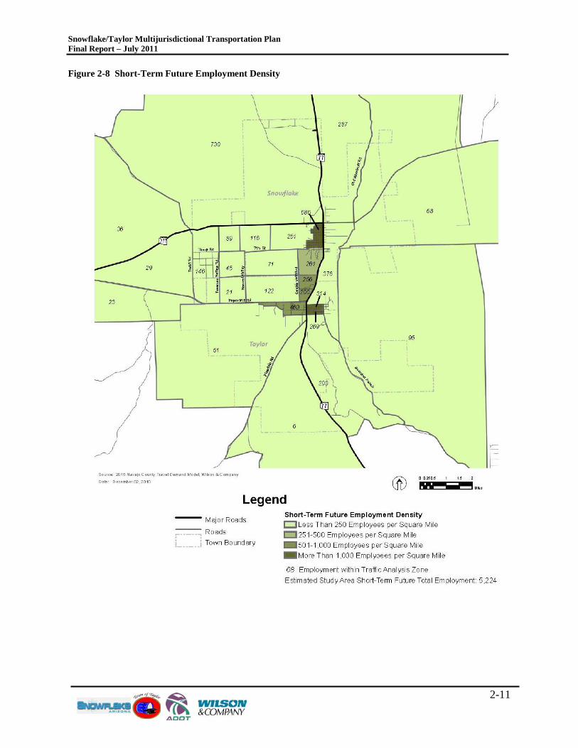
Figure 2-8 Short-Term Future Employment Density
Snowflake/Taylor Multijurisdictional Transportation Plan Final Report – July 2011
2-12
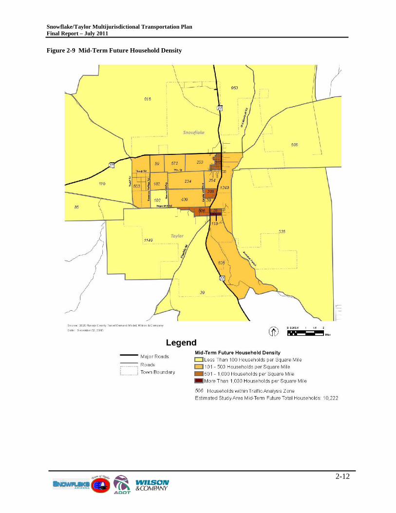
Figure 2-9 Mid-Term Future Household Density
Snowflake/Taylor Multijurisdictional Transportation Plan Final Report – July 2011
2-13
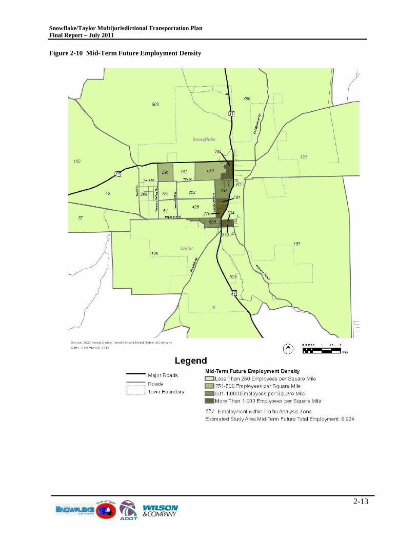
Figure 2-10 Mid-Term Future Employment Density
Snowflake/Taylor Multijurisdictional Transportation Plan Final Report – July 2011
2-14
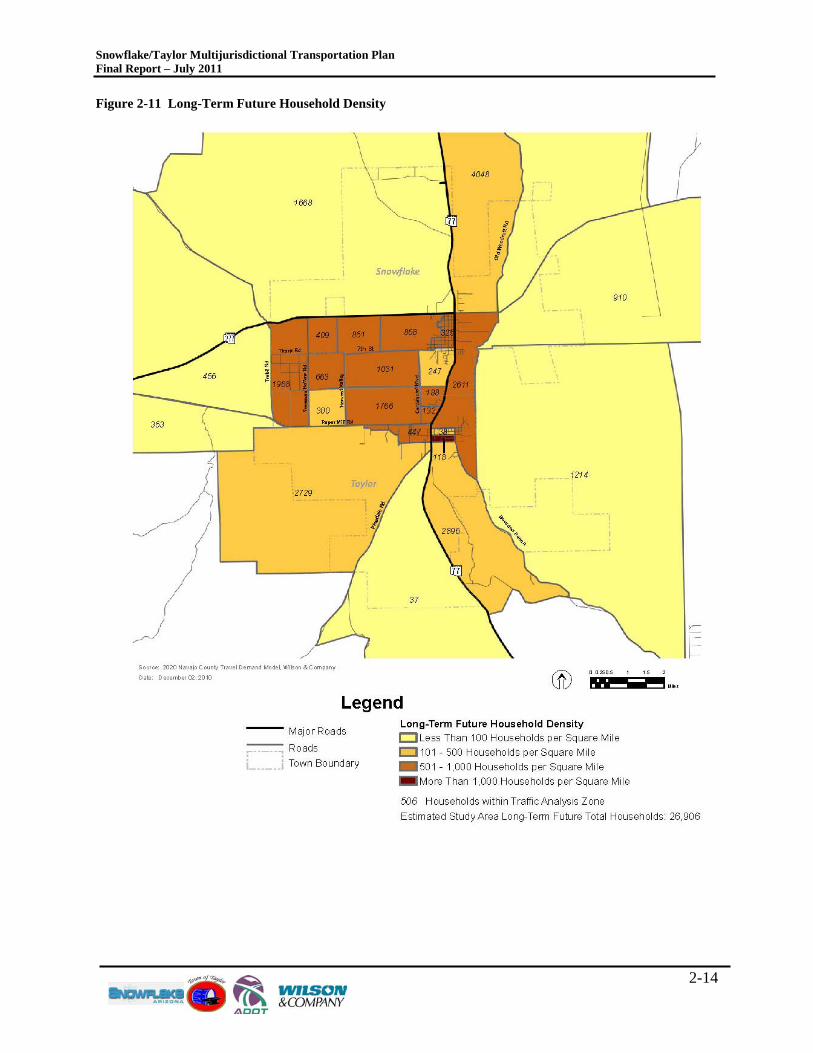
Figure 2-11 Long-Term Future Household Density
Snowflake/Taylor Multijurisdictional Transportation Plan Final Report – July 2011
2-15
Figure 2-12 Long-Term Future Employment Density
Snowflake/Taylor Multijurisdictional Transportation Plan Final Report – July 2011
3-1
3.0 T R ANS P OR TAT ION S Y S T E M DE F INIT ION The Long-Term Study Area roadway network is defined by the existing roadway system plus any improvements supported by authorized funding – committed improvements – and improvements identified in adopted plans that ultimately will be implemented. Improvements identified in adopted plans are considered, for purposes of this regional transportation plan, to be committed, because they have been identified and adopted/approved through a formal long-range planning process. Nevertheless, it is not certain the planned improvements will be implemented nor is the precise timing of implementation known. The Existing plus Committed roadway network provides the basis for examining the future adequacy of the primary transportation facilities in the Study Area and identifying potential deficiencies based on the anticipated travel demands from the forecasted socioeconomic conditions. No additional roadways beyond those that are already constructed will be included in the Existing plus Committed roadway network. The principal components of the existing plus committed roadway system are described in the following sections.
3.1 R OADW AY F UNC T IONAL C L AS S IF IC AT ION Roads are classified according to specific design and traffic characteristics. The functional classification process categorizes roads by how they perform in regard to providing access and mobility within the community. A principal arterial, for example, typically provides mobility for longer distance trips with higher speeds and less access to adjoining properties. Conversely, the function of a local street is to provide direct access to neighborhoods with lower speeds. The Sub-Region’s roadway network includes four roadway functional classifications. • Principal Arterial: This facility serves regional circulation needs. It moves traffic at moderate speeds while
providing limited access to adjacent land. Access is controlled through raised medians and through spacing and location of driveways and intersections. In the Sub-Region, a principal arterial is a two- or four-lane state highway.
• Minor Arterial: The general purpose of a Minor Arterial is to serve regional/sub-regional traffic circulation needs by moving traffic at moderate speeds, while providing limited access to adjacent land. Access to minor arterial streets is limited to intersections at quarter-mile spacing and to driveways of major developments, such as large commercial, industrial, or office complexes, or master-planned communities. On-street parking is not allowed.
• Major Collector: This class of roadway provides for shorter distance trips, generally less than three miles, and primarily serves to collect and distribute traffic between key traffic generators, local streets, and arterial streets. Design guidelines for this roadway classification provide for direct access to abutting land. Access to major collector streets is limited to intersections at eighth-mile spacing and to driveways to adjacent developments. All vehicles entering the traffic stream must be driving forward; no backing into traffic is allowed. On-street parking is not allowed.
• Minor Collector: Minor Collectors serve shorter distance trips than the Major Collector, generally less than one mile. This class of roadway provides direct access to adjacent land and collects and distributes traffic between key traffic generators, local streets, and arterial streets. Access to Minor Collector streets should be restricted except for large contiguous lots.
As the functional classification changes from arterial roadway to local roadway, the level of access generally increases, the capacity decreases, and the purpose of the roadway changes from efficiently moving vehicles to providing direct property access. Table 3.1 provides a summary
Snowflake/Taylor Multijurisdictional Transportation Plan Final Report – July 2011
3-2
of the characteristics of each of the four roadway functional classifications applicable to the Snowflake and Taylor communities. Table 3.1 Characteristics of Roadway Functional Classifications
Functional Classification Characteristics
Principal Arterial Provides regional mobility with limited direct access. Direct commercial access can occur, but access is infrequent to preserve capacity and mobility.
Minor Arterial
Provides access between Principal/Major Arterial and Major Collector routes. The level of access generally is less than on a Major Arterial, but more than a Major Collector. Direct commercial access typically is provided on Minor Arterial routes.
Major Collector Provides access between Major Collector and Minor Arterial routes. The level of access generally is less than on a Minor Collector, but more than a Minor Arterial.
Minor Collector Provides access between local streets and Major Collector routes. Source: Wilson & Company
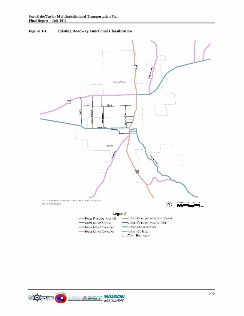
Figure 3-1 depicts the functional classification for the primary roadway network in the Snowflake and Taylor area. As shown, there are three roads that serve as the primary transportation corridors in the area including SR-77, SR-277 and Paper Mill Road. Outside of these three roadways, two of which are state highways, there are limited east/west and north/south contiguous routes for mobility. This in turn places significant pressure on SR-77 and SR-277 for local mobility needs. Most of the commercial and industrial developments in the two towns are located on these two state routes, forcing additional pressure on these key regionally significant routes. Additionally, most of the traffic that passes through the towns must traverse through the signalized intersection of SR-77/SR-277 making this intersection the most important intersection in the study area for community mobility.
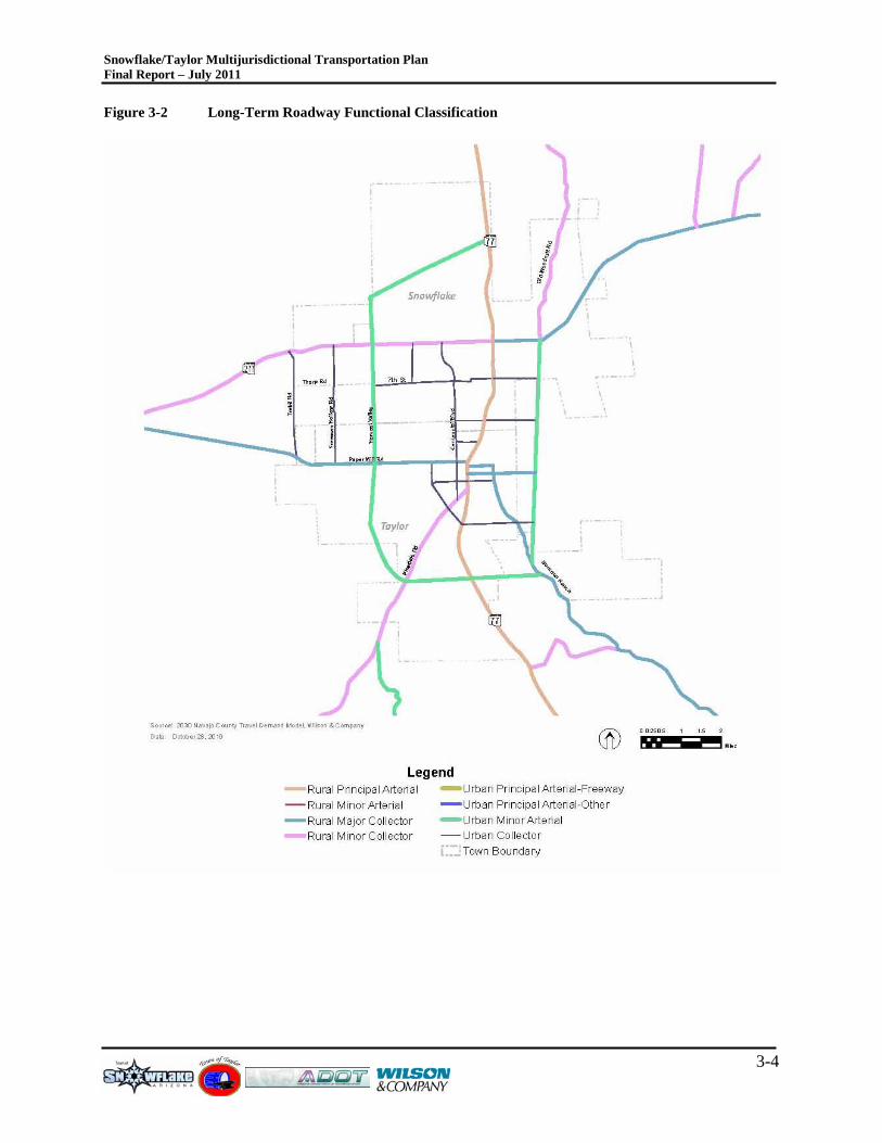
Figure 3-2 depicts the long-term functional classification of roadways serving as a build-out network. This reflects the needs identified in the Future Land Use Plans/Development Plans for Snowflake and Taylor. As illustrated, the state highways and proposed roadways that surround the communities are shown as Principal Arterial and Minor Arterial roadways. Harvest Valley Road in Taylor, also known as Porter Road in Snowflake, is proposed to be upgraded to a Minor Arterial roadway. This is very significant as it provides an additional higher capacity north/south oriented roadway to serve local community travel needs, compliment the capacity of SR-77 and potentially reduce the travel demand at the SR-77/SR-277 intersection.
As the Future Land Use Plans are refined, and as the communities react with the proposed Aztec developments in the immediate vicinity, additional roadways providing connectivity to SR-277 and SR-77 will be planned. These new roadways may provide additional refinements to those future roadways in this Plan. As such, ultimately the transportation system and the proposed area land uses must coincide with each other so that roadway functional classification properly accommodates the type and amount of traffic from future proposed development plans.
Snowflake/Taylor Multijurisdictional Transportation Plan Final Report – July 2011
3-3
Figure 3-1 Existing Roadway Functional Classification
Snowflake/Taylor Multijurisdictional Transportation Plan Final Report – July 2011
3-4
Figure 3-2 Long-Term Roadway Functional Classification
Snowflake/Taylor Multijurisdictional Transportation Plan Final Report – July 2011
3-5
3.2 F UNC T IONAL C L AS S IF IC AT ION C AP AC IT IE S Roadway capacity corresponds directly with roadway functional classification. In general, as the roadway classification is elevated, the roadway can handle higher traffic volumes. Factors such as level of access control, number of driveways, availability of left-turn lanes and if the roadway is divided or undivided play a critical role in overall capacity.
The Highway Capacity Manual (2000) defines the operational measures of effectiveness for all types of roadways and intersections in terms of qualitative levels of service (LOS). This is the common method to measure traffic capacity and operations. LOS measures the quality of traffic flow, maneuverability, driver comfort, average speed, and the ratio of the level of traffic or traffic volume to the capacity of the roadway. LOS definitions are defined from LOS A through F, including:
• LOS A: Free-flow travel conditions, excellent maneuverability, a high level of driver comfort, traveling speeds at the speed limit.
• LOS B: Almost free-flow travel conditions, slightly reduced maneuverability, a high level of driver comfort, traveling speeds very close to the speed limit.
• LOS C: Traffic congestion is noticeable with somewhat restricted maneuverability, a moderate level of driver comfort as awareness must be increased, and traveling speeds are reduced less than the speed limit.
• LOS D: Traffic congestion and associated delays restrict maneuverability and lessen driver comfort. Speeds are slower and much of the roadway capacity is being utilized.
• LOS E: Traffic flow is very unstable with extremely restricted maneuverability. Driver comfort is extremely poor with speeds excessively slower than the posted limit and almost all of the roadway capacity is being used.
• LOS F: Traffic flow is saturated with practically no maneuverability and driver comfort is extremely poor. Average speeds are extremely slow and are characterized by stop-and-go travel conditions with 100 percent of the roadway capacity being used.
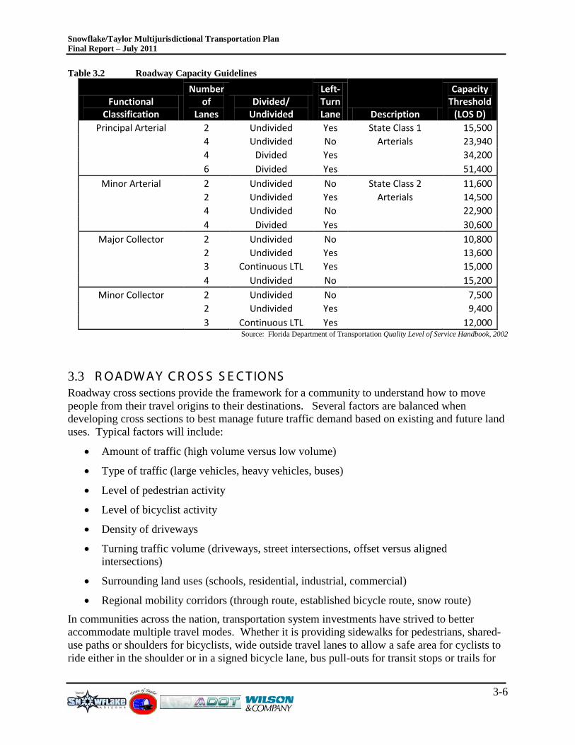
This study evaluates LOS for roadway segments only. The information presented in Table 3.2 is a general guideline for roadway capacity.
Within Snowflake and Taylor, most of the roadways are two-lanes and undivided. Two-lane, undivided roadways typically have the lowest capacities due to left-turn movements. A key point in Table 3.2 is the difference in capacity between a major collector two-lane roadway with a continuous two-way left-turn lane and a four-lane roadway without any left-turn lanes. The capacities are very similar due to the inside lanes of the four-lane roadway typically being used as a left-turn lane. Where there are several driveway accesses, a four-lane roadway can lead to increased safety and capacity issues.
The capacities presented in Table 3.2 were used to calculate future year roadway segment volume-to-capacity ratios. The computed volume-to-capacity ratios identifies those roadway segments that are anticipated to have congestion issues due to the roadway not having enough capacity to meet the anticipated travel demands either borne from surrounding land uses or the roadway functioning as a through route for regional travel.
Snowflake/Taylor Multijurisdictional Transportation Plan Final Report – July 2011
3-6
Table 3.2 Roadway Capacity Guidelines
Functional Classification
Number of
Lanes Divided/
Undivided
Left-Turn Lane Description
Capacity Threshold
(LOS D) Principal Arterial 2 Undivided Yes State Class 1 15,500
4 Undivided No Arterials 23,940 4 Divided Yes
34,200
6 Divided Yes 51,400 Minor Arterial 2 Undivided No State Class 2 11,600
2 Undivided Yes Arterials 14,500 4 Undivided No
22,900
4 Divided Yes 30,600 Major Collector 2 Undivided No
10,800
2 Undivided Yes
13,600 3 Continuous LTL Yes
15,000
4 Undivided No 15,200 Minor Collector 2 Undivided No
7,500
2 Undivided Yes
9,400 3 Continuous LTL Yes 12,000
Source: Florida Department of Transportation Quality Level of Service Handbook, 2002
3.3 R OADW AY C R OS S S E C T IONS Roadway cross sections provide the framework for a community to understand how to move people from their travel origins to their destinations. Several factors are balanced when developing cross sections to best manage future traffic demand based on existing and future land uses. Typical factors will include:
• Amount of traffic (high volume versus low volume)
• Type of traffic (large vehicles, heavy vehicles, buses)
• Level of pedestrian activity
• Level of bicyclist activity
• Density of driveways
• Turning traffic volume (driveways, street intersections, offset versus aligned intersections)
• Surrounding land uses (schools, residential, industrial, commercial)
• Regional mobility corridors (through route, established bicycle route, snow route)
In communities across the nation, transportation system investments have strived to better accommodate multiple travel modes. Whether it is providing sidewalks for pedestrians, shared-use paths or shoulders for bicyclists, wide outside travel lanes to allow a safe area for cyclists to ride either in the shoulder or in a signed bicycle lane, bus pull-outs for transit stops or trails for

Snowflake/Taylor Multijurisdictional Transportation Plan Final Report – July 2011
3-7
equestrians, communities are making the investments to provide safe mobility options to their residents, employers and visitors.
Each proposed cross section includes a shared-use path that would be wide enough for more than two people to walk side-by-side, bicycle use and/or equestrian use. The path could be constructed with material other than concrete or asphalt. Each cross section also includes a detached sidewalk that is at least 5-feet wide, and is separated from the roadway by at least 5 feet as indicated in the ADOT Roadway Design Guidelines. All sidewalks would be constructed of either concrete or asphalt material. Detaching the sidewalk and path from the curb and gutter can offer several advantages, including:
• Increased safety for the pedestrian;
• Lower cost for maintenance since the sidewalk and curb/gutter are not monolithic;
• Pedestrians would potentially not be impacted by roadway and curb/gutter maintenance activities;
• Improved ability to maintain sidewalk use during/after a snow event because plowed snow would have a lower chance of building up on the detached sidewalk; and
• Improved ADA accessibility, particularly during roadway maintenance activities. Each proposed cross section includes a wide outside travel lane or paved shoulder for bicycle use. The ADOT Bicycle Policy states:
"Provide shared roadway cross-section templates as a minimum condition with new major construction and major reconstruction projects, regardless of the presence of a shared use path" where "shared roadway" is defined as "a roadway which is open to both bicycle and motor vehicle travel. This may be an existing roadway, street with wide curb lanes, or road with paved shoulders," and "Consider, as a part of major new construction and major reconstruction in urban areas, wide curb lanes up to 15 ft in width (exclusive of gutter pan) and placement of a stripe at the vehicle lane edge where appropriate" (paragraph 1.e.).
Conceptual cross section drawings were developed that integrated the above factors to represent the needs for the Functional Classifications are illustrated as follows:
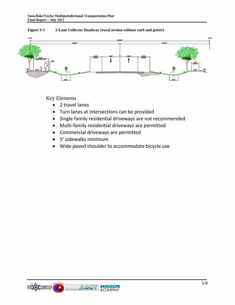
• Figure 3-3: 2-Lane Collector Roadway
• Figure 3-4: 2-Lane Collector Roadway (rural Collector without curb/gutter)
• Figure 3-5: 3-Lane Collector Roadway (includes center turn lane)
• Figure 3-6: 5-Lane Arterial Roadway (includes center turn lane)
• Figure 3-7: 4-Lane Arterial Roadway (includes center median)
Snowflake/Taylor Multijurisdictional Transportation Plan Final Report – July 2011
3-8
Figure 3-3 2-Lane Collector Roadway (rural section without curb and gutter)
Key Elements • 2 travel lanes • Turn lanes at intersections can be provided • Single family residential driveways are not recommended • Multi-family residential driveways are permitted • Commercial driveways are permitted • 5’ sidewalks minimum • Wide paved shoulder to accommodate bicycle use
Snowflake/Taylor Multijurisdictional Transportation Plan Final Report – July 2011
3-9
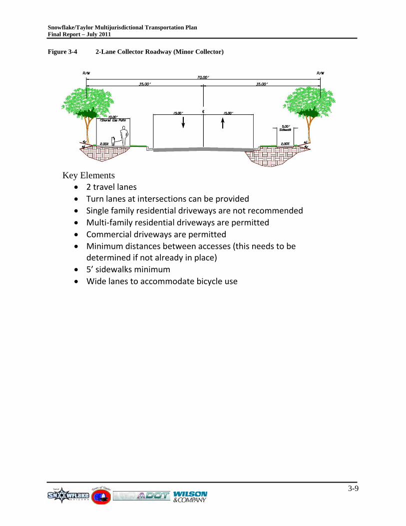
Figure 3-4 2-Lane Collector Roadway (Minor Collector)
Key Elements • 2 travel lanes • Turn lanes at intersections can be provided • Single family residential driveways are not recommended • Multi-family residential driveways are permitted • Commercial driveways are permitted • Minimum distances between accesses (this needs to be
determined if not already in place) • 5’ sidewalks minimum • Wide lanes to accommodate bicycle use
Snowflake/Taylor Multijurisdictional Transportation Plan Final Report – July 2011
3-10
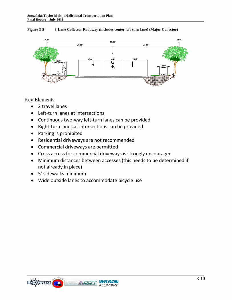
Figure 3-5 3-Lane Collector Roadway (includes center left-turn lane) (Major Collector)
Key Elements • 2 travel lanes • Left-turn lanes at intersections • Continuous two-way left-turn lanes can be provided • Right-turn lanes at intersections can be provided • Parking is prohibited • Residential driveways are not recommended • Commercial driveways are permitted • Cross access for commercial driveways is strongly encouraged • Minimum distances between accesses (this needs to be determined if
not already in place) • 5’ sidewalks minimum • Wide outside lanes to accommodate bicycle use
Snowflake/Taylor Multijurisdictional Transportation Plan Final Report – July 2011
3-11
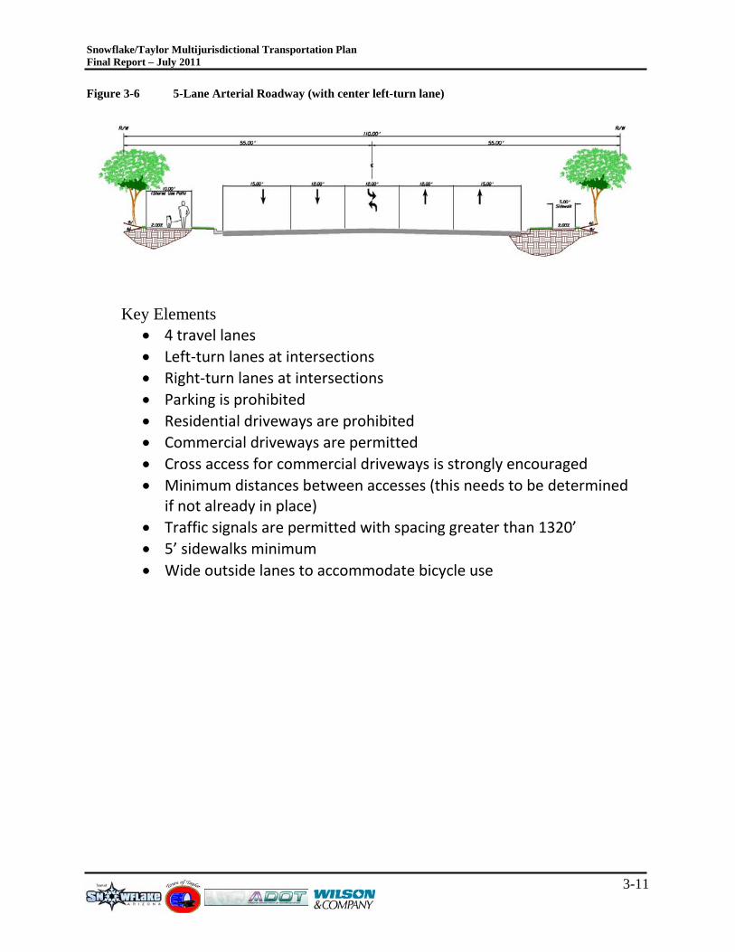
Figure 3-6 5-Lane Arterial Roadway (with center left-turn lane)
Key Elements • 4 travel lanes • Left-turn lanes at intersections • Right-turn lanes at intersections • Parking is prohibited • Residential driveways are prohibited • Commercial driveways are permitted • Cross access for commercial driveways is strongly encouraged • Minimum distances between accesses (this needs to be determined
if not already in place) • Traffic signals are permitted with spacing greater than 1320’ • 5’ sidewalks minimum • Wide outside lanes to accommodate bicycle use
Snowflake/Taylor Multijurisdictional Transportation Plan Final Report – July 2011
3-12
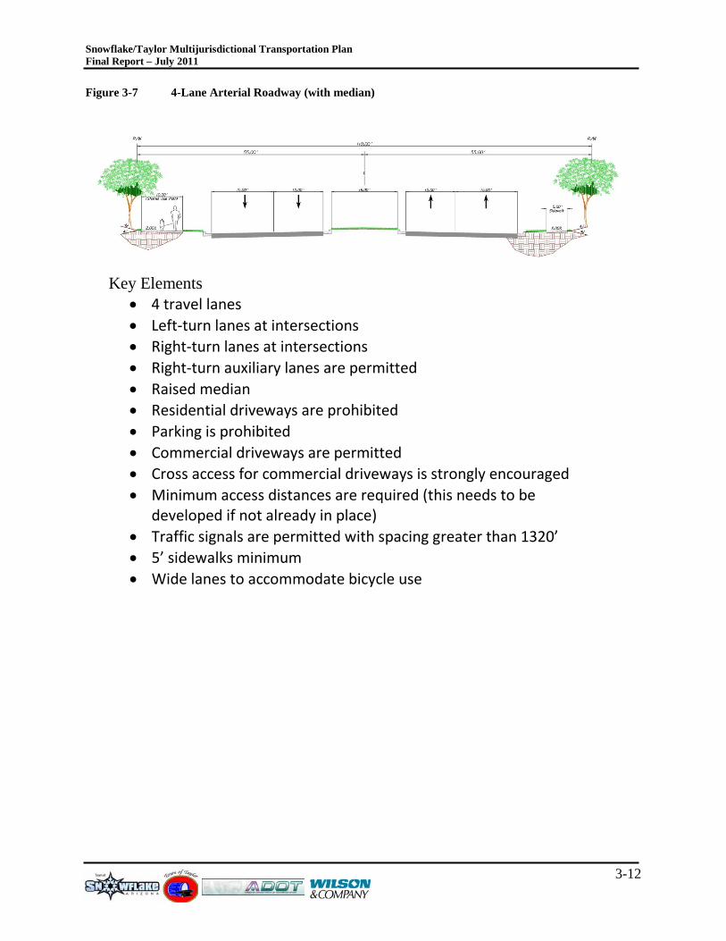
Figure 3-7 4-Lane Arterial Roadway (with median)
Key Elements
• 4 travel lanes • Left-turn lanes at intersections • Right-turn lanes at intersections • Right-turn auxiliary lanes are permitted • Raised median • Residential driveways are prohibited • Parking is prohibited • Commercial driveways are permitted • Cross access for commercial driveways is strongly encouraged • Minimum access distances are required (this needs to be
developed if not already in place) • Traffic signals are permitted with spacing greater than 1320’ • 5’ sidewalks minimum • Wide lanes to accommodate bicycle use
Snowflake/Taylor Multijurisdictional Transportation Plan Final Report – July 2011
4-1
4.0 T R ANS P OR TAT ION NE T WOR K S The purpose of this chapter is to present the evaluation of future roadway networks and improvement alternatives based on short-term, mid-term and long-term socioeconomic data projections of households and employment. This evaluation includes a series of traffic assignments using the TransCAD travel demand model to test improvement scenarios generated by the various socioeconomic data projections. This evaluation is focused on daily roadway segment capacities and projections. As development occurs in the region, more detailed evaluations that would include intersection based evaluations will be required.
4.1 T R AV E L DE MAND MODE L NE T WOR K S Five model networks will be used to conduct travel demand modeling activities for the Snowflake-Taylor Multijurisdictional Plan. The five networks include:
• Year 2006 – Existing Condition Network – The validated and calibrated modeling network used to assess changes in travel patterns and available capacity.
• Year Short-Term Existing plus Committed Network and Growth Assumptions– Represents a short-term future year travel network, nominally estimated as year 2015, which does not include any new or improved roadways beyond the Year 2006 model.
• Year Mid-Term Existing plus Committed Network and Growth Assumptions – Represents a growth scenario beyond the short-term growth described above and an associated travel network, nominally estimated as year 2020, which does not include any new or improved roadways beyond the Year 2006 model.
• Year Long-Term Existing plus Committed Network and Growth Assumptions– Represents an extended/long-term growth scenario beyond the short-term growth described above and an associated travel network, nominally estimated as year 2030, which does not include any new or improved roadways beyond the Year 2006 model.
• Year Long-Term Build-out Network – Represents an extended/long-term growth scenario, nominally estimated as year 2030, and potential future roadways that could be constructed above and beyond the existing plus committed network.
The five travel demand model networks described above will serve as the basis for the roadway capacity and performance evaluations. These five models will also provide the necessary information to help identify the select roadways to examine for geometric layouts.
4.2 T R ANS P OR AT ION NE T WOR K T R AF F IC F OR E C AS T S Information presented in this section includes a series of traffic assignments generated for the transportation networks described in Section 4.1 along with the short-term, mid-term and long-term growth projections of households and employment. These travel demand model assignments have been developed to reveal where future year travel demand deficiencies may exist. The traffic assignments provide a basis for testing and evaluating different network improvement scenarios as well as identify where key travel patterns exist.
Snowflake/Taylor Multijurisdictional Transportation Plan Final Report – July 2011
4-2
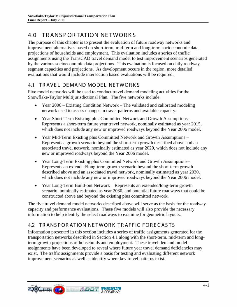
Figure 4-1 Year 2006 Traffic Volumes
Snowflake/Taylor Multijurisdictional Transportation Plan Final Report – July 2011
4-3
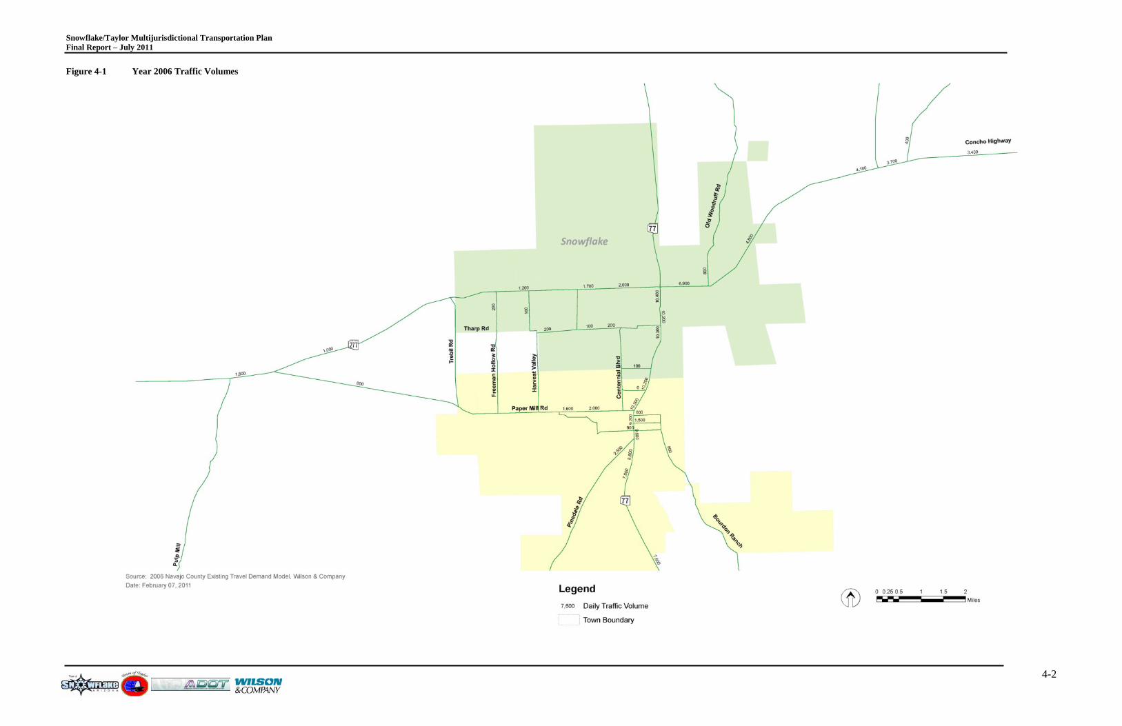
Figure 4-2 Short-Term Travel Demand Forecast

Snowflake/Taylor Multijurisdictional Transportation Plan Final Report – July 2011
4-4
Figure 4-3 Mid-Term Travel Demand Forecast

Snowflake/Taylor Multijurisdictional Transportation Plan Final Report – July 2011
4-5
Figure 4-4 Long-Term Travel Demand Forecast
Snowflake/Taylor Multijurisdictional Transportation Plan Final Report – July 2011
4-6
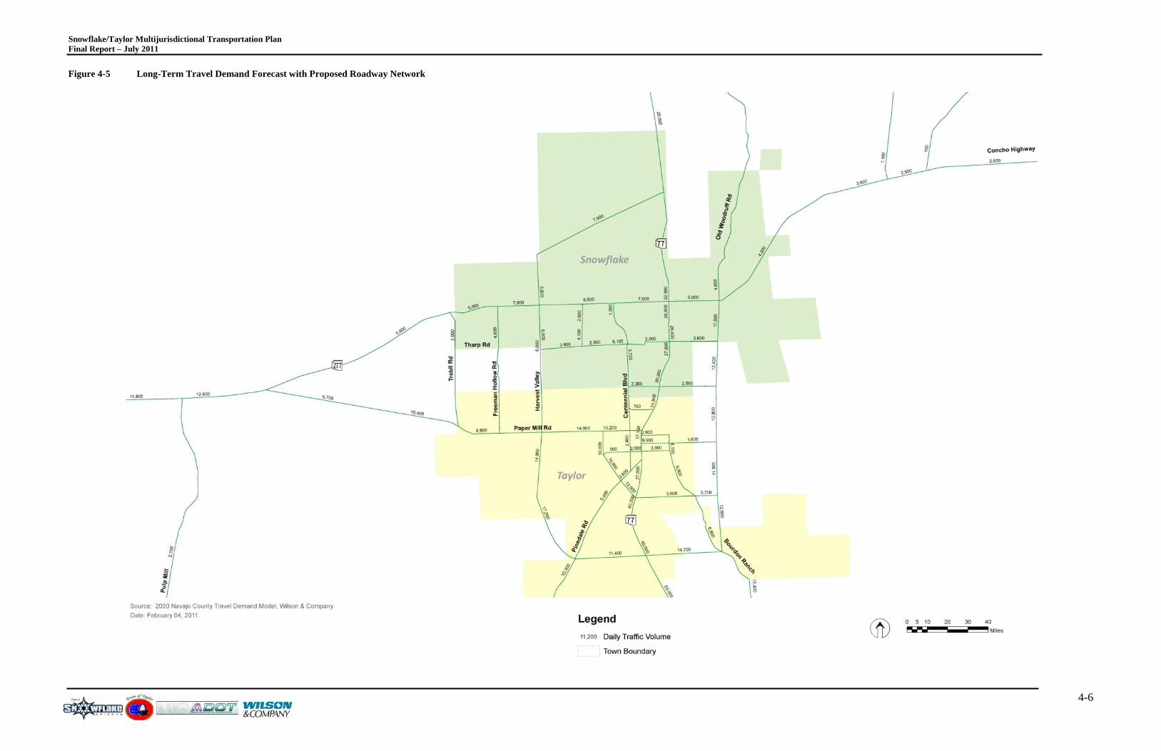
Figure 4-5 Long-Term Travel Demand Forecast with Proposed Roadway Network
Snowflake/Taylor Multijurisdictional Transportation Plan Final Report – July 2011
4-7
As illustrated in Figures 4-1 through 4-5, the forecasts show that there is significant travel demand growth in the Snowflake and Taylor region. This demand is developed from within these two towns, along with the surrounding communities, and a portion of the proposed developments associated with the Aztec Area Plan.
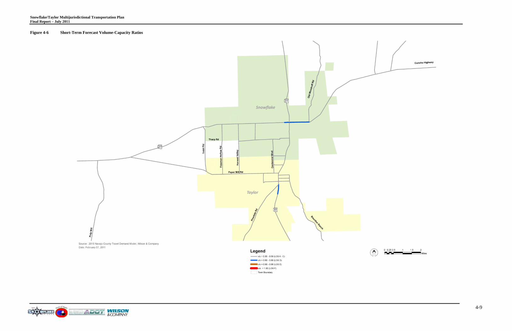
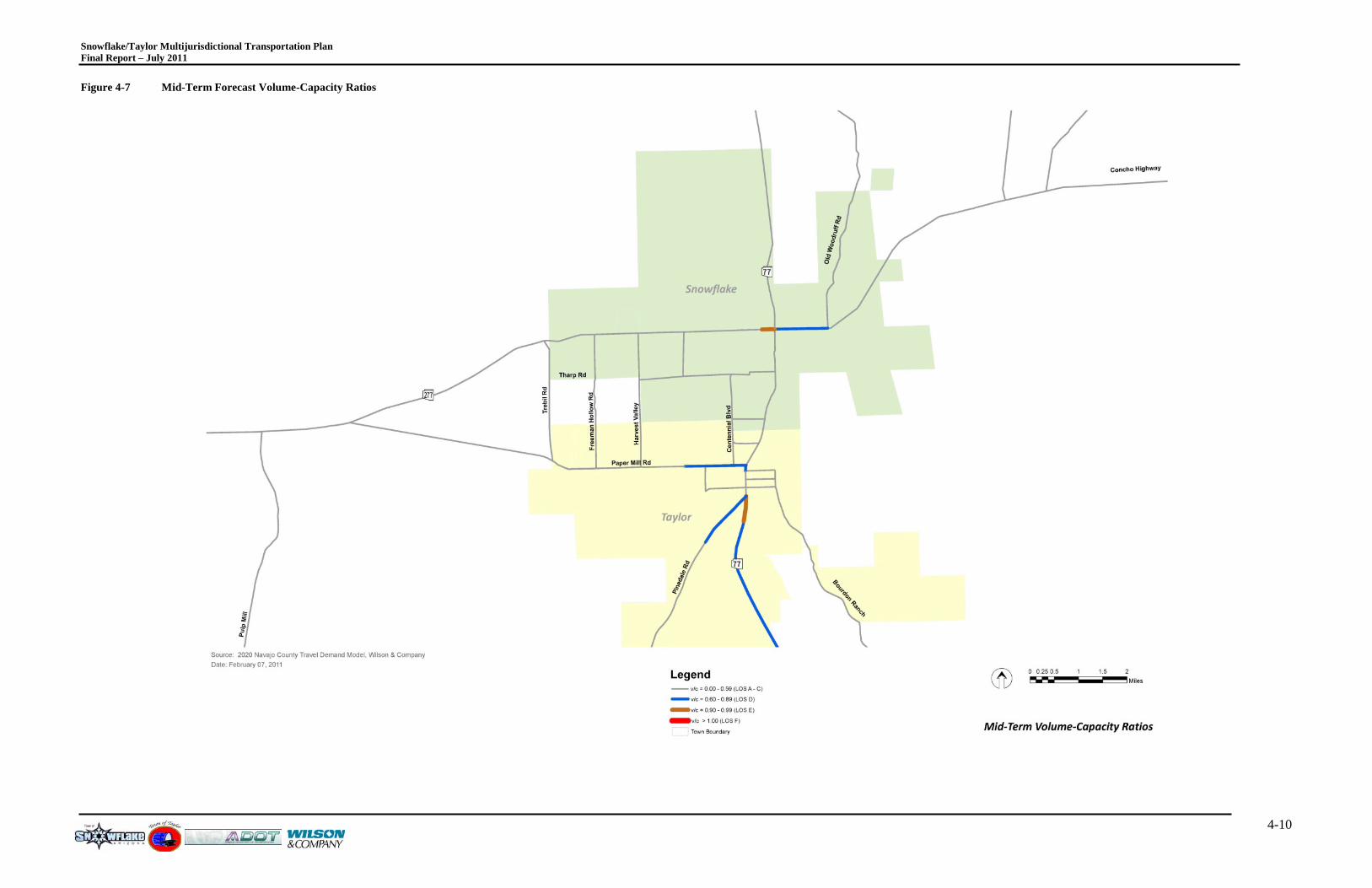
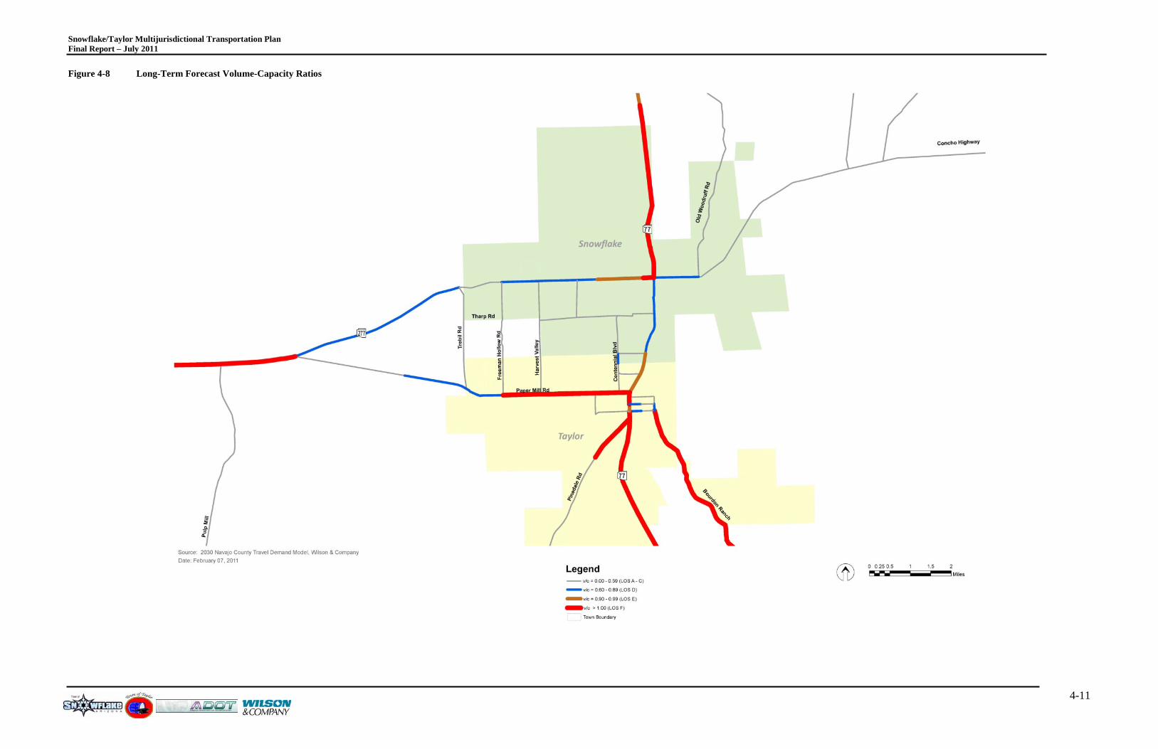
4.3 T R ANS P OR T AT ION NE T WOR K P E R F OR MANC E A segment capacity analysis was conducted for the primary network using the capacities and model data used for this study. Figures 4-6 through 4-9 depict the segment capacity analysis results for the short-term, mid-term, long-term, and long-term with the proposed roadways, respectively.
This capacity analysis uses the daily traffic volume and the model daily capacity to determine a volume-to-capacity ratio. The travel demand model does factor in travel time and level of congestion when assigning vehicle trips to the network so that the path taken is the shortest path based on the shortest travel time. When a roadway segment becomes saturated, the model will reassign traffic to a path that has less congestion resulting in shorter travel times.
4.3.1 S HOR T -T E R M F OR E C AS T NE T WOR K P E R F OR MANC E Figure 4-6 illustrates the short-term travel demand model network performance forecast. As illustrated, there are two contiguous segments that are anticipated to exhibit LOS D conditions including SR-77 south of Pinedale Road and SR-277 in the vicinity of the SR-77 intersection.
4.3.2 MID-T E R M F OR E C AS T NE T WOR K P E R F OR MANC E Figure 4-7 illustrates the mid-term travel demand model network performance forecast. As illustrated, several additional roadway segments are anticipated to exhibit LOS D and LOS E conditions including SR-77 south of Pinedale Road, Pinedale Road, Paper Mill Road and segments of SR-277 in the vicinity of the SR-77 intersection. The mid-term forecast illustrates the importance of the SR-77/SR-277 intersection, the SR-77/Paper Mill Road intersection and the SR-77/Pinedale Road intersection. These three intersections will take on much of the burden of regulating traffic through the two towns.
4.3.3 L ONG -T E R M F OR E C AS T NE T WOR K P E R F OR MANC E Figure 4-8 illustrates the long-term travel demand model network performance forecast. As illustrated, there are several segments that are anticipated to exhibit LOS D, LOS E and LOS F conditions including all of SR-77 through both towns, Pinedale Road, Paper Mill Road, Bourdon Ranch Road and SR-277. As conveyed with the mid-term forecast network performance, the intersections of SR-77/SR-277, SR-77/Paper Mill Road and SR-77/Pinedale Road will take on much of the burden of regulating traffic through the two towns. As the congestion worsens at these locations, it is anticipated that spillback traffic effects will occur causing additional mobility issues. These issues can be minimized through the use of aggressive access management practices by limiting direct driveway access and limiting the number of traffic signals on the corridor. Each traffic signal installed on the corridor will remove available through capacity, ultimately causing traffic to use different “cut-through” routes not intended for through movements. Additionally, each driveway is a potential conflict point where safety and capacity issues typically are found.
Snowflake/Taylor Multijurisdictional Transportation Plan Final Report – July 2011
4-8
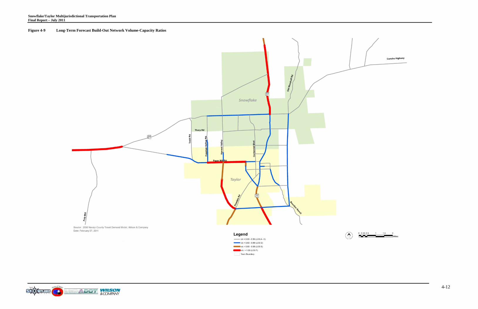
4.3.4 L ONG -T E R M F OR E C AS T NE T WOR K P E R F OR MANC E WIT H P R OP OS E D R OADW AY S Figure 4-9 illustrates the long-term travel demand model network performance with the proposed roadways for the two towns. As illustrated, there is a significant demand that can be addressed with the new roadways, particularly with the peripheral connections in the vicinity of the airport between SR-77/Pinedale Road/Paper Mill Road. This proposed network can greatly address some of the anticipated congestion along SR-77 in the long-term, although some congestion is still anticipated along SR-77. Again, these issues can be minimized through the use of aggressive access management practices by limiting direct driveway access and limiting the number of traffic signals on the corridor. Each traffic signal installed on the corridor will remove available through capacity, ultimately causing traffic to use different “cut-through” routes not intended for through movements. Additionally, each driveway is a potential conflict point where safety and capacity issues typically are found.
Snowflake/Taylor Multijurisdictional Transportation Plan Final Report – July 2011
4-9
Figure 4-6 Short-Term Forecast Volume-Capacity Ratios
Snowflake/Taylor Multijurisdictional Transportation Plan Final Report – July 2011
4-10
Figure 4-7 Mid-Term Forecast Volume-Capacity Ratios
Snowflake/Taylor Multijurisdictional Transportation Plan Final Report – July 2011
4-11
Figure 4-8 Long-Term Forecast Volume-Capacity Ratios
Snowflake/Taylor Multijurisdictional Transportation Plan Final Report – July 2011
4-12
Figure 4-9 Long-Term Forecast Build-Out Network Volume-Capacity Ratios
Snowflake/Taylor Multijurisdictional Transportation Plan Final Report – July 2011
5-1
5.0 MULT I-MODAL E L E ME NT S Integrating multi-modal elements in a community’s transportation system is critical for the ultimate success of achieving community mobility. The movement of “Complete Streets” has been in motion for several years. Complete Streets are designed to serve everyone – pedestrians, bicyclists, transit riders and drivers. Complete Streets in communities improves safety and mobility for all regardless of age or special needs. As a community grows, such as the anticipated growth that will occur in the towns of Snowflake and Taylor, it is essential to plan and design community mobility infrastructure that can accommodate all that currently use and tomorrow’s population/visitors that will use the same system in the future.
5.1 S IDE WAL K S Sidewalks positively serve communities in many ways. There are several safety benefits to sidewalks, primarily by providing a safe route for pedestrians to walk alongside of a roadway. Sidewalks serve people of all ages. Sidewalks also play an important role to provide access for people with disabilities.
There are also traffic operational benefits to providing sidewalks. As a community provides a network of sidewalks and trails, it lessens the requirement to drive to near-by destinations. Storefronts that are adjacent or close to each other with sidewalks in place can be easily accessed without the requirement of driving or walking on unfavorable surfaces. As illustrated in Chapter 4, it will become very important to provide mobility choices for those that live in, visit or pass through Snowflake and Taylor.
ADOT Roadway Design Guidelines (RDG) address pedestrian facilities along State Highways even though the State Engineer does not have a "pedestrian policy" and ADOT does not typically construct new sidewalks as part of a highway project: "In urban areas, the highway cross section should provide space for sidewalks.” It also states that “sidewalks. when required, should be offset from the roadway (Figure 306.4C) . . . Desirably, there should be at least 5 ft between the sidewalk and the back of the roadway curb" (p. 300-45).
5.2 B IC Y C L E F AC IL IT IE S ADOT standards regarding lane widths along State Highways, RDG, Section 301.3 - Lane Width and Pavement Width (p. 300 - 2) – states, "The pavement width shall provide for the number of traffic lanes required by the projected traffic volumes plus the appropriate minimum paved shoulder widths given in Table 302.4 ("Paved Shoulder Width," p. 300-10). Pavement widths shall be sufficient to accommodate bicycle traffic in accordance with the ADOT Bicycle Policy" (refer to Appendix E).
State Engineer, Bicycle Policy, paragraph 1.d.states that ADOT will: "Provide shared roadway cross-section templates as a minimum condition with new major construction and major reconstruction projects, regardless of the presence of a shared use path" where "shared roadway" is defined as "a roadway which is open to both bicycle and motor vehicle travel. This may be an existing roadway, street with wide curb lanes, or road with paved shoulders," and "Consider, as a part of major new construction and major reconstruction in urban areas, wide curb lanes up to 15 ft in width (exclusive of gutter pan) and placement of a stripe at the vehicle lane edge where appropriate" (paragraph 1.e.). RDG, Section 306.4 , Figure 306.4A, p. 300-47, specifies a 16
Snowflake/Taylor Multijurisdictional Transportation Plan Final Report – July 2011
5-2
ft curb lane, including 2 ft curb and gutter, typical, but "Consider 17 ft on a project-by-project basis to accommodate bicyclists" (refer to footnote and paragraphs A and B on p. 300-45).
The State Engineer does not, typically, sign or mark on-street bike lanes (per Bicycle Policy, paragraph 1.f.). And ADOT does not sign or designate sidewalks as bicycle routes or bikeways (paragraph 2. c.) nor does ADOT mark or sign shared-use paths on State right-of-way parallel and adjacent to roadways for bicyclists.
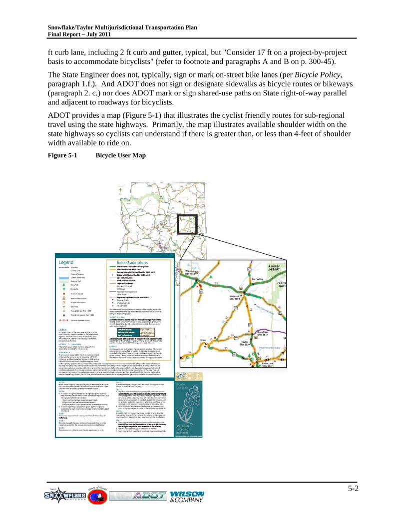
ADOT provides a map (Figure 5-1) that illustrates the cyclist friendly routes for sub-regional travel using the state highways. Primarily, the map illustrates available shoulder width on the state highways so cyclists can understand if there is greater than, or less than 4-feet of shoulder width available to ride on. Figure 5-1 Bicycle User Map
Snowflake/Taylor Multijurisdictional Transportation Plan Final Report – July 2011
5-3
This information allows cyclists to identify and plan safe routes if available. The Navajo County Central Region Transportation Study roadway assessment identified that the SR-77, SR-277 and SR-377 corridors should be studied further to remove horizontal and vertical curves and provides additional passing opportunities. Those corridors should also be examined to improve shoulder width to a total paved shoulder width of 4-feet or greater.
5.3 T R ANS IT In 2008, ADOT completed the Arizona Rural Transit Needs Study. That study identified that there are numerous unmet needs for rural transit services in Arizona. Presently, only 18 percent of the estimated rural transit demand is currently being met. Existing rural transit services are projected to meet only 13 percent of the total ridership need in 2016 if no additional services are introduced. The study described the vision that rural transit service in Arizona should be expanded significantly through the year 2016 to address the rapidly growing transportation demands and needs of rural residents statewide. Within Navajo County, there are several opportunities that should be examined further that can promote this vision.
Three goals were established in the Rural Transit Needs Study as well. They include:
• Goal #1: Provide services in multiple geographic areas, including transit services that operate within designated rural areas, services that connect rural areas with each other, and services that connect rural areas with urbanized areas;
• Goal #2: Address needs of particular market segments that use rural transit services, including but not limited to the elderly, persons with disabilities and persons of low income; and
• Goal #3: Serve a variety of trip purposes for rural Arizona residents including employment, medical, shopping and personal business needs.
The Rural Transit Needs Study did not necessarily address specific regional or subregional travel demand, but based the needs on elderly and low income unmet demand.
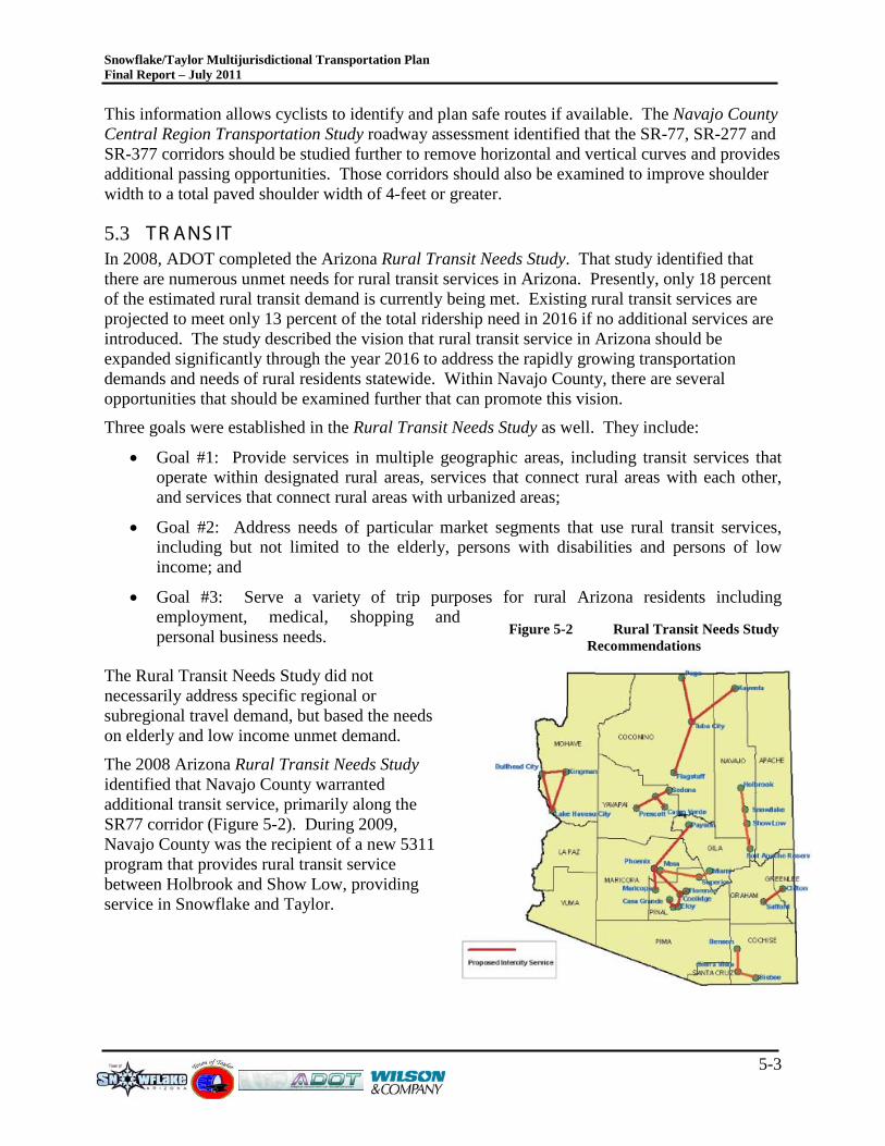
The 2008 Arizona Rural Transit Needs Study identified that Navajo County warranted additional transit service, primarily along the SR77 corridor (Figure 5-2). During 2009, Navajo County was the recipient of a new 5311 program that provides rural transit service between Holbrook and Show Low, providing service in Snowflake and Taylor.
Figure 5-2 Rural Transit Needs Study Recommendations
Snowflake/Taylor Multijurisdictional Transportation Plan Final Report – July 2011
6-1
6.0 E NV IR ONME NTAL C ONS IDE R AT IONS
6.1 E NV IR ONME NT AL J US T IC E OV E R VIE W “Title VI of the Civil Rights Act of 1964” and related statutes assure that individuals are not excluded from participation in, denied benefit of, or subjected to discrimination under any program or activity receiving federal financial assistance on the basis of race, color, national origin, age, sex, and disability. “Executive Order 12898” on environmental justice, dated February 11, 1994, directs that programs, policies, and activities not have a disproportionately high and adverse human health or environmental effect on minority and low-income populations.
There are three fundamental environmental justice principles. Including:
• To avoid, minimize, or mitigate disproportionately high and adverse human health and environmental effects, including social and economic effects, on minority populations and low income populations.
• To ensure the full and fair participation by all potentially all affected communities in the transportation decision making process.
• To prevent the denial of, reduction in, or significant delay in the receipt of benefits by minority and low-income populations.
The demographic composition of the study area was calculated using the U.S. Department of Commerce, Bureau of the Census 2000, Census of Population and Housing statistics. Census tracts are small, relatively permanent statistical subdivisions of a county for tallying census information, and do not cross county boundaries. They are delineated with the intention of being maintained over a long period of time to allow statistical comparisons from census to census.
The U.S. DOT Order (5610.2) on environmental justice provides definitions of the four minority groups addressed by the Executive Order. The four groups include:
• Black (a person having origins in any of the black racial groups of Africa);
• Hispanic (a person of Mexican, Puerto Rican, Cuban, Central or South American, or other Spanish culture or origin, regardless of race);
• Asian American (a person having origins in any of the original peoples of the Far East, Southeast Asia, the Indian subcontinent, or the Pacific Islands); and
• American Indian and Alaskan Native (a person having origins in any of the original people of North America and who maintains cultural identification through tribal affiliation or community recognition).
Additionally, the U.S. DOT Order defines “low income” as a person whose household income is at or below the Department of Health and Human Services poverty guidelines, which are used to determine the eligibility for Community Service Block Grants.
The intent of the Executive Order regarding environmental justice is to help ensure that those minority communities and low income populations do not burdened by a disproportionate share of an improvement project and benefit equally from the transportation system.
Snowflake/Taylor Multijurisdictional Transportation Plan Final Report – July 2011
6-2
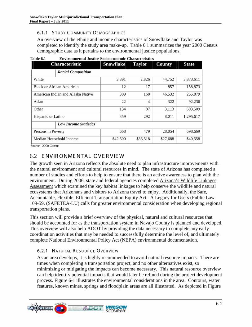
6.1.1 S T UDY C OMMUNIT Y DE MOG R AP HIC S An overview of the ethnic and income characteristics of Snowflake and Taylor was completed to identify the study area make-up. Table 6.1 summarizes the year 2000 Census demographic data as it pertains to the environmental justice populations.
Table 6.1 Environmental Justice Socioeconomic Characteristics Characteristic Snowflake Taylor County State
Racial Composition
White 3,891 2,826 44,752 3,873,611
Black or African American 12 17 857 158,873
American Indian and Alaska Native 309 168 46,532 255,879
Asian 22 4 322 92,236
Other 134 87 3,113 603,509
Hispanic or Latino 359 292 8,011 1,295,617
Low Income Statistics
Persons in Poverty 668 479 28,054 698,669
Median Household Income $42,500 $36,518 $27,688 $40,558 Source: 2000 Census
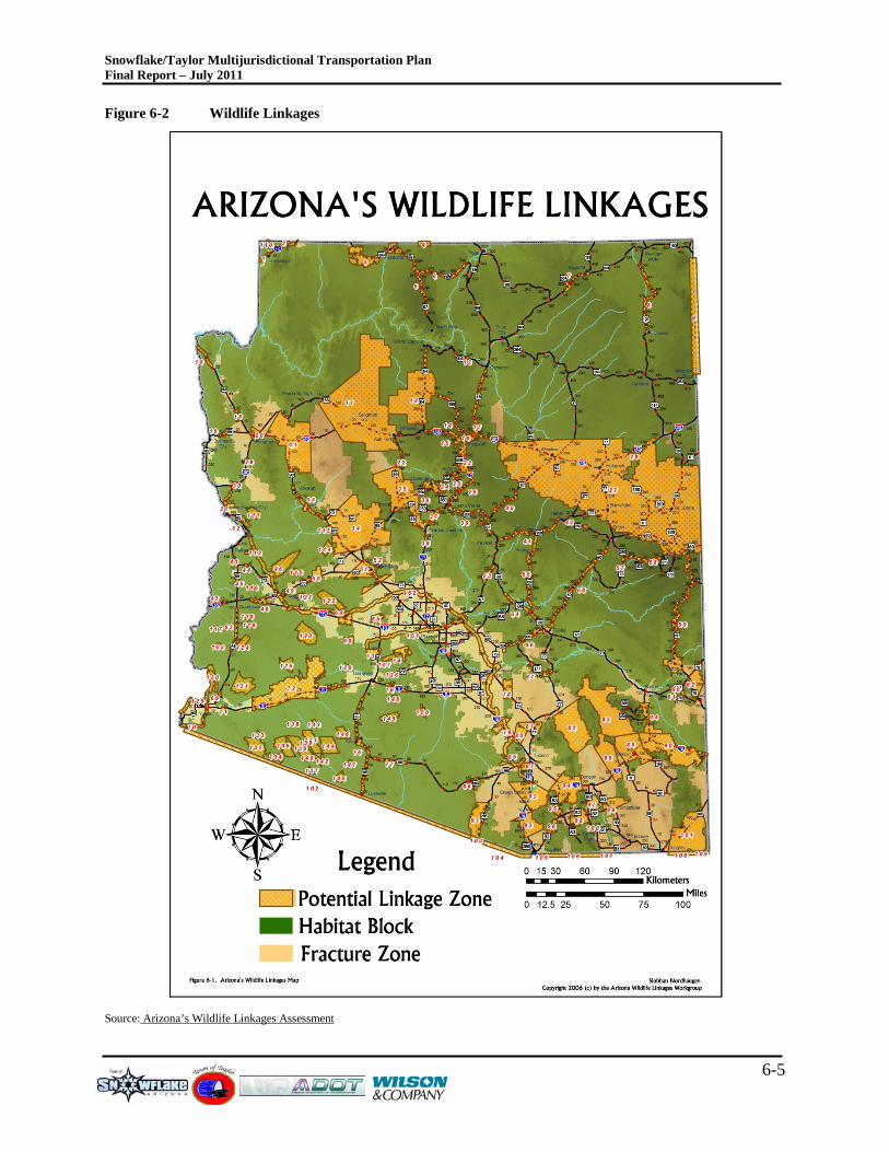
6.2 E NV IR ONME NT AL OV E R VIE W The growth seen in Arizona reflects the absolute need to plan infrastructure improvements with the natural environment and cultural resources in mind. The state of Arizona has completed a number of studies and efforts to help to ensure that there is an active awareness to plan with the environment. During 2006, state and federal agencies completed Arizona’s Wildlife Linkages Assessment
This section will provide a brief overview of the physical, natural and cultural resources that should be accounted for as the transportation system in Navajo County is planned and developed. This overview will also help ADOT by providing the data necessary to complete any early coordination activities that may be needed to successfully determine the level of, and ultimately complete National Environmental Policy Act (NEPA) environmental documentation.
which examined the key habitat linkages to help conserve the wildlife and natural ecosystems that Arizonans and visitors to Arizona travel to enjoy. Additionally, the Safe, Accountable, Flexible, Efficient Transportation Equity Act: A Legacy for Users (Public Law 109-59, (SAFETEA-LU) calls for greater environmental consideration when developing regional transportation plans.
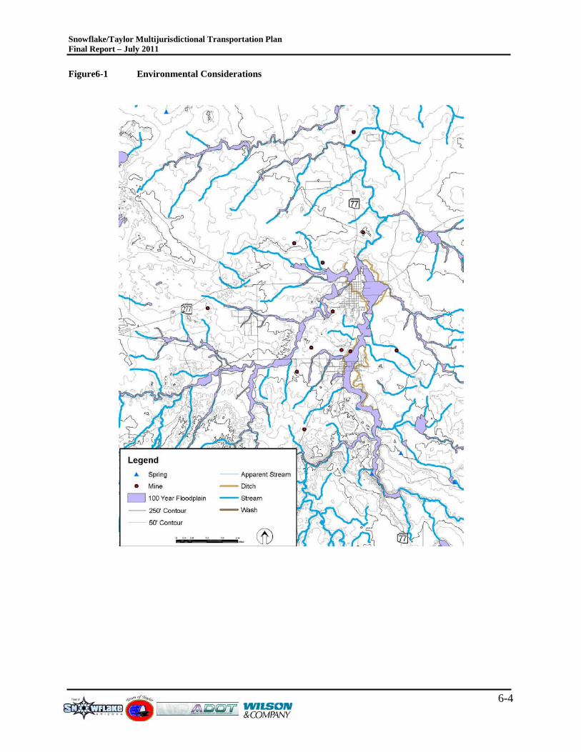
6.2.1 NAT UR AL R E S OUR C E OV E R V IE W As an area develops, it is highly recommended to avoid natural resource impacts. There are times when completing a transportation project, and no other alternatives exist, so minimizing or mitigating the impacts can become necessary. This natural resource overview can help identify potential impacts that would later be refined during the project development process. Figure 6-1 illustrates the environmental considerations in the area. Contours, water features, known mines, springs and floodplain areas are all illustrated. As depicted in Figure
Snowflake/Taylor Multijurisdictional Transportation Plan Final Report – July 2011
6-3
6-1, much of the areas in the vicinity of Snowflake and Taylor are within the 100-year flood zone.
A search using the National Wetland Inventory (NWI) database did not identify any known wetlands within the study area.
There are also several streams in the area. These streams, if adjusted can impact the 100-year floodplain. And will require U.S. Army Corps of Engineers coordination. As projects are defined and designed, early coordination with the USACOE is encouraged to maximize communication to the permitting agency and minimize review time.
During 2006, Arizona’s Wildlife Linkages Assessment
was completed identifying one key linkages within the study area between Holbrook and Snowflake, and both Snowflake and Taylor are located within “Potential Linkage Zones.” Figure 6-2 depicts the statewide wildlife linkages. These three identified linkages should be understood when any transportation improvement project is being contemplated in these areas. Additionally, as development proposals are proposed, care should be taken to understand and preserve them.
Snowflake/Taylor Multijurisdictional Transportation Plan Final Report – July 2011
6-4
Figure6-1 Environmental Considerations
Snowflake/Taylor Multijurisdictional Transportation Plan Final Report – July 2011
6-5
Figure 6-2 Wildlife Linkages
Source: Arizona’s Wildlife Linkages Assessment
Snowflake/Taylor Multijurisdictional Transportation Plan Final Report – July 2011
7-1
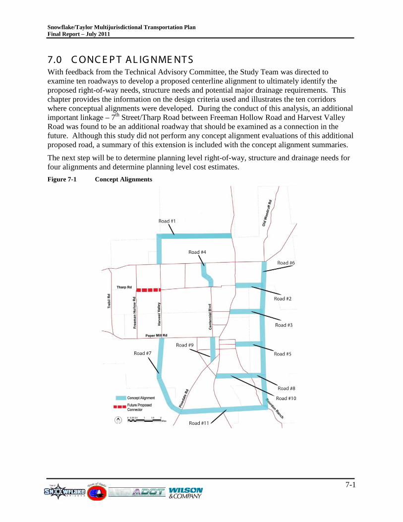
7.0 C ONC E P T AL IG NME NT S With feedback from the Technical Advisory Committee, the Study Team was directed to examine ten roadways to develop a proposed centerline alignment to ultimately identify the proposed right-of-way needs, structure needs and potential major drainage requirements. This chapter provides the information on the design criteria used and illustrates the ten corridors where conceptual alignments were developed. During the conduct of this analysis, an additional important linkage – 7th Street/Tharp Road between Freeman Hollow Road and Harvest Valley Road was found to be an additional roadway that should be examined as a connection in the future. Although this study did not perform any concept alignment evaluations of this additional proposed road, a summary of this extension is included with the concept alignment summaries.
The next step will be to determine planning level right-of-way, structure and drainage needs for four alignments and determine planning level cost estimates. Figure 7-1 Concept Alignments

Snowflake/Taylor Multijurisdictional Transportation Plan Final Report – July 2011
7-2
7.1 C ONC E P T L AY OUT S The design criteria described in Section 7.1 was used to preliminarily and conceptually identify potential layouts for each proposed roadway. The concept layouts are all conceptual in nature and do not identify a preferred alignment or actual alignment of a future roadway. The concept layouts were developed to identify fatal flaws of a future roadway alignment for planning purposes, and to illustrate the potential for future structure needs for spanning streams, washes and other known geographic elements. Future work efforts will be required to accurately design any future roadway. Appendix A, under separate cover, includes the illustrative roadway alignments as a first-step towards identifying probable alignments based on the limited topographic and environmental sensitivity information used in this study. As new development occurs, it is anticipated that the developer will work with the City towards a common goal of economic development coupled with a viable and safe transportation system.
7.2 C OS T E S T IMAT E S Cost estimates are more developed at a planning level to identify probable costs for the proposed roadways. Each of the estimates were based on a worst-case scenario, but will provide enough definition for planning purposes. As the alignments are refined, the costs will also be refined as well. As an example, extensive structure costs are assumed due to the floodplain crossings in the area. The costs associated with the floodplain crossings will probably decrease as the area is surveyed and the actual floodplain is mapped versus using readily available data. This approach does provide for awareness that there are costs associated with such an improvement; however, the extent of the costs must be refined as additional work is performed on these corridors.
7.3 C OR R IDOR S UMMAR IE S The following corridor summaries are prepared for each corridor evaluated. The corridor summary includes the proposed alignment, referencing any known existing roadways currently in place. The length of the improvement and identification of the number of structures and the length of the structures are identified at a planning level. In addition, a description of the proposed improvement along with summaries of existing and future land use assumptions, the proposed functional classification, any known constraints and an implementation strategy is defined.
Snowflake/Taylor Multijurisdictional Transportation Plan Final Report – July 2011
7-3
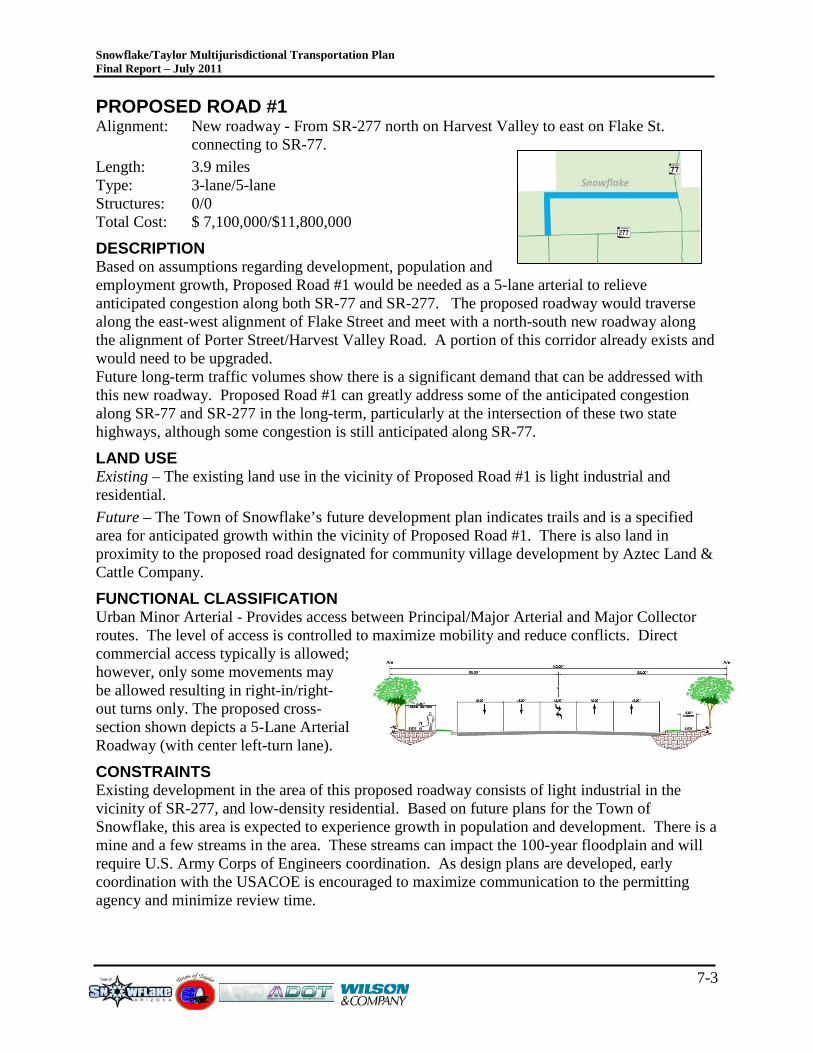
PROPOSED ROAD #1 Alignment: New roadway - From SR-277 north on Harvest Valley to east on Flake St.
connecting to SR-77. Length: 3.9 miles Type: 3-lane/5-lane Structures: 0/0 Total Cost: $ 7,100,000/$11,800,000
DESCRIPTION Based on assumptions regarding development, population and employment growth, Proposed Road #1 would be needed as a 5-lane arterial to relieve anticipated congestion along both SR-77 and SR-277. The proposed roadway would traverse along the east-west alignment of Flake Street and meet with a north-south new roadway along the alignment of Porter Street/Harvest Valley Road. A portion of this corridor already exists and would need to be upgraded. Future long-term traffic volumes show there is a significant demand that can be addressed with this new roadway. Proposed Road #1 can greatly address some of the anticipated congestion along SR-77 and SR-277 in the long-term, particularly at the intersection of these two state highways, although some congestion is still anticipated along SR-77.
LAND USE Existing – The existing land use in the vicinity of Proposed Road #1 is light industrial and residential.
Future – The Town of Snowflake’s future development plan indicates trails and is a specified area for anticipated growth within the vicinity of Proposed Road #1. There is also land in proximity to the proposed road designated for community village development by Aztec Land & Cattle Company.
FUNCTIONAL CLASSIFICATION Urban Minor Arterial - Provides access between Principal/Major Arterial and Major Collector routes. The level of access is controlled to maximize mobility and reduce conflicts. Direct commercial access typically is allowed; however, only some movements may be allowed resulting in right-in/right-out turns only. The proposed cross-section shown depicts a 5-Lane Arterial Roadway (with center left-turn lane).
CONSTRAINTS Existing development in the area of this proposed roadway consists of light industrial in the vicinity of SR-277, and low-density residential. Based on future plans for the Town of Snowflake, this area is expected to experience growth in population and development. There is a mine and a few streams in the area. These streams can impact the 100-year floodplain and will require U.S. Army Corps of Engineers coordination. As design plans are developed, early coordination with the USACOE is encouraged to maximize communication to the permitting agency and minimize review time.
Snowflake/Taylor Multijurisdictional Transportation Plan Final Report – July 2011
7-4
IMPLEMENTATION STRATEGY The extent of the transportation needs far exceed revenues anticipated for the area. It is important to have a plan for the future so as projects can be designed and built as funding becomes available. For Proposed Road #1, a 3-lane arterial may allow for staged implementation and be effective in the short- and mid-term. As traffic volumes reach 10,000, the design process should begin to make the arterial a 5-lane roadway, as that process can take at least 5 years from design to construction.
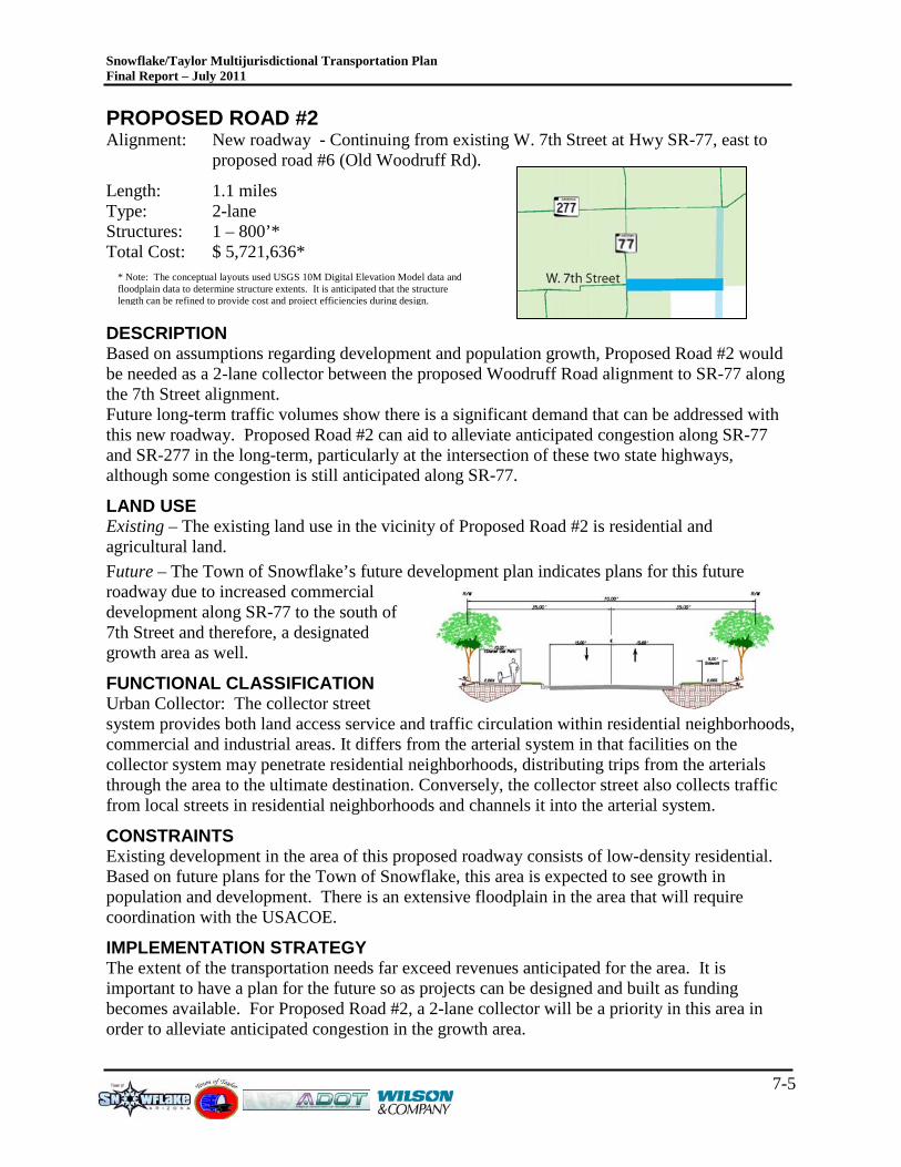
Snowflake/Taylor Multijurisdictional Transportation Plan Final Report – July 2011
7-5
* Note: The conceptual layouts used USGS 10M Digital Elevation Model data and floodplain data to determine structure extents. It is anticipated that the structure length can be refined to provide cost and project efficiencies during design.
PROPOSED ROAD #2 Alignment: New roadway - Continuing from existing W. 7th Street at Hwy SR-77, east to
proposed road #6 (Old Woodruff Rd).
Length: 1.1 miles Type: 2-lane Structures: 1 – 800’* Total Cost: $ 5,721,636*
DESCRIPTION Based on assumptions regarding development and population growth, Proposed Road #2 would be needed as a 2-lane collector between the proposed Woodruff Road alignment to SR-77 along the 7th Street alignment. Future long-term traffic volumes show there is a significant demand that can be addressed with this new roadway. Proposed Road #2 can aid to alleviate anticipated congestion along SR-77 and SR-277 in the long-term, particularly at the intersection of these two state highways, although some congestion is still anticipated along SR-77.
LAND USE Existing – The existing land use in the vicinity of Proposed Road #2 is residential and agricultural land. Future – The Town of Snowflake’s future development plan indicates plans for this future roadway due to increased commercial development along SR-77 to the south of 7th Street and therefore, a designated growth area as well.
FUNCTIONAL CLASSIFICATION Urban Collector: The collector street system provides both land access service and traffic circulation within residential neighborhoods, commercial and industrial areas. It differs from the arterial system in that facilities on the collector system may penetrate residential neighborhoods, distributing trips from the arterials through the area to the ultimate destination. Conversely, the collector street also collects traffic from local streets in residential neighborhoods and channels it into the arterial system.
CONSTRAINTS Existing development in the area of this proposed roadway consists of low-density residential. Based on future plans for the Town of Snowflake, this area is expected to see growth in population and development. There is an extensive floodplain in the area that will require coordination with the USACOE.
IMPLEMENTATION STRATEGY The extent of the transportation needs far exceed revenues anticipated for the area. It is important to have a plan for the future so as projects can be designed and built as funding becomes available. For Proposed Road #2, a 2-lane collector will be a priority in this area in order to alleviate anticipated congestion in the growth area.
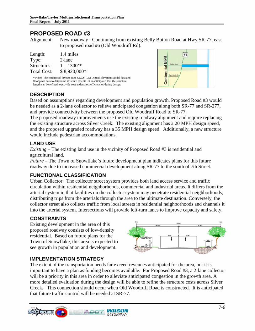
Snowflake/Taylor Multijurisdictional Transportation Plan Final Report – July 2011
7-6
* Note: The conceptual layouts used USGS 10M Digital Elevation Model data and floodplain data to determine structure extents. It is anticipated that the structure length can be refined to provide cost and project efficiencies during design.
PROPOSED ROAD #3 Alignment: New roadway - Continuing from existing Belly Button Road at Hwy SR-77, east
to proposed road #6 (Old Woodruff Rd).
Length: 1.4 miles Type: 2-lane Structures: 1 – 1300’* Total Cost: $ 8,920,000*
DESCRIPTION Based on assumptions regarding development and population growth, Proposed Road #3 would be needed as a 2-lane collector to relieve anticipated congestion along both SR-77 and SR-277, and provide connectivity between the proposed Old Woodruff Road to SR-77. The proposed roadway improvements use the existing roadway alignment and require replacing the existing structure across Silver Creek. The existing alignment has a 20 MPH design speed, and the proposed upgraded roadway has a 35 MPH design speed. Additionally, a new structure would include pedestrian accommodations.
LAND USE Existing – The existing land use in the vicinity of Proposed Road #3 is residential and agricultural land. Future – The Town of Snowflake’s future development plan indicates plans for this future roadway due to increased commercial development along SR-77 to the south of 7th Street.
FUNCTIONAL CLASSIFICATION Urban Collector: The collector street system provides both land access service and traffic circulation within residential neighborhoods, commercial and industrial areas. It differs from the arterial system in that facilities on the collector system may penetrate residential neighborhoods, distributing trips from the arterials through the area to the ultimate destination. Conversely, the collector street also collects traffic from local streets in residential neighborhoods and channels it into the arterial system. Intersections will provide left-turn lanes to improve capacity and safety.
CONSTRAINTS Existing development in the area of this proposed roadway consists of low-density residential. Based on future plans for the Town of Snowflake, this area is expected to see growth in population and development. IMPLEMENTATION STRATEGY The extent of the transportation needs far exceed revenues anticipated for the area, but it is important to have a plan as funding becomes available. For Proposed Road #3, a 2-lane collector will be a priority in this area in order to alleviate anticipated congestion in the growth area. A more detailed evaluation during the design will be able to refine the structure costs across Silver Creek. This connection should occur when Old Woodruff Road is constructed. It is anticipated that future traffic control will be needed at SR-77.
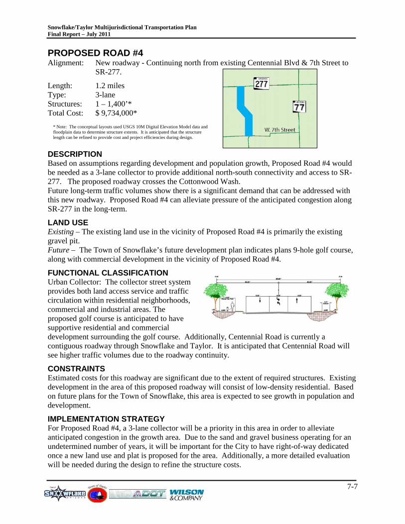
Snowflake/Taylor Multijurisdictional Transportation Plan Final Report – July 2011
7-7
* Note: The conceptual layouts used USGS 10M Digital Elevation Model data and floodplain data to determine structure extents. It is anticipated that the structure length can be refined to provide cost and project efficiencies during design.
PROPOSED ROAD #4 Alignment: New roadway - Continuing north from existing Centennial Blvd & 7th Street to
SR-277.
Length: 1.2 miles Type: 3-lane Structures: 1 – 1,400’* Total Cost: $ 9,734,000*
DESCRIPTION Based on assumptions regarding development and population growth, Proposed Road #4 would be needed as a 3-lane collector to provide additional north-south connectivity and access to SR-277. The proposed roadway crosses the Cottonwood Wash. Future long-term traffic volumes show there is a significant demand that can be addressed with this new roadway. Proposed Road #4 can alleviate pressure of the anticipated congestion along SR-277 in the long-term.
LAND USE Existing – The existing land use in the vicinity of Proposed Road #4 is primarily the existing gravel pit. Future – The Town of Snowflake’s future development plan indicates plans 9-hole golf course, along with commercial development in the vicinity of Proposed Road #4.
FUNCTIONAL CLASSIFICATION Urban Collector: The collector street system provides both land access service and traffic circulation within residential neighborhoods, commercial and industrial areas. The proposed golf course is anticipated to have supportive residential and commercial development surrounding the golf course. Additionally, Centennial Road is currently a contiguous roadway through Snowflake and Taylor. It is anticipated that Centennial Road will see higher traffic volumes due to the roadway continuity.
CONSTRAINTS Estimated costs for this roadway are significant due to the extent of required structures. Existing development in the area of this proposed roadway will consist of low-density residential. Based on future plans for the Town of Snowflake, this area is expected to see growth in population and development.
IMPLEMENTATION STRATEGY For Proposed Road #4, a 3-lane collector will be a priority in this area in order to alleviate anticipated congestion in the growth area. Due to the sand and gravel business operating for an undetermined number of years, it will be important for the City to have right-of-way dedicated once a new land use and plat is proposed for the area. Additionally, a more detailed evaluation will be needed during the design to refine the structure costs.
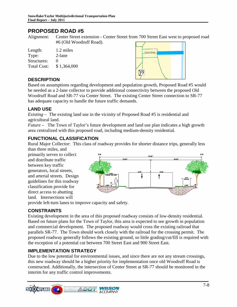
Snowflake/Taylor Multijurisdictional Transportation Plan Final Report – July 2011
7-8
PROPOSED ROAD #5 Alignment: Center Street extension - Center Street from 700 Street East west to proposed road
#6 (Old Woodruff Road).
Length: 1.2 miles Type: 2-lane Structures: 0 Total Cost: $ 1,364,000
DESCRIPTION Based on assumptions regarding development and population growth, Proposed Road #5 would be needed as a 2-lane collector to provide additional connectivity between the proposed Old Woodruff Road and SR-77 via Center Street. The existing Center Street connection to SR-77 has adequate capacity to handle the future traffic demands.
LAND USE Existing – The existing land use in the vicinity of Proposed Road #5 is residential and agricultural land. Future – The Town of Taylor’s future development and land use plan indicates a high growth area centralized with this proposed road, including medium-density residential.
FUNCTIONAL CLASSIFICATION Rural Major Collector: This class of roadway provides for shorter distance trips, generally less than three miles, and primarily serves to collect and distribute traffic between key traffic generators, local streets, and arterial streets. Design guidelines for this roadway classification provide for direct access to abutting land. Intersections will provide left-turn lanes to improve capacity and safety.
CONSTRAINTS Existing development in the area of this proposed roadway consists of low-density residential. Based on future plans for the Town of Taylor, this area is expected to see growth in population and commercial development. The proposed roadway would cross the existing railroad that parallels SR-77. The Town should work closely with the railroad for the crossing permit. The proposed roadway generally follows the existing ground, so little grading/cut/fill is required with the exception of a potential cut between 700 Street East and 900 Street East.
IMPLEMENTATION STRATEGY Due to the low potential for environmental issues, and since there are not any stream crossings, this new roadway should be a higher priority for implementation once old Woodruff Road is constructed. Additionally, the intersection of Center Street at SR-77 should be monitored in the interim for any traffic control improvements.
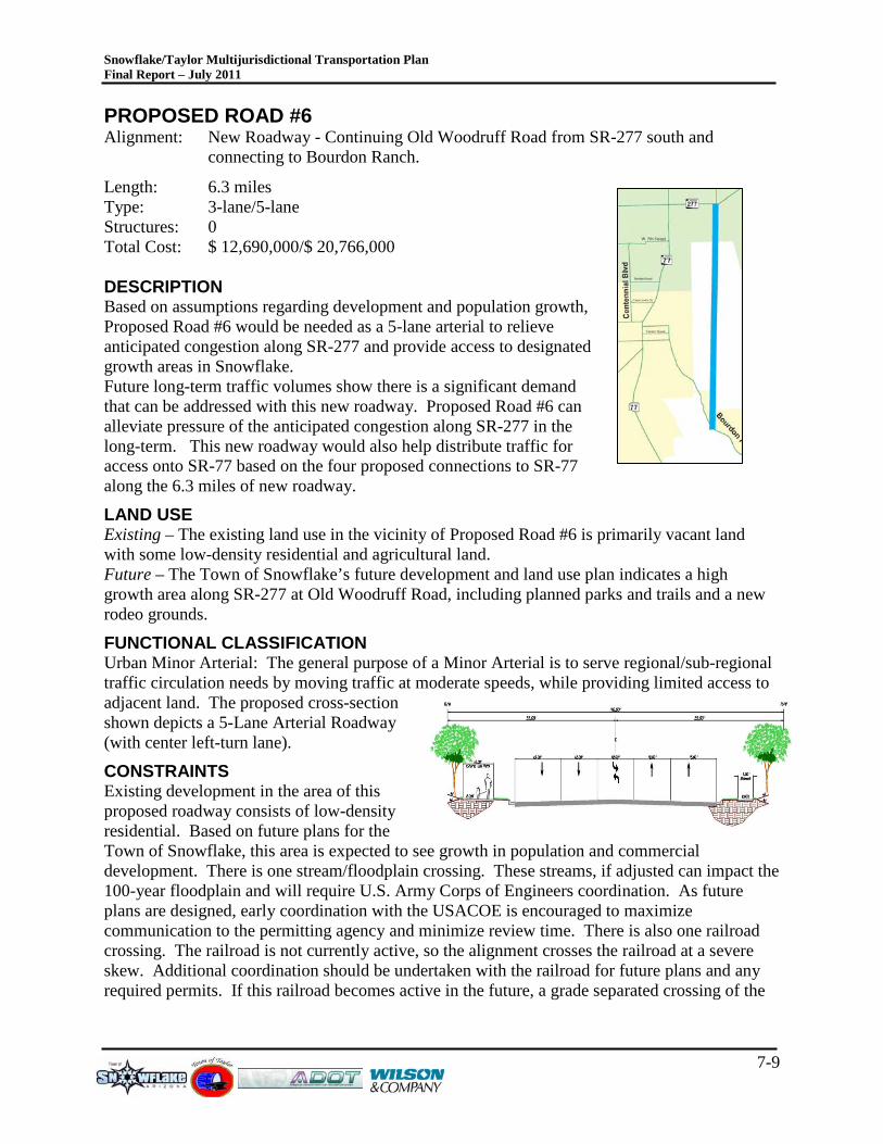
Snowflake/Taylor Multijurisdictional Transportation Plan Final Report – July 2011
7-9
PROPOSED ROAD #6 Alignment: New Roadway - Continuing Old Woodruff Road from SR-277 south and
connecting to Bourdon Ranch.
Length: 6.3 miles Type: 3-lane/5-lane Structures: 0 Total Cost: $ 12,690,000/$ 20,766,000 DESCRIPTION Based on assumptions regarding development and population growth, Proposed Road #6 would be needed as a 5-lane arterial to relieve anticipated congestion along SR-277 and provide access to designated growth areas in Snowflake. Future long-term traffic volumes show there is a significant demand that can be addressed with this new roadway. Proposed Road #6 can alleviate pressure of the anticipated congestion along SR-277 in the long-term. This new roadway would also help distribute traffic for access onto SR-77 based on the four proposed connections to SR-77 along the 6.3 miles of new roadway.
LAND USE Existing – The existing land use in the vicinity of Proposed Road #6 is primarily vacant land with some low-density residential and agricultural land. Future – The Town of Snowflake’s future development and land use plan indicates a high growth area along SR-277 at Old Woodruff Road, including planned parks and trails and a new rodeo grounds.
FUNCTIONAL CLASSIFICATION Urban Minor Arterial: The general purpose of a Minor Arterial is to serve regional/sub-regional traffic circulation needs by moving traffic at moderate speeds, while providing limited access to adjacent land. The proposed cross-section shown depicts a 5-Lane Arterial Roadway (with center left-turn lane).
CONSTRAINTS Existing development in the area of this proposed roadway consists of low-density residential. Based on future plans for the Town of Snowflake, this area is expected to see growth in population and commercial development. There is one stream/floodplain crossing. These streams, if adjusted can impact the 100-year floodplain and will require U.S. Army Corps of Engineers coordination. As future plans are designed, early coordination with the USACOE is encouraged to maximize communication to the permitting agency and minimize review time. There is also one railroad crossing. The railroad is not currently active, so the alignment crosses the railroad at a severe skew. Additional coordination should be undertaken with the railroad for future plans and any required permits. If this railroad becomes active in the future, a grade separated crossing of the
Snowflake/Taylor Multijurisdictional Transportation Plan Final Report – July 2011
7-10
railroad should be preserved, so access in the immediate vicinity of the railroad crossing (1,000 feet on either side) should be carefully planned.
IMPLEMENTATION STRATEGY The extent of the transportation needs far exceed revenues anticipated for the area. It is important to have a plan for the future so as projects can be designed and built as funding becomes available. For Proposed Road #6, a 3-lane arterial may be more affordable and effective in the short- and mid-term. As traffic volumes reach 10,000, the design process should begin to make the arterial a 5-lane roadway, as that process can take at least 5 years from design to construction.
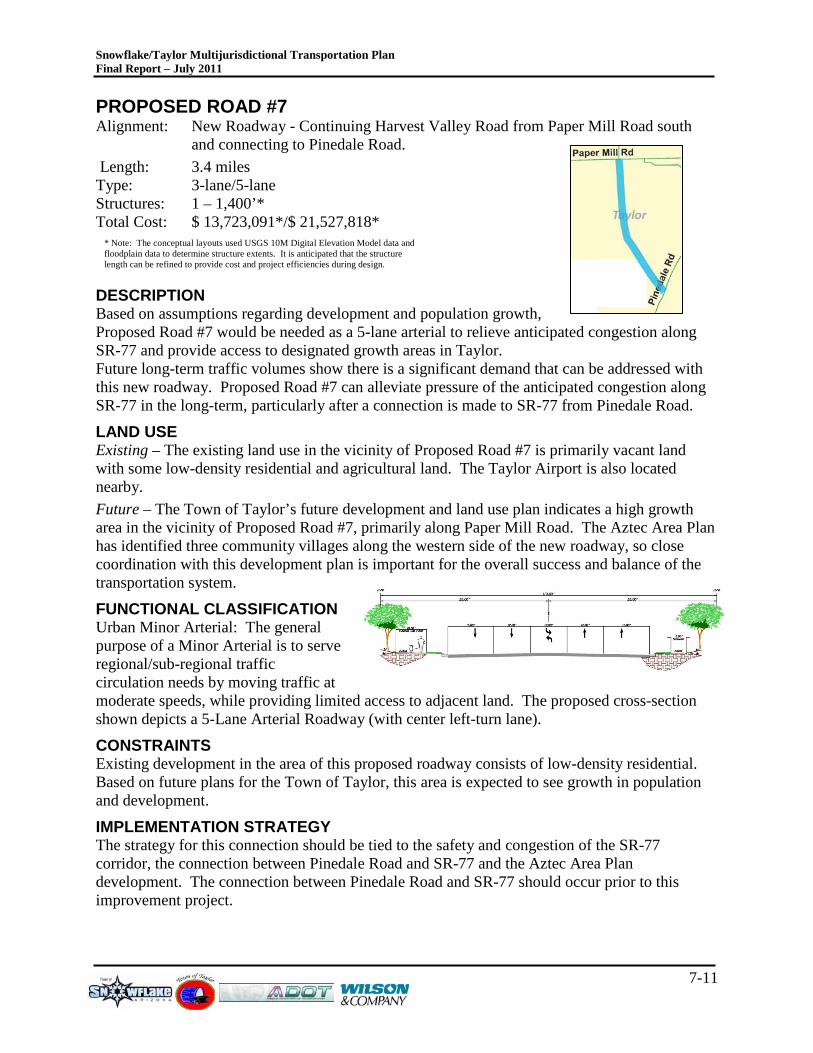
Snowflake/Taylor Multijurisdictional Transportation Plan Final Report – July 2011
7-11
* Note: The conceptual layouts used USGS 10M Digital Elevation Model data and floodplain data to determine structure extents. It is anticipated that the structure length can be refined to provide cost and project efficiencies during design.
PROPOSED ROAD #7 Alignment: New Roadway - Continuing Harvest Valley Road from Paper Mill Road south
and connecting to Pinedale Road. Length: 3.4 miles Type: 3-lane/5-lane Structures: 1 – 1,400’* Total Cost: $ 13,723,091*/$ 21,527,818*
DESCRIPTION Based on assumptions regarding development and population growth, Proposed Road #7 would be needed as a 5-lane arterial to relieve anticipated congestion along SR-77 and provide access to designated growth areas in Taylor. Future long-term traffic volumes show there is a significant demand that can be addressed with this new roadway. Proposed Road #7 can alleviate pressure of the anticipated congestion along SR-77 in the long-term, particularly after a connection is made to SR-77 from Pinedale Road.
LAND USE Existing – The existing land use in the vicinity of Proposed Road #7 is primarily vacant land with some low-density residential and agricultural land. The Taylor Airport is also located nearby. Future – The Town of Taylor’s future development and land use plan indicates a high growth area in the vicinity of Proposed Road #7, primarily along Paper Mill Road. The Aztec Area Plan has identified three community villages along the western side of the new roadway, so close coordination with this development plan is important for the overall success and balance of the transportation system.
FUNCTIONAL CLASSIFICATION Urban Minor Arterial: The general purpose of a Minor Arterial is to serve regional/sub-regional traffic circulation needs by moving traffic at moderate speeds, while providing limited access to adjacent land. The proposed cross-section shown depicts a 5-Lane Arterial Roadway (with center left-turn lane).
CONSTRAINTS Existing development in the area of this proposed roadway consists of low-density residential. Based on future plans for the Town of Taylor, this area is expected to see growth in population and development.
IMPLEMENTATION STRATEGY The strategy for this connection should be tied to the safety and congestion of the SR-77 corridor, the connection between Pinedale Road and SR-77 and the Aztec Area Plan development. The connection between Pinedale Road and SR-77 should occur prior to this improvement project.
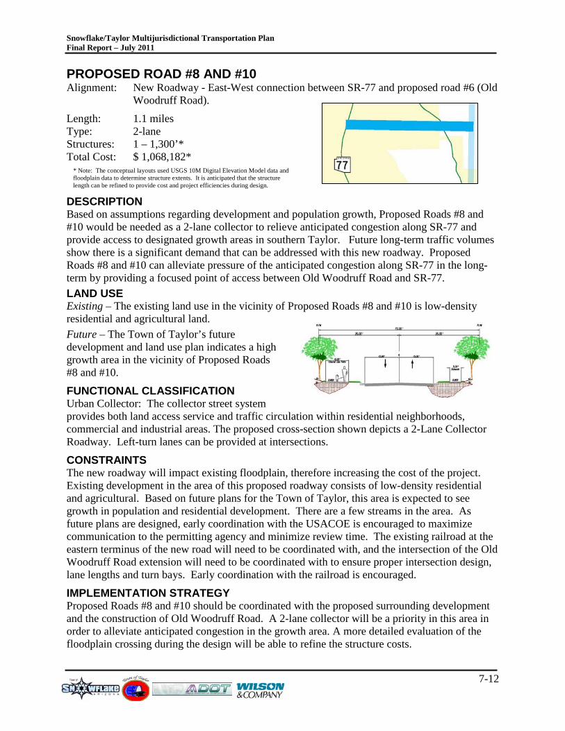
Snowflake/Taylor Multijurisdictional Transportation Plan Final Report – July 2011
7-12
* Note: The conceptual layouts used USGS 10M Digital Elevation Model data and floodplain data to determine structure extents. It is anticipated that the structure length can be refined to provide cost and project efficiencies during design.
PROPOSED ROAD #8 AND #10 Alignment: New Roadway - East-West connection between SR-77 and proposed road #6 (Old
Woodruff Road).
Length: 1.1 miles Type: 2-lane Structures: 1 – 1,300’* Total Cost: $ 1,068,182*
DESCRIPTION Based on assumptions regarding development and population growth, Proposed Roads #8 and #10 would be needed as a 2-lane collector to relieve anticipated congestion along SR-77 and provide access to designated growth areas in southern Taylor. Future long-term traffic volumes show there is a significant demand that can be addressed with this new roadway. Proposed Roads #8 and #10 can alleviate pressure of the anticipated congestion along SR-77 in the long-term by providing a focused point of access between Old Woodruff Road and SR-77. LAND USE Existing – The existing land use in the vicinity of Proposed Roads #8 and #10 is low-density residential and agricultural land. Future – The Town of Taylor’s future development and land use plan indicates a high growth area in the vicinity of Proposed Roads #8 and #10.
FUNCTIONAL CLASSIFICATION Urban Collector: The collector street system provides both land access service and traffic circulation within residential neighborhoods, commercial and industrial areas. The proposed cross-section shown depicts a 2-Lane Collector Roadway. Left-turn lanes can be provided at intersections.
CONSTRAINTS The new roadway will impact existing floodplain, therefore increasing the cost of the project. Existing development in the area of this proposed roadway consists of low-density residential and agricultural. Based on future plans for the Town of Taylor, this area is expected to see growth in population and residential development. There are a few streams in the area. As future plans are designed, early coordination with the USACOE is encouraged to maximize communication to the permitting agency and minimize review time. The existing railroad at the eastern terminus of the new road will need to be coordinated with, and the intersection of the Old Woodruff Road extension will need to be coordinated with to ensure proper intersection design, lane lengths and turn bays. Early coordination with the railroad is encouraged.
IMPLEMENTATION STRATEGY Proposed Roads #8 and #10 should be coordinated with the proposed surrounding development and the construction of Old Woodruff Road. A 2-lane collector will be a priority in this area in order to alleviate anticipated congestion in the growth area. A more detailed evaluation of the floodplain crossing during the design will be able to refine the structure costs.
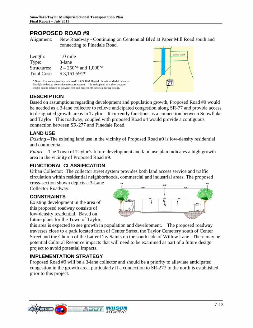
Snowflake/Taylor Multijurisdictional Transportation Plan Final Report – July 2011
7-13
* Note: The conceptual layouts used USGS 10M Digital Elevation Model data and floodplain data to determine structure extents. It is anticipated that the structure length can be refined to provide cost and project efficiencies during design.
PROPOSED ROAD #9 Alignment: New Roadway - Continuing on Centennial Blvd at Paper Mill Road south and
connecting to Pinedale Road. Length: 1.0 mile Type: 3-lane Structures: 2 – 250’* and 1,000’* Total Cost: $ 3,161,591*
DESCRIPTION Based on assumptions regarding development and population growth, Proposed Road #9 would be needed as a 3-lane collector to relieve anticipated congestion along SR-77 and provide access to designated growth areas in Taylor. It currently functions as a connection between Snowflake and Taylor. This roadway, coupled with proposed Road #4 would provide a contiguous connection between SR-277 and Pinedale Road.
LAND USE Existing –The existing land use in the vicinity of Proposed Road #9 is low-density residential and commercial. Future – The Town of Taylor’s future development and land use plan indicates a high growth area in the vicinity of Proposed Road #9.
FUNCTIONAL CLASSIFICATION Urban Collector: The collector street system provides both land access service and traffic circulation within residential neighborhoods, commercial and industrial areas. The proposed cross-section shown depicts a 3-Lane Collector Roadway.
CONSTRAINTS Existing development in the area of this proposed roadway consists of low-density residential. Based on future plans for the Town of Taylor, this area is expected to see growth in population and development. The proposed roadway traverses close to a park located north of Center Street, the Taylor Cemetery south of Center Street and the Church of the Latter Day Saints on the south side of Willow Lane. There may be potential Cultural Resource impacts that will need to be examined as part of a future design project to avoid potential impacts.
IMPLEMENTATION STRATEGY Proposed Road #9 will be a 3-lane collector and should be a priority to alleviate anticipated congestion in the growth area, particularly if a connection to SR-277 to the north is established prior to this project.
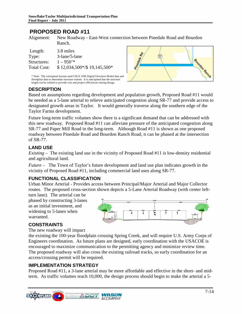
Snowflake/Taylor Multijurisdictional Transportation Plan Final Report – July 2011
7-14
* Note: The conceptual layouts used USGS 10M Digital Elevation Model data and floodplain data to determine structure extents. It is anticipated that the structure length can be refined to provide cost and project efficiencies during design.
PROPOSED ROAD #11 Alignment: New Roadway - East-West connection between Pinedale Road and Bourdon
Ranch.
Length: 3.8 miles Type: 3-lane/5-lane Structures: 1 – 950’* Total Cost: $ 12,034,500*/$ 19,145,500*
DESCRIPTION Based on assumptions regarding development and population growth, Proposed Road #11 would be needed as a 5-lane arterial to relieve anticipated congestion along SR-77 and provide access to designated growth areas in Taylor. It would generally traverse along the southern edge of the Taylor Farms development. Future long-term traffic volumes show there is a significant demand that can be addressed with this new roadway. Proposed Road #11 can alleviate pressure of the anticipated congestion along SR-77 and Paper Mill Road in the long-term. Although Road #11 is shown as one proposed roadway between Pinedale Road and Bourdon Ranch Road, it can be phased at the intersection of SR-77.
LAND USE Existing – The existing land use in the vicinity of Proposed Road #11 is low-density residential and agricultural land. Future – The Town of Taylor’s future development and land use plan indicates growth in the vicinity of Proposed Road #11, including commercial land uses along SR-77.
FUNCTIONAL CLASSIFICATION Urban Minor Arterial - Provides access between Principal/Major Arterial and Major Collector routes. The proposed cross-section shown depicts a 5-Lane Arterial Roadway (with center left-turn lane). The arterial can be phased by constructing 3-lanes as an initial investment, and widening to 5-lanes when warranted.
CONSTRAINTS The new roadway will impact the existing the 100-year floodplain crossing Spring Creek, and will require U.S. Army Corps of Engineers coordination. As future plans are designed, early coordination with the USACOE is encouraged to maximize communication to the permitting agency and minimize review time. The proposed roadway will also cross the existing railroad tracks, so early coordination for an access/crossing permit will be required.
IMPLEMENTATION STRATEGY Proposed Road #11, a 3-lane arterial may be more affordable and effective in the short- and mid-term. As traffic volumes reach 10,000, the design process should begin to make the arterial a 5-
Snowflake/Taylor Multijurisdictional Transportation Plan Final Report – July 2011
7-15
lane roadway, as that process can take at least 5 years from design to construction. A more detailed evaluation during the design will be able to refine the structure costs. Additionally, as additional planning is completed for the western portion of Snowflake, additional connections may be desirable west of this study area between Paper Mill Road and SR-77, crossing Pinedale Road.
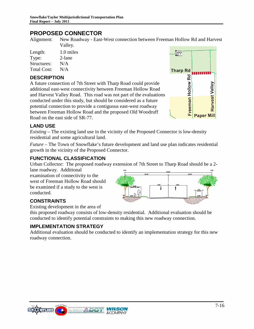
Snowflake/Taylor Multijurisdictional Transportation Plan Final Report – July 2011
7-16
PROPOSED CONNECTOR Alignment: New Roadway - East-West connection between Freeman Hollow Rd and Harvest
Valley. Length: 1.0 miles Type: 2-lane Structures: N/A Total Cost: N/A
DESCRIPTION A future connection of 7th Street with Tharp Road could provide additional east-west connectivity between Freeman Hollow Road and Harvest Valley Road. This road was not part of the evaluations conducted under this study, but should be considered as a future potential connection to provide a contiguous east-west roadway between Freeman Hollow Road and the proposed Old Woodruff Road on the east side of SR-77.
LAND USE Existing – The existing land use in the vicinity of the Proposed Connector is low-density residential and some agricultural land. Future – The Town of Snowflake’s future development and land use plan indicates residential growth in the vicinity of the Proposed Connector.
FUNCTIONAL CLASSIFICATION Urban Collector: The proposed roadway extension of 7th Street to Tharp Road should be a 2-lane roadway. Additional examination of connectivity to the west of Freeman Hollow Road should be examined if a study to the west is conducted. CONSTRAINTS Existing development in the area of this proposed roadway consists of low-density residential. Additional evaluation should be conducted to identify potential constraints to making this new roadway connection.
IMPLEMENTATION STRATEGY Additional evaluation should be conducted to identify an implementation strategy for this new roadway connection.
Snowflake/Taylor Multijurisdictional Transportation Plan Final Report – July 2011
8-1
8.0 IMP L E ME NTAT ION P R OG R AM AND NE XT S T E P S Each of the corridors examined in this study were reviewed to identify if there were any fatal flaws so that further resources could be used to plan and eventually program improvements for these corridors. This study also examined how the existing and proposed capacities of the transportation system will be able to accommodate the future proposed demands based on anticipated development. The assumptions used for this study should be refined as new development occurs and the economy recovers. Additionally, when the Aztec Area Plan begins to develop, additional coordination and planning activities should take place to ensure a coordinated transportation system that is balanced with the proposed land uses. A land use/transportation system balance occurs when the correct roadway functional classification correlates with the surrounding land uses. An example of this would be to ensure that truck traffic from an industrial development or retail establishment does not have to directly interact with surrounding residential development.
As the network is improved, and as the area develops, multimodal improvements including accommodating for pedestrian and bicycle mobility is very important for the ultimate sustainability of a community’s success. The proposed cross sections included herein provide recommendations that reflect a multimodal transportation system, safely allowing motorists, cyclists and pedestrians to interact on the same roadway.
The following implementation program outlines the necessary steps required to successfully implement the Plan improvements.
8.1 F UT UR E R OADWAY F UNC T IONAL C L AS S IF IC AT ION P L AN The Future Roadway Functional Classification Plan, shown for the Town of Snowflake and the Town of Taylor (Figure 3-2), establishes the overall design framework to guide the development of the Snowflake and Taylor area roadway network over the planning period. Each major roadway is classified according to the Federal Highway Administration functional classification standards.
The protection of right-of-way is critical for implementing the ultimate functional classification design standards set forth in this document to enable multimodal mobility. The functional classifications shown in Figures 3-3 through 3-7 depict and establish a basis for requiring the necessary right-of-way to construct the roadway to the full design cross section.
When the Town of Snowflake and the Town of Taylor adopt this Multijurisdictional Transportation Plan, they are adopting the Future Roadway Functional Classification Plan and associated functional classifications, cross sections and support documentation to implement the transportation system.
8.2 R OADW AY IMP R OV E ME NT P L AN The concept alignments represented in Figure 7-1 depict improvements needed and identified based on the 2007 Southern Navajo/Apache Sub-Regional Transportation Plan and assumptions, refinements from the Technical Advisory Committee direction, and readily available data that provided a basis for the recommended conceptual alignments included as Appendix A. As
Snowflake/Taylor Multijurisdictional Transportation Plan Final Report – July 2011
8-2
development occurs, the conceptual alignments for the proposed roadways examined in this Plan will be refined to reflect multimodal connectivity and corridor constraints.
8.3 IMP L E ME NT AT ION AC T ION IT E MS The following action items are required to support and implement this Multijurisdictional Transportation Plan.
PLAN ADOPTION Upon adopting this Multijurisdictional Transportation Plan, the Town of Snowflake and the Town of Taylor must reference this document in the General Plan and update the roadway design and construction standards to reflect the cross sections contained herein.
STAKEHOLDER COORDINATION Continued stakeholder coordination is essential to implement a long-term roadway improvement plan. The coordination between the two Towns, ADOT, Navajo County, the USACOE, the Northern Arizona Council of Governments, the surrounding White Mountain communities and the Aztec Land and Cattle Company should be maintained at a minimum. The White Mountain Regional Transportation Committee is an effective forum for coordination and communication between many of the groups listed above.
CORRIDOR ENGINEERING STUDIES Protection of right-of-way for future roadways is essential to maintaining the integrity of a transportation system and associated plans. Corridor studies are typically the method to identify specific needs, intersection configurations, drainage needs and avoidance of environmental concerns. As development occurs in any of the areas of the proposed roadways examined herein, a detailed engineering study should be undertaken to augment the efforts of this study and the work required as part of any new development, and should identify a plan for phasing improvements for ultimate implementation.
TRAFFIC DATA COLLECTION Traffic data collection activities should be undertaken periodically, preferably every other year, on the roadways with Collector and Arterial functional classifications at a minimum. Data from these collection efforts would provide valuable insights to enable planners and engineers to develop phased implementation strategies with the communities and stakeholders. Since it can take approximately 5 years at a minimum to design and construct a locally funded roadway, and more if the roadway has federal or state funds associated with it, timing of when to begin corridor or system level improvements can be critical to ensure funds are spent in the best locations.
TRACK NEW DEVELOPMENT New development should be tracked to ensure that assumptions used for the 2007 Southern Navajo/Apache County Sub-Regional Transportation Study and this Multijurisdictional Transportation Plan can be updated as development occurs and the Plans are updated. Ideally, this should be tracked using Geographic Information System (GIS) software so the development can be spatially analyzed with the surrounding socioeconomic data.
UPDATE NAVAJO COUNTY TRANSPORTATION PLAN
Snowflake/Taylor Multijurisdictional Transportation Plan Final Report – July 2011
8-3
To facilitate periodic updates of the sub-regional travel demand model used to conduct these analyses, the two Towns should strive to maintain current dwelling unit and employment databases. Regional accounting of this data will aide in less costly updates to the regional travel demand model package that Navajo County and ADOT maintain. This would qualify for ADOT PARA funds to assist in completing these planning efforts.
EXPAND THE SNOWFLAKE/TAYLOR MULTIJURISDICTIONAL TRANSPORTATION PLAN AREA There are several economic development opportunities in the region that should be explored and examined for future access outside of this Multijurisdictional Transportation Plan area. East of this study area, the area south of SR-277 to the Forest Service boundary should be examined to provide insights on known constraints and explore transportation connections and opportunities as development occurs. North of SR-277, the area bound by SR-77 to the east, Dry Lake Wind Farm Road to the north, SR-377 to the east and SR-277 to the south should be examined regarding how to best blend the Aztec Area Plan recommendations to develop a comprehensive land use, economic development and transportation plan to identify a collector and arterial street network that provides and promotes regional connectivity and planned, sustainable growth. This would qualify for ADOT PARA funds to assist in completing these planning efforts.
UPDATE THE SNOWFLAKE/TAYLOR MULTIJURISDICTIONAL TRANSPORTATION PLAN As development occurs and improvements are engineered and made, this Multijurisdictional Transportation Plan should be updated to reflect local needs and desires. Ideally, this Plan should feed into any updates of the Navajo County Transportation Plan. Additionally, this Plan update should correlate with the General Plan updates so that the future land use assumptions used in a General Plan can blend with a balanced multimodal transportation system. This would qualify for ADOT PARA funds to assist in completing these planning efforts.