social studies module
DESCRIPTION
First Period ModuleTRANSCRIPT
PDC CIENCIAS SOCIALES 6o
GAF-137-V1 20-01-2012
PAG 1 de 34
STUDENT
GROUP
No
TEACHER
VLADIMIR SALAS POLO
PERIOD
1
TIME OF WORKING
9 Weeks
SUBJECT
Social Studies AREA:
Science
OBJECTIVE OF THE AREA
Asumir una actitud crítica y propositiva frente a los acelerados cambios que se presentan en los contextos local, nacional e internacional.
COMPREHENSION GOAL OF THE
YEAR
Describir el desarrollo histórico y cultural de la humanidad durante la edad antigua.
COMPREHENSION GOAL FOR THE
PERIOD
Describir los principales aspectos del sistema solar y del planeta
INTRODUCTORY QUESTION
¿Cómo te imaginas los paisajes y los accidentes geográficos millones de años atrás o cómo eran antes los continentes?
CONTENTS
Origen de la tierra.
Conceptos básicos de geografía.
Características geográficas de los continentes africano, europeo, asiático, americano y Oceánico
COMPREHENSION GOALS OF THE
PERIOD
a. Comprender las eras de la tierra y las teorías
del origen de la tierra.
b. Manejar conceptos básicos de geografía.
c. Conocer las principales características geográficas de los continentes africano, europeo, asiático, americano y Oceánico.

PDC CIENCIAS SOCIALES 6o
GAF-137-V1 20-01-2012
PAG 1 de 34
ACTIVITIES OF THE PERIOD
COMPETENCE
ACTIVITIES FOR
STUDENTS
DATE CONTINOUS
EVALUATION
El hombre y su relación
con el planeta tierra
Individual work: According to the readings in this module, the student will find differences that characterize each continent. After analyzing the readings in the module, the student will describe the most important zones of the geography of each continent. Presentation of an oral and written description showing the main physical aspects of each continent.
Week 1-3
Week 4-6 Week 7-9
Week 1-3 Week 4-6 Week 7-10
LEVEL OF GOAL
S. Describe los principales aspectos geográficos de los continentes. A. Analiza los principales aspectos geográficos de los continentes Bs. Identifica los principales aspectos geográficos de los continentes.
B. Se le dificulta describir los principales aspectos geográficos de los continentes
RESOURCES
Neat and clean classroom for working according to the given activity. Word maps, geographical maps and summary descriptions which will help students to understand the studied topics.
BIBLIOGRAPHY
- www.wikipedia.com
- http://www.skwirk.com.au/
- http://geography.howstuffworks.com/ - http://www.fortunecity.com/oasis/skegness/394/geogra.htm - Sociales integradas, Aldea 6; Voluntad 2000 - Amigos de las ciencias sociales, Santillana 2006.

PDC CIENCIAS SOCIALES 6o
GAF-137-V1 20-01-2012
PAG 1 de 34
INTRODUCTION
Geography consists of the study of our planet, its climatic conditions, the various land forms on the planet and the different natural occurrences. It encompasses a wide knowledge base. It includes the spatial analysis of human and natural phenomena, the exploration of earth sciences and the relationship between nature and human life. The study of geography includes the analysis of social, economic and environmental processes that affect nature. Don’t you think it is important to know all about this in depth? Don’t you feel the need to have knowledge of our Earth? If you feel the need to, you have a reason to say that geography is important. The geography of a region affects the living of its inhabitants. The geographical conditions of a region influence its culture. They have a deep impact on the social and cultural norms of the people. They influence the culture and civilization of the region. The geography of a region has a direct effect on the art forms, the literature, the food habits and the celebrations of the people that inhabit it. This makes it important to study geography. You can catch a glimpse of world culture and heritage by browsing through different cultures of the world. If you find it boring to learn about the natural resources and climate, you must understand that it is these resources in nature that let us live. The climatic conditions in different regions of the world support the plant and animal life of that region. The climatic conditions and the availability of natural resources in a particular region shape the life of its inhabitants. Geography influences the distribution of natural and man-made resources across the globe. The natural wealth of a region owes its existence to the region’s geographical conditions. The geographical location of a region influences its climate, which in turn influences the life forms that can thrive in that region. Why does oil come from Saudi Arabia? Why are China and India the largest producers of rice? Why do camels populate the African terrains and polar bears inhabit the Arctic? Why does the deciduous forest biome inhabit parts of America, Asia, Europe, Africa and Australia? Why are rainforests found in the equatorial regions? It is all because of the diverse geographical conditions around the world. Moreover, studying geography helps us appreciate the diversity in the life forms on Earth. It exposes us to the various ecology issues and environmental science and technology concerns. It helps us understand how nature influences life. It lets us know how cultures take shape. It enables us to know how civilizations are born. It helps us understand the interaction between the natural components and human beings. The study of geography gives us an opportunity to observe and analyze the close association between the natural environment and human life. Reading, investigating and knowing the different aspects that form part of the geographic conditions of the continent in the planet where you live would be interesting for you, in addition of exploring something new for you. As your guide or teacher if you can call me like this I hope you will be interested for participating of this good experience that is to study the universal geography. Before reading about the continents evaluate yourself answering these questions:
1. Do you know what the biggest continent is? 2. Which continent has the most countries? 3. Which one has the most number of rivers? 4. According to the position of the continents on the earth, what are the characteristics of climate for
each one? 5. Which continent has the most important variation of flora and fauna. 6. Which is the most populated continent? 7. What is the most important continent according to their economies? 8. Can you describe how your experience was if you were visiting any of the continents?

PDC CIENCIAS SOCIALES 6o
GAF-137-V1 20-01-2012
PAG 1 de 34
GEOGRAPHY KEY WORDS
Culture
Political system
Environments
Landscapes
Economy
Relief
Mountains
Deserts
Rivers
Islands
Climate
Coastline
Isthmus
Basin
Bay
Butte
Canyon
Cataract
Delta
Flood plain
Glacier
Hill
Isthmus
Mesa
Mountain
Mountain pass
Peninsula
Plain
Plateau
River mouth
Strait
Tributary
Valley
Volcano
PDC CIENCIAS SOCIALES 6o
GAF-137-V1 20-01-2012
PAG 1 de 34
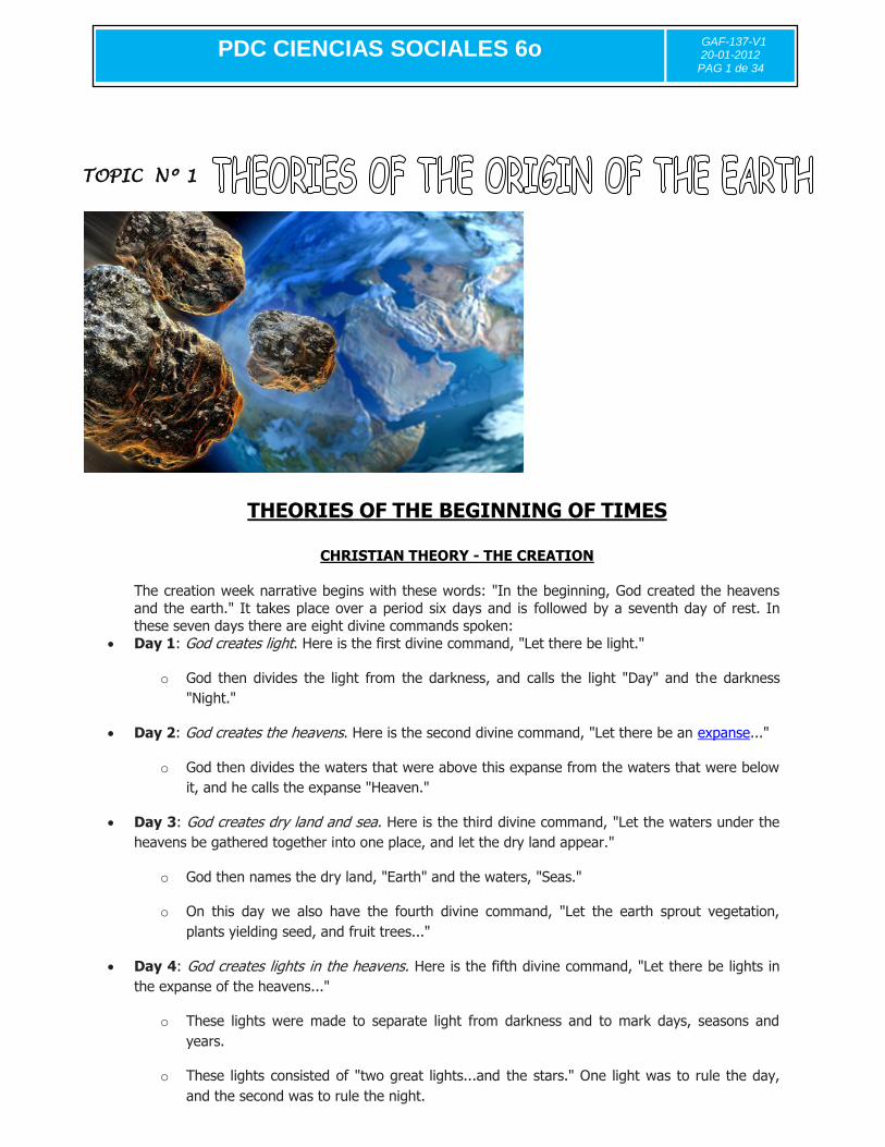
TOPIC Nº 1
THEORIES OF THE BEGINNING OF TIMES
CHRISTIAN THEORY - THE CREATION
The creation week narrative begins with these words: "In the beginning, God created the heavens
and the earth." It takes place over a period six days and is followed by a seventh day of rest. In
these seven days there are eight divine commands spoken:
Day 1: God creates light. Here is the first divine command, "Let there be light."
o God then divides the light from the darkness, and calls the light "Day" and the darkness
"Night."
Day 2: God creates the heavens. Here is the second divine command, "Let there be an expanse..."
o God then divides the waters that were above this expanse from the waters that were below
it, and he calls the expanse "Heaven."
Day 3: God creates dry land and sea. Here is the third divine command, "Let the waters under the
heavens be gathered together into one place, and let the dry land appear."
o God then names the dry land, "Earth" and the waters, "Seas."
o On this day we also have the fourth divine command, "Let the earth sprout vegetation,
plants yielding seed, and fruit trees..."
Day 4: God creates lights in the heavens. Here is the fifth divine command, "Let there be lights in
the expanse of the heavens..."
o These lights were made to separate light from darkness and to mark days, seasons and
years.
o These lights consisted of "two great lights...and the stars." One light was to rule the day,
and the second was to rule the night.
PDC CIENCIAS SOCIALES 6o
GAF-137-V1 20-01-2012
PAG 1 de 34
Day 5: God creates sea creatures and birds. Here is the sixth divine command, "Let the waters
swarm with swarms of living creatures, and let birds fly above the earth across the expanse of the
heavens."
o God tells these creatures "to be fruitful and multiply."
Day 6: God creates the land animals and human beings This is the seventh divine command, "Let
the earth bring forth living creatures..."
o He makes wild beasts, livestock and reptiles.
o He then creates man in his image, male and female.
o God tells them "to be fruitful, and multiply, and fill the earth, and subdue it."
o God gives both humans and animals plants to eat.
o God describes his creation as "very good".
Day 7: Day of rest. God, having completed the heavens and the earth, rests from His work, and
blesses and sanctifies the seventh day.
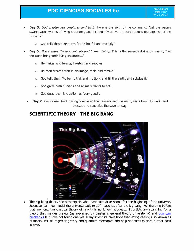
SCIENTIFIC THEORY - THE BIG BANG
The big bang theory seeks to explain what happened at or soon after the beginning of the universe.
Scientists can now model the universe back to 10-43 seconds after the big bang. For the time before that moment, the classical theory of gravity is no longer adequate. Scientists are searching for a
theory that merges gravity (as explained by Einstein's general theory of relativity) and quantum
mechanics but have not found one yet. Many scientists have hope that string theory, also known as M-theory, will tie together gravity and quantum mechanics and help scientists explore further back
in time.
PDC CIENCIAS SOCIALES 6o
GAF-137-V1 20-01-2012
PAG 1 de 34
Because scientists cannot look back in time beyond that early epoch, the actual big bang is hidden
from them. There is no way at present to detect the origin of the universe. Further, the big bang
theory does not explain what existed before the big bang. It may be that time itself began at the big bang, so that it makes no sense to discuss what happened “before” the big bang.
According to the big bang theory, the universe expanded rapidly in its first microseconds. A single
force existed at the beginning of the universe, and as the universe expanded and cooled, this force
separated into those we know today: gravity, electromagnetism, the strong nuclear force, and the
weak nuclear force. A theory called the electroweak theory now provides a unified explanation of electromagnetism and the weak nuclear force theory . Physicists are now searching for a grand
unification theory to also incorporate the strong nuclear force. String theory seeks to incorporate the force of gravity with the other three forces, providing a theory of everything (TOE).
One widely accepted version of big bang theory includes the idea of inflation. In this model, the
universe expanded much more rapidly at first, to about 1050 times its original size in the first 10-32
second, then slowed its expansion. The theory was advanced in the 1980s by American cosmologist Alan Guth and elaborated upon by American astronomer Paul Steinhardt, Russian American scientist
Andrei Linde, and British astronomer Andreas Albrecht. The inflationary universe theory solves a number of problems of cosmology. For example, it shows that the universe now appears close to the
type of flat space described by the laws of Euclid’s geometry: We see only a tiny region of the
original universe, similar to the way we do not notice the curvature of the earth because we see only a small part of it. The inflationary universe also shows why the universe appears so homogeneous.
If the universe we observe was inflated from some small, original region, it is not surprising that it appears uniform.
Once the expansion of the initial inflationary era ended, the universe continued to expand more
slowly. The inflationary model predicts that the universe is on the boundary between being open and closed. If the universe is open, it will keep expanding forever. If the universe is closed, the
expansion of the universe will eventually stop and the universe will begin contracting until it collapses. Whether the universe is open or closed depends on the density, or concentration of mass,
in the universe. If the universe is dense enough, it is closed.
CLASSWORK-Answer the following questions
1. How do you think the creation of the world really was according to your knowledge?
2. What are the theories of the origin of earth?
3. Write some of their main characteristics.
4. For your personal point of view what is the theory of the origin of earth that is closer to your
believed?
PDC CIENCIAS SOCIALES 6o
GAF-137-V1 20-01-2012
PAG 1 de 34
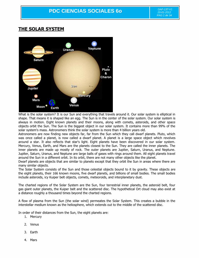
THE SOLAR SYSTEM
What is the solar system? It is our Sun and everything that travels around it. Our solar system is elliptical in shape. That means it is shaped like an egg. The Sun is in the center of the solar system. Our solar system is
always in motion. Eight known planets and their moons, along with comets, asteroids, and other space
objects orbit the Sun. The Sun is the biggest object in our solar system. It contains more than 99% of the solar system's mass. Astronomers think the solar system is more than 4 billion years old.
Astronomers are now finding new objects far, far from the Sun which they call dwarf planets. Pluto, which was once called a planet, is now called a dwarf planet. A planet is a large space object which revolves
around a star. It also reflects that star's light. Eight planets have been discovered in our solar system. Mercury, Venus, Earth, and Mars are the planets closest to the Sun. They are called the inner planets. The
inner planets are made up mostly of rock. The outer planets are Jupiter, Saturn, Uranus, and Neptune.
Jupiter, Saturn, Uranus, and Neptune are large balls of gases with rings around them. All eight planets travel around the Sun in a different orbit. In its orbit, there are not many other objects like the planet.
Dwarf planets are objects that are similar to planets except that they orbit the Sun in areas where there are many similar objects.
The Solar System consists of the Sun and those celestial objects bound to it by gravity. These objects are
the eight planets, their 166 known moons, five dwarf planets, and billions of small bodies. The small bodies include asteroids, icy Kuiper belt objects, comets, meteoroids, and interplanetary dust.
The charted regions of the Solar System are the Sun, four terrestrial inner planets, the asteroid belt, four
gas giant outer planets, the Kuiper belt and the scattered disc. The hypothetical Ort cloud may also exist at
a distance roughly a thousand times beyond the charted regions.
A flow of plasma from the Sun (the solar wind) permeates the Solar System. This creates a bubble in the interstellar medium known as the heliosphere, which extends out to the middle of the scattered disc.
In order of their distances from the Sun, the eight planets are:
1. Mercury
2. Venus
3. Earth
4. Mars

PDC CIENCIAS SOCIALES 6o
GAF-137-V1 20-01-2012
PAG 1 de 34
5. Jupiter
6. Saturn
7. Uranus
8. Neptune
THE BLUE PLANET
Earth is the third planet from the Sun and the fifth largest, It is our mother earth. The place where we live.
Earth is the only planet whose English name does not derive from Greek/Roman mythology. The name derives from Old English and Germanic. There are, of course, hundreds of other names for the planet in
other languages. In Roman Mythology, the goddess of the Earth was Tellus - the fertile soil (Greek: Gaia,
terra mater - Mother Earth). The Earth is divided into several layers which have distinct chemical and seismic properties. But the objective
of its studies in this module is to recognize the main characteristics of the continents which are part of the earth.
The first continent to be studied is Africa, the first continent where life took place according to historians and
investigators. Later we will continue studying the continents in order of the development of the world ancient civilizations.
Asia, Europe, America and the rest; Oceania and Antarctica. Let´s travel around the world.

PDC CIENCIAS SOCIALES 6o
GAF-137-V1 20-01-2012
PAG 1 de 34
TOPIC Nº 2
Introduction
Which continent am I?
Write the number of the continent being described in the text below.
A. I am contain countries such as Peru, Chile, and Paraguay. I am fourth in land size among the the
seven continents and contain almost 400 million inhabitants. My land borders the Atlantic Ocean on the east and the Pacific Ocean on the west. We have a history of colonization, which has led to a
variety of different languages spoken in my countries. We have a rich history of advanced civilizations
before our encounter with other cultures.
Which continent am I?
B. I am located entirely in the southern hemisphere. I was once a penal colony, but I have grown to become one of the most successful economies in the world.
Which continent am I?
C. I am home to mainland nations such as Canada and The United States, and island nations such as Cuba and Aruba. I am the third largest continent in the world.
Which continent am I?

PDC CIENCIAS SOCIALES 6o
GAF-137-V1 20-01-2012
PAG 1 de 34
D. I am a continent that borders two oceans and the Mediterranean Sea. I contain countries such as
Egypt, Zambia, and Senegal. My history is filled with powerful and advanced civilizations that were prosperous for centuries before our interaction with other peoples. The last 150 years have brought us
colonization and eventual freedom. But for many of my people, recent history has been filled with civil war, disease, and famine.
Which continent am I?
E. I am home to countries such as China, Japan, and India. I am the largest continent in size. My inhabitants are responsible for some of the most important inventions known to man, such as
papermaking, gunpowder, and printing. We also contain many growing economies and populations, leading many to believe that we will be the dominant continent in years to come.
Which continent am I?
F. I am the home to countries such as France, Germany, Portugal, and Poland. My inhabitants explored the rest of the globe, reaching places like the Caribbean and India with our superior sailing
technology.
Which continent am I?
To have success in the study of geography and to explore the continents is important to identify and locate
places in any part of the world. Maps are an excellent tool to study geography because they allow us to know where we are going. A map can give us direction when we are in unknown areas. Maps also allow
people to know what is in certain areas covered by the map. In other words, these support us in our
purpose to explore the continents.
Components of a Map – Using your knowledge read and answer.
1. Maps usually have a to show what distance on the earth is represented by a certain distance
on the map.
a. grid b. scale
c. legend d. cell
2. What is the purpose of the legend on a map?
a. To tell you what you are looking at on the map. b. To show distances on the map.
c. To tell you what the symbols mean on the map.
d. To show directions on the map.
3. A smaller map set within the border of a larger map. a. legend
b. inset map c. political map
d. none of the above
4. A physical map focuses on
a. elevation. b. population.
c. land surface d. boundaries.
5. A is a symbol that shows us directions on a map.
a. globe b. compass rose
c. map
d. ocean
PDC CIENCIAS SOCIALES 6o
GAF-137-V1 20-01-2012
PAG 1 de 34
6. A map that shows human-made features such as borders, states, and countries.
a. political map b. legend
c. compass rose d. none of the above
7. One of the different ways of showing earth's curved surface on a flat map.
a. equator
b. Map Projection c. cartographer
d. Prime Meridian
8. Which of the maps listed below shows elevation by the use of contour lines and the horizontal position of terrain features and land formations?
a. city or state road map
b. geographic map c. topographic map
d. tourist map
9. Latitude lines: a. run north and south of the Equator
b. run east and west of the Prime Meridian c. meet at the poles
d. have a maximum of 180 degrees
10. Longitude lines:
a. run east and west of the Equator b. run north and south of the Prime Meridian
c. meet at the poles d. have a maximum of 90 degrees
The key concepts or big ideas in geography
Geographic concepts allow for the exploration of relationships and connections between people and both natural and cultural environments. They have a spatial component.
They provide a framework that geographers use to interpret and represent information about the world. The development of understanding of these concepts will allow students to participate as critical, active,
informed and responsible citizens. Geography is also divided into elements supporting its study and comprehension.
The Six Essential Elements of Geography
There are Eighteen National Geography Standards and they are organized into the following Six Essential Elements for Geography:
1. The world in spatial terms
The purpose of the first essential element of geography is to study the relationships between people, places, and environments by mapping information about them into a spatial context.
2. Places and regions
The purpose of the second essential element of geography is to show how identities and lives of individuals and peoples are rooted in particular places and in those human constructs called regions.
PDC CIENCIAS SOCIALES 6o
GAF-137-V1 20-01-2012
PAG 1 de 34
3. Physical systems
The purpose of the third essential element of geography is to identify how physical processes shape the
Earth’s surface and how they interact with plant and animal life to create, sustain, and modify ecosystems.
4. Human systems
The purpose of the fourth essential element of geography is to show how people are central to geography in
that human activities help shape the Earth’s surface, human settlements and structures.
5. Environment and society
The purpose of the fifth essential element of geography is to show how the the physical environment is modified by human activities, largely as a consequence of the ways in which human societies value and use
Earth’s natural resources.
6. The uses of geography
The purpose of the sixth essential element of geography is to show how the knowledge of geography
enables people to develop an understanding of the relationships between people, places, and environments over time -- that is, of Earth as it was, is, and might be.

PDC CIENCIAS SOCIALES 6o
GAF-137-V1 20-01-2012
PAG 1 de 34
TOPIC Nº 3
THEORY
KNOWING AFRICA
The territory, Taken from http://www.fortunecity.com/oasis/skegness/394/geogra.htm
Africa is connected with Asia by the isthmus of Suez, and separated from Europe by the Mediterranean Sea. The continent is an enormous plateau with terraced flatlands rising one above the other, terminating in the rugged mountains of the east, where the Nile and the Zaïre rivers rise.

PDC CIENCIAS SOCIALES 6o
GAF-137-V1 20-01-2012
PAG 1 de 34
Relief: Africa is bounded N by the Mediterranean Sea, W by the Atlantic Ocean, and E by the Indian Ocean and the Red Sea. Its greatest length from N to S is 8,000 km/5,000. Its area, including Madagascar and the other adjacent islands is three times that of Europe. The coastline is regular, with no deep seas, bays, or river estuaries of any size to afford climatic or commercial advantages; so that in proportion to its size Africa has less coastline than any other continent.
Mountains: The mountains of Africa may be divided into three distinct systems: (1) the Atlas; (2) the west coast; and (3) the east coast.
The Atlas Mountains occupy the northern portion between the sea and the Sahara. The eastern Atlas, consists of two parallel ranges enclosing a plateau where salt lakes called ―chotts‖ are found. The western Atlas, known as the Great Atlas of Morocco, have an average elevation of 3,050 m, and the highest peaks are over 4,275 m.
The west coast system consists of the Cameroon Highlands, 4,000-4,300 m/13,123 m high, and the highlands of Lower Guinea, known as the Kong Mountains.
The east coast system, which is the most important, consists of:
(a) The southern section, containing the Drakensberg with Thabana Ntlenyana
(b) The section between the Zambezi and Ethiopia, containing the highest peaks in Africa and the Great Lakes.
(c) The Ethiopian system rises abruptly from the coast and gradually descends towards the Nile
Deserts: There are two great deserts: the Sahara, the largest in the world, in the north, and the Kalahari, a sandy rainless region, in the south. The Libyan and Nubian deserts are continuations of the Sahara. As well as extensive areas of sand, the Sahara and the Kalahari have thousands of square kilometres of rocky expanses with scrubland that can support small antelopes, ostriches, and camels.
Rivers: Considering its size, and compared with other continents, Africa has relatively few rivers, and its commercial prosperity has been greatly retarded by the want of navigable rivers with good harbors. Most rivers are impeded by cataracts. The most important are the Nile, Zaïre, Zambezi, and Niger.
The Nile is of political, historical, and commercial importance, and its overflow is of vital importance to Egypt. This flow is now controlled by the Aswan High Dam. The great lakes connected with the Nile are Victoria, Mobutu, and Edward.
The Zaïre, which drains an equatorial rains region, has a constant water supply, and between Boyoma Falls and Pool Malebo the river is navigable for 1,600 km/995 mi. Lake Tanganyika supplies the Zaïre river with a considerable volume of water.
The Zambezi is the main river in the east, and though navigable in some parts, its course is impeded by cataracts and rapids. The Victoria Falls, the largest in the world, are situated on this river.
The Niger is of great commercial importance, being navigable almost entirely from its source to its mouth in the Gulf of Guinea.
The Orange river is not useful for navigation, though imaginative schemes have been embarked upon to use the water for irrigation and industrial purposes; but the Limpopo, with its mouth just north of Delagoa Bay, is navigable for about 100 km.
The Senegal, Gambia, and Ogooué flow into the Atlantic on the west, and provide navigable waterways for some distance from their mouths.
PDC CIENCIAS SOCIALES 6o
GAF-137-V1 20-01-2012
PAG 1 de 34
Islands: Africa has very few islands, and they are all small with the exception of Madagascar (590,500 sq km/228,000 sq mi) which is one of the largest in the world. In the North Atlantic are the Madeira Islands, the Canary Islands, and the Green Cape Islands.
Climate: Nearly three-quarters of the total area of Africa lies within the tropics, so that there is almost perpetual summer with defined seasons of rain and drought. The variations in climate are caused by prevailing winds and height.
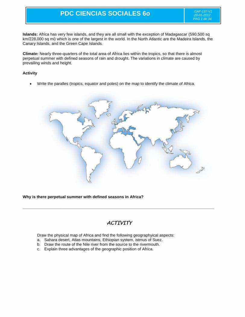
Activity
Write the paralles (tropics, equator and poles) on the map to identify the climate of Africa.
Why is there perpetual summer with defined seasons in Africa?
______________________________________________________________________________________
ACTIVITY
Draw the physical map of Africa and find the following geographyical aspects: a. Sahara desert, Atlas mountains, Ethiopian system, istmus of Suez. b. Draw the route of the Nile river from the source to the rivermouth. c. Explain three advantages of the geographic position of Africa.
PDC CIENCIAS SOCIALES 6o
GAF-137-V1 20-01-2012
PAG 1 de 34
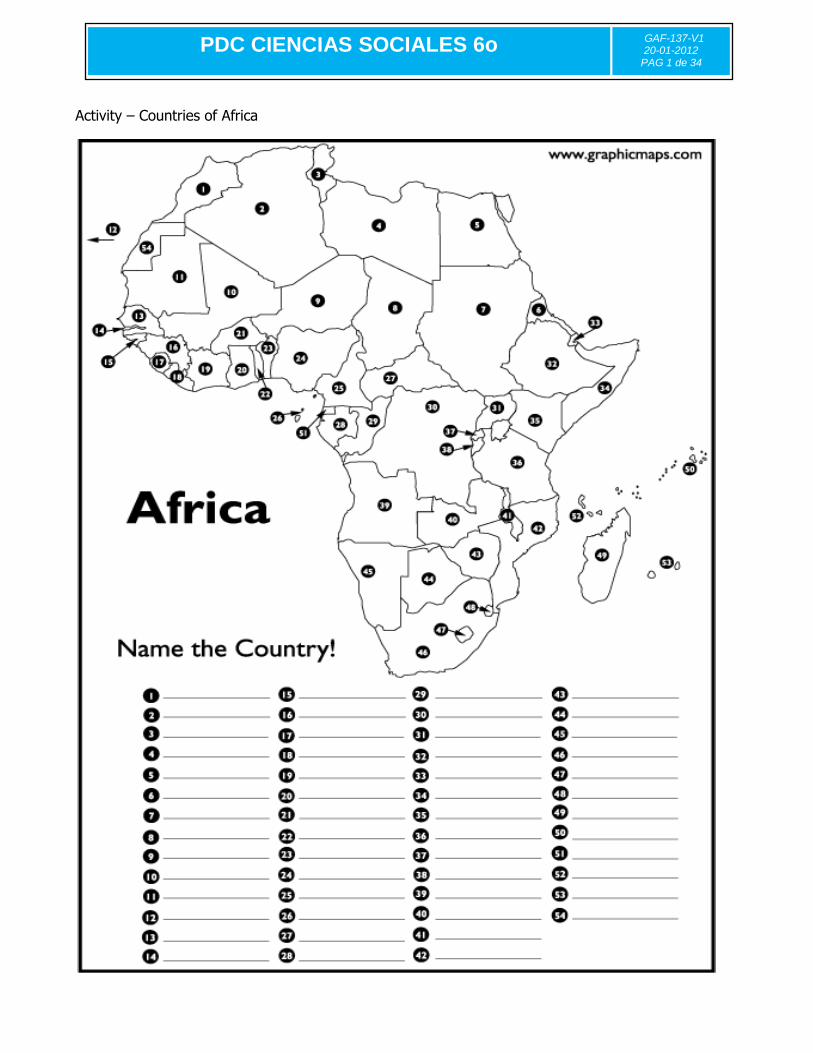
Activity – Countries of Africa
PDC CIENCIAS SOCIALES 6o
GAF-137-V1 20-01-2012
PAG 1 de 34
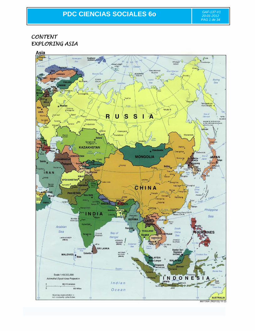
CONTENT
EXPLORING ASIA
PDC CIENCIAS SOCIALES 6o
GAF-137-V1 20-01-2012
PAG 1 de 34
Taken from http://en.wikipedia.org/ and http://geography.howstuffworks.com/
Comprising approximately fifty countries. It has an area, including islands, of roughly 49,694,700 km². Asia is joined to Africa by the Isthmus of Suez and to Europe by a long border generally following the Ural Mountains.
Physical Geography The Asian landmass stretches from the Equator to far above the Arctic Circle. It reaches almost halfway around the globe (about 165 degrees of longitude) from Asia Minor on the Mediterranean Sea to the eastern tip of Siberia on the Bering Strait. Bordering waters include the Red Sea, the Arabian Sea, the Persian Gulf, and the Bay of Bengal. Many islands or groups of islands that form countries include the Philippines, Japan, Taiwan, and Sri Lanka.
Climate Northern Asia has a severe continental climate. Though often divided into several types—such as polar, sub-polar, middle-latitude steppe, and middle-latitude desert—it is everywhere marked by long, cold winters; warm to hot summers; and little precipitation. The coldest place on earth, excluding Antarctica, is the Verkhoyansk region of northeast Siberia, where January temperatures average -58° F. (-50° C.). Subtropical and tropical conditions prevail throughout most of India and Indochina. Winters are mild, both because of the southerly latitude and because cold air masses are blocked by mountains, particularly the Himalayas. In other words Asia has a varied climate including countries with the four seasons. What are the key words that best describes the climate of Asia? ________________ ________________ ________________ ________________ ________________
The People The people of Asia belong to a large variety of ethnic groups. India itself is made up of several hundred groups. India's ethnic composition is so complex that the people generally identify themselves by their religion rather than their ethnic group. A few countries, notably North Korea, South Korea, and Japan, are among the world's most ethnically homogeneous (made up of people belonging to the same ethnic group). The Chinese are a numerous and important ethnic group in Asia. Outside of China, ethnic Chinese form significant minorities in several Asian countries, including Malaysia, the Philippines, Indonesia, and Singapore. Some ethnic groups in Asia are in danger of disappearing due to the loss of their homelands to industrialization and urban expansion. Threatened groups include some of the hill tribes of Thailand, Burma, and Laos. Asia is the most populated continent due to the number of people living in each of the fifty countries that form it. In 1995, Asia had a population of about 3,484,000,000, approximately three-fifths of the world's total population.

PDC CIENCIAS SOCIALES 6o
GAF-137-V1 20-01-2012
PAG 1 de 34
Rivers and lakes of Asia
Investigate what rivers are the most important, historically and commercially. Physical relief of Asia-Visit http://mapasinteractivos.didactalia.net/comunidad/mapasflashinteractivos/recurso/Physical-relief-of-Asia-Where-is--
/d11d0b46-6e5f-4356-8b9e-a5ab7357972e Practice coasts of Asia too. On line.
Write the name of the following landform on the map. Use arrows or numbers.
___ Caucasus Mountain
___Hundu Kush
___Altai Mountains
___Kunlun Mountains
___Zagros Mountains
___Tian Shan
___Central Siberia Plate
___Deccan Plateau
___West Siberian Plain
___Himalaya
___Ural Mountains
___Plateau of Tibet
PDC CIENCIAS SOCIALES 6o
GAF-137-V1 20-01-2012
PAG 1 de 34
CONTENt
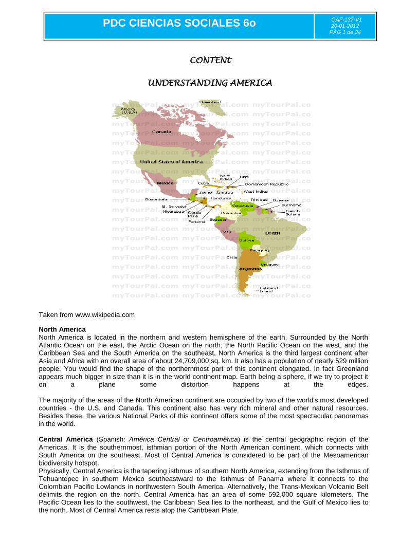
UNDERSTANDING AMERICA
Taken from www.wikipedia.com
North America North America is located in the northern and western hemisphere of the earth. Surrounded by the North Atlantic Ocean on the east, the Arctic Ocean on the north, the North Pacific Ocean on the west, and the Caribbean Sea and the South America on the southeast, North America is the third largest continent after Asia and Africa with an overall area of about 24,709,000 sq. km. It also has a population of nearly 529 million people. You would find the shape of the northernmost part of this continent elongated. In fact Greenland appears much bigger in size than it is in the world continent map. Earth being a sphere, if we try to project it on a plane some distortion happens at the edges. The majority of the areas of the North American continent are occupied by two of the world's most developed countries - the U.S. and Canada. This continent also has very rich mineral and other natural resources. Besides these, the various National Parks of this continent offers some of the most spectacular panoramas in the world. Central America (Spanish: América Central or Centroamérica) is the central geographic region of the Americas. It is the southernmost, isthmian portion of the North American continent, which connects with South America on the southeast. Most of Central America is considered to be part of the Mesoamerican biodiversity hotspot. Physically, Central America is the tapering isthmus of southern North America, extending from the Isthmus of Tehuantepec in southern Mexico southeastward to the Isthmus of Panama where it connects to the Colombian Pacific Lowlands in northwestern South America. Alternatively, the Trans-Mexican Volcanic Belt delimits the region on the north. Central America has an area of some 592,000 square kilometers. The Pacific Ocean lies to the southwest, the Caribbean Sea lies to the northeast, and the Gulf of Mexico lies to the north. Most of Central America rests atop the Caribbean Plate.

PDC CIENCIAS SOCIALES 6o
GAF-137-V1 20-01-2012
PAG 1 de 34
South America The fourth-largest continent in the world, South America is located in the Western Hemisphere and in the Southern Hemisphere. A small part of the continent is also located in the Northern Hemisphere. South America is surrounded by the Atlantic Ocean on the east and north, the Caribbean Sean and North America on the northwest and the Pacific Ocean on the west. With an area of 17,840,000 sq. km, South America constitutes almost 3.5% of the Earth's surface. It is also the fifth most populous continent in the world after Asia, Africa, Europe, and North America with an estimated population of more than 371,090,000. Often referred to as Latin America, South America has the greatest north-south extension. The high mountains and the highland areas extend up to different elevation levels, which together contribute to its diverse climate. In other words ―The Americas‖, or America are the lands of the Western hemisphere or New World, comprising the continents of North America and South America with their associated islands and regions. America may be ambiguous in English, as it is more commonly used to refer to the United States of America The Americas cover 8.3% of the Earth's total surface area (28.4% of its land area) and contain about 13.5% of the human population (about 900 million people).
Topography
Aconcagua, the highest mountain in the Americas The western geography of the Americas is dominated by the American cordillera, with the Andes running along the west coast of South America
and the Rocky Mountains and other Western Cordillera ranges
running along the western side of North America. The 2300 km long (1429 mile long) Appalachian Mountains run along the east coast of North America from Alabama to Newfoundland. North of the Appalachians, the Arctic Cordillera runs along the eastern coast of Canada.
Hydrology With coastal mountains and interior plains, the Americas have several large river basins that drain the continents. The largest river basin in South America is that of the Amazon, which has the highest volume flow of any river on Earth. The largest river basin in North America is that of the Mississippi, covering the second largest watershed on the planet. The second largest watershed of South America is that of the Paraná River, which covers about 2.5 million km².
Population
Mexico City, Mexico New York City, United States São Paulo, Brazil The total population of America is around 858,000,000

PDC CIENCIAS SOCIALES 6o
GAF-137-V1 20-01-2012
PAG 1 de 34
Largest urban centers The most populated cities in the Americas are Mexico City, capital of Mexico, New York City, located in the east coast of the United States of America, and São Paulo, capital of the Brazilian state of the same name. There is much discussion about which of these urban centers is the most populated as each one of them can surpass the others based on the criteria of choice.
City Country City Proper Population Rank
São Paulo Brazil 11,037,593 1st
Mexico City Mexico 8,841,916 2nd
New York City United States 8,363,710 3rd
Ethnology The population of the Americas is made up of the descendants of seven large ethnic groups and their combinations.
The Indigenous peoples of the Americas, being Amerindians, Inuit, and Aleuts.
Those of European ancestry, mainly Spanish, British, Irish, Italian, Portuguese, French, Polish, German, Dutch, and Scandinavian people.
Mestizos, those of mixed European and Amerindian ancestry.
Those of Black African ancestry, mainly of West African descent.
Mulattoes, people of mixed Black African and European ancestry.
Zambos (Spanish) or Cafusos (Portuguese), those of mixed Black African and Amerindian ancestry.
Asians, that is, those of Eastern, South, and Southeast Asian ancestry.
Those from the Middle East (Middle Easterners).
Activity- Relief of America Find the places on your right.
Relief of North America Note:On a sheet of paper make the rivers and lakes
___Sierra Madre Oriental
___Mexican Altiplano
___Appalachian Moutain
___Great Plains
___Sierra Madre Occidental
___RockyMountains

PDC CIENCIAS SOCIALES 6o
GAF-137-V1 20-01-2012
PAG 1 de 34
South American Relief – find the places on your right.
Note:On a sheet of paper make the rivers and lakes
CONTENt
EUROPE
___Andes
___Mato Grosso Plateau
___Amazon Basin
___Pampas
___Patagonia
___Guiana Highlands
___Serra do Espinaço
PDC CIENCIAS SOCIALES 6o
GAF-137-V1 20-01-2012
PAG 1 de 34
Relative Location Globally, Europe’s relative location, at the heart of the land hemisphere, is one for maximum efficiency for contact with the rest of the world. Almost nowhere in Europe is far from the sea and Europe interfaces with the land as it does nowhere else on Earth. Southern and Western Europe consists almost entirely of peninsulas and islands from Greece, Italy and the Iberian peninsula (Spain and Portugal) to the British Isles, Denmark and the Scandinavian peninsula (Norway and Sweden). Southern Europe faces the Mediterranean and Western Europe virtually surrounds the North Sea as it look out over the Atlantic Ocean. Europe has long been a place of contact between peoples and cultures resulting in the circulation of goods and ideas. The hundreds of miles of navigable waterways; the easily traversed bays, straits and channels between numerous islands and peninsulas and the Mainland; and the highly accessible Mediterranean, North and Baltic Seas, all provided the routeways for these exchanges. Later, even the oceans become avenues of long distance spatial interaction. This historic advantage of moderate distances applies on the mainland as well. Europe’s Alps may form a transcontinental divider, but what they separate still lies in close contact, and mountain passes have been used for centuries. No place in Europe is very far from anyplace else on the continent, although nearby places are often sharply different from each other. Short distances and large differences make for much interaction which is typical of European geography over the past 1000 years. Europe is a world geographic realm of modest portions on the peninsular margin of Western Eurasian landmass. Europe’s relative location at the heart of the land hemisphere is one of maximum efficiency for contact with the rest of the world. Much of Europe is in close contact with the sea with hundreds of miles of navigable waterways. No place in Europe is very far from anyplace else on the continent. Short distances and large differences make for much interaction. Climate Of all of Europe’s advantages, none stand out as much as Europe’s mild and temperate climate. At first glance it would appear to be a harsh and cold climate, due to its northerly position on the globe (most of the continental land mass lies north of New York City). Europe lies mainly in the temperate climate zones, being subjected to prevailing westerlies. The climate is milder in comparison to other areas of the same latitude around the globe due to the influence of the Gulf Stream. The Gulf Stream is nicknamed "Europe's central heating", because it makes Europe's climate warmer and wetter than it would otherwise be. The Gulf Stream not only carries warm water to Europe's coast but also warms up the prevailing westerly winds that blow across the continent from the Atlantic Ocean. History: Culture in Europe started to really develop in Ancient Greece. They came up with many of the systems and cultural ideas used by Europe and later adopted by the rest of the western world. Around 275 B.C. the Roman Empire was expanding and started to take over Greece. Even though they conquered them, Romans still kept many of Ancient Greece's ideas. A little while later around 200 A.D. the religion of Christianity came to Rome. It soon became Rome's official religion and spread throughout Europe. The influence of Christianity on Europe was huge, in the Middle Ages even started expansion and the Crusades. Till this day different branches of Christianity remain major religions in Europe. Religion: Since the spread of Christianity through Europe in early A.D., Christianity has remained to be Europe's main religion. Christianity was broken into different branches: Orthodox, Protestant, and Catholic, and depending on the beliefs of different regions, people adopted them. Judaism is also
PDC CIENCIAS SOCIALES 6o
GAF-137-V1 20-01-2012
PAG 1 de 34
practiced in Europe and the religion of Sunni' Islam is also practiced in Turkey and some southern parts of Europe
EUROPEAN CULTURE
Europe is made up of an an extremely diverse range of cultures, religions, and ethnic backgrounds. Each country has its own holidays, traditions, and history. Below, the cultural characteristics of Europe are divided up into a few different categories, each touching on the different areas that make up European culture.... Life-style: Europe is divided into four traditional cultural areas: The Atlantic Fringe, The Plain, The Mediterranean Area, and The Alpine Area. Since the increase in modernization in the 20th century, these areas are not often referred to anymore. Though take note that the life-styles of the people in these areas of the past helped shape the way people in the same places live today. The types of crops produced has also not changed very much from past to present. Each area has its own unique food, customs, and ideas of what is important to daily life. The Atlantic Fringe: Iceland, the Netherlands, Belgium, Albania, parts of Scandinavia, western Ireland, Britain, and Spain, northern Portugal, and northern and western France. -The Atlantic Fringe is made up of all the regions along, and some inland, of the Atlantic Ocean. -Cattle and fishing both are important in this area. -Families tended to include three generations. The Plain: Lowland Britain, France, Germany, Poland, European Russia, Denmark, southern Sweden, Austria, Hungary, Romania, Bulgaria, Yugoslavia, and Czechoslovakia (now the Czech Republic). -Wheat and cereal crops are the main agriculture of this area. -Communal cooperation is very important to the people of villages in this area. Mediterranean Area: Southern Portugal, the plateau of Spain, southern Italy, most of Greece, and the islands of the Mediterranean Sea. -The Mediterranean Area tended to have the very rich and the very poor living in it. -The array of agriculture of this area included cereal crops, wheat, fishing, orchards, and vineyards. More vegetables and fruit were grown in the Mediterranean Area, than anywhere else in Europe. -Family is a very important part to life in this area, and are often loyal and closely bonded. Alpine Area: upland and mountains of central Europe: Switzerland, Bavaria, southeast France, northern Italy, Austria, Czechoslovakia, and Yugoslavia. The Alpine Area also includes most mountains extending form these countries.
PDC CIENCIAS SOCIALES 6o
GAF-137-V1 20-01-2012
PAG 1 de 34
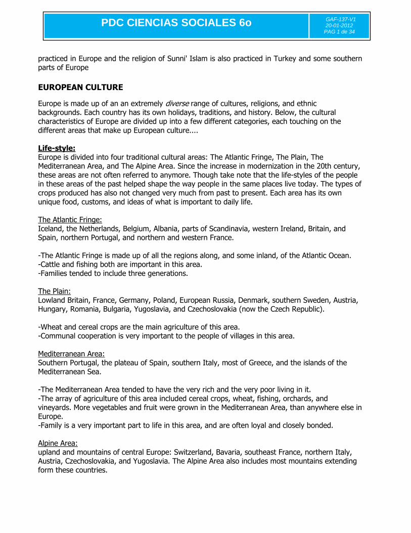
Activity – Name the Country
PDC CIENCIAS SOCIALES 6o
GAF-137-V1 20-01-2012
PAG 1 de 34
CONTENt
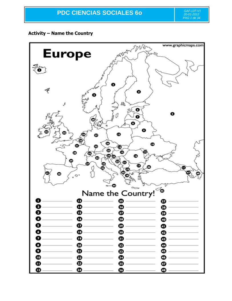
AUSTRALIA
Introduction Taken from http://www.skwirk.com.au/
Australia is often referred to as an ancient land, the oldest of continents. Australia has not always had its present shape or position on the globe. Even today, it is in the process of colliding with South-East Asia. Originally, Australia was joined to a super-continent, referred to as Pangaea (meaning 'all lands' in Greek), before it separated and drifted across the Earth's surface, experiencing a variety of different climatic changes and geological events. In focusing on Australia's journey across the Earth, it is possible to gain a greater insight into the evolution of Australian landforms, soils, flora and fauna. The Australian continent (Oceania) Australia is the sixth-largest country in the world. The only countries larger than Australia are Russia, Canada, China, the United States of America and Brazil. Australia is a little less than half the size of Russia and is only slightly smaller than the United States. Australia has an approximately oval shape, with the country wider east to west than north to south. At the north and south of the continent are two areas of water that cut into the Australian mainland, the Gulf of Carpentaria in the north and the Great Australian Bight in the south.

PDC CIENCIAS SOCIALES 6o
GAF-137-V1 20-01-2012
PAG 1 de 34
Some people believe that Australia is the largest island on Earth, while others believe it is its own continent because it has its own tectonic plate and unique plant and animal life. Some people believe that Australia is part of a continent called Oceania, which includes many islands such as New Zealand, Fiji and Papua New Guinea. While Australia is the only country that occupies the entire mainland of a continent, it is the smallest of the seven continents. The largest continent is Asia, which covers nearly 45 000 000 km2. The next largest continent is Africa, followed by North America, South America, Antarctica and Europe.
The Australian States and Territories The Commonwealth of Australia consists of six States: New South Wales, Queensland, South Australia, Tasmania, Victoria and Western Australia and two mainland major territories, the Australian Capital Territory and the Northern Territory.
Geography
Australia's landmass of 7,617,930 square kilometers (2,941,300 sq mi) is on the Indo-Australian Plate. Surrounded by the Indian and Pacific oceans, Australia is separated from Asia by the Arafura and Timor seas. The world's smallest continent
and sixth largest country by total area,
Australia – owing to its size and
isolation – is often dubbed the 'island continent and variably considered the world's largest island. Australia
has 34,218 kilometers (21,262 mi) of coastline (excluding all offshore islands) and claims an extensive Exclusive Economic Zone of 8,148,250 square kilometers (3,146,060 sq mi). This exclusive economic zone does not include the Australian Antarctic Territory.
Environment Although most of Australia is semi-arid or desert, it includes a diverse range of habitats from alpine heaths to tropical rainforests, and is recognized as a mega diverse country. Because of the continent's great age, its extremely variable weather patterns, and its long-term geographic isolation, much of Australia's biota is unique and diverse. About 85% of flowering plants, 84% of mammals, more than 45% of birds, and 89% of in-shore, temperate-zone fish are endemic. Australia has the greatest number of reptiles of any country, with 755 species.
OCEANIA

PDC CIENCIAS SOCIALES 6o
GAF-137-V1 20-01-2012
PAG 1 de 34
A million of islands and atolls around the Pacific Ocean distributed in three big groups:
Melanesia, Polinesia and Micronesia. All of these have common characteristics of climate and
geologic form.
ACTIVITY WORD SEARCH Places of Oceania
C B O U M N W M E B S X B Z A A A T O M X A M Y P J U M Y O
S O M U F A L B H Y V O F I D H U X I Q S I M B X C A Y E U
N D O R A E R J J A U K N M G J V C H V G S U Z O B U Z P T
E F N K K R A Q O K C O I V B Z R K X Y D E X A Z E N G L Q
W U S A I N H M U N D R V N M O O V H Z X N N A P C I A N O
G M E P L S A T O E A E E Z N K F Q P A L A U I S L A N D S
U Y W F W S L B L L S H Q E M O Z I N J W L X I O Q W S V Z
I U G J B U I A T B Z A S G B P K I E U U E M V M R B T D Y
N E B M U L C Y N Y I I S A E W K N T E Q M K L I V E I J W
E Y M J O W I D T D A U S T R A L I A M B S Z Y T P U R L F
A B S E E S N Y Z E S T C H R P X J S P W K F B V V F L P Y
W Y Z N L L S M M S I Q W Z J L J C D O N G F F Z X O P U W
R E J A M B R I L X K C O T K X A I N A E C O I Z C Q Z V M
E P N N X M B C S P F K O S G O R D A X V I D I J L Z Q N G
Y D P G E A B Y M J O D R S O A A S L S W P T M C P A H D H
S I W C B V H Y J O M J K W T M P X S R P A T D L F I L P V
M B I U N X K Z J F J Y I G R Q H E I S I L M E I Z Y X E N
S K Y A B L J O R J M U P B A O N Z R S T J M Z Z X J B I E
H X R B W N Y T H P G X V P W S U K E E Q R F V R X U P F W
W I S D N A L S I L L A H S R A M N T D N A L A E Z W E N H
V B S S D A H S P W M V C I Q Z Y X S F T X H Z Z G T L G E
F V H H N N Z B N L N S C K U L J R A D I R J J A R J Z V B
F I J I Y P A E R K Q B D V O E J Q E J S M O E O A R O N R
F T Z S M P P L T U I M S P E R I X S F U Q M B I G A C F I
T I B B A F B S E R W W H D Z H H Y T W X B R Q S B R R A D
I X G V G I Q B N R G B G V V Z Y U F Q Y I I K T O R X V E
Z Q J O N R F W Q A I O A W I A V G A P A G Q C R K N W R S
W V U K O I N U L H U W T P B Z Z X V N N B Y C Z D P T H V
A J F C T I J J J R M X E N M S J Q D S N W P Q M Z S F M F
O H I N R I K K Z F V W K N U Q R O V F C C A T I D B H B Z
ADMIRALTYISLANDS
AUSTRALIA
COOKISLANDS
EASTERISLANDS
FIJI
HAWAII
MARQUESAS
MARSHALLISLANDS
MELANESIA
MICRONESIA
NEWCALEDONIA
NEWGUINEA
NEWHEBRIDES
NEWIRELAND
NEWZEALAND
OCEANIA
PALAUISLANDS
POLYNESIA
SAMOA
SOCIETYISLANDS
TONGA
TROBRIAND
Background Information Oceania The Pacific Ocean comprises 1/3 of the entire Earth. There are 25,000 islands in the Pacific, more than in any other ocean. The larger island masses are located in the Southern and Western Pacific,
close to the Australian and Asian continents; they usually form arcs. Most of the islands are close enough to each other that they form groups or
clusters.
The islands in the Pacific Ocean are mostly of volcanic origin, which results in crust instability. There are more than 400 active volcanoes in the region, and naturally, there are many earthquakes as well.
These islands can be divided into several geological types. Some are continental, which means that they were formed by processes of sedimentation, folding and faulting. Examples are New Zealand,
New Guinea, and New Caledonia. Other islands, like Tahiti, Oahu and Ponape are volcanic, which
means they were formed by volcanic intrusion. And the third geological type are coral islands that are surrounded by coral reefs that vary in thickness and depth. A well-known example is the Great Barrier
Reef, a large system of about 900 islands and over 3000 coral reefs. Today, the thousands of islands and atolls in Oceania are inhabited by over 8 million people, and
these societies are quite diverse. People from this region have left rural areas and migrated into the
cities, or they have migrated into the metropolitan areas of the United States, Australia and New Zealand. For example, many Samoans and Tongans now live in Los Angeles and San Francisco.
PDC CIENCIAS SOCIALES 6o
GAF-137-V1 20-01-2012
PAG 1 de 34
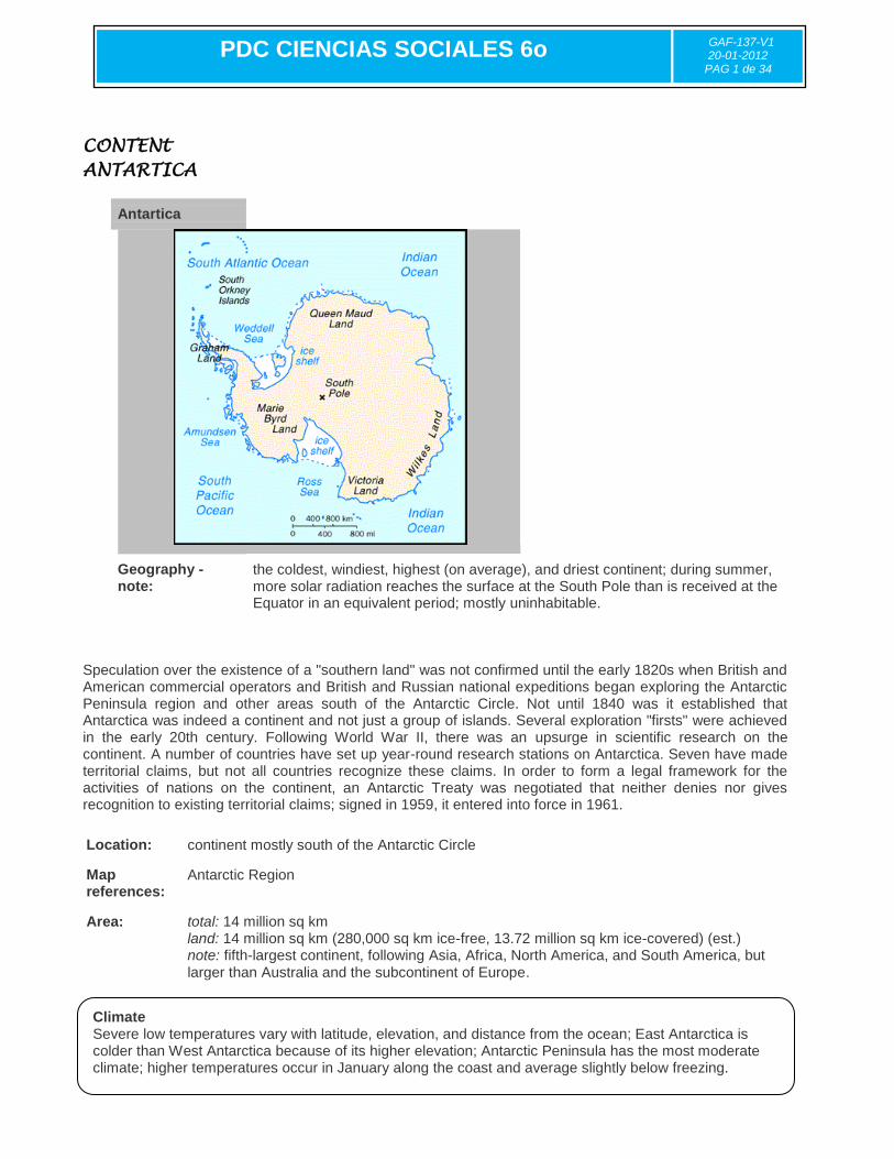
CONTENt
ANTARTICA
Speculation over the existence of a "southern land" was not confirmed until the early 1820s when British and American commercial operators and British and Russian national expeditions began exploring the Antarctic Peninsula region and other areas south of the Antarctic Circle. Not until 1840 was it established that Antarctica was indeed a continent and not just a group of islands. Several exploration "firsts" were achieved in the early 20th century. Following World War II, there was an upsurge in scientific research on the continent. A number of countries have set up year-round research stations on Antarctica. Seven have made territorial claims, but not all countries recognize these claims. In order to form a legal framework for the activities of nations on the continent, an Antarctic Treaty was negotiated that neither denies nor gives recognition to existing territorial claims; signed in 1959, it entered into force in 1961.
Location: continent mostly south of the Antarctic Circle
Map references:
Antarctic Region
Area:
total: 14 million sq km land: 14 million sq km (280,000 sq km ice-free, 13.72 million sq km ice-covered) (est.) note: fifth-largest continent, following Asia, Africa, North America, and South America, but larger than Australia and the subcontinent of Europe.
Antartica
Geography - note:
the coldest, windiest, highest (on average), and driest continent; during summer, more solar radiation reaches the surface at the South Pole than is received at the Equator in an equivalent period; mostly uninhabitable.
Climate Severe low temperatures vary with latitude, elevation, and distance from the ocean; East Antarctica is colder than West Antarctica because of its higher elevation; Antarctic Peninsula has the most moderate climate; higher temperatures occur in January along the coast and average slightly below freezing.

PDC CIENCIAS SOCIALES 6o
GAF-137-V1 20-01-2012
PAG 1 de 34
ACTIVITY
1. What are the two nearest continents to Antarctica? 2. Should people exploit the mineral resources in Antarctica or should them being conserved as a patrimony for humans? Why or why not?