socio-economic study of the - …d2ouvy59p0dg6k.cloudfront.net/downloads/wwf_socio... · report...
TRANSCRIPT

REPORT
SOCIO-ECONOMIC STUDY OF THE
FISHERIES SECTOR IN SURINAME
28 JUNE 2017
PREPARED BY: ATTUNE, GWENDOLYN SMITH AND DUNJA BURKHARDT
COMMISSIONED BY: WORLD WILDLIFE FUND GUIANAS

2 | P a g e
This document has been produced with the financial assistance of the Netherlands Embassy in Suriname.
It has been produced within the context of the project: Promoting Integrated and Participatory Ocean Governance in Guyana and Suriname: the Eastern Gate to the Caribbean, which is funded by the European Union and is a partnership between World Wildlife Fund Guianas, Nature Conservation Division in Suriname, Protected Areas Commission in Guyana and Green Heritage Fund Suriname.
DISCLAIMER: The contents of this publication are the sole responsibility of WWF and can under no circumstances be regarded as reflecting the position of the Netherlands Embassy or the European Union Citation: Smith, G. and D. Burkhardt. 2017. Socio-economic Study of the Fisheries Sector in Suriname. WWF Guianas, 46 pp.
3 | P a g e
Table of Contents
1. Introduction ................................................................................................................................................. 5
Objective ........................................................................................................................................................... 5
Methodology ..................................................................................................................................................... 5
2. Administrative and legal structure ................................................................................................................ 6
2.2 Fishing Grounds ........................................................................................................................................ 10
2.3 Fishing Licenses ......................................................................................................................................... 12
2.3.2 Commercial Fishing Licenses .............................................................................................................. 16
2.4 Fishing Fleet .............................................................................................................................................. 18
2.4.1 Vessel Monitoring System ..................................................................................................................... 20
2.5 Catch registration .......................................................................................................................................... 20
3. Demographics and population ........................................................................................................................ 21
3.1 Coastal ethnic groups ................................................................................................................................ 21
3.2 Fishing Communities and Demographics in Suriname ............................................................................. 24
4. Health .............................................................................................................................................................. 32
5. Education ........................................................................................................................................................ 33
5.1.2 Commercial Fisheries ................................................................................................................................. 36
6. Employment and GDP ..................................................................................................................................... 38
6.1 Socio-economic Importance ......................................................................................................................... 39
7. Infrastructure and Services ............................................................................................................................. 41
7.1 Boat landings ............................................................................................................................................. 41
7.2 Public Services ........................................................................................................................................... 42
8. Other activities ................................................................................................................................................ 43
8.1 Tourism ................................................................................................................................................. 43
8.2 Oil and Gas sector ................................................................................................................................. 43
8.3 Port Handling and Services ................................................................................................................... 44
References .......................................................................................................................................................... 46

4 | P a g e
LIST OF ABBREVIATIONS
ABS Algemeen Bureau voor de Statistiek
BV Inland navigation (Binnenvaart)
CEP Caribbean environment program
CEVIHAS Centrale Visaanvoer Haven Suriname
EBS NV Energie Bedrijven Suriname
EEZ Exclusive Economic Zone
FAO Food and Agriculture Organization of the United Nations
FR Forest Reserve
GPD Gross Domestic Product
IDB Inter-American Development Bank
LBB National Forest Service (s’ Lands Bos Beheer)
LVV Agriculture, Animal Husbandry, and Fisheries (Ministry of) (Landbouw, Veeteelt, en Visserij)
MAS Maritime Authority Suriname
MUMA Multiple Use Management Area
NB Nature Conservation division (Natuurbeheer)
NIMOS National Institute for Environment and Development in Suriname (Nationaal Instituut voor Milieu en Ontwikkeling in Suriname)
NR Nature Reserve
RGD Regionale Gezondheids Dienst
SK Suriname Coast (fishing license)
SKB Suriname Coast Bangamary (fishing license)
SSA Suriname Seafood Association
SWM Surinaamse Waterleiding Maatschappij
TED Turtle Excluder Device
VISCO Vissers Organisatie Coronie
VKI Stichting Viskeurings Instituut
VMS Vessel Monitoring System

5 | P a g e
1. INTRODUCTION
Fisheries have long been a traditional source of income worldwide and thus also contribute to many livelihoods
in Suriname. Suriname is rich in natural resources and rich in a variety of fish species. The country’s coastal
waters contain fish species with a high market value that are in high demand in the Caribbean, United States,
Europe and Japan. Rivers and more inland creeks and swamps also provide for a variety of fish. Fisheries include
a whole chain of different segments in which people find employ from fishermen to fish processing companies
to sellers and exporters, and lastly the consumers.
The fisheries in Suriname can be divided in two main sectors, namely the artisanal sector and industrial sector.
The artisanal sector can also be commercial in nature, may it be on a relatively smaller scale than the industrial
fishing. The commercial fisheries contain shrimp and fish trawling, fishing on species like red snapper, mackerel
and longline fishing on larger pelagic fish species. The artisanal fisheries or ‘small-scale’ fisheries use more
traditional fishing techniques like driftnet fishing in the coastal waters and further down in sea; Fyke net fishing,
seine net fishing, line fishing and chase pin or ‘Jagi-Jagi’ fishing in the rivers and river mouths.
The importance of the fishery sector is reflected in its contribution to Suriname’s economic sector. In 2015, the
total catch from vessels operating in Surinamese waters was 31.852 tons fish and 6.821 tons shrimp. Over the
last decade, the fisheries sector has become increasingly important and currently represents 2.3% of GDP.
Though total fish and shrimp capture has been fluctuating, higher international market prices have resulted in
higher values of production and exports for the sector1 (Derlagen et.al, 2013). This study describes the socio-
economic characteristics of fisheries in Suriname with representation of local fishing communities within the
coastal districts, demographic and socio-cultural characteristics.
Objective
The goal of this study is to get insight in the socio-economic importance of the Suriname marine fisheries sector,
more specifically the relationship between economic and social activities. Specific focus is set on the coastal
districts of Nickerie, Coronie, Saramacca, Wanica, Paramaribo, Commewijne and Marowijne, particularly
focusing on fishing populations.
Methodology
The desk-top study was conducted by two social science consultants, Gwendolyn Smith and Dunja Burkhard.
Data was collected in two ways: 1) interviews with the Ministry of Fisheries, and 2) secondary data collection.
Data collection took place from 15 May until 20 June 2017. Data that was based on assumptions and could not
be verified was excluded from this report: only factual data is included.
Secondary data were collected from the General Bureau of Statistics in Suriname (ABS), internet sources,
reports from international organizations and existing consultancy reports. Of relevance were Environmental
and Social Assessment studies in the oil and gas sector, and the Fisheries Management Plan for Suriname 2014-
2018 was used to obtain information about local development initiatives in the area.
1 Derlagen, C., Barreiro-Hurlé, J. and Shik, O. (2013). Agricultural Sector Support in Suriname, IDB/FAO, Rome, Italy available at http://www.gov.sr/media/968294/agricultural_sector_support_in_suriname.pdf

6 | P a g e
2. ADMINISTRATIVE AND LEGAL STRUCTURE
Suriname is geo-politically divided into ten districts (Figure 1). The coastal area is the most populous area and
contains the districts of Nickerie, Coronie, Saramacca, Wanica, Paramaribo, Para, Commewijne, and
Marowijne. Together, these districts account for 91.5% of the total population of Suriname (479,590 people).
This is the region where most fishers live. The remaining 8.5% of the population (44,552 people) live inland in
the savannah and forest region districts of Sipaliwini and Brokopondo.
Figure 1: The Districts of Suriname
7 | P a g e
2.1 Government
The districts are further subdivided into several regions called resorts. District commissioners are supported by
an advisory council of elected officials at both district and resort level. Each resort elects several
representatives into a representative body called resort council. According to Article 161 of the 1987
Constitution, these resort councils are the highest political-administrative body in the district. However, until
now, the resort councils have not functioned effectively due to small populations and restricted jurisdiction
(on economic drivers). Although resorts are the lowest administrative organs of government, in general, they
have limited executive power in decision-making processes. Their main task is to channel information and
signal the higher level of government, such as the district commissioner, members of parliament and high-level
staff of Ministries.
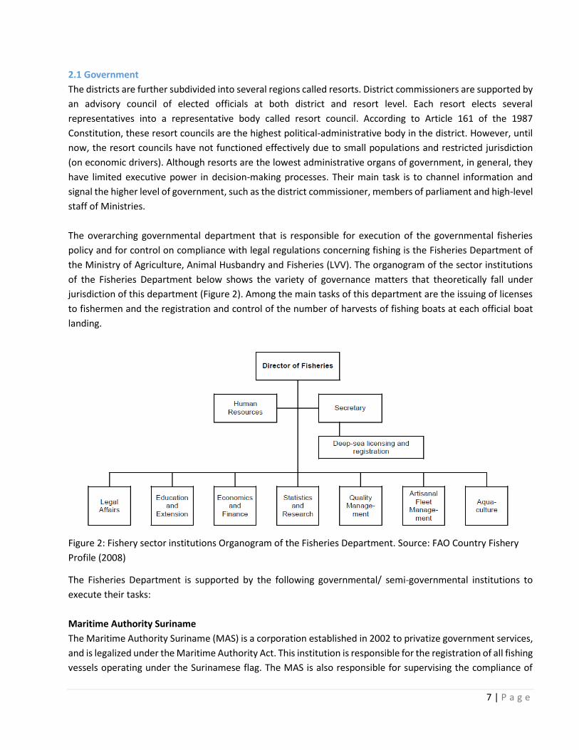
The overarching governmental department that is responsible for execution of the governmental fisheries
policy and for control on compliance with legal regulations concerning fishing is the Fisheries Department of
the Ministry of Agriculture, Animal Husbandry and Fisheries (LVV). The organogram of the sector institutions
of the Fisheries Department below shows the variety of governance matters that theoretically fall under
jurisdiction of this department (Figure 2). Among the main tasks of this department are the issuing of licenses
to fishermen and the registration and control of the number of harvests of fishing boats at each official boat
landing.
Figure 2: Fishery sector institutions Organogram of the Fisheries Department. Source: FAO Country Fishery
Profile (2008)
The Fisheries Department is supported by the following governmental/ semi-governmental institutions to
execute their tasks:
Maritime Authority Suriname
The Maritime Authority Suriname (MAS) is a corporation established in 2002 to privatize government services,
and is legalized under the Maritime Authority Act. This institution is responsible for the registration of all fishing
vessels operating under the Surinamese flag. The MAS is also responsible for supervising the compliance of

8 | P a g e
ships with legal rules and the authority must guarantee a safe and efficient passage of sea-going vessels from
and to Suriname, based on internationally accepted standards, rules and treaties ratified by Suriname. The
MAS sends out notices to shipping traffic and all other water users about e.g. shipwrecks and other possible
obstacles in the water, water levels and tidal currents.
Suriname Forest Service (LBB) and the Nature Conservation Division (NB)
The Suriname Forest Service (LBB) is responsible for the establishment and supervision of management of
protected areas, including the turtle nesting beaches. The Nature Conservation Division (NB) of LBB is
responsible for the daily management of protected areas. There is potential interference from oil exploration
activity (planned seismic survey areas) to several protected areas, namely (from West to East): Mac Clemen
Forest Reserve (FR), Hertenrits Nature Reserve (NR), Bigi Pan Multiple Use Management Area (MUMA), Peruvia
NR, Coppename Monding NR, North Saramacca MUMA, and Commewijne-Marowijne MUMA. NB does not
execute any activities in the Atlantic Ocean.
The Suriname Coast Guard
As of 2017, the Suriname Coast Guard is the official supporting institution by law in charge of fisheries
inspections of fishing activities in Surinamese waters. The Coast Guard falls under jurisdiction of the Ministry
of Internal Affairs, and works in close collaboration with the Fisheries Department to execute their tasks.
Fish Inspection Institute (VKI)
The Fish Inspection Institute (VKI) was established by the Ministry of LVV in 2007. The VKI is the competent
authority established to inspect the quality of fish products and see if caught fish follows food health
regulations under the Fish Inspection Act of 2000. The main tasks of this institute include: 1) determining of
quality standards for all fishery products; 2) inspections and control on the hygiene on board fishing vessels, all
plants, landing sites and commercial aquaculture farms; 3) execution of control over the entire production
chain of fisheries products from packing, labeling, storage and transportation of fisheries products to the final
consumer; 4) registration of landing sites and commercial aquaculture farms2 (Ministry of LVV, n.d).
2.1.1 Legal framework
Suriname is governed by the 1987 Constitution of the Republic of Suriname. Suriname’s legislation at the
national level is exercised through Laws or Acts generated by the Parliament (Wet, also called Verordening and
Landsverordening prior to 1975), Decrees (Decreet), Government Decree (Staatsbesluit), Presidential Decree
(Resolutie), Presidential Orders (Presidentieel Besluit) or Ministerial Orders (Ministeriele Beschikking) targeting
various sectors (Schalkwyk & Sanchez, 2016). Suriname does not have an approved national law on
environmental management, but there are several regulations, national acts and signed international
conventions that are relevant to the fisheries in Suriname. It is noteworthy to mention that fisheries legislation
in Suriname is currently being redrafted under a FAO TCP project : “Updating Suriname’s capture fisheries legal
2 Available at: http://www.gov.sr/media/62827/note_regarding_plant__animal_andfisheries_health_in_suriname_van_debie.pdf

9 | P a g e
framework”.The outcome of this process will be a new fisheries act, replacing both the current fishing degree
and fish protection act.
National law Content
The fishing decree, 1980 (S.B. 1980 No. 144, as
amended by Act S.B. 2001 No. 120)
Authorizes the government to make regulations for the
protection of marine fish stocks, and defines the fishery
zone as the territorial waters of Suriname including the
exclusive economic zone (EEZ). By law of April 14th,
1978, it is prohibited for neither Surinamese nations
nor foreigners to fish in the fishery zone without a valid
fishing license. This includes the licensing and
registration of all fishing vessels operating in the waters
of the fishery zone.
Law on the Territorial Sea and the Continuous
Economic Zone 1978 (S.B. 1978 No. 26)
Defines the territorial sea of Suriname at 12 nautical
miles from the nearest point on the line of low-water
mark along the shore and establishes a zone, and the
“Economic Zone," at 200 nautical miles from the coast.
Claims Suriname’s sovereign rights concerning the
exploration, exploitation, conservation and management
of living and nonliving resources within these zones.
Fish Protection Act, 1961 (G.B. 1961 No. 44 as
amended by Act S.B. 1981 No. 66)
Prohibits the taking or disturbance of fish within
Suriname’s territorial waters (except during established
fishing seasons)
Convention Content
United Nations Convention on the Law of the
Seas (UNCLOS); 1982
Establishes controls on routine discharges from
maritime vessels and addresses national jurisdiction
over territorial waters
United Nations Convention on Biological
Diversity (UNCBD) and the Cartagena Protocol
on Biosafety, 2000
Relates to biodiversity, oil spills, specially protected
areas and wildlife and land-based sources of marine
pollution. Provides the legal framework for the
Caribbean Environment Program (CEP).
Convention on International Trade in
Endangered Species of Wild Fauna and Flora
(CITES), 1973
Ensure that international trade in specimens of wild
animals and plants does not threaten the survival of the
species in the wild
Ramsar Convention, 1971 The convention on Wetlands of International
Importance, especially as Waterfowl Habitat
United Nations Conference on Straddling Fish
Stocks and Highly Migratory Fish Stocks, 1995
United Nations Fish Stocks Agreement, 2001
Conservation and management of highly migratory and
straddling fish stocks in international waters regulated
by e.g. the Northwest Atlantic Fisheries Organization

10 | P a g e
and the International Commission for the Conservation
of Atlantic Tunas
Rio Declaration on Environment and
Development (Agenda 21)
E.g. conservation of biological diversity (biodiversity),
control of pollution
Convention Content
International Convention for the Prevention
of Pollution from Ships 1973 as modified by
Protocol of 1978 relating thereto
(MARPOL73/78)
Establishes controls on routine discharges from maritime
vessels
Caribbean Environment Program (CEP) Established by the UN Environment as one of the
Regional Seas Programs in recognition of the importance
and value of the Wider Caribbean Region’s fragile and
vulnerable coastal and marine ecosystems including
endemic plants and animals.
FAO Code of Conduct for Responsible
Fisheries, 1995
Strengthening and building fisheries management
systems
The Reykjavik declaration on responsible
Fisheries in the Marine Ecosystem, 2001 Implementation and consideration of marine ecosystems
into responsible fisheries management
Table 3: Overview of Fisheries Laws and Regulations
2.1.2 Fishers’ organizations
Currently there are six fishers’ organizations registered in Suriname, which represent artisanal fishers in their
respective area (Nickerie, Coronie, Boskamp, Commewijne, Galibi and Paramaribo)3. Fishers active in the
district of Coronie are represented by the fisher’s organization of Coronie (VISCO). Fishers active in the district
of Commewijne are represented by the organization called ‘Visserij Collectief Commewijne (VCC)’ and fishers
active in the district of Marowijne are represented by the fisher’s organization of Galibi (Vissersorganisatie
Galibi).
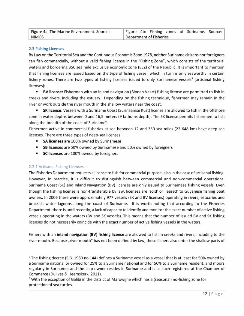
2.2 Fishing Grounds
Marine water resources (Exclusive Economic Zone – EEZ) extend approximately 370 kilometers offshore from
the coast of Suriname. The EEZ zone can be divided into three ecological sections, which are characterized by
the differing water color (blue, green and brown waters) depending on the season as can be seen in figure 4a.
In terms of fisheries, the EEZ can be divided in two major areas (Figure 4b):
3 Available at: http://www.gov.sr/ministerie-van-lvv/actueel/capaciteitsversterking-binnen-de-visserijsector.aspx

11 | P a g e
1. The Deep-Sea
Zone (beyond 10 fathoms)– this is the area of industrial fisheries. Industrial fishing tends to occur at depths
greater than 18 meters (10 fathoms). This zone contains mostly of blue waters, but also green and even brown
at the inner border depending on the season.
2. The Shallow Zone (0 – 10 fathoms) – this area is dominated by artisanal fishers (typically holding a BV
or SK license). This zone is characterized by green and brown waters.
The marine water resources contain several unique species, such as dolphins, sea turtles, whale sharks and
manta rays of which many are sensitive to changing circumstances. Communities living along the coast take
tourists to watch Guiana dolphins, sea turtles and other interesting species.
In the deep-sea zone of the marine water resources, fishers target deep-sea shrimp species and fish such as
red snapper, mackerel and other larger pelagic types such as sharks, tuna and related fish. Closer to the coast
lies the shallow zone, where fishermen target Sciaenidae and Ariidea species in conjunction with the shallow
water Seabob shrimp (Xiphophenaeus kroyeri). The shallow zone is characterized by its shallow contour and
brown to green. By law, these zones are also related to the types of fishing that are allowed (Figure 4b).
Trawling, for instance, is not allowed in the shallow sea zone.
Seabob shrimp fishing is allowed between 10 fathoms (18.3m) water depth to 15 fathoms (27.4m) water depth
to the limit of Suriname waters4. Commercial fishers (other than Seabob shrimp fishers) can fish from 15
fathoms (27.4m) water depth to the limit of Suriname waters. Deep-sea shrimp trawlers can fish from 45
fathoms (82.3m) to the limit of Suriname waters. Fishing on tuna and tuna-like species is allowed from 28
fathoms to the limit of Suriname waters. Artisanal fishermen can fish from the coast until 9 fathoms (16.5m)
water depth.
4 An exception to this is the border depth line for sea bob shrimp fishing east of Matapica which partly crosses the 15 fathoms depth line
12 | P a g e
Figure 4a: The Marine Environment. Source: NIMOS
Figure 4b: Fishing zones of Suriname. Source: Department of Fisheries
2.3 Fishing Licenses
By Law on the Territorial Sea and the Continuous Economic Zone 1978, neither Suriname citizens nor foreigners
can fish commercially, without a valid fishing license in the “Fishing Zone”, which consists of the territorial
waters and bordering 350 sea mile exclusive economic zone (EEZ) of the Republic. It is important to mention
that fishing licenses are issued based on the type of fishing vessel, which in turn is only seaworthy in certain
fishery zones. There are two types of fishing licenses issued to only Surinamese vessels5 (artisanal fishing
licenses):
▪ BV license: Fishermen with an inland navigation (Binnen Vaart) fishing license are permitted to fish in
creeks and rivers, including the estuary. Depending on the fishing technique, fishermen may remain in the
river or work outside the river mouth in the shallow waters near the coast.
▪ SK license: Vessels with a Suriname Coast (Surinaamse Kust) license are allowed to fish in the offshore
zone in water depths between 0 and 16,5 meters (9 fathoms depth). The SK license permits fishermen to fish
along the breadth of the coast of Suriname6.
Fishermen active in commercial fisheries at sea between 12 and 350 sea miles (22-648 km) have deep-sea
licenses. There are three types of deep-sea licenses:
▪ SA licenses are 100% owned by Surinamese
▪ SB licenses are 50% owned by Surinamese and 50% owned by foreigners
▪ SC licenses are 100% owned by foreigners
2.3.1 Artisanal Fishing Licenses
The Fisheries Department requests a license to fish for commercial purpose, also in the case of artisanal fishing.
However, in practice, it is difficult to distinguish between commercial and non-commercial operations.
Suriname Coast (SK) and Inland Navigation (BV) licenses are only issued to Surinamese fishing vessels. Even
though the fishing license is non-transferable by law, licenses are ‘sold’ or ‘leased’ to Guyanese fishing boat
owners. In 2006 there were approximately 977 vessels (SK and BV licenses) operating in rivers, estuaries and
brackish water lagoons along the coast of Suriname. It is worth noting that according to the Fisheries
Department, there is until recently, a lack of capacity to identify and monitor the exact number of active fishing
vessels operating in the waters (BV and SK vessels). This means that the number of issued BV and SK fishing
licenses do not necessarily coincide with the exact number of active fishing vessels in the waters.
Fishers with an inland navigation (BV) fishing license are allowed to fish in creeks and rivers, including to the
river mouth. Because „river mouth‟ has not been defined by law, these fishers also enter the shallow parts of
5 The fishing decree (S.B. 1980 no 144) defines a Suriname vessel as a vessel that is at least for 50% owned by a Suriname national or owned for 25% to a Suriname national and for 50% to a Suriname resident; and moors regularly in Suriname; and the ship owner resides in Suriname and is as such registered at the Chamber of Commerce (Duijves & Heemskerk, 2011). 6 With the exception of Galibi in the district of Marowijne which has a (seasonal) no-fishing zone for protection of sea turtles.

13 | P a g e
the coastal zone. For certain fishing techniques, such as Jagi-Jagi the fishers stay in the river mouth because
they depend on the tide. Yet when working with the long-line or drifting gillnet, the fishers enter the fertile
mudflats or go even deeper at sea; up to a depth of 4 to 6 fathoms (7 meter to 11-meter depth).
BV licensed fishers use two types of boats:
▪ Flat bottom boats and
▪ Round bottom boats
Because these boats are not seaworthy, BV fishers can only fish at sea when the water is not too turbulent.
When the water is relaxed, BV fishers may travel for up to four hours along the coast and go at sea. BV licensed
fishers typically work with less than three people onboard, but occasionally they go out alone. Data for 2011
(preliminary) show that most BV licenses have been allocated for the Suriname River and Suriname River mouth
(incl. Braamspunt) fishing areas, followed by the Corantijn River and Nickerie River mouth. These data for 2011
are not complete (explaining the large difference between 2011-2010) but they do give a general impression
of the busiest fishing areas. Also, it is worth mentioning that until recently there is no limit to the issuing of BV
licenses by the Fisheries Department.
Figure 5: Number of BV licenses allocated for the different fishing areas in 2011. Source: Duijves &
Heemskerk (2011)
Vessels with a Suriname Coast (SK) license are allowed to fish in the offshore zone between 0 and 9 fathoms
depth (16.641 m), but the exact fishing grounds of fishermen holding an SK license depend on four factors:
(1) The season
(2) The water level and moon
(3) Catch results by other fishers
(4) Perceived risk of piracy

14 | P a g e
SK fishers from Paramaribo reported that they travel for up to about 14 hours before putting out their nets. SK
fishers use two types of boats:
▪ Decked wooden vessels named „closed type Guyanese‟ vessels or „inboard‟. This type of boat typically
stays at sea for two to three weeks, or up to a month in exceptional cases and typically 15 meters in length.
▪ Open wooden vessels named „open type Guyanese‟ vessels or „cabin cruiser‟ can stay for about two
weeks at sea and are between 12 to 14 meters long.
Closed type Guyanese vessel Open type Guyanese vessel
Unlike the BV licenses, fishers with SK licenses have a limitation to their numbers issued by the Fisheries
Department. Table 2 below reflects the number of actual issued fishing licenses per fishing type category
between the years 2003 and 2012. It must be stated however that when these numbers are compared to the
determined number of licenses that can be issued by the Department of Fisheries (Table 1), there are
inconsistencies. The number of issued SK fishing licenses for example is higher than the maximum
predetermined number in some years. This has led to disputes between fishers and discontent with the
Fisheries Department. Apart from these conflicts, these inconsistencies have negative impacts on fish stocks
and may even further amplify conflicts over licensing.

15 | P a g e
Table 1: The number of permitted licenses for commercial and artisanal fisheries 2003-2012. Source: Fishery
Management Plan 2014-2018 (Fisheries Department)
Year 2003 2004 2005 2006 2007 2008 2009 2010 2011 2012
Shrimp trawlers 100 100 100 70 65 65 31 31 31 34
Seabob trawlers 30 30 30 29 30 30 25 20 20 22
Fish trawlers 15 15 15 15 15 15 15 15 25 23
Fish trawlers small pelagic 0 0 10 10 10 10 10 10 0 0
Large pelagic line fishing 0 15 15 18 10 10 10 30 30 60
Snapper and mackerel 100 150 150 150 150 150 100 100 100 100
Total commercial fleet: 245 310 320 292 280 280 191 206 206 239
SK gillnet and njawarie 325 350 350 340 345 345 304 300 300 300
SK Bangamary 40 40 35 40 40 40 30 20 20
Total artisanal fleet: 325 390 390 375 385 385 344 330 320 320

16 | P a g e
Table 2: The number of issued fishing licenses per category 2003-2012. Source: Fishery Management Plan
2014-2018 (Fisheries Department)
2.3.2 Industrial Fishing Licenses
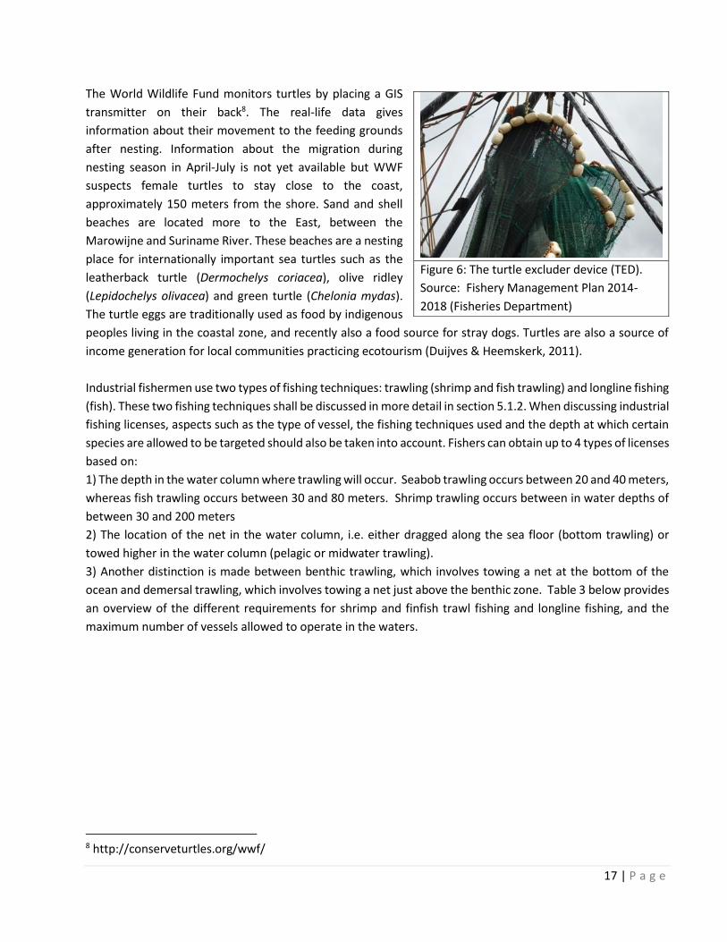
In the marine environment, major threats to sea turtles are injury and mortality as a result of bycatch during
fishing operations, especially during trawling. To minimize these threats, turtle excluder devices or TED’s are
used. A "Turtle Excluder Device" is a grid of bars with an opening either at the top or the bottom of the trawl
net. The grid is fitted into the neck of a shrimp trawl (Figure 6). Small animals such as shrimp pass through the
bars and are caught in the bag end of the trawl. When larger animals, such as sea turtles and sharks, are
captured in the trawl, they strike the grid bars and are ejected through the opening7. Fishers working with
shrimp and seabob trawlers are obligated to fish with the TED’s during their operations. The TEDs are part of
the requirements to receive and renew fishing licenses and to be able to export their shrimp to the USA.
7 National Oceanic and Atmospheric Administration: http://www.noaa.gov/
17 | P a g e
The World Wildlife Fund monitors turtles by placing a GIS
transmitter on their back8. The real-life data gives
information about their movement to the feeding grounds
after nesting. Information about the migration during
nesting season in April-July is not yet available but WWF
suspects female turtles to stay close to the coast,
approximately 150 meters from the shore. Sand and shell
beaches are located more to the East, between the
Marowijne and Suriname River. These beaches are a nesting
place for internationally important sea turtles such as the
leatherback turtle (Dermochelys coriacea), olive ridley
(Lepidochelys olivacea) and green turtle (Chelonia mydas).
The turtle eggs are traditionally used as food by indigenous
peoples living in the coastal zone, and recently also a food source for stray dogs. Turtles are also a source of
income generation for local communities practicing ecotourism (Duijves & Heemskerk, 2011).
Industrial fishermen use two types of fishing techniques: trawling (shrimp and fish trawling) and longline fishing
(fish). These two fishing techniques shall be discussed in more detail in section 5.1.2. When discussing industrial
fishing licenses, aspects such as the type of vessel, the fishing techniques used and the depth at which certain
species are allowed to be targeted should also be taken into account. Fishers can obtain up to 4 types of licenses
based on:
1) The depth in the water column where trawling will occur. Seabob trawling occurs between 20 and 40 meters,
whereas fish trawling occurs between 30 and 80 meters. Shrimp trawling occurs between in water depths of
between 30 and 200 meters
2) The location of the net in the water column, i.e. either dragged along the sea floor (bottom trawling) or
towed higher in the water column (pelagic or midwater trawling).
3) Another distinction is made between benthic trawling, which involves towing a net at the bottom of the
ocean and demersal trawling, which involves towing a net just above the benthic zone. Table 3 below provides
an overview of the different requirements for shrimp and finfish trawl fishing and longline fishing, and the
maximum number of vessels allowed to operate in the waters.
8 http://conserveturtles.org/wwf/
Figure 6: The turtle excluder device (TED).
Source: Fishery Management Plan 2014-
2018 (Fisheries Department)
18 | P a g e
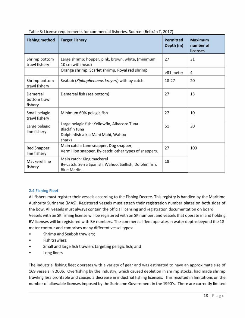
Table 3: License requirements for commercial fisheries. Source: (Beltrán T, 2017)
Fishing method Target Fishery Permitted Depth (m)
Maximum number of licenses
Shrimp bottom trawl fishery
Large shrimp: hopper, pink, brown, white, (minimum 10 cm with head)
27 31
Orange shrimp, Scarlet shrimp, Royal red shrimp
>81 meter 4
Shrimp bottom trawl fishery
Seabob (Xiphophenaeus kroyeri) with by catch 18-27 20
Demersal bottom trawl fishery
Demersal fish (sea bottom) 27 15
Small pelagic trawl fishery
Minimum 60% pelagic fish 27 10
Large pelagic line fishery
Large pelagic fish: Yellowfin, Albacore Tuna Blackfin tuna Dolphinfish a.k.a Mahi Mahi, Wahoo sharks
51 30
Red Snapper line fishery
Main catch: Lane snapper, Dog snapper, Vermillion snapper. By-catch: other types of snappers.
27 100
Mackerel line fishery
Main catch: King mackerel By-catch: Serra Spanish, Wahoo, Sailfish, Dolphin fish, Blue Marlin.
18
2.4 Fishing Fleet
All fishers must register their vessels according to the Fishing Decree. This registry is handled by the Maritime
Authority Suriname (MAS). Registered vessels must attach their registration number plates on both sides of
the bow. All vessels must always contain the official licensing and registration documentation on board.
Vessels with an SK fishing license will be registered with an SK number, and vessels that operate inland holding
BV licenses will be registered with BV numbers. The commercial fleet operates in water depths beyond the 18-
meter contour and comprises many different vessel types:
• Shrimp and Seabob trawlers;
• Fish trawlers;
• Small and large fish trawlers targeting pelagic fish; and
• Long liners
The industrial fishing fleet operates with a variety of gear and was estimated to have an approximate size of
169 vessels in 2006. Overfishing by the industry, which caused depletion in shrimp stocks, had made shrimp
trawling less profitable and caused a decrease in industrial fishing licenses. This resulted in limitations on the
number of allowable licenses imposed by the Suriname Government in the 1990’s. There are currently limited
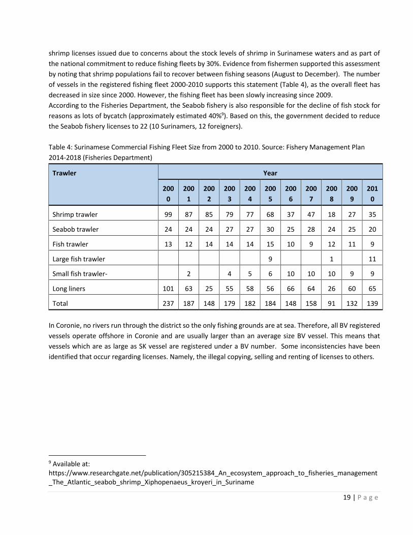
19 | P a g e
shrimp licenses issued due to concerns about the stock levels of shrimp in Surinamese waters and as part of
the national commitment to reduce fishing fleets by 30%. Evidence from fishermen supported this assessment
by noting that shrimp populations fail to recover between fishing seasons (August to December). The number
of vessels in the registered fishing fleet 2000-2010 supports this statement (Table 4), as the overall fleet has
decreased in size since 2000. However, the fishing fleet has been slowly increasing since 2009.
According to the Fisheries Department, the Seabob fishery is also responsible for the decline of fish stock for
reasons as lots of bycatch (approximately estimated 40%9). Based on this, the government decided to reduce
the Seabob fishery licenses to 22 (10 Surinamers, 12 foreigners).
Table 4: Surinamese Commercial Fishing Fleet Size from 2000 to 2010. Source: Fishery Management Plan
2014-2018 (Fisheries Department)
Trawler Year
200
0
200
1
200
2
200
3
200
4
200
5
200
6
200
7
200
8
200
9
201
0
Shrimp trawler 99 87 85 79 77 68 37 47 18 27 35
Seabob trawler 24 24 24 27 27 30 25 28 24 25 20
Fish trawler 13 12 14 14 14 15 10 9 12 11 9
Large fish trawler 9 1 11
Small fish trawler- 2 4 5 6 10 10 10 9 9
Long liners 101 63 25 55 58 56 66 64 26 60 65
Total 237 187 148 179 182 184 148 158 91 132 139
In Coronie, no rivers run through the district so the only fishing grounds are at sea. Therefore, all BV registered
vessels operate offshore in Coronie and are usually larger than an average size BV vessel. This means that
vessels which are as large as SK vessel are registered under a BV number. Some inconsistencies have been
identified that occur regarding licenses. Namely, the illegal copying, selling and renting of licenses to others.
9 Available at: https://www.researchgate.net/publication/305215384_An_ecosystem_approach_to_fisheries_management_The_Atlantic_seabob_shrimp_Xiphopenaeus_kroyeri_in_Suriname
20 | P a g e
2.4.1 Vessel Monitoring System
All commercial and artisanal licensed and registered fishermen are obligated to install a tracking device called
the Vessel Monitoring System (VMS) on their vessel. This system works via the Argos satellite navigation
network and must continuously, permanently and automatically provide the following information:
▪ The identity of the vessel
▪ The geographical position of the vessel
▪ The date and time of the positioning of the vessel
▪ The speed and direction of the vessel
The VMS data is retrieved and documented twice daily. Illegal fishing activities can be detected and can be
prosecuted.
2.5 Catch registration
All fishermen operating industrial and artisanal fishing vessels are obligated to deliver their catch to designated
landings in Suriname. These landings are designated by the Fisheries Department where data regarding the
catches is collected and documented in special logbook forms and must be sent electronically to the Fisheries
Department after each landing. This is the case for industrial fishing, but in the case of artisanal fishing not all
landings are recorded due to a sample-based system that used by the Fisheries Department. As mentioned
before, the recording system works well for the registration of industrial fishing since each catch of each vessel
is traceable. However, for the SK fleet, sometimes flaws are detected within the system: catches of different
vessels being registered together.
21 | P a g e
3. Demographics and population
Suriname has a total land area of 163,820 square kilometers and a total of 524,143 inhabitants. In 2010 several
6,324 people were employed in the fishing sector, comprising about approximately between 7% and 8% of the
total workforce. The population density in Suriname is approximately 3.1 inhabitants per square kilometers.
This makes Suriname a low populated country. The average density, however, does not reflect the spatial
distribution of the population in Suriname, for the population distribution over the different coastal districts is
unequal (Table 5). The district of Wanica is growing faster compared to any other district with 36.7% growth
between 2004-2012 compared to a growth rate varying between -6.5 to 27.3% on average (ABS, 2012)
Table 5: Population Numbers and Density for the Coastal Districts of Suriname. Source: ABS, 2004
District Population Area (km2) Density (Inhabitants per
km2)
Paramaribo 242,946 182 1327.6
Wanica 85,986 443 194.1
Nickerie 36,639 5,353 6.8
Coronie 2,887 3,902 0.7
Saramacca 15,980 3,636 4.4
Commewijne 24,649 2,353 10.5
Marowijne 16,642 4,627 3.6
In recent years, the annual growth of the Surinamese population has been around 1.37 %. The population of
Suriname consists of several ethnic groups, such as Hindustani 27.4%, Creoles 17.7%, Maroons 14.7%; Javanese
14.6%; Mixed 12.5%; Miscellaneous others (Chinese, Indigenous peoples, Lebanese, European, etc.) 6.5%; Not
reported, 6.6% (Smith et.al, 2014). Local fishermen working along the Suriname coast (full-time or part- time)
are represented by almost all ethnic groups living in the country. The following section will describe these
different ethnic groups living in the coast districts of Suriname.
3.1 Coastal ethnic groups
There are several coastal fishery groups, which are discussed below.
Hindustani
Hindustani people (37% of the Surinamese population) are the descendants of indentured laborers from
former East India, who came to Suriname between 1873 and 1918 to work on the plantations. They dominate
the rice farming industry in western Suriname, in the districts of Nickerie and Coronie. The main urban center
of the rice districts is Nieuw Nickerie, on the border with Guyana, with 11,100 inhabitants (Smith et.al, 2014).
Creoles
Approximately 31% of the Suriname population are the descended from African slaves and people of mixed
African heritage. Creoles in the coastal area frequently live on the old plantations and rural lands obtained by
their families after the abolition of slavery, mostly in the coastal districts of Para, Wanica, and Coronie (found
22 | P a g e
to the south and west of Paramaribo). In the past decades, a significant proportion of lands in the district of
Coronie has become brackish and unsuitable for agriculture due to the deteriorating sea defense system. This
event has forced many small-farmers in this district out of business, and many have migrated towards
Paramaribo (Smith et.al, 2014). Today, Creoles primarily work as public servants and laborers in extractive
industries (e.g. bauxite, lumber etc.) and other resource-based industries, such as fisheries, coconut and
banana plantations, and bee farming.
Javanese
Javanese (15% of the Surinamese population) are the descendants of indentured laborers from the Indonesian
island of Java who came to Suriname between 1890 and 1939 to work on the plantations after the abolition of
slavery. They continue to inhabit the rural areas surrounding Paramaribo, in the districts of Saramacca, Wanica,
and Commewijne. Their main economic activity is small-scale agriculture of fruits and vegetables, which are
sold at the Paramaribo markets (Smith et.al, 2014).
Maroons
In the 18th century, groups composed of primarily Ndyuka Maroons settled in the Suriname coastal zone where
they worked in the lumber and balata wood product industries. Today, the Maroons form approximately 11%
of Suriname’s population and mostly live on the savannahs and plains to the east of Paramaribo, in the district
of Marowijne (Smith et.al, 2014). Many continue to work in the extractive industries (e.g. bauxite, lumber etc.),
in addition to subsistence agriculture, hunting, fishing, and minor trade. Some informally sell fruits, vegetables,
and bush meat along the main road to the east; others bring their produce to the Central Market in Paramaribo.
The main village of Albina (capital of the Marowijne district), on the border with French Guiana, is an important
transport hub for travelers between Suriname and French Guiana, and for Maroons traveling from the villages
along the Marowijne, Lawa, and Tapanahonie Rivers in the interior to the coast.
Indigenous peoples
The original inhabitants of the coastal region districts are the Kalina (Caribs population 2,500) and Lokono
(Arawaks, population 3,500) Amerindians, who continue to inhabit this area. They live primarily along the main
roads and rivers. Many villages of this ethnic group have their own headman, called kapitein, but there is no
overarching political structure governing both the Carib and Arawak ethnic groups. The indigenous groups
living in the coastal regions engage in fisheries for livelihood (Smith et.al, 2014). However, the distinction
between traditional and commercial is difficult to make and this also elicits conflicts between the Fisheries
Department and the indigenous peoples (POF, 2017). Also, because indigenous peoples customarily travel large
distances in what they consider their territory. An overview of the indigenous peoples’ territory is given in
Figure 7.

23 | P a g e
Figure 7: An overview of the territory of indigenous groups in Suriname
24 | P a g e
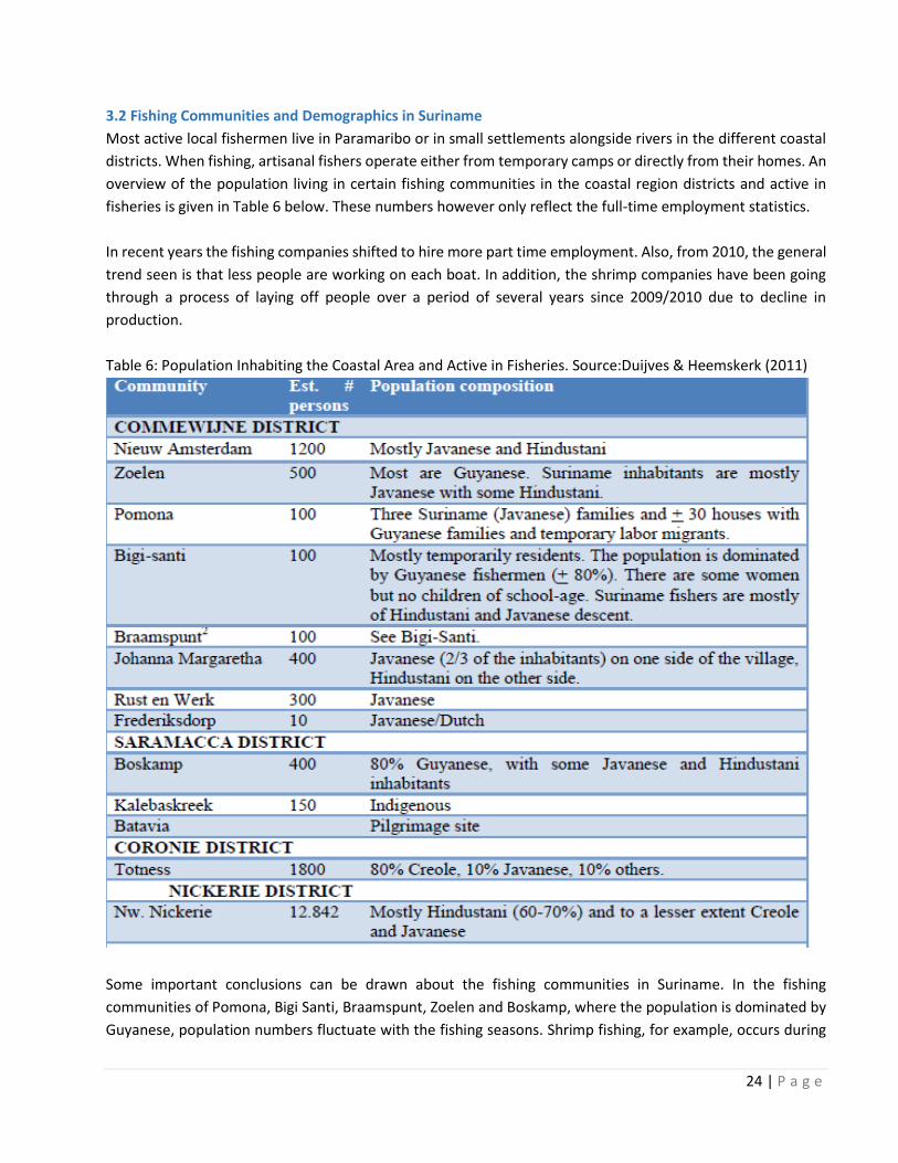
3.2 Fishing Communities and Demographics in Suriname
Most active local fishermen live in Paramaribo or in small settlements alongside rivers in the different coastal
districts. When fishing, artisanal fishers operate either from temporary camps or directly from their homes. An
overview of the population living in certain fishing communities in the coastal region districts and active in
fisheries is given in Table 6 below. These numbers however only reflect the full-time employment statistics.
In recent years the fishing companies shifted to hire more part time employment. Also, from 2010, the general
trend seen is that less people are working on each boat. In addition, the shrimp companies have been going
through a process of laying off people over a period of several years since 2009/2010 due to decline in
production.
Table 6: Population Inhabiting the Coastal Area and Active in Fisheries. Source:Duijves & Heemskerk (2011)
Some important conclusions can be drawn about the fishing communities in Suriname. In the fishing
communities of Pomona, Bigi Santi, Braamspunt, Zoelen and Boskamp, where the population is dominated by
Guyanese, population numbers fluctuate with the fishing seasons. Shrimp fishing, for example, occurs during

25 | P a g e
two seasons. Large Seabob shrimp are caught during Suriname‟s long rainy season (May-August), which mostly
occurs in the Suriname River. In December-January, fishers catch the small „wit-bere‟ shrimp, which mostly
occur in the Commewijne River. In the shrimp off-season, some families in communities that focus on shrimp
fishing (i.e. Zoelen, Pomona) will catch fish (e.g. Kandra).
Also, some members of more settled fishing families may look for employment elsewhere (i.e. Paramaribo),
mostly in construction. Others (particularly single men) may move back to Guyana. Particularly in December
and January, many Guyanese fishers leave Suriname to spend the holidays in Guyana. In Pomona, Guyanese
labor migrants come specifically for shrimp fishing at the start of the season (April) and often leave Pomona
again in October at the closure of the shrimp season (Duijves & Heemskerk, 2011).
During the high seasons for Seabob shrimp some fishers from Zoelen work from nearby fishing locations such
as Braamspunt, and only return home every couple of days. During the off-season for Seabob shrimp, the
inhabitants stay in Zoelen to catch small shrimp and small fishes (e.g. anchovies) to make terie. While the
Guyanese fishers tend to stay at Bigi Santi/Braamspunt for months, the Suriname fishers tend to come for a
couple of days at a time
Interesting is the high number of Guyanese fishers living in a number of these communities and working in
Suriname waters. As compared to people from Paramaribo and other urban areas, the inhabitants of most
fishing and plantation communities have relatively poor access to health care facilities, government
institutions, information and educational facilities. They rely on -often irregular- boat and/or bus transport.
The households largely use on rainwater for their daily water needs and the more isolated communities have
no access to electricity. In those isolated fishing communities (i.e. Braamspunt, Bigi Santi, Pomona), living
conditions can be characterized as very poor (Duijves & Heemskerk, 2011).
3.2.1 Fishing communities in the Paramaribo District
In Paramaribo, fishers can deposit their fish at a number of boat landings are located on the western shores of
the Suriname River. The most important of these may be the Waldring landing and Clevia. The fishers working
from these locations do not form a physically fixed community, but they are part of the socio-economic
community of artisanal fishers. They live mostly dispersed in Paramaribo and Commewijne (Figure 8).
On the south side of the city, industrial trawlers moor on a couple of locations, including Bethesda. The boat
owners are Dutch, Surinamese, Chinese, Korean, and Venezuelan. Foreign crews typically live on the boats.
These fishers do not form a community in the traditional sense, but they do form a socioeconomic community
with shared lifestyles and knowledge systems. The Surinam harbor is located in Paramaribo as well.
Fishers who are landing their boats along the West (Paramaribo) banks of the Suriname River typically live
dispersed in the capital city of Paramaribo. Fishing is not the main economic activity in the Paramaribo district.
More jobs can be found in the commercial sector, public sector and business sector (Heemskerk & Duijves,
2011).

26 | P a g e
Figure 8: Fishing communities in Paramaribo and Commewijne

27 | P a g e
3.2.2 Fishing Communities in the Commewijne District
The district of Commewijne contains several fishing communities that also serve as well-known fish landings
(Figure 8):
● Nieuw Amsterdam is the district capital of Commewijne.
● Zoelen is a small shrimp fishers’ settlement located on the former plantation Zoelen near the village of
Nieuw Amsterdam.
● Pomona, a shrimp fishers’ village is located on the Eastern banks of the Suriname River at the mouth
of the Jonkermans Creek.
● Bigi Santi and Braamspunt are two fishing communities located on a peninsula on the north-western
shore of the district, together popularly known as “Braamspunt”.
● Johanna Margaretha, is a former plantation village on the Northern banks of the Commewijne River.
Some river fishermen are located here.
● Rust en Werk, is a former plantation village on the northern banks of the Commewijne River. Some
river fishermen are located here.
● Frederiksdorp is a former plantation made into a tourist resort on the northern banks of the
Commewijne River.
● Other plantations, settlements and villages in Commewijne include: Mariënburg, Alkmaar. Ellen,
Leliëndaal. All of these are located on former plantations.
Fishing is an important economic activity in the village of Nieuw Amsterdam. The village of Nieuw Amsterdam
contains 17 registered boat owners that operate a total of 22 vessels holding an SK or BV license. By estimation
the whole district of Commewijne includes a total of approximately 50 to 100 boats. Depending on the boat
type, 2 to 6 people may be working per boat. Fishing directly employs 300 to 500 people (including vessel
owners and fish processors), and indirectly sustains many more. Other important economic activities in Nieuw
Amsterdam include government service, agriculture, and tourism. Tourism activities generally involve dolphin
watching, and visiting old plantations in the district (Duijves & Heemskerk, 2011).
All fishermen working from Zoelen hold Inland Navigation (Binnenvaart - BV) licenses. Approximately 15 fishing
boats moor at the Zoelen landing on a regular basis. The fishermen use seine nets (known locally as fuik or
foiki, to catch small shrimp (witi-bere) and fishes which are used to make dried salted fish (known locally as
terie). Both the shrimps and fish species are caught in the Commewijne River near the village (Duijves &
Heemskerk, 2011).
Commercial fishermen may fish in the local river or go further offshore to target Kandra (Cynoscion virescens),
prawns, and large shrimp. Shrimp and small fishes are typically dried at home and sold either to intermediaries
or straight to end clients. In the shrimp and terie industry, fishermen’s wives and other family members hold
important roles in processing the catch. Male tasks include making the drying rack and carry the load with a
shovel. Female tasks include sorting, salting and turning the fish on the drying rack daily, packaging and
sales/marketing. Young boys who not visit school usually go along with their fathers. Small children may help
the mother.
The Bigi Santi and Braamspunt fishermen utilise seine nets to target shrimp and small fish found in

28 | P a g e
coastal/intertidal waters, the catch is dried to produce, sara-sara and terie respectively. This fishing technique
depends on tidal movements; the nets are placed in the water at high tide and as the water recedes the shrimp
and fish are pulled in the net and scooped out. Due to the reduced tidal flow during neap tide (i.e. when the
moon is in the 1st or final quarter) known locally as lesi watra, fishermen do not go out. May and June are the
peak months for the shrimp fishermen, while mid-October to November are low-season months. During the
low season, fishermen look for temporary work on nearby plantations and in Paramaribo.
Information on other groups of fishermen were unavailable during the time of this study.
3.2.3 Fishing Communities in the Saramacca District
The fishing communities in the district of Saramacca are named:
● Boskamp is a small fishers’ community on the banks of the Coppename River in the Saramacca district
(Figure 9).
● People living along the Saramacca River and the Larecoweg and in Calcutta are mostly (subsistence)
farming families who use the Saramacca River for fishing and transportation.
● The inhabitants of the indigenous communities of Kalebaskreek and of the village of Batavia use the
Coppename River to fish for subsistence use and to travel to the coastal area. The Coppename River is
also the main access route to the indigenous villages of Corneliskondre and Donderskamp along the
Wayambo River.
The fishing community of Boskamp which is situated west of Paramaribo near the mouth of the Coppename
River is the home of Suriname and Guyanese fishers and their families. According to the Visserijdienst (Fisheries
Department), the community has between 10 and 15 BV licensed boats. Most BV fishermen from the
community utilise a fishing technique known locally as jagi jagi, in the river mouth. As a result of this fishing
method (see also Table 6.9 and Section 6.6.1) there are a number of poles standing in the water along the coast
which cannot easily be removed. The majority of fixed gear stands are placed in the fish-rich estuarine area
between the Saramacca and Coppename River.
Boskamp is known in Suriname for its dried and smoked fish, which is prepared by the local population. At least
one resident from Boskamp takes tourists to the mouth of the Coppename River and along the shore for bird
watching on the mud flats and fishing.
Information on other groups of fishermen were unavailable during the time of this study.

29 | P a g e
Figure 9: Location of the fishing community of Boskamp in Saramacca
3.2.4 Fishing Communities in the Coronie District
Totness is the district capital of District Coronie (Figure 10).
While not a classic fisher community, it is the main point of
departure for fishers from this district. In 2011, the Fisheries
Service in the Coronie district, registered 9 BV boats and 3
SK (Suriname coast license) boats. The only fishing
technique used in Coronie is drift nets, no static gear such
as jagi-jagi or shrimp fishing with fyke nets takes place in
this district. Other economic activities in the district are
agriculture, horticulture (cultivation of coconuts and
beekeeping) and livestock rearing. Approximately 15% of
the district inhabitants are working in public services.
Figure 10: The location of Totness in Coronie

30 | P a g e
3.2.5 Fishing Communities in the Nickerie District
Nickerie (Figure 11) is a predominantly agricultural district with rice and banana as the main cash crops and
important export products. The main fishing activities in Nickerie are drift net and purse seine fisheries (known
locally as hari-tité) for Koebi (Plagioscion surinamensis) along the mouth of the Corantijn River, and fyke net
and drift net fishing in the coastal area. Popular fishing locations are found between Turtlebank and
Corantijnpolder.
In addition to the local fishermen, there are many Guyanese fishermen working in Suriname waters, they are
concentrated in the Springland area. Other economic activities on Suriname territory include wood transport
by Chinese companies and Guyanese vessels using the Zaagmolenlanding to enter the river.
Figure 11: The city of Nieuw Nickerie

31 | P a g e
3.2.6 Fishing Communities in the Marowijne District
There is a lack of data on fishing activities specifically in the
Marowijne district of Suriname. According to the Fisheries
Department, this is due to the fact that fisher’s active in this
district are not formally registered by the Department,
moreover the registration is not maintained. The little
information available on fisheries in Marowijne states that
the fishing community of Galibi had a number of 35
fishermen active in this sector in 2012 (Figure 12). More
information on the number of active fishers and the socio-
economic importance of fisheries in Galibi could be
obtained through the fishing organization of Galibi.
Figure 12: The location of Galibi in the district
Marowijne

32 | P a g e
4. Health
The citizens of Suriname have an average life expectancy of 70.8 years. The life expectancy for 2010-2015 is 74
for women and 68 for men. People active in all chains within the fishery sector are expected not to deviate
from these numbers. The most significant diseases that can cause death are stroke, coronary heart disease,
diabetes mellitus and HIV/AIDS.
Suriname has a total of five hospitals, of which four are located in Paramaribo and one is located in Nieuw
Nickerie. Only two out of these hospitals are equipped with an emergency room, one hospital in Paramaribo
and one in Nieuw Nickerie. The remaining services in the coastal region districts are provided by smaller
Government clinics called RGD clinics (Figure 13). Fishermen can use all of these services for a small fee or free
by obtaining a social security card.
Compared to other districts, the district of Nickerie has a relatively high number of suicides. An epidemiological
study in the Nickerie catchment area revealed high rates of suicide (48 per 100,000) and attempted suicide
(207 per 100,000) on average in the years 2000–2004. Particularly remarkable is the high number of attempted
suicides among males (49%), and the use of pesticides in both fatal (55%) and nonfatal suicidal behavior (44%).
The high incidence of suicidal behavior may reflect the very poor economic situation of the district, poverty of
most of the population, high levels of alcohol misuse, domestic violence, the rigidity of Hindustani culture
regarding family traditions, the accessibility of pesticides, and the lack of future perspectives. There is no
statistical data on health incidents specifically regarding active fishermen.
Figure 13: The RGD clinics in Suriname. Source: RGD online (2017)

33 | P a g e
5. Education
Children go to pre-primary school at age four for a period of two years until they can be enrolled in primary
schools. Primary education lasts for 6 years and children are typically enrolled from age 6 until they are 12
years old (compulsory education runs from age 7 to 12). On average, children stay in school for 7.2 years. From
the age of 4, 91% are enrolled in primary education. When reaching the age of 12, children are eligible for
secondary education, however only approximately half of this age group will continue school (Duijves &
Heemskerk, 2011).
The literacy rate of Suriname adults (15 years and older) is 95% (which is approximately equal among men and
women – 95/94%). For youth between 15 and 24 years, the literacy rate is 98% (approximately equal among
men and women – 98/99%). Several primary and secondary educational facilities can be found in all coastal
districts, however continued secondary and higher educational facilities are located only in Paramaribo.
In Suriname, there is no specialized education in fishing, but fishers mostly obtain skills by on the job
experience. However, there are several initiatives of the Ministry of Agriculture and Fisheries to provide
training and workshops for people active in fisheries. Trainings are usually linked to projects funded by outside
funders such as technical and conflict resolution trainings in the project: Sustainable Management of Bycatch
in Latin America and the Caribbean Trawl Fisheries (REBYC-II-LAC) funded by the FAO. Statistical data on
educational levels of fishermen is yet unavailable.
A considerable number of Guyanese fishers have been living in Suriname for a long time, and their children
attend schools in Suriname. In Commewijne most of the children on the right bank of the Commewijne River
go to school on the other side of the river and School children living on the former plantations in the
Commewijne district rely heavily on school boats and ferry boats to travel to school to bring them to schools
in Ellen, Leliëndaal, Nieuw Amsterdam and Paramaribo. Nieuw Amsterdam itself has two primary schools, one
public school and one EBGS (Moravian Church). Children from Zoelen are visiting this school as well; the school
bus takes the children to these schools. Continued education possibilities are centered in the resorts Alkmaar
(Ellen and Leliëndaal) and Meerzorg. In Boskamp children visit the primary school in Calcutta, secondary
education can be found in Freiburg. School children from Kalebaskreek and Batavia travel to Boskamp by boat
as well. Totness and Nickerie have several educational facilities, primary as well as secondary (Duijves &
Heemskerk, 2011).
5.1 Skills
As mentioned in the previous section, fishermen obtain their skills by experience. These skills are learned on
the job or are passed on from family members, and contain knowledge on e.g. fishing seasons, fish stocks and
fishing techniques. Each fishing technique is characterized by specific gear, period of being active, duration of
fishing trips, and fishing location. The different fishing techniques are described in more detail below.
5.1.1 Artisanal Fishing Techniques
Artisanal fishermen can be divided into two main categories based on their location and the fishing techniques
used:

34 | P a g e
Coastal fishing
▪ The drifting gillnets stand as a vertical curtain in the water column with floating devices attached to
the top and weights at the bottom. This is the most common method of fishing in the coastal zone. The gillnets
are set out between 2 and 5 kilometers offshore from the coast with mesh sizes ranging from 2.5 to 8 inches.
Fishermen using this technique mainly catch Bang-bang, Kandratiki and Koepila and Bangamary (dagutifi).
▪ The bottom long-line consists of a main line of between 600 and 1000 meters in length with baited
hooks attached at intervals. Long lines are set by an anchor or left to drift (Figure 14).
Figure 14: Long line with baited hooks. Source: Fishery Management Plan 2014-2018 (Fisheries Department)
River, Estuarine and Brackish Water Fishing
These fishermen use a variety of techniques for catching fish.
▪ Chase pin (known locally as Jagi-Jagi) is a fishing technique whereby a seine net is placed on two sticks
after the flood tide has reached the furthest point in the river (Figure 15). In front of the fixed net, there are a
series of smaller poles in a “V” shape. As the water recedes during the ebb tide, the poles lean together and
act as a barrier to direct the fish into the seine net at the end of the V shape. The fishermen stay for an average
of 4-6 hours on the water using this technique. Different Jagi-Jagi stands may be placed in the river along a
wide stretch of water. The poles of the chase pins remain in the water and are only replaced when they are
worn. In some instances, such as in the mouth of the Coppename River near Boskamp, the Jagi-Jagi stands
close off a large section of the river mouth, and other vessels have to go around them.
Figure 15: Diagram of the Jagi-Jagi Fishing Technique. Source: Smith et.al, 2014
▪ Fishermen also use fyke nets to catch fish in estuaries. Fyke nets are bag-shaped nets which are held
open by hoops. These nets are also known as “hoop nets” or “funnel nets” (known locally as foiki). This
35 | P a g e
technique depends on the tidal currents in the river mouth. Fyke nets are placed between poles, but do not
use the rambling sticks to chase fish into the net. Fyke net stands are found in the estuaries of the Suriname,
Commewijne and Corantijn Rivers.
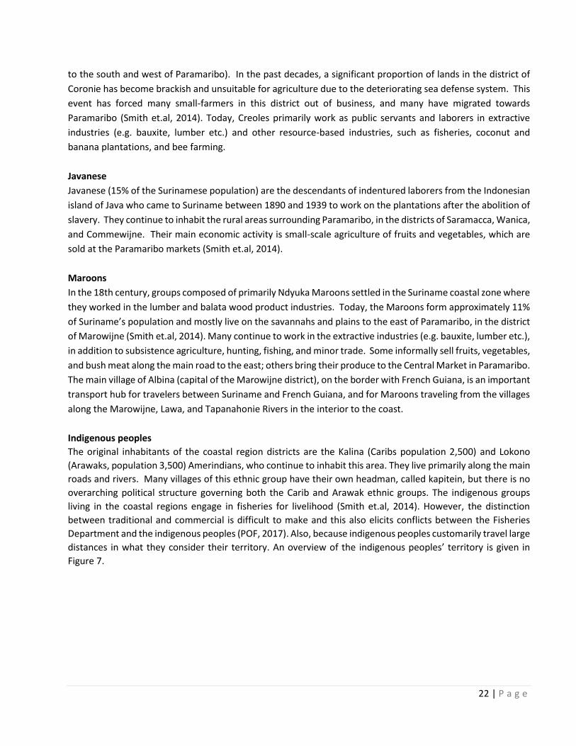
▪ Fishermen use njawarie fishing (a pin seine net) or ‘schutbank’ on the mud banks to form a “U” shape
that traps fish as the tide recedes (Figure 16). At the high tide, a long net is placed on the riverbank and as the
tide gets low, the fish are captured in the net. Fishermen using this technique mainly catch fish such as Bang-
bang, Koepila, Pani, Snoek, Dagoe tifi and Botro fisie (Duijves & Heemskerk, 2011).
Figure 16: The net setup for the Njawarie fishing. Source: Fishery Management Plan 2014-2018 (Fisheries
Department)
Table 7 below provides a complete overview of the characteristics of the artisanal fisheries in Suriname.

36 | P a g e
Table 7: Characteristics of different artisanal fishers. Source: Duijves & Heemskerk (2011)
5.1.2 Commercial Fisheries
The commercial fishermen use two types of fishing techniques in Suriname: trawl fishing and line fishing.
▪ Trawl fishing includes pulling a large fishing net through the water behind one or more boats (Figure
17a) and is regulated by the Ministry of LVV through licensing. Trawl fishing is predominantly used for
catching shrimp and large pelagic fish (finfish) (Duijves & Heemskerk, 2011). Some of the shrimp trawl
vessels have been modified to catch finfish including Lutjanids (L. synagris) and Sciaenids (C. virescens).
▪ Line fishing (Figure 17b) includes suspending fishing lines with baited hooks from one or more boats.
Line fishing is predominantly used for red snapper and mackerel (Duijves & Heemskerk, 2011).
Figure 17a: Trawl fishing technique Figure 17b: Line fishing technique

37 | P a g e
There are no specific communities attached to commercial fishing offshore Suriname. Fishing boats are
operated by both Surinamese nationals and foreigners (e.g. Venezuelans, Guyanese etc.). About 80% of all
offshore licensed fisherman are foreigners. Currently all industrial (deep sea) vessels mainly targeting tuna,
operate under the Panamanian flag, and no such boats operate with a Surinamese flag. Surinamers have
cultural barriers to fishing on sea because they do not like to stay away from home for long periods of time.
The last year’s foreigners have changed from predominantly Chinese to fishers coming from the Philippines.
Commercial fisheries are mainly used for export purposes and generally operate from Paramaribo or the
district of Para.
38 | P a g e
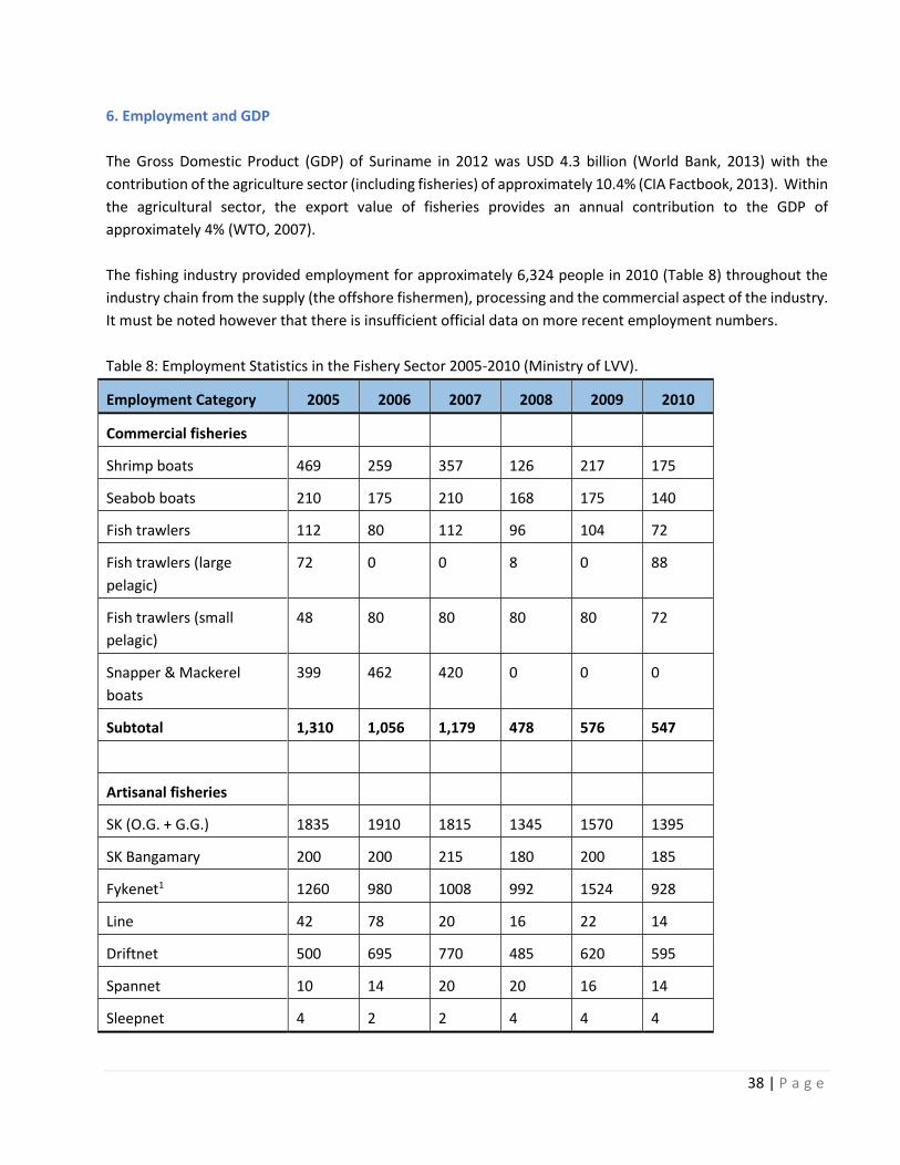
6. Employment and GDP
The Gross Domestic Product (GDP) of Suriname in 2012 was USD 4.3 billion (World Bank, 2013) with the
contribution of the agriculture sector (including fisheries) of approximately 10.4% (CIA Factbook, 2013). Within
the agricultural sector, the export value of fisheries provides an annual contribution to the GDP of
approximately 4% (WTO, 2007).
The fishing industry provided employment for approximately 6,324 people in 2010 (Table 8) throughout the
industry chain from the supply (the offshore fishermen), processing and the commercial aspect of the industry.
It must be noted however that there is insufficient official data on more recent employment numbers.
Table 8: Employment Statistics in the Fishery Sector 2005-2010 (Ministry of LVV).
Employment Category 2005 2006 2007 2008 2009 2010
Commercial fisheries
Shrimp boats 469 259 357 126 217 175
Seabob boats 210 175 210 168 175 140
Fish trawlers 112 80 112 96 104 72
Fish trawlers (large
pelagic)
72 0 0 8 0 88
Fish trawlers (small
pelagic)
48 80 80 80 80 72
Snapper & Mackerel
boats
399 462 420 0 0 0
Subtotal 1,310 1,056 1,179 478 576 547
Artisanal fisheries
SK (O.G. + G.G.) 1835 1910 1815 1345 1570 1395
SK Bangamary 200 200 215 180 200 185
Fykenet1 1260 980 1008 992 1524 928
Line 42 78 20 16 22 14
Driftnet 500 695 770 485 620 595
Spannet 10 14 20 20 16 14
Sleepnet 4 2 2 4 4 4

39 | P a g e
Zeegnet 40 40 20 40 65 55
Gillnet 108 195 108 90 105 213
Guyana (SK + BV)2 45 40 0 0 0 0
Sport fishing 0 0 0 0 0 0
Subtotal 4,044 4,154 3,978 3,172 4,126 3,403
Fish sales
Central market3 489 372 339 339 285 261
Fish stores4 498 412 258 387 104 175
Fish sellers5 74 74 74 60 60 96
Factory 70 65 0 51 51 51
Fish company 480 0 0 273 135 375
Subtotal 1,611 923 671 1,110 635 958
Processing companies 1,414 1,388 1,236 1,218 940 1,235
Total employment in
sector
8,379 7,521 6,393 6,924 6,458 6,324
1 Fykenet fisheries involve family units 2 Licenses issued by Suriname Government 3 Sellers of the Central Market are also fish processors (in both Paramaribo and Nickerie) 4 Registered licenses at the Chamber of Commerce 5 Sellers registered by the Chamber of Commerce
6.1 Socio-economic Importance
The fishing industry is an important economic sector in Suriname. In 2004, the gross value of fisheries’ output
was estimated at 36.6 million USD. In 2006, fish production worth 45.7 million USD was exported (Stichting
Planbureau Suriname, 2008). Most of this money was earned in industrial fishing.
Historically, the commercial fishing industry started in Suriname during the mid-1970s with the first recorded
export in 1976. The industry has been a relatively stable sector that contributes to the GDP mainly via the
export of shrimp and other fish types. Suriname fish export data shows a steady quantity of export products
in the last decade.
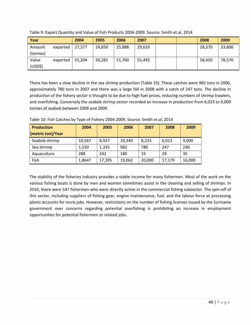
40 | P a g e
Table 9: Export Quantity and Value of Fish Products 2004-2009. Source: Smith et.al, 2014
Year 2004 2005 2006 2007 2008 2009
Amount exported
(tonnes)
27,377 24,850 25,888 29,633 28,370 33,800
Value exported
(USD$)
55,204 50,281 51,760 55,492 58,450 78,570
There has been a slow decline in the sea shrimp production (Table 10). These catches were 982 tons in 2006,
approximately 780 tons in 2007 and there was a large fall in 2008 with a catch of 247 tons. The decline in
production of the fishery sector is thought to be due to high fuel prices, reducing numbers of shrimp trawlers,
and overfishing. Conversely the seabob shrimp sector recorded an increase in production from 6,023 to 9,000
tonnes of seabob between 2008 and 2009.
Table 10: Fish Catches by Type of Fishery 2004-2009. Source: Smith et.al, 2014
Production
(metric ton)/Year
2004 2005 2006 2007 2008 2009
Seabob shrimp 10,567 8,927 10,340 8,233 6,023 9,000
Sea shrimp 1,530 1,335 982 780 247 240
Aquaculture 288 242 180 19 29 35
Fish 1,8647 17,395 19,062 20,000 17,179 16,000
The stability of the fisheries industry provides a stable income for many fishermen. Most of the work on the
various fishing boats is done by men and women sometimes assist in the cleaning and selling of shrimps. In
2010, there were 547 fishermen who were directly active in the commercial fishing subsector. The spin-off of
this sector, including suppliers of fishing gear, engine maintenance, fuel, and the labour force at processing
plants accounts for more jobs. However, restrictions on the number of fishing licenses issued by the Suriname
government over concerns regarding potential overfishing is prohibiting an increase in employment
opportunities for potential fishermen or related jobs.

41 | P a g e
7. Infrastructure and Services
7.1 Boat landings
Both artisanal and commercial fishermen are mandatory to moor their vessels at certain designated boat
landings in Suriname (Table 11). There is no auction system for catch at the boat landing locations, but rather
the catch is sold to intermediary buyers or sold directly to fish processing companies. All fishing vessels are
obligated to deliver their catch to designated landings in Suriname. Compulsory condition of licensing for
artisanal fishing is that their catch is processed in Suriname. Thus, if the vessel has less landings than the
minimum required landings of 12 landings per year their license will not be renewed. However, in reality a
significantly large number of SK licensed vessels are not landing in Suriname, but in Guyana which means less
revenue for fish processing companies in Suriname. The process of illegal renting of licenses to vessel owners
living in Guyana contributes to this problem. The landing obligation would be able to prevent this problem,
after all when vessels do not land or have less registered landings in Suriname than the minimum required
amount their license will not be renewed. However in reality there is no strict policy control over the
requirements of the landing obligation. Another problem is: only a limited amount of the total catch is landed
in Suriname, while the larger amount of more valuable catch is landed and processed in Guyana. Another fact
are the false invoices from fish processing companies in Suriname.
Surinamese vessels with an SA license are mandatory to harbor in Suriname on regular basis. Because fishers
and other water users from Paramaribo to Nickerie live dispersed over the districts, boat landings are important
contact points for fishers and others in the fishing industry. The boat landings also are a place to get in touch
with boat owners who organize tourist trips, for example dolphin or bird watching trips. In addition, the boat
landings are important for industrial (freight) traffic.
Artisanal boat landings
Important designated boat landings for artisanal fishing vessels are located in the Suriname River, the Nickerie
River, the Coppename River (Boskamp) in the district of Saramacca and the Marowijne River (Galibi) in the
district of Marowijne. Artisanal fishing communities bring their catch to different landings in Paramaribo North
(Iijn 4, the Waldring boat landing or Clevia) or the Central Market. A large concentration of artisanal fishermen
are located in Boskamp in the district of Saramacca, these fishermen bring their catch to the “small bridge”
area of Boskamp. Individual fishermen in Totness (Coronie district) and bring their catch to the Totness canal.
At Nieuw Nickerie fishermen bring their catch to the Zeedijk or turtleback area as both places are used as
landing sites for artisanal fishers (Duijves & Heemskerk, 2011).
Commercial landings
The commercial fishing vessels are predominantly (percentage/numbers) owned by fish processing companies
that land their harvest for own processing at the central fish landing harbor called Centrale Visaanvoer Haven
Suriname (CEVIHAS) or at their private landing stage. These are all located in the Suriname River or near
Paramaribo. Landings used for trawling operations in Paramaribo are Bethesda and CEVIHAS; whilst in the
district of Para the boat landings are Domburg and Paranam.

42 | P a g e
Table 11: Artisanal and commercial boat landings in Suriname. Source: Duijves & Heemskerk (2011)
7.2 Public Services
Water and Sanitation
Suriname has enormous water reserves. Depending on the area, fresh water and groundwater resources are
exceptionally rich. Suriname’s water is clean and safe to drink from the tap.
Most households in Nieuw Amsterdam are being supplied with tap water by the Suriname Water Company
(Surinaamse Waterleiding Maatschappij, SWM). However, the water pressure is too low to make use of the
system. The households largely rely on rainwater for their daily needs, especially for households on the
plantation lands(e.g. Bakkie and Rust en Werk). In dry periods people need to buy water.
In Zoelen drinking water from SWM is accessible in the entire village. Households in Boskamp (Saramacca
district) are supplied with SWM tap water but the water is not purified and thus can barely be used. In Pomona
drinking water is obtained from rainwater.
At Bigi Santi/Braamspunt, for drinking water, the fishers and their families rely on rainwater. In the dry season
the fishers buy SWM water in Nieuw Amsterdam.

43 | P a g e
Electricity
The state-owned company N.V. Energiebedrijven Suriname (EBS) is the main energy provider in Suriname. Most
coastal towns and villages receive electricity from the EBS. The Energy Companies Suriname (Energie Bedrijven
Suriname, EBS) provides electricity in Commewijne, from Bakkie to Rust en Werk. In zoelen most of the villagers
have access to the public electricity net, though one part of the village is not connected. In Pomona electricity
is derived from the village generator, with some household owning private generators.
In Boskamp all the houses have access to electricity. Nieuw Nickerie and Totness are the regional centers of
their districts with most necessary facilities and utilities. In Bigi Santi and Braamspunt there is no public
electricity (only few individuals own a generator).
8. Other activities
Other than the activities pertaining to fishing, there are a number of activities taking place in the waters of
Suriname such as tourism, oil and gas and port and handling activities. The vessels operating in these sectors
moor and sail out from various harbors and piers in Suriname, these are named in table 12.
8.1 Tourism
Tourists can enjoy a number of activities in the coastal/ marine environment of Suriname. A number of tour
operators operating in Paramaribo, Commewijne, Marowijne and Nickerie organise a variety of trips within
Suriname for bird watching tours, dolphin spotting tours and sea turtle watching tours. The coastline of
Suriname consists predominantly of sandy beaches, mudflats, clay banks and other geomorphological features.
There are several sandy beaches along the Saramacca, Coronie and Nickerie districts, with only a few beaches
suitable for swimming and other forms of recreation.
In addition, the mudflats along the Suriname coast are feeding grounds for large numbers of migratory and
resident waterfowl (Smith et.al, 2014). The high bird diversity and occurrence of rare and endemic species,
including the scarlet ibis (in the Bigi Pan area of Nickerie), attracts bird watchers and other tourists. Eco-tourism
caused by sea turtle nesting grounds provides an important source of income for the indigenous villages near
Galibi (Marowijne district).
8.2 Oil and Gas sector
The petroleum industry started in Suriname in the 1980‘s and has continued to develop through exploitation
of its offshore reserves. Suriname’s state-owned oil company, Staatsolie has become a steady producer of the
hydrocarbon reserves from its onshore fields. In 2011, 5.99 million barrels of crude oil were produced from
onshore wells at the Tambaredjo field.
According to Staatsolie reports, it is believed that the offshore Suriname Basin contains at least another 21

44 | P a g e
billion barrels of undiscovered oil (Smith et.al. 2014). In 2011, crude oil production amounted to 5.99 million
barrels, an increase of 3% compared to 2010. Exploration activities in Commewijne, Weg naar Zee and Nickerie
commenced and the results so far indicate the Weg naar Zee Block as the most mature area, with prospects to
declare reserves at the end of 2012.
Since the discovery of the Zaedyus well in French Guyana (2010), there has been a noticeable increased interest
in offshore Suriname. Twenty-five wells have been drilled in the Suriname portion of the Guyana-Suriname
Basin, to provide information on source rocks, hydrocarbon content and potential reservoirs
8.3 Port Handling and Services
The main port in Suriname is the “Nieuwe Haven” port located in Paramaribo. This is a complex of 123.500 m2
consisting of a 600m long quay for cargo ships and a separate quay for bulk oil delivery. This port has the
greatest movement of shipping activity. There are a number of inland ports located on major rivers to the east
and south of Paramaribo (Moengo and Paranam, respectively). To the west of Paramaribo the largest port is
Nieuw Nickerie, with a smaller inland port (Wageningen) located upstream of the coast on the Nickerie River.
The most important navigation routes depart from Paramaribo northwest to Trinidad and Tobago, and
northeast to Rotterdam in the Netherlands. In 2004, traffic in these two routes ranged between 800 and 1,000
vessels a year. There is a lesser coastal shipping route to the northeast linking Paramaribo to Belém (Brazil).
Suriname’s port handles import goods coming from Europe, USA, China, Japan, Latin America and the
Caribbean. Approximately 100.000 twenty-foot containers and 300,000-ton freight are handled at the port
annually. This means that container trucks constantly enter and leave the Nieuwe haven for loading/unloading,
especially during business hours. Several shipping, freight and transport companies are located at the Nieuwe
Haven to support port operations.
Table 12: Harbours and other important tourist piers in Suriname

45 | P a g e

46 | P a g e
References
ABS 2012 Achtste algemene volks- en woningtelling in Suriname Beltrán T. (2017). Study: “Impacts of rising cost factors in fishing operations in the CRFM Member States” Paper 4: “Results and analysis of cost structure in fishing operations in CRFM Member States and FAO-GEF/REBYC-II LAC Project participating countries” Central Intelligence Agency (CIA) 2013 World Factbook country profile Suriname (online) Available at: https://www.cia.gov/library/publications/the-world-factbook/geos/ns.html Derlagen, C., Barreiro-Hurlé, J. and Shik, O. (2013). Agricultural Sector Support in Suriname, IDB/FAO, Rome, Italy (online) Available at http://www.gov.sr/media/968294/agricultural_sector_support_in_suriname.pdf Duijves & Heemskerk (2011). Environmental and Social Impact Assessment for the Staatsolie River Seismic Project Social Specialist Study Prepared for Noordam Consultancy on behalf of Staatsolie Maatschappij Suriname N.V. Fisheries Department of the Ministry of LVV. Fishery Management Plan 2014-2018 (version 2013) Food and Agriculture Organization of the United Nations (FAO) 2008 Fishery Country Profile. FID/CP/SUR February 2008 Ministry of LVV, n.d Available at: http://www.gov.sr/media/62827/note_regarding_plant__animal_andfisheries_health_in_suriname_van_debie.pdf Perspectives of Freedom Foundation, 2017. Stakeholders analysis for the revision of the Nature Conservation Law in Suriname. Schalkwyk & Sanchez (2016). Draft-Environmental Impact Assessment Addendum GuyanaSpan2 Seismic Survey, September 2016 ERM Project no.0356831 GX. Technology Inc. Smith et.al. (2014). ESIA for an Exploration Well in Block 47 prepared for Tullow Oil. Stichting Planbureau Suriname (2008). Agrarisch Potentieel: Visserij & Aquacultuur RGD (2017). Available at: www.rgd.sr (online) World Bank (2013). World Bank Data country profile Suriname (online) Available at: www.worldbank.org World Trade Organization (2007). Suriname country profile. Available at: www.wto.org (online)