soil survey of halifax county - agriculture and agri...
TRANSCRIPT
SOIL SURVEY OF HALIFAX COUNTY
NOVA SCOTIA
J. 1. MacDougall and D.B. Cann Canada Department of Agriculture
and
J. D. Hilchey Nova Scotia Department of Agriculture
Report No. 13 Nova Scotia Soit Survey
Truro, Nova Scotia
1963
Copies of this publication may be obtained from
SOI LS AND CROPS BRANCH NOVA SCOTIA DEPARTMENT OF AGRICULTURE AND MARKETING NOVA SCOTIA AGRICULTURAL COLLEGE TRURO, NOVA SCOTIA
@ MINISTER OF SUPPLY AND SERVICES CANADA 1981
Printed 1963
Reprinted 1981
CONTENTS PAGE
Introduction ............... . ............................................... 7
General Description of the Area ............................................ 9 Location and Extent .......................... ........................ 9 Population, Towns and Industries ...................................... 9 Transportation and Markets ................... ........................ 11
Factors in Soi1 Formation .................................................. 12 Climate ............................................................... 12 ParentMaterials. ....................................................... 13 Vegetation ................. .......................................... 16 Topography and Drainage .............................................. 16
Soi1 Development and Classification .......................... ............... 18
How the Soils Were Mapped ............................................. 21 Classification of the Soils .................... .......................... 21
Descriptions ofthe Soils ..................................................... 22 Soils Developed from Fine-textured Parent Materials ..................... 22
Lawrencetown Series ............................................. 22 Soils Developed from Moderately Fine-textured Parent Materials ........... 22
Falmouth Series .................................................... 22 WolfvilleSeries .......... ......................................... 23 Queens Series ...................................................... 25 Hantsport Series ................................................. 26 Mahone Series ...................................................... 27 Stewiacke Series ................................................... 27
Soils Developed from Medium-textured Parent Materials ................... 28 Bridgewater Series .................................................. 28 Riverport Series .................................................... 29 Middlewood Series .......................... ..................... 29 Kirkhill Series ..................................................... 30 Cumberland Series ................................................ 30 Bridgeville Series .................................................. 31 Chaswood Series .......................... ....................... 32
Soils Developed from Moderately Coarse-textured Parent Materials ....... 32 Halifax Series ...................................................... 32 Danesville Series ................................................. 33 GibraltarSeries.. ................................................... 34 Bayswater Series ................................................. 34 AspotoganSeries.. .................................................. 35
Soils Developed from Coarse-textured Parent Materials ................... 35 Hebert Series .................................................... 35 Torbrook Series .................................................... 36 Nictaux Series ................................. .................. 36
3
4
. . 36 . 36
37 37
. . 37
Miscellaneous Soils ....................................... Peat ................................................. Rock Land ........................................... Salt Marsh ........................................... Coastal Beach ......................................
Land Use .................................................... 38
Land-use Classes ......................................... 39
Crop Adaptability Ratings .............................. . . 44
Management of Soils .................................... . . 44
Discussion of Analytical Data ................................................ 47
Summary ................................................................ 50
Glossary ................................................................... 51
LIST OF TABLES PAGE
1. Mean monthly and seasonal temperatures and precipitation . . 12
2. Frost-free periods .....................................
3. Classification of the soils .................................
4. Acreages of the soils .....................................
5. Acres of farm land in various uses ........................
6.
7.
8.
9.
10.
11.
12.
13.
14.
15.
16.
17.
18.
Acres of field crops ....................................
Numbers of livestock and poultry on farms ................
Areas of various classes of land ...........................
Soils in Class II ........................................
Soils in Class III .....................................
Soils in Class IV ........................................
Soils in Class V .........................................
Soils in Class VI .......................................
Soils in Class VII .....................................
Soils in Class VIII ......................................
Ratings of soils in Classes II to IV ........................
Chemical and physical analyses of representative soi1 profiles
Available nutrients in various soi1 profiles .................
.
. .
.
.
.
.
. .
.
. .
. .
. .
. .
. .
. .
.
.
. .
. .
.
.
. .
.
* .
. .
.
.
. .
.
. 13
20
23
38
. 38
38
39
40
. 46
. 41
. 42
42
. 43
. 43
. 44
. 48
49

5
LIST OF FIGURES PAGE
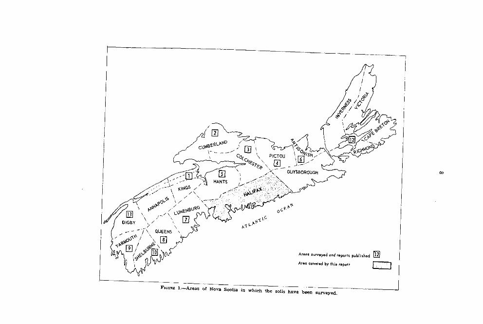
1. Areas of Nova Scotia in which the soils have been surveyed (map) . . . . . . . . 8
2. Population trends in Halifax County, 1371-1961 (chart) . . . . . . . . . . . . . . . . . . 9
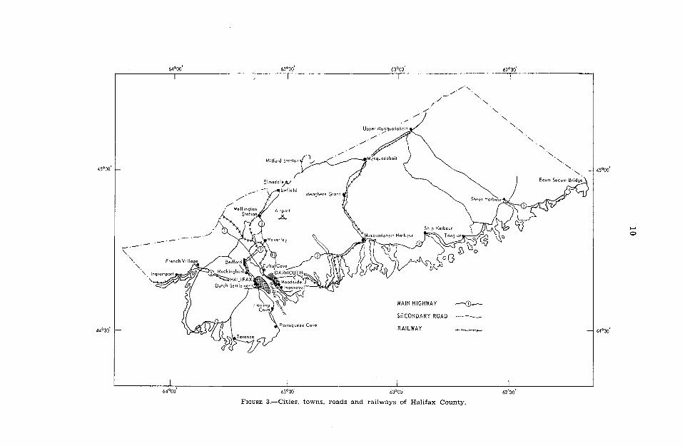
3. Map of Halifax County . . . . . . . , . . . . . . . . _. . . . . . . _. . . . . _ . . _. , . . . . . . . . 10
4. Monthly changes in precipitation and soi1 moisture at two stations (chart) . . 13
5. Parent materials of soils according to texture (map) . _ _ . . . . . . . . _ . . . _ . . , 14
6. Geological formations (map) . _ . . . . . . . . . . . . _ . . . . . . . . . . . . . _ . . . . . . . 15
7. Drainage systems, and 500-foot contours (map) . . _ . . . . _ . . . . _ _ . . . . . . . . . _ _ . 19
8. Wolfville soils on drumlin area . . . . . . . . . _ . . . . . . . . . . . . . . . . . . . . 24
9. Queens soils ,...,..............._,.,....,............................... 26
10. Cumberland and Stewiacke soils . . . . . . . . . . . . . . . _ . . . . . . . . . . . . . . . . . . 31
11. Rock land on granite bedrock . . . . . . . . . . . . . . . . . . . . . . . . . . . . . . . . . . . . . . . . . . . 3’7
12. Land-use capability classes . . . . . . . . . . . . . . . . . . . . . . . . . . . . (In box)
13. Chart for determining soi1 texture . . . . . . . . , . . . . . . . . . , . . . . . . . . . . . . . . . . . . 53

PREFACE
Because of the public demand for information on the soils of Halifax County, Nova Scotia, this soi1 survey report has been reprinted. During the years since the report was published, substantial changes have taken place in survey techniques, in the system of soi1 classification, and in soi1 evaluations. The latest edition of The Canadian System of Soil Clussijcution is available from authorized bookstore agents, other local bookstores, or by mail for $9.00 ($10.80 outside Canada) from the Canadian Government Publishing Centre, Supply and Services Canada, Hull, Que. KlA OS9. Your cheque or money order in Canadian funds should be made payable to the Receiver General for Canada.
The maps were recompiled on a new topographie base, which has created slight discrepancies along streams and other water features. It is necessary to regard with caution the dehneation of adjacent soils, such as stream floodplains.
A generalized soi1 map of the province was published in 1974 under the title: Soils of Novu Scotiu. A map depicting the suitability of Nova Scotia soils for septic tanks is also available. Address your requests to: Soils and Crops Branch, Nova Scotia Department of Agriculture and Marketing, Nova Scotia Agricultural College, Truro, N.S.
ACKNOWLEDGMENTS
The soi1 survey of Halifax County was a joint project of the Research Branch, Canada Department of Agriculture, and the Nova Scotia Department of Agriculture and Marketing.
The authors were assisted in the field work by Messrs. J. E. Hawley and J. G. Williams. Aerial photographs of the area were supplied by the Nova Scotia Research Foundation.
Dr. P. C. Stobbe, Director, Soi1 Research Institute, Ottawa, gave advice on classifying the soils in the field, and J. H. Day, Pedologist, Soi1 Research Institute, made helpful suggestions concerning the manuscript.
The base maps were supplied by the Department of Mines and Tech- nical Surveys, Ottawa, and the map was prepared for lithographing by the Cartographie Section of the Soi1 Research Institute, Ottawa.

INTRODUCTION
This report describes the soils of Halifax County and the factors affect- ing their formation and usefulness for agriculture. It is the thirteenth in a series of reports describing the soi1 resources of the province. Halifax County was surveyed during the summers of 1957 and 1958.
The first part of the report gives a general description of the area and the factors that affect the formation and use of the soils. The main part describes the soils in detail, their classification and suitability for use. The chemical and physical properties of some of the major soi1 types are described in the latter part of the report.
A soi1 map accompanying the report shows the locations of rivers, lakes, towns, roads and railroads, as well as the distributions of the various soils. The soi1 series, and their topography and stoniness, are shown by colors and symbols, which are described in the map legend.
Those interested in a particular area of land should first locate it on the map and refer to the legend, which gives a short description of each soil. More information is given in the text. The soi1 variations on an individual farm are usually too small to appear on a map of this scale. The report and map contain much information for those interested in soi1 conservation, wildlife, agricultural economics, highway construction and other fields in which soils play an important part.
CU
Y?-./ i c.-...--
--

GENERAL DESCRIPTION OF THE AREA
Location and Extent
Halifax County occupies the south-central part of Nova Scotia. The area is bounded on the south by the Atlantic Ocean, on the east by Guysborough County, on the west by Lunenburg and on the north by Colchester and Hants. Halifax County lies between 44”40’ and 451~15’ north latitude and between 62”lO’ and 64”15’ west longitude (Figure 1).
The County has an area of 2,293 square miles, or 1,46’7,729 acres, and is the largest county of the province. The greatest distance from east to west is 88 miles; from north to south, 28 miles.
Population, Towns and Industries
The population of the County in 1961 was 225,723. About 24 percent, or 54,444 persons, were rural dwellers, of whom 2,622 were on farms. The remaining or urban population was concentrated in the Halifax-Dartmouth area. The trend of population over the past 90 years is shown in Figure 2.
Halifax, with a population of 92,511, is the capital and largest city of the province. It was founded in 1749 by Hon. Edward Cornwallis with 2,576 colonists, mostly discharged soldiers and sailors. For 100 years previously fish- ing and trading posts had been established near the present site. The city is on a peninsula on the southwest shore of Halifax Harbor and is a major tenter of shipping, manufacturing, education, arts and sciences. The major manufactures are ships, bakery products, chocolates, electrical appliances, elec-
1871 1891 1911 1931 1951 1961
FIGURE 2.-Population of Halifax County, 1871 to 1961.
9

11
tronic equipment, paints, varnishes, building materials, beer and fish products. Repairing ships and fishing are also important industries. A large naval base at Halifax provides a market for a wide range of materials as well as considerable employment.
About two thirds of the wholesale trade of the province is handled through Halifax. A recently constructed abattoir provides an outlet for meat products to the farmers of the province.
Dartmouth, a city immediately across the harbor from Halifax, has a population of 46,966 and is rapidly growing. It has an oil refinery, an aviation plant, shipyards, and woodworking and building supply establishments. A modern bridge spans the harbour and the urban area Will probably expand mainly near Dartmouth.
Of the smaller towns, Sheet Harbour has a pulp and power development and Hubbards has important fisheries and woodworking. Bedford, Sackville, Waverly and Musquodoboit are a11 thriving communities and have very good shopping, recreation and educational facilities. Fishing, farming and forestry are basic industries in the County.
Transportation and Markets
Halifax County is well supplied with transportation facilities. Figure 3 shows the locations of the larger centers of population and the principal roads, railways and airports.
Halifax Harbour is one of the world’s finest and is capable of berthing the largest ships. During World War II it was the largest and most important naval base in Canada. Almost a11 exports from Nova Scotia as well as many from other parts of Canada are shipped to a11 parts of the world from this port. There is also steamship communication with many of the principal ports of the world.
Along the toast are many bays and inlets that make suitable harbors for fishermen and also facilitate shipping by water from the smaller communities to Halifax.
Paved highways connect Halifax and Dartmouth with other centers of the province and good secondary roads serve the settled areas of the County. A line of the Canadian National Railways from Halifax through Truro to Sydney serves the eastern part of the province and a line along the south shore to Yarmouth serves the western part. A line through Truro and Amherst to Montreal serves traffic between other parts of Canada and the eastern seaboard. A branch line from Dartmouth through Musquodoboit Harbour to Musquodoboit carries freight to and from the Musquodoboit Valley three times weekly. The Dominion Atlantic Railway operates a daily service from Halifax through the Annapolis Valley to Yarmouth. This is an important line for bringing produce from the Valley to Halifax.
A modern airport at Kelly Lake,, about 20 miles from Halifax, is equipped to handle the largest aircraft and provides passenger and freight service to a11 parts of the world. Trans-Canada Air Lines and Eastern Provincial Airways both operate from this airport.
The Halifax-Dartmouth area offers the largest market in the Province for farm produce. It uses much of the produce grown in the County and from surrounding counties, and some is imported from outside the province. With rapidly increasing population this market is expected to expand in the future.
FACTORS IN SOIL FORMATION
Soils are formed from various parent materials by the interaction of climate, vegetation, topography, drainage and time. The effects of these factors on soi1 development in Halifax County are described briefly as follows.
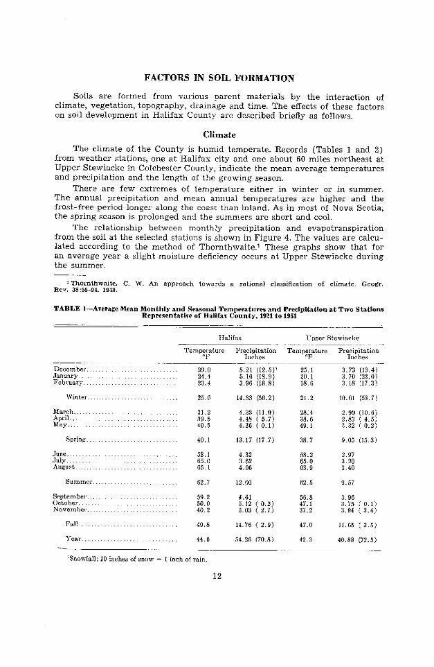
Climate
The climate of the County is humid temperate. Records (Tables 1 and 2) from weather stations, one at Halifax City and one about 60 miles northeast at Upper Stewiacke in Colchester County, indicate the mean average temperatures and precipitation and the length of the growing season.
There are few extremes of temperature either in winter or in summer. The annual precipitation and mean annual temperatures are higher and the frost-free period longer along the toast than inland. As in most of Nova Scotia, the spring season is prolonged and the summers are short and cool.
The relationship between monthly precipitation and evapotranspiration from the soi1 at the selected stations is shown in Figure 4. The values are calcu- lated according to the method of Thornthwaite .1 These graphs show that for an average year a slight moisture deficiency occurs at Upper Stewiacke during the summer.
‘Thornthwaite, C. W. An approach towards a rational classification of climate. Geogr. Rev. 38:55-94. 1948.
TABLE 1-Average Mean Monthly and Seasonal Temperatures and Precipitation at Two Stat.ions Representative of Halifax County, 1921 to 1951
TIalifax TTpper Stewiarke ~- - -
TemTt”re Precipitation
Inches TempPre Precc~t~stion
_- December. January February .
Winter.,
March.. April. May..
Sprint:
June.. July August.
58.1 65.0 65.1
4.32 58.2 2.97 3.62 65.0 3.20 4.06 63.9 3.40
Summel 62.7 12.00 62.5 9.57
September.. October. November.
59.2 50.0 40.2
56.8 47.1 37.2
Fall.
l-em.
49.8 14.76 ( 2.9)
54.26 (70.8)
47.0
42.3
3.96 3.75 ( 0.1) 3.94 ( 3.4)
11.65 ( 3.5)
40.88 (72.5)
29.0 5.21 (12.5)’ 24.4 5.16 (18.9) 23.4 3.9û (18.8)
. 25.6 14.33 (50.2)
31.2 4.33 (11.9) 39.5 4.48 ( 5.7) 49.5 4.36 ( 0.1)
40.1 13.17 (17.7)
25.1 3.73 (13.4) 20.1 3.70 (23.0) 18.6 3.18 (17.3)
21.2 10.61 (53.7)
28:4 2.90 (10.6) 38.6 2.83 ( 4.5) 49.1 3.32 ( 0.2)
38.7 9.05 (15.3)
LSnowfall; 10 inches of snow = 1 inch of min.
12

13
TABLE 2-Average Dates of Frosts and Average Numbers of Frost-free Days at Four Stations Representative of Halifax Countg
Station Lat. N.
Feet Long. EibOVe Years Frost- La& First
IV. mean sra free days spring fa11 level frostl frost’
Ecum Secum .............. 44%’ G2”08 ’ 10 119 hlay 30 September 26 Dartmoutb (airport). ...... 44”38’ G3’30’ 1% 7 171 May ï October 25 Halifax City ................ 44”39’ 63’38’ 152 May 13 October 12 Cpper Stewiacke. ... ... .. 45”15’ G3”OO’ 557 85 90 June 12 September 10
I32O 17. OP lomer.
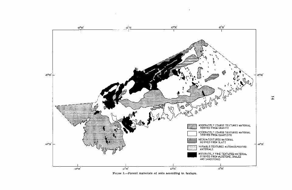
Parent Materials
The soils of the County have developed almost entirely from glacial drift. The distribution of the parent materials (Figure 5) is almost the same
as that of the underlying rock formations (Figure 6). This is particularly true of the coarse-textured materials derived from granite and quartzite. The finer-textured materials were moved somewhat further by the ice sheet and accumulated in deeper deposits. These deposits are often in the form of drum- lins or drumlin-like mounds.
Slate and quartzite bedrocks of Precambrian age underlie much of the County. The strata were originally formed as very deep deposits in shallow water and were later uplifted and strongly folded. During the Devonian age, great masses of molten granite intruded the bottom beds and crystallized while still deep below the surface. Subsequent weathering has removed most of the slates, which overlie the quartzite.
UPPER STEWIACKE
T-----l
HALIFAX
1
JFMAMJJASONDJ JFMAMJJASONDJ
-1 PRECIPITATION
MONTH
r-j SOIL MOISTURE DEFICIENCY
w WATER NEED
[m WATER SURPLUS
SOIL MOISTURE USED
m SOIL MOISTURE RESTORED FIGURE 4.-Monthly changes in precipitation and soi1 moisture at two representative stations.
I 6&‘00’
I I 63’30’ 63’00’
FIGURE 5.-Parent materials of mils according to texture.
I 62’30’

15

16
The parent material derived from granite is a pale-yellow, coarse sandy loam and is usually not very deep over bedrock. Water percolates rapidly through this material and consequently the soi1 has low water-holding capacity.
Parent material derived chiefly from quartzite is a pale-brown to olive sandy loam. It is also very thin over bedrock and very stony, but contains more fine material than that derived from granite and holds moisture slightly better.
The slate rock furnishes more fine material to the drift than either granite or quartzite and the resulting parent material ranges from an olive-gray sandy loam to loam. The material is usually thin over bedrock and contains numerous slate fragments along with some quartzite rock. This material holds moisture well and the soils formed from it are more suitable for agriculture than those formed from either granite or quartzite parent material.
In the Musquodoboit Valley area the parent material is reddish brown and moderately fine textured, ranging from sandy loam to sandy clay loam. The material is derived chiefly from sandstone, mudstones and shales of the Windsor series of Carboniferous age. Usually the material is fairly deep and moderately permeable and contains less stone than the other parent materials. Most of the better farms of the County are on this type of material. Some of it has been carried across the County to form drumlins near Dartmouth and along the coastal area east of Halifax.
Coarse-textured water-deposited materials occur in various parts of the County in the forms of kames, terraces and outwash. Recent alluvial sediments occur along the river and stream channels and vary in texture from sandy loam to silt loam. Soils formed from this material are important agriculturally since they are stone-free and fairly fertile.
Vegetation
The native vegetation of the County is forest and about ‘70” percent of the total land area is still in productive forest: softwood grows on 37 percent, mixed wood on 30 percent and hardwood on 3 percent. The dominant softwood species are red spruce (38 percent) and balsam fir (33 percent). The remainder are black spruce, white spruce, hemlock and pine. The most common hardwoods are red maple (50 percent) and yellow birch (24 percent), the principal other species being white birch, white ash, sugar maple and beech.
In many coastal areas, stands are inferior where the soils are wet and shallow. Barrens and burned-over areas support only wire birch and small quantities of yellow birch, fir, spruce, alder and poplar along with huckleberry, sheep laurel and blueberry. Poorly drained areas support stunted stands of fir, black spruce, red maple, tamarack, hemlock and alder; and #peat bogs covered with spagnum, clubmoss, cattails and sedges are found in very poorly drained areas.
On cultivated areas, timothy, red clover and brown top are grown for hay. Pasture grasses consist of brown top, red fescue, couchgrass and poverty grass. Often present are blue-eyed grass, greenbrier, goldenrod, spirea, wild rasp- berry and blackberry. In the wetter areas, spike rush, bog fern, bulrush, club moss and sedges are dominant.
Topography ad Drainage
Halifax County is an undulating plain rising gently from the Atlantic toast to an altitude of 500 feet at the northern boundary of the County. This plain is part of the Southern Upland, which extends from Yarmouth to Canso.
ZHawboldt, L. S.. and R. M. Bulmer. The forest resources of Nova Scotia, p. 94. N.S. Dept. Lands and Forests. 1958.
17
The underlying slate and quartzite beds (Figure 6), which occupy much of the County, have been steeply folded and faulted, particularly near Halifax and eastward. This made them more vulnerable to weathering and erosion. The slates, being softer, eroded more rapidly, SO that broad areas of quartzite rocks now enclose narrow bands of slate. In some areas, granite intrusions near the surface have become exposed. The granite and quartzite areas appear as a series of broad, low ridges that are marked by numerous boulders, fre- quent outcrops of bedrock and poorly drained depressions. In contrast, the slate areas have smooth ridges and slopes that are covered with fairly deep drift.
Drumlins are a feature of the landscape near Sackville and Dartmouth and in the eastern part of the County. In the Musquodoboit Valley, where the softer Carboniferous rocks overlie the rocks of the Southern Upland, the relief changes to long, smooth slopes characteristic of the lowlands. The parent material is generally deep, fairly free of stone and moderately well drained.
Lakes and rivers occupy about 8 percent of the County, or 119,800 acres. The Stewiacke, Musquodoboit, Tangier and Sheet Harbour rivers drain most of the area and a11 flow to the Atlantic Ocean (Figure 7). The coastline is much indented with bays, inlets and harbors, which provide protection for fishermen and often add to the scenery.

SOIL DEVELOPMENT AND CLASSIFICATION
The agencies of soi1 formation must act over a sufficiently long period for soils to reach a mature state of development. It is generally agreed that the last glaciation occurred about 10,000 years ago, SO that forces have acted at least that long. Decomposing vegetation under the existing climate forms organic acids, which are carried downward by percolating water. In the process salts, iron, aluminum and lesser amounts of clay and silt are removed from the surface minera1 soi1 and leached downwards. Many of these products of decom- position are deposited at lower depths. In time layers, or horizons differing in physical characteristics and chemical composition are formed parallel to the earth’s surface. A vertical section through these layers is called the soi1 profile.
The surface layer, consisting of organic material, is called the L-H horizon. The Upper minera1 part of the profile, from which the constituents have been removed, is called the A horizon. It is underlain by layers in which material from the A horizon has been deposited, forming a zone of accumulation, or B horizon. The C horizon, underlying the B, is the unweathered material simi- lar to that from which the Upper horizons have developed. Further subdivisions may be made within each horizon according to observable differences in char- acteristics.
This process takes place more rapidly in coarse-textured materials that have free drainage. The resulting profiles have the following characteristics. The L-H horizon consists of a thin layer of leaf litter and partly decomposed organic matter. This is underlain by a leached, or eluvial, horizon (Ae) of minera1 soi1 from which clay, bases, iron and aluminum have been removed. The illuvial (B) horizon is dark, distinctly colored by materials leached from the A horizon. It may be designated Bh, Bf or Bfh depending on the amounts present and coloring due to humus or iron compounds in the horizon. If the horizon is cemented it may be designated Bfhc. The C horizon is usually lighter colored than the B and more firm and dense.
Soils having these characteristics are known as Podzols. Many of the soils of the County belong to this group. In general the profile is drscribed as follows:
Horizon L-H
Ae Bfh
Bf C
Description Black, semidecomposed organic matter; transition to Ae abrupt. Light-gray to pinkish-gray minera1 soil; loose and friable. Dark-brown to reddish-brown minera1 soi1 becoming lighter in color with depth; usually finer textured than Ae. Yellowish-brown to light reddish brown minera1 soil. Unweathered parent material; various textures, colors and consistencies.
In another large group of soils in the County, development has been restricted by poor drainage and consequent lack of aeration. These soils are usually found at the feet of slopes, on low-lying areas or on nearly level land where a compact subsoil restricts the downward movement of water. These soils differ from the well-drained Podzol soils in certain characteristics. Usually the L-H horizon is thicker and contains more organic matter, the Ae and B horizon may be mottled with gray and yellowish-brown because of reduction of iron compounds in the presence of organic matter. This reduction process is
18

19
-.a c.7 f
‘ib9/ i,.’ ./

20
I
I I;

21
called gleying. Gleyed horizons are indicated by attaching the suffix g to the main horizon designation. As a group, these soils are known as Gleysols. A Gleysol profile is described as follows:
Horizon Description L-H Black, semidecomposed organic matter; often mucky in
appearance. Aeg Dark-gray to dark reddish gray minera1 soil; mottled with
light and dark patches. Bg Light-brown to Iight reddish brown minera1 soil; strongly
mottled with gray or strong-brown colors.
In the very poorly drained sites, the mottling may be much subdued and the lower horizons may be du11 gray.
Along present stream courses throughout the area, sediments have been deposited on flood plains. These materials have not had enough time to develop profiles. They are immature soils, or Regosols.
Another group of soils found in the County are the organic deposits. These are found in depressional areas and consist of successive layers of organic material in various stages of decomposition. Most of these soils are classed as peat.
How the Soils Were Mapped
Within each of the great soi1 groups there are local variations in charac- teristics such as texture, color or consistency or in parent material. On this basis the soils are separated into smaller groups called series. Al1 the soils in a series have developed from the same kind of parent material, have the same drainage and the same kind of profile. Each series may be divided into soil types, based on the texture of the surface soil. The soi1 type was the unit of mapping used in Halifax County.
The soi1 profiles were examined in pits dug in fields and forested areas and in the roadside exposures found in many parts of the surveyed area. The boundaries between various soi1 types were plotted on base maps with a scale of 1:50,000. Differences of slope and stoniness for each type were recorded. Notes were taken on the vegetation, crops, suitability for use, and present agricultural practices on the various soi1 types.
At the end of the survey, samples were taken of the major soi1 types for physical and chemical analyses. These analyses are given near the end of this report.
Classification of the Soils
The soi1 series found in the County are grouped in Table 3 to show their main relationships. The major differences in the soils are associated with differences in the texture and composition of the parent materials.
The soils in each horizontal row of Table 3 are developed from the same kind of parent material. They differ in characteristics produced by differences in drainage, such as the presence of mottling, accumulation of surface organic matter, or degree of development. The soils in each column have the same kind of profile, but become coarser in texture towards the bottom of the table.
DESCRIPTIONS OF THE SOILS
In the following descriptions, the soi1 color is followed by a set of symbols that designate the color in the Munsell system .3 The colors given are for moist soils.
Soils Developed from Fine-textured Parent MateriaIs
LAWRENCETOWN SERIES (2,949 acres) The Lawrencetown soils are poorly drained and occur in low basins and
nearly level areas in association with the imperfectly drained Queens soils. The soils occupy less than 1 percent of the County (Table 4) and are unim- portant agriculturally. They are developed from reddish-brown clay loam to clay lacustrine deposits. The parent material is usually varved, stone-free, plastic and impervious. The deposits are also deep. The topography is level to gently undulating and the tree caver consists mostly of hemlock, black spruce, red maple, alder and tamarack. A representative profile is described as follows:
Horizon Ah
Aci!
Bd
B@
C
Use
Depth Inches Description o- 3 Black (2.5YR 2/0) silty clay loam; slightly plastic; medium,
subangular blocky structure; pH 6.2. 3- 9 Gray (5Y S/i) silty clay loam; moderately plastic; weak
platy structure; mottled; pH 6.3. 9-18 Dark reddish gray (5YR 4/2) silty clay loam; medium,
subangular blocky structure; distinct mottles; plastic; pH 6.6.
18-24 Dark reddish gray (5YR 4/2) silty clay loam; plastic; impervious; coarse blocky structure; mottled; pH 6.9.
24+ Dark reddish brown (5YR 3/2) silty clay loam; massive, varved; plastic; impervious; pH 7.2.
The Lawrencetown soils are unsuitable for agriculture in their present condition because of poor drainage. About 36 percent of these soils would be productive if drained.
Soils Developed from Moderately Fine Textured Parent Materials
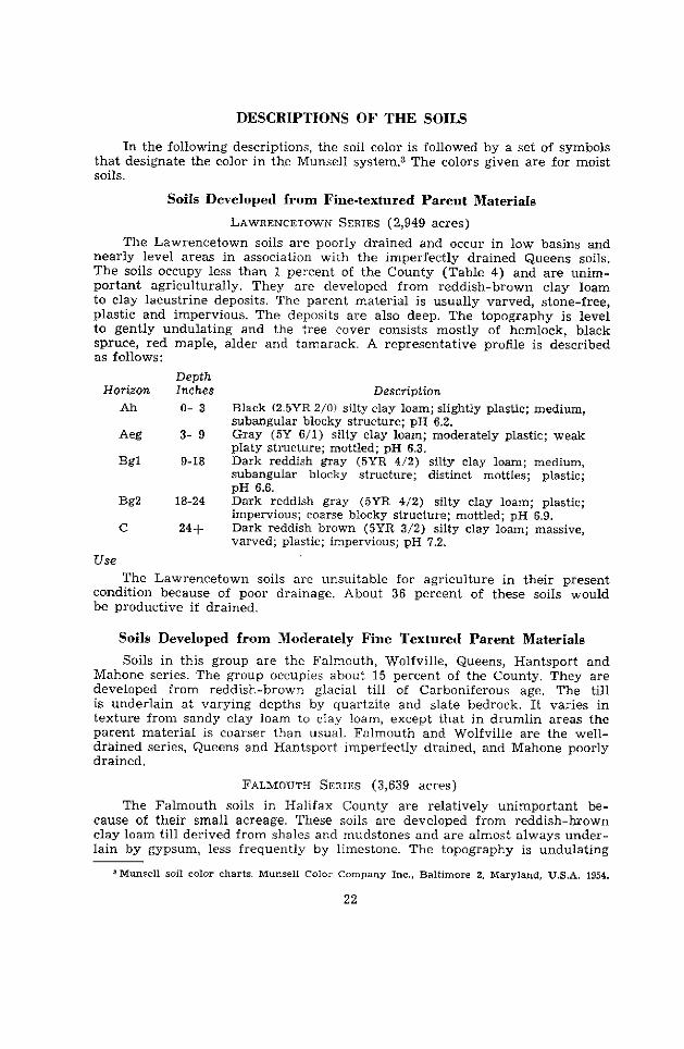
Soils in this group are the Falmouth, Wolfville, Queens, Hantsport and Mahone series. The group occupies about 15 percent of the County. They are developed from reddish-brown glacial till of Carboniferous age. The till is underlain at varying depths by quartzite and slate bedrock. It varies in texture from sandy clay loam to clay loam, except that in drumlin areas the parent material is coarser than usual. Falmouth and Wolfville are the well- drained series, Queens and Hantsport imperfectly drained, and Mahone poorly drained.
FALMOUTH SERIES (3,639 acres)
The Falmouth soils in Halifax County are relatively unimportant be- cause of their small acreage. These soils are developed from reddish-brown clay loam till derived from shales and mudstones and are almost always under- lain by gypsum, less frequently by limestone. The topography is undulating
JMunsell soi1 color charts. Munsell Color Company Inc., Baltimore 2. Maryland, U.S.A. 1954.
22
23
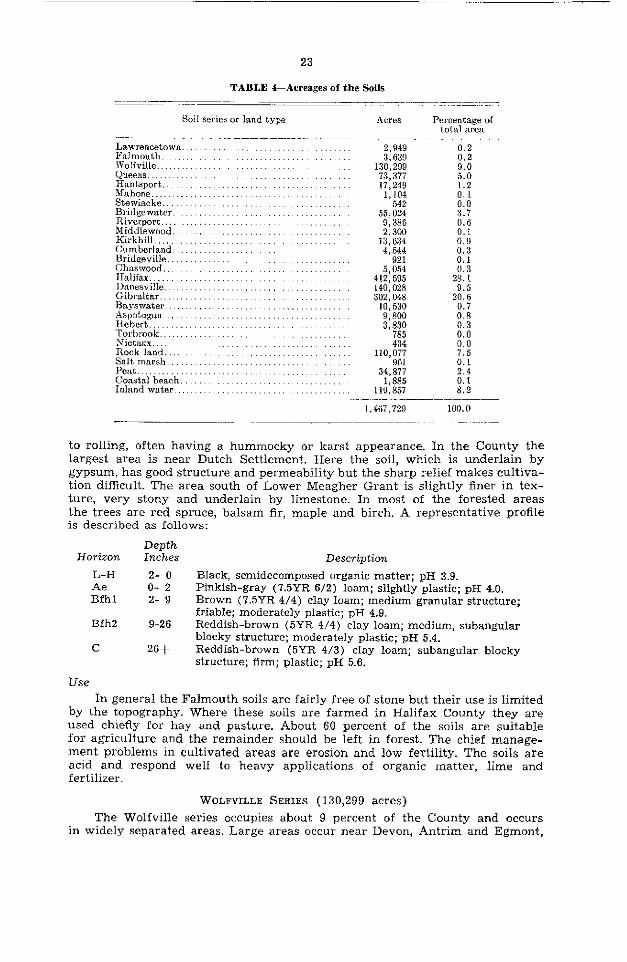
TABLE 4-Acreages of the Soils
Soi1 series or land type Acres Percentage of total area
Lawrencetown.. Falmouth.. Wolfville. Queens. I-Tantsport.. Mahone.. . Stewiacke.. Bridgewater. Riverport. Middlewood, Kirkhill Cumberland.. Bridgeville. Chaswood.. Halifax.. Danesville.. Gibraltar., Baysvfater. Aspotogan. Hebert.. Torbrook. Nictaux. Rock land. Salt marsh.. Pent . Coastal beach Inland water..
.........
..........
.........
.........
........
........ ........ ........
...<....
2,949 0.2 3,639
130,299 Y:0 ï3,37ï 5.0 17,249 1.2
1,104 0.1 542 0.0
55,024 3.7 9,38û 0.6 2,300 0.1
13, G34 0.9 4,544 0.3
921 0.1 5,054
412,595 140,028 302,048
10,530 9,800 3,830
785 434
110,077 961
34,877 1.885
119;F357 --~-
1,407,729
0.3 28.1
9.5 20.6
0.7 0.8 0.3 0.0 0.0 7.5 0.1 2.4 0.1 8.2
100.0
to rolling, often having a hummocky or karst appearance. In the County the largest area is near Dutch Settlement. Here the soil, which is underlain by gypsum, has good structure and permeability but the Sharp relief makes cultiva- tion difficult. The area south of Lower Meagher Grant is slightly finer in tex- ture, very stony and underlain by limestone. In most of the forested areas the trees are red spruce, balsam fir, maple and birch. A representative profile is described as follows:
Horizon L-H Ae Bfhl
Bfh2
C
Depth Inches Description 2- 0 Black, semidecomposed organic matter; pH 3.9. o- 2 Pinkish-gray (7.5YR 6/2) loam; slightly plastic; pH 4.0. 2- 9 Brown (7.5YR 4/4) clay loam; medium granular structure;
friable; moderately plastic; pH 4.9. 9-26 Reddish-brown (5YR 4/4) clay loam; medium, subangular
blocky structure; moderately plastic; pH 5.4. 26+ Reddish-brown (5YR 4/3) clay loam; subangular blocky
structure; firm; plastic; pH 5.6.
Use In general the Falmouth soils are fairly free of stone but their use is limited
by the topography. Where these soils are farmed in Halifax County they are used chiefly for hay and pasture. About 60 percent of the soils are suitable for agriculture and the remainder should be left in forest. The chief manage- ment problems in cultivated areas are erosion and low fertility. The soils are acid and respond well to heavy applications of organic matter, lime and fertilizer.
WOLFVILLE SERIES (130,299 acres) The Wolfville series occupies about 9 percent of the County and occurs
in widely separated areas. Large areas oçcur near Devon, Antrim and Egmont,

24
near Shubenacadie Lake and Sackville, and also in the Dartmouth area. Smaller, isolated areas of drumlins (Figure 8) occur near Dartmouth and the Halifax-Guysborough border.
These soils are developed from reddish-brown till derived from shale, sandstone and mudstone of Carboniferous age. The till is mainly sandy clay loam but varies from gravelly clay loam to loam. The areas bordering the Queens soils have a finer texture. On the drumlins near Sackville and Dart- mouth in the eastern part of the County, the till is generally lighter in tex- ture. The topography ranges from gently undulating to the characteristic drumlin topography, where slopes range up to 15 percent. A few of the drum- lins are only capped with the reddish-brown material and the texture of this is lighter and the interna1 drainage more rapid. The Wolfville parent material in general is fairly deep in some areas near Devon and South Uniacke. In a few places the soils are stony, but on much of the acreage stoniness is not a serious problem. A fairly large acreage of Wolfville soi1 still in forest is suitable for agriculture. The principal trees are red spruce, balsam fir, birch, maple, hemlock and aider. A sandy loam under forest is described as follows:
Horizon L-H Ae
Bfhl
Depth Inches z- 0 o- 3
3-10
Bfh2 10-20
BC 20-30 C 3Of
Description Black, semidecomposed organic matter; pH 3.8. Pinkish-gray (7.5YR 6/2) sandy loam; friable; porous; pH 4.2. Dark-brown (7.5YR 4/4) sandy loam; medium granular structure; friable; moderately porous; sticky when wet; pH 4.5. Strong-brown (7.5YR 5/6) sandy loam; weakly developed, fine granular structure; moderately porous; compact; pH 4.9. Reddish-brown (5YR 4/3) loam; moderately firm; pH 5.2. Dark reddish brown (5YR 4/3) loam; firm; some stone; pH 5.2.
25
Use Where Wolfville soils are deep enough they are suitable for most crops
grown in the area. About 60 percent of the soils are arable. Shallowness over bedrock and stoniness limit the use of the remainder to forestry.
TO maintain high yields the soils need generous applications of lime, fertilizer and organic matter. On some of the steeper slopes, contour tillage should be used to guard against erosion.
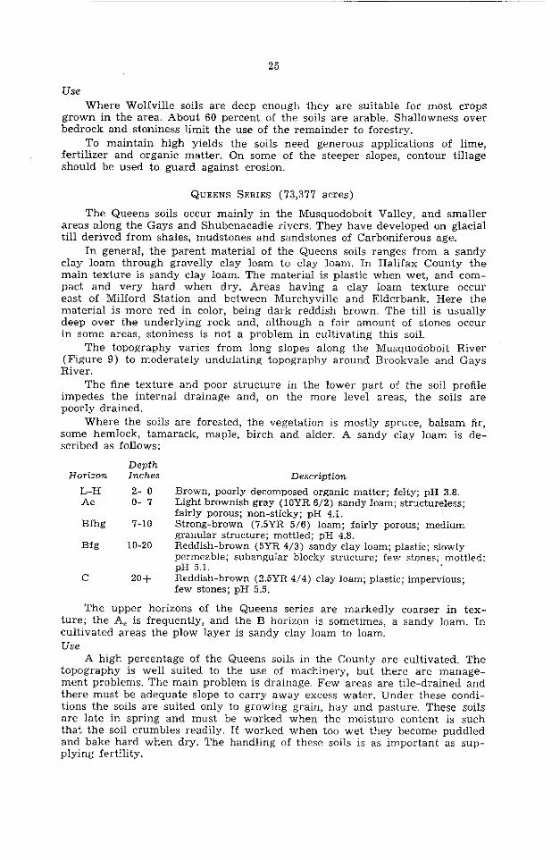
QUEENS SERIES (73,377 acres)
The Queens soils occur mainly in the Musquodoboit Valley, and smaller areas along the Gays and Shubenacadie rivers. They have developed on glacial till derived from shales, mudstones and sandstones of Carboniferous age.
In general, the parent material of the Queens soi& ranges from a sandy clay loam through gravelly clay loam to clay loam. In Halifax County the main texture is sandy clay loam. The material is plastic when wet, and com- pact and very hard when dry. Areas having a clay loam texture occur east of Milford Station and between Murchyville and Elderbank. Here the material is more red in color, being dark reddish brown. The till is usually deep over the underlying rock and, although a fair amount of stones occur in some areas, stoniness is not a problem in cultivating this soil.
The topography varies from long slopes along the Musquodoboit River (Figure 9) to moderately undulating topography around Brookvale and Gays River.
The fine texture and poor structure in the lower part of the soi1 profile impedes the interna1 drainage and, on the more level areas, the soils are poorly drained.
Where the soils are forested, the vegetation is mostly spruce, balsam fir, some hemlock, tamarack, maple, birch and alder. A sandy clay loam is de- scribed as follows:
Horizon
L-H Ae
Bfhg
Bfg
C
Depth Inches Description 2- 0 Brown, poorly decomposed organic matter; felty; pH 3.8. o- 7 Light brownish gray (10YR 6/2) sandy loam; structureless;
fairly porous; non-sticky; pH 4.1. 7-10 Strong-brown (7.5YR 5/6) loam; fairly porous; medium
granular structure; mottled; pH 4.8. 10-20 Reddish-brown (5YR 4/3) sandy clay loam; plastic; slowly
permeable; subangular blocky structure; few stones; mottled; pH 5.1.
20+ Reddish-brown (2.5YR 4/4) clay loam; plastic; impervious; few stones; pH 5.5.
The Upper horizons of the Queens series are markedly coarser in tex- ture; the A, is frequently, and the B horizon is sometimes, a sandy loam. In cultivated areas the plow layer is sandy clay loam to loam. Use
A high percentage of the Queens soils in the County are cultivated. The topography is well suited to the use of machinery, but there are manage- ment problems. The main problem is drainage. Few areas are tile-drained and there must be adequate slope to carry away excess water. Under these condi- tions the soils are suited only to growing grain, hay and pasture. These soils are late in spring and must be worked when the moisture content is such that the soi1 crumbles readily. If worked when too wet they become puddled and bake hard when dry. The handling of these soils is as important as sup- plying fertility.

26
FICURE g.-me Queens soils occupy rolling topography in the Musquodoboit Valley.
The natural fertility of thr Queens soils is not high. Efficient production requires the maintenance of reasonable levels of organic matter, adequate applications of a balanced fertilizer and the correction of the acidity of the cultivated layer. The farms on the Queens series are mostly in dairy produc- tion with some mixed farming. The chief crops grown are hay, oats, barley, corn and small amounts of intertilled crops. The soils are unsuitable for commercial production of hoed crops because of the fine texture, imperfect drainage or danger of erosion.
Under good management the Queens soils are capable of high production of grass. At present they are not being used to their full capabilities. More fertilizer and lime should be used and a higher fertility maintained throughout the rotation. Organic matter levels shouId be high and particular attention should be paid to external drainage. Al1 of the Queens soils are arable.
HANTSPORT SERIES (17,249 acres)
The Hantsport soils are imperfectly drained and occupy about 1 percent of the County. The larger areas occur at Meagher Grant and east of Dartmouth.
These soils are developed from reddish-brown glacial till derived from Carboniferous shales and sandstones. The main texture of the till is sandy clay loam but a few variations of gravelly clay loam and clay loam are found. The sandier textures occur where quartzite and slate material is mixed with the till. They are associated with the Wolfville soils and often occur over slate or quartzite bedrock and, like the Wolfville soils, they are in places shallow and stony.
The topography is gently undulating but along the toast near Dartmouth the soils occur on the lower or flatter drumlins, where run-off is slow. The forest vegetation is mostly red and black spruce, balsam fir, hemlock, aider, red maple and birch.
A representative profile occurring on a drumlin under forest is described .as follows:
Horizon
L-H Ae
Bgjl
Depth Inches Description
2- 0 Grayish-black, semidecomposed fibrous mor; pH 3.9. o- 4 Reddish-brown (5YR 4/4) sandy loam; friable; moderately
sticky when wet; porous; structureless; pH 4.1. 4- 9 Reddish-brown (5YR 4/4) sandy clay loam; weakly de-
veloped granular structure; sticky when wet; moderately .slow interna1 drainage; mottled with strong-brown stains
Bgj2 (7.5YR 5/6-5/8) ; pH 4.5.
9-19 Reddish-brown (5YR 4/4) sandy clay loam; slightly plastic; mottled; pH 4.6.
C 19+ Reddish-brown (2.5YR 4/4) sandy clay loam; fairly com- pact in place; slightly plastic; moderately slow perme- ability; pH 4.9.
In these soi& east of Dartmouth the surface horizons are lighter in texture and the B horizon is sometimes yellowish red (5YR 4/8).
Use Where drainage is moderately good and there are not too many stones,
the Hantsport soils are being farmed successfully. They are capable of growing a moderately wide range of crops. The acidity must be corrected and fertility levels must be raised and maintained for effirient yields. At Eastern Passage the shallowness of the till over bedrock restricts the drainage but does not inter- fere with cultivation. The acreage in hoed crops is not large; those grown include cabbage, beets, carrots and potatoes. About 85 percent of these soils are arable.
MAHONE SERIES (1,104 acres)
The Mahone soils are poorly drained and occur in association with the Hantsport and Wolfville series. They have a very small acreage scattered over the County and are unimportant agriculturally. They are developed from reddish sandy clay loam till of Carboniferous age; the till is often shallow over slate or quartzite bedrock and often is mixed with these materials. The soils occur on level to depressional topography and are wet for the greater part of the year. The principal trees are hemlock, black spruce, alder and tamarack. A sandy loam is described as follows:
Horizon L-H Aeg
Bhg
Depth Inches Description 3- 0 Brownish-black, semidecomposed greasy mor. o- 4 Gray (2.5YR 5/0) sandy loam; some silty areas; massive
but friable. 4- 6 Very dark grayish brown (1OYR 3/2) sandy loam; medium
Bg 6-15 c 15f
granular structure; friable; porous; mottled. Dark-brown (7.5YR 4/4) loam; firm; mottled; impermeable. Reddish-brown (5YR 4/3) sandy clay loam; some granitic material.
Use The Mahone soils are not used for agriculture because. of poor drainage.
About 60 percent could be farmed if drainage were improved, but at present this is not economically feasible.
STEWIACKE SERIES (542 acres) The Stewiacke soils are well-drained alluvial deposits. Their total acreage
in the County is small. They occur as small areas along the Shubenacadie River and at Upper Musquodoboit along the Musquodoboit River.
28
The deposits are stone-free and vary from silt loam to silty clay loam. Occasional flooding of these soils still occurs and additional sediments are added to their surface from time to time. The soils are immature and do not have distinct horizons. The deposits are at least five feet deep, usually over grave1 or coarser sediments. Interna1 drainage is adequate.
A soi1 under grassland cultivation is described as follows:
Depth Horizon Anches Description
AP O- 6 Dark-brown (7.5YR 4/2) silt loam (cultivated layer); medium granular structure; friable; porous.
Cl 6-12 Dark-brown (‘7.5YR 4/2) silt loam; medium granular to subangular biocky structure; slightly plastic; moderately friable.
c2 12-24 Brown (7.5YR 4/4) silt loam; slightly plastic; moderately porous; distinct stratification.
Along the Shubenacadie River the soils are more reddish and slightly finer in texture. When cultivated, they have a dark-brown very fine sandy loam to silt loam surface layer.
Use The Stewiacke soils are fertile and highly productive. They are a11 used,
chiefly for grassland but to a lesser extent for grain and intertilled crops. Inter- tilled crops are grown only where the danger of seasonal flooding is not too great. The soils are easy to work, but some areas have poor air drainage and a short frost-free period. They respond well to treatments of lime, fertilizer and organic matter. Al1 of the soils are arable.
Soils Developecl from Meclium Texturecl Parent Materials
The soils developed from till include the Bridgewater, Kirkhill, Riverport, and Middlewood series. They occupy about 15 percent of the County and are developed from material derived from Precambrian slates. The till is olive colored and has a shaly loam texture. The Kirkhill and Bridgewater soils are well drained, the Riverport soils imperfectly drained and the Middlewood soils poorly drained.
Soils occurring on medium-textured alluvium included in this group are the well-drained Cumberland, the imperfectly drained Bridgeville and the poorly drained Chaswood series. They occupy less than .1 percent of the County and occur mainly along the Musquodoboit River. The deposits consist of sediments washed from local uplands and deposited by flood waters of the various rivers and streams.
BRIDGEWATER SERIES (55,024 acres) The well-drained Bridgewater soils occur as small areas scattered through-
out the County. They occupy less than 4 percent of the total area and less than half of them are suitable for agriculture.
The soils are developed from a medium-textured, olive-colored glacial till that is derived principally from the Precambrian slates. In Halifax County the slate exposures are usually small and quartzite and granite fragments are often mixed with the slaty till. In such cases the texture of the parent material is coarser. A few areas have some fine-textured Carboniferous ma- terial mixed with the till and the resulting texture may be a sandy clay loam.
The topography of the Bridgewater soils is undulating with some drum- linoid ridges and steep slopes. About half of the soils are shallow and usually
stony. The areas most suitable for agriculture occur on the drumlin topography or in undulating areas where there is a good depth of drift over the bedrock.
29
The vegetation is mostly spruce, balsam fir, red maple, hemlock, some pine, birch, beech and poplar. A represemative shaly loam under this vegetatjon is described as follows:
Horizon
L-H
Ae
Bfhl
Bfh2
C
Use
Depth Inches Description
2- 0 Dark reddish brown (5YR 2/2), poorly decomposed organic matter; pH 4.1.
o- 2 Gray (2.5Y 5/0) shaly loam; porous; weakly developed platy structure; pH 3.8.
2- 7 Light olive brown (2.5Y 5/4) to yellowish-brown (10YR 5/4) shaly loam; porous; friable; weak granular structure; pH 4.7.
7-18 Olive (5Y 5/4) loam; firm; structureless; porous; shale fragments; pH 4.9.
18+ Olive (5Y 4/3) shaly loam; fîrm but porous; numerous shale fragments; pH 5.1.
The Bridgewater soils are well suited for forest production. Where the till is deep enough and not too stony they are suitable for hay, grain, vege- tables and pasture or for most crops. Fertility levels are low and lime needs to be used. In dry years the soils are likely to be slightly droughty, but if kept high in fertility and organic matter they yield very good crops. About 40 percent of this series is arable land.
RIVERPORT SERIES (9,386 acres)
The Riverport soils occupy less than 1 percent of the surveyed area. They are found as small, imperfectly drained areas in association with the Bridge- water series. The texture and appearance of the Riverport soils are similar to those of the Bridgewater series, but they are darker colored and mottled in the B horizon. The soils are often shallow and stony. Forest vegetation is red maple, spruce, hemlock, blueberry and lambkill. The profile described below occurs on undulating relief:
Depth Horizon Inches Description
L-H 3- 0 Black, semidecomposed greasy mor. Aeg o- 3 Gray (2.5Y 6/0) shaly loam; friable; mottled. Bfhgj 2- 8 Brown (IOYR 4/3) loam; friable; structureless; mottled. BZ 8-16 Light olive brown (2.5Y 5/4) loam; friable; structureless;
mottled; slate fragments. C 16-b Dark grayish brown (2.5Y 4/2) shaly loam; slightly
mottled; many shale fragments.
Quartzite stone makes up much of the coarse fragments of this soil.
Use Only a very small acreage of the Riverport soils has been cleared for
cultivation. About 60 percent of these soils are too stony or shallow for agri- culture and should be left in forest.
MIDDLEWOOD SERIES (2,300 acres)
The Middlewood soils occur as small areas in various parts of the County in association with the Bridgewater and Riverport series. They are poorly drained soils developed from slate parent material on Ievel to depressional
30
topography. Drainage is restricted by the bedrock, which is usually close to the surface. Many quartzite and slate stones occur on the surface and in the profile. Forested areas have black spruce, tamarack, hemlock, and alder. A typical soi1 is described as follows:
Depth Horizon Inches Description
L-H 4- 0 Black, fairly well decomposed greasy mor. Aeg 0- 6 Dark-gray (5Y 4/1) loam; firm; many yellowish-brown
(IOYR 5/8) mottles. J% 6-14 Dark grayish brown (1OYR 4/2) shaly clay loam; firm;
strong-brown (7.5YR 5/6) mottles; massive. C 14+ Olive-brown (2.5Y 4/4) shaly clay loam with gray (5Y
5/0) streaks; compact.
Ground water is often at or very near the surface for a large part of the year. The profiles of this soi1 are always shallow and often have a thick, mucky surface.
Use The Middlewood soils are unsuitable for agriculture and should remain in
forest.
KIRKHILL SERIE~ (13,634 acres) Only one area of Kirkhill soils was mapped. This area is along the border
between Colchester and Halifax counties north of the Musquodoboit Valley. The parent material of the Kirkhill soils is olive shaly loam glacial till.
This is shallow over most of the area and rock outcrops and slate ledges are common. The topography is undulating, consisting of fairly long smooth ridges which are generally forested as they are too shallow for agriculture. The principal trees are red spruce, balsam fir, maple and birch. The soils are generally well drained, but mottling may occur in many profiles due to the shallowness over the bedrock. A shaly loam is described as follows:
Depth Horizon Xnches Description
L-H l- 0 Brown, semidecomposed organic matter. Ae o- 2 Light-gray (2.5Y 7/2) shaly loam; loose and porous. Bfhl 2- 7 Dark-brown to dark yellowish brown (1OYR 4/3-4/4) shaly
loam; friable; medium granular structure; porous; high organic matter content.
Bfh2 7-16 Brown (10YR 5/3) to dark grayish brown (2.5Y 4/2) shaly loam; porous; friable; many shale fragments.
C 16+ Olive (2.5Y 4/4) shaly loam; many stones; very shallow to bedrock.
Use The Kirkhill soils are too shallow and often too stony for agriculture. A few
small areas have been cleared and are farmed. The soils are well suited to forest and should be used for this purpose.
CUMBERLAND SERIES (4,544 acres) The Cumberland soils (Figure 10) are well-drained alluvial deposits along
streams and rivers throughout the County, but chiefly along the Musquodoboit River. They occupy only about 0.3 percent of the County, but are important because they are a11 under cultivation.
The topography of these soils is level and usually free from erosional pits and ditches. The deposits are underlain by grave1 at depths varying from one

31
to five feet. The soils are preferred to upland soils since they are level, stone- free and more fertile. They are easy to work, have good water-holding capacity and are porous. They are, however, subject to flooding in spring or fall, have poor air drainage and have a short frost-free period.
The Cumberland soils do not have distinct horizons. Soi1 material is often added to the surface during flooding, and helps to maintain a fairly high fertil- ity. The only trees are an occasional elm and some alder .and shrubs along rivers and streams. A fine sandy loam is described as follows:
Depth Horizon Inches Description
AP 0- 6 Dark-brown (‘7.5YR 4/2) fine sandy loam; friable; medium granular structure; porous; pH 5.3.
Cl 6-12 Reddish-brown (5YR 4/4) fine sandy loam; friable; porous; pH 5.5.
C2 12-20 Reddish-brown (5YR 4/4) fine sandy loam; friable; a few indistinct mottles; pH 5.6.
20+ Brown (7.5YR 4/4) sandy loam; loose; stratification and sand lenses; pH 5.6.
Use The Cumberland soils are used to a large extent for hay and grain, but
are suitable for a wide range of crops, if reasonable tare is exercised. Chiefly timothy and clover are grown for hay and with good management give high yields. The soils require organic matter and lime and respond well to fertilizer. Where flooding does not often occur, they are excellent for vegetables and intertilled crops. Poor air drainage and a short frost-free period are limitations. Al1 of the soils are arable.
BRIDGEVILLE SERIES (921 acres) The Bridgeville soils are imperfectly drained alluvial deposits found in
association with the Cumberland and Stewiacke soils.
FIGURE lO.-Cumberland and Stewiacke soils OCCUI on the level flood plains along the main rivers.
32
The topography is level to depressional. The texture ranges from fine sandy loam to clay loam on the surface and in the subsoil. Runoff from the surround- ing upland and a high water table keep the soils wet in spring and fall. The surface horizon is usually darker colored than in the Cumberland soils and mottling and even gleying may occur in the surface horizon. A silt loam is described as follows:
Horizon
AP
C&
cgj2
IIC
Use
Depth Inches Description 0- 6 Very dark brown (10YR 2/2) silt loam; slightly plastic.
6-17 Brown (‘7.5YR 5/2) silt loam; slightly plastic; distinct brown (7.5YR 5/4) mottles.
17-30 Dark-brown (7.5YR 4/4) to strong-brown (7.5YR 5/6) silt loam; plastic; mottled; stone-free.
30+ Grave1 and Sand.
The Bridgeville soils at present are used only for hay or pasture and, until drainage cari be improved, this is their best use.
CHASWOOD SERIES (5,054 acres) The Chaswood series includes a11 the poorly drained recent alluvial soils
of the County. They occur on depressional topography next to the upland or farthest from the river and consequently receive a good deal of runoff from the upland. The main texture of these soils is silt loam, but variations from fine sandy loam to clay loam occur. The soi1 often has a peaty or mucky surface. The subsoil is usually gleyed and strongly mottled. Vegetation consists mostly of sedges and reeds. A profile is described as follows:
Depth Horizon Inches Description
AP o- 8 Dark-gray (10YR 4/1) silt loam; plastic. cg 8-30 Grayish-brown (2.5Y 5/2) silt loam; plastic; impervious;
noncalcareous.
The surface horizon may at times be fairly well decomposed organic silt loam to silty clay loam. The subsoil may often be gleyed silty clay loam over reddish-brown material.
Use Except for some use as rough pasture the Chaswood soils are unsuitable
for agriculture because of poor drainage.
Soils Developed from Moderately Coarse Textured Parent Materials
Soils in this group occupy 60 percent of the County. They include the well- drained Halifax and Gibraltar, the imperfectly drained Danesville and Bays- water and the poorly drained Aspotogan series. The soils are stony, often shal- low and generally unsuitable for agriculture.
HALIFAX SERIES (412,595 acres)
The Halifax series occupies about 28 percent of the surveyed area, more than any other series in the County. The soils are well to excessively drained and occur largely in the central and eastern part of the County. The parent material is olive to yellowish-brown sandy loam to gravelly sandy loam glacial till derived chiefly from quartzite. The topography is gently undulating with a rough microrelief. The soils are often shallow and usually stony and porous

33
and the profile is strongly leached. Near the toast the Ae horizon is thicker than in the soils farther inland, and the upper B is darker and thicker but is less than three inches.
The principal trees are red spruce, white spruce, balsam fir, hemlock, pine, maple and birch. A silt loam is described as follows:
Horizon L-H
Ae Bfh
Bf
C
Depth lnches Description 3- 0 Black (10YR 2/1) organic matter; slightly fibrous but fairly
well humified; pH 3.4. o- 3 Light-gray (2.5Y 7/2) silt loam; friable; porous; pH 3.6. 3- 5 Very dark grayish brown (10YR 3/2) silt loam; fine
granular structure; porous; friable; pH 4.9. 5-17 Yellowish-brown (10YR 5/6) silt loam; fine granular
structure; friable; porous; pH 5.1. 17+ Olive (5Y 5/3) gravelly silt loam derived from quartzite
till; porous; pH 5.0.
The profile described above is finer-textured than the main type, which is Halifax sandy loam.
In general the Halifax soils are too stony for agriculture. A few small areas have been cleared of stone and are farmed on a small scale. About 2,000 acres, or 0.5 percent of the soils cari be used for agriculture, but have very severe limi- tations. These limitations are stoniness, low fertility and droughtiness. Where the soils have a good depth of till, they support good forest vegetation and this is their best use. Where they are cleared and farmed, it is important to maintain high levels of organic matter to increase the moisture-holding capacity. It is also necessary to use heavy applications of a balanced fertilizer and to correct the acidity with lime.
DANESVILLE SERIES (140,028 acres) The Danesville soils are imperfectly drained and occupy about 10 percent
of the County. They occur in association with the Halifax soils and are derived from similar parent material. As in the Halifax soils, this material is stony and shallow and consequently the soils have severe limitations for agriculture. The main texture is gravelly sandy loam to stony sandy loam. The topography is undulating with rough microrelief and small depressional areas. The water table is often present in the lower part of the profile. In coastal areas, organic matter impregnates the Ae horizon, the Bfh is thicker than in the soils farther inland and the profile is darker colored. Forest vegetation is spruce, balsam fir, hemlock, red maple, and birch along with an undergrowth of labrador tea, lambkill and blueberry in the more sparsely wooded areas. A profile in a poorly wooded area is described as follows:
Depth Hori‘~oll Ilzches Description
L-H 3- 0 Black, semidecomposed greasy mor. Ae o- 5 Gray (10YR 5/0) sandy loam; friable; medium granular
structure. Bfhgjl 5- 9 Dark reddish brown (5YR 2/2) sandy loam; medium
granular structure; friable; porous; mottled; stony. BfhTj2 Y-17 Dark-brown (7.5YR 4/4) sandy loam; friable; mottled. C 17+ Dark-brown (7.5YR 4/4) sandy loam; firm; mottled; stony.
Where Danesville soils are found on shallow areas between drumlins of Wolfville soi1 there is some mixing of the two tills.
34
There are no significant areas of Danesville soils being cultivated. These soils should remain in forest.
GIBRALTAR SERIES (302,048 acres)
These soils occupy about 20 percent of Halifax County and are well to excessively drained. They occur in the western part of the County and also as a band extending eastward from Waverley to Sheet Harbour. A smaller area occurs in the northeastern corner of the County.
The parent material has a sandy loam texture and is derived from granite. The soils are shallow, extremely stony, porous, and have low moisture-holding capacity. Thé topography is undulating to rolling and a characteristic feature of the landscape is the’frequency and size of the boulders that litter the sur- face. Many areas that were burned over are now barrens. Where the till is deep enough, forest vegetation is mainly spruce, fir, maple and birch. A representative profile is described as follows.
Horizon L-H Ae
Bfh
Bfhc C
Depth Inches Desc?%ption 4- 0 Black, semidecomposed, fibrous, greasy mor. o- 4 Pinkish-gray (7.5YR 6/2) sandy loam; structureless; very
friable and porous. 4- 5 Very dark grayish brown (IOYR 312) sandy loam; firm;
porous; weakly developed platy structure; stony. 5-12 Brown (7.5YR 4/4) sandy loam; strongly cemented; stony. 12+ Pale-brown (10YR 6/3) gravelly sandy loam; porous;
stony.
Gibraltar profiles are shallow, seldom more than 20 inches thick. The Ae horizon is relatively thick and the B horizon is usually thin with an incipient Bh beneath the A, horizon. The texture throughout the profiles is usually a sandy loam.
Use The soils are unsuitable for agriculture due to excessive stoniness. A few
isolated areas have been cleared and are farmed or used for blueberry produc- tion. The soils should be left in forest.
BAYSWATER SERIES (10,530 acres)
The Bayswater soils are imperfectly drained and occur in association with the Gibraltar series. Like the Gibraltar soils they are derived from shallow and stony granitic till. The main texture is gravelly sandy loam and the topography is undulating to depressional. Forest vegetation is mostly spruce, fir, hemlock, tamarack and aider. A representative profile is described as follows:
Depth Horizon Inches Description
L-H 4- 0 Dark-brown to black peaty organic matter over black greasy mor.
Ae o- 4 Bfhcgj 1
Gray (2.5Y 5/0) sandy loam; structureless; very friable. 4- 6 Very dark grayish brown (10YR 3/2) sandy loam; weakly
Bfh& developed platy concretions; friable; porous; mottled.
6-15 Brown (10YR 4/3) sandy loam; firmly cemented; stony; mottled.
C 15+ Yellowish-brown (IOYR 5/6) sandy loam; stony; porous.

35
The Upper part of the B horizon is more strongly developed in coastal areas and varies from one to three inches thick. The profile is mottled in the Ae horizon and always cemented in the lower B. Use
There are no areas of Bayswater soils at present being farmed. The soils are unsuitable for agriculture chiefly because of stoniness and should be left in forest.
ASPOTOGAN SERIES (9,800 acres) The Aspotogan soils occur on depressional topography in association with
the Halifax and Gibraltar soils. They are poorly drained and are derived from gravelly sandy loam till that is shallow and very stony. These soils usually have a heath-type vegetation of lambkill, sphagnum moss and sweet fern along with balsam fir, spruce, tamarack and alder. The water table is at or near the surface for a good part of the year. A representative profile is described as follows:
Horizon L-H Aeg Bfhg
Bg C
Use
Depth Inches Description 5- 0 Black peaty organic matter. o- 4 Dark-gray (5Y 4/1) sandy Ioam; friable; mottled; stony. 4- 8 Dark-brown (7.5YR 3/2) sandy loam; friable; mottled;
structureless; stony. 8-20 Olive-gray (5Y 4/2) sandy loam; friable; mottled; stony. 20+ Olive (5Y 5/3) stony sandy loam; some quartzite stones.
The Aspotogan soils are unsuitable for agriculture because of stoniness and poor drainage.
soi18 Developed from Coarse-Textured Parent Materials
This group of soils is developed from coarse-textured, stratified parent materials deposited as outwash plains, kames, and river terraces. They are a11 well to excessively drained.
HEBERT SERIES (3,830 acres)
Small areas of Hebert soils occur at many points in the County, but chiefly along the larger rivers and streams. The parent material is grave1 and interbedded Sand and finer sediments of mixed origin. The topography varies from gently undulating to kame-type hills and river terraces. The color of the parent material ranges from reddish brown to grayish brown. A soi1 under spruce and fir vegetation is described as follows:
Horizon L-H Ae
Bfhl
Bfh2
C
Depth Inches Description
2- 0 Dark-brown (7.5YR 3/2) fibrous organic matter. o- 2 Pinkish-white (7.5YR 8/2) sandy loam; loose and porous;
structureless. 2- 5 Yellowish-brown (IOYR 5/6) sandy loam; very friable
and porous; poorly developed granular structure. 5-18 Yellowish-brown (1OYR 5/4) sandy loam; friable but firm
in place. 18+ Strong-brown (7.5YR 5/6) gravelly sandy loam; fairly
compact; stratified layers of Sand and gravel.
36
The cultivated layer is usually yellowish-brown (10YR 5/4) sandy loam. Many areas are easily cleared of surface stone and the soils have a fair water- holding capacity. Some cementing may occur in the lower B horizon.
Use These soils are farmed in many areas, but chiefly along the Musquodoboit
and Gays rivers. The soils may be used for a wide range of crops, their chief disadvantage is that they are droughty. Where used, they must be well sup- plied with organic matter and nutrients for good yields. The profile is acid throughout and the use of lime is necessary for most crops. About 90 percent of these soils are arable.
TORBROOK SERIES (785 acres)
These soils are formed from deposits of sand and grave1 derived chiefly from slate. The deposits occur as eskers, kames and outwash material. Most of the soils have been cleared of forest and, where surface stone is not a problem, they are cultivated. A soi1 under spruce and balsam fir is described as follows:
Depth Horizon Inches Description
L-H l- 0 Very dark brown (10YR 2/2) organic matter; pH 4.8. Ae o- 5 Gray (5Y 5/1) gravelly sandy loam; loose; structureless;
pH 4.4. Bfh 5-13 Yellowish-brown (10YR 5/6) sandy Ioam; fine to medium
granular structure; friable; pH 4.6. Bfhc 13-20 Dark yellowish brown (10YR 4/4) gravelly sandy loam;
moderately cemented; pH 5.0. C 20-k Olive-brown (2.5Y 4/4) grave1 derived chiefly from slate.
The cultivated layer is dark yellowish brown (10 YR 4/4) sandy loam with a fine crumb structure.
Use These soils are droughty, but are used chieffy for small gardens and culti-
vated crops. They require organic matter, fertilizer and lime.
NICTAUX SERIES (43.4 acres)
The Nictaux series occurs chiefly around Musquodoboit Harbour. The parent materials are stratified sand and grave1 derived chiefly from granite. The soi1 has little agricultural value and is used chiefly for road material. A profile is described as follows:
Depth Horizon Inches Description
L-H 6- 0 Very dark brown (10YR 2/2) organic matter. Ae 2-14 Pinkish-gray (7.5YR 6/2) gravelly sandy loam; porous;
structureless; loose. Bfh 14-15 Dark reddish brown (5YR 2/2) sandy loam; granular
structure; porous. Bfhc 15-28 Yellowish-brown (10YR 5/4) gravelly loamy Sand; moder-
ately cemented; some stones. C 28+ Pale-brown (10YR 6/3) coarse sand and gravel.
Use This soi1 is not used for agriculture but has value as road material.
Rliscellaneous Soi16
PEAT (34,877 acres) The organic soils in Halifax County consist of peat formed in depressional
areas, old lake beds and ponds. Thrse soils occur throughout the County, but
37
FIGURE 11,Rock outcrops and boulders are common on the areas mapped as rock land. The bedrock is chiefly granite.
many are found near the toast. Brown, semidecomposed fibrous material com- posed chiefly of sphagnum moss forms the surface layer to a depth of one to three feet. The underlying material, in various stages of decomposition, is dark brown and fibrous. The deposits are very acid t.hroughout and saturated with water. They are unsuitable for agriculture.
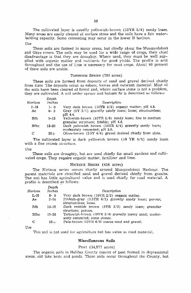
ROCK LAND (110,077 acres) The areas of this land type have bedrock exposed on at least 60 percent of
the land surface, or the till is extremely shallow or stony (Figure 11). They occur over granite or quartzite rock formations and make up about ‘7 percent of the surveyed area. The land has little value except for water storage or wild- life.
SALT MARSH (961 acres)
Salt marsh occurs at various places along the toast as tidal deposits. The largest of these is at West Lawrencetown. The sediments are made up of gray silt or silt loam and are flooded periodically. Vegetation consists of sait-tolerant species of reeds and grasses. The deposits have not been used for agriculture and have little value.
COASTAL BEACH (1,885 acres)
Various coastal beaches have been formed by wave action. The deposits are gray and vary in texture from fine sand to coarse gravel. These areas have no agricultural value, but are important for recreation.
LAND USE
Much of Halifax County is forested. There are 439 farms occupying 93,102 acres, or about ‘7 percent of the land area (Table 5). The farms average 210 acres but vary considerably in size. In 1961 there were 30 farms larger than 600 acres and 149 less than 69 acres. Slightly over 1 percent of the land area is cleared for cultivation or rough pasture, or about 42 acres of improved land per farm.
TABLE b-Acres of Farm Land in Various Uses, 1961
Total land area.. 1,320,320 Areainfarms........................................ 93,102 Numberoffarms.................................... 439 Improved
Fieldcrops...................................... 10,610 Pasture.......................................... 4,816 Other.. . 1,838 Total.. . . 17,264
Unimproved Woodland. Other................................. ,,.....,_. Total
75 > 838 11.055 86,893
The farm population of the County is 2,622, or about 1 percent of the total. Most of the farms are in the Musquodoboit Valley, between Dartmouth and Porters’ Lake and around Sackville. There is a ready market at Halifax and Dartmouth for a11 farm products, but the average farm income is small. Many farmers supplement their incomes with part-time employment, mainly in fishing and lumbering.
There were 10,044 acres of field crops grown in 1961 (Table 6). Of this area 84 percent was used for hay and 12 percent for oats. An additional 492 acres was in vegetables and tree and small fruits.
TABLE &-Acres of Field Crops, 1961
Al1 field crops.. Hay Oatsforhay....... .._.._...............,,...,,,..._ Oats. . Potatoes............................................. Turnips, swedes, mangles.. Other field crops..
10,044 8,467
164 1,063
159
1:;
Dairying and mixed farming account for the largest part of the agricultural production in the County (Table 7). For May, 1961, milk production was over a million pounds. Egg production for the same period was about 70,000 dozen. From 1951 to 1961, there were increases in the numbers of hogs and poultry while other livestock decreased.
TABLE ?-Types and Numlt;s of Livestock and Poultry,
Horses............................................... Cattle.. Cows and heifers milking.. Sheep..... .._.........__........_....._............ S ‘e wm . . . ..<...<........._..............._...._......_ Hens and c’hickens..
250 6,416 2,707
892 5,714
Turkeys.................................,,.......... 123,680
3,230
38
39
Halifax County has about 70 percent of the land area in productive forest (Table 8). This is made up of about 37 percent softwood, 29 percent mixed wood and the remainder hardwood. Forest products are an important source of revenue and the County should have a well-planned forestry program. Under the present system of management, forest production is far below its potential.
TABLE t&-Acreages of Various Classes of Land, 19581 --~-.
Land class ACWS Percentage of total area
Forestland............ .._.. ..,......................... _. 1,059,000 72.5 Coniferousforest..... .._............._..... ..__ 548,000 37.5 Mixedforest................. .._..... ._. 432,000 29.6 Deciduousforest............ .._.. 3.1 Total, productive forest.
45,000 1,025,OOO 70.2
Depletedforest...................... 34,000 2.3 Nonforested and nonproductiveland-
Brush land, rock barren, and old burn net being restocked, 155,000 10.6 Waste land-
Tidal and mud flats, marsh, muskeg with stunted trees, sand and grave1 pits. capes and quarries.
@arz;2ural and other improved land.. 50,000 81,000 5::
Lakes, rivers and estuaries.. Totalarea................
114,000 .._ 1.459.000 10;: 0
' Hawboldt, L. S., and R. M. Bulmer. 1958.
The forest resources of Nova Sc&ia, p. 122. N. S. Dept. Lands and For&s.
Land-use Classes
The soils of the County were grouped (Figure 12 (in box), Tables 9-15) according to the characteristics that permanently affect their suitability for use: stoniness, topography, drainage, depth, fertility and texture. On this basis there are eight land-use capability classes, in which the physical factors impose increasingly severe limitations on the use of land for crops. Classes 1 to IV are suitable for cultivated crops, pasture or woodland, but the alternate uses become fewer and the risks greater from Class 1 to Class IV. Classes V to VIII are best suited to pasture or forest.
Within each class, the soils may be grouped according to the kind of physical limitations on use such as stoniness, wetness, shallowness and slope or erosion hazards. They may be further subdivided into textural groups that have nearly uniform management requirements.
In Tables 9-14 the soils are listed with their topographie and stoniness symbols as they appear on the soi1 map. The symbols for topography are:
Symbol Topogruphy Slope % A Level to gently undulating . . . _ . . . . . . _ . . . . . . . o-3 B Undulating to gently rolling . . . . . . . . . . . . . . . . . . 4-8 C Strongly undulating to rolling . . . . . . . . . . . . . . . 9 -16 D Strongly rolling to hilly . . . . . . . . , . . . . . . . . 17-30
The symbols for stoniness are: Symbol Degree of Stoniness
0 Stone-free
1 Slightly stony; no hindrance to cultivation 2 Moderately stony; enough stone to interfere with cultiva-
tion unless removed 3 Very stony; enough stone to be a serious handicap to
cultivation 4 Excessively stony; too stony for cultivation
40
Land-use Capability Glass 1 Land in this class.is easy to work and cari be cultivated safely by ordinary
good farming methods. The soils are deep, fertile and productive, The land is nearly level and there is little or no erosion. The soils must have ti frost-free period of 100 or more days.
No significant area of land in Halifax County meets these standards.
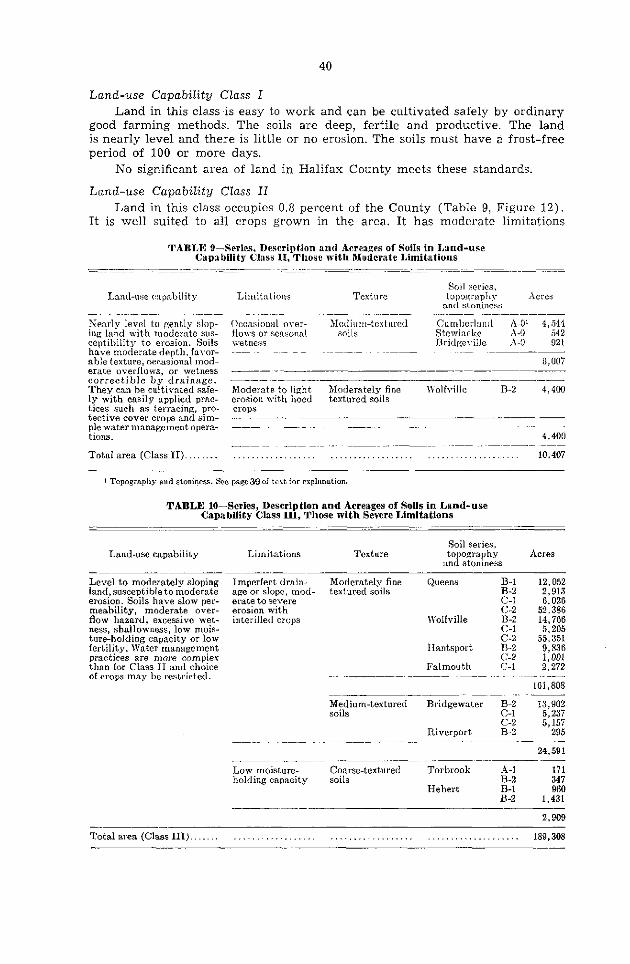
Land-use Capability Glass II Land in this class occupies 0.8 percent of the County (Table 9, Figure 12).
Tt is well suited to a11 crops grown in the area. It has moderate limitations
TABLE 9-Series, Description and Acreages of Soils in Land-use Capabi1it.y Class II, Those with Moderate Limitations
Land-use capability
?Tearly level to gently slop- ing land with modernte sus- ceptibility to erosion. Soils hsve moderate deptb, favor- able texture, occasional mod- erate overflows, or wetness correctible by drainage. Thev cari be cultivated safe- ly mith easily applied prac- tices such as terracing, pro- tective caver crops and sim- ple water management opera- tions.
Total area (Class II). . .
Limitations Texture Soi1 series.
topozrapll> ad stoniness
Acres
Occasional orer- Jlediam-textured ComberIant d-01 4,544 flows or sensorinl soils Stemiacke A -0 542 wetness Bridgerille il-0 921 _---~~-.-~.-~--
G, 007 ~- .~-
Moderate to light Moderately fine Wolfville B-2 4,400 erosion with hoed testured soils WOp3
_~~.- ~- -~ ~~
4,400 _--.~_---- ..,,......._..,,.. . . . . . . . . . . . . . . . ..<.............. 10,407
1 Topography and stoniqss. Sec page39 of test for explanstion.
TABLE lO-Series, Description and Acreages of SOUS in Land-use CapabiIity Class III, Those with Severe Limitations
Soi1 series, Land-use capability Limitations Texture topography Acres
and stoniness --- Level to moderately sloping Imperfect drain- Moderately fine Queens B-l 12,052 land,, susceptible to moderate age or slope, mod- textured soils B-2 2,913 eroslon. Soils bave slow per- erate to severe C-l 6,026 meability, moderate over- erosion with c-2 52,386 flow hasard, excessive wet- interilled crops Wolfville B-2 14,766 ness, shallowness, low mois- C-l 5,205 ture-holding capacity or low 55,351 fertility. Water management Hantsport $12 9,836 practices are more compler c-2 1,001 than for Glass II and choice Falmouth C-l 2,272 of crops may be restricted. -_~-~--~-- ~~
161,808
g;ltium-textured Bridgewater B-2 13,902 C-l 5,237
g:; 5,15i
Riverport 295
--- Low moisture- holding capacity
Coarse-textured soils
Torbrook
Hebert
24,591
A-l 171 B-2 347 B-l 960 B-2 1,431
2,909
Total area (Class III). . . . . . . . . . . . . . . . . . . . . . . . . . . . . . . . . . . . . . . . . . 189,308
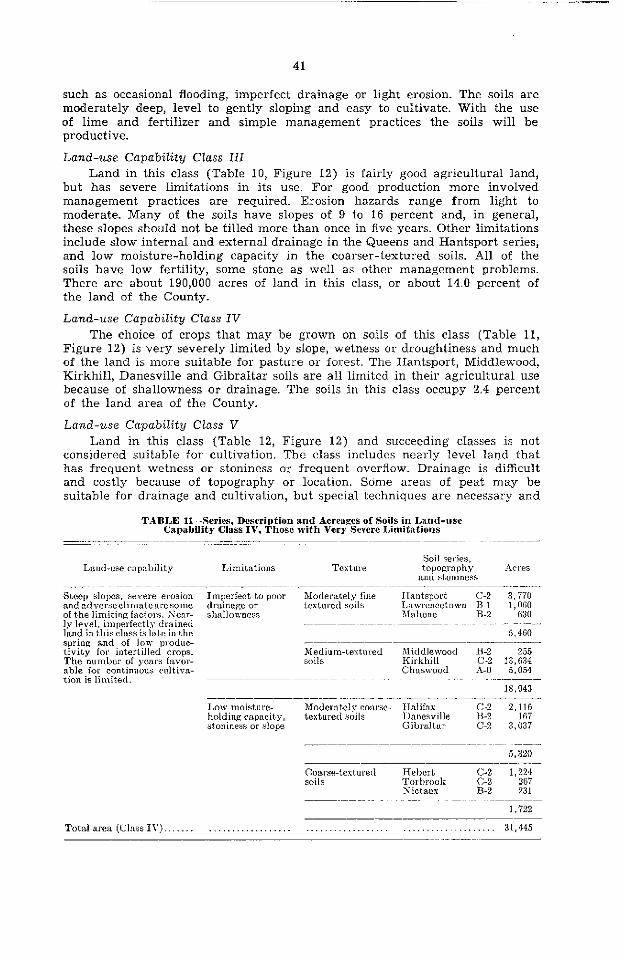
41
such as occasional flooding, imperfect drainage or light erosion. The soils are moderately deep, level to gently sloping and easy to cultivate. With the use of lime and fertilizer and simple management practices the soils Will be productive.
Lund-use Capability Glass III Land in this class (Table 10, Figure 12) is fairly good agricultural land,
but has severe limitations in its use. For good production more involved management practices are required. Erosion hazards range from light to moderate. Many of the soils have slopes of 9 to 16 percent and, in general, these slopes should not be tilled more than once in five years. Other limitations include slow interna1 and external drainage in the Queens and Hantsport series, and low moisture-holding capacity in the coarser-textured soils. Al1 of the soils have low fertility, some stone as well as other management problems. There are about 190,000 acres of land in this class, or about 14.0 percent of the land of the County.
Land-use Capability Glass IV The choice of crops that may be grown on soils of this class (Table 11,
Figure 12) is very severely limited by slope, wetness or droughtiness and much of the land is more suitable for pasture or forest. The Hantsport, Middlewood, Kirkhill, Danesville and Gibraltar soils are a11 Iimited in their agricultural use because of shallowness or drainage. The soils in this class occupy 2.4 percent of the land area of the County.
Land-use Capability Class V Land in this class (Table 12, Figure 12) and succeeding classes is not
considered suitable for cultivation. The class includes nearly level land that has frequent wetness or stoniness or frequent overflow. Drainage is difficult and costly because of topography or location. Scime areas of peat may be suitable for drainage and cultivation, but special techniques are necessary and
TABLE Il-Series, Description and Acreages of Soils in Land-use Capability Glass IV, Those with Very Severe Limitations
Land-use capability Limitations Texture Sd series. topowaphy
and stoniness rlcres
Steep slopes, severe erosion andadverseclimatearesorne of the limiting factors. Sear- ly level. imperfectly drained land in this class is late in the spring and of low produc- tivity for intertilled crops. The number of years favor- able for cont.innous cultiva- tion is limit,ed.
Imperfect to poor Moderately fine Iraatsport~ C-2 3 ii0 drainage 01 testured soils Lawrencetown n-1 1:otjo shallowness Mahone R-2 630
5,460 _~---~--~ ~-- Bfedium-testored Xiddlewood R-2 255 soils Kirkhill c-2 13,634
Chaswood A-O 5,054
18,943
Low moisture- Modelately couse- Halifax c-2 2,116 holding capacity, testured soils Danesville n-2 167 st,oniness or slope Gibraltar C-2 3,037
5,320
Coarse-texturetl soils
Hehert Torhrook Xictaus
C:i 1,224
267 6-z 231
1,722
Total area (Class IV). . . . . . . . . . . . . . . . . . . . . . . . . . . . . . . . . . . . . . . . . . . . . . . . . . 31,445
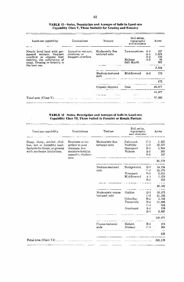
42
TABLE l%Serles, Description and Acreages of Soils in Land-use CapabBity Ciass V, Those Suitable for Grazing and Forestry
Land-use capability Limitations Texture Soi1 series,
tmwwhy Acres and stoniness
_- .
Nearly level land with per- Excessive wetness, Moderately fine Lawrencetown A-O 187 marrent wetness, frequent stoniness, or textured soils A-l 1,574 overflow or climate that frequent overflow A-2 128 restricts the cultivation of Mahone A-2 crops. Grasing or forestry is Salt Marsh 92 the best use. ---
2,934
Medium-textured soils
Middlewood A-2 172
172
Organic deposits Peat 34,877
34 < 877
Total area (Class V). . ..<...... .._._. 37,983
TABLE 13-Series, Description and Acreages of Soils in Land-use Capabiiity Glass VI, Those Suited to Forestry or Rough Pasture
Land-use capability Limitations Texture Soi1 series. topography
and stoniness Acres
__ -__-- .~. - -~-- ~_~- .-.
Steep, stony, eroded, shal- Stoniness or im- Moderately fine Falmouth C-3 1,367 low, wet or droughty land. Perfect to poor textured soils Wolfville C-3 50,577 Suitable for forest, or grasing drainage, low Hantsport B-3 1,845 wit.h moderate limitations. moisture-holding Mahone il-2 243
capacity, shnllow- B-3 147 ness.
54,179
hfedium-textured soils
Bridgewater
Riverport hfiddlewood
B-3 14,734 c-3 14,579 B-3 9,091 A-3 1,275 B-3 423
40,102 -- -~- --- ---- Moderately coarse Halifax B-3 19,673 textured soils c-3 81,106
Gibraltar B-3 2,156 Danesville B-3 21,885
c-3 654 Aspotogan A-3 570
B-3 2,427
128,471
Coarse-textured Hebert soils Xictaux
B-3 215 c-3 203
418
Total area (Glass VI). ........................................ ................... 223,170

43
one must consider many factors before undertaking the cultivation of these soils. Class V land occupies 2.8 percent of the land of the County.
Land-use Capability Glass VI The land in this class (Table 13, Figure 12) is suitable only for forestry.
A few areas may be used for rough pasture but the soils are too stony, shallow or wet for cultivation. Glass VI land occupies 16.5 percent of the land of the County.
Land-use Capability Glass VII The land in this class (Table 14, Figure 12) is suitable only for forestry
and wildlife. It includes steep, stony, shallow and very wet land and accounts for 55.2 percent of the land of the County.
Land-use Capability CEass VIII Land in this class (Table 15, Figure 12), which occupies 8.3 percent of
the land of the County, has value only as food and shelter areas for wildlife and water storage. Coastal beaches, which are included in this group, are im- portant as recreational areas.
TABLE 14-Series, Description aod Acreages of Soils In Land-use Capability Glass VII, Those Sulted to Forestry aod WUdlife
Land-use capability Limitations Texture
- Very steep. stony, shallow, eroded or swampy land chiefly suited to forestry and wildlife. Limited areas suit- able for grazing.
Total area (Glass VII).
Soi1 series. topozraphy
and stoniness Acres
Slope, stoniness or Moderately fine Hantsport B-4 797 imperfect to poor textured soils drainage -~ _---
797
Medium-textured Britlgewater B-4 soils Middlewood A-4
- --~-~-
1,415 175
1,590
Moderately coarse Halifax textured soils
Gibraltar
Danesville
Bayswater Aspotogan
38,405 271,295
:2 13,930 282,925
B4 115,628 1,694
B2 10,530 $2 4,352
2,451
741,210 ~--....~
.<.....,< .,.....,...,<..... 743,597 -
TABLE 15-Series, Description and Acreages of Soils in Land-use Capability Class VIII, Those Suited for Wildlife or Recreation
Land-use capability Limitations Texture Soi1 series, topography
and stoniness Acres
Very steep, rough, stony, Rockiness Rock Land 110,077 sandy, wet, or severely Coastal Beach 1,885 eroded land --~ Total area (Class VIII). . . . ...<... ..<....<......... 111,962
Total land area of the County. 1,347,872

44
TABLE 16--SuitabiIity RatingS of Soils in Classes II to IV for Selected Crops? -~~~~ ..- ~-
Soi1 Series Acres Ha>, Grain I’asture Potatoes kvegetables ~- ~---~_-
CLASS II-Go&. .............. 10,407 Cumberland ............... 4,544 E E Stewiacke. ................ .ï42 E 5; G Bridgeville. ............... 921 G 1: Wolfville .................. 4,400 G G G
CLASS III-GOOD TO F>UR ...... 189,308 Queens. .................... ï3,376 G G Wolfville ..... .. _ ......... ï5v 322 : Hantsport~ ................ 10,837 G G-1:
G
1~alrnoutll.. ................ 2,272 G G Y Bridgemater., ............. 24,296 G Riverport .................. 295 G-F g-1: Torbrook .................. 518 1?-1’
,$f < a 1.-- 1’
Hebert., ................. 2,391 11’ F E CL‘ISS IV-FAIR TO I’OOR. ...... 31,648
Hantsport ................. 3,170 G-F F c-1; L awrencetown. ............ 1,060 13’ 1’ F Mahone ................... 030 1: 1’ 1; Middlemood ............... 255 ;: 1p E’ Iiirkhill .................. 1X.634
5,054 1; 1.. Y
Chaswood ................. 1’ 10 Halifax .................... 2,116 1.‘ 11’ F Danesville. ................ 167 GF 1‘. G-F Gibraltar., ................ 3,037 y-p 1:-I> 1:-l-> Ilebert. ................... 1,224 Torbrook .................. 267 g-p
F 1: 1:-p F-P
Sictaos. ................... 434 1’ 1’ 1’
1 E. excellent; G. ~ood; 17. fair: 1’. po»r. ? Classes Y to 1.111 are unsuitable for asrieulture.
Crop Arlaptability Rat+s
Soils that are suitable for trop land may vary in their ability to produce a specified trop because of inherent fertility and physical composition. In the discussion above; the soils were grouped on the basis of characteristics that Iimit their use. In Table 16, the soils in classes II to IV are rated on their suitability for crops grown in the area. The ratings of excellent, good, fair and poor for the crops shown are based largely on observations and knowledge of the characteristics of the soils. The ratings should be based on reliable trop yields since this is the best measure of the suitability of a soi1 for a specified trop. Since these data are not available, the ratings are very general. A soi1 rated as unsuitable for most crops may be ideally suited to the produc- tion of a single trop. Soils suitable for a wide range of crops are rated higher than those adaptable to only a few crops. The ratings assume normal good management practices.
Management of Soils
The following is information on practices in soi1 management.
Drainage Poorly drained soils must be drained by open ditches or tile drainage
before satisfactory trop yields cari be obtained. Whether or not a poorly drained soi1 should be artificially drained Will depend on factors such as trop value, soi1 type and expense involved in drainage. In Halifax County, artifi- cial drainage could be used to control seasonal flooding of alluvial soils and also to improve local wet areas in otherwise well-drained soils.
Irrigation Irrigation boosts trop yields. The cost of installation, however, may make
its use prohibitive for low-value crops. For some vegetable and small fruit

crops, particularly strawberries, it has proven very successful. For these crops an irrigating system may be used to increase yields, control quality and prevent frost damage in spring. Crops on sandy soils that are low in organic matter Will .suffer from moisture deficiencies even in short periods of dry weather.
Fertïiity Al1 upland soils in the County are low in natural fertility. They are also
acid throughout the profile. Proper management of these soils Will involve liming, conservation of humus and raising the level of fertility by growing legumes and using commercial fertilizers.
Few crops grow well on an acid soil. This is not due to the acidity alone since soi1 acidity in itself is not harmful to most plants. It is the secondary effects of soi1 acidity that are unfavorable to plant growth. Acid soils usually contain soluble aluminum in amounts toxic to plants. Also, beneficial soi1 bacteria, such as those that convert organic nitrogen to nitrate and those that fix atmospheric nitrogen, do not thrive in an acid medium. High acidity usually indicates a low level of available calcium and magnesium in the soil. Most crops and soi1 bacteria require fairly high levels of these elements for optimum growth and activity.
With the exception of a few crops, notably potatoes, strawberries and blueberries, the soi1 pH should be raised to between 6.0 and ‘7.0 for good growth. In this range there is optimum bacterial activity, soluble aluminum is reduced to a low level and there is little danger of lowering soluble man- ganese or iron to the deficiency level. Boron, however, may become deficient at this pH.
Lime should be applied to the soi1 at two to three tons per acre on plowed land. Additional lime should be applied in four or five years if the need is indicated.
Humus Humus is an essential constituent of agricultural soils and maintaining it is
one of the greatest problems. in soi1 management. Reasonably high levels of humus improve the water-holding capacity and structure of the soil, increase resistance to erosion, and ensure a continuing supply of nitrogen and other nutrients through microbiological activity. Humus also aids in aeration and helps to prevent clodding in fine-textured soils.
Because of its importance the conservation of humus should be considered and understood by a11 who work with’the soil. The content of soi1 humus is lowered by clean cultivation and summer fallowing. It is conserved by main- taining the soi1 under grass caver. Healthy crops of grasses and legumes, with the use of barnyard manure, Will maintain and usually raise the level of soi1 humus. In livestock farming it should not be necessary to plow down green manure crops. The practice is costly and has only a short-term effect on the level of soi1 humus because of the rapid decomposition of this material. The plant nutrients supplied may be applied directly and without delay in commercial fertilizer.
Commercial Fertilizers Adequate drainage, use of lime and maintenance of humus levels Will not
give efficient or satisfactory trop yields. These practices must be supplemented by the use of commercial fertilizers. The plant nutrients used by the trop or lost through leaching must be replaced in some way. A portion is returned through plant and animal residues. Some nitrogen may be replaced by nitrogen- fixing bacteria, but most soils Will not regenerate by natural means a11 the

46
available nitrogen, phosphorus, calcium and potash needed for good trop growth. Crops of high value, such as vegetables, flowers, small fruits and potatoes, may return the cost of heavy rates of fertilizer application. Grain and hay usually Will not. In any case the law of diminishing returns should govern the rates of application.
Foliar sprays cari be used for crops showing deficiency symptoms; epsom salts is used for magnesium deficiency and borax for boron deficiency. Rates of application Will depend on the trop.
Erosion The erosion hazard in Nova Scotia is not as great as in many other areas
of North America because SO little land in Nova Scotia is cultivated. Fields in sod and not overgrazed are in little danger from erosion. However, con- tinuous intensive production of root crops, vegetables or potatoes on many soils could result in severe gully, ri11 and sheet erosion.
The erodibility of soils depends on the caver, texture and structure, degree and length of slope and amount of organic matter. Practically a11 of the erosion in the County is caused by water. TO ensure that water erosion losses are kept to a minimum the following recommendations should be observed:
1. Production of vegetable and root crops should be confined to soils with A and B slopes (O-8 percent). However, on slopes of 4-8 percent, moderate to severe erosion cari occur under clean cultivation. High humus levels and plowing and cultivating with the contour Will reduce this danger.
2. Soils with C slopes (9-16 percent) Will show moderate to severe erosion under clean cultivation and are best suited to hay or pasture. If cultivated, these soils should be strip-cropped on the contour and have grassed drainage- ways.
3. Soils with D slopes (17-30 percent) are too steep for cultivation but may make good pasture if reseeded and fertilized.
4. Soils with E slopes (above 30 percent) should be left in forest.

DISCUSSION OF ANALYTICAL DATA
The results of chemical and physical analyses of four representative pro- files are given in Tables 1’7 and 18. The samples were taken under virgin conditions except for the Bridgewater sandy loam. Many of the soils have been mapped elsewhere in the province and their chemical and physical characteris- tics have been recorded in other reports. Much of the analysis is of interest to workers in soi1 genesis and classification. The physical analysis was determined by the pipette method.3
Organic Matter and Nitrogen
The loss on ignition is a rough measure of the organic matter content of the sample. The determination was made at a temperature of 750” C. The total carbon is an accurate measurement made by dry combustion of samples and measurement of the carbon dioxide given off. The Bfh horizons of Halifax and Bridgewater soils are high in organic matter. These soils were not classed as Humic Podzols, but some of the profiles resemble this group of soils. The soils near the toast are darker colored and probably have a higher organic matter content than soils farther inland.
The level of total nitrogen is proportional to the carbon content. Since Halifax County soils are considered to have adequate levels of humus a fairly good supply of total nitrogen is ensured. However, applications of nitrate fertilizer are needed, particularly in early spring when biological activity is low. Additional application during the growing season may be needed for fast- growing leafy crops.
pH and Lime Requirement
In Halifax County, most of the soils are acid and require lime for most crops. The requirement varies with the texture, organic matter and pH of the soil, but, in general, cultivated soils in the County require two to three tons per acre. After the pH has been corrected to the desired level (about 6.3 for most crops), lime need only be applied to maintain this level.
Calcium, Magnesium, Potassium, Phosphorus and Cobalt
Since the soils of the County are strongly Ieached ,they are low in available amounts of these nutrients. Calcium and magnesium are usually applied as dolomitic limestone. Frequent applications of phosphorus and potassium are necessary for a11 soils of the County. The alluvial soils periodically have material added to their surface and have higher levels of these nutrients. However, they also require lime to correct and maintain pH as well as addi- tions of phosphorus and potash to increase yields, which are at present often low.
Like similar soils in other parts of the province, some of the soils of the County, especially the coarser-textured ones, are probably deficient in cobalt. A deficiency of this element shows up as wasting disease in ruminants. This condition is usually treated by adding the correct concentration of a cobaltized salt to the feed ration.
SToogood, J. A., and T. W. Peter% Comparison of methods of mechanical analysis of soik. Canadian J. Agr. Sci. 33: 157. 1953.
47

TABLE 1%Chemical and Physical Analyses of Four RepresentaWe Soi1 ProflIeS
Horizon
_ -. - -~..---- -~
Milliequivalents per 100 grams of soi1
Loso” ToCta’ TOtd g)y Total Total Free ~-
Depth pH ignition N ” TO~I Total
ca0 Mg0 FI?*03 Inches % % % % % F%o3 % % %
L-H ........... Ae ...... ;J Bfh. .............. 3-5 Bf ................... 5-li c ................. 17 +
1,-H. ................ 2-O ;ki: : .......... : ... o-3
...... 3-10 Bfh2. ............ 10-20 BC., ................. 2030 c.. ................ 30+
Ah.. ’ o-3 Aeg., / 3-9
Fg-. ..“. 9-18 18-21
c.. ;;y;;
36-42 42-4u
j 4s -t
3.4 83.3 3.6 2.5 4.9 18.2 5.1 8.3 5.0 3.6
3.7 70.4 3.8 2.3 4.5 7.6 5.0 1.5 5.4 2.3 5.2 2.6
6.3 21.2 6.3 3.8 6.6 4.3 i.0 4.1 7.2 3.8 7.3 3.8 ï.6 4.0 7.6 4.4 7.3 4.3
.16.3 2.6 7:: 24.1 12.0
2.1 24.9 .R 20.5
37:: 1.41 .05 23.7 84.1 9.1 4.3
1.7 .16 71.5 1.2
l .0X
l 76.3
1 CO
:i .02 .02 i6.8 72.6 16:8 18.5
i.8
:i .2 .2
:: .2 -1
A9 54.3 18.4 .Ol 69.6 21.8 .05 62.8 27.8 .05 63.4 28.0 .05 59.3 27.3 .04 61.5 27.6 .04 63.1 27.9 .05 59.8 28.8 .u5 (il. I 25.7
HdijBZ mt I oam 1 0.8 .22 1.7 .30 6.0 .63 6.0 .87 4.6 1.25
Wolfuille Loam 1.3 .52 .22 1.4 .14 .20 5.5 .52 4.2 1 25 l
.52 4.i 4.8 31 :9:
2.03 .82 :fî; 1.05
.02 t:i
.55 1.41
.GO 1.33 1.32 1.25 1.1x 2.92 1.41 ï3
-Y3 1.9 2.4 1.0
7s 3.1 1.8 1.6 1.;
,?l
:i
2.3 2.5 2.1 2.3 1.5 1.5 1.5
122.8 4.83 9.4 .19
15.4 .14 11.2 .G6
4.5 .oo
84.1 4.4
12.3
::2 5.2
1 10.03 .28 .19
1.07 .12 2.28
I 4.50 .II .ll
.03 .67 1.05
53.7 34.41 1.50 .30 11.1 6.21 .50 .21 11.5 13. 19 .78 .25 10.5 12.73 .72 .27 10.0 II.29 .69 .28
9.; ll.GF .58 .2ï x.9 18.0X .69 .30 .- 21.28 .6l :39 R.9 22.92 oi .3i
1.17 .OF .05 .04 .04
1.07 .c3
:0: .lO .16
21.3 54.5 27.1 56.6 2R. 3 01.5 38.5 62.7
2;3 l 5R.9 I 3Zl l 35.8 38.7 S!:i 38.6 34.7 22.4 35.4 34.5 26.8 52.6 33.3 21.0 42.8
Pi:: 38.0
0.0
n.0 0.0 0.0 0.0 0.0 0.0 0.0
II.4 9.9 5û. I 32.5 8.7 7.3 63.4 27.9 9.5 9.x 51.1 39.4 6.8 53.9 39.3
0::
ii i
55.3 58.5 37.7 34.7
8.2 8. I 59.7 32.1 6.1 6.0 54.4 39.5 Y.9 8. !1 55.2 35.9
- 4.4 6.5 5.9 4.5
~. 5.3 4.5 5.0
14.1 19.2
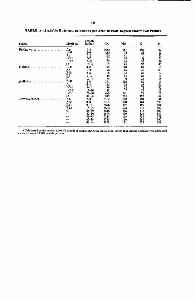
49
TABLE l&-Avallable Nutrlents In Pounds per Acre1 in Four Bepresenfative Soil ProllIes
Series Horizon Depth Inches K P
Bridgewater. . Ap L-H Ae Bfhl Bfh2
Halifax.. _. E-H
&h Bf
JNoIfyille.. E-H
$?hl
iE2
Lawrencetown.. . _. Ah -kg W 32 - -
-
z o-2 2-7 7-18 18 + E 2-5 517 17 +
02 3-10 10-20 20-30 30 +
5; 9-18 18-24 24-30 30-36 36-42 4248 48 +
1812 486 128
5;
1;;
l2
ii 381 112
76
42: 912
13764 2484 5276 4892 4516 4664 7232 9712 9168
187
7: 19 14 45
li0 45 34 14
0 loi
226
16: 252 360 120 187 173 165 139 165 146 161
101
7; 54 35 35
:i 39
!P 80
2
5 125 234
i” 210 218 210 234 296 273
384 492
” 528
4:
1 Calculated on the basis of 2,CW,ooO pounds of mil peracre ta six inches deep, except that orgmic bor?mm were calculated on the bsais of 193,OQQ pounds per acre.

SUMMARY
Halifax County is in the south-central part of Nova Scotia. The largest county in the province, it has an area of 2,293 square miles, or 1,467,729 acres. Halifax City, situated on the south shore of Halifax Harbour, is the capital and largest city of the province.
The County forms part of the Southern Upland, which extends the length of the province from Yarmouth to Canso. The topography is undulating, the highest altitude, 500 feet, being along the northeast boundary. The underlying bedrock is mostly quartzite or granite and is very resistant to weathering. The drift is generally shallow and stony.
The climate is humid temperature, the annual precipitation being 54 inches. The mean annual temperature is 44°F.
Lumbering is an important industry since most of the land area is in productive forest. The principal species are red’spruce, balsam fir, black spruce, hemlock, white pine, white spruce, maple and birch.
The soils are developed from glacial drift that varies in texture from stony sandy loam to clay loam. The well-drained soils belong to the Podzol great soi1 group. Under forest caver they have a light-colored eluvial (Ae) horizon beneath a very acid organic surface layer. The illuvial (B) horizon is brown to reddish brown, acid and moderately high in organic matter. The solum varies from 15 to 30 inches thick.
Slightly over 1 percent of the land area of the County has been cleared for farming or rough pasture. Most of this farm area is in the Musquodoboit Valley and near Sackville, where the parent materials of the soils are chiefly sandstones and shales of Carboniferous age. Some of these materials have been deposited as drumlins in other parts of the County and these areas are also farmed to a considerable extent. The soils best suited for agriculture are the Cumberland, Stewiacke, Wolfville, Queens, Bridgewater and Hantsport series, and these soils make up almost a11 of the acreage farmed.
Both dairying and mixed farming are carried on and the principal crops are hay and grain. The soils have low natural fertility and require frequent applications of lime and fertilizer for maintenance of good trop yields.
50

GLOSSARY
Alluvium-Sediments deposited by streams.
Available nutrients-Plant nutrients in soluble form, i.e., readily available for absorption by plant roots.
Boulders-Rock fragments over two feet in diameter. Catena-An association of soils developed from one kind of parent material
but differing in characteristics due to differences in relief and drainage.
Cobbles-Rounded or partly rounded rock fragments from 3 to 10 inches in diameter.
Color-Soi1 colors are measured by comparison with a Munsell color chart. The Munsell system specifies the degrees of the three simple variables of color: hue, value and chroma. For example: 10YR 6/4 is a color with a hue of lOYR, a value of 6 and a chroma of 4.
Consistence-The degree and kind of cohesion and adhesion of a soil, or its resistance to deformation or rupture.
Drift-Material of any sort moved from one position to another. The term is most commonly used for material deposited by glacial action.
GIaciofluvial material-Glacial material sorted and deposited by water that originated from melting glaciers.
Grave&-Rock fragments from 2 mm. to 3 inches in diameter.
Horizon-A layer in the soi1 profile approximately parallel to the land surface and having more or less well defined characteristics that have been pro- duced by soil-forming processes. The major organic horizons are defined as follows:
L-An organic layer characterized by accumulation of organic matter in which the original structures are definable.
F-An organic layer characterized by accumulation of partly decom- posed organic matter in which the original structures are discern- ible with difficulty.
H-An organic layer characterized by accumulation of decomposed organic matter in which the original structures are not definable.
The major minera1 horizons are defined as follows: A-A minera1 horizon or horizons formed at or near the surface in
the zone of maximum removal of materials in solution and SUS- pension and/or maximum in situ accumulation of organic matter. It includes horizons in which organic matter has accumulated as a result of biological activity (Ah); horizons that have been eluviated of clay, iron, aluminum and/or organic matter (Ae) ; horizons dominated by these conditions but transitional to the underlying B or C (AB or A and B); and horizons markedly disturbed by cultivation or pasturing (AP).
B-A minera1 horizon or horizons characterized by one or more of the following: an illuvial enrichment (exclusive of dolomite or salts more soluble in water) of silicate clay, iron, aluminum, or organic matt.er (Bt, Bf, Bh, Bfh); a concentration of weathering products believed to have been formed in situ (Bt) ; the removal of dolomite and salts more soluble in water (Bm) ; an oxidation of sesquioxides that gives a conspicuously darker, stronger, or redder color than overlying and/or underlying horizons in the same sequum (Bmf);
51

52
a prismatic or columnar structure characterized by the presence of exchangeable sodium (Bn) .
C-A minera1 horizon or horizons comparatively unaffected by the pedogenic processes operative in A and B, excepting the process of gleying and the accumulation of dolomite and salts more soluble in water (Ck, Cs, Cg, and C).
The minera1 subhorizons described in this report are denoted by lower- case suffixes, as follows:
c-A horizon cemented (irreversibly) by soil-forming processes. e-A horizon characterized by the removal of clay, iron, aluminum
or humus. Usually lighter colored than the layer below. f-A horizon enriched with hydrated iron. g-A horizon characterized by reduction and gray colors, often mottled. h-A horizon enriched with organic matter. When used with A, it must
show at least one Munsell unit of value darker than the horizon immediately below.
j-A horizon whose characteristics are weakly expressed. k-A horizon enriched with carbonate. m-A horizon characterized by the loss of water-soluble materials
only. p-A layer disturbed by man’s activities, to be used only with A. s-A horizon enriched with Salt, including gypsum. t-A horizon enriched with silicate clay.
Lithologic changes are indicated by Roman numeral suffixes. If more than one lower-case suffix is required, and if one only is a weak
expression, then the j is linked to that suffix with a bar, i.e., BfG. In bisequa profiles the first sequum designations are bracketed. Mer-Unincorporated organic material that rests with little mixing on the
underlying minera1 or organic-minera1 horizon.
Mottles-Irregularly marked spots or streaks, usually yellow or orange, some- times blue. Mottling indicates poor aeration and lack of good drainage.
Parent Mate&&-The unaltered or essentially unaltered material from which the soi1 develops.
pH-The intensity of acidity or alkalinity expressed as the logarithm of the reciprocal of the hydrogen-ion concentration. With this notation, pH 7.0 is neutral; lower values indicate acidity, higher values alkalinity.
Potential Evapotranspiration-The amount of water that would be transferred from the soi1 to the atmosphere by evaporation and transpiration if it were constantly available.
Profile-A vertical section of a soi1 through a11 its horizons and extending into the parent material.
Relief-The elevation or inequalities of the land surface when considered collectively.
Series-A group of soils formed from the same parent material and having horizons similar in distinguishing characteristics and arrangement except for the texture of the surface soil.
Solum-In normal soils the solum includes the A and B horizons, or the part of the soi1 profile above the parent material.

53
Structure-The aggregation of primary particles into compound particles, which are separated from adjoining aggregates by surfaces of weakness.
Texture-The percentages of Sand, silt and clay in a soi1 determine its texture. Particles from 2 to 0.05 mm. in diameter are called Sand, those from 0.05 to 0.002 mm. are called silt and those below 0.002 mm. are called clay.
PER CENT SAND
FIGURE 13.-Percentages of clay and Sand in the main textural classes of soils; the remainder of each class is silt. See Toogood, J. A., Cari. J. Soi1 Sci. 28: 54-55, 1958. The limits between classes are as in Soil Survey Manual, U.S.D.A. Handbook 18, 1951.
Till-That part of glacial drift deposited directly by ice with little or no trans- portation by water; generally unstratified.
Topography-The soi1 slope.
Type-A subdivision of the soi1 series based on the texture of the surface soil.