solving today’s hurricane problem through modification · solving today’s hurricane problem...
TRANSCRIPT

i
Solving Today’s HurricaneProblem Through Modification
Submitted by:Greg Machos
Webmaster/Ownerwww.hurricaneville.com
Submitted to:Dr. Stephan Nelson
Director of Atmospheric ScienceNational Science Foundation
Room 7754201 Wilson Boulevard
Arlington, VA 22230
April 27, 2001
Final Proposal for Business and Professional WritingIf found, please return to:
Mark WarenDepartment of EnglishMurray Hall, Room 032
College Avenue Campus, Rutgers University

i
ABSTRACT
This proposal is for a research study that will attempt to combine the bestelements of both the federal government and private industry projects on hurricaneintensification and modification. There will be a difference in the way a hurricane willbe attacked. Rather than trying to attack it through seeding its inner core, thisproposal will try to use wind shear at the upper levels to destroy the storm’s verticalstructure. Past research has shown that work in this area of study has had positiveimpacts on hurricane forecasting that ultimately saved lives. Furthermore,technology has improved significantly over the last twenty years and with thetremendous strides made in weather forecasting over the past century, now may bea great time to revisit this kind of research again.
Coastal communities in the eastern half of the United States as well as manyunderdeveloped countries in the Caribbean and Central America are more vulnerablethan ever to a major hurricane like Hurricane Andrew in 1992 or Hurricane Mitch in1998. Hurricane Andrew caused approximately $27 billion dollars in damage aftermaking landfall in South Florida while Hurricane Mitch left an estimated 11,000people dead from heavy rains over a period of several days. While forecasting ahurricane’s storm track and intensity has improved, it has not been able to keeppace with the explosive population growth that has taken place over the past severaldecades.
Efforts are being made into researching hurricane intensity by the federalgovernment. NASA and NOAA have joined forces to investigate tropical storms andhurricanes to see why and how they intensify. There are also studies being done tofind out how wind shear affects a hurricane along the coast during landfall.Meanwhile, private industry is making efforts to eradicate hurricanes through theconcept of storm modification although experts in the meteorological field aren’tenthusiastic about these ideas due to the inconclusive results from ProjectStormfury.

ii
TABLE OF CONTENTS
Abstract……………………………………………………………………………………………………………………….i
Table of Contents………………………………………………………………………………………………………ii
Table of Figures………………………………………………………………………………………………………..iii
Introduction……………………………………………………………………………………………………………….1
Coastal Populations Continue To Grow Rapidly….…….……….………………………….2
Improvements In Forecasting Can’t Keep Up….……….……….………………………….3
The Central American Hurricane Problem….…….…………….….……………….…………4
Literature Review……………………………………………………………………………………………………..5
Problem Hurricanes Present To Today’s World……….…………..……………………….5
Early Attempts To Control Hurricanes………………………….………………………………….7
Research Being Done Today……………………………………………………………………………….9
Federal Government Projects…………………….…………………………………………………..9
Government Research Into Hurricane Intensity……………………………………………..9
Shearing A Hurricane Apart…………..………………………………………………………………10
Private Industry Projects…………………….………………….………………….……………….10
Dyn-O-Mat’s Hurricane Fighting Gel…………………………………………………..…………10
Proposal……………………….…………………………………………………………………………………..………12
Budget……………………………………………………………………………………………………………………….16
Breakdown…………………………..…………………………………………………………………………16
Budget Justification………………………………………………………………………………………..17
Discussion…………………………………………………………………………………………………………………19
Works Cited..……………………………………………………………………………………………………………20

iii
TABLE OF FIGURES
Figure 1: Long Term Tropical Activity in the Atlantic (1890-1995)…………….1
Figure 2: Tropical Activity in the Atlantic (1991-2001)…………….…………………..1
Figure 3: Increase in Coastal Populations………………………………………………………..2
Figure 4: Improvement in Forecasting Errors……………..…..……………………………..3
Figure 5: Hurricane Mitch off Coast of Honduras in October, 1998……………..5
Figure 6: Devastation From Hurricane Mitch In Honduras…………………………….6
Figure 7: Process of Orographic Lifting……………………………………………………………..6
Figure 8: Estimated Deaths in Recent Catastrophes……………………………………….7
Figure 9: Wind Reduction in Hurricane Debby………………………………………………….8
Figure 10: NOAA Gulfstream IV Aircraft…………………………………………………………….9
Figure 11: Percentage Breakdown of Proposed Budget……………….………………16
Figure 12: Percentage Breakdown of Facilities Budget……………….……………….16
Figure 13: Percentage Breakdown of Materials Budget……………….……………….17
Figure 14: Total Itemized Cost for Project……………….……………………………………..17

1
INTRODUCTION
Over the past five to ten years, forecasters and scientists alike have beenwarning people living along the East Coast of the United States as well as many ofthe Caribbean islands in the Atlantic Basin that the Atlantic region is entering aperiod of increased tropical activity. As depicted in Figure 1, past trends in historyhave indicated that increased activity occurs every forty years or so. Consequently,forecasters believe that more intense hurricanes will make landfall over the nextforty years. Activity has already begun to rise over the past decade.
Since 1991, there has been a dramatic increase in the number of tropical storms andhurricanes that have developed each year during the hurricane season as shown inFigure 2.
Harbingers of such increased activity go as far back as Hurricane Andrew in1992, which brought some $27 billion dollars in damage to South Florida (GreatStorms Collection), Hurricane Opal in 1995, which heavily damaged the Gulf Coast ofFlorida, and Hurricane Fran in 1996 which caused some $6 billion dollars in damageto Wilimington, North Carolina. Then in 1998, Hurricane Mitch became a catastropheof enormous proportions in parts of Central America dumping three to six feet of rainin 48 hours (Sarewitz and Pielke 45). One year later, in September, 1999, HurricaneFloyd caused approximately $6 billion dollars in damage from North Carolina to NewEngland.
0
5
10
15
20
Number Of Storms
1991 1995 1997 1998 1999 2000 2001
Year
Figure 2: Tropical Activity in the Atlantic (1991-2001)
Tropical StormsHurricanes
Figure 1: Long Term Tropical Activity in the Atlantic (1890-1995)
0
5
10
15
20
25
1890 1933 1965 1995Year
Number Of Storms
TropicalStormsHurricanes

2
So far, much of the coastal population in the United States has been lucky,but research shows that the next major hurricane to strike a major coastal city couldend up costing as much as $80 billion dollars in damage (Mandias, par 5).Meanwhile, coastal populations keep growing and while forecasting hurricanes hasimproved over the last several decades, it has not been able to keep up with thetremendous growth in population particularly along the coast (Sheets, Danger’sEdge). As a result, forecasters fear that a recipe for disaster may be brewing.
Coastal Populations Continue To Grow Rapidly…
Many people dream of living along the coast. The beauty and tranquility andtranquility of living near the ocean is very attractive to people who are caught up inthe hectic hustle and bustle of everyday life in the cities and the suburbs. Whileliving along the coast may sound enticing, the fact still remains that coastal life isn’talways calm and serene. It is often marred by coastal storms such as hurricanes,which claim many lives and cause billions in property damage periodically. Forinstance, Hurricane Andrew killed 65 people and caused $27 billion dollars in damageafter it rolled through the Bahamas, South Florida, and Louisiana in August, 1992(Great Storms Collection).
Nevertheless, populations continue to experience explosive growth along ourcoastlines. For example, in the four coastal counties of New Jersey, which includeMonmouth, Ocean, Atlantic, and Cape May, the number of residents grew from 1.3million to 1.6 million between 1980 and 1993 (Insurance Research Council 10).Since 1993, these coastal populations have continued growing as New Jersey hasbecome one of the most densely populated areas in the country (Insurance ResearchCouncil 10). Furthermore, since 1960, coastal populations across the United Stateshave grown from about 175 people per square mile of coastline to about 275 peopleper square mile of coastline as shown in Figure 3 (http://www.census.gov).
This change in population is nearly 150% more growth over the past fourdecades, and that figure is expected to continue rising. By the year 2015, thecoastal population per square mile is expected to double that in 1960 as reflectedalso in Figure 3 (http://www.census.gov). With this kind of growth in coastalpopulation, there will need to be more buildings, roads, and houses. All of this newinfrastructure will cost money to insure. Finally, the rate of growth in coastalpopulations relative to non-coastal populations indicates a trend of more peoplemigrating from inland areas toward the coast (http://www.census.gov).
Figure 3
Increase in Coastal Populations

3
Improvements in Forecasting Can’t Keep Up…
Over the past century, there have been a number of significant developmentsin technology that have helped hurricane forecasting make tremendous strides overthe past several decades. The development of both radar and satellite imagery inthe 1950s and 1960s really helped weather forecasters monitor hurricanes moreeffectively (Ahrens 226). Prior to the implementation of these tools, “severe storms,such as hurricanes and typhoons, went undetected until they moved dangerouslynear inhabited areas (Ahrens 226).
However, there were difficulties in the beginning as forecasters misinterpretedearly satellite imagery. For instance, before Hurricane Camille devastated theMississippi Gulf Coast in August, 1969, forecasters at the fledgling National HurricaneCenter originally thought that Camille wasn’t that powerful because of its small sizeand diameter depicted in the satellite imagery (Danger’s Edge). This is whereanother development, weather aircraft came in. Going back to the early 1950s,aircraft known as Hurricane Hunters flew into these dangerous storms, and collecteddata such as location, temperature, pressure, humidity, and wind speed. In the caseof Camille, this proved to be quite important since the data collected from theHurricane Hunter aircraft contradicted the satellite imagery, and gave forecasters amuch clearer, but dire picture of what was happening in Camille (Danger’s Edge).
Over the past several decades, computer technology has become moreprevalent as well. As computers have become more powerful and less expensive,they have been able to process large amounts of data in shorter amounts of time. Inaddition, the computer processing technology of today is much more adept atprocessing complex mathematical and scientific formulas the forecasters andscientists use to try and model what’s occurring in the atmosphere. Consequently,forecasters have been able to work with more accurate forecasting models (Ahrens221).
The improvement in forecasting models has even had a huge impact on theforecasting of hurricanes, which can be quite difficult due to their unpredictablebehavior. Difficulty in forecasting hurricanes comes from the fact thatapproximately eighty percent of a hurricane’s motion comes from winds around thestorm system called “steering currents,” which start out hundreds of miles away(Williams, 148). To give an idea of how much forecasting these storms hasimproved, Figure 4 indicates a gradual reduction of errors, in terms of nautical miles,made by s eve ra l d i f f e r en t hurr icane forecast ing models(http://www.nhc.noaa.gov).
Improvements in Forecasting Errors. Source: NOAA.
Figure 4

4
However, despite the progress that has been made in the forecasting of ahurricane’s future track, forecasters point out that these improvements are onlygradual over time. Moreover, they fear that although the future looks promising forfurther improvement, a forecaster’s skills and technology won’t be able to keep upwith the explosive growth that is occurring along the coastlines of the United States.Then, there are problems with accurately forecasting hurricane intensity. Despitesome advances in recent years, the task of prognosticating how strong a hurricanewill be at landfall continues to be a difficult one. Forecasting intensity is difficultbecause there are many different variables at play in the environment within andaround a hurricane. These variables include such things as warm eddies in theocean, wind shear, concentric eyewalls, and sea surface temperature anomalies.
The Central American Hurricane Problem…
Not only is the problem of forecasting hurricanes critical for the United States,but also for the surrounding underdeveloped regions of Mexico, Central America, andthe Caribbean. The countries in these regions also have problems with tremendouspopulation growth. However, they also have to endure the burdens that go withpoor social and economic conditions, corrupt governments, poor land usage, adegraded local environment, and a lack of hazard mitigation and emergencymanagement protocols.
While it is true the places in the United States would be heavily damaged by amajor hurricanes, and the cost of rebuilding from that would be in the billions, theoverall economic structure and current infrastructure of roads, communication lines,buildings, and a solid government in place would enable these same places torecover quite rapidly. On the other hand, in places like Honduras and Nicaragua inCentral America, this is not the case. As a matter of fact, both of these countries arestill recovering from the devastation brought by Hurricane Mitch some four years agoin October, 1998 (Sarewitz and Pielke, 45).
Furthermore, thousands of people in these underdeveloped regions such asCentral America lose their lives to storms like Mitch every year. For instance, inaddition to the catastrophic devastation left behind by Hurricane Mitch in 1998, therewere approximately 11,000 people in both Honduras and Nicaragua combined thatlost their lives due to the mudslides and raging flood rivers that resulted from theheavy rains. A different approach must be looked at in order to supplementforecasting and prevent catastrophes like this from occurring again in the future.
Research and data demonstrate the need for an alternative solution to usingjust forecasting as mankind’s defense against hurricanes. The following research willshow that there is work being done by the federal government and private industryin the areas of better understanding hurricane intensity and storm modification.Although the work done in storm modification, particularly in private industry hasdrawn skepticism from experts, it is important to point out that technology hasimproved tremendously since the failure of Project Stormfury in 1980. In addition,the advancements in the science of meteorology over the past century can give hopeto the idea of revisiting the concept of storm modification.

5
LITERATURE REVIEW
Problem Hurricanes Present To Today’s World…
It is well known that hurricanes are very vast and vicious storms that canaffect a large number of people over wide stretches of land in coastal and low-lyingregions in the Caribbean, Central America, Mexico, and the Eastern United States.Hurricanes can present a variety of problems with winds, rain, storm surge, waves,and even tornadoes. For example, there were numerous problems when HurricaneMitch, shown in Figure 5, devastated the Central American countries of Hondurasand Nicaragua.
Now, of course, there were underlying social issues of increased population,poverty, poor land-usage, a degraded local environment, and a lack of emergencypreparedness and hazard mitigation (Sarewitz and Pielke 45). However, if Mitch hadspun off the coast of Texas or moved inland like Tropical Storm Allison did in June of2001, the same result would have happened in Houston with many more lives,homes, and businesses lost. Mitch would have been a devastating hurricaneanywhere with winds near 190 mph at one point along with battering waves andcoastal storm surge.
On the environmental side, there was perhaps another process at work, whichwas the idea of global warming, or the “inadvertent modification” of the atmosphere(Sarewitz and Pielke 46). However, the idea of curing global warming will notprevent future disasters such as the catastrophe caused by Mitch in Central Americafrom occurring again since the problems that occurred there were not going to besolved “by reducing greenhouse gases” (Sarewitz and Pielke 45). In addition, singleevents such as Hurricane Mitch or Tropical Storm Allison will probably never beattributed directly to global warming since the effects of greenhouse gases probablywon’t be felt until decades later (Sarewitz and Pielke 48).
In the case of Mitch, what created the catastrophe for Honduras andNicaragua, shown in Figure 6, was a phenomenon called orographic lifting, which was
Figure 5
Hurricane Mitch Off Honduran Coast in October, 1998. Source: NOAA
HurricaneMitch
Honduras
Nicaragua
Belize

6
the actual lifting of the rushing air from Mitch over the rugged terrain of theHonduran and Nicaraguan countryside (http://www.usatoday.com par. 2)demonstrated in Figure 7. The combination of the tremendous moisture from Mitchand the lifting of this moisture over the mountains resulted in three to six feet of rainover this region of Central America within 48 hours (Sarewitz and Pielke 45). Thedeluge from Mitch caused tremendous mudslides and flooding that either sweptmany people away in raging rivers, or buried them in tons of mud.
This is not the only time that a hurricane or storm caused this much deathand devastation. Within the eighteen months following Mitch, there were even worsedisasters in Venezuela and Mozambique as indicated in Figure 8 (Sarewitz and Pielke57). In Venezuela, heavy rains over a period of several days at the start of the rainyseason in December, 1999, caused a surge of water to flood small villages and townsin the Northeastern portion of the country (Machos par 5). As a result,approximately 20,000 people lost their lives (Machos pars. 3-4). Meanwhile, inMozambique, a series of tropical cyclones, i.e. hurricanes, brought devastating floodsthat killed thousands in late February and early March, 2000 (Machos par. 1)
Figure 6
Some of the Devastation from Hurricane Mitch in 1998.Source: Honduras National Web Site
Where roadbuckles fromheavy rains
Bottom half ofthe road
Top half ofthe road
Figure 7
The Process of Orographic Lifting. Source: USA Today

7
Early Attempts to Control Hurricanes…
Studies and tests had already been done as early as 1947 when GeneralElectric sponsored a cloud seeding project headed by Dr. Irving Langmuir (Boesen63). The project, called Project Cirrus, was primarily focused on seeding hurricanesby having a plane drop dry ice into them. This idea became reality on October 13,1947 when a Navy plane flew into a hurricane out at sea, and released dry ice into it(Boesen 63).
The results of this earlier experiment apparently gave Langmuir and hisresearchers enough proof that their idea worked as the storm suddenly changeddirection, and made landfall in Savannah, Georgia (Boesen 63). However, it wouldbe discovered years later by another scientist named Mook that the sudden changein direction of the storm was not caused by the seeding rather by changes in theupper level steering winds (National Academy of Sciences 106).
The hurricanes during the period of the 1940s and 1950s were particularlydevastating to residents of the East Coast of the United States, particularly fromNorth Carolina on up into New England. Storms such as Connie and Hazel inOctober, 1954 and Diane in August, 1955 were massive and powerful. TheseCategory Four Hurricanes brought hurricane conditions well inland to places such asNew England and even Canada (http://www.hurricaneville.com/historic.html).
Of the three storms, Diane was the one that finally put government agenciesinto action. After making landfall in North Carolina on August 17, 1955, Dianeswiftly moved up the East Coast into New England, where it spawned the worstwinds and flooding of that time. As a result, some 184 people died, and damagefrom the storm was estimated at $5 billion dollars (Boesen 62-63), which todaywould be in the range of about $80 billion (Sarewitz and Pielke 58).
After the 1954 and 1955 hurricane seasons, President Eisenhower appointedan Advisory Committee on Weather Control (National Academy of Sciences 5).Additional life was given to this committee’s work when Congress passed a bill in1956, which prolonged the committee two more years (Fleagle 70). However,despite the government action, nothing much was done on the matter until 1961 dueto skepticism on the part of many scientists (Fleagle 70), and fear of lawsuits ifsomething were to go wrong (Battan 113).
Then, in 1961, a group led by Pierre St. Amand at the Navy Weapons Centerin California took a major step with the development of new seeding generators.These improved generators would be able to release large amounts of the chemicalcompound, silver iodide (AgI), from an airplane into a storm such as a hurricane(Boesen 63). At the same time, Dr. Robert H. Simpson, director of the National
Figure 8
Estimated Number of Deaths In Recent Catastrophes
0
5,000
10,000
15,000
20,000
Mitch Venezuela Mozambique
Est. Deaths
8
Hurricane Research Labs in Miami, Florida) theorized that a hurricane could beweakened with particles of frozen nuclei (Boesen 63). Releasing frozen nuclei intothe clouds of a hurricane would change the moisture into ice crystals and cause animbalance between the forces driving the storm (Boesen 63). These twodevelopments brought about the eventual creation of Project Stormfury.
The group’s first test was performed on Hurricane Esther in September, 1961.A Navy plane loaded with silver iodide crystals was sent into Esther, and releasedseveral waves of the crystals. What resulted was apparently a decrease in thesustained winds in Esther by about ten percent (Battan 113). The apparent successwith Esther formalized the creation of Stormfury, which was a partnership betweenU.S. Weather Bureau and the Navy (Battan 114). Members of the project teamdeveloped another hypothesis for hurricane modification. They proposed that if thesupercooled water contained within the deep clouds of the eyewall can be convertedto ice, the storm’s vertical column of air would be warmed slightly and the hurricanewould be modified into a moderate tropical storm with heavy rain (Battan 115).
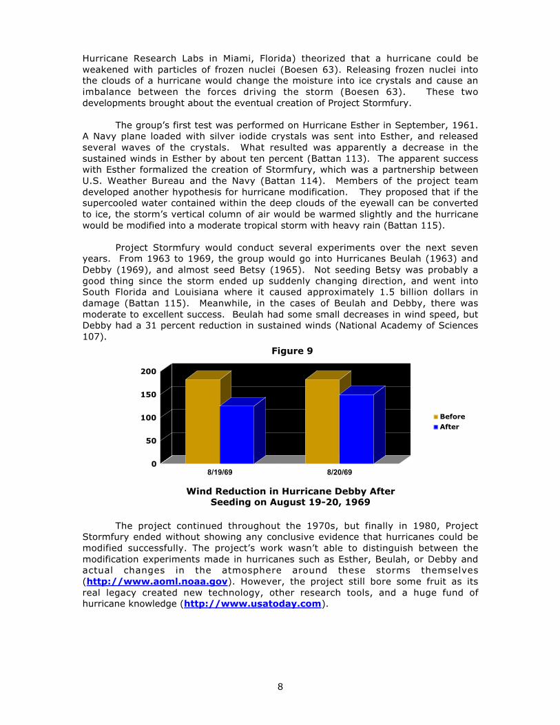
Project Stormfury would conduct several experiments over the next sevenyears. From 1963 to 1969, the group would go into Hurricanes Beulah (1963) andDebby (1969), and almost seed Betsy (1965). Not seeding Betsy was probably agood thing since the storm ended up suddenly changing direction, and went intoSouth Florida and Louisiana where it caused approximately 1.5 billion dollars indamage (Battan 115). Meanwhile, in the cases of Beulah and Debby, there wasmoderate to excellent success. Beulah had some small decreases in wind speed, butDebby had a 31 percent reduction in sustained winds (National Academy of Sciences107).
The project continued throughout the 1970s, but finally in 1980, ProjectStormfury ended without showing any conclusive evidence that hurricanes could bemodified successfully. The project’s work wasn’t able to distinguish between themodification experiments made in hurricanes such as Esther, Beulah, or Debby andactual changes in the atmosphere around these storms themselves(http://www.aoml.noaa.gov). However, the project still bore some fruit as itsreal legacy created new technology, other research tools, and a huge fund ofhurricane knowledge (http://www.usatoday.com).
Figure 9
Wind Reduction in Hurricane Debby AfterSeeding on August 19-20, 1969
0
50
100
150
200
8/19/69 8/20/69
BeforeAfter

9
Research Being Done Today…
There are a number of projects currently going on today on the topic ofHurricane Intensity and Modification by both the federal government and privateindustry. There are two separate ways that the problem is being attacked. First, thegovernment is researching hurricane intensity so researchers can better understandwhat causes a hurricane to intensify at a given moment during its life cycle.Meanwhile, a private company is working on a unique powder that will weakenhurricanes by robbing them of their moisture if it is successful. Other work beingdone is a study that was featured in the American Meteorological Society a coupleyears ago, where researchers are investigating how wind shear affects the verticalprofile of a hurricane.
Government Research Into Hurricane Intensity…
In the summer of 2001, the federal government deployed several agenciesincluding NOAA, the National Oceanic and Atmospheric Administration, and NASA,the National Aeronautics and Space Administration to begin research into finding outwhat causes hurricanes to intensify. Forecasters want to better understand whystorms such as Hurricane Opal rapidly strengthened in the Gulf of Mexico in October,1995 while others such as Hurricane David slowly weakened after becoming sopowerful in September, 1979. The first case studies in this project were TropicalStorms Barry and Chantal, which both developed during the first weeks of August,2001 (Machos par 1). Chantal was a particularly good case since it fluctuated inintensity quite often, despite sea surface temperatures and upper level windconditions being favorable for development (Machos par 1).
One of the biggest obstacles facing tropical forecasters today is not onlywhere the storm will make landfall, but also how much will it strengthen or weaken(Machos par 3). In dealing with Chantal, researchers found how difficult it can be tofigure out whether or not a system will develop into a hurricane and intensify(Machos par 3). Factors such as warm eddies, sea surface temperature anomalies,upper level winds, and wind shear all have an impact on a hurricane’s intensity.Researchers are hoping that this investigation will yield important clues in theforecasting the intensity of future storms (Machos par 2-3).
However, according to Dr. Bob Sheets in 1991, forecasting has only mademodest gains while population has exploded (Danger’s Edge). Plotting a graph thatwould compare population growth with improvement in forecasting, one would seethat the forecasting graph would have a linear plot while the population graph wouldbehave exponentially (Danger’s Edge). Despite the progress made in forecastingover the last several decades, forecasters are unable to predict with very highaccuracy where a hurricane will be in 72 hours, and even have greater difficulty infiguring out how intense a storm would be in the same time frame.
NOAA Gulfstream IV Taking Part in Hurricane Intensity Research
Figure 10

10
Shearing a Hurricane Apart…
Another effort into hurricane intensification looks at the way wind shear hasan adverse affect on hurricanes and tropical storms (American Meteorological Society192-207). Many know that in order for a hurricane to strengthen or stay healthy, itmust have light winds aloft (http://www.hurricaneville.com/factors.html).Hurricanes need to have light winds aloft because they are “vertically stacked”. Inother words, these storms have a vertical profile where clouds build up vertically inthe atmosphere.
Well, if the upper level winds surrounding a hurricane or tropical storm nearbyare blowing in a west to east direction that will tear up the storm’s vertical profileand hinder any thunderstorm development that a hurricane or tropical storm needsto intensify (http://www.usatoday.com). There are many different factors thatcan cause westerly shear in the tropics, and they include upper level troughs and astrong El Nino Episode in the Pacific Ocean (http://www.usatoday.com). Whatthe researchers are attempting to find out is whether or not the difference betweenobservations of wind shear over land and the oceans can be the basis for modifyingthe vertical profile of the hurricane’s straight-line winds at landfall.
Another major critic of hurricane modification, Dr. Steve Lyons, believes thatshearing a hurricane apart would be even more difficult to attacking the hurricanethrough seeding. He believes that developing an artificial upper level disturbance inthe atmosphere would be difficult since the “area surrounding a hurricane is muchlarger than the hurricane itself.” In order to weaken the hurricane, there must besomething done to destroy the storm system’s energy core.
However, there is technology available including the new Gulfstream aircraft,which can study what goes on at the upper levels of the atmosphere in and around ahurricane. In addition, there is more knowledge available from past experiencessuch as Project Stormfury along with better computer simulated models to giveresearchers and forecasters better information on what is going on in theatmosphere in and around a hurricane. While there may not be a way to completelyeradicate a hurricane, there may be a way to contain it or prevent it from becomingtoo severe.
Dyn-O-Mat’s Hurricane Fighting Gel…
Private industry is also currently making efforts to help in the prevention offuture hurricane catastrophes. One of the more significant developments was madethis past summer when a South Florida based company called Dyn-O-Mat(http://www.dynomat.com), culminated two years of research when theysuccessfully tested their hurricane powder, Dyn-O-Gel, on a storm cloud (Machos par2). Dyn-O-Gel, which has since been renamed to Dyn-O-Storm(http://www.dynomat.com), was released into a storm cloud 1,600 meters longand 4,000 meters deep by a military aircraft.
Approximately 4,000 kilograms of the substance was required to absorb themoisture from the storm cloud (Science News par 3). The polymer has grainscapable of holding 2000 times its own weight in moisture. It would be the equivalentof taking a huge sponge or super strong paper towel and soaking up all the moisturein a tropical storm or hurricane. According to William A. Cordani, Assistant to theCEO at Dyn-O-Mat, the company estimated that the cost to drop the material intothe storm cloud was in excess of $500,000 dollars.

11
Interacting with the moisture, the powder turns into a gel like a substancethat becomes heavy and falls back to the earth. Cordani states that researchers atDyn-O-Mat “discovered that the gel dissolves in salt water, and they recognized thatthe disbursement of Dyn-O-Gel into tropical storms and hurricanes could alter them.”While the substance is considered safe and biodegradable, it will be used on stormsout at sea rather than near the coast where it could impact people (Science News par4-5).
The people at Dyn-O-Mat are very excited about their recent success, andwant to obtain government funding to perform another test of their product on atropical depression (Machos par 2). As a matter of fact, Cordani said that Dyn-O-Matis working closely with a lobbyist, who is seeking funding in the range of 50,000,000dollars from the federal government although the company isn’t sure if it will needthat much funding. In addition, they are hoping that eventually Dyn-O-Mat will beable to sell this product to the government (Science News, par 4).
However, despite recommendations by a number of astronauts, who havealso lent their assistance to the project, there are skeptics. There are some critics ofthe product who say that a powder such as Dyn-O-Gel, or Dyn-O-Storm, isn’t strongenough to be able to reduce a hurricane’s intensity (Machos par 3). One of thosepeople is Dr. Hugh Willoughby of NOAA, a researcher who flew into and studiedHurricane Gilbert in 1988. Willoughby has given advice to the people at Dyn-O-Gelon what they need to do in order to weaken a hurricane, but he still remainsskeptical.
Dr. Willoughby believes that the prospects to modify a hurricane are“dubious” at best. That is because people just cannot comprehend the “power andsize of a hurricane relative to human endeavors.” Many powerful storms such asGilbert, Andrew, and Mitch cover around 1,000 square miles in diameter or more.There is just so much energy that these storms contain over a large area that theycan’t be overwhelmed with just a simple powder, or ice pellets. He feels that theonly way to combat these storms is through “better building codes, wiser land use,and more accurate forecasts.”

12
PROPOSAL
The Plan…
This plan proposes that research pursue the promising idea of hurricanemodification. Research has indicated that it would be worthwhile to revisit thissubject of hurricane modification, particularly through the use of wind shear. Theplan would be to conduct a research experiment to find out whether or not hurricanemodification through wind shear is feasible. If it is found feasible, then the planwould continue by taking the results obtained from the research experiment, andusing them to develop an artificial upper level disturbance that would shearhurricanes apart. The research would take place at Florida State University.
Prior to conducting the research experiment, work would be done in analyzingsimulations of the upper level wind flow, and try to model it in a computer. Thepurpose of this work would be to try to gain a better understanding of the forces atwork in the upper levels of the atmosphere. Data collectors and researchers wouldtake data obtained from the upper levels of the atmosphere around a hurricane ortropical storm, and feed it into a supercomputer. The supercomputer will then try torecreate the dynamics of the upper level wind patterns around a hurricane. Theresults of this research would be analyzed by the researchers and then used as thebasis for the first stage of the research experiment.
Upon the completion of the preliminary analysis, the research experimentwould commence with the creation of a scaled down environment in a lab that wouldsimulate a powerful hurricane getting sheared apart by winds generated from a windtunnel. The objective of this particular test would be to see how to implement theshear so that it has an immediate and effective impact on the simulated storm.Another important aspect of this experiment that will be important to observe will behow the upper levels of the atmosphere will behave.
The next step would be to take this experiment out of the lab and into a realworld setting by creating an artificial wind in the upper levels near a very smallstorm such as a tropical wave, or small area of low pressure in the Atlantic awayfrom land. This would be done so that if there were any adverse effects, nonewould have an impact on any nearby countries. If this test turns out to be asuccess, then work would continue with the next step in the line of progression,which would be to test it on a tropical depression.
Upon the conclusion of this research, results would be analyzed. Conclusionsdrawn from the analysis will be used to decide whether to continue start up agovernment consortium. This consortium would bring together the best researchersfrom the government, private industry, and academia to develop a process thatwould generate hostile upper level conditions in the vicinity of a hurricane that wouldtear the storm’s vertical cloud structure apart, and weaken it. The implementation ofartificial shear would be used in areas such as the Gulf of Mexico and the CentralAtlantic.
These areas would be good areas for this to work since the disturbance willnot be directly over land, and at the same time protect coastal areas from CentralAmerica and Mexico through the Caribbean Basin, and up the entire eastern coastlineof the United States.

13
Projected Timeline for the Research Project…
The proposed program for the research experiment must be completed withintwo years. During the course of the research, evaluations will be made along theway by the project team as well as the National Science Foundation and Florida StateUniversity. Evaluations by the representatives of the NSF and the Florida State willbe performed on a quarterly basis while the project team would make their ownevaluations at the end of each particular leg of the research.
The preliminary work on the project would begin as soon as this proposal issubmitted. During this preliminary stage, a project manager would be named, andcontact the appropriate personnel at the National Science Foundation and FloridaState University. The project manager would also begin the task of assembling ateam, and inquiring about the availability the necessary resources to conduct theresearch experiment.
Upon approval, the program would commence in earnest toward the end ofthe second quarter of 2002. The project team would get together and get situatednear the lab at Florida State University. After orientation to the project and the labfacilities, the team will commence work on their research. The research will start inSeptember, 2002 with preliminary investigations into computer models on upperlevel wind patterns and the vertical cloud structure of a hurricane.
Using the results of the preliminary research, the researchers will analyze thedata and determine what forces are working to create the upper level wind patterns.The researchers will determine what forces would be useful in developing the upperlevel disturbance that will be used. So, the next stage of the research work will lookat what exactly happens in the lab, and whether or not it supports the researchersfindings from the computer data. The goal will be to begin this phase of the projectin early 2003.
The lab simulation portion of the project should conclude by the end of thefirst quarter of 2003 with the lab experiment on the simulated storm cloud going intothe wind tunnel. After that, there will be another period of analysis by theresearchers to determine what exactly happened, and whether the forces in the windcoming from the wind tunnel is behaving in a similar fashion to the forces modeled inthe computer. Once that is completed, work will commence on putting together areal world test. This is projected to begin in July, 2003.
This work will start with a venture out to the remote location somewhere inthe Caribbean island chain. There are numerous waves that move off the Africancoast during the course of the season, and probably the best time for performing areal life test of this concept on a tropical wave would be at this time since conditionsaren’t favorable for significant hurricane development. Once this test is done, thecycle of analysis begins, and a decision will be made to pursue the research further.
Below is a more specific breakdown of the timeline.
♣ April, 2002—Proposal is submitted to the National Science Foundation forapproval.
♣ May, 2002—Project Manager is named, and contacts with NSF and FloridaState begin.

14
♣ June, 2002—Work begins on assembling a team and allocating essentialresources.
♣ July, 2002—Upon approval, the team will meet at Florida State Universityand set forth an agenda for the project. Officials of the NSF and Florida StateUniversity conduct a review of the project.
♣ August, 2002—Project team completes orientation for both the facilities andthe project itself.
♣ September, 2002—Project team commences research with preliminaryinvestigation into computer models on upper level wind patterns andhurricane cloud structure.
♣ October, 2002—Researchers begin analysis of computer data of windpatterns and hurricane cloud structure. Analysis will try to detect what forcesare at work at the upper levels when shear exists.
♣ November, 2002—Analysis of computer data continues while work in puttingtogether the lab for the simulated storm situation begins. Project is givenanother quarterly evaluation by the NSF and Florida State.
♣ December, 2002—Researchers complete analysis on the computer data, anda basis or foundation is created by which the next stage of the research willbe followed. Final preparations are made for the upcoming lab experiment.
♣ January, 2003—The next phase of the research project commences with theteam getting together in the lab and conducting experiments with the artificialstorm cloud structure and the wind shear.
♣ February, 2003—Work continues in the lab with the simulated storm. Datais collected and analyzed by the researchers to see whether or not theirconclusions from the computer data are valid.
♣ March, 2003—Lab work concludes with further analysis of the data collectedfrom the experiment. Analysis of this data is compared to and combined withthe results of the computer analysis to amend the basis of the firstexperiment to create a new foundation for the next experiment.
♣ April, 2003—Analysis is done by the NSF and Florida State University todetermine whether more funding is needed. Meanwhile, preparation beginsfor the next stage of the research.
♣ May, 2003—Upon approval of additional funding by the NSF, the projectteam moves out to the remote location in the Caribbean to continue work onthe next portion of the research experiment.
♣ June, 2003—Final preparations are made for the real world experiment on astorm cloud or tropical wave in the Central Atlantic.
♣ July, 2003—Work commences on the next stage of the research experiment.Pilots will begin flights into Central Atlantic near the Lesser Antilles todetermine what disturbances would be good for the experiment.

15
♣ August, 2003—Test is conducted on a wave in the Atlantic. Researchanalysis begin while evaluation of project is conducted by the NSF and FloridaState.
♣ September, 2003—Analysis continues as project team heads back to FSUnow that the height of the hurricane season begins. Researchers begin to puttogether their findings and generate a report on them as well.
♣ October, 2003—Analysis and report work continues.
♣ November, 2003—Analysis and report work continues. Project team meetsto review findings and discuss them.
♣ December, 2003—Analysis draws to a close while report work continues.NSF conducts another evaluation of the project.
♣ April, 2004—Research report is submitted by the project team to the NSF.NSF begins analysis of report and evaluation of the project for more funding.If approved, the team will commence work on an experiment with adepression.

16
BUDGET
The following is a detailed budget for the proposed research experiment. Thisbudget is based on a similar project by Dyn-O-Mat for their Dyn-O-Storm product.With the help of both Florida State University and the National Science Foundation interms of funding, the resources required for the research experiment can beobtained. Currently, this is a preliminary budget since there are details still beingworked out.
Budget Breakdown…
The budget for the research experiment will consist of two major components: (1)The facilities required for housing, conducting the research, and performing theexperiments, and (2) The resources required to conduct the research experiments.In Figure 10 below, there is a percentage breakdown of the costs for the two majorcomponents.
As shown in Figure 10, the majority of the cost for this research project will beneeded to allocate the necessary materials such as aircraft, wind tunnel, computers,and personnel such as pilots to fly the aircraft into storms, data collectors, andresearchers to analyze the data. The percentage breakdown of these resources isgiven in Figure 12. Figures 11 and 12 show a more specific breakdown of theFacilities and Materials budgets.
24%
76%
Facilities
Materials
Percentage Breakdown of Proposed Budget
Figure 11
28%
3%14%
55%
Labs
Airport
Remote Location
Housing
Figure 12
Percentage Breakdown of Facilities Budget

17
Now, the final budgetary info is a detailed itemized budget in Figure 13 below. Thisconsists of all the elements of each component. The detailed breakdown alsoincludes info on how the costs were calculated.
Figure 14
Total Itemized Cost for Project
Budget Justification…
This project is a very ambitious one. However, compared it to the 400,000 dollarsworth of powder used by Dyn-O-Mat to eradicate a storm cloud, this is a manageablebudget. Overall, the budget is still very comparable to that of the Dyn-O-Mat projectalthough they are using a different means to go about modifying a hurricane. Thesecosts have been updated, and determined by resources allocated for the Dyn-O-Matproject, and actual research done on what it would take to conduct this experiment.
(1) Facilities: This is based on the need for a laboratory to conduct the researchand experiments in, airport or airfield to fly reconnaissance aircraft into and
FaciltiesLabs $100,000Airport $10,000Remote Location $50,000Housing (20 people) $192,000Subtotal $352,000
Materals
Aircraft $250,000Wind Tunnel $25,000Computers $100,000Pilots (6 at $37,500 for 6 mos.) $225,000DATA Collectors (10 @ $10/hr) $208,000Researchers (5 @ $60,000/year.) $300,000
Bottom Line Grand Total $1,460,000
23%
2%
9%
20%19%
27%
Aircraft
Wind Tunnel
Computers
Pilots
Data Collectors
Researchers
Percentage Breakdown of Materials Budget
Figure 13

18
out of storms, a remote location that will have a lab and airfield to do work onanalyzing real world experiments involving a tropical wave or depression.There will also be a need for housing for a total of about 20 people. Thehousing costs are based a cost for an average apartment, which is about$800 dollars. This price includes some utilities as well.
(2) Material: This is the bulk of the costs as the total materials or resourcesrequired to conduct this research experiment accounts for about 80% of thetotal budget for the project. This includes the cost for using airplanes,computers, special weather related equipment such as dropsondes, satellite,radar, cloud making substances, and a wind tunnel, and finally for personnel.
The personnel is broken up into three distinct categories: Pilots, DataCollectors, and Researchers. The pilots will be hurricane hunter pilots. Therewill be two for each major part of the day: mornings, afternoons, andevenings, and they will only be required for six months out of the year to flyinto storms. Data Collectors will consist of graduate students pursuingmeteorology, and will make an hourly wage for their work.
Finally, we have the researchers, who will be the driving force of the project.They will put forth the agenda to follow during the course of the researchexperiment, and they will be analyzing the data collected during the research.It is important to note that while the pilots will only be needed for six monthsout of the year, data collectors and researchers will be needed constantlysince lab work and experiments will be conducted throughout the year.

19
DISCUSSION
It is essential to have an evaluation of the program, especially since theresearch and experimentation will yield results that will determine whether to go onto the next step. During each phase of the process, from the preliminaryinvestigation to the completion of the experiment on an actual hurricane, the projectwill be evaluated to see what has been accomplished, and most importantly what hasbeen learned. The results from each evaluation will be used as the basis for the nextstep in the research experiment.
At the end of the preliminary investigation, an evaluation will be done by theresearchers and the project leader on the information given by the computer modelsof the upper level wind patterns. The results will then be used as a basis forunderstanding what forces are at work to create these upper level wind patterns.From there, it will be determined what forces will be beneficial to use to destroy thehurricane’s vertical structure.
Using the analysis from the preliminary investigation, an experiment will beconducted in the lab using a wind tunnel that will recreate an upper level windenvironment that is hostile to hurricane development. It will be used on an artificialcloud structure similar to the vertical cloud column in a hurricane. Researchers willevaluate how the vertical cloud column behaved when the forces created by theupper level wind acted on it. The analysis obtained will be used as the foundation forthe next step, which will be using these forces on a storm cloud or tropical wave.
Building on the successful outcome from the previous step, the project teamwill then try to develop a process that would recreate a man-made artificialdisturbance at the upper level that will be deployed on a tropical depression to seehow it behaves in that instance. Again as with the previous steps, results from theinteraction of the upper level wind forces and the depression will be evaluated. Atthis point, a determination will be made based on the analysis from the previous foursteps to decide whether or not to go any further and test this process on a hurricane.
By developing an alternative to just the concept of improved forecastingmethods, building codes, and emergency management procedures, scientists willhave another tool at their disposal that may prove beneficial even if the researchultimately fails. The benefits from such research will help researchers and forecastersto better understand what goes on in a hurricane, and generate more accurateforecasts for both a hurricane’s future track and intensity. With the advancementsmade in meteorology in the past 100 years, and the rapid improvement intechnology over the past couple of decades, the time is now to revisit this subject.

20
WORKS CITED
Ahrens, Donald C. Essentials of Meteorology: An Invitation to the Atmosphere.
New York: West Publishing Company. 1993.
Atkinson, Bruce W. The Weather Business: Observation, Analysis, Forecasting, and
Modification. Garden City, New York: Doubleday & Company, Inc. 1969.
Barnes, Gary M, Paul B. Bogner, and James L Franklin. “Conditional Instability and
Shear for Six Hurricanes Over Atlantic Ocean.” American Meteorological Society.
[Boston, MA]. 15.2 (2000): 192-207.
Battan, Louis J. Harvesting the Clouds: Advances in Weather Modification. Garden
City, New York: Doubleday & Company, Inc. 1969.
Boesen, Victor. Doing Something About the Weather. New York: G.P. Putnam’s
Sons. 1975.
“Cloud Busters: Scientists Learn How To Stop the Rain.” Science News [New York,
NY] 2 August 2001.
Collins, Paul. “Just Subtract Water.” Business 2.0 [San Francisco, CA] January
2002.
“Company Tests Hurricane-Fighting Gel.” New Orleans Channel.com. [New Orleans,
LA]. July, 2002.
Cordani, William A. Internet e-mail interview. 19 April, 2002.
Danger’s Edge. The Weather Channel. Dir. Ray Ban. The Weather Channel, 1991.
“Dyn-O-Gel Substance Passes Its First Test.” The Weather Channel. 16 July 2001.
http://www.weather.com/news_center/tropics
Fleagle, Robert G., ed. Weather Modification: Science and Public Policy. Seattle:
University of Washington Press. 1968.
Great Storms Collection. The Weather Channel. Dir. Ray Ban. The Weather
Channel, 1994.

21
Hess, W.N., ed. Weather and Climate Modification. New York: John Wiley & Sons.
1974.
Insurance Institute for Property Loss Reduction and Insurance Research Council, Inc.
Coastal Exposure and Community Protection: Hurricane Andrew’s Legacy.
Boston: Author. April, 1995.
“Investigating Hurricane Intensity.” The Weather Channel. 17 July 2001.
http://www.weather.com/news_center/tropics
Landsea, Chris. Internet e-mail interview. 18 March 2002.
Lyons, Steve. Internet e-mail interview. 19 March 2002.
Machos, Greg. “Hurricane Powder Gives Hope To Weather Researchers.” Greg’s
W e a t h e r C e n t e r . 3 0 J u l y 2 0 0 1 .
http://members.aol.com/windgusts/HurricanePowder.html
Machos, Greg. “Researchers Try To Find Out More About Hurricane Intensity.”
G r e g ’ s W e a t h e r C e n t e r . 1 4 A u g . 2 0 0 1 .
http://members.aol.com/windgusts/HurricaneIntensity.html
Mason, B.J. Clouds, Rain and Rainmaking. New York: Cambridge University Press.
1975.
Riddle, Amanda. “Quirky Ideas Abound For Weakening Hurricanes.” Naples News.
[Naples, FL]. 30 May 2001.
Santaniello, Neil. “Florida Firm Says New Product May Be Able to Weaken
Hurricanes.” Sun-Sentinel. [West Palm Beach, FL]. 20 July 2001.
Sarewitz, Daniel and Roger Pielke, Jr. “Breaking the Global Warming Gridlock.”
Scientific & Technical Writing. Ed. Michael J. Goeller, Robert J. Gill, Barbara
Hamilton, and Jennifer Novak. New York: Houghton Mifflin Company. 2001.
United States. National Academy of Sciences. Weather Climate & Modification:
Problems and Progress. Washington, D.C.: National Academy of Sciences.
1973.

22
United States. National Research Council. Weather and Climate Modification:
Problems and Prospects. Washington, D.C.: National Academy of Sciences.
1966.
Williams, Jack. The Weather Book: An Easy-To-Understand Guide To The USA’s
Weather. New York: Vintage Books. 1992.
Willoughby, Hugh. Internet e-mail interview. 19 March 2002.