some observations on the amarillo ... - applied geophysics · page 340 | september ~ october 2014...
TRANSCRIPT
Page 338 | September ~ October 2014
By: S. Parker Gay, Jr., Applied Geophysics, Inc., Salt Lake City, Utah 84111 | (801) 328-8541 | [email protected]
Oil and Gas Exploration
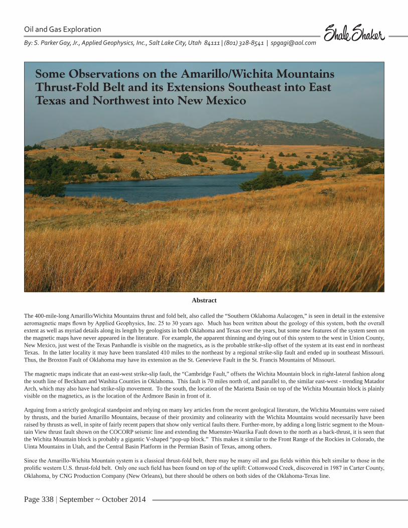
Some Observations on the Amarillo/Wichita Mountains Thrust-Fold Belt and its Extensions Southeast into EastTexas and Northwest into New Mexico
Abstract
The 400-mile-long Amarillo/Wichita Mountains thrust and fold belt, also called the “Southern Oklahoma Aulacogen,” is seen in detail in the extensive aeromagnetic maps flown by Applied Geophysics, Inc. 25 to 30 years ago. Much has been written about the geology of this system, both the overall extent as well as myriad details along its length by geologists in both Oklahoma and Texas over the years, but some new features of the system seen on the magnetic maps have never appeared in the literature. For example, the apparent thinning and dying out of this system to the west in Union County, New Mexico, just west of the Texas Panhandle is visible on the magnetics, as is the probable strike-slip offset of the system at its east end in northeast Texas. In the latter locality it may have been translated 410 miles to the northeast by a regional strike-slip fault and ended up in southeast Missouri. Thus, the Broxton Fault of Oklahoma may have its extension as the St. Genevieve Fault in the St. Francis Mountains of Missouri.
The magnetic maps indicate that an east-west strike-slip fault, the “Cambridge Fault,” offsets the Wichita Mountain block in right-lateral fashion along the south line of Beckham and Washita Counties in Oklahoma. This fault is 70 miles north of, and parallel to, the similar east-west - trending Matador Arch, which may also have had strike-slip movement. To the south, the location of the Marietta Basin on top of the Wichita Mountain block is plainly visible on the magnetics, as is the location of the Ardmore Basin in front of it.
Arguing from a strictly geological standpoint and relying on many key articles from the recent geological literature, the Wichita Mountains were raised by thrusts, and the buried Amarillo Mountains, because of their proximity and colinearity with the Wichita Mountains would necessarily have been raised by thrusts as well, in spite of fairly recent papers that show only vertical faults there. Further-more, by adding a long listric segment to the Moun-tain View thrust fault shown on the COCORP seismic line and extending the Muenster-Waurika Fault down to the north as a back-thrust, it is seen that the Wichita Mountain block is probably a gigantic V-shaped “pop-up block.” This makes it similar to the Front Range of the Rockies in Colorado, the Uinta Mountains in Utah, and the Central Basin Platform in the Permian Basin of Texas, among others.
Since the Amarillo-Wichita Mountain system is a classical thrust-fold belt, there may be many oil and gas fields within this belt similar to those in the prolific western U.S. thrust-fold belt. Only one such field has been found on top of the uplift: Cottonwood Creek, discovered in 1987 in Carter County, Oklahoma, by CNG Production Company (New Orleans), but there should be others on both sides of the Oklahoma-Texas line.

September ~ October 2014 | Page 339
INTRODUCTION
Oklahoma’s most spectacular structure is undoubtedly the “Southern Oklahoma Aulacogen,” which in this article I refer to as the Amarillo–Wichita Mountains thrust-fold belt. My experience with this structural system dates back 30 years when Applied Geophysics, Inc. began flying a series of detailed aeromagnetic surveys that eventually extended continu-ously along the belt from the Texas-New Mexico border on the west, across the Texas Panhandle, then across the width of southern Oklahoma to Lamar County in northeast Texas on the east, a distance of nearly 400 miles. The aeromagnetic
mapping, because of its regional extent, yet detailed nature, reveals a number of interesting features of the system that are not common knowledge. I will focus on these specific facets of the thrust and fold belt, rather than try to make this yet an-other discussion of the “Southern Oklaho-ma Aulacogen,” of which there have been many, notably those of Burke (1977), Gil-bert (1983, 1987), Donovan (1982, 1984), and Perry (1989), among others.
CENTRAL REGION
My first discussion will be of the nature of the deep Anadarko basin in front of the Mountain View and Broxton Faults
in Oklahoma. This discussion does not involve the magnetic data, but it will be pertinent to later observations of the Mountain View system based on the magnetics. I start first by showing a seg-ment of the southwest to northeast cross section of Oklahoma (see Figure 1) pub-lished by the Oklahoma Geological So-ciety forty years ago (Witt, 1971). The most notable feature of the cross section (but not the feature which I will empha-size later) is the verticality shown by the many faults that have uplifted the Wichita Mountains. Today, of course, we know that the Wichita Mountains were raised by a series of northeast-directed thrust faults resulting from intense northeast-
Figure 1. Part of the 1971 Oklahoma Geological Society southwest to northeast cross section of the state. There are two major flaws in the cross section, one of which was recognized at the time of publication. The other is discussed in this paper.

Page 340 | September ~ October 2014
Some Observations on the Amarillo/Wichita Mountains Thrust-Fold Belt and its Extensions Southeast into East Texas and Northwest into New Mexico, cont.
Oil and Gas Exploration
southwest regional compression in Late Mississippian-Early Pennsylvanian time and perhaps earlier. At the time the cross
section was in preparation over four de-cades ago, many geologists in the Okla-homa City Geological Society knew, or
suspected, that the faults were thrusts, and stated they could not “condone the pub-lishing of the cross section in its present
September ~ October 2014 | Page 341
form” (Cochrane, 1971), i.e., with verti-cal faults. It was, nevertheless, published in that form. However, these dissenting
geologists prevailed on the map commit-tee to publish an “alternate explanation” with thrust faults (see circle on left side of Figure 1). This is interesting, in that thrust faults, not vertical faults, were shown by the committee at three other places on the original cross section under 1) Altus Field, 2) Cement Field, and 3) Oklahoma City Field (although under the latter, there is an uplift drawn in the form of a thrust but a line for the fault itself does not appear).
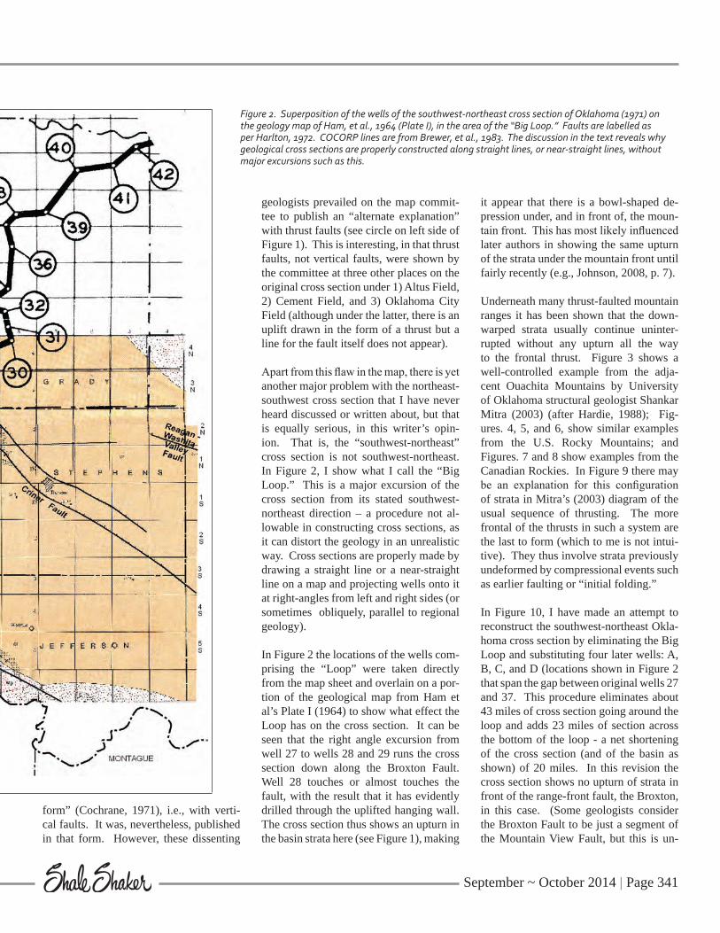
Apart from this flaw in the map, there is yet another major problem with the northeast-southwest cross section that I have never heard discussed or written about, but that is equally serious, in this writer’s opin-ion. That is, the “southwest-northeast” cross section is not southwest-northeast. In Figure 2, I show what I call the “Big Loop.” This is a major excursion of the cross section from its stated southwest-northeast direction – a procedure not al-lowable in constructing cross sections, as it can distort the geology in an unrealistic way. Cross sections are properly made by drawing a straight line or a near-straight line on a map and projecting wells onto it at right-angles from left and right sides (or sometimes obliquely, parallel to regional geology).
In Figure 2 the locations of the wells com-prising the “Loop” were taken directly from the map sheet and overlain on a por-tion of the geological map from Ham et al’s Plate I (1964) to show what effect the Loop has on the cross section. It can be seen that the right angle excursion from well 27 to wells 28 and 29 runs the cross section down along the Broxton Fault. Well 28 touches or almost touches the fault, with the result that it has evidently drilled through the uplifted hanging wall. The cross section thus shows an upturn in the basin strata here (see Figure 1), making
it appear that there is a bowl-shaped de-pression under, and in front of, the moun-tain front. This has most likely influenced later authors in showing the same upturn of the strata under the mountain front until fairly recently (e.g., Johnson, 2008, p. 7).
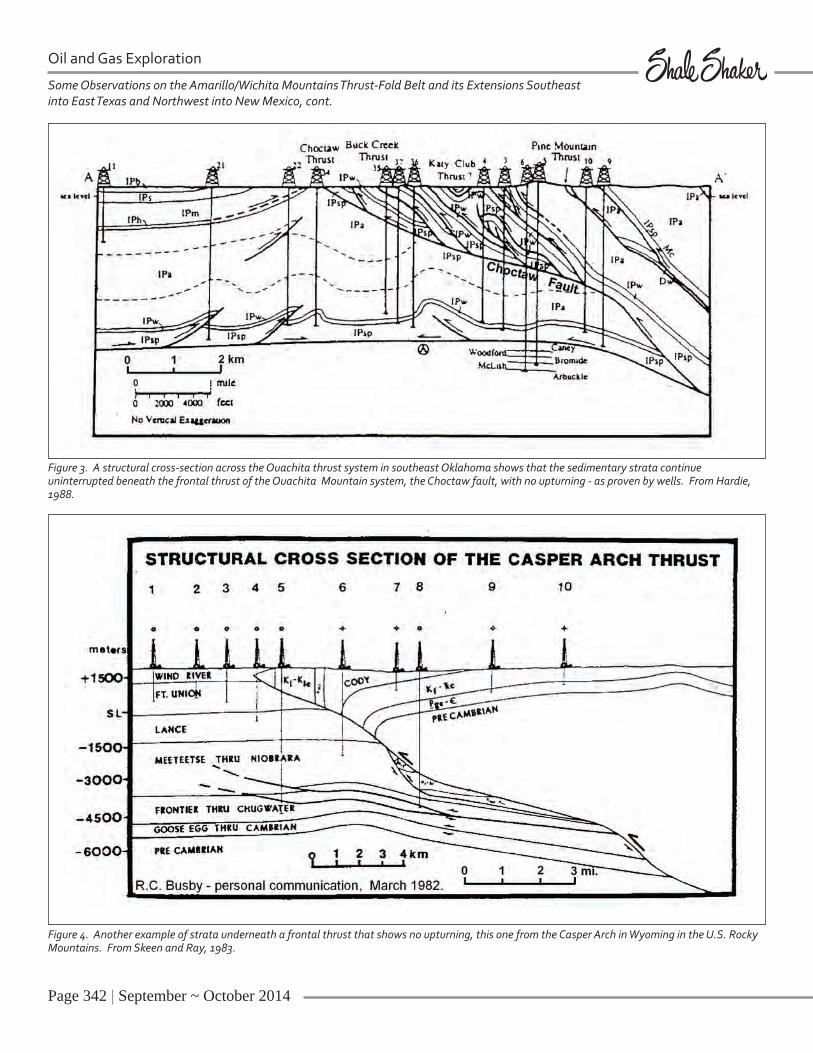
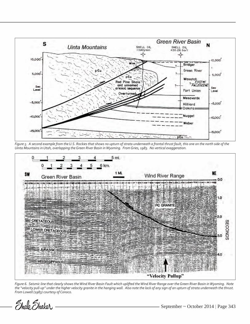
Underneath many thrust-faulted mountain ranges it has been shown that the down-warped strata usually continue uninter-rupted without any upturn all the way to the frontal thrust. Figure 3 shows a well-controlled example from the adja-cent Ouachita Mountains by University of Oklahoma structural geologist Shankar Mitra (2003) (after Hardie, 1988); Fig-ures. 4, 5, and 6, show similar examples from the U.S. Rocky Mountains; and Figures. 7 and 8 show examples from the Canadian Rockies. In Figure 9 there may be an explanation for this configuration of strata in Mitra’s (2003) diagram of the usual sequence of thrusting. The more frontal of the thrusts in such a system are the last to form (which to me is not intui-tive). They thus involve strata previously undeformed by compressional events such as earlier faulting or “initial folding.”
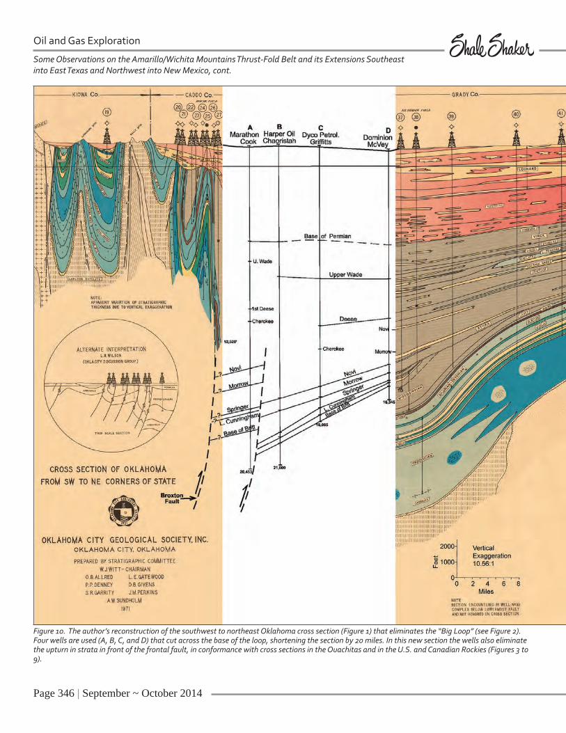
In Figure 10, I have made an attempt to reconstruct the southwest-northeast Okla-homa cross section by eliminating the Big Loop and substituting four later wells: A, B, C, and D (locations shown in Figure 2 that span the gap between original wells 27 and 37. This procedure eliminates about 43 miles of cross section going around the loop and adds 23 miles of section across the bottom of the loop - a net shortening of the cross section (and of the basin as shown) of 20 miles. In this revision the cross section shows no upturn of strata in front of the range-front fault, the Broxton, in this case. (Some geologists consider the Broxton Fault to be just a segment of the Mountain View Fault, but this is un-
Figure 2. Superposition of the wells of the southwest-northeast cross section of Oklahoma (1971) on the geology map of Ham, et al., 1964 (Plate I), in the area of the “Big Loop.” Faults are labelled as per Harlton, 1972. COCORP lines are from Brewer, et al., 1983. The discussion in the text reveals why geological cross sections are properly constructed along straight lines, or near-straight lines, without major excursions such as this.
Page 342 | September ~ October 2014
Oil and Gas Exploration
Some Observations on the Amarillo/Wichita Mountains Thrust-Fold Belt and its Extensions Southeast into East Texas and Northwest into New Mexico, cont.
Figure 3. A structural cross-section across the Ouachita thrust system in southeast Oklahoma shows that the sedimentary strata continue uninterrupted beneath the frontal thrust of the Ouachita Mountain system, the Choctaw fault, with no upturning - as proven by wells. From Hardie, 1988.
Figure 4. Another example of strata underneath a frontal thrust that shows no upturning, this one from the Casper Arch in Wyoming in the U.S. Rocky Mountains. From Skeen and Ray, 1983.
September ~ October 2014 | Page 343
Figure 5. A second example from the U.S. Rockies that shows no upturn of strata underneath a frontal thrust fault, this one on the north side of the Uinta Mountains in Utah, overlapping the Green River Basin in Wyoming. From Gries, 1983. No vertical exaggeration.
Figure 6. Seismic line that clearly shows the Wind River Basin Fault which uplifted the Wind River Range over the Green River Basin in Wyoming. Note the “velocity pull-up” under the higher velocity granite in the hanging wall. Also note the lack of any sign of an upturn of strata underneath the thrust. From Lowell (1983) courtesy of Conoco.

Page 344 | September ~ October 2014
Some Observations on the Amarillo/Wichita Mountains Thrust-Fold Belt and its Extensions Southeast into East Texas and Northwest into New Mexico, cont.
Oil and Gas Exploration
Figure 7. An example of complex thrust faulting in the Canadian Rockies that shows no upturning of underlying strata in front of the thrusting, again proven by well data. Structure of the eastern Rocky Mtn. foothills at 49º45’ N latitude. From Price (1981).
Figure 8. A second example from the Canadian Rockies that show major thrusts with no proven consequential upturning of strata underneath the thrusts. From Fox (1959).

September ~ October 2014 | Page 345
tenable, as the Broxton strike is some 25º different.) I consider the Broxton to be a “30º” splay off the Mountain View. Such splays are common along regional strike-slip faults. See the splays off the San An-dreas Fault in California (Harding, 1974, p. 131) and the Barisan Mountain Fault in Sumatra (Harding, 1974, p. 134), for ex-ample. These splay faults along the Wich-ita system may have been formed during an earlier episode of transpressional activ-ity in late Proterozoic time.
In Figure 10 the placement of a thrust be-tween wells A and B to account for higher intercepts in well A rather than drawing an upturn in strata here may be questioned by some. However, the formation tops in
wells D, C, and B fall along nearly straight lines. If there were an upturn it should be visible to a degree in well B, possibly in well C, and would not just appear in well A. Additionally, there is precedent for placing a buried thrust (or thrusts) in front of the Broxton or Mountain View Thrusts. Johnson (1989, p. 8) shows a cross sec-tion by H. G. Davis with this geometry, and Petroleum Information (1982, p. 11) shows the same but with vertical faults. McConnell (1989) says that cross sec-tions across the Wichita Mountains “show basement-involved thrusts and folds simi-lar to those recognized within the foreland of the Rocky Mountains” and then goes on to calculate the amount of shortening created by the thrusting, a rather definitive
statement against vertical faults. There-fore, my conclusion is that there is no upturn of strata under the Wichita frontal thrust. The strata are continuous without deviation from the shelf right down to the faults, as in the other examples I show in Figures 3 through 8. Note that these six figures are not theoretical. They are based on drilled wells or seismic data.
Knowledge of the probable configuration of the strata under the various thrusts in the Wichita Uplift is very important to oil and gas explorers, and the supposed, but non-existent, upturn of strata could be misleading for some.
The next topic I will discuss is the overall
Figure 9. Explanation of multiple thrusting showing that once a thrust forms, later thrusts of this same system form successively in front of the first one, not behind it. (From Mitra, 1986.)
Page 346 | September ~ October 2014
Oil and Gas Exploration
Some Observations on the Amarillo/Wichita Mountains Thrust-Fold Belt and its Extensions Southeast into East Texas and Northwest into New Mexico, cont.
Figure 10. The author’s reconstruction of the southwest to northeast Oklahoma cross section (Figure 1) that eliminates the “Big Loop” (see Figure 2). Four wells are used (A, B, C, and D) that cut across the base of the loop, shortening the section by 20 miles. In this new section the wells also eliminate the upturn in strata in front of the frontal fault, in conformance with cross sections in the Ouachitas and in the U.S. and Canadian Rockies (Figures 3 to 9).
September ~ October 2014 | Page 347
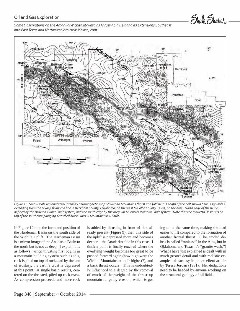
geometry of the Wichita Mountain Up-lift in Oklahoma. For this, I turn to the aeromagnetic data, as shown in Figure 11. This is a small-scale rendition of the original magnetic maps generated at Ap-plied Geophysics, and hence it lacks much of the detail, but nevertheless shows quite well the overall form of the uplifted thrust belt lying between the Broxton Fault on the north and the parallel Muenster-Wau-rika Fault system on the south (the Burch Fault lies south of the Muenster-Waurika and has much less throw according to the magnetics). The Muenster-Waurika sys-tem is not a straight line like the Broxton, but appears to be broken into segments that later had different amounts of north-east transport. Nevertheless, it follows a path approximately parallel to the Brox-ton Fault so that the uplifted Wichita block maintains a fairly constant width southeast to its termination across the Red River in Collin County, Texas. Applied Geophysics’ magnetic data did not ex-tend far enough to cover this termination, so we have combined NURE (National Uranium Resource Evaluation Program) magnetic data from the NOAA (National Oceanic and Atmospheric Administration) website with our data in Figure 11 to map this area. It is interesting to speculate why such a long, complexly faulted and up-lifted block would suddenly end in Collin County as shown. I will offer an explana-tion for this below.
Note that the amplitudes of the mag-netic anomalies in the highest part of the Wichita Uplift centered on Kiowa County (Figure 11) are much stronger than the anomalies to the southeast. This is due to an increasing depth of burial of the mag-netic basement rocks in the thrusts in the uplift to the southeast. That is, the system plunges southeast (It also plunges in the opposite direction into the Texas Panhan-dle where we have the “buried Amarillo Mountains,” which I will also discuss lat-er). Just to the north of the culmination in height of the Wichita Mountains in south-west Oklahoma lies the deepest part of the Anadarko Basin in Beckham and Washita
Counties (McBee, 1992, comment during talk), as the law of isostasy would suggest.
To the southeast, the magnetic data in Fig-ure 11 reveal that the Marietta Basin sits on top of the Wichita Uplift, whereas the Ardmore Basin is clearly in front of it on the north and is therefore an extension of the Anadarko Basin.
Figure 12a shows the interpretation of the COCORP regional seismic data (Brewer, et al., 1983) across the thrust-fold belt; its location is given in Figure 2. The frontal fault, the Mountain View, is quite promi-nent on the COCORP line. In Figure 12b I extend this fault downward in typical listric fashion to the south (dashed line). The Muenster-Waurika Fault on the south was also mapped on the COCORP line (mislabled as the Burch Fault?) and is shown to be north-dipping, that is, extend-ing back under the uplift to the north. I project this fault downdip to the Mountain View Fault as a back-thrust, thus making the Wichita Uplift a gigantic V-shaped “pop-up” block. While some may think this interpretation is controversial, Camp-bell (2007) also shows a backthrust on the south side of the uplift. Furthermore, the Front Range west of Denver, Colorado, has been shown to have this geometry (Fig-ure 13), as does the Uinta Uplift in Utah (Stone, 1993) and also the Central Basin Platform of the Permian Basin in Texas and New Mexico. Plus, there are many such pop-up blocks that form localized uplifts in other thrust belts, some of which are producing oil or gas fields. Some il-lustrative scattered examples are: Sohare Anticline, Wyoming (Albertus, 1985); Di-vide Creek Anticline, Colorado (Hoak and Klawitter, 1997); unnamed fold, Macken-zie Mountains, Canada (Harding, 1985); and an unnamed fold in Perdido fold-belt, Texas (Rowan, 2000). Closer to home, Allen (1991) had an excellent discussion of a similar oil-field-sized “pop-up” in the Potato Hills in Oklahoma. This one may perhaps be more significant to Oklahoma geologists than the others.
Page 348 | September ~ October 2014
Oil and Gas Exploration
Some Observations on the Amarillo/Wichita Mountains Thrust-Fold Belt and its Extensions Southeast into East Texas and Northwest into New Mexico, cont.
In Figure 12 note the form and position of the Hardeman Basin on the south side of the Wichita Uplift. The Hardeman Basin is a mirror image of the Anadarko Basin to the north but is not as deep. I explain this as follows: when thrusting first begins in a mountain building system such as this, rock is piled on top of rock, and by the law of isostasy, the earth’s crust is depressed at this point. A single basin results, cen-tered on the thrusted, piled-up rock mass. As compression proceeds and more rock
is added by thrusting in front of that al-ready present (Figure 9), then this side of the uplift is depressed more and becomes deeper – the Anadarko side in this case. I think a point is finally reached where the overlying weight becomes too great to be pushed forward again (how high were the Wichita Mountains at their highest?), and a back thrust occurs. This is undoubted-ly influenced to a degree by the removal of much of the weight of the thrust–up mountain range by erosion, which is go-
ing on at the same time, making the load easier to lift compared to the formation of another frontal thrust. (The eroded de-bris is called “molasse” in the Alps, but in Oklahoma and Texas it’s “granite wash.”) What I have just explained is dealt with in much greater detail and with realistic ex-amples of isostasy in an excellent article by Teresa Jordan (1981). Her deductions need to be heeded by anyone working on the structural geology of oil fields.
Figure 11. Small-scale regional total intensity aeromagnetic map of Wichita Mountains thrust and fold belt. Length of the belt shown here is 230 miles, extending from the Texas/Oklahoma line in Beckham County, Oklahoma, on the west to Collin County, Texas, on the east. North edge of the belt is defined by the Broxton-Criner Fault system, and the south edge by the irregular Muenster-Waurika Fault system. Note that the Marietta Basin sits on top of the southeast-plunging disturbed block. MVF = Mountain View Fault.

September ~ October 2014 | Page 349
Figure 12. a. The COCORP deep seismic line across the Wichita Mountains fold and thrust belt. The line was shot in three segments (see Figure 2). This figure is from Brewer et al. (1983). b. My interpretation (blue) of the continuation of the main north- and south-bounding faults at depth, the Mountain View and the Muenster - Waurika (here called the Burch), a back-thrust.
Figure 13. A regional cross-section of the Front Range in Colorado that shows a similar geometry as the Wichita Uplift. Here again, I have extended (in blue) the front- and back-thrusts at depth. From Raynolds (1997).
Page 350 | September ~ October 2014
Oil and Gas Exploration
Some Observations on the Amarillo/Wichita Mountains Thrust-Fold Belt and its Extensions Southeast into East Texas and Northwest into New Mexico, cont.
The Front Range in Colorado has its Har-deman Basin equivalent – the Middle (Figure 12) and South Park Basins to the west with the Denver Basin as the main (frontal) basin. The Uinta Mountains have their Anadarko and Hardeman Basin, the Green River Basin on the north and the Uinta Basin on the south, respectively, and the Central Basin Platform of the Perm-ian Basin has the deeper Delaware Basin on the south and the Midland Basin on the
north, indicating that the causative thrust-ing is from north to south, with the prob-able backthrust on the north, or Midland Basin, side. A cross section by Brown (1984a) supports the thrusting on the south side of the Central Basin Platform in Gray Ranch Field. However, a recent pa-per (Dotsey, 2012) incorrectly shows the Platform to have been raised along verti-cal, or near-vertical, faults, which geolo-gists now know is not possible in such a
compressional system.
So far I have been dealing with compres-sional faults. At this point, I want to men-tion a rather enigmatic strike-slip fault that we have mapped with the magnetics but which has not been mapped geologi-cally. It affects the magnetics on the north side of Figure 11 trending east-west near the south line of Beckham and Washita Counties, and we have given it the name

September ~ October 2014 | Page 351
Cambridge Fault for a location on the old Atchison, Topeka, and Santa Fe Railroad, which lies along the fault zone in north-central Kiowa County. It appears to offset the Wichita Mountain Block with left-lateral movement and then extends eastward under the Anadarko Basin where it truncates deep basement anomalies at four places until it is truncated itself by a northwest trending block corresponding to a magnetic high. In Figure 14, I have
cut the magnetic map apart along the sup-posed fault and moved the north side 37 miles to the east where it matches the data on the south side quite well, both on the uplift and in the basin. As support for this long strike-slip fault, I’d like to point out another east-west trending fault system only 70 miles to the south of this fault, the Matador/Red River Arch that shows on the magnetics of Figure 11 as a series of narrow elongated east-west anomalies. Beyond that I don’t know what to make of the Cambridge Fault. No evidence for it is shown on the regional structure maps of Ham, et al. (1964) or of Harlton (1972), both of which were quite com-prehensive studies. Since it offsets the magnetic anomaly pattern that I believe is due to uplifted basement blocks in the late Mississippian/Early Pennsylvanian thrust belt, then it would have formed later, but no such later major strike-slip event is known here. Perhaps geologists who have drilled wells close to or along the length of the fault would be able to shed more light on its characteristics, and hence on its ex-istence and its origin. An explanation for the origin of this fault would probably also explain the origin of the parallel Matador Arch to the south.
EASTERN REGION
So far in this paper I have mainly discussed compressional structures which were ac-tivated in late Mississippian-early Penn-sylvanian time and apparently followed earlier strike-slip faults of the “Southern Oklahoma aulacogen” which formed in Precambrian and/or early Cambrian time. These faults apparently had major trans-verse movement over long periods of time both in the earlier fault–forming episode and in the later period of reactivation.
In Figure 15, I show several of these reac-tivated strike-slip faults in Johnston, Pon-
totoc and adjacent counties as mapped by Lloyd Gatewood (personal communica-tion, 1984; now deceased, 2011). I do this to illustrate that these long faults always fall along magnetic gradients and are parallel to elongate magnetic anomalies because their magnetic signatures are pro-duced by slivers of basement rocks along them. Starting on the north, the faults il-lustrated are the Pauls Valley-Franks Fault, and the Sulphur, Mill Creek, Reagan, and Washita Valley Faults, all of which show very good correlations with the magnetic data. The correlations are not quite exact, one reason being that the wells used to lo-cate the faults were scattered, and the fault traces are thus not closely controlled.
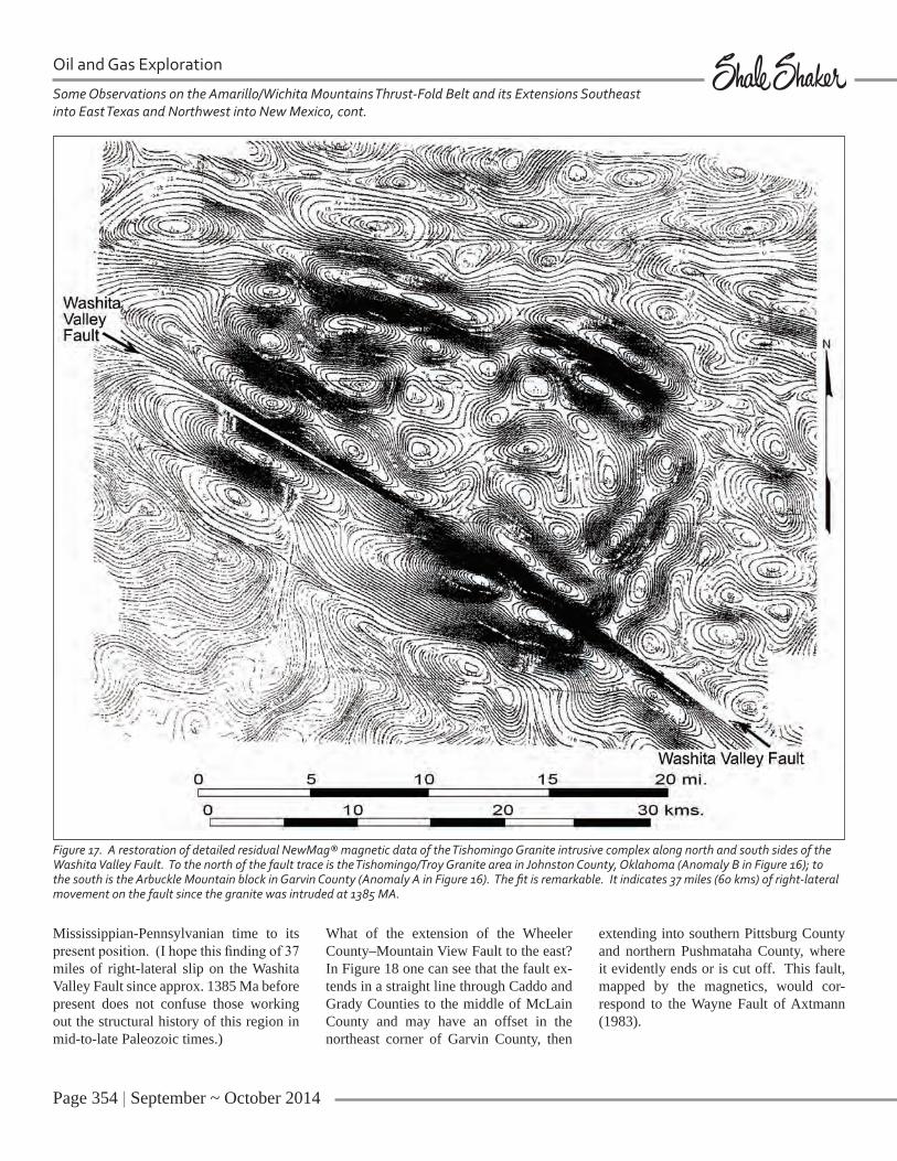
At this point, I will switch the discussion to an interesting structural feature interpreted from the magnetic data in the eastern part of the Mountain View Fault System, an-other feature I have never heard discussed. That is the offset of the Tishomingo/Troy Granite along the Washita Valley Fault. In the upper left corner of Figure 16, there are two notable areas of magnetic anom-alies marked A and B. Anomalous Area A corresponds to the uplifted Arbuckle Mountains and consists of a magnetic high over the mountain block on the south and a magnetic low on the north, whereas Anomalous Area B corresponds to out-crops of the Troy and Tishomingo Gran-ites (Lidiac and Denison, 1999) under the high on the north with a low on the south. The Washita Valley Fault corresponds to the strong magnetic gradient between the highs and lows in both cases. Quite soon after flying the magnetic survey in the 1980s, we noticed that anomalies A and B seemed to match, so we cut the map apart along the fault, lined up the anomalies on north and south sides, and obtained a rath-er remarkable fit. A computer version of the restored feature is shown in Figure 17, and I think the fit is quite convincing. For
Figure 14. Restoration of the northwest termination of the Wichita Mountains fold and thrust belt on the Oklahoma - Texas state line along the near-east-west-trending “Cambridge Fault.” Thirty seven miles of movement are required to line up several magnetic features here as discussed in the text. However, geologic confirmation is lacking. These are the same total intensity contours as shown in figure 11.

Page 352 | September ~ October 2014
Oil and Gas Exploration
Some Observations on the Amarillo/Wichita Mountains Thrust-Fold Belt and its Extensions Southeast into East Texas and Northwest into New Mexico, cont.
Figure 15. Aeromagnetic data (NewMag® residual) of part of Johnston, Pontotoc and adjacent counties with faults from Lloyd Gatewood’s Arbuckle map (updated April 1983) overlain. Note that the faults follow magnetic gradients and elongated magnetic anomalies in all cases.

September ~ October 2014 | Page 353
detail, note the match of the linear mag-netic lows in the southeast corner as well as the linear truncation of magnetic anom-alies on the west side. I interpret this large composite feature (12 x 20 miles) to be a complex igneous intrusion with the vari-ous magnetic highs and lows arising from different individual intrusive cells, or plu-tons. One notable example of a composite intrusion is the Sierra Nevada batholith in California, well-described in U.S. Geo-logical Survey publications. This huge well–studied intrusive complex consists of multiple plutons intruded into, beside,
and around each other, similar to what we have here (see Lidiac and Denison, 1999, Figure 2).
The horizontal offset between anomalies A and B shown in Figure 17 is 37 miles (60 kms) in a right-lateral sense, and there is a slight rotation of 6° between the two segments due to the curvature of the Washita Valley Fault in this area. Some geologists may disagree with my finding of right-lateral movement on the fault, but as the granite was intruded at approxi-mately 1375-1395 Ma, this exercise only
shows net movement since that time, i.e. including possible late Proterozoic - early Paleozoic offset, not just the Mississippi-an-Pennsylvanian movement. Strike-slip movement during the Mississippian-Penn-sylvanian episode has been postulated as left-lateral by several workers: 49 miles by Tanner (1967), 20 miles by Carter (1979), 36 miles by Wilkinson (1997), and zero miles by Brown (1984b), but I see no problem with the fault having had a com-ponent of right-lateral slip greater than 60 kms in Proterozoic or Cambrian time, then moving with left slip a certain amount in
Figure 16. Regional magnetic map (total intensity) of the eastern part of this study showing Arbuckle Mountains anomaly (A), Tishomingo/Troy Granite anomaly (B), and the eastern end of the Wichita Mountains fold and thrust belt (C-C’) to its termination in Collin County, Texas, (C’).
Page 354 | September ~ October 2014
Some Observations on the Amarillo/Wichita Mountains Thrust-Fold Belt and its Extensions Southeast into East Texas and Northwest into New Mexico, cont.
Oil and Gas Exploration
Mississippian-Pennsylvanian time to its present position. (I hope this finding of 37 miles of right-lateral slip on the Washita Valley Fault since approx. 1385 Ma before present does not confuse those working out the structural history of this region in mid-to-late Paleozoic times.)
What of the extension of the Wheeler County–Mountain View Fault to the east? In Figure 18 one can see that the fault ex-tends in a straight line through Caddo and Grady Counties to the middle of McLain County and may have an offset in the northeast corner of Garvin County, then
extending into southern Pittsburg County and northern Pushmataha County, where it evidently ends or is cut off. This fault, mapped by the magnetics, would cor-respond to the Wayne Fault of Axtmann (1983).
Figure 17. A restoration of detailed residual NewMag® magnetic data of the Tishomingo Granite intrusive complex along north and south sides of the Washita Valley Fault. To the north of the fault trace is the Tishomingo/Troy Granite area in Johnston County, Oklahoma (Anomaly B in Figure 16); to the south is the Arbuckle Mountain block in Garvin County (Anomaly A in Figure 16). The fit is remarkable. It indicates 37 miles (60 kms) of right-lateral movement on the fault since the granite was intruded at 1385 MA.
September ~ October 2014 | Page 355
Now let’s return to Figure 11 and look at the bend in the Wichita Mountain Block in Kiowa County where the Mountain View Fault on the west appears to turn southeast into the Broxton Fault. Appar-ently, the Mississippian-Pennsylvanian compressional thrusting episode connects these two faults, but the earlier strike-slip movement (Precambrian-Cambrian) on the Mountain View would have been lin-ear – no such bend possible. The Brox-ton and other faults parallel to it and the Washita Valley Fault appear to be splays off the Mountain View, as stated earlier. Regional strike-slip faults are always linear, but many times they are offset by cross-faults where they can be interpreted as being bent if there is insufficient well control.
The next, and final, topic of the eastern region of the Amarillo-Wichita thrust-fold belt that I will discuss is where, why, and how does this long, prominent system of faults end? In Figure 16, I have placed black dots at the truncation points of 1) the Wichita Mountain block and 2) the Washita Valley/Arbuckle block. (Note that these dots fall inboard of the last mag-netic contour lines, because in plan view magnetic anomalies are always larger than their source bodies and the anomalies be-come broader as their sources get deeper.) Note that on the magnetic map of Figure 16 there appears to be no obvious exten-sion of either of these features towards the southeast, so I believe they are truncated as shown. But why?
The first explanation that comes to mind is that they are simply cut off by the Ouachi-ta structural system. That is, the continent ended here as shown by many authors, and oceanic crust (later subducted?) existed to the southeast. Having these faults extend across the continent-ocean boundary into oceanic crust would readily dispense with the truncation problem.
However, there is another possibility. Per-haps these anomalies were faulted off by a regional strike-slip fault. Connecting the
dots of Figure 16 produces a straight line striking about N29°E, which would give the approximate strike of the postulated fault. If this line is extended 200 miles southwest into Texas, it falls precisely along the east side of the Llano Uplift (cored by Precambrian basement), and a segment of it is exactly parallel to the boundary of the uplift, as per Bayley and Muehlberger’s basement map (1968).
Next question: If such a long regional fault exists would it have carried the Wichita ex-tensions to the northeast or the southwest? Examination of the “Magnetic Anomaly Map of the United States” (Zietz, 1982) shows no possible west-northwest struc-tural trends as one goes southwest through Texas and into Mexico, but as one goes northeast into Missouri, there are many possibilities. The detailed magnetic map of the St. Francis Mountains in south-eastern Missouri (flown in sections by the U.S. Geological Survey starting as far back as 1949) shows several candidates west-northwest basement faults, includ-ing the well-known and well-mapped St. Genevieve Fault system, which has the same strike. Also, the northeast-trending offsetting fault shows well in the magnet-ics in this area. It passes approximately through the town of Springfield, Missouri, and over the center of the Ozark Uplift. It is about 410 miles along this line from the truncation of the Washita Valley Fault on the Texas-Oklahoma line to the intersec-tion with the St. Genevieve system in Mis-souri. I would suggest that here we might find the Wichita Mountain and Washita Valley Fault extensions.
Before I hang my hat on that one, however, I recall that a number of years back, Kin-sland, on the basis of anomaly patterns on the gravity and magnetic maps of the U.S. (Kinsland, 1982, 1986) proposed a 500-mile long offset along an hypothesized northwest-southeast fault trending almost clear across the United States. This fault was not accepted by several well-known geologists who wrote rebuttals, but I don’t know that any of them actually proved
him wrong. Kinsland published many correlating features along this supposed fault then and also in later papers, and a debate judge would likely have ruled that he had won the argument. My own analysis is that he is probably right, as this supports my finding that the Precambrian crystalline crust is cut pervasively by long strike-slip faults, which control most or all of post-Precambrian structure (Gay, 2008, 2011). That being the case, the long strike-slip faults I propose in this paper do not seem so unreasonable.
WESTERN REGION
I will now move the discussion to the west and examine the Amarillo/Texas portion of the Amarillo-Wichita Mountains thrust-fold belt (see Figure 19). One of the first things this map reveals is that the width of the belt in Texas is markedly reduced from its width in Oklahoma. To better see this, look again at Figure 18. Here, the de-creasing width of the belt as one goes west is quite apparent. We can express this in tabular form as follows:
Location Width of Thrust Belt
New Mexico – Texas line Approx. 10 miles
Gray – WheelerCounties, Texas Approx. 20 miles
SouthernOklahoma Approx. 25-30 miles
NortheastTexas Approx. 40 miles
SoutheastMissouri Approx. 75 miles
The latter entry is speculation on my part, but it cannot be dismissed as a possibility at this time (see discussion in last section).
Why the decrease in width of the thrust belt to the west? This seems to indicate a lesser amount of northeast shortening

Page 356 | September ~ October 2014
Oil and Gas Exploration
and hence a lesser degree of compression in that direction. We must be getting far-ther away from the continent-continent collision that is causing the compressive/transpressive stress here. Beyond that, I won’t speculate further. I leave that to others who are better versed in plate tec-tonics than I and can answer this question
more reliably. But this observation may be a key piece of evidence for better un-derstanding the “Southern Oklahoma au-lacogen/thrust belt.”
Going back to Figure 19, we can see that the Amarillo-Wichita thrust-fold belt terminates abruptly in Union County,
New Mexico, only 10 miles west of the Texas - New Mexico line. (Thus, not much chance of oil on this trend in New Mexico, but fortunately plenty of it on another northwest-southeast trend to the south in the Permian Basin.) I made a brief attempt to see if the system in Union County, New Mexico was offset along a
Some Observations on the Amarillo/Wichita Mountains Thrust-Fold Belt and its Extensions Southeast into East Texas and Northwest into New Mexico, cont.

September ~ October 2014 | Page 357
regional cross-cutting fault, as it is at its eastern end in northeast Texas, but was not successful. The system seems to just be dying out going west, as the magnetic anomaly merges with other basement lithologic anomalies. In this regard, note the strong linear northeast-trending mag-netic low just north of the red arrows in
Figure 19. This I interpret as an earlier ul-tramafic dike-like intrusion injected into a rift or extensional fault in Archean or early Proterozoic time and so is unrelated to the Amarillo/Wichita thrust-fold system.
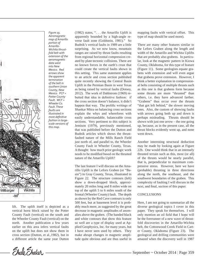
The next topic I will discuss is the thrust-ed nature of the buried Amarillo uplift in Texas. This must be treated here, because as recently as 1989 (Budnik) the uplift was illustrated as being raised along verti-cal faults similar to those shown in 1971 for the Wichita Mountains (Figure 1), with no thrusting. Multiple papers with cross sections constructed from well data prove beyond doubt the thrusted nature of the system in Oklahoma, and I would argue that the continuity of the system across the Texas-Oklahoma line is sufficient proof that the system is thrusted in Texas as well. However, there does exist one good exam-ple of the thrusted nature of the system in Texas, that is, a well controlled cross sec-tion of the Mills Ranch Field in Wheeler Co. published by Jemison (1979). It is for this reason that I felt confident enough to call the entire system a thrust-fold belt in the title of this paper. Perhaps this des-ignation might inspire some oil and gas explorers to take a new look at the Texas side of the belt from a different perspec-tive. Surely, undiscovered hydrocarbons are hidden by complex thrusting and fold-ing in the buried Amarillo Mountains as they are in the Wichita Mountains across the state line.
Now let’s look at another prominent aspect of this system - the frontal fault. In Okla-homa it is called the Mountain View Fault and in Texas, the Wheeler County Fault (Budnik, 1987), but the two are continu-ous and co-linear, not separate features. There is some along-strike complexity along the mountain front on both sides of the border as the magnetic data show (Fig-ure 18 and 19). For example, there occur
a series of slightly offset individual mag-netic highs along the front rather than just one long continuous magnetic gradient as would be the case if the frontal fault were a long straight line. The magnetic data thus suggest that the front is cut by cross faults into a series of individual, probably en echelon, segments, each one topped by an anticline. The same situation occurs back of the front to the south on top of the uplifts, as the magnetic pattern shows so well (Figures 11, 18 and 19). Cross-faults undoubtedly play a role here in separating the belt into individual anticlines and syn-clines (see Gay, 2011, pp 18-23).
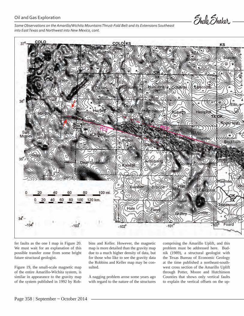
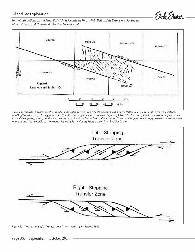
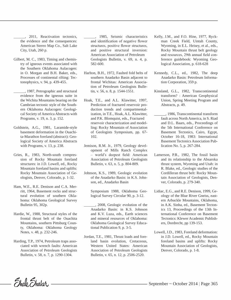
We have now traced the frontal fault from Fannin County in northeast Texas westward across southern Oklahoma, to Moore County, Texas, in the Panhandle (Figure 18). What happens to it here? The Wheeler County Fault seems to simply disappear in a maze of anomalies appar-ently not related to the Amarillo-Wichita belt. But look to the south. Ten miles away is a strong trend exactly parallel to it that continues on to the west. Parts of this trend are labeled as the Potter County Fault by Budnik (1989), so I use the name “Potter County Fault” for the entire trend across Potter County and parts of Old-ham and Hartley Counties to, and beyond, the New Mexico line. This fault is quite pronounced on the larger scale, detailed magnetic map (not possible to show here) in its linearity and continuity. In the area between this new fault and the Wheeler County Fault occurs a series of short, par-allel northwest-trending magnetic gradi-ents that I interpret as faults comprising a possible “transfer zone” (Figure 20). This term has only appeared in the literature in the last 20 years or so, and a reason-able, theoretical depiction of it was drawn by McBride (1994) and is shown here in Figure 21. However, neither of McBride’s diagrams shows the same pattern of trans-
Figure 18. The entire Amarillo-Wichita thrust-fold system is shown here in one image, from northeast Texas on the east to New Mexico on the west. Note my possible/probable extension of the Mountain View Fault to the east (red). This would correspond, in part, to the Wayne Fault of Axtmann (1983).
Page 358 | September ~ October 2014
Some Observations on the Amarillo/Wichita Mountains Thrust-Fold Belt and its Extensions Southeast into East Texas and Northwest into New Mexico, cont.
Oil and Gas Exploration
fer faults as the one I map in Figure 20. We must wait for an explanation of this possible transfer zone from some bright future structural geologist.
Figure 19, the small-scale magnetic map of the entire Amarillo-Wichita system, is similar in appearance to the gravity map of the system published in 1992 by Rob-
bins and Keller. However, the magnetic map is more detailed than the gravity map due to a much higher density of data, but for those who like to see the gravity data the Robbins and Keller map may be con-sulted.
A nagging problem arose some years ago with regard to the nature of the structures
comprising the Amarillo Uplift, and this problem must be addressed here. Bud-nik (1989), a structural geologist with the Texas Bureau of Economic Geology at the time published a northeast-south-west cross section of the Amarillo Uplift through Potter, Moore and Hutchinson Counties that shows only vertical faults to explain the vertical offsets on the up-
September ~ October 2014 | Page 359
lift. The uplift itself is depicted as a vertical horst block raised by the Potter County Fault (vertical) on the south and the Wheeler County Fault (vertical) on the north. Another publication a few years earlier on this area infers vertical faults on the uplift but does not show them in cross section (Dutton, et al.,1982), but in a different article the same year Dutton
(1982) states, “. . . the Amarillo Uplift is apparently bounded by a high-angle re-verse fault zone (Goldstein, 1981).” So Budnik’s vertical faults in 1989 are a little surprising. As we now know, mountain ranges are raised by thrust faults resulting from regional horizontal compression cre-ated by plate tectonic collisions. There are no known forces in the earth’s crust that could create the vertical faults shown in this setting. This same statement applies to an article and cross section published quite recently showing the Central Basin Uplift in the Permian Basin in west Texas as being raised by vertical faults (Dotsey, 2012). The work of Dahlstrom (1969) re-butted that idea in definitive fashion: if the cross section doesn’t balance, it didn’t happen that way. The prolific writings of Shankar Mitra on balancing cross sections explain the whys and wherefores with easily understandable, balanceable cross sections. Very pertinent to this subject is Jemison (1979), previously mentioned, that was published before the Dutton and Budnik articles which shows the thrust-faulted nature of the Mills Ranch Field just north of, and parallel to, the Wheeler County Fault in Wheeler County, Texas. A thought: how much prior geologic work needs to be modified based on the thrusted nature of the Amarillo Uplift?
The last feature I will discuss on the Ama-rillo Uplift is the Lefors Graben (or “Ba-sin”) in Gray County, Texas, illustrated in Figure 22. The structure contours (left) show a down-dropped block, approxi-mately 20 miles long and 8 miles wide on top of the uplift 5 to 6 miles south of the frontal (Wheeler County) fault. The depth as shown by the Red Cave contours is only 500 feet, but at basement level it is prob-ably much more, as suggested by the great decrease in magnetic amplitudes of anom-alies above the graben. (The banded black and white contours that show this feature so well are a type of display used at Ap-plied Geophysics, Inc. for many years, but I have never seen used by others. They make abrupt changes in magnetic ampli-tude quite obvious and are thus useful in
mapping faults with vertical offset. This type of map should be used more).
There are many other features similar to the Lefors Graben along the length and width of the Amarillo and Wichita Uplifts that are probably also grabens. In particu-lar, look at the magnetic pattern in Kiowa County, Oklahoma, for this type of feature (Figure 11). Some geologists equate gra-bens with extension and will even argue that grabens prove extension. However, I think a better explanation in compression-al belts consisting of multiple thrusts such as this one is that grabens form because some thrusts are more “thrusted” than others, i.e. they have advanced farther. “Grabens” thus occur over the thrusts “that got left behind,” the slower moving ones. Also, the custom of showing faults with arrows going both up and down is perhaps misleading. Thrusts should be shown with just one arrow – the one going up, because, as in the present case, all the thrust blocks evidently went up, and none went down.
Another interesting structural deduction may be made by looking again at Figure 22b. One would think that in an intensely thrusted terrain such as this, most (or all) of the thrusts would be nearly parallel, that is, perpendicular to maximum com-pressive stress. However, here we have (probable) thrusting in three directions along the north, the southeast, and the southwest boundaries of the graben. This complexity of faulting I will discuss in the next, and final, section of this paper.
CONCLUSIONS
Here, I am not going to summarize all the diverse geological topics I cover in this paper. They speak for themselves. I will only mention an oil field that I hope will be the forerunner of a new wave of thrust-fold discoveries in the Amarillo-Wichita belt, the Cottonwood Creek Field in Cart-er County, Oklahoma (Figure 23). The geological and drilling communities were amazed when the discovery well in 1987
Figure 19. Aeromagnetic map of Amarillo portion of Amarillo-Wichita thrust-fold belt with extension of the aeromagnetic data west into New Mexico. Red arrows show the apparent termination of the belt in southern Union County, New Mexico. PCF = Potter County Fault. WCF = Wheeler Co. Fault. These faults are illustrated in more definitive fashion in large-scale versions of this map.
Page 360 | September ~ October 2014
Oil and Gas Exploration
Some Observations on the Amarillo/Wichita Mountains Thrust-Fold Belt and its Extensions Southeast into East Texas and Northwest into New Mexico, cont.
Figure 20. Possible “transfer zone” on the Amarillo Uplift between the Wheeler County Fault and the Potter County Fault, taken from the detailed NewMag® residual map at 1:275,000 scale. (Small-scale magnetic map is shown in Figure 19.) The Wheeler County Fault is approximately as shown on published geology maps, but the length and continuity of the Potter County Fault is new. However, it is quite convincingly observed on the detailed magnetic data (not possible to show here). Name of Potter County Fault is taken from Budnick (1987).
Figure 21. Two versions of a “transfer zone” constructed by McBride (1994).

September ~ October 2014 | Page 361
Figure 22. a. Structural geology map of Lefors Graben (Basin) in Gray County, Texas (from Budnik, 1987). Structure contours are on top of Permian Red Cave formation. b. Banded NewMag® contours of same area as a. The lighter area in center is the graben. It stands out so well because of the lower amplitudes of the magnetic anomalies, which have wider bands. Note the Lefors Fault on both maps and the probable straight-line faults on the southeast and southwest of the basin shown on the magnetic map. Magnetic data courtesy of Applied Geophysics, Inc.
Figure 23. Cross section based on well data (Read and Richmond, 1993) of the Cottonwood Creek Field in Carter County, Oklahoma, along the overthrust Wichita Mountain front. This cross section serves as a model for the type of structural complexity that should be present along the entire Amarillo-Wichita thrust-fold belt.

Page 362 | September ~ October 2014
Oil and Gas Exploration
Some Observations on the Amarillo/Wichita Mountains Thrust-Fold Belt and its Extensions Southeast into East Texas and Northwest into New Mexico, cont.
blew out from the Arbuckle Brown Zone to the tune of an estimated 4000 bopd through a small hole in the drill bit. But to me and others, it is even more amaz-ing that a highly accurate cross section based on well data by CNG’s Dave Read (Figure 23) shows the same type of com-plex thrusting as one observes in regional thrust belts. Figure 24, for comparison, is a cross section of the Covenant Field in the Utah-Wyoming, or Western U.S., thrust belt, discovered in 2004 (Chidsey et al., 2007). There are overlapping thrusts coming from both directions in a complex pattern, which is not a whole lot more com-plex than Read and Richmond’s (1983) cross section in the Amarillo-Wichita thrust-fold belt. The Covenant discovery was made by geologist Doug Strickland who worked out the geology years before
the discovery while employed by a major oil company. He presented it much later to a then-small oil company in Michigan, Wolverine Gas and Oil Corp., who drilled it. The field lies 140 miles from nearest production in the thrust belt to the north in northeast Utah, and its discovery opened up this belt to a leasing/drilling frenzy go-ing toward the old belt to the north as well as a couple of hundred miles or more to the south, a play still ongoing to this day. However, only one further discovery has been made in this belt after ten years of exploration: Providence Field discovered in 2008, 20-25 miles north of Covenant, by Doug Strickland (died young, 2011).
Some geologists, such as Strickland and Read, seem to have a better nose for sniff-ing out these structures than others. Here,
I simply point out that the 400-mile long Amarillo-Wichita thrust-fold belt also has the potential for additional complexly thrusted fields. To those who are interested in getting a feel for what some of the other complexly thrusted producing structures look like, consult the cross sections of the Utah-Idaho thrust belt fields in Lamerson, 1982 (Pineview Field, p. 301; Painter Res-ervoir, p. 304; Yellow Creek, p. 333), West and Lewis, 1982 (Anschutz Ranch Field, p. 638), Kelly and Hine, 1977 (Ryckman Creek Field, p. 621), and Sieverding and Royse, 1990 (Whitney Canyon Field, p. 9). The Covenant structure is just one of the many styles of thrusting illustrated in this belt. I would like to show figures of these interesting structures, but this paper has gone on long enough.
Figure 24. Cross section (Chidsey, et al., 2007) of the recently discovered (2004) Covenant Field in Sevier County, Utah, on the southern extension of the Western United States thrust belt. Note thrusting from both directions, as at Cottonwood Creek in Figure 23. Also note the post-compressional relaxation (normal) faults that are found in several places in the Rocky Mountains and should be looked for in the Amarillo-Wichita belt. These faults should not be confused with faults contemporaneous with compression.

September ~ October 2014 | Page 363
I will finish with just one more Figure, No. 25. Here we see a large compressional fold with three seemingly out-of-place normal faults. These are post-compressional faults, i.e. they occurred after compres-sion ceased and the rock was no longer partially held up by horizontal forces in the crust. They are thus relaxation faults. Due to their steep dips, it is easy to mis-take them for terrane-raising faults, but they have not raised the terrane, they have lowered the flanks as this real-data (well and seismic) illustration shows. Similar
post-compressional relaxation faults are also shown in Figure 24. Do not confuse these faults with the faults that created the structure.
Footnote: All the structural conclusions I arrive at in this paper based on mag-netic data were carried out on maps and overlays at a scale of an inch to 8000 ft. (1:96,000) or 1:250,000 scale. The maps in some cases, were up to six feet long. In this sense, they were regional, but the magnetic data they contain were detailed,
due to a tight magnetic line spacing (1/2 mile to 1 mile) and a sensitive magnetom-eter (.01 gamma). It has been difficult to condense these maps down to fit on 8 ½ x 11 sheets of paper for this article. So if some of my figures do not seem to il-lustrate well the points I make in the text, I beg the reader’s indulgence and suggest he spend additional time examining the figures (with a magnifying glass?) or con-tacting the author for further explanation with larger-scale maps.
Figure 25. Cross section of the giant Madden Field in Fremont County, Wyoming. Two thrusts are shown. The large one on the right raised the Owl Creek Mountains; the one in front of it, and parallel to it, on the left raised the prolific Madden Anticline. The other three faults shown are post-compressional relaxation faults. From Ray and Keefer (1985).

Page 364 | September ~ October 2014
Oil and Gas Exploration
Some Observations on the Amarillo/Wichita Mountains Thrust-Fold Belt and its Extensions Southeast into East Texas and Northwest into New Mexico, cont.
References Cited
Allen, M.W., 1991, Structural analysis of the northeastern Potato Hills: Ouachi-ta Mountains, Oklahoma: Okla-homa Geological Notes, v. 51, n. 6, p. 188-197.
Albertus, J., 1985, Eastern Jackson Hole, Wyoming, in R.R. Gries and R.C. Dyer, eds., Seismic exploration of the Rocky Mountain region: Rocky Mountain Association of Geologists, Denver, Colorado, p. 67-72.
Axtmann, T.C., 1983, Structural mecha-nisms and oil accumulation along the Mountain View – Wayne Fault, south-central Oklahoma: Shale Shaker, v. 34, no. 1, p. 1-12, no. 2, p. 13-22.
Bayley, R.W., and W.R. Muehlberger, 1968, Basement rock map of the United States, exclusive of Alaska and Hawaii: U.S. Geological Survey, scale 1:2,500,000.
Brewer, J.A., R. Good, J.E. Oliver, L.D. Brown, and S. Kaufman, 1983, CO-CORP profiling across the southern Oklahoma aulacogen: Overthrusting of the Wichita Mountains and com-pression within the Anadarko Basin: Geology, v. 11, n. 2, p. 109-114.
Brown, W.G., 1984a, Basement involved tectonics, foreland areas: American Association of Petroleum Geologists Continuing Education Course Note Series, no. 26, 92p.
______, 1984b, Washita Valley Fault sys-tem: A new look at an old fault in J.G. Borger, ed., Technical Proceedings of the 1981 American Association of Petroleum Geologists Mid-Continent Section Regional Meeting: Oklahoma City Geological Society, p. 68-80.
Budnik, R.T., 1987, Structure-contour map of the Lower Permian Red Cave Formation, Amarillo Uplift and vicin-ity, Texas Panhandle: Texas Bureau of Economic Geology Miscellaneous Map, no. 37, scale 1:282,910.
______, 1989, Tectonic structures of the Palo Duro Basin, Texas Panhandle: Texas Bureau of Economic Geology Report of Investigations no. 187, 43p.
Burke, K., 1977, Aulacogens and conti-nental breakup: Annual Review of Earth and Planetary Sciences, v. 5, p. 371-396.
Campbell, J.A., 2007, Understanding the structure of the Wichita Uplift, south-ern Oklahoma: Shale Shaker, v. 57, n. 6, p. 87-97.
Carter, D.W., 1979, A study of movement along the Washita Valley Fault, Ar-buckle Mountains, Oklahoma: Shale Shaker, v. 30, p. 79-106.
Chidsey, T.C., Jr., J.S. DeHamer, E.E. Hart-wick, K.R. Johnson, D.D. Schelling, D.A. Sprinkel, D.K. Strickland, J.P. Vrona, and D.A. Wavrek, 2007, Pe-troleum geology of Covenant Oil Field, in G.C. Willis, M.D. Hylland, D.L. Clark, and T.C. Chidsey, Jr., eds., Central Utah - Diverse Geology of a Dynamic Landscape: Utah Geo-logical Association Publication 36, p. 273-296.
Cochrane, T.E., 1971, The Oklahoma City Geological Society cross section: Shale Shaker, v. 21, n. 8-9, p. 196.
Dahlstrom, C.D.A., 1969, Balanced cross-sections: Canadian Journal of Earth Sciences, v. 6, p. 743-757.
Dotsey, P., 2012, New approach to basin formation temperature modelling: First Break, v. 30, no. 12, p. 107-113.
Donovan, R.N. 1982, Geology of the Blue Creek Canyon area, in M.C. Gilbert, ed., Geology of the eastern Wichita Mountains, southwestern Oklahoma: Oklahoma Geological Survey Guide-book 21, p. 65-77.
______, 1984, The geology of the Blue Creek Canyon area, in M.C. Gilbert and R.N. Donovan, compilers, Recent developments in the Wichita Moun-tains: Geological Society of America South-central Section, Annual Meet-ing, Richardson, Texas, Guidebook to Field Trip 1, p. 40-101.
Dutton, S.P., 1982, Pennsylvanian fan-del-ta and carbonate deposition, Mobeet-ie Field, Texas Panhandle: American Association of Petroleum Geologists Bulletin, v. 66, n. 4, p. 389-407.
______, A.G. Goldstein, and S.C. Ruppel, 1982, Petroleum potential of the Palo Duro Basin, Texas Panhandle: Texas Bureau of Economic Geology Report of Investigations No. 123, 87p.
Fox, F.G., 1959, Structure and accumu-lation of hydrocarbons in southern Alberta foothills, Alberta, Canada: American Association of Petroleum Geologists Bulletin, v. 43, n. 5. p. 991-1025.
Gatewood, L., 1983, Viola-Bromide (Wil-cox) and Oil Creek structure map of an area in eastern Oklahoma: Okla-homa City, Oklahoma, privately sold and distributed, scale 1 inch = 16000 feet.
Gay, S.P. Jr., 2008, Fundamental advances in structural geology based on ongo-ing studies in reactivation tectonics: Shale Shaker, v. 59, nos. 1 and 2, p. 9-22, 49-60.
September ~ October 2014 | Page 365
______, 2011, Reactivation tectonics, the evidence and the consequences: American Stereo Map Co., Salt Lake City, Utah, 260 p.
Gilbert, M. C., 1983, Timing and chemis-try of igneous events associated with the Southern Oklahoma Aulacogen: in O. Morgan and B.H. Baker, eds., Processes of continental rifting: Tec-tonophysics, v. 94, p. 439-455.
______, 1987, Petrographic and structural evidence from the igneous suite in the Wichita Mountains bearing on the Cambrian tectonic style of the South-ern Oklahoma Aulacogen: Geologi-cal Society of America Abstracts with Programs, v. 19, n. 3, p. 152.
Goldstein, A.G., 1981, Laramide-style basement deformation in the Ouachi-ta-Marathon foreland (abstract): Geo-logical Society of America Abstracts with Programs, v. 13, p. 238.
Gries, R., 1983, North-south compres-sion of Rocky Mountain foreland structures: in J.D. Lowell, ed., Rocky Mountain foreland basins and uplifts: Rocky Mountain Association of Ge-ologists, Denver, Colorado, p. 1-32.
Ham, W.E., R.E. Denison and C.A. Mer-ritt, 1964, Basement rocks and struc-tural evolution of southern Okla-homa: Oklahoma Geological Survey Bulletin 95, 302p.
Hardie, W., 1988, Structural styles of the frontal thrust belt of the Ouachita Mountains, southern Pittsburg Coun-ty, Oklahoma: Oklahoma Geology Notes, v. 48, p. 232-246.
Harding, T.P., 1974, Petroleum traps asso-ciated with wrench faults: American Association of Petroleum Geologists Bulletin, v. 58, n. 7, p. 1290-1304.
______, 1985, Seismic characteristics and identification of negative flower structures, positive flower structures, and positive structural inversion: American Association of Petroleum Geologists Bulletin, v. 69, n. 4, p. 582-600.
Harlton, B.H., 1972, Faulted fold belts of southern Anadarko Basin adjacent to frontal Wichitas: American Associa-tion of Petroleum Geologists Bulle-tin, v. 56, n. 8, p. 1544-1551.
Hoak, T.E., and A.L. Klawitter, 1997, Prediction of fractured reservoir pro-duction trends and compartmental-ization, in T.E., Hoak, A.L. Klawitter, and P.K. Blomquist, eds., Fractured reservoir characterization and model-ling: Rocky Mountain of Association of Geologists Symposium, pp. 67-102.
Jemison, R.M. Jr., 1979, Geology devel-opment of Mills Ranch Complex – world’s deepest field: American Association of Petroleum Geologists Bulletin, v. 63, n. 5, p. 804-809.
Johnson, K.S., 1989, Geologic evolution of the Anadarko Basin: in K.S. John-son, ed., Anadarko Basin
Symposium 1988, Oklahoma Geo-logical Survey Circular 90, p. 3-12.
______, 2008, Geologic evolution of the Anadarko Basin: in K.S. Johnson and K.V. Luza, eds., Earth sciences and mineral resources of Oklahoma: Oklahoma Geological Survey Educa-tional Publication 9, p. 3-5.
Jordan, T.E., 1981, Thrust loads and fore-land basin evolution, Cretaceous, Western United States: American Association of Petroleum Geologists Bulletin, v. 65, n. 12, p. 2506-2520.
Kelly, J.M., and F.O. Hine, 1977, Ryck-man Creek Field, Uintah County, Wyoming, in E.L. Heisey, et al., eds., Rocky Mountain thrust belt geology and resources, 29th annual field con-ference guidebook: Wyoming Geo-logical Association, p. 618-628
Kennedy, C.L., ed., 1982, The deep Anadarko Basin: Petroleum Informa-tion Corporation, 359 p.
Kinsland, G.L., 1982, Transcontinental transform? : American Geophysical Union, Spring Meeting Program and Abstracts, p. 49.
______, 1986, Transcontinental transform fault across North America, in S. Riad and D.L. Baars, eds., Proceedings of the 5th International Conference on Basement Tectonics, Cairo, Egypt, October 16-18, 1983: International Basement Tectonics Association Pub-lication No. 5, p. 267-284.
Lamerson, P.R., 1982, The fossil basin and its relationship to the Absaroka thrust system, Wyoming and Utah: in R. Blake, ed., Geologic studies of the Cordilleran thrust belt: Rocky Moun-tain Association of Geologists, Den-ver, Colorado, p. 279-340.
Lidiac, E.G., and R.E. Denison, 1999, Ge-ology of the Blue River Gneiss, east-ern Arbuckle Mountains, Oklahoma, in A.K. Sinha, ed., Basement Tecton-ics 13, Proceedings of the 13th In-ternational Conference on Basement Tectonics: Klewer Academic Publish-ers, Dordrecht, pp 139-153.
Lowell, J.D., 1983, Foreland deformation: in J.D. Lowell, ed., Rocky Mountain foreland basins and uplifts: Rocky Mountain Association of Geologists, Denver, Colorado, p. 1-8.

Page 366 | September ~ October 2014
Oil and Gas Exploration
Some Observations on the Amarillo/Wichita Mountains Thrust-Fold Belt and its Extensions Southeast into East Texas and Northwest into New Mexico, cont.
McBee, W., Jr., 1992, Geology of the Ouachita - Arbuckle Junction, Okla.: Workshop on Structural Styles in the Southern Midcontinent: Oklahoma Geological Survey, program with ab-stracts.
McBride, J.H., 1994, Investigating the crustal structure of a strike-slip “step - over” zone along the Great Glen Fault: Tectonics, v. 13, n. 5, p. 1150-1160.
McConnell, D.A., 1989, Determination of offset across the northern margin of the Wichita Uplift, southwest Okla-homa: Geological Society of America Bulletin, v. 101, p. 1317-1332.
Mitchell, B.J., and M. Landisman, 1970, Interpretation of a crustal section across Oklahoma: Geological Society of America Bulletin, v. 81, p. 2647-2656.
Mitra, S., 1986, Duplex structures and imbricate thrust systems: geometry, structural position and hydrocarbon potential: American Association of Petroleum Geologists Bulletin, v. 70, n. 9, p. 1087-1112.
______, 2003, Structural styles and hydro-carbon traps in compressive basins: Course notes for American Associa-tion of Petroleum Geologists Short Course on Balanced Cross-Sections.
Perry, W.J., Jr., 1989, Tectonic evolution of the Anadarko Basin region, Okla-homa: U.S. Geological Survey Bul-letin 1866-A, 19p.
Price, R.A., 1981, The Cordilleran fore-land thrust and fold belt in the south-ern Canadian Rocky Mountains, in K.R. McClay and N.J. Price eds., Thrust and nappe tectonics: Geologi-cal Society of London Special Publi-cation 9, p. 427-448.
Ray, R.R., and W.R. Keefer, 1985, Wind River Basin, central Wyoming, in R.R. Gries and R.C. Dyer, eds., Atlas of seismic exploration of the Rocky Mountain region: Rocky Mountain Association of Geologists, Denver, Colorado, p. 201-212.
Raynolds, R.G., 1997, Synorogenic and postorogenic strata in the Central Front Range, Colorado, in D.W. Bol-yard and S.A. Sonnenberg, eds., Geo-logic history of the Colorado Front Range: American Association of Pe-troleum Geologists Rocky Mountain Section Guidebook, p. 43-47.
Read, D.L., and G.L. Richmond, 1993, Geology and reservoir characteris-tics of the Arbuckle Brown Zone in the Cottonwood Creek Field, Carter County, Oklahoma: Oklahoma Geo-logical Survey Circular 95, p. 113-125.
Robbins, S.L., and G.R. Keller, Jr., 1992, Complete Bouguer and isostatic re-sidual gravity maps of the Anadarko Basin, Wichita Mountains, and sur-rounding areas, Oklahoma, Kansas, Texas, and Colorado: U.S. Geologi-cal Survey Bulletin 1866-G, scale 1:1,000,000.
Rowan, M.G., B.D. Trudgill, and J.C. Fiduk, 2000, Deep-water, salt-cored foldbelts: lessons from the Mississip-pi fan and Perdido foldbelts, northern Gulf of Mexico, in W. Mohriak and M. Talwani, eds., Atlantic rifts and continental margins: American Geo-physical Union, Geophysical Mono-graph 115, p. 173-191.
Sieverding, J.C., and F. Royse, Jr., 1990, Whitney Canyon - Carter Creek Field, U.S.A. westernWyoming thrust belt, in E.A. Beaumont and N.H. Foster, eds., Structural traps III, tectonic fold and fault traps: American Association of Petroleum Geologists, Treatise of Petroleum Geology, p. 1-29.
Skeen, R.C., and R.R. Ray, 1983, Seismic models and the interpretation of the Casper Arch Thrust: Application to Rocky Mountain foreland structure, in J.D. Lowell, ed., Rocky Mountain foreland basins and uplifts: Rocky Mountain Association of Geologists, Denver, Colorado, p. 99-124.
Stone, D.S., 1993, Tectonic evolution of the Uinta Mountains: Palinspastic restoration of a structural cross sec-tion along longitude 109°15ʹ, Utah: Utah Geological Survey Miscella-neous Publication 93-8, 19p.
Tanner, J.H., 1967, Wrench fault move-ments along the Washita Valley Fault, Arbuckle Mountain area, Oklahoma: American Association of Petroleum Geologists Bulletin, v. 51, p. 125-141.
West, J., and H. Lewis, 1982, Structure and palinspastic reconstruction of the Ab-saroka thrust, Anschutz Ranch area, Utah and Wyoming: in R.B. Powers, ed., Geologic studies of the Cordille-ran thrust belt: Rocky Mountain As-sociation of Geologists, Guidebook, v. 2, p.633-639.
Wilkinson, R.P., 1997, Is the Washita Val-ley Fault a strike-slip fault or a thrust fault, and who cares?: Shale Shaker, v. 48, p. 44.
Witt, W.J., ed., 1971, Cross-section of Oklahoma from SW to NE corners of state (map): Oklahoma City Geologi-cal Society, scale 1 inch = 4 miles.
Zietz, I., 1982, Composite magnetic anomaly map of the United States, part A: Conterminous United States: U.S. Geological Survey Geophysical Investigations Map GP-954-A, scale 1:2,500,000.