source water protection plan - watershed...
TRANSCRIPT

1
SOURCE WATER
PROTECTION PLAN
City Utilities of Springfield Public Water System
PWSID # 5010754
Date of Report: September 2014
Certified Operator
Tim Neely 301 E Central
City Utilities-Fulbright Treatment Plant Springfield, MO 65801 Phone: 417-831-8947

2
Table of Contents
Emergency Notification and Assistance Telephone List Chapter 1: Introduction
Purpose and Objectives Background Geology and Groundwater Land Use
Chapter 2: Source Water Information
Disinfection Procedures Detailed Information about Each Water Intake Device Water System History Water Facts
Chapter 3: Implementation Actions Action Goals How You Can Help Protect Drinking Water Appendices Appendix 1: Emergency Water Conservation Plan Appendix 2: Hydrilla Information Appendix 3: Source Water Assessment and Susceptibility Determination Sheets Appendix 4: Source Water Protection Resources Appendix 5: Internet Resources
3
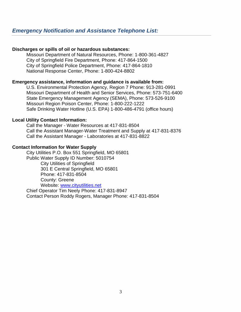
Emergency Notification and Assistance Telephone List:
Discharges or spills of oil or hazardous substances:
Missouri Department of Natural Resources, Phone: 1-800-361-4827 City of Springfield Fire Department, Phone: 417-864-1500 City of Springfield Police Department, Phone: 417-864-1810 National Response Center, Phone: 1-800-424-8802
Emergency assistance, information and guidance is available from: U.S. Environmental Protection Agency, Region 7 Phone: 913-281-0991
Missouri Department of Health and Senior Services, Phone: 573-751-6400 State Emergency Management Agency (SEMA), Phone: 573-526-9100
Missouri Region Poison Center, Phone: 1-800-222-1222 Safe Drinking Water Hotline (U.S. EPA) 1-800-486-4791 (office hours) Local Utility Contact Information:
Call the Manager - Water Resources at 417-831-8504 Call the Assistant Manager-Water Treatment and Supply at 417-831-8376 Call the Assistant Manager - Laboratories at 417-831-8822
Contact Information for Water Supply
City Utilities P.O. Box 551 Springfield, MO 65801 Public Water Supply ID Number: 5010754
City Utilities of Springfield 301 E Central Springfield, MO 65801 Phone: 417-831-8504 County: Greene Website: www.cityutilities.net
Chief Operator Tim Neely Phone: 417-831-8947 Contact Person Roddy Rogers, Manager Phone: 417-831-8504

4
Chapter 1: Introduction
Purpose and Objectives This plan can be used to provide education to the public about the water supply in your community. Source Water Protection is about protecting the public drinking water supply and is a fundamental step in enhancing public health and welfare of the community. The information in this book can guide you to becoming informed and educated on protecting the environment and watersheds in which we live, work and play. Source water protection means to protect, preserve and, in some cases, enhance the quality of water resources that we use every day. This means the water we drink, as well as the water we use in agriculture, industry and recreation. Individuals have the opportunity to help protect water and make a positive impact in the watershed where they live. Every drop of water is a precious resource that should not be wasted. Water customers and concerned citizens can help protect our source water by the daily choices of what potential contaminants we use, where we use these contaminants and what we do with the leftover products. You can also become involved by serving on an action committee or volunteering to help clean water efforts taking place in your community. To find a watershed group in your area, see the resources list.
Background Information Springfield-Greene County lies on a relatively flat watershed divide and is drained by the headwaters of the Sac and the James Rivers, which flow generally north and south of the divide respectively. The Little Sac Watershed is 390 square miles and includes Fellows Lake, McDaniel Lake, and Stockton Lake which make up the majority of the City of Springfield's public drinking water supply (see figure 1). In 1998, the Little Sac River was placed on the 303d list for bacterial contamination, for which a TMDL for Fecal Coliform was approved in 2006. In 2009, in a joint effort between the WCO and the Greene County Soil and Water Conservation District (GCSWCD), a nine element watershed management plan entitled “The Upper Little Sac Watershed Management Plan” was developed. It was accepted by Missouri Department of Natural Resources on July 8, 2010. The Little Sac Watershed lies within the Springfield Plateau sub-region of the larger Ozark physiographic region. In this area, Mississippian-age limestone predominates. Large springs drain the upland portions of the Little Sac Basin, including Fulbright Spring (the original and a current source of drinking water for Springfield) and Sander Spring which fills Valley Water Mill Lake. This geology can provide connected underground passages for surface water to interact with groundwater. The Little Sac Watershed is about 90 percent privately owned land and therefore the land management of the drinking watershed is largely voluntary. Many citizens who live inside the watershed(s) that provide our drinking water live outside the public water supply service area. Those citizens, however, almost always have private wells, and therefore, source water protection and education can still be of great benefit—whether or not they are a City Utilities customer. A Source Water Protection Plan (SWPP) is a very important tool for coordinating effective protection of the environment and watersheds in which we all live, work and play.

5
Geology and Groundwater The Ozarks, including the Little Sac River watershed, are well known for karst geology characterized by numerous sinkholes, caves, bedrock fractures and streams. The karst developments that are typical of the Springfield plateau aquifer are mostly located in the southern portion, more urban and suburban portions of the Little Sac River Watershed. (Figure 1). Two aquifers lie under the Little Sac River Watershed. The Ozark aquifer is a high-yielding, deep confined aquifer of generally very good quality. It provides for municipal, agricultural, and industrial water. The Springfield plateau aquifer is an unconfined shallow aquifer located from near the surface down to 200 to 300 feet and is recharged by precipitation. The shallow aquifer was generally of fairly good quality and was a major drinking water supply resource until the mid-1950s. Karst geologic conditions combined with improper investigation and construction techniques can result in contamination to the shallow aquifer. Contamination of this aquifer has prompted stricter regulations for wells, which now require wells to be drilled to the deep aquifer and cased through the shallow aquifer. Most of the domestic water is now pumped from the deep Ozark aquifer, but the Springfield plateau aquifer still provides agricultural and industrial water.
Figure 1: Map of Sinkholes in Little Sac Watershed

6
Land Use The Little Sac River Watershed is located in the Ozark Border Area, Major Land Resource Area (MLRA). This area is part of the northeast and central farming forest region. The Ozark Border MLRA is comprised of approximately 35 % forest, 25 % pasture mainly of introduced grasses and legumes, and 40 % cropland. Feed grains and hay are the main crops. Summer droughts and steep slopes limit the use of the land for crop production. Shallow wells, small creeks, or springs are often used for livestock needs. Deep wells supply drinking water and water for high volume uses. This area supports oak-hickory forests. The grassland supports a combination of introduced and native tall-prairie grasses consisting mainly of indian grass, littlebluestem, big bluestem, and switch grass. Introduced grasses include fescue, annual crab grasses, and Kentucky bluegrass. The pastures are mostly in fescue grass over-seeded with red clover. The watershed consists mostly of grassland (67 %) and forests (30 %). The grassland designation includes hay, pasture, and land enrolled in the Conservation Reserve Program (CRP). Hay and CRP land, which are sometimes considered cropland, behave more like grassland in terms of runoff, erosion, and nutrient loads and have been left in this class. Urban areas comprise 2.4% of the watershed. A high contamination potential exists due to the high urban population density and the amount of impervious surfaces. Estimates indicate that the most urbanized portion of this watershed has about 25% imperviousness.
Figure 2: Upper Little Sac River 2005 Land Use Map

7
Chapter 2: Source Water Information
The City of Springfield’s public drinking water is supplied by a combination of groundwater and surface water sources. It consists of two groundwater wells, three surface water impoundments, Stockton, Fellows, and McDaniel Lakes and two reservoirs, Fulbright and Valley Water Mill.(Figure 3). Figure 3: Source Water Map

8
Water System Contacts: Roddy Rogers, P.E. Manager – Water Resources (417) 831-8504 Kem Reed, P.E. Assistant Manager – Water Treatment & Supply (417) 831-8376 Tim Neely General Supervisor – Water Treatment & Supply Chief Operator (417) 831-8947 City Utilities operates and maintains a complete water system that currently serves approximately 80,600 residential, commercial, and industrial customers. City Utilities has managed the City of Springfield’s entire water supply, treatment, and distribution since 1957.
Supply Water is supplied to the Springfield water system from three lakes, a river, two wells, and a spring. The three lakes are McDaniel Lake, Fellows Lake, and Stockton Lake. Fellows and McDaniel Lakes are located on the Little Sac River and share a combined watershed. The total combined capacity of the Fellows and McDaniel impoundments is approximately 11.5 billion gallons. Water from McDaniel Lake is pumped to the Fulbright WTP through 24-inch and 30-inch transmission mains. The McDaniel Pump Station includes 9.5 mgd, 13.5 mgd, and 23.5 mgd pumps. The 9.5 and 13.5 mgd pumps are equipped with diesel back-up power. City Utilities continues to optimize its program for chemically treating McDaniel Lake to reduce taste and odor issues, including ongoing testing of an alternative algaecide that can be more easily applied. Water from Fellows Lake supplies the Blackman Water Treatment Plant (WTP). Water from Fellows Lake is pumped to the Blackman WTP using four pumps, rated at 15 mgd each. Fellows Lake water can also flow along a natural streambed into McDaniel Lake (and then be pumped to the Fulbright Treatment Plant). Water from Stockton Lake is pumped from the Stockton Pump Station to Fellows Lake through the 30.1 mile, 36-inch pipeline. The pump station and pipeline can currently deliver 15.0 mgd to Fellows Lake, McDaniel Lake, Fellows Lake Pump Station or a combination of the three. This supply source can be expanded by 15.0 mgd with the installation of an additional intake pump and a booster station at a site along the 36-inch pipeline. CU has a contract with the Corps of Engineers (COE) for 50,000 acre-feet (yield of about 30 mgd). Raw water is also supplied from the James River and is pumped to the Blackman WTP for treatment when river flows are high enough to allow this. CU is required to leave a Corps of Engineers permit-specified flow in the river and cannot pump from the river if flow is below this permitted flow quantity. There are five vertical turbine pumps at the James River intake structure, two with capacities of 5.0 mgd each and three with capacities of 10.0 mgd each. The most well-known source of water on the Springfield water system is the historic Fulbright Spring, which is connected by natural underground channels to Valley Water Mill Reservoir. This raw water is treated at the Fulbright Treatment Plant. Raw water is also supplied by two wells. Well No. 1 at the Fulbright Treatment Plant supplies raw water directly to the treatment plant. Well No. 12 (3952 S. Kansas Avenue) supplies water directly to the distribution system after treatment with chlorine and fluoride at the site.

9
Current work continues in several areas to actively monitor and protect Springfield watersheds. Construction permits require active erosion control and the City, CU and the County are working cooperatively on stream corridor buffers.
Distribution Distribution is composed of a network of pipes, storage tanks, and booster pumping stations. There are over 1250 miles of mains varying in diameter from 1 ½ to 48 inches that are made primarily of cast iron, ductile iron, concrete, and polyvinyl chloride (PVC). Other materials in the system include asbestos cement (AC) and high density polyethylene (HDPE). Water is distributed from each plant in transmission mains varying in diameter from18 to 48 inches. There are four pressure planes and the majority of the system is looped. Elevated and ground level storage tanks are in place to handle changes in water use and to maintain adequate pressures. The total system storage is 18.25 million gallons. An additional 10-12 million gallons of storage would achieve the industry standard of storage approximately equal to an average day usage. Additional storage is included in the long range plans.
Treatment and Current Disinfection Procedures Most of the raw water is treated at two main facilities, the Blackman WTP and the Fulbright WTP. The combined peak day capacity of both water treatment facilities and the distribution system well is 68.1 mgd. Both the Blackman WTP and the Fulbright WTP utilize Honeywell TDC 3000 computers for data acquisition, recordkeeping, and process control. These systems use back-up uninterruptible power supplies for continuous operation. Both plants can be operated and controlled from the Fulbright WTP Control Room by one Water Plant Operator. The Blackman WTP is remotely operated.

10
Fulbright Water Treatment Plant
Fulbright is located north of the city and the present plant was constructed between the years 1937 and 1941 and has a firm capacity of 20.6 mgd. It is one of two plants in Springfield’s water supply system where total treatment and pumping take place to supply water to the customers of City Utilities. As raw water enters the treatment process, certain chemicals are added: polymer as a coagulant for settling, carbon to control taste and odor, and chlorine as a disinfectant. These chemicals are mixed with the raw water in the rapid mix. Another oxidant, potassium permanganate, may be added at McDaniel Lake. The raw water then enters flocculation chambers where the polymer is gently agitated to form a “floc”. From the flocculation chambers the raw water then flows into the settling basins where the “floc”, together with foreign particles, settles out of the water. The settled water is then collected over a weir system and is filtered by six (6) dual media filters. The filtered effluent water then enters the clearwell where post chlorination takes place to ensure a free chlorine residual of 1.0 mg/l (winter dosage) or 1.2 mg/l (summer dosage). Soda ash is added for pH adjustment. Fluoride is then added to the product at a 1.0 mg/l dosage rate. From the clearwell the finished product is pumped into the distribution system. The pumping facility at Fulbright consists of four (4) high service pumps: 4 MGD, 8 MGD, 11 MDG, and 13 MGD. All four pumps are equipped with auxiliary power: three with diesel engine drives and the fourth with power from a diesel engine generator set. Residuals from the treatment process flow to an old quarry, owned by City Utilities. Decant is pumped back to the head of the treatment process.

11
Blackman Water Treatment Plant
Blackman is located southeast of the city and was put in service in 1980. It is one of two plants in Springfield’s water supply system where total treatment and pumping take place to supply water to the customers of City Utilities. It currently has a firm capacity of 46 MGD. As raw water enters the treatment process certain chemicals are added: polymer as a coagulant for settling, carbon to control taste and odor, and chlorine as a disinfectant. Another oxidant, potassium permanganate, may be added. The raw water then enters the primary flocculation chambers where the coagulant is gently agitated to form a “floc”. From the flocculation chambers the raw water then flows into the primary clarifier basins where the “floc”, together with foreign particles, settles out of the water, while clarifier arms scrape settled sludge to the center of the basin where it is removed through blow-off valves. The settled water then passes through the secondary flocculators and clarifiers. Secondary coagulant and carbon may be added at this point if necessary. The settled water then continues down the settling basins to the filter inlet gates. Water at this point may be fed into the four (4) filters associated with the appropriate settling basin or may also be fed into the adjoining four (4) filters through cross-over piping linking each basin to all available filters. This arrangement may be used when one basin is out of service. All eight (8) filters at Blackman have been converted to dual media, anthracite/sand. A program began in FY98 to convert the filters to deep-bed, air-scour with bigger pump units which will increase each filters capacity from 4.25 MGD to 7.5 MGD. Six have been increased to 7.5 MGD and two remain 4.25 MGD. After filtration the water is chlorinated to insure a chlorine residual of 1.0 mg/l (winter dosage) or 1.2 mg/l (summer). Fluoride is added at a 1.0 mg/l dosage rate. The final additive to adjust pH is soda ash. The treated water leaves the plant and goes south via a 36-inch pipeline and north via the new 30-inch pipeline. Construction of an on-site generated disinfection system was completed in 2013. The plant has dual power feeds from one substation.

12
McDaniel Lake
McDaniel Lake is a 1.5 billion gallon reservoir created by a nearly 50 foot high, 1,200 foot long concrete gravity dam and spillway. The 300 acre lake is located on the Little Sac River four miles north of Springfield, one mile upstream of the confluence of the Little Sac and South Dry Sac Rivers. The 484 foot long concrete spillway consists of twenty-two bays, each 21 feet long separated by support structures. Two slide gates previously used to control lake levels were retired in place. The 39 square mile watershed that feeds the lake includes Fellows Lake. Twenty square miles of the watershed feeds Fellows Lake. The remaining 19 square miles lies below Fellows Lake and feeds McDaniel Lake (Figure 3). Its purpose from the time of its construction in 1926 – 1929 to the present is water supply for Springfield. Water from the reservoir is pumped to the Fulbright Treatment Plant by pumps rated at 9, 13, and 23 MGD. The intake ports are housed in a square concrete shaft built onto the upstream face of the dam. Intake port elevations are at elevations 1113 & 1099. Normal pool is at 1127. The pumps are housed in a structure located at the toe of the concrete dam. The two larger pumps have diesel backup, and two above-grade diesel fuel tanks were installed on site in 1999. Energy is supplied by a CU 13.2 kV electric transmission line from the south. Potassium permanganate can be introduced at the pump station to help remove taste and odor compounds and provide some disinfection. A carbon feed system was added in 2003 to further control taste and odor issues as they arise.
13
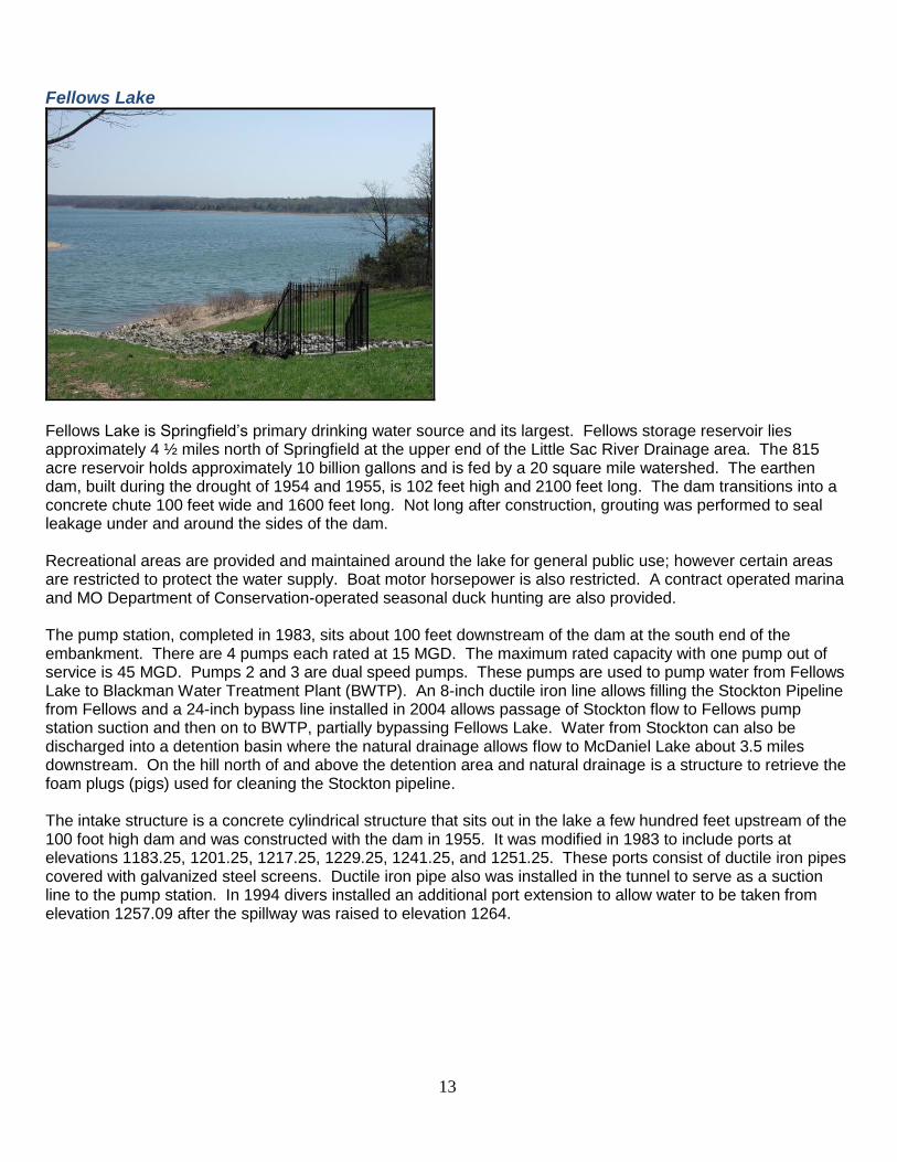
Fellows Lake
Fellows Lake is Springfield’s primary drinking water source and its largest. Fellows storage reservoir lies approximately 4 ½ miles north of Springfield at the upper end of the Little Sac River Drainage area. The 815 acre reservoir holds approximately 10 billion gallons and is fed by a 20 square mile watershed. The earthen dam, built during the drought of 1954 and 1955, is 102 feet high and 2100 feet long. The dam transitions into a concrete chute 100 feet wide and 1600 feet long. Not long after construction, grouting was performed to seal leakage under and around the sides of the dam. Recreational areas are provided and maintained around the lake for general public use; however certain areas are restricted to protect the water supply. Boat motor horsepower is also restricted. A contract operated marina and MO Department of Conservation-operated seasonal duck hunting are also provided. The pump station, completed in 1983, sits about 100 feet downstream of the dam at the south end of the embankment. There are 4 pumps each rated at 15 MGD. The maximum rated capacity with one pump out of service is 45 MGD. Pumps 2 and 3 are dual speed pumps. These pumps are used to pump water from Fellows Lake to Blackman Water Treatment Plant (BWTP). An 8-inch ductile iron line allows filling the Stockton Pipeline from Fellows and a 24-inch bypass line installed in 2004 allows passage of Stockton flow to Fellows pump station suction and then on to BWTP, partially bypassing Fellows Lake. Water from Stockton can also be discharged into a detention basin where the natural drainage allows flow to McDaniel Lake about 3.5 miles downstream. On the hill north of and above the detention area and natural drainage is a structure to retrieve the foam plugs (pigs) used for cleaning the Stockton pipeline. The intake structure is a concrete cylindrical structure that sits out in the lake a few hundred feet upstream of the 100 foot high dam and was constructed with the dam in 1955. It was modified in 1983 to include ports at elevations 1183.25, 1201.25, 1217.25, 1229.25, 1241.25, and 1251.25. These ports consist of ductile iron pipes covered with galvanized steel screens. Ductile iron pipe also was installed in the tunnel to serve as a suction line to the pump station. In 1994 divers installed an additional port extension to allow water to be taken from elevation 1257.09 after the spillway was raised to elevation 1264.

14
Stockton Lake
Raw water from Stockton Lake, a Corps of Engineers reservoir, is conveyed to Springfield’s Fellows Lake using a 15 MGD intake (future 30 MGD) and pump station and 30 miles of 36-inch diameter ductile iron pipe. The pipeline runs from Tunnel Bluff on the Turkey Creek arm of Stockton Lake 30 miles northwest of Springfield into sailboat cove at Fellows Lake 5 miles north of Springfield. The Stockton intake and pump station provide the head to push 15 MGD of water the full 30 mile distance and over 470 feet increase in elevation to Springfield. The intake and pump station incorporate a unique sloping pipe submersible pump design to minimize lake disturbance and to maximize aesthetics. The intake and pump station housing structure consists of a concrete vault constructed mostly underground by excavation into the bluff above the lake surface. The four underwater pump casings and discharge pipes are founded on steel pile foundations and follow the bluff from the lake bottom, up out of the water, and in through the front wall of the rock-faced concrete vault. The pump station includes one 7.5 MGD Hayward Tyler submersible pump and three 7.5 MGD Floserve (Byron Jackson) pumps. The 18 foot long, 15,000 pound pump/motor units are mounted on rollers to allow insertion and removal from the casing pipes which extend 50 feet below the lake surface. The pump impellers and shafts are stainless steel and pump control is accomplished by ball valves. Removable intake screens are coated with a zebra mussel resistant paint. The intake ports are located at elevations 830, 840, 850, and 860. Conservation pool level is at 867 MSL. Current pumping capacity is 15 MGD with a planned ultimate capacity of 30 MGD. The total head to overcome is over 600 feet and the pump/motor units are housed in ductile iron pipe sitting at a 2:1 slope. The 1200 hp motors are electric, submersible, and water cooled. Pump efficiency (wire to water) is 76% and three phase power is supplied at 4160 volts by Empire District Electric Company. A control building houses the SCADA system and electrical facilities which allow remote computer operation of the pumps and valves. A 69/4.16kV transformer and substation with grounding grid delivers power from a 69 kV transmission line to run the pumps. The pump station is remotely operated using a 12 strand jacketed fiber optic communications cable buried with the pipeline.
15
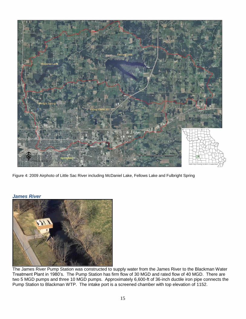
Figure 4: 2009 Airphoto of Little Sac River including McDaniel Lake, Fellows Lake and Fulbright Spring
James River
The James River Pump Station was constructed to supply water from the James River to the Blackman Water Treatment Plant in 1980’s. The Pump Station has firm flow of 30 MGD and rated flow of 40 MGD. There are two 5 MGD pumps and three 10 MGD pumps. Approximately 6,600-ft of 36-inch ductile iron pipe connects the Pump Station to Blackman WTP. The intake port is a screened chamber with top elevation of 1152.

16
Wells & Fulbright Spring
City Utilities operates and maintains two wells: one 1,400’ deep, 2.7 MGD well (Well No.1) at Fulbright WTP; and one distribution system well. Well No. 12 (Kansas) is about a mile west of Fairview on south Kansas Ave and produces 1.5 MGD. Water from the distribution system well receives treatment with chlorine and fluoride and is pumped directly into the system. The Well at the plant is pumped to the head of the plant for treatment. Fulbright Spring was one of the original sources of water for Springfield in the late 1800’s. It exits an opening in the bluff at Fulbright WTP where it is contained in a covered concrete structure. Two variable speed submersible pumps (6 MGD and 3 MGD) are available to pump water to the head of the treatment process. A maximum of 9 MGD can be taken (pump limitations) and the drought yield is generally accepted as 2.7 MGD.
Water System History In the early 1900s, changes were taking place in our community. With a population close to 24,000 and less than seven square miles to the city limits, Springfield was experiencing quite a growth. The downtown area was booming with construction, the first electric lights were installed, automobiles led to the end of streetcars, and railroads facilitated the progress of industrial expansion. Springfield’s continual growth would heighten the need for measures to provide adequate and safe drinking water for its community. The Fulbright Spring was the main source of water supply for the city until 1887 when the Jones’ spring (now the site of Ozarks Technical Community College) on the eastern edge of the city was leased. Growth of the city around the spring made the water unsuitable, and it was eventually abandoned. In 1889, Mr. Paul Perkins (franchisee) of the first Springfield water system) sold the system to George Wescott and Samuel Hanson of Maine, under the name of Springfield Water Works Company. From 1889 and into the early 1900s, the demand for additional water supplies continued and resulted in the purchases of Valley Water Mill and both Ritter and Owen Springs. H.B. McDaniel bought into the company, which was reorganized again to become the Springfield Water Company. Within a few years after the purchase of the springs, the water company finally addressed the issues of dirty water and taste complaints by installing the first filtration plant with a hypochlorite (a disinfectant) addition at the Fulbright site. In 1911, ownership again changed and the system would operate under the name of Springfield City Water Company. Under their ownership, the Fulbright reservoir was completed, and an additional source added. McDaniel Lake was constructed in 1927 and construction of a pump station was completed within a couple of years. In 1930, the Consumers Water Company of Portland, Maine, purchased the existing waterworks. Within just a few years, scares of e-coli bacteria in the water and reported cases of typhoid fever caused additional concern for the quality of water. Ammonia chlorination facilities were added to battle these issues and help ease the

17
fears of the community. Beginning in 1937, four years of construction resulted in the Fulbright Water Treatment Plant (Fulbright Plant). The years following saw a record drought, the completion of Fellows Lake, and citizens concerned about a reliable water supply. Various factors in the 1930’s including high rates, hydrant rental, and the typhoid scare resulted in contentious times with calls for additional taxation of the system, termination of the franchise, construction of a separate municipal system, and finally in 1940 an election to purchase the system, which failed. Opportunities for public purchase of the water system occurred on regular intervals during this time. By 1957, the community continued to suffer from the drought that hit in 1952, and the response by the water company had been too little, too late. Although the water company had constructed Fellows Lake during the drought, it was not a usable resource and a temporary plant had been constructed near the James River, in addition to six wells ordered by the Public Service Commission to be drilled around McDaniel lake – none of which prevented the community from having a water shortage. After price negotiations in 1957, the community was ready to buy and on May 14, 32 percent of the registered voters came to the polls to give an 82 percent favorable vote to purchase. City Utilities began its operation of the water system knowing that rates were a sensitive issue and that adequate sources of supply and treatment capacity were major voter factors in the approval of the water system purchase. The private water company had a rate increase pending with the Public Service Commission that was estimated to nearly double water rates and City Utilities had no intention of allowing that to happen. Also, the utility accepted the mandate to provide adequate planning and construction of facilities to prevent any further shortages of water. The next fifty years included the following treatment projects: In 1963, two new settling basins at Fulbright Plant and other improvements to increase the plant capacity were constructed. In 1968, a $2 million bond issue financed additional pumping capacity at McDaniel Lake, conversion of Fulbright high service pumps to electric drive, and completion of filtration improvements at Fulbright Plant to increase the plant capacity. In 1971, a $6 million bond issue financed the purchase of the Parkview, Parkcrest, and Orchard Crest Water Companies; a computer control system at the Fulbright Plant; and a zero discharge waste disposal system for filter backwash water and settling basin sludge. A site was also selected for a new water treatment plant utilizing the James River. In 1978, a $22.5 million bond issue financed new treatment capacity including the following projects: Well #13 on the Blackman Water Treatment Plant (Blackman Plant) site to provide additional capacity during plant construction, the 30 mgd Blackman Plant which was placed in service in 1980 with an intake and pump station on the James River. In 1983, a pump station and additional intake capacity were completed at Fellows Lake which, along with an 11-mile, 36-inch diameter pipeline, allowed the Blackman plant to utilize lake water when James River flows were low and to pump river water to the lake when river flows were adequate. Also in 1983, voter mandated fluoridation systems were added at plants and wells. In 1993, the American Waterworks Association designated Fulbright Plant a waterworks National Landmark. During the mid-1990s, the filters at Blackman Plant were converted to dual media, and at both plants pH control was converted to soda ash and the coagulants were converted to polyaluminum chloride as treatment optimizations. Emergency shut-off valves were installed on all on-line chlorine cylinders at both plants. In the late 1990s, a phased expansion plan was developed to increase Blackman Plant capacity. Pilot plant studies were conducted on high-rate, deep-bed filters resulting in an exception to traditional design requirements

18
by the Missouri Department of Natural Resources, allowing Filter #3 to be tested plant scale. The success resulted in a schedule for phased steps of electrical and filter backwash upgrades along with eight filter conversions and pump upgrades all within the existing plant’s basic structure to ultimately raise the plant capacity from 30 mgd to 52.5 mgd. Filter conversions were done in 1999, 2000, 2002, 2006, 2008, 2011, and 2012 and 2014. The pump on the last filter conversion is scheduled to be installed in 2015. In early 1996, the Stockton Pump Station and pipeline began delivering up to 15 mgd of water from Stockton lake to Fellows Lake. Beginning in 2002, a program of treating McDaniel Lake with a chelated copper compound at selected times and locations along with a powdered activated carbon feed system at the pump station was initiated to reduce taste and odor possibilities. Following September 11, 2001, a Vulnerability Assessment was performed on the water system and an Emergency Response Operating Plan prepared. Silt was removed from Valley Water Mill reservoir in coordination with a project of the Watershed Committee of the Ozarks to construct wetlands and a Watershed Institute on site for educational purposes in 2003. In 2009, spillway improvements and repairs were completed in Fellows Lake Dam. In 2013, an onsite chlorine generation disinfection system was constructed at Blackman Water Treatment Plant. In 2014, a new 1 million gallon elevated storage tank was constructed on Highway 60 east of Springfield.
History of the Watershed Committee
C.W. Titus Education Facility at Watershed Center at Valley Water Mill Park
The Watershed Committee of the Ozarks began about 30 years ago when Springfield Mayor Harry Strawn, sent a memo to the Chair of the Board of Public Utilities, N. L. "Mac" McCartney. The memo began: "With your concurrence, I have appointed an ad hoc task force to develop a program for the protection of surface and subsurface watersheds which supply Springfield and the surrounding area with drinking water." It was a prophetic statement and a visionary approach. Development was encroaching into the drinking watersheds and
19
officials worried about whether public policies and programs would effectively protect our precious drinking water supplies. In November 1983, the Task Force issued its report and recommendations, many of which are pertinent and instructive even today. One recommendation centered on the need for a permanent body whose primary purpose would be oversight and protection of public drinking water sources. From this recommendation, the Watershed Management Coordinating Committee was established in 1984. In 1989, the organization became a non-profit corporation and changed its name to Watershed Committee of the Ozarks. The Watershed Committee of the Ozarks (WCO) adopted a six-member board, comprised of three citizen appointees representing the respective sponsors and three at-large positions. The mission of the Watershed Committee of the Ozarks is “to sustain and improve the water resources of Springfield and Greene County through education and effective management of the region’s watersheds." The Watershed Committee of the Ozarks with community partnerships and support created the Watershed Center at Valley Water Mill Park. The Watershed Center is a 100-acre parcel with great geologic and historic interest. It contains a prominent fault zone where streams flow into underground channels. It was the site of a grist mill before the Civil War. And it contains a wide variety of natural and man-made features, including a seventeen-acre lake, wetlands, spring-fed stream, caves, sinkholes, glades and forests. The Watershed Committee utilizes this site to teach students, citizens and local businesses about our drinking water resources in the Ozarks and how to protect them.
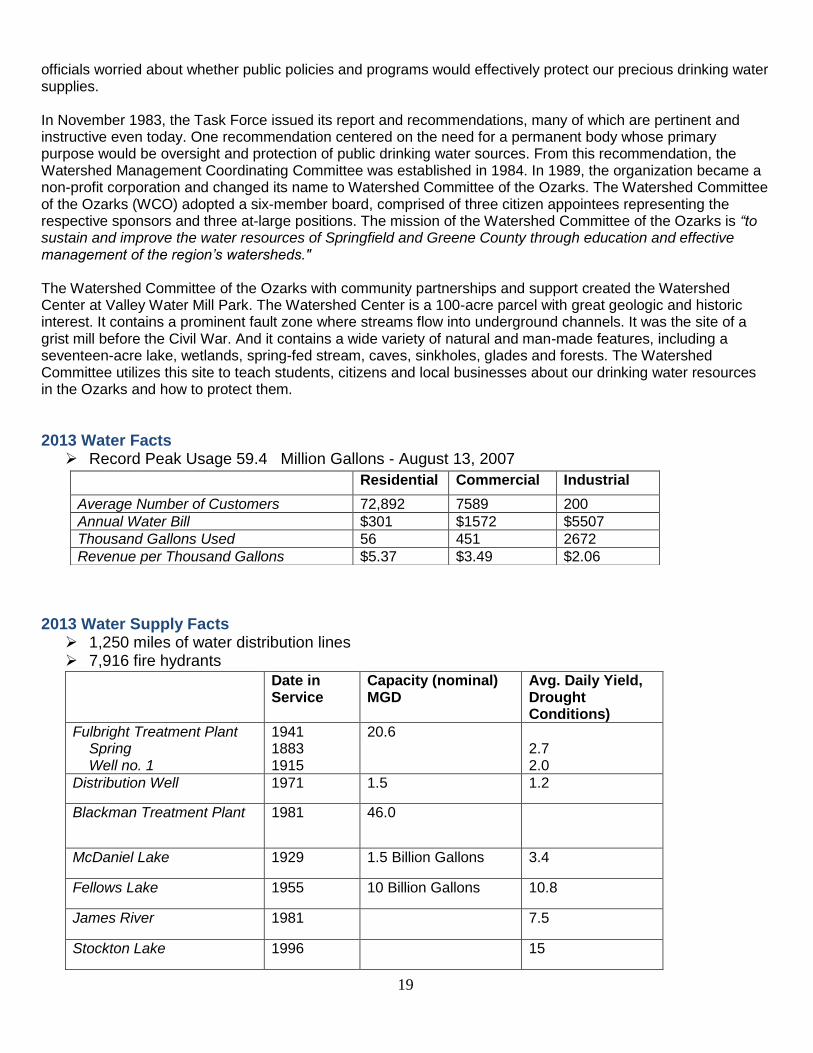
2013 Water Facts Record Peak Usage 59.4 Million Gallons - August 13, 2007
2013 Water Supply Facts 1,250 miles of water distribution lines 7,916 fire hydrants
Residential Commercial Industrial
Average Number of Customers 72,892 7589 200
Annual Water Bill $301 $1572 $5507
Thousand Gallons Used 56 451 2672
Revenue per Thousand Gallons $5.37 $3.49 $2.06
Date in Service
Capacity (nominal) MGD
Avg. Daily Yield, Drought Conditions)
Fulbright Treatment Plant Spring Well no. 1
1941 1883 1915
20.6 2.7 2.0
Distribution Well 1971 1.5 1.2
Blackman Treatment Plant 1981 46.0
McDaniel Lake 1929 1.5 Billion Gallons 3.4
Fellows Lake 1955 10 Billion Gallons 10.8
James River 1981 7.5
Stockton Lake 1996 15
20
Chapter 3: Implementation Actions
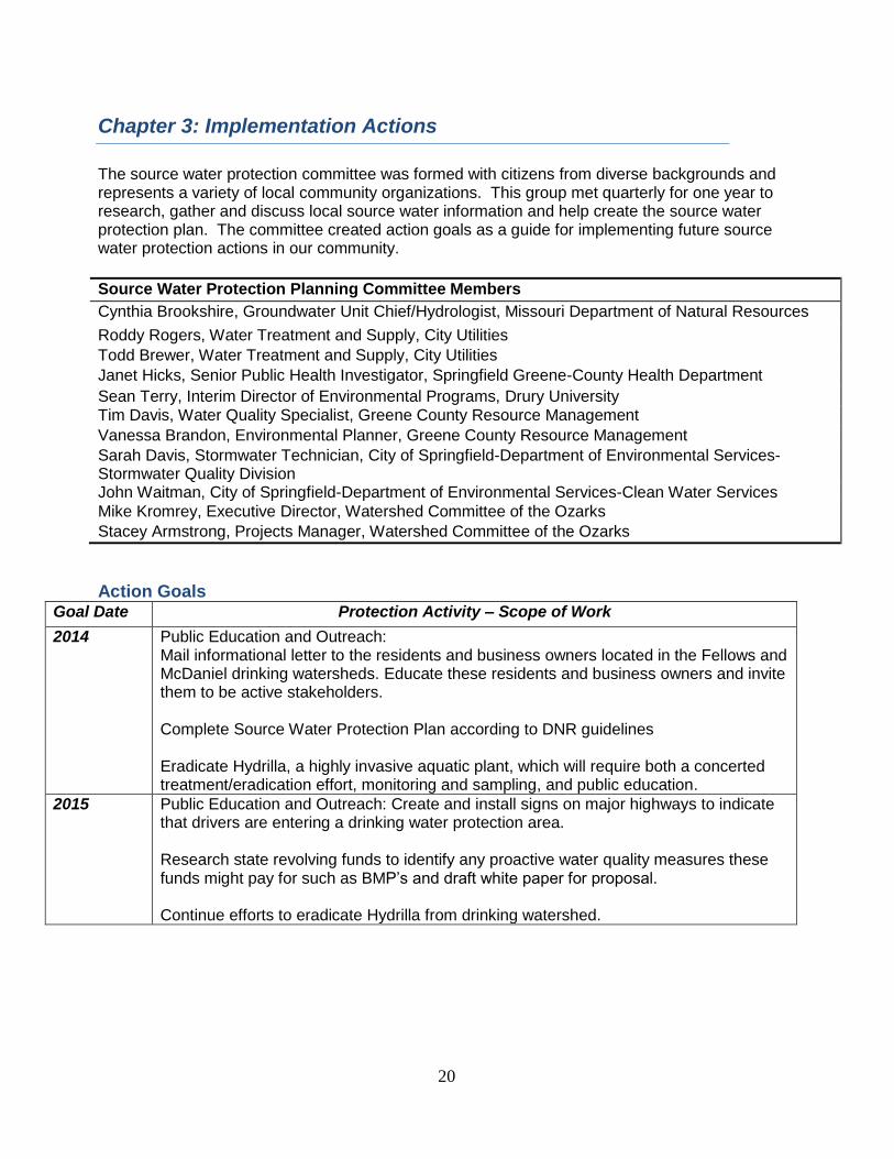
The source water protection committee was formed with citizens from diverse backgrounds and represents a variety of local community organizations. This group met quarterly for one year to research, gather and discuss local source water information and help create the source water protection plan. The committee created action goals as a guide for implementing future source water protection actions in our community.
Source Water Protection Planning Committee Members
Cynthia Brookshire, Groundwater Unit Chief/Hydrologist, Missouri Department of Natural Resources
Roddy Rogers, Water Treatment and Supply, City Utilities
Todd Brewer, Water Treatment and Supply, City Utilities
Janet Hicks, Senior Public Health Investigator, Springfield Greene-County Health Department
Sean Terry, Interim Director of Environmental Programs, Drury University Tim Davis, Water Quality Specialist, Greene County Resource Management
Vanessa Brandon, Environmental Planner, Greene County Resource Management
Sarah Davis, Stormwater Technician, City of Springfield-Department of Environmental Services-Stormwater Quality Division John Waitman, City of Springfield-Department of Environmental Services-Clean Water Services
Mike Kromrey, Executive Director, Watershed Committee of the Ozarks
Stacey Armstrong, Projects Manager, Watershed Committee of the Ozarks
Action Goals Goal Date Protection Activity – Scope of Work
2014
Public Education and Outreach: Mail informational letter to the residents and business owners located in the Fellows and McDaniel drinking watersheds. Educate these residents and business owners and invite them to be active stakeholders. Complete Source Water Protection Plan according to DNR guidelines Eradicate Hydrilla, a highly invasive aquatic plant, which will require both a concerted treatment/eradication effort, monitoring and sampling, and public education.
2015
Public Education and Outreach: Create and install signs on major highways to indicate that drivers are entering a drinking water protection area. Research state revolving funds to identify any proactive water quality measures these funds might pay for such as BMP’s and draft white paper for proposal. Continue efforts to eradicate Hydrilla from drinking watershed.

21
2016
Public Education and Outreach: Educate water users about the true cost of water by providing information about water costs in other regions. Monitoring: Complete some bacterial source tracking studies on Pierson Creek and the James River above Blackman Continue efforts to eradicate Hydrilla from drinking watershed.
2017 Monitoring: Identify early warning and/or remote sensing technology that could be applied to the James River intake and look for resources that might pay for their acquisition. Draft or revise Upper James Watershed Management Plan Targeted mailer and BMP projects in the Upper James River Watershed. Continue efforts to eradicate Hydrilla from drinking watershed. Continue to research for Enterococcus Update and Revise Source Water Protection Plan
How you can help protect drinking water Water is essential to life and the daily choices we make can have a large impact our water supply. The quantity of water we use, how we use it and what activities we do on the land can all impact our drinking water. -Install a Rain Barrel or learn how to make your own here: http://watershedcommittee.org/our-publications/ -Use water wisely by installing low flow fixtures in your home: http://www.cityutilities.net/conserve/res_pgms.htm -Plant Native Landscaping that uses less water and can easily survive drought -Plant a Rain Garden to filter water in your yard and reduce flooding -Pick up your pet’s waste (urban areas) -Don’t dump in storm drains because they drain directly to your local stream -Do Not Litter (we all live down steam) -Install Pervious Pavement or Pavers to reduce stormwater runoff -Practice good sanitation and hand washing hygiene before eating when swimming, learn more here: http://www.cdc.gov/healthywater/swimming/ -Water lawn only as needed (1 inch per week)
Use and dispose of harmful materials properly.
Don't dump them on the ground! Hazardous waste that is dumped on or buried in the ground can contaminate the soil and can move down into the ground water or be carried into nearby surface waters by runoff during rainstorms. You might be surprised to learn that a number of products you use at home contain hazardous or toxic substances. Products like motor oil, pesticides, leftover paints or paint cans, mothballs, flea collars, weed killers, household cleaners and even a number of medicines contain materials that can be harmful to surface water and ground water.
22
Don't overuse pesticides or fertilizers.
You might apply fertilizers to make your grass thick and green, your flowers colorful and your vegetable crop abundant. You also might use pesticides to keep bugs from ruining what the fertilizers have helped to produce. What you might not know is that many of these fertilizers and pesticides contain hazardous chemicals that can travel through the soil and contaminate ground water. If you feel you must use these chemicals, use them in moderation.
Volunteer in your community
Find a watershed or wellhead protection organization in your community and volunteer to help. Such as Watershed Committee of the Ozarks, visit: www.watershedcommittee.org to learn more. Use EPA's Adopt Your Watershed to locate groups in your community.
Identify ways you can help prevent runoff pollution from your home, business or farm
Check out the City Storm Water Services page at http://www.springfieldmo.gov/2148/Stormwater-101 and USDA landcape planning page at http://www.nrcs.usda.gov/wps/portal/nrcs/main/mo/programs/planning/ to learn more.
Join in stream team or stream cleanup.
You can make new friends while you help protect source water. To learn more about Missouri Stream Team programs or to join a Stream Team visit: http://www.mostreamteam.org.
Prepare a presentation about your watershed for a school or civic organization
Discuss water quality threats, including polluted runoff and habitat loss. Highlight things people can do to protect water quality, including limiting fertilizer use and eliminating the use of herbicides and pesticides. Research your presentation using EPA's Nonpoint Source Program.
Organize a storm drain stenciling project
Stencil a message next to the street drain reminding people "Dump No Waste - Drains to River" with the image of a fish. Stencils are also available for lakes, streams, bays, ground water and oceans, as well as the simple "Protect Your Water" logo with the image of a glass and faucet. Produce and distribute a flyer for households to remind residents that storm drains dump directly into your local water body.
Learn how to conserve water at your house on this interactive website.http://www.h2ouse.org/ The do’s and don’ts around the house http://water.epa.gov/polwaste/nps/dosdont.cfm

23
APPENDICES

24
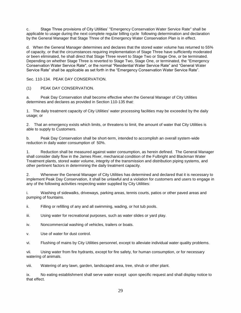
Appendix 1: Emergency Water Conservation Plan In times of drought conditions, City Utilities has determined a course of action to try to conserve water. The Emergency Water Conservation Plan – Starts with a water watch when heightened awareness is necessary, followed by a water warning at stored water volume equal to or less than 65% of capacity followed by three emergency stages. Emergency Water Conservation Plan - Key Points KeyPoints_____________________________________________________________ Water Watch Heightened Awareness Necessary_______________________ Customers requested to practice conservation and to minimize or discontinue water use for non-essential purposes. Irrigation limited to the Odd-Even Watering Schedule (3 days). Requests shutting off fountains. ______________________________________________________________________ Water Warning Stored water is approximately 65%_______ _______ _______ Restrictions same as WATCH. Stage I Water Shortage Stored water equal to or less than 60%___________________ Provisions of “Emergency Conservation Water Service Rate” applicable. No washing of paved areas and no operation of ornamental fountains. Filling of private pools limited to a 4 hour period one day a week. Noncommercial washing of vehicles limited to specific hours one day per week. Water at restaurants only on request. No use of water for dust control. Irrigation limited to midnight to 6 a.m., one day per week. ______________________________________________________________________ II Water Emergency Stored water equal to or less than 55% _ ______ Stage I restrictions remain in effect. Use of sprinkler systems – prohibited. Filling of private pools – prohibited. Noncommercial washing of vehicles – prohibited. Provisions of Emergency Water Conservation Rate still applicable. ______________________________________________________________________ III Water Crisis Stored water equal to or less than 55%__ __ ________ __ Stage I and II restrictions – remain in effect. Washing of vehicles, trailers or boats – prohibited. Watering lawns – prohibited. Trees, plants, etc. – from a handheld container. Filling of all pools – prohibited. Water usage from a fire hydrant shall be limited to usage for human consumption, necessary watering of animals, or fire safety. No new water service connections with the exception of Fire Services. Excessive use surcharge becomes effective, based on previous January, February, March billing. Additional provisions of Emergency Conservation Water Service Rate applicable. Source: City Utilities Emergency Water Conservation Plan - Complete Plan EMERGENCY WATER CONSERVATION PLAN Sec. 110-131. TITLE OF DIVISION. This division shall be known as the "Emergency Water Conservation Plan." Sec. 110-132. DEFINITIONS.
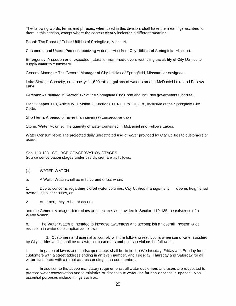
25
The following words, terms and phrases, when used in this division, shall have the meanings ascribed to them in this section, except where the context clearly indicates a different meaning: Board: The Board of Public Utilities of Springfield, Missouri. Customers and Users: Persons receiving water service from City Utilities of Springfield, Missouri. Emergency: A sudden or unexpected natural or man-made event restricting the ability of City Utilities to supply water to customers. General Manager: The General Manager of City Utilities of Springfield, Missouri, or designee. Lake Storage Capacity, or capacity: 11,600 million gallons of water stored at McDaniel Lake and Fellows Lake. Persons: As defined in Section 1-2 of the Springfield City Code and includes governmental bodies. Plan: Chapter 110, Article IV, Division 2, Sections 110-131 to 110-138, inclusive of the Springfield City Code. Short term: A period of fewer than seven (7) consecutive days. Stored Water Volume: The quantity of water contained in McDaniel and Fellows Lakes. Water Consumption: The projected daily unrestricted use of water provided by City Utilities to customers or users. Sec. 110-133. SOURCE CONSERVATION STAGES. Source conservation stages under this division are as follows: (1) WATER WATCH a. A Water Watch shall be in force and effect when: 1. Due to concerns regarding stored water volumes, City Utilities management deems heightened awareness is necessary, or 2. An emergency exists or occurs and the General Manager determines and declares as provided in Section 110-135 the existence of a Water Watch. b. The Water Watch is intended to increase awareness and accomplish an overall system-wide reduction in water consumption as follows: 1. Customers and users shall comply with the following restrictions when using water supplied by City Utilities and it shall be unlawful for customers and users to violate the following: i. Irrigation of lawns and landscaped areas shall be limited to Wednesday, Friday and Sunday for all customers with a street address ending in an even number, and Tuesday, Thursday and Saturday for all water customers with a street address ending in an odd number. c. In addition to the above mandatory requirements, all water customers and users are requested to practice water conservation and to minimize or discontinue water use for non-essential purposes. Non-essential purposes include things such as:

26
1. Use of water to wash down sidewalks, walkways, driveways, parking lots, tennis courts, or other hard-surfaced areas. 2. Use of water to wash down buildings or structures for purposes other than immediate fire protection. 3. Use of water for dust control. 4. Use of water for flushing gutters or permitting water to run or accumulate in any gutter or street. 5. Operation of any ornamental fountain or pond except where necessary to support aquatic life. d. When the General Manager determines and declares that the circumstances requiring implementation of a Water Watch have sufficiently moderated or been eliminated, the Water Watch may be terminated. (2) WATER WARNING a. A Water Warning shall be in force and effect when: 1. Stored water volume is approximately equal to or less than 65% of lake storage capacity or 2. An Emergency exists or occurs and the General Manager determines and declares as provided in Section 110-135 the existence of a Water Warning. b. The Water Warning is intended to heighten awareness greater than a Water Watch and accomplish an overall increased system-wide reduction in water consumption as follows: 1. Customers and users shall continue to comply with the restrictions and requests detailed in the Water Watch. c. When the General Manager determines and declares that the total volume of water stored at McDaniel and Fellows Lakes has returned to approximately 70% of capacity, or that the circumstances requiring implementation of a Water Warning have sufficiently moderated or been eliminated, a Water Warning may, at the discretion of the General Manager, revert to a Water Watch or be terminated. (3) STAGE ONE – WATER SHORTAGE. a. Stage One Shall be in force and effect when: 1. Stored water volume is equal to or less than 60% of lake storage capacity; or 2. An emergency exists or occurs and the General Manager determines and declares as provided in Section 110-135 the existence of a Stage One-Water Shortage. b. Stage One is intended to accomplish an overall system-wide reduction in water consumption of 15% as follows: 1. Customers and users shall comply with the following restrictions when using water supplied by City Utilities and it shall be unlawful for customers and users to violate the following:

27
i. No washing of sidewalks, driveways, parking areas, buildings, gutters, tennis courts, patios or other paved areas; no operation of any ornamental fountain or pond except where necessary to support aquatic life. ii. Filling or refilling of any and all privately owned residential swimming, wading, or hot tub pools shall be limited to 4 hours per week between the hours of 8 PM and midnight. iii. Noncommercial washing of motor vehicles, trailers or boats, shall be limited to washing from a bucket between 6 to 8 AM or 8 to 10 PM Sundays for all customers with a street address ending in an even number and 6 to 8 AM or 8 to 10 PM Saturdays for all water customers with a street address ending in an odd number. iv. No use of water for dust control. v. Irrigation of lawns and landscaped areas shall be limited to midnight to 6 AM Sundays for all customers with a street address ending in an even number, and midnight to 6 AM Saturdays for all water customers with a street address ending in an odd number. vi. No eating establishment shall serve water except upon specific request and shall display notice to that effect. c. Stage One provisions of City Utilities’ "Emergency Conservation Water Service Rate" shall be applicable as set forth in the “Emergency Conservation Water Service Rate”. d. When the General Manager determines and declares that the stored water volume equals at least 65% of capacity, or that the circumstances requiring implementation of Stage One have sufficiently moderated or been eliminated, Stage One shall be terminated, or may revert to a Water Watch or Water Warning. The normal “Residential Water Service Rate” and “General Water Service Rate” shall be applicable as set forth in the “Emergency Conservation Water Service Rate”. (4) STAGE TWO – WATER EMERGENCY. a. Stage Two shall become effective when: 1. Stored water volume is equal to or less than 55% of capacity or 2. An emergency occurs or continues or 3. Stage One has not accomplished a 15% reduction in water consumption, as determined by the records of pumpage at the Fulbright and Blackman Water Treatment Plants. and the General Manager determines and declares as provided in Section 110-135 the existence of a Stage Two-Water Emergency. b. Stage Two is intended to accomplish an overall system-wide reduction in water consumption of 20%, as follows: 1. Restrictions of Stage One shall remain in effect, except as modified below and it shall be unlawful for customers and users to violate the following: i. The use of permanently installed automatic sprinkler systems and hose end sprinklers is prohibited at all times. ii. Filling or refilling of any and all privately owned residential swimming, wading, or hot tub pools is prohibited. Using water for recreational purposes such as water slides or yard play is prohibited.

28
iii. Noncommercial washing of vehicles is prohibited. c. Stage Two provisions of City Utilities’ "Emergency Conservation Water Service Rate" shall be applicable as set forth in the “Emergency Conservation Water Service Rate” . d. When the General Manager determines and declares that the stored water volume has returned to 60% of capacity, or that the circumstances requiring implementation of Stage Two have sufficiently moderated or been eliminated, Stage Two may, at the discretion of the General Manager, revert to Stage One or be terminated. Depending on whether Stage Two is reverted to Stage One or terminated, the "Emergency Conservation Water Service Rate" or the normal “Residential Water Service Rate” and “General Water Service Rate” shall be applicable as set forth in the “Emergency Conservation Water Service Rate”. (5) STAGE THREE – WATER CRISIS. a. Stage Three shall become effective when: 1. Stored Water volume is equal to or less than 50% of capacity or 2. An emergency occurs or continues; or 3. Stage Two has not accomplished a 20% reduction in water consumption, as determined by the records of pumpage at the Fulbright and Blackman Water Treatment Plants. and the General Manager determines and declares as provided in Section 110-135 the existence of Stage Three-Water Crisis. b. Stage Three is intended to accomplish an overall system-wide reduction in water consumption of 25%, as follows: 1. As respects water supplied by City Utilities, it shall be unlawful for customers and users to violate the following: i. All requirements of Stages One and Two shall remain in effect except as modified below: ii. All washing of vehicles, trailers or boats is prohibited. iii. Watering of any lawn, garden, or landscaped area is prohibited. Trees, shrubs, and plants may be watered from a handheld container. iv. Filling or refilling of any and all swimming, wading or hot tub pools is prohibited. v. No application for new, additional, expanded, or increased-in-size water service connections, meters, service lines, pipeline extensions, mains or water service facilities that fall under a building permit applied for after implementation of Stage Three shall be approved until circumstances requiring implementation of Stage Three have sufficiently moderated or been eliminated. This section shall not apply to fire services. vi. Customers and users who consume more than their average water use during the most recent January, February, and March billing months shall be subject to the surcharge as defined in the “Emergency Conservation Water Service Rate”. vii. Water usage from a fire hydrant by customers and users shall be limited to usage for human consumption, necessary watering of animals or for fire safety purposes.
29
c. Stage Three provisions of City Utilities’ "Emergency Conservation Water Service Rate" shall be applicable to usage during the next complete regular billing cycle following determination and declaration by the General Manager that Stage Three of the Emergency Water Conservation Plan is in effect. d. When the General Manager determines and declares that the stored water volume has returned to 55% of capacity, or that the circumstances requiring implementation of Stage Three have sufficiently moderated or been eliminated, he shall direct that Stage Three revert to Stage Two or Stage One, or be terminated. Depending on whether Stage Three is reverted to Stage Two, Stage One, or terminated, the "Emergency Conservation Water Service Rate", or the normal “Residential Water Service Rate” and “General Water Service Rate” shall be applicable as set forth in the “Emergency Conservation Water Service Rate”. Sec. 110-134. PEAK DAY CONSERVATION. (1) PEAK DAY CONSERVATION. a. Peak Day Conservation shall become effective when the General Manager of City Utilities determines and declares as provided in Section 110-135 that: 1. The daily treatment capacity of City Utilities' water processing facilities may be exceeded by the daily usage; or 2. That an emergency exists which limits, or threatens to limit, the amount of water that City Utilities is able to supply to Customers. b. Peak Day Conservation shall be short-term, intended to accomplish an overall system-wide reduction in daily water consumption of 50%. 1. Reduction shall be measured against water consumption, as herein defined. The General Manager shall consider daily flow in the James River, mechanical condition of the Fulbright and Blackman Water Treatment plants, stored water volume, integrity of the transmission and distribution piping systems, and other pertinent factors in determining the daily treatment capacity. 2. Whenever the General Manager of City Utilities has determined and declared that it is necessary to implement Peak Day Conservation, it shall be unlawful and a violation for customers and users to engage in any of the following activities respecting water supplied by City Utilities: i. Washing of sidewalks, driveways, parking areas, tennis courts, patios or other paved areas and pumping of fountains. ii. Filling or refilling of any and all swimming, wading, or hot tub pools. iii. Using water for recreational purposes, such as water slides or yard play. iv. Noncommercial washing of vehicles, trailers or boats. v. Use of water for dust control. vi. Flushing of mains by City Utilities personnel, except to alleviate individual water quality problems. vii. Using water from fire hydrants, except for fire safety, for human consumption, or for necessary watering of animals. viii. Watering of any lawn, garden, landscaped area, tree, shrub or other plant. ix. No eating establishment shall serve water except upon specific request and shall display notice to that effect.

30
x. Using water supplied by City Utilities in any vehicle washing business. 3. In addition to the mandatory restriction of 2, (above), General Service Rate customers shall reduce daily short-term consumption by 50%. c. When the General Manager of City Utilities determines that daily demand no longer threatens to exceed the daily treatment capacity, or that an actual or imminent shortage of water requiring implementation of Peak Day Conservation has otherwise been sufficiently moderated or eliminated, he shall direct that Peak Day Conservation be terminated. Sec. 110-135. NOTIFICATION OF CUSTOMERS. (a) All persons shall be conclusively presumed to have notice of the implementation of any stage of the Plan as herein before set forth and shall be subject to its provision (including City Utilities’ "Emergency Conservation Water Service Rate"), upon the filing of a notice of such implementation of any Section hereof with the City Clerk of the City of Springfield, Missouri, and when a copy of such notice is posted at the customer entrance to the Robert E. Roundtree Center at 301 East Central, Springfield, Missouri. (b) Reasonable effort shall be made to utilize news media and other means to publicize the implementation of various stages of the Plan. Notice shall be posted and filed at least 24 hours prior to the time for implementation of Stages One, Two and Three, and at least one hour prior to the time for implementation of Peak Day Conservation. (c) Notification to customers of violation of this Emergency Water Conservation Plan will be U.S. Mail, notification left at the account address, overnight mail, or other method of notice determined at the time the account is established or updated. Sec. 110-136. COMPLIANCE. (a) During Stage Two and Three of the Plan in which the "Emergency Conservation Water Service Rate" is in effect, customers will be provided (printed on bills) with at least the usage threshold below which the Stage Three Excessive Use Surcharge will not apply in the upcoming billing period as set forth in the “Emergency Conservation Water Service Rate”. (b) Compliance with the Plan -- Customers and users who receive water service from City Utilities shall be entitled to receive such water service only upon compliance with provisions of Section 110-131 to 110-138, inclusive. 1. First failure to comply with the provisions of this Ordinance shall result in a written warning and notification to the customer. A failure to comply will be verified by City Utilities personnel or contractors. 2. Second and any subsequent failure to comply will result in an additional warning and notification to the customer. After City Utilities personnel or contractors have verified the violation, and the notice of violation has been issued, an Emergency Water Conservation Verification charge in the amount as approved by the Board of Public Utilities as part of Policy 5.50-Customer Service Fees, will be added to the Customer’s bill. The Emergency Water Conservation Verification charge shall be calculated based on the criteria set forth in Policy 5.47, Service Rules and Regulations, Section I.20, Special Services. The notification will include information regarding the Verification charge. The Emergency Water Conservation Verification charge will be part of the customer’s bill, and due and payable in the same manner as for other utility services. 3. Third and any subsequent failure to comply will result in termination of service as set forth in City Utilities Service Rules and Regulation, Policy 5.47, and an Emergency Water Conservation Disconnect/connect charge will be added to the Customer’s bill, in the amount as approved by the Board of Public Utilities as part of Policy 5.50-Customer Service Fees. The Emergency Water Conservation Disconnect/connect charge shall be calculated based on the criteria set forth in Policy 5.47, Service Rules and Regulations, Section I.20, Special Services. Service will be restored as set forth in City Utility policies upon payment of

31
the Emergency Water Conservation Disconnect/connect charge and any unpaid Emergency Water Conservation Verification charges. 4. Customers and users with dedicated irrigation service meters who fail to comply with any irrigation restrictions shall be issued a written notification of violation and termination of service. If service is terminated, service will not be restored until Stages One, Two and Three of the Emergency Water Conservation Plan have been terminated and all fees, including the Emergency Water Conservation connect/disconnect charge, have been paid, subject to the relief provided in Section 110-138. (c) Violation of this Emergency Water Conservation Plan shall be considered a violation of City Utilities Service Rules and Regulations, Policy 5.47, and termination of services shall be as set forth and according to said Service Rules and Regulations, and the City Utilities Customer Service Fees, Policy 5.50. Sec. 110-137. MISDEMEANOR; NEW CUSTOMERS. (a) Any person who shall violate the provisions of Section 110-133 or Section 110-134 shall be guilty of a misdemeanor and punished as provided in Section 1-7 of the Springfield City Code. (b) Any customer who applies for service during any time the restrictions on water use contained herein are in effect will be advised of that fact by City Utilities. Sec. 110-138. GRANTING OF EXCEPTIONS. (a) Request for exception. Exceptions to the application of use restrictions and relief from the "Emergency Conservation Water Service Rate" may be requested in writing, setting forth in reasonable detail the factual basis for such request. Such request shall be signed by the customer making it, delivered to the General Manager of City Utilities. Any request for exception or appeal following notification of violation shall be as set forth as described in this Section 110-138 (a), and received by the General Manager within ten calendar days of the mailing or personal notification to the customer or user by City Utilities. (b) Appeals. Any person aggrieved by a decision of the General Manager may appeal the same under Chapter 536 "V.A.M.S."
32
Appendix 2: Hydrilla (Hydrilla verticillata) Information
What is hydrilla? Hydrilla is a federally listed noxious weed that can be detrimental to our aquatic resources. It is native to the Indian sub-continent and was first observed in the United States in the early 1950s, more than likely from the aquarium trade. Today, hydrilla has spread from Florida to Maine on the eastern seaboard and is even found in the state of Washington. Right now, at least 29 states are dealing with introduced populations of hydrilla. Hydrilla has several different methods of reproduction including: fragmentation, tuber production, turions (above ground tuber like structures that eventually fall into the sediment) and seed dispersal. Depending on the variety of hydrilla, the tubers and turions can stay viable in the soil for at least four years or up to 10 years. Because of the persistence of this invasive plant, any control plan should include continued monitoring and, as necessary, follow-up treatments for several years.
Why are we concerned? Hydrilla can quickly spread throughout freshwater systems including ponds, lakes, reservoirs, and even streams. Hydrilla displaces the local aquatic plant community, interferes with boating and fishing, clogs water intake systems, and adversely changes the dynamics of fish populations. In places that have hydrilla, pond owners and lake managers are faced with expensive control measures. In short, this plant is not only detrimental to small ponds and lakes, but it will harm Missouri’s economy through hindering fishing and other recreational uses at our larger impoundments if it is allowed to spread.
Controlling the spread of hydrilla is extremely difficult, making it imperative that eradication efforts are put in place promptly. Hydrilla is difficult to control because it can grow in about any wet area, so even the smallest watering hole and drainage area will need to be monitored and possibly treated. If hydrilla becomes established in larger rivers and impoundments, control efforts will be almost impossible and cost prohibitive. Once established, managing the plant then becomes the only option and that will still be an expensive challenge. Florida was spending over $14.5 million per year in the mid- 1990s just to manage the plant. Missouri’s only chance to protect our state’s water resources is to implement a multifaceted control plan within smaller drainage areas and be proactive against future introductions.
How does it move from one place to another? Hydrilla spreads primarily through fragmentation which means that it only takes one small piece of plant to enter a waterbody and start a new stand. Common modes of transportation include boat trailers, fishing gear, waterfowl, mammals, or even fish and plant introductions from other waterbodies that have hydrilla.
What do we do now? We need to take swift action and try to eliminate the plant from the area ponds that are impacted. This will take a coordinated effort and will require participation from all impacted pond owners. Research has revealed that chemical control methods provide the best results. However, with the implementation of any large scale aquatic vegetation control effort using herbicides, there are some risks, such as

33
losing a few fish through oxygen depletion from excessive vegetation decomposition and possible effects on non-target plants in treated water bodies. We can minimize the oxygen depletion risk by treating when water temperatures are cooler such as early spring or even in the fall. We are also aware that several of the infested ponds are primary water sources for livestock and this will be taken into consideration. In fact, the control method selected for each pond will be based on its use, potential for sport fish management, and equipment accessibility.
In certain situations, the effectiveness of herbicides can be enhanced by incorporating grass carp and timely water level drawdowns into the treatment plan. Grass carp are known to be effective consumers of hydrilla, but may also consume more favorable aquatic plant species. So, once the hydrilla is under control, the grass carp numbers should be reduced to encourage the establishment of desirable aquatic plants.
What can you do to prevent the spread of the hydrilla? One of the main routes for spread outside of the immediate area is via a plant fragment hitching a ride on something such as boat trailer, within a boat’s livewell, or even in a bait bucket. To help reduce the spread of hydrilla, you and those that use your pond(s) should implement the following measures immediately:
Do not bring in outside boats to fish any of these impoundments. Boats that stay on a particular small lake or pond are still okay to use, but should not be transported to another impoundment. If a boat has been in a pond or small lake with hydrilla and has traveled to another waterbody, we need to know that information as soon as possible. Please contact:
Kara Tvedt Fisheries Management Biologist Missouri Department of Conservation 417/895-6881, ext. 1626
In addition, any trailers or other equipment that enter the pond(s) or small lakes should not be moved to other water bodies.
Thoroughly clean all fishing gear after each trip.
Do not transport plants or fish to another waterbody.
Do not remove hydrilla plants from your property. Disposal of these plants should be handled on-site and under advisement from the Department of Conservation.
Do not allow anyone to collect the plant for aquarium use or empty the contents of an aquarium in your pond or small lake.
Do not purchase, plant, or sell hydrilla.

34
Common Characteristics of Hydrilla:
Submersed, usually rooted aquatic plant
Slender stems reaching 30 feet in length in deep water
Leaves are whorled around the stem with 3 to 8 leaves per whorl
Leaves are narrow and up to 0.8 inches long
Leaves have serrated edges Leaves have spines or nodules
on the under- side midrib.
Branching is limited until it reaches the sur- face
Can have small (~0.25 inch), potato like tu- bers attached to the roots.

35
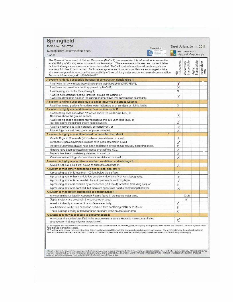
Appendix 3: Source Water Assessment and Susceptibility Determination Sheets
What is a source water assessment? A source water assessment is a study that defines the land area contributing water to each public water system, identifies the major potential sources of contamination that could affect the drinking water supply, and then determines how susceptible the public water supply is to this potential contamination. Public utilities and citizens can then use the publicly available study results to the take actions to reduce potential sources of contamination and protect drinking water. As required by the Safe Drinking Water Act, states have completed source water assessments for virtually every public water system. To find Springfield’s complete source water assessment visit this link and enter PWSS No. 5010754. http://maproom.missouri.edu/swipmaps/pwssid.htm
36

37

38
Appendix 4: Source Water Protection Resources City Utilities Consumer Confidence Report 2013: http://www.cityutilities.net/resident/water.htm Northwest Wastewater Treatment Plant Contingency Plan, City of Springfield Public Works Department Sanitary Services Division. 2008 City of Springfield Sewer Overflow Response Plan, February 1, 2006 Greene County, Missouri. Application for Stormwater Permit for Small Municipal Separate Storm Sewer System (MS4). Stormwater Management Program, September 10, 2007 Greene County Multi-Jurisdictional Hazard Mitigation Plan, 2009. http://www.greenecountymo.org/oem/mitigation.php Springfield-Greene County Emergency Operations Plan, 2008. www.greenecountymo.org/oem/EOP.php The City of Springfield NPDES Storm Water Permit Annual Report, July 2008-June 2009. www.springfieldmo.gov/stormwater/pdfs/2009/MS4Report09.pdf Local Storm Water Pollution Hotline 417-864-1900 and after hours contact Springfield Fire Department Little Sac River Watershed Management Plan, Watershed Committee of the Ozarks and the Greene County Soil and Water District. 2009 City Utilities of Springfield, MO Triennial Report on the Condition and Operation of the Water System September 30, 2007 Black & Veatch Water Quality Protection Policy for Fulbright Spring, Pierson Creek, and Sinkhole Watersheds #8648 City of Springfield, MO April 1999 City of Springfield Storm Water Design Criteria Manual Watershed Groups: Watershed Committee of the Ozarks Ozarks Water Watch James River Basin Partnership Water Treatment and Supply Management Program (Includes Emergency Plans)

39
Appendix 5: Internet Resources The following links may be of use for obtaining information pertinent to water quality and source water protection efforts. Missouri Department of Natural Resources (MoDNR) main page http://www.dnr.mo.gov
http://www.dnr.mo.gov/regions/regions.htm (MoDNR Regional and Satellite Office map) http://www.dnr.mo.gov/env/esp/index.html (Environmental Services Program main page) http://www.dnr.mo.gov/pubs/pub2193.pdf (FAQ Wellhead Protection Section fact sheet) http://www.dnr.mo.gov/pubs/index.html (MoDNR publications main page) http://www.dnr.mo.gov/pubs/pub682.pdf (Abandoned Wells and Cisterns fact sheet) http://www.dnr.mo.gov/pubs/pub2175.pdf (well construction guidance document)
MoDNR Division of Environmental Quality (DEQ) main page http://www.dnr.mo.gov/env/index.html MoDNR Water Protection Program (WPP) main page http://www.dnr.mo.gov/env/wpp/index.html
http://www.dnr.mo.gov/env/wpp/wqcc/index.html (Water Quality Coordinating Committee link) http://www.dnr.mo.gov/env/wpp/wellhd/water.htm (water well information) http://www.dnr.mo.gov/env/wpp/wellhd/plugging.htm (well plugging information) http://www.dnr.mo.gov/env/wpp/sdwc/index.html (Safe Drinking Water Commission link) http://www.dnr.mo.gov/env/wpp/wellhd/docs/specialarea2map.pdf (Special Well Drilling Area 2 map - Jasper and Newton Counties) http://www.dnr.mo.gov/forms/index.html#WellheadProtection (well certification/registration forms and information)
MoDNR Public Drinking Water Branch (PDWB-WPP) main page http://www.dnr.mo.gov/env/wpp/dw-index.htm
http://www.dnr.mo.gov/env/wpp/census.htm (PWS Census information) http://www.dnr.mo.gov/env/wpp/eop/index.html (Model Emergency Operations Plan) http://www.dnr.mo.gov/env/wpp/wqstandards/uaa/pub/dw-ccr.htm (Consumer Confidence Reporting Information) http://www.dnr.mo.gov/env/wpp/dww/index.html (Drinking Water Watch) http://www.dnr.mo.gov/env/wpp/dwsecurity/index.html (PWS infrastructure security information) http://www.dnr.mo.gov/env/wpp/wellhd/index.html (Wellhead Protection Section main page) http://www.dnr.mo.gov/pubs/pub417.pdf (Design Guide for Community Public Water Systems)
Center for Agriculture, Resource and Environmental Systems (CARES-MU) Drinking Water/Watershed Internet Resources
40
http://maproom.missouri.edu/ (CARES main map room) http://drinkingwater.missouri.edu/ (CARES drinking water main page) http://cares.missouri.edu/projects/completed/old/SW.aspx (Source Water Inventory Project program summary) http://drinkingwater.missouri.edu/swip/ (Source Water Inventory Project main page) http://maproom.missouri.edu/swipmaps/pwssid.htm (Source Water Inventory Project maps) http://drinkingwater.missouri.edu/swap/ (Missouri Source Water Assessment Plan) http://cares.missouri.edu/projects/completed/old/VA.aspx (VA project/PDWB) http://drinkingwater.missouri.edu/swip/landuse/ (CARES land use maps)
MoDNR Water Pollution Control Branch (WPCB-WPP) main page http://www.dnr.mo.gov/env/wpp/wp-index.html
http://www.dnr.mo.gov/env/wpp/nps/mgmtplan/index.html (NPS management plan) http://www.dnr.mo.gov/env/wpp/waterquality/305b/index.html (Missouri Water Quality Report) http://www.dnr.mo.gov/env/wpp/wpcp-guide.htm (special construction guidelines) http://www.dnr.mo.gov/env/wpp/tmdl/index.html (TMDL’s) http://www.dnr.mo.gov/env/wpp/tmdl/wpc-tmdl-progress.htm (TMDL's in progress) http://www.dnr.mo.gov/env/wpp/tmdl/info/index.html (TMDL info sheets) http://www.dnr.mo.gov/env/wpp/waterquality/index.html (water quality assessments and impaired waters) http://www.dnr.mo.gov/env/wpp/waterquality/303d/index.html (Missouri 303d list) http://www.dnr.mo.gov/env/wpp/watersheds/index.htm (watershed index) http://www.dnr.mo.gov/env/wpp/watersheds/info/index.html (info sheets) http://www.dnr.mo.gov/env/wpp/stormwater/index.html (stormwater issues) http://www.dnr.mo.gov/env/wpp/cafo-workgroup.htm (CAFO info) http://www.dnr.mo.gov/env/wpp/cwc/index.html (Clean Water Commission link) http://www.dnr.mo.gov/env/wpp/permits/index.html (Water Pollution Control Branch permits)
MoDNR Water Resources Center (WRC) main page http://www.dnr.mo.gov/env/wrc/index.html
http://www.dnr.mo.gov/env/wrc/drought/resopreports.htm (bathymetric surveys of drinking water reservoirs/drought response planning) http://www.dnr.mo.gov/env/wrc/Water_Res_Rpts.htm (misc. WRC reports) http://www.dnr.mo.gov/env/wrc/logmain/index.html (registered drilling logs) http://www.dnr.mo.gov/env/wrc/grdh2o.htm (WRC main groundwater resources page) http://www.dnr.mo.gov/env/wrc/groundwater/education/provinces/gwprovince.htm (major groundwater provinces of Missouri) http://www.dnr.mo.gov/env/wpp/wpp-map-gallery.htm (WPP main map gallery) http://www.dnr.mo.gov/env/wrc/welltypes.htm (Information on registered water wells of Missouri)
41
MoDNR Division of Geology and Land Survey (DGLS) main page http://www.dnr.mo.gov/geology/index.html
http://www.dnr.mo.gov/geology/adm/publications/gen_info.htm http://www.dnr.mo.gov/geology/adm/publications/map-SurfMap.pdf http://www.dnr.mo.gov/geology/adm/publications/map-MajorStrucFeatures.pdf http://www.dnr.mo.gov/geology/geosrv/index.html http://www.dnr.mo.gov/forms/index.html (permits and forms) http://www.dnr.mo.gov/geology/statemap/missouri-maps.htm (geologic map of MO) http://www.dnr.mo.gov/geology/landsurvey/index.html (land survey program)
MoDNR Soil and Water Conservation Program (SWCP) main page http://www.dnr.mo.gov/env/swcp/index.html
http://www.dnr.mo.gov/env/swcp/publicat.htm (Soil and Water Conservation Districts of Missouri)
MoDNR Financial Assistance Center (FAC) main page http://www.dnr.mo.gov/env/wpp/srf/index.html
http://www.dnr.mo.gov/env/wpp/srf/draft-09-dwsrf-iup.pdf (Memorandum on Intended Use Plan) http://www.dnr.mo.gov/env/wpp/srf/fy08-dwiup.pdf (Current SDWC Intended Use Plan) http://www.dnr.mo.gov/env/wpp/srf/fy08-cwiup.pdf (Current CWC Intended Use Plan) http://www.dnr.mo.gov/env/wpp/srf/draft-09-cwsrf-iup.pdf (Proposed CWC Intended Use Plan) http://www.dnr.mo.gov/env/wpp/srf/cleanwaterintiative.pdf (Clean Water Initiative: Forty Percent State Construction Grants info/application form, Rural Sewer Grant loan info/application form, Rural Drinking Water Grant info/application form, Direct Loan for water or wastewater info/application form) http://www.dnr.mo.gov/env/wpp/srf/srf-app_guid.htm (Application forms for CWC SRF and DW SRF and guidance information)
United States Environmental Protection Agency (USEPA) main page http://www.epa.gov/
http://www.epa.gov/safewater/watersecurity/pubs/security_act.pdf (Federal Bioterrorism Act information) http://www.epa.gov/ow/ (EPA Office of Water main page) http://www.epa.gov/safewater/ (EPA Office of Groundwater and Drinking Water main page) http://www.epa.gov/safewater/sdwa/index.html (Safe Drinking Water Act) http://www.epa.gov/owow/tmdl/ (EPA info on TMDL’s) http://www.epa.gov/safewater/dwinfo/mo.htm (EPA’s Missouri Drinking water page) http://www.epa.gov/rgytgrnj/ (EPA Region 7 main page) http://www.epa.gov/owow/nps/cwact.html (EPA Clean Water Act - 319) http://www.epa.gov/waterscience/standards/ (EPA water quality standards information) http://cfpub1.epa.gov/npdes/?program_id=6 (EPA NPDES program)

42
Other Links http://www.moruralwater.org (Missouri Rural Water Association main page) http://www.asdwa.org/ (Association of State Drinking Water Administrators) http://www.awra.org/ (American Water Resources Association) http://www.awwa.org/ (American Water Works Association) http://www.gwpc.org/home/GWPC_Home.dwt (Ground Water Protection Council) http://www.groundwater.org/ (The Groundwater Foundation) http://www.nrcs.usda.gov/ (NRCS main page) http://www.mdc.mo.gov/ (Missouri Department of Conservation) http://www.mostreamteam.org/ (Missouri Stream Teams) http://kellysolutions.com/mo/ (Pesticide database search engine) http://www.usda.gov/wps/portal/usdahome (US Dept. of Agriculture main page) http://mda.mo.gov/ (MO Dept. of Agriculture main page) http://www.usace.army.mil/ (US Army Corps of Engineers main page) http://www.usgs.gov/ (USGS main page) http://water.usgs.gov/ (USGS main water page) http://www.watershedcommittee.org/ (Watershed Committee of the Ozarks) http://extension.missouri.edu/explore/ (MU Extension main page)