south dublin county€¦ · this document represents south dublin county council’s appropriate...
TRANSCRIPT

ADAMSTOWN SDZ PLANNING SCHEME 2014: APPROPRIATE ASSESSMENT SCREENING REPORT
South Dublin County Council Land Use Planning & Transportation Department
Adamstown


Part 1
Determination as to whether or not the Adamstown SDZ Planning Scheme and Draft Amendments would adversely affect the integrity of a European site

Determination A formal screening process of the Adamstown SDZ Planning Scheme 2003 and the 2013 Draft Amendments was carried out to determine whether Appropriate Assessment Article 6(3) of the Habitats Directive was required. The screening exercise were carried out in accordance with the Commission’s methodological guidance (EC, 2002) to determine a) whether the plan or project is directly connected to or necessary for the management of the site and b) whether the plan, alone or in combination with other plans and projects, is likely to have significant effects on a Natura 2000 site(s) in view of the site(s) conservation objectives. It was determined that an Appropriate Assessment of the Planning Scheme and Draft Amendments was not required having regard to:
• The AA Screening Report (October 2013) and Addendum to the Screening Report (January 2014);
• The characteristics of the Planning Scheme; • The objectives of the Plan to protect Natura 2000 sites and biodiversity; • The Strategic Environmental Assessment Environmental Report prepared; and • The consultations with the Prescribed Bodies

Part 2 Appropriate Assessment Screening Report

South Dublin County
Habitats Directive Assessment
SCREENING
OF THE
ADAMSTOWN SDZ PLANNING SCHEME, 2003 AND DRAFT AMENDMENTS, 2013 FOR APPROPRIATE ASSESSMENT
IN ACCORDANCE WITH THE REQUIREMENTS OF ARTICLE 6(3) OF THE EU HABITATS DIRECTIVE
South Dublin County Council
County Hall
Tallaght
Dublin 24

CONTENTS SECTION 1 Introduction 1.1 Background 1.2 The Appropriate Assessment Process 1.2.1 Formal Guidance 1.2.2 Other Guidance Documents 1.2.3 Aim of the Screening Process SECTION 2 Screening Matrix 2.1 Location and Description of the Adamstown SDZ lands 2.2 Context of the Planning Scheme 2.2.1 Structure and Content of the Planning Scheme 2.3 Assessment of Relevance of the Planning Scheme to Natura 2000 Sites . 2.3.1 Introduction 2.3.2 Natura 2000 Sites within South Dublin County 2.3.3 Natura 2000 Sites relevant to the Adamstown SDZ lands 2.4 Avoidance of Impacts SECTION 3 Descriptions of Natura 2000 Sites SECTION 4 Assessment of Potential Impacts 4.1 Assessment of the Adamstown SDZ Planning Scheme 4.2 Cumulative Effects SECTION 5 Conclusions Appendix 1 Descriptions of Relevant Natura 2000 sites Appendix 2 Relevance of Natura 2000 to Adamstown SDZ lands Appendix 3 Screening of the Draft Amendments Appendix 4 Relevant County Development Plan Objectives.

Section 1- Introduction 1.1 Background This document represents South Dublin County Council’s Appropriate Assessment (AA) Screening Report for the Adamstown Strategic Development Zone (SDZ) Planning Scheme, 2003 in South Dublin County. This report has been prepared in accordance with the requirements of Article 6(3) of the Habitats Directive (Directive 92/43/EEC). The Adamstown SDZ Planning Scheme 2003, predated the 2010 amendment to the Planning and Development Act 2000 (as amended) and was not subject to an Appropriate Assessment Screening prior to its approval. The Planning Scheme is subject to a review currently where forty-nine amendments have been proposed. It is noted that the Scheme was subject to an Environmental Appraisal in 2003. The amendments currently proposed have been subject to a Strategic Environmental Assessment to determine the likely significant effects of implementing the amended Scheme on the environment. The preparation of the amendments to the Planning Scheme was an iterative process which worked to inform the development of appropriate policies and objectives from the earliest stages of the preparation process. As a result, there are a number of objectives in place that relate to general environmental protection throughout the Plan lands. Having regard to the Planning and Development (Amendment) Act 2010 (No. 30 of 2010) in the context of the legislative clarification regarding the obligations on planning authorities under the Birds Directive (79/409/EEC) and the
Habitats Directive (92/43/EEC) 1 , South Dublin County Council are undertaking an appropriate assessment screening of the impact of the Planning Scheme and the draft amendments on Natura 2000 network of European sites, comprising both Special Areas of Conservation (SAC’s, including candidate SAC’s), and Special Protection Areas (SPAs, including proposed SPAs. Council Directive 92/43/EEC on the conservation of natural habitats and of wild flora and fauna (Habitats Directive) was transposed into Irish law by the European Community (Natural Habitats) Regulations 1997 (S.I. No. 94/1997) and amended by S.I No. 477 of 2011, EC (Birds and Natural Habitats) Regulations. Article 6 (3) of the ‘Habitats’ Directive 92/43/EEC states that; Any plan or project not directly connected with or necessary to the management of the site but likely to have a significant effect thereon, either individually or in combination with other plans or projects, shall be subject to appropriate assessment of its implications for the site in view of the sites conservation objectives. In the light of the conclusions of the assessment of the implications for the site and subject to the provisions of paragraph 4, the competent national authorities shall agree to the plan or project only after having ascertained that it will not adversely affect the integrity of the site concerned and, If appropriate, after having obtained the opinion of the general public. Article 6(4) states: 'if, in spite of a negative assessment of the implications for the site and in the absence of
1 Clarification sought from European Commission that
existing land use plans are fully compliant with the EU
Directives; detailed in the Dept. Of Environment,
Community and Local Government Circular “PSSP
5/2011 re: compliance of existing land use plans with
the EU Habitats Directive”

alternative solutions, a plan or project must nevertheless be carried out for imperative reasons of overriding public interest, including those of economic or social nature, the Member State shall take all compensatory measures necessary to ensure that the overall coherence of Natura 2000 is protected. It shall inform the Commission of the compensatory measures adopted. Where the site concerned hosts a priority natural habitat type and/or a priority species the only considerations which may be raised are those relating to human health or public safety, to beneficial consequences of primary importance for the environment or, further to an opinion from the Commission, to other imperative reasons of overriding public interest. Article 6(3) therefore requires that an "appropriate assessment" be undertaken for any plan or project which is not necessary for the management of a Natura 2000 site and which has the potential to have an impact on the integrity of a Natura 2000 site i.e. a Special Area of Conservation (SAC) or a Special Protection Area for Birds (SPA), or on the conservation objectives of such a site. These sites are those designated under European Commission’s Natura 2000 network of sites. These “European sites” are designated on the basis of the presence of certain habitats and species that are deemed to be of international importance. In order to ensure that the Planning Scheme complies fully with the requirements of Article 6 of the Habitats Directive and all relevant Irish transposing legislation, a screening of the Scheme was carried out to see if it requires an AA. This report documents the outputs of this process.
1.2 The Appropriate Assessment Process
Article 6 (3) and (4) of the Habitats Directive2 requires an assessment of a project or plan which may give rise to a significant effect on a Natura 2000 site. There are four stages included in the AA process which may be summarised below. This screening report is the first step assessment of the planning scheme and draft amendments. Stage 1: Screening The first step to establishing if an appropriate assessment is required is referred to as ‘screening’ and its purpose is to determine on the basis of a preliminary assessment and objective criteria if the plan, alone or in combination with other plans or projects, could have a significant effect on a Natura 2000 site in view of the sites conservation objectives. The process identifies any likely impacts upon a Natura 2000 Site, either alone or in combination with other projects or plans, and considers whether these impacts are likely to be significant. Stage 2: Appropriate Assessment The consideration of the impact of the project or plan on the integrity of the Natura 2000 Site, either alone or in combination with other projects or plans to the site’s structure and function and its conservation objectives. Additionally, where there are adverse impacts, an assessment of the potential mitigation of those impacts. Stage 3: Alternative Solutions The process which examines alternative ways of achieving the objectives of the project or plan that avoid adverse impacts on the integrity of the Natura 2000 site.

Stage 4: Imperative Reasons of Overriding Public Interest This stage is the main derogation process of Article 6(4) which examines whether there are imperative reasons of overriding public interest (IROPI) for allowing a plan or project which will have adverse effects on the integrity of a Natura 2000 site to proceed. 1.2.1 Formal Guidance This Screening Statement for Appropriate Assessment has been prepared with regard to the following guidance documents where relevant:
- Assessment of Plans and Projects Significantly Affecting Natura 2000 Sites: Methodological Guidance on the Provisions of Article 6(3) and (4) of the Habitats Directive 92/43/EEC (European Commission Environment Directorate General, 2001)
- Managing Natura 2000 Sites: The
Provisions of Article 6 of the Habitats Directive 92/43/EEC (EC Environment Directorate General, 2000)
- Appropriate Assessment under
Article 6 of the Habitats Directive: Guidance for Planning Authorities Circular NPW 1/10 & PSSP 2/10
- Appropriate Assessment of Plans
and Projects in Ireland – Guidance for Planning Authorities. (Department of Environment, Heritage and Local Government, 2010 revision)
- Guidelines for Good Practice,
Appropriate Assessment of Plans under Article 6(3) Habitats Directive (International Workshop on Assessment of Plans under the Habitats Directive, 2011)
- Guidance Document on Article
6(4) of the Habitats Directive 92/43/EEC. Clarification of the Concepts of Alternative Solutions, Imperative Reasons of Over-riding Public Interest, Compensatory Measures, Overall Coherence. Opinion of the European Commission (European Commission, January 2007)
This screening exercise was based on a desk-top study drawing on information sources which included the following: NPWS on-line data for Natura 2000 sites; Ordnance Survey of Ireland mapping and aerial photography; geological, hydrological and soils data available from GSI; water quality data (EPA and SDCC); in-house data arising from site visits to the SDZ lands. 1.2.2 Other Guidance Documents The Adamstown SDZ Planning Scheme was considered in the context of a range of other higher level measures, all of which assist in mitigating any potential impacts of the Planning Scheme. These include the following National Plans, Regional Plans and Local Plans: ‘Our Sustainable Future: a Framework for Sustainable Development for Ireland’ (2012); National Spatial Strategy 2002-2020; National Climate Change Strategy, 2007-2012; National Heritage Plan (2002); The Planning System and Flood Risk Management Guidelines 2009; Regional Planning Guidelines 2010 – 2020: Greater Dublin Area Draft Transport Strategy 2011-2030; Sustainable Residential Development In Urban Areas (2009); The Retail Planning Strategy For The Greater Dublin Area (2008-2016); South Dublin County Council Development Plan 2010 – 2016; Green City Guidelines’ (UCD Urban Institute Ireland 2008).

1.2.3 Aim of the Screening process The aims of the screening process are:
to identify the Natura 2000 network within the “zone of influence” of the Planning Scheme;
to identify the linkages between the sensitivities of the individual European sites and the implications of the Planning Scheme and draft amendments;
to determine if the implementation of the Strategic Development Zone Planning Scheme and draft amendments could result in likely significant effects on the European sites in terms of impacts on their sensitivities (i.e. screening).
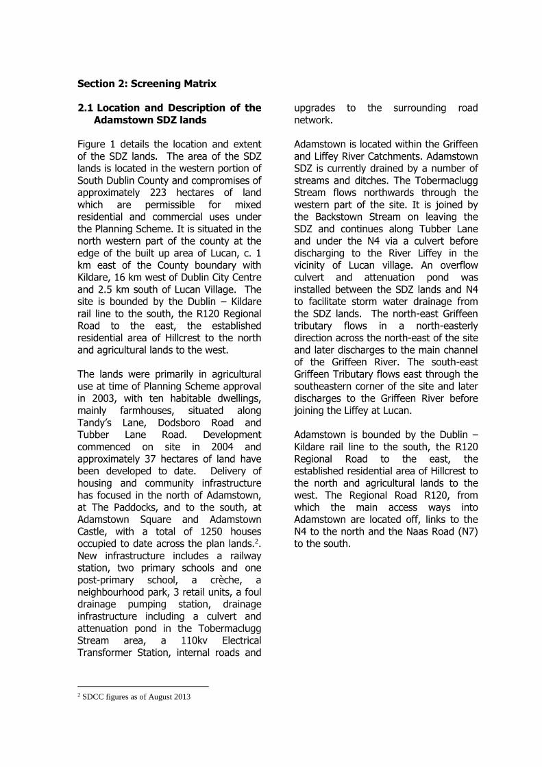
Section 2: Screening Matrix 2.1 Location and Description of the
Adamstown SDZ lands Figure 1 details the location and extent of the SDZ lands. The area of the SDZ lands is located in the western portion of South Dublin County and compromises of approximately 223 hectares of land which are permissible for mixed residential and commercial uses under the Planning Scheme. It is situated in the north western part of the county at the edge of the built up area of Lucan, c. 1 km east of the County boundary with Kildare, 16 km west of Dublin City Centre and 2.5 km south of Lucan Village. The site is bounded by the Dublin – Kildare rail line to the south, the R120 Regional Road to the east, the established residential area of Hillcrest to the north and agricultural lands to the west. The lands were primarily in agricultural use at time of Planning Scheme approval in 2003, with ten habitable dwellings, mainly farmhouses, situated along Tandy’s Lane, Dodsboro Road and Tubber Lane Road. Development commenced on site in 2004 and approximately 37 hectares of land have been developed to date. Delivery of housing and community infrastructure has focused in the north of Adamstown, at The Paddocks, and to the south, at Adamstown Square and Adamstown Castle, with a total of 1250 houses occupied to date across the plan lands.2. New infrastructure includes a railway station, two primary schools and one post-primary school, a crèche, a neighbourhood park, 3 retail units, a foul drainage pumping station, drainage infrastructure including a culvert and attenuation pond in the Tobermaclugg Stream area, a 110kv Electrical Transformer Station, internal roads and
2 SDCC figures as of August 2013
upgrades to the surrounding road network. Adamstown is located within the Griffeen and Liffey River Catchments. Adamstown SDZ is currently drained by a number of streams and ditches. The Tobermaclugg Stream flows northwards through the western part of the site. It is joined by the Backstown Stream on leaving the SDZ and continues along Tubber Lane and under the N4 via a culvert before discharging to the River Liffey in the vicinity of Lucan village. An overflow culvert and attenuation pond was installed between the SDZ lands and N4 to facilitate storm water drainage from the SDZ lands. The north-east Griffeen tributary flows in a north-easterly direction across the north-east of the site and later discharges to the main channel of the Griffeen River. The south-east Griffeen Tributary flows east through the southeastern corner of the site and later discharges to the Griffeen River before joining the Liffey at Lucan. Adamstown is bounded by the Dublin – Kildare rail line to the south, the R120 Regional Road to the east, the established residential area of Hillcrest to the north and agricultural lands to the west. The Regional Road R120, from which the main access ways into Adamstown are located off, links to the N4 to the north and the Naas Road (N7) to the south.

Figure 1: Location and Extent of SDZ Lands
2.2 Context of the Planning Scheme The Government designated 223.5 hectares of privately owned land at Adamstown as a site for the establishment of a Strategic Development Zone for residential development on 1st July 2001(S.I No. 272 of 2001). It is based on the criteria and considerations for the designation of sites for SDZ’s as set out in Part IX, Sections 165 to 171 of the Planning and Development Act 2000 (as amended). The overall aim of the Adamstown SDZ is set out in the Government Order that designated the area as an SDZ (S.I No. 272 of 2001), which states that Adamstown SDZ designation was made taking into consideration: “the deficiency in the supply of housing nationally and in the Greater Dublin Area particularly, the
number and phasing of the housing units which would be delivered by the inclusion of the lands within a strategic development zone, the potential for comprehensive planning and development of the site due to its scale and configuration, the efficient use of public investment in infrastructural facilities, including public transport, water, waste water and roads and that development of the site will help give effect to the policies in the Strategic Planning Guidelines for the Greater Dublin Area for development within the Metropolitan Area”. The type of development specified in the Order is “residential development and the provision of schools, commercial activities, including employment, office and retail facilities, a rail halt, emergency
services, and the provision of community facilities”. South Dublin County Council is the specified Development Agency for the Adamstown SDZ site and the relevant Planning Authority for the area. A draft Planning Scheme was prepared and submitted to the elected members of South Dublin County Council in December 2002 and was adopted by the Council subject to variations and modifications on 7th May 2003. The adopted scheme was the subject of an appeal to An Bord Pleanala, who approved the scheme subject to modifications on 26th September 2003. Section 171 of the Planning and Development Act (as amended) sets out provisions for revocation or amendment of a Planning Scheme. A series of amendments are currently being proposed to the Adamstown SDZ Planning Scheme; in the 10 year period since scheme approval, the economic and policy context within which the scheme operates has changed. While there is no legal requirement to review a Planning Scheme, it was considered timely to review and update the approved Planning Scheme to take account of this changed context.
2.2.1 Structure and Content of the Planning Scheme
The Planning Scheme is set out in a written statement with accompanying maps and tables. Figure 2 presents the overall framework for the planning scheme while a list of the sections is outlined below:

Figure 2 Overall Framework for the Adamstown SDZ Planning Scheme (2013)
The Planning Scheme comprises five parts:
Part 1 Introduction: Introduces the concept and explains the background to the Adamstown SDZ process.
Part 2 Proposals for
Development: Sets out the development parameters for the overall Adamstown site, including the type, extent and design of development, requirements for transportation, services and amenities and divides the site into 15 sub-areas (11 development areas and 4 amenity areas).
Part 3 Development and Amenity Areas: Details development parameters for each of the 15 sub-areas.
Part 4 Phasing and
Implementation: Indicates the required phasing of development.
Part 5 Environmental Appraisal:
Environmental appraisal of the Scheme.

The Planning Scheme’s Philosophy “aims to create sustainable communities rather than just housing developments” and it was prepared “with regard to best practice in the planning and design of new urban communities”
The philosophy will be achieved by using a holistic approach that integrates the following aspect:
Urban Design To create urban place with a strong sense of identity that is attractive and desirable as well as safe and secure, in a traditional town and village format;
Land Use To require a mix of land uses to provide amenities, facilities, services and employment and enable the community to work, shop and recreate locally;
Housing To facilitate a mix of house types, sizes and tenure options that allow all sections of society to remain part of the community throughout the life cycle i.e. from the cradle to the grave;
Transportation To provide alternatives to the private car in the form of a new railway station and transport interchange, additional rail capacity, dedicated bus routes and a continuous network of walking and cycling links;
Ecology and Landscape To preserve ecosystems and landscape by incorporating distinct habitats and established landscape features into a network of parks and open spaces;
Conservation To protect and ensure the appropriate use of historic structures, built heritage and archaeological features;
Energy Efficiency To minimise energy usage through innovations in accessibility, block layout, building design, use of materials and adaptability in floor plans and uses;
Phased Delivery To ensure that development occurs at a pace whereby it is supported by all necessary infrastructure, services, amenities and facilities.

2.3 Assessment of Relevance of Planning Scheme to Natura 2000 sites 2.3.1 Introduction There are two types of EU designated sites; Special Areas of Conservation (SACs) and Special Protection Areas (SPAs). Special Areas of Conservation and Special Protection Areas are designated to afford protection to habitats and species listed in the Habitats and Birds Directives. These two designations are collectively known as the Natura 2000 network. The overall aim of the EC Habitats Directive is to maintain or restore the favourable conservation status of habitats and species of community interest. EU law requires Local Authorities to have regard to the integrity and conservation objectives of these sites when considering development proposals in their vicinity. The aim of the Birds Directive is to provide a framework for the conservation and management of wild birds in Europe and the maintenance of the populations of all wild bird species across their natural range. 2.3.2 Natura 2000 Sites within South Dublin County Within the area of South Dublin County, there are two areas designated as cSACs: Glenasmole Valley cSAC and a portion of the larger Wicklow Mountains cSAC that extends into the county area. There is also one SPA- a portion of the Wicklow Mountains SPA. These three Natura 2000 sites are all located in the Dublin Mountains, bordering with County Wicklow.
Natura 2000 sites within South Dublin County
Site Code
Other Natura 2000 sites within 15km of SDZ lands
Site Code
Glenasmole Valley cSAC Wicklow Mountains cSAC Wicklow Mountains SPA
001209 002122 004040
Rye Water Valley/Carton cSAC Red Bog, Kildare, cSAC Poulaphouca Reservoir SPA
001398 000397 004006
Other Natura 2000 sites outside the limit of 15km from SDZ lands
North Dublin Bay cSAC South Dublin Bay cSAC South Dublin Bay and River Tolka Estuary SPA
000206 000210 004024
Table 1: Natura 2000 sites within 15km radius of the Adamstown SDZ lands
The Adamstown SDZ Planning Scheme is not directly connected with or necessary to the management of Natura 2000 sites in South Dublin County or elsewhere. Best practice recommends assessing Natura 2000 sites located within 15km of a proposed plan or project (see Figure 3). These Natura 2000 sites are listed in Table 1 above. This table also lists those Dublin Bay Natura 2000 sites which are just outside the limit of the recommended 15km zone of influence (Dublin Bay Natura 2000 sites) but for best practice, are also included in the current assessment.

Figure 3 Relevance of Natura 2000 sites to the SDZ Lands

2.3.3 Natura 2000 Sites relevant to Adamstown SDZ Lands. For the Adamstown SDZ lands, the sites requiring assessment of relevance represents three Natura 2000 sites within South Dublin County (Glenasmole valley cSAC, Wicklow Mountains cSAC, and Wicklow Mountains SPA), in addition to three in County Kildare (Poulaphouca Reservoir SPA, Red Bog, and Rye Water/Carton cSAC), and two in County Wicklow (Wicklow Mountains cSAC and Wicklow Mountains SPA). The suite of Natura 2000 sites located in Dublin Bay (North Dublin Bay cSAC, South Dublin Bay cSAC, and South Dublin Bay and River Tolka Estuary SPA), are outside of the recommended 15km assessment zone. There are no Natura 2000 sites located either within or directly adjacent to the SDZ lands. For the Natura 2000 sites located within South Dublin County, County Wicklow, and County Kildare, there are no direct ecological or hydrological links (source-pathway- receptors) between the SDZ lands and these Natura 2000 sites. Negative impacts on these sites are therefore highly unlikely by virtue of distance from Adamstown and the absence of source-pathway-receptors. The Tobermaclugg Stream and the Griffeen River drain much of the land around Adamstown before both join the River Liffey which ultimately empties into Dublin Bay. A potential ecological link exists therefore between surface water drainage from the plan lands and those Natura 2000 sites located in Dublin Bay. While the Dublin Bay Natura 2000 sites are located outside of the suggested limit of 15km for assessment, for Best Practice reasons they are included in this AA Screening. In relation to waste water treatment, the 9B trunk sewer, which flows into the
Grand Canal Trunk Sewer (GCTS) services the plan lands. This sewer discharges into the wastewater treatment works in Ringsend. In order to allow for development growth, South Dublin County Council is cognisant of the need to ensure the provision of requisite wastewater treatment, without which development would conflict with the requirements of the Urban Wastewater Treatment Directive which requires the collection and high level treatment of wastewater. 2.4 Avoidance of Impacts 2.4 (i) Adamstown SDZ Planning Scheme 2003 The relevance of the Planning Scheme to the Natura 2000 network was assessed in Section 2.3 where the only potentially relevant impact was seen to arise from the hydrological link (via the Tobermaclugg Stream, the Griffeen River and the Rathmines and Pembroke Sewer) that exists between the Plan lands and the Dublin Bay Natura 2000 sites, over 15km distant. A number of key objectives of the Planning Scheme, some of which have been carried out to date, include:
Upgrading of Lucan/Palmerstown High Level Water Supply Scheme (LPHLWSS)
Tobermaclugg Pumping Station Connection of green
spaces/integration of Tobermaclugg Stream
Prior to the implementation of the approved Planning Scheme, Adamstown consisted largely of agricultural land and was not served by a water and drainage system. The Planning Scheme detailed proposals for extensive foul, surface and
water drainage infrastructure to be provided on site to serve the future population of the lands. It was noted in several sections that the design of the Planning Scheme pre-empted the potential for likely significant effects and addressed them accordingly. Tobermaclugg Stream, located in the northwestern quadrant of the lands, has been incorporated into the open space/park provision within the Scheme with a series of connected green spaces and corridors facilitating the retention and protection of the stream that follows through the site. In the ten years since the adoption of the Planning Scheme, extensive development works have been carried out on the site The most significant infrastructure delivered to date on site is the Tobermaclugg Pumping Station located in the north-west quadrant of the SDZ lands. The established drainage system was considered insufficient to meet the requirements of the approved Scheme and flood events had occurred in the environs of Tubber lane. A storm water culvert and 5000m³ attenuation pond was installed in 2011 to manage surface water flow in this area. The culvert takes surface water directly from Adamstown to the attenuation pond, bypassing a section of the Tobermaclugg Stream, with outfall to the River Liffey in the vicinity of Lucan Village. Another infrastructural objective of the Planning Scheme has been completed to date- the Lucan/Palmerstown High Level Water Supply Scheme (LPHLWSS) which serves the plan lands, provides additional water supply and boost pressures in the local area. Works to upgrade the LPHLWSS comprised of the provision of a new storage reservoir near Peamount and a series of network improvements which were fully commissioned in October 2004.
Both of these infrastructural projects (i.e. water supply scheme and pumping station) significantly improved the water quality for the Planning Scheme, thereby reducing any potential impact further downstream on Natura 2000 sites. 2.4.1 (ii) Draft Amendments to the SDZ Planning Scheme, 2003 For the Adamstown SDZ Planning Scheme, the draft amendments were screened to determine whether or not the potential existed for these to have a significant negative impact on the Natura 2000 network. This assessment is presented in Appendix 3. The draft amendments have resulted in an amended overall framework for the plan lands (Figure 2); however the network of green spaces, corridors and streams remains unchanged from the approved Scheme. Objectives have been incorporated into the draft amendments to enhance the protection of biodiversity on site including the introduction of a Green Infrastructure Strategy (MA 13); retention of natural features in parks (MA12) and the promotion of SUDS in an Environmental Sustainability section (MA11).Full details of these amendments are provided in Appendix 5. Since the adoption of the Planning Scheme, national guidelines relating to flood risk management were published (2009) as well as the publication of the regional drainage policy i.e. Greater Dublin Strategic Drainage Study (2005). Both of these policy documents advocate the use of sustainable urban drainage systems and outline ways for the sufficient management of water in Dublin. As previously noted, construction in Adamstown to date has delivered only one-tenth of the SDZ’s potential yet the drainage infrastructure (and much of the road infrastructure) has been delivered upfront to cater for the forecasted population. Opportunities for retrofitting Green Infrastructure elements within the

plan lands, as part of a wider SUDS provision, exists and have been taken into consideration in the draft amendments (Appendix 5). The screening of the Planning Scheme and draft amendments does not take into account any additional mitigation measures that may be applied when individual projects are applied (i.e. planning applications) that could further address impacts on ecological receptors. Adherence to the above quoted strategy and objectives, in combination with the over-arching protective policies and objectives in the SDCC County Development Plan (relevant objectives listed in Appendix 4), will therefore act to avoid significant downstream impacts on Natura 2000 sites. The Adamstown SDZ Planning Scheme, 2003 pre-dates the 2004 SEA Regulations. The Planning Scheme does incorporate a comprehensive Environmental Appraisal. The draft amendments, however have been subject to Strategic Environmental Assessment which considered the following environmental issues within the SDZ lands: Population, Biodiversity (flora, fauna), Landscapes/Geology, Water Quality, Air Quality, Waste Management, Cultural and Material assets, and Climate and Sustainability. The interaction between the various environmental topics is considered in the Environmental Report where potential impacts on biodiversity and flora and fauna have been examined. The outcome of the SEA process indicates that where possible conflicts with the status of the listed Strategic Environmental Objectives were identified, these conflicts were all likely to be mitigated for.
2.4.2 South Dublin County Development Plan 2010-2016 The current South Dublin County Development 2010-2016 states that it will continue to support the implementation of the Adamstown SDZ Planning Scheme and its realisation as a compact and sustainable neighbourhood with an eventual future population of more than 20, 000 people. The full range of policies and objectives contained within the South Dublin County Council Development Plan 2010 – 2016 are applicable to development in Adamstown and have been taken into consideration in the content of the Planning Scheme. Development within Adamstown is carried out in accordance with the Planning Scheme. The SDCC County Development Plan 2010-2016 contains a number of policies and objectives that relate to the protection of the environment, landscape, water quality, and Natura 2000 sites. The protection of SACs and pNHAs is specifically referred to in Policy LHA 8 of the CDP: Policy LHA 8: It is the policy of the Council to protect and preserve areas designated or proposed as Special Areas of Conservation (E.U. Habitats Directive) and proposed Natural Heritage Areas’. In addition, the requirements for appropriate assessment of potential impacts on Natura 2000 sites are detailed in Policy LHA 9: Policy LHA 9: It is the policy of the Council that projects giving rise to significant direct, indirect or secondary impacts on Natura 2000 sites arising from their size or scale, land take, proximity, resource requirements, emissions (disposal to land, water or air), transportation requirements, duration of construction, operation, decommissioning or from any other
effects shall not be permitted on the basis of this Plan (either individually or in combination with other plans or projects); Except as provided for in Article 6(4) of the Habitats Directive, viz. There must be: (a) No alternative solution available; (b) Imperative reasons of overriding public interest for the plan to proceed and (c) Adequate compensatory measures in place. All subsequent plan-making and adoption of plans arising from this Plan will be screened for the need to undertake Appropriate Assessment under Article 6 of the Habitats Directive. Where relevant, projects will be screened for the need to undertake Appropriate Assessment under Article 6 of the Habitats Directive. A range of other policies in the County Development Plan 2010-2016 relate to water quality and waste water treatment, all of which aim to eliminate or reduce the potential for deterioration of water quality, both ground water and surface water (see Appendix 4). In particular, Policy WD2 of the County development Plan specifically relates to the requirement that sufficient capacity in public waste water treatment must precede development. Policy WD 2 Wastewater Treatment Plants and Wastewater Collection Systems It is the policy of the Council that development shall be preceded by sufficient capacity in the public wastewater treatment plants and appropriate extensions in the existing public wastewater collection systems.
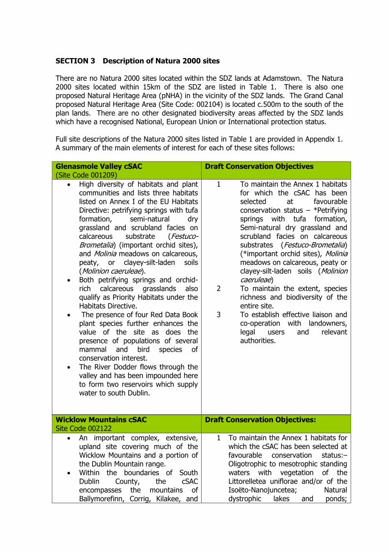
SECTION 3 Description of Natura 2000 sites There are no Natura 2000 sites located within the SDZ lands at Adamstown. The Natura 2000 sites located within 15km of the SDZ are listed in Table 1. There is also one proposed Natural Heritage Area (pNHA) in the vicinity of the SDZ lands. The Grand Canal proposed Natural Heritage Area (Site Code: 002104) is located c.500m to the south of the plan lands. There are no other designated biodiversity areas affected by the SDZ lands which have a recognised National, European Union or International protection status. Full site descriptions of the Natura 2000 sites listed in Table 1 are provided in Appendix 1. A summary of the main elements of interest for each of these sites follows:
Wicklow Mountains cSAC Site Code 002122
Draft Conservation Objectives:
An important complex, extensive, upland site covering much of the Wicklow Mountains and a portion of the Dublin Mountain range.
Within the boundaries of South Dublin County, the cSAC encompasses the mountains of Ballymorefinn, Corrig, Kilakee, and
1 To maintain the Annex 1 habitats for which the cSAC has been selected at favourable conservation status:– Oligotrophic to mesotrophic standing waters with vegetation of the Littorelletea uniflorae and/or of the Isoëto-Nanojuncetea; Natural dystrophic lakes and ponds;
Glenasmole Valley cSAC (Site Code 001209)
Draft Conservation Objectives
High diversity of habitats and plant communities and lists three habitats listed on Annex I of the EU Habitats Directive: petrifying springs with tufa formation, semi-natural dry grassland and scrubland facies on calcareous substrate (Festuco-Brometalia) (important orchid sites), and Molinia meadows on calcareous, peaty, or clayey-silt-laden soils (Molinion caeruleae).
Both petrifying springs and orchid-rich calcareous grasslands also qualify as Priority Habitats under the Habitats Directive.
The presence of four Red Data Book plant species further enhances the value of the site as does the presence of populations of several mammal and bird species of conservation interest.
The River Dodder flows through the valley and has been impounded here to form two reservoirs which supply water to south Dublin.
1 To maintain the Annex 1 habitats for which the cSAC has been selected at favourable conservation status – *Petrifying springs with tufa formation, Semi-natural dry grassland and scrubland facies on calcareous substrates (Festuco-Brometalia) (*important orchid sites), Molinia meadows on calcareous, peaty or clayey-silt-laden soils (Molinion caeruleae)
2 To maintain the extent, species richness and biodiversity of the entire site.
3 To establish effective liaison and co-operation with landowners, legal users and relevant authorities.

Cruagh, stretching south to the summit of Kippure Mountain at the border with County Wicklow
While the entire cSAC lists ten habitats listed in Annex I of the EU Habitats Directive, the vegetation within the South Dublin County portion of the site mainly provides good examples of the typical upland habitats of heath, blanket bog and upland grassland.
Several rare, protected plant and animal species also occur in this cSAC.
Northern Atlantic wet heaths with Erica tetralix; European dry heaths; Alpine and Boreal heaths; Species-rich Nardus grasslands, on siliceous substrates in mountain areas (and submountain areas, in Continental Europe); Blanket bog; Siliceous scree of the montane to snow levels; (Androsacetalia alpinae and Galeopsietalia ladani); Calcareous rocky slopes with chasmophytic vegetation; Siliceous rocky slopes with chasmophytic vegetation; Old sessile oak woods with Ilex and Blechnum in British Isles.
2 To maintain the Annex 2 species for
which the cSAC has been selected at favourable conservation status: - Lutra lutra
3 To maintain the extent, species
richness and biodiversity of the entire site.
4 To establish effective liaison and co-
operation with landowners, legal users and relevant authorities.
Wicklow Mountains SPA (Site Code 4040)
Main Conservation Objective:
Extensive upland site, comprising a substantial part of the Wicklow Mountains (See Appendix for full site description).
The site, which is within the Wicklow Mountains National Park, is fragmented into about twenty separate parcels of land.
Much of the site is State-owned and managed for nature conservation based on traditional landuses for the uplands.
The site is of high ornithological importance as it supports very good examples of upland and woodland bird communities, several of which are very rare at a national level.
Two species, Ring Ouzel and Red Grouse, are Red-listed and their status is of high conservation concern.
To maintain the special conservation interests for the SPA at favourable conservation status – Merlin, Peregrine.
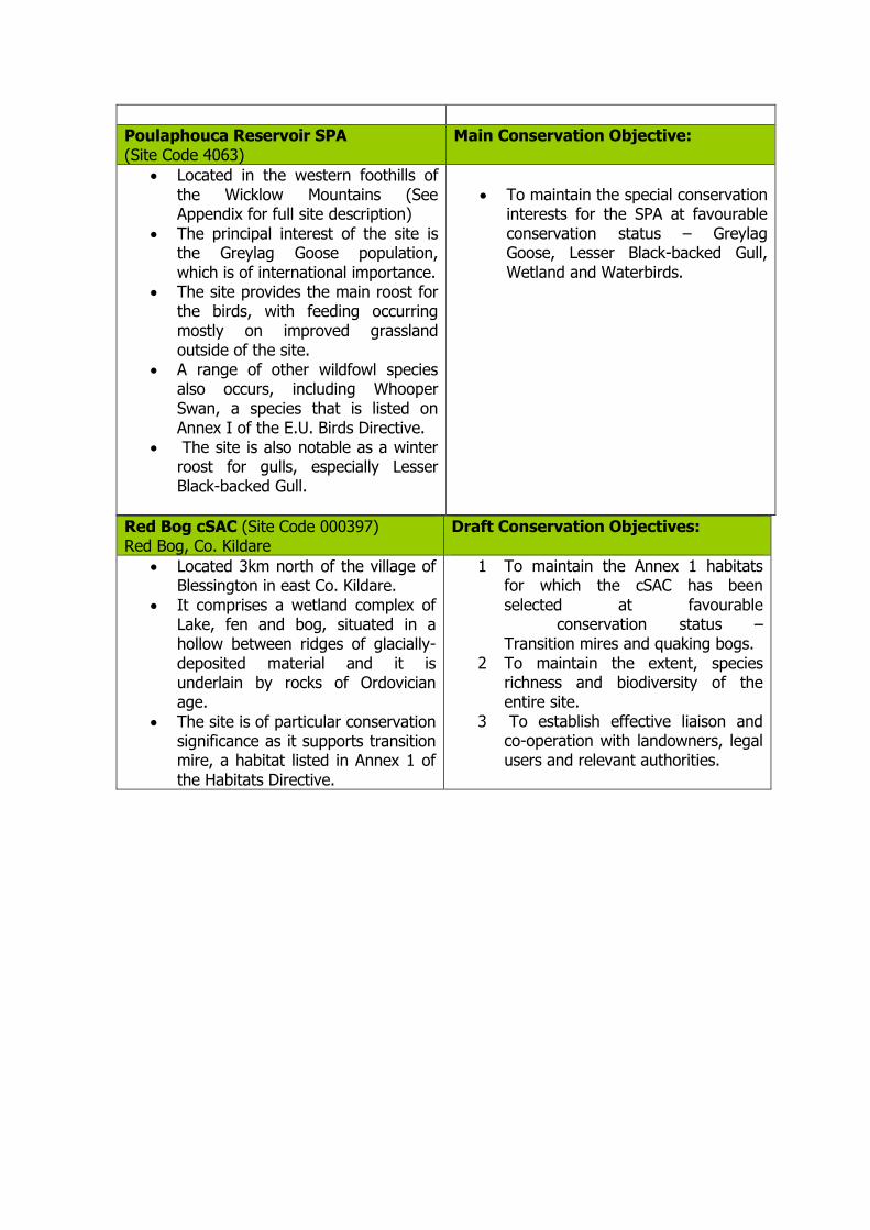
Poulaphouca Reservoir SPA (Site Code 4063)
Main Conservation Objective:
Located in the western foothills of the Wicklow Mountains (See Appendix for full site description)
The principal interest of the site is the Greylag Goose population, which is of international importance.
The site provides the main roost for the birds, with feeding occurring mostly on improved grassland outside of the site.
A range of other wildfowl species also occurs, including Whooper Swan, a species that is listed on Annex I of the E.U. Birds Directive.
The site is also notable as a winter roost for gulls, especially Lesser Black-backed Gull.
To maintain the special conservation interests for the SPA at favourable conservation status – Greylag Goose, Lesser Black-backed Gull, Wetland and Waterbirds.
Red Bog cSAC (Site Code 000397) Red Bog, Co. Kildare
Draft Conservation Objectives:
Located 3km north of the village of Blessington in east Co. Kildare.
It comprises a wetland complex of Lake, fen and bog, situated in a hollow between ridges of glacially-deposited material and it is underlain by rocks of Ordovician age.
The site is of particular conservation significance as it supports transition mire, a habitat listed in Annex 1 of the Habitats Directive.
1 To maintain the Annex 1 habitats for which the cSAC has been selected at favourable conservation status – Transition mires and quaking bogs.
2 To maintain the extent, species richness and biodiversity of the entire site.
3 To establish effective liaison and co-operation with landowners, legal users and relevant authorities.

North Dublin Bay cSAC (Site Code 000206)
Draft Conservation Objectives:
Covers the inner part of north Dublin Bay, the seaward boundary extending from the Bull Wall lighthouse across to the Martello Tower at Howth Head (See Appendix for full site description).
The North Bull Island is the focal point of this site. This SAC site is an excellent example of a coastal site with all the main habitats
1. To maintain the Annex 1 habitats
for which the cSAC has been selected at favourable conservation status:– Mudflats and sandflats not covered by seawater at low tide; Annual vegetation of drift lines; Salicornia and other annuals colonising mud and sand; Atlantic salt meadows (Glauco
Rye Water Valley/Carton cSAC (Site Code 001398)
Draft Conservation Objectives:
This site is located between Leixlip and Maynooth in Co. Kildare. It extends along the Rye Water, a tributary of the River Liffey.
The woodlands at Carton Demesne are the site of a rare fungus, Diderma deplanatum and also support birds such as Blackcap, Woodcock, and Long-eared Owls. On or about the lake, birds such as Little Grebe, Coot, Moorhen, Tufted Duck, Teal, and Kingfisher have been recorded. Kingfisher are listed in Annex 1 of the EU Birds Directive.
The mineral spring occurring on the site is also listed as an Annex 1 habitat of the EU Habitats Directive.
The Rye Water is a spawning ground for Trout and Salmon while White-clawed crayfish Austropotomobius pallipeshas been recorded at Leixlip.
Rare snail species and dragonflies also occur in the marsh vegetation near to Louisa Bridge.
The main importance of the site lies in the presence of several rare and threatened plant and animal species and of a rare habitat – thermal, mineral, petrifying spring.
1. To maintain the Annex 1 habitats for which the cSAC has been selected at favourable conservation status:– *Petrifying springs with tufa formation
2. To maintain the Annex 2 species for which the cSAC has been selected at favourable conservation status: - Vertigo angustior, Vertigo moulinsiana
3. To maintain the extent, species
richness and biodiversity of the entire site.
4. To establish effective liaison and
co-operation with landowners, legal users and relevant authorities.

represented.
It holds good examples of ten habitats that are listed on Annex I of the E.U. Habitats Directive; one of these is listed with priority status. Several wintering bird species have populations of international importance, while some invertebrates on the site are of national importance.
The site also contains a numbers of rare and scarce plants including some which are legally protected.
Puccinellietalia maritimae); Petalophyllun ralfsii; Mediterranean salt meadows (Juncetalia maritimi); Embryonic shifting dunes; Shifting dunes along the shoreline with Ammophila arenaria (white dunes); Fixed coastal dunes with herbaceous vegetation (grey dunes); Humid dune slacks
2. To maintain the extent, species richness and biodiversity of the entire site.
3. To establish effective liaison and co-operation with landowners, legal users and relevant authorities.
South Dublin Bay cSAC (Site Code 000210)
Draft Conservation Objectives
Lies south of the River Liffey and extends from the South Wall to the west pier at Dun Laoghaire (See Appendix for full site description).
It is a fine example of a coastal system with extensive sand and mudflats. South Dublin Bay is also an internationally important bird site.
1. To maintain the Annex 1
habitats for which the cSAC has been selected at favourable conservation status: - Mudflats and sandflats not covered by seawater at low tide.
2. To maintain the extent, species richness and biodiversity of the entire site.
4 To establish effective liaison and co-operation with landowners, legal users and relevant authorities.
South Dublin Bay and River Tolka Estuary SPA (Site Code 4024)
Main Conservation Objective:
Comprises a substantial part of Dublin Bay. It includes the intertidal area between the River Liffey and Dun Laoghaire, and the estuary of the River Tolka to the north of the River Liffey, as well as Booterstown Marsh. A portion of the shallow marine waters of the bay is also included (See Appendix for full site description).
The site is an important site for wintering waterfowl, being an integral part of the internationally important Dublin Bay complex. It is of international importance for Light-bellied Brent Goose and of
To maintain the special conservation interests for the SPA at favourable conservation status – Light-bellied Brent Goose, Oystercatcher, Ringed Plover, Golden Plover, Knot, Sanderling, Dunlin, Bar-tailed Godwit, Redshank, Black-headed Gull, Roseate Tern, Common Tern, Arctic Tern, and Wetland and Waterbirds.

national importance for nine other waterfowl species. As an autumn tern roost, it is also of international importance. Furthermore, the site supports a nationally important colony of Common Tern. All of the tern species using the site are listed on Annex I of the E.U. Birds Directive, as are Bartailed Godwit and Mediterranean Gull.
SECTION 4 Assessments of Potential Impacts 4.1 Assessment of the Adamstown SDZ Planning Scheme In Section 2.3 (Assessment of relevance of Planning Scheme to Natura 2000 Sites), a potential hydrological link was identified as being the primary source-pathway-receptor between the SDZ lands and Natura 2000 sites – primarily the Dublin Bay Natura 2000 sites. No other hydrological or ecological links to other Natura 2000 sites within 15km of the SDZ lands was identified as posing a potential threat. This hydrological link via the Tobermaclugg Stream and Griffeen River systems thereby potentially provides a vehicle for the transfer of negative impacts to these Natura 2000 sites downstream of the SDZ lands which rely on water quality for the maintenance of their conservation objectives. An assessment of the draft amendments to the Planning Scheme (Appendix 3) was undertaken and no significant impacts were identified. In some instances, positive impacts are likely to arise in relation to the overall biodiversity resource e.g. retention of natural features in the parks and enhancement of existing ecological features and wildlife corridors. The Planning Scheme was assessed following the factors as listed: - size and scale; land-take; distance from the Natura 2000 site or key features of the site; resource requirements (water abstraction etc.); emissions (disposal to land, water, or air); excavation requirements); transportation requirements; duration of construction, operation, decommissioning, etc.; habitat area; disturbance to key species; habitat or species fragmentation; species density; changes in key indicators of conservation
value (water quality etc.); climate change; key relationships that define the structure of the site; key relationships that determine the function of the site. The Planning Scheme and draft amendments, in conjunction with the over-arching policies of the South Dublin County Development Plan 2010-1016 within which framework the Planning Scheme is placed, in addition to the range of other instruments considered in the formulation of the Planning Scheme (see Section 2.4), all serve to ensure that no significant negative impact arises from the Planning Scheme and the draft amendments. 4.2 Cumulative Impacts
The National Spatial Strategy 2002-2020 and the National Development Plan 2007-2013 set the national planning framework within which the Planning Scheme has been prepared. Within South Dublin County itself, the County Development Plan 2010-2016 provides the local framework within the regional approach of the Regional Planning Guidelines 2010-2020. These documents have been subject to screening for Appropriate Assessment to ensure no significant impacts are likely. The Adamstown Planning Scheme and draft amendments were prepared taking the objectives and policies of these plans into account. The assessment for Adamstown Planning Scheme and the draft amendments indicates there will be no significant impacts arising from the Scheme. In relation to potential cumulative impacts from the Planning Scheme in conjunction with other plans and projects, it is a requirement that each of these, in addition to each individual application within the Planning Scheme itself, will all

be subject to screening for appropriate assessment to ensure there will be no significant negative impact on Natura 2000 sites. Taken together, adherence to this required approach will ensure no cumulative impacts will arise from the plan
SECTION 5 Conclusions This screening report has evaluated the Adamstown SDZ Planning Scheme 2003 and the draft amendments (2013) to determine whether or not significant negative impacts on Natura 2000 sites are likely to arise by virtue of the planning scheme’s implementation. The report finds that the planning scheme has been formulated to ensure that developments and effects arising from the planning scheme, either individually or in combination with other plans and projects, shall not give rise to significant effects on the integrity of any Natura 2000 site. The Appropriate Assessment procedure for the Planning Scheme and draft Amendments is therefore concluded at this Screening Stage and a detailed (Stage 2) Appropriate Assessment is not required.

Appendix 1- Natura 2000 descriptions (as listed in Table 1) SITE SYNOPSIS SITE NAME: GLENASMOLE VALLEY SITE CODE: 001209 Glenasmole Valley in south Co. Dublin lies on the edge of the Wicklow uplands, approximately 5 km from Tallaght. The River Dodder flows through the valley and has been impounded here to form two reservoirs which supply water to south Dublin. The non-calcareous bedrock of the Glenasmole Valley has been overlain by deep drift deposits which now line the valley sides. They are partly covered by scrub and woodland, and on the less precipitous parts, by a herb-rich grassland. There is much seepage through the deposits, which brings to the surface water rich in bases, which induces local patches of calcareous fen and, in places, petrifying springs, a priority habitat listed on Annex I of the EU Habitats Directive. Examples of calcareous fen and flush areas occur between the two reservoirs, where sedges (Carex flacca and Carex panicea) are joined by such species as Grass of Parnassus (Parnassia palustris), Few-flowered Spike-rush (Eleocharis quinqueflora), Zig-zag clover (Trifolium medium) and the scarce Fen Bedstraw (Galium uliginosum). Orchid-rich grassland occurs in the drier parts of this site and in places grades into Molinia meadow, both of these habitats are listed on Annex I of the EU Habitats Directive. Species recorded in these habitats include Frog Orchid (Coeloglossum viride), Northern Marsh-orchid (Dactylorhiza purpurella), Fragrant Orchid (Gymnadenia conopsea), Marsh Helleborine (Epipactis palustris), Early-purple Orchid (Orchis mascula) and Greater Butterfly Orchid (Platanthera chlorantha).
Two Red Data Book species have also been found here, Green-winged Orchid (Orchis morio) and Small-white Orchid (Pseudorchis albida). The sward includes Sweet Vernal-grass (Anthoxanthum odoratum), Creeping Bent (Agrostis stolonifera) and Crested Dog's-tail (Cynosurus cristatus). Other species which occur are Common Bird's-foot-trefoil (Lotus corniculatus), Kidney Vetch (Anthyllis vulneraria), Common Restharrow (Ononis repens), Yellow-wort (Blackstonia perfoliata) and Autumn Gentian (Gentianella amarella). Woodland occurs in patches around the site. On the east side of the valley, below the northern lake, a Hazel (Corylus avellana) wood has developed on the unstable calcareous slopes and includes Ash (Fraxinus excelsior), Downy Birch (Betula pubescens), Goat Willow (Salix caprea) and (Irish) Whitebeam (Sorbus hibernica). Spring Wood-rush (Luzula pilosa), Wood Speedwell (Veronica montana) and Brambles (Rubus fruticosus agg.) are included in the ground flora. Wet semi-natural broad-leaved woodland is also found around the reservoirs and includes Alder (Alnus glutinosa) and Willow (Salix spp.) with Yellow Iris (Iris pseudacorus), Horsetail (Equisetum spp.), Brambles and localised patches of Japanese Knotweed (Reynoutria japonica), an introduced species. The lake shore vegetation is not well developed, which is typical of a reservoir. There are occasional patches of Canary-grass (Phalaris arundinacea) and Purple-loosestrife (Lythrum salicaria), which are more extensive around the western shore of the northern lake, along with Common Marsh-bedstraw (Galium palustre) and Water Mint (Mentha aquatica). Other vegetation includes

Shoreweed (Littorella uniflora) and the scarce Water Sedge (Carex aquatilis). As well as the Green-winged Orchid and Small-white Orchid, two other threatened species which are listed in the Irish Red Data Book also occur in the site, Yellow Archangel (Lamiastrum galeobdolon) and Yellow Bird's-nest (Monotropa hypopitys). The site provides excellent habitat for bat species, with at least four species recorded: Pipistrelle, Leisler’s, Daubenton’s and Brown Long-eared Bat. Otter occurs along the river and reservoirs. These habitats also support Kingfisher, an Annex I species under the EU Birds Directive. Glenasmole Valley contains a high diversity of habitats and plant communities, including three habitats listed on Annex I of the EU Habitats Directive. The presence of four Red Data Book plant species further enhances the value of the site as does the presence of populations of several mammal and bird species of conservation interest. 03.09.2001 SITE SYNOPSIS SITE NAME: WICKLOW MOUNTAINS SITE CODE: 002122 This site is a complex of upland areas in Counties Wicklow and Dublin, flanked by Blessington Reservoir to the west and Vartry Reservoir in the east, Cruagh Mt. in the north and Lybagh Mt. in the south. Most of the site is over 300m, with much ground over 600m and the highest peak of Lugnaquilla at 925m. The Wicklow Uplands comprise a core of granites flanked by Ordovician schists, mudstones and volcanics. The form of the Wicklow Glens is due to glacial erosion. The Wicklow Mountains are
drained by several major rivers including the Dargle, Liffey, Dodder, Slaney and Avonmore. The river water in the mountain areas is often peaty, especially during floods. The topography is typical of a mountain chain, showing the effects of more than one cycle of erosion. The massive granite has weathered characteristically into broad domes. Most of the western part of the site consists of an elevated moorland, covered by peat. The surrounding schists have assumed more diverse outlines, forming prominent peaks and rocky foothills with deep glens. The dominant topographical features are the products of glaciation. High corrie lakes, deep valleys and moraines are common features of this area. The substrate over much of the area is peat, usually less than 2m deep. Poor mineral soil covers the slopes and rock outcrops are frequent The vegetation over most of the site is a mosaic of heath, blanket bog and upland grassland (mostly on peaty soil, though some on mineral soil), with stands of dense Bracken (Pteridium aquilinum) and small woodlands mainly along the rivers. Mountain loughs and corrie lakes are scattered throughout the site. The site supports many habitats that are listed on Annex I of the E.U. Habitats Directive. The two dominant vegetation communities in the area are heath and blanket bog. Heath vegetation, with both wet and dry heath well represented, occurs in association with blanket bog, upland acid grassland and rocky habitats. The wet heath is characterised by species such as Ling (Calluna vulgaris), Cross-leaved Heath (Erica tetralix), Cottongrasses (Eriophorum spp.), Tormentil (Potentilla erecta), Mat-grass (Nardus stricta), Bent grasses (Agrostis spp.) and bog mosses (Sphagnum spp.). In places the wet heath occurs in conjunction with flush communities and streamside vegetation, and here species

such as Heath Rush (Juncus squarrosus) and Carex spp. are found. Dry heath at this site is confined to shallow peaty soils on steep slopes where drainage is better and particularly in sheltered conditions. It is characterised by species such as Ling, Gorse (Ulex spp.), Bell Heather (Erica cinerea), Bilberry (Vaccinium myrtillus), Purple Moor-grass (Molinia caerulea) and lichens (Cladonia spp.). In places the heath grades into upland grassland on mineral soil, some examples of which correspond to the E.U. Habitats Directive Annex I priority habitat species-rich Nardus grassland. Blanket bog is usually dominated by Cottongrasses, Ling and bog mosses (Sphagnum spp.). On steeper slopes there is some flushing and here Purple Moor-grass, Heath Rush, and certain Sphagnum species become more common. The Liffey Head blanket bog is among the best of its kind in eastern Ireland, with deep peat formations and an extensive system of dystrophic pools developed among the hummocks and hollows on the bog surface. The vegetation is largely dominated by Ling and Cross-leaved Heath, with Cottongrasses (Eriophorum vaginatum and E. angustifolium), Deergrass (Scirpus cespitosus) and Bog Asphodel (Narthecium ossifragum). In drier areas, Bilberry and Cowberry (Vaccinium vitis-idaea) are common, while the scarce Bog Rosemary (Andromeda polifolia) is also found. Blanket bog occurs over extensive areas of deeper peat on the plateau and also on gentle slopes at high altitudes. Peat erosion is frequent on the peaks - this may be a natural process, but is likely to be accelerated by activities such as grazing. Due to the underlying rock strata, the water of the rivers and streams tends towards acidity. The water is generally oligotrophic and free from enrichment. The lakes within the area range from the high altitude lakes of Lough Firrib and Three Lakes, to the lower pater-noster
lakes of Glendalough, Lough Tay and Lough Dan. Spectacular corrie lakes (such as Loughs Bray (Upper and Lower), Ouler, Cleevaun, Arts, Kellys and Nahanagan) exhibit fine sequences of moraine stages. The deep lakes are characteristically species poor, but hold some interesting plants including an unusual form of Quillwort (Isoetes lacustris var. morei), a Stonewort (Nitella sp.) and Floating Bur-reed (Sparganium angustifolium). The Red Data Book fish species Arctic Char has been recorded from Lough Dan, but this population may now have died out. Alpine vegetation occurs on some of the mountain tops, notably in the Lugnaquilla area, and also on exposed cliffs and scree slopes elsewhere in the site. Here alpine heath vegetation is represented with species such as Crowberry (Empetrum nigrum), Cowberry, Dwarf Willow (Salix herbacea), the grey-green moss Racomitrium lanuginosum and scarce species such as Mountain Clubmoss (Diphasiastrum alpinum), Firmoss (Huperzia selago), and Starry Saxifrage (Saxifraga stellaris). Some rare arctic-alpine species have been recorded, including Alpine Lady’s-mantle (Alchemilla alpina) and Alpine Saw-wort (Saussurea alpina). Small areas of old oakwood (Blechno-Quercetum petraeae type) occur on the slopes of Glendalough and Glenmalure, near L. Tay and L. Dan, with native Sessile Oak (Quercus petraea) 100-120 years old. On wetter areas, wet broadleaved semi-natural woodlands occur, which are dominated by Downy Birch (Betula pubescens). Mixed woodland with non-native tree species also occurs. The site supports a range of rare plant species, which are listed in the Irish Red Data Book: Parsley Fern (Cryptogramma crispa), Marsh Clubmoss (Lycopodiella inundata), Greater Broom-rape
(Orobanche rapum-genistae), Alpine Lady's-mantle, Alpine Saw-wort, Lanceolate Spleenwort (Asplenium billotii), Small White Orchid (Pseudorchis albida) and Bog Orchid (Hammarbya paludosa). The latter three species are legally protected under the Flora (Protection) Order, 1999. The rare Myxomycete fungus, Echinostelium colliculosum, has been recorded from the Military Road. Mammals and birds which occur are typical of the uplands. Deer are abundant, mainly hybrids between Red and Sika Deer. Other mammals include Hare, Badger and Otter, the latter being a species listed on Annex II of the E.U. Habitats Directive. Pine Marten has recently been confirmed as occurring within the site. Among the birds, Meadow Pipit, Skylark, Raven and Red Grouse are resident throughout the site. Wheatear, Whinchat and the scarce Ring Ouzel are summer visitors. Wood Warbler and Redstarts are rare breeding species of the woodlands. Dipper and Grey Wagtail are typical riparian species. Merlin and Peregrine Falcon, both Annex I species of the EU Birds Directive, breed within the site. Recently, Goosander has become established as a breeding species. Large areas of the site are owned by NPWS, and managed for nature conservation based on traditional landuses for the uplands. The most common landuse is traditional sheep grazing. Other land uses include turf-cutting, mostly hand-cutting but some machine-cutting occurs. These activities are largely confined to the Military Road, where there is easy access. Large areas which had been previously hand-cut and are now abandoned, are regenerating. In the last 40 years, forestry has become an important landuse in the uplands, and has affected both the wildlife and the hydrology of the area. Amenity use is very high, with Dublin city close to the site.
Wicklow Mountains is important as a complex, extensive upland site. It shows great diversity from a geomorphological and a topographical point of view. The vegetation provides examples of the typical upland habitats with heath, blanket bog and upland grassland covering large, relatively undisturbed areas. In all ten habitats listed on Annex I of the EU Habitats Directive are found within the site. Several rare, protected plant and animal species occur. 12.10.2001 SITE SYNOPSIS SITE NAME: WICKLOW MOUNTAINS SPA SITE CODE: 004040 This is an extensive upland site, comprising a substantial part of the Wicklow Mountains. The underlying geology of the site is mainly of Leinster granites, flanked by Ordovician schists, mudstones and volcanics. The area was subject to glaciation and features fine examples of glacial lakes, deep valleys and moraines. Most of site is over 300 m, with much ground being over 600 m; the highest peak is Lugnaquillia (925 m). The substrate over much of site is peat, with poor mineral soil occurring on the slopes and lower ground. Exposed rock and scree are features of the site. The dominant habitats present are blanket bog, heaths and upland grassland. The bog habitat is usually dominated by Ling (Calluna vulgaris), Cross-leaved Heath (Erica tetralix), Cottongrasses (Eriophorum vaginatum and E. angustifolium), Deergrass (Scirpus cespitosus) and Bog Asphodel (Narthecium ossifragum). Bog mosses (Sphagnum spp.) are well represented. On shallower peats, dry heath is represented by such species as Ling, Gorse (Ulex spp.), Bell Heather (Erica cinerea), Bilberry (Vaccinium myrtillus), Purple Moor-grass (Molinia caerulea) and lichens (Cladonia

spp.). Fine examples of native Oak woodlands are found in the Glendalough area, and include Sessile Oak (Quercus petraea) trees of 100-120 years old. Glendalough Lake is a good example of an oligotrophic system. The site supports good examples of both upland and woodland bird communities. The open peatlands provide excellent foraging habitat for Merlin (5-10 pairs) and Peregrine (c. 10 pairs). The Merlins nest in old crows nests, whilst the Peregrines nest on cliffs and crags. Other birds of the open peatlands and scree slopes include Ring Ouzel, now a very rare bird in Ireland, and Red Grouse. The Wicklow uplands are the only regular location in Ireland where Goosander breeds, with the Glendalough lakes being a regular site. This species was proved to be breeding only as recently as 1994 and it is now well established. Whinchat, a localised species in Ireland, breeds within the site. The Glendalough Oak woods are a regular location for several rare breeding passerines. Redstart is recorded most years and 1-2 pairs probably breed. Wood Warbler is another annual visitor, with perhaps up to 5 pairs in some years. Recently, Garden Warbler has been recorded, whilst Blackcap has a very strong breeding population. The site, which is within the Wicklow Mountains National Park, is fragmented into about twenty separate parcels of land. Much of the site is State-owned and managed for nature conservation based on traditional landuses for the uplands. The most common landuse is traditional sheep grazing. Other land uses include turf-cutting, mostly by hand though some machine-cutting also occurs. Grazing by sheep and deer in the woodlands can be damaging as it prevents or reduces regeneration. Dublin City is close to the site and amenity use is very high; if not properly controlled,
recreational activities could cause disturbance to some bird species. This site is of high ornithological importance as it supports very good examples of upland and woodland bird communities. Several of the species which occur are very rare at a national level. Two species, Ring Ouzel and Red Grouse, are Red-listed and their status is of high conservation concern. Also of note is that Merlin and Peregrine are both listed on Annex I of the E.U. Birds Directive. 25.8.2004 SITE SYNOPSIS SITE NAME: POULAPHOUCA RESERVOIR SPA SITE CODE: 004063 Poulaphouca Reservoir SPA, located in the western foothills of the Wicklow Mountains, was created in 1944 by damming of the River Liffey for the purpose of generating electricity from hydropower. The reservoir covers an area of approximately 20 square kilometres and is the largest inland water body in the Mideast and south-east regions. The reservoir receives water from two main sources, the River Liffey at the northern end, and the Kings River at the southern end. The exit is into the River Liffey gorge at the western end. Underlying the reservoir are sands and gravels deposited during the last glaciation. The shores of the lake are mostly sandy. When water levels are low the exposed lake muds are colonised by an ephemeral flora of annual plant species. Wet grassland areas occur in sheltered bays around the lake but especially in the northern part. Reed Canary-grass (Phalaris arundinacea) is the main grass species present, but other plant species characteristic of wet grasslands occur, including Creeping Bent (Agrostis stolonifera), Meadowsweet (Filipendula ulmaria), Yellow Iris (Iris pseudacorus)

and Water Mint (Mentha aquatica). Sedges (Carex spp.) are locally common, while Rusty Willow (Salix cinerea subsp. oleifolia) scrub is often found associated with the wet grassland. In some places the water washes against grassy banks which are generally less than a metre high, and in a few places there are steep sand and clay cliffs, up to 15 m high - these are remnants of the old River Liffey channel. In many places the banks are actively eroding, and a strip of conifers has been planted around much of the perimeter of the reservoir in an attempt to stabilize the banks. Poulaphouca Reservoir is of international importance for its Greylag Goose population, which is one of the largest in the country. The site provides the main roost for the birds, with feeding occurring mostly on improved grassland outside of the site. An average peak of 1,058 individuals occurred during the five seasons 1995/96 to 1999/00. A range of other waterfowl species occur in relatively low numbers, including Whooper Swan (34), Wigeon (262), Teal (136), Mallard (283), Goldeneye (36), Cormorant (16), Great Crested Grebe (11), Curlew (118) and Mute Swan (17). The site is also used by Grey Heron (12). The reservoir attracts roosting gulls during winter, most notably a large population of Lesser Black-backed Gull (1,116), which in Ireland is rare in winter away from the south coast. Black-headed Gull (1,245) and Common Gull (229) also occur. Breeding birds at the site include Great Crested Grebe (several pairs), which is localised in its distribution in eastern Ireland, as well as Snipe and Lapwing. The principal interest of the site is the Greylag Goose population, which is of international importance. A range of other wildfowl species also occurs, including Whooper Swan, a species that is listed on Annex I of the E.U. Birds Directive. The site is also
notable as a winter roost for gulls, especially Lesser Black-backed Gull. 2.3.2005 SITE SYNOPSIS SITE NAME : NORTH DUBLIN BAY SAC SITE CODE : 000206 This site covers the inner part of north Dublin Bay, the seaward boundary extending from the Bull Wall lighthouse across to the Martello Tower at Howth Head. The North Bull Island is the focal point of this site. The island is a sandy spit which formed after the building of the South Wall and Bull Wall in the 18th and 19th centuries. It now extends for about 5 km in length and is up to 1 km wide in places. A well-developed and dynamic dune system stretches along the seaward side of the island. Various types of dunes occur, from fixed dune grassland to pioneer communities on foredunes. Marram Grass (Ammophila arenaria) is dominant on the outer dune ridges, with Lyme Grass (Leymus arenarius) and Sea Couchgrass (Elymus farctus) on the foredunes. Behind the first dune ridge, plant diversity increases with the appearance of such species as Wild Pansy (Viola tricolor), Kidney Vetch (Anthyllis vulneraria), Bird's-foot Trefoil (Lotus corniculatus), Rest Harrow (Ononis repens), Yellow Rattle (Rhinanthus minor) and Pyramidal Orchid (Anacamptis pyramidalis). In these grassy areas and slacks, the scarce Bee Orchid (Ophrys apifera) occurs. About 1 km from the tip of the island, a large dune slack with a rich flora occurs, usually referred to as the 'Alder Marsh' because of the presence of Alder trees (Alnus spp). The water table is very near the surface and is only slightly brackish. Saltmarsh Rush (Juncus maritimus) is the dominant species, with Meadow Sweet (Filipendula ulmaria) and Devil's-bit
(Succisa pratensis) being frequent. The orchid flora is notable and includes Marsh Helleborine (Epipactis palustris), Common Twayblade (Listera ovata), Autumn Lady's-tresses (Spiranthes spiralis) and Marsh orchids (Dactylorhiza spp.) Saltmarsh extends along the length of the landward side of the island. The edge of the marsh is marked by an eroding edge which varies from 20 cm to 60 cm high. The marsh can be zoned into different levels according to the vegetation types present. On the lower marsh, Glasswort (Salicornia europaea), Saltmarsh Grass (Puccinellia maritima), Annual Sea-blite (Suaeda maritima) and Greater Sea-spurrey (Spergularia media) are the main species. Higher up in the middle marsh Sea Plantain (Plantago maritima), Sea Aster (Aster tripolium), Sea Arrowgrass (Triglochin maritima) and Sea Pink (Armeria maritima) appear. Above the mark of the normal high tide, species such as Scurvy Grass (Cochlearia officinalis) and Sea Milkwort (Glaux maritima) are found, while on the extreme upper marsh, Sea Rushes (Juncus maritimus and J. gerardii) are dominant. Towards the tip of the island, the saltmarsh grades naturally into fixed dune vegetation. The island shelters two intertidal lagoons which are divided by a solid causeway. The sediments of the lagoons are mainly sands with a small and varying mixture of silt and clay. The north lagoon has an area known as the "Salicornia flat", which is dominated by Salicornia dolichostachya, a pioneer Glasswort species, and covers about 25 ha. Tassel Weed (Ruppia maritima) occurs in this area, along with some Eelgrass (Zostera angustifolia). Eelgrass (Z. noltii) also occurs in Sutton Creek. Cordgrass (Spartina anglica) occurs in places but its growth is controlled by management. Green algal mats (Enteromorpha spp., Ulva lactuca) cover large areas of the flats during summer. These sediments
have a rich macrofauna, with high densities of Lugworms (Arenicola marina) in parts of the north lagoon. Mussels (Mytilus edulis) occur in places, along with bivalves such as Cerastoderma edule, Macoma balthica and Scrobicularia plana. The small gastropod Hydrobia ulvae occurs in high densities in places, while the crustaceans Corophium volutator and Carcinus maenas are common. The sediments on the seaward side of North Bull Island are mostly sands. The site extends below the low spring tide mark to include an area of the sublittoral zone. Three Rare plant species legally protected under the Flora Protection Order 1987 have been recorded on the North Bull Island. These are Lesser Centaury (Centaurium pulchellum), Hemp Nettle (Galeopsis angustifolia) and Meadow Saxifrage (Saxifraga granulata). Two further species listed as threatened in the Red Data Book, Wild Sage (Salvia verbenaca) and Spring Vetch (Vicia lathyroides), have also been recorded. A rare liverwort, Petalophyllum ralfsii, was first recorded from the North Bull Island in 1874 and has recently been confirmed as being still present there. This species is of high conservation value as it is listed on Annex II of the E.U. Habitats Directive. The North Bull is the only known extant site for the species in Ireland away from the western seaboard. North Dublin Bay is of international importance for waterfowl. During the 1994/95 to 1996/97 period the following species occurred in internationally important numbers (figures are average maxima): Brent Geese 2,333; Knot 4,423; Bar-tailed Godwit 1,586. A further 14 species occurred in nationally important concentrations - Shelduck 1505; Wigeon 1,166; Teal 1,512; Pintail 334; Shoveler 239; Oystercatcher 2,190; Ringed Plover 346; Grey Plover 816; Sanderling 357; Dunlin 6,238; Blacktailed Godwit 156; Curlew 1,193; Turnstone 197 and Redshank 1,175. Some of these
species frequent South Dublin Bay and the River Tolka Estuary for feeding and/or roosting purposes (mostly Brent Goose, Oystercatcher, Ringed Plover, Sanderling, Dunlin). The tip of the North Bull Island is a traditional nesting site for Little Tern. A high total of 88 pairs nested in 1987. However, nesting attempts have not been successful since the early 1990s. Ringed Plover, Shelduck, Mallard, Skylark, Meadow Pipit and Stonechat also nest. A well-known population of Irish Hare is resident on the island The invertebrates of the North Bull Island have been studied and the island has been shown to contain at least seven species of regional or national importance in Ireland (Orders Diptera, Hymenoptera, Hemiptera). The main landuses of this site are amenity activities and nature conservation. The North Bull Island is the main recreational beach in Co Dublin and is used throughout the year. Much of the land surface of the island is taken up by two golf courses. Two separate Statutory Nature Reserves cover much of the island east of the Bull Wall and the surrrounding intertidal flats. The site is used regularly for educational purposes. North Bull Island has been designated a Special Protection Area under the E.U. Birds Directive and it is also a statutory Wildfowl Sanctuary, a Ramsar Convention site, a Biogenetic Reserve, a Biosphere Reserve and a Special Area Amenity Order site. This site is an excellent example of a coastal site with all the main habitats represented. The holds good examples of ten habitats that are listed on Annex I of the E.U. Habitats Directive; one of these is listed with priority status. Several of the wintering bird species have populations of international importance, while some of the invertebrates are of national
importance. The site contains a numbers of rare and scarce plants including some which are legally protected. Its proximity to the capital city makes North Dublin Bay an excellent site for educational studies and research. 23.11.1999 SITE SYNOPSIS SITE NAME: SOUTH DUBLIN BAY SITE CODE: 000210 This site lies south of the River Liffey and extends from the South Wall to the west pier at Dun Laoghaire. It is an intertidal site with extensive areas of sand and mudflats, a habitat listed on Annex I of the E.U. Habitats Directive. The sediments are predominantly sands but grade to sandy muds near the shore at Merrion gates. The main channel which drains the area is Cockle Lake. There is a bed of Eelgrass (Zostera noltii) below Merrion Gates which is the largest stand on the east coast. Green algae (Enteromorpha spp. and Ulva lactuca) are distributed throughout the area at a low density. Fucoid algae occur on the rocky shore in the Maretimo to Dún Laoghaire area. Species include Fucus spiralis, F. vesiculosus, F. serratus, Ascophyllum nodosum and Pelvetia canaliculata. Lugworm (Arenicola marina) and Cockles (Cerastoderma edule) and other annelids and bivalves are frequent throughout the site. The small gastropod Hydrobia ulvae occurs on the muddy sands off Merrion Gates. South Dublin Bay is an important site for waterfowl. Although birds regularly commute between the south bay and the north bay, recent studies have shown that certain populations which occur in the south bay spend most of their time there. The principal species are Oystercatcher (1215), Ringed Plover (120), Sanderling (344) and Dunlin (2628), Redshank (356) (average winter peaks 1996/97 and 1997/98). Up to 100

Turnstones are usual in the south bay during winter. Brent Geese regularly occur in numbers of international importance (average peak 299). Bar-tailed Godwit (565), a species listed on Annex I of the EU Birds Directive, also occur. Large numbers of gulls roost in South Dublin Bay, e.g. 4,500 Black-headed Gulls in February 1990; 500 Common Gulls in February 1991. It is also an important tern roost in the autumn, regularly holding 2000-3000 terns including Roseate Terns, a species listed on Annex I of the E.U. Birds Directive. South Dublin Bay is largely protected as a Special Protection Area. At low tide the inner parts of the south bay are used for amenity purposes. Baitdigging is a regular activity on the sandy flats. At high tide some areas have windsurfing and jet-skiing. This site is a fine example of a coastal system with extensive sand and mudflats, a habitat listed on Annex I of the E.U. Habitats Directive. South Dublin Bay is also an internationally important bird site. 25.2.2000 SITE SYNOPSIS SITE NAME: SOUTH DUBLIN BAY AND RIVER TOLKA ESTUARY SPA SITE CODE: 004024 The South Dublin Bay and River Tolka Estuary SPA comprises a substantial part of Dublin Bay. It includes the intertidal area between the River Liffey and Dun Laoghaire, and the estuary of the River Tolka to the north of the River Liffey, as well as Booterstown Marsh. A portion of the shallow marine waters of the bay is also included. In the south bay, the intertidal flats extend for almost 3 km at their widest. The sediments are predominantly well-aerated sands. Several permanent
channels exist, the largest being Cockle Lake. A small sandy beach occurs at Merrion Gates, while some bedrock shore occurs near Dun Laoghaire. The landward boundary is now almost entirely artificially embanked. There is a bed of Dwarf Eelgrass (Zostera noltii) below Merrion Gates which is the largest stand on the east coast. Green algae (Enteromorpha spp. and Ulva lactuca) are distributed throughout the area at a low density. The macro-invertebrate fauna is well-developed, and is characterised by annelids such as Lugworm (Arenicola marina), Nephthys spp. and Sand Mason (Lanice conchilega), and bivalves, especially Cockle (Cerastoderma edule) and Baltic Tellin (Macoma balthica). The small gastropod Spire Shell (Hydrobia ulvae) occurs on the muddy sands off Merrion Gates, along with the crustacean Corophium volutator. Sediments in the Tolka Estuary vary from soft thixotrophic muds with a high organic content in the inner estuary to exposed, well-aerated sands off the Bull Wall. The site includes Booterstown Marsh, an enclosed area of saltmarsh and muds that is cut off from the sea by the Dublin/Wexford railway line, being linked only by a channel to the east, the Nutley stream. Sea water incursions into the marsh occur along this stream at high tide. An area of grassland at Poolbeg, north of Irishtown Nature Park, is also included in the site. The site is a Special Protection Area (SPA) under the E.U. Birds Directive, of special conservation interest for the following species: Light-bellied Brent Goose, Oystercatcher, Ringed Plover, Golden Plover, Grey Plover, Knot, Sanderling, Dunlin, Bar-tailed Godwit, Redshank, Black-headed Gull, Roseate Tern, Common Tern and Arctic Tern. The E.U. Birds Directive pays particular attention to wetlands, and as these form part of the SPA, the site and its associated waterbirds are of special

conservation interest for Wetland & Waterbirds. The site is an important site for wintering waterfowl, being an integral part of the internationally important Dublin Bay complex – all counts for wintering waterbirds are mean peaks for the five year period 1995/96-99/2000. Although birds regularly commute between the south bay and the north bay, recent studies have shown that certain populations which occur in the south bay spend most of their time there. An internationally important population of Light-bellied Brent Goose (525) occurs regularly and newly arrived birds in the autumn feed on the Eelgrass bed at Merrion. Light-bellied Brent Goose is also known to feed on the grassland at Poolbeg. The site supports nationally important numbers of a further nine species: Oystercatcher (1,263), Ringed Plover (161), Golden Plover (1,452), Grey Plover (183), Knot (1,151), Sanderling (349), Dunlin (2,753), Bar-tailed Godwit (866) and Redshank (713). Other species occurring in smaller numbers include Great Crested Grebe (21), Curlew (397) and Turnstone (75). South Dublin Bay is a significant site for wintering gulls, especially Black-headed Gull (3,040), but also Common Gull (330) and Herring Gull (348). Mediterranean Gull is also recorded from here, occurring through much of the year, but especially in late winter/spring and again in late summer into winter. Both Common Tern and Arctic Tern breed in Dublin Docks, on a man-made mooring structure known as the E.S.B. dolphin – this is included within the site. Small numbers of Common Tern and Arctic Tern were recorded nesting on this dolphin in the 1980s. A survey of the dolphin in 1999 recorded Common Tern nesting here in nationally important numbers (194 pairs). This increase was largely due to the ongoing management of the site for
breeding terns. More recent data highlights this site as one of the most important Common Tern sites in the country with over 400 pairs recorded here in 2007. The south bay is an important tern roost in the autumn (mostly late July to September). Birds also use the Dalkey Islands to the south. The origin of many of the birds is likely to be the Dublin breeding sites (Rockabill and the Dublin Docks) though numbers suggest that the site is also used by birds from other sites, perhaps outside the state. More than 10,000 terns have been recorded, consisting of Common, Arctic and Roseate terns. The wintering birds within this site are now well-monitored. More survey, however, is required on the wintering gulls and the autumn terns. Booterstown Marsh supports an important population of Borrer’s Saltmarsh-grass (Puccinellia fasciculata), a rare, Red Data Book species that is listed on the Flora (Protection) Order, 1999. The South Dublin Bay and River Tolka Estuary SPA is of international importance for Light-bellied Brent Goose and of national importance for nine other waterfowl species. As an autumn tern roost, it is also of international importance. Furthermore, the site supports a nationally important colony of Common Tern. All of the tern species using the site are listed on Annex I of the E.U. Birds Directive, as are Bartailed Godwit and Mediterranean Gull. 1.5.2008

Appendix 2- Identification of Natura 2000 Sites and their Relevance to the SDZ lands
Site Name and Code
Distance from Plan lands
Natura 2000 Features of Interest Do any potential source-pathway-receptor links exist between the proposed development and the Natura 2000 site?
Glenasmole Valley cSAC (001209)
12km *Petrifying springs with tufa formation Semi-natural dry grassland and scrubland facies on calcareous substrates (Festuco-Brometalia) (*important orchid sites) Molinia meadows on calcareous, peaty or clayey-silt-laden soils (Molinion caeruleae)
No. The Glenasmole Valley SAC is located in the Dublin Mountains which is situated at an altitude higher than that of the SDZ lands and in a separate river catchment area which does not drain through the SDZ lands. There are therefore no hydrological links connecting the Natura 2000 site to the lands of the SDZ. In addition, there are no direct ecological pathways linking the two areas.
Wicklow Mountains cSAC (002122)
12 km Oligotrophic to mesotrophic standing waters with vegetation of the Littorelletea uniflorae and/or of the Isoëto-Nanojuncetea Natural dystrophic lakes and ponds Northern Atlantic wet heaths with Erica tetralix European dry heaths; Alpine and Boreal heaths Species-rich Nardus grasslands, on siliceous substrates in mountain areas (and submountain areas, in Continental Europe) Blanket bog
No. The Wicklow Mountains SAC is located in the Dublin Mountains which is situated at an altitude higher than that of the SDZ lands and in a separate river catchment area which does not drain through the SDZ lands. There are therefore no hydrological links connecting the Natura 2000 site to the lands of the SDZ. In addition, there are no direct ecological pathways linking the two areas.
Wicklow 15 km Merlin (Falco columbarius) No. The Wicklow Mountains SPA is located in the
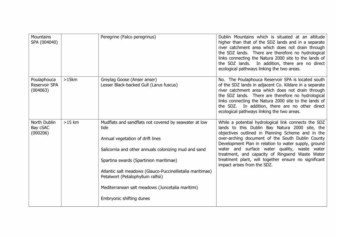
Mountains SPA (004040)
Peregrine (Falco peregrinus)
Dublin Mountains which is situated at an altitude higher than that of the SDZ lands and in a separate river catchment area which does not drain through the SDZ lands. There are therefore no hydrological links connecting the Natura 2000 site to the lands of the SDZ lands. In addition, there are no direct ecological pathways linking the two areas.
Poulaphouca Reservoir SPA (004063)
>15km Greylag Goose (Anser anser) Lesser Black-backed Gull (Larus fuscus)
No. The Poulaphouca Reservoir SPA is located south of the SDZ lands in adjacent Co. Kildare in a separate river catchment area which does not drain through the SDZ lands. There are therefore no hydrological links connecting the Natura 2000 site to the lands of the SDZ. In addition, there are no other direct ecological pathways linking the two areas.
North Dublin Bay cSAC (000206)
>15 km Mudflats and sandflats not covered by seawater at low tide
Annual vegetation of drift lines
Salicornia and other annuals colonizing mud and sand
Spartina swards (Spartinion maritimae)
Atlantic salt meadows (Glauco-Puccinellietalia maritimae) Petalwort (Petalophyllum ralfsii)
Mediterranean salt meadows (Juncetalia maritimi)
Embryonic shifting dunes
While a potential hydrological link connects the SDZ lands to this Dublin Bay Natura 2000 site, the objectives outlined in Planning Scheme and in the over-arching document of the South Dublin County Development Plan in relation to water supply, ground water and surface water quality, waste water treatment, and capacity of Ringsend Waste Water treatment plant, will together ensure no significant impact arises from the SDZ.

Shifting dunes along the shoreline with Ammophila arenaria (white dunes)
Fixed coastal dunes with herbaceous vegetation (grey dunes) Humid dune slacks
South Dublin Bay cSAC (000210)
> 15km Mudflats and sandflats not covered by seawater at low tide
While a potential hydrological link connects the SDZ lands to this Dublin Bay Natura 2000 site, the objectives outlined in the Planning Scheme and in the over-arching document of the South Dublin County Development Plan in relation to water supply, ground water and surface water quality, waste water treatment, and capacity of Ringsend Waste Water treatment plant, will together ensure no significant impact arises from the Planning Scheme.
South Dublin Bay and River Tolka Estuary cSPA (004024)
>15 km Light-bellied Brent Goose (Branta bernicla hrota) Oystercatcher (Haematopus ostralegus) Ringed Plover (Charadrius hiaticula) Golden Plover (Pluvialis apricaria) Knot (Calidris canutus) Sanderling (Calidris alba) Dunlin (Calidris alpina) Bar-tailed Godwit (Limosa lapponica) Redshank (Tringa totanus) Black-headed Gull (Larus ridibundus) Roseate Tern (Sterna dougallii ) Common Tern (Sterna hirundo ) Arctic Tern (Sterna paradisaea) Wetlands & Waterbirds
While a potential hydrological link connects the SDZ lands to this Dublin Bay Natura 2000 site, the objectives outlined in Planning Scheme and in the over-arching document of the South Dublin County Development Plan in relation to water supply, ground water and surface water quality, waste water treatment, and capacity of Ringsend Waste Water treatment plant, will together ensure no significant impact arises from the Planning Scheme

North Bull Island SPA (004006)
>15 km Light-bellied Brent Goose (Branta bernicla hrota) Shelduck (Tadorna tadorna) Teal (Anas crecca) Pintail (Anas acuta) Shoveler (Anas clypeata) Oystercatcher (Haematopus ostralegus) Golden Plover (Pluvialis apricaria) Grey Plover (Pluvialis squatarola) Knot (Calidris canutus) Sanderling (Calidris alba) Dunlin (Calidris alpina) Black-tailed Godwit (Limosa limosa) Bar-tailed Godwit (Limosa lapponica) Curlew (Numenius arquata) Redshank (Tringa totanus) Turnstone (Arenaria interpres) Black-headed Gull (Larus ridibundus) Wetlands & Waterbirds
While a potential hydrological link connects the SDZ lands to this Dublin Bay Natura 2000 site, the objectives outlined in the Planning Scheme and in the over-arching document of the South Dublin County Development Plan in relation to water supply, ground water and surface water quality, waste water treatment, and capacity of Ringsend Waste Water treatment plant, will together ensure no significant impact arises from the Planning Scheme
Red Bog cSAC, Co. Kildare (000397)
11 km Natural euthrophic lakes with Magnopotamion or Hydrocharition-type vegetation Active raised bogs Transition mires and quaking bogs
While a potential hydrological link connects the SDZ lands to this Dublin Bay Natura 2000 site, the objectives outlined in the Planning Scheme and in the over-arching document of the South Dublin County Development Plan in relation to water supply, ground water and surface water quality, waste water treatment, and capacity of Ringsend Waste Water treatment plant, will together ensure no significant impact arises from the Planning Scheme.
Rye Water Valley/Carton cSAC (001398)
10 km Vertigo angustior Vertigo moulinsiana Petrifying springs with tufa formation (Cratoneurion)
While a potential hydrological link connects the SDZ lands to this Dublin Bay Natura 2000 site, the objectives outlined in the Planning Scheme and in the over-arching document of the South Dublin County Development Plan in relation to water supply, ground

water and surface water quality, waste water treatment, and capacity of Ringsend Waste Water treatment plant, will together ensure no significant impact arises from the Planning Scheme.

Appendix 3: Screening of the Draft amendments to the Adamstown SDZ Planning Scheme 2003 Each of the draft amendments has a unique reference number. Changes to the text follow the sequence of the Planning Scheme. The relevant section/schedule/appendix headings and paragraph/policy and page numbers of the different types of changes are identified below. The amendments highlighted in BLUE below refer to Material Amendments with the remaining amendments considered non-material. (Full detail and descriptions of the draft amendments are contained in the accompanying report; this screening report should be read in conjunction with the main amendments document.)
Amendment No.
Section Page of Draft Amendments Report
Description Potential for Negative Impact on Natura 2000 Sites
1 1.3 Background and Process
11 Insert additional sections 1.3.9 and 1.3.10 advising of current process and relocation of text to facilitate additions
No impact on Natura 2000 Network
2 1.6 Planning Context 12 Amendments to Sections 1.6.1-1.6.6 to reflect relevant, updated and new national, regional and local guidance. Insert figure reflecting these changes. Regional Planning Guidelines 2010-2022, Retail Strategy for the Greater Dublin Area 2008-2016 Greater Dublin Area Draft Transport Strategy 2011-2030 South Dublin County Development Plan 2010-2016 Design Manual for Streets 2013 National Transport Strategy 2012-2030 (Ch 9 Walking and Cycling)
No impact on Natura 2000 Network
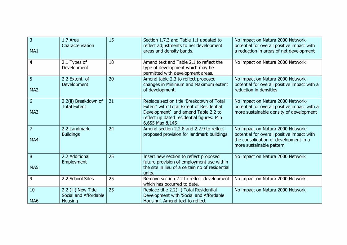
3 MA1
1.7 Area Characterisation
15 Section 1.7.3 and Table 1.1 updated to reflect adjustments to net development areas and density bands.
No impact on Natura 2000 Network- potential for overall positive impact with a reduction in areas of net development
4 2.1 Types of Development
18 Amend text and Table 2.1 to reflect the type of development which may be permitted with development areas.
No impact on Natura 2000 Network
5 MA2
2.2 Extent of Development
20 Amend table 2.3 to reflect proposed changes in Minimum and Maximum extent of development.
No impact on Natura 2000 Network- potential for overall positive impact with a reduction in densities
6 MA3
2.2(ii) Breakdown of Total Extent
21 Replace section title ‘Breakdown of Total Extent’ with ‘Total Extent of Residential Development’ and amend Table 2.2 to reflect up dated residential figures: Min 6,655 Max 8,145
No impact on Natura 2000 Network- potential for overall positive impact with a more sustainable density of development
7 MA4
2.2 Landmark Buildings
24 Amend section 2.2.8 and 2.2.9 to reflect proposed provision for landmark buildings.
No impact on Natura 2000 Network- potential for overall positive impact with the consolidation of development in a more sustainable pattern
8 MA5
2.2 Additional Employment
25 Insert new section to reflect proposed future provision of employment use within the site in lieu of a certain no of residential units.
No impact on Natura 2000 Network
9 2.2 School Sites 25 Remove section 2.2 to reflect development which has occurred to date.
No impact on Natura 2000 Network
10 MA6
2.2 (iii) New Title Social and Affordable Housing
25 Replace title 2.2(iii) Total Residential Development with ‘Social and Affordable Housing’. Amend text to reflect
No impact on Natura 2000 Network
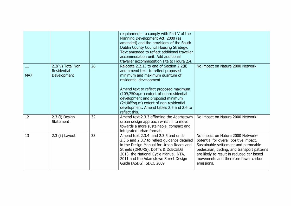
requirements to comply with Part V of the Planning Development Act, 2000 (as amended) and the provisions of the South Dublin County Council Housing Strategy. Text amended to reflect additional traveller accommodation unit. Add additional traveller accommodation site to Figure 2.4.
11 MA7
2.2(iv) Total Non Residential Development
26 Relocate 2.2.13 to end of Section 2.2(ii) and amend text to reflect proposed minimum and maximum quantum of residential development Amend text to reflect proposed maximum (109,750sq.m) extent of non-residential development and proposed minimum (24,065sq.m) extent of non-residential development. Amend tables 2.5 and 2.6 to reflect this.
No impact on Natura 2000 Network
12 2.3 (i) Design Statement
32 Amend text 2.3.3 affirming the Adamstown urban design approach which is to move towards a more sustainable, compact and integrated urban format.
No impact on Natura 2000 Network
13 2.3 (ii) Layout 33 Amend text 2.3.4 and 2.3.5 and omit 2.3.6 and 2.3.7 to reflect guidance detailed in the Design Manual for Urban Roads and Streets (DMURS), DoTTs & DoEC&LG 2013, the National Cycle Manual, NTA, 2011 and the Adamstown Street Design Guide (ASDG), SDCC 2009
No impact on Natura 2000 Network- potential for overall positive impact. Sustainable settlement and permeable pedestrian, cycling, and transport patterns are likely to result in reduced car based movements and therefore fewer carbon emissions.

14 MA8
2.3(v) Development Density
34 Amend Section 2.3.20 and table 2.7 to reflect proposed densities and plot ratios. Amend Section 2.3.21 to provide for infill development clarify density requirements (allowing for development to fall below or above density ranges) with provision made for addressing any shortfall within relevant landholding or development area.
No impact on Natura 2000 Network- potential for overall positive impact with a more sustainable density of development. Lower density housing can potentially assist biodiversity retention
15 2.3(iv) Residential Yield
37 Omit Section 2.3.23 (Reference to Adamstown LAP-not relevant)
No impact on Natura 2000 Network
16 MA9
2.3 (vii) Road/Street Width
38 Amend Section (vii) title to ‘Road and Street Network’ Amend text to reflect guidance detailed in the Design Manual for Urban Roads and Streets (DMURS), DoTTs & DoEC&LG 2013, the National Cycle Manual, NTA, 2011 and the Adamstown Street Design Guide (ASDG), SDCC 2009. Omit Table 2.8. Omit Figures 2.11 and 2.12. Amend Figure 2.10 Road/Street Type Updated to reflect the new layout and system of classification used within the ASDG/DMURS
No impact on Natura 2000 Network- potential for overall positive impact. Sustainable settlement and permeable pedestrian, cycling, and transport patterns are likely to result in reduced car based movements and therefore fewer carbon emissions.
17 2.3(x) Building Language and Finishes
40 Amend section 2.3.46 to reflect DMURS No impact on Natura 2000 Network- potential for overall positive impact. Sustainable settlement and permeable pedestrian, cycling, and transport patterns are likely to result in reduced car based movements and therefore fewer carbon emissions.
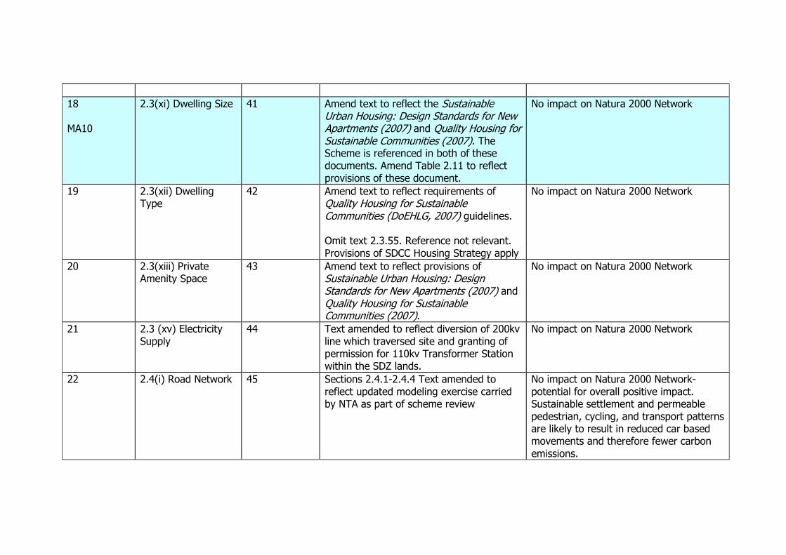
18 MA10
2.3(xi) Dwelling Size 41 Amend text to reflect the Sustainable Urban Housing: Design Standards for New Apartments (2007) and Quality Housing for Sustainable Communities (2007). The Scheme is referenced in both of these documents. Amend Table 2.11 to reflect provisions of these document.
No impact on Natura 2000 Network
19 2.3(xii) Dwelling Type
42 Amend text to reflect requirements of Quality Housing for Sustainable Communities (DoEHLG, 2007) guidelines. Omit text 2.3.55. Reference not relevant. Provisions of SDCC Housing Strategy apply
No impact on Natura 2000 Network
20 2.3(xiii) Private Amenity Space
43 Amend text to reflect provisions of Sustainable Urban Housing: Design Standards for New Apartments (2007) and Quality Housing for Sustainable Communities (2007).
No impact on Natura 2000 Network
21 2.3 (xv) Electricity Supply
44 Text amended to reflect diversion of 200kv line which traversed site and granting of permission for 110kv Transformer Station within the SDZ lands.
No impact on Natura 2000 Network
22 2.4(i) Road Network 45 Sections 2.4.1-2.4.4 Text amended to reflect updated modeling exercise carried by NTA as part of scheme review
No impact on Natura 2000 Network- potential for overall positive impact. Sustainable settlement and permeable pedestrian, cycling, and transport patterns are likely to result in reduced car based movements and therefore fewer carbon emissions.
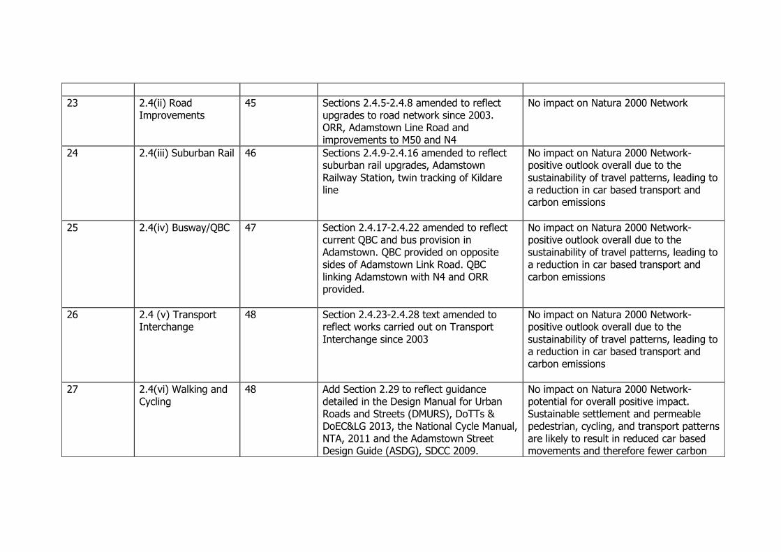
23 2.4(ii) Road Improvements
45 Sections 2.4.5-2.4.8 amended to reflect upgrades to road network since 2003. ORR, Adamstown Line Road and improvements to M50 and N4
No impact on Natura 2000 Network
24 2.4(iii) Suburban Rail 46 Sections 2.4.9-2.4.16 amended to reflect suburban rail upgrades, Adamstown Railway Station, twin tracking of Kildare line
No impact on Natura 2000 Network- positive outlook overall due to the sustainability of travel patterns, leading to a reduction in car based transport and carbon emissions
25 2.4(iv) Busway/QBC 47 Section 2.4.17-2.4.22 amended to reflect current QBC and bus provision in Adamstown. QBC provided on opposite sides of Adamstown Link Road. QBC linking Adamstown with N4 and ORR provided.
No impact on Natura 2000 Network- positive outlook overall due to the sustainability of travel patterns, leading to a reduction in car based transport and carbon emissions
26 2.4 (v) Transport Interchange
48 Section 2.4.23-2.4.28 text amended to reflect works carried out on Transport Interchange since 2003
No impact on Natura 2000 Network- positive outlook overall due to the sustainability of travel patterns, leading to a reduction in car based transport and carbon emissions
27 2.4(vi) Walking and Cycling
48 Add Section 2.29 to reflect guidance detailed in the Design Manual for Urban Roads and Streets (DMURS), DoTTs & DoEC&LG 2013, the National Cycle Manual, NTA, 2011 and the Adamstown Street Design Guide (ASDG), SDCC 2009.
No impact on Natura 2000 Network- potential for overall positive impact. Sustainable settlement and permeable pedestrian, cycling, and transport patterns are likely to result in reduced car based movements and therefore fewer carbon
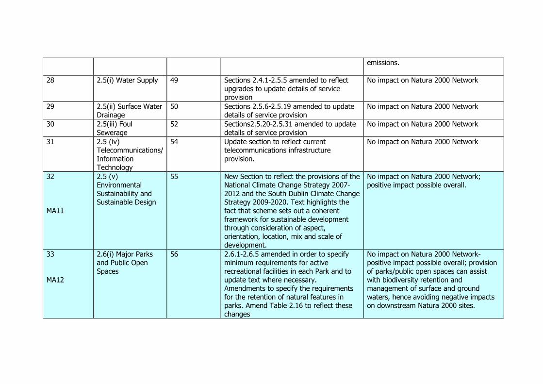
emissions.
28 2.5(i) Water Supply 49 Sections 2.4.1-2.5.5 amended to reflect upgrades to update details of service provision
No impact on Natura 2000 Network
29 2.5(ii) Surface Water Drainage
50 Sections 2.5.6-2.5.19 amended to update details of service provision
No impact on Natura 2000 Network
30 2.5(iii) Foul Sewerage
52 Sections2.5.20-2.5.31 amended to update details of service provision
No impact on Natura 2000 Network
31 2.5 (iv) Telecommunications/ Information Technology
54 Update section to reflect current telecommunications infrastructure provision.
No impact on Natura 2000 Network
32 MA11
2.5 (v) Environmental Sustainability and Sustainable Design
55 New Section to reflect the provisions of the National Climate Change Strategy 2007-2012 and the South Dublin Climate Change Strategy 2009-2020. Text highlights the fact that scheme sets out a coherent framework for sustainable development through consideration of aspect, orientation, location, mix and scale of development.
No impact on Natura 2000 Network; positive impact possible overall.
33 MA12
2.6(i) Major Parks and Public Open Spaces
56 2.6.1-2.6.5 amended in order to specify minimum requirements for active recreational facilities in each Park and to update text where necessary. Amendments to specify the requirements for the retention of natural features in parks. Amend Table 2.16 to reflect these changes
No impact on Natura 2000 Network- positive impact possible overall; provision of parks/public open spaces can assist with biodiversity retention and management of surface and ground waters, hence avoiding negative impacts on downstream Natura 2000 sites.

34 MA13
2.6 (ii) Green Infrastructure
60 Section added to formalise the requirement to protect, enhance and link key assets of public space network
No impact on Natura 2000 Network; positive outlook possible overall. The provision of parks and associated SUDS measures as part of an overall Green Infrastructure strategy can assist with biodiversity retention and management of surface and ground waters, hence avoiding negative impacts on downstream Natura 2000 sites.
35 2.6 (iii) Education /Schools
61 Sections 2.6.10-2.6.12 amended to provide update on school provision in Adamstown. Schools campus is now developed and incorporates 2 no 16-classroom primary schools and secondary school with capacity for up to 1,000 pupils. Updated scheme reflects this provision. Also reflects proposals to relocate primary school adjacent to Tandy’s Lane Village.
No impact on Natura 2000 Network
36 MA14
2.6 (iv) Childcare Facilities
61 Section 2.6.13-2.6.16 amended to reflect current thinking on childcare provision. Childcare provision to be linked to development of District and Local Centres and to reflect demand for childcare needs to be met in existing private residential properties or other flexible use buildings.
No impact on Natura 2000 Network
37 MA15
2.6 (vi) Children’s Play Facilities
63 New Section’s 2.6.15-2.6.17 and new Table 2.6.18 to reflect SDCC’s desire to provide a range of secure outdoor play facilities within appropriate distances of homes to encourage varied physical and
No impact on Natura 2000 Network- positive impacts overall Provision of children’s play facilities within close proximity to the community will reduce the need to travel outside of the
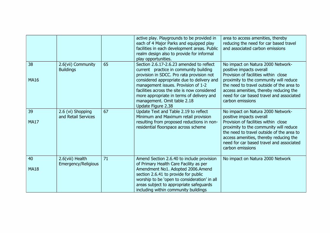
active play. Playgrounds to be provided in each of 4 Major Parks and equipped play facilities in each development areas. Public realm design also to provide for informal play opportunities.
area to access amenities, thereby reducing the need for car based travel and associated carbon emissions
38 MA16
2.6(vii) Community Buildings
65 Section 2.6.17-2.6.23 amended to reflect current practice in community building provision in SDCC. Pro rata provision not considered appropriate due to delivery and management issues. Provision of 1-2 facilities across the site is now considered more appropriate in terms of delivery and management. Omit table 2.18 Update Figure 2.38
No impact on Natura 2000 Network- positive impacts overall Provision of facilities within close proximity to the community will reduce the need to travel outside of the area to access amenities, thereby reducing the need for car based travel and associated carbon emissions
39 MA17
2.6 (vi) Shopping and Retail Services
67 Update Text and Table 2.19 to reflect Minimum and Maximum retail provision resulting from proposed reductions in non-residential floorspace across scheme
No impact on Natura 2000 Network- positive impacts overall Provision of facilities within close proximity to the community will reduce the need to travel outside of the area to access amenities, thereby reducing the need for car based travel and associated carbon emissions
40 MA18
2.6(viii) Health Emergency/Religious
71 Amend Section 2.6.40 to include provision of Primary Health Care Facility as per Amendment No1. Adopted 2006.Amend section 2.6.41 to provide for public worship to be ‘open to consideration’ in all areas subject to appropriate safeguards including within community buildings
No impact on Natura 2000 Network
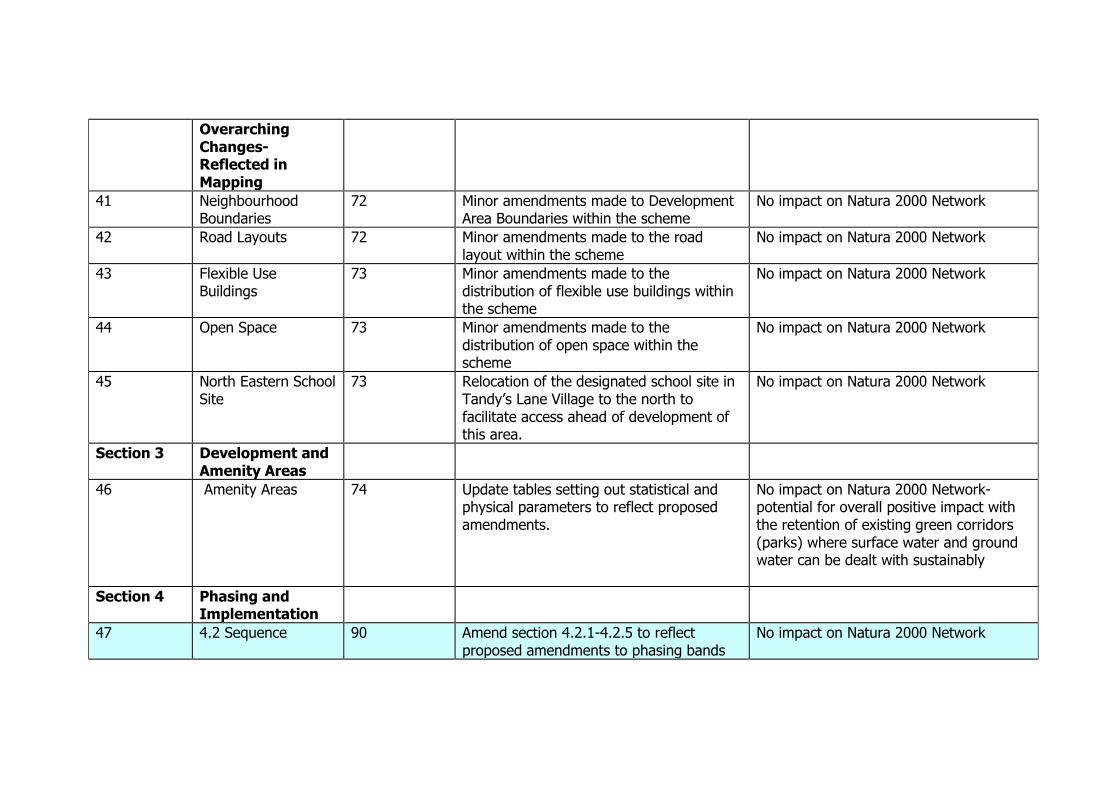
Overarching Changes- Reflected in Mapping
41 Neighbourhood Boundaries
72 Minor amendments made to Development Area Boundaries within the scheme
No impact on Natura 2000 Network
42 Road Layouts 72 Minor amendments made to the road layout within the scheme
No impact on Natura 2000 Network
43 Flexible Use Buildings
73 Minor amendments made to the distribution of flexible use buildings within the scheme
No impact on Natura 2000 Network
44 Open Space 73 Minor amendments made to the distribution of open space within the scheme
No impact on Natura 2000 Network
45 North Eastern School Site
73 Relocation of the designated school site in Tandy’s Lane Village to the north to facilitate access ahead of development of this area.
No impact on Natura 2000 Network
Section 3 Development and Amenity Areas
46 Amenity Areas 74 Update tables setting out statistical and physical parameters to reflect proposed amendments.
No impact on Natura 2000 Network- potential for overall positive impact with the retention of existing green corridors (parks) where surface water and ground water can be dealt with sustainably
Section 4 Phasing and Implementation
47
4.2 Sequence 90 Amend section 4.2.1-4.2.5 to reflect proposed amendments to phasing bands
No impact on Natura 2000 Network

MA 19 and overall min-max development potential. Amend phasing tables to reflect proposed amended phasing bands and to reflect current infrastructural developments to date and changing infrastructural requirements in the scheme.
48 4.3 Operation 101 Amend section 4.3.1-4.3.3 to reflect proposed phasing bands and operation of the scheme to date.
No impact on Natura 2000 Network
49 MA 20
4.4 Timing 103 Amend section 4.4.1-4.4.5 to reflect operation and development of the scheme to date and the proposed amendments to phasing bands.
No impact on Natura 2000 Network

Appendix 4 South Dublin County Development Plan 2010-2016 objectives and policies relevant to water protection. Policy LHA 21 River and Stream Management It is the policy of the Council to implement a strategy (prepared on a regional basis) for the management of rivers and streams throughout the County. Policy LHA 22 Watercourses It is the policy of the Council to protect, maintain, improve and enhance the natural and organic character of the watercourses in the County and to promote access, walkways and other recreational uses of their associated public open space, subject to a defined strategy of nature conservation and flood protection. 2.3.4 Strategy: The strategy of the Council for the development of Water Supply and Drainage in the County is as follows: • Continue the sustainable development and improvement of the water supply and foul drainage systems throughout the County to meet the anticipated water and drainage requirements of the area. • Protect surface water catchments and manage catchment areas where appropriate to protect the surface water drainage infrastructure of the County. • Implement the provisions of national policy and legislation in the control of water pollution. • Ensure that existing and proposed developments are not subject to undue risk of flooding. • Conserve treated water by active leakage detection, non-domestic metering and development of infrastructure. • Actively pursue and resolve water leakage.
Policy WD 1 Water Supply and Drainage It is the policy of the Council to co-operate with adjoining authorities to continue the sustainable development and improvement of the water supply and drainage systems throughout the County to meet the anticipated water and drainage requirements of the area, in accordance with the recommendations set out in the ‘Greater Dublin Strategic Water Supply Study’ and the ‘Greater Dublin Strategic Drainage Study’, and the proposed ‘Dublin Region Water Services Strategic Plan’ when adopted. Policy WD 2 Wastewater Treatment Plants and Wastewater Collection Systems It is the policy of the Council that development shall be preceded by sufficient capacity in the public wastewater treatment plants and appropriate extensions in the existing public wastewater collection systems. Policy WD 3 Quality of Surface Water and Groundwater It is the policy of the Council that the ongoing development of the County shall be undertaken in such a way as not to compromise the quality of surface water (and associated habitats and species) and groundwater. Policy WD 4 Soil and Groundwater Contamination It is the policy of the Council to require adequate and appropriate investigations to be carried out into the nature and extent of any soil and groundwater contamination and the risks associated with site development work, where brownfield development is proposed.
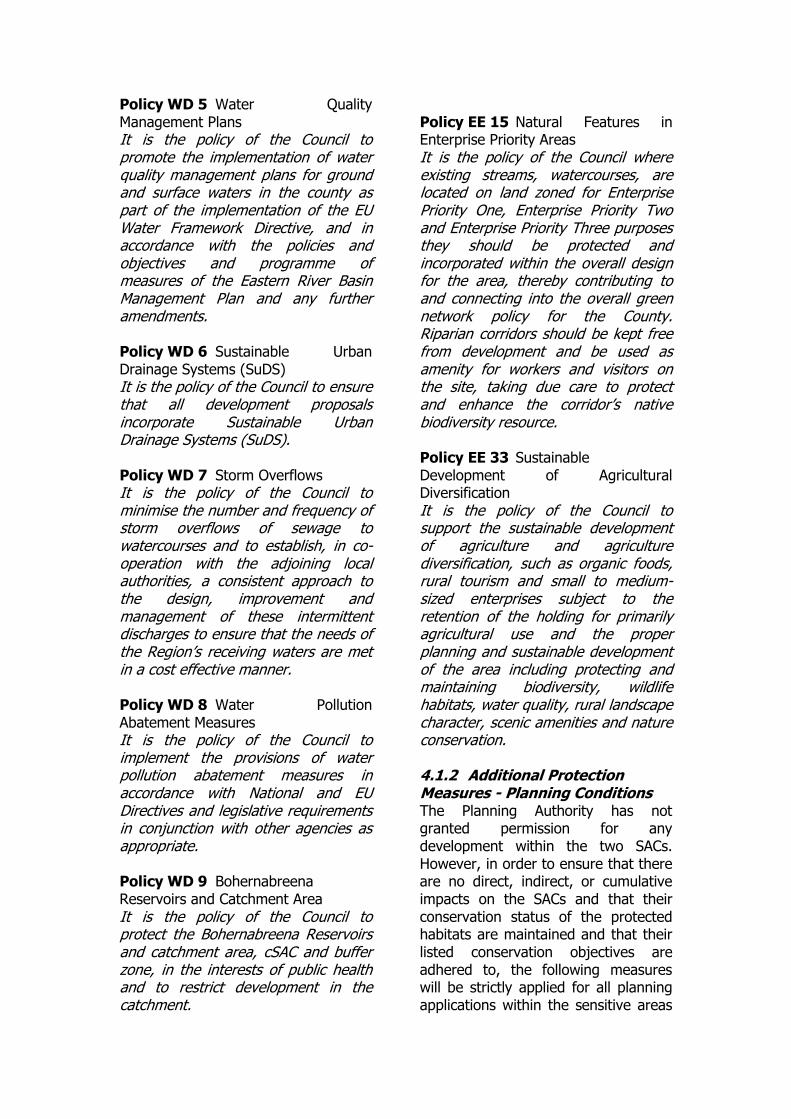
Policy WD 5 Water Quality Management Plans It is the policy of the Council to promote the implementation of water quality management plans for ground and surface waters in the county as part of the implementation of the EU Water Framework Directive, and in accordance with the policies and objectives and programme of measures of the Eastern River Basin Management Plan and any further amendments. Policy WD 6 Sustainable Urban Drainage Systems (SuDS) It is the policy of the Council to ensure that all development proposals incorporate Sustainable Urban Drainage Systems (SuDS). Policy WD 7 Storm Overflows It is the policy of the Council to minimise the number and frequency of storm overflows of sewage to watercourses and to establish, in co-operation with the adjoining local authorities, a consistent approach to the design, improvement and management of these intermittent discharges to ensure that the needs of the Region’s receiving waters are met in a cost effective manner. Policy WD 8 Water Pollution Abatement Measures It is the policy of the Council to implement the provisions of water pollution abatement measures in accordance with National and EU Directives and legislative requirements in conjunction with other agencies as appropriate. Policy WD 9 Bohernabreena Reservoirs and Catchment Area It is the policy of the Council to protect the Bohernabreena Reservoirs and catchment area, cSAC and buffer zone, in the interests of public health and to restrict development in the catchment.
Policy EE 15 Natural Features in Enterprise Priority Areas It is the policy of the Council where existing streams, watercourses, are located on land zoned for Enterprise Priority One, Enterprise Priority Two and Enterprise Priority Three purposes they should be protected and incorporated within the overall design for the area, thereby contributing to and connecting into the overall green network policy for the County. Riparian corridors should be kept free from development and be used as amenity for workers and visitors on the site, taking due care to protect and enhance the corridor’s native biodiversity resource. Policy EE 33 Sustainable Development of Agricultural Diversification It is the policy of the Council to support the sustainable development of agriculture and agriculture diversification, such as organic foods, rural tourism and small to medium-sized enterprises subject to the retention of the holding for primarily agricultural use and the proper planning and sustainable development of the area including protecting and maintaining biodiversity, wildlife habitats, water quality, rural landscape character, scenic amenities and nature conservation. 4.1.2 Additional Protection Measures - Planning Conditions The Planning Authority has not granted permission for any development within the two SACs. However, in order to ensure that there are no direct, indirect, or cumulative impacts on the SACs and that their conservation status of the protected habitats are maintained and that their listed conservation objectives are adhered to, the following measures will be strictly applied for all planning applications within the sensitive areas

above and adjacent to the County’s two SACs in the Dublin Mountains.
o All planning applications received by the Planning Authority for these areas will be subject to rigorous Appropriate Assessment screening and full AA investigation where required. Where impacts are seen to be likely, or where reasonable doubt exists to potential for impact, no application will be allowed to proceed.
o Appropriate Assessments will
be based upon contemporary scientific data regarding hydrology and ecology wherever appropriate.
o For any permitted
development, strict conditions will apply regarding the type, installation, monitoring, and servicing of all newly-granted waste water treatment systems in the catchment area of the two SACs.

Appendix 5 Detailed Draft Amendments to the Adamstown Planning Scheme 2003 Guide to Reading Amendments The draft amendments are identified as a series of changes and are set out under the relevant sections of the 2003 Planning Scheme. Where appropriate, extracts of text are included in order to show the draft amendments in context. Each of the draft amendments has a unique reference number.
Changes to the text follow the sequence of the Planning Scheme. The relevant section/schedule/appendix headings and paragraph/policy and page numbers of the different types of changes are identified as follows:
Draft amendments involving additional text are shown in green. Draft amendments involving deletion of text are shown in red
strikethrough.
Draft amendments involving relocation of text are shown in blue.
MATERIAL AMENDMENT NO 11 AMENDMENT REF. NO.32
Section Ref. 2003 Scheme Page Ref.
2.5 (v) New Section Environmental Sustainability and
Sustainable Design
2.5 (v) Environmental Sustainability and Sustainable Design 2.5.1 The Planning Scheme supports environmental sustainability through ensuring
a coherent framework for sustainable development at Adamstown, ensuring that sustainable design is integral to the development of the area and aligning new development with public transport. This will assist greatly towards meeting the aims contained in the National Climate Change Strategy and the Councils Climate Change Strategy. Environmental sustainability is promoted in Adamstown through four approaches:
A mix of use types in the area, to support the development of sustainable residential communities.
Buildings to be designed and constructed to energy standards prescribed by the Building Regulations Part L – Dwellings as a minimum. 2011 requirements prescribe that a building shall be designed and constructed so as to ensure that the energy performance of the building is such as to limit the amount of energy required for the operation of the dwelling and the amount of carbon dioxide (CO2) emissions associated with this energy use. The regulations also prescribe that a reasonable proportion of the energy consumption to meet the energy performance of a dwelling should be provided by renewable energy sources.
Encouraging high levels of use of sustainable modes of transport by promoting walking, cycling and public transport.
Promoting and supporting improvements in the public realm which reduce energy consumption, support Sustainable Urban Drainage Systems (SUDS),

increase carbon sequestering and support CHP (combined heat and power) schemes.
2.5.2 Through the implementation of a coherent framework for sustainable
development, new development should have an inherently low carbon footprint. The proximity of local, well established amenities should lessen travel needs and the proximity of public transport shall reduce the need for car based trips from the site. New developments within the SDZ area should, where possible, seek to maximise energy efficiency through their location and design. In combination with the materials chosen and physical attributes of building design, sustainability should also inform key urban design elements such as creating attractive micro climates in key public or private public spaces, maximising passive solar gain, reducing overshadowing and addressing wind tunnel impacts. A key part of sustainable building and reduced carbon footprint is the energy consumption of heat, light and power of a building. Opportunities to source energy from sustainable sources should be exploited where possible.
2.5.3 All development proposals shall be accompanied by a sustainability statement
to illustrate measures proposed to increase energy efficiency, reduce resource consumption and minimise waste generation.
MATERIAL AMENDMENT NO 12 AMENDMENT REF. NO.33
Section Ref. 2003 Scheme Page Ref.
2.6 (i) Major Parks and Public Open Spaces
28-33
2.6 (i) Major Parks and Public Open Spaces 2.6.1 In accordance with the South Dublin County Development Plan 1998,2010-
2016 minimum required public open space within the Adamstown SDZ Planning Scheme Area is calculated as follows:-
County Development Plan
1998 Zoning Objective
Total Area subject to
each Zoning Objective within the Planning Scheme
Area (hectares)
County Development
Plan 1998 Open Space
Requirement
% Hectares
A1 ‘to provide new residential communities’ (excludes Tandy’s Lane)
211.54 14% 29.62
A ‘to preserve residential amenity’
0.12
10% 0.01
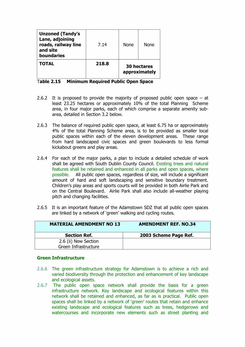
Unzoned (Tandy’s Lane, adjoining roads, railway line and site boundaries
7.14 None None
TOTAL 218.8 30 hectares
approximately
Table 2.15 Minimum Required Public Open Space
2.6.2 It is proposed to provide the majority of proposed public open space – at
least 23.25 hectares or approximately 10% of the total Planning Scheme area, in four major parks, each of which comprise a separate amenity sub-area, detailed in Section 3.2 below.
2.6.3 The balance of required public open space, at least 6.75 ha or approximately
4% of the total Planning Scheme area, is to be provided as smaller local public spaces within each of the eleven development areas. These range from hard landscaped civic spaces and green boulevards to less formal kickabout greens and play areas.
2.6.4 For each of the major parks, a plan to include a detailed schedule of work
shall be agreed with South Dublin County Council. Existing trees and natural features shall be retained and enhanced in all parks and open spaces, where possible. All public open spaces, regardless of size, will include a significant amount of hard and soft landscaping and sensitive boundary treatment. Children’s play areas and sports courts will be provided in both Airlie Park and on the Central Boulevard. Airlie Park shall also include all-weather playing pitch and changing facilities.
2.6.5 It is an important feature of the Adamstown SDZ that all public open spaces
are linked by a network of ‘green’ walking and cycling routes.
MATERIAL AMENDMENT NO 13 AMENDMENT REF. NO.34
Section Ref. 2003 Scheme Page Ref.
2.6 (ii) New Section Green Infrastructure
Green Infrastructure 2.6.6 The green infrastructure strategy for Adamstown is to achieve a rich and
varied biodiversity through the protection and enhancement of key landscape and ecological assets.
2.6.7 The public open space network shall provide the basis for a green infrastructure network. Key landscape and ecological features within this network shall be retained and enhanced, as far as is practical. Public open spaces shall be linked by a network of ‘green’ routes that retain and enhance existing landscape and ecological features such as trees, hedgerows and watercourses and incorporate new elements such as street planting and

sustainable urban drainage systems. Opportunities to extend this green infrastructure network into individual schemes should also be explored where possible through use of sustainable design techniques at the local level that have beneficial environmental impacts.