south east forest np mount imlay np
TRANSCRIPT

N
R
e
ste
d
FORESTRY CORPORATION OF NSW, HARDWOOD FORESTS DIVISION HARVEST PLAN LOCALITY MAP
Timbillica State Forest NO. 768 Plan Name: HP_ED_220_221_222_17 VERSION: 1
1:100,000 Cpt No's: 220, 221 & 222 Plan No: 56804 Contour Interval 10m Eden Management Area
Mapsheet: Mt Imlay (8823-4S); Kiah (8823-1S); Narrabarba (8823-2N) AGD_1966_AMG_Zone_56 Date Printed: 4/05/201
South East Forest NP
TOWAMBA RIVER
Kiah !
Mount Imlay NP
B
Emergency Meeting Point 11 and Helicopter Landing Area.
Intersection of Princes Hwy and Imlay Rd.
ÁÁ
Á G
WALLAGARAUGH RIVER
G EMP & Helicopter Landing Area Native Forests General Management (Zone 4) ! Towns Planning Unit Non Forestry Use (Zone 7)
Sealed Special Protection (Zone 1) National Park Estate Major Forest Road Special Management (Zone 2) Vacant Crown Land Main Rivers Harvesting Exclusion (Zone 3A) Á Evacuation Route
WaterBodies Special Prescription (Zone 3B) Á Haluage Route Kilometres
0 0.5 1 1.5 2 2.5 3 3.5 4 4.5 5 5.5 6 6.5 7

FORESTRY CORPORATION OF NSW, HARDWOOD FORESTS DIVISION HARVEST PLAN OPERATIONAL MAP
C1
S1
H B
!
J B
XX !
!
^
úú

X
FORESTRY CORPORATION OF NSW, HARDWOOD FORESTS DIVISION HARVEST PLAN FOREST TYPE MAP
!
!̂
!!̂̂^
^
! !
!̂
!̂
^̂̂
X̂X
!
! ! ^̂!
XX #
!
! !
!
!
XX!
XX
!
!
!
ª!?Forest Type Area (ha)
! !
26 4 102 51
! !
!
! 111 !
112 114
##00
^̂ 121 123 130 131 133
#0 ^ 150
!?ª # ! 157
XX ^̂ ! 158
X !̂ ! 159
^ !̂ 169
9 15
162 98 10 28
9 0 3
174 4 1
49

FORESTRY CORPORATION OF NSW, HARDWOOD FORESTS DIVISION HARVEST PLAN HABITAT CLASS MAP
!
! !
!
! !
!
!
!
!
! !
!
!
!
!
! !
! !!
! !
!
!
!

Hardwood Forests Division
Harvest and Haul Plan
State Forest Timbillica IFOA Region Eden
Management Area Eden Compartments 220 221 222
Harvest Plan No. 56804 Coupes Part 2, Part 4
Part 1, Part 2
Part 1, Part 2, Part 3, Part 4
Legal Conditions Native Forest Harvesting in accordance with IFOA conditions.
Harvesting and Roading activities must have EPL coverage.
To implement this plan you must hold a current Contractors Licence.
Standard Harvest Plan Conditions and Operating Procedures apply.
Survey expiry date for this plan is 04/05/2027.
Certification Timber products removed from the plan area are within the Defined Forest Area covered by Australian Forestry Standard AS4708:2013 Certificate 604224
Prepared by Planner
Jarod Addinsall
Date:
04/05/2017 Jarod Addinsall
Approved by Operation Planning Mgr
Lee Blessington
Date:
04/05/2017 Lee Blessington
Abbreviations PA = Production Assistant, PS = Production Supervisor, RC = Roading Coordinator, Crew = Harvest Contractor/Forest Operators, IFOA = Integrated Forestry Operations Approval, TSL = Threatened Species Licence, EPL = Environment Protection Licence, FL = Fisheries Licence, CH = Cultural Heritage, SOP = Standard Operating Procedure, HPOM = Harvest Plan Operational Map.
1. Harvest Area Details Cpt 220 Cpt 221 Cpt 222 Total
Event ID 126213 126215 126214 Gross Area (ha) 244 96 178 518 Harvest Area 37 5 17 59 Estimated Yield 2,000 400 1,500 3,900 Yield/ha 60 70 80 Slope (% 0-20 degrees) 81 84 49 Slope (% 20-25 degrees) 14 8 30 Slope (% 25-30 degrees) 5 8 21
Document title: HP_ED_220_221_222_17 Version No.: 1 Page 1 of 13 Harvest Plan no.: 56804 Approval Date: 04/05/2017 Expiry Date: 04/05/2027
Warning: a printed copy of this document may be uncontrolled. Please verify this is the latest version prior to use.

Contractor must ensure timber removed is allocated to the correct compartment when entered onto Delivery Docket.
1. Management Conditions on Boundaries Boundary Conditions
FMZ FMZ 1-Special Protection, FMZ 3A Harvesting Excluded, FMZ 3B-Special Prescriptions (visual) and FMZ 4- General Management occur within the compartment and are shown on the HPOM.
FMZ 1, 3A – Harvesting and harvesting machinery are not permitted in these areas. PA must mark boundaries as shown on the HPOM when adjacent or near to the boundary of the NHA.
FMZ 3B (Visual) – A visual protection zone exists along the skyline. The PA is not required to mark this boundary but must supervise implementation of modified harvesting prescriptions, see table 6.
Research Any inventory plots located during the harvesting operation which are not shown on the HPOM are to be treated the same as the surrounding area.
Cultural Heritage Surveys have been conducted. No heritage item is within 200m of the harvest area. Consequently the site is not marked, and the PA is not required to check the site.
If any potential heritage sites are identified notify the planner immediately.
2. Expected Yields
Product Estimates Volume
Sawlog 400m3
Pulp 3,500t
Total 3,900t
Species Species Mix (Sawlog)
STA 75%
SBK 20%
MM 5%
3. Haulage Haul Route North out Timbillica Road, turning right onto Imlay Road and then turning left
onto the Princes Highway.
Document title: HP_ED_220_221_222_17 Version No.: 1 Page 2 of 13 Harvest Plan no.: 56804 Approval Date: 04/05/2017 Expiry Date: 04/05/2027
Warning: a printed copy of this document may be uncontrolled. Please verify this is the latest version prior to use.

4. Community Issue Detail Conditions
Notifications Required Nil All relevant notifications have been conducted. A notification list for FCNSW staff is available from the planner.
Pests/Weeds Myrtle Rust Is known to occur in Bega Valley/Cooma-Monaro Shires. To prevent further spread the crew/haulage operators must ensure all harvesting machinery, equipment and vehicles heading west from BegaValley/Cooma-Monaro Shire or south into Victoria are checked and all infected vegetation removed.
5. Infrastructure Infrastructure Conditions
Nil Nil
6. Harvesting Conditions
Silviculture Type Harvesting Objectives and Condition for each stand condition
FMZ 4 & 3B, The harvest area is predominately mature to over mature Silvertop Ash, Blue Modified Shelter- Leaved Stringbark, Bloodwood and Monkey Gum in mixed aged stands. The wood (MSW) objective is to harvest all commercially available trees to create canopy
openings and ensure mechanical disturbance creates a suitable seed bed for regeneration of the stands.
77% NHA Crew to target sawlogs, pulpwood and other miscellaneous products as markets allow.
PA to instruct crew to retain patches (>0.5ha) of quality advanced regeneration where they occur.
Crew to remove all merchantable stems not marked for retention.
The crew is responsible for protecting retained seed trees and retaining patches of advanced regeneration.
FMZ 3B – Special Prescriptions (Visual)
100% Integrated (modified shelter-wood) with 50% canopy retention. Target sawlogs for removal. Larger diameter trees (i.e. Habitat trees) or the most visually pleasant trees that are within the largest 30% diameter class of the stand should be retained.
13% NHA (as Tree selection should be evenly spread over the FMZ 3B area. mapped)
IFOA Limits MSW IFOA Limits Thinning Cpt 220 Cpt 221 Cpt 222
Net Harvestable Area 182 101 180 Thinning Area NA Harvest Area 37 5 17 Pre-Thin BA/SPH NA
Post-Thin BA/SPH NA Planned Removal 20% 5% 9% Planned Removal/SPH NA
Document title: HP_ED_220_221_222_17 Version No.: 1 Page 3 of 13 Harvest Plan no.: 56804 Approval Date: 04/05/2017 Expiry Date: 04/05/2027
Warning: a printed copy of this document may be uncontrolled. Please verify this is the latest version prior to use.

7. Tree Retention - refer to TSL booklet for full conditions
Prescription Condition/Responsibility
Mark-Up – the PA is responsible for marking up the forest ahead of harvesting operations consistent Forest Mark Up and Tree Retention SOP
Compartment Mark-Up Survey Compartment mark-up surveys must be conducted at least 100m in advance of operations. The survey must search for threatened (5.1, 5.2) and protected species features listed in conditions 5.1 and 5.2 of the TSL.
Hollow-bearing and Non-Regrowth Zone - 5.6, conditions apply. Recruitment tree retention (H Additional H trees for Greater Glider condition does not apply. and R)
PA must verify the habitat quality and record on the habitat quality map. PA must select and mark H and R trees as per the habitat quality.
Habitat Quality H Trees/2ha R Trees/2ha High 12 12 Moderate 8 8 Low 4 4
Significant Food Resources PA must mark for retention - stands of forest oak and forest oak feed trees. (5.6 k)
Bloodwood and Ironbark are suitable E tree species present in these compartments.
Harvesting - crew and PA responsibilities
Protection of Retained Trees Trees marked or selected for retention must not be felled. (5.6g) The crew must minimise damage to H, R and E trees by using
directional felling.
Harvesting debris should not accumulate within 5 m of retained trees. Where debris does accumulate the crew must remove or flatten to < 1m high.
The PA must be notified of any badly damaged retained trees and they must assess and record if a replacement retained tree is required.
Stag Retention (Dead standing The crew should retain stags where safe to do so. trees 5.6e) The crew must record the date, DBH, risk and location of unsafe
stags removed
Significant food resources The crew should avoid damaging flowering or fruiting banksias or
Species Coordinate Comments
GBC Feed Tree 739679E/5874048N old record not marked.
GBC Feed Tree 739679E/5874048N old record not marked.
GBC Feed Tree 739679E/5874048N old record not marked.
grass trees.
Document title: HP_ED_220_221_222_17 Version No.: 1 Page 4 of 13 Harvest Plan no.: 56804 Approval Date: 04/05/2017 Expiry Date: 04/05/2027
Warning: a printed copy of this document may be uncontrolled. Please verify this is the latest version prior to use.

8. Site-Specific Flora and Fauna
Condition Boundary Type
Prescription
Riparian Habitat Protection (5.7)
(Lidar Corrected)
Pink Tape Implement filter strip/stream exclusion zone around drainage features as shown on the HPOM. Refer to SOP1.
PA must mark the location of all mapped and UMDL.
The crew will locate and protect all 2nd order and above streams with GPS.
Ground Habitat (5.17 d)
N/A Nil.
Threatened Ecological Community (TEC)
Pink Tape Riverflat Eucalypt Forest on coastal flood plain is mapped in compartments 220 and 221.
The TEC is not within 50m of the harvest area, consequently the PA is not required to mark the TEC exclusion.
The crew must protect all areas of marked TEC.
Rainforest (5.4) Pink Tape Rainforest (RF) is mapped in the compartment. Following verification of forest structure and species composition the extent of mapped RF has been changed on the HPOM.
The PA must mark as an exclusion the Rainforest exclusion zone as shown on the HPOM when within or adjacent to the NHA.
The PA must search for and mark all areas of unmapped rainforest.
The crew must protect all areas of marked Rainforest.
Rare Forest Ecosystems (5.5)
Pink Tape Rare Forest Ecosystems are mapped within the Wallagaraugh Flora Reserve.
The Rare Forest Ecosystem is not within 50m of the harvest area, consequently the PA is not required to mark the Rare Forest Ecosystem exclusion.
The crew must protect all areas of marked Rare Forest Ecosystem
Ridge & Headwater Habitat (RHH) (5.8)
Pink Tape RHH is mapped in the compartments.
The RHH is not within 50m of the harvest area, consequently the PA is not required to mark the RHH exclusion.
The crew must protect all areas of marked RHH.
Heath and Scrub (5.10)
Pink Tape Heath and scrub is mapped within the Wallagaraugh Flora Reserve.
The Heath and Scrub is not within 50m of the harvest area, consequently the PA is not required to mark the Heath and Scrub exclusion.
Document title: HP_ED_220_221_222_17 Version No.: 1 Page 5 of 13 Harvest Plan no.: 56804 Approval Date: 04/05/2017 Expiry Date: 04/05/2027
Warning: a printed copy of this document may be uncontrolled. Please verify this is the latest version prior to use.

The crew must protect all areas of marked Heath and Scrub.
Rocky Outcrops and Cliffs (5.11)
Pink Tape Rocky Outcrops are not mapped in the compartments, however there is rocky terrain to be verified by the PA.
The PA must mark as an exclusion any rocky outcrop + relevant exclusion zone as it occurs on the ground.
The crew must protect all areas of marked rocky outcrop.
Feed trees for Glossy black cockatoo, Yellow Bellied Glider, Squirrel Glider
Pink Tape and paint
The Glossy black cockatoo feed trees are approx. 500m from the edge of the NHA. The PA does not need to mark the mapped feed trees prior to harvesting.
If any other feed trees are identified, they must be marked and protected.
Crew must protect all marked feed trees.
Fish N/A Compartment contains Class 2 Aquatic Habitat. All streams, drainage lines, wetlands and other water bodies within the compartment are Class 2 Aquatic Habitat. Only crossings shown on the HPOM can be used.
9. Soil & Water – Refer to EPL Booklet for full conditions
Issue Assessment Conditions
EPL Scheduled Activity Yes
Inherent hazard level 2 Nil
Dispersible Soils No Nil
Mass Movement / Instability Yes – Cpt 220 Maximum cut batter height for new road construction within Cpt 220 should be limited to 3m. Cut batter grades within Cpt 220 should be no steeper than 1H:4V.
Seasonality conditions No Nil
Historical or existing erosion No Nil
Ground cover >70% Nil
Seasonal Burning conditions No Nil
Log Dumps SOP 5 PA is responsible for authorising moving the location of a log dump.
Roading management during harvesting
SOP 6 Refer to SOP 6.
PA is responsible for monitoring road and crossing drainage during haulage.
Wet Weather and Rutting SOP 6 Crew is responsible for implementing automatic closures and following notified closures.
Document title: HP_ED_220_221_222_17 Version No.: 1 Page 6 of 13 Harvest Plan no.: 56804 Approval Date: 04/05/2017 Expiry Date: 04/05/2027
Warning: a printed copy of this document may be uncontrolled. Please verify this is the latest version prior to use.
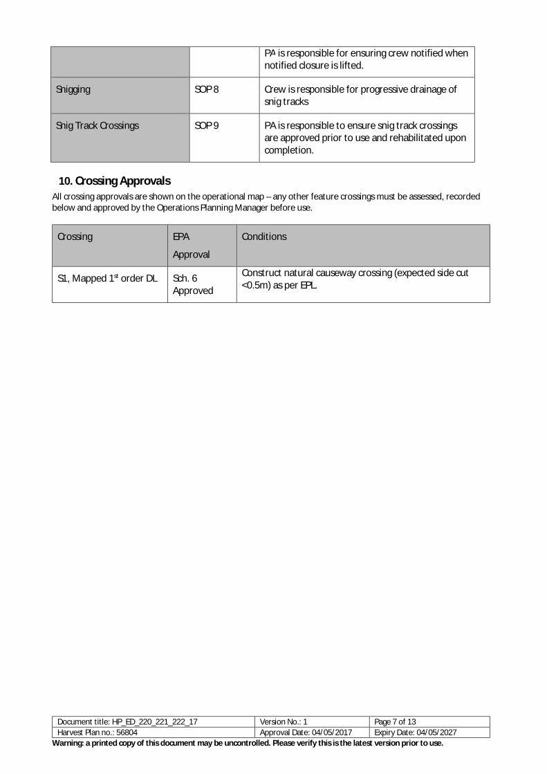
PA is responsible for ensuring crew notified when notified closure is lifted.
Snigging SOP 8 Crew is responsible for progressive drainage of snig tracks
Snig Track Crossings SOP 9 PA is responsible to ensure snig track crossings are approved prior to use and rehabilitated upon completion.
10. Crossing Approvals All crossing approvals are shown on the operational map – any other feature crossings must be assessed, recorded below and approved by the Operations Planning Manager before use.
Crossing EPA
Approval
Conditions
S1, Mapped 1st order DL Sch. 6 Approved
Construct natural causeway crossing (expected side cut <0.5m) as per EPL.
Document title: HP_ED_220_221_222_17 Version No.: 1 Page 7 of 13 Harvest Plan no.: 56804 Approval Date: 04/05/2017 Expiry Date: 04/05/2027
Warning: a printed copy of this document may be uncontrolled. Please verify this is the latest version prior to use.

11. Operational Plan Briefing: A briefing of this operational plan was conducted by
Person Role Nature of Briefing Date
12. Acknowledgement of Briefing: I acknowledge that I have received a copy of the plan documents and that I have been briefed on the conditions of the Plan. I understand the operational control requirements as outlined in the plan and take responsibility for the implementation of plan conditions relevant to my responsibilities
Name Role Signature Date
Document title: HP_ED_220_221_222_17 Version No.: 1 Page 8 of 13 Harvest Plan no.: 56804 Approval Date: 04/05/2017 Expiry Date: 04/05/2027
Warning: a printed copy of this document may be uncontrolled. Please verify this is the latest version prior to use.

13. Standard Operating Procedures: The following SOP’s apply to this plan. FCNSW staff and the crew must hold a copy on site whilst operating and comply with the conditions set out in each SOP.
Procedure Number
Title
1 Drainage Feature Protection
2 Exclusion Zone Boundary Management
3 Forest Mark-Up
5 Log Dump Operation and Use
6 Road and Crossing Management and Wet Weather Controls
7 Safety Requirements
8 Snigging and Snig Track Crossing
9 Documentation and approvals
Document title: HP_ED_220_221_222_17 Version No.: 1 Page 9 of 13 Harvest Plan no.: 56804 Approval Date: 04/05/2017 Expiry Date: 04/05/2027
Warning: a printed copy of this document may be uncontrolled. Please verify this is the latest version prior to use.

Operational Diary:
Date Issue Action Required
Action Completed Initials
Record: Daily activities (eg tree marking, dump 2); Condition 5.2 of TSL items - EEC locations, rocky outcrops, koala scats, feed tree identification etc), discussions with stakeholders/neighbours/ site visitors; areas of impenetrable understorey; unviable areas not marked, non-conformances; harvesting issues identified, twice weekly road and crossing drainage checks
Document title: HP_ED_220_221_222_17 Version No.: 1 Page 10 of 13 Harvest Plan no.: 56804 Approval Date: 04/05/2017 Expiry Date: 04/05/2027
Warning: a printed copy of this document may be uncontrolled. Please verify this is the latest version prior to use.

14. Roading Plan: Maintenance works not completed by RC must be recorded and passed onto the PA for completion and documentation. The start and finish dates of all maintenance and construction must be recorded on the individual roading sheets along with other relevant changes or explanations. All rubber flaps on minor forest roads must be removed and replaced with trafficable rollover banks on completion of operation.
Summary of roading requirements Feature Details Works Required Existing roads to be used. 2,650m/4 Yes New roads to be constructed 100m/1 Yes Existing crossings used 1 Yes New crossings to be constructed Nil NA Length of road >10° 60m NA Borrow pits and gravel pits 0 NA Mass movement prescriptions apply Yes No Dispersible soil conditions apply No NA Seasonality provisions apply No NA
Checklist of works required on roads & crossings Road/Crossing Name Works Required Date
Started Date Finished Initials
Timbillica Rd
FCNSW Responsibility
Clear and/or reshape road formation.
Clear roadside vegetation up to 3m either side of road.
Clean/clear out existing drainage structures.
Install one additional mitre drain as mapped and marked in the field at:
• E740382 N5873084
A site specific prescription has been designed for sections of road where drainage spacing exceeds EPL spacing requirements. Refer to appendix 1 “File Note: Site specific drainage requirements for Timbillica Rd Cpt 220 & 222” for details.
RC/PA Comments:
Cpt 220 Trail
Contractor Responsibility
Clear and/or reshape road formation.
Clear roadside vegetation up to 3m either side of road.
Install drainage as per EPL.
RC/PA Comments:
Cpt 220-1 Trail
Contractor Responsibility
Clear and/or reshape road formation.
Clear roadside vegetation up to 3m either side of road.
Install drainage as per EPL.
Document title: HP_ED_220_221_222_17 Version No.: 1 Page 11 of 13 Harvest Plan no.: 56804 Approval Date: 04/05/2017 Expiry Date: 04/05/2027
Warning: a printed copy of this document may be uncontrolled. Please verify this is the latest version prior to use.

RC/PA Comments:
Cpt 220-2 Trail
Contractor Responsibility
Construct 100m of access trail with maximum road prism of 7m. Maximum grade of 12 degrees and maximum side slope of 3 degrees. Road grade in excess of 10 degrees for 60m. Install drainage as per EPL.
RC/PA Comments:
Cpt 220-3 Trail
Contractor Responsibility
Clear and/or reshape road formation.
Clear roadside vegetation up to 3m either side of road.
Install drainage as per EPL.
RC/PA Comments:
Document title: HP_ED_220_221_222_17 Version No.: 1 Page 12 of 13 Harvest Plan no.: 56804 Approval Date: 04/05/2017 Expiry Date: 04/05/2027
Warning: a printed copy of this document may be uncontrolled. Please verify this is the latest version prior to use.

FORESTRY CORPORATION OF NSW, HARDWOOD FORESTS DIVISION ROADING PLAN MAP
ú B
!
J!
Á
Á