south elmham a d district local history group
TRANSCRIPT
SOUTH ELMHAM A�D
DISTRICT LOCAL HISTORY
GROUP
�EWSLETTER
Issue �o. 28 September 2011
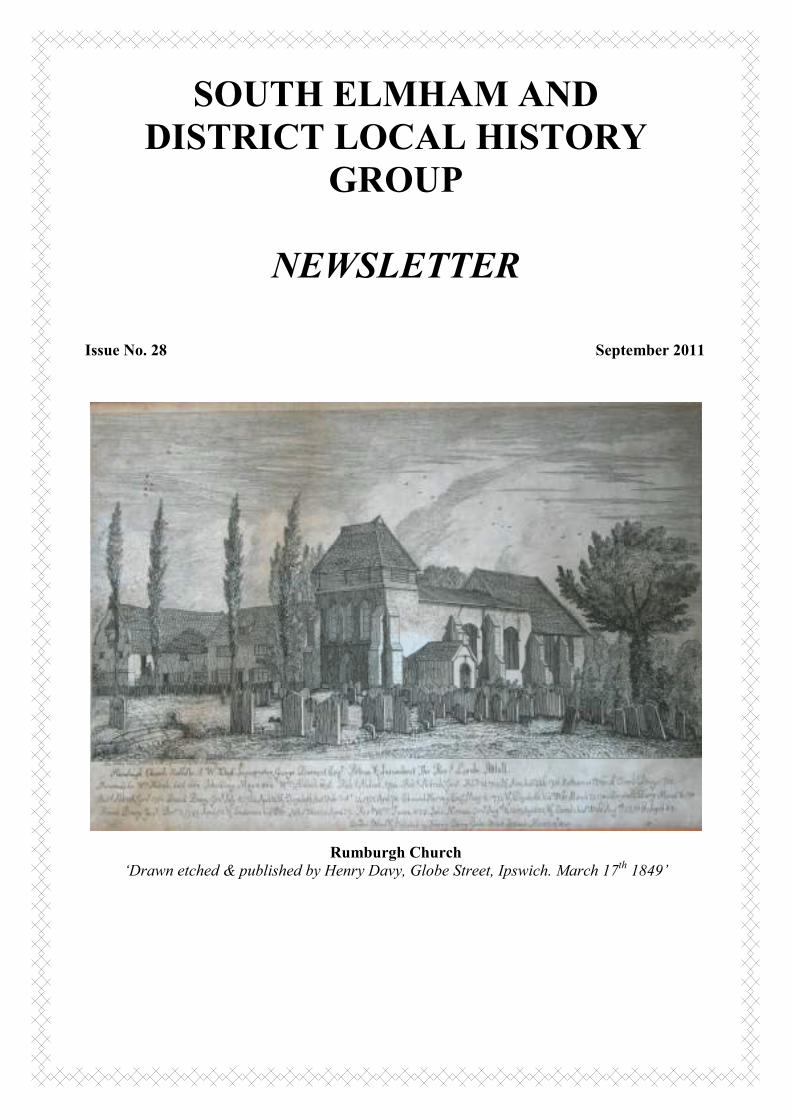
Rumburgh Church
‘Drawn etched & published by Henry Davy, Globe Street, Ipswich. March 17th
1849’
2
Chairman’s notes.
Well harvest is well and truly upon us now, although haysel is running late because of the
wet July, therefore there is much to do all at once.
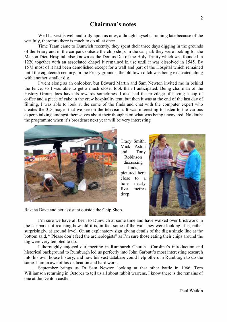
Time Team came to Dunwich recently, they spent their three days digging in the grounds
of the Friary and in the car park outside the chip shop. In the car park they were looking for the
Maison Dieu Hospital, also known as the Domus Dei of the Holy Trinity which was founded in
1220 together with an associated chapel it remained in use until it was dissolved in 1545. By
1573 most of it had been demolished except for a wall and part of the Hospital which remained
until the eighteenth century. In the Friary grounds, the old town ditch was being excavated along
with another smaller dig.
I went along as an onlooker, but Edward Martin and Sam Newton invited me in behind
the fence, so I was able to get a much closer look than I anticipated. Being chairman of the
History Group does have its rewards sometimes. I also had the privilege of having a cup of
coffee and a piece of cake in the crew hospitality tent, but then it was at the end of the last day of
filming. I was able to look at the some of the finds and chat with the computer expert who
creates the 3D images that we see on the television. It was interesting to listen to the various
experts talking amongst themselves about their thoughts on what was being uncovered. No doubt
the programme when it’s broadcast next year will be very interesting.
Tracy Smith,
Mick Aston
and Tony
Robinson
discussing
finds,
pictured here
close to a
hole nearly
five metres
deep.
Raksha Dave and her assistant outside the Chip Shop.
I’m sure we have all been to Dunwich at some time and have walked over brickwork in
the car park not realising how old it is, in fact some of the wall they were looking at is, rather
surprisingly, at ground level. On an explanatory sign giving details of the dig a single line at the
bottom said, “ Please don’t feed the archeologists” as I’m sure those eating their chips around the
dig were very tempted to do.
I thoroughly enjoyed our meeting in Rumburgh Church. Caroline’s introduction and
historical background to Rumburgh led us perfectly into John Garbutt’s most interesting research
into his own house history, and how his vast database could help others in Rumburgh to do the
same. I am in awe of his dedication and hard work.
September brings us Dr Sam Newton looking at that other battle in 1066. Tom
Williamson returning in October to tell us all about rabbit warrens, I know there is the remains of
one at the Denton castle.
Paul Watkin

3
Editorial
In this issue we are fortunate in having contributions from two new writers.
John Garbutt, who presented his findings at the July meeting in Rumburgh, has written
about his house there, and how he managed to reclaim the lordship of the manor of Rumburgh
from an American who had bought it in 1973. (See page 8)
Margaret Robert has taken an interest in Metfield by trying to unlock something of the
personal histories of those whose names are recorded in various ways in the village church, from
black American airmen to a 17th century clockmaker. (See page 13).
On page 9 Caroline Cardwell, who writes so much for our Newsletter, has given us her
presentation of July on The History of Rumburgh, and finishes by writing that Rumburgh
deserves a village history. I hope, as I am sure many others do, that she will find the time to do
this herself. It is her print of Rumburgh Church that appears on the front cover of this newsletter.
Basil Harrold
A Tribute to Stella Harrold
I first met Stella and Basil at a local history exhibition I had organised in St Margaret
South Elmham. It was during the year 2000 and held in our village hall to celebrate the
Millennium. They were very interested in the display I had of All Saints School, which Basil
had attended whilst staying at his parent’s house - All Saints Old Rectory, during the war. I was
very pleased therefore, when they both joined our History Group at its very beginning, although
it was not until we started the Inventory Group that I got to know Stella a little better. She was a
very kind and thoughtful person, most considerate and very bright. Stella was always the one
who remembered the obscure items in the inventories without having to look them up and often
managed to decipher writing we had been having difficulties with, before anyone else did!
It was Stella who suggested that our Inventory Group had a trip to Strangers Hall
Museum and Norwich Castle. We went to see some of the furniture that we were reading about
in the inventories and also the guns and weapons often listed. It was a most enjoyable day, with
our own personal guide at both venues. Last year, we went to Sutton Hoo, as I had happened to
mention one day that I had never been and therefore Stella insisted that another trip was
organised!
She was always most welcoming and after Audrey sadly passed away, we continued with
our inventory meetings in Basil and Stella’s home usually with a slice of her wonderful
homemade cake and a cup of tea. It was not until Stella’s funeral that I realised that I did not
know very much about her, as she was never one to talk much about herself. Stella lost her
mother when she was only 3 and her father when she was 26, but it was he who had encouraged
her to follow in his footsteps and she qualified in Medicine from Queens University, Belfast in
1957. Stella met Basil whilst they were both Senior House Officers in Bath practicing
Anaesthetics and Medicine respectively and married just a year later. They had two children
Elizabeth and William.
Stella continued working as a Doctor running baby clinics and immunisation programmes
in local schools during term time in school hours, enabling her to continue to provide her own
children with all the care they needed.
At the age of 54 and 55 Stella and Basil bought a 21 acre farm and 30 ewes and lived
very happily there for 11 years
On Basil’s retirement in 1995, they moved to Halesworth, the home that they have lived
in the longest. A boat and then a caravan were purchased, but more recently they both enjoyed
the challenge of rejuvenating the local WEA with Stella as secretary and Basil as treasurer.
I feel privileged to have known Stella and totally agree with the words her daughter
Elizabeth spoke during her funeral service – “Stella was pragmatic, forgiving, quite serious but
always ready to laugh, generous and valued her neighbours. She was a well informed historian
4

and botanist and was relied on by many people for her general knowledge and powers of recall.
Not flashy but always well dressed and enduringly polite. The last few weeks of Stella’s life
were tough but she bore them with stoicism, dignity, determination and bravery”.
Susan Riseborough
Rumburgh
Some historical notes and ideas for further research.
Basically – these are the notes of the July meeting – however I thought they could be
slightly expanded and may interest those of you who couldn’t get to Rumburgh at the end of
July.
The �ame – and the Place
“Possibly “the fort made of tree-trunks” Romburch [1047-64] copy.Ra- Ro’hurc 1086,
Rumburg(he) c. 1130-1316, Romburg c. 1189, Rumburgh from 1327, Rumboro 1610.
OE *hrun-burh< hruna+burh. OE run “deliberation, counsel” would also be possible – Watts,
Victor – The Cambridge Dictionary of English Place-2ames, 2004. The burgh part of the name
seems to indicate some sort of fortified enclosure, and it is interesting that, on the 1884 OS 25”
to the mile map there are indications of a double ditched enclosure round the church – only a few
traces of these moats are now left.
Peter Warner in The Origins of Suffolk [1996] suggests that the parish of Rumburgh was
formed partly out of Blything Hundred and partly out of Wainford hundred and its remote
position made it a favourable site for the Benedictine monastery founded shortly before the
Norman Conquest. As late as the sixteenth century Rumburgh is referred to in some documents
as Rumburgh in South Elmham and on the Southern boundary of the South Elmhams, the
Franchismere, there is place name evidence that the medieval tenement lands crossed boundaries
of both hundred and parish.
The large ditches on each side of Rumburgh Street and the “moats” behind Street and
Hattons farms also possibly indicate that The Street was a hundred boundary which was moved
further North at some time prior to 1066. The land between The Street and the boundary with
South Elmham is called in medieval documents le Rodefield – [OE rod, rodu – a clearing]; One
rather gets the impression of the northern part of the parish of Wissett up to the Beck, as unused
land – which was considered a suitable site for the foundation of the Benedictine monastery by
Bishop Aethelmar sometime between 1047 and 1065.
The Priory
The priory is included in Domesday Book [1086] as a dependant chapelry of Wissett,
and, after various changes of patronage in the early Middle Ages, the priory was given to the
abbey of St. Mary’s, York. In the charters describing this gift, the priory is described as being in
possession of the revenues of the churches of Wissett, Spexhall, Holton and South Cove. The
priory also controlled the tithes of Kettleburgh, Swaffham, and Costessy, and rents from St.
Mary’s, lands in Cambridgeshire, and Norfolk, including Bassingbourn, Little Abington, and
Linton.

5
The taxation roll of 1291 shows that the income of the priory was £35 5s 11¾d, this, however,
seriously undervalued
the income which was
more in the region of £70
[Martin Heale –PSIAH
2003] The priory was
never very wealthy and
by the Dissolution was
worth approximately £30
per year.
On 11th
September 1528 the
King’s Commissioners
arrived at Rumburgh and
declared to the prior and
the monks the formal
dissolution of the house
– its revenues and
income to be transferred
to the foundation of
Cardinal Wolsey’s
college in Ipswich. The
survey made by the
commissioners in 1525
can be read in the
Suffolk Record Office at
Lowestoft; the end
finally came in 1528.
After Wolsey’s disgrace,
the priory and its
possessions reverted to
the Crown, and were
granted to Robert
Downes, who sold it to
the Duke of Norfolk.
Very little early priory
documentation remains –
one of the best sources is the Craven Ord scrapbook in SROI [HD 1538/335/1]. Curiously two
or three centuries later, long after the monks had left, local land descriptions included phrases
such as “lying next to the former lands of Rumburgh priory”.
The Common
This common land was an agricultural resource of about 100 acres, shared with Wissett
and enclosed by Act of Parliament in 1851 – the Enclosure Award and accompanying maps are
in the Ipswich Rocord Office,
In about 1680, Nathaniel Fairfax recorded the following information –
In the [Wissett]] street at the turning up towards Chediston, is a place called Wissett Cross,
where, as they say, of olden time stood a cross … [and] in a dirty place at Rumburgh coming
out of the Street unto the green at a 3 way leet near the Butts is called Green Cross Slough
perhaps from some cross there set up. [CUL, Hengrave MSS, 37/3/180}

6
The antiquarian, David Davy, remembered when he was a boy [he was born in Rumburgh] that
“the young people met two or three times a week on Rumburgh Common during the summer
evenings for this amusement [camping – a medieval ball game] Matches sometimes used to be
made between parishes, which sometimes became real battles”.
July 11th 1830 – “A Sermon was delivered on Rumburgh Common near the ruins of a
cottage of three tenements Destroyed by Lightning early in the morning of the 26th June
preceding by John Dennant – the profits arising from the sale of this discourse will be applied to
the general fund for the relief of the nineteen surviving sufferers” Halesworth - Printed and sold
by T. Tippell and also by the author price 6d. [SROL]. Reading through this lengthy pamphlet
now it is hard to imagine why anyone would pay a hard-earned 6d. for it, but the philanthropy
behind the event was an indication of general concern for the plight of the poor and the desperate
straights of those nineteen people deprived of shelter and possessions at a time when life for the
poor was extremely hard. It would be interesting to search local papers and see if more could be
found out about this event.
The thatched cottage facing the Pleasure Ground used to be the Town House – it
belonged to the parish and was used as accommodation for the poor and elderly before the
establishment of the workhouse system in the late 18th century, when the poor went to the
workhouse at Blythburgh. The Pleasure Ground was “for the amusement and recreation of the
labouring poor of the parish” after enclosure.
Close to the common is the Buck public house, which used to be run by the parish for the
benefit of the poor and the repair of the church; it was called the White Hart in the 1830’s.
Place �ames
Most of the medieval names in Rumburgh changed during the 17th and 18
th centuries. So
very few of the “old” names of the farms [or tenements as they were designated in the medieval
period] are known – Pear Tree Farm at Aldous Corner was Wyards and Kimbers Court was
Cranes, Street Farm had a brief time called Thompsons Farm, but this was in the later 19th
century – I am hoping to find out its medieval name one day]. The Street was called that in the
late 15th century; in the early 18
th century Malt Office Lane, which recalls the maltings there, was
known as the King’s Highway from St. James to Bungay. The road to St. James from All Saints
Common was Nowgateway. New Road in Rumburgh was “new” in 1851, when the common
was enclosed. Mill Road remembers the site of the windmill, scene of a fatal accident in the
1830s recorded in the church registers. The tithe award and map gives the names of the fields in
the early nineteenth century, but mostly they are very basic and descriptive – Long meadow,
Winding Field, Neathouse Fields – two of the fields that formerly went with Street Farm are
called Gules – they lie up near Rumburgh Wood and recall the tenement Gules or Gooldes which
lay just over the parish/hundred boundary in what is now St. Michael South Elmham.
.
The Community
There are ample sources for studying the village and its inhabitants, where families came
from – and where they went - and to a certain extent their social mobility in the Census which
starts in 1841; it is available online up to 1911 and can be used for gleaning all sorts of
information besides that needed by family historians.
And finally, in 1844 [White’s Directory of Suffolk] Rumburgh contained among its
inhabitants the following: butcher, bricklayer, joiner, 2 shoemakers, tailors and shopkeepers,
wheelwright, coach builder, maltster, 2 blacksmiths, a beerhouse and the Buck and a corn miller;
also the schoolmaster and parish clerk John Blowers [I have a copy of his notebook] and the 15
farmers.
7
By 1908 [Kelly’s Directory for Norfolk and Suffolk] trades added included a threshing
machine proprietor and a dressmaker; in 1937 the private residents included 2 clergymen, and
trades – an ironmonger, farmers, thatcher, boot repairer and blacksmith. In 1967 when I came to
live here we had a shop and post office, a blacksmith, an agricultural machinery repair business,
the Buck, and the church.
There are many more things that could be researched about the village – the school, the
Feoffees [whose records go back to the late 17th century], the chapel, the changes in farming –
just what it was actually like here in WWII and so on – many worthwhile and interesting projects
of varying degrees of complexity; Rumburgh deserves a village history.
Caroline Cardwell, July 2011.
Footnote
Electricity for Wissett and Rumburgh
Work has started on the electricity scheme for Wissett and it is anticipated that the supply
will be through in the New Year. It is understood that the supply will be extended to Rumburgh
at the same time.
This is entirely due to private enterprise and public spirited gesture and generosity which
led five people Messrs Calvert, Lambert, Richardson, Rowe, and Mrs. Steward to put up the
initial capital to enable the scheme to come into being.
Found, after much searching, by Roly Bray in The Beccles and Bungay Journal of
November 19th 1948 (and given to the editor in July 2009)
Book Review
Traditional Crafts and Industries of East Anglia:
The Photographic Legacy of Hallam Ashley, ed. By Andrew Sargent
English Heritage, 2010. £16.99 [paperback]
This is a book to have on one’s shelves – filled with marvellous black and white photographs of
East Anglia taken between 50 and 60 years ago and now a vanished world – Halesworth railway
station before the modern road was built, a saddler’s shop in the Thoroughfare with all the
harness displayed outside, mills and quarries, thatching. A reed cutter working at Horning in
1949 is worthy of Emerson – and specialist crafts such as chair making, boat building and
brickyards – all these are recorded with great artistry and skill. It is difficult to choose but one of
the most poignant pictures is of steam engines at Great Massingham in Norfolk, dumped on the
common in 1940 and being scrapped in 1946; or the picture of the village store at Ludham in
Norfolk in 1953 with everything laid out in front that was needed by the village.
Hallam Ashley [1900-87] was a notable photographer, well-known in East Anglia
through exhibitions and his private work; after his death, his vast collection of negatives was
given to the National Monuments Record with which he had had a long association; they may be
consulted at the NMR offices in Swindon [tel: 01793 414600]. A selection may be viewed and
purchased online at www.english-heritage.org.uk/viewfinder Caroline Cardwell

8
The Rumburgh Village Database and the history of Kimbers Court.
By John Garbutt, Kimbers Court, Rumburgh
Kimbers Court, The Street, Rumburgh
Introduction
Since moving to Rumburgh several years ago, I have built up a very large historical
database of over 24,000 lines on the village. The purpose of this database was to discover as
much as I could about the past inhabitants of Rumburgh and the properties that they lived in.
The database has been very successful in enabling the history of my own house to be discovered
over a period of more than 500 years.
The contents of my database are freely available to anyone who is interested and I have
produced a free handout (available from: [email protected]) for anyone who would like to
know about the method that I used to create it. All I ask in return is that any comments or
omissions are referred to me and that the source is quoted where information is used by others.
Also I will be happy to talk to anyone about setting up similar databases for adjacent villages.

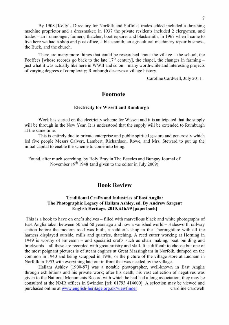
The house’s history 9
Kimbers Court in 1525 John Walker
My house is currently called Kimbers
Court – a name that was chosen by the
previous owners although it had no previous
connection with the house. It is a timber-
framed former farmhouse built mainly in
two phases in about 1525 and 1600.
A good way of starting to research the
history of a house is to look at the Electoral
Registers held at the County Records Offices
This is because the address is shown thus
making it fairly easy to work back through
the various voters. In the case of my house
it was called “Carmel” from about 1981
when John and Merle Sparks became the
owners but previously had been called “Red
House” and “Red House Farm” – a name that would have been used in recognition of the time,
probably about 1850, when the house’s exterior was faced in brick. The earliest year when this
name was used in the Electoral Records was about 1921 when the occupiers were Arthur and
Matie Saxby. However, prior to this time, the house’s name is not given so it cannot be
identified without information from other sources.
The 1910 Finance Act and 1840s Tithe Awards both provide maps that enable accurate
identification of properties and the associated records name each owner and occupier. In the
case of Kimbers Court, the 1910 Finance Act shows that it was owned by Preston, Hillary and
Snelling who were probably executors of the estate of F B Moore, who’s name had been crossed
through. The occupier was Mrs Emma Baker who was farming 93 acres of land including 4
acres that were copyhold of the Manor of Sibton.
Unfortunately, the Map of the 1842 Rumburgh Tithe Award shows a large blank area
where the house and the farmland associated with it was situated. However, this is explained by
the Award’s record book that states "And whereas all that Farm and Lands situate in the said
parish belonging to the Reverend John Holmes now in the occupation of the Executors of
Charles Reynolds containing by estimation Ninety three acres or thereabouts are by prescription
free from the payment of Tithes." Thus, the 1842 owner and occupier have been identified and
the tithe free status explains why the property is not shown on the map.
The 1910 and 1840s records can be used as “anchor points” for research because they
provide certainty about the owners and occupiers. This information can then be compared with
other documents such as the (soon to be fully available) 1911 Census and the 1841 version.
Although the 1841 Census provides little or no information about the address of the property, it
does show Elizabeth Reynolds aged 70, as a Farmer living with her family. The identification
can be corroborated, because the properties are listed in a logical order - as though the
enumerator wrote them down as he walked past.
The 1842 information can also be linked with the 1830 Overseers of the Poor Assessment
that shows the Reverend John Holmes as the owner of a property of 96 acres with 1½ Common
Rights occupied by Charles Reynolds Senior.
Moving forward for a moment, the 1851 Enclosure Award of Rumburgh and Wissett
Common, lists a property owned by John Holmes “formerly Girling's, in the Occupation of
David Reynolds” with 1½ Common Rights. Thus we have the name of a former owner and find
this in the 1799 Land Tax where John Girling Junior was himself farming two pieces of land that
we can calculate as of about 94 and 4 acres. John Girling is also shown in the 1790 Poll Tax as
the owner of Freehold land in Rumburgh.
10
Until earlier in 2011, 1790 was as far back in time as I could take the history of Kimbers
Court. Then some documents that the solicitors Cross Ramm and Co had transferred to the
County Records Offices turned up in Norwich. These are 14 boxes of documents relating to the
Brooke Hall Estate owned by the Holmes family who, as we have already seen, had been owners
of Kimbers Court. Three documents of different dates list the title deeds stored in the Brooke
Hall strong room and one of these is a “Farm in Rumburgh purchased of Girling, John in two
bundles … In Charles Raynold's Occupation.” Unfortunately, on the third of these lists dated
1844, John Holmes has written “These … deeds … given to Mr Crabtree Jan.y 21 1860” – this
was when the Brooke Hall Estate was sold off and the title deeds were then separated from the
contents of the 14 boxes.
Another Brooke Hall document is the Estate Manager’s note book that from 1835 details
a “Farm in Rumburgh in the occupation of Charles Reynolds”. This lists the field names, the
size of each and the crop rotation until 1839. The same pages include a crude map of the farm
that corroborates the identification of the property. The note book also contains much
information about the rent payable and the allowances made by the landlord for costs that had to
be expended by the occupier. These include payments to the Manor Courts of Sibton (as noted
above in the 1910 Finance Act record) but also of Wissett Le Roos and of Rumburgh – normally
spelt Romburgh in the Manorial Records.. This was the first indication that any part of the Farm
had been copyhold of the Manor of Rumburgh and thus the Manorial Records would have shown
every change in the property’s ownership over hundreds of years. For this reason, it became a
priority to get access to the Rumburgh Manorial Records because they would be an enormous
help with discovering the history of my house and the village in general.
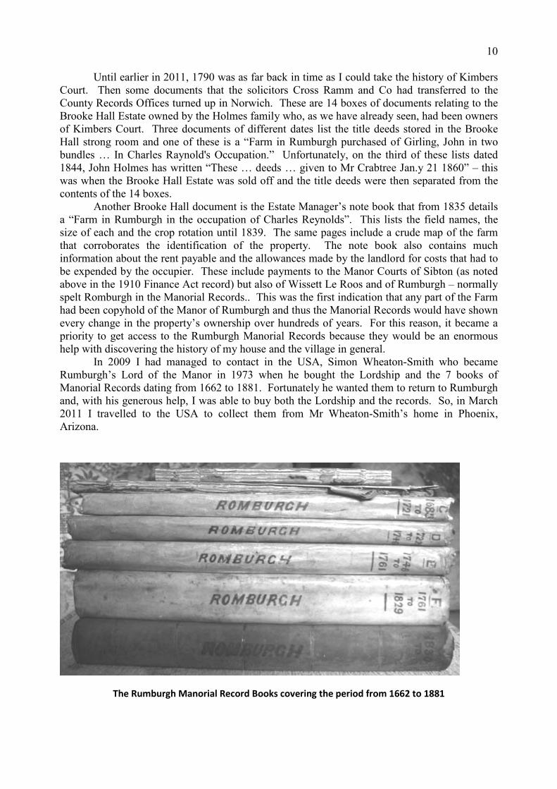
In 2009 I had managed to contact in the USA, Simon Wheaton-Smith who became
Rumburgh’s Lord of the Manor in 1973 when he bought the Lordship and the 7 books of
Manorial Records dating from 1662 to 1881. Fortunately he wanted them to return to Rumburgh
and, with his generous help, I was able to buy both the Lordship and the records. So, in March
2011 I travelled to the USA to collect them from Mr Wheaton-Smith’s home in Phoenix,
Arizona.
The Rumburgh Manorial Record Books covering the period from 1662 to 1881

11
Since each of the Record Books is indexed, it was easy to discover that in 1811, Thomas Holmes
(the uncle of the Reverend John Holmes) bought from John and Sarah Girling the following
copyhold lands “fourteen acres of land in divers pieces lying together in Rodefield each at the
end of the other holden by service 4s 8d rent by the year and suit of Court And also to 3 acres of
land lying in the said field called Rodefield formerly Goodwyns abutting upon the Franchis Meer
between Rumburgh and Southelmham towards the North holden by service and 2d rent by the
year one days work in the Autumn valued at 3d and suit of Court”. These very precise words are
used throughout the Manorial Records and were translated from Latin in about 1730. Thus, using
each Book’s index and corroborating this identification by the precise wording in each entry, it
was possible to track the property’s owners back to 1663 when Robert and Alice Baker bought it
from Roger North who, in 1643 was the heir of George Lawrence.
At this stage, I had discovered much of the house’s history back to 1643 but no earlier
house name had been found. However, there was a large amount of earlier information that I had
already entered in my database but could not previously link with the house.
Firstly, I had already obtained the Rumburgh Manorial Records from 1614 to 1662 that
are stored in the Norfolk Records Office. The pages for 1643 quote in English the 1641 Will of
George Lawrence: “… All those my mess[uage] or tene[me]nt wherin I now dwell in Rumburgh
… & the lands thereunto belonginge ... Called the name Cranes And also all those my lands
w[hi]ch Richard Lawrence my father deceased hate purchased [prior to 1603] ...” This provides a
former house name and the copyhold description in Latin is exactly the same as the English
translation shown above for 1811.
Having now obtained an earlier house name, I was able to connect the house with the
1559 Will of John Lawrence who bequeathed to his wife Elizabeth “… my tenement that I dwell
in called Cranes with all the lands ther unto used and belonging both fre and bond ... after her
decease the seyd ten[emen]t Cranys & the sayd lands ... unto Richard Lawrence my sonne …”
and “land called Cranys ... I give and Bequeath unto Richard Lawrence ... and then ... unto John
Lawrence my godson the son of Henry Lawrence my Eldest sonne ... “The National Archive at
Kew holds a detailed survey that was carried out in 1528 of Rumburgh Priory which had just
been closed down. Amongst much other information, it includes descriptions of the property that
the Priory owned and the income that was received. This confirms that John Lawrence held a
messuage “formerly of Robert Crane” and the description of the property that he occupied is very
close to that used in the Manorial Records.
The 1503/4 Rumburgh Manorial Records exist in the Essex Records Office and quote the
1504 Will of John Lawrence who was probably the father of the man of the same name referred
to in the last paragraph. The will bequeaths several properties to his wife Margery including: “...
my ten[em]ent called Cranes w[ith] all the lands as well free as bond … “. The associated
Manorial description is, once again, identical to that used in later years and records that “John
Laurens took [up the copyhold property] from the surrender of Thomas Laurens father of the said
John at a court held … in the 11th year of Edward IV [c1471] … “. We should note that this
document was written probably before the oldest part of the present house was built in about
1525. However, since earlier pieces of broken pottery have been found below the house’s floor,
it seems likely that it replaced a previous one on the same site.
Before I moved to Rumburgh in 2005, I was involved in writing and publishing two
books on the village of Nazeing in Essex. These include the following text:: “In Nazeing one
saddening break with the past has been that several houses which had retained their names for
five or six centuries have had them changed, mostly since 1945.” So, should I now adopt an
earlier name for the house? “Red House Farm” was a name used for about 130 years until about
1980 but it might cause some confusion because there are three other nearby properties of
12
this name. Perhaps “Cranes” is more suitable since it was used for more than 170 years from a
date prior to 1471 when Robert Crane owned the house, until at least 1643.
A summary of the history of Kimbers Court:
Date* Name Occupier Owner
2005 Kimbers Court John Mallory Garbutt John Mallory Garbutt
1992 Kimbers Court Paul & Phyllis Coombs Paul & Phyllis Coombs
1981 Carmel John & Merle Sparkes John & Merle Sparkes
1980 Red House Farm Gordon & Joan Martin Gordon and Joan Martin
1960 The approximate date when the Farmhouse was separated from its land.
1953 Red House Farm Robert & Margery Ward
1937 Red House Farm Robert Meadows Robert Meadows
1925 Red House Farm Robert Meadows Mrs M Taylor
1921 Red House George & Matie Tayler George & Matie Tayler
1914 A J More Foster Hill [executors]
1907 Mrs E Baker Frank Beaumont Moore
1897 Samuel Calver Francis Moore
1883 Francis Moore Francis Moore
1874 Mrs Emma Salter Francis Moore
1870 Isaac & Emma Gowen Francis Moore
1868 [in Manor. Records] William Mower Francis Moore
1861 Benjamin Mower James Cracknell
1850 David Reynolds Rev. John Holmes
1850 Red House Farm – the approximate date when the house was faced in brick
1842 Farm of 93 acres Executors of Cha.s Reynolds Rev. John Holmes
1811 Charles Reynolds Rev. Thomas Holmes
1795 [in Manor. Records] John Girling Junior
1789 [in Manor. Records] John Girling Senior
1756 [in Manor. Records] Mary Baker (née Girling)
1735 [in Manor. Records] Simon & Martha Baker
1688 [in Manor. Records] Simon Baker
1663 [in Manor. Records] Robert Baker
1643 [in Manor. Records] Roger North
1643 Cranes George Lawrence
???? Cranes Richard Lawrence
1559 Cranes John & Elizabeth Lawrence John & Elizab. Lawrence
1528 Formerly Robert Crane John Lawrence John Lawrence
1504 Cranes John & Margery Lawrence
1471 Cranes Thomas Laurens
???? Robert Crane’s Robert Crane
*Note: some dates are approximate.
I hope you have found this article to be interesting and that I have shown how enormously
helpful a database can be when carrying out research into the history of a village such as
Rumburgh. Please contact me if you would like to talk about either the Rumburgh database or
creating a similar one in another place. [email protected]
August 2011

13
Metfield
Who do you think they were?
In 2010 a presentation was made in St John the Baptist church in the village of Metfield
which took as its theme “Who Do You Think They Were?” Based on the television series which
looks at the ancestors of famous people, we took the church as the centre of the presentation, and
the names written in the church were the background “chatter”.
We didn’t look at the architecture or the history of the church – which is interesting but at
the same time similar to many others in Suffolk – but at the names which we felt made the church
special. The four presenters – a builder, a Royal Engineer, a contracts manager and a teacher -
all live within a stone’s throw of the church, and concentrated on different parts of it.
The names we talked about fell into four groups: the craftsmen who had worked in the
church; the memorials to men and women who had given their time and talents to the church; the
Metfield dead of two world wars; and the American dead of World War II, who had lived, fought
and sometimes died on the Metfield airfield.
They were real people who could say “I was there, this is what I did. See, this is my
name which commemorates me
and my actions.” The presenters
similarly were real people telling
of the history of their church: we
were here, at this time, in this
place.
In this small church, the
first presenter, Christopher,
started chronologically with the
names written on the medieval
painted ceiling. The earliest
names were those of Jesus (IHS
Jesus Hominum Salvator) and
Mary his mother high up above,
their faded initials surrounded by
grapes and vines.
Then a great leap forward
in time, and in 1826 King George
IV has his royal initials painted
into the royal arms, to be hung
high on the west wall. The cost
was £5, but the political benefits
to George were immediate: lest
you forget, I am the head of the
Church in England. The painted nave roof with the monograms of Jesus and Mary
A village church is a community centre, and the few plaques within it commemorate men
and women whose modest working lives were centred around this old building. The young vicar,
Harry Fowler Haines, died in February 1899 and was buried in the churchyard, aged only 30, his
lingering illness minuted in church records. In 1904 the ladies sewing circle subscribed
14
to his plain brass memorial close to the communion rail. By the organ is another brass plate,
commemorating Margery Edgcumbe’s who for over 60 years had produced music in the church.
Another, by the clock, praises the work of Adolphus George (“Puddy” or “Puds” “a very jolly
person who pulled your leg” – he died in
January 1980 aged 76 - and his wife Vi Harper
– she died aged 95 in May 2004 - who cared
for the church for 50 years, everything from
opening and closing the church, cleaning,
ringing the bells, singing in the choir. These
memorials tell of real lives lived in this parish,
and of years of kindly service.
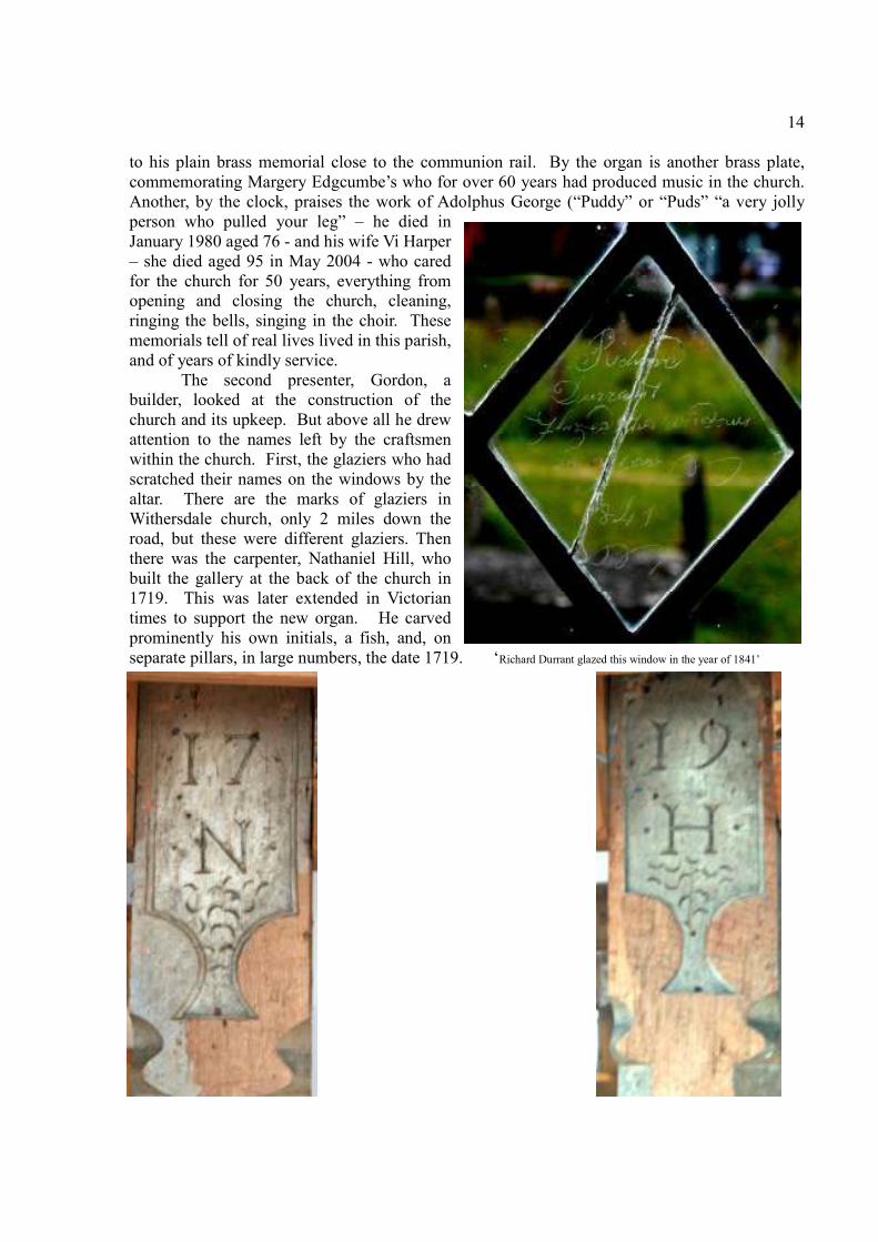
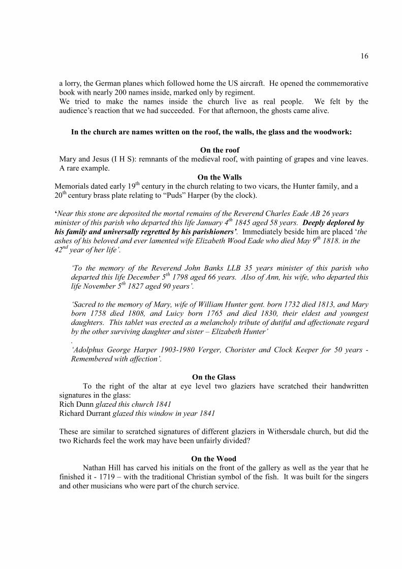
The second presenter, Gordon, a
builder, looked at the construction of the
church and its upkeep. But above all he drew
attention to the names left by the craftsmen
within the church. First, the glaziers who had
scratched their names on the windows by the
altar. There are the marks of glaziers in
Withersdale church, only 2 miles down the
road, but these were different glaziers. Then
there was the carpenter, Nathaniel Hill, who
built the gallery at the back of the church in
1719. This was later extended in Victorian
times to support the new organ. He carved
prominently his own initials, a fish, and, on
separate pillars, in large numbers, the date 1719. ‘Richard Durrant glazed this window in the year of 1841’

15
The clock at Metfield is a working clock of museum quality. The original, made by Garrett, was
installed in 1629, at a cost of £6 14 s 4d. 90 years later, in 1719, the Metfield clock was modified
by William Spendelow. In 1703 he had come to Metfield from the nearby village of Mendham
bringing with him his wife and six
children. He already had a good
reputation, and in 1709 William
built the clock in nearby Cratfield.
In November 1733 he died and
was buried in the churchyard in
Metfield.
The third presenter,
Margaret Robert, brought alive the
men from Metfield who died in
two world wars. On the war
memorial each man has only the
details of his regiment, but we
looked at the lives of these
Metfield men and boys on a more
personal level. We looked at
where each had lived, what age he
was when he had died, which
theatre of war he had died in. Two
of the men had relatives still living
who vividly remembered their
uncles from World War I, and the
sister of one of the dead men from
World War II still lives only doors
away from the church. Edward
Hunter described how his uncle, a
dashing young daredevil who
lived on the road to St James,
would ride bareback on two horses
through the Street in Metfield, of
how he had walked to
Fressingfield to sign up with four
others, told his parents he would
be home soon, been shipped off to France and killed soon after arrival. His mother, on the day
that he died, saw him in the kitchen of their house as she was baking bread. A 101-year-old lady
was able to explain her uncle’s regiment on the war memorial: one of six children living in the
general store on the green in Metfield, he had already emigrated to New Zealand before joining
up. He was allowed home on the way to France to visit his parents; within months he was dead
in France, part of the New Zealand Expeditionary Force. In World War ll Gordon Runnacles was
killed in Italy in 1942. His sister Marjorie is one of the only two women remembered by name in
the church – the other is the present vicar, Susan Loxton.
Our fourth presenter, Dan Loveday, a serving soldier, opened the wall-mounted American
book of remembrance, and exhibited the Purple Heart won by one of those who crashed on the
airfield. There is a small private museum in Metfield which commemorates the sacrifice of the
American airmen during World War II. Dan told of the building of the runways, now mainly
again under crops, the massive bomb blast which killed five aircrew unloading the bombs from
16
a lorry, the German planes which followed home the US aircraft. He opened the commemorative
book with nearly 200 names inside, marked only by regiment.
We tried to make the names inside the church live as real people. We felt by the
audience’s reaction that we had succeeded. For that afternoon, the ghosts came alive.
In the church are names written on the roof, the walls, the glass and the woodwork:
On the roof
Mary and Jesus (I H S): remnants of the medieval roof, with painting of grapes and vine leaves.
A rare example.
On the Walls
Memorials dated early 19th century in the church relating to two vicars, the Hunter family, and a
20th century brass plate relating to “Puds” Harper (by the clock).
‘2ear this stone are deposited the mortal remains of the Reverend Charles Eade AB 26 years
minister of this parish who departed this life January 4th
1845 aged 58 years. Deeply deplored by
his family and universally regretted by his parishioners’. Immediately beside him are placed ‘the
ashes of his beloved and ever lamented wife Elizabeth Wood Eade who died May 9th
1818. in the
42nd
year of her life’.
‘To the memory of the Reverend John Banks LLB 35 years minister of this parish who
departed this life December 5th
1798 aged 66 years. Also of Ann, his wife, who departed this
life 2ovember 5th
1827 aged 90 years’.
‘Sacred to the memory of Mary, wife of William Hunter gent. born 1732 died 1813, and Mary
born 1758 died 1808, and Luicy born 1765 and died 1830, their eldest and youngest
daughters. This tablet was erected as a melancholy tribute of dutiful and affectionate regard
by the other surviving daughter and sister – Elizabeth Hunter’
.
‘Adolphus George Harper 1903-1980 Verger, Chorister and Clock Keeper for 50 years -
Remembered with affection’.
On the Glass
To the right of the altar at eye level two glaziers have scratched their handwritten
signatures in the glass:
Rich Dunn glazed this church 1841
Richard Durrant glazed this window in year 1841
These are similar to scratched signatures of different glaziers in Withersdale church, but did the
two Richards feel the work may have been unfairly divided?
On the Wood
Nathan Hill has carved his initials on the front of the gallery as well as the year that he
finished it - 1719 – with the traditional Christian symbol of the fish. It was built for the singers
and other musicians who were part of the church service.
17
The Metfield Airbase
The Metfield airbase was built in 1943. By the beginning of June of that year the land
had been cleared, three runways built with hardstandings, and living quarters for 2473
enlisted men and 421 officers provided.
Metfield was the base from which the European Division Air Transport - USS TAF -
maintained direct air links with the USA. Operations from the airfield started in August
1943 when the 353rd Fighter Group moved in. Within days their crews were flying over
Europe.
In April 1944 the 353rd moved out of Metfield and their place was taken by the 491
st
Bomb Group with B24 heavy bombers.
On 15 July 1944 a serious incident occurred when the station’s bomb dump exploded.
Five men unloading the bombs were blown to smithereens, 1200 tons of bombs
exploded, five B24s were destroyed and six more damaged. The blast was heard clearly
up to 40 miles away. It destroyed or damaged property in a radius of ten miles.
The names in the book on the nave wall record the deaths of those of men who were
based at the Metfield airbase. Some were killed at the airfield, some lost their
lives over mainland Europe.
Metfield airbase was returned to the RAF in 1945, and is now once again under crops. It
now has another claim to fame: Wink’s Meadow at its one-time western end is the
home of spectacular orchids.
The Metfield bomb dump
The casualties of Saturday 15th July 1944 at 19.30 were all members of the black regiments
stationed near Metfield (the American army still practised segregation); the truck drivers were
delivering bombs and are named in the American book of remembrance:
Donald Adkins, private, 2218 Quartermasters Truck CO/AVN From Indiana
Donald Hurley, private 1st class, 2210 Quartermasters Truck CO/AVN From Ohio
Earl McClure, private, 1578 Quartermasters Truck BATT/AVN From West Virginia
Lebi Nash, private 1st class, 1578 Quartermasters Truck BATT/AVN From Mississippi
Steve Suchey, private, 2218 Quartermasters Truck CO/AVN
All these men are listed as “missing in action” at the American War Cemetery at Maddingly,
Cambridgeshire.
They were all killed when the dump exploded as they unloaded bombs, and their remains were
never found. 1,200 tons of bombs exploded, destroying five B24 Liberator Heavy Bombers and
damaging six more. Property up to ten miles away was either destroyed or damaged. The blast
(a double thunderclap) could be heard 40 miles away.
Unexploded ordnance was distributed over many hundreds of square feet of land and much of it
was never recovered.
A memorial now stands on the Fressingfield road to remember the Americans.
Margaret Robert

South Elmham and District Local History Group
Winter Programme 2011-12
Meetings will be held at St. Margaret Village Hall (unless otherwise stated)
On Thursdays at 7.30 p.m.
22nd
September
‘The other battle: Stamford Bridge, Harold Godwinsson and the 25th September’
By Dr. Sam Newton
27th
October
‘The Archaeology of Rabbit Warrens’
By Professor Tom Williamson
24th
�ovember
‘The Shiring of the Counties: 9th and 10
th century East Anglia’
By Dr. Lucy Marten
December
No Meeting
Other Meetings
8th
October 2011
Society for Landscape Studies Autumn Conference
‘Autumn Trees and Woodpastures’
A one day conference at the UEA Registration deadline 16th September
Contact: Landscape History Conference Faculty Office, Arts 2 Building, Room 2.32
Faculty of Arts & Humanities, University of East Anglia, Norwich, NR4 7TJ
Email to: [email protected]
10th
December Suffolk Institute of Archaeology and History
‘St. Edmund and the Wider World of Medieval Relics’
By Charles Freeman
2.30 p.m. Blackbourne Hall Elmswell IP30 9UH
Non-members £5
Books ‘Traditional Crafts and Industries of East Anglia:
The Photographic Legacy of Hallam Ashley’, ed. By Andrew Sargent
English Heritage, 2010. £16.99 [paperback]
See review on page 7
Submission for publication in this Newsletter should be made to the editor at 1 London Road Halesworth Suffolk IP19 8LH
Or by telephone to 01986 874554 or to [email protected] at least three weeks before publication dates in January, May, and September