south gordon community plan - city of...
TRANSCRIPT

City of Guelph Planning Division
City of Guelph Phone: (519) 837 5616 City Hall Fax: (519) 837 5640 59 Carden Street Email: [email protected] Guelph ON N1H 3A1
South Gordon Community Plan
Approved by City Council on March 15, 1999
Updated
FEBRUARY 2003

South Gordon Community Plan
Table of Contents 1.0 Introduction 1
2.0 Location 1
3.0 Guiding Principals 2
4.0 General Policies 2
5.0 Natural Heritage System 3
6.0 Cultural Heritage System 6
7.0 Neighbourhood Design 7
8.0 Parks, Community Trails and Open Spaces 8
9.0 Schools and Institutional Uses 10
10.0 Residential 13
11.0 Commercial and Mixed Use Centres 14
12.0 Transportation 18
13.0 Municipal Services 19
14.0 Special Policy Areas 20
14.1 Old Brock Road Neighbourhood 20
14.2 Kortright Road East 23
15.0 Implementation 24
16.0 Land Use Concept 24
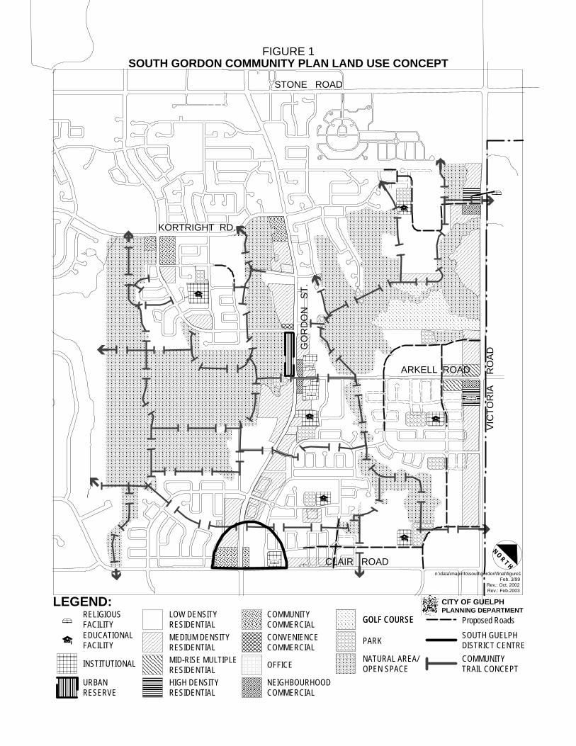
List of Figures Figure 1 Land Use Concept
Figure 2 Natural Heritage System
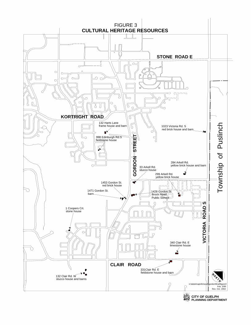
Figure 3 Cultural Heritage Resources
Figure 4 Transportation Concept
Figure 5 Old Brock Road Neighbourhood Special Policy Area “A”

- 1 -
SOUTH GORDON COMMUNITY PLAN
Adopted by Guelph City Council on March 15, 1999 Administrative Update February 14, 2002
1.0 Introduction
The South Gordon Community Plan is a City Council-adopted statement of policies that is intended to guide and direct future development activity and municipal works within the boundaries defined below in the Location Map. The Land Use Concept (Figure 1) provides guidance on the location of specific land uses. The Community Plan is intended to provide additional guidance on the implementation of the City of Guelph Official Plan. Together, these policy documents promote the public interest in the future development of the city while maintaining the quality of life for the citizens of Guelph. The Community Plan also reduces uncertainty concerning future development activity.
2.0 Location The boundaries of the South Gordon Community Plan apply to approximately 980 hectares (2400 acres) of land identified on the location map below. Approximately 400 hectares, 40% of the total land area, is comprised of natural heritage areas and open spaces. Kortright Road forms the northerly Boundary, for the most part, with the University of Guelph lands forming the Boundary in the northeast corner. The easterly boundary is formed by Victoria Road South. The southerly boundary is formed By Clair Road. The westerly boundary runs through the centre of the Hanlon Creek Conservation Area. SOUTH GORDON
COMMUNITY PLANSTUDY AREA
VIC
TOR
IA R
OA
D S
(
CLAIR ROAD
STONE ROAD
NORTH

- 2 -
3.0 Guiding Principals of the Community Plan
The following guiding principles are complementary to the Official Plan’s policies that encourage the development of a safe, healthy, diverse and efficient residential community: 3.1 Provide a balanced and integrated mixture of complementary land uses in
convenient locations to meet the daily needs of community residents. 3.2 Utilize the neighbourhood planning principle which provides a diversity of choices
and opportunities for residents to live, learn, work, shop, play, recreate, gather and worship within the community.
3.3 Maximize opportunities for the integration of different housing forms, tenure
(ownership/rental) and price suitable for individuals of all ages, household types and income levels within the community.
3.4 Promote the integration and mixture of land uses to provide employment
opportunities in proximity to residential neighbourhoods. 3.5 Encourage compatible development and intensification of under-utilized lands
while respecting existing established residential areas.
3.6 Promote sustainability by encouraging compact urban patterns and multiple residential building types which conserve energy, water and other resources.
3.7 Neighbourhoods should be connected to each other and to the rest of the city by
roads, pedestrian paths, bicycle linkages and transit routes to create a more accessible, convenient, safe and energy efficient environment.
3.8 Create an attractive entrance way into Guelph by promoting a high level of urban
and landscape design along the Gordon Street corridor.
4.0 General Policies
4.1 The South Gordon Community Plan shall conform to and implement the policies
of the City of Guelph Official Plan (see Section 15, Implementation). 4.2 The South Gordon Community Plan Land Use Concept (Figure 1) gives direction
on preferred land use locations. It is recognized that the location of roads, facilities and the boundaries of land use shown on the Land Use Concept are not exact. Specific locations will be determined as the Community Plan is implemented by various means including plans of subdivision, land severance and zoning by-law amendments. Minor changes in location of land uses and proposed roads will not require a Community Plan amendment.

- 3 -
4.3 Prior to development approval, any alteration, filling or construction within a
designated fill line, watercourse, floodplain, pond or wetland will require a Fill, Construction and Alteration to Waterway Permit from the Grand River Conservation Authority.
5.0 Natural Heritage System
5.1 Development within the Natural Heritage System and/or adjacent lands designation on Figure 2 will be subject to the policies of the Official Plan and the Community Plan.
5.1.1 The City of Guelph Environmental Advisory Committee (EAC) and the
City’s Environmental Planner shall be consulted on matters related to natural heritage resources identified on Figure 2 and will provide assistance in the review of environmental impact and related technical studies.
5.2 This plan recognizes that the watershed planning approach has been adopted by
City Council in the Hanlon Creek and Torrance Creek subwatersheds. These subwatershed studies provide recommendations for the protection, conservation, management, rehabilitation and monitoring of the natural environment. Planning studies and development proposals shall be required to incorporate the recommendations of the appropriate study to the satisfaction of the City of Guelph, Grand River Conservation Authority and other Provincial authorities (if applicable).
5.3 Where an environmental impact study is required for a proposal within the
boundaries of the Hanlon Creek or Torrance Creek subwatersheds, the policies of the Official Plan shall apply. In addition, development proponents will be required to follow detailed environmental impact study guidelines developed in conjunction with the Grand River Conservation Authority, other agencies and the community.
. 5.4 Where supported by an approved environmental impact study, minor
amendments to the boundaries of the Natural Heritage System will not require an amendment to this Community Plan. If a boundary adjustment is deemed appropriate by the City and the Grand River Conservation Authority, the adjacent land use designation would apply.
5.5 The Natural Heritage System is based on the recommendations of the Hanlon
Creek and Torrance Creek subwatershed studies. Reference should be made to the appropriate study for a detailed description of natural heritage features and their ecological function. This Community Plan recognizes the importance of retaining the identified Natural Heritage System and placing these lands in the appropriate Official Plan designations.

- 4 -
5.6 Natural Heritage System boundaries will be defined through an approved environmental impact study and shall have regard for the recommendations of the appropriate subwatershed study. As part of the impact assessment, the following information should be provided to assist staff in reviewing the appropriateness of proposed ecological buffers:
5.6.1 Identify and comment on the size, physical form and ecological function of
the natural heritage feature to be buffered;
5.6.2 Identify and comment on the land use proposed adjacent to the natural heritage feature and address the potential impact on the size, physical form and ecological function of the natural heritage feature;
5.6.3 Identify and comment on the proposed actions to minimize impacts, protect
and maintain the size, physical form and ecological functions of the natural heritage feature;
5.6.4 Specify the ecological function that the buffer will perform and determine
the actual buffer widths required to minimize impacts to the natural heritage feature;
5.6.5 Identify and comment on potential land uses (i.e parks, trails, storm water
management facilities) that could exist within the buffer area without creating a negative impact on the ecological functions of the natural heritage feature;
5.6.6 Propose procedures for monitoring the effectiveness of the buffer areas;
and,
5.6.7 Comply to the criteria in the Impact Assessment Guideline and the Management Strategy Table 6.3.2 for lands within the Torrance Creek Subwatershed limits.
5.7 Corridor study areas identified in the Torrance Creek subwatershed study shall be
subject to an environmental impact study on Figure 6.3.1 to further define their location, function, appropriate form and management technique.
5.8 The City shall, when reviewing development applications, encourage multiple-use
greenway corridors between the Hanlon Creek, Mill Creek and Torrance Creek subwatersheds and beyond the city limits to form a connected regional open space system.
5.9 Existing vegetation communities, wildlife habitat and natural heritage systems
should be incorporated into new development areas where appropriate. 5.10 Locally significant wetlands and upland woodlots are important components of
the natural heritage system. In addition, the Torrance Creek Subwatershed

- 5 -
study identifies three locally significant hedgerows that should be subject to further review. The limits and boundaries of these locally significant natural heritage features will be defined through an environmental impact study. Identified significant features will be reserved from development in public and/or private ownership.
5.11 A tree inventory report may be required to accompany development applications
identifying all individual trees (over 10 cm diameter breast height) and the species composition of groups of trees or hedgerows. This study shall address the feasibility of retaining desired trees and the protection measures to be implemented during construction.
5.12 The City will continue to provide resourceful and sensitive stewardship of
municipally owned open space. The City will also encourage interim land stewardship practices on private lands which will strive to maintain natural heritage features and functions on these lands prior to development.
5.13 Future development should be integrated with the existing landforms, where
feasible, to maintain the physical character of the area. 5.14 This Plan recognizes lands east of Gordon Street as being within the Arkell
Springs Water Resource Protection Area. In accordance with Official Plan policy, the City will ensure that all development and redevelopment meets Provincial water quality objectives for surface and groundwater and does not impair groundwater resources. The City may impose certain conditions on development and restrict specific land uses that may lead to groundwater contamination. The City, in consultation with the Province and the Grand River Conservation Authority, Township of Puslinch and the community, will develop a comprehensive groundwater protection program. Additional sensitive groundwater areas may be identified and will be recognized by an Official Plan amendment. Recommendations of the Hanlon Creek Watershed Plan and the Torrance Creek Subwatershed Study should also be considered by City staff in determining appropriate land use.
5.15 A monitoring program shall be prepared by the City of Guelph, in consultation
with the Environmental Advisory Committee, the Grand River Conservation Authority and appropriate Provincial Ministries for lands within the Torrance Creek subwatershed. An implementation committee will be formed and will develop the monitoring strategy for the Hanlon and Torrance Creek subwatersheds.
5.16 Developers within the Hanlon Creek and Torrance Creek subwatersheds will be
required to contribute toward the production of a stewardship manual and/or signage to advise future home-owners and interested parties of the natural heritage features and management strategy.

- 6 -
5.17 The Director of Planning or the Commissioner of Environment and Transportation may require submission of a technical study to assist in the review of a proposal where City staff does not have the required resources. This technical study will be at the development proponent's expense.
5.18 The City, in consultation with the development industry and the community,
intends to explore policy options regarding public acquisition priorities and appropriate compensation for lands that are identified as part of the natural heritage system and/or ecological buffers and/or wildlife corridors.
6.0 Cultural Heritage Resources 6.1 This Plan recognizes the importance of respecting our cultural heritage
resources which may include archaeological, built heritage, cultural heritage landscape and visual resources.
6.2 An archaeological assessment will be required as part of the development
application review process for lands identified by the Ministry of Culture and the City of Guelph as having archaeological potential as outlined on Schedule 3 of the City of Guelph Official Plan.
6.3 The Local Architectural Conservation Advisory Committee (LACAC) shall be
consulted in matters related to built heritage resources identified on Figure 3 and cultural heritage landscape resources identified by LACAC as part of the development review process.
6.4 Significant built heritage resources be incorporated into development plans
wherever possible. Consideration shall be given to providing an appropriate setting or context for the built heritage resource.
6 5 This Plan recognizes the importance of maintaining views and vistas to built
heritage and cultural heritage landscape resources. Planning staff may require applicants to demonstrate how views and vistas to built heritage resources will be maintained or enhanced as part of the development application review process.
6.6 This Plan recognizes the importance of maintaining open views to the natural environment. New development and redevelopment should provide physical and visual access to natural open space areas where possible. Planning staff may require a visual resource assessment to be completed by a qualified professional as part of the development review process in areas that have been identified as visually prominent.

- 7 -
7.0 Neighbourhood Design
7.1 A clearly identifiable public realm should be established in all new residential
areas expressed through interconnected network of streets, parks, school sites, community trails and natural heritage features.
7.2 Appropriate neighbourhood design should include measures to promote
pedestrian safety and comfort by providing a clearly defined public realm which is physically and visually accessible to all age groups and abilities.
7.3 Residential development should be designed in a manner that provides
opportunities for informal surveillance of all public parks and streets. Wherever possible, walking and bicycle paths should be visible, accessible and aligned along routinely used public spaces to increase opportunities for informal surveillance in order to maximize resident safety.
7.4 Community parks, neighbourhood parks, schools, places of worship and other
public functions should be placed in visually prominent, central and accessible locations to provide a neighbourhood focal point and gathering place. Providing a central green or common to complement these features in new residential areas is encouraged.
7.5 The physical design of parks, school sites and community trail systems will be
an integral part of the neighbourhood's identity. Public spaces should be distinctive and express the character of the neighbourhoods in which they are located.
7.6 Provide opportunities for both on-street and off-street parking adjacent to parks
with active recreation facilities as appropriate. The use of shared parking facilities between school sites and neighbourhood parks is encouraged.
7.7 New development shall be encouraged to provide physical and visual access to
parks and natural heritage features by incorporating sensitive site planning and arrangement of buildings and/or by visually terminating streets with parks or open space areas.
7.8 Neighbourhood design shall provide opportunities for views of important public
buildings, heritage buildings and other landmarks. Development should consider opportunities to provide new landmarks in the form of public art or by providing architecturally expressive buildings. Landmarks are important devices to provide orientation and aids in developing a unique community identity. The setting provided for public buildings, heritage buildings and landmarks should reflect the features' potential significance to the community.
7.9 The streetscape is a key neighbourhood design element which determines the
character of any neighbourhood. The City may require development proponents

- 8 -
to provide streetscape details and concept plans to assist staff in review of development applications.
7.10 Canada Post is encouraged to place community mailboxes in convenient
locations such as Commercial Centres and/or within a convenient walking distance to the majority of residents. Community mailboxes should be provided at least 9 metres from an intersection to reduce potential traffic conflicts. Lighting and accessibility to persons who are physically challenged should be provided for new community mailboxes.
8.0 Parks, Community Trails and Open Space 8.1 The exact size and location of Community and Neighbourhood Parks will be
finalized at the draft plan of subdivision application review stage. The City may request alternative and/or additional park locations be provided during the development review process without amendment to this Community Plan.
8.2 Parks should be located in central locations to maximize their accessibility to
residents and serve as focal points for passive and active recreation. Parks should be connected to bicycle and community trail routes which provide access to the overall open space system.
8.3 Lands intended for parks should be appropriately shaped to accommodate active
and/or passive recreational facilities to the satisfaction of the Commissioner of Community Services.
8.4 Parks will provide adequate street frontage to provide an inviting image, be
visible to potential users and provide informal neighbourhood surveillance. A minimum frontage of 50 metres or 1 metre/100 square metres, whichever is greater, should be provided along a public street and from the park's main entrance.
8.5 The City may wish to establish larger Community Parks in new development
areas by acquiring additional lands for park purposes beyond the amount provided for by parkland dedication.
8.6 Small parcels of land intended primarily for decorative horticultural display,
entrance features, traffic islands, intersection triangles and purposes other than community or neighbourhood park will not be accepted by the City as fulfilling parkland dedication requirements. The City may also require a developer to enter into an agreement to cover the additional costs of maintaining these features to the satisfaction of Commissioner of Community Services and the Commissioner of Environment and Transportation.
8.7 Where an individual development parcel is not suitable to accommodate a park,
the City may require cash in lieu of parkland dedication. In special circumstances,

- 9 -
consideration may be given to pooling parkland dedication requirement between multiple landowners.
8.7.1 To ensure that the best locations are used for neighbourhood and
community parks, the City, in consultation with the development industry and the community, may explore policy options related to cost-sharing between benefiting parties.
8.8 The City will continue, where feasible, to make all parks and recreation facilities
fully accessible to persons who are physically challenged. 8.9 The City and School Boards will explore opportunities for cooperative
development of public facilities. These shared facilities may include; play facilities, public libraries, sports fields, recreation centres, tennis courts, swimming pools and other facilities to be developed in conjunction with elementary or secondary school-sites.
8.10 All hazard lands, wetlands, locally significant woodlots and specified ecological
buffers, shall be reserved from development and shall not be accepted towards fulfillment of the required parkland dedication.
8.11 Linear greenway facilities intended for storm water management purposes may
be dedicated to the City but will not be accepted as fulfilling parkland dedication requirements.
8.12 Open space linkages should be established between the Hanlon Creek and Torrance Creek subwatersheds to provide visual amenity and recreational opportunities for residents. These open space linkages may also provide habitat and suitable movement corridors for wildlife. These linkages should make use of upland woodlots, hedgerows and other identified natural heritage features where appropriate.
8.13 The cost of primary walkway links providing direct access from residential areas
to schools, parks and transit routes shall be funded by the development proponent. Such primary links will be identified through the subdivision review process. All community trails and walkway links that are anticipated to be part of a school route shall be designed in a manner to accommodate snow removal equipment and snow storage.
8.14 An inter-connected community trail system is proposed to physically link
neighbourhood features such as schools, parks, places of worship, commercial and mixed use areas together. Linkages to other city-wide community trail systems and to trails within Puslinch Township are desired.
8.15 The ultimate trail routing, acquisition strategies, access points, design standards,
construction specifications, interpretive signage, off-street parking areas and

- 10 -
other community trail facilities and details will be determined through a comprehensive Community Trail Master Plan.
8.16 Community trails shall be designed and constructed in a manner that minimizes
impact on natural heritage features. Post-construction rehabilitation may include closing informal trails in sensitive areas and appropriate landscape restoration measures. Community trail linkages proposed in significant natural heritage areas may require further study prior to construction activity.
8.17 The City requires a minimum width of 6 metres be provided to accommodate the
community trail in existing built-up neighbourhoods. New development areas will be encouraged to provide a wider trail corridor of up to 15 metres to create an attractive setting. Bicycle trails should be clearly defined with signs and be wide enough to minimize bicycle/pedestrian conflicts.
8.18 Community trail routes will be staged in a manner which will discourage
trespassing, respect private property and the privacy of abutting owners. 8.19 This Community Plan recognizes that many of the proposed trails shown on
Figure 1 are on private lands and that dedication, acquisition and compensation will be explored in consultation with private landowners.
8.20 The Park symbol on Figure 1 west of the Gordon/Arkell intersection is intended as
a possible community trail facility. This general area could be considered a potential location for off-street parking and interpretive signage. In addition, this would provide a significant and protected view of the Hanlon Creek Conservation Area.
8.21 The City, in consultation with the development industry and the community,
intends to explore policy options regarding appropriate compensation for lands acquired by the City for community trail purposes.
9.0 Schools and Institutional Uses 9.1 The Community Plan and Official Plan promotes the adequate distribution of
school sites to meet the community's educational needs. Official Plan policy encourages the provision of new schools within a reasonable time period following the construction of new housing in the area. The City may require residential development to be phased where it is determined, in consultation with the School Boards, that there is not adequate supply of school spaces to accommodate the new population.
9.2 Future schools should be generally located as shown on the land use concept.
Exact location and size of school sites will be determined through the plan of subdivision review process. Minor location changes will not require an amendment to the Community Plan.

- 11 -
9.3 This Community Plan recognizes the potential for Brock Road Public School to
expand to meet future demand. An expansion will not require an amendment to the Community Plan.
9.4 The City, in cooperation with the Public and Separate School Boards, will
continue to explore opportunities for joint-use facilities, sites and buildings. 9.5 This Community Plan recognizes that the need for possible school sites is based
on population projections and student generation factors. It is recognized that a site reserved for a school does not ensure that a school will be built. Consideration of alternate land uses is encouraged for all proposed school sites during the plan of subdivision approval process. Implementation of the alternate land use would require a zone change amendment in the event that the school site is declared surplus by the School Board.
9.6 Neighbourhood-oriented institutional uses such as places of worship, day care
and recreation facilities may not be specifically shown on the concept but are permitted in all commercial, mixed use and residential areas in accordance with Official Plan policy. Development proponents are encouraged to provide sites suitable for institutional uses at appropriate locations identified on Figure 1.
9.7 Group homes, rest homes, nursing homes and other types of group
accommodations are encouraged in appropriate locations in accordance with Official Plan policy.
9.8 Neighbourhood institutional uses should either be located on public transit routes
or within a short walking distance to public transit. 9.9 All institutional buildings and their lands should be designed to be accessible to all
age groups and to people with special needs. 9.10 This Community Plan encourages neighbourhood institutional uses to develop in
proximity to each other and consider joint use of lands, parking and buildings wherever possible.
10.0 Residential
10.1 Residential development shall provide for a range of housing forms and densities in each neighbourhood that would be affordable to moderate and lower income households. Opportunities for mixing building types and lot sizes is encouraged in new neighbourhoods to satisfy diverse housing needs.
10.2 The City shall encourage development proponents to provide multiple residential
units in new plans of subdivision. Approximately 40% of new residential units within the South Gordon Community Plan boundaries should be multiple residential types.

- 12 -
10.3 Notwithstanding Community Plan policy 10.2, development proposals containing
25 units or less will not be required to provide multiple residential building types. 10.4 Development proponents in the Community Plan area are encouraged to provide
sites suitable for multiple residential apartments at appropriate locations. 10.5 The Community Plan land use concept indicates preferred locations for low
density, medium density, mid-rise multiple residential and high density multiple residential land uses. Notwithstanding the multiple residential locations identified on the land use concept, additional lands may be utilized for multiple residential uses without amendment to this Community Plan provided that the locations comply with Official Plan policy.
10.6 Low Density Residential land use permits single detached homes, semi-detached
homes, duplexes, accessory apartments, street-oriented townhouses and cluster townhouses at a maximum density of 35 units per hectare and a maximum height of three storeys.
10.7 Medium Density Residential land use category permits street-oriented
townhouses, cluster townhouses and apartment buildings at a minimum density of 20 units per hectare and a maximum density of 100 units per hectare.
10.8 Mid-Rise Multiple Residential land use category permits apartment buildings up to
a maximum of 100 units per hectare and shall comply with criteria established in the Official Plan.
10.9 High Density Residential land use category permits apartment buildings at a
density of 100 to 150 units per hectare and shall comply with criteria established in the Official Plan.
10.10 Public access between established and new neighbourhoods is encouraged in all
new development areas to facilitate circulation and promote neighbourhood integration. Multiple residential blocks may be required to provide a publicly-owned and accessible community linkage to facilitate circulation through the neighbourhood.
10.11 A sensitive transition in height and massing of buildings is recommended between
low density and multiple residential building types. Additional setback requirements and enhanced landscaping may be required to improve compatibility between building types.
10.12 Multiple residential building types shall be encouraged along arterial roads and
other appropriate locations where there is direct access to public transit service. 10.13 Consideration should be given to locating multiple residential building types
adjacent to natural heritage features to maximize passive outdoor recreation
- 13 -
opportunities for residents and provide opportunities for protected views to natural heritage features.
10.14 The residential portion of the South Gordon Community Plan is expected to
comprise of approximately 8100 to 8600 homes with an estimated population of 25,000 to 27,000 people when fully developed.
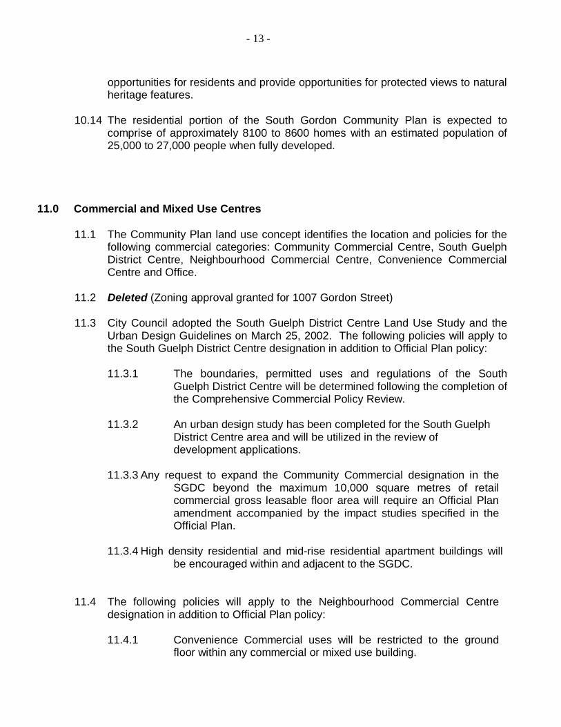
11.0 Commercial and Mixed Use Centres 11.1 The Community Plan land use concept identifies the location and policies for the
following commercial categories: Community Commercial Centre, South Guelph District Centre, Neighbourhood Commercial Centre, Convenience Commercial Centre and Office.
11.2 Deleted (Zoning approval granted for 1007 Gordon Street) 11.3 City Council adopted the South Guelph District Centre Land Use Study and the
Urban Design Guidelines on March 25, 2002. The following policies will apply to the South Guelph District Centre designation in addition to Official Plan policy:
11.3.1 The boundaries, permitted uses and regulations of the South
Guelph District Centre will be determined following the completion of the Comprehensive Commercial Policy Review.
11.3.2 An urban design study has been completed for the South Guelph
District Centre area and will be utilized in the review of development applications.
11.3.3 Any request to expand the Community Commercial designation in the SGDC beyond the maximum 10,000 square metres of retail commercial gross leasable floor area will require an Official Plan amendment accompanied by the impact studies specified in the Official Plan.
11.3.4 High density residential and mid-rise residential apartment buildings will
be encouraged within and adjacent to the SGDC.
11.4 The following policies will apply to the Neighbourhood Commercial Centre
designation in addition to Official Plan policy:
11.4.1 Convenience Commercial uses will be restricted to the ground floor within any commercial or mixed use building.

- 14 -
11.5 The following policies will apply to the Convenience Commercial Centre land
uses in addition to Official Plan policy:
11.5.1 The Convenience Commercial Centre shown on the land use concept shall be limited to a maximum commercial gross leasable floor area of 300 square metres.
11.5.2 Convenience Commercial uses will be restricted to the ground
floor within any commercial or mixed use building.
11.5.3 Office and institutional land uses are encouraged within Convenience Commercial Centre designation.
11.6 The following policies will apply to the Office designation in addition to Official
Plan policy:
11.6.1 Three office locations have been identified on the land use concept.
11.6.2 Multiple residential and institutional land uses will be permitted
within the Office without amendment to the Community Plan.
11.6.3 A Convenience Store with a maximum floor space of 300 square metres may be permitted on property municipally known as 1460-1474 Gordon Street.
11.6.4Additional office locations may be considered along the Gordon Street
corridor in appropriate locations. Offices should be located adjacent to non-residential or multiple residential uses, meet City standards for off-street parking and have appropriate access to a major road. Proposals will be evaluated on a site-specific basis as part of the development application process. Retail commercial uses will not be permitted within the Office designation.
11.7 Notwithstanding the residential land use designation in the Official Plan and
Community Plan, Brock Road Garage located at 1475-1483 Gordon Street is zoned C.1-18 and permits a "vehicle service station."
12.0 Transportation
12.1 The Transportation Concept (see Figure 4) provides general guidance on the
location of the main internal road network intended for the Community Plan area. Detailed implementation of new roadway geometries and traffic control improvements will generally follow the findings of the South Gordon Community Plan Traffic and Internal Road Network Review (1999) report prepared by Paradigm Transportation Solutions Limited. Other road alternatives generated by

- 15 -
development proponents may also be considered by the City during the development review process if accompanied with supporting studies.
12.2 Traffic impact studies may be required as part of the development review
process to address detailed intersection turning movements at arterial and collector intersections to confirm or refine preliminary intersection geometries, length of turning lanes and traffic control devices identified in the Traffic and Internal Road Network Review.
12.3 All plans of subdivision will provide appropriate pavement and right-of-way width consistent with the current City of Guelph standards. The functional classification of collector and arterial roads within the Community Plan are illustrated on Figure 4.
12.4 The City shall encourage driveways in new residential plans of subdivision to be
oriented in a manner that accommodates short term on-street parking. 12.5 A traffic noise attenuation study will be required to accompany any residential
development application adjacent to an arterial road. This study is to be prepared by a recognized acoustical consultant or a transportation consultant with expertise in noise attenuation. Appropriate attenuation measures shall be more precisely determined by the noise report to the satisfaction of the City and/or the Ministry of Environment. Where noise mitigation is required, the proponent shall explore available planning options and mitigation measures such as increased setbacks, intervening non residential land uses and revising the building/lot orientation on the proposal. Noise attenuation barriers are not recommended where other options are available to provide mitigation.
12.6 Direct vehicular access to Gordon Street, Clair Road and Victoria Road will be
limited to multiple residential and non-residential land uses. Multiple residential developments will be encouraged to direct their access to collector roads where appropriate. Adjacent non-residential development will also be encouraged to develop shared driveway access to minimize the number of driveways and to increase their spacing. The construction of turning lanes, at the expense of the developer/owner, may be required by the City for any multiple residential or non-residential driveway access to Gordon Street, Clair Road or Victoria Road.
12.6.1 Notwithstanding Community Plan policy 12.6, infill development
between two existing residences located along an arterial road may have direct vehicular access to the arterial road, at the discretion of the City, if a shared driveway is not practical in this location.
12.7 The City may consider incorporating traffic calming features into future plans of
subdivision at the discretion of the Commissioner of Environment and Transportation. The proponent shall provide the Works Department a report documenting the approach, type and location of controls to assist in the City's review. The City may also request documentation of similar proven examples of

- 16 -
these features and their technical details be provided. Traffic calming features shall be designed in a manner that does not restrict local truck delivery vehicles, public transit, school buses and emergency vehicles. Traffic calming requirements and devices should be designed in accordance with guidelines established by the Transportation Association of Canada and the Institute of Transportation Engineers (document pending publication). These features should not be restricted to intersections but should be provided at regular intervals (approximately 300 metres) on streets exceeding 300 metres in length.
12.8 Internal road networks will be designed in a manner that evenly distributes traffic throughout the neighbourhood along collector roads while discouraging through traffic on local residential streets.
12.9 The City is exploring options to establish a permissive truck routing policy to
direct truck traffic to routes which minimize impact on local residential streets. 12.10 Residential neighbourhoods will be connected to each other and to the rest of
the city by roads, pedestrian and bicycle linkages and public transit routes to create a more accessible, convenient, safe and energy efficient environment. An inter-connected network of streets is essential to provide for efficient movement of pedestrians, cyclists, vehicles and public transit in accordance with Community Plan principle 3.7.
12.11 The use of emergency vehicle access roads as a means to link two residential
areas will be discouraged if a road linkage is technically feasible and significant adverse impacts are demonstrated not to occur.
12.12 A continuous, connected, safe and attractive outdoor public realm will be
provided to facilitate pedestrian movement throughout the neighbourhood utilizing sidewalks along public roads, parks, community trails and natural greenway corridors. Walking distances between housing, schools, transit stops, parks, open space, shopping and other local destinations will be minimized by providing direct and convenient pedestrian linkages. All linkages will be constructed in an accessible manner in accordance with the City's barrier-free environment policy in the Official Plan.
12.13 The planning, design and construction of all roads and community trails shall
have regard for construction practices that minimize impact on natural heritage features.
12.14 Any road crossing of the community trail network may be subject to specific design studies to recommend measures to improve safety of trail users, signage, enhancement plantings and/or surface treatment. Such studies shall be undertaken by the development proponent to the City's satisfaction as part of the development approval process.

- 17 -
12.15 Bicycle lanes, routes and community trails will provide opportunities for utilitarian and recreational travel internally within the Community Plan area and along the arterial road network.
12.16 The City will provide public transit on a phased basis as the road connections
are established, the need arises and financial resources are available to expand transit services. Public transit routes are subject to change and may utilize local, collector and arterial roads. The public transit route will be designed to provide transit stops within 400 metres for 90 percent of residents.
12.17 All plans of subdivision, zoning by-law amendments and severances will be
evaluated on their ability to facilitate pedestrian and bicycle movement and provide direct pedestrian linkages to existing and potential public transit routes. Road connections or walkways to existing and future transit routes should be provided at a regular intervals of no greater than 200 metres.
12.18 Guelph Transit shall be consulted on the location of future bus stops and/or transit shelters during the development review process.
12.19 Multiple residential, institutional and other non-residential uses are encouraged adjacent to arterial roads and/or potential transit routes.
12.20 Gordon Street is recognized as an important traffic artery connecting Guelph to
Highway 401. An environmental assessment study will be undertaken to determine the need justification and alternatives to the proposed improvements to Gordon Street. As part of this study, alternative routes will be explored to re-distribute north/south traffic from Gordon Street to the under-utilized Victoria Road corridor and Hanlon Parkway.
12.21 Class environmental assessments and/or development applications shall address the appropriate location and means of accommodating the movement of wildlife across roads where linkages have been defined in a subwatershed study. The preferred option shall be appropriate for the identified wildlife species identified by an environmental impact study. Where feasible and appropriate, special traffic control measures such as changes in roadway texture, centre medians, road narrowing and signage may be used to slow vehicle speeds to facilitate wildlife crossing.
12.22 Gordon Street is also recognized as a visually prominent entrance way into
Guelph from Highway 401. As a component of the detailed engineering design for the Gordon Street improvements, streetscape design guidelines will be prepared by the City to address the following:
12.22.1 Establish detailed landscape requirements to maintain a sufficient
density of plant material for the continuous length of the street.

- 18 -
12.22.2 Establish appropriate setbacks and building form controls to ensure that buildings are set back from the street behind the required minimum planting areas.
12.22.3 Identify appropriate locations for property access, parking and loading areas.
12.22.4 Provide guidelines to co-ordinate signage and lighting design with landscape requirements for non-residential uses.
12.22.5 Provide detailed requirements for the safe and efficient movement of pedestrians, cyclists and public transit along and across Gordon Street. Preferred locations for pedestrian and transit amenities may also be illustrated.
12.23 Victoria Road forms the boundary between the City of Guelph and the Township
of Puslinch. New development along this road should provide a sufficient density of plant material for the continuous length of the street to provide an attractive visual buffer between the urban and rural municipality.
12.24 In re-development areas, the City may require a detailed local road network plan to demonstrate that new roads are in locations that would provide access to adjacent property owners over the long term. These plans are to be prepared by the development proponent. Alternatively, the City may proceed with this study or retain a consultant to prepare a detailed area plan at the development proponent's expense.
13.0 Municipal Services 13.1 The policies of the Official Plan set out the City's policies regarding the extension
of municipal services and staging of development. 13.2 The City of Guelph will guide the direction, location, scale and timing of
development in order to ensure a compact, orderly development form and to minimize the cost of municipal services and related infrastructure.
13.3 Pre-mature zoning of land will not be permitted for activities that do not have adequate municipal services. The City may consider the use of a Holding ("H") symbol where appropriate. Development will not be permitted which would negatively impact the City's ability to provide and/or extend municipal services in a logical and cost-efficient manner.
13.4 That in addition to Official Plan policy, the following policies related to storm water management (SWM) shall apply to the Community Plan area:

- 19 -
13.4.1 SWM facilities are permitted in all land use designations provided such facilities are integrated with adjacent uses in a manner acceptable to the City and Grand River Conservation Authority.
13.4.2 SWM practices shall address such concerns as quantity, quality, groundwater recharge, erosion/siltation control and other specified design requirements. General principles for SWM shall be determined by the City and Grand River Conservation Authority. Reference should be made to the targets established in the Hanlon Creek Watershed Plan and the Torrance Creek Subwatershed Study.
13.4.3 A detailed SWM and engineering report will be undertaken for any
development proposal subject to approval by the Grand River Conservation Authority and the City prior to registration of any individual plans of subdivision. This report will describe the specific techniques and best management practices required to address the quantity and quality issues of stormwater drainage to minimize environmental impacts and, where appropriate, propose methods for groundwater recharge. This report will be consistent with, and implement the recommendations of the appropriate subwatershed studies.
13.4.4 The stormwater management and engineering report shall include:
a) Detailed grading and drainage plans showing existing and
proposed drainage.
b) Geotechnical and hydrogeological information to identify infiltration potentials, to local and regional aquifers, of the site and surrounding area.
c) Detailed SWM plans, including the manner in which stormwater will be conveyed from the site to a receiving water body.
d) Erosion and sedimentation control measures to be employed
both during and after construction, including their required maintenance. These plans should indicate a means whereby exposed soils, sediments and eroded materials will be retained on site during all phases of construction and should be in accordance with current SWM practices.
e) The potential impacts of the proposed SWM techniques on
the water quality of the receiving waters in terms of, but not restricted to water temperatures, base flow and fisheries
- 20 -
potential, including recommendations on how any potential impact will be mitigated.
f) The potential impacts in terms of quality and quantity of any
SWM techniques on the regional aquifer and/or any municipal water sources connected to affected aquifer.
13.5 Stormwater management facilities will be provided in a manner which minimizes
impact and/or enhances the function of natural heritage features and conforms to the recommendations of the applicable subwatershed study.
13.6 Shared stormwater management solutions may be appropriate in
redevelopment areas to provide for the efficient use of land and to minimize long term maintenance costs.
13.7 Funds for all infrastructure and planning studies required to accommodate new
development in the South Gordon Community Plan area shall be provided through development charges, multi-party front-end agreements and/or direct payment from development proponents.
13.8 This Community Plan encourages all landowners wishing to develop small
parcels of land to consider submitting plans of subdivision in association with adjacent landowners and to consider entering into cost-sharing agreements for the required technical and planning studies.
13.9 All residences presently on private septic systems are encouraged to connect to
the municipal water and sanitary sewer (when available) through the Local Improvements Act procedure or any successor thereof.
14.0 Special Policy Areas 14.1 Special Policy Area A (Old Brock Road Neighbourhood)
14.1.1 In addition to the policies of this Community Plan, Special Policy
Area A applies to lands identified on Figure 5. Lands within the Policy Area Boundary will likely experience pressure for residential infill and re-development over several years. Stable Residential Areas, where limited re-development potential exists, have become established over the last 30 to 40 years. Residential infill that respects the existing scale and building orientation on the lot may be appropriate within the identified Stab/e Residential Areas. Re-development of Lands Adjacent to Stable Residential Areas should consider measures to enhance compatibility between new and existing buildings.

- 21 -
14.1.2 The City recognizes that the decision whether or not to develop an individual parcel is at the discretion of the owner. The Land Use Concept indicates preferred future land uses to guide re-development over the long term. Individual applications will be evaluated within the Policy Area Boundary on the basis of their own merits having regard for the Land Use Concept. Individual development applications will not be supported if they limit the City's ability to provide for the planned and orderly extension of municipal infrastructure and roads considering the long term development potential of this area.
14.1.3 New infill development within Stable Residential Areas identified on
Figure 5 should respect the physical character of adjacent buildings and "fit" into the neighbourhood by considering the following:
14.1.3.1 The height and massing of a new building introduced
into a Stable Residential Area should be compatible with the scale of existing buildings to contribute positively to unified streetscape. In general, a one-storey difference may be acceptable if the new building uses similar materials, finishes and proportions which help to blend in with existing homes.
14.1.3.2 New infill buildings should be oriented toward the
street and should have similar front yard setback as their immediate neighbours to maintain a consistent street edge. Where there is a variable front yard depth on the existing block, the front yard set back of an infill building should equal the average front yard setback on that particular block.
14.1.3.3 Consideration of alternative lotting arrangements building orientations may be considered if the overall visual impact is complementary to the existing homes on the street and/or is buffered by landscape materials.
14.1.3.4 Garages should not be located closer to the street than the front face of the building.
14.1.3.5 Residential infill development will be encouraged to
retain existing high quality trees to the extent possible.
14.1.4 Development on Lands Adjacent to Stable Residential Areas on
Figure 5 should consider measures to enhance the compatibility of

- 22 -
new uses adjacent to established areas by considering the following:
14.1.4.1 A transition in scale should be achieved between
new uses and existing homes. New buildings immediately adjacent to existing homes should be no more than one storey higher than the existing buildings. Recessing the upper storey also helps improve compatibility with the adjacent lower height buildings. From a neighbourhood compatibility perspective, it is important that similar housing forms face each other on the same street. Transitions in density, height and building type should occur at the rear property line.
14.1.4.2 Notwithstanding Policy 14.1.4.1, restrictions on height
shall not apply where new uses are buffered by significant mature vegetation or deep rear yard setbacks. Height restrictions would also not apply to interior units in new cluster townhouse developments, to new buildings along arterial roads or to new buildings adjacent to multiple residential and/or non-residential uses.
14.1.4.3 Residential re-development will be encouraged to
retain existing high quality trees to the extent possible.
14.1.4.4 Where multiple residential uses are proposed adjacent to a stable residential area, sensitivity to the surrounding context can be achieved by providing enhanced front, side and/or rear yard setbacks.
14.1.4.5 Multiple residential projects adjacent to stable residential areas shall provide landscaped buffer strips. Existing mature vegetation at the rear or side property lines shall be retained and protected from construction activity if feasible.
14.1.5 Planning and Environment and Transportation staff may initiate detailed
area plans within the Old Brock Road Neighbourhood, on a priority basis, subject to City priorities and budget constraints.
14.1.5.1 This Community Plan recognizes the requirement for
a future local road network to provide access to lands southwest of the Gordon Street and Arkell Road intersection and north of Lowes Road West. Prior to

- 23 -
the consideration of any development proposal in this area, at least one public meeting shall be held with neighbourhood residents to discuss and evaluate road network alternatives.
14.1.6 Roadside vegetation should be retained and enhanced to the extent
possible during construction activity intended to upgrade roads and provide piped infrastructure.
14.1.7 The Old Brock Road neighbourhood was annexed into the City of
Guelph in 1966. Typical urban amenities such as street lighting and sidewalks were not provided at time of development. Provision of these urban amenities within existing stable residential areas will be considered upon request from the neighbourhood in accordance with the Local improvement Act procedure or any successor thereof. However, new development on other lands within the Special Policy Area boundary and/or lands adjacent to an arterial road may be required to meet current City standards, where appropriate.
14.1.8 An "Urban Reserve" designation has been placed on a property at
the south-west corner of Edinburgh Road South and Gordon Street. The development proponent will be required to prepare an environmental impact study to determine the property's development potential for residential land use as set out in the Official Plan.
14.2 Special Policy Area B (Kortright Road East)
14.2.1 This Community Plan recognizes the requirement for a permanent road connection between Kortright Road East and Victoria Road. At present, specific details on the location and potential alignment of the future road connection are not available and are subject to change. These details will be finalized through the development review process. Landowners on Kortright Road East will be notified of future development applications affecting this road connection.
14.2.2 A Neighbourhood Traffic Management Plan should be initiated at an
appropriate time and in accordance with the Policy and Procedures for Initiating, Reviewing and Implementing Neighbourhood Traffic Management Plans. This study should include consideration of traffic calming/control measures in the vicinity of Macalister Park.
Note: The Special Policy Area affecting the South Guelph District Centre has been deleted with the Council adoption of the South Guelph District Centre Land Use Study and Urban Design Guidelines on March 25, 2002.

- 24 -
15.0 Implementation 15.1 This Community Plan recognizes that the Official Plan is the comprehensive
land use plan for the City of Guelph. 15.2 The policies and figures of the South Gordon Community Plan are intended to
provide additional and complementary guidance for future land development and municipal works within the Community Plan boundaries. These policies and figures provide additional detail or elaborate upon the general policies of the Official Plan.
15.3 The Community Plan is a Council-adopted long range policy document and is
intended to be maintained as a relevant policy guide through continuous monitoring, systematic review and periodic amendment.
15.4 Amendments may be initiated where deemed to be in the overall interests of the
City. Development applications which do not comply to the Community Plan policies and/or land use concept will require a Council approved amendment to the Community Plan.
15.5 A Community Plan review will be undertaken in concert with the regular five year
review of the Official Plan in order to remain consistent with the parent document and reflect refined land use boundaries.
15.6 Any person or public body may request that the City Council reconsider any
Community Plan policy by making a request to the City Clerk and Director of Planning. This written request must clearly state the reasons why a specific policy should be reconsidered by Council.
16.0 South Gordon Community Plan Land Use Concept
16.1 The Land Use Concept has been formulated based on general land use
planning principles, background studies, subwatershed studies and consultation with the public and prescribed agencies.
16.2 The land use and circulation pattern occurring in the Community Plan area will be based on this Land Use Concept. This Plan recognizes that the exact location of roads and land use boundaries will be refined as the Concept is implemented by development approvals in conformity with policies of this Plan.
16.3 Notwithstanding the multiple residential locations identified on the land use
concept, additional lands may be utilized for multiple residential uses provided that they comply with Official Plan policy.
16.4 "Religious Facility" is a symbol indicating the desirability of a facility in the general location. Other institutional uses and additional locations may also be appropriate and will not require a Community Plan amendment.

- 25 -
16.5 The "Golf Course" designation recognizes the existing Victoria West Golf
Course. This Plan does not restrict the existing permitted uses of the Victoria West Golf Course property.
G G
G
G
G
G
VIC
TOR
IA
RO
AD
ARKELL ROAD
CLAIR ROAD
STONE ROAD
GO
RD
ON
S
T.
KORTRIGHT RD.
SOUTH GORDON COMMUNITY PLAN LAND USE CONCEPT
LEGEND:
n:\data\mapinfo\southgordon\final\figure1Feb. 3/99
Rev.: Oct. 2002Rev.: Feb.2003
N O R T H
CITY OF GUELPHPLANNING DEPARTMENTRELIGIOUS
FACILITYEDUCATIONALFACILITYG
LOW DENSITYRESIDENTIALMEDIUM DENSITYRESIDENTIALMID-RISE MULTIPLERESIDENTIAL
Proposed Roads
FIGURE 1
INSTITUTIONAL
SOUTH GUELPHDISTRICT CENTRE
COMMUNITYCOMMERCIAL
OFFICE
NEIGHBOURHOODCOMMERCIAL
GOLF COURSE
PARK
NATURAL AREA/OPEN SPACE
CONVENIENCECOMMERCIAL
URBANRESERVE
HIGH DENSITYRESIDENTIAL
COMMUNITYTRAIL CONCEPT
GOLF COURSE

ARKELL ROAD
EDINBURGH ROAD
GO
RDO
N ST
REET
50m
50m30m
50m
50m30m30m
30m
30m
30m
30m
30m
30m
30m30m
30m
30m
30m
30m
HA
NLO
N
TORRANCEHANLON
CLAIR ROAD EAST
ARKELL ROAD
VIC
TOR
IA
RO
AD
GO
RDON ST.
GO
RD
ON
ST.
STONE ROAD
CLAIR ROAD WEST
KORTRIGHT RD.
HA
NLO
N P
AR
KW
AY
LEGEND:Torrance CreekNatural Heritage System
Provincially Significant Wetlands
Open Space Land Use Designation
Adjacent Lands (EIS) Required
Ecological LinkagesCorridor Study Areas
Locally Significant Woodlot
Watershed Boundary(approximate)
n:\data\mapinfo\southgordon\final\figure2Rev. Feb.3/99
Rev: Oct. 2002
NATURAL HERITAGE SYSTEMFIGURE 2
Locally SignificantHedgerows
Arkell Springs WaterResource Protection Area
CITY OF GUELPHPLANNING DEPARTMENT
N O R T H
284 Arkell Rd.yellow brick house and barn
1023 Victoria Rd. Sred brick house and barn
340 Clair Rd. Elimestone house
331Clair Rd. Efieldstone house and barn
Brock RoadPublic School
299 Arkell Rd.
33 Arkell Rd.
1428 Gordon St.
stucco house
yellow brick house
frame house and barn
fieldstone house998 Edinburgh Rd.S
132 Harts Lane
1453 Gordon St.red brick house
1471 Gordon St.barn
1 Coopers Crt.stone house
132 Clair Rd. Wstucco house and barns
KORTRIGHT ROAD
Tow
nshi
p o
f Pu
slin
ch
STONE ROAD E
GO
RD
ON
ST
REE
T
CLAIR ROAD
VIC
TOR
IA R
OA
D S
FIGURE 3CULTURAL HERITAGE RESOURCES
n:\data\mapinfo\southgordon\final\figure3Feb. 3/99
Rev. Oct. 2002
N O R T H
CITY OF GUELPHPLANNING DEPARTMENT

LEGEND:
COLLECTOR ROADSGOLF COURSE
NATURAL AREA/ OPEN SPACEFUTURE TRANSIT NODE
ARTERIAL ROADS
.
VIC
TOR
IA
RO
AD
ARKELL ROAD
CLAIR ROAD
GO
RD
ON
S
T.
KORTRIGHT RD.
STONE ROAD
.
FIGURE 4SOUTH GORDON COMMUNITY PLAN TRANSPORTATION CONCEPT
n:\data\mapinfo\southgordon\final\figure4Feb. 3/99
N O R T H
CITY OF GUELPHPLANNING and BUSINESS DEVELOPMENT
URBAN RESERVE

JENSON BLVD.
DR.
DR. ECLAIRFIELDS
HANEY
McGARRMcGARR
BEAV
ER
DR.MEA
DO
WD
R.
GO
RD
ON
ST
.
VALLEY RD.
LAN
DSD
OW
N
DR
.
HARTS LN. E
CRT.
MAL
VER
NC
RES
.
RIDGEWAY
GOR
DON
ST.
LOWES RD.
PINE DR. RIDGE
FARLEY DR.
DRIVEPORTER
CRES
CENT
CAR
RIN
GTO
N
FAR
LEY
DR
.
DRIV
E
RIC
KSO
N
AVE.
GEDDES
CRES.
TRUESDALE
VERSMITH.
DAW
N
AVE
.
IRVING CRES.
DR
.
HARTS LN. W
EDINBURGH RD. S
DARNELL RD.
CARRINGTON PL.
ROBIN RD.PARK
G
MILLER ST.
KETTLERIDGEPARK
AMALIA
CRES.
CUMMINGSCRT.
BUR
KE C
T.
CR
ES.
CAM
M
CR
ES.
BLAIR DRIVE
FARLEYDR.
OAKRIDGE CRES.
RO
BIN
R
D.
FALCONCIRCLE
ELDERBERRYCRT.
CR
T.
GO
RD
ON
S
T.
ARKELL RD.
AVE.
DR.
DR
.
GAW
PERIWINKLE WAY
PIN
E R
IDG
E
CR
T.
PINE RIDGEPARK
WESTMINISTER'A'
RO
EHAM
PTO
NC
RES
.
POR
TER
LOWES RD.
CLAIRFIELDS DR.E
EVAN
S
SPEN
CER
CRES.
DR. WCLAIRFIELDS
STABLE RESIDENTIAL AREAS
OLD BROCK ROAD NEIGHBOURHOOD SPECIAL POLICY AREA 'A'
LANDS ADJACENT TOSTABLE RESIDENTIAL AREAS
FIGURE 5
POLICY AREA BOUNDARY
URBAN RESERVE LANDS
n:\data\mapinfo\southgordon\final\figure5Feb. 3/99
N O R T H
CITY OF GUELPHPLANNING and BUSINESS DEVELOPMENT