south padre island’s beach access plan - texas … padre island’s beach access plan erosion...
TRANSCRIPT


South Padre Island’s Beach Access Plan Erosion Response Plan...................................................................................................Appendix 1 Beach User Fee Plan......................................................................................................Appendix 2

"
ORDINANCE NO. 05~-27 AN ORDINANCE OF THE TOWN OF SOUTH PADRE ISLAND, TEXAS, AMENDING CHAPTER 22 OF THE CODE OF ORDINANCES FOR THE TOWN OF SOUTH PADRE ISLAND (DUNE PROTECTION, BEACH RENOURISHMENT, AND BEACH ACCESS PLAN) IMPLEMENTING PROVISIONS) TO ALLOW AN EXCEPTION TO CONSTRUCTION SEAWARD OF THE mSTORIC BUILDING LINE; PROVIDING FOR SEVERABILITY AND REPEAL OF CONFLICTING ORDINANCES; PROVIDING A PENALTY NOT TO EXCEED $500.00 FOR EACH OFFENSE; AND AUTHORIZING PUBLICATION IN CAPTION FORM.
Whereas, the Beach and Dune Task Force has recommended approval of the proposed amendment to the Dune Protection, Beach Renourishment, and Beach Access Plan with Implementing Provisions which allows an exception to construction seaward of the Historic Building Line for Lots 1,2,3, & 4 of Block 156 at their January 24,2005 meeting; and
Whereas, the Board of Aldermen has received the recommendation and justifications of the Beach and Dune Task Force regarding this matter; and
Whereas, the Board of Aldermen has provided a sixty (60) day review and comment period to the General Land Office and the Office of the Attorney General regarding the proposed plan, as required by law.
NOW, THEREFORE, BE IT ORDAINED BY THE BOARD OF ALDERMEN OF THE TOWN OF SOUTH PADRE ISLAND, TEXAS:
SECTION 1: Chapter 22 of the Code of Ordinances for the Town of South Padre Island is hereby amended and republished in its entirety as more fully set forth in Exhibit "A" hereto attach~d.
SECTION 2: Tbis Ordinance repeals all portions of any prior ordiruinces or- parts of ordinances of the Code of Ordinances in conflict herewith.
SECTION 3: Any violation of the above-amended Chapter 22 of the Town of South Padre Island may be punished by a fine notto exceed Five Hundred Dollars ($500.00) for each offense, for each day such offense shall continue, and the penalty provisions of Section 21-1 of the Code of Ordinances is hereby adopted and incorporated for all purposes.
SECTION 4: If for any reason, any section, paragraph, subdivision, clause, phrase, word, or provision of this Ordinance shall be held unconstitutional by final judgment of a court of competent jurisdiction, it shall not affect any other section, paragraph, subdivision, clause, phase, word, or provision of this Ordinance, for it is the definite intent of this Board of Aldermen that every section, paragraph, subdivision, clause, phrase, word, or provision, hereof be given full force and effect for its purpose.
SECTION 5: This Ordinance shall become effective when published in caption or summary form according to law.
PASSED, APPROVED, AND ADOPTED on First Reading, this 20th day of April 2005.
PASSED, APPROVED, AND ADOP econd Reading, this ~ay Of~2005. ~y.. 1,/
.;::;. w;1
ATTEST: ~: * " WN OF SOUTH ISLAND
~ 0;:;:t ~ ,r:
~ .~ ~ iCt ADAMS, City Secretary ',/ * -w-O-B..:::Ec...:R"'-T--'-N-. .......IPINKE~-RL-...T-'O"N"', .... JR."-'--,+-MA-YOR
Dated 04111105 Page 2 of37

,.

, '
· .
Town of South Padre Island Dune Protection, Beach Renourishment, and Beach Access Plan
mSTORY.
1959 The 2nd called session of the 561h Texas Legislature passed the Texas Open .Beaches Act which guaranteed the public's right to use the beaches.
1973 The 63 rd Texas Legislature passed and enacted the Dune Protection Act, which allowed the Commissioner's Court of any county bordering the Gulf of Mexico and North of the Mansfield Ship Channel that has a barrier island or peninsula to establish a dune protection line on the Gulf Beach (Only Nueces and Brazoria counties established Dune Protection Lines) and the Coastal Public Lands Management Act of 1973, which set the stage for how, by whom, and for whom coastal public lands will be managed.
July 25, 1979 The Town of South Padre Island Board of Aldermen pass Resolution No. 91 which set forth the Town's policy in regards to the enforcement by the Office of the Attorney General, under the direction of Mark White, of the Open Beaches Act, the Dune Protection Act, and other state and federal agencies' control of the Laguna Madre.
September 3,1981 Letter from John W. Fainter, Jr., First Assistant Attorney General, representing the State of Texas written to then-Mayor Glen McGeHee, establishing a building line, commonly referred to as the Historic Building Line, for the Town of South Padre Island Beachfront Construction that would provide a minimum of two hundred feet of open beach above the mean low tide line according to then available data. The letter stated that the Attorney General could review the line and change it to ensure the protection of the State's open beaches. The line was located on a map (drawn by Chas R. Haile Associates, Inc., Consulting Engineers, Houston, Texas City, Corpus Christi, Nederland, and is dated March 1981) provided by the Texas Attorney General and is on file with the Public Works Department of the Town of South Padre Island.
1989 At the request of the 71 sl Texas Legislature, the General Land Office began coordinating the development of a comprehensive coastal management plan.
February 1991 The General Land Office, under the leadership of Garry Mauro, submits their Texas Coastal Management Plan to the nnd Texas Legislature recommending that the Dune Protection Act be amended.
June 7, 1991 Sections 61 & 63 of the Texas Natural Resources Code (i.e. the Open Beaches Act and the Dune Protection Act) were amended, requiring local governments along the entire Texas Coast to submit to more rigorous beach regulations as well as to develop and implement a Dune Protection Line, and Beach and Dune Management Plans.
September 9,1991 The Cameron County Commissioner's Court delegated to the Town the authority to establish and administer the dune protection line, and to implement a Dune Protection and Beach Access Plan within Town corporate municipal limits.
September 18, 1991 The Town of South Padre Island Board of Aldermen passed a Resolution establishing the Town's Beach and Dune Task Force, whose charge it is to carry forth the State's Coastal Management Plan.
November 11, 1991 First meeting of the Town of South Padre Island Beach and Dune Task Force.
September 21, 1992 The first draft Dune Protection Ordinance was recommended for approval by the Beach and Dune Task Force of the Town of South Padre Island.
October 13, 1992 The Town of South Padre Island Board of Aldermen approved, on second reading, the first draft of the Dune Protection Ordinance 161 - Dune Protection and Beach Access Plan (i.e. Chapter 22 of the Town's Code of Ordinances) and forwarded it to the GLO for review and approval.
Dated 04/11/05 Page 3 of 34

August 9, 1993 The Town of South Padre Island Board of Aldermen approved, on second reading, the amended Dune Protection Ordinance 16lA - Dune Protection and Beach Access Plan (i.e. Chapter 22) and forwarded it to the GLO for review and approval.
April 11, 1994 Ken Cross & Susan Theisen of the Environmental Protection Division of the Office of the Attorney General write a letter to then-City Manager Jim Chisholm detailing the Town's Public Beach Access plans from an April 7, 1994 workshop.
May 18, 1994 The Town of South Padre Island Board of Aldermen approved, on second reading, the further amended Dune Protection Ordinance 161 B - Dune Protection and Beach Access Plan (i.e. Chapter 22) and forwarded it, along with the Board-approved Comprehensive Beach Management Plan to the GLO for review and approval. .
October 5, 1994 The Town of South Padre Island Board of Aldermen approved, on second reading, the further amended Dune Protection Ordinance 161 C ~ Dune Protection and Beach Access Plan (i.e. Chapter 22) and forwarded it, along with the Board-approved and revised, Comprehensive Beach Management Plan tothe OLO for review and approval.
January 9, 1995 The Town of South Padre Island Beach & Dune Task Force reviewed and recommended approval of the first Beach and Dune Permit Application Guidelines, an informational handout for applicants.
July 1995 The General Land Office approved and certified the Town's Comprehensive Beach Management Plan. This plan allows for the following special provisions within the eroding section of the Town's beach: Padre Beach Section VITI and North: 1) Beach renourishment; 2) the construction of retaining walls if the applicant submits some type of financial guarantee to sec.ure the removal of the wall; 3) mitigation of critical dunes on a 1: 1 basis; 4) swimming pools will be allowed, but will not be considered "impervious"; and 5) the Town will submit annual reports monitoring the shoreline as well as quarterly progress reports on beach renourishment efforts.
October 20, 1999 The Town meets with General Land Office staff, under the Direction of newly elected Commissioner, David Dewhurst, to discuss Town Beach and Dune concerns. This meeting prompts the request for comments to revise General Land Office BeachlDune Rules as well as Town BeachlDune Regulations.
November 22, 1999 The Task Force recommends changes to the Town Board of Aldermen concerning the Town's Dune Protection and Beach Renourishment and Beach Access Plan.
December 15, 1999 The Town responded to the GLO's request for comments on suggested amendments to the GLO BeachlDune Rules, and gave preliminary approval to the proposed changes in Ordinance 99-20, amending Chapter 22, the Town's Dune Protection, Beach Renourishment and Beach Access Plan.
August 14, 2000 The Town is informed that the GLO understood the December letter and enclosures to be in response to requests for comments regarding OLO Beach/Dune Rules and not a formal request to update the Town of South Padre Island Dune Protection, Beach Renourishment and Beach Access Plan.
February 7,2001 The Board of Aldermen for the Town of South Padre Island review and approve another draft of the Town of South Padre Island Dune Protection, Beach Renourishment and Beach Access Plan on which the Beach and Dune Task Force had been working since August 2000.
February 8, 2001 The Town sends a copy of the draft plan to the GLO and the Office of the Attorney General requesting legal and technical advise on the proposed plan as allowed under § 15 .3( 0) of the Beach/Dune Rules.
July 11, 2001 The Town receives a response letter from the GLO regarding the proposed plan, stating their specific concerns and suggesting a meeting between Town representatives and State GLO staff.
August 15, 2001 The date of the Town's response to the July II, 200 I GLO letter. The Town requests a meeting between Town representatives and State GLO staff.
November 8, 2001 A joint meeting between representatives of the Town and the GLO takes place here on the Island to view areas of concern along the beach as well as to discuss significant points within the proposed plan.
Dated 041 I 1/05 Page 4 of 34

. '
"
January 28, 2002 The Beach and Dune Task Force review and recommend approval of the revised draft of the Town of South Padre Island Dune Protection, Beach Renourishment and Beach Access Plan.
February 6, 2002 The Board of Aldermen approved, on First Reading, the revised draft plan and ordinance. Staff forwards a copy to the state agencies for review and comment.
May 16,2002 The date of response from the GLO office expressing concerns with the Town's proposed plan that warrant further discussion.
June 26, 2002 The date of response from the Office of the Attorney General expressing concerns with the Town's proposed plan that warrant further discussion.
September 18, 2002 Receipt by the GLO of the revised Town of South Padre Island Dune Protection, Beach Renourishment and Beach Access Plan for technical review.
January 3, 2003 Jerry Patterson was sworn in as Land Commissioner of the Texas General Land Office.
February 20 & 21, 2003 The Town meets with representatives of the General Land Office to discuss the February 14, 2003 written comments from the GLO and other additional changes to the plan to facilitate State certification of the Town's plan.
April 28, 2003 The Beach and Dune Task Force recommend approval of the most recent draft with minor modifications.
May 7, 2003 The Board of Aldermen review and approve the revised Town of South Padre Island Dune Protection, Beach Renourishment and Beach Access Plan.
,January 24,2005 The Beach and Dune Task Force recommends the request to amend the Town of South Padre Island Dune' Protection, Beach Renourishment and Beach A.ccess Plan in order to allow the construction of a proposed retaining wall and townhQus.r. de.Y1'JQpment seaw,lrd oLtb_~cHistQJic_BlIilclj.llR--L.ine for LQ1LL. 2~'L<£:J..9J B!ocld 56.
February 2, 2005 The Board of Aldermen Yote in support of the plan amendmeHt to build seaward of the Historic Building Line for Lots 1,2,.3 &4 of Block 156 as shown in a survey exhibit includecl within the plan.
RENOURISHMENT ACTIVITIES. It was not until the late 1990's that the Town began significant beach renourishment efforts:
Year Feb.l997
Feb. 1999
May 1999
Dec. 2000
Feb. 2001
Jan. 2002
NOY.2002
Dated 0411 1/05
Material I source Dredge material / Brownsville Ship Channel
Dredge material / Brownsville Ship Channel
Sand off Highway 100 North of Town
Dredge material / Brownsville Ship Channel
Sand off Highway 100 North of Town
Sand off Highway 100 North of Town
Sand off Highway 100
Cubic Total Cost Cost to Pay Yards of Project EDC
489,211 $1,938,700 $ 661,259
494,766 $3,136,170 $ 55,388
41,628* TxDOT donated $ 22,565 men & equip to clear rd.
366,886 $2,277 ,893 $ 177,3 14
27,956* TxDOT / GLO CEPRA $ 3,200
23,895* $109,917 $ 3,125 ($4.60 / cu yd)
81,252* TxDOT / GLO CEPRA $ 9,411
Page 5 of 34

- Jan. 2003
Nov. 2002
Dec. 2004-,Jan 2005
North of Town
Dredge material! Brownsville Ship Channel
Dre(~ material! Brownsville Ship Channel
306,402 $1,097,900 (331,037= in-place yardage)
261.600 $1.4.95,000 -.f],??= in-pla~e yardage)~ __ _
* estimated yardages based upon Town count of 12 cubic yard trucks
"
$ 183,090
The first renourishment effort in 1997 deposited sand on the northern portions of the Town beach 3.5 to 4.5 miles north of the Jetties between Padre South condominium complex north to the Suntide II condominium complex. The renourishment event in February of 1999 took place on the southern portion of the Town beach approximately 1.5 to 2.25 miles north of the Jetties between the Radisson Resort north to Padre Grand. The renourishment project in May 1999 occurred because TxDOT needed to clear the portion of Highway 100 north of Town that had been covered by beach sand that had blown over the road in order to allow property owners access to their property. This blown sand was loaded and deposited on the northern portion of the Town's beach from the Tiki and White Sands St. area south to the Inverness. The Town's portion of the costs involved paying for half of the dump trucks and for two of the four front-end loaders.
The fourth renourishment activity, a dredging that began in December 2000, deposited sand on the north end of the island from the Bahia Mar south to roughly Starlight Circle beach access. The Federal Government paid the bulk of the costs for this activity (75%), the remaining 25% was split between the GLO via a CEPRA fund (75% of the remaining 25%) and the Town (25% of the 25%). The fifth renourishment activity in February of 2001 again used sand that had blown over Highway 100 and deposited that sand in the northern portion of the Town's beach from the Tiki I Whitesands St. area south to the Inverness, overlapping slightly in the area of the recent dredging. In this particular beach renourishment activity, the Town was required only to pay for the rental of a front-end loader ($3,200). TxDOT again used CEPRA funds the Town had received to pay for the cost of hauling the sand to the beach. The renourishment activity in January 2002 was hoped to have been another GLO ! TxDOT partnership within the CEPRA program to move approximately 40,000 cubic yards of sand. However, the GLO could not finalize the necessary paperwork in time, and TxDOT cancelled the project after paying the total cost to move 23,895 cubic yards of sand, which was placed on the northern portion of the beach between the Tiki I Whitesands St. area south to the Inverness. The cost to the Town (EDC) for this last project was $3,125 for the rental of one front-end loader.
In the fall of 2002 the Town began work on two renourishment activities. A cooperative partnership between the Town, Cameron County, the GLO through the CEPRA program, the Port of Brownsville, and the USACE facilitated the beneficial use of dredge material from the Brownsville Ship Channel during the months of November and December of 2002. This project deposited 331,037 cubic yards of material between Neptune Circle Beach access (Lighthouse Condominiums) north to Gay Dawn Circle Beach Access. Meanwhile, during the months of November 2002, December 2002, and January 2003, the Town worked closely with TxDOT and the General Land Office through a second CEPRA program project to move sand on Highway 100 onto the north end of the Town's beach, between the Inverness and the northern Town limits (La Quinta). These projects, combined, resulted in a noticeably wider beach on the north end of Town.
Dated 04/1 1/05 Page 6 of 34
, .

EXISTING CONDITIONS.
The most critical coastal management issues facing the Town involve erosion, beach nourishment, dune protection, and beach access. Erosion has long been an identified problem within the Town's four (4) miles of beachfront.
.:. l.6 miles of the Town's beach are eroding at rates averaging 8 feet/year. This area corresponds with Block #62 north to Andy Bowie Park. (University of Texas Bureau of Economic Geology, Open File Report 93-1) .
• :. 2.4 miles of the Town's beach are accreting at rates averaging up to 2 feet/year. This area corresponds with Block #62 south to the Town's southern limits at Isla Blanca Park.
15
10 •
•
-5 0.5 1.0 1.5 2.0
•
2.5 3.0
Distance from Jetty, mi
-Dec 1993 to Mar 2000 ~Historic Average (1937-1991)
3.5 4.0 4.5
Figure 1. Shoreline rate of change over 4 mile segment of South Padre Island, December 1993 to March 2000.
Figure 1 above, taken from report J90239 prepared by Shiner Mosely and Associates, Inc. in April 2000, shows a comparison of the historic shoreline change along the four miles of beach on South Padre Island with the short-term erosion that has occurred from December 1993 to March 2000. In addition, Figure 1 shows the erosion rates at various locations along the Island in relation to two (2) beach renourishment efforts that took place.
5.0
In the historic sense, accretion has occurred to the South since the construction of the jetties, which have helped trap sand and keep it within the Padre Island sand system, and erosion has taken place at a higher rate beginning approximately 2.75 miles from the jetties. Short term erosion rates (Dec 1991 to March 2000), however, show a different trend: the very southern portion of the Town's beach is
Dated 0411 1105 Page 7 of 34

eroding, the middle portion of the Island has seen sporadic accretion, and the northern-most portion of the Town's beach, although experiencing long-term erosion, the trend has reversed recently, at least since 1993, and accreted. This slowing of shoreline rates of change (i.e. erosion) and accretion of beach is assuredly due to the renourishment efforts that have taken place since 1997.
The general consensus is that the only realistic long-term solution, other than a building prohibition and retreat, is beach nourishment coupled with the building of dunes along the beachfront. The results of the Town's renourishment efforts, as shown by Figure 1 above, substantiate this consensus and show the positive results that beach renourishment efforts can provide. However, in planning these events, the Town must consider the tourist season and tIte type of visitors likely to be on the Island. The most desirable time of year for beach renourishment activities are the fall months of September through December, thereby dodging the spring and summer visitors, as well as the Winter Texan visitors who generally enjoy the Island during the months of January and February.
One practical source of beach nourishment material is from the maintenance dredging of the Brownsville Ship Channel which occurs about every two years:
.:. The distances from the dredge locations to the beach are within realistic pumping distances .
• :. The amount of dredge material within reasonable pumping distance appears to be more than required for nourishment - an average of 420,000 +/- cubic yards every 2 years or so .
• :. Maintenance dredging must occur and beach nourishment constitutes a positive use of this material, as compared to other alternatives .
• :. The dredge material is uncontaminated sand .
• :. The Federal Government has a program whereby they will pay 50% of the incremental cost of placing the material on the beach, if it can be shown that storm damage reduction benefits will offset the increased costs .
• :. The Town adopted Resolution No. 442 on December 1,1993 supporting beach nourishment and requesting all Federal, State, and local entities to support, fund, and assist in expediting the nourishment of the beaches of South Padre Island, Texas.
The second practical source of beach nourishment material is from the sand that blows over Highway 100 north of Town .
• :. The distances from the location of the sand to the beach are realistic distances to haul sand and adequate access is available for the required machinery .
• :. The amount of sand material drifting over the highway varies from year to year, but has provided adequate volumes to replenish the northern portion of the Town's beach .
• :. A TxDOT mandate requires that public roads remain clear and beach nourishment constitutes a positive use of this material, as compared to other alternatives .
• :. The drift material is uncontaminated, beach-quality sand:
Dated 041 I 1/05 Page 8 of 34

Detailed surveys of the beach within the Town's limits began in December 1993, and surveys of the beach have continued on a quarterly basis each year since. During the month of March, the entire length of the Town's beach is surveyed and in September, only 8000 feet of the Town is surveyed, as required by the agreement with the General Land Office. The first 1993 surveys revealed a number of characteristics:
.... £' Q) bIl
~ ..d U '+-< 0
~ <I)
.S ] 0
..d C/l
.:. The beach topography has been extensively shaped by the regular scraping of debris to fonn "dunes". A substantial amount of sand is contained in such "dunes" .
• :. Both topography"and bathymetry differ greatly between accreting/stable areas and eroding areas .
• :. In December 1993, of the 4 miles of the Town's beachfront, approximately 2.8 miles (70%) had retaining walls. Of these 2.8 miles of retaining walls, 1.9 miles were located within accreting/stable areas, and 0.85 miles were located within eroding areas.
60
50
40
30
20
10
0
-10
-20
-30
-40
-50
-60
0.5
Figure 2. Island.
1.0 1.5 2.0 2.5 3.0
Distance from Jetty, mi
3.5
..........
-Dec 1993 to Feb 1995 ..... Feb 1995 to Jun 1998
--Jun 1998 to Mar 2000
4.0 4.5
ShorelineVariability (rate of change) over 4 mile segment of South Padre
5.0
Figure 2 above, also taken from report J90239 prepared by Shiner Mosely and Associates, Inc. in April 2000, shows the variability of the shoreline from December 1993 to March of 2000. "As can be seen in the figure, the rate of shoreline change is highly variable with high rates of accretion followed by high rates of erosion at the same location depending on the interval of time examined. Because of this high degree of variability, the average rate for the total survey period should not be the only rate considered in beach nourishment planning and design. These short-term undulations can cause the shoreline to periodically move within closer proximity to beachfront structures. The structures are then exposed to increased risk of storm damage, particularly along northern areas where the beach is
Dated 04/11/05 Page 9 of 34

narrower and there is less of a buffer to dissipate wave energy." (pg.4, Shiner, Mosely and Associates, Inc., Report J90239, April 2000.)
In October 2000 the Town had +/- 27751inear feet of undeveloped beachfront property (-12 % of the 22,800 linear feet of beach) remaining. By January 2002, this number has diminished to +/- 2400 linear feet (Le. 10.5%). The Town understands that the purpose of the General Land Office's Beach AccesslDune" Protection Rules (31 TAC § 15.1 - 15.10) is to protect beach access and existing dunes from destruction caused by the development process, and when those conditions are threatened, the Town fully understands the need and rational to follow these regulations, but just a very small portion (10.5%) of the Town's heachfront is undeveloped, and of that portion that is developed, most of it had been developed prior to the Town's adoption of a Beach Management Plan in 1994.
The existing Beach and Dune Regulations, as well-intentioned as they are, do not adequately address the bulk of the Island's need: an appropriate permitting process/procedure that takes into consideration the fact that most of the construction needs of the Town's beachfront properties require only regular maintenance or landscaping activities - activities which do not require any form of disturbance east of the Town's Historic Building Line, and would therefore have no impact on the dunes east of that line, the drainage of the property, or the public's access to or use of the beach. The Town does not believe the original intention behind these regulations was to create a tedious permitting process for the maintenance of existing structures, but to protect the public'S right of free access to and along the beach, and the remaining undisturbed natural resources necessary in helping to protect and diminish the erosion of Texas beaches. The Town of South Padre Island strongly believes that this permitting process must balance the needs between the enhancement/construction of dunes with the property owners' right to get over the dunes and to the beach as well as to have a clear view of the beach.
With the above in mind, and pursuant 31 T AC § IS.3(a) of the General Land Office BeachlDune Rules, which allows local governments to adopt and implement a beach/dune program consistent with the requirements of the Open Beaches Act, Dune Protection Act, and 31 TAC §§ 15.1-15.10 of the beach/dune rules, the Town of South Padre Island submits this revised Beach Access, Dune Protection, and Beach Renourishment Plan with attached local plan implementing provisions.
BEACH MANAGEMENT PLAN.
The Town's beach and dune management plan has five primary components:
1. Beach Access.
The Town has provided twenty-four (24) public beach access points as defined in the Attorney General's letter dated April 11, 1994 and has worked with the Texas Attorney General to develop a Beach Access Plan that includes both immediate and future action.
Parking Improvements. The Town will provide head-in parking at the following unimproved cul-de-sacs: Ocean Drive, White Cap Circle, Riviera Circle, Treasure Island Circle, Gay Dawn Circle, Sapphire Circle, White Sands St., and Harbor St.
At the following partially improved cul-de-sacs, the Town will complete the paving necessary for parking: Gulf Circle, and Sea Island Circle.
The Town has provided additional access improvements which include: a) the marking of the designated parking areas on the South end of Gulf Blvd.; b) the realignment of certain portions of Gulf Dated 041 I 1/05 Page [0 of 34

Blvd. where conflict has occurred between public parking and private development; and c) studies regarding possible additional public infrastructure improvements at cul-de-sacs or other public access points.
Sign age. The Town will install signs at all 24 cul-de-sacs as improvements are made. Signs will indicate improvements (Le. handicap access), and may be phased in over time.
Impacts of Future Development. Future growth, especially along Gulf Blvd. has the potential to impact public parking. The Town will insure that any new development shall not interfere with and/or diminish public beach access, public beach use, and/or public parking.
South End Access. Access easements exist between the end of Gulf Blvd. and Isla Blanca Park. The Town has cooperated with the Attorney General to identify the owners of these easements.
Dune Walkovers. The Town has built dune walkovers to improve the access atthe following beach access locations:
Beach Circle Moonlight Circle Neptune Circle (handicap) Aurora Circle (stairs)
Seaside Circle (handicap) Bouganvillaea Circle Starlight Circle Good Hope Circle
Blue Water Circle (handicap) Poinsettia Circle Aquarius Circle. Fantasy Circle
The following beach access areas do not currently have walkovers, but the Town may install them depending on funding availability and need:
Harbor St. Circle Sea Island Circle Riviera Circle Gay Dawn Circle
Ocean Drive Circle Surf Circle Treasure Island Circle Sapphire Circle
Gulf Circle White Cap Circle Daydream Circle White Sands
On November 1, 1995, the Board of Aldermen adopted the following policy concerning private dune walkovers:
"Private dune walkovers attached to private property will be discouraged. Because a single- or two-family dwelling will not generate pedestrian traffic sufficient to warrant a dune walkover, singleand two-family dwelling will not qualify for private dune walkovers. For multiple-family uses, their proximity to a public beach access will be the primary consideration in evaluating the necessity for a private dune walkover. In all cases, properties and/or developments with direct access to a public beach access will be expected to utilize that access and a separate private dune walkover will not be I
allowed.
At their October 23,2000 meeting, the Beach and Dune Task Force expanded this policy to include:
"Since the idea of building dune walkovers makes no sense unless dunes exist to walk over, the Task Force will not recommend approval of applications for dune walkovers unless or until significant dunes exist on the beach side of the property to walk over, OR until the applicant submits plans to construct dunes, with vegetation, on the property east of the Historic Building Line. Part of the dune construction plans must address the width and height of the constructed dune. The Task Force will review the dune construction plan with the applicant and give feedback and suggestions. The Task
Dated 041 I 1/05 Page II of34

Force further encourages partnering between property owners in regards to dune construction and I or dune walkover construction and maintenance."
2. Dune Ridge Construction.
"
A study conducted by Robert A. Morton, Bureau of Economic Geology, The University of Texas at Austin: Beach and Dune Conditions at South Padre Island, Texas; Assessment and Recommendations; 1993; (pp 33-34), states that dune complexes ten to twelve feet (10' - 12') in height above sea level and seventy-five to one hundred feet (75' - 100') in width at the base should "survive most large storms and minimize the beach-front damage most frequently caused by direct wave attack", Therefore, the Town proposes a plan consistent with this philosophy in an effort to preserve and protect private property and the public beach. To be proactive in this matter, the Town will undertake efforts in cooperation with the General Land Office, TxDOT, the useE and lor any other agency or program, to construct a continuous dune ridge along the entire length of the Town.
The Town proposes the following general approach in regards to its Dune Ridge:
.:. Allow the construction of private retaining walls, but not seawalls, landward of the dunes and the Historic Building Line. The only exception to this rule is that construction seaward of the Historic Building Line may take place in the area shown on the survey labeled "Exhibit B" for Lots 1. 2, 3, & 4 of Block 156 Padre Beach Subdivision, Section X;
.:. Require financial guarantees by all those constructing private retaining walls behind the dunes;
.:. Construct a 75-100 ft wide dune system parallel to the shoreline and running the entire length of the Town. This dune ridge will be located between retaining walls within Town on the West, and the public beach on the East and average ten to twelve (10' - 12') feet in height above sea level;
.:. The Town will continue its program of raking/cleaning the beach, but should do so in a manner that will encourage and promote beach cleaning and dune construction while also coordinating this effort with property owners who appreciate this material. Long term remedies for beach cleaning rely on the cooperation between the Town and private property owners;
.:. Use a combination of existing sand in dunes presently seaward of existing walls and new beach nourishment material to build the dunes and to maintain a recreational beach seaward of the dunes;
.:. The Town promotes the recreational use of the beach and encourages, but does not require, these recreation activities to occur on the wet portion of the sand (recreational beach) east of the dune ridge and line of vegetation in an effort to protect the dunes and dune vegetation .
• :. The Town endorses the concept to enhance and improve the Town's continuous dune line and will allow property owners to haul in beach quality sand to construct dunes in barren and low-lying areas. And since vegetated dunes are a primary component to dune ridge stabilization and beach renourishment, revegetation of bare dunes /newly
Dated 041 I 1/05 Page 12. of 34
"
constructed dunes with indigenous dune vegetation is strongly encouraged. Both activities can be accomplished with a City Manager or designee approved permit as long as the proposed activity does not restrict or interfere with the public's access to the beach or use of the beach at normal high tide .
• :. The Town endorses the concept of Town-sponsored activities to alter existing dune shape and size where a complete dune ridge construction plan has been reviewed and approved by the Town, the General Land Office, and the Office of the Attorney General. In such cases, the plan must meet the following criteria: 1) the height of the existing dune(s) is/are greater than fifteen feet (15') in elevation; 2) an affirmative demonstration can be made that substantial dunes would likely form naturally in the area of the proposed dune ridge construction project; 3) the project demonstrates equal or better protection with the proposed dune ridge construction plan; 4) the adjacent littoral property owner(s) provide written consent for the proposed dune ridge construction project; and 5) the adjacent littoral property is in compliance with previously issued and approved Beach and Dune permits;
.:. In such instances that the shape and / or size of the existing dune(s) are altered: 1) the Town shall ensure that all sand seaward of the Historic Building Line remains in the beach/dune system; 2) the height of the altered dunes seaward of the Historic Building Line can be no lower than ten foot (10') in elevation; 3) the altered dune(s) must be vegetated with indigenous dune vegetation and watered to stabilize the dune(s); and
·4) the project shall not restrict or interfere with the public's access to the beach or use of the beach at normal high tide .
• :. The Town encourages cooperation and partnering between adjacent property owners in the maintenance of dunes/ dune heights as well as the design of dune walkovers in an effort to reduce the need and number for walkovers at every beach-front structure; and,
.:. The Town shall provide local funding with the Y2 cent EDC sales tax and other sources.
NOTE: All Dunes Seaward of the Dune Protection Line are Critical Dunes.
3. Beach Nourishment.
The Town will continue to undertake beach nourishment efforts, in cooperation with the General Land Office and the USeE under the Section 933 program andlor other appropriate program, to widen the beach in the eroding areas and to use a portion of these materials to construct a continuous dune ridge along the entire length of the Town. The Town, with the cooperation of TxDOT, will utilize the sand that drifts over Highway 100 as well as any other acceptable beach nourishment sources and resources.
The Historic trend of erosion (as seen in Figure #1) and the increase risk to beach-front structures associated with the temporary shoreline undulations (as seen in Figure #2), demonstrate that future renourishment projects should be concentrated north of Esperanza Street, along the northern portions of the Town's beaches. Placement of renourishment material south of Esperanza Street should probably be done if funding is not available for placement further north OR when funding is available
Dated 0411 1/05 Page 13 of 34

to renourish this area in addition to the northern beaches of the Town. However, the Town should continue to monitor the beach erosion pattern to assure that the southern portions of the Town's beaches are not neglected.
The Town recognizes that any long term remedy will have to rely on an ongoing Beach Nourishment Program that:
.:. Uses beach quality material from any and all acceptable sources .
• :. Since vegetated dunes are a primary component to dune ridge stabilization and beach renourishment, revegetation of bare dunes is strongly encouraged;
.:. Will require significant local funding even with the help of Federal Section 933, Coastal Erosion Planning & Response Act funds, and other federal grant programs; and
.:. The Town must comply with all applicable State and Federal laws.
The funding for Town Beach Renourishment projects may be provided by the existingYl cent EDC sales tax~ grants for which the Town may apply and receive; or, if required, additional revenue from the general fund and/or from a general obligation bond issue.
4. Local Planning Policies and Guidelines.
The Town's goal is to provide compliance under the state program, provide equal and consistent application of rules and regulations for all beachfront properties within the Town, and yet protect thc pr-ivate property owner from extravagant permitting procedures for regular maintenance and landscaping activities. In order to provide consistency regarding the local permitting procedure within Town limits, the Town will the follow the additional policies and guidelines below:
Major Regulatory Provisions .
• :. Final authority over permits lies with the Board of Aldermen; however, the Beach and Dune Task Force has been established to make recommendations for Beach and Dune Protection Permits .
• :. The Dune Protection Line is designated as the east right-of-way of Gulf Boulevard and the extension north and south thereof or 1000 feet from Mean High Tide whichever is lesser .
• :. A Beach and Dune Protection Permit is required for activities seaward of the Dune Protection Line if such activities impact dunes or dune vegetation .
• :. Beach and Dune Protection Permits can be issued only if the action will not materially weaken any dune or dune vegetation, or increase flooding, etc. If damage cannot be avoided, then it must be minimized, and then any resulting damage must be compensated for by the permittee .
• :. Beach and Dune Protection Permits for construction are issued only if the proposed action will not interfere with the public access to the beach as provided for in the Open Beaches Act.
Dated 04/11/05 Page 14 of 34

The special regulatory provisions under this Plan are structured to allow for compliance under the sta coastal program.
Special Provisions within the Town as provided by this Plan and these Policies .
.. :. No construction will take lace seaward of the Historic B uildin Line exce t, shown all the surve s labeled Exhibit "B" for Lots 1 2 3 & 4 of Block 156 Beach Subdivision, Section X.
.:. Property owners will be permitted to build retaining walls, but not seawalls, across the beach side of their property which may connect with adjacent walls subject to other requirements of State Law and the following 'conditions:
• The property owner will be requIred to remove any wall that is exposed to substantial wave action for 20 days out of any 30 consecutive days except following major storm events (tropical storms, hurricanes, etc.) in which case, the owner will be given additional time to determine compliancy, as determined by the Town and State agencies;
• Such removal will be at the property owner's expense;
• The Town will require property owners to either agree to a deed covenant or other suitable financial guarantee acceptable to the Town to secure removal of the wall; and
• If the property owner fails to remove the wall, the Town will remove the wall and assess the cost against the financial guarantee .
• :. Swimming pools will be allowed to be installed with concrete, but their footprint will not count against the 5% impervious area allocation .
• :. Ecocreto, a pervious concrete, will be an additional allowable pervious material that beachfront property owners may use to reduce the amount of impervious surface within the dune protection area .
• :. Along the East Right of Way of Gulf Boulevard and seaward, all dunes are critical.
.:. Mitigation for any critical dune alteration will be required on a 1: 1 basis with all material above the ten (10') foot elevation going East of the Historic Building Line (except for Lots 1,2,3, & 4 of Block 156, where the sand mllst be placed seaward of the retaining wall), preferably on the subject property .
• :. The Town will strive to undertake and fund beach nourishment in this area approximately every two years .
• :. The Town will continue to provide a semi-annual monitoring of the shoreline and beach (plus an additional post-hurricane monitoring) as well as progress reports on the beach nourishment efforts .
• :. In order to facilitate a continuous dune line, the Town may sponsor activities to alter dune shape and size as detailed under 2. Dune Ridge Construction on pages 11 through 13 of this plan.
Dated 041 II 105 Page 15 of 34

·:. A primary goal of this Plan is to create an expedited permitting process whereby the City Manager or Designee of the Town of South Padre Island has the authority to issue permits for certain designated beach/dune related items without having property owners go though the extensive review period normally required for new construction. None of the following permits may be issued by the City Manager or designee if the proposed activities will: 1) increase or alter the footprint of the existing structure; 2) increase the impervious surface on the property; 3) adversely affect dunes or dune vegetation; or 4) impact the public's access to the beach or use of the beach at normal high tide along, the beach. This expedited permitting process would be available for the following activities:
1) Maintenance activities of existing properties between the east right-of-way line of Gulf Boulevard to the Historic Building line that result in no net increase in impervious cover. (Le. Property Maintenance Permits)
2) Minor construction projects on pre-developed properties between the east right-of-way line of Gulf Boulevard to the Historic Building Line that result in no net increase in impervious cover, and no increase in the footprint of existing structures such as installation/construction of fences, open wooden decks, spas, swimming pools, landscaping features, installation of sprinkler systems. (Le. Property Maintenance Permits)
3) Special Event permitting for activities that occur on the public beach. The duration of this permit will be for no greater than thirty (30) consecutive days and the permitting procedure will be compatible with Town Special Event
. ·--·---~-ordlllance(s) as well as WIth normal beach and recreation activities, and is intended to include weddings, anniversaries, and other occasion parties; Spring Break-type activities which may require the construction of stages and towers; the setup of tents and inflatables for outdoor displays; as well as other sport-related events. These permits can be issued for special events seaward of the Historic Building Line but only if the action will not materially weaken any dune or dune vegetation, block access to or on the beach, or increase flooding. Copies of Special Events Permits issued by the Town will be sent to the General Land Office and the Office of the Attorney General for their files.
4) Town-sponsored beach re-nourishment activities;
5) Retaining Wall/Walkway Maintenance Permits to move sand that has accumulated within ten (10') feet of an established retaining wall or dune walkover if it is determined that the proposed activity: a) is purely maintenance of existing facilities and not new construction; b) has no impact; and c) does not cause any sand to be removed from the beach.
5. Compliance with Local and State Reiulations.
The Town will implement State mandated coastal management using the following approach:
Dated 04/11/05 Page 16 of 34
All proposed actions within the Town will be handled in a manner consistent with this plan that will emphasize implementation of beach nourishment, required mitigation, and allow development in the interim with mandatory removal requirements if erosion reaches any walls. The Town will enforce the various components of this management plan by Ordinance - Chapter 22 of the Town of South Padre Island Code of Ordinances (attached) - as well as other rules and regulations referenced in the Plan and the Ordinance.
Responsibilities
The successful implementation of The Town's Plan will require the concerted, cooperative effort of both the public and private sectors.
Local Government
• Seek renewed acceptance and certification under the State Coastal Program. • Provide substantial, ongoing funding commitment. • Enforce the agreed-upon codes and requirements. • Agree to remove any walls that are subject to substantial wave action 20 days out of any
30 days (except following a major storm event, such as a hurricane or tropical storm) and adopt an ordinance requiring all property owners to agree to such a deed covenant or other financial guarantee.
State Government
• Approve the overall approach, including the Master Planned approach within the Town -~---~~- ---+im-$-;---~~~~~--~---~--~-~
• Monitor local activities to insure compliance with overall agreements. • Provide technical assistance and support for the beach nourishment project. • Provide maintenance material from aU available sources.
Federal Government
• Provide maintenance material from all available sourceS. • Provide matching funds under USCE Section 933 Program, and other federal grant
programs. • Provide technical assistance in the planning and design of the Town's Beach
Nourishment Program.
Private Sector
• Recognize that under current state law, the Town must meet State requirements, and support the Town in its dealings with the State.
• Accept that there will be a change in beachfront developments. • Realize that costs will go up. • Work with neighboring property owners to build and maintain a continuous dune line.
Dated 04/11105 Page 17 of 34

CHAPTER 22
DUNE PROTECTION, BEACH RENOURISHMENT, AND ACCESS PLAN IMPLEMENTING PROVISIONS
Sec. 22-1. DEFINITIONS.
For the purpose of this ordinance, the following words and terms as used herein are defined to mean the following: .
"Beach Access and Use Plan" shall be that plan that is adopted by the Town of South Padre Island pursuant to 6l.015 of the Texas Natural Resources Code (i.e. this document).
"Beach & Dune Protection Permit" means a permit that is required for all construction activities East of the Dune Protection Line, and which requires the full review and approval of the General Land Office, the Office of the Attorney General, the Beach and Dune Task Force, and the Board of Aldermen.
"Beach and Dune Task Force" means an advisory body consisting of seven (7) individuals appointed by the Board of Aldermen whose task shall be to review and make recommendations to the Board of Aldermen regarding Beach and Dune Protection permit applications and the Beach Access Plan.
"Coppice Mounds" means the initial stages of dune growth formed as sand accumulates on the downwind side of plants and other obstructions on or immediately adjacent to the beach seaward of the foredunes. Coppice mounds may be unvegetated.
"Construction" means causing or carrying out any building, bulk heading, filling, clearing, excavation, or substantial improvement to land or the size of any structure. "Building" includes, but is not limited to, all related site work and placement of construction materials on the site; however, "Building" does not include maintenance activities. "Filling" includes, but is not limited to disposal of dredged materials. "Excavation" includes, but is not limited to removal or alteration of dunes and dune vegetation and scraping, grading, or dredging a site. "Substantial improvements to land or the size of any structure" includes, but is not limited to creation of vehicular or pedestrian trails, landscape work (that adversely affects dunes or dune vegetation), and increasing the size of the structure.
"Critical Dune Area" means those portions of the beach/dune system as designated by the Texas General Land Office, that are located within 1,000 feet of mean high tide of the Gulf of Mexico that contain dunes and dune complexes that are essential to the protection of public beaches, submerged land, and State-owned land, such as public beaches and coastal public lands, from nuisance, erosion, storm surge, and high wind and waves. Critical dune areas include, but are not limited to, the dunes that store sand in the beach/dune system to replenish eroding public beaches. Specifically within the corporate municipal limits of the Town of South Padre Island, Critical Dune Areas encompass the undeveloped portions of the Town East of the right-of-way of Gulf Blvd. and the extension thereof, or 1000 ft West of mean high tide, whichever is lesser.
Dated 04/11/05 Page 18 of34
"Damage to Dunes" means any unauthorized alteration to dunes or dune vegetation.
"Designated Beach Access Areas" means all dedicated street rights-of-way abutting the Gulf of Mexico and any other dedicated beach access route(s) that may be designated as a beach access area.
"Dune" means a natural or man-made emergent mound, hill, or other ridge of sand either bare or vegetated, located on land which is adjacent to the waters of the open Gulf of Mexico.
"Dune Enhancement Permit" means a permit issued by the City Manager or designee after the applicant has satisfied the Town that the proposed activities will only elevate dune height and/or promote dune vegetation propagation; will not negatively impact or alter existing dunes and/or dune vegetation; and is consistent with the Town's plan to create a continuous dune line.
"Dune Protection, Beach Renourishment, and Access Plan Ordinance" means Chapter 22 of the Town of South Padre Island Code of Ordinances.
"Dune Protection Line" means a line established within the Town of South Padre Island that shall be the East right-of-way of Gulf Blvd and a line extended therefrom to both the North and South boundaries of the Town, or a line 1,000 feet landward from mean high tide, whichever is lesser.
"Dune Ridge Construction" means those Town-sponsored and authorized activities involved solely with modifying the shape and/or size of dunes andlor dune vegetation east of the Historic Bllilding Line. In those instances \Vpexe dU!1~_heigp~s_ anci{oLdtl!!e yeg~t~ti()n~reQrQP()s~(L tQJ~~_ . elevated and/or enhanced, the City Manager or designee is given the authority to permit the activity. However, in those instances where dune height(s) andlor dune vegetation is/are proposed to be reduced, the property owner will be required to submit an application for a Dune Ridge Construction Permit that will be reviewed and approved by the Town, the General Land Office, and the Office of the Attorney General.
"Erosion" is the wearing away of land or the removal of beach andlor dune material by wave action, tidal currents, littoral currents or deflation. Erosion includes but is not limited to horizontal recession and scour and can be induced by human activities.
"FEMA" means the Federal Emergency Management Agency of the United States Government. This agency administers the national Flood Insurance Program and the Flood msurance Rate Maps.
"Foredune" means those dunes which offer the first significant means of dissipating storm generated wave and current energy ensuing from the open Gulf of Mexico. Because various heights and configuration of dunes may perform this function, no standardized physical description can be offered. However, where they occur, foredunes are distinguishable from surrounding dune types by their relative location and physical appearance. Foredunes are the first distinguishable, usually grasscovered stabilized large dunes encountered landward from the open Gulf of Mexico. Although they may be large and continuous, foredunes are typically hummocky and discontinuous, and are often interrupted by breaks and wash over channels.
Dated 041 I 1/05 Page 19 of 34
"GLO" means the General Land Office of the State of Texas.
"Historic Building Line" shall mean that line established by the Texas Attorney General that indicates the buildable depth line-for the construction of buildings or structures on or to the landward side of the line. The only exceptions to construction seaward of this line shaH be that area designated in the survey labeled "Exhibit B" for Lots 1,2,3, & 4- of Block 156 Padre Beach Subdivision, Section X. &leh The Historic Building Line is located on a map (drawn by Chas R. Haile Associates, Inc., Consulting Engineers, Houston, Texas City, Corpus Christi, Nederland, dated March 1981) provided by the Texas Attorney General and is on file with the Public Works Department of the Town of South Padre Island. The line was intended to retain a minimum of two hundred feet of open beach above the mean low tide line according to then available data and is subject to change by the Attorney General to ensure the protection of the State's open beaches.
"Line of Vegetation" means the extreme seaward boundary of natural vegetation which spreads continuously inland.
"Maintenance (Maintenance Activities)" means those activities involved with repairing and/or renovating existing structures and those that do not alter or increase the foot print of existing structures, increase the impervious surface on the property, impact the public's access to or use of the beach, or adversely impact dunes and/or dune vegetation. Maintenance activities include, but are not limited to: repairing or replacing siding, steps, roofs, windows, doors, fences, sidewalks, landscaping. Maintenance activities will require a Property Maintenance Permit.
"Manufacture" means something made from raw t?at~~ials b)'~an~. or .. by ~llchine~_Ji,-e. anYthing man-made).
"Practicable". In determining what is practicable, the Town shall consider the effectiveness, scientific feasibility, and commercial availability of the technology or technique, as well as the cost of the technology or technique.
"Property Maintenance Permit" means a permit which is required for all maintenance activities East of the Dune Protection Line that can be issued by the City Manager or designee without the necessary review of the General Land Office, Office of the Attorney General, Beach and Dune Task Force, and the Board of Aldermen.
"Public Beach" means any beach bordering on the Gulf of Mexico that extends inland from the line of mean low tide to the natural line of vegetation bordering on the seaward shore of the Gulf of Mexico, or such larger contiguous area to which the public has acquired a right of use or easement to or over by prescription, dedication, or estoppel, or has retained a right by virtue of continuous right in the public since time in memorial as recognized by law or custom. This definition does not include a beach that is not accessible by a public road or ferry as provided in Section 61.021 of the Texas Natural Resources Code.
"Retaining Wall" means a stlUcture designed primarily to contain material and to prevent the sliding of land.
Dated 04111/05 Page 20 of 34
"Retaining Wall / Walkway Maintenance" means those activities that result in the raking and/or moving of debris, litter, trash and non-vegetated sand that has accumulated in designated walkways or within ten (10) feet of an established retaining wall or fence. Retaining wall / Walkway maintenance activities shall not be construed to allow excavation, trimming or disturbance of natural dune formations seaward of the dune protection line or the removal of sand, either temporary or permanent, from the beach/dune system within the Town.
"Retaining Wall / Walkway Maintenance Permit" means a permit which is required for all retaining wall/walkway maintenance activities East of the Dune Protection Line that can be issued by the City Manager or designee without the necessary review of the General Land Office, Office of the Attorney General, Beach and Dune Task Force, and the Board of Aldermen.
"Structure" includes, without limitation, any building or combination of related components constructed in an ordered scheme that constitutes a work or improvement construction on or affixed to land.
"Seawall" means a manufactured embankment located along a shoreline designed and engineered specifically to withstand flooding and wave action. Seawalls are not authorized east of the Town's Dune Protection Line.
"Town" means all area within the corporate municipal limits of the Town of South Padre Island, Texas.
"Washover" means local areas that channel hurricane flood tide across barrier islands and peninsulas into bay areas.
Sec. 22-2. GENERAL PROVISIONS
A. The Board of Aldermen does hereby establish the Beach and Dune Task Force whose charge it shall be to identify problems, develop goals and objectives, and develop a strategy plan to give advice and to make recommendations to the Board of Aldermen on the Dune Protection, Beach Renourishment and Access Plan and for the renourishment of the beach within the Town.
B. The Town of South Padre Island shall endeavor to protect the dune system and the foredune line within the corporate municipal limits of the Town. The foredunes offer protection and provide a buffer against storms, and will keep sand in the beach dune system.
Dated 04111105
(1) The Town, when considering any Beach and Dune Protection Permit, shall strive to avoid any damage and destruction to dunes, and in particular the fore dunes and the foredunes ridge to the maximum extent practical. The foredunes and the foredune ridge are the primary focus of protection; however, they depend on the backdunes for preservation. The backdunes upon which the foredunes and the fore dune ridge depend shall be protected by the same standard that protects the foredunes and foredune ridge. Therefore, damage and destruction to backdunes that actively exchange sand with and extend vegetation to foredunes and the foredune ridge shall be avoided to the maximum extent practicable.
Page 21 of 34

(2) Every dune in the beach/dune system is linked to and dependent upon the other dunes for survival. Therefore, the backdunes that do not directly protect and preserve foredunes and the foredune ridge shall be protected to the maximum extent practicable.
(3) Hurricane storm surge is the most destructive element on the Texas coast. As this is particularly true for South Padre Island, where elevations are low and continuous dunes are lacking, it is recognized and established that the primary focus is to protect the foredune area and the foredune ridge. At the same time, protection of all dunes East of the Dune Protection Line will continue.
C. The Town of South Padre Island recognizes the importance of beach renourishment to stabilize and protect the public beach. The significance ,of tourism and its contribution to the economy reinforce the necessity to renourish our most precious resource--the beach. The Town of South Padre Island shall provide for the renourishment of our beach and appropriate the resources necessary to accomplish this project. The Town of South Padre Island shall develop a dune system in front of all properties to offer a protection from severe storm and beach erosion.
D. The Town of South Padre Island will not abandon, relinquish or convey any right, title, easement, right-of-way, street, path or other interest that provides existing or potential beach access, unless an alternative equivalent or better beach access is first provided consistent with the Town's Dune Protection, Beach Renourishment and Access Plan.
Sec. 22-3. BEACH AND DUNE TASK FORCE-APPOINTMENT
The Board of Aldermen may appoint seven (7) individuals to serve on the Beach and Dune Task Force. The appointment of individuals shall be for two (2) year terms, such terms to be staggered, and all terms shall expire on September 30 of the year said members term is scheduled to expire or until their successor is appointed. The Task Force shall elect one of the members as Chairperson, and the Chairperson may not make or second motions and may only vote to break a tie vote and if the Chairperson is absent the members shall appoint a temporary Chairperson to preside at the meeting. The Board of Aldermen may remove any appointee to the Beach and Dune Task Force at anytime. The initial members appointed by the Board of Alderman shall have three (3) members appointed for a one (1) year term and four (4) members appointed for a two (2) year term, and thereafter all appointments will be for a two year term. .
Sec. 22-3.1 MEETINGS.
The Beach and Dune Task Force shall conduct all its meetings in a public setting and shall follow all of the procedures required by the Open Meetings Act in the conduct of all its business.
Sec. 22-3.2 GUIDELINES.
The Beach and Dune Task Force has adopted general guidelines as stated within this plan for the construction of a continuous dune line based upon a 1993 study conducted by Robert A. Morton: Beach and Dune Conditions at South Padre Island, Texas; Assessment and Recommendations (Bureau of Economic Geology, The University of Texas at Austin). Additional specifications and/or guidelines
Dated 04/11/05 Page 22 of 34

for the preservation and enhancement of dunes shall be consistent with the above 1993 study as well as Dune Protection' and Improvement Manual for the Texas Gulf Coast (as published and amended by the
~ General Land Office).
Sec. 22·4. DUNE PROTECTION LINE
A. The Board of Aldermen does hereby establish a Dune Protection Line. Such line shall be the East right-of-way line of Gulf Boulevard and a line extended therefrom to both the North and South boundaries of the Town, or 1,000 feet landward of the mean high tide, whichever is lesser. The Dune Protection Line is applicable to all areas within the corporate municipal limits of t4e Town and no area seaward of the Dune Protection Line within the Town is exempt from this Chapter.
B. The Dune Protection Line is also depicted on the Historic Building Line Map dated March 1981, which Map is also the same Map furnished to the Town by the Office of the Texas Attorney General and is on file with the Public Works Department of the Town of South Padre Island, Texas. The map shows the East Right-of-Way line of Gulf Boulevard as that line is extended to both the North and South boundaries of the Town. The East Right-of-Way line of Gulf Boulevard is tied to specific monuments on Gulf Boulevard and the existing monuments are referenced to the Texas State Plan Coordinate System.
C. The Dune Protection Line is </. "moving" line changing with shoreline changes, and subject to modification. The Dune Protection Line shall be reviewed at least every five (5) years to determine if the line is adequately located to achieve the purpose of preserving critical dune areas. In addition to the five-year review, the Town will review the adequacy of the Line within Ninety (90) days after a Tropical Storm or hurricane affects the beach within the Town limits.
Sec. 22·5. FOREDUNE LINE.
The Town of South Padre Island shall endeavor to enhance and/or establish a fore dune line within the corporate municipal limits of the Town. Such line will offer protection and be used as a buffer against storms and will keep sand in the beach/dune system.
Sec. 22·6. TOWN PERMIT EXEMPTIONS.
The activity of the Town shall at all times be consistent with the Town's mission of preserving and enhancing the beach and public beach accesses located within the Town of South Padre Island. In order to promptly and adequately address the needs of the public, the Town of South Padre Island will not be required to obtain a permit for the following activities:
A. Cleaning and grooming of the beaches within the Town that does not damage dunes andlor dune vegetation.
B. Town designated public beach access dune walkover construction, clearing and maintenance activities.
C. Town-sponsored beach renourishment projects.
Dated 041 II 105 Page 23 of 34

D. Town-sponsored dune ridge construction projects that solely involve bringing in more beach quality sand for dune ridge construction and/or the planting of indigenous dune vegetation neither activity of which adversely impact existing dunes or dune vegetation, or the public's access to or use of the beach.
E. The use of Town vehicles (police, public works or emergency vehicles) on the Beach.
Sec. 22·7. PERMITS AND APPRO V ALS REQUIRED.
A. An applicable permit is required for all construction, maintenance, dune management activities and/or retaining wall I walkway maintenance East of the Dune Protection Line. A permit must be obtained from the Town prior to any activity. Failure to acquire a permit prior to any construction activity East of the Dune Protection Line is subject to penalty as is or may be provided in this or any other ordinance of the Town. Such penalty for failure to acquire a permit when necessary can result in a fine, removal, restoration, and/or remediation orders.
B. Permits issued pursuant to this Chapter shall be accompanied by a permit fee established by the Board of Aldermen. The Board of Aldermen may establish and/or modify fees for the issuance of any permits mentioned within this Chapter 22 by resolution.
Sec. 22·8 CITY MANAGER OR DESIGNEE AUTHORIZED PERMITS.
A. The following permits under this Sec. 22-8 may be authorized directly by the City Manager or designee and are not required to be reviewed or approved by the Beach and Dune Task Force, the General Land Office, or the Office of the AttomeYGeneral. . The City Manager or designee may authorize permits under this Section 22-8 only if the proposed activity will not:
(1) increase or alter the footprint of an existing structure; (2) increase the impervious surface on the property; (3) adversely affect dunes or dune vegetation; and lor (4) obstruct the public's access to or use of the beach.
B. The City Manager or Designee may request whatever information as may be necessary to determine the extent and nature of the activities prior to approving such activity. Such information must include the name of the property owner and/or the owner's representative. An on-site inspection with the owner, owner's representative or the individual who will be responsible for undertaking the proposed activities of the permit may be requested by the City Manager or Designee.
C. The City Manager or Designee will determine the expiration date of the permit depending on the nature of the activity, but under no circumstance will the permit be applicable for greater than six (6) months from the original date of permit approval.
D. In the event that the City Manager or Designee denies an applicant's request, the applicant may appeal the decision to the Beach and Dune Task Force. In so doing, the applicant will need to submit to Town staff a copy of all information necessary to completely understand the nature of the situation for submission to the Task Force. The Task Force can then make a recommendation that will be forwarded to the Board of Aldermen for final review and approval. Dated 0411 1/05 Page 24 of 34

Sec. 22-8.1 BEACH SPECIAL EVENTS PERMITTING.
The Town must approve all beach special events activities prior to the commencement of such activities. The Board of Aldermen or the City Manager may designate a Special Events period [length of time] and permits may be granted during such period for setting up temporary outdoor facilities both on beach front properties and seaward of the Town's Historic Building Line established by the Attorney General of Texas. A Beach Special Events Permit is only valid for the specific Special Events period [length of time] and not for any other Special Events period. Each Special Events period requires a separate permit. These permits shall be granted with special conditions and requirements as the City Manager or his designee may believe is necessary to preserve the public beaches and the general health and safety of the users thereof. A copy of the permit issued by the Town will be forwarded to the General Land Office and the Office of the Attorney General for their files no later than five (5) days from the date the Town issued the permit. Any person desiring to set up any type of temporary facility during the Special Event period on the beach shall comply with the following:
A. No facility or manufacture may be set up in a manner to destroy dunes and/or vegetation.
B. No outdoor facility or manufacture may be set up that will impair public access to the beach or use of the public beach.
C. Any applicant obtaining Special Event permit will provide whatever sanitary facilities that the Town believes are reasonably necessary as a result of the number of people being attracted to the Special Event Activities.
D. The permit will specifically describe the facilities being set up and what wiH be left in place overnight and shall comply with all requirements of the Building Department that pertain to safe installations. Any application for permit must either be signed by the beachfront property owner or have a letter of consent from the beachfront property owner for the applicant seeking the permit.
E. No sales of any nature may take place on the beach (seaward of the Historic Building Line).
Sec. 22-8.2 RETAINING WALL / WALK WAY MAINTENANCE.
All retaining wall/walkway maintenance activities must be approved by the Town prior to undertaking such maintenance activities.
A. The City Manager or Designee may require modifications to the retaining wall/walkway maintenance activities to ensure that such activities do constitute property maintenance activities and do not damage dunes and/or dune vegetation.
B. If the City Manager or Designee issues a permit for retaining wall/walkway maintenance activities, any and all sand that will be moved and/or removed from the designated walkways and/or retaining walls must be used to establish and/or enhance the foredune line. The City Manager or
Dated 041 II 105 Page 25 of 34

Designee will work with the owner, owner's representative and/or permittee to determine the placement of the sand.
Sec. 22-8.3 VEHICLE ACCESS.
The Town of South Padre Island prohibits vehicular access to the public beaches, except for public safety, emergency vehicles, beach maintenance equipment, and permitted vehicles. The City Manager or Designee may perl)1it vehicle access to the beach in coordination with permitted construction and/or property maintenance activities; however, a separate vehicle access permit and fee will be required.
Sec. 22-8.4 PROPERTY MAINTENANCE.
The Town must approve all property maintenance activities East of the Dune Protection line prior to undertaking such activities. If the City Manager or Designee determines that the activity conforms to the requirements as set forth in Section 22-8 above, then the City Manager or Designee may issue a permit for the property maintenance activities. The City Manager or Designee may require modifications to the property maintenance activities to ensure that such activities conform to the requirements.
Sec. 22-9 TOWN SPONSORED DUNE RIDGE CONSTRUCTION PERMITS.
A. The Town endorses the concept of Town-sponsored activities to alter existing dune shape and size where a complete dune ridge construction plan has been reviewed and approved by the Town. In the event that a specific property owner wishes to alter dunes seaward of their retaining wall, that property owner may present a plan to Town staff that includes the pertinent items and information as necessary to completely understand and review the application. Once complete, staff will forward the plan to the Beach and Dune Task Force, who will in turn provide a recommendation to the Board of Aldermen for review and consideration. The Board of Aldermen will determine if the Town wishes to approve and sponsor such activity.
B. The Town may approve and/or sponsor dune ridge construction activities only if it finds as a fact, after a full investigation, that the particular project as proposed, meets the criteria below. Failure to meet anyone of these criteria will result in a finding of material weakening or material damage and the Town shall not approve the application for the dune ridge construction activity as proposed.
(1) the height of the existing dune(s) is/are greater than fifteen feet (15') above sea level;
(2) an affirmative demonstration can be made that substantial dunes would likely form naturally in the area of the proposed dune ridge construction project;
(3) the project demonstrates equal or better protection with the proposed dune ridge construction plan;
Dated 04111/05 Page 26 of34

· . (4) the adjacent littoral property owner(s) provide written consent for the proposed dune ridge construction project;
(5) the adjacent littoral property IS in compliance with previously issued and approved Beach and Dune permits;
(6) the Town shall ensure that all sand seaward of the Historic Building Line (or in the case of Lots 1,2,3 & 4 of Block 156. PB X, seaward of the retaining wall) remains in the beach/dune system;
(7) the height of the altered dunes seaward of the Historic Building Line (or in the case of Lots 1,2,3 & 4 of Block 156, PE X, seaward of the retaining wall) can be no lower than ten feet (10') above sea level;
(8) the altered dune(s) must be vegetated with indigenous dune vegetation and watered to stabilize the dune(s); and
(9) the project shall not restrict or interfere with the public's access to the beach or use of the beach at normal high tide.
C. If the Board of Aldermen approve and sponsor such activity, the Town will forward the plan, with· appropriate and pertinent information and the expected time frame from begilU1ing of the project to completion, to the General Land Office and the Office of the Attorney General for their review and approval. These state agencies shall have fifteen (15) working days from receipt of the proposed dune ridge construction application to review, and provide comments to the Town.
Sec. 22=10 BEACH & DUNE PROTECTION PERMITS
For all other construction activities East of the Dune Protection Line, or any activity that impacts dunes and/or dune vegetation within the Dune Protection area not already addressed by the permits mentioned in the preceding Sections, an application for a Beach and Dune Protection permit will be required.
A. Staff will review any submitted application within a minimum of ten (10) working days to determine its completeness. A Beach and Dune application shall contain the items and information set forth in 31 TAC §15.3(s)(4). [18 Tex Reg. 661, starting at 696]
B. If the Beach and Dune ap.plication is determined to be complete, the staff shall forward the application and the development plan to the General Land Office and the Attorney General no less than ten (10) working days prior to acting on the development plan. The General Land office and the Attorney General may submit comments on the proposed construction to the Town of South Padre Island.
C. After reviewing the application for completeness, the City Manager or Designee shall forward the application to the Beach and Dune Task Force. The Task Force shall review the application and make recommendations to the Board of Aldermen on all Beach and Dune Protection Permit requests. The Task Force shall have up to six (6) weeks to review permit applications and
Dated 0411 1/05 Page 27 of34

forward a recommendation to the Board of Aldermen. The Board of Aldermen shall grant or deny a permit within four (4) weeks of receiving a recommendation from the Task Force. The Board of Aldermen may make modifications to and/or overturn a recommendation of the Task Force with a majority vote of the Board of Aldermen.
D. The Town may approve a permit application only if it finds as a fact, after a full investigation that the particular conduct proposed will not materially weaken any dune or materially damage dune vegetation or reduce the effectiveness of any dune as a means of protection against erosion and high wind and water. In making the finding as to whether such material weakening or material damage will occur, the Town shall use the following technical standards. Failure to meet any one of these standards which is not adequately mitigated as provided for herein will result in a finding of material weakening or material damage and the Town shall not approve the application for the construction as proposed.
(1) The activity shall not result in the potential for increased flood damage to the proposed construction site or adjacent property.
(2) The activity shall not result in runoff or drainage patterns that aggravate erosion on or off the site.
(3) The activity shall not result in significant changes to dune hydrology.
(4) The activity shall not disturb unique flora or fauna or result in adverse effects on dune complexes or dune vegetation.
(5) The activity shall not significantly increase the potential for washovers or blowouts to occur.
E. The Town shall consider the following items and information when determining whether to grant a permit:
Dated 041 I 1/05
(1) All comments submitted to the Town by the General Land Office and the Office of the Attorney General;
(2) Cumulative and indirect effects of the proposed construction on all dunes and dune vegetation within critical dune areas or seaward of a dune protection line;
(3) Cumulative and indirect effects of other activities on dunes and dune vegetation located on the proposed construction site;
(4) The pre-construction type, height, width, slope, volume, and continuity of the dunes, the pre-construction condition of the dunes, the type of dune vegetation, and percent of vegetation cover on the site;
Page 28 of 34

Dated 04/11/05
(5) The local historic erosion rate as detennined by the University of Texas at Austin, Bureau of Economic Geology, and whether the proposed construction may alter dunes and dune vegetation in a manner that may aggravate erosion;
(6) The applicant's mitigation plan for any unavoidable adverse effects on dunes and dune vegetation and the effectiveness, feasibility, and desirability of any proposed dune reconstruction and revegetation;
(7) The impacts on the natural drainage patterns of the site and adjacent property;
(8) Any significant environmental features of the potentially affected dunes and dune vegetation such as their value and function as floral or fauna habitat or any other benefits the dune and dune vegetation provide to other natural resources;
(9) Wind and storm patterns including a history of washover patterns;
(10) Location of the site on the flood insurance rate map;
(11) Success rates of dune stabilization projects in the area.
(12) Mitigation: The Town shall strive to balance the objective of dune protection and preservation while recognizing a property owner's right to reasonable development of private property. The permit application review process shall consider mitigation proposals or options t()r~d!:l~e_thedist_llr~al!<::e a~<!!()r loss of du!,!e(s) if~lle p!()perty owner/applicant can demonstrate that all reasonable efforts to avoid the disturbance andlor loss of dunc(s) are impractical. It is recognized and established that the primary focus of dune protection is to protect the foredune area while at the same time desiring to afford reasonable protection of all dunes East of the Dune Protection Line. The mitigation sequence shall be used as a decision-making basis for granting Beach and Dune Protection Permits. Mitigation is an acceptable method to insure the continued stability of the beach. It does allow for the construction of hard structures and surfaces within the permitted area so long as at no time will the structures come in routine contact with wave action. The removal of sand from permitted areas adjacent to dunes and replenishing the beach system is specifically provided for and encouraged. If a sand dune on a lot needs to be moved or leveled for construction, it must be moved and reconstructed East of the Historic Building Line (or in the case of Lots 1, 2, 3 & 4 of Block 156, PB X, seaward of the retaining wall). The mitigation sequence consists of the following steps:
a. A void damage to dunes, including man-made alteration of dunes or the beach profile, removal or destruction of vegetation, and removal of sand from the dunes. Permits allowing damage to dunes shall only be issued where there is no practicable alternative to the proposed activity, proposed site, or proposed methods for conducting the activity.
b. Minimize damage to dunes. If an application for a Beach and Dune Protection permit or beachfront construction certification proves to the city that damage to
Page 29 of 34

dunes and/or dune vegetation is unavoidable, a permit allowing the unavoidable damage may be issued provided that there is a permit condition requiring that the damage shall be minimized to the greatest extent practicable.
c. Compensate for all damage to dunes. Unavoidable damage to dunes and dune vegetation shall be compensated for by the creation of new dunes, the enhancement of existing dunes, and/or the repair of the damaged dunes as well as the planting of indigenous vegetation. The new, enhanced, and/or repaired dunes shall strive to be superior or equal to the damaged dunes in their ability to protect the community from potential flood damage, to support indigenous flora and fauna,and to protect the adjacent beach from erosion. The creation of new dunes as described by Dr. Morton in front of hard structures shall be 10 feet to 12 feet (above sea level) and 75 feet to 100 feet in width or consistent with a plan approved by the Town of South Padre Island. A property owner may be authorized to use plants other than native plants to enhance the stability of newly created dunes.
d. Compensation efforts shall be continuous and concurrent with the construction until the new, enhanced and/or repaired dunes and dune vegetation is equal or superior to the damaged dune and dune vegetation. However, in no event shall the compensation process take more than two years. After two years, the permittee shall be liable for penalties if compensation is incomplete, unless natural causes have prevented the same.
F. Unless otherwise specified witliiri the pefmitaila apptovea by the Board of Aldermen, Beach and Dune Protection Permits expire after two (2) years, at which time the applicant will need to reapply if the activity has not been completed.
Sec. 22·10.1 BEACH & DUNE PROTECTION PERMITTING PROCESS.
Any applicant for a Beach and Dune Protection Permit shall be subject to the following review requirements to determine if said activities affect adversely public access to and use of the public beach, and no permit shall be issued unless all of the review requirements have been met;
A. The Town shall review the proposed development plan and the General Land Office's comments and the Attorney General's comments or other information it considers useful to determine consistency with the Beach Access and Use Plan.
B. Any development of property seaward of the Dune Protection line, including but not limited to areas adjoining a designated beach access area, must demonstrate that such development shall not interfere with and/or diminish public beach access, public beach use andlor public parking.
C. If the proposed construction is recommended to be permitted by the Town of South Padre Island, the application shall also be reviewed for the compliance with the Beach Access and Use Plan and if the proposed activity will affect adversely public access to and use of the public beach.
D. The Town of South Padre Island, after considering all appropriate information, shall make
Dated 04/11/05 Page 30 of 34
the determination and shall certify that the construction as proposed either is consistent or inconsistent· with the Beach Access and Use Plan, in which case the Town of South Padre Island must specify how the construction is inconsistent with the Plan or how it will affect adversely public access to, and use of, the public beach.
E. The Town of South Padre Island may include in the permit any reasonable terms and conditions it finds necessary to assure adequate public beach access and use rights consistent with Chapter 61 of the Texas Natural Resources Code. If the proposed activity will impair existing beach access, then the applicant must provide equivalent or better access.
F. There shall be no construction or erection of a permanent structure seaward (East) of the Historic Building Line as depicted on the Map on file with the Public Works Department of the Town of South Padre Island, except for that area designated in the survey labeled "Exhibit B" for Lots l, 2, 3, & 4 of Block 156 Padre Beach Subdivision, Section X.
Sec. 22·11. COMPLIANCE WITH OTHER LAWS.
A.Pennits may not be issued if the proposed activity is determined to be in violation of Chapters 61 and/or 63 of the Natural Resources Code or any other state, local and federal laws related to the requirements of the Dune Protection Act and Open Beaches Act.
B. Permits may not be issued if the proposed activity is determined to be in violation of the GLO beach access/dune protection rules (31 TAC §§15.1 - 15.10), except as may be authorized by the Comprehensive Beach Management Plan of the Town provided for in this Chapter.
C. A violation of any law(s) related to the requirements of the Dune Protection Act and Open Beaches Act is a violation of this Chapter.
Sec. 22·12. ADMINISTRATIVE RECORD.
A. The Town shall compile and maintain an administrative record which demonstrates the basis for each final decision made regarding the issuance of permits pursuant to this Chapter. The administrative record shall include copies of the following:
(1) All materials the Town received from the applicant as part of or regarding the permit application.
(2) The transcripts, if any, or the minutes and/or tape of the Town's meeting(s) during which a final decision regarding the permit was made; and
(3) All comments received by the Town regarding the permit, if any.
B. The Town shall keep the administrative record for a minimum of three years from the date of a final decision on a permit. The Town shall send to the General Land Office or the Office of the Attorney General, upon request by either agency, a copy of those portions of the administrative record that were not originally sent to those agencies for permit application review and comment. The record must be received by the appropriate agency no later than 10 working days after the Town receives the
Dated 04/11105 Page 31 of 34

request. The state agency reviewing the administrative record shall notify the appropriate permittee of the request for a copy of the administrative record from the Town. Upon request of the permittee, the Town shall provide to the permittee copies of any materials in the administrative record regarding the permit that were not submitted to the Town by the permittee (i.e. the permit application) or given to the permittee by the Town (i.e. the permit).
Sec. 22·13. BUILDING PERMIT REQUIRED.
If a permit is granted pursuant to this Chapter, the applicant must also obtain a Building permit from the Town of South Padre Island for the proposed activity subject to compliance with all other ordinances and codes of the Town, including, but not limited to the Master Flood Hazard Prevention Ordinance.
Sec. 22·14. VOIDABLE PERMITS.
Any permit issued by the Town under this Chapter shall be voidable under the following circumstances:
A. The permit is inconsistent with this Chapter or with State law at the time the Permit was issued.
B. A material change occurs after the permit is issued.
C. A permittee fails to disclose any material fact in the application.
D. The Town shall require that a permittee apply for a new permit in the event of any material changes. Material changes include human or natural conditions that have adversely affected dunes, dune vegetation, or beach access and use that either:
(1) did not exist at the time the permittee prepared the original permit application; or
(2) were not ,considered by the Town making the permitting decision because the permittee failed to provide information regarding the site condition in the original application for a permit.
E. A permit automatically terminates in the event the construction comes to lie within the boundaries of the public beach by artificial means or by action of storm, wind, water, or other naturally influenced causes. Nothing in the permit shall be construed to authorize the construction, repair, or maintenance of any construction within the boundaries of the public beach at any time.
Sec. 22·15. BEACH ACCESS AND USE PLAN.
A. The Town of South Padre Island shall utilize all dedicated street right-of-ways abutting the Gulf of Mexico for public beach access. The Town shall endeavor to enhance public beach access through the utilization of twenty-four (24) street cul-de-sacs along the Town beaches, and through the dedication of private land and/or the acquisition of private land for purposes of providing public beach
Dated 04/ II /05 Page 32 of 34

access. The Board of Aldermen may provide through the course of budgeting the Towns financial resources, funds to improve and/or enhance public beach access points or public recreational facilities. The Town may build or require dune walkovers for beach access whenever practicable.
B. The Town's Beach Access plan is contained in the Town's comprehensive beach management plan: The Town of South Padre Island's Dune Protection, Beach Access, and Beach Renourishment Plan.
Sec. 22-15.1 SIGNAGE.
The Town of South Padre Island shall provide beach access signs and will adopt uniform signage requirements as may be required by any State or Federal regulations.
Sec. 22-16. APPEAL FROM DECISION OF THE BOARD OF ALDERMEN
Any person aggrieved by a decision of the Board of Aldermen may present to any District Court in Cameron County, Texas a duly verified petition, setting forth that the decision is illegal, in whole or in part, and specifying the grounds of the illegality. The petition must be presented to the court no later than the 20th day after the day on which the Board renders the decision.
Sec. 22-17. ACTS PROHIBITED.
It shall be unlawful for any person to do any of the following acts:
A. To undertake any construction activity East of the Dune Protection Line without a Beach & Dune Permit.
B. To undertake any Retaining wall / Walkway maintenance activities without a permit.
C. To violate conditions of any permit issued under this ordinance.
D. To remove sand from the Beach system within the Town located East of the Dune Protection line.
E. To remove sand, dirt or earthen materials from the Town limits unless the same IS
contaminated.
F. The construction of seawalls.
G. To violate any other provisions of this ordinance.
Sec. 22-18. PENALTIES
Any person convicted of a violation of any provision of this Chapter shall be fined in an amount not to exceed Five Hundred Dollars ($500.00) as provided by Sec. 21-1 of Chapter 22 of the Code of Ordinances and each day that the violation continues shall be a separate violation.
Dated 041 I 1/05 Page 33 of 34

Sec. 22·19. APPROVAL.
Pursuant to 31 TAC §15.3(0) of the General Land Office BeachlDune Rules, which allows local governments to amend their BeachlDune Plan" in a manner consistent with the requirements of the Open Beaches Act, Dune Protection Act, and 31 TAC §§15.1-15.10 of the beach/dune rules, the Town of South Padre Island formally submits this amended and revised Dune Protection, Beach Access, and Beach Renourishment Plan with attached revised local implementing provisions for review and approval.
The prior Comprehensive Beach Management Plan that addressed dune protection, beach access and beach nourishment, and which the Town Board of Aldermen adopted by Ordinance No.161C, dated September 1994, is hereby replaced and superceded by this Dune Protection, Beach Renourishment, and Access Plan dated May 7, 2003 and is- hereby approved and incorporated herein for all purposes.
The Town has submitted this Ordinance as amended (Chapter 22 of the Code of Ordinances of the Town of South Padre Island) to the General Land Office and the Office of the Attorney General pursuant to Chapters 61 and 63 of the Natural Resources Code and rules enacted pursuant thereto.
Dated 041 II 105 Page 34 of 34

1
CityofSouthPadreIsland
ErosionResponsePlan
SubmittedtotheTexasGeneralLandOffice
InCompliancewith31TAC15.17
ApprovedforSubmissionJune20,2012
Preparedby:PeterA.Ravella,Principal
PeterA.RavellaConsulting,LLC
BillWorsham,P.E.LEAPEngineering
RoyE.Mann,PrincipalTheRiversStudio,LLC
ReubenTrevino
CoastalResourcesManager

2

3
TABLEOFCONTENTS1. OVERVIEW
1.1. Purpose1.2. JurisdictionalScope1.3. Requirements‐TNRC§33.607,31TAC§15.171.4. ProcessforReview,Approval&Implementation1.5. ERPShorelineDataSources
2. CURRENTSHORELINEMANAGEMENTPRACTICES
2.1. PeriodicNourishment/BeneficialUse2.2. DuneEnhancement/DunePlantingProgram
2.2.1. 2010/11Plantings2.2.2. 2011/12Plantings2.2.3. Volunteersreport
2.3. SeaweedManagement2.3.1. Goal2.3.2. CircumstancesWarrantingSeaweedRelocation2.3.3. Timing2.3.4. LocationandBeachConditions2.3.5. Seaweedcoverage
2.4. ManagementofRelocatedSeaweed
3. EXISTINGSHORELINECONDITIONS
3.1. Beach&BeachProfile3.1.1. Shorelinechangerates3.1.2. Annualvolumelossesandgains3.1.3. AreasofConcern
3.1.3.1. HotSpots3.1.3.2. Developed&UndevelopedBeachfrontTracts3.1.3.3. Vulnerability
3.2. DuneComplex&Uplands3.2.1. Location,elevation&depth3.2.2. Vegetativecover3.2.3. Dunehotspotsandwashoverareas3.2.4. Conclusions
3.3. BeachAccessHandbook(AttachmentA)
4. DESIREDSHORELINECONDITIONS
4.1. Beach&BeachProfile

4
4.1.1. Goal:BeachDepth&Elevation4.1.2. SandVolume&Sources4.1.3. Methods4.1.4. EstimatedAnnualCost
4.2. DuneComplex&Uplands4.2.1. Goal:Location,Elevation,Depth&VegetativeCover4.2.2. SandVolume&SandSources4.2.3. Methods4.2.4. EstimatedAnnualCosts
4.3. BeachAccessPoints4.3.1. AccessEnhancementGoals4.3.2. Walkovers&Mobi‐mats4.3.3. ConceptualWalkways&Footpaths4.3.4. EstimatedAnnualCost
5. SEMIANNUALPRE‐STORMMONITORINGPROGRAM
5.1. Goal–MaintainFEMAReimbursementEligibility5.2. Frequency,MethodandLocation5.3. OutputReport/Recordkeeping5.4. EstimatedAnnualCost
6. EROSIONRESPONSEPLANFORSPICITYLIMITS
6.1. Setbacks6.2. ProhibitionOnConstructionSeawardofSetbackLine6.3. ExemptionsfromSetbackLine6.4. RequirementsforExemptConstruction6.5. ProcedurestoPreservePublicAccess6.6. ProceduresforDuneProtection&Enhancement6.7. CriteriaforVoluntaryAcquisitionorBuyouts
7. CONCEPTUALFUNDINGSTRATEGYFORERP

5
SOUTHPADREISLANDEROSIONRESPONSEPLAN
1.0 OVERVIEW
Recognizing the long‐termbenefits of effective shorelinemanagement, the City ofSouthPadrehaselectedtoprepareandimplementanErosionResponsePlan.
1.1Purpose
Inaccordancewithstatelaw,theCityofSouthPadreIslandhaselectedtoprepareanErosionResponsePlan.Ingeneral, thepurposeofthisplanistoexploremeansand methods to reduce the public expenditures due to damage to property andinfrastructurethatcanresultfromshorelinechange,erosion,andstormconditions.
In2009, theTexasLegislaturepassedHouseBill 2571whichmandated that eachcoastalcommunitydevelopanErosionResponsePlan(ERP).While this legislativedirectiveis“voluntary,”citiesandcountiesthatfailtoprepareanERPareineligiblefor state assistance under certain grant programs such as the Coastal ErosionPlanningandResponseAct.ItisinthebestinterestoftheCitytodevelopanERPinaccordancewiththestatuteandtheregulatoryrequirementsfoundinTexasNaturalResourcesCode,§33.607andChapter31,TexasAdministrativeCode,§15.17et.seq.
1.2ScopeofthePlan
Inthisplan,theCityofSouthPadreIslandhaselectedtoaddresserosionsandstormriskswithin the currentCityboundaries. Subsequent editionsof theERPmaybeaddedtoaddresspotentialrisksintheundevelopedareasnorthoftheCityinwhatiscalled its“extraterritorial jurisdiction”orETJ.TheCityrecognizesthatCameronCountycurrentlyhasprincipaljurisdictionoverbeachanddunemattersintheETJ,however, because it is likely theCitywill annexportions of theETJ in the future,developmentinthisareamayleadtosignificantfinancialexposuretotheCityandits taxpayers from poor development practices and predicted storm damage andshorelineerosion.
1.3ERPRequirements
ThedetailedrequirementsforlocalErosionResponsePlansaresetforthinChapter31TexasAdministrativeCode,§15.17. Ingeneral, the rules require that theERPaddressthefollowingelements:
Constructionsetbacklimits Prohibitionsonconstructionseawardofthesetbackline Exemptionsfromthesetbackline Requirementsforexemptconstruction Procedurestopreservepublicaccess Proceduresforprotectionandenhancementofdunes Criteriaforvoluntaryacquisitionorbuyout

6
Post‐Stormrecoveryplans
1.4 ProcessforERPDevelopment,AdoptionandCertification
Theprocessforthedevelopment,adoption,andcertificationoftheCity’sERPissetforth in the General Land Office (GLO) rules governing the program. LocalgovernmentsarechargedwiththeresponsibilitytodevelopanERPindraftformforsubmissiontothestatenolaterthanJuly2011.
Upon submission to the state, the GLO will review the Draft ERP and providecomments to the City. The City will then have the opportunity to undertakenecessary and appropriate revisions to the Draft, leading to the submission of aFinal ERP. Once in final form, the Citywill be required to include the Plan as anappendixtoitsexistingBeachAccessandDuneProtectionPlan.
Following local adoption, the GLO will review the ERP for final certification inaccordance with state procedures. To do so, the GLO is required to propose anadministrative rule to either reject or certify the City’s plan. The proposedcertification is published in theTexasRegister followed by aminimum of 30‐daypubliccommentperiod.Assumingacceptablepubliccommentsandcompliancewithallregulatoryrequirements,theGLOcanthenmoveforwardwithfinalcertificationoftheCity’sERPintheformofafinaladministrativerule.Thecertificationprocessmayrequireupto180daystocomplete.
Once certified, theCity is then required tomove forwardwithamendments to itsBeach Access and Dune Protection Plan and ultimately to implementation of thecertifiedERP.Thiscompletestheadoption,approval,andcertificationprocess.
1.5 ERPShorelineDataSources
IndevelopingitsCity’sERP,theCityreliedonthreeprincipaldatasources:(1)theUniversityofTexasBureauofEconomicGeology (UT‐BEG); (2) theTexasGeneralLandOffice;and(3)dataavailable throughtheCity’sbeachmanagementprogramarchives.Shoreline change rates, beach profiles, and projected shoreline positions wereobtained from the UT‐BEG. From the GLO, the City obtained the 2009 TexasCoastwideErosionResponsePlan,whichincludessubstantialdataandinformationnecessaryforthelocalplan,LIDARelevationdata,andupdatedaerialphotographyof theCity’s shoreline. Finally, theCity compileddataonpreviousbeneficialuseprojects,updatedshorelineprofiles,duneenhancementprojects,andcostestimatesforvariousshorelinemanagementactivities. NonewsurveydatawascollectedinthefieldduringthecourseofdevelopingthisERP.2.0 CURRENTSHORELINEMANAGEMENTPRACTICES

7
2.1PeriodicNourishment/BeneficialUse
Formorethantenyears,theCityhasworkedwiththeU.S.ArmyCorpsofEngineersto place sand dredged from the federallymaintained Brazos Santiago Pass on itsbeaches. Thisbeneficialuseproject isa critical componentof theCity’s shorelinemanagementprogramandwillremainacornerstoneoftheERP.Table 1 shows the history of beneficial use projectswithin the City, beginning in1997andextendingthroughMarch2011.Thebeneficialuseprojectsareshadedinorangeandconstitutethelargestsourceofsandvolumeplacedonthebeachduringthe reporting period. Over the 14 years, total sand volume placed reached2,774,390cubicyards.Projectcostsforalleffortsidentifiedtotaled$18,885,015,withtheCityassuming$1,636,832ofthecost.Theremainingcostswerepaidbythestateorfederalgovernment,dependingonthespecificprojecttypeandthefinancialarrangementsmadeamongtheparties.

8
Table 1: City of South Padre Island Renourishment History Note: Beneficial Use Projects are in Orange
Project Date
Sand Source Project Location Project Length
(ft)
Fill Volume (cu yds)
Cost of Project
Cost to City
Feb 1997 Dredge Brownsville Ship
Channel 3.5 - 4.5 mi from Jetties; Padre S north to Suntide
8,100 489,211 $1,938,700 $661,259
Feb 1999 Dredge Brownsville Ship
Channel
1.5 - 2.25 miles from Jetties; Radisson N to
Padre Grand 4,600 494,766 $3,136,170 $55,388
May 1999 Highway 100 Sand Tiki south to Inverness 3,200 41,628 $48,500 $22,565
Dec 2000 Dredge Brownsville Ship
Channel Bahia Mar S to Starlight
Circle beach access 5,200 366,886 $2,277,893 $177,314
Feb 2001 Highway 100 Sand
Tiki south to Inverness 3,200 27,956 $107,200 $3,200
Jan 2002 Highway 100 Sand
Tiki south to Inverness 3,200 23,895 $109,917 $3,125
Nov 2002- Jan 2003
Highway 100 Sand La Quinta/City limits S to
Inverness 3,800 81,252 $37,644 $9,411
Nov 2002 Dredge Brownsville Ship
Channel Neptune Circle N to Gay
Dawn Circle 2,400 306,402 $2,946,400 $183,210
Dec 2003 Highway 100 Sand La Quinta/City limits south
to Inverness 3,800 53,560
Nov 2004 - Jan 2005
Dredge Brownsville Ship Channel
Neptune Circle N to Gay Dawn Circle
1,200 261,600 $1,495,000 $84,525
Feb - Mar 2007
Highway 100 Sand La Quinta/City limits S to
Good Hope Circle 4,400 71,045 $432,133 $108,033
Feb - Mar 2008
Highway 100 Sand
La Quinta/City limits S to Inverness 3,800 100,178 $528,545 $132,136
Dec 2008 – Mar 09
Dredge Brownsville Ship Channel
Gay Dawn Circle to White Sands
2,200 406,000 $5,600,000 $139,938
Mar 2009 Highway 100 Sand White Sands to La Quinta/ City Limits 900 50,011 $226,913 $56,728
Mar 2010 Dredge Brownsville Ship
Channel
Parkshore to N of La Quinta 2500 130,000 $1,839,222 $138,750
Mar 2011 Dredge Brownsville Ship
Channel Northern City Limits 2500 367,000 $4,017,000 $600,000
Totals
2,774,390 $18,885,015 $1,636,832

9
2.2DuneEnhancement/DunePlantingProgram
In2009,theCityinitiatedaDuneEnhancementandPlantingProgramtorespondtodunelossesfollowingHurricaneDollyandHurricaneIke.Thisprogramhasevolvedand grown to become an integral element of the City’s shoreline managementprogramandacornerstoneoftheErosionResponsePlandescribedinthisreport.
ThepreservationandrestorationofthedunelineprovidesmanybenefitstotheCityand its residents. Land Commissioner Jerry Paterson succulently articulated thevalueofdunesintheagency’sDuneProtectionManual:
“TheTexas Coast is an environmental and economic treasure composed ofinterlocking, interdependent ecological systems. Coastal sand dunes are acrucial part of that system. Dunes serve not only as vital habitat fornumerous native plants and animals, but an irreplaceable recreationalresourceuponwhichhumansmusttreadlightly.”
Mostbeachfrontpropertyownerstodayunderstandthatthedunelineprovidesaneffectivenaturalbarriertoerosion,flooding,andstormdamagethatprotectspublicand private property, including inland infrastructure. In addition, visitorsappreciatethatthedunesystemprovideshabitatforlocalplantsandanimals.Itisgenerallywellunderstoodthathealthydunescreatea“sandsavingsaccount"forthebeach itself.Whileaseawallorotherhardstructurescanundermine thebeach ‐‐because they focus and refractwave energy back to the sandy beach ‐‐ a healthydune system can better absorbwave energy and provide a source of sand to thebeachwhenitisunderwaveattack.Sandthatisstoredinthedunesisbeneficialtothe function and stability of the beach. During storms, dune sand can beredistributed down the beach face by wave attack and erosion, where summercurrentscanmoveitbacktobeachface. This“sandcycle”iswelldescribedintheGLODuneProtectionManual:
“Duringastorm,high‐energywavesflattenthebeach.Waveswashingagainstthe base of the foredunes erode sand, undermining and collapsing theseaward dune face. In severe storms, the dune face commonly recedesseveral yards— inextremecasesasmuchas100yards— leavinga steepcliff.Sometimesdunesarecompletelydestroyed.Retreatingwavescarrytheeroded sand offshore and deposit it just seaward of the surf zone in largebars. Thisprocess of dune erosion and sandmovementdissipatesmuchofthe energy of stormwaves. Sandbars also dissipate stormwave energy bycausingwavestobreakfurtheroffshore.
If the supply of sand remains constant, the natural exchange between thebeach, dunes, and offshore areaswill repair and rebuild dunes to a height

10
andwidth determined by local conditions. However, the loss of vegetationthat traps andholds sandmakes the beach anddunesmore susceptible towind andwater erosion, thus inhibiting their recovery from storms. Bays,channels, marshes, and grass flats behind the weakened foredune areexposed to storm‐surge flooding and to accumulation ofwindblown sand.”(DuneProtectionManual,Chapter2,page5).
Startingin2008,theCityofSouthPadreIsland,incooperationwiththeSouthTexasSurfrider Foundation South Texas Chapter and University of Texas Brownsville(UTB),initiatedapilotprojecttoharvestduneplantsfordunerestorationprojectsfollowingHurricanesDollyandIke.HarvestedplantsweretransportedtotheUTBgreenhouse where they were propagated and eventually replanted on the City’sdunes as part of the post‐hurricane recovery effort. While this modest pilotprogram planted a few thousand plants here and there, it demonstrated that theparties could cooperatively work together and that dune plantings could besuccessfulycompleted,leadingtoamoreorganizedandcomprehensiveeffort.
2.2.12010/11Plantings
In2010,theCitydevelopedamoreaggressivedune‐plantingschedulewiththegoalof8,000to10,000plantsperplantingevent.PlantingprojectsstartedinDecember2010andwerescheduledonceamonththroughMay2011,withthespecificgoalofinstalling approximately 50,000 plants along the most narrow and vulnerablesections of the City’s beaches. As the program expanded, property owners andhomeowner associations raised concerns that the dune enhancement/plantingprojects could elevate the dunes, blocking the view from ground‐level condos orrooms.However, but constructivelyworking through these issues,many of theseconcerns have been resolved. Many property owners recalled that even thoughHurricaneIkemadelandfallintheGalveston,Texasarea,morethan300milestothenorth,thestormproducedsignificantstormsurgeanddunedamageinSouthPadreIsland.Presently,thereisgreaterappreciationfortheduneenhancement/plantingprogramandincreasinglandownerdemandforprojectsalongtheCity’sbeachfront.
The dune enhancement and planting program has been successful. Over the lastyear, the vegetation planted by the volunteers has becomemore established and,mostimportantly,monitoringhasshownthattherootsystemshaveextendedintothedunes,increasingtheirstability.StartinginDecember2010,theCityhostedoneSaturdaymorningvolunteerplantingeventseachmonthuntilMay.Inall,morethan400 volunteers have participated in the program from various organizationsincluding students from South Texas College and the University of Texas atBrownsville, TexasMaster Naturalists, winter visitors, island locals, and studentsfromschooldistrictsacrosstheRioGrandeValley.Morethan350localelementaryschoolkids fromthe3rd,4th,and5thgrade levelshaveparticipatedthroughschoolfield trips to the beachwhere theywere taught the importance of the dunes andgivenachancetohelpplantdunevegetation.

11
Since the program’s inception, the City purchasedmore than $21,000.00 of duneplants and, with the help of the volunteers, was able to substantially reduce itsinstallationcosts.Todate,volunteerhavedonatedapproximately2,100man‐hourstotheprogram,savingtheCityapproximately$50,000.00inlaborcosts.
2.2.22011/12Plantings
The City and the Surfrider Foundation South Texas Chapter hosted 7 volunteereventsandschoolfieldtripforthe5thgradersofalocalelementary.Togetheratotalof50,000indigenousplantswereplantedinbareareasthatwere lowinelevationandvulnerable.
2.2.3VolunteerReports
Thevalueoftheseduneenhancement/plantingprojectsgoesbeyondthenumberofvolunteers,theplantsinstalled,oreventhesizeofthedunearearestored.Certainly,theprojectshaveapositiveenvironmental,ecologicalandeveneconomicimpact,asdifficultasitmaybetoquantifythesebenefits.Throughthisprogram,theCityandits partners are also changing the community’s ethic and enhancing the public’sunderstandingofbeachanddunesystem.TheCityhasbrought togetherdisparategroupsfromaroundtheregionandgiventhemanopportunityto investtheirtimeandenergyinthebettermentofSouthPadreIsland’sbeaches.Intheprocess,thesevolunteers are educated about the function and value of ahealthybeach/dunesystem. Participants unavoidably gain a vested interest inthe protectionandmaintenance of the island’s beaches and dunes, an investment that cannot bemeasuredindollarsorstatistics.TheSPIDuneEnhancementandPlantingProgramhashelpedcreateamoreeducated,caring,andmotivatedbeachcommunityanditishoped theparticipating volunteerswill share their knowledge and their desire toprotectourlocalbeacheswithothersformanyyearstocome.
2.3SeaweedManagement
Over the years, the City has developed a set of guidelines governing seaweedmanagementon thebeach.Theseguidelineshaveoriginated throughpracticeandexperience and are generally consistent with sound practice. However, given thesignificantinfluxofseaweedthatcanoccurduringtheSpringmonths,theCityseekstomaximize thebenefits to thedune systemby improving its seaweedandbeachmaintenancepractices.2.3.1GoalThegoaloftheCity’sseaweedmanagementprogramistolimitdamagetothebeachdunesystemfromrakingactivitiesandpromotetheformationofacontinuousdunesystemalongtheCity’sdevelopedbeachfront. Thepresenceofseaweedalongthebeachisnotdetrimentaltotheconditionoftheshorelineitselfbutcanbeanuisance
12
to beach visitors. In general, the City will seek to limit seaweed raking andmechanicalbeachmanipulationtocircumstancesclearlywarrantingtherelocationofseaweed.HarvestingtheSargassum/otherseaweedsforplacementofcoppicesanddunesisabeneficial and valuable practice. Sargassum relocation from the beach, however,shouldconformtotheCity’smanagementandschedulingrequirements.
2.3.2MethodsforSargassumRelocation
WhenrelocatingSargassumfromabovethehigh‐tide line,careshouldbetakentoseparatetheseaweedfromthesandsubstrate,i.e.,withhayrakes(tineequipped)orsand siftingmachinery rather thanwith bulldozer blades.Doing sowill allow thesurfacesand,depositedtherebythesurf, tokeepinserviceasasupplysourceforboth thedunes, bywind‐driven sand, and fornearshorebermsand terraces.Thisdynamicofexchangebackandforthbetweenthebeachandthenearshoreservestomaintain a proper sand budget for both tiers. Removing sand along with theSargassum and even more so with hauling beach sand to supplement duneelevation, subtracts somesupply from theequation.Whilewinddoesmovebeachsandlandwardregularly,relocationofsandunauthorizedbytheCoastalResourcesManagershouldbeprohibited.
2.3.3Location&TimingofSeaweedRelocation.TheCityseekstolimitthelocationandtimingofitsseaweedmanagementpracticesto those areas thatwarrant seaweed relocationmechanically and to the seasonaldemandofthebeach.WithintheCityLimitsallareasarehighlyusedbythepublicsince all beach areas are in front of condominiums and hotels. Areas that have ahigherdemandaregenerallymoreappropriate forseaweedrelocationthanrarelyusedstretchesoftheshoreline.Weatherforecastsandtidesarealwaysconsideredwhendeterminingthewhethertorelocateseaweedortowait.
2.3.4SeaweedCoverage.The City seeks to limit seaweed relocation to circumstances where seaweedcoverageanddepositioninterferewiththepublic’suseandenjoymentofthebeach.ThissubjectivedecisionisamatterofjudgmentandcanbeexercisedbytheMayor,Citymanager,PublicWorksDirector,ortheCoastalResourcesManager.2.4ManagementofrelocatedSeaweed.Inthecourseoftheyear,theCityrelocatesthousandsofcubicyardsofseaweedonthe beach. This volume constitutes a significant resource, as it is excellent dunebuildingmaterial.TheCity’sintentistomaximizethebenefitsthatcanbeobtained

13
byeffectivelyusingtherakedseaweedtorebuildtodunes,fillingaps,andraisetheelevationofportionsofthebackbeachthatleadtowashoutsandinundation.Theseareas are typically vegetated through the dune volunteer program to encourageseawardmigrationofthevegetationline.TheCityiscontinuallyadaptingitsbeachmaintenancepracticestousethemostuptodateinformationavailable.
Photo1‐TypicalSeaweedManagementshowingdepositionofseaweedonupperbeach(PhotographbyNancyMarsden,March10,2007)
Photo 1b‐ Same section of beach from above showing the results of the City’sseaweedmanagement and volunteer plantings programs. (Photograph byRichardStockton,May2012)
3.0EXISTINGSHORELINECONDITIONS

14
The purpose of this section is to generally describe the shoreline conditions thatexist within the jurisdiction of the City of South Padre Island. In general, theassessment is divided into three broad subject areas: (§3.1) theBeach andBeachProfile,(§3.2)theDuneSystem,and(§3.3)BeachAccessways.
3.1BeachandBeachProfile
TheGulfofMexicoshorelineisacontinuous,sandybeach/dunesystemwithintheCityandextendingtothesouthandnorthoftheCity.Tothesouth,about1mileofbeach separates the City portion of the beach from the north jetty of the BrazosSantiagoPass,adeep‐draftfederalnavigationchannel.Tothenorth,oversixmilesofundevelopedbeach,mostofwhichiswithintheCity’sextraterritorialjurisdiction(ETJ),separatesthenortherlyCitylimitfromthesoutherlylimitofthePadreIslandNationalSeashore.
About 5.5 miles of sandy beaches lie between the southerly and northerly Citylimits, including about 0.75mileswithinAndyBowieCounty Parknear the northend of City. Virtually all of the property immediately landward of the beach isdevelopedwiththeexceptionofthecountypark.
Construction of thenavigation jetties at Brazos Santiago Pass in 1935 has causedprofoundchanges to thebeach/dunesystem in theCity.The jettiesaswell as thedeep‐draft channel act as barriers to both northward and southward longshoretransportofsandalongthebeachandinthesubmergednearshore.
Overthelongterm(yearstodecades),moresandtravelstowardthenorththantothesouthatthispointalongtheGulfshoreline.Asaresult,constructionofthejettiescausedsandtoaccumulateonthesouthsideofthesouth jetty,whilethebeachtothenorthofthenorthjettywasstarved.Initially,thisresultedinarapidretreatoftheGulfshorelineinthesoutherlypartoftheCity.Citybeachesarealsoadjustingtoongoingsealevelrisebymigratinglandwardandupwardoverthelongterm.
After significant initial shorelineretreatduringaperiodofadjustment to thenewconditionswiththejettiesandchannel,thebeachtothenorthofthejettiesbecameshelteredsuchthatsandarrivingfromthenorthnowbecomestrappedinthejetty’sshadow.ShorelineretreatinthesoutherlyendoftheCityhaseffectivelyceasedandseawardadvancehasnowbeendocumented.ThenortherlyportionoftheCitystillexperiences shoreline retreat, with a more or less stable shoreline segment inbetween(seeFigure1).
City streets and individual property lines were laid out decades ago, such thatchangesinthebeachlocationduetoshorelineadvanceandretreathaveaffectedthedepth of the beach/dune complex between theGulf ofMexico and the beachfrontdevelopment.
It is apparentwhen viewing thepresent shoreline location relative to streets anddevelopedpropertiesthattheshorelinehasrotatedinacounterclockwisedirectionaboutapointroughlythreemilesnorthofBrazosSantiagoPass.Cross‐shorebeach
15
surfaceprofilesextendingfromthedunesoutintodeepwaterandtakenatintervalsalongthebeachappeartobeverysimilarfromthesouthendoftheCitytothenorthend,eventhoughtheprofilesaremigratingseaward(southend)orlandward(northend) over time such that the effects of development on the landward ends of theprofilesarequitedifferent.
3.1.1Shorelinechangerates
The State of Texas has designated the University of Texas—Bureau of EconomicGeology(BEG)astheofficialrepositoryofstatewideshorelinechangeinformation.BEGmappedhistorical shorelinesusingdatabeginningwith charts from themid‐19th Century, to 20th‐Century aerial photography, to 21st Century Lidar. Longtermaverageannualratesofshorelinechangeweredeterminedbasedoncomparisonsofthese historical shorelines. The determinations generally do not consider thephysical processes causing shoreline change; rather, they are only indications ofpastratesofsuchchange.
Along theTexas coast, there is considerable variability in actual shoreline changerates from year to year. A typical cycle consists of a large storm‐induced retreatfollowedbymonthsandsometimesyearsofrecoveryduringrelativelybenignwaveconditions. Shoreline locations also vary seasonally, typically exhibiting winterretreatandsummeradvance.
ForpurposesofthisErosionResponsePlan,thebeacheswithintheCityaredividedintothreezonesbasedonBEGanalyses(seeFigure1):
(1) The Southerly Zone of Accretion (green) ‐‐ average annual shorelineadvanceinexcessof+2ft,ashorelinereachroughly12,000feetinlength;
(2)TheCentralZoneofStability(yellow)‐‐averageannualshorelinechangeof‐2ftto+2ft,ashorelinereachroughly4,000feetinlength;and
(3)TheNortherlyZoneofErosion(red)‐‐averageannualretreatofgreaterthan‐2ft,ashorelinereachroughly11,000feetinlength.

16
Figure1:SPIaccreting,Stable,andErodingZones
3.1.2Annualvolumelossesandgains
Dataregardingthemagnitudeofsanddeficitsandsurplusesat locationsalongtheCitybeachfrontisusefultoinformanydiscussionofreasonablealternativeactionstoaddressshorelineretreatandreduce futurepublicexpendituresdue toerosionand storms. The BEG shoreline change rates provide an excellent basis for aplanning‐levelestimateofthevolume(quantity)ofsandneededtooffsetsomeorallofthesanddeficitwithintheCity,(includingtheeffectofsealevelrise)thatresultsinshorelineretreat.
Knowledge of volume requirements leads directly to cost estimates of sandmanagement strategies.Once these strategies canbe viewed indollar terms, theycan be compared to the costs of dissimilar alternative strategies such as landpurchasesorconstraintsplacedupondevelopmentorpost‐disasterreconstruction.
TotheextentthattheERPisbydefinitionintendedtoaddresstheeffectsoferosion,thesoutherlyaccretingbeachisnotanobviousfocalpointofplanningefforts.DuneresilienceandpublicaccessissuesintheaccretingareaareaddressedelsewhereintheERP.However,itisimportanttounderstandtheextentofsandaccretioninthisarea as a potential resource for combating sand deficits and shoreline retreat in

17
areas further to the north while acknowledging potential equity issues that mayarisedependingontheresponseapproachbeingconsidered.
Thenotionofanannualvolumechange isuseful forplanningandcostestimating,buttoreiteratethediscussionofshorelinechangerates,themechanismofchangeisgenerally not a steady gain or loss of sand. Rather, episodes of large changes areseparatedbypotentially longperiodsofrecoverytoequilibrium.Thatequilibriummay be (and generally is) a gradual gain or loss over the long term. Thesemechanismsshouldbekeptinmindduringthedevelopmentofresponsemeasures.
Planning‐level estimates of average annual volume changewere developed usingtypical beach profiles taken in the accreting (south), stable (central), and eroding(north) zones of the City beachfront and translating them landward or seaward.This simple estimation approach is appropriate in the context of the ERP level ofeffortandisnottheresultofanoriginal,rigorousanalysisofcoastalprocesses.Foreaseofcomparison,quantitiesarebrokendowntocubicyardsofsandper footofbeach (cy/ft) throughout theERP.Thisunit canbemultipliedbyaselecteddollaramountpercubicyard($/cy)toarriveatacostperfootofalongshorebeachlength($/ft).
Intheaccretingzone,whereaverageannualshorelineadvancerangesfrom2fttoabout10ft,theaverageannualincreaseinsandvolumerangesfrom2cy/ftto11cy/ft.
Thestablezone,bydefinition,doesnothaveanaverageannualaccretionorerosionquantity.
Intheerodingzone,whereaverageannualshorelineretreatrangesfrom‐2ftto about ‐5 ft (within theCity limits), the average annual decrease in sandvolumerangesfrom2cy/ftto5cy/ft.
NotethattheeffectsofsealevelrisearecapturedwithintheBEGratesanddonotneedtobeaddedtothecalculationsbasedontheBEGrates.
In the three figures below (designated 2a, 2b and 2c), typical areas are shown ineachofthethreebeachsections–accreting,stableanderoding.

18
InFigure2a,itisapparentthatsufficientbeachdepthexistsforadunesystemanddune elevations can reach +14 feet or greater. Beach conditions in the accreting
Figure2a

19
area are thus conducive to dune restoration, enhancement and replanting.
Figure 2b depicts a typical section of the beach/dune system in the stable area.Here, dunes are typically narrower than those found further south and dune
Figure2b

20
elevationsareusuallylower.Thelackofdunewalkoversresultsintheproliferationoffootpathsthroughthedunesandfragmentationofthesystem.
Figure2c

21
Figure 2c depicts a typical section of the beach/dune system in the eroding area.Here, dunes are extremely narrower than those found further south.
3.1.3AreasofConcern
Itcomesasnosurpriselocallythattheareaofgreatestgeneralconcernisthenortherlyzoneofretreatingshorelines,asdepictedinFigure2c,above.Progressingnorthwardfromthejetties,thebeachgenerallynarrowsandissubjectedtoincreasinglyhighererosionrates.AtthenorthernCitylimit,inthevicinityofAndyBowiePark,thenarrowbeachesleaveslimitedareafortheformationofdunesand,wheredunesarefound,theyaretypicallylower,morefragmented,andprovidelessprotectiontothedunesfoundinthesouthernreachoftheCity’sbeach.
Asdescribedpreviously,theshorelineisrotatinginacounterclockwisedirection,whilethehistoricalbuildinglineandtheexistingbeachfrontbuildingswithintheCityremainstationary.Othermorelocalizedareasofconcernareportionsofthebeachweredunesdonotexistatthelandwardsideofthedrybeach,asshowninPhoto2below.
Photo2‐DunesarelimitedorpoorlyformedinerodingareasalongthenorthernreachoftheCity’sbeach.(PhotographbyRichardStockton,May2012)
Thesenarrowbeachareasaremoresusceptible todowncutting(verticalerosion),causingsandlosseitherseawardintodeeperwaterorlandwardintothedevelopedareaandlosttothebeach/dunesystem.Thisisbecausetheduneprovidesabarrierto landward washover as well as a reservoir of sand that is drawn down to thebeach during elevated tides and high wave action. Without this barrier andreservoir,muchmoresandlosscanoccur.
Washoversdooccurperiodically,andresultinthetransportofsignificantquantitiesofsand into theLagunaMadreandseaward intodeepwater.Thesequantitiesareeffectivelylosttothebeach/dunesystem,althoughsandwashedintotheLagunaisanaturalpartofthebarrier island’sresponsetorisingsealevelastheislandmoveslandwardandupward.

22
Natural washovers tend to reappear in similar locations over time. In addition,development patterns can create manmade washover opportunities. A shore‐perpendicular street end not adequately protected by a dune is an example of awashoveropportunity.
In termsof otherbeach responses to stormactivity, any structural feature that isimpactedbywaveactionhasaneffectonthebeachprofileatthatlocationanduponadjacentareas.Anyexposedfeaturesuchasaseawall,dunewalkover,orpavementwill have an effect. Mitigation opportunities to addresswashovers and structuralimpactsarediscussedelsewhereinthisreport.
Althoughdunesanddunemaintenance/mitigationarealsodiscussedelsewhereinthisreport,itisworthnotingthatdunescannotbereadilysustainedatalocationonthe beach that is too low to provide for a roughly 200 ft depth of sandy beachbetweenthetypicalwaterlineandtheforedune(seeFigure2c,Photo3,andPhoto3b).
Photo3‐NarrowbeachatWhitesandsSt.,dunerestorationwouldbeproblematicseawardofthestructure(PhotographbyNancyMarsden,March10,2007)
Photo3b‐NarrowbeachatWhitesandsSt.(PhotographbyRichardStockton,May2012)
23
Thatistosay,innortherlyareasoranyareawherethewetbeachistypicallywithinroughly200 ft of thehistorical building line, beachnourishmentof thedrybeachand submerged nearshore is appropriate before or in conjunction with dunebuildingefforts.Otherwise,restoredduneswilltendtobeshort‐livedandonlyserveto nourish the beach with sand while losing the value of any dunemitigation/planting/wateringefforts.
3.1.3.1Hotspots
TheBEGshorelinechangedataportraysafairlyconsistentprogressionofchangingrates fromsouthtonorthalongtheCitybeachfront.Oneexampleofarelativehotspot can be seen near the northerly City limit. This localized increase in the BEGretreat rate is likelyanartifactof the locationbeingahistoricalnaturalwashoverarea,althoughfillassociatedwiththedevelopmentofthisportionofthebeachfronthasrestoredelevationssuchthatthewashoverwillnotbeeasilyactivated.
3.1.3.2Developedandundevelopedbeachfronttracts
ThevastmajorityofbeachfrontpropertieswithintheCityaredeveloped,includingbulkheadsalongthehistoricalbuildingline.Fromanerosionresponseperspective,there is little to suggest at this point that infill development of the remainingundevelopedparcelswillbedetrimentaltoCity‐wideerosionresponse.
Protectionofthebuiltenvironmentlandwardofthebeachfromdamagecausedbycoastal storms is dependent upon themaintenance of a healthy, continuous dunesystemwhichisitselfpredicatedonadrybeachofsomedepthbetweenthetypicalwaterlineandthedunes.
Anecdotalevidencesuggeststhatongoingdunebuilding/restorationactivitieshaveresulted in some seaward advance of the beach itself. Such a result is notinconsistentwiththecoastalprocessesatworkinSPItotheextentthattherestoreddunes are contributing sand to the beach over time. However, within the limitedscope and level of effort facilitated by the production of this ERP, there isinsufficient evidence to make a strong determination of either correlation orcausationofthiseffect.
3.1.3.3Vulnerability
The City, including its public infrastructure and private property, is vulnerable totheeffectsofbeacherosioninseveralways,includingthefollowing:
Discrete events (storms)—High tides and waves can directly impact andcause damage to infrastructure and property that is not adequatelyseparatedfromGulfwatersbyacontinuousandrobustbeach/dunesystem.
Washover—Internal flooding within the City can occur as a result ofactivation of natural or manmade washover locations allowing high Gulfwaterlevelstoencroachlandwardofthedunesystem.
24
Sand deficit—Assuming a static building line, sand deficit causes thelandward retreat of the beach/dune system over time. Eventually thestationarystructuresimpacttheretreatingdunesandbeach,weakeningtheCity’s defense against coastal storms and increasing the frequency andseverityofdamage.
Relative sea level rise—The natural response of a barrier island toprogressivesealevelriseisfortheislandto“rollover”aswashoverdepositsraise elevations in thebackbay.Thisprocess is ongoing in SPIdespite thepresenceofdevelopment.
Effects of built environment—The built environment primarily affects theavailability of sand to the beach/dune system. The navigation channel andjetties starve the entire City of beach sand, while beachfront developmentboth captures sand beneath pavement and causes more wind‐transportedsandtobelosttolandwardareas.
Vehicle/pedestrian impacts—Publicvehiclesandpedestrianscausedamagetodunevegetation and the loss of dune elevation.The resultingweakeneddunesystemismoresusceptibletowaveerosionandwashover.
3.2. DuneComplexandUplands
Thefollowingdescriptionsarebasedon2011observationsanddata,whichfollowaperiodofrelativequiet, in termsof theabsenceofseverestormsandwaveactionalongSouthPadreIsland’sGulfshores.i.e.,withoutseriousbeach/duneerosionandloss.
3.2.1Location,Elevation,andDepthofDunes.
Dunesare found inbothhealthyanddegradedstates in theCity’s jurisdiction, thebetterdunesbeingcomponentsorpartsofcontinuousdunefieldsorsystems.Inthesouth, certain areas are devoid of dunes, having been removed over time byrecreationaluse,beachaccess,andstormsurge.(seePhoto4below).

25
Photo4‐Typicalareawhereduneshavebeendamagedbyrecreationaluseandbeachaccess(showingFrankePlaza,Radisson&“CocaColaBeach(PhotobyNancyMarsden,March2007)
Inthebeach’scentralsection,dunesarefairlycontinuous,withdisruptionsforthecausessimilartothesouthbeachexamplesbutofgenerallysmallermagnitudes.Inthenorth,particularlyintheCity’sETJ,withsparserdevelopmenttodate,dunesaregenerallybroaderandhigher,arecomponentsofintegratednaturaldunefields,andhaveexperiencedfewerdisturbancesotherthannaturaldunemigrationandwind‐erosiondynamics.
Photo5 ‐Areaofgenerally continuousduneswith intermittent footpathdamage (PhotobyRichardStockton,May2012)
Dune Elevation: At the south end, most dunes are on average below 7 feet inelevationabovegrade,withmanybelow5feet. Inthecenter,stableandvegetated

26
dunes range in elevation, on average, between 6 and 11 feet above grade. In thenorth, theaverage ishigher,withsomestableandvegetateddunesreaching12to16 feet in elevation or higher. In the developed areas of the beach, as previouslynoted,manyduneshavebeendisturbed,eroded,and/orremoved.
DuneDepth: Inthemoreextensivelydisturbedareas,someduneformationshavedisappearedentirely,whileremnantdunes,mainlylowinelevation,varyfrom20to40 feet in depth (running landward from the shore), in many examples. In theslightlydisturbedreaches,somelargelyintactduneclustersextend50tomorethan100feetindepth,withfairlydistinctforedunes,interduneareas,andbackdunes.Intheleastdisturbedareas,primarilyinthenorthofAndyBowiePark, includingtheETJ,dunefieldsarefoundinexcessof200feetindepth.Wherehousingandotherdevelopment has not yet occurred along Gulf Boulevard in the north,many dunefields extend the full distancebetweenhighbeachand the road, inmany cases inexcessof300feet.
Analysisof2010surveydatarevealsthatasignificantpercentageofthe landwardbeachareawithintheCitylimits‐‐thezoneofpotentialfordunedevelopment‐‐isactually covered by established and emerging dunes. The City would gain inprotectionfromstormdamageprotectionwerethispercentagetoincrease.
Figure3abelowshowsbeachelevationsaboveandbelow+8feet,withareasshadedgold being greater than +8 ft. In this figure, it is typical that beach and duneelevationsreachat leasteightfeet,butareasof lowerelevation,usuallycoincidingwithfootpaths,accessroads,orduneareasclearedtoexpandthedrybeach,canbeseen.

27
3.2.2.DuneVegetativeCover.
Whereduneshavebeenprotected,bothbydunefencingsettoaugmentthedunesby sand trapping and by owner and visitor adherence to City and non‐profitorganizationalguidanceonduneprotectionandsustainability,duneplantsarewellestablished (see Photo 5 above). The City, with extensive help from visitors, andnon‐profits through theDunePlantingeffortshas establishedaplantingprogram.Through the program these plants have naturalized onto the dune surfaces,resultinginsuccessfulcoverandabuild‐upofdunedefensesagainststormeffects.
Furtheranalysisofthe2010aerialphotosrevealsthatmostoftheestablishedandemerging dunes within the City limits are well vegetated, where the dunes areallowedtoexist.Totheextentthatfurthervegetatedcoverisplantedandsupportedand dunes are restored and expanded in the bare areas, properties andinfrastructure landward of these zones can be made more secure from stormdamage.
3.2.3DuneHotspotsandOverwashAreas.
TheCity’sdunesystemisfragmentedandinconsistentlimitingtheprotectivevalueofthisnaturalstormandfloodbarrier.Thereareseveralcausesforthiscondition,whichcanbecataloguedasfollows:Excessive number pedestrian trails andwalkways through the dunes– Along theCity’s4mile‐longbeachfront, therearedozensofunimprovedpedestrian trailsorpaths through thedunes. Cumulatively, thesepaths result in a substantial lossofdunemassfromdowncuttingduetofoottraffic.
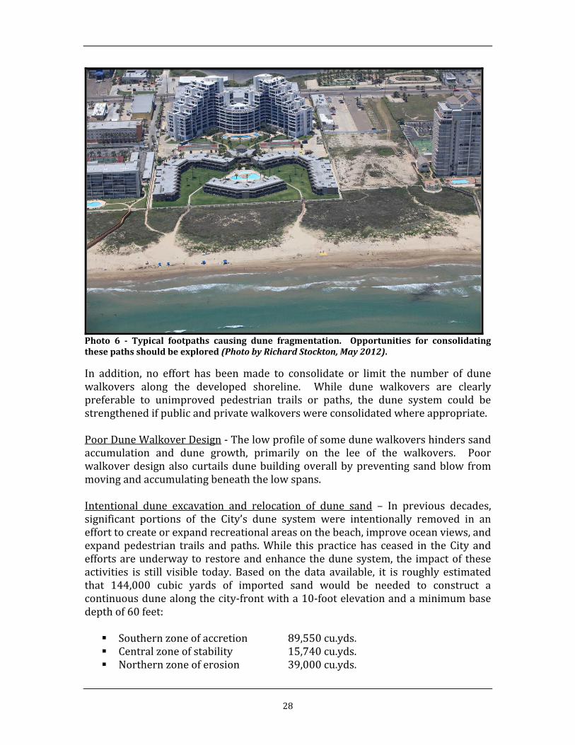
28
Photo 6 ‐ Typical footpaths causing dune fragmentation. Opportunities for consolidatingthesepathsshouldbeexplored(PhotobyRichardStockton,May2012).
In addition, no effort has beenmade to consolidate or limit the number of dunewalkovers along the developed shoreline. While dune walkovers are clearlypreferable to unimproved pedestrian trails or paths, the dune system could bestrengthenedifpublicandprivatewalkoverswereconsolidatedwhereappropriate.PoorDuneWalkoverDesign‐Thelowprofileofsomedunewalkovershinderssandaccumulation and dune growth, primarily on the lee of the walkovers. Poorwalkoverdesignalsocurtailsdunebuildingoverallbypreventingsandblow frommovingandaccumulatingbeneaththelowspans.Intentional dune excavation and relocation of dune sand – In previous decades,significant portions of the City’s dune system were intentionally removed in anefforttocreateorexpandrecreationalareasonthebeach,improveoceanviews,andexpandpedestrian trails andpaths.While thispracticehas ceased in theCityandeffortsareunderwaytorestoreandenhancethedunesystem, the impactof theseactivities is still visible today. Based on thedata available, it is roughly estimatedthat 144,000 cubic yards of imported sand would be needed to construct acontinuousdunealongthecity‐frontwitha10‐footelevationandaminimumbasedepthof60feet: Southernzoneofaccretion 89,550cu.yds. Centralzoneofstability 15,740cu.yds. Northernzoneoferosion 39,000cu.yds.
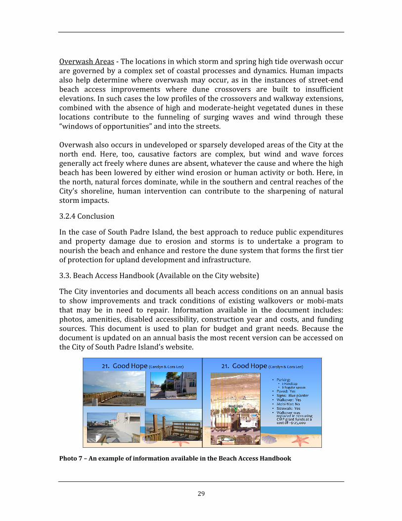
29
OverwashAreas‐Thelocationsinwhichstormandspringhightideoverwashoccuraregovernedbyacomplexsetofcoastalprocessesanddynamics.Humanimpactsalso help determinewhere overwashmayoccur, as in the instances of street‐endbeach access improvements where dune crossovers are built to insufficientelevations.Insuchcasesthelowprofilesofthecrossoversandwalkwayextensions,combinedwith theabsenceofhighandmoderate‐heightvegetateddunes in theselocations contribute to the funneling of surging waves and wind through these“windowsofopportunities”andintothestreets.OverwashalsooccursinundevelopedorsparselydevelopedareasoftheCityatthenorth end. Here, too, causative factors are complex, but wind and wave forcesgenerallyactfreelywheredunesareabsent,whateverthecauseandwherethehighbeachhasbeenloweredbyeitherwinderosionorhumanactivityorboth.Here,inthenorth,naturalforcesdominate,whileinthesouthernandcentralreachesoftheCity’s shoreline, human intervention can contribute to the sharpening of naturalstormimpacts.
3.2.4Conclusion
InthecaseofSouthPadreIsland,thebestapproachtoreducepublicexpendituresand property damage due to erosion and storms is to undertake a program tonourishthebeachandenhanceandrestorethedunesystemthatformsthefirsttierofprotectionforuplanddevelopmentandinfrastructure.
3.3.BeachAccessHandbook(AvailableontheCitywebsite)
TheCityinventoriesanddocumentsallbeachaccessconditionsonanannualbasisto show improvements and track conditions of existing walkovers or mobi‐matsthat may be in need to repair. Information available in the document includes:photos, amenities, disabled accessibility, construction year and costs, and fundingsources. This document is used to plan for budget and grant needs. Because thedocumentisupdatedonanannualbasisthemostrecentversioncanbeaccessedontheCityofSouthPadreIsland’swebsite.
Photo7–AnexampleofinformationavailableintheBeachAccessHandbook

30
4.0 DESIREDSHORELINECONDITIONS
4.1BeachandBeachProfile
Inthedesiredcondition,thereisadequatespacebetweentheGulfofMexicoandthedevelopedbeachfronttomaintainanaturalbeachdepthandhealthyprotectivedunesystem.
ThebeachalongthesouthendofSouthPadreIslandiscontinuous,healthy,andunhamperedbystructuralencroachmentsduringtimesofnormalwaterlevels.ItisonlytotheextentthatinsufficientspaceremainsbetweenthebeachandexistingbeachfrontdevelopmentthatactiveinterventionsuchasbeachnourishmentisneededtosustaintheCity’sdesiredbufferzone.SuchisthecaseonlyinthenortherlyerosionzonewithintheCity.
Theprofileor“shape”ofthebeach—includingitsslope,thenumber,sizeandlocationofsandbarsinshallowwater,beachdepthbetweenwater’sedgeandthedunes—isdeterminedbythewaterlevelsandwaveconditionspresentoverlongperiods,asoccasionallyinterruptedandchangedbystorms.Assuch,itisdifficultandexpensive,ifnotaltogetherfutile,toattempttocreatealastingbeachprofilethatdiffersfromthe“natural”profile.
Theremustbeaclearunderstandingamongdecisionmakersandthecommunitythatinordertoprovidespaceforahealthydunesysteminthenortherlyerosionzone,theentirebeachprofileincludingthesubmergedpartmustbe“moved”seawardbyprovidingtheappropriatequantityofsand.Inpractice,theaddedsandcanbeplacedonthevisiblebeach,butitmustberecognizedthattheGulfwillreworkthematerialovertheentireprofileincludingtheoffshoreareato15ftormoreofdepth.Thus,whendiscussingthelong‐termapproachtomaintainingahealthybeach‐dunebuffer,wearetalkingabouteverythingbetween15ftdepthandthehistoricalbuildingline.
4.1.1Beachdepthandelevation
ThetypicalbeachdepthinSPIbetweenatypicalwaterlevel(sayMeanSeaLevel)andthevegetatedforeduneisabout200ft.Theactualdepthcanvaryseasonallyandinresponsetostorms,butforplanningpurposesthistypicaldepthisuseful.
Theelevationatwhichforedunesemergeandtendtosustainvegetationisaminimumofabout5ftabovethetypicalsealevelinSPI.Thatis,thebeachelevationvariesfromsealeveltoabout5ftwithintheroughly200ftdepth.
4.1.2Sandvolumeandsources
Twogoalsmustbeachievedtoprotectandmaintaindevelopmentalongthehistoricalbuildinglinewithoutretreatandwithahealthybeach‐dunebuffer.First,sufficientroommustbeprovidedbetweenthewater’sedgeandthebuildinglinebymovingthebeachprofileseawardtocreateastablebeachdepthandhealthydune

31
system.Second,oncethebeachandduneareestablishedatthedesiredlocation,theannualsanddeficitmustbebroughttozerothereafter.
Planning‐levelestimatesofsandquantitiesneededtocreateandmaintainarelativelystableshorelinelocationweredeterminedbyaccountingfortheamountneededtomovetheentirebeachprofile(between15ftdepthandtheforedune)seaward.
InroundnumbersforthespecificcaseofSPI(notapplicabletoallbeaches),each1ftofprofilemovementrepresentsavolumeofapproximately1cy/ftofbeach.Basedonthisapproximation,thesandrequiredtomovetheprofileofthenortherlyerodingzone(11,000linearfeetofbeach)isroughly660,000cubicyards.Thisassumesthepresentbeachdepthisacceptablebutspaceforanadditional60ftofduneisneeded.
Anadditionalsandcontributionwillthenbenecessarytooffsettheaverageannualshorelineretreat,whichwillcontinuetooccur.Theapproximateamountneededtomaintainthenewshorelinelocationinthenortherlyzone,andincludingasmallamounttomaintainthecentral“stable”zoneasdefined,is40,000cubicyardsperyear(cy/yr).Thisfigureisbasedonanannualretreatrateof0ftto2ftinthe“stable”area,andretreatvaryingfrom2to5ftinthenortherlyerodingzone,multipliedbythebeachlength(say2,000ftofstablebeachand11,000ftoferodingbeach)andtheprofilemovementfigureof1cyperftofbeachperftofretreat.
PotentialsandsourcesincludethefederalnavigationchannelatBrazosSantiagoPass,accretionslocatedimmediatelysouthandnorthofthepassjetties,offshoreborrowsites,thestatehighwayrightofway(perhistoricalpractice),maintenancedredgingmaterialfromtheGulfIntracoastalWaterway(GIWW),andland‐basedsources(includingbarge‐accessibledepositslocatedneartheGIWWmanymilesnorthoftheCity.
Conservationcanalsobeviewedasa“source.”Examplesincludereducinglossesofwindblownsandintodevelopedareas,lossesofwaterbornesandthroughwashovers,avoidanceofpavementoversandthatiswithintheactivebeach/dunesystem,andtherecyclingandcrushingofglassintosand‐sizegrains.
4.1.3Methods
Dredgingofsandfromsubmergedsourceswilllikelycontinuetobethemostcost‐effectivemethodofproducingrequiredvolumesofsand.Thebeneficialuseofmaterialdredgedfromthefederalnavigationchannelsisparticularlycosteffective.
Healthydunesrepresentperhapsthebesttrappingmechanismtolimitthelandwardlossofbeachsandfromtheactivebeach/dunesystem.Sandfencingcanboostthetrappingofwindblownsandaswell.

32
Apre‐positionedcontractwithCorpsofEngineersshouldbeexploredforemergencydredgingeventsthattendtobeassociatedwithsignificantcoastalstorms,toensurethatvaluablesandisnotsimplydumpedoffshoreindeepwater.
4.1.4Estimatedannualcost
Thehistoricalcost(totheCity)forthereceiptofmaterialdredgedfromthefederalnavigationchannelhasaveragedabout$1/cy.Theactualcosttopayforsimilardredgingnotassociatedwithchannelmaintenance,asmaybethecaseforalarge,stand‐alonebeachnourishment,isestimatedtobeabout$6to$8/cybasedonrecentnavigationdredgingcosts.ArecentexampleofsandimportedintotheCityfromamainlandsourcewaspricedat$10/cywhichshouldperhapsbeinflatedtobetween$10and$12/cygivencurrentfuelcosts.
Thus,aplanningestimateforalargeinitialnourishmenttomovetheprofileseawardtoprovideroomforahealthydunesystemintheerodingzonecoulduse$10/cyasaconservativeestimate.Thisunitcostmultipliedby660,000cysuggestsa$6.6millionsandcosttowhichplanning,engineeringandpermittingcostscanbeadded.
Similarly,theannualmaintenancevolumeof40,000cycanbemultipliedby$10/cytoarriveata$400,000annualsandcostforplanningpurposes.
4.2DuneComplex
In general terms, a strong and stable dune system, with a capacity for relativelyeffective resistance to minor and moderate storm and tidal events, capable ofsustainingdunevegetation,andprotectioninsomemeasureofbackshorepropertyandinfrastructure,exhibitsthefollowingparameters:
• Relatively high quantities of dune and beach sand, over the beach‐dunecross‐section,foreachlinearfootofbeach‐line
• Dune landforms that conform to mature dune types, that is, classicallystableshapesthatareprimarilywind‐carved,withwind‐deliveredaccretingsandbalancing,byandlarge,wind‐drivensandloss
• Absenceofhuman(footandvehicle)disturbanceinthedunesandonthebeachsurfacesfrontingtheforedunes
• Minimumprimarydune and inter‐dune elevationsof 10 feet,with somedunesinthesystemreachinganoptimum12feetinelevationorgreater
•Vegetationwithminimumeighty‐fivepercentcoverage,orbetter,ofdunesurfaces
AlthoughprotectionofSouthPadreIsland’sbeachanddunesfromerosion,acentralsubjectofthisplan,isvitaltodefenseoftheurbanfabricandthelivesofitscitizens,protectionofnaturalhabitatisalsoamatterofhighestpriority.Itisaswellamatter

33
of interest to thousands of beachgoers, citizen and visitor alike, andprotection ofnaturalhabitatisanobligationoftheCityofSouthPadreIsland.
Securingamplebeachdepthandwell‐vegetatedhighanddeepdunesareessentialtobeachwildlifeastheyareforerosionprotection.AsstatedontheCity’sWebsite,habitat restoration (andmaintenance in a quality state) is a public priority: “. . .numerous species suchas theKempRidley sea turtlesandPipingPlovers relyonwide,healthybeachesasaplace to live, feedandnest.”Asdovarious terns,gulls,sanderlings, willets, crabs, and other life forms that help make up the completeshoreecosystem–andserveaskeyvisitorattractions.
TheCity’sWebsiteconciselypointsoutthat“Dunesareimportantbecausetheyareour first line of defense from storms and flooding. Coastal communities areprotected from the storms that occur in the Gulf by a system of vegetated sanddunes which provide a protective barrier. The General Land Office has directedcoastal communities to protect these dunes becausestabilized, vegetated dunesofferthebestnaturaldefenseagainstdamagecausedbystorms.”
4.2.1GoalsandObjectivesofaSPIDuneEnhancementProgram
The goal and objectives of restoring and enhancing dune vegetative cover aredefinedabove.Locally,theCityisworkingwiththeShorelineTaskForcetodevelopa dune enhancement technique first effectively demonstrated by Padre GrandeCondominiumsandsecondbyLaConchaCondominiums.TheGLOapprovedthesetwo pilot projects before the beach and dune plant amendment was approved.FollowingthepilotprojectssuccesstheCity’sbeachandduneplanwasamendedtoallowforsuchprojectstotakeplace.Ingeneral,thetechniqueisintendedtoworkinareaswhereduneshavebeenlostoronlyremnantsremainorwhereexcessivesandhas built up in excess of +10 feet elevation. The technique also seeks to makeeffectiveuseofrakedseaweedtoadvancethedunesystemfromitsmostlandwardpositionseawardtotheextentofthenaturallineofvegetation. Usingsandfenceand rakedseaweed,piles areplacedon the seawardedgeof remnantdunesor indunegaps.Vegetationisencouragedbyirrigationandallowedtopropagate.Asthevegetationlineadvances,relocatedseaweedpilesareaddedtothetoeofthedune,shapedto10 ftelevation,and irrigated. Over time,dunevegetationhasadvancedseaward to the position itwill naturally occur, such that no encroachment of thepubliceasementoccurs.Inareaswereduneelevationsexceedaspecifiedelevation in theBeachandDunePlan,dunescanbe“topped”andthesandusedfirsttoadddepthandsandvolumetotheimmediatesurroundingdunefieldintheareasoflowelevationbringtheareatoa10’ elevationwhichwill strengthen thedune systemagainstblowouts. Secondlythesandcanbetransportedtoareaswithweakdunestoelevateandstrengthenthedune systemagainst overwash and inundation. Theseprojects require individualbeach dune permits and should be undertaken sparingly and preferably only inareasthatarestable.

34
Location: The goal of an erosion‐control and protective dune program is to bothpreserve mature, high, vegetated dunes, and to restore and revegetate disturbedandmissingdunes, yielding fully vegetateddune fieldswithample elevations anddepthsbetweenthehigh‐beachandthebuildingsetbackline(SBL).Objectivesthatwillneedtobemetinthisregardaredunepreservation,repairandrevegetationofdisturbed andmissing dunes, infilling of disturbed and dune‐depleted areaswithnewdunesandplantings,installationofdune‐fencingandotherdunedevelopmentand maintenance measures, consolidation of walkways wherever feasible,development of new walkways and dune crossovers that achieve sustainablebeachgoer access and are of superior design and durable construction, andelimination of beach access ways that are detrimental to the dune system. Theforegoingrecommendationforconsolidation isconsistentwiththe2007DuneGapReport, which recommended that the City, “consolidate paths, when possible,throughthedunesforlessimpact.“Elevation: Dune building and rehabilitation should meet the goal of providingsufficient elevation in the dune fields to enable the dune system to function as aprotective feature in moderate storm conditions. By defending beachfront andupland buildings, infrastructure, and lives from severe storms. Where sufficientbeachdepthexists,theCity’sobjectiveistoprovideacontinuousdunesystemwitha minimum elevation of +10 feet in areas where visibility of the surf zone is animportant consideration, anda targetoptimumelevationof+12 feetorhigher, asdeterminedasappropriatebytheSPICoastalResourceManager,wherevisibilityofthesurfzoneisasecondaryconsideration.Depth:Beachdynamicswillneedtobetaken intoaccount,withdeeperbeachanddune fieldsmore achievable in the southern (accreting beach) reaches, narrowerbeach and dune fields probable in the northern (depleting) reach, and mixedconditionsinthecenter.TheCityintendstodevelopacontinuousdunefield,alongtheentirebeachfront,between thehighbeachand theSBL.Wherebeachdepth issufficient, the base dune depth should be a minimum of 60 feet, with 100 feetpreferable. In thenorthernerodingareas,aminimumbasedunedepthof60 feetshould be attained and efforts to nourish the shoreline should be aggressivelypursuedsuchthatbasedunedepthof100feetcanbesustained.Dune Volume: In order to function as a protective feature in moderate stormconditionsatargetsandvolumeshouldbeused.TheCitywillstriveforeverybeachfrontpropertytohaveaDuneVolume(DV)ataminimum66cyandagoalof110cyperlinearyard.Usingtheabovedesirableduneconditionsata10’(3.3yd)elevationwith100’(33.3yd)ofdepthequalstoatargetvolumetricgoalof110cyperlinearyardofbeach.Wherebeachwidthsdonotallow foradunewitha100’depth theelevationrequirementscanbeadjustedinordertomeetthetargetdunevolume.Methods: In the Figure, below, recommended dune plant species are identified.Sargassumandotherseaweedinthewracklinewillcontinuetobecritical inbothretaining moisture on the wet beach, thereby sustaining its resistance to wind

35
erosion,andinprotectingdunes,especiallythefore‐dunes, fromwinderosionandhighsurferosion.Remediation and/or consolidation of footpaths will be critical if the City is toestablishacontinuousdunefieldataminimumelevationof+10feetandbasedepthof60feet.Closecoordinationwithlandownerswillberequired.
Dune Fencing to Control Foot Traffic: Installation of stable dune fencingapproximately2feetawayfromthetoeofslopeononeormoresidesofthehealthydune, as ruled as necessary by the City’s coastal resources manager, should beinstalled to deter foot traffic across dunes. These barriers should be openedsignificantlyor fully removedduring turtlenesting seasons.Thealignmentof thisfencing should be adjusted as necessary as determined by the Coastal ResourcesManager. This protective fencing need not follow guidelines for sand entrapment(dunebuilding)astheperimeteralignmentsareintendedtopreserve(protectfromhumanimpacts)ratherthanbuild.
4.2.2SandVolumeandSources
Sand Volume: The estimated volume of sand needed to restore the dune field is144,000 to 161,540 cubic yards with the Southerly Zone of Accretion requiringapproximately39,000cu.yds,theCentralZoneofStabilityrequiring15,740cu.yds.,

36
and the Northerly Zone of Erosion requiring 89,550 cu .yds. up to as much as106,800cu.yds.
SandSources:Sandsourcesfordunebuildingmayinclude:(1)offshoresources;(2)sand dredged from the Brazos Santiago Pass as part of the USACE’s routinemaintenanceofthechannel;(3)windblownsandonandwithintheright‐of‐wayofParkRoad100;and(4)truck‐hauledriversand
4.2.3Methods
Giventhelimitedamountofsandinthesandbudgetutilizingallavailablesourcesisamust.ThroughtheDunePlantingprogramandutilizationofsandfencestheCitycanbuilddunesthatwillprovideprotectiontopublicinfrastructureandstoresandtoreplenishthebeachsystemafterastorm.
ThroughtheDuneRidgeEnhancementprogramsandthatisstoredinsanddunesinelevationsabove+10feetorhighercanbeusedtofill inlowelevationstopreventblowoutsoffrontaldunesandtobuildasolidcontinuousdunesystemwithagoalofbuildingadunesystemtofunctionasaprotectivefeatureinstormevents.
4.2.4EstimatedCosts
Giventhevarietyofpotentialsandsourcesfordunebuilding,nosinglecostestimatefor dune sand can be provided. It is expected however that obtaining sufficientquantities of off‐beach sand (sources other than windblown sand of seaweedmanagement)couldcostatleast$10percubicyardandincreasesignificantlyfromthere.
ThespeciesandtypesofplantsneededforthedunerevegetationeffortsarenotedaboveandfullydescribedintheGLODuneProtectionManual. BasedonavailableinformationplantsarecurrentlyavailabletotheCityat$0.42perplant.
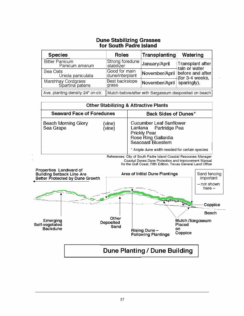
37

38
4.3BeachAccessPoints–PublicAndPrivate
4.3.1AccessEnhancementGoals:
TheCityisdedicatedtoprovidingthepublicaccesstothebeach.WhenpossibletheCitywill fund access improvements through hotel/motel tax but relies heavily ongrantsformatchingfunds.
4.3.2Walkovers,Mobi‐mats
Walkover Design Standards: Both public and private access ways should meetstandardsforupgradedconstructionmethodsanddesigninordertoreducestormdamageandpost‐stormrepaircosts.
Stainless steel cable‐stay railing systems are recommended for access ramps,staircases, and crossovers.Though theyare costlier thanwoodcounterparts, theyare highly resistant to storm damage and salt spray corrosion and require lowermaintenanceandrepairattention.
For ramp, crossover, andotherhardenedwalking surfaces, severalhighlydurablematerials havebeen substituted forwoodplanking in recent years. These includeTREXandotherplasticizedcompositesandboardsmadefromkenaf,aplantgrownandprocessed,amongotherlocations,inWillacyCounty.
As the City proceeds in the design of additional street‐end and other ramps,crossovers,andwalkways/boardwalks,suchalternativematerialsandtheircosts–initialandlife‐span–shouldbeinvestigated.
Withemploymentofsturdierstructuralelementsandmoredurablerailingsystemsandwalkwaysurfaces,O&Mcostsmaybekeptatminimallevelsoveramulti‐decadelife‐span.
ADA‐conformingHandicappedRampsLinking toDuneCrossovers:TheCitybuildshandicappedaccessiblerampsfromstreet‐endsonacontinuingschedule.ByTexasAccessibility Standards and Americans with Disabilities Act criteria, handicappedrampsmustbylawnotexceed8.33percentwhererailingsareinstalled;5.0percentisthemaximumwherepathwayslackrailings.Thesteeper,1:12designsmustalsohavelandingsofspecifieddimensionsatgivenrampintervals.
Mobi‐Mats: When unable to provide a walkover the City will use, if available, apolymermat that is able to createa solidwalking surface for thepublic touse toaccess the beach. Thesemats protect the dunes from erosion and damage to thesurroundingvegetation.
EliminatingDuplicativeandDune‐damagingPathstotheBeach:Onealternativetothe existingmultitude of privatewalkways between the built beachfront and thebeach is to reduce the number of walkovers and openwalkways to the shore inexchangeforamorelimitednumberofcrossovers,ramps,andwalkwaysbuiltwithstronger components and more durable materials, while at the same time

39
constructedmoresustainablywithrespecttothedunesystemsoverwhichthenewelementswilltraverse.
Continuation of the City’s street‐end handicapped ramp programwill expand thenumberof general access structures thatarewell‐built andoffer thepotential foreliminating nearby duplicative and /or dune‐damaging private trails to the beachthatliebetweenthestreet‐ends.
It is therefore recommended that the City confer with property owners whereprivatepaths to thebeachhavebeen fashionedwithresultingdunedepletionandlosstodeterminewhetheragreementcanbereachedforsucheliminations–giveneasily reached alternative crossovers such as nearby street‐end accessways thatwouldservetheirresidentsorotheruserswithoutsignificantlossofconvenience.
Optionswould includetheretainingofoneprivatewalkwaymidwaybetweentwoadjacent street‐ends and acquisition by the City and dismantling of other privatewalkwaysinthisreach.Theremainingwalkwayshouldalsobeupgraded,asneeded,to yield a raised crossover built of durable and sustainablematerials that archesovertheregenerateddunesystembeneath.Thecostofthisimprovementwouldbeborneby theCity inexchange foraperpetualaccesseasement toallowsharingofaccessbytheownerwiththepublic.
4.3.3ConceptualWalkways&Footpaths
North‐south Walkways (at‐grade “Boardwalks”) Linking to Public Street‐endCrossovers andApproved Intermediate Crossovers. The foregoing improvementswouldbedependentontheconstructionofnorth‐southwalkwaysor“boardwalks”that would afford access from in‐the‐block addresses to the street‐end publicwalkways.
Here,too,accesseasementswouldneedtobepurchasedbytheCityfromagreeablepropertyowners.Topreserveownerprivacy, thenorth‐southwalkwayswouldbealigned a reasonable short distance Gulf‐ward from the buildings and gatedapproachestothebuildingentranceswouldensureaccessbyresidentsandguestsonly. The distances from the buildings the north‐southwalkwayswould be offsetwouldtakeintoaccountthedunesystemineachlocation.Wheredunesarecloseby,the walkways would be raised somewhat to clear the dune slope. The walkwaysurfaces would also be permeable, as is provided by spaced wood or othersustainable‐materialboardsorbysuchmanufacturedmaterialsas“Mobi‐Mat”.ThispermeabilitywillalsosecureconformancewiththeTexasandCityrequirementsforconstructionwithinthebuildingSetbackLines.
Convenience forbeachfrontresidentsandguests,whereexistingprivatepathsareeliminated except for a mid‐point improved and raised private crossover, wouldeasily be conserved. The time lost by the short detourswould not exceed a half‐minuteonaveragewhereamidpointcrossoverisretainedand1minuteonaveragewherenoprivatepathsareretainedbetweentwostreet‐ends.

40
Such walkway consolidation was recommended in the 2007 South Padre IslandDuneGapReport.

41
Applicability of Walkways–Boardwalk Concepts to South Padre Island’s Hotel /DiningDistricts: Theprincipalofprotectingandrestoringdunesbyconsolidatingwalkways and channeling foot traffic along beach‐parallel boardwalks is alsoapplicabletotheCity’shotel‐diningdistricts.Aswiththeexamplesdiscussedhere,economic benefits to the private sector, in addition to long‐term cost savings andsustainabilityinthepublicsector,arepossible.
4.3.4EstimatedAnnualCost

42
Theannualcostforbeachaccessimprovementscannotbecalculatedasit’sbasedonprojectsize.Thecosttoconstructawalkoverbasedonhistoricalprojectsis$775.00alinearfoot.ThecostofMobi‐Matrangesfrom$110‐$135alinearfoot.
TheCityoperatesonabeachmaintenancebudgetsolelyfundedbyhotel/moteltax.TheCitydoesnothaveabeachuserfeeatthispointbutmaybeanecessaryoptioninthefutureforrevenue.
5.0SEMI‐ANNUALPRE‐STORMMONITORINGPROGRAM
5.1Goal
Thepurposeandneedofamonitoringprogramistoaccomplishatleasttwogoals:(1)toinformlocaldecisionmakersandthecommunityatlargeaboutthestatusandupcoming maintenance needs; and (2) to ensure that adequate, recent data isavailable to document storm losses and ensure eligibility for federal disasterassistancerelatedtonourishedbeaches.
5.2Frequency,Method,andLocation
A twice‐annual program consisting primarily of profile surveys augmented withother forms of data collection (e.g., photography, sand tracer studies, numericalsimulations)canprovideyeartoyearcomparisonsaswellasindicationsofseasonalvariationstoinformdecisionmaking.Previouslyestablishedprofilelocationscanbeusedtoensurethebestuseofexistingdataandthecosteffectivenessofnewdatacollection/analysisefforts.
In addition to periodic profile surveys, project‐specific surveys of nourishmentactivities and the progressive movement of material from designed nourishmentprisms by natural forces can allow the optimization of subsequent nourishmentactivities. Maintenance practices that result inmovement of sand resources (andseaweed) along and across the beach can be factored into monitoring tasks andresultstoprovideaclearpictureoftheprogram’sachievements.
5.3OutputReport/Recordkeeping
Thedeliverableproductsgeneratedthroughmonitoringcanincludetheprofiledatareduced andpresented graphically, comparisons to historical profiles at the samelocation, trend analyses, quantity calculations, and projected maintenance needs.The informationwill alsobe available toCity officials dealingwithFEMA inpost‐stormresponsemodetodeterminefederalassistancequalifications.
5.4Estimatedannualmonitoringcost.
AdetailedscopeofmonitoringeffortcanbedevelopedtosuittheCity’sneedsandbudget. Theorderofmagnitudecostcanbeexpectedtobe$50,000to$100,000peryear.
6.0EROSIONRESPONSEPLANFORSPICITYLIMITS

43
Thespecificcontentseachlocalgovernment’serosionresponseplanaresetforthin31TACPartI,section15.17.Theseelementsareidentifiedanddescribedbelow.6.1ConstructionSetbacksFor the purpose of the ERP, the “setback” is the line seaward of which no newconstruction shouldoccur. In establishing the setback line, the state requires thatthe City utilize data obtained from the University of Texas Bureau at EconomicGeology.ThemostfurtherallowtheCityforoptionsinestablishingofbaselinefromwhichthesetbacklineismeasured.Theseoptionsare:
Thelineofvegetation(LOV) TheMeanLowTide(MLT) TheMeanHighTide(MHT) GLO‐approvedCoastalBoundarySurvey
Therulesfurtherspecifythatthesetbacklinecannotbefurtherlandwardthentheduneprotectionlineandmustprotectasmuchofthecriticalduneareaaspracticable.
TheexistenceofthesetbacklineisintendedtoimproveshorelinemanagementpracticesinTexasbyreducingtheriskstobeachfrontstructuresfromerosion,stormsandwaves.Currently,nostatewidesetbacklimitexistsinstatelaw,however,currentGLOrulesspecifythatnoconstructionispermittedseawardofthelineofvegetation,asthisiswithinthepublicbeacheasement.Inerodingareas,GLOrulesimposecertainconstructionlimitsandrestrictionswithin200feetlandwardofthemeanlowtideline.Subjectively,staterulesalsorequirethatnewconstructionalongtheGulfbeachesofthestatebelocated“asfarlandwardaspracticable.”
Forthepurposesofthiserosionresponseplan,theCityofSouthPadreIslandproposesthatitssetbacklinebetheHistoricBuildingLine(HBL)establishedbytheCityandapprovedbytheGeneralLandOfficeintheCity’scertifiedBeachAccessandDuneProtectionsPlan.TheHBLisshownapparentasthelineofretainingwallsthatfrontallexistinganddevelopedpropertieswithintheCitylimits.ThisHistoricalBuildingLine(HBL)wasestablishedonSeptember3,1981.AletterfromJohnW.Fainter,Jr.,FirstAssistantAttorneyGeneral,representingtheStateofTexaswrittentothen‐MayorGlenMcGeHee,establishingabuildingline,commonlyreferredtoastheHistoricBuildingLine,fortheCityofSouthPadreIslandBeachfrontConstructionthatwouldprovideaminimumoftwohundredfeetofopenbeachabovethemeanlowtidelineaccordingtothenavailabledata.TheletterstatedthattheAttorneyGeneralcouldreviewthelineandchangeittoensuretheprotectionoftheState’sopenbeaches.Thelinewaslocatedonamap(drawnbyChasR.HaileAssociates,Inc.,ConsultingEngineers,Houston,TexasCity,CorpusChristi,Nederland,andisdatedMarch1981)providedbytheTexasAttorney

44
GeneralandisonfilewiththePublicWorksDepartmentoftheCityofSouthPadreIsland.Seepictures8a,8b,and8c.
TheHBLhasunmistakablyestablishedthepublicbeachonSouthPadreIslandandhasalsogivenbeachfrontpropertyownersanunderstandingofwheretheycanbuildupto.TheHBLalsomakesitclearwherethedunefieldshouldstarttoprovideprotectionforbeachfrontproperties.WiththeclearknowledgeofwherethedunesshouldbetheCityhastheabilitytobuildacontinuousdunelineofsimilarelevationtowithstandstormsurge.ThenaturalcycleofabarrierislandistomigratelandwardbutwithhealthydunefieldseastoftheHBLthatstoreandholdthesandvolumesneededtoprovideprotectionandsupplythebeachwithsandfollowingmajorstorms.Withtheabilitytokeepahealthydune/beachsystemseawardoftheHBLweareabletoreducepublicexpendituresduetoerosionandstormdamageloss.TheShoresubdivisionhasabuildingline(formerlycalledthe“440‐footLine”)itwasestablishedtoensurethatproposedconstructiononthesitewouldbelocatedfarlandwardofthebeachsoastoprotectthefore‐duneareaandreducetheriskofstormdamagetothesubdivision.Seephoto8d.Asadevelopedurbanshoreline,itisimpracticalfortheCitytoestablishanewordifferentsetbacklineotherthantheHBL,establishedmorethanadecadeagoanduponwhichthishighlydevelopedshorelinewasconstructed.TheCityrecognizesthatforittomaintaintheHBLasitsdesignatedSetbackLinefortheERP,theCityisobligatedtomanagethepositionoftheshoreline‐‐thebeachanddunesystem‐‐sothatexistingdevelopmentisnotsubjecttoanundueriskofdamagefromerosion,wavesandstormsurge.TheCity’sstrategytoaccomplishthisoutcome–andtherebylimitpublicexpendituresduetoshorelineerosion,wavesandstorms–istoundertakeadedicatedprogramofbeachnourishmentanddunerestoration,asdescribedinSection4.0,DesiredShorelineConditions.

45
Photo8a‐AerialphotoshowingtheSouthernportionoftheCity.TheDuneProtectionLine(DPL)isinredandtheHistoricalBuildingLine(HBL)isingreen.
Photo8b‐AerialphotoshowingthemiddleportionoftheCitywiththeHBLandDPLshown.
Photo8c‐AerialphotoshowingthemiddleportionoftheCitywiththeHBLandDPLshown.
Photo8d‐TheShoresSubdivision.The“440‐footline”isingreen6.2ProhibitiononConstructionSeawardofSetbacklineInaccordancewithstaterulesandtherequirementsofthisERP,allneworrebuilthabitablestructuresmustbeconstructedlandwardofthebuildingsetbackline,tothemaximumextentpracticable.Exceptforthosenon‐habitableamenitiesspecificallyexemptbelow,allnewconstructionwithintheCityofSouthPadreIslandwillberequiredtobeconstructedlandwardofthesetbackline.

46
InthisERP,theCityisnotproposingtoallowconstructionorrepairofanyhabitablestructuresseawardoftheHBL,whichservesastheSBL.6.3ExemptionsfromtheSetbackLineExemptionsfromthesetbacklinehaveonlybeengrantedfornon‐habitablestructuressuchasdunewalkovers.Dunewalkoversremovethepedestriantrafficfromthedunesthatleadtoerosionandblowoutsalongthefrontaldunes.Themostharmfulactivitythattakesplaceonthedunesisthecontinuouspedestriantrafficthatleadstolowelevations.Stormsurgemakesitswayupthepathsanderodesthepathwitheachwavewhichcaneventuallyunderminethemassivedunesthatprovideprotection(seePhoto9).
Photo9‐Showstheeffectivenessofusingdunewalkoverstokeeppedestriantrafficoffthedunes.6.4RequirementsforExemptStructures.
HabitablestructuresmaybeexemptfromtheSBLlimitationsinthreelimitedcircumstances:(1)iftheownerdemonstratesthatthereisnopracticablelocationfortheconstructiontooccurlandwardofthesetbackline;(2)theconstructionisconsistentwithanexistingsetbacklinecertifiedbytheGeneralLandOfficepriortotheERP;or(3)theconstructionconsistsofminorrepairstoanexistingstructurethatdoesnotincreasethefootprintofthestructure.
Inthiscase,theERPrequiresallnewhabitableconstructionorrepairstoexistinghabitablestructurestooccurlandwardofthesetbackline–whichistheHistoricBuildingLineasspecifiedherein.Non‐habitableamenitiessuchaswalkways,dunecrossovers,smalldecks,andotheraccessimprovementsareexemptfromtheconstructionsetbacklimit.
Staterulesestablishtherequirementsforexemptstructuresforlocalgovernmentsthatchoosetopermitmoreseawardconstruction.First,theexemptstructuremustbeelevatedtoaminimumof2feetabovetheFEMAbasefloodelevation(BFE)and

47
thefoundationforthestructuremustconformtoASCEfloodresistantstandards.Inaddition,thestructuremustbedesignedforfeasiblerelocationanditmustbeplannedinawaythatminimizesimpactnaturalhydrology.TherulesalsoprohibitenclosuresbelowtheBFE.Inanyevent,allexemptstructureconstructionmustbelocatedlandwardofthelandwardtoeoftheforeduneridgewheneverpracticable.Registeredprofessionalengineersmustcertifythattheserequirementshavebeenmet.6.5EnhancingandPreservingPublicAccess.Thestaterequirementsforerosionresponseplansarealsointendedtoenhancepublicaccesstotheshorelineinadditiontoreducingpotentialpublicexpendituresforerosionandstorms.Withrespecttoaccess,therulesrequirethattheCityevaluatethevulnerabilityofaccesspointstoerosionandstormsurgedamage.TherulesrequirethattheCityupgradepublicaccessconstructionmethodsanddesignstoreducepost‐stormrepaircosts.TheCityisrequiredtocreateascheduleforpublicaccessdesignimprovementsandinventoryexistingaccessamenitiesinordertosupportanyfutureFEMApost‐stormfundingclaims.Finally,theCityisrequiredtoestablishpost‐stormbeachaccessassessmentproceduressothatdamagescanbecataloged.ThestepsfortheimprovementofpreservationofpublicaccessaredescribedaboveinDesiredConditions4.3BeachAccessPoints.Beach Access Handbook: The City inventories and documents all beach accessconditions on an annual basis to show improvements and track conditions ofexisting walkovers or mobi‐mats that may be in need of repair. Informationavailable in the document includes: photos, amenities, disabled accessibility,constructionyearandcosts,andfundingsources.Thisdocumentisusedtoplanforbudgetandgrantneeds.ItcanalsobeusedforFEMAreimbursementrequests.
Post‐stormassessmentprocedureswilltakeplaceimmediatelyfollowingthestormeventonceitissafetoenterthebeach.TheCoastalResourcesManagerwillinventoryallbeachaccessconditionsprestormandpoststorm.AlistofaccesspointsnotincompliancewiththelocalplanandBeach/Dunerules,descriptionsofrepairs,andreplacementsneededwillbecompiled.ThisassessmentwillalsobeusedforFEMAreimbursementrequestsalongwiththeannualfixedassetsreportthatvaluesallCitypropertyforthefiscalyear.6.6DuneProtection&EnhancementDuneprotectionandenhancementprojectsareacriticalcomponentoftheCity’sERP.GLOrulesrequirethattheCityspecifythetargetduneelevationandpercentvegetativecoverforitsduneprotectionandenhancementprogram.TheCityisfurtherrequiredtoidentifyspecificlocationsofdunegapsandblowoutsfor

48
potentialdunerestorationprojects.Finally,theCityisrequiredtooutlinespecificdunere‐vegetationprojects,identifymeasurestoprotectthelandwardsideoftheforeduneridge,andidentifythegoals,schedules,andfundingsourcestoaccomplishitsduneprotectionandenhancementprogram.AsspecifiedunderDesiredConditions,above,theCityseekstoestablishacontinuousdunesystemwithaminimum10footelevationand60‐footbasedepth.Intheaccretingareasandinareaswherebeachnourishmenthascreatedandcansustainabeachwithof200feet,theCity’sgoalistoestablishtheduneswithaminimumbasedepthof100feet.Asillustratedabove,dunegapshavebeenidentifiedusingLIDARdataandaerialphotography.ThroughtheDuneVolunteerPlantingprogramtheCitywillbeabletofillinthesegapsandnarrowbeachaccesspathsenhancingourcontinuousduneline.TheCitywassuccessfulingettingtheDunePlantingProgramfundedthroughtheCMPCycle17.TheCitywillcontinuetoapplyforgrantfundsinordertofundthisprogram.6.7CriteriaforVoluntaryAcquisitionorBuyouts.Onerecognizedstrategytoreducepublicexpendituresfollowingstormsanderosioneventsistopurchaseorbuyoutvulnerablepropertiesalongtheshoreline.Thestaterulesallowlocalgovernmentstodevelopcriteriagoverningthevoluntaryacquisitionorbuyoutofbeachfrontparcelsandstructures.Ifsuchanapproachistobeemployed,theCitywasrequiredtoidentifypropertiesentirelyseawardofthebuildingsetbackline,provideforvoluntaryacquisition,andestablishproceduresforprioritizingpropertytobeacquired.UsingtheHBLasthesetback,nohabitablestructurescurrentlyexistseawardoftheproposedsetbackline.TheCityofSouthPadreIslandhasalsoelectedanERPstrategybaseduponmaintenanceofthebeachandrestorationandenhancementofthedunesystem.Thisapproachisanalternativetotheavailablestrategyforvoluntaryacquisitionandbuyouts.TheCityhasnotelectedtodevelopavoluntaryacquisitionandbuyoutprogramatthistime.7.0ConceptualFundingStrategy–SPIShorelineManagementProgramAsERPstrategiesarerefinedandcostestimatesaredeveloped,theCityintendstodevelopafundingstrategytosupportimplementationoftheERP.PreliminarydiscussionsindicatethatthereiscommunitysupportforestablishmentofaDedicatedShorelineMaintenanceAccounttoprovidefundsfor:
1. On‐goingbeachnourishmentprojects;

49
2. Annualbeachmonitoring,includingaerialphotography,beachtransects,mapping,andassessmentoftheconditionofbeachaccesses;
3. Duneenhancementandrestorationprojects,includingthedunegapprojectsandvolunteerduneplantingprogram;
4. Publicaccessimprovementsandenhancements,includingwalkovers,parkingimprovements,consolidationofwalkoversandpathways,
5. Planning,permittinganddesigncostsassociatedwiththeprojectsabove;and
6. Minorprogramadministrationandsupportcosts.Whileannualrevenueneedscannotbeaccuratelypredictedatthistime,conceptualfundingoptionshavebeendiscussedwiththeCityandShorelineTaskForce.Ingeneral,theCityexpectstodevelopafundingplanbroadlyreflectingthefollowingprinciples:
1. SeektomaximizestateandfederalsupportfortheCity’sshorelinemanagementprogram,particularlyseekingon‐goingCEPRAandCMPgrantfundswheneverpossibleandcontinuedeffortstosecureUSACEcommitmenttothebeneficialuseprojects;
2. Seektoindentifythelocalandvisitorbeneficiariesofsoundbeach,duneandshorelinemanagementpracticesandemploy,totheextentpractical,a“beneficiariespay”strategy;
3. Seektoimplementa“blended”fundingstreamsuchthatrevenuessupportingtheDedicatedShorelineMaintenanceAccountarederivedfrommultiplefundingsourcesatthefederal,stateandlocallevel;
4. Seektodevelopalong‐termfundingstrategythatisstable,predictableandsufficienttosupportcurrentandfutureshorelinemanagementneeds;
5. Seektodevelopafundingstrategythroughacommunity‐basedprocessthatistransparent,engagesthepublicandprovidesrobustopportunitiesforpublicinputanddiscussion.
Thoughnospecificrecommendationscanbemadeatthistime,therearethreepotentialfundingsourcesatthelocallevelthattheCitymaywishto“blend”tosupportthelocalshareoftheDedicatedShorelineMaintenanceAccount:1.AdvaloremRevenues:TheCitymaywishtoconsideraShorelineMaintenanceadvaloremassessmentasonecontributingrevenuestreamtothededicatedaccount.Currently,propertyownersinSouthPadreIslandpayatotaladvaloremtaxrateof$1.962379per$100ofassessedvalue.Thistaxrateiscomprisedofassessmentsfromanumberoftaxingentitiesbesidesthecity,includingCameronCountyandtheschooldistrict.TheCity'scurrentadvaloremtaxrateis$0.2456per$100ofassessedvalue,whichisthelowestmunicipaltaxrateinCameronCounty.AmodestincreaseintheCity’sadvaloremtaxrateofthreecentsper$100wouldincreasetolocalratefrom$0.2456to$0.2756per$100value.Evenatthisincreasedrate,theCity’sadvaloremratewouldstillbethelowestinCameron

50
County‐‐lessthanthatofLosFresnos,SanBenito,Brownsville,PortIsabel,Harlingen,andLagunaVista.BasedonatotalassessedvalueofpropertyintheCityofabout$2.6billion,anadditionalthree‐centadvaloremassessmentwouldgenerateabout$780,000peryearfortheDedicatedShorelineMaintenanceAccount.2.HotelOccupancyTaxRevenues:Likemostbeachresortcommunities,theCityisblessedwithadiverseandsubstantialhotelandrentalmarketsector.VisitorshiptotheCityincreasessubstantiallybeginninginthespringmonths,peaksinthesummer,andgraduallydeclinesinthewinter.Thisvisitorshippatternistypicalofmanybeachresortcommunitiesandreflectsthestronginfluenceofthebeachasthecornerstoneofthelocaltouristeconomy.Currently,hotelpatronsandshort‐termvacationpropertyrenterspayHotelOccupancyTaxesthatbenefittheCityandstate.BelowisatypicalbreakdownofHOTrevenuesonaone‐nightstayataSPIhotel:
Room at $99.00/night HOT Rate $99.00
City Occupancy Tax 8.0% $7.92
State Occupancy Tax 6.0% $5.94
City Beach Nourishment Occupancy Tax 0.5% $0.50
TOTAL HOTEL OCCUPANCY TAXES 14.5% $14.36
Outofthe14.5%occupancytaxrate,theCitycurrentlydedicatesaone‐halfofonepercenttosupportitsbeachnourishmentprogram.Giventhatasubstantialpercentageofout‐of‐townvisitorscometoSouthPadreIslandtoenjoythebeachandgiventhesubstantiallong‐termcostofbeachanddunemanagement,theCitymaywishtoconsidersomeadjustmenttotherateorallocationofrevenues.ModifyingHOTratesisasensitivesubjectandwouldrequireclosecoordinationwithhotelownersandoperatorsandotherstakeholdersbeforeanyproposalcouldbedeveloped.Nationally,theuseofHOTrevenuesasacomponentofacomprehensivefundingstrategyhasproventobeausefulandreliablerevenuesourcetosupportbeachandshorelinemanagementprojects.
3.SalesTaxRevenues:InabeachresorttownlikeSouthPadreIsland,salestaxesrevenuestypicallyincreasesubstantiallyduringthetouristseason.Out‐of‐town

51
visitorsswellthesummerpopulationcontributingsubstantialrevenuestothecommunity.Attractedtothebeautifulbeaches,thesevisitorsareclearlybenefitfromawell‐maintainedbeachandpublicaccessimprovements.Asthecommunitycontinuestogrow,salestaxestypicallygrowaswell.Thoughthefinancialandcommunityissuesregardingtheuseofsalestaxrevenuesforshorelinemanagementwouldbecomplex,itwouldbeprudenttoexplorethisrevenuestreamasapotentialcomponentoftheblendedfundingstream.
Overall,theCitywouldbenefitifitcanidentifyareliableandpredictablefundingstrategytosupportitslong‐termshorelinemanagementprogram.Erosionisapersistentforcethatdirectlyandsubstantiallythreatensmanybarrierislandbeachtowns.TheresponsestrategyandfundingplanmustbeequallypersistentiftheCityistomaintainitsplaceasthepremierbeachresortcommunityinTexas.


BeachUserFeePlan
1
The City of South Padre Island proposes to establish a paid parking program for the Gulf Coast beach
located within the City’s boundaries. The program will utilize an internet/phone system for visitors to
pay for their parking spaces. The revenue will be used to fund reasonable and necessary services and
facilities directly related to the public beach.
SOUTHPADREISLANDSCURRENTPROGRAM..............................................................................2
BEACHACCESSSYSTEM....................................................................................................................................3CURRENTREVENUE...................................................................................................................................................3SouthPadreIsland...................................................................................................................................................3CameronCountyFeeSchedule...........................................................................................................................3
EXPENDITURES............................................................................................................................................................4SouthPadreIsland...................................................................................................................................................4
FREEPUBLICPARKING.....................................................................................................................................4FREETRANSPORTATION.................................................................................................................................6
BEACHUSERFEEPROGRAM................................................................................................................6
PASSPORT–THEINTERNETPAYSYSTEM..........................................................................................................7EstimatedSaleswithPaybyPhone..................................................................................................................7
SEASONPARKINGPASS.....................................................................................................................................8EstimatedSalesforSeasonPass........................................................................................................................8
NECESSITYFORBEACHUSERFEE................................................................................................................8USERFEESSUPPORTENHANCEDMANAGEMENTPRACTICES.......................................................9Short‐Term..................................................................................................................................................................9Long‐Term...................................................................................................................................................................9
CITATIONOFALLLEGALAUTHORITY..........................................................................................10
LEGALAUTHORITYAUTHORIZINGCOLLECTIONOFFEES.............................................................10BEACHACCESSCHARGEAUTHORIZATION...........................................................................................10AUTHORIZATIONSCHEDULE......................................................................................................................10
STATESTANDARDSCONSISTENCY.................................................................................................11
PROPOSEDFEEISCONSISTENTWITHSTATESTANDARDS..........................................................11USEOFBEACHUSERFEEREVENUES.......................................................................................................11RECIPROCITYAGREEMENT................................................................................................................................12SIGNAGE.........................................................................................................................................................................12REPORTINGADMINISTRATIVECOSTANDACCOUNTING.................................................................12
CITYOFSOUTHPADREISLANDBEACHPARKINGSYSTEM........................ATTACHMENTA
CITYOFSOUTHPADREISLANDDRAFTPARKINGORDINANCE………….ATTACHMENTB

BeachUserFeePlan
2
CURRENT BEACH ACCESS SYSTEM:
Presently there are a total of twenty‐six (26) City beach access points maintained by the City of South
Padre Island (City), and 1,665 parking spaces. Three of the beach accesses parking spaces are located off
of Gulf Boulevard.
Easement located on the North property line of La Copa.
This ten (10) foot wide public beach access was also
dedicated as part of an agreed judgment with the State.
This right of way will utilize the free parking provided by
the City at the multi‐modal center and between Padre
Boulevard and Highway 100.
Whitesands Street is a public right‐of‐way. It is the City’s
Northern most public beach access. Free public parking is
available for this right of way at the South Padre Island Post
Office and the Convention Center. While both parking lots
are approximately one‐half mile to the beach, use of the
Wave, the City free bus service will facilitate the beach
access.
Easement located on North property line of The Pearl.
This beach access begins as a forty (40) foot wide public
Ingress / egress easement at the Park Rd 100 frontage
road and transitions to a ten (10) foot wide pedestrian
access 301.11 feet west of the toe of the existing retaining
wall. This access was dedicated at the encouragement of
the State, to the Texas Conservation Foundation.

BeachUserFeePlan
3
The remaining 23 beach accesses under the City’s jurisdiction are located on Gulf Boulevard. The beach
access cul‐de‐sac’s located on Gulf Blvd are public rights‐of‐way. More details on access points and
parking areas can be found in the City’s Beach Parking System Handbook (Attachment A) dated April
2015.
CURRENT REVENUE:
South Padre Island:
Three beach accesses provide free parking in the City. They include: Harbor Circle, Surf Circle and Aurora
Circle. The City’s current beach related services and beach renourishment funds are solely funded
through the Hotel Occupancy Tax (HOT). The City’s beach access and maintenance operations, beach
patrol, and law enforcement costs are funded by the 2% that the City gets back from the State and
during fiscal year 2015 we anticipate revenue of $1,643,017. The beach renourishment fund is funded
by the 0.5% that is locally collected and during fiscal year 2015 we anticipate revenue of $415,635. With
the increasing costs for beach renourishment and walkover construction the City has only been able to
improve beach accesses over the last few years through grants supplied by the General Land Office
(GLO).
Cameron County Fee Schedule:
The following fee schedule has been adopted by Cameron County Commissioners’ Court and approved
by the GLO:
Pass Type Current Maximum
Day Use 5.00$ 12.00$
30 Day Pass 23.00$ 25.00$
Annual Pass 53.00$ 100.00$
*Military Veterans receive 50% off

BeachUserFeePlan
4
EXPENDITURES:
FREE PUBLIC PARKING:
The City currently has a total of 928 parking spaces East of Padre Blvd. of those spaces 409 of them are
located on the East side streets and Beach Access Cul‐de‐sacs. Parking along the unimproved East side
streets is currently restricted for safety reasons. As funds become available the City will continue to
improve the East side streets to address safety concerns which would then make them available for free
public beach parking. Required improvements include for unrestricted on street parking include
widening of the street with curb/gutter and a sidewalk. However, with increasing pressure by residents
and business owners to improve conditions on Padre Boulevard, side streets improvements occur at a
slow pace.
The free public parking available to visitors comprises 69% of the City’s total available parking. The table
outlines all the City free public parking areas. Additional information is available in the City’s Beach
Parking System Handbook (Attachment A) date April 2015.
The City recognizes the need to expand parking along Padre Boulevard not only to improve access to the
Gulf beach, but also to provide access to local businesses to support the City’s Form Based Code. In
2011, the City adopted a zoning ordinance known as Form Based Code. The ordinance provides for an
alternative to conventional zoning. It places the focus on the form of development as opposed to use. It
promotes mixed‐use development pedestrian use of the streets along with transit. With the new code,
the City is moving towards the multi‐modal use of the streets. The approach will focus on additional
Totals YE 2013 Totals YE 2014 Avg Direct Supervision 67,915$ 67,915$ 67,915$ Labor 203,173$ 228,749$ 215,961$ Law Enforcement 216,937$ 278,091$ 247,514$ Equipment expense 137,321$ 194,610$ 165,965$ Administrative expense 21,000$ 21,000$ 21,000$ Miscellaneous supplies 64,454$ 60,575$ 62,515$ Electricity-YE 2,102$ 2,102$ 2,102$ Water-YE 4,254$ 4,254$ 4,254$
Totals 717,156$ 857,296$ 787,226$
Annual average for side street improvements 150,000$ Beach Renourishment Annual Budget 650,000$ Gulf Blvd & Beach Access improvements average 2012- 2014 615,000$
2,202,226$

BeachUserFeePlan
5
parking structures that will accommodate persons visiting the City, enjoying the local commerce and
natural resources.
The majority of the free parking located on Padre Boulevard is West of the Boulevard. To local officials
and residents Padre Boulevard is the City’s Main Street. To State officials, it is often viewed as a
highway; hence its designation of Highway 100. However, Highway 100 is the Main Street in Port Isabel
and Los Fresnos. On the forefront of City initiatives is the walkability of Padre Boulevard. City officials
are working closely with the Texas Department of Transportation to reduce speed limits, construct
medians and crosswalks for the entire length of the City. Our goal is to make South Padre Island a
walkable city for our residents and visitors and provide ample parking amenities for this population.
Similarly, the City needs to adopt the common approach to beach parking that is used in numerous
communities. This common approach is for the driver to drop‐off their passengers at a beach access,
find a place to park and then walk to meet the passengers on the beach. This same process is used when
it is time to leave. Rarely, in populated areas are beach users able to park in front of the beach that they
will access without paying a fee for beach parking.
As part of the Beach User Fee program, the City will make three cul‐de‐sac / beach circles available for
free parking. These circles: Harbor Circle (16 spaces and 2 ADA spaces), Surf Circle (19 spaces and 3 ADA
spaces), and Aurora Circle (10 spaces and 2 ADA spaces) provide 45 free public spaces and 7 ADA spaces
for resident and visitor uses. These three cul‐de‐sacs are spread out at the .1 mile point of the
southmost point of Gulf Boulevard, the .6 mile point, and 2 mile point of the 2.5 mile long Gulf
Boulevard. In compliance with Chapter 681 of the Texas Transportation Code persons with disabilities
are exempt from the payment of any fees if the vehicle is displaying an appropriate license plate or
disabled parking placard. This does not permit parking at a time when or a place where parking is
prohibited.
Location ADA Public Total
Convention Center 8 461 469
Post office 3 80 83
City Hall 5 100 105
Beach Accesses Cul‐de‐sacs 20 45 65
Improved East Side Streets 0 112 112
Unrestricted area East Side Streets 0 223 223
Contributed by County Parks for
Shores Development 0 100 100
1157

BeachUserFeePlan
6
FREE TRANSPORTATION:
The “Wave,” the city’s free bus system, will be integral to public access to South Padre Island’s public
beaches. As the city becomes more congested, the city will move to direct parking to large public lots
and assist the public in accessing the city through the Wave, bicycle and pedestrian traffic. Presently, the
wave runs seven days per week. After going by the off‐beach parking areas it goes directly to Gulf Blvd
heading south providing access to 23 of the City’s 26 beach access points. The route then runs south on
Padre, to the location of the multi‐modal facility where it provides access to two more beach access
points within the City’s jurisdiction. After leaving that area the route then goes back passed the off‐
beach parking area and back to Gulf Blvd. Presently, the Wave operates from 7:00 am until 9:00 pm
every day. An illustration and more details on the Waves dedicated beach route can be found in the
City’s Beach Parking System Handbook (Attachment A) dated April 2015.
BEACH USER FEE PROGRAM:
Fee Schedule:
Daily Max $13.00
Seasonal Pass Max $50.00
The City proposes to initiate an internet based paid parking system for beach parking on Gulf boulevard
in conjunction with a seasonal beach parking permit program. The Beach User Fee will be required for
only at certain times on South Padre Island, the City plans on running the program from March 1‐
September 15 (26 weeks) and will be limited to 8:00AM to 8:00PM. The City will not be requiring a
beach user fee during the rest of the year to provide additional free parking to the public during non‐
peak times. The City will implement a $6 charge for 6 hours of use if the beachgoer wishes to extend
their time an additional $6 charge will be required. Details on fees and charges are in the below table. In
compliance with Chapter 681 of the Texas Transportation Code persons with disabilities are exempt
from the payment of any fees if the vehicle is displaying an appropriate license plate or disabled parking
placard. This does not permit parking at a time when or a place where parking is prohibited.
6 Hours + 6 Hours Beachgoer Charge $ 6.35 $ 6.00 Convenience Fee $ 0.35 $ - Transaction Fee $ 0.33 $ 0.33
City of SPI $ 5.67 $ 5.67

BeachUserFeePlan
7
PASSPORT –The Internet pay system1:
The internet system “Passport,” will enable a beach‐goer to pay on‐line for a six‐hour parking pass for
any available public parking space located on Gulf Boulevard. Using a smart phone, the driver can log
into the system and pay six dollars for six hours of parking in a designated parking space. This system
can also be accessed via text with a standard cell phone, or by phone. As the six‐hour time limit
approaches, the system user will be “pinged” with a notice that their parking time is expiring. The user
will have the option to renew their space for an additional six hours, or vacate the spot. Once the
“meter” has expired, the police department will be notified that the vehicle parking has expired. The SPI
Police officer will need to locate the vehicle on Gulf Boulevard to write a parking citation. Gulf Boulevard
will be divided into zones to ease the ability to locate the vehicle. Persons paying cash will be able to
purchase two, six‐hour passes to allow for twelve hours of beach parking.
Estimated Sales with Pay by Phone:
The estimated revenue to be generated from the seasonal parking program is $271,440. This estimated
revenue is conservatively calculated using only weekend days during the duration of the year when the
program would be in use.
The City plans on running the program from March 1‐ September 15 (26 weeks) and charging between
the hours of 8 am to 8 pm. The parking fee is $6.00 for 6 hours and the city anticipates each spot to be
used at least twice a day on Saturday and Sunday during 26‐week period.
Visitor would be charged $6.35 to park their vehicle.
City of South Padre Island would receive total parking fee of $6.00
City of South Padre Island would pay .33 cents per transaction for credit card processing fee.
Projected Revenue to City of South Padre Island
$5.67 Per Transaction
*$10,440 Per Weekend (Saturday ‐ Sunday)
*$271,440 Annual revenue from Pay By Phone App and cash payments
*Calculations are based on turning each parking space twice per weekend day.
The option to pay in cash will be made available at City Hall during the week and the Visitor’s Center and
Police Station during weekends. Passport (pay‐by‐phone) Signage will include information for
beachgoers on locations for cash payments.
1 Additional information on the Passport (pay‐by‐phone) system is provided at the following link provided by the Passport company and at www.myspi.org provided by the City’s IT Director.
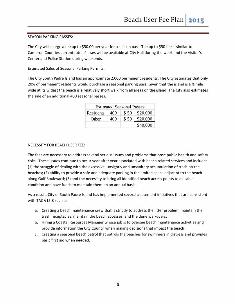
BeachUserFeePlan
8
SEASON PARKING PASSES:
The City will charge a fee up to $50.00 per year for a season pass. The up to $50 fee is similar to
Cameron Counties current rate. Passes will be available at City Hall during the week and the Visitor’s
Center and Police Station during weekends.
Estimated Sales of Seasonal Parking Permits:
The City South Padre Island has an approximate 2,000 permanent residents. The City estimates that only
20% of permanent residents would purchase a seasonal parking pass. Given that the island is a ½ mile
wide at its widest the beach is a relatively short walk from all areas on the island. The City also estimates
the sale of an additional 400 seasonal passes.
NECESSITY FOR BEACH USER FEE:
The fees are necessary to address several serious issues and problems that pose public health and safety
risks. These issues continue to occur year after year associated with beach related services and include:
(1) the struggle of dealing with the excessive, unsightly and unsanitary accumulation of trash on the
beaches; (2) ability to provide a safe and adequate parking in the limited space adjacent to the beach
along Gulf Boulevard; (3) and the necessity to bring all identified beach access points to a usable
condition and have funds to maintain them on an annual basis.
As a result, City of South Padre Island has implemented several abatement initiatives that are consistent
with TAC §15.8 such as:
a. Creating a beach maintenance crew that is strictly to address the litter problem, maintain the
trash receptacles, maintain the beach accesses, and the dune walkovers;
b. Hiring a Coastal Resources Manager whose job is to oversee beach maintenance activities and
provide information the City Council when making decisions that impact the beach;
c. Creating a seasonal beach patrol that patrols the beaches for swimmers in distress and provides
basic first aid when needed.
Residents 400 50$ 20,000$ Other 400 50$ 20,000$
40,000$
Estimated Seasonal Passes

BeachUserFeePlan
9
USER FEES SUPPORT ENHANCED MANAGEMENT PRACTICES:
The City of South Padre Island continues to maintain adequate and safe beach access for the public
which are subsidized through the collection of HOT. The addition of a Beach User Fees collected will
support expenditures associated with both long‐term and short‐term enhanced beach management
practices such as:
Short‐Term:
a. Seasonal staffing to support the influx of visitors during peak times including law enforcement,
life guards, code enforcement, and maintenance workers.
b. Expanded beach cleaning activities:
Increase the hand collection of litter.
Purchase beach equipment that lessens the maintenance activities impacts to the
beach/dune system.
Create a beach recycling program.
Create educational signage for the public related to beach maintenance.
c. Beach access and Walk‐over preventive maintenance:
For improvement and general maintenance of designated beach access points. By installing
parking, rinse stations, drinking water, and walkovers.
The City will use funds to rehabilitate older beach access walkover that are in need of repair.
Long‐Term:
a. Enhance safety along Gulf Boulevard with improved and designated parking along Gulf
Boulevard with appropriate signage along with pedestrian pathways. (Two to five years
depending on Beach User Fee revenue and grant availability.)
b. Purchase of vacant lots adjacent to the public beach to provide additional parking areas for the
public. (Proposed purchase of multiple‐lots in three locations for up‐to 60 spaces per combined
lots at a projected cost of $600,000: $450,000 for land; $150,000 for improvements. Two to
eight years depending on Beach User Fee revenue and grant availability.)
c. Construction funds available for future parking structures adjacent to the beach. (Three to five
years depending on Beach User Fee revenue and grant availability.)
d. Develop a trolley system that would enhance accessibility to the beach through the utilization of
the remote off‐beach parking areas for present and future demands. (Five or more years
depending on Beach User Fee revenue and grant availability.)
e. The City currently only has two public restrooms on Gulf Blvd. Improved public sanitation by
provision of port‐a‐potties or other mobile restrooms along the beach or access points located
in the City. Given our seasonal nature of demands for public sanitation mobile restrooms are the
most adaptable for our fluctuating demands. (One to three years depending on HOT revenue
and grant availability.)
f. Beach access enhancements:

BeachUserFeePlan
10
The City currently has four beach accesses on Gulf Boulevard that are completely
undeveloped if they were improved there would be an approximate increase of 85 parking
spaces in those cul‐de‐sacs. Another three beach accesses are partially developed and
would increase parking by approximately 40 spaces if improved within the next one to three
years.
CITATION OF ALL LEGAL AUTHORITY:
LEGAL AUTHORITY AUTHORIZING COLLECTION OF FEES:
Section 63.053(b) of the Texas Natural Resource Code allows governing body of a municipality to charge
reasonable fees that do not exceed the cost for the provision and maintenance of public beach related
facilities and services necessary to implement such plans, including but not limited to parking, public
health and safety, environmental protection and matters contained in the certified beach access plans,
and that do not unfairly limit access to and use of such beaches. Title 31, Texas Administrative Code,
Rule 15.8 sets forth requirements to be met for Beach User Fees.
BEACH ACCESS CHARGE AUTHORIZATION:
The City is authorized to charge a beach user a fee in exchange for providing services to beach users in
general. A beach user fee may only imposed if the fee is reasonable, taking into account the cost to the
local government of providing public services and facilities directly related to the public beach. A
reasonable fee is one that recovers the cost of providing and maintaining beach‐related services. In
addition, any fee collected for off‐beach parking to provide access to and from the public beach is
considered a beach user fee.
AUTHORIZATION SCHEDULE:
In order to establish and a maintain quality beach‐related services and facilities for the preservations
and enhancement of access to and from the beach and safe and healthy use of beaches by the public,
the following fee schedule is proposed for adoption by the City Council:
Up to $13.00 fee for daily use
o Visitor would be charged $6.35 to park their vehicle.
Parking Fee: $6.00 for 6 hrs.
Convenience Fee: .35 cents
Up to $50.00 fee for a seasonal pass
o The season will be from March 1st ‐ September 15th and only required for the spaces that
are adjacent to the beach. (Gulf Boulevard R.O.W. and beach access cul‐de‐sacs, with
the exception of all ADA parking spaces and regular parking spaces available at Harbor
Circle, Surf Circle and Aurora Circle that will be available as free parking)

BeachUserFeePlan
11
o 50% of the proposed generated revenue would be used to either purchase or lease land
and improvements for use for beach related public parking east of Padre Boulevard.
Proposed purchase of multiple‐lots in three locations for up‐to 60 spaces per combined
lots at a projected cost of $600,000: $450,000 for land; $150,000 for improvements.
Two to eight years depending on Beach User Fee revenue and grant availability.
STATE STANDARDS CONSISTENCY:
PROPOSED FEE IS CONSISTENT WITH STATE STANDARDS:
The beach user fee cannot exceed the necessary and actual cost of providing reasonable beach‐related
public facilities and services, unfairly limit public use to and from public beaches in any manner, is not
inconsistent with Title 31, Texas Administrative Code, Rule §15.8 or the Open Beaches Act; or
discriminates on the basis of residence.
The City fee will only apply to parking spaces adjacent to the public beach this includes east and west
sides of Gulf Boulevard, and beach access cul‐de‐sacs identified. All other parking areas west of Gulf Blvd
will remain free to the public to use in addition to the 65 spaces identified as free parking previously in
the plan. The off‐beach parking areas will be serviced by a dedicated beach route that will run 365 days
a year from 7 am – 9pm.
The beach user fee will not exceed the necessary and actual cost of providing reasonable beach related
public facilities and services. The Beach User Fee will not unfairly limit public use to and from the public
beaches. The beach user fee does not discriminate on the basis of residence and is consistent with Title
31, Texas Administrative Code, Rule §15.8 and the Open Beaches Act.
USE OF BEACH USER FEE REVENUES:
Revenues generated from beach user fees shall be used only for beach‐related services. In accordance
with TAC §15.2(11),“beach‐related services” means reasonable and necessary services and facilities
directly related to the public beach which are provided to the public to ensure safe use of and access to
and from the public beach, such as vehicular controls, management, and parking (including acquisition
and maintenance of off‐beach parking and access ways); sanitation and litter control; lifeguarding and
lifesaving; beach maintenance; law enforcement; beach nourishment projects; beach/dune system
education; beach/dune protection and restoration projects; providing public facilities such as restrooms,
showers, lockers, equipment rentals, and picnic areas; recreational and refreshment facilities; liability
insurance; and staff and personnel necessary to provide beach‐related services including, but not limited
to, reasonable administrative costs and accounting directly attributable to beach related services as
limited by TAC §15.8(f). Beach‐related services and facilities shall serve only those areas on or
immediately adjacent to the public beach. The City recognizes that enforcement of the program does
not qualify as a beach user fee expense.

BeachUserFeePlan
12
RECIPROCITY:
The City and Cameron County have entered into an interlocal agreement (No. 2013C04165). Each party
will recognize its own Beach Parking Permit system and be responsible for enforcement within their
respective jurisdictions. Neither will be required to acknowledge or accept the other’s permit within
their jurisdictional limits.
SIGNAGE:
The City shall assure that all free and user fee based access for parking and payment locations are clearly
identified with signs at all access areas including the off‐beach parking areas. Signage will be posted in
Spanish and English.
REPORTING ADMINISTRATIVE COST AND ACCOUNTING:
The following methods shall be used for administering and reporting beach user fee accounting:
a. The City will submit quarterly reports of the revenues and expenditures from Beach User Fee
accounts within 60‐61 days after the end of the quarter.
January 31
April 30
July 31
October 31
a. No more than 10% of beach user fee revenues shall be expended in one fiscal year on
reasonable administrative costs related to beach related services. Administrative Costs are
restricted to the direct costs of providing support for beach services such as supervisors who are
directly involved in providing services, then his or her time is eligible, further, accounting, record
keeping, personnel services, legal services, insurance and organizational management is eligible.
b. Revenue/Expenditure Accounting. The City will establish a separate “fund” in the City’s budget
for all expense of revenue activities occurring on City beaches. Revenues will be maintained and
accounted for separately and not commingled with any other funds so that fee collections may
be directly traced to expenditures on beach related services.
c. Beach user fee revenues shall be maintained and documented individually for each beach user
fee and account balances and expenditures shall be documented according to general accepted
accounting principles.
d. Annual operating and capital budgets will be established based on anticipated revenues and any
excess revenues at year‐end will be credited to the following year’s operating and capital
budgets.

5/6/2015
1
Public Parking Requirements on SPI
City Limits 1,415
The Shores 205
Total required 1,620

5/6/2015
2
Paid Parking Beach Access Cul‐de‐sac’s
• 23 Beach Access Cul‐de‐sac’s on Gulf Blvd ~600 feet from one access to the next (3 access points will remain free)•230 Total Public Parking Spaces (65 spaces will be free)•There are 4 beach accesses that are completely undeveloped
•With improvements an approximate increase of 85 parking spaces
•There are 3 beach accesses that are partially developed •With these improvements there would be ~40 spaces
•Other beach accesses are in need of maintenance and repair but there is currently no revenue for upkeep
Paid Parking on Gulf Blvd
• The Public is allowed to park on the East and West sides of Gulf Blvd.
• Currently there are 343 spaces on the ROW of Gulf Blvd
• For safety reasons the City is currently in the process of improving sections of Gulf Blvd this means exact parking space numbers will fluctuate as the improvements are made– This includes a project funded by the CMP grant cycles 18 & 19
– Future improvements will incorporate load/unloading zones for the public to safely transport items to the beach accesses and then utilize the public transportation for the off‐beach areas

5/6/2015
3
Free Parking in Cul‐de‐sacs on Gulf Blvd.
• A total of 65 parking spaces or 29% of parking spaces in the beach accesses will be free of charge.
• Three beach accesses on Gulf Blvd as free parking areas– Harbor Circle
» 18 Spaces
– Surf Circle» 22 Spaces
– Aurora Circle» 12 Spaces
• In compliance with Chapter 681 of the Texas Transportation Code persons with disabilities are exempt from the payment of any fees if the vehicle is displaying an appropriate license plate or disabled parking placard. This does not permit parking at a time when or a place where parking is prohibited.
Free Parking on East Side Streets• Parking along the East side streets is currently restricted unless said vehicle displays a hurricane return sticker (Ord. Sec 18‐19.1).
• The ordinance does permit:– Unrestricted parking in the area that is 200 feet or less from Padre Blvd.
• Except for areas with in 30 feet of a stop sign per Tx State Law
– Unrestricted parking on the streets that have been improved, these are streets that are 32 feet wide with curb and gutter and a sidewalk on one side.
– Currently there are 3 streets:• East Hass‐ 21 spaces• East Mezquite‐ 40 spaces• East Esperanza‐ 18 spaces• East Huisache‐ 33 spaces scheduled for this year (2013)

5/6/2015
4
Unrestricted parking in the areas located 200 feet or less from Padre Blvd (PR 100)
200 feet from Padre Areas with available parking
Unrestricted parking on improved East side streets
Unrestricted parking
• East Hass‐ 21 spaces• East Mezquite‐ 40 spaces• East Esperanza‐ 18 spaces• East Huisache‐ 33 spaces scheduled for this year (2013)

5/6/2015
5
Parking East of Padre BlvdBeach Accesses
Gulf Blvd R.O.W. 343
Restricted Unrestricted
Haas 21
Harbor St 0
Sunny Isle 0
Mars 3
Palm 7
Corral 2
Sheepshead 2
Pompano 5
Tarpon 5
Marlin 3
Ling 6
Pike 2
AmberJack 0
Whiting 4
Swordfish 10
Redsnapper 0
Dolphin 3
Kingfish 4
Acapulco 4
Campeche 3
Bahama 2
Atol 0
Retama 12
Mesquite 41
Huisache 34
Lantana 0
Oleander 0
Gardenia 14
Hibiscus 2
Esperanza 18
Saturn 8
Venus 13
Jupiter 10
Mars 18
Constellation 0
Capricorn 12
Aries 0
Polaris 8
Verna Jean 10
Georgia Ruth 0
Carolyn 8
Cora Lee 18
Morningside 2
Parade 6
Palmetto 6
Sunset 11
223 114 337Cont.
Restricted Unrestricted
Dedicated Free Parking Spaces (54)+ All Disabled Parking Spaces (20)
Name ADA Public Total
Harbor 2 16 16
Ocean Dr 0 0 0
Gulf Circle 1 19 19
Beach Circle 0 17 17
Sea Island 0 9 9
Sea Side 1 12 12
Surf Circle 3 19 19
White Cap 0 0 0
Bluewater 2 20 20
Riviera 0 0 0
Treasure Island 1 7 7
Daydream 0 0 0
Moonlight 0 6 6
Bougainvillaea 1 10 10
Poinsettia 0 10 10
Neptune 0 12 12
Starlight 1 11 11
Aquarius 2 8 8
Aurora 2 10 10
Gay Dawn 2 6 6
Good Hope 2 9 9
Fantasy 0 9 9
Sapphire 0 0 0
20 210 230
Public Transportation for off‐beach parking areas
• Off‐Beach parking areas will be serviced by a dedicated beach route
• The Wave will provide transportation to all beach access points on SPI
• The complete route will take 30 minutes.
• Route will run 365 days a year from 7 a.m. – 9 p.m.

5/6/2015
6
Dedicated Beach RouteNorth
Off‐Beach Parking AreasConvention Center
• 469 Public Parking Spaces
• The Wave provides transportation to and from the Convention Center every half hour
• The Wave will travel directly to Gulf Blvd after this stop
469
469
469
469
PADRE BLVD
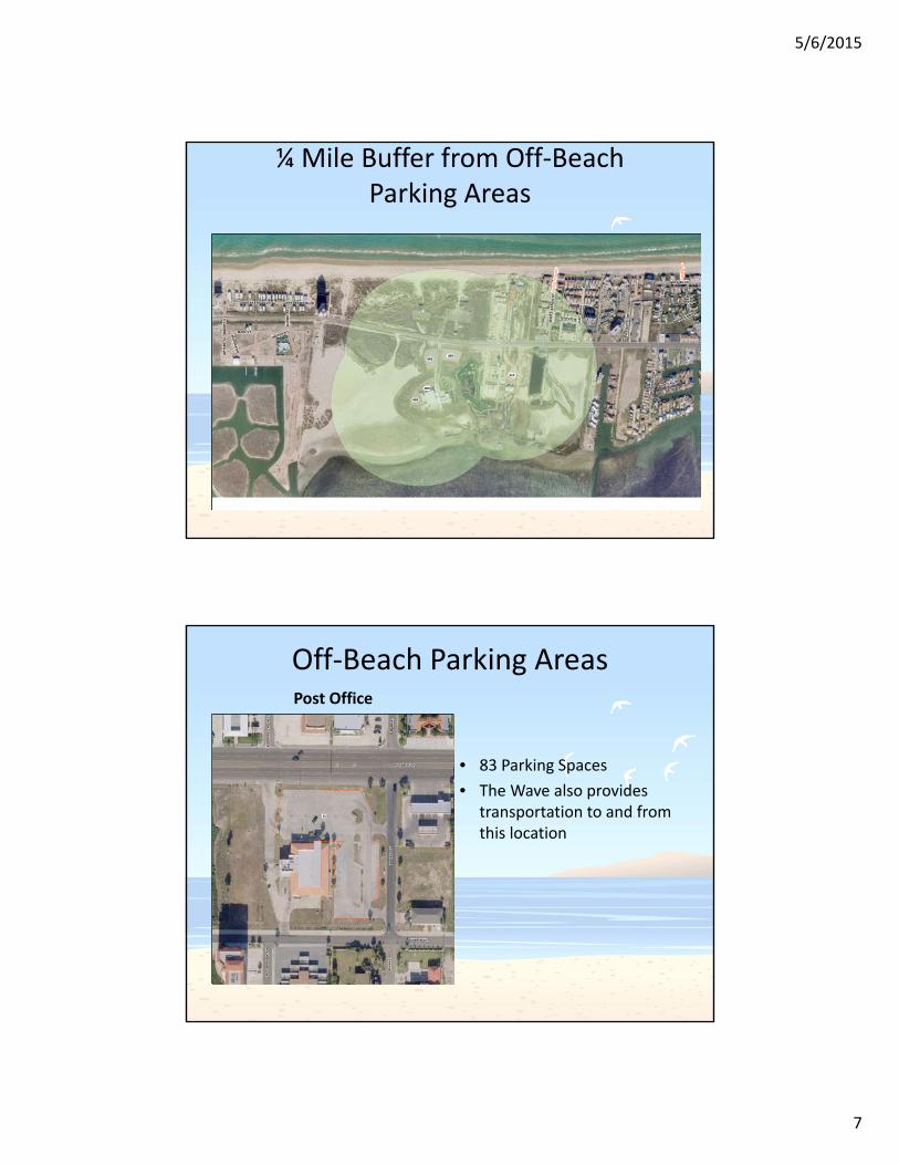
5/6/2015
7
¼ Mile Buffer from Off‐Beach Parking Areas
469469
112
469
469
W S
UN
SE
T D
R
E S
UN
SE
T D
R
GULF BLVD
PA
LM
ET
TO
DR
WH
ITE
SA
ND
S S
T
VIL
LA
S D
OC
E D
R
BREAKERS BLVD
YUCCA CIR
MA
RIN
A D
R
HAVANA DRBAYVIEW
MAIN ST
BEACH DR
HA
CIE
ND
A
WH
AR
F S
T WATER ST
SH
OR
E D
R
WH
AR
F S
T
BREAKERS BLVD
Sa p
phi
re
Wh
ite S
ands
Off‐Beach Parking AreasPost Office
• 83 Parking Spaces
• The Wave also provides transportation to and from this location
83
PADRE BLVD
LAGUNA BLVD
W M
AR
S S
TE
MA
RS
ST
W C
ON
ST
EL
LA
TIO
NE
CO
NS
TE
LL
AT
ION
ST
W M
AR
S S
T

5/6/2015
8
Off‐Beach Parking AreasCity Hall
• 105 Parking Spaces
105
105
105
PADRE BLVD
LAGUNA BLVD
W V
EN
US
LN
E V
EN
US
LN
E J
UP
ITE
R L
NW
JU
PIT
ER
LN
¼ Mile Buffer from Off‐Beach Parking Areas
83
105
105
105
PADRE BLVD
LAGUNA BLVD
GULF BLVD
E M
AR
S S
T
E V
EN
US
LN
E S
AT
UR
N L
N
E J
UP
ITE
R L
N
W O
LE
AN
DE
R S
T
E A
RIE
S S
T
W E
SP
ER
AN
ZA
ST
E H
IBI S
CU
S S
T
W S
AT
UR
N L
N
E G
AR
DE
NIA
ST
E O
LE
AN
DE
R S
T
E P
OL
AR
IS S
T
E E
SP
ER
AN
ZA
ST
W H
IBIS
CU
S S
T
W M
AR
S S
T
W A
RIE
S S
T
W G
AR
DE
NIA
ST
E V
ER
NA
JE
AN
ST
E C
ON
ST
EL
LA
TIO
N S
T
E G
EO
RG
IA R
UT
H S
T
W C
AP
RIC
OR
N S
T
W P
OL
AR
I S S
T
W G
EO
RG
IA R
UT
H S
T E C
AP
RIC
OR
N S
T
W G
AR
DE
NIA
ST
Au r
ora
Nep
tun
e
Sta
rligh
t
Aqu
ariu
s
Po i
nse
ttia
Gay
Da
wn
Bou
ga
invi
llea

5/6/2015
9
¼ Mile Buffer from Beach Accesses
31 Tex. Admin. Code 15.7(h)(1)(B) • Where vehicles are prohibited from driving on and along the
beach, ingress/egress access ways are no farther apart than 1/2 mile.– All parking areas are with in ½ mile of a beach access with a majority
being less than a ¼ mile
Beach Parking System
Number of Spaces Req by TOBA
Southern City Limits 1,415
The Shores 205
Total required 1,620
Paid Parking Areas
Free Parking East of Padre Blvd
Off‐beach parking areas
508, 31%
1157, 69%
Paid Spaces
Free Spaces
928, 55%
757, 45%East of Padre Blvd
Off‐Beach parking
ADA Public Total
Beach Access Culdesac's 0 165 165
Gulf Blvd R.O.W. 0 343 343
Beach Access Culdesac's 20 45 65
Improved East Side Streets 0 112 112
Unrestricted area East Side Streets 0 223 223
Convention Center 8 461 469
Post office 3 80 83
City Hall 5 100 105
Contributed by County Parks for Shores Development 0 100 100
1665

5/6/2015
10
31 Tex. Admin. Code 15.7(h)(1)(1) For the purposes of this subchapter, beach access and use is presumed to be preserved if the following criteria are met.
(A) Parking on or adjacent to the beach is adequate to aaccommodate one car for each 15 linear feet of beach.
– SPI has identified 1,665 parking spaces for beach goers...
(B) Where vehicles are prohibited from driving on and along the beach, ingress/egress access ways are no farther apart than ½ mile.
– 55% (908) of our identified spaces are East of Padre Blvd well with in a ¼ mile of numerous beach access points on Gulf Blvd
– All Off‐beach parking areas are with in ½ mile of beach access points but will also be serviced by free public transportation with a direct route to Gulf Blvd
(C) Signs will be conspicuously posted which explain the nature and extent of vehicular controls, parking areas, and access points, including access for disabled person.
– SPI will provide signage at all beach parking areas
31 Tex. Admin. Code 15.8(c)(2)(D)
• (D) Discriminates on the basis of residence– All off‐beach parking areas will serviced by free public transportation
– Out of the 1,665 spaces identified on SPI 55% are East of Padre Blvd
– Of those 908 spaces East of Padre Blvd 45% are free parking
– Every vehicle parking on Gulf Blvd or beach access cul‐de‐sacs will be required to have a beach parking permit regardless of residence

5/6/2015
11
SPI is limited by funds for routine maintenance and improvements despite this challenge we have a very successful beach access program that was recognized by Commissioner Patterson in 2010 when he declared SPI the most accessible beach in Texas. We look forward to expanding these efforts with a BUF revenue.

ORDINANCE NO. 15- 06
AN ORDINANCE OF 1HE CITY OF SOUTH PADRE ISLAND, TEXAS, ADDING SECTION 18-19.4 OF CHAPTER 18 OF 1HE CODE OF ORDINANCES TO RESTRICT PARKING IN OR ON A CUL-DE-SAC EAST OF THE EAST RIGHT -OF-WAY LINE OF GULF BOULEVARD AND GULF BLVD FROM MARCH 1 TO SEPTEMBER 15 AND ANY PARKING ON SAID STREET OR CUL-DE-SAC MUST PAY A PARKING FEE, PROVISION FOR HANDICAP PARKING WITH NO FEE.; PROVIDING FOR A PENALTY FOR VIOLATION NOT TO EXCEED FJVE HUNDRED DOLLARS ($500.00); PROVIDING FOR SEVERABILITY; AND AUTHORIZING PUBLICATION IN CAPTION FORM.
WHEREAS, Section 18-19.1 of the Code of Ordinances restricts parking on residential side streets from March 1 to September 15; and
WHEREAS, currently overnight parking is prohibited year-round on the cui-de-sacs east of Gulf Boulevard with the exception of Aurora, Surf and Harbor Circles where the prohibition begins at 2:01am; and
WHEREAS, In order to establish and maintain beach related services and facilities for the preservation and enhancement of access to and from the public beach, and to provide safe and healthy use of public beaches by the public, vehicles may be charged a fee for parking in or on a cul-de-sac east of the east right-of-way line of Gulf Boulevard and Gulf Boulevard from March 1 to September 15:
NOW, TIIEREFORE, BE IT ORDAINED BY 1HE CITY COUNCIL OF 1HE CITY OF SOUTH PADRE ISLAND, TEXAS:
Section 1. Sec. 18-19.4 of Chapter 18 of the Code of Ordinances of the City of South Padre Island is hereby added to read as follows:
"Sec. 18-19.4. Paid Parking in or on a cnl-de-sac east of the east right-of-way line of Gulf Boulevard and Gulf Boulevard from March 1 to September 15
Ord 15-
(A)No person shall stop, stand or park a vehicle in or on Gulf Blvd or a cul-de-sac east of Gulf Blvd with out paying a parking fee as herein provided: (1) $6.00 for six hours from the hours of 8:00 am to 8:00 pm; except parking is prohibited in the cui-de-sacs east of the east Right-of-way line of Gulf Boulevard between the hours of 12:01 A.M. and 6:00A.M., except Aurora Circle, Surf Circle and Harbor Circle the prohibited hours are between 2:01 A.M. and 6:00 A.M. When permitted, parking is restricted to designated spaces on the westerly side of Gulf Boulevard and at Beach access cui-de-sacs on the easterly side of Gulf Boulevard; during the hours that parking is permitted at cui-de-sacs Harbor, Surf, and Aurora it shall be without a parking fee (free). (2) A $50.00 season pass will be available for purchase at the Police Station in City Hall; (3) Vehicles are limited to remaining in one parking space for a maximum twentyfour hour period.
(4) Payment can be made by credit card by contacting the phone number on the sign by cell phone or other mobile device, as this is an internet based parking
Page 1

system and at the locations where season passes are made available.
(B) Over night parking is still prohibited in the Cui-de-sacs per Sec. 18-19.2 of the Code of Ordinances.
(C) In compliance with Chapter 681 of the Texas Transportation Code persons with disabilities are exempt from the payment of any fees if the vehicle is displaying an appropriate license plate or disabled parking placard. This does not permit parking at a time when or a place where parking is prohibited.
Section 2.This ordinance does not become effective until the Texas General Land Office (GLO) has approved the City's Beach User Fee Plan.
Section 3. This Ordinance repeals all portions of any prior ordinances or parts of ordinances ofthe Code of Ordinances in conflict herewith.
Section 4. Any violation of this Ordinance may be punished by a fine not to exceed Five Hundred Dollars ($500.00) for each offense or for each day such offense shall continue and the penalty provisions of Section 21-1 of the Code of Ordinances is hereby adopted and incorporated for all purposes.
Section 5. If for any reason any section, paragraph, subdivision, clause, phrase, word or provision of this Ordinance shall be held invalid or unconstitutional by final judgment of a court of competent jurisdiction, it shall not affect any other section, paragraph, subdivision, clause, phrase, word or provision of this Ordinance for it is the definite intent of this City Council that every section, paragraph, subdivision, clause, phrase, word or provision hereof be given full force and effect for its purpose.
Section 6. This Ordinance shall become effective when published in summary form or by publishing its caption.
PASSED, APPROVED AND ADOPTED on First Reading, this 6th day ofMay 2015.
PASSED, APPROVED AND ADOPTED on Second Reading, this 20th day ofMay 2015.
ATTEST:
Ord 15- Page 2
CITY OF SOUTH PADRE ISLAND, TEXAS
Bharat R. Patel. MAYOR