southwest asia middle east human environmental · pdf filesouthwest asia middle east human...
TRANSCRIPT
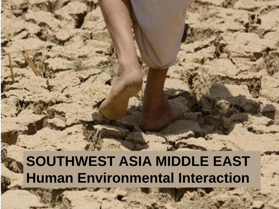
SOUTHWEST ASIA MIDDLE EAST
Human Environmental Interaction

GA Geography Grade 7 • As many of you learned in our introductory “Themes and Enduring
Understandings” lessons for GA Geography Grade 7, students continue
the study of physical and cultural geography, focusing on the remaining
regions of the world (not covered last year): Southwest Asia/Middle East,
Africa, and Southern and Eastern Asia.
• For this lesson on SW Asia/ME Human Environmental Interaction, terms
in bold text will be used to activate your schema of terms used last
year. Many of these first terms relating to Human Environment Interaction
should be familiar, as you applied them in both Geography and Earth
Science last year.
• I have links to web pages highlighted within the directions on slides as a
reading exercise, and as a beginner lesson in technology.
Assignment: Journal p 14
G6a G7a G7b SWA/ME Environment PPT
• Use your journal to complete short answer responses to bold
questions 1-10 and the BONUS. Skip a line between questions.
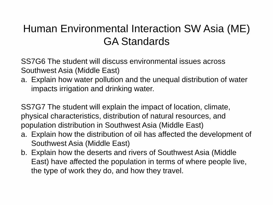
Human Environmental Interaction SW Asia (ME)
GA Standards
SS7G6 The student will discuss environmental issues across
Southwest Asia (Middle East)
a. Explain how water pollution and the unequal distribution of water
impacts irrigation and drinking water.
SS7G7 The student will explain the impact of location, climate,
physical characteristics, distribution of natural resources, and
population distribution in Southwest Asia (Middle East)
a. Explain how the distribution of oil has affected the development of
Southwest Asia (Middle East)
b. Explain how the deserts and rivers of Southwest Asia (Middle
East) have affected the population in terms of where people live,
the type of work they do, and how they travel.

SW Asia/ME Environmental Issues Intro
Fragile Environment
Deforestation
Desertification
Overgrazing
Water Management
Pollution
Click here for
online map
practice—or
timed challenge
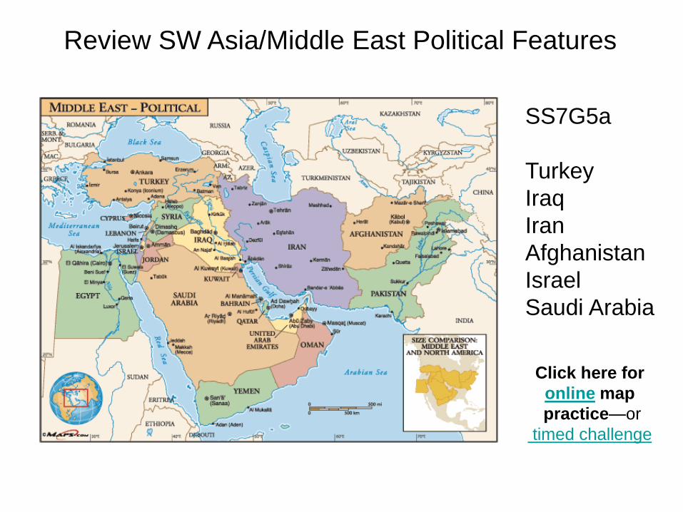
SS7G5a
Turkey
Iraq
Iran
Afghanistan
Israel
Saudi Arabia
Review SW Asia/Middle East Political Features

SS7G5b
Gaza Strip
Jordan River
Suez Canal
Red Sea
Euphrates River
Tigris River
Persian Sea
Strait of Hormuz
Arabian Sea
Click here for
online practice
Review SW Asia/Middle East Physical Features
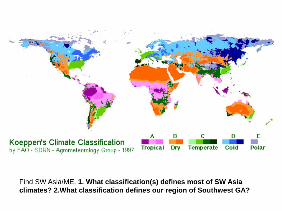
Find SW Asia/ME. 1. What classification(s) defines most of SW Asia
climates? 2.What classification defines our region of Southwest GA?

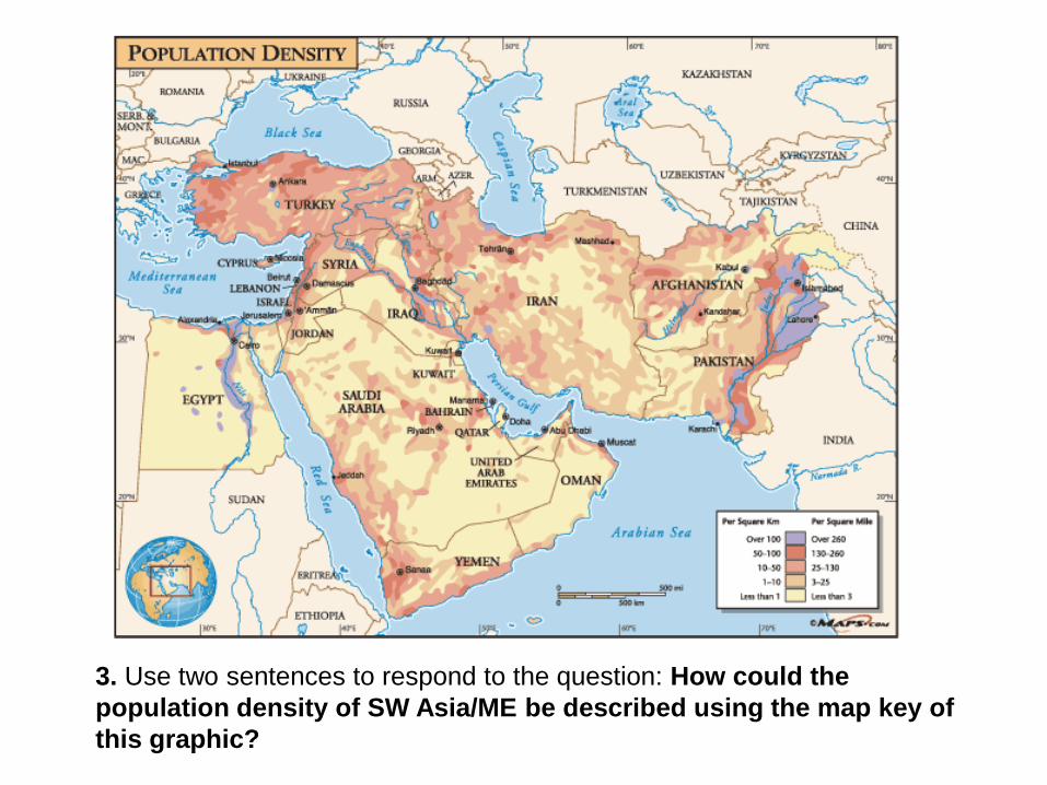
3. Use two sentences to respond to the question: How could the
population density of SW Asia/ME be described using the map key of
this graphic?

4. Use two sentences to respond to the question: How
are physical features of the land a factor impacting
(changing) how people live in SW Asia/ME?

(Conservation—using techniques that make the best use of resources with the
least amount of waste, loss, injury or decay)
5. In what way is this person practicing good conservation techniques?

Subsistence Agriculture (Subsistence Farming)
Nearly all the crops or livestock made are used to
feed the family, with little extra; most are farms
tended with hand tools and possibly an animal for
plowing.
6. Use one to
two sentences
to respond to
the question:
What is meant
by this
statement—
subsistence
farmers are
attempting to
meet the basic
survival needs
of a family?


7. About what temperature range was recorded around the
Persian Gulf on 21 Aug 2012?

SE Asia ME Water Crisis Causes Solutions
• Dry Land
• Dams decreasing available
water downstream
• Drought (Little Rainfall)
• Population Growth
• Water use per person
• Agriculture (Farming and
Irrigation)
• Overuse of land and fertilizers,
leading to Desertification
• Desalination Removing Salt
from Seawater—Expensive!
• Alternative Water Sources
(Storing rainwater, capturing
winter thaw from mountains
etc.)
• Importing Water (Buying from
another country)
• Conservation (Saving Water)
• Treating Waste Water
(Yummy)
• Decreasing chemical fertilizers
• Water resource distribution
• Alternative Energy Sources

Drought
Extended period of time without rainfall

Much of SW Asia/ME—
arid or semi-arid with
few water sources
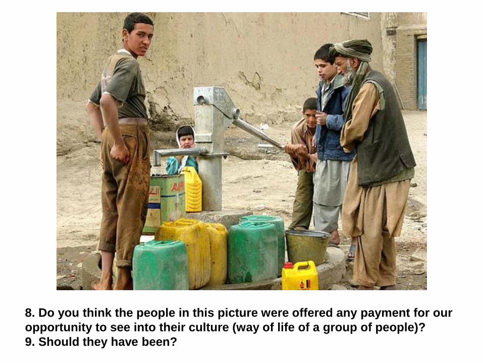
8. Do you think the people in this picture were offered any payment for our
opportunity to see into their culture (way of life of a group of people)?
9. Should they have been?

Link to an Aquifer Recharge Map Series to answer the following:
BONUS: Which region has a higher rate of aquifer recharge,
southwest GA, USA, or SW Asia/Middle East?

An oasis—a small place where trees are able to grow and
where people can live with grazing animals and a few crops

10. In which of these two countries, Turkey or Saudi Arabia,
would an oasis more likely be found?

Water is unevenly distributed in
SW Asia/Middle East, with much of
the land being arid.
Lack of water and WATER RIGHTS may
lead to WATER WARS in the future.
Countries like Turkey that place dams
upstream decrease the water supply to
others countries in desperate need. People
are often displaced from their homelands.
Conflict over water rights has also been an
issue between the Jews and Arabs from the
beginning of the Arab-Israeli Conflict.
Water is expected to become the most
valuable resource of SW Asia, taking the
place of oil. Click on the interactive map link.
Map of UN Partition Plan 1947
for dividing the land of
Palestine between Palestinian
and Jewish people

DAMS
Turkey, Syria,
Iraq, &
Iran
Hydroelectric
Power—from
energy of
moving water
Industry
Irrigation of
crops

Dams decrease the water supply, preventing rivers like the Tigris and
Euphrates from flooding—nutrients no longer deposit on the soil as
fertilizers—many farmers then use chemical fertilizers that eventually
build up in the soil as salts---soil becomes unusable for crops or animals

Wasteful
WATER CONSERVATION
ISSUES
Efficient
Drip Irrigation (Bringing water to
plants where needed)

Fossil Water (Paleowater) Water that has been sealed in underground aquifers
(layers of rock) for long periods of time—once used cannot
be replaced by underground springs or rainfall
(a nonrenewable resource)
Also, radioactive particles
(from the breakdown of
sandstone) have been found
in some of the water—these
particles must be removed
and safely disposed of.
Does this look like an
inexpensive or a long-term
solution to water needs?
Pipes are put in place for a
Libyan water transfer project. Link to fossil water article
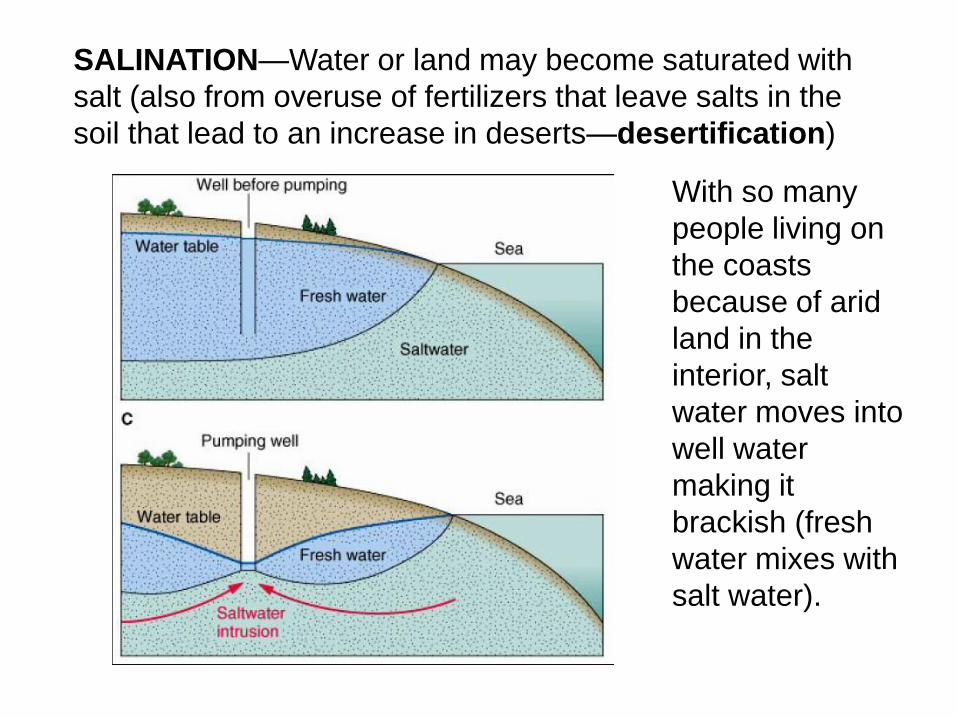
SALINATION—Water or land may become saturated with
salt (also from overuse of fertilizers that leave salts in the
soil that lead to an increase in deserts—desertification)
With so many
people living on
the coasts
because of arid
land in the
interior, salt
water moves into
well water
making it
brackish (fresh
water mixes with
salt water).

Desalination—Removes salt from seawater
Problem—A technology too expensive for most to afford
US has plants in Tampa Bay, FL and San Antonio, TX
Desalination
plant in Saudi
Arabia
Produces
25,000,000 or
more gal/day
fresh water
Some processes
fit for drinking

Petroleum—Crude Oil
• Another resource unequally
distributed in SW Asia/ME
• Countries with oil have
greater access to resources
and development
• Many countries have large
populations living in poverty
who suffer from the lack of
resources

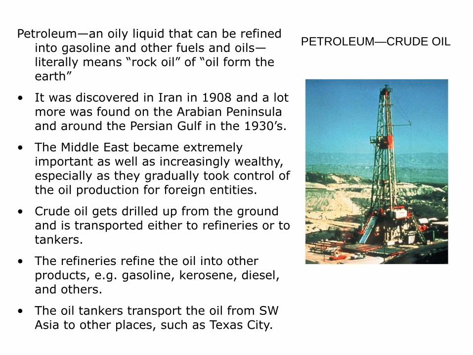
Petroleum—an oily liquid that can be refined into gasoline and other fuels and oils—literally means “rock oil” of “oil form the earth”
• It was discovered in Iran in 1908 and a lot more was found on the Arabian Peninsula and around the Persian Gulf in the 1930’s.
• The Middle East became extremely important as well as increasingly wealthy, especially as they gradually took control of the oil production for foreign entities.
• Crude oil gets drilled up from the ground and is transported either to refineries or to tankers.
• The refineries refine the oil into other products, e.g. gasoline, kerosene, diesel, and others.
• The oil tankers transport the oil from SW Asia to other places, such as Texas City.
PETROLEUM—CRUDE OIL
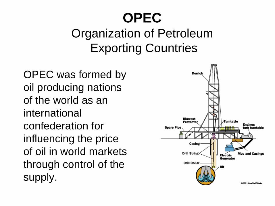
OPEC was formed by
oil producing nations
of the world as an
international
confederation for
influencing the price
of oil in world markets
through control of the
supply.
OPEC Organization of Petroleum
Exporting Countries

What information does the graphic show? Create notes that list the members
and crude oil reserve percentages for each country. Which four members have
the largest reserves?
Read more about the organization, members and mission of OPEC.

Supertankers Knock Nevis
• 1504 feet long, 226 feet wide
• sits 80 feet in the water fully loaded
• weighs 1,428,496,250 pounds
• can carry 127,100,000 gallons of oil
• so big, she can’t navigate the Panama Canal, the Suez Canal, or even the English Channel

Oil spill of the Exxon Valdez in 1989
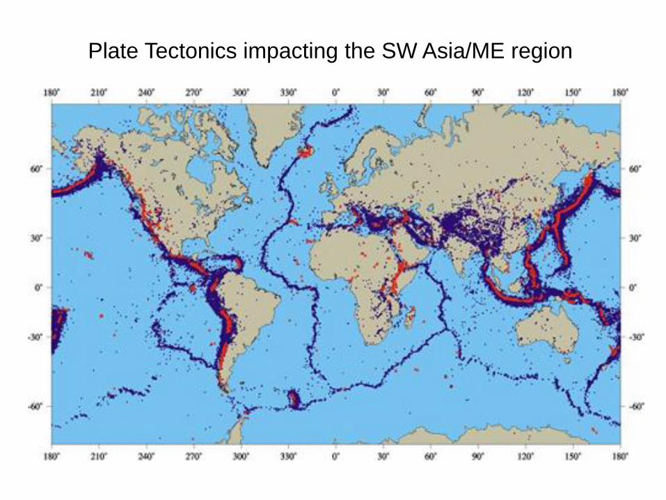
Plate Tectonics impacting the SW Asia/ME region

Plate Tectonics impacting the SW Asia/ME region

To answer the question, “How often do earthquakes occur in the region?,”
click on the Seismic Monitor image or here to link to an interactive map.

To complete
overview and review
SW Asia/Middle East
click here

Resources SW Asia/Middle East
Human Environmental Interaction
Fossil Water
http://news.nationalgeographic.com/news/2010/05/100505-fossil-water-
radioactive-science-environment/
World's Freshwater
http://ngm.nationalgeographic.com/2010/04/water/water-animation
http://www.aljazeera.com/indepth/features/2011/06/2011622193147231653.ht
ml
OPEC
http://www.opec.org/opec_web/en/17.htm
Earthquakes and volcanic activity
http://www.iris.edu/seismon/
Map Practicehttp://www.mapquiz.net/en/
http://www.ilike2learn.com/
http://www.sheppardsoftware.com/Geography.htm
http://www.studentsoftheworld.info/menu_infopays.html
http://www.nationsonline.org/oneworld/western_asia_map.htm