spa, delhi syllabus copy
TRANSCRIPT
Co-ordinated by :
Department of Housing
School of Planning and Architecture
4 B, Indraprastha Estate, New Delhi
July – December, 2012
Master of Planning
First Semester - Integrated Programme

Master of Planning, 1st Semester Integrated Programme, July – December 2012 SPA – New Delhi
CONTENTS
1. ABOUT SPA 1 2. ABOUT THE MASTER OF PLANNING ( First Semester )
(a) First Day Programme 3 (b) Studio Programme Schedule 4 (c) Faculty Grouping 5 (d) Syllabus 6 (e) Time Table 14
3. ASSIGNMENTS
(a) Assignment 1: Area Appreciation 18 (b) Assignment 2: Site Planning 19 (c) Assignment 3: Outline Development Plan 20
4. ANNEXURES
(a) Annexure 1: Planning Terminologies 21 (b) Annexure 2: Techniques of Map Presentation 42 (c) Annexure 3: Delhi Master Plan Development Code 46 (d) Annexure 4: Landuse Classification and Colour Coding 57 (e) Annexure 5: References 59
(f) Annexure 6: Directory 65

Master of Planning, 1st Semester Integrated Programme, July – December 2012 SPA – New Delhi
1
About SPA, New Delhi

1
Master of Planning, 1st Semester Integrated Programme, July – December 2012 SPA – New Delhi
About SPA, New Delhi
The origin of the School of Planning and Architecture ( SPA ), New Delhi dates back to the year 1941. What started in a modest way to impart architectural education gradually grew into significant size and encompassed many other associated fields. Today, the SPA has emerged as a premier national level ‘ deemed University’ in South Asia with a dozen departments of studies, centers of research, well equipped libraries and computer facilities, around 40 internal faculty and over a 100 visiting faculty. SPA imparts education at the bachelor’s, master’s and doctoral level. Today, SPA offers courses in architecture, physical planning, urban planning, regional planning, environmental planning, housing, transport planning, urban design, architectural conservation, landscape architecture, industrial design and building engineering and management. Operating from twin campuses at the Indraprastha Estate, New Delhi, SPA alumni have made a mark for themselves both in India as well as abroad. SPA has good academic resources and support systems. The Library has a rich collection of over 70,000 books and receives over 250 journals. The library is also a member of the DELNET and provides online access to a catalogue of 1100 libraries in Delhi, within Indian and overseas. More information is available at the SPA Prospectus 2012 and the website www.spa.ac.in

2
Master of Planning, 1st Semester Integrated Programme, July – December 2012 SPA – New Delhi

Master of Planning, 1st Semester Integrated Programme, July – December 2012 SPA – New Delhi
2
About the
Master of Planning
( First Semester )
1
Master of Planning, 1st Semester Integrated Programme, July – December 2012 SPA – New Delhi
About the Master of Planning
(First Semester)
The Master of Planning programme is a two year – 4 semester programme. The first semester of this programme is an integrated one; common to all the 5 planning specializations of urban planning, regional planning, housing, transport planning and environment planning. The first semester starts on 23
rd August, 2012 and ends on 05 December 2012.
a) FIRST DAY PROGRAMME
Date: Monday, 23 July, 2012 Venue: New Committee Room, Ground Floor, Central Block, Planning Building
Schedule:
TIME PROGRAMME
FORENOON
10:00 am to 1.00 pm
Students to report to their respective departments
Environmental Planning - 2nd Floor, Central Block Planning Bldg.
Housing – 4th
Floor, Central Block, Planning Building Regional Planning – 2
nd Floor, Central Block, Planning
Building Transport Planning – 4
th Floor, Central Block, Planning
Building Urban Planning – 2
nd Floor, South Block, Planning Building
AFTERNOON
2:00
INTRODUCTORY REMARKS - Coordinator of Master of Planning ( 1
st Semester Integrated Programme )
2:15
WELCOME ADDRESS by the Dean of Studies
2:45
INTRODUCTIONS - HODs, Faculty and Students
3:00
PRESENTATION - School of Planning and Architecture, New Delhi
3:15
ABOUT THE PLANNING DEPARTMENTS – Presentations by HODs of Environmental Planning, Housing, Regional Planning, Transport Planning and Urban Planning.

2
Master of Planning, 1st Semester Integrated Programme, July – December 2012 SPA – New Delhi
b) STUDIO PROGRAMMESCHEDULE : 23
rd July 2012 to 3
rd December 2012
Date Day Programme
22 Wed
22 Sat Proceed to Field
7 Wed
23-Jul-12 Mon Welcome, Orientation
23 Thu
23 Sun
8 Thu
24 Tue Meeting with Director, Film
24 Fri
24 Mon
Field Work
9 Fri
25 Wed -
25 Sat
25 Tue
10 Sat
26 Thu Film
26 Sun
26 Wed
11 Sun
27 Fri AREA APPRECIATION
27 Mon Review 4
27 Thu
12 Mon Review 9
28 Sat
28 Tue
28 Fri
13 Tue
29 Sun
29 Wed
29 Sat
14 Wed
30 Mon Review 1
30 Thu
30 Sun
15 Thu
31 Tue
31 Fri
01-Oct-12 Mon Field Work
16 Fri
01-Aug-12 Wed
01-Sep-12 Sat
2 Tue
17 Sat
2 Thu
2 Sun
3 Wed
18 Sun
3 Fri
3 Mon Review 5
4 Thu
19 Mon Review 10
4 Sat
4 Tue
5 Fri
20 Tue
5 Sun
5 Wed
6 Sat
21 Wed
6 Mon Review 2
6 Thu
7 Sun
22 Thu
7 Tue
7 Fri
8 Mon Field Work
23 Fri
8 Wed
8 Sat
9 Tue
24 Sat
9 Thu
9 Sun
10 Wed Return to Delhi
25 Sun
10 Fri
10 Mon Review 6
11 Thu Faculty Meeting Students
26 Mon Review 11
11 Sat
11 Tue
12 Fri Faculty Meeting Students
27 Tue
12 Sun
12 Wed
13 Oct'12 - 28 Oct'12 - Mid Term Break – Data Analysis
28 Wed
13 Mon Review 3
13 Thu Submission
29 Mon Review 7
29 Thu
14 Tue
14 Fri O.D.P.
30 Tue
30 Fri Submission
15 Wed
15 Sat
31 Wed
01-Dec-12 Sat
16 Thu
16 Sun
01-Nov-12 Thu
2 Sun
17 Fri Submission
17 Mon
2 Fri
3 Mon Final Jury
18 Sat
18 Tue
3 Sat
Preparatory Leave and Examinations
19 Sun
19 Wed
4 Sun 20 Mon SITE PLANNING
20 Thu
5 Mon Review 8
21 Tue
21 Fri
6 Tue
3
Master of Planning, 1st Semester Integrated Programme, July – December 2012 SPA – New Delhi
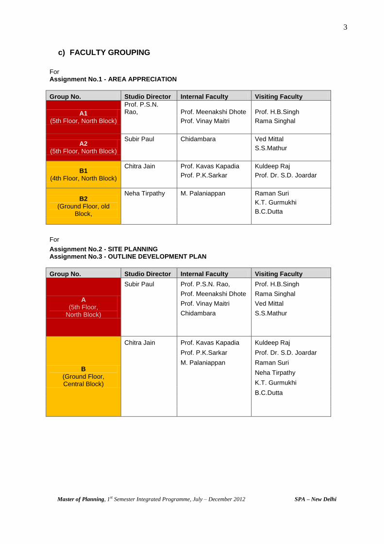
c) FACULTY GROUPING
For Assignment No.1 - AREA APPRECIATION
Group No. Studio Director Internal Faculty Visiting Faculty
A1 (5th Floor, North Block)
Prof. P.S.N. Rao, Prof. Meenakshi Dhote Prof. H.B.Singh
Prof. Vinay Maitri Rama Singhal
A2 (5th Floor, North Block)
Subir Paul Chidambara Ved Mittal
S.S.Mathur
B1 (4th Floor, North Block)
Chitra Jain Prof. Kavas Kapadia Kuldeep Raj
Prof. P.K.Sarkar Prof. Dr. S.D. Joardar
B2 (Ground Floor, old
Block,
Neha Tirpathy M. Palaniappan Raman Suri
K.T. Gurmukhi
B.C.Dutta
For Assignment No.2 - SITE PLANNING
Assignment No.3 - OUTLINE DEVELOPMENT PLAN
Group No. Studio Director Internal Faculty Visiting Faculty
A (5th Floor,
North Block)
Subir Paul Prof. P.S.N. Rao, Prof. H.B.Singh
Prof. Meenakshi Dhote Rama Singhal
Prof. Vinay Maitri Ved Mittal
Chidambara S.S.Mathur
B (Ground Floor, Central Block)
Chitra Jain Prof. Kavas Kapadia Kuldeep Raj
Prof. P.K.Sarkar Prof. Dr. S.D. Joardar
M. Palaniappan Raman Suri
Neha Tirpathy
K.T. Gurmukhi
B.C.Dutta
4
Master of Planning, 1st Semester Integrated Programme, July – December 2012 SPA – New Delhi
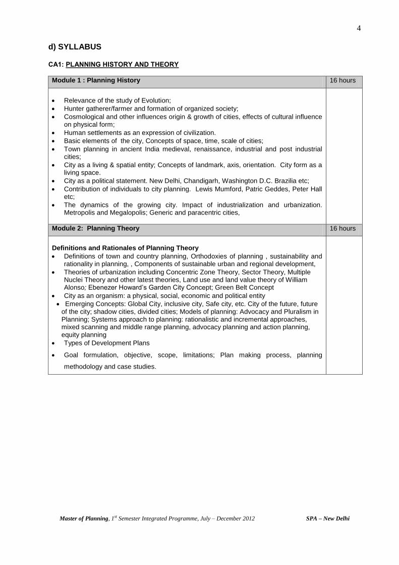
d) SYLLABUS CA1: PLANNING HISTORY AND THEORY
Module 1 : Planning History 16 hours
Relevance of the study of Evolution;
Hunter gatherer/farmer and formation of organized society;
Cosmological and other influences origin & growth of cities, effects of cultural influence on physical form;
Human settlements as an expression of civilization.
Basic elements of the city, Concepts of space, time, scale of cities;
Town planning in ancient India medieval, renaissance, industrial and post industrial cities;
City as a living & spatial entity; Concepts of landmark, axis, orientation. City form as a living space.
City as a political statement. New Delhi, Chandigarh, Washington D.C. Brazilia etc;
Contribution of individuals to city planning. Lewis Mumford, Patric Geddes, Peter Hall etc;
The dynamics of the growing city. Impact of industrialization and urbanization. Metropolis and Megalopolis; Generic and paracentric cities,
Module 2: Planning Theory 16 hours
Definitions and Rationales of Planning Theory
Definitions of town and country planning, Orthodoxies of planning , sustainability and rationality in planning, , Components of sustainable urban and regional development,
Theories of urbanization including Concentric Zone Theory, Sector Theory, Multiple Nuclei Theory and other latest theories, Land use and land value theory of William Alonso; Ebenezer Howard’s Garden City Concept; Green Belt Concept
City as an organism: a physical, social, economic and political entity
Emerging Concepts: Global City, inclusive city, Safe city, etc. City of the future, future of the city; shadow cities, divided cities; Models of planning: Advocacy and Pluralism in Planning; Systems approach to planning: rationalistic and incremental approaches, mixed scanning and middle range planning, advocacy planning and action planning, equity planning
Types of Development Plans
Goal formulation, objective, scope, limitations; Plan making process, planning
methodology and case studies.

5
Master of Planning, 1st Semester Integrated Programme, July – December 2012 SPA – New Delhi
CA2 : SOCIO - ECONOMIC BASE FOR PLANNING
Module 1 : Nature and Scope of Sociology 8 hours
Sociological concepts and methods, man and environment relationships;
socio-cultural profile of Indian society and urban transformation;
traditions and modernity in the context of urban and rural settlements
Issues related to caste, age, sex, gender, health safety, marginalized group, un/underemployed, disabled population.
Module 2 : Community and Settlements 8 hours
Social problems of slums and squatters communities, urban and rural social transformation and its effects on social life, safety, security and crime in urban areas and its spatial planning implications, social structure and spatial planning;
Role of socio-cultural aspects in the growth patterns of city and neighbourhood communities;
Social planning and policy; community participation; Marginalization and concepts of inclusive planning, Gender concerns. Settlement Policy: National Commission on Urbanisation, Rural Habitat Policy – Experiences in developing countries regarding Settlement structure, growth and its spatial distribution.
Module 3 : Elements of Micro and Macro Economics 8 hours
Concepts of demand, supply, elasticity and consumer market; concept of revenue cost;
Economies of scale, economic and social cost, production and factor market;
Different market structure and price determination; market failure, cost-benefit analysis, public sector pricing;
Determinants of national income, consumption, investment, inflation, unemployment, capital budgeting, risk and uncertainty, long-term investment planning
Module 4 : Development economics and Lessons from Indian Experiences 8 hours
Economic growth and development, quality of life; Human development index, poverty and income distribution, employment and livelihood;
Economic principles of land use planning;
Policies and strategies of economic planning, balanced vs. unbalanced growth, public sector dominance; changing economic policies, implications on land and case studies

6
Master of Planning, 1st Semester Integrated Programme, July – December 2012 SPA – New Delhi
CA3: PLANNING TECHNIQUES
Module 1 : Survey Techniques and Mapping 8 hours
Data Base for Physical surveys (incl. land use / building use / density / building age,
etc.) and Socio-economic surveys; Survey techniques, etc.; Land use classification/
coding; expected outputs.
Techniques of preparing base maps – concepts of scales, components and detailing
for various levels of plans (regional, city, zone, local area plans).
Module 2: Analytical Methods 18 hours
Classification of regions, delineation techniques of various types of regions, Analysis of
structure of nodes, hierarchy, nesting and rank size. Scalogram, sociogram, etc.;
Planning balance sheet.
Threshold analysis; Input Output analysis, SWOT analysis.
Methods of population forecasts and projections
Lorenz Curve, Ginni Ratio, Theil’s index, rations: urban – rural, urban concentration,
metropolitan concentration;
Location dimensions of population groups – Social area and strategic choice approach
– inter connected decision area analysis.
Module 3: Planning Standards 6 hours
Spatial standards, performance standards and benchmarks, and variable standards.
UDPFI guidelines, zoning regulations and development controls
7
Master of Planning, 1st Semester Integrated Programme, July – December 2012 SPA – New Delhi
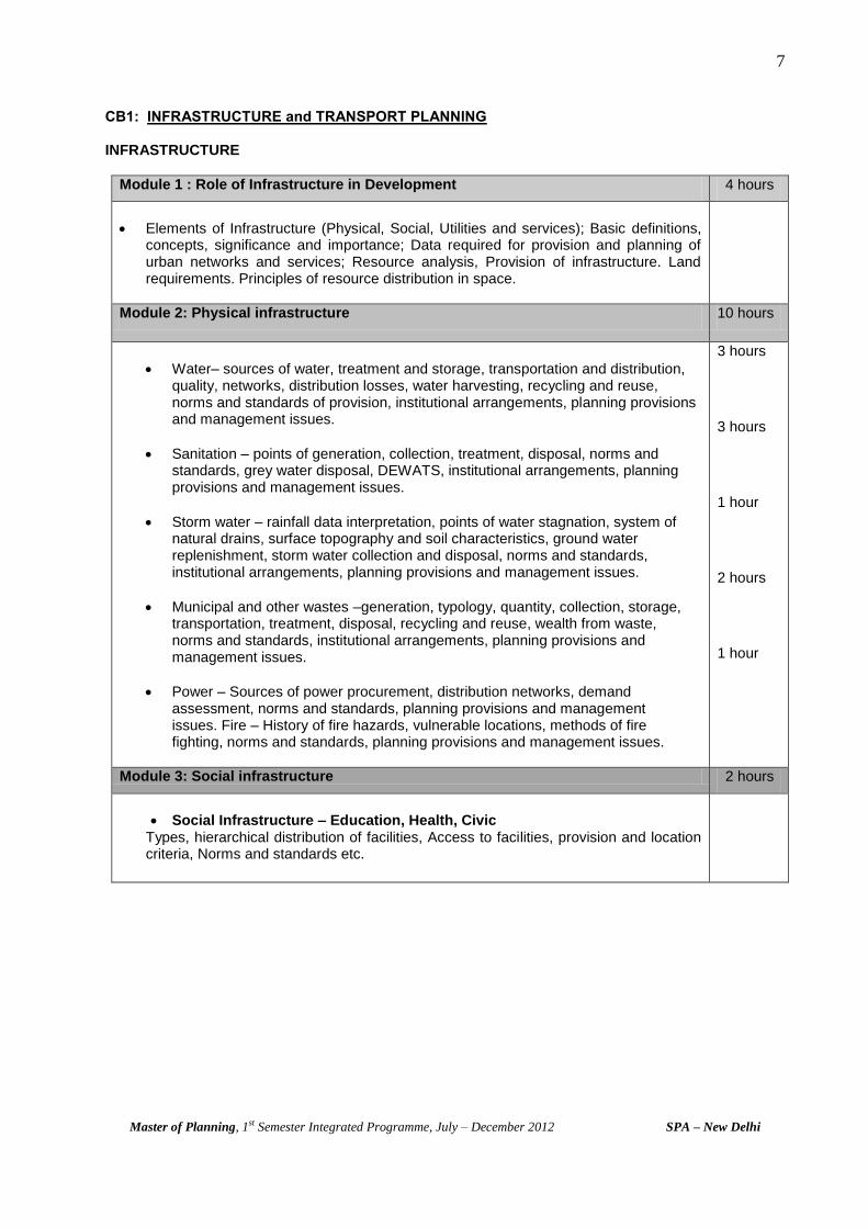
CB1: INFRASTRUCTURE and TRANSPORT PLANNING INFRASTRUCTURE
Module 1 : Role of Infrastructure in Development 4 hours
Elements of Infrastructure (Physical, Social, Utilities and services); Basic definitions, concepts, significance and importance; Data required for provision and planning of urban networks and services; Resource analysis, Provision of infrastructure. Land requirements. Principles of resource distribution in space.
Module 2: Physical infrastructure 10 hours
Water– sources of water, treatment and storage, transportation and distribution, quality, networks, distribution losses, water harvesting, recycling and reuse, norms and standards of provision, institutional arrangements, planning provisions and management issues.
Sanitation – points of generation, collection, treatment, disposal, norms and standards, grey water disposal, DEWATS, institutional arrangements, planning provisions and management issues.
Storm water – rainfall data interpretation, points of water stagnation, system of natural drains, surface topography and soil characteristics, ground water replenishment, storm water collection and disposal, norms and standards, institutional arrangements, planning provisions and management issues.
Municipal and other wastes –generation, typology, quantity, collection, storage, transportation, treatment, disposal, recycling and reuse, wealth from waste, norms and standards, institutional arrangements, planning provisions and management issues.
Power – Sources of power procurement, distribution networks, demand assessment, norms and standards, planning provisions and management issues. Fire – History of fire hazards, vulnerable locations, methods of fire fighting, norms and standards, planning provisions and management issues.
3 hours
3 hours
1 hour
2 hours
1 hour
Module 3: Social infrastructure 2 hours
Social Infrastructure – Education, Health, Civic Types, hierarchical distribution of facilities, Access to facilities, provision and location criteria, Norms and standards etc.
8
Master of Planning, 1st Semester Integrated Programme, July – December 2012 SPA – New Delhi
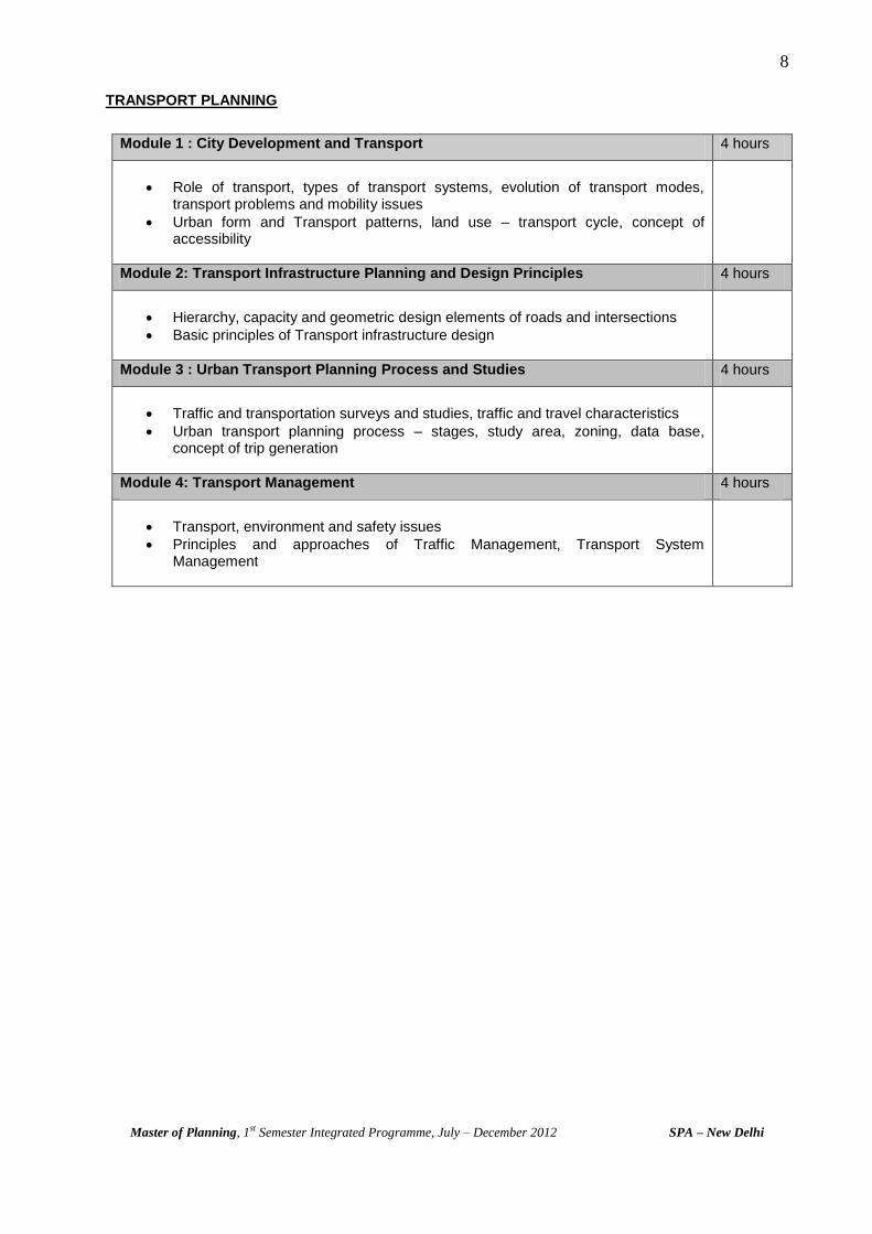
TRANSPORT PLANNING
Module 1 : City Development and Transport 4 hours
Role of transport, types of transport systems, evolution of transport modes, transport problems and mobility issues
Urban form and Transport patterns, land use – transport cycle, concept of accessibility
Module 2: Transport Infrastructure Planning and Design Principles 4 hours
Hierarchy, capacity and geometric design elements of roads and intersections
Basic principles of Transport infrastructure design
Module 3 : Urban Transport Planning Process and Studies 4 hours
Traffic and transportation surveys and studies, traffic and travel characteristics
Urban transport planning process – stages, study area, zoning, data base, concept of trip generation
Module 4: Transport Management 4 hours
Transport, environment and safety issues
Principles and approaches of Traffic Management, Transport System Management
9
Master of Planning, 1st Semester Integrated Programme, July – December 2012 SPA – New Delhi
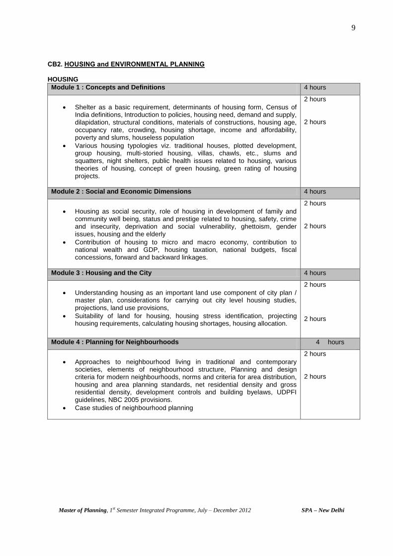
CB2. HOUSING and ENVIRONMENTAL PLANNING HOUSING
Module 1 : Concepts and Definitions 4 hours
Shelter as a basic requirement, determinants of housing form, Census of India definitions, Introduction to policies, housing need, demand and supply, dilapidation, structural conditions, materials of constructions, housing age, occupancy rate, crowding, housing shortage, income and affordability, poverty and slums, houseless population
Various housing typologies viz. traditional houses, plotted development, group housing, multi-storied housing, villas, chawls, etc., slums and squatters, night shelters, public health issues related to housing, various theories of housing, concept of green housing, green rating of housing projects.
2 hours
2 hours
Module 2 : Social and Economic Dimensions 4 hours
Housing as social security, role of housing in development of family and community well being, status and prestige related to housing, safety, crime and insecurity, deprivation and social vulnerability, ghettoism, gender issues, housing and the elderly
Contribution of housing to micro and macro economy, contribution to national wealth and GDP, housing taxation, national budgets, fiscal concessions, forward and backward linkages.
2 hours
2 hours
Module 3 : Housing and the City 4 hours
Understanding housing as an important land use component of city plan / master plan, considerations for carrying out city level housing studies, projections, land use provisions,
Suitability of land for housing, housing stress identification, projecting housing requirements, calculating housing shortages, housing allocation.
2 hours
2 hours
Module 4 : Planning for Neighbourhoods 4 hours
Approaches to neighbourhood living in traditional and contemporary societies, elements of neighbourhood structure, Planning and design criteria for modern neighbourhoods, norms and criteria for area distribution, housing and area planning standards, net residential density and gross residential density, development controls and building byelaws, UDPFI guidelines, NBC 2005 provisions.
Case studies of neighbourhood planning
2 hours
2 hours
10
Master of Planning, 1st Semester Integrated Programme, July – December 2012 SPA – New Delhi
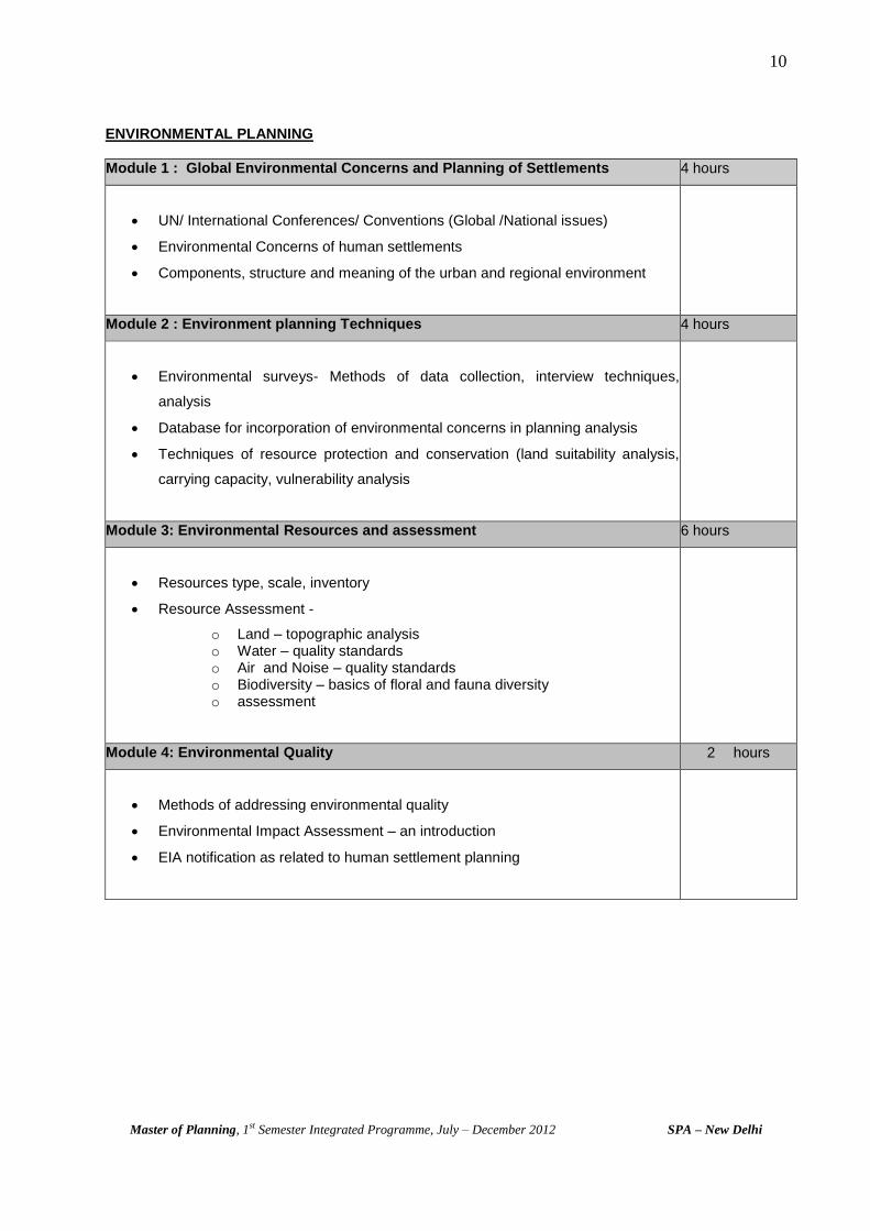
ENVIRONMENTAL PLANNING
Module 1 : Global Environmental Concerns and Planning of Settlements 4 hours
UN/ International Conferences/ Conventions (Global /National issues)
Environmental Concerns of human settlements
Components, structure and meaning of the urban and regional environment
Module 2 : Environment planning Techniques 4 hours
Environmental surveys- Methods of data collection, interview techniques,
analysis
Database for incorporation of environmental concerns in planning analysis
Techniques of resource protection and conservation (land suitability analysis,
carrying capacity, vulnerability analysis
Module 3: Environmental Resources and assessment 6 hours
Resources type, scale, inventory
Resource Assessment -
o Land – topographic analysis o Water – quality standards o Air and Noise – quality standards o Biodiversity – basics of floral and fauna diversity o assessment
Module 4: Environmental Quality 2 hours
Methods of addressing environmental quality
Environmental Impact Assessment – an introduction
EIA notification as related to human settlement planning

11
Master of Planning, 1st Semester Integrated Programme, July – December 2012 SPA – New Delhi
PLANNING AND DESIGN STUDIO
Studio is a significant component of the Master of Planning Integrated Programme. It is an
interactive platform with multidisciplinary expertise of different disciplines i.e. Urban Planning,
Regional Planning, Transport Planning, Housing and Environmental Planning. It is enriched with a
comprehensive approach of assessing and addressing issues of settlements and planning for
them. The programme is based on the principle of teamwork which is essential for planning of
settlements. The studio programme is designed to be discussion based, is an extension /
supplement to the lectures delivered and the lectures thus should find their applications in the
studios.
S. no. Studio Assignments Time Duration
1 Area Appreciation Three Weeks
2 Site Planning Four Weeks
3 Outline Development Plan for a City/Town Six Weeks
Studio courses are studio oriented and application based courses as given here under:
GIS Applications
Demography and Statistical Applications and
Remote Sensing
Module 1 : GIS Applications 10 hours
Coordinate system and geo-coding, vector data structure and algorithms, raster data structure and algorithms, data bases for GIS – concepts, error modeling and data uncertainty, decision making through GIS, constructing spatial data infrastructure and spatial information system. National Urban Information system.
Module 1 - Demography 10 hours
Sources of demographic data in India, Settlement type, growth pattern and structure: urban settlement analysis, Concentration: spatial, vertical and size, peri-urban sprawl, economic base; Rural Settlements – Size, occurrence and character, transformation, Policies towards various size class settlements.
Population structure and composition – Age, sex, gender, marital status, caste, religion, literacy level etc.; Age - sex ratio, structure, pyramid; dependency ratio; occupational structure; Fertility; mortality, migration analysis, natural growth of population, migration and its implications in spatial planning;
Module 2 – Statistical Applications 8 hours
General concepts- statistical interference, population and samples variables, Sampling, simple statistical models, Measures of central Tendency, Measures of Dispersion, Measures of shape of distribution , Correlation and regression

12
Master of Planning, 1st Semester Integrated Programme, July – December 2012 SPA – New Delhi
e) Time Tables
Time Table : Section A1
Time 9:00 A.M. -
10:00 A.M.
10:00 A.M. -
11:00 A.M.
11:00 A.M. -
12:00 NOON
12:00 NOON -
1:00 P.M.
1:00 P.M.
- 2:00
P.M.
2:00 P.M. -
3:00 P.M.
3:00 P.M. -
4:00 P.M.
4:00 P.M. -
5:00 P.M. Days
Monday Special
Lecture/Library
Planning and Design Studio
(HBS***/RS***/PSN**/VF*) L
Planning and Design Studio
(HBS***/RS***/PSN*/MD***)
Tuesday Socio- Economic Base for
Planning (MP**) Planning Techniques (SJ**) U
Planning and Design Studio
(PSN**/VF***)
Special
Lecture/
Library
Wednesday
Housing and
Environmental
Planning (RG*)
Socio-
Economic Base
for Planning
(MKJ*)
Infrastructure
and Transport
Planning (SP*)
Planning
History and
Theory (AK*)
N Studio Course # (GIS/Demography and Statistical
Application/ Remote Sensing)
Thursday Planning History and Theory
(HBS**)
Housing & Environmental
Planning (AKM**) C
Planning and Design Studio
(PSN**/RS**/VM**)
Special
Lecture/
Library
Friday
Special
Lecture/
Library
Planning
Techniques- T
(SJ*)
Infrastructure and Transport
Planning (SR**) H
Planning and Design Studio
(HBS**/RS**/VM**)
Special
Lecture/
Library
* denotes one hour each T- Tutorials GIS - Geographical information System
MP - M. Palaniappan RG - Ruchita Garg SP - Subir Paul HBS- Prof. H.B. Singh VF- Visisting
Faculty SJ - Prof. Dr. S.D. Joardar MKJ - Prof. Manoj K. Jha AK- Prof. Dr. Ashok Kumar AKM - Prof. A.K. Maitra
RS - Rama Singhal PSN - Prof. Dr. P.S.N.Rao MD - Meenakshi Dhote VM - Vinay Maitri SR - Sewa
Ram
# - Faculty and Total Hours for Studio Courses
GIS Dr. J. Gildayal 16
Remote Sensing Prof. Mahavir 8
Demography Dr. Roychaudhari 12
Statistical Applications Prof Vinay Maitri 12

13
Master of Planning, 1st Semester Integrated Programme, July – December 2012 SPA – New Delhi
Time Table : Section A2
Time 9:00 A.M. -
10:00 A.M.
10:00 A.M. -
11:00 A.M.
11:00 A.M. -
12:00 NOON
12:00 NOON -
1:00 P.M.
1:00 P.M.
- 2:00
P.M.
2:00 P.M. -
3:00 P.M.
3:00 P.M. -
4:00 P.M.
4:00 P.M. -
5:00 P.M. Days
Monday Special
Lecture/Library
Planning and Design Studio
(VMT***/C***/SP***) L
Planning and Design Studio
(VMT***/C***/SP***)
Tuesday Socio- Economic Base for
Planning (MP**) Planning Techniques (SJ**) U
Planning and Design Studio
(SP**/SSM**/VF**)
Special
Lecture/
Library
Wednesday
Housing and
Environmental
Planning
(RG*)
Socio-
Economic Base
for Planning
(MKJ*)
Infrastructure
and Transport
Planning (SP*)
Planning
History and
Theory (AK*)
N Studio Course # (GIS/Demography and Statistical
Application/ Remote Sensing)
Thursday Planning History and Theory
(HBS**)
Housing & Environmental
Planning (AKM**) C
Planning and Design Studio
(SP**/SSM**/C**)
Special
Lecture/
Library
Friday
Special
Lecture/
Library
Planning
Techniques- T
(SJ*)
Infrastructure and Transport
Planning (SR**) H
Planning and Design Studio
(VMT**/SSM**/VF**)
Special
Lecture/
Library
* denotes one hour each T- Tutorials GIS - Geographical information System
MP - M. Palaniappan RG - Ruchita Garg SP - Subir Paul HBS- Prof. H.B. Singh SR - Sewa
Ram
SJ - Prof. Dr. S.D. Joardar MKJ - Prof. Manoj K. Jha AK- Prof. Dr. Ashok Kumar AKM - Prof. A.K. Maitra
VMT - Ved Mittal C- Chidambara
SSM - S.S.Mathur VF- Visisting Faculty
# - Faculty and Total Hours for Studio Courses
GIS Dr. J. Gildayal 16
Remote Sensing Prof. Mahavir 8
Demography Dr. Roychaudhari 12
Statistical Applications Prof Vinay Maitri 12
14
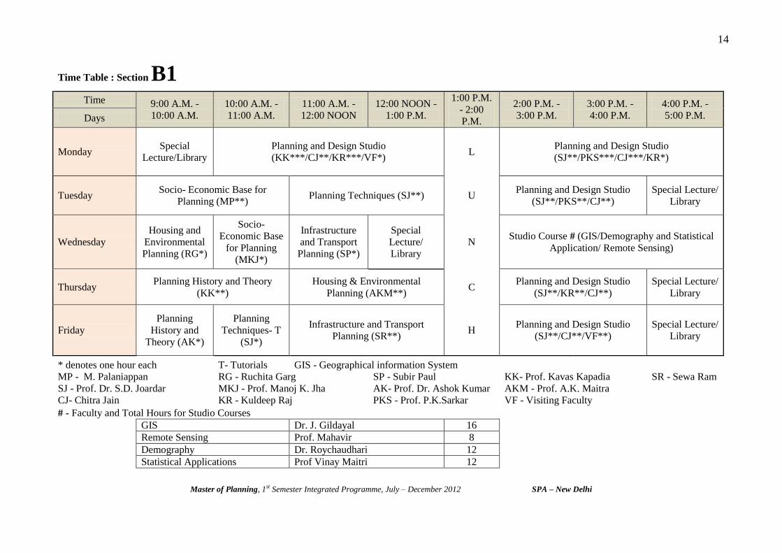
Master of Planning, 1st Semester Integrated Programme, July – December 2012 SPA – New Delhi
Time Table : Section B1
Time 9:00 A.M. -
10:00 A.M.
10:00 A.M. -
11:00 A.M.
11:00 A.M. -
12:00 NOON
12:00 NOON -
1:00 P.M.
1:00 P.M.
- 2:00
P.M.
2:00 P.M. -
3:00 P.M.
3:00 P.M. -
4:00 P.M.
4:00 P.M. -
5:00 P.M. Days
Monday Special
Lecture/Library
Planning and Design Studio
(KK***/CJ**/KR***/VF*) L
Planning and Design Studio
(SJ**/PKS***/CJ***/KR*)
Tuesday Socio- Economic Base for
Planning (MP**) Planning Techniques (SJ**) U
Planning and Design Studio
(SJ**/PKS**/CJ**)
Special Lecture/
Library
Wednesday
Housing and
Environmental
Planning (RG*)
Socio-
Economic Base
for Planning
(MKJ*)
Infrastructure
and Transport
Planning (SP*)
Special
Lecture/
Library
N Studio Course # (GIS/Demography and Statistical
Application/ Remote Sensing)
Thursday Planning History and Theory
(KK**)
Housing & Environmental
Planning (AKM**) C
Planning and Design Studio
(SJ**/KR**/CJ**)
Special Lecture/
Library
Friday
Planning
History and
Theory (AK*)
Planning
Techniques- T
(SJ*)
Infrastructure and Transport
Planning (SR**) H
Planning and Design Studio
(SJ**/CJ**/VF**)
Special Lecture/
Library
* denotes one hour each T- Tutorials GIS - Geographical information System
MP - M. Palaniappan RG - Ruchita Garg SP - Subir Paul KK- Prof. Kavas Kapadia SR - Sewa Ram
SJ - Prof. Dr. S.D. Joardar MKJ - Prof. Manoj K. Jha AK- Prof. Dr. Ashok Kumar AKM - Prof. A.K. Maitra
CJ- Chitra Jain KR - Kuldeep Raj PKS - Prof. P.K.Sarkar VF - Visiting Faculty
# - Faculty and Total Hours for Studio Courses
GIS Dr. J. Gildayal 16
Remote Sensing Prof. Mahavir 8
Demography Dr. Roychaudhari 12
Statistical Applications Prof Vinay Maitri 12

15
Master of Planning, 1st Semester Integrated Programme, July – December 2012 SPA – New Delhi
Time Table : Section B2
Time 9:00 A.M. -
10:00 A.M.
10:00 A.M. -
11:00 A.M.
11:00 A.M. -
12:00 NOON
12:00 NOON -
1:00 P.M.
1:00 P.M.
- 2:00
P.M.
2:00 P.M. -
3:00 P.M.
3:00 P.M. -
4:00 P.M.
4:00 P.M. -
5:00 P.M. Days
Monday Special
Lecture/Library Planning and Design Studio (MP***/NT***/KT***) L
Planning and Design Studio
(MP*/NT***/BCD***/KT**)
Tuesday Socio- Economic Base for
Planning (MP**) Planning Techniques (SJ**) U
Planning and Design Studio
(RSU**/NT**/BCD**)
Special Lecture/
Library
Wednesday
Housing and
Environmental
Planning
(RG*)
Socio-
Economic Base
for Planning
(MKJ*)
Infrastructure
and Transport
Planning (SP*)
Special
Lecture/
Library
N Studio Course # (GIS/Demography and Statistical
Application/ Remote Sensing)
Thursday Planning History and Theory
(KK**)
Housing & Environmental
Planning (AKM**) C
Planning and Design Studio
(RSU**/BCD**/KT**/MP**)
Special Lecture/
Library
Friday
Planning
History and
Theory (AK*)
Planning
Techniques- T
(SJ*)
Infrastructure and Transport
Planning (SR**) H
Planning and Design Studio
(KT**/BCD**)
Special Lecture/
Library
* denotes one hour each T- Tutorials GIS - Geographical information System
MP - M. Palaniappan RG - Ruchita Garg SP - Subir Paul KK- Prof. Kavas Kapadia VF- Visisting
Faculty SJ - Prof. Dr. S.D. Joardar MKJ - Prof. Manoj K. Jha AK- Prof. Dr. Ashok Kumar AKM - Prof. A.K. Maitra
RSU - Raman Suri KT - K.T. Gurmukhi NT - Neha Tirpathy BCD - B.C.Dutta SR - Sewa Ram
# - Faculty and Total Hours for Studio Courses
GIS Dr. J. Gildayal 16
Remote Sensing Prof. Mahavir 8
Demography Dr. Roychaudhari 12
Statistical Applications Prof Vinay Maitri 12

Master of Planning, 1st Semester Integrated Programme, July – December 2012 SPA – New Delhi
3
Assignments
Assignment No. 1 - Area Appreciation
Assignment No. 2 - Site Planning
Assignment No. 3 - Outline Development Plan
1
Master of Planning, 1st Semester Integrated Programme, July – December 2012 SPA – New Delhi
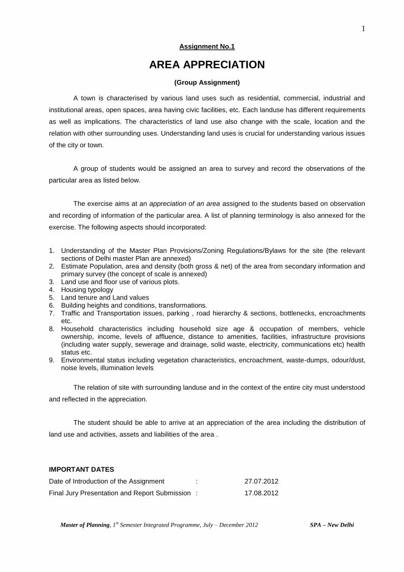
Assignment No.1
AREA APPRECIATION
(Group Assignment)
A town is characterised by various land uses such as residential, commercial, industrial and
institutional areas, open spaces, area having civic facilities, etc. Each landuse has different requirements
as well as implications. The characteristics of land use also change with the scale, location and the
relation with other surrounding uses. Understanding land uses is crucial for understanding various issues
of the city or town.
A group of students would be assigned an area to survey and record the observations of the
particular area as listed below.
The exercise aims at an appreciation of an area assigned to the students based on observation
and recording of information of the particular area. A list of planning terminology is also annexed for the
exercise. The following aspects should incorporated:
1. Understanding of the Master Plan Provisions/Zoning Regulations/Bylaws for the site (the relevant sections of Delhi master Plan are annexed)
2. Estimate Population, area and density (both gross & net) of the area from secondary information and primary survey (the concept of scale is annexed)
3. Land use and floor use of various plots. 4. Housing typology 5. Land tenure and Land values 6. Building heights and conditions, transformations. 7. Traffic and Transportation issues, parking , road hierarchy & sections, bottlenecks, encroachments
etc. 8. Household characteristics including household size age & occupation of members, vehicle
ownership, income, levels of affluence, distance to amenities, facilities, infrastructure provisions (including water supply, sewerage and drainage, solid waste, electricity, communications etc) health status etc.
9. Environmental status including vegetation characteristics, encroachment, waste-dumps, odour/dust, noise levels, illumination levels
The relation of site with surrounding landuse and in the context of the entire city must understood
and reflected in the appreciation.
The student should be able to arrive at an appreciation of the area including the distribution of
land use and activities, assets and liabilities of the area .
IMPORTANT DATES
Date of Introduction of the Assignment : 27.07.2012
Final Jury Presentation and Report Submission : 17.08.2012
2
Master of Planning, 1st Semester Integrated Programme, July – December 2012 SPA – New Delhi
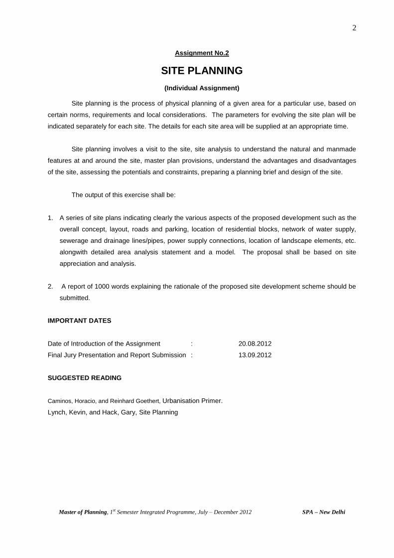
Assignment No.2
SITE PLANNING
(Individual Assignment)
Site planning is the process of physical planning of a given area for a particular use, based on
certain norms, requirements and local considerations. The parameters for evolving the site plan will be
indicated separately for each site. The details for each site area will be supplied at an appropriate time.
Site planning involves a visit to the site, site analysis to understand the natural and manmade
features at and around the site, master plan provisions, understand the advantages and disadvantages
of the site, assessing the potentials and constraints, preparing a planning brief and design of the site.
The output of this exercise shall be:
1. A series of site plans indicating clearly the various aspects of the proposed development such as the
overall concept, layout, roads and parking, location of residential blocks, network of water supply,
sewerage and drainage lines/pipes, power supply connections, location of landscape elements, etc.
alongwith detailed area analysis statement and a model. The proposal shall be based on site
appreciation and analysis.
2. A report of 1000 words explaining the rationale of the proposed site development scheme should be
submitted.
IMPORTANT DATES
Date of Introduction of the Assignment : 20.08.2012
Final Jury Presentation and Report Submission : 13.09.2012
SUGGESTED READING
Caminos, Horacio, and Reinhard Goethert, Urbanisation Primer.
Lynch, Kevin, and Hack, Gary, Site Planning

3
Master of Planning, 1st Semester Integrated Programme, July – December 2012 SPA – New Delhi
Assignment No.3
OUTLINE DEVELOPMENT PLAN
(Group Assignment)
The students are required to prepare an Outline Development Plan for the assigned town. The main
purpose of this exercise is to familiarise the students with the following processes :
a) To understand the settlement in terms of various facets
b) To familiarize with conducting surveys for collecting data in a scientific manner
c) To appreciate problems, potentials and issues
d) To identify/project future requirements
e) To prepare a development plan with a 20 year perspective
In order to carry out this exercise, students are expected to undertake data collection, both primary and
secondary.
Primary data collection is to be done through the following surveys :
- Household survey
- Housing survey
- Landuse survey
- Environment survey
- Traffic Volume Count survey
- Traffic Speed and Delay survey
- Origin and Destination survey
- Parking survey
- Road geometrics survey
Secondary data collection is to be done by way of visiting various offices and collecting data as per a
predetermined Data Collection Format.
Students are expected to exhibit adequate initiative at every stage of the preparation of the Outline
Development Plan. The Studio Directors and faculty will intimate further information regarding the
various aspects to be studied. The students are advised to note that the field visit for primary data
collection etc, is being planned from 22.9.2012 to 10.10.2012.
IMPORTANT DATES
Date of Introduction of the Assignment : 14.09.2012
Final Plan & Report : 30.11.2012

Master of Planning, 1st Semester Integrated Programme, July – December 2012 SPA – New Delhi
4
Annexures
Annexure 1: Planning Terminologies
Annexure 2: Techniques Of Map Presentation
Annexure 3: Delhi Master Plan Development Code
Annexure 4: Landuse Classification and Color Coding
Annexure 5: References
Annexure 6: Directory
21
Master of Planning, 1st Semester Integrated Programme, July – December 2012 SPA – New Delhi
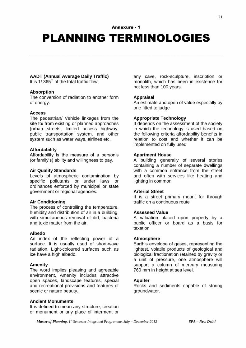
Annexure - 1
PLANNING TERMINOLOGIES
_____________________________________________________________________________________________
AADT (Annual Average Daily Traffic) It is 1/ 365th of the total traffic flow. Absorption The conversion of radiation to another form of energy. Access The pedestrian/ Vehicle linkages from the site to/ from existing or planned approaches (urban streets, limited access highway, public transportation system, and other system such as water ways, airlines etc. Affordability Affordability is the measure of a person’s (or family’s) ability and willingness to pay. Air Quality Standards Levels of atmospheric contamination by specific pollutants or under laws or ordinances enforced by municipal or state government or regional agencies. Air Conditioning The process of controlling the temperature, humidity and distribution of air in a building, with simultaneous removal of dirt, bacteria and toxic matter from the air. Albedo An index of the reflecting power of a surface. It is usually used of short-wave radiation. Light-coloured surfaces such as ice have a high albedo. Amenity The word implies pleasing and agreeable environment. Amenity includes attractive open spaces, landscape features, special and recreational provisions and features of scenic or nature beauty. Ancient Monuments It is defined to mean any structure, creation or monument or any place of interment or
any cave, rock-sculpture, inscription or monolith, which has been in existence for not less than 100 years. Appraisal An estimate and open of value especially by one fitted to judge Appropriate Technology It depends on the assessment of the society in which the technology is used based on the following criteria affordability benefits in relation to cost and whether it can be implemented on fully used Apartment House A building generally of several stories containing a number of separate dwellings with a common entrance from the street and often with services like heating and lighting in common Arterial Street It is a street primary meant for through traffic on a continuous route Assessed Value A valuation placed upon property by a public officer or board as a basis for taxation Atmosphere Earth’s envelope of gases, representing the lightest, volatile products of geological and biological fractionation retained by gravity or a unit of pressure, one atmosphere will support a column of mercury measuring 760 mm in height at sea level. Aquifer Rocks and sediments capable of storing groundwater.
22
Master of Planning, 1st Semester Integrated Programme, July – December 2012 SPA – New Delhi
Balcony A horizontal cantilevered projection including a handrail or balustrade to serve as passage or sitting out place Barsati Habitable room/ rooms on the roof of building with or without toilet and kitchen. Base Map Map indicating such existing features as the street systems, railroads, rivers, parks or other facilities. The map is the formation for all subsequent maps to be utilized throughout the planning process. Basic Capacity The maximum number of passenger cars that can pass at a given point, in a lane or on a road during one hour Betterment Tax A tax on the increment in value accruing to an owner because of development work carried out by local authority. Biodiversity The variability among living organisms and the ecological complexes of which they are a part, this includes diversity within species between species and of ecosystems (UN Conference on Environment and Development 1992) Bio-mass The total weight of biological organisms within a specified unit (area, community, population) Biome An area dominated with similar plant species and ecological community extending over the same physiography region. Biosphere The zone occupied by living organism at the common boundary of earth’s lithosphere, hydrosphere and atmosphere, Biological Oxygen Demand (BOD) The quality of oxygen required for the oxidation of organic matter by bacterial action in the presence of oxygen.
Budget Planning Budget Planning is the allocation of capital outlay for planned development. Building Code A body of legislative regulations or bye-laws that provides minimum standards to safeguard life or limbs, health, property and public welfare by quality of material, use and occupancy, loation and maintenance of all building and structures within the city and certain equipment specifically regulated therein. Building line The line upto which the plinth of a building adjoining a street or an extension of a street or on a future street may lawfully extend. It includes the lines prescribed in the Delhi Master Plan or specially indicated in any scheme or layout plan or in the bylaws. Building A building is generally a single structure on the ground. Any structure for whatsoever purpose and of whatsoever material constructed and every part thereof, whether used as human habitation or not and includes foundation, plinth walls, roofs, chimneys, plumbing and building services, fixed platforms, verandahs, balcony, cornice or projection part of building or any thing affixed thereto or any wall enclosing or indenting to enclose land or space and signs and outdoor display structure, monuments, memorials or any contrivance of permanent nature, built under or over ground. Carpet area All the covered area that can be carpeted, i.e. plinth area less than area of the walls, canopies, chajjas, stairwell etc. Carriage way It is the width of the roadway excluding the shoulders. It is paved width of the road surface. Catchment A three-dimensional land system or drainage basin, which converts precipitation and groundwater, inputs to stream flow and whose components are assessed in terms of influence on these processes.

23
Master of Planning, 1st Semester Integrated Programme, July – December 2012 SPA – New Delhi
The area of land draining into a stream or a water course at a given location is known as catchment area or Drainage area or Drainage basin. Census (Source: Abstract from Census of India, General Population Tables, primary census , 1991)
The basic unit for rural areas is revenue village, which has definite surveyed boundaries. The revenue village may comprise several hamlets, but the entire village has been treated as one unit .In un-surveyed areas like settlements within forest areas, each habitation area with locally recognised boundaries within each forest range officer’s area was treated as one unit. The following criteria were adopted for treating a place as urban in 1991 Census: (a) All statutory towns i.e. all places with a
municipality, corporation, cantonment board or notified town area committee, etc.
(b) All other places which satisfied the following criteria:
(i) A minimum population of 5,000 (ii) At least 70% of the male working
population engaged in non-agricultural pursuits
(iii) A density of population of at least 400 persons per sq. km. (1000 per sq. mile)
Note: A town with a population of one hundred thousand and above is generally referred to as a ‘city’. The urban criteria of the 1981 and 1991 censuses varied slightly from that of the 1961 and 1971 censuses. The workers in occupations of forestry, fishing, livestock, hunting, logging, plantations and orchards etc. (falling in industrial category III) were treated as non- agricultural activities in 1961 and 1971 census whereas in 1981 and 1991 censuses, these activities have been treated as agricultural activities for the purpose of determining the male working population in non-agricultural pursuits. The urbanised outgrowths of the cities and towns have also been treated as urban. In several areas around a core city or a statutory town fairly large well-recognised
railway colony, university campus, port area, military camp etc, might have come up. Even id such places are lying outside the statutory limits of the corporation, municipality or cantonment, etc, in most cases they fall within the revenue limits of the village or villages, which is or are contiguous to the town. Since such areas are already urbanized, it is not considered realistic to treat such areas lying outside the statutory limits of a town as rural units, although a few of them may not satisfy some of the prescribed eligibility tests to qualify themselves as independent urban units. Such areas have been termed as ‘outgrowth’ (OG’s) and reckoned along with the town . Each such town together with its out-growth is treated as an integrated urban area and is designated as ‘urban agglomeration’ (U.A) therefore constitutes: (i) A city or a town with a continuos
outgrowth, the outgrowth being outside the statutory limits but falling within the boundaries of the adjoining villages or
(ii) Two or more adjoining towns with their outgrowths, if any as in (I) above or
(iii) A city and one or more adjoining towns with or without outgrowths all of which form a continuous spread.
The concept of urban agglomeration (U.A) was adopted for the first time in 1971 census and continued in 1981 and 1991 censuses. Census house Is a building or part of a building having a separate main entrance from the road or common courtyard or staircase etc, used or recognised as a separate unit. It may be occupied or vacant. It may be used for residential or non- residential purpose or both. Central Business District (CBD) The Central Business District is the focus of intra-city transport routes, having the maximum overall accessibility to most parts of urban area. It is characterized by peak land values and intense developments with high densities, the development usually being vertical rather than horizontal. Within the district, the shopping area is usually separated from the main office area and

24
Master of Planning, 1st Semester Integrated Programme, July – December 2012 SPA – New Delhi
entertainment area. The central business district merges almost unnoticed into the surrounding transitional zone, but usually its boundaries are marked by public transport termini. Central Place This basic unit is a settlement it could be a city or town or even community, which provides goods and services to an area larger than itself. The passenger car unit of a vehicle type depends upon the size and kid speed of the vehicle, type and kind of road environment. Cesspool Underground catch basin that is used where there is no sewer and into which household sewage or other liquid waste is drained to permit leaching of the liquid into the surrounding soil. Channel flow The confinement and concentration of the surface water movement in a fluvial channel. Channel network The pattern and connectivity of all channels draining a catchment. Circulation System of movement/ passage of people, goods from place to place, streets, walkways, parking area etc. City It is large than a town and having a population of 100,000 and above and serving as the primate center for services and function. Clear sky design Clear Sky Design is the sky corresponding to a solar altitude of 15 degree luminance, distribution of the sky opposite the sun is constant for a given altitude up to 15 degree, and beyond 15 degree, it illumination is taken as 8,000 lux from the entire sky vault, direct sunlight being excluded. Climbers Plants, which have special structure to climb on supports, are defined as climbers.
Cluster Development One in which a number of dwelling units are grouped leaving some land undivided for common use. It may mean grouped leaving the same numbers of units allowed in a given subdivision or zoned area on smaller than usual or minimum lot, with the remainder of land available as a common area. Coastal plain A gently sloping land surface which forms a continuum with the continental shelf and is susceptible to small sea level changes; it is likely to be wide on trailing edge (passive margin) coasts and narrow on leading-edge (convergent margin) coast. Collector Street A collector street is one intended for collecting and distributing traffic to and from street and for providing access to sub-arterial street. Colony It means an area of land within a controlled area, which is developed or proposed to be developed for purpose of sub-dividing into plots for residential or other purposes Comprehensive Plan It includes a review of the physical structure of a city or planning area and a measurement of development trends, definition of goals and objective for future growth and change and specific recommendations comprehensively in the form of maps and plans which incorporate the proposals and establish standards of density and building intensity in support of the plan. Community facilities Facilities or services used by number of people in common including schools, health, recreation, police, fire, public transportation, community centre etc. Community The people living in a particular area/ region and usually linked by common interest, viz, namely the region itself or any population cluster.

25
Master of Planning, 1st Semester Integrated Programme, July – December 2012 SPA – New Delhi
Compound Compound means land, whether enclosed or not, which is the appurtenance of a building or the common appurtenance of several buildings. Conservation Conservation is the action taken to prevent decay. It embraces all acts that prolong the life of our culture and natural heritage, the object being to project to those who use and look at historical buildings, which such building possess. Conservation means all processes, of looking after a place (means site, area, building or other works, group of buildings or other works together with pertinent contents and surroundings) so as to retain its cultural significance. It includes maintenance, and may, according to circumstances, including adaptation and will be commonly a combination or more than one of these. Convenience It is closely associated with the public interest and constitutes a third major basis for the exercise of control. It can be judged in terms of home-to-home, work, work-to-recreation, etc. relationships. Convenience Shopping A group of shops (not exceeding 50 in number) in a residential area, serving a population of about 5,000 persons. Core House Core house is one of the many forms of low-cost housing, covering delivery of anything short of the finished product and incorporating site-and-services scheme. The essence of this house is to provide a framework, which enables a target group of low-income households to obtain substantial at costs within their means. Cost To the client, the cost is the price he pays to the builder. To the builder, it is the price he pays for the resources used in executed the project. Courtyard A space permanently open to sky, enclosed fully or partially by buildings and may be at
ground level or any other level within or adjacent to a building. Coverage It is the term used to express the percentage of a piece of property, which may be properly, be occupied by building. Covered Area Ground area covered immediately above the plinth level covered by the building but does not include the spaces covered by: 1. Garden, rocky, well and well structures,
plant nursery, water pool, swimming pool (if open to air), plate-form round a tree, tank, fountain, bench, chabutra with open top and unenclosed on side by wall end the like;
2. Drainage culvert, conduit, catch pits, gully-pits, chamber, gutter etc; and
3. Compound wall, gate, slide swing canopy, area covered and open at least on three sides and also open to sky.
Cul-De-Sac It is a street leading to a closed end provided with facility of turning of vehicles. Cycle time Any complete sequence of signal indication and time associated with it is called cycle time. Cyclone A cyclone is an intense vortex or a whirl in the atmosphere with very strong winds circulating around it in anti-clockwise direction in the Northern Hemisphere and in clockwise direction in Southern Hemisphere, with associated convective cloud bands. Decibel The universal measure of loudness is called decibel, usually abbreviated as dB. Zero decibel is the threshold of the hearing, while 85 dB is usually considered loud enough to cause damage to the ear.

26
Master of Planning, 1st Semester Integrated Programme, July – December 2012 SPA – New Delhi
Density It is the ratio of persons, households or volume of building or development to some unit of land area. Density on Concentration It is the number of vehicles occupying a given length of lane or roadway, averaged over time. Desertification Land degradation in arid, semi-arid and city sub-humid areas resulting mainly from adverse human impacts (U.N. Environmental Programme, 1992). Design The arrangement of elements that make up a work of art, a machine or other man-made object; the process of selecting the means and contriving the elements, steps and procedures for predicting what will be adequate to satisfy some needs. Development In order to carrying out of building, engineering, mining or other operations in or over or under land or water or making of any material change in any building or land includes redevelopment and subdivision of any land. Development means socio-economic and physical development. It can be understood as a process consisting of the following three sub-processes (a) production, (b) provision (in terms of infrastructure etc.) and (c) utilisation (or consumption) where the people have a choice and the process is sustainable over a long period of time. Development Controls It is process through which development carried out by many agencies, both by public and private are checked in the benefit of whole society. Development Plan The objective of development plan is to foster the social and economic development of the community by creating an effective plan for the physical structure of an area and by encouraging measures to create a pleasant environment while reconciling with
conflicting land use claims, is know as outline development plan. Developer Three sectors are considered in the supply of dwellings: 1. Popular Sector – The marginal sector
with limited or no access to the formal financial, administrative, legal, technical institutions involved in the provision of dwellings. The housing process (promotion, financing, construction, and operation) is carried out by the popular sector generally for self-use and sometimes for profits.
2. Public Sector – The government or non-profit organizations involved in the provision of dwellings. The housing process is carried out by the public sector for services (non-profit or subsidized housing).
3. Private Sector – the individuals, groups or societies, who have access to the formal financial, administrative, legal, technical institutions in the provision of dwellings. The housing process is carried out by the private sector for profits.
Dhalao A premise used for collection of garbage for its onward transport to disposal site. District Road District roads are the roads transferring each district, serving area of production and markets and connecting to these with each other or national or state highways. Diversity The variety and relative abundance of species in defined area. Diverted Traffic Traffic, which has changed from its previous route of travel to another route, without change in origin or destination Drainage Basin A geographical area bounded by a watershed and drained by a discreet drainage network

27
Master of Planning, 1st Semester Integrated Programme, July – December 2012 SPA – New Delhi
Drainage Density The total stream channel length per unit land surface area, normally calculated for an entire drainage basin. Drainage Network More or less synonymous with the channel network but may also include rills, gullies and larger underground pipes not considered part of a permanent surface channel network. Drainage Pattern The geometric configuration or plan of drainage network which usually reflects catchment geology, tectonic and denudation history. Dwell Time The time for which a transit vehicle is stopped for the purpose of serving passengers (for example, stoppage of a bus for boarding and alighting of passengers. Dwelling units In relation to a building or portion of a building, means a unit of accommodation, in such building or portion used sole for the purpose of residence. Dwelling Type The physical arrangement of dwelling units includes: 1. Detached – Individual dwelling unit,
separated from the other. 2. Semi-detached – Two dwelling units
sharing a common wall. 3. Row / Group – Dwelling units grouped
together linearly or in cluster. 4. Walk-up – Dwelling units grouped in
two to five stories with stairs for vertical circulation.
5. High Rise – Dwelling units in five or more stories with stairs and lifts for vertical circulation.
Dwelling Unit Area The dwelling unit area is the built-up covered area of a dwelling unit. Dwelling Unit A general, global designation of a building / shelter in which people live. A dwelling may contain one more dwelling units.
Dwelling Unit Area The dwelling unit area (sq. m) is the built-up, covered area of a dwelling unit. Easement (Servitude) A right in respect of an object (as land owned by one person) in virtue of which the object (Land) is subjected to a specified use or enjoyment by another person or for the benefit of another thing. Ecology Study of the earth’s households including the plants, animals, microorganisms and people that live together as interdependent components. Study of their structure and function of nature. Economic Activity The 1981 census, the data of main workers were presented for the four categories viz, cultivators, agricultural labourers, household industry and other workers. Categories III, IV, V, (b) , VI to IX were clubbed together and the data were presented under the category of ‘other workers. In 1991 census the data for main workers have been classified in to nine industrial as in 1971 census. The categories are: I – Cultivators, II- Agricultural Labourers, III-Livestock, Forestry, Fishing, Hunting, and Plantations, or orchards and allied activities, IV- Mining and Quarrying, V-(a) Manufacturing, processing, servicing and repairs in household industry, V(b) Manufacturing , processing, servicing and repair in other than household industry, VI- constructions, VII-trade and commerce, VIII- Transport, storage and communications, IX- other services. I-Cultivators A person was considered as cultivator if he or she was engaged either as employer, worker or family in cultivation of land owned or held from government or held from private persons or institutions for payment in money, kind or share of crops. Cultivation included supervision or direction of cultivation. Cultivation involves ploughing, sowing and harvesting and production of cereals and millets crops. II-Agricultural Laborers
28
Master of Planning, 1st Semester Integrated Programme, July – December 2012 SPA – New Delhi
A person who worked in another person’s land for wages in cash, kind or share or crop was regarded as an agricultural labourer, working in another person’s land for wages. An agricultural labourer has no right of lease or contract on land on which he worked. V(a)Household Industry Is an industry conducted by the household himself/herself and or members of the household at home or within the village in rural areas and only within the precincts of the house where the household lived in urban areas. A household industry is one that is engaged in production, processing, servicing, repairing or making and selling(but not merely selling) of goods.
Ecosystem Open system comprising plants, animals and their environment, which is evolved in the flow of energy and the circular of matter. Edges Edges are the linear elements not used or considered as a path by the observer. They are the boundaries between two phases linear breaks in continuity: shores, railroad cuts, edges of development, walls etc. such edges may be barriers, more or less penetrable, which close one region off from the other; or they may be seams, lines along with two regions which are related and joined together. Effluent Outflow or discharge from a sewer or sewage treatment plant. Emergency It is any event, which threatens to, or actually does, inflict damage to property or people. Energy Power of doing work either being associated with natural bodies or having an existence independent of matter.
Energy Flow Rate at which energy is absorbed or omitted by a unit area of surface or the rate at which energy passes through a cross section of unit area. Environmental Impact It is the sum of the short term and long term affects of any proposed actions (or absence of action) on man himself and on the physical, biological and socio-economic environment including the effects of policies, legislative, proposals, programmes, projects and operational practices. Epicentre The locations of earth’s surface directly above the focus is called the Epicentre. Erosion Any dynamic process, which causes the removal of earth materials, distinguished here from weathering, denudation and mass wasting. Express Way These are divided arterial highway for motor traffic, with full or partial control of access and provided generally with grade separation at intersections. It connects major activity areas and its main function is to provide for movement of heavy volumes of motor traffic at high speed. Exurbia The area, surrounding a metropolitan area beyond the suburbs. Facility The terms denotes physical entitles namely buildings, land equipments etc. and the whole system of activities contained therein rendering services of all types for the benefit of the community. Factor of Safety A measure of the balance between shear stress and shear strength in a slope; a state of limiting equilibrium exits when shearing forces equal resisting forces in a slope and F=1

29
Master of Planning, 1st Semester Integrated Programme, July – December 2012 SPA – New Delhi
Fallow Land It is defined as land within cultivated holdings, which have not been cultivated during the current year and last five years or more in succession. Such lands may be either fallow or covered with shrubs or jungles. Land under thatching grasses, bamboo bushes and other groves for fuels etc., which are not included under orchards or forests and land grazing. Meadows are included in the category. Feasibility The practicability of a project with respect to time, labour force and funds available. Flood Plain A low-lying land surface prone to episodic river floods and associated alluvial sedimentation. Floor Area Ratio (FAR) The quotient obtained by dividing the total covered area (plinth area) on al the floors divided by the area of the area of the plot and multiplied by 100. FAR = Floor x 100 x Plot Area Floor Space Index (FSI) FSI is the same as FAR but expressed in units and not as %. Flow It is the number of vehicles passing a specified point during a stated period of time, which is usually expressed in vehicles per hour. Forest This includes al land classified as forests under any legal enactment dealing with forests. This may be owned by the state or by any private individual. Land maintained as potential forests. Any area used for any other purpose but situated within the forest so defined is treated as forests. An area set aside for the production of timber and other forest procedure or maintained under woody vegetation for certain indirect benefits, which it provides, e.g. climate or protective. Formal Region It is a geographical area, which is uniform, or homogeneous in terms of selected
criteria like topography, climate, vegetation, industries etc. Focus (Hypocenter) The place of origin of an earthquake inside the earth is called focus. Fringe The term fringe suggests a borderline case between the rural and urban, and actually lies on the periphery of urban areas, surrounding it and distinguished it from the truly countryside. Functional Region It is a geographical area, which displays a certain functional coherence such as cities, towns and village, which are functionally related. Garbage Animals and vegetable waste resulting from the handling, preparation, cooking and serving of foods. It does not include food waste from industrial processing Geological Process A process usually involving or associated with Earth near surface or interior rocks and distinct from or combined with geo-morphological process. Green House Effect The condition in which the earth’s average global temperature is normally higher than predicated by radiation laws by virtue of the presence of capable of absorbing outgoing long-wave radiation. Green Time The length of the green phase plus its change intervals in seconds (in a traffic signal) Gross Residential Density Residential density is calculated by taking the total resident population over the entire land area of a residential zone including all roads, parks/ playgrounds, educational institutions, facilities areas etc. Ground level concentration The solid, liquid or gaseous materials per unit volume of air, from 0 to 2 meters above the ground level.

30
Master of Planning, 1st Semester Integrated Programme, July – December 2012 SPA – New Delhi
Ground water The portion of all subsurface water stored in saturated rock below the water table, sometimes extended to include water in the overlying unsaturated layer. Group Housing A premise of size not less than 4000 sqm comprising of residential flats with basic amenities like parking, park, convenience shops, public utilities etc. Growth Centres These are small towns or larger villages that have the potential of becoming nuclei for the future economic, social and political development of the surrounding areas. Gross Density It includes any kind of land utilisation, residential, circulation, public facilities etc. Hamlet It is less than a village and consists of a dozen households and subsidiary to other settlements. Habitable Room A room occupied or designed for occupancy by one or more persons for study, living, sleeping, kitchen if it is used for living room, but not including bathrooms, water-closet, compartments, laundries, serving and storage pantries, corridors, cellars and spaces that are not used frequently or during extended periods. Most regulations required a habitable room to be at least 100 sq ft. Headway It is the time between successive vehicles as they pass a point on the road.
Herbivores Organisms, which eat plants and therefore occupy the second trophic level in ecosystems. Hierarchy of Road Roads are generally classified into two major categories- Urban and Rural
1. Urban Roads – (a) Expressways (b) Arterial Roads (c) Sub-arterial Roads (d) Collector Roads (e) Local Roads
2. Rural Roads – (a) National Highways (b) State Highways (c) Other District Roads (e) Village Roads.
House In the context of planning, ‘house’ means a building for human habitation. It can take many forms, a mud-hut with a single room to a place with 500 rooms. For modern planning, the majority of houses are either one, two or three storey single-family dwellings and either detached, semi-detached or terraced i.e., structurally joined in rows of three or more. Except in housing statistics, the term is not usually applied to single-floor dwellings in multi-storey building; these are called ‘apartments’ in USA and most European countries and ‘flats’ in Great Britain. Household Is a group of persons who commonly live together and would take their meals from a common kitchen unless the exigencies of work prevented any of them form doing so. There may be a household of persons related by blood or a household of unrelated persons of having a mix of both. Household such as boarding houses, messes, hostels, residential hostels, rescue homes, jails ashrams etc. these are called “institutional households”. There may be one member households, two member households or multi-member household. For census purposes each one of these types is regarded as a ‘household’. Housing Demand It is measured as the number of dwellings of standard quality that a given expenditure could purchase. Housing Finance Covers financing at al stages in the development and sale of housing from land purchase to construction, installation of on-site infrastructure, and mortgage credit. Some stages, such as construction, require short-term loans; other, such as mortgage financing are long-term.

31
Master of Planning, 1st Semester Integrated Programme, July – December 2012 SPA – New Delhi
Houseless Population The enumeration of the houseless population was carried out in possible places where houseless population are likely to live such as on roadside pavements, in hume pipe, under staircase or in the open, temples mandaps, platforms. Housing Need Number of dwelling units required for households without shelter and households occupying unacceptable living quarters, or The total need for housing irrespective of the capability of the individuals/ households to be able to afford it. Housing Shortage A housing shortage is the amount by which the demand for housing at a given price exceeds the supply of housing. Housing Situation Incomes, city size, rate of urban growth and policy together define the housing situation in any city. Housing Stock It is a capital god with a long life complicates the analysis of housing demand. Housing Supply The total supply of housing that is made available, or existing, by various sources like Government/ non-Governmental agencies, to meet the demand and need of the housing. Human Settlements It is a habitat comprising of man made and natural environment in which man lives works, raises his family and seeks his physical spiritual and intellectual well being.
Image of the City People’s impressions of a building, a particular environment or a whole city, are (of course), more than visual. Within the city lie many connotations, memories, experience, hopes, crowds, places, buildings, the drama of life and death, affecting each person according to one’s own predictions. From his environment, each person constructs his own mental
picture of the parts of the city in physical relationship to one another. The most essential parts of an individual’s image overlap and compliment those of his fellows. Hence, we can assume a collective picture of what people extract from the physical reality of a city. The extracted picture is the image of the city. Imageabilty It is the quality in a physical object, which gives it a high probability of evoking a strong image in any given observer’s mind. It is that shape, color, or arrangement which facilitates the making of vividly identified, powerfully structured, highly useful mental images of the environment. Income The amount (measured in money) of gains from capital or labour. The amount of such gain received by a family per year may be used as an indicator of income groups. Income Groups A group of people or families within the same range of incomes. Indigenous Technology A specific skill in or from a particular environment, for the ultimate benefit of society living in that environment. Informal Unit A small retail or service unit without a permanent roof, of mobile nature, rendering service without making demands on infrastructure. Infiltration capacity The maximum rates at which water may infiltrate soil or rock. Infrastructure It is the basic facilities, which any developed area requires to sustain the activity being carried out in it. Infrastructure may be physical or social. 1) Physical Infrastructure – (a) Water
Supply (b) Sewage Disposal (c) Drainage (d) Solid Waste Disposal (e) Power Supply.
2) Social Infrastructure - (a) Health (b)
Education (c) Communications (d)

32
Master of Planning, 1st Semester Integrated Programme, July – December 2012 SPA – New Delhi
Security (e) Fire Safety (f) Other facilities such as milk booths, petrol and gas stations, barat ghars, dharamshalas etc.
Integrated Area Development Plan It refers to the appropriate location of social and economic activities over a physical space for the balanced development of a region. Intergreen Time (Clearance interval) The time period between the end of a green indication of another phase on the traffic signal. Journey speed It is the effective speed of a vehicle between two points, i.e. total distance / total journey time (including delays). Kutcha Unbaked, clay built, below a fixed standard, half done. Provisional, flimsy, substandard. Land Land includes benefits arising out of land, and things attached to earth permanently fastened to anything attached to the earth. Land cost The amount of money given or set as the amount to be given as consideration for the sale of a specific piece of land. Land Development The process of making undeveloped land ready for development through the provision of utilities, services and access. Land Development Cost The cost of land development mentioned above. Landfill Depositions of refuse on land with cover on a weekly or more frequent basis so that no nuisance or insult to the environment results. Land Ownership The exclusive right of control and possession of a parcel of land.
Landslides It involves the down-slope mass movement of soil, rock or a mix of both. They may occur on clay slopes steeper than about 7O and on jointed rock slopes. Land Subdivision The division of land in blocks, lots and laying out of streets. Land Tenancy The temporary holding or mode of holding a parcel of land of another. Land Utilisation A qualification of the land around a dwelling unit in relation to user, physical controls and responsibility.
Public – (street, walkways and open spaces);. User can be anyone and unlimited, physical controls are minimum and responsibility for maintenance is on public sector.
Semi- Public – (open spaces or parks, playgrounds and schools); User is unlimited groups of people, physical controls – partial or complete and responsibility is on public sector as well as the user.
Private – (dwellings, lots); user is basically the owner or tenant or squatter, complete physical controls, and responsibility is on the user.
Semi-private – (cluster courts); user are the group of owners and or tenants, physical controls partial or complete and responsibility is on the user.
Landmarks They are a type of point references in a city or locality. They are external and the observer does not have to enter within them. They are usually a rather simply defined physical object building, sign, store or mountain. Their use involves the singling out of an element from a host of possibilities. Land use A broad term used to classify land according to present use and according to the suitability for future users, that is for housing or residential, open spaces and parks, commercial and industrial.
33
Master of Planning, 1st Semester Integrated Programme, July – December 2012 SPA – New Delhi
Landuse Planning It is concerned with the allocation, intensity, amount and land development required for various space using functions of the city life. Land value The value of land in area depends primarily on its location and on the use to which it might be put. The value of property is the value, which is estimated on the basis of actual yearly sales and lettings. Layout The plan of a design or arrangement of something that is laid out on a base. Level of Services It is a qualitative measure describing operational conditions within a traffic stream and their perception by drivers or passengers. Six levels of service are recognized commonly designated from A to F where A represents the best operating condition (i.e. free flow) and F is the worst (i.e. forced flow). Literate A person who can be both read and write with understanding in any language is taken for the purpose of census. A person, who can merely read but cannot write, is not a literate. It is not necessary that a person who is literate should have received any formal education or should have passed any minimum educational standard. According to 1991 census, children of age 6 years or less have been considered as illiterates even if the child was going to school and might have picked up reading and writing a few words. Local Government It is that part of the government of nation which deals with mainly with matters concerning the inhabitants of a particular district or place and which is thought desirable should be administered by local authorities, subordinate to the central government. Local Shopping Centre A group of shops (not exceeding 75 in numbers) is serving a population of 15,000 persons.
Local Street A local street is one primarily intended for access to residence, business or other abutting property. Location The situation or way in which something (the site) is placed in relation to its surroundings (the urban context). Master Plan A comprehensive long range plan intended to guide the growth and development of a city, town or region expressing official contemplation on the course its transportation, housing and community facilities should take and making proposals for industrial settlement, commence, population distribution and other aspects of growth and development. It is usually accompanied by drawings, explanatory data and prefatory apologia explaining its limitations. Few aspects of the city process are aroused for controversy than the master plan. Conceptions of what it should be to run the gamut for the future down to the simple zoning scheme. No master plan can fulfill the specification in the face of recurring changes caused by industrialisation, population shift, traffic increase, urbanisation and periodic political undulations. Management It is the coordination of an organised effort to attain specific goals or objectives. Mangrove Swamp A tropical intertidal ecosystem on low energy coasts capable of high productivity wide diversity and coastline protection against erosion. Marginal worker Workers, who work during any time in the year preceding the enumeration but do not work for a major part of the year i.e those who worked for less than 183 days or six months. Metropolis It is an urban conurbation having a population of one million and above with a cosmopolitan character and administered

34
Master of Planning, 1st Semester Integrated Programme, July – December 2012 SPA – New Delhi
by one or more Municipal Corporations or Local bodies. Micro-climate The climate of the land surface, extending no more than a few meters above ground and strongly influenced by its material, morphological and organic components. Modular Housing Factory produced units used alone or in combination with other units after it is erected at a building site. Mortgage A document that pledges the buyer’s property as security against a loan. National Highway National Highways are the important or main highways running through the length and breadth of the country, connecting ports, highways and capitals of states and including roads of strategic and military value. Natural Resources Any portion of natural environment – soil, water, rangeland, forest, wildlife, minerals or human population or that man can utilise to promote his welfare. Net Ecosystem Production (NEP) The change in the biomass of an ecosystem per unit time, equivalent to net primary productivity minus losses due to grazing by herbivores. Net Residential Density It is calculated by taking the total resident population over the area comprising only of land under residential use, access roads and tot-lots. Nodes They are the points, strategic spots in a city into which are the intensive foci to and from which he is travelling. They may be primarily junctions, places of a break in transportation, a crossing or convergence of paths, moments of shift from one structure to another, or the nodes may be simply concentrations, which gain their importance from being the condensation of some use of
physical character as a street corner hangout or an enclosed square. Non Renewable Resources Resources which are used and not replaced i.e. all non-energy mineral resources and mineral energy resources. Open Space An area forming an integral part of the site, left open to the sky. Occupancy Rate It is defined as the number of persons per habitable room (Government of India). Origin and Destination Survey A survey to determine the origin and destination of journeys. Pucca Permanent when used to describe a structure. Made of brick and mortar or stone as compared to a ‘kuccha’ structure made of bamboo or mud. It is substantial, permanent, solidly built, baked, strong, solid, firm, lasting and permanent. Park A premise used for recreational leisure activity. It may have on it related landscaping, parking facility, public toilet, fencing etc. It will include synonyms like lawn, open space, green etc. Parking Accumulation The total number of vehicles parked in an area at a specified time. Parking Duration The length of time spent in a parking space. Parking Index Percentage of the theoretically available number of parking bays actually occupied by parked vehicles. Parking Turnover Rate of the usage of available parking space. Parking Volume The number of vehicles parked in a particular area over a given period of time. It is usually measured in vehicles per day.

35
Master of Planning, 1st Semester Integrated Programme, July – December 2012 SPA – New Delhi
Passenger Car Unit (PCU) To express capacity of roads, the term passenger car unit is used. The basic consideration behind this practice is that different types of vehicles offer different degrees of interference to other traffic and it is necessary to bring all types to a common unit. The common unit adopted is called ‘passenger car unit’. Peak Hour Factor It is defined as the traffic volume during peak hour expressed as a percentage of the ADT. Permeability The capacity of earth materials to circulate and transit fluid (water, chemical solutions, air etc.) through their pores and fractures measured as the fluid volume passing through a unit cross-section area. pH Value The measure of acidity or alkalinity of a substance, measured by the number of hydrogen ions per litre, on a logarithmic scale where neutrality is equal to 7. Acidic or alkaline substances have pH value more or less than 7 respectively. Planning It is defined as an organized process by which a society achieves its development goals. In other words, it means to achieve development i.e. betterment of quality of life or Planning is the establishment of goals, policies and procedures for social or economic units, i.e. city. Planning and Development Authorities An agency for plan preparation, plan approval, plan enforcement and plan implementation. It also means a Regional Planning and Development Authority, Metropolitan Planning and Development Authority or an Area Planning and Development Authority constituted under the Social planning and Development Act. It seeks to achieve expanding opportunities for raising the standards of life, of the whole population through deliberate steps initiated
by the government, influencing both economic activity and physical environment when necessary to achieve the end. Plant Community A group of plants which when form a distinct combination of species in the landscape and which interact with each other. Playground A premise used for outdoor games. It may have on it landscaping, parking facilities, public toilets etc. Plaza An open space generally found in an urban environment that serves as a point of assembly, as a physical link between buildings and as a stage for the display of sculptures. Plinth The portion of a structure between the surface of the surrounding ground and surface of the floor, immediately above the ground. Plot / lot A measured parcel of land having fixed boundaries and access to public circulation. Pollution Presence of any substance in air or water in such a concentration that may be or tend to be injurious to human beings or other living creatures or plants or to the air or water itself could be referred to as pollution. Population Density The ratio between total population to the total area of a city or region or a given. It is expressed in persons per acre or hectare. Public Convenience It is basically a derivative of the locational arrangement of land use and the relationship that the each functional use bears to every other one. Public Utilities It comprises all those services of necessity which are required in the interest of health and convenience of the population. They include system of public transport, water

36
Master of Planning, 1st Semester Integrated Programme, July – December 2012 SPA – New Delhi
supply, sewerage, storm water drainage, gas, electricity, street lighting, telephones, fire protection and such other services. Policy The intended purposes, mechanisms and guidelines by which programmes are carried out. Policies are usually long-range commitments for which immediate programmes can vary gently. Practical Capacity The maximum number of vehicles that can pass during one hour without the traffic density being so great as to cause unreasonable delay, hazard under prevailing roadway and traffic condition. Preservation Preservation means maintaining the fabric (all the physical material) of a place in the existing state and retarding deterioration. Programme It consists of deciding the order to implement the plan, calculating as far as possible within a given time when each stage may be expected to be completed. Protected Area It means any archeological site or remains, which is declared by the Central Government to be of national importance. Protected Forest Those forest areas which are to be conserved to attain physical and climatic balance of the country. Special license for particular activities have to be procured. Public Transportation System These are modes of passenger transport that are open that are open for public use. Rainwater Harvesting Water in the atmosphere can be tapped through the condensation of mist or air moisture of through ran-catchment. The former sources have proved feasible where other sources are not available. The interception of rainwater before it reaches the ground has the advantage that the water may collect with minimum contamination. The amount of water, which can be collected, is determined by the
amount of rainfall and the size of the collection area. Rainwater can be harvested on roof or ground. Contamination with bird droppings, dust and other deposits on the roof can be overcome by the installation of simple devices to separate the first flush of water from remainder to be stored. Ground catchments are ideal for collecting surface run-off which require a degree of protection to prevent gross pollution of the water. Rate of flow It represents the number of vehicles passing a point during a time interval less than one hour but expressed as an equivalent hourly rate. Redensification This refers to the increase in the floor space area of a portion to accommodate additional population for residential purposes or other urban activities as a part of the urban redevelopment or renewal programmes for the city or the area. Often the process is applied to under-utilised segments of the inner city to limit the horizontal expansion of the city and maximise the utlisation of available infrastructure. Region Region is a continuous and localise intermediate area between national and urban lands. An area including one or more countries, which contain certain geographical, economic and social characteristics in common. Regional Planning It is the process of formulation and clarifying social objectives in the ordering of activities in supra-urban space. Regulations Rules or orders having the force of law issued by an executive authority of a goverment usually under power granted by constitution of law, delegated by legislation. Renewable Resources Resources that are replenished through relatively rapid natural cycles. Reserved Forest Those forest areas, which are to be censured to attain physical and climatic
37
Master of Planning, 1st Semester Integrated Programme, July – December 2012 SPA – New Delhi
balance of the country. No permission for any activities are allowed there Residential Density Residential or housing density is the variously expressed in numbers of dwellings, households, habitable rooms or persons per acre or hectare. Residential Flat Residential accommodation for one family (one household) which may occur as part of group housing or independently. Residence Includes the use for human habitation of any land or buildings or part thereof including gardens, grounds, garrage, stables and out-houses if any, appertaining to such building. Resources That upon which one relies for aid, support or supply/ means to attain given ends of the capacity to take advantage of opportunities or to extricate oneself from difficulties. Resource Conservation It is defined as planned management of natural sources to prevent natural exploitation, destruction or neglect. It also includes utlitisation of natural resources especially by a manufacture so as to prevent wasting of resources and ensure future use of resource that have been depleted. Resource Utlisation It is the rate at which the resources are used. Resource Mobilisation Is to assemble and make ready for use or organise for action. Restoration The process of restoration is a highly specialized operation. Its aim is to preserve and reveal the aesthetic and historic value of the monument and based on respect for original material and authentic documents. Restructuring This refers to the development process applied to alter the existing structure of an area for improved functional efficiency and /
or image. The restructuring process may not necessarily demand extensive interventions to alter the structure, but generally involves sensitive relocation of uses and reorientation of functional networks within and outside the area. Right of Way It is the width of the land secured and preserved for the public road purposes. It should be adequate to accommodate all the elements that make up the cross-section of the highway and may reasonably provide for future development. Road/ Street Any highway, street, lane, pathway, alley, stairway, passageway, carriage-way, footway, square, place or bridge, a thoroughfare or not, over which the public have a right of passage or access or have passed uninterruptedly for a specified period, whether existing or proposed in any scheme, and includes and all bunds, channel, ditches, storm water drains, culverts, sidewalks, traffic islands, roadside trees and hedges, retaining walls, fences, barriers and railings within the street lines. Running speed It is the average speed maintained by a vehicle over a given course while the vehicle is in motion i.e running time. Sea level The mean surface elevation of the sea, normally excluding transient changes induced by tides, atmospheric pressure, upwelling and water influx. Settlement An establishment having specific location and occupying fixed and definite positions on the earth surface. Scenario A technique to set up a logical sequence of events to demonstrate plausibly how a future state might evolve, step by step. Such scenario start from the present situation and their purpose is not so much to predict the future as to explore systematically, the branch points in the possibilities, which are dependent on critical choices.
38
Master of Planning, 1st Semester Integrated Programme, July – December 2012 SPA – New Delhi
Screen line An imaginary line drawn across part of a traffic study area, across which the total number of movements of any particular kind are determined, in order to check the estimated traffic flows across same line. Sectoral plan It deals individually with the functional sectors of economic and social activities such as agriculture, health, industry, education and transportation. In such a plan, existing facilities in each sector, their capacity and use, travel, behavior, locational preference and numerous other kinds of information are considered specifically. Semi-Detached Building A building detached on three sides with open spaces. Services It comprises the whole system of activities namely educational, medical, cultural, recreational, transport rendering services, which are highly desirable for socio-cultural enrichment of community life. Service Lanes Service lanes are roads provided adjacent to major roads on both sides. They will be connected with the major road once in a kilometer or so. This is to control the access to major roads so that thorough traffic is not disturbed much. Set back line A line usually parallel to the plot boundaries or centre line of a road and laid down in each case by the authority or as per recommendations of the Master or Zonal Plan, beyond which nothing can be constructed toward the plot boundaries, excepting with the permission of the authority Sewage The effluent in a sewer network. Sewer The conduit in a subterranean network used to carry off water and waste matter.
Sewerage System It is the network system of sewers in a city or town or locality. Shrubs Woody, semi woody or herbaceous perennial plants, branches arise from the base of the plants and grow upto a height of about 0.5 to 4 mts. The plants are usually small and straight bushes like but some are recumbent or prostrate. Site Land (that could be) made suitable for building purposes by dividing into lots, laying out streets and providing facilities. Site and Services The subdivision of urban land and the provision of services for residential use and complimentary commercial use. Site and services projects are aimed to improve the housing conditions of the low income groups of the population by providing (a) Site : the access to a piece of land where people can build their own dwelling. (b) Services : the opportunity of access to employment, utilities, service and community facilities, financing and communications. Size It is the population and physical extent of a city. Slum An area in which the narrowness, closeness, and bad arrangement or design, lack of ventilation, light or sanitation facilities, or any combination of this factors are detrimental to safety, health or morals. Sodium Adsorption Ratio A measure of soil alkalinity, calculated by dividing the content of exchangeable sodium by the square root of the sum of exchangeable calcium and magnesium. Soil Texture The relative proportions of sand (2.0 - 0.05 mm diameter), silt (0.05 – 0.002mm) and clay (<0.002 mm) in soil. Solar Altitude Angle
39
Master of Planning, 1st Semester Integrated Programme, July – December 2012 SPA – New Delhi
The vertical angle at the point of observation between the horizon plane and the line connecting the sun with the observer. Solar Azimuth Angle The angle at the point of observation measured on a horizontal plane between the northerly direction and a point on the horizontal circle where it is intersected by the arc vertical circle, going through the zenith and the sun’s position. Solar Chart A circular diagram prepared individually for each geographical latitude showing the path of the sun projected on a plane in a form which enables the altitude and azimuth to be read off directly for the month, date and time required. Space Mean speed It is the average of the speed measurements at an instant of time over a space. Spacing The distance between successive vehicles in a traffic stream measured form front bumper . Speed Speed is the rate of movement of traffic or a specified component of traffic and is expressed in metric unit or kilometer per hour. State Highway They are the other main trunk or arterial roads of a state, connecting up with national headquarters and important cities within the state. Statutory Planning Practices It includes those plans formulated and adopted for implementation by the authority of the state or central government as the case may be set up for that purpose. Street Lighting Illumination to improve vision at night for security and for the extension of activities.
Structure Plan It is a guide to the course of change in the structure of an area or for a specified period an aspect of the existing structure, unless a decision contributes to that change or conservation it should not be included in the plan. Structure Planning It is intended to translate National and Regional, economic and social policies into a local context and in doing so provide a framework for the implementation of local plans. Sub Arterial street Provide access to adjoining areas and are used for parking, loading, unloading , are usually restricted and regulated. Suburb Suburb are the compactly developed or developing areas surrounding the central city in a metropolitan area. There is normally no identifiable boundary between city and suburb, the city merges gradually into the suburb without an appreciable break in physical aspects. Sullage Drainage or refuge especially from a house, farm, yard or street. Sustainable Development Development that meets the needs of the present without compromissing the ability of the future generations to meet their own needs. System It is a set of interconnected part or elements having a regularity or relationship and interdependency between each other. The interdependency between each other. The functioning of the whole complex is called system. Technological Development It is the improvement and application in technical process that increase the productivity of machine and eliminate the manual operation done by the order or absolute machines.
40
Master of Planning, 1st Semester Integrated Programme, July – December 2012 SPA – New Delhi
Time Mean Speed It is the average of the speed measurements at one point in space over a period of time. Topography The configuration of a (land) surface including its relief and the position of its natural and man made features. Tot-lot The green areas which are integrated in a residential development with a view to provide safe and supervised play area for 4 year+ age group. Traffic Capacity The maximum number of vehicles which has a reasonable expectation of passing over a given section of a lane or a roadwy in one direction. Traffic Volume It is the actual number of vehicles observed or predicted to be passing a point during a given time interval. Tree Woody plant with a spreading crown, whose single trunk exceeds diameter of 15cm and attains a height of more than 4m. Trip A one –way movement between a point of origin and a point of destination. Type of Structure Pucca A pucca structure is one whose walls and roofs are at least made of pucca materials such as cement , concrete, oven burnt bricks, stone and stone blocks, junk board, titles, timber, galvanized or corrugated iron sheets, asbestos, cement sheets etc. Kutcha A kutch structure is one which has both walls and roofs made of kutcha or non-pucca materials such as unburnt bricks, bamboo, mud grass, leaves, reeds and or thatch etc. Semi-Pucca A semi-pucca structure is one which could not treated as wholly pucca or wholly kutcha.
Urban Fabric This refers to the manner in which urban tissues, either uniform or diverse in nature are knitted together with the urban structure to form an entity. Urban Form It is the collective three-dimensional expression of an urban area as represented by their relationship to each other. The term built would refer to buildings, city wall, vertical towers, flyovers etc, while open spaces would include streets, courtyards, roads, parks, tot-lots, river beds etc. Size, shape, grain and texture of an area are some of the characteristics, which determine the nature of urban form. Urban Renewal Plan It is the legal document including maps, reports, etc that regulates renewal programmes with a view to bring about improvement in the whole physical fabric of the urban life. It is based on continuous, three pronged approaches comprising of conservation, rehabilitation and redevelopment of the program areas. Village Is an inhabited place larger than a hamlet and smaller than a town, having a primary means of production, cohesive community, simple organisation and elementary level of amenities facilities and services. Work Work is defined as participation in any economically productive activity. Such participation was physical or mental in nature. Work involved not only actual work but also effective supervision and direction or work. It also included unpaid work on farm or in family enterprise. According to this definition, the entire population has been classified into three main categories i.e. Main workers, Marginal workers and Non- workers. Main Workers Are those who had worked for the major part of the year preceding the date of enumeration i.e. those who were engaged in any economically productive activity for 183 days or six months during the year.

41
Master of Planning, 1st Semester Integrated Programme, July – December 2012 SPA – New Delhi
Marginal Workers Are those who work during any time in the year preceding the enumeration but did not work for a major part of the year i.e those who worked for less than 183 days or six months. Secondary Work Any other work or secondary work was reckoned only if the person was engaged in some economically productive work. workers could be fulltime workers or seasonal workers or marginal workers. Non- Workers Were those who had not worked any time at all in the year preceding the date of enumeration. Zonal Development Plan In order to establish the specific limitations which apply to the use of land as an instrument for achieving the goals set forth in the outline development plan. Zonal plan comprises the legal regulations for the sue of land. It is an application of policy decisions for the protection of the public health, welfare and safety. The regulations include provisions for the use of property and limitations upon the shape and bulk of building that occupy the land. Zoning Ordinances Authoritative decree or direction to partition (a city or a township) into zones or sections to be reserved for different uses (as of height and area of all structure).
42
Master of Planning, 1st Semester Integrated Programme, July – December 2012 SPA – New Delhi
Annexure - 2
TECHNIQUES OF
MAP PRESENTATION
___________________________________
Visual Presentation for Planning Purposes Base Map: A map, which shows the existing physical pattern of land, upon which survey information or planning proposals are superimposed. The kind of maps required from the point of view of different presentation techniques they demand, fall into five classes, showing: 1. Factors or areas of different character but of approximately equal importance e.g. land use, 2. Factors of the same kind but of different intensity e.g. Density 3. Flows e.g. Traffic, Population movements. 4. Distribution of service centres combined with representation of their service areas, e.g.
Shops, schools etc. 5. Comparison of different subjects e.g. lands availability, comparison of density. The essential
purpose of a base map is to enable the location of one set of Planning information to be identified in relation to that on the other maps and to show relationship of the general character of the area to the planning information superimposed on it can be shown. However it is desirable to prepare special base maps in form of traced adaptations of published maps. Survey of India, is one single largest organisation publishing maps in India.
The level of information to be included in a Base map depends upon its scale, area covered and the level of planning details to be shown, the following check-list can be used to show the information: Regional Level Map : 1. Boundary- National, State, District, , Taluka, Tehsil, Village 2. Roads-National highway, State highway, Major District roads, other district roads, fair
weather roads, etc. 3. Bridges 4. Rivers and streams, canals, lakes, swamps, marshy lands etc. 5. Railway lines-Broad gauge, meter gauge 6. Forest lands- Protected forests, Reserved forests, National Parks, Sanctuaries, 7. Mountains-Hills, hillocks, etc. 8. Settlements- urban, rural 9. Contours-with interval in meters. City Level Map : 1. Boundary- Metropolitan, Urban Agglomeration, Municipal Corporation, Planning Districts
Zones, Wards 2. Roads- National Highway, State Highway, Major District roads, arterial roads, sub- arterial
roads, major roads 3. Bridges 4. Rivers and streams, canals, Lakes, swamp, Marshy lands etc. 5. Railway lines-Broad gauge, meter gauge 6. Forest lands- Protected forest, Reserved Forest, districts Parks, open spaces, green belt 7. Religious places-Temples, Mosques, Tombs, Shrines, Churches etc, 8. Settlements, cantonment area, fort, palaces, airport, ports etc.
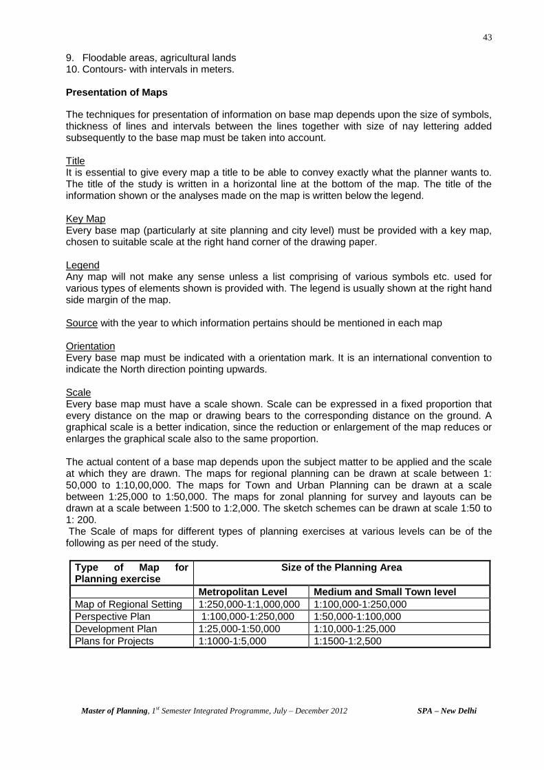
43
Master of Planning, 1st Semester Integrated Programme, July – December 2012 SPA – New Delhi
9. Floodable areas, agricultural lands 10. Contours- with intervals in meters.
Presentation of Maps
The techniques for presentation of information on base map depends upon the size of symbols, thickness of lines and intervals between the lines together with size of nay lettering added subsequently to the base map must be taken into account. Title It is essential to give every map a title to be able to convey exactly what the planner wants to. The title of the study is written in a horizontal line at the bottom of the map. The title of the information shown or the analyses made on the map is written below the legend. Key Map Every base map (particularly at site planning and city level) must be provided with a key map, chosen to suitable scale at the right hand corner of the drawing paper. Legend Any map will not make any sense unless a list comprising of various symbols etc. used for various types of elements shown is provided with. The legend is usually shown at the right hand side margin of the map. Source with the year to which information pertains should be mentioned in each map Orientation Every base map must be indicated with a orientation mark. It is an international convention to indicate the North direction pointing upwards. Scale Every base map must have a scale shown. Scale can be expressed in a fixed proportion that every distance on the map or drawing bears to the corresponding distance on the ground. A graphical scale is a better indication, since the reduction or enlargement of the map reduces or enlarges the graphical scale also to the same proportion. The actual content of a base map depends upon the subject matter to be applied and the scale at which they are drawn. The maps for regional planning can be drawn at scale between 1: 50,000 to 1:10,00,000. The maps for Town and Urban Planning can be drawn at a scale between 1:25,000 to 1:50,000. The maps for zonal planning for survey and layouts can be drawn at a scale between 1:500 to 1:2,000. The sketch schemes can be drawn at scale 1:50 to 1: 200. The Scale of maps for different types of planning exercises at various levels can be of the following as per need of the study.
Type of Map for Planning exercise
Size of the Planning Area
Metropolitan Level Medium and Small Town level
Map of Regional Setting 1:250,000-1:1,000,000 1:100,000-1:250,000
Perspective Plan 1:100,000-1:250,000 1:50,000-1:100,000
Development Plan 1:25,000-1:50,000 1:10,000-1:25,000
Plans for Projects 1:1000-1:5,000 1:1500-1:2,500

44
Master of Planning, 1st Semester Integrated Programme, July – December 2012 SPA – New Delhi
Techniques for Presentation
There are two broad techniques used for presentation, i.e. 1. Monochrome presentation –secures the desired effect solely by variations of density,
texture and or direction in the lines, edgings and symbols used. 2. Colour technique- relies upon colour contrast to denote differentiation. 3. Use of series of overlays and Single composite maps- is used for the purpose of
comparison, placed over a base map, together with any combination of separate survey subject, can be treated as a map in its own right, can be placed over the base map together with any combination of other subjects desired and compared with them by experimenting with different combinations significant data apparently unconnected may reveal themselves. Any interesting combination of subjects can be printed to from a composite map.
Patterns of symbols are especially suitable for items covering a large proportion of the maps. They may consist of squares, oblongs, triangles, and circles or in fact any shape capable of being drawn quickly and accurately. A variation application of the principles suggested to basic types of Planning Maps Maps showing factors or areas of different character but of approximately equal importance- may be presented. However it is essential that the notation used shall not unduly accentuate any of the following: 1. Particular area- Thus if colours are used they should be of about equal intensity, hatching
should be differentiated by changes of colour, direction and texture. 2. Maps showing factors of the same kind but differing intensity- Variety in the intensity of the
rendering applied is to be desired rather than variety of colour, shape or direction. 3. Flows- These will most often be represented by use of direction indicators, where a number
of unconnected flows have to be shown on the map, particularly if they cross each other, to use a different colour or texture for each indicator.
4. Distribution of services centres and extent of services areas- The form of representation is by use of symbols, necessary to indicate the presence or absence of a considerable number of service facilities and are self-explanatory.
5. Maps dealing with several subjects/themes or aspects-each representing some characteristic to summaries the analyses of the surveyed data.
( Source: KEEBLE, Lewis. Principles and Practices of Town and Country Planning )
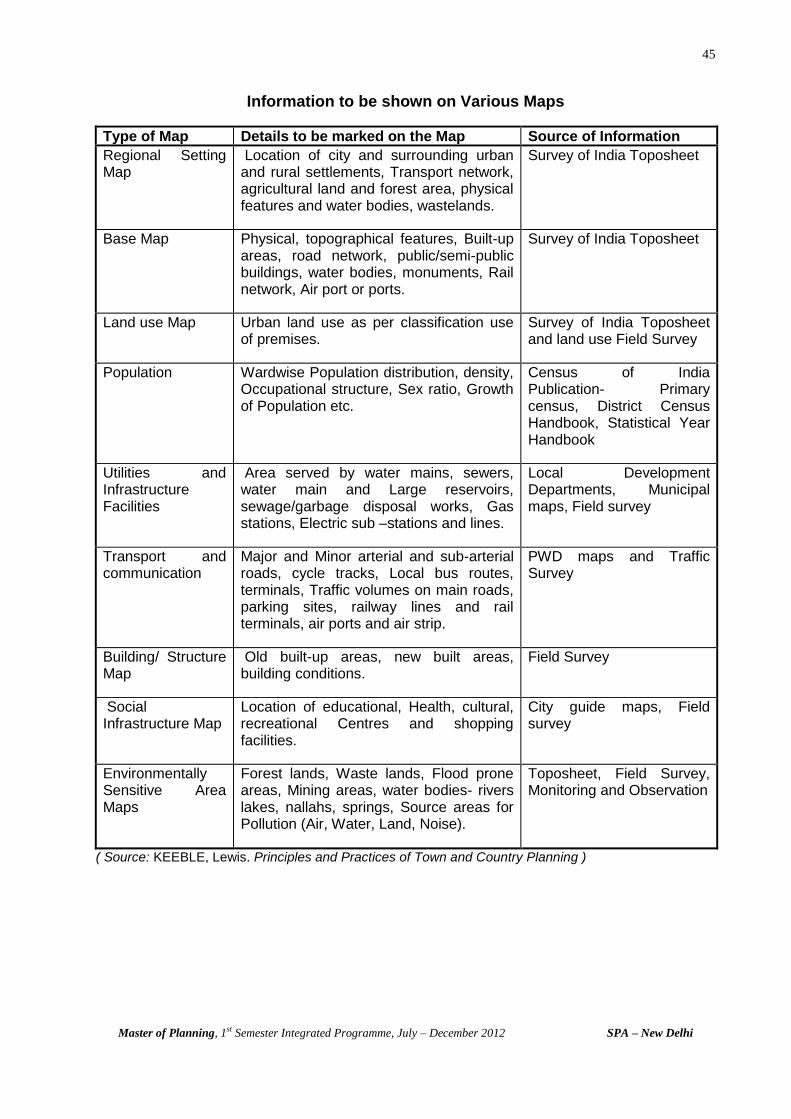
45
Master of Planning, 1st Semester Integrated Programme, July – December 2012 SPA – New Delhi
Information to be shown on Various Maps
Type of Map Details to be marked on the Map Source of Information
Regional Setting Map
Location of city and surrounding urban and rural settlements, Transport network, agricultural land and forest area, physical features and water bodies, wastelands.
Survey of India Toposheet
Base Map Physical, topographical features, Built-up areas, road network, public/semi-public buildings, water bodies, monuments, Rail network, Air port or ports.
Survey of India Toposheet
Land use Map Urban land use as per classification use of premises.
Survey of India Toposheet and land use Field Survey
Population Wardwise Population distribution, density, Occupational structure, Sex ratio, Growth of Population etc.
Census of India Publication- Primary census, District Census Handbook, Statistical Year Handbook
Utilities and Infrastructure Facilities
Area served by water mains, sewers, water main and Large reservoirs, sewage/garbage disposal works, Gas stations, Electric sub –stations and lines.
Local Development Departments, Municipal maps, Field survey
Transport and communication
Major and Minor arterial and sub-arterial roads, cycle tracks, Local bus routes, terminals, Traffic volumes on main roads, parking sites, railway lines and rail terminals, air ports and air strip.
PWD maps and Traffic Survey
Building/ Structure Map
Old built-up areas, new built areas, building conditions.
Field Survey
Social Infrastructure Map
Location of educational, Health, cultural, recreational Centres and shopping facilities.
City guide maps, Field survey
Environmentally Sensitive Area Maps
Forest lands, Waste lands, Flood prone areas, Mining areas, water bodies- rivers lakes, nallahs, springs, Source areas for Pollution (Air, Water, Land, Noise).
Toposheet, Field Survey, Monitoring and Observation
( Source: KEEBLE, Lewis. Principles and Practices of Town and Country Planning )

46
Master of Planning, 1st Semester Integrated Programme, July – December 2012 SPA – New Delhi
Annexure - 3
DELHI MASTER PLAN
AND DEVELOPMENT CODE
______________________________________________
Delhi- the Capital of India
The city of Delhi, with a population of more than 13,782,976 (as per 2001 census) has a distinct personality of it own. It is centuries old with a glorious past history. Being the capital of the largest democracy, i.e. India, it is gaining importance among the largest metropolitan cities of the world. With the growing population at unpredictable speed and limited areas of land at our disposal, a comprehensive master plan for Delhi was a must. Master Plan- it was on 1
st September, 1962, when the first Comprehensive Master Plan for Delhi was
brought on the Statute book for the development of Delhi and since then it has been the guiding start for all sorts of developments. Building activity in different urban sectors has to be regulated as per guidelines provided therein with a view to avoid any complications. Being the first landmark in the history of Delhi, the 1962 Master Plan shall ever remain unique document, which has provided a useful base regulating the development of building activities in Delhi. The Second Plan The plan is precisely a comprehensive revision of the first one. The thrust is on developing much faster more comfortable and co-ordinated system with 2001 as the prospective year. For the time being the plan will cater to 128 lakh population and was formulated with a view to meet the ground realities over the next 11 years. In fact the mere formulation of plan to tackle Delhi’s problems and provide a better environment to the people, is like running away from the realities than meeting them. The enormity of the capital’s problems needs to be tackled at much wider canvas with greater thrust on developing the National Capital Region, as step directly needed to decongest the city as a long term measure. The desirable results could be achieved of the implementation is prefect one aspect which the concerned authorities have been found waiting over years. A harmonious effort at the top most level in the formulation of a plan for the city, could only provide the key to its problem, it is felt. The ultimate solution to counter Delhi’s gigantic problems lies in pooling up of all the available options of planning and financial priorities to decide development to take place in the next 20 years, but most important is to stop the population explosion in Delhi particularly the migration aspect if the problem like chaotic traffic scenes are to be checked. Master Plan and Development Plans There is provision for carrying out a civic survey of and preparing a master plan for Delhi under the Delhi Development Act 1957. Under the 1957 Act the master plan shall define the various zones into which Delhi any be divided for the purpose of development and indicate the manner in which the land in each zone is proposed to be used and the stages by which any such development shall be carried out and serve as a basic pattern of frame work within which the zonal development plans of various zones may be prepared. Zonal Development Plans The 1957 act further provides that simultaneously with the preparation of the master plan, the Delhi Development Authority shall proceed with the preparation of a zonal development plan for each of the zones into which Delhi may be divided. Such plan shall contain a site plan and use plan for the developments of zone and show the approximate locations and extents of land uses proposed in the zone for such things as public building and other public works and utilities, roads, housing, recreation, industry, business markets, schools, hospitals and public and private open spaces. The plan would further specify the standards of population density and building density and also show every area required or declared for development or re-development.
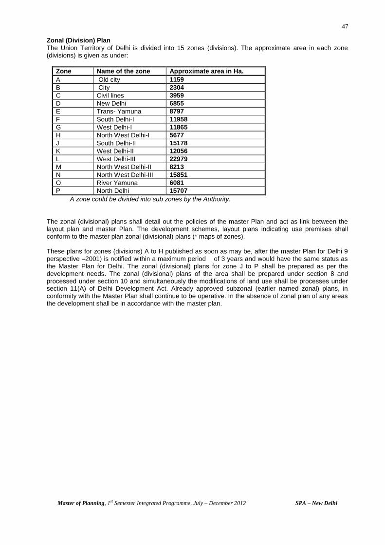
47
Master of Planning, 1st Semester Integrated Programme, July – December 2012 SPA – New Delhi
Zonal (Division) Plan The Union Territory of Delhi is divided into 15 zones (divisions). The approximate area in each zone (divisions) is given as under:
Zone Name of the zone Approximate area in Ha.
A Old city 1159
B City 2304
C Civil lines 3959
D New Delhi 6855
E Trans- Yamuna 8797
F South Delhi-I 11958
G West Delhi-I 11865
H North West Delhi-I 5677
J South Delhi-II 15178
K West Delhi-II 12056
L West Delhi-III 22979
M North West Delhi-II 8213
N North West Delhi-III 15851
O River Yamuna 6081
P North Delhi 15707
A zone could be divided into sub zones by the Authority.
The zonal (divisional) plans shall detail out the policies of the master Plan and act as link between the layout plan and master Plan. The development schemes, layout plans indicating use premises shall conform to the master plan zonal (divisional) plans (* maps of zones). These plans for zones (divisions) A to H published as soon as may be, after the master Plan for Delhi 9 perspective –2001) is notified within a maximum period of 3 years and would have the same status as the Master Plan for Delhi. The zonal (divisional) plans for zone J to P shall be prepared as per the development needs. The zonal (divisional) plans of the area shall be prepared under section 8 and processed under section 10 and simultaneously the modifications of land use shall be processes under section 11(A) of Delhi Development Act. Already approved subzonal (earlier named zonal) plans, in conformity with the Master Plan shall continue to be operative. In the absence of zonal plan of any areas the development shall be in accordance with the master plan.
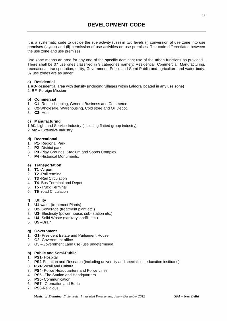
48
Master of Planning, 1st Semester Integrated Programme, July – December 2012 SPA – New Delhi
DEVELOPMENT CODE
It is a systematic code to decide the sue activity (use) in two levels (i) conversion of use zone into use premises (layout) and (ii) permission of use activities on use premises. The code differentiates between the use zone and use premises. Use zone means an area for any one of the specific dominant use of the urban functions as provided . There shall be 37 use ones classified in 9 categories namely: Residential, Commercial, Manufacturing, recreational, transportation, utility, Government, Public and Semi-Public and agriculture and water body. 37 use zones are as under: a) Residential 1.RD-Residential area with density (including villages within Laldora located in any use zone) 2. RF- Foreign Mission b) Commercial 1. C1- Retail shopping, General Business and Commerce 2. C2-Wholesale, Warehousing, Cold store and Oil Depot. 3. C3- Hotel c) Manufacturing 1.M1-Light and Service Industry (including flatted group industry) 2. M2 – Extensive Industry d) Recreational 1. P1- Regional Park 2. P2 -District park 3. P3 -Play Grounds, Stadium and Sports Complex. 4. P4 -Historical Monuments. e) Transportation 1. T1 -Airport 2. T2 -Rail terminal 3. T3 -Rail Circulation 4. T4 -Bus Terminal and Depot 5. T5 -Truck Terminal 6. T6 -road Circulation f) Utility 1. U1-water (treatment Plants) 2. U2- Sewerage (treatment plant etc.) 3. U3- Electricity (power house, sub- station etc.) 4. U4 -Solid Waste (sanitary landfill etc.) 5. U5 –Drain g) Government 1. G1- President Estate and Parliament House 2. G2- Government office 3. G3 –Government Land use (use undetermined) h) Public and Semi-Public 1. PS1- Hospital 2. PS2-Eduation and Research (including university and specialised education institutes) 3. PS3-Socail and Cultural 3. PS4- Police Headquarters and Police Lines. 4. PS5 –Fire Station and Headquarters 5. PS6- Communication 6. PS7 –Cremation and Burial 7. PS8-Religious.

49
Master of Planning, 1st Semester Integrated Programme, July – December 2012 SPA – New Delhi
i) Agricultural and Water Body 1. A1 – Plant Nursery 2. A2-Green Belt 3. A3- rural zone (village as residential areas) 4. A4 –Rural and water body DEFINITIONS
Mixed Use Zone means a use zone in the Land Use plan could be indicated as consisting of more than one use zones in such a case the use premises/use activities permitted in both the use zone shall be applicable. Layout Plan means a sub-division plan indicating configuration and sizes of all use premises. Each use zone may have one or more than one layout plan depending upon the extensiveness of the area under the specific use zone and vice-versa. Zonal Development Plan means a plan for one of the zones (division) of the Union Territory of Delhi containing detailed information regarding provision of social infrastructure, parks and open spaces and circulation system. Land use Plan means the plan indicating all the use zones as defined in clause 2(1) Special Area means any area designated as such in the plan. Commercial Centre includes a CBD, Distt. Centre, Community Centre, Local Shopping Centre and Convenience shopping Centre and Non- -hierarchy Commercial Centres. Use Premises means one of the many sub-divisions of a use zone, designated at the time of preparation of the layout plan, for a specific main use or activity and includes the use premises described as below. SCHEDULE TO THE DEVELOPMENT CODE
Definition of use premises
001. Residential Plot-Plotted Housing - A premises for one or more than one dwelling unit and may have on it on e main building block and one accessory block for garage/garages and servant quarters.
02. Residential Plot-Group Housing -A premises of size not less than 4.000sqm comprising of
residential flats with basic amenities like parking, park convenience shops, public utility etc. 003. Residential Flat - Residential accommodation for one family (one household) which may occur
as part of group housing or independently. 004. Residence-cum-workflat – A premises providing accommodation for one family (one
household) and its workspace restricted to ground floor. The premises are allowed only in public housing schemes.
005. Residential Premises-Special Area - A premises providing residential accommodation in
special area with or without mixed use as given in special area regulations. 006. Foreign Mission - A premises for office and other uses of a foreign mission as per the
regulations in this regard. 007. Hostel - A premises in which rooms attached to ‘Institutions” or otherwise are let out on a long-
term basis. 008. Guest house, Boarding House and Lodging House - Guest house in premises for housing the
staff of Govt., Semi-Govt., Public undertaking and Private Limited Company for short duration’s.

50
Master of Planning, 1st Semester Integrated Programme, July – December 2012 SPA – New Delhi
Boarding House is a premise in which rooms are let out on a long-term basis as compared to hotels.
Lodging House is a premises used for lodging of less than 15 persons. 009. Dharamshala and its equivalent - A premises providing temporary accommodation for short
duration on no profit basis. 010. Baratghar - A premises used for marriage and other social functions and run by public agency. 011. Night Shelter - A premises providing night accommodation to individuals without any charges
with token charges. Local government or voluntary agencies may run it . 012. Retail Shop - A premises for sale of commodities directly to consumer with necessary storage. 013. Repair Shop - A premises equivalent of retail shop for carrying out repair of household goods,
eletronic gadgets, automobiles, cycles etc. 014. Personnel Service Shop – A premises equivalent of a retail shop providing personnel services
like tailor, barber etc. 015. Vending Booth - A premises in the form of booth for sale of commodities of daily needs either
through a mechanical installation or otherwise. 016. Convenience shopping Centre - A group of shops not exceeding 50 in number in residential
area serving a population of about 5,000 persons. 017. Local Shopping Centre - A group of shops not exceeding 75 in number in residential area
serving a population of 15,000 persons. 018. Weekly market/Informal Sector Unit - An area used in a week by a group of informal shop
establishment in the form of a market. These markets shift form one area to another in different days of the week.
Informal Unit: retail/Service unit, stationery or mobile, working without roof including small khokhas on roadside.
019 Wholesale Trade - A premises form where goods and commodities are sold delivered to
retailers. The premises included storage and godown and loading and unloading facilities. 020. Storage, Godown and Warehousing - A premises for exclusive use of storage of goods and
commodities in manner as per the requirements of respective commodities. The premises included the related loading and unloading facilities by Road transport or Rail transport as the case may be.
021. Cold Storage - A premises where perishable commodities are stored in covered space using
mechanical and electrical device to maintain the required temperature etc. 022. Gas Godown - A premises where cylinder of cooking gas or other gas are stored. 023. Oil Depot - A premises for storage of petroleum products with all related facilities. 024. Junk Yard - A premises for covered, semi-covered or open storage including sale and purchase
of waste goods, commodities and materials. 025. Commercial Office - A premises used for office of profit making organisations. 026. Bank - A premises for office to perform banking functions and operation. 027. Motor Garage and Workshop - A Premises for servicing and repair of automobiles. 028. Cinema - A premises with facilities for projection for movies and stills for can audience including
an auditorium for other audience.
51
Master of Planning, 1st Semester Integrated Programme, July – December 2012 SPA – New Delhi
030. Petrol Pump - A premises for sale of petroleum products to consumers. It may include servicing of automobiles.
031. Restaurant - A premises used for serving food items on commercial basis including cooking
facilities. It may have covered or open space or both for sitting arrangement. 032. Hotel - A premises used for lodging of 15 persons or more on payment with or without meals 033. Motel – A premises located near main highways and outside urbanisable limits for catering to the
convenience of persons travelling by road. 034. Flatted group industry - A premises having a group of small industrial units in Annexure III
having upto 50 workers with non-hazardous performance. These units may be located in multi-storied buildings.
035. Service Centre - A premise essentially having repair shops for automobiles, electrical
appliances, building material etc. to provide essential services to neighbouring residential areas. 036. Industrial Plot-Light Industry - A premises for industrial unit as per list given in Annexure III
having upto 50 workers with non-hazardous performance. 037. Industrial Plot-Extensive industry - A premises for industrial units as per the list given in the
Annexure III having upto 50 workers in case of new extensive industrial units and 500 workers for existing units.
038. Industrial Premises-Extractive Industry - A premises for carrying out quarrying or extraction
of stone and sub-soil material respectively. 039. Industrial Plot-Industry Specific type - A premises for an industrial unit within a group of such
units for manufacturing of specific products like electronic goods etc. 040 Park - A premises used for recreational leisure activity. It may have on it related landscaping,
parking facilities, public toiler, fencing etc. It will include synonymous like lawn, open space, green etc.
041. Play Ground - A premises used for outdoor games. It may have on it Landscaping, parking
facilities, public toilet etc. 042. Outdoor games stadium -.A premises for outdoor games with pavilion building and stadium
structure to seat spectators including related facilities for players. 043 Indoor Games Stadium - A premises for indoor stadium with play area and spectators seating
including related facilities for players. 044. Indoor Games hall - A premise providing enclosed space for indoor games including related
facilities for players. 045. Shooting Range - A premises with related facilities for shooting practice and or sports. 046. Swimming Pool - A premises with facilities for swimming and spectators seating, which shall
vary size, standard and purpose. 047. Recreational Club - A premises used for gathering of group of persons for social and
recreational purposes with all related facilities. 048. Historical Monuments - A premises having structure or ruins thereof, belonging to an age gone
past. 049. National Memorial – A premises having the tomb, samadhi or memorial dedicated to an
important personality including all related facilities for visitors.
52
Master of Planning, 1st Semester Integrated Programme, July – December 2012 SPA – New Delhi
050. Zoological Garden Aquarium - A premises in the form of garden or park or aquarium with a collection of animals, species and birds for exhibition and study. It shall include all related facilities.
051. Bird sanctuary – A premises in the form of large park or forest for preservation and breeding of
birds with al related facilities. 052. Botanical Garden - A premises in the form of a garden with plantation for research and
exhibition. 053. Specialised Park/Ground - A premises having a park or ground for a designated use like public
meeting grounds, fun park, wonder land etc. 054 Planetarium - A premises for short duration stay, for recreation or leisure purpose, of a family
located within a tourist and or recreational centre. 055. Planetarium - A premises for short duration stay, for recreational or leisure purpose of a family
located within a tourist and or recreational centre. 056. Flying Club - A premises used of training and fun rides on gliders and other aircraft. It may
include other activities like recreational club and indoor games. 057. Cargo and Booking Office - A premises used for booking office and storage of goods by an
airline. 058. Railway Freight Godown - A premises for storage of goods transported by the railways. 059. Railway Booking Office - A premises used for the offices of railways for purpose of booking for
passengers travel. 060. Road transport Booking office - A premises used for the office of road transport agency. It may
or may not include godown. 061. Parking - A premises used for parking of vehicles. The public parking lots may be run on
commercial or non- commercial basis. 062. Taxi and Three wheeler stand - A premises to be used for parking of intermediate public
transport vehicles run on commercial basis. The parking lots may be run on commercial or non-commercial basis.
063. Bus Terminal - A premises used by public transport agency to park the buses for short duration
to serve the population. It may include the related facilities for passengers. 064. Bus Depot - A premises used by a public transport agency or any other such agency for parking
maintenance and repair of buses. This may or may not include a workshop. 065. Public Utility Premises-
(i) Overhead tank- A premises having a overhead tank of storage and supply of water to its neighbouring areas. It may or may not include a pump house.
(ii) Underground Tank - A premises having an underground tank for storage and supply of water to its neighbouring areas. It may or may not include a pump house.
(iii) Oxidation Pond - A premises having a tank used for the oxidation process for sewerage and other waste.
(iv) Septic Tank - A premises having an underground tank for collection of sewerage and its consequent disposal.
(v) Sewerage Pumping Station - A premises with a pumping station used for pumping sewerage on to a higher gradient.
(vi) Public Toilet and Urinal - A premises having latrine and urinals for use of public. It may or may not include drinking water facility.
(vii) Electric Sub-station - A premises having electrical installation and transformer for distribution of power.
53
Master of Planning, 1st Semester Integrated Programme, July – December 2012 SPA – New Delhi
(viii) Dhallao and Dustbin - A premises used for collection of garbage for its onwards transportation to sanitary land-fill.
(ix) Dhobi Ghat - A premises used for cleaning and drying of clothes/linen by washerman. 066. Central Government Office - A premises used for the offices of Union Government. 067. Local Government Office - A premises used for offices of Local Government and Local Bodies. 068. Public Undertaking Office - A premises used for the offices of a company established under the
Act of public enterprises bureau. 069. International Conference Centre - A premises having all facilities for a conference meeting
symposium etc. where a number of different countries will be participating. 070. Courts - A premises used for the offices of judiciary. 071. Government Land (use undetermined) - A premises of Government land for which the use is
undetermined. 072. Hospital - A premises providing medical facilities of general of specialised nature for treatment of
indoor and outdoor patients. 073. Health Centre - A premises having facilities for treatment of indoor and outdoor patients having
upto 30 beds. The health centre may be managed by a public or a charitable institution on non-commercial basis. It includes family welfare centre.
074. Nursing Home - A premises having medical facilities for indoor and outdoor patients having upto
30 beds. It shall be managed by a doctor or a group of doctors on commercial basis. 075. Dispensary - A premises having facilities for medical advice and provision of medicines
managed by public or charitable institutions. 076. Clinic - A premises with facilities for treatment of outdoor patients by a doctor. In case of a
polyclinic, it shall be managed by a group of doctors. 077. Clinical Laboratory - A premises with facilities for carrying out various tests for confirmation of
symptoms of a disease. 078. Voluntary Health Service - A premises having medical facilities for treatment of outdoor patients
and other like blood bank etc. by voluntary institutions. This service may also take the form of temporary camp with charitable motive.
079. Creche and Day Care Centre - A premises having nursery facilities for infants during day time.
The centre may be managed by an individual of an institution on commercial or noncommercial basis.
080. Nursery and Kindergarten School - A premises with facilities for training and playing for
children preparatory to the school. 081. Primary School - A premises having educational and playing facilities for students upto V
standard. 082. Secondary School - A premises having educational and playing facilities for students from V1 to
X standard. It shall include existing cases of middle school, which are upto VIII standard for the purpose of this code.
083. Senior Secondary School - A premises having educational and playing facilities for students
from VIth to XIIth standard. 084. Integrated School - A premises having educational and playing facilities for students upto XII
standard.

54
Master of Planning, 1st Semester Integrated Programme, July – December 2012 SPA – New Delhi
085. Integrated Residential School - A premises having educational and playing facilities for students upto XII standard. It shall have boarding facilities for students and may have residence for faculty members.
086. College - A premises with educational and playing facilities for students of under-graduate &
post-graduate courses under a university. It includes all professional disciplines. 087. Vocational Training Institute - A premises with training facilities for short-term courses for
discipline, preparatory to the employment in certain profession and trade. It shall be run by public or charitable institution on non-commercial basis. It includes training-cum-work centre.
088. Social Welfare Centre - A premises with facilities for welfare and promotion of community
development. It shall be run by a public or charitable institution. 089. Research and Development Centre - A premises providing facilities for research and
development for any specific field. 090. Library - A premises having a large collection of books for reading and reference for general
public or specific class. 091. Technical Training Centre - A premises with facilities for training in discipline of technical
nature. It includes technical schools, industrial training institute etc. 092. Commercial and Secretarial Training Centre - A premises having training facilities for
stenography correspondence, record keeping etc. 093. Music, Dance and Drama Training Centre - A premises having facilities for imparting training
and coaching for music, dance and dramatics. 094. Sports Training Centre - A premises having facilities for training and coaching for different
indoor and outdoor games including swimming. It shall also include centre for physical education. 095. Motor Driving Training Centre - A premises having facilities for training of driving automobiles. 096. Children Traffic Park - A premises in the form of a park with facilities for introducing and
educating children about traffic and signaling. 097. Museum - A premises with facilities for storage and exhibition of Objects illustrating antiques,
natural history, art etc. 098. Exhibition Centre and Art Gallery - A premises with facilities for exhibition and display of
paintings, photographs, sculptures, murals, ceramics, handicrafts or products of a specific class. 099. Auditorium - A premises having an enclosed space to seat audience and stage for various
performances like concerts, play, music, recitals, functions etc. 100. Open Air Theatre - A premises having facilities for audience seating and a stage for
performance and open to sky. 101. Community Hall - A premises having an enclosed space for various social and cultural activities
of neighbourhood of 15,000 population. 102. Fair Grounds - A premises having facilities for exhibition and display and other cultural activities
for a group of participants. 103. Cultural and Information Centre - A premises with facilities for cultural and information services
for an institution, state and country. 104. Social and Cultural Institute - A premises with facilities for activities of socio-cultural nature run
by a public, voluntary or individual on primarily non-commercial basis. 105. Reformatory - A premises with facilities for confinement and reform of offenders.

55
Master of Planning, 1st Semester Integrated Programme, July – December 2012 SPA – New Delhi
106. Orphanage - A premises with facilities for boarding of children who are bereaved of parents. It
may or may not have educational facilities. 107. Religious - A premises dedicated to accommodation and service of God or other objects of
religious nature. It may have different nomenclature in different religion like temple (all fait's), mosque, church, gurudwara, syangoue, ashram, bathing ghat, gaushala.
108. Yoga Meditation, Spiritual and Religious Discourse Centre - A premises having facilities for
self attainment, achieving higher quality of mind and body, spiritual and religious course etc. 109. Police Post - A premises having facilities for a local police post of temporary nature or on
smaller scale as compared to a police station. 110. Police Station - A premises having facilities for the offices of local police post. 111. District Police Office - A premises having facilities for the offices of paramilitary forces. 112. Civil Defence and Home Guard - A premises having facilities for offices and other functions of
civilian organisation for internal defence. 113. Forensic Science Laboratory - A premises containing facilities for application of medical
knowledge to legal problems. 114. Jail - A premises with facilities for detension, confinement and reform of criminals under the law. 115. Fire Post - A premises with lesser degree of facilities for fire fighting. The post may be attached
to a specific premises with fire prone activities. 116. Fire Station - A premises with facilities for the fighting for a catchment area assigned to it. It may
include residence of essential staff. 117. Post Office - A premises with facilities for postal communication for use by the public. 118. Post and Telegraph office - A premises with facilities for postal and telecommunication for use
by the public. 119. General and Head Post Office - A premises with facilities for postal and telecommunication to
and from a number of post offices attached to it. 120. Telephone Exchange - A premises having facilities for central operation of telephone system for
a designated area. 121. Radio and Television Station - A premises with facilities for recording, broadcast and
transmission of news and other programmes through the respective medium. It may include some hostel accommodation for guest artist, transmission facilities like towers.
122. Transmission Tower and Wireless Station - A premises used for installation of a tower for
communication purposes. 123. Satellite and Tele-Communication Centre - A premises with facilities for research and
development of satellite and tele-communication technology. 124. Observatory and Weather Office - A premises with facilities for research and development of
data relating to weather and forecasting thereof. 125. Burial Ground - A premises with facilities for burying of dead bodies. 126. Cremation Ground - A premises with facilities of performing last rites of dead bodies by burning. 127. Cemetery - A premises with facilities for burying of dead bodies by Christian community.

56
Master of Planning, 1st Semester Integrated Programme, July – December 2012 SPA – New Delhi
128. Electric Crematorium - A premises with facilities for disposing off the dead body in an electric furnace.
129. Orchard - A premises with a thick growth of fruit trees. It may also include garden with fruit trees. 130. Plant Nursery - A premises with facilities for rearing and sale of young plants. 131. Forest - A premises with thick natural flora. In case of Union Territory of Delhi, it shall include city
forest, which may have part natural flora and part manmade flora. 132. Dairy Farm - A premises with facilities for rearing and processing of dairy products. It may have
temporary structure for sheds of animals and birds. 133. Poultry Farm - A premises with facilities for rearing and processing of dairy products. It may
have temporary structure for sheds of birds. 134. Piggery - A premises with facilities for rearing and processing of piggery products. It may have
temporary structure for sheds of pigs. 135. Farm House - A dwelling house on a farm. 136. Rural Centre - A premises having facilities for different functions for a certain number of villages
it caters to.

57
Master of Planning, 1st Semester Integrated Programme, July – December 2012 SPA – New Delhi
Annexure – 4
LANDUSE CLASSIFICATION
AND COLOR CODING
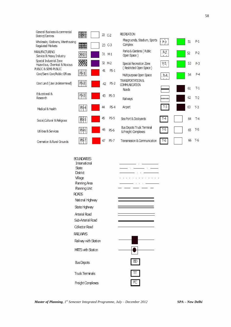
58
Master of Planning, 1st Semester Integrated Programme, July – December 2012 SPA – New Delhi

59
Master of Planning, 1st Semester Integrated Programme, July – December 2012 SPA – New Delhi
Annexure - 5
REFERENCES
HOUSING _____________________________________________________________________________________________
1. Abram, Charles (1964), Housing In Modern World, Faber And Faber, 24 Russen Square London
2. Abram, Charles, Man’s Struggle For Shelter In An Urbanising World, Vakils, Fefferand Simmons Pvt. Ltd Hauge Building 9 Sprott Road, Ballard, Bombay
3. Khurana M.L.(1997), Reading In Cooperative Housing, National Cooperative Housing Federation Of India, 6a/6 Siri Fort Institutional Area, Khel Gaon Marg, New Delhi-110049
4. Chandoke S.K. (1994) Habitation And Environment, Har Anand Publication. 5. Vliet Van, William & Weesep , Van Jan (1990). Government And Housing, Sage
Publications, New Bury Park, London. 6. Male L. Ronald (1974) Housing Plus Environment, Olympus Publishing Company, Salt
Lakecity, Utah 7. Smith. F. Willam (1074), Housing, Prentice-Hall Inc, Englewood Cliff, Nj 07632 8. Satterthwaite, David & Hardoy E. Jorge, Shelter: Need & Response, Johan Wiley & Sons,
Chichester, New York, Toronto. 9. Roske Deyo Mildred (1983) Housing In Transition, Winston, Rinehartm Holt 10. Nientied, Peter & Raj, Mulkh, Housing And Income In Third World, Mohan Primlanifor
Oxford & Ibh Publishing Co. Pvt. Tld 66 Janpath, New Delhi. 11. Revi, Aromar(1990) Shelter In India, Har- Anand Publication In Association With Vikas
Publishing House Pvt. Ltd. 12. Roa B. Bhaskara (1979) Housing And Habitat In Developing Countries, Newman Group
Of Publishers, 4c Ansari Road New Delhi-110002 13. Jayaram N. Sandhu R.S. (1988) Housing In India B.R. Publishing Corporation Delhi-
110007 14. Umashankar .P. & Misra K. Girish (1993), Public- Private Responsibilities In Urban
Housing, Reliance Publishing House & Iipa (Centre For Urban Studies) New Delhi 15. Poulose, Thomas K (1988) Innovative Approaches To Housing The Poor, Mrs. C.
Matthew, Trivandrum 695041, Kerala. 16. Girish K Misra and P.S.N.Rao . Housing Legislation in India, Kanishka Pub., New Delhi Recommended Reading Articles 1. The Neighborhood (Pg. 129-147) Molen L. Ronald, Housing Plus Environment 1974,
Olympus Publishing Company, Slat Lake City, Utah 2. Habitation Patterns In North-Western Uttar Pradesh, India, (Chapter 6 Pg. 98-120)
Chandhoke S.K, Habitation & Environment 1994, Har- Anand Publications, Chiraj Delhi 3. Human Environment And Habitation, (Chapter 13 Pg. 200-238)- Chandhoke S.K.
Habitation & Environment 1994, Har- Anand Publications, Chiraj Delhi 4. The Psychology Of Housing (Chapter 6 (G. 117-139), Roske Deyo Mildred, Housing In
Transition 1983, The Dryden Press 8 Aunders College Publishing 5. The Basics Of Housing Choice (Chapter 4 Pg. 75-96) Roske Deyo Mildred, Housing In
Transition 1983, The Dryden Press 8 Aunders College Publishing 6. Housing And Habitat Planning (Chpater 2 Pg. 8-26)- Roske Deyo Mildred, Housing In
Transition 1983, The Dryden Press 8 Aunders College Publishing 7. Special Problem Of Human Settlements (Chapter 10 (Page 153-163), Roske Deyo
Mildred, Housing In Transition 1983, The Dryden Press 8 Aunders College Publishing

60
Master of Planning, 1st Semester Integrated Programme, July – December 2012 SPA – New Delhi
8. Women And Housing – General Perspective And Habitat Planning (Chapter 13 Pg. 238-248), Sharma R.N., Indo- Swedish Perspective On Affordable Housing, 1994, Tata Institute Of Social Science, Bombay
9. Participation, Self Help And Mobilisation (Chapter 10 Pg. 195-205) Sharma R.N., Indo- Swedish Perspective On Affordable Housing, 1994, Tata Institute Of Social Science, Bombay
10. The Concept Of Katra Settlement In Historical Perspective & Types Of Katras And Other Forms Of Settlements In Old Delhi, (Chapter 1 &2 Pg. 23-40), Trivedi R. Harshad, Housing And Community In Old Delhi, 1975
ENVIRONMENTAL PLANNING _____________________________________________________________________________________________
1. Asesh Kumar Maitra, Urban Environment In Crisis, New Age International Publishers, 2000
2. Avijit Gupta, Ecology and Development in Third World, Routledge, London, 1988 3. Aggarwal.S.K, Pollution Ecology, Himanshu Publications Udaipur 1991 4. D.Baune D.V. Chapman, M.D Gwynne, J.M Payna, The Global environment, Science
Technology and Management Vol I,II, Scandinavian Science Pub. 1997, Wiley Company 5. Centre For Environmental Studies, School of Planning & Architecture, Abstract Reading
Material On Environmental Factors As Landuse Determinants: Landuse & Housing, 1985
6. Brij Gopal, N Bharway, Elements of Ecology, Vikas Publishers 1981 7. Douglas F Muschett Ed. Principles Of Sustainable Development, S l Press Florida 1997 8. Edbington John M And Edington Ann, Ecology And Environmental Planning London
Chapman &Hall 1977 9. Eugene Podum, Fundamental Of Ecology, Wd Sanders Company 10. Goudie A, Human Impact Man’s Role In Environmental Change, Basil Black Well,
England 1981 11. Gareth Jones And Graham Hollier, Resource Society And Environmental Management,
Paul Chapman Publishing Ltd 1997 12. Gordan Dickinson & Kevin M, Ecosystem, Routtledge London 1998 13. Gopal B & Bhardwaj N. Elements Of Ecology, Vikas Publishing Co, U.P. 1979 14. Goulden P.O, Environmental Pollution Analysis, Heyden, London, 1978 15. Haw R.C, The Conservation Of Natural Resources, Faber And Faber Ltd, London, 1959 16. Khoshoo T.N. Environmental Concerns And Strategies, Ashish Publishing House 1988 17. Marsh W.M, Environmental Analysis, Mc Graw Hill USA, 1978 18. M.S. Sethi S.A Iqbal Encylopedia of Nature & Environment, DPH, New Delhi, 1998 19. Mannion A.M Global Environmental Change, Longman Scientific Technology, 1991 20. Martin Holdgate, From Care to Action, Making of Sustainable World, IUCN, Earth scn
Pub, Ltd, London, 1997 21. M.S. Sethi And Inderjeet Kam Sethi, Understanding Our Environment 22. Nagchaudhuri B.D, Introduction To Environmental Management, Environmental Science
Series Interprint, 1983 23. Pratha. Dasgupta & Karl Goramn Maller, The Environment and Emerging Developemnt
Issue Vol. I, II, Clarendon Press Oxford, 1997 24. World Commission On Environment And Development, Our Common Future Oxford
University, Delhi 1987 25. Peter Bartelmus, Environmental And Development, Allen.S. University, Boston 1986 26. Paul F J.Eagles, Planning and Management of Environmental Sensitive Areas, Themes
in Resource Management, Longman 1984 27. Rusell D Thompson & Allen Perry, Applied Climatology- Principles & Practice, Routledge,
London, 1997
61
Master of Planning, 1st Semester Integrated Programme, July – December 2012 SPA – New Delhi
28. Shekhar Singh Ed., Environmental Policy In India, IIPA, New Delhi 1984 29. Saini N.S & Majumdar T.K., Workshop On Environmental Parameters In Planning Of
Town And Cities, School of Planning & Architecture, New Delhi, 1982 30. Serageldin & Steer, Valuing The Environment, 31. Turkj, Eco-System, Energy , Population, W.B. Sanders Company Recommended Reading Reports:
1. K.Parik, India Development Report, 1997-98, Oxford Publishers, New Delhi, 1997 2. World Resource 1988-99, World Resource, UNEP, UNDP, World Bank, 1998 3. Anil. Aggarwal, Sunita Narian, S.Sen, Fifth Citizen Report, Part I,II Centre for Science and
Environment, 1999 4. Ministry Of Environment And Forestry GOI, National Strategy For Conservation And
Sustainable Development, Report Of The Core Committee April 1990 5. Compendium of Environmental Statistics, 1998, CSO, Dept of Statistic, Ministry of
Planning & Programme Implementation, GOI, New Delhi, 1998 6. India Infrastructure Report Vol. I,II,II, 1996 URBAN PLANNING
1. Singh, Kulwant & Steinberg, Florian Urban India In Crisis; New Age International Limited Publishers, New Delhi, 1996 Introduction By Kulwant Singh & Florian Steinberg Chapter I: Urbanisation – Emerging Scenarios And New Challenges. By Gopalkrishan & Nina Singh Chapter 31: Urban Master Planning – What Future? By Florian Steinberg
2. Mc Robie, George Small Is Possible; Jonathan Cape, London. 1981 3. Ray, Larry & Sayer, Andrew Culture And Economy After The Cultural Turn; Sage
Publications, London. 1999 4. Murphy, Denis & Pimple, Minar Eviction Watch Asia – Forced Eviction And Housing Right
Abuses In Asia; Asian Coalition For Housing And Urban Poor Associates, Philippines .1995 5. Sandler, Todd; Global Challenges; Cambridge University Press, UK. 1997 6. Rao, P.S.N. ( 2006 ). Urban Governance and Management, Kanishka Pub., New Delhi. 7. Rao, P.S.N. and G.C.Srivastava ( 2006 ). Municipal Finance in India, Kanishka Pub.,
New Delhi Recommended Reading - Articles 1. Avraham, Eli; ‘Cities And Their News Media Images’, Cities, Vol.17.,No.5, Oct. 2000, Pg
363-370; Elsevier Science Limited, Oxford, Uk2000 2. Morishita, Joji & O’regan, Fred ‘ Whaling: Should Japan Be Allowed To Continue?’ The
Ecologist, Vol.31, No.6, July/Aug 2001, Pg 18-21, Think Publishing Limited, London. 2001 3. Goldsmith, Terry ‘Poverty- The Child Of Progress’, The Ecologist, Vol.31, No.6, July/Aug.
2001, Pg 44-47, Think Publishing Limited, London. 2001 4. Sale, Kirkpatrick ‘ There’s No Place Like Home…’, The Ecologist,Vol.31, No.2, March
2001, Pg 40-43, Think Publishing Limited, London.2001 5. ‘Global Citizens On The Move – A New Era Of International Migration’; States Of
Disarray – The Social Affects Of Globalisation, Unrisd Report For The World Summit For Social Development, Pg 59-71.
6. Rai, Milan & Eden, Douglas ‘Can We Ever Justify Economic Sanctions?’, The Ecologist, Vol.31,No.4, May 2001, Pg 24-27, Think Publishing Limited, London. 2001
7. Serageldin, Ismail & Mahfouz, Afaf ‘Women In Egypt: Education And Modernity’, The Self And The Other – Sustainability And Self-Empowerment, Pg 18, World Bank And Conference Of Non-Governmental Organisations, Washington Dc. 1995
8. Khan, Sameera ‘Neighbourhood Tales’, One India One People, Vol.4/11, June 2001, Pg 17-19, One India One People Foundation, Mumbai.
62
Master of Planning, 1st Semester Integrated Programme, July – December 2012 SPA – New Delhi
1. National Geographic, Vol.186, July- Dec. 1994, National Geographic Society, Washington
D.C Ellis, William S. (1994); ‘ Boston – Breaking New Ground’, National Geographic, July 1994, Pg 2-34, National Geographic Society, Washington D.C
3. Grove, Noel (1994); ‘Recycling’, National Geographic, July 1994, Pg 92-116, National Geographic Society, Washington D.C
4. Bryson, Bill (1994); ‘England’s Lake District’; National Geographic, August 1994, Pg 2-34, National Geographic Society, Washington D.C
5. Edward, Mike (1994); ‘Soviet Pollution’; National Geographic, August 1994, Pg 70-99, National Geographic Society, Washington D.C
6. White, Peter T.(1994); ‘Crimea : Pearl Of A Fallen Empire’; National Geographic, September 1994, Pg 96-119, National Geographic Society, Washington D.C
7. Mitchell, John G.(1994); ‘Our National Parks’; National Geographic, October 1994, Pg 2-55, National Geographic Society, Washington D.C
8. Gore, Rick (1994); ‘When The Greeks Went West’; National Geographic, November 1994, Pg 2-37, National Geographic Society, Washington D.C
9. Mccarry, John (1994); ‘Madeira Toasts The Future’; National Geographic, November 1994, Pg 90-113, National Geographic Society, Washington D.C
10. Putman, John J. (1990); ‘Buenos Aires’; National Geographic, December 1994, Pg 84-105, National Geographic Society, Washington D.C
11. Parfit, Michael (1994); ‘Canada’s Highway Of Steel’; National Geographic, December 1994, Pg 36-66, National Geographic Society, Washington D.C
REGIONAL PLANNING
1. Chapin F.S, Urban Landuse Planning, University Of Illnois, 1968 2. Friedmann, John And Alonso William, Regional Development And Planning, Cambridge
M.I.T Press 1964 3. Glasson John, Introduction To Regional Planning, Hutchinson 1975 4. Isard Walter, Methods Of Regional Analysis: An Introduction To Regional Sciences,
Cambridge M.I.T Press 5. Government Of India (1988), Report Of The National Commission On Urbanisation, Vol
II, Ministry Of Urban Development, Govt. Of India 6. Hilhorst. J.G.M Regional Planning: A Systems Approach, Rotterdam University Press,
Netherlands, 1971 7. Keeble L. Principles Of Town And Country Planning, Estate Gazette, London. 1969 8. Kukinski A Ed, Growth Poles And Growth Centres In Regional Planning, Mounton:
Paris, 1972 9. Mcloughlin. J.B. Urban And Regional Planning: A System Approach, Allen & Unwin
1969, 10. R.P Mishra Ed. Regional Planning, Concepts Techniques, Policies And Case Studies,
Prasaranga University Of Mysore Press 1970 11. Mishra R.P & Sundram K.V, Multi –Level Planning And Integrated Development In India,
Heritage Publication New Delhi 1980 12. Mishra R.P & Sundram K.V, And Prakasa Rao. V.L.S Regional Development Planning In
India: A New Strategy, Vikas New Delhi 1974 13. Misra R.P. Urs. D.V And Natraj V.K. Ed Regional Planning And National Development,
Vikas, New Delhi 1978 14. Mukerjee A. Studies In Multi-Level Planning: Foundations Of Decentralisation, Vol-II,
Herirage , New Delhi 1990 15. Ratcliff J, Urban And Regional Planning In India, Vikas, New Delhi. 1977 16. Suderam K.V, Urban & Regional Planning In India, Vikas Publishers New Delhi 1977

63
Master of Planning, 1st Semester Integrated Programme, July – December 2012 SPA – New Delhi
17. Tiwari P.C. Regional Development And Planning In India, Criterion Publication New Delhi
18. United Nations Centre For Regional Development (Uncrd) Growth Pole Strategy And Regional Development Planning In Asia: Proceeding And Papers From The Seminar On Industrialisation Strategies And Growth Pole Approach To Regional Planning, Nagoya, Japan. 1976
TRANSPORT PLANNING ____________________________________________________________________________ 1. Barton M.J, Introduction To Transportation Planning 2. B.G. Hutchison, Principles Of Urban Transport Model 3. Colin Buchanan, Traffic In Town 4. Homburger, Transportation Engineering Handbook 5. Hmso, U. k, Roads In Urban Areas 6. L.M. Thomson, Great Cities And Their Traffic 7. L.R.Kadiyali, Traffic Engineering And Transport Planning 8. Lane, Powell & Smith, Analytical Transport Planning 9. Mitchell R.B. & Rapkin. C., Urban Traffic: A Function Of Landuse-Use 10. P.G. Patankar, Urban Mobility In Urban Countries 11. Pignataro, Traffic Engineering 12. Salter R.J. Hoursell N.B, Highway Traffic Analysis And Design 13. V.G. Stover, Transport And Land Development Reports: 1. NTPC Report-Planning Commission, Govt Of India 2. Alternate System Of Urban Transport, Govt Of India. 3. Report Of Working Group On Transportation, Govt. Of India IRC Codes: 1. Geometric Design 2. Urban Roads 3. Rural Roads 4. Interchange 5. Signage 6. Signals 7. UDPFI Guidelines, ITPI, New Delhi Transport Plans - Foreign Cities: 1. Adelaide 2. Perth 3. Melbourne 4. Movement In London Transport Plans - Indian Cities: 1. Bangalore 2. Mumbai 3. Nagpur 4. Ahmedabad
64
Master of Planning, 1st Semester Integrated Programme, July – December 2012 SPA – New Delhi
Annexure - 6
DIRECTORY
Administration
Sl. No. Designation Name Phone No.
1 Director Prof. Sandeep Sancheti 23702395/98 ext. 222
2 Dean of Studies Prof. Neelima Risbud 9891059875
3 Registrar N.K.Sharma 23702396 ext.227
23702382 ext.233
4 Warden Parag Anand Meshram 9873969969
Heads of the Departments
Sl. No. Name Department Phone No.
1 Prof. Dr. Mahavir Environmental Planning 9810326582
2 Prof. Neelima Risbud Housing
3 Prof. K.Kapadia Regional Planning 26512036/23702378
([email protected]) Urban Planning
4 Sewa Ram Transport Planning 9810567049
Co-ordinator - 1st Semester M. Planning (Integrated Programme)
Name Phone No. E. Mail ID
Prof. Dr. P.S.N.Rao 9891137388 [email protected]
Faculty
Sl. No. Name Phone No. E. Mail ID
1 Prof. P.K. Sarkar 9810469985
2 Prof. Dr. Vinay Maitri 9811253755
3 M. Palaniappan 9312315677
4 Prof. Dr. Ashok Kumar 9968076056
5 Prof. Dr. Meenakshi Dhote 9313508547
6 Chidambara 9971965161
65
Master of Planning, 1st Semester Integrated Programme, July – December 2012 SPA – New Delhi
Visiting Faculty
Sl. No. Name Phone No. E. Mail ID
1 Prof. Dr. M.K. Jha 9899694883 [email protected]
2 Prof. H.B. Singh 9971795391
3 Prof. A.K. Maitra 9810413591
4 Prof. Dr. S.D. Joardar 9868858424 [email protected]
5 Prof. Raman Dev Surie 9953870077 [email protected]
6 Neha Tirpathi 9810345483
7 B.C. Dutta 9810150599
8 Kuldeep Raj 9891091113
9 S.S.Mathur 9810424039
10 Subir Paul 9868375932
11 Dr. J. Gildiyal 9312659291
12 Prof. K.T. Gurmukhi 9968257322
13 Rama Singhal 9818097940
14 Ved Mittal 9891918849
15 Dr. Ruchita Garg 9868380200
16 Chitra Jain 9811031643
Research Associates
Sl. No. Name Phone No. E. Mail ID
1 Priyadarshini Ghosh 9560518036 [email protected]
2 Narendranath Reddy 8882143255 [email protected]
Support Staff
Sl. No. Name Phone No. E. Mail ID
1 Kamal Tuteja 9810469250 [email protected]
2 Joginder Singh
Service Providers
Sl. No. Name Phone No.
1 Sushil- Audio Visual Equip. 9810206166
2 Om Pal- BMI, Maint. 8285157812