spaa precision ag news magazine vol 12 issue 1 spring / summer 2015
TRANSCRIPT

FeaturesVariable rate in actionYield variation potatoes3D imaging for beefPA Symposium round-up
Spring/Summer 2015 Volume 12 Issue 1
precision ag news

SPAA SPAA, a non-profit, independent membership organisation - promoting the development and adoption of precision
technologies in agriculture, viticulture and horticulture
Precision Ag News is published by SPAA - Society of Precision Agriculture Australia Inc.© 2015 ISSN1449-3705SPAA - PO Box 3490 Mildura VIC 3502Ph 0437 422 000 Fax 1300 422 279 Email [email protected] www.spaa.com.auAdvertising contact: Nicole Dimos 0437 422 000 or [email protected] Ag News is edited and produced for SPAA by AgriKnowHow with design by Lightning Designs.
SPAA DISCLAIMERSPAA has prepared this publication, on the basis of information
available at the time of publication without any independent verification. Neither SPAA and its editors nor any contributor to this publication represent that the contents of this publication are accurate or complete; nor do we accept any omissions in
the contents, however they may arise. Readers who act on the information in this publication do so at their risk. The contributors may identify particular types of products. We do not endorse or recommend the products of any manufacturer referred to. Other
products may perform as well or better than those specifically referred to.
SPAA is supported by
WHE AT
C ANOL A
MAIZE
BARLE Y
SORGHUM
CHICKPE A
LENTIL
PE A
LUPIN
SOYBE AN
GrainGrowers and Perten Instruments Australia have developed Australia’s first low cost, portable NIR monitor, GrainVantage™ – offering the ability to measure protein, moisture and oil content in whole grains and oil seeds – anytime, anywhere!
COMPETITIVE LY PRICE D AT
$9950 E X C L . G S T
COMPETITIVELY PRICED✓
CALIBRATED TO YOUR LOCAL RECEIVAL SITE✓
FULLY PORTABLE✓
SIMPLE – FAST – EFFICIENT✓
THE ESSENTIAL GRAIN MANAGEMENT TOOL✓
For further information call
1800 620 519or email
www.graingrowers.com.au
GGL_104051_GRAINVANTAGE HP-AD_01.indd 1 28/10/2015 4:10 pm

Volume 12 Issue 1 3SPAA
Contents
From the presidentWhat a fantastic four months it has been for SPAA with the PA Expo program going from strength to strength, a great turnout at the PA Symposium, more new members and the recruitment of our Development Officer, Dimity Hunter.
The new format of the PA Expos – half a day of presentation followed by an on-farm visit has been popular; we also tried a more field day type set-up in northern NSW. SPAA plans to extend these activities into other areas in 2016.
At the PA Symposium it was heartening to see the wider delivery of PA tools into horticulture and the huge impact these are already having in reducing or redistributing inputs. I was interested to see crop variation similar to broadacre, even across these smaller paddocks. It was also good to hear that the long awaited grains protein monitor is delivering reliable results that are making farmers money (see page 7).
Farming in an area that has been connected to the national broadband network (NBN) has certainly increased our internet speed. However, the same line speed and reliability needs to be delivered to all rural regions and also continually upgraded. This will only happen if we keep lobbying our politicians and providing facts to back up our arguments.
At the Symposium I learnt that to upload a yield map represents 10Mb/ha of data compared to downloading a prescription map which takes only 0.02Mb/ha. We not only need good download capacity in agriculture, we also need fast and reliable upload. Let’s hope this will be a reality sooner than later.
Robin Schaefer President SPAA
www.spaa.com.au
SPAA NEWS
4 Working together
5 Expo round-up
6 18th PA Symposium
FEATURES
8 Variable rate in action Ben Cripps brings some of the skills and discipline he learnt in the army to help the profitability of his family farm.
12 Big picture detailWithout good records and data analysis, the full benefits of PA farming tools might not be realised.
14 Early PA for potatoesUnderstanding the drivers of yield variation in potatoes could help sustain and progress this high risk industry.
16 3D imaging Forget the silly 3D glasses, this imaging technology can quantify agricultural factors that traditionally relied on human visual assessment.
18 UAV boostWith 50% of the potential growth in the UAV market seen to be in the agricultural
sector, knowing what to buy when is the biggest challenge.
20 Appy farmers 2Following the article on apps developed by grain growers, here are two additional apps/pieces of software developed by farmers for farmers.
22 Intern trainee flies highAs a geologist Brooke Schofield specialised in the use of GIS; now she is putting her skills to use in agriculture.
INNOVATION
16
DEVELOPMENTS AND DEMOS
20
PA IN PRACTICE
8
4 Issue 1 Volume 12 SPAA NEWS
Since the last issue of Precision Ag News we have run four more PA Expos as well as co-
organised the 18th Symposium on Precision Agriculture. I am delighted to report that in total these events have provided practical and cutting edge PA information to over 475 farmers and industry specialists. The Expos were made possible with support from the Department of Agriculture - 25 Years of Landcare grants, the GRDC and SPAA’s corporate supporters.If you missed out, some of the speakers are featured in this issue and presentations are on the SPAA website.The next PA Expo will be at the end of February 2016 on Eyre Peninsula.SPAA continues to support PA and extension activities in other projects such as the nitrous emissions project and the controlled traffic farming project. It is also about to embark on the production of a series of PA fact sheets with financial support from the SA Grains Industry Trust.So, with so much activity I am delighted that Dimity Hunter has been engaged as SPAA’s Development Officer to organise and attend events in order to increase SPAA’s outreach.
Welcome to DimitySPAA is pleased to welcome Dimity Hunter in the role of Development Officer. Dimity will be based near Moree, NSW. This is a part time position that will take Dimity across Australia organising
activities. However, when in the office she will be available on Tuesdays and Wednesdays from 7:30am to 5:00pm.
Dimity first came across SPAA when recommended to source a copy of the SPAA publication PA in Practice, so when the new role was advertised, she was already aware of SPAA and the value of the extension activities it delivers.
Dimity has a degree in agriculture from University of Queensland, will complete her post graduate certificate in Precision Agriculture from University of New England next year and has hands on farming experience. In addition, she has good communication skills and lots of enthusiasm and is looking forward to working with the SPAA team, its members, project collaborators and stakeholders.
She is based on a mixed farming property so is particularly interested in the use of PA in cropping and sheep and beef enterprises. However, she will be working to support extension activities, including more SPAA Expos, across all production sectors.
As her job title suggests, Dimity will be working on projects and activities that help to promote the objectives of SPAA to even more farmers across Australia. I look forward to working closely with Dimity.
Dimity can be contacted on 0427 543 384, [email protected] or follow her on Twitter @SPAA_DO
RINPAS It is also encouraging to report that SPAA is now one of the members of the steering committee for the development of the National Primary Industries Research, Development and Extension Strategy for Precision Agriculture Systems.
SPAA past-president Neale Postlethwaite will represent SPAA on this committee. The committee is chaired by Associate Professor David Miron, the coordinator of the Research and Innovation Network for Precision Agriculture Systems (RINPAS).
RINPAS brings together 15 organisations including research providers such as universities and CSIRO, Research and Development Corporations, industry and state government primary industry departments to establish and drive the implementation of a national agenda for precision agriculture in primary production.
The collaboration will be working to achieve improved communications infrastructure, the creation of cross industry strategies for ‘big data’, increasing on-farm profitability and education and training to increase on-farm adoption of new technology.
More information can be found at www.rinpas.org.au.
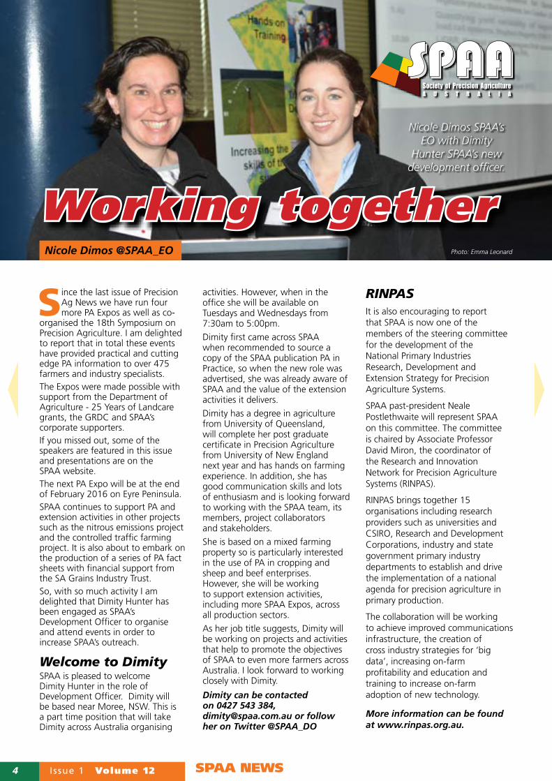
Working together Photo: Emma LeonardNicole Dimos @SPAA_EO
Nicole Dimos SPAA’s EO with Dimity
Hunter SPAA’s new development officer.

Volume 12 Issue 1 5SPAA NEWS
Adam Inchbold is a fifth generation farmer at Yarrawonga in the Riverine
Plains. He has been at the forefront of PA adoption and shared his experience at the PA Expo Jerilderie, NSW.
For Adam yield maps are gold as they locate and quantify differences in production across the paddock.
Adam uses yield for his production zones and soil samples within these zones. However, he posed the question - could he zone more appropriately to nutrient requirement? He discussed his phosphorus (P) replacement zones and showed how these rates
varied depending on the number of years of yield data or combinations of yield and EM38 soil data used to establish the quantity of P removed in the grain.He illustrated how fertiliser response rate trials across his zones helped identify the different response rates between zones. For example, it was only his medium potential soil that showed a positive yield response to urea rates of more than 150kg/ha, while his high potential soil showed no response to urea. He also showed that not only do different zones respond to different rates, zones vary in their response risk. In part this was due to the different water holding capacity of the soil in the different zones. He reminded the audience that high, medium and low are relative to each paddock so, high, medium and low input prescriptions need to be created for each paddock.Adam illustrated how he uses a net wastage calculation to compare the cost saving of variable rate fertiliser to a blanket rate. The savings have
more than paid for his investment in PA technology and data management.From experience Adam has found that just starting PA helped to initiate other decisions about his further adoption of PA technologies.
Adam’s top tips for those yet to adopt PA:• consider 2cm RTK as the
one and only step into guidance/autosteer;
• consider keeping hardware generic;
• consider possibilities for multiple uses of hardware; and
• seriously consider data management.
He also said - Do the simple stuff first.• Test strips are important for all
of us;• Making the most out of
spatial data is important – even in droughts;
• Yield maps are Gold!• Crop sensing looks interesting –
watch this space;• Consider a few key soil moisture
monitoring zones.
Expo round-up
Photo: Alex Milner-Smyth
Alex Milner-Smyth, Mediaroo Communications runs her business from a farm in
the South Australian Mallee, so she is well aware of the limitations of slow data transfer and mobile black spots. While these still cause problems for some farmers, others are achieving better access since the introduction of 4G and for the lucky few, the national broadband network. So for those that do have good mobile and mobile data reception, what are the opportunities?
Alex presented the benefits that Cloud Computing can offer. These include:• secure, remote access from
any device;• less data stored on home
computers = increased system capacity;
• data is easily recoverable to a new device;
• no requirement for backing up data as this is automatic;
• collaboration/file sharing with other users – without handling duplicate files.
There are several widely used cloud based storage systems that offer specific or general storage and file sharing options. Flickr, for example, is exclusively for storing and sharing photos, while Google Drive, iCloud, Microsoft OneDrive and DropBox all can save multiple file formats – text, video, images, spreadsheets.
Placing farm records in a cloud storage system allows access to all files directly from your mobile device; no need to go back to the office to look up paddock records. Alternatively, there are dedicated farm management programs such as ProductionWise or EvoCrop that support cloud based access from mobile devices.
Different systems meet different user needs, so it is important to do some homework, ask friends what they use, look at on-line forums and calculate how much data you will need to store on the cloud.
The full set of presentations from the SPAA PA Expos can be found on the SPAA website.
Making the most of mobile technologies
Speakers from the Three Springs Expo (left to right) Ben Cripps, Alex Milner-Smyth, Frank D’Emden and Brady Green
6 Issue 1 Volume 12 SPAA NEWS
T he 18th annual Precision Agriculture Symposium attracted over 230 delegates, including 70 students from Charles Sturt University campus at Wagga
Wagga, NSW. The Symposium was run by SPAA in collaboration with the University of Sydney Precision Agriculture Laboratory.The audience listened to 18 speakers on a diverse range of PA topics – from the blue sky to practical, relating to agriculture and horticulture and cross industry issues such as data integration and storage.Other highlights of the event were the trade display, supported by 17 suppliers of PA equipment and service, and the opportunities to network during breaks, PA Connections and the Symposium Dinner.The Symposium was widely followed on Twitter with about 3000 impressions for the leading tweets. By using the #PASymposium15 those not attending could keep in contact with developments at the Symposium. Symposium papers can be found on the SPAA website but here are a few tasters.
New and better satellitesDavid Lamb, CRC for Spatial Information, presented details about the new Japanese Quasi-Zenith satellite system that will improve guidance accuracy and reliability.By 2018, a constellation of four global positioning satellites (GPS) will provide augmented positions services to enhance accuracy and reliability of satellite derived navigation solutions. By 2023 there will be seven in this constellation.From Monash University, Chris Rudiger presented information on his collaborative work with colleagues, Alessandra Monerris and Jeff Walker, on high resolution soil moisture monitoring. They are working on developing two methods to monitor soil moisture at a farm scale. The first method consists of using a combination of coarse and high resolution satellite imagery. This process produces maps with a resolution of about 1km but is limited by the frequency of data retrieval, every two to three days and cloud cover.
The second system is using the signal from GPS. The idea behind this approach is to determine soil moisture by measuring the difference between the direct signal received from the GPS and the signal reflected by the land surface. This system uses free signal that is available everywhere and new satellite constellations should help improve accuracy and resolution.The team are still at the stage of gathering on-ground samples to truth against the satellite readings but early results are looking positive.
Remote sensing near and farA PA conference without unmanned aerial vehicles (UAVs), well, just would not be a PA conference (see page 18). However, Moree grain grower Ben Boughton, an early adopter of UAVs and founder of Satamap, admitted that in recent months his UAV has been grounded. While Ben remains passionate about the potential for UAVs, he has concluded that it is a combination of high resolution satellite imagery plus professionally flown UAVs that will provide him with the most cost effective data collection, processing and some analysis. The satellite data will provide the overview and how biomass, crop stress, etc is evolving, while the UAV will be used to focus on smaller areas of specific interest.Ben accepts that imagery gathered by a UAV is much more detailed, by a factor of at least 500, but that level of detail is not always justified, nor is the cost of collecting and collation. Landsat 8 imagery (15-30m pixel) is free and goes back to 2013. Sentinel-2 will provide free imagery at 10m resolution every 10 days. That means together these two satellites could provide four to five scenes per month. Another satellite service to watch out for is Planet Labs that has launched over 100 micro satellites and plans to offer daily imagery at three to 5m resolution.Satellites are providing an increasing and ever changing range of opportunities. Events such as the PA Symposium provide a forum for those involved in land management to learn about relevant uses and developments.
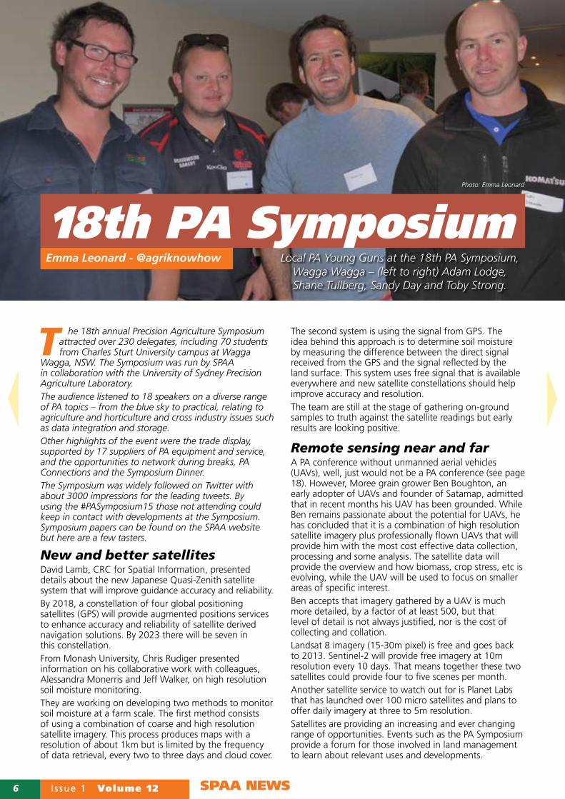
18th PA SymposiumEmma Leonard - @agriknowhow Local PA Young Guns at the 18th PA Symposium,
Wagga Wagga – (left to right) Adam Lodge, Shane Tullberg, Sandy Day and Toby Strong.
Photo: Emma Leonard

Volume 12 Issue 1 7SPAA NEWS
Intensive horticulture creates significant spatial, temporal and cultural obstacles to the adoption of PA. In an effort to unlock the benefits of PA for intensive horticulture, the project team including pictured left to right Sarah Limpus and Ian Layden DAF Queensland have established eight precision demonstration vegetable farms across Queensland. Stephen Frahm and Stephen Hegarty, VNET precision farming have assisted DAF with implementing and optimising yield monitoring sweet potatoes in Bundaberg and potatoes in Gatton. At the PA Symposium they shared some of their expereinces of using PA tools in carrot, chilli, potato, sweet potato, tomato, green bean and onion crops.In many respects the operational complexity and multiple harvesters and implements used in intensive horticulture have meant that adoption of PA lags behind broadacre cropping. Growing eight different crops in a single season that can require different planting and harvesting equipment is a problem not experienced in broadacre. The project has retro-fitted tractors and harvesters with data acquisition platforms and output controllers to enable variable rate applications. It has also helped those who had tools to put them to use.
The critical first steps have been to identify the level of variation across crops and the potential reasons, and to build the capacity of agronomists and service providers to use and support PA tools and agronomic approaches.Small block size has led to the incorrect assumption that variation in soil properties is unlikely to exist. EM38 mapping has helped growers visualise the extent and location of soil variation. Variable rate lime and compost application is gaining traction as is yield monitoring, as monitors are developed for these diverse crop types. Yield monitors are not only indicating production but in some root crops have identified the tonnes of soil removed from a paddock at harvest.As many horticultural crops are sold on quality rather than quantity, measuring quality and identifying variation in the harvest point across a paddock is going to be an important development for horticultural crops.SPAA encourages veggie growers to contact [email protected] to learn more about this project. More detailed stories will be reported in future issues of Precision Ag News.
Phillip Clancy, from Australian company Next Instruments, illustrated how his on-harvester or on-auger mounted oil and protein monitor has helped farmers increase returns by ensuring more grain loads meet higher quality specifications.
Taking samples every 11 seconds, the resolution of the quality data is considerably lower than yield data but this appears to be high enough. For example, in an 185ha paddock with two distinct quality zones blending increased return by $37.29/ha, a small reward for one farmer collaborator who had invested considerable time and effort into helping the practical development of this monitor.
(Right to left) farmer collaborator Ashleigh Wakefield with Managing Director of Next Instruments, Mat Clancy
and the Australian grain oil and protein monitor.
Grain quality on the go
PA for veggie growershttps://www.youtube.com/user/HortSmart Photo: Emma Leonard
Photo: Emma Leonard
8 Issue 1 Volume 12 PA IN PRACTICE
As an ex-soldier it is not surprising that Ben Cripps applies military precision
to his farming but destroying the harvester with fire during his first harvest seems a bit of an extreme way of converting to PA.
In Ben’s case the harvester fire helped accelerate an upgrade to one fitted with a yield monitor and the Ag Leader software SMS™ Basic, which he now uses for all record keeping. This change helped underpin the adoption of a comprehensive variable rate approach to inputs.
While the harvester might have been the tipping point, the soil is very much the starting point for Ben’s approach to PA. While some of his soils have high clay content, others are sand plain. Ben and his father initiated a program of electromagnetic (EM) and gamma radiometric soil mapping to really understand soil properties.
About 50% of the farm has been mapped and the remainder has been zoned based on similar soil properties and performance.
“My objective was to gain a clear understanding of soil water holding capacity; for us these soil measurements have provided the basis for robust zones and we have only made minor modifications based on yield data,” said Ben.
“Costing about $30/ha, soil mapping is one of the best investments I have made. We now have variable rate inputs based on these zones and that is generating substantial savings.”
Ground truthingWhile the soil surveys provided the overview, going out into the paddock and checking is vital for Ben. Soil samples were taken across the farm to ground truth the soil maps and zones. This ground truthing is an on-going process for Ben.
As he is not keen on a shovel, during the summer when soils are dry he uses a mini digger to dig into the soil profile. While this cannot stay on his tracks, Ben believes the information it helps him discover is greater than the compaction the mini digger might cause.
“When I notice something different in the growing crop or in the yield map, I will go and look for the cause and that can include looking into the root zone for compaction, residual soil moisture or chemical issues.”
Ben uses a motorbike to scout his crops as he does not want any vehicle going off his controlled traffic tracks.
“I won’t let a ute on our paddocks; all scouting is done by bike and I am able to cover large areas and see more detail without dismounting.”
Scouting can include gathering soil and plant samples and sweeping for insects.
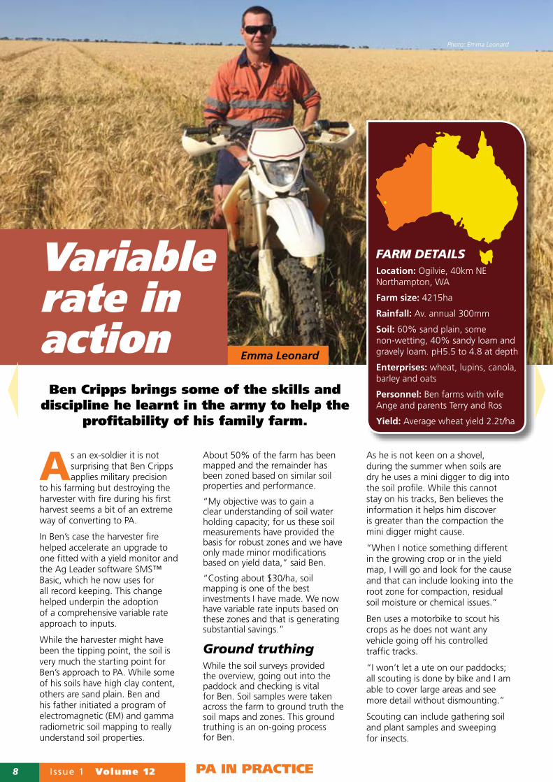
Variable rate in action Emma Leonard
FARM DETAILS
Location: Ogilvie, 40km NE Northampton, WA
Farm size: 4215ha
Rainfall: Av. annual 300mm
Soil: 60% sand plain, some non-wetting, 40% sandy loam and gravely loam. pH5.5 to 4.8 at depth
Enterprises: wheat, lupins, canola, barley and oats
Personnel: Ben farms with wife Ange and parents Terry and Ros
Yield: Average wheat yield 2.2t/ha
Photo: Emma Leonard
Ben Cripps brings some of the skills and discipline he learnt in the army to help the
profitability of his family farm.
Volume 12 Issue 1 9
Ben has trialled a UAV for crop scouting but it was attacked by a wedge-tailed eagle, which normally he never sees on his property.
Varaible rateBen regularly scouts paddocks for weeds, pest and disease and to check on the effectiveness of a treatment. He uses an app called GIS Kit Pro on his iPad where he can drop pins onto the map. As he scouts a paddock, he adds a red pin to a zone that requires pesticide, for example. This map is then created in SMS™ Basic and can then be exported to the controller in the CASE Patriot sprayer. Basically, he has two zones/rates - sprayed/full rate or not sprayed/zero.
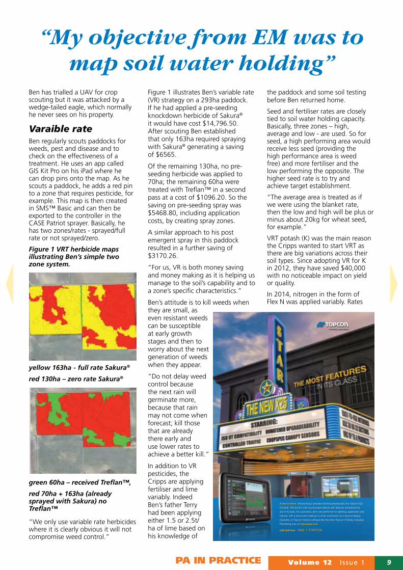
Figure 1 VRT herbicide maps illustrating Ben’s simple two zone system.
yellow 163ha - full rate Sakura®
red 130ha – zero rate Sakura®
green 60ha – received Treflan™,
red 70ha + 163ha (already sprayed with Sakura) no Treflan™
“We only use variable rate herbicides where it is clearly obvious it will not compromise weed control.”
Figure 1 illustrates Ben’s variable rate (VR) strategy on a 293ha paddock. If he had applied a pre-seeding knockdown herbicide of Sakura® it would have cost $14,796.50. After scouting Ben established that only 163ha required spraying with Sakura® generating a saving of $6565.
Of the remaining 130ha, no pre-seeding herbicide was applied to 70ha; the remaining 60ha were treated with Treflan™ in a second pass at a cost of $1096.20. So the saving on pre-seeding spray was $5468.80, including application costs, by creating spray zones.
A similar approach to his post emergent spray in this paddock resulted in a further saving of $3170.26.
“For us, VR is both money saving and money making as it is helping us manage to the soil’s capability and to a zone’s specific characteristics.”
Ben’s attitude is to kill weeds when they are small, as even resistant weeds can be susceptible at early growth stages and then to worry about the next generation of weeds when they appear.
“Do not delay weed control because the next rain will germinate more, because that rain may not come when forecast; kill those that are already there early and use lower rates to achieve a better kill.”
In addition to VR pesticides, the Cripps are applying fertiliser and lime variably. Indeed Ben’s father Terry had been applying either 1.5 or 2.5t/ha of lime based on his knowledge of
the paddock and some soil testing before Ben returned home.
Seed and fertiliser rates are closely tied to soil water holding capacity. Basically, three zones – high, average and low - are used. So for seed, a high performing area would receive less seed (providing the high performance area is weed free) and more fertiliser and the low performing the opposite. The higher seed rate is to try and achieve target establishment.
“The average area is treated as if we were using the blanket rate, then the low and high will be plus or minus about 20kg for wheat seed, for example.”
VRT potash (K) was the main reason the Cripps wanted to start VRT as there are big variations across their soil types. Since adopting VR for K in 2012, they have saved $40,000 with no noticeable impact on yield or quality.
In 2014, nitrogen in the form of Flex N was applied variably. Rates
PA IN PRACTICE
“My objective from EM was to map soil water holding”
A star is born! Announcing a precision farming blockbuster, the Topcon X25
Console. This 8-inch color touchscreen debuts with features unmatched by
any in its class. It’s a powerful, all-in-one performer for planting, application and
harvest, with a price point making it a smart investment as a second display.
Operates on Topcon Horizon software like the other Topcon X Family Consoles.
Premiering now on topconpa.com
Call toll free: 1800 1 TOPCON

10 Issue 1 Volume 12 PA IN PRACTICE
were modified by water holding capacity in relation to Yield Prophet® recommendations. Two post N treatments are normal but staying flexible and responding to the season is important.
Ben has three soil characterisation sites that represent average production on different soil types across the farm. Nitrogen decisions are modified up or down from Yield Prophet® forecast depending on the zone. His Yield Prophet® subscription so far has paid for itself every year. He finds the biggest limitation with Yield Prophet® is in soils where there is a hard pan and it does not compensate well for heat events.
Record keepingGenerating new VRT zones for every application makes the importance of record keeping paramount. All of Ben’s input and output data is logged in SMS™ Basic, including prices, and prescription maps are generated with this software.
From his army days on night patrols Ben understands the importance of good organisation; knowing exactly where everything was in your pack could be the difference
between life and death. He applies the same degree of rigour to his record keeping and knows that the background filing system is really important so data can be easily and correctly entered and retrieved.
All GPS equipment is Case IH and compatible with the SMS™ operating and recording software.
“A single platform simplifies synching machinery and data and makes life easier during the busy periods when you need it to work.”
Details: Ben Cripps, 0427 772 755, [email protected], @bencrippsC97
PA applications Guidance 2004, RTK 2011
Vehicle steering 2008
Grain yield monitoring 2011
Variable rate inputs 2012
Electromagnetic soil maps 2012
NDVI mapping tested 2014
Spray application mapping 2013
CTF 2015
What Ben suggests to new
PA adopters1. Buy the best computer
you can - fastest, heaps of RAM, big screen, portable.
2. Establish a background system on your computer that works for you.
3. One step at a time – is it nitrogen, potash, CTF or something else that will give you the biggest bang for your bucks?
4. Every time you can record what you did in a paddock, do it. You never know when it will come in useful.
5. The benefits of one machinery operating system make life much easier when under pressure.
6. Spend the time learning your computer software inside out, then VRT and PA become easy.
7. Collate information in one system. It means less for you to remember.
8. BACKUP!!
All GPS equipment is Case IH and compatible with the SMS™ operating and recording software. A single platform simplifies synching machinery and data and makes life easier during the busy
periods when you need it to work.
Photo: Emma Leonard

Volume 12 Issue 1 11PA IN PRACTICE
SST Software Australia| Ph: +617-3854-2340h:
91 Commercial Rd. | Teneriffe, Queensland, 4005 40
Mark Pawsey
Email: [email protected]
STRENGTHENING THE RELATIONSHIP BETWEENGROWERS AND AG SERVICE PROVIDERS
At SST Software, we strive to develop quality precision ag tools that lead to better farm management decisions. Ultimately, our goal is to help farmers more efficiently and profitably run their businesses. We believe this is best accomplished by strengthening the relationship between the growers and their trusted ag service provider. Our unique tools standardise data as it is collected, thus empowering collaboration across an entire farming team. From spray recommendations to high-end analysis, precision ag is made simple and seamless. Soon, the iPhone version of Sirrus for farmers will create a new level of communication between farmers and sales-agronomists.
The Sirrus iPhone version will enhance communication efforts and work processes between growers and ag service providers.
Sirrus iPhone for growers(Currently in development)
Sirrus iPad for agronomists and ag retailers
• Standardized Farm Scouting & Record Keeping • Soil Test by Zone or Grid • Reference Management Zones • RTK compatible• Load NDVI Imagery Zones • User-Defined VRT Recommendations • Collect & Edit Field Boundaries • Edit Maps Legends
• Current & Historical Weather Data • Edit VRT Recommendations • Apply Nutrient Credits • Reports
Sirrus iPad Features
To learn more, visit www.sstsoftware.com/sirrus@SSTSoftwareAUS

12 Issue 1 Volume 12 PA IN PRACTICE
Reducing within paddock variation and improving profitability through the use of
good agronomy and record keeping are at the heart of Warwick and Di Holding’s cropping operation in southern New South Wales.For the past 10 years, they have run a continuous cropping system on tramlines, using a tined no-till system. They have no livestock.The controlled traffic farming (CTF) system is based on 3m wheel centres and implements in multiples of 12m. For example, they have a 12m seeding bar and harvester comb and a 36m spray boom.Machines are driven on permanent, uncultivated bare wheel tracks leaving the crops to grow in uncompacted soil. In areas where water lies, and that can be whole paddocks in some years, the hard tracks are helping them drive on the paddock much sooner after heavy rainfall and ensure operations are as timely as possible.“Our yield maps are showing removing random traffic and soil compaction is reducing yield variation; the other great benefit of CTF is it makes running on-farm trials much easier,” said Warwick.Warwick is dogmatic about not running on the tracks but wanted to burn narrow windrows as part of his integrated weed control. Normally this requires lighting across the rows but Warwick has been inventive and built a 36m, three jet burner pulled by a tractor. The harvester dumps the
chaff and grass seeds in the centre of wheel tracks. The tractor runs on every third set of tracks burning the row immediately behind and each row in the set of wheel tracks to left and right.Warwick admits they had a few near misses when setting the system up due to solenoids sticking. Di reminds those considering this system to think carefully where you will start and finish to make sure you have not boxed yourself into a burning paddock.From his experience, if you cannot see any evidence of wheel tracks in a paddock, then the whole paddock is compacted. If you can, CTF will still help improve the soil for crops and machine trafficability.
Stubble managementWhile too much or too little water have been big challenges over the past 10 years, so has growing crops with large stubbles. “In heavy stubbles, poor establishment can reduce wheat yields by as much as a tonne, which is just not acceptable.”Using 2cm RTK guidance and autosteer has enabled most paddocks to be sown inter-row in most seasons, but where the stubbles lodge, stubble burning can be the only option.“I prefer to retain the stubble but if we cannot seed through it, we burn immediately before the seeder but after a knockdown. The burn is like a double knock. We can then take the
opportunity to use pre-emergents on the weeds as the herbicide is more effective with less stubble.”Other techniques being explored to manage wheat stubble are growth regulators, harvest cut height and post-harvest stubble mulching. Where growth regulators were trialled last year, no difference was measured. Warwick and Di are continuing to investigate timing and rates of growth regulators to shorten and strengthen wheat stubble.If the rotation includes wheat, pulse, wheat, they will sow the second wheat on the stubble row of the pulse to try and minimise disease from the first wheat stubble and to capitalise on any nitrogen fixed by a pulse.
Paddock recordsPaddock records are an important part of Warwick and Di’s business, helping them fully understand the costs and returns driving profitability. Each year Di compiles all production and financial records in a book. The figures are used to analyse
FARM DETAILS
Location: Yerong Creek, NSW
Farm size: 2000ha
Rainfall: annual 510mm winter dominant
Soil: sandy loam, loam, clay loam and sodic red clay with pH from 4.5 to 5.8 (CaCl2)
Enterprises: Continuous grain crops – wheat, lupins, canola, field peas, and occasionally faba beans.
Personnel: Warwick and Di Holding and fulltime employee Ryan.
Yield: Target wheat yield 4t/ha
Big picture detail
Without good records and data analysis, the full benefits of PA farming tools might
not be realised.
Emma Leonard
Photo: Emma Leonard

Volume 12 Issue 1 13PA IN PRACTICE
productivity and profitability and to compare crops, varieties and farms (soil types) based on cost per tonne and per hectare.They also use return on dollars spent as a key indicator to compare crops, farms and seasons. Fifteen years of records have allowed them to look at the big picture in detail. This has helped identify profitable rotations and also quantify the differences in profitability and sustainability between properties. They use this to underpin the profitability of leased properties and to be confident in determining realistic lease rates.“There is no point being pin-point precise in your paddocks if you are sloppy with your records and business analysis.”Measuring and recording operations, inputs and outputs allow Warwick and Di to revisit the numbers and learn how their decisions around rotations, nutrition, operations and the smaller details affect the big picture - profitability.
Variable rateLike many farmers, Warwick and Di have tried a range of PA tools and applications including electromagnetic soil surveying, yield mapping, satellite imagery and variable rate inputs. While they have seen some value, they are not putting all of them to use year on year.For example, at this stage the initial set-up cost of going to variable rate phosphorous (P) and the medium term savings anticipated from trials and their detailed paddock records have made them decide not to adopt variable rate P at the moment. However, they have been pleased with the use of pH mapping and variable rate lime and gypsum.About 10 per cent of the farm has been treated with variable rate lime or gypsum. The same amount of
lime was used over a total area but higher or lower rates were applied based on pH and soil type. This means there was no cost saving but the Holdings are hoping to see yield benefits and reduced in paddock variation. They hope to expand this program across the farm.
On farm trialsThe combination of Di’s agronomy background, Warwick’s continual search for improvement and CTF makes running trials an integral part of the Holding’s business.
They are co-operators in the National Frost Initiative and they have seen correlations between frost damage and yield from the elevation maps generated from the RTK system. Management options are also part of the potential solutions package for frost management, but it is early days for the research.
Foliar fungicide use at flowering to target Sclerotinia in canola is another trial. However, the one Warwick is especially keen to see the yield maps for this year is a canola seed size trial.
For a number of reasons, Warwick has been grading and then passing the canola seed over a gravity table to ideally only save seed greater than 2mm; in some years they have reduced this to 1.8mm. This year the seed has been sown in the same paddock of commercially bought seed of the same variety and a
hybrid. In September dry matter differences indicate the precision graded seed should yield the best, but time will tell.“We start with about 10 tonne of seed and by the time put over the gravity cleaning table and down to 2mm, we have about 600kg; the rest is sold.”Like many farmers, Warwick is enjoying flying his UAV and gathering aerial images of the farm and the trial plots. These are giving him records of real time crop inspections and he can compare change over time and identify areas that require further inspection.Details: Warwick Holding, 0428 306 500, [email protected] Twitter @PontaraGrain
If equipped with RTK autosteer, farmers can gather elevation data during pre-drilling fertiliser or seeding from which maps of variation in water depth can be generated.
Shallow water tended to yield 1.6t/ha less rice than deeper water.
Photo: Emma Leonard PA applications
Guidance 2004
Grain yield monitoring 2004
Electromagnetic soil maps 2005
Vehicle steering 2006
Controlled traffic farming 2006
Spray application mapping 2008
pH mapping and variable rate lime and gypsum 2014Home-designed and built narrow windrow burner to suit the 12m
controlled traffic system.

14 Issue 1 Volume 12 INNOVATION
A fully irrigated, high yielding potato crop costs between $13,500 and $15,000 per
hectare to grow in Tasmania. These input costs are virtually irrespective of yield, yet new research is highlighting huge yield variations from less than 20t/ha to over 100t/ha, a four-fold variation.
While the average potato yield of growers contracted to Simplot Australia is 58t/ha, their breakeven yield is 42t/ha making any opportunity to increase yield extremely valuable.
Simplot Australia is the last remaining processor of frozen vegetables in Australia with a factory located at Devonport, Tasmania. The largest vegetable sector for Simplot is processed potatoes with 250,000 tonnes of raw product converted to French fry and associated products. The farm gate value of potatoes in Tasmania exceeds $100M.
So, the University of Sydney and TerraPix are working on a project jointly funded by Horticulture Innovation Australia (HIA) and Simplot looking at yield variation in potatoes. The project aims to
understand the extent and causes of within-field spatial variation in potato yield and to provide some preliminary management responses.
To achieve this, EM38 soil surveys, in-crop reflectance sensing from aerial and ground platforms and a harvester mounted yield monitor have been used to gather spatial data.
“Higher NDVI
generally related to
higher potato yield.”
SoilPotatoes in Tasmania are often grown in undulating landscapes with soils that range from duplex soils of the Midlands through to the
Ferrosol loams of the North. These soils include a wide range of textures from sands through to clays and the farms in the project cover this diversity.
Prior to planting, the 17 project fields were surveyed for elevation (Figure 1a) and apparent electrical conductivity (ECa) using a Dual EM38 (Figure 1b) which measures to two depths simultaneously (0-75cm and 0-1.5m). The ECa surveys were performed on a 15m swath and physical samples were taken to estimate soil texture.
Within a field, clay content was found to double and yield was found to generally increase as clay content increased.
As tubers growing under the soil, potatoes are negatively affected by increasing soil strength. The depth to restrictive soil strength was found to range from 17cm to 50cm. The average tuber weight was found to increase where the depth to soil compaction/restrictive soil strength was greater.
In addition to considerable variation in clay content, zone based soil
Early PA for potatoesUnderstanding the drivers of yield variation in potatoes could
help sustain and progress this high risk industry.
Brett Whelan Photo: Emma Leonard

Volume 12 Issue 1 15INNOVATION
sampling established that within field nitrate levels ranged between two and six-fold and soil phosphorus between two and 10-fold.
Further investigation found that the nitrate content of the hill, not the soil below the hill, is most strongly related to the yield.
In-crop measurementsIn-crop reflectance sensing (Figure 1c) from aerial platforms was undertaken five times during the season to measure changes in normalised difference vegetation index (NDVI).
Higher NDVI generally related to higher yield. On manually assessing the areas of higher crop reflectance, it was found that higher crop reflectance generally meant more plants/stem per 3m of crop row. Three metre row sampling is a standard in potato production.
It was found that plant numbers ranged between six to 12 plants per 3m and the number of stems from 14 to 50 in the same area. A significant variation in above ground stem length from 60 to 140cm was also recorded.
As plants and stems increased so did tuber weight and total yield. Therefore, reflectance can provide a valuable tool for predicting yield and identifying areas of differing yield where variation in management may be required.
Potato Yield MonitorThe potato yield monitoring system has been developed in Australia by Advanced Technology Viticulture. The system includes a cabin-mounted logging/operation terminal that connects to a GPS and the yield sensor.
The yield sensor is a load cell mounted under the final portion of the delivery belt. At this stage of the harvest process, all loose foreign material has been removed.
Software allows the time from lifting to weighing to be used to match the measured yield with the right location in the field. An example of the raw data collected by the yield monitoring system is shown in Figure 1d. While not all fields were yield mapped due to disease and some logistical issues, the average harvester yield variability was found to be four-fold within a field.
There are, however, some logistics of the harvesting operation that make the monitoring less smooth than a grain harvesting operation. Contract harvesting of the fields and contractual delivery agreements mean that often a field is harvested as two or more subsections.
Each harvest operation will also be undertaken in blocks that may not be adjacent, meaning that gathering whole field yield data can be problematic.
The research project is an Australian first for the exploration of variability within potato production paddocks. Research is on-going but results are anticipated to encourage the increased adoption of PA technologies potato production.
Biog. Dr Brett Whelan is Associate Professor in Precision Agriculture, Precision Agriculture Laboratory Faculty of Agriculture and Environment at The University of Sydney. He is convenor of the Precision Agriculture Symposium in Australasia and has been a long-time supporter of SPAA.
Details [email protected]
1a topography
1c crop reflectance - NDVI
1b EM38
1d yield
Figure 1 A range of spatial data layers are being collected and compared to each other and physical samples to try and establish relationships and potential causes and solutions to yield variation in potatoes.
16 Issue 1 Volume 12 INNOVATION
The evolution of cheaper and faster software and hardware is offering new opportunities
for monitoring and decision support tools for agriculture. In this issue of Precision Ag News, we turn our attention to 3D technology.
The 3D we are referring to goes beyond watching movies wearing funny glasses to see the 3D effects. It is more about providing machines with the ability to ‘see’ in 3D and use those visual observations to make decisions.
A combined research project between the Centre of Autonomous Systems at the University of Technology Sydney and the New South Wales Department of Primary Industries (NSW DPI) Beef Industry Centre of Excellence, which is funded by Meat and Livestock Australia (MLA), is using 3D imaging to quantify P8 fat values and muscle score in beef cattle.
Having tools to assist producers ‘meet market specifications’ and
predict meat yield in live animals on-farm has been on beef producers’ wish-list for a long time.
“We have a really strong modelling research team at NSW DPI and are producing ground breaking tools for feedlot and pasture based beef systems; we have developed the BeefSpecs calculator and the BeefSpecs drafting tool,” said Dr Malcolm McPhee who is leading the research collaboration on behalf of NSW DPI.
Critical inputs to the BeefSpecs tools include sex, frame score, breed, management (grass or grain), and performance (initial weight, initial P8 fat, growth rate, days on feed and dressing percentage). Future inputs will include muscle score to predict meat yield.
Currently, fat and muscle are evaluated visually or by a trained assessor using ultrasound. The former system is subjective and the latter is relatively slow and requires a skilled operator.
“Integrating a 3D imaging system with decision tools will support management to increase the potential to produce animals that meet the market’s requirements; falling outside specifications can cost producers up to $40/head.”
Man teaches machineDr Alempijevic is using multiple RGB-D cameras mounted on the race. These gather red,blue,green images along with per-pixel depth at the rate of 30 images per second. These cameras are relatively cheap and similar to those used with an Xbox.
As the cameras are synchronised, they are able to deal with any animal movement and readings are not influenced by coat colour or the size/scale of the animal.
“The images can be taken at the same time as weighing an animal or even as they pass down a race, as it takes us less than one second to acquire sufficient image data.”
3D imaging
Forget the silly 3D glasses, this imaging technology can quantify agricultural factors that traditionally relied on
human visual assessment.
Emma Leonard
Photo: Emma Leonard
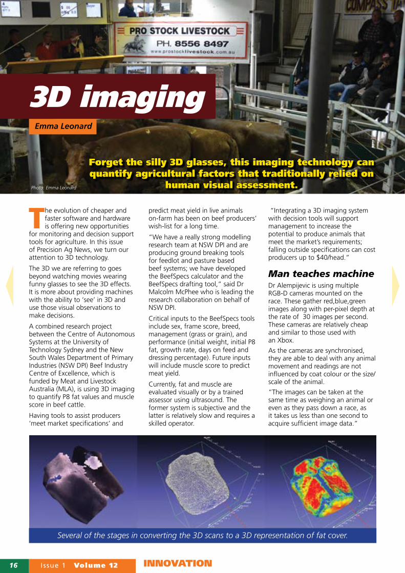
Several of the stages in converting the 3D scans to a 3D representation of fat cover.
Volume 12 Issue 1 17INNOVATION
Gathering the images is only one part of the process; analysis is the next challenge. Dr Alempijevic and colleagues have been working with skilled livestock assessors to understand how they use visual cues to quantify fat and muscle.
“Our aim is to replicate the cognitive skills of the best livestock assessors and turn what they see into a mathematical description with an assigned value.
“We then use this to teach the machine to estimate an animal’s condition based on the 3D shape the machine ‘sees’,” said Dr Alempijevic.
The project has had another unique resource available to help in the development of the digital descriptions. At the Glen Innes Research Station, low muscling and high muscling herds have been developed. This long-term investment by the NSW Government established in the early 1990s provides the research team with an exceptional source of base data, which is unparalleled across the globe.Animals from each herd are visually evaluated by leading livestock assessors to assess muscle score and trained assessors measure P8 fat using ultrasound. At the time of the assessment, 3D images are also gathered and the datasets are integrated.
The greater the diversity of animals observed, the more the algorithms learn about the spread of muscle and fat cover in the population.
“With our 3D system, which we hope will be commercialised within five years, all beef producers would have access to a reliable and quantifiable system of measurement that assists producers meet market specifications.”
Biog - Dr Malcolm McPhee is a Senior Research Scientist from NSW Department of Primary Industries Beef Industry Centre of Excellence, Armidale.
Dr Alen Alempijevic is a Senior Lecturer with the Centre for Autonomous Systems at the University of Technology, Sydney.
Details Malcolm McPhee 02 6770 1838, [email protected]
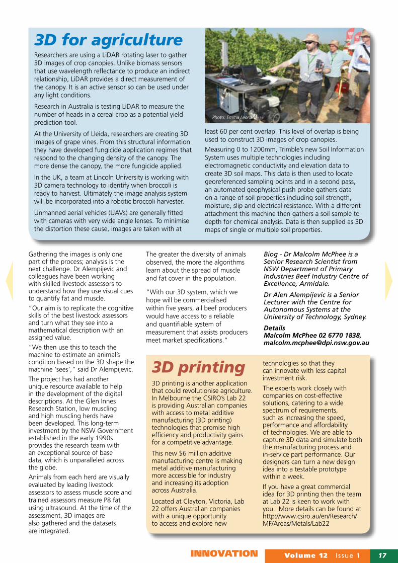
3D for agricultureResearchers are using a LiDAR rotating laser to gather 3D images of crop canopies. Unlike biomass sensors that use wavelength reflectance to produce an indirect relationship, LiDAR provides a direct measurement of the canopy. It is an active sensor so can be used under any light conditions.
Research in Australia is testing LiDAR to measure the number of heads in a cereal crop as a potential yield prediction tool.
At the University of Lleida, researchers are creating 3D images of grape vines. From this structural information they have developed fungicide application regimes that respond to the changing density of the canopy. The more dense the canopy, the more fungicide applied.
In the UK, a team at Lincoln University is working with 3D camera technology to identify when broccoli is ready to harvest. Ultimately the image analysis system will be incorporated into a robotic broccoli harvester.
Unmanned aerial vehicles (UAVs) are generally fitted with cameras with very wide angle lenses. To minimise the distortion these cause, images are taken with at
least 60 per cent overlap. This level of overlap is being used to construct 3D images of crop canopies.
Measuring 0 to 1200mm, Trimble’s new Soil Information System uses multiple technologies including electromagnetic conductivity and elevation data to create 3D soil maps. This data is then used to locate georeferenced sampling points and in a second pass, an automated geophysical push probe gathers data on a range of soil properties including soil strength, moisture, slip and electrical resistance. With a different attachment this machine then gathers a soil sample to depth for chemical analysis. Data is then supplied as 3D maps of single or multiple soil properties.
Photo: Emma Leonard
3D printing3D printing is another application that could revolutionise agriculture. In Melbourne the CSIRO’s Lab 22 is providing Australian companies with access to metal additive manufacturing (3D printing) technologies that promise high efficiency and productivity gains for a competitive advantage.
This new $6 million additive manufacturing centre is making metal additive manufacturing more accessible for industry and increasing its adoption across Australia.
Located at Clayton, Victoria, Lab 22 offers Australian companies with a unique opportunity to access and explore new
technologies so that they can innovate with less capital investment risk.
The experts work closely with companies on cost-effective solutions, catering to a wide spectrum of requirements, such as increasing the speed, performance and affordability of technologies. We are able to capture 3D data and simulate both the manufacturing process and in-service part performance. Our designers can turn a new design idea into a testable prototype within a week.
If you have a great commercial idea for 3D printing then the team at Lab 22 is keen to work with you. More details can be found at http://www.csiro.au/en/Research/MF/Areas/Metals/Lab22

18 Issue 1 Volume 12 DEVELOPMENTS & DEMOS
USA technology specialist Chad Colby is excited about UAVs and the rapidly
evolving software and hardware associated with this platform. He is also passionate about sharing his experience and knowledge from this fast moving sector of PA.
At the 18th Precision Agriculture Symposium, Chad shared information on new developments but also some key messages about buying and flying UAVs.
More $ is not more UAVWhen it comes to buying UAVs, Chad believes the biggest misconception is that spending more is better.
“For most growers, gathering optical images cheaply in a timely fashion is going to provide the greatest value and this can be done from a ship costing less than $3000.
“Basically, the most important part of the ship is the camera and the images created and there are some amazing advancements now and in the near future.”
For example, MicaSense has recently released a new red edge multispectral camera which could be
attached to a DJI Phantom, although this is not very practical, or to a Cessna aeroplane. Another example is Flir Vue™, a new thermal camera suitable for mounting on UAVs.
However, Chad reminded the audience that the latest DJI Phantom ships now have OEM (original equipment manufacturer) cameras that will not be able to have more advanced sensors added over time.
Having said this Chad suggests farmers gain the most from a good optical (RGB) image from a UAV.
“When flying a UAV know the
rules and stick by them”
In the cloudThe cost and time for gathering and processing data is reducing dramatically with the introduction of several new cloud based systems. Ag Eagle Inc and Precision Hawk have both developed technology to process data during the flight providing real time imagery beyond visual very shortly after completing the flight.
Drone Deploy is another system that works with low cost ships such as DJI Phantom and Inspire systems. Chad demonstrated how this worked in the field to those lucky enough to travel on the bus from SA to the Symposium at Wagga Wagga.
Once logged into his DroneDeploy account, Chad quickly and easily created a flight plan, which was then flown autonomously by his DJI Phantom 3 Professional. On returning to the bus, Chad went into his account via the DroneDeploy website and within about an hour (while moving in and out of signal), he received a stitched image of the 10ha area he flew.
This was achieved using a 4G connection but Chad did emphasise the need for reliable, ubiquitous internet coverage for rural areas with both fast upload as well as download speeds. The majority of the time, this uploading of images is done back at the office, unless the data is needed ASAP in the field.
DroneDeploy is a game changer; it works with many different flight systems and is probably at the vanguard of other products. Currently, it gives a one month free trial to those who want to give it a go with an android device. After that, there are monthly packages
UAV boost
With 50% of the potential growth in the UAV market seen to be in the agricultural sector, knowing what
to buy when is the biggest challenge.
Emma Leonard
Photo: Emma Leonard

Volume 12 Issue 1 19DEVELOPMENTS & DEMOS
w w w . f a r m s c a n a g . c o m
Start at any level then add components to control your sprayer, air seeder, spreader or harvesting machinery all at minimal cost and all compatible in one system.
AGGUIDE
Providing INNOVATION in agriculture for over 37 years!
JACKALA Compact & robust monitor that adapts onto almost any machine. A Multifunctional monitor, capable of many simultaneous tasks! e.g Speed & Area, Tacho & More
7000The all-new 7000 series of controllers from Farmscan Ag allows for complete control of your spraying, spreading and seeding application rates! UPGRADE TODAY
CALL OR VISIT US ONLINE NOW Farmscan Ag Pty Ltd, 11/493 South Street, Toowoomba QLD 4350, ABN 92 143 803 070
Tel 1800 327 672 Fax 07 4602 4151 Email [email protected] Website www.farmscan.ag
CALL OR VISIT US ONLINE NOW Farmscan Ag Pty Ltd, 11/493 South Street, Toowoomba QLD 4350, ABN 92 143 803 070
WIRELESS BLOCKAGE & FLOW MONITOR
ow
ned & operated
Proudly Australian
that are based on the number of hectares mapped and these include the options to turn optical georeferenced maps (Ortho maps) into near infra-red, elevation and 3D models.
Buy the latestThese are just a taste of the new products on the market – more can be found in Chad’s Symposium paper. However, Chad emphasised that technology is not a one off buy; upgrading to the latest product is essential.
“Just like computers and mobile devices UAVs are a rapidly evolving technology. If farmers are to gain the most from this they need to budget annually for new ships and other hardware and software upgrades, otherwise they will just get left behind.
“For UAVs, we are really in an acceleration phase for new developments, so do your research and think carefully about what you want to achieve.”
Chad is keen on a combination of two UAVs to provide quick yet detailed information. The initial imagery is collected from a low cost ship with optical camera then a ship with higher quality and issue specific camera e.g. NIR, thermal, is flown to focus on specific areas identified in the initial image.
Others at the Symposium were keen on a combination of satellite and UAV with the satellite data providing the overview and the UAV the detail.
“As we progress new packages and ways of integrating UAVs into the data, collection and analysis required for agriculture will evolve.”
Know the rulesHowever, Chad’s overarching message was know the rules and stick by them; if not, you are the one at risk. He encouraged all flying UAVs to know the current rules from the Civil Aviation Safety Authority (CASA) and to keep up to date with any changes. Also he recommended, to know their ship and its set-up requirements and to implement these. “There is no good reason to crash or lose a ship; these problems are generally caused when operators have not trained properly or read the instructions.“The more unnecessary ‘stuff-ups’, the more restrictions the authorities will apply to the airspace; UAV operators have to be as responsible as pilots.”
While knowing the rules and operating procedures for the ship are crucial to avoid problems, so is appropriate insurance just in case not everything goes to plan.
“The current ruling is that I fly as a hobbyist and cannot make decisions or give advice based on the images I gather – yet I still have a high level of insurance cover.
“Know what the rules and implications are in Australia and act on them before, not after a problem occurs.”
Chad’s paper is full of good references and information and his paper is available on the SPAA website.
Details Chad E Colby, @TheChadColby, Blog www.agtechtalk.com, facebook.com/thechadcolby
Photo: Emma Leonard Photo: Emma Leonard
Chad Colby demonstrated that the cloud based UAV guidance and image processing system Drone Deploy controls a chosen flight path and stitches the images automatically.

20 Issue 1 Volume 12 DEVELOPMENTS & DEMOS
Why develop StockID
After over 20 years of individual ewe testing and all the issues of manually
reading ear tags, Pete and father Lachlan Treloar introduced electronic identification (EID/radio frequency identification RFID) tags in 2011. As they already had electronic scales, they decided to only purchase a stick reader/EID scanner. This is mounted on the side of the race or used freely when shearing, etc. However, they needed some software to link the information from the EID and the scales or other data such as classing results.
A quick search on the internet found an app from England that was purpose-built by a farmer. While the app worked well, Pete found it was
too limited and would not let him easily load information from another source (i.e. wool results) and nor did it give him complete freedom of what information to record. For example, he could not enter something as simple as weight.
So, Pete contacted an app developer in Adelaide and provided him with the specifications he required from StockID.
What it doesBasically, StockID is a large spread sheet in the farmer’s pocket with all the records for each animal that has an EID. The app can be used without an EID scanner as there is search capability on the front page and options for manual entry of records.
In operation the app has two modes - SCAN and EDIT. It starts in SCAN mode and will display information
linked to any EID as it is scanned with the reader. If the user wishes to add any information about a particular animal, they switch to edit mode with a simple toggle button at the top of the screen, make the changes then switch back to scan mode (which saves the information) and continue scanning animals.
The app allows users to display up to six fields of information about each animal at one time. The choice of fields is customisable and chosen by the user.
So, for example when Pete is culling lambs, he leaves the app in SCAN mode, has fields such as rank, micron, fleece weight, yield, twin or single and sire displayed, then as each is scanned all the relevant information is displayed. If he is weighing lambs he uses edit
Following last issues articles on apps, here are two more software products designed for farmers by farmers, this time for livestock
producers and grape growers.
Appy farmers 2Photo: Emma LeonardEmma Leonard

Volume 12 Issue 1 21DEVELOPMENTS & DEMOS
mode and manually inputs in the weight from the scales, then flips back to SCAN ready for the next sheep. There are plans to automate entry of weights for those with bluetooth scales but that depends on demand.
In summary, the app is designed to be completely customisable to meet individual producers’ needs.
Platform Android only. iPhones/iPads would not talk to the stick reader – they would connect but could not transfer information. Currently the app defaults to using email to transfer data from the office computer to the phone. However, an advantage of Android is the file is saved to the phone on export and can easily be sent via bluetooth
to a computer/device of choice or saved to a SD card or other storage system.
Cost Currently there are two versions available - a free version that only has one field linked to each EID – but users can test the app with their scanner.
The full version costs $49.50.This has an unlimited number of fields that can be linked to each EID.
Both are available from Google Playstore.
Details StockId.com.au, Peter Treloar, [email protected], www.stockid.com.au
Collecting grape yield data at harvest is a great step forward but having time to process and use the data is always a struggle at this busy time of the year.Viticulturalist and GIS specialist Hans Loder and a colleague have written a small program that is able to quickly and simply display yield data from ATV’s yield monitor on Google Earth.“We take the raw data from the ATV software and roughly process it into a .kml file format with a legend; this file format can be read directly in Google Earth,” explains Hans.While this process does not take away the need for proper kriging and final processing of yield data for
accurate analysis, the program provides an option for the fast processing of yield data for immediate use. It will also assist in visualising yield variation.
Furthermore, when the cursor is run over the image in Google Earth, a yield in tonnes per hectare and kilograms per meter is displayed.
The program is going to be tested further in vintage 2016 and has already been acknowledged by achieving the status of finalist in the inaugural innovation awards run by the Wine Grape Council of SA.
Details: Hans Loder, [email protected]
Program improves grape yield data availability at harvest

22 Issue 1 Volume 12 DEVELOPMENTS & DEMOS
As a means of attracting new, young blood into agricultural research, the SA
Research and Development Institute (SARDI) has established an internship program. With the support of the SA Grains Industry Trust (SAGIT) and the Grains Research and Development Corporation (GRDC), the program provides a research placement for a recent graduate to work with one of SARDI’s established research teams.
Brooke Schofield is the second recipient of the SARDI internship and has joined the Clare- based SARDI New Variety Agronomy (NVA) group which has a strong focus on pulse research. However, Brooke does not have an agricultural or even plant breeding background but studied geology at the University of Adelaide.
“In my honours year I looked at the use of satellite data for soil observations so gained skills in the use of Geographical Information Systems (GIS). I was also working part time in a grain quality laboratory so both of these initiate links to agriculture,” explained Brooke.
On completing her studies Brooke was delighted to be able to find a research job that used some of the skills she had developed during her degree. She enjoys the rewards of being involved with agriculture and its direct links to food production and rural communities.
“In agriculture I feel I can really make a difference; the world needs more efficient food production and my research can contribute to achieving that goal.”
Brooke’s internship research project is primarily investigating the potential use of an unmanned aerial vehicle (UAV) as a method of collecting phenotype data from crop trial plots.
“Working in agriculture I feel I can
really make a difference”
The NVA group runs large numbers of trial plots each year looking at disease, herbicide tolerance, varieties and the impact of different agronomic practices in pulses. All plots have to be regularly monitored in the search for visual differences which could be due to improved growth, herbicide tolerance or susceptibility to disease.
With colleagues, Brooke has established plots of different varieties of lentils, chickpeas, faba beans and field peas as well as wheat and barley incorporating differences in herbicide treatments, seeding rates and row spacing.
Working with accredited UAV service provider Martin Peters, FarmingIT, Brooke is gathering optical colour images and near infrared images of the plots.
“Initially we flew a bare earth flight in May and then the first crop flight was in late June, then late August and two more flights will occur before harvest.”
Visual checks are carried out on the same or consecutive days to the flight and as crops mature, handheld biomass readers are also being used to gather data and ground truth the aerial results. A third set of data is being collected using the University of Sydney’s ‘ladybird’ field robot which is also fitted with a hyperspectral camera and a LiDAR enabling 3D images to be produced.
“In addition to identifying difference, we are also assessing what data produces the best crop surface model. Crop surface is a key indicator of biomass production, crop vigour and health.”
Brooke is excited about the long term prospects in agricultural research and is keen to continue developing her skills in the use of spatial technologies and data analysis.
Details: Brooke Schofield, 0401 933 509, [email protected]
Intern trainee flies high
Photo: Emma LeonardEmma Leonard
As a geologist Brooke Schofield specialised in the use of GIS; now she is putting her skills to
use in agriculture.

It’s always flattering when others try to imitate your success. But with nearly 20 years of track leadership under our belts, we’ve picked up a few things the copies missed. Like our exclusive five-axle design. It gives our Steiger® Quadtrac,® Steiger Rowtrac™ and Magnum™ Rowtrac tractors a smoother ride and more power to the ground with less berming and compaction. It’s one of the advantages of paying your dues, instead of paying homage. Learn more at www.caseih.com
IF WE WEREN’T ALREADY RED, WE’D BE BLUSHING.

Meet the New John Deere 9RX Series TractorThe New 9RX Series Tractor is no copycat. We kept innovation at the forefront, using your feedback to make it right. The result is a game-changing 4-Track tractor that’s anything but ordinary.
Just how unique and innovative? The upswept axle component is the largest cast poured in the business and allows the 9RX to have a larger drive wheel, putting more power to the ground and increasing reliability. The e18™ Transmission with Effi ciency Manager™ helps keep productivity levels high and inputs low. It responds quickly and automatically in intense fi eld conditions to actively improve the tractor’s performance and your drive experience, while reducing fuel consumption.
Under the hood, you’ve got a power range of 346 to 456 kW (470 – 620 hp). Pair that with increased hydraulic fl ow and the 9RX is ready to cover large acres and pull big implements in less time.
Bring on the sloped, wet, and loose fi eld conditions too, because the 9RX’s unique track design adds to its superior and agile performance in the fi eld and on the road. The larger articulated footprint allows for more fl otation and better grip resulting in less berming and reduced soil disturbance, improving yield potential.
The 9RX also comes JDLink™ Connect and AutoTrac™ ready to boost performance and effi ciency even more. Visit your John Deere Dealer today for more information about our most anticipated tractor yet, the New John Deere 9RX Series Tractor.
Nothing Runs Like a Deere™ JohnDeere.com.au/9RX
IT’S INNOVATION. NOT IMITATION.