spanning the years f - torranceca.gov
TRANSCRIPT
1
Following is a historical overview of the City of Torrance, organized into segments that
include some of the key events, developments and changes that have shaped Torrance into the balanced City that we know today. It begins with the founding of the City in 1912.
More information about the City’s history is available from the Torrance
Library, as well as the Torrance Historical Society & Museum.
Special thanks to the following for use of historic photos: Torrance Historical Society & Museum; Cal State Dominguez Hills; University of Southern California; Los Angeles Public Library; Mount Lowe Preservation Society; Metro-LA Archives; images also provided by the City of Torrance.
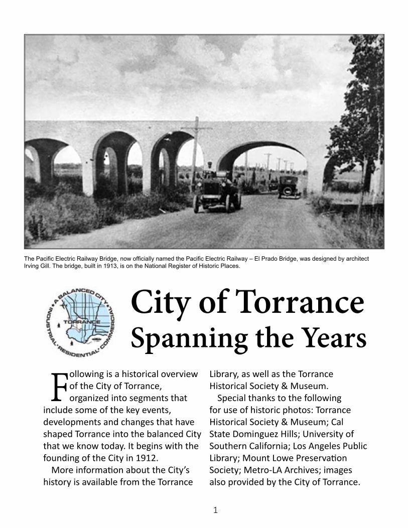
The Pacific Electric Railway Bridge, now officially named the Pacific Electric Railway – El Prado Bridge, was designed by architect Irving Gill. The bridge, built in 1913, is on the National Register of Historic Places.
City of TorranceSpanning the Years
2
The “Planned Modern Industrial City” that would come to be called Torrance
came into being in the early years of a new century. In 1910, the City of Los Angeles had a population of 320,000 people, and nearby Long Beach had just 17,000.
The Southern California region was stepping out on two major projects.
The first, the construction of the Los Angeles Aqueduct, began in 1905 and was completed in 1913. This brought much-needed water from the Owens Valley into Los Angeles and the region. With the water came a boom in development.
The second major project in the region was the building of a breakwater to spur development of the Los Angeles harbor and shipping facilities. This development would make Los Angeles a major gateway for
imports serving the West, and become a hub of exports.
At the same time, the film industry was beginning to grow in Los Angeles; the region’s airplane manufacturing industry began to take flight; and oil and gas exploration would become a booming business.
1910 saw a dramatic historic event in downtown Los Angeles with the bombing of the Los Angeles Times building during a period of labor unrest between unions and anti-union factions. During this time, the burgeoning business community began to move away from Los Angeles, which was considered to be a hotbed of labor activity.
It was during this time that real estate developer Jared Sidney Torrance began assembling a group of investors with the idea of creating a “Planned Modern Industrial City” that would be a mix
1912-1921: Creating a Planned Modern Industrial City
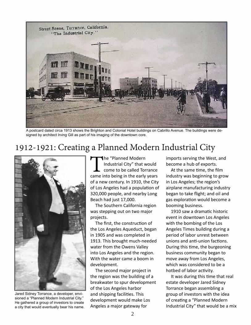
A postcard dated circa 1913 shows the Brighton and Colonial Hotel buildings on Cabrillo Avenue. The buildings were de-signed by architect Irving Gill as part of his imaging of the downtown core.
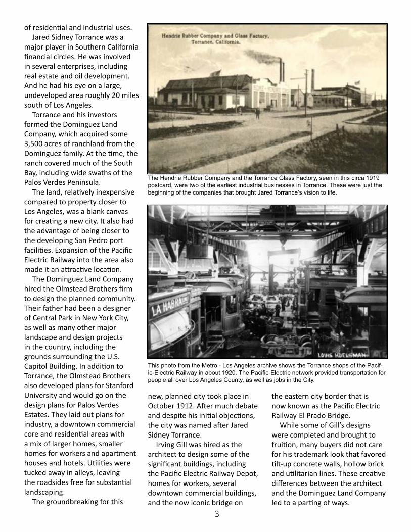
Jared Sidney Torrance, a developer, envi-sioned a “Planned Modern Industrial City.” He gathered a group of investors to create a city that would eventually bear his name.
3
of residential and industrial uses. Jared Sidney Torrance was a
major player in Southern California financial circles. He was involved in several enterprises, including real estate and oil development. And he had his eye on a large, undeveloped area roughly 20 miles south of Los Angeles.
Torrance and his investors formed the Dominguez Land Company, which acquired some 3,500 acres of ranchland from the Dominguez family. At the time, the ranch covered much of the South Bay, including wide swaths of the Palos Verdes Peninsula.
The land, relatively inexpensive compared to property closer to Los Angeles, was a blank canvas for creating a new city. It also had the advantage of being closer to the developing San Pedro port facilities. Expansion of the Pacific Electric Railway into the area also made it an attractive location.
The Dominguez Land Company hired the Olmstead Brothers firm to design the planned community. Their father had been a designer of Central Park in New York City, as well as many other major landscape and design projects in the country, including the grounds surrounding the U.S. Capitol Building. In addition to Torrance, the Olmstead Brothers also developed plans for Stanford University and would go on the design plans for Palos Verdes Estates. They laid out plans for industry, a downtown commercial core and residential areas with a mix of larger homes, smaller homes for workers and apartment houses and hotels. Utilities were tucked away in alleys, leaving the roadsides free for substantial landscaping.
The groundbreaking for this
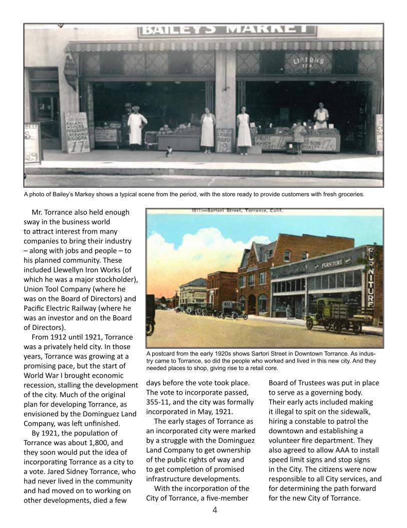
The Hendrie Rubber Company and the Torrance Glass Factory, seen in this circa 1919 postcard, were two of the earliest industrial businesses in Torrance. These were just the beginning of the companies that brought Jared Torrance’s vision to life.
new, planned city took place in October 1912. After much debate and despite his initial objections, the city was named after Jared Sidney Torrance.
Irving Gill was hired as the architect to design some of the significant buildings, including the Pacific Electric Railway Depot, homes for workers, several downtown commercial buildings, and the now iconic bridge on
the eastern city border that is now known as the Pacific Electric Railway-El Prado Bridge.
While some of Gill’s designs were completed and brought to fruition, many buyers did not care for his trademark look that favored tilt-up concrete walls, hollow brick and utilitarian lines. These creative differences between the architect and the Dominguez Land Company led to a parting of ways.
This photo from the Metro - Los Angeles archive shows the Torrance shops of the Pacif-ic-Electric Railway in about 1920. The Pacific-Electric network provided transportation for people all over Los Angeles County, as well as jobs in the City.
4
Mr. Torrance also held enough sway in the business world to attract interest from many companies to bring their industry – along with jobs and people – to his planned community. These included Llewellyn Iron Works (of which he was a major stockholder), Union Tool Company (where he was on the Board of Directors) and Pacific Electric Railway (where he was an investor and on the Board of Directors).
From 1912 until 1921, Torrance was a privately held city. In those years, Torrance was growing at a promising pace, but the start of World War I brought economic recession, stalling the development of the city. Much of the original plan for developing Torrance, as envisioned by the Dominguez Land Company, was left unfinished.
By 1921, the population of Torrance was about 1,800, and they soon would put the idea of incorporating Torrance as a city to a vote. Jared Sidney Torrance, who had never lived in the community and had moved on to working on other developments, died a few
days before the vote took place. The vote to incorporate passed, 355-11, and the city was formally incorporated in May, 1921.
The early stages of Torrance as an incorporated city were marked by a struggle with the Dominguez Land Company to get ownership of the public rights of way and to get completion of promised infrastructure developments.
With the incorporation of the City of Torrance, a five-member
Board of Trustees was put in place to serve as a governing body. Their early acts included making it illegal to spit on the sidewalk, hiring a constable to patrol the downtown and establishing a volunteer fire department. They also agreed to allow AAA to install speed limit signs and stop signs in the City. The citizens were now responsible to all City services, and for determining the path forward for the new City of Torrance.
A photo of Bailey’s Markey shows a typical scene from the period, with the store ready to provide customers with fresh groceries.
A postcard from the early 1920s shows Sartori Street in Downtown Torrance. As indus-try came to Torrance, so did the people who worked and lived in this new city. And they needed places to shop, giving rise to a retail core.
5
The decade of the 1920s was a period of substantial growth for the Southern
California region. The City of Los Angeles had a population of a little more than 500,000 in the 1920 census. By the end of the decade, that population would swell to more than 1 million.
This growth reflected the continued annexation of smaller communities, but was also the result of a continued migration of people to Southern California. The new population was very diverse, including those who had relocated from other parts of the
United States as well as immigrants from Europe, Asia and Mexico. They came seeking economic opportunities and a better climate.
The region was experiencing a major economic boom tied to the rapid expansion of petroleum-related industries, including exploration, production and refining. There also was the emerging aviation sector. And the harbor facilities continued to expand, with the Port of Los Angeles surpassing San Francisco as the busiest port on the West Coast.
During this decade, 90 percent
of the silent films produced in the United States were made in the Los Angeles area. Plus the region was a major agricultural area, with orange groves, fields of grain, commercial flower fields, cattle ranches and a wide range of other produce and livestock.
Paved streets and highways were replacing dirt roads as the region expanded and more people were buying cars. And the Pacific Electric Railway was still shuttling people across outlying areas.
In these years, Torrance was beginning to bustle as people came into the city for work. It also was
1921-1930: Growing Population, Growing City
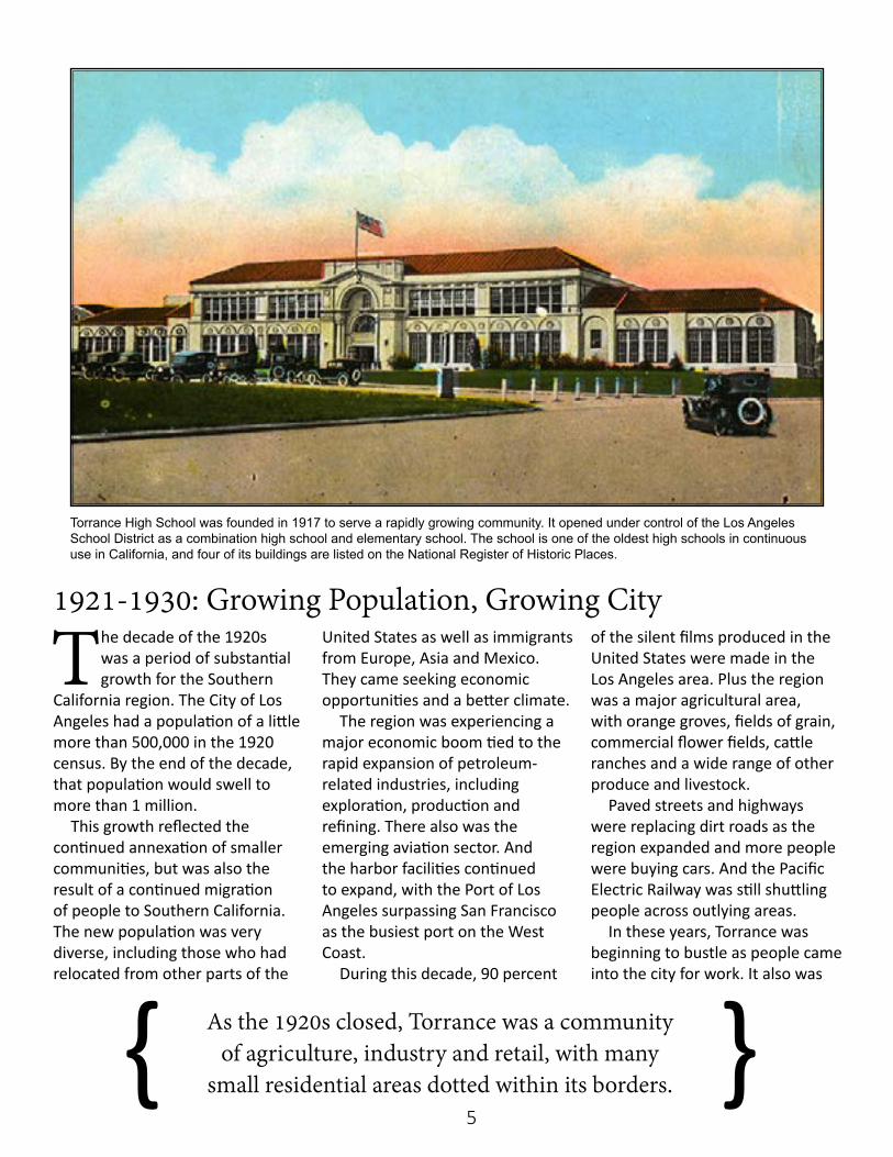
Torrance High School was founded in 1917 to serve a rapidly growing community. It opened under control of the Los Angeles School District as a combination high school and elementary school. The school is one of the oldest high schools in continuous use in California, and four of its buildings are listed on the National Register of Historic Places.
As the 1920s closed, Torrance was a community of agriculture, industry and retail, with many
small residential areas dotted within its borders.{ }
6
becoming a small shopping hub for the South Bay.
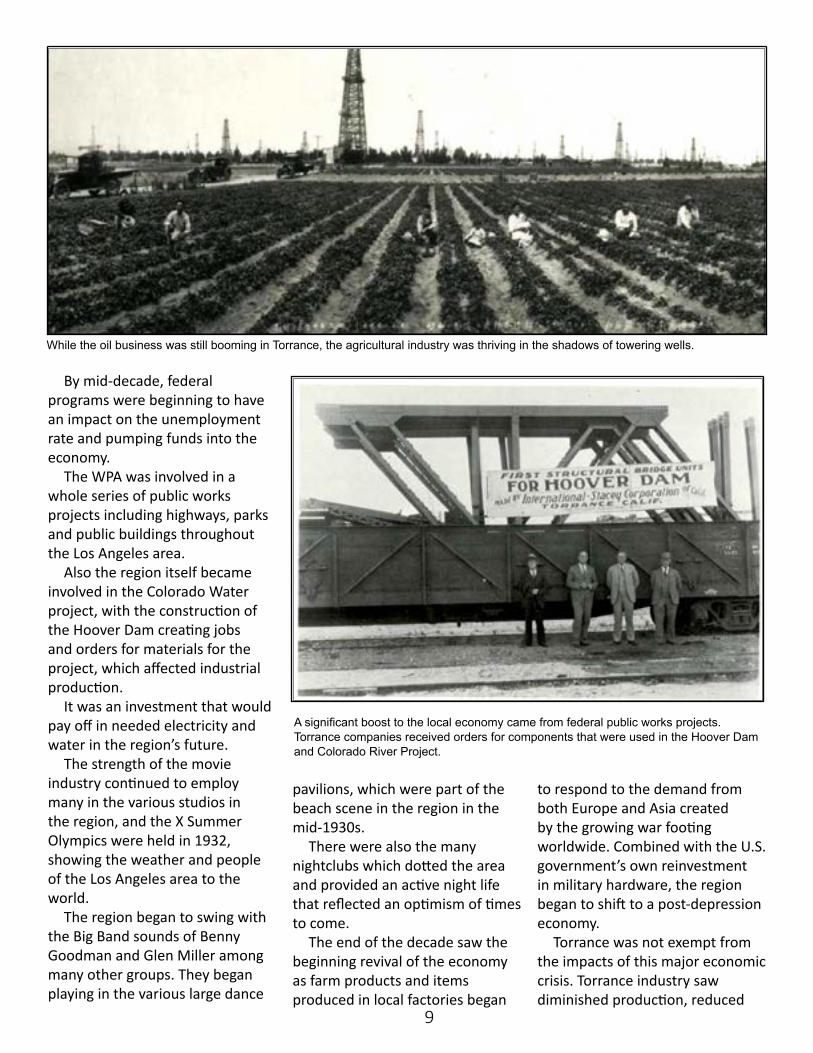
Industry had grown slowly, but with the 1920s came the discovery and exploration of the Torrance-Wilmington Oil Field. And soon a forest of oil derricks had popped up across central and south Torrance. The city expanded its borders to take in more land to the south, north and west of the original city boundaries.
And while the oil business was booming, agriculture was still a big part of Torrance. There were fields of vegetables and flowers; dairies; rabbit, chicken, turkey and pig farms; and even a mink farm in the Meadow Park area in the southern part of the city.
Torrance remained fairly isolated from downtown Los Angeles. It was still a long, 20-minute drive or an even longer trip on the Red Car. Pacific Electric Railway had created
a special to bring employees from other areas to work in its large service facilities that were located on Crenshaw Boulevard.
And in 1927, General Petroleum purchased a large chunk of land
in the northern part of the city to build a refinery that could process crude oil from Kern County. The refinery opened in 1929. It would go through many changes in name and ownership over the years,
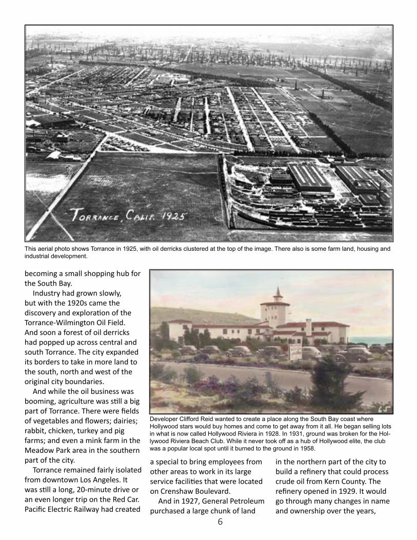
This aerial photo shows Torrance in 1925, with oil derricks clustered at the top of the image. There also is some farm land, housing and industrial development.
Developer Clifford Reid wanted to create a place along the South Bay coast where Hollywood stars would buy homes and come to get away from it all. He began selling lots in what is now called Hollywood Riviera in 1928. In 1931, ground was broken for the Hol-lywood Riviera Beach Club. While it never took off as a hub of Hollywood elite, the club was a popular local spot until it burned to the ground in 1958.
7
eventually becoming the Exxon-Mobil Torrance Refinery for several years. It is now the PBF Energy-owned Torrance Refining Co.
While the petroleum industry was coming up in Torrance, there also was a slow expansion of heavy industry, including a glass factory, a rubber plant, Columbia Steel and Rome Cable, among others.
And taking advantage of the ocean and city views from the southern hillsides, developers had a go at creating an upscale housing tract in the 1920s. They envisioned an affluent, French Riviera style of community. But with the development being so isolated from Los Angeles, sales were flat. The project did bring with it finished streets, several large custom homes and the Hollywood Riviera Club at the beach.
As the 1920s closed, Torrance had successfully transitioned into its own City, while also becoming more than the Planned Modern Industrial City envisioned by Jared Sidney Torrance. It was now a
community of agriculture, industry and retail, with many small residential areas dotted within its borders. And its population, while still small, had grown from 1,800 in 1921 to more than 7,000 by 1930.
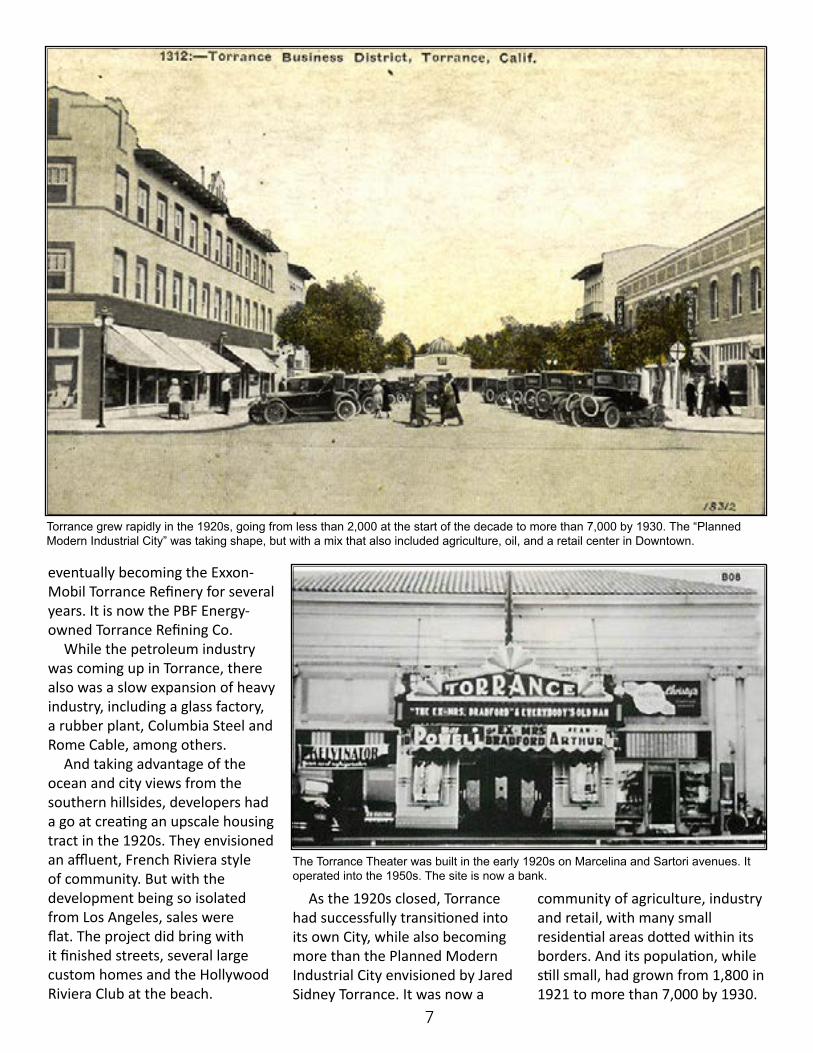
Torrance grew rapidly in the 1920s, going from less than 2,000 at the start of the decade to more than 7,000 by 1930. The “Planned Modern Industrial City” was taking shape, but with a mix that also included agriculture, oil, and a retail center in Downtown.
The Torrance Theater was built in the early 1920s on Marcelina and Sartori avenues. It operated into the 1950s. The site is now a bank.
8
The decade of the 1930s saw a significant slowdown in growth for the Los Angeles
area. The census shows a growth in county population of only 500,000 from 2.2 million in 1930 to just over 2.7 million in 1940.
Farm income dropped 50 percent from what it had been in the late 1920s. Unemployment reached 28 percent by 1932, and by 1937, 20 percent of Californians were on public relief.
Industry and manufacturing were both impacted by the effects
of the Great Depression. There were many industrial
plant closures, and those that didn’t close significantly reduced production. There also were a series of bank failures with their impact on investors and individual bank accounts.
During this time, there was a continuous migration of individuals displaced by the dust bowl in the Midwest and of individuals facing unemployment with industrial shutdown throughout the country. In 1932, more than
12,000 Mexican farm workers were deported.
The concern of Californians with the large number of arriving individuals who were unemployed and had no employment opportunities led to Los Angeles City sending police officers to the California-Arizona border to turn back arriving unemployed immigrants. The state went so far as to adopt a bill which would pay travel expenses for Filipino immigrants if they would return to the Philippines.
1930s: A Changing Economic Landscape
Unemployment reached 28 percent by 1932, and by 1937, 20 percent of Californians were on public relief.{ }
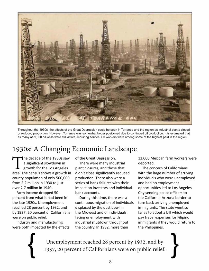
Throughout the 1930s, the affects of the Great Depression could be seen in Torrance and the region as industrial plants closed or reduced production. However, Torrance was somewhat better positioned due to continued oil production. It is estimated that as many as 1,000 oil wells were still active, requiring service. Oil workers were among some of the highest paid in the region.
9
By mid-decade, federal programs were beginning to have an impact on the unemployment rate and pumping funds into the economy.
The WPA was involved in a whole series of public works projects including highways, parks and public buildings throughout the Los Angeles area.
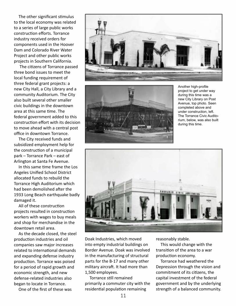
Also the region itself became involved in the Colorado Water project, with the construction of the Hoover Dam creating jobs and orders for materials for the project, which affected industrial production.
It was an investment that would pay off in needed electricity and water in the region’s future.
The strength of the movie industry continued to employ many in the various studios in the region, and the X Summer Olympics were held in 1932, showing the weather and people of the Los Angeles area to the world.
The region began to swing with the Big Band sounds of Benny Goodman and Glen Miller among many other groups. They began playing in the various large dance
pavilions, which were part of the beach scene in the region in the mid-1930s.
There were also the many nightclubs which dotted the area and provided an active night life that reflected an optimism of times to come.
The end of the decade saw the beginning revival of the economy as farm products and items produced in local factories began
to respond to the demand from both Europe and Asia created by the growing war footing worldwide. Combined with the U.S. government’s own reinvestment in military hardware, the region began to shift to a post-depression economy.
Torrance was not exempt from the impacts of this major economic crisis. Torrance industry saw diminished production, reduced
While the oil business was still booming in Torrance, the agricultural industry was thriving in the shadows of towering wells.
A significant boost to the local economy came from federal public works projects. Torrance companies received orders for components that were used in the Hoover Dam and Colorado River Project.

10
employment and diminished payrolls. This particularly affected the retail businesses in the downtown. Torrance was fortunate however in the diverse nature of it economics.
The substantial oil production activity continued, and as the decade passed there were perhaps as many as 1,000 wells requiring service and maintenance.
Each new well had a con-struction cost of approximately $50,000 and took about 60 days from starting construction until approval by the state. There were no controls as to spacing of the wells. As they came online, each
well would produce about 250 barrels a day.
But as time passed, individual well production would dra-matically fall off because of the overdevelopment of the oil field. While this diminished the profitability of individual wells, it still was seen as worth the risk.
Oil-related workers were some of the highest paid workers in the region. A rough neck could make $2.50 per day with a potential $4.50 per day if the well came in. A driller made the same per day, but could be eligible for a potential $10 per day with bonuses. This was very good pay during the
Depression, and because of the size and activity of the Torrance field it involved a large number of workers.
The General Petroleum refinery reduced production but still brought employees into the area to maintain and operate the refinery. The Pacific Electric shops also continued to service the system’s Red Cars and bus fleet at its facilities in Torrance.
The agricultural base continued to produce a variety of crops. There were reduced market prices for crops produced, but still it provided continued income to workers and farm owners.
During this time, the Pacific Electric shops in Torrance continued to maintain the system’s Red Cars and bus fleet. The Pacific Electric bus repair facilities that were located on Crenshaw Boulevard are shown in the picture to the left. Seen at right are the Pacific Electric shops looking west from the back of the site.
The citizens of the City passed bond issues for several projects. One of them was to build a new City Hall, left. The new Torrance City Hall was on Cravens Avenue in downtown, right.
11
The other significant stimulus to the local economy was related to a series of large public works construction efforts. Torrance industry received orders for components used in the Hoover Dam and Colorado River Water Project and other public works projects in Southern California.
The citizens of Torrance passed three bond issues to meet the local funding requirement of three federal grant projects: a new City Hall, a City Library and a community Auditorium. The City also built several other smaller civic buildings in the downtown area at this same time. The federal government added to this construction effort with its decision to move ahead with a central post office in downtown Torrance.
The City received funds and subsidized employment help for the construction of a municipal park – Torrance Park – east of Arlington at Santa Fe Avenue.
In this same time frame the Los Angeles Unified School District allocated funds to rebuild the Torrance High Auditorium which had been demolished after the 1933 Long Beach earthquake badly damaged it.
All of these construction projects resulted in construction workers with wages to buy meals and shop for merchandise in the downtown retail area.
As the decade closed, the steel production industries and oil companies saw major increases related to international demands and expanding defense industry production. Torrance was poised for a period of rapid growth and economic strength, and new defense-related industries also began to locate in Torrance.
One of the first of these was
Doak Industries, which moved into empty industrial buildings on Border Avenue. Doak was involved in the manufacturing of structural parts for the B-17 and many other military aircraft. It had more than 1,500 employees.
Torrance still remained primarily a commuter city with the residential population remaining
reasonably stable. This would change with the
transition of the area to a war production economy.
Torrance had weathered the Depression through the vision and commitment of its citizens, the capital investment of the federal government and by the underlying strength of a balanced community.
Another high-profile project to get under way during this time was a new City Library on Post Avenue, top photo. Seen completed above and under construction, left. The Torrance Civic Audito-rium, below, was also built during this time.
12
The 1940s would be a major watershed for the Los Angeles metropolitan area.
Population for the county would rise from 2.7 million in 1940 to 4.1 million at the end of the decade.
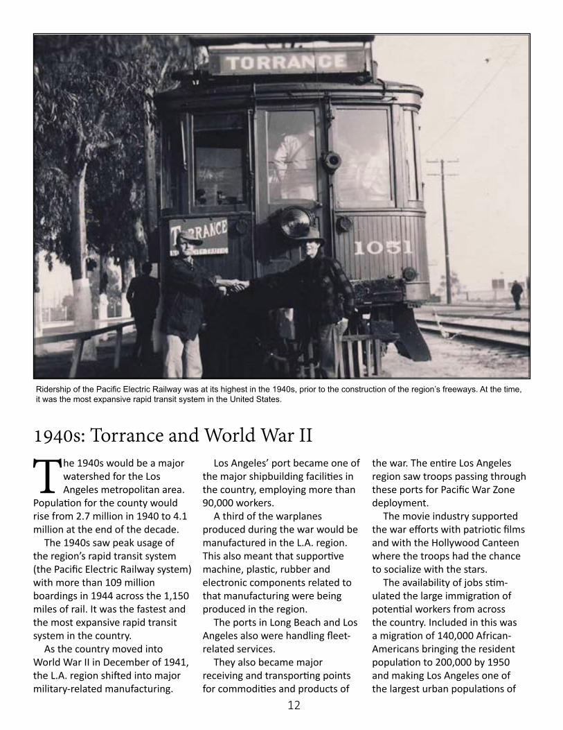
The 1940s saw peak usage of the region’s rapid transit system (the Pacific Electric Railway system) with more than 109 million boardings in 1944 across the 1,150 miles of rail. It was the fastest and the most expansive rapid transit system in the country.
As the country moved into World War II in December of 1941, the L.A. region shifted into major military-related manufacturing.
Los Angeles’ port became one of the major shipbuilding facilities in the country, employing more than 90,000 workers.
A third of the warplanes produced during the war would be manufactured in the L.A. region. This also meant that supportive machine, plastic, rubber and electronic components related to that manufacturing were being produced in the region.
The ports in Long Beach and Los Angeles also were handling fleet-related services.
They also became major receiving and transporting points for commodities and products of
the war. The entire Los Angeles region saw troops passing through these ports for Pacific War Zone deployment.
The movie industry supported the war efforts with patriotic films and with the Hollywood Canteen where the troops had the chance to socialize with the stars.
The availability of jobs stim-ulated the large immigration of potential workers from across the country. Included in this was a migration of 140,000 African-Americans bringing the resident population to 200,000 by 1950 and making Los Angeles one of the largest urban populations of
1940s: Torrance and World War II
Ridership of the Pacific Electric Railway was at its highest in the 1940s, prior to the construction of the region’s freeways. At the time, it was the most expansive rapid transit system in the United States.
13
African-Americans outside of the South.
The war years were also a time of rationing and restricted availability of some items. There were no new automobiles produced until 1946.
Tires, gasoline (which was only 15 cents a gallon), sugar, butter and meat were rationed and required ration points to purchase. There were drives for kitchen grease and scrap paper and metal. Many citizens grew victory gardens of fresh vegetables and fruits.
As the war ended, the region saw many returning soldiers and war-time workers choosing to make Southern California their home. There were also the returning Japanese-American internees who had been held in “relocation” camps through the war.
The post war boom in auto sales and the continuing demand for aviation products provided a solid economic base. The last years of
the decade saw rapid construction of residential units and a contin-uing shortage of schools for the ever-growing population.
In 1940, the Arroyo Seco Parkway became the first of a rapidly growing network of freeways that allowed for the spreading of this population into what was the “empty” farm lands of the suburbs.
The Los Angeles metropolitan region was at hand. Torrance reflected much of that regional history, but it also had elements that were its own.
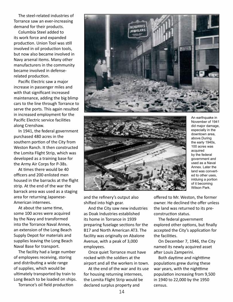
Torrance was shaken into the war years by the 1941 earthquake in November. No lives were lost, but many of the brick buildings in Downtown Torrance suffered major damage. Significant damage took place to commercial and residential properties. The damage related mainly to the unreinforced masonry facing and parapets, and in the residential area brick chimneys and foundations.
The damage was estimated to be more significant than that caused by the 1931 Long Beach earthquake.
With the declaration of war in December of 1941, the people of Torrance took a position of supporting the Japanese heritage families who were part of the community.
The City Council adopted a resolution stating this community support. But the federal government took steps to have individuals of Japanese heritage removed from their homes and farms to be interned in locations far from Torrance.
Torrance had many young men signing up for service in the various military branches. Two of these were Louis Zamperini and Ted Tanouye, both graduates of Torrance High School.
Torrance benefited from the rapid economic growth related to the preparation and engagement in World War II.
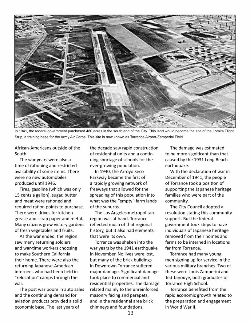
In 1941, the federal government purchased 480 acres in the south end of the City. This land would become the site of the Lomita Flight Strip, a training base for the Army Air Corps. This site is now known as Torrance Airport-Zamperini Field.
14
The steel-related industries of Torrance saw an ever-increasing demand for their products.
Columbia Steel added to its work force and expanded production. Union Tool was still involved in oil production tools, but now also became involved in Navy arsenal items. Many other manufacturers in the community became involved in defense-related production.
Pacific Electric saw a major increase in passenger miles and with that significant increased maintenance, adding the big blimp cars to the line through Torrance to serve the ports. This again resulted in increased employment for the Pacific Electric service facilities along Crenshaw.
In 1941, the federal government purchased 480 acres in the southern portion of the City from Weston Ranch. It then constructed the Lomita Flight Strip, which was developed as a training base for the Army Air Corps for P-38s.
At times there would be 40 officers and 200 enlisted men housed in the barracks at the flight strip. At the end of the war the barrack area was used as a staging area for returning Japanese-American internees.
At about the same time, some 100 acres were acquired by the Navy and transformed into the Torrance Naval Annex, an extension of the Long Beach Supply Depot for materials and supplies leaving the Long Beach Naval Base for transport.
The facility had a large number of employees receiving, storing and distributing a wide range of supplies, which would be ultimately transported by train to Long Beach to be loaded on ships.
Torrance’s oil field production
and the refinery’s output also shifted into high gear.
And the City saw new industries as Doak Industries established its home in Torrance in 1939 preparing fuselage sections for the B17 and North American AT3. The facility was originally on Abalone Avenue, with a peak of 3,000 employees.
Once quiet Torrance must have rocked with the soldiers at the airport and all the workers in town.
At the end of the war and its use for housing returning internees, the Lomita Flight Strip would be declared surplus property and
offered to Mr. Weston, the former owner. He declined the offer unless the land was returned to its pre-construction status.
The federal government explored other options, but finally accepted the City’s application for the facilities.
On December 7, 1946, the City named its newly acquired asset after Louis Zamperini.
Both daytime and nighttime populations grew during these war years, with the nighttime population increasing from 9,500 in 1940 to 22,000 by the 1950 census.
An earthquake in November of 1941 did major damage, especially in the downtown area, above.During the early 1940s, 100 acres was acquired by the federal government and used as a Naval Annex. Later the land was convert-ed to other uses, inlduing a portion of it becoming Wilson Park.
15
At the end of World War II, there was a major growth surge in Southern
California. Torrance returned for a while to much of the pace it had prior to the war. It was a time of continuing vegetable farms, expansion of dairy farms and many chicken and rabbit ranches.
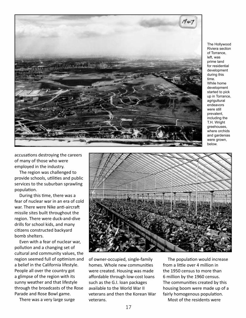
Verburg Dairy was one of many dairies in Torrance. There also were the Meadow Park Dairy, the Hudson Dairy and the Quinn Dairy among many across Torrance during this time period.
Torrance also had been a major producer of commercial flowers. T.H. Wright produced orchids and gardenias. There were also large fields of commercial roses
near 182nd Street and Crenshaw Boulevard.
By 1947, Torrance was full of political changes. The small rural population of Torrance adopted a
City Charter. The Charter removed the City from the Los Angeles Unified School District. Torrance and Culver City were the last two cities to break away from LAUSD.
1950s: Torrance Thrives After the War
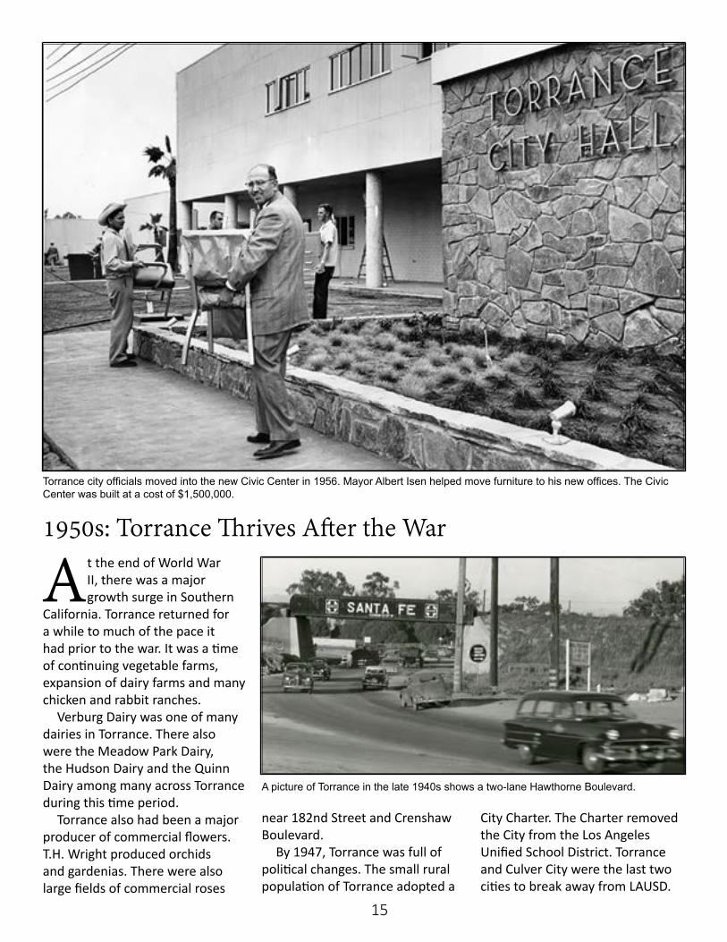
Torrance city officials moved into the new Civic Center in 1956. Mayor Albert Isen helped move furniture to his new offices. The Civic Center was built at a cost of $1,500,000.
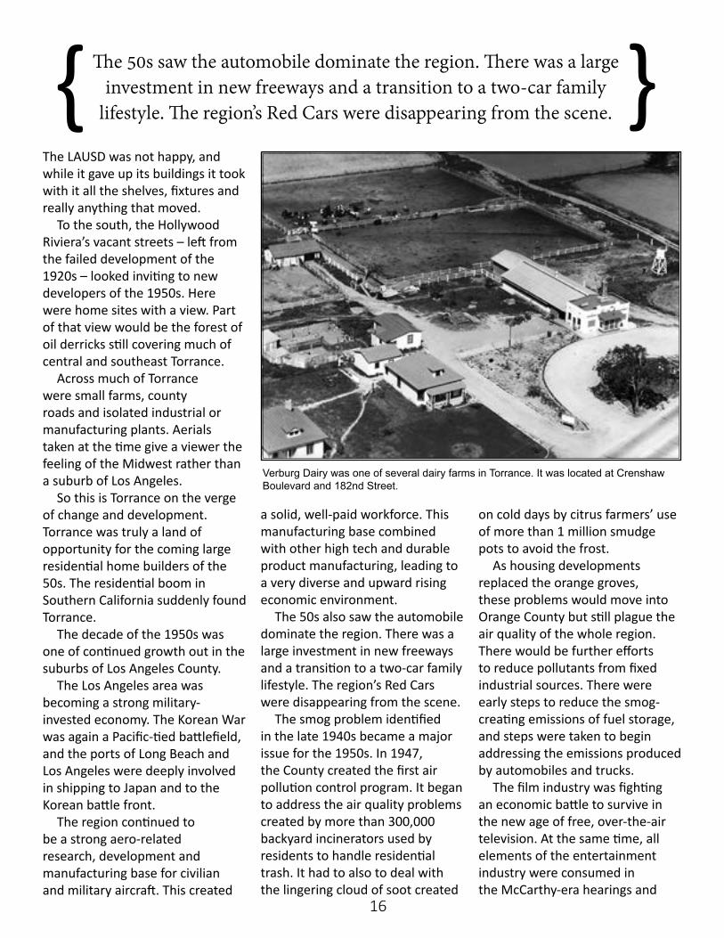
A picture of Torrance in the late 1940s shows a two-lane Hawthorne Boulevard.
16
The 50s saw the automobile dominate the region. There was a large investment in new freeways and a transition to a two-car family
lifestyle. The region’s Red Cars were disappearing from the scene.{ }The LAUSD was not happy, and while it gave up its buildings it took with it all the shelves, fixtures and really anything that moved.
To the south, the Hollywood Riviera’s vacant streets – left from the failed development of the 1920s – looked inviting to new developers of the 1950s. Here were home sites with a view. Part of that view would be the forest of oil derricks still covering much of central and southeast Torrance.
Across much of Torrance were small farms, county roads and isolated industrial or manufacturing plants. Aerials taken at the time give a viewer the feeling of the Midwest rather than a suburb of Los Angeles.
So this is Torrance on the verge of change and development. Torrance was truly a land of opportunity for the coming large residential home builders of the 50s. The residential boom in Southern California suddenly found Torrance.
The decade of the 1950s was one of continued growth out in the suburbs of Los Angeles County.
The Los Angeles area was becoming a strong military-invested economy. The Korean War was again a Pacific-tied battlefield, and the ports of Long Beach and Los Angeles were deeply involved in shipping to Japan and to the Korean battle front.
The region continued to be a strong aero-related research, development and manufacturing base for civilian and military aircraft. This created
a solid, well-paid workforce. This manufacturing base combined with other high tech and durable product manufacturing, leading to a very diverse and upward rising economic environment.
The 50s also saw the automobile dominate the region. There was a large investment in new freeways and a transition to a two-car family lifestyle. The region’s Red Cars were disappearing from the scene.
The smog problem identified in the late 1940s became a major issue for the 1950s. In 1947, the County created the first air pollution control program. It began to address the air quality problems created by more than 300,000 backyard incinerators used by residents to handle residential trash. It had to also to deal with the lingering cloud of soot created
on cold days by citrus farmers’ use of more than 1 million smudge pots to avoid the frost.
As housing developments replaced the orange groves, these problems would move into Orange County but still plague the air quality of the whole region. There would be further efforts to reduce pollutants from fixed industrial sources. There were early steps to reduce the smog- creating emissions of fuel storage, and steps were taken to begin addressing the emissions produced by automobiles and trucks.
The film industry was fighting an economic battle to survive in the new age of free, over-the-air television. At the same time, all elements of the entertainment industry were consumed in the McCarthy-era hearings and
Verburg Dairy was one of several dairy farms in Torrance. It was located at Crenshaw Boulevard and 182nd Street.
17
accusations destroying the careers of many of those who were employed in the industry.
The region was challenged to provide schools, utilities and public services to the suburban sprawling population.
During this time, there was a fear of nuclear war in an era of cold war. There were Nike anti-aircraft missile sites built throughout the region. There were duck-and-dive drills for school kids, and many citizens constructed backyard bomb shelters.
Even with a fear of nuclear war, pollution and a changing set of cultural and community values, the region seemed full of optimism and a belief in the California lifestyle. People all over the country got a glimpse of the region with its sunny weather and that lifestyle through the broadcasts of the Rose Parade and Rose Bowl game.
There was a very large surge
of owner-occupied, single-family homes. Whole new communities were created. Housing was made affordable through low-cost loans such as the G.I. loan packages available to the World War II veterans and then the Korean War veterans.
The population would increase from a little over 4 million in the 1950 census to more than 6 million by the 1960 census. The communities created by this housing boom were made up of a fairly homogenous population.
Most of the residents were
The Hollywood Riviera section of Torrance, left, was prime land for residential development during this time.While home development started to pick up in Torrance, agrigultural endeavors were still prevalent, including the T.H. Wright greehouses, where orchids and gardenias were grown, below.
18
of similar age, had similar life experiences and backgrounds. They had children of a similar age and were of similar ethnic, racial and economic demographics.
The communities also had a makeup of mostly a single working parent with the mother staying at home. The homeowners had a child-oriented lifestyle which included drive-in movies, the new media of television, Little League, Girl and Boy Scouts, the YMCA and a strong Parent Teacher Association. There also were the various family oriented theme parks which would include Disneyland when it opened in 1955.
Torrance shared these characteristics as it shifted into the 1950s.
Suddenly developers discovered
that Torrance had large empty tracts of land; that it was near the beach with year-round moderate weather and that all this was
within 20 miles of downtown Los Angeles. Kaufman, Wilson, Watt, Truman Brown and David Hensch, among others, were packaging
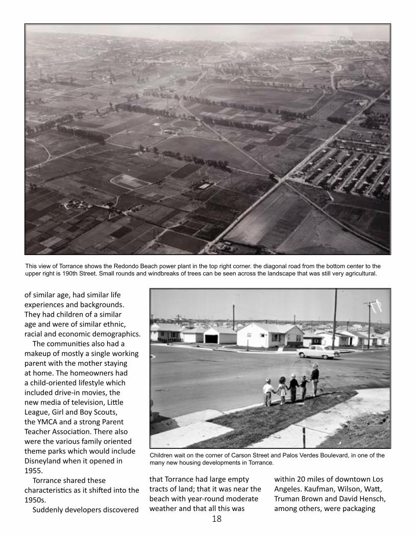
This view of Torrance shows the Redondo Beach power plant in the top right corner. the diagonal road from the bottom center to the upper right is 190th Street. Small rounds and windbreaks of trees can be seen across the landscape that was still very agricultural.
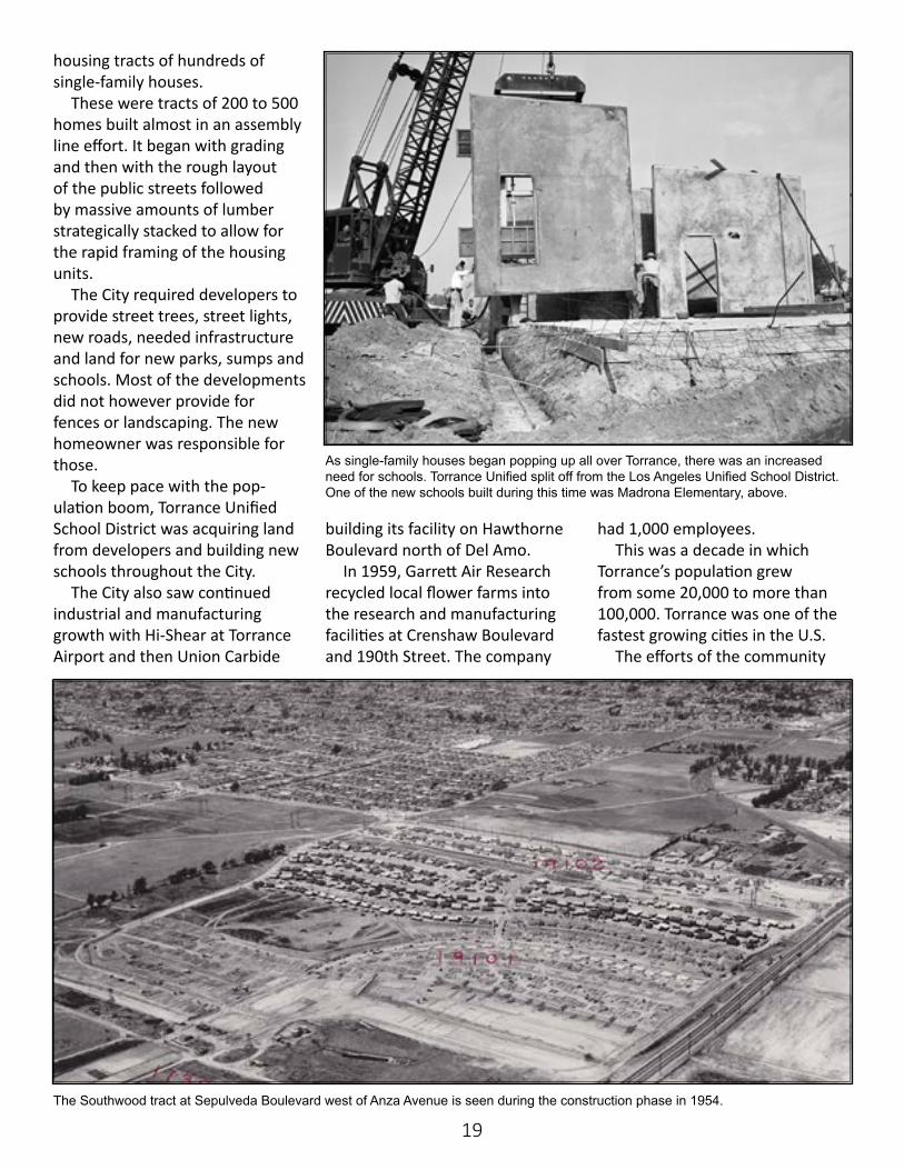
Children wait on the corner of Carson Street and Palos Verdes Boulevard, in one of the many new housing developments in Torrance.
19
housing tracts of hundreds of single-family houses.
These were tracts of 200 to 500 homes built almost in an assembly line effort. It began with grading and then with the rough layout of the public streets followed by massive amounts of lumber strategically stacked to allow for the rapid framing of the housing units.
The City required developers to provide street trees, street lights, new roads, needed infrastructure and land for new parks, sumps and schools. Most of the developments did not however provide for fences or landscaping. The new homeowner was responsible for those.
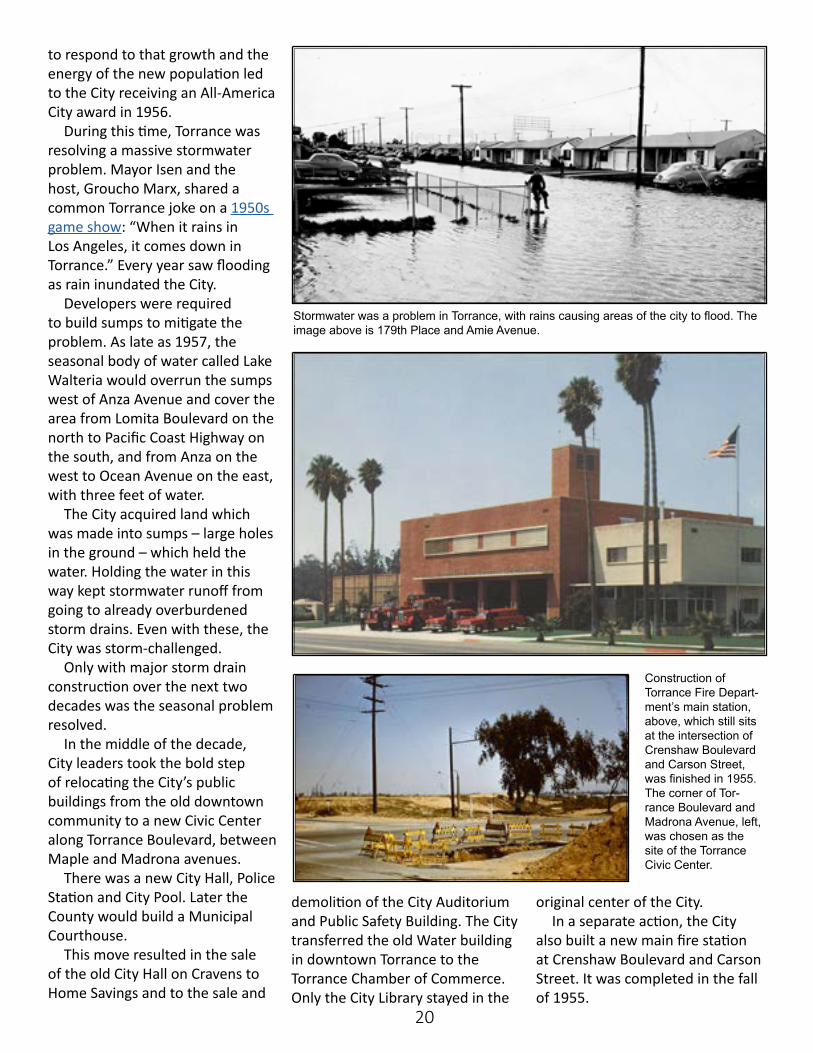
To keep pace with the pop-ulation boom, Torrance Unified School District was acquiring land from developers and building new schools throughout the City.
The City also saw continued industrial and manufacturing growth with Hi-Shear at Torrance Airport and then Union Carbide
building its facility on Hawthorne Boulevard north of Del Amo.
In 1959, Garrett Air Research recycled local flower farms into the research and manufacturing facilities at Crenshaw Boulevard and 190th Street. The company
had 1,000 employees. This was a decade in which
Torrance’s population grew from some 20,000 to more than 100,000. Torrance was one of the fastest growing cities in the U.S.
The efforts of the community
As single-family houses began popping up all over Torrance, there was an increased need for schools. Torrance Unified split off from the Los Angeles Unified School District. One of the new schools built during this time was Madrona Elementary, above.
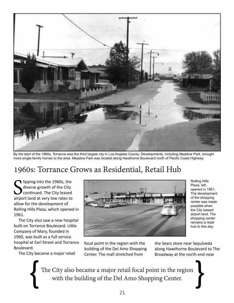
The Southwood tract at Sepulveda Boulevard west of Anza Avenue is seen during the construction phase in 1954.
20
to respond to that growth and the energy of the new population led to the City receiving an All-America City award in 1956.
During this time, Torrance was resolving a massive stormwater problem. Mayor Isen and the host, Groucho Marx, shared a common Torrance joke on a 1950s game show: “When it rains in Los Angeles, it comes down in Torrance.” Every year saw flooding as rain inundated the City.
Developers were required to build sumps to mitigate the problem. As late as 1957, the seasonal body of water called Lake Walteria would overrun the sumps west of Anza Avenue and cover the area from Lomita Boulevard on the north to Pacific Coast Highway on the south, and from Anza on the west to Ocean Avenue on the east, with three feet of water.
The City acquired land which was made into sumps – large holes in the ground – which held the water. Holding the water in this way kept stormwater runoff from going to already overburdened storm drains. Even with these, the City was storm-challenged.
Only with major storm drain construction over the next two decades was the seasonal problem resolved.
In the middle of the decade, City leaders took the bold step of relocating the City’s public buildings from the old downtown community to a new Civic Center along Torrance Boulevard, between Maple and Madrona avenues.
There was a new City Hall, Police Station and City Pool. Later the County would build a Municipal Courthouse.
This move resulted in the sale of the old City Hall on Cravens to Home Savings and to the sale and
Stormwater was a problem in Torrance, with rains causing areas of the city to flood. The image above is 179th Place and Amie Avenue.
Construction of Torrance Fire Depart-ment’s main station, above, which still sits at the intersection of Crenshaw Boulevard and Carson Street, was finished in 1955. The corner of Tor-rance Boulevard and Madrona Avenue, left, was chosen as the site of the Torrance Civic Center.
demolition of the City Auditorium and Public Safety Building. The City transferred the old Water building in downtown Torrance to the Torrance Chamber of Commerce. Only the City Library stayed in the
original center of the City. In a separate action, the City
also built a new main fire station at Crenshaw Boulevard and Carson Street. It was completed in the fall of 1955.
21
Slipping into the 1960s, the diverse growth of the City continued. The City leased
airport land at very low rates to allow for the development of Rolling Hills Plaza, which opened in 1961.
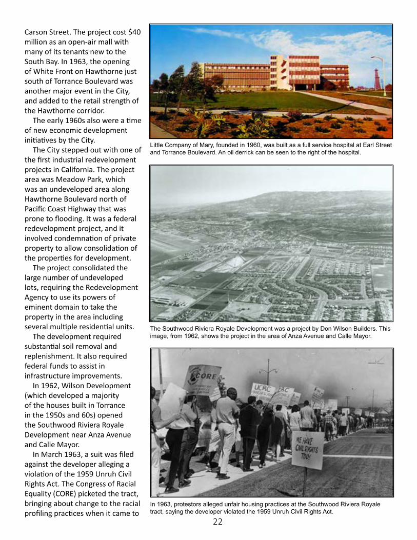
The City also saw a new hospital built on Torrance Boulevard. Little Company of Mary, founded in 1960, was built as a full service hospital at Earl Street and Torrance Boulevard.
The City became a major retail
focal point in the region with the building of the Del Amo Shopping Center. The mall stretched from
the Sears store near Sepulveda along Hawthorne Boulevard to The Broadway at the north end near
1960s: Torrance Grows as Residential, Retail Hub
The City also became a major retail focal point in the region with the building of the Del Amo Shopping Center. { }
By the start of the 1960s, Torrance was the third largest city in Los Angeles County. Developments, including Meadow Park, brought more single-family homes to the area. Meadow Park was located along Hawthorne Boulevard north of Pacific Coast Highway.
Rolling Hills Plaza, left, opened in 1961. The development of the shopping center was made possible when the City leased airport land. The shopping center remains a retail hub to this day.
22
Carson Street. The project cost $40 million as an open-air mall with many of its tenants new to the South Bay. In 1963, the opening of White Front on Hawthorne just south of Torrance Boulevard was another major event in the City, and added to the retail strength of the Hawthorne corridor.
The early 1960s also were a time of new economic development initiatives by the City.
The City stepped out with one of the first industrial redevelopment projects in California. The project area was Meadow Park, which was an undeveloped area along Hawthorne Boulevard north of Pacific Coast Highway that was prone to flooding. It was a federal redevelopment project, and it involved condemnation of private property to allow consolidation of the properties for development.
The project consolidated the large number of undeveloped lots, requiring the Redevelopment Agency to use its powers of eminent domain to take the property in the area including several multiple residential units.
The development required substantial soil removal and replenishment. It also required federal funds to assist in infrastructure improvements.
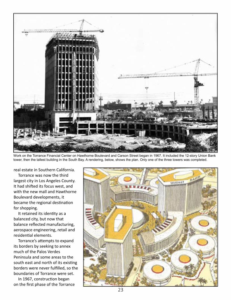
In 1962, Wilson Development (which developed a majority of the houses built in Torrance in the 1950s and 60s) opened the Southwood Riviera Royale Development near Anza Avenue and Calle Mayor.
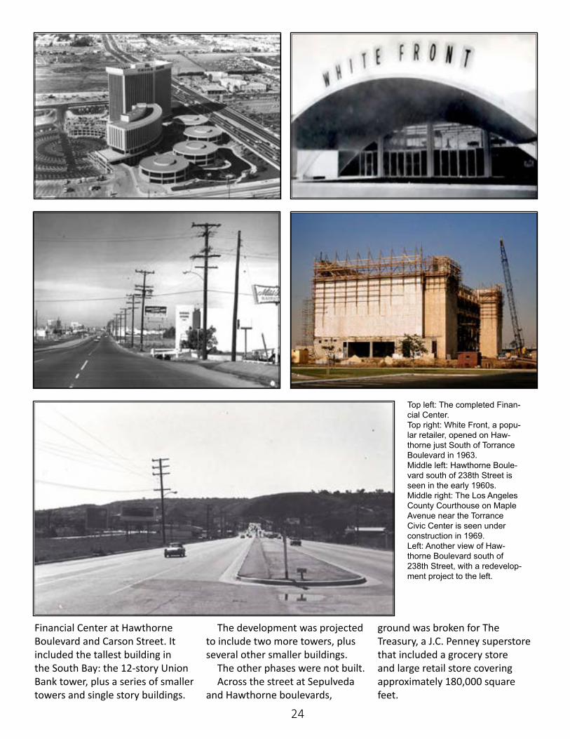
In March 1963, a suit was filed against the developer alleging a violation of the 1959 Unruh Civil Rights Act. The Congress of Racial Equality (CORE) picketed the tract, bringing about change to the racial profiling practices when it came to
Little Company of Mary, founded in 1960, was built as a full service hospital at Earl Street and Torrance Boulevard. An oil derrick can be seen to the right of the hospital.
The Southwood Riviera Royale Development was a project by Don Wilson Builders. This image, from 1962, shows the project in the area of Anza Avenue and Calle Mayor.
In 1963, protestors alleged unfair housing practices at the Southwood Riviera Royale tract, saying the developer violated the 1959 Unruh Civil Rights Act.
23
real estate in Southern California. Torrance was now the third
largest city in Los Angeles County. It had shifted its focus west, and with the new mall and Hawthorne Boulevard developments, it became the regional destination for shopping.
It retained its identity as a balanced city, but now that balance reflected manufacturing, aerospace engineering, retail and residential elements.
Torrance’s attempts to expand its borders by seeking to annex much of the Palos Verdes Peninsula and some areas to the south east and north of its existing borders were never fulfilled, so the boundaries of Torrance were set.
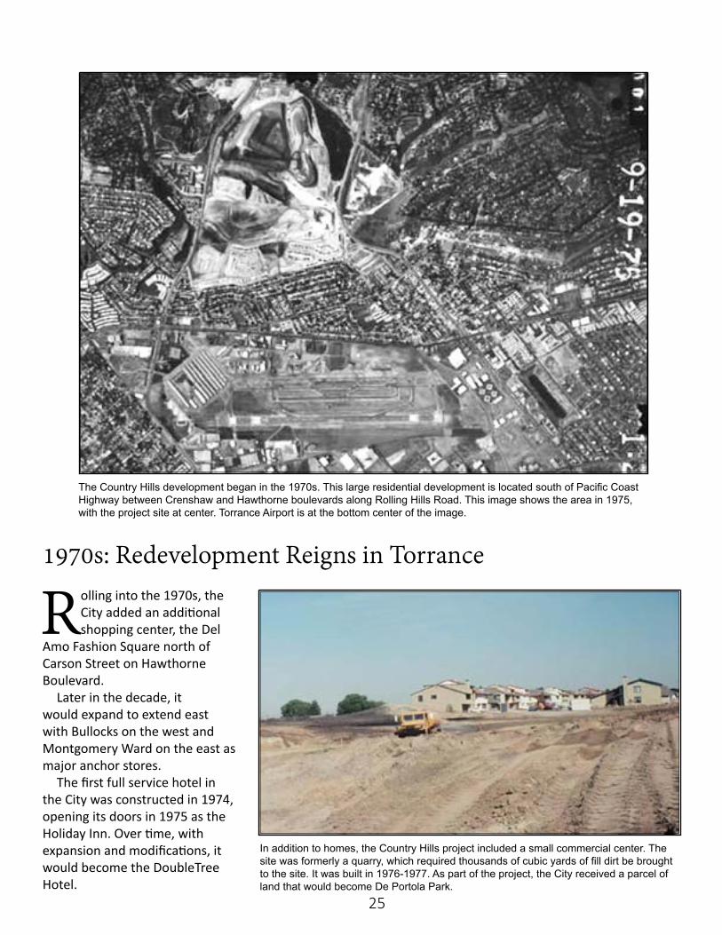
In 1967, construction began on the first phase of the Torrance
Work on the Torrance Financial Center on Hawthorne Boulevard and Carson Street began in 1967. It included the 12-story Union Bank tower, then the tallest building in the South Bay. A rendering, below, shows the plan. Only one of the three towers was completed.
24
Financial Center at Hawthorne Boulevard and Carson Street. It included the tallest building in the South Bay: the 12-story Union Bank tower, plus a series of smaller towers and single story buildings.
The development was projected to include two more towers, plus several other smaller buildings.
The other phases were not built. Across the street at Sepulveda
and Hawthorne boulevards,
ground was broken for The Treasury, a J.C. Penney superstore that included a grocery store and large retail store covering approximately 180,000 square feet.
Top left: The completed Finan-cial Center.Top right: White Front, a popu-lar retailer, opened on Haw-thorne just South of Torrance Boulevard in 1963.Middle left: Hawthorne Boule-vard south of 238th Street is seen in the early 1960s. Middle right: The Los Angeles County Courthouse on Maple Avenue near the Torrance Civic Center is seen under construction in 1969.Left: Another view of Haw-thorne Boulevard south of 238th Street, with a redevelop-ment project to the left.
25
Rolling into the 1970s, the City added an additional shopping center, the Del
Amo Fashion Square north of Carson Street on Hawthorne Boulevard.
Later in the decade, it would expand to extend east with Bullocks on the west and Montgomery Ward on the east as major anchor stores.
The first full service hotel in the City was constructed in 1974, opening its doors in 1975 as the Holiday Inn. Over time, with expansion and modifications, it would become the DoubleTree Hotel.
1970s: Redevelopment Reigns in Torrance
The Country Hills development began in the 1970s. This large residential development is located south of Pacific Coast Highway between Crenshaw and Hawthorne boulevards along Rolling Hills Road. This image shows the area in 1975, with the project site at center. Torrance Airport is at the bottom center of the image.
In addition to homes, the Country Hills project included a small commercial center. The site was formerly a quarry, which required thousands of cubic yards of fill dirt be brought to the site. It was built in 1976-1977. As part of the project, the City received a parcel of land that would become De Portola Park.
26
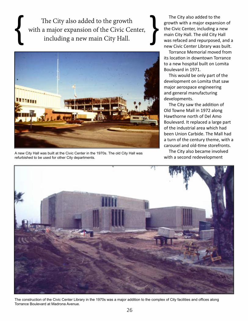
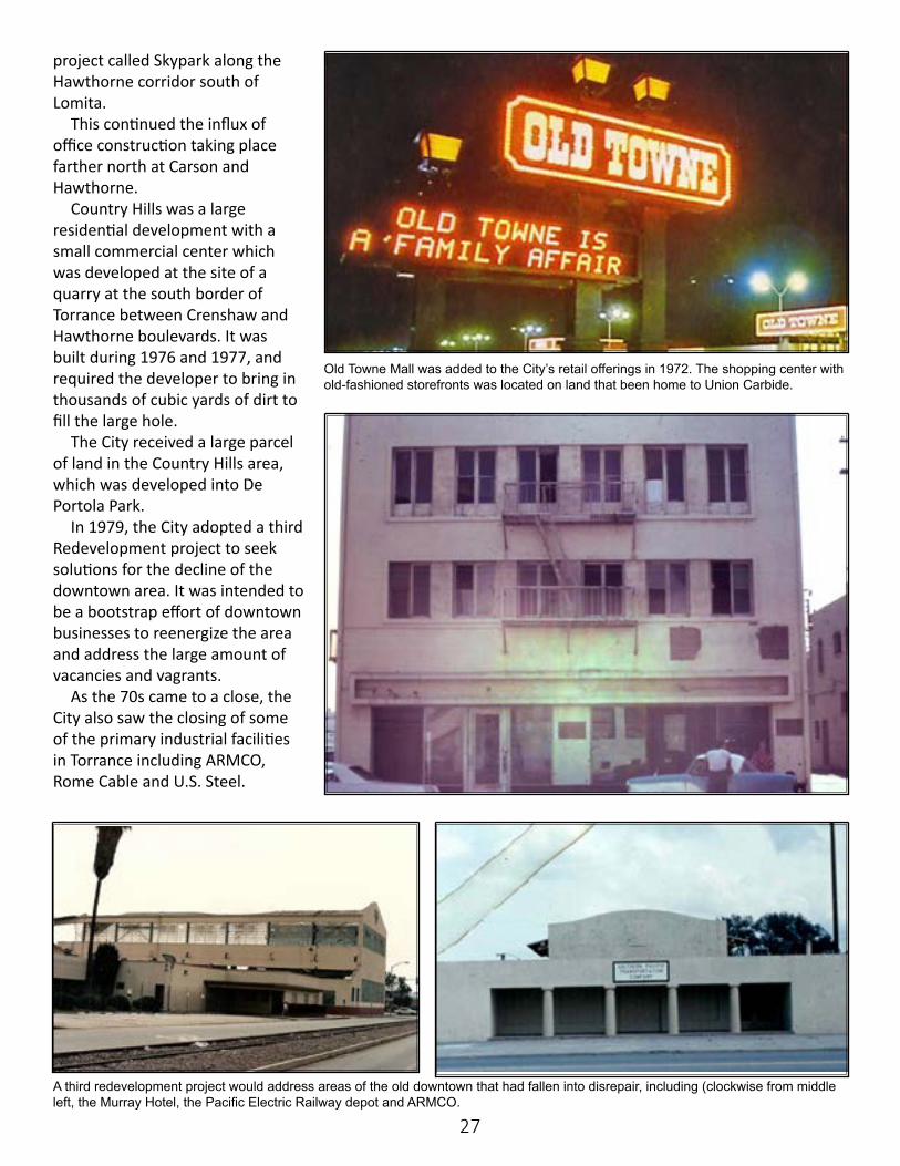
The City also added to the growth with a major expansion of the Civic Center, including a new main City Hall. The old City Hall was refaced and repurposed, and a new Civic Center Library was built.
Torrance Memorial moved from its location in downtown Torrance to a new hospital built on Lomita Boulevard in 1971.
This would be only part of the development on Lomita that saw major aerospace engineering and general manufacturing developments.
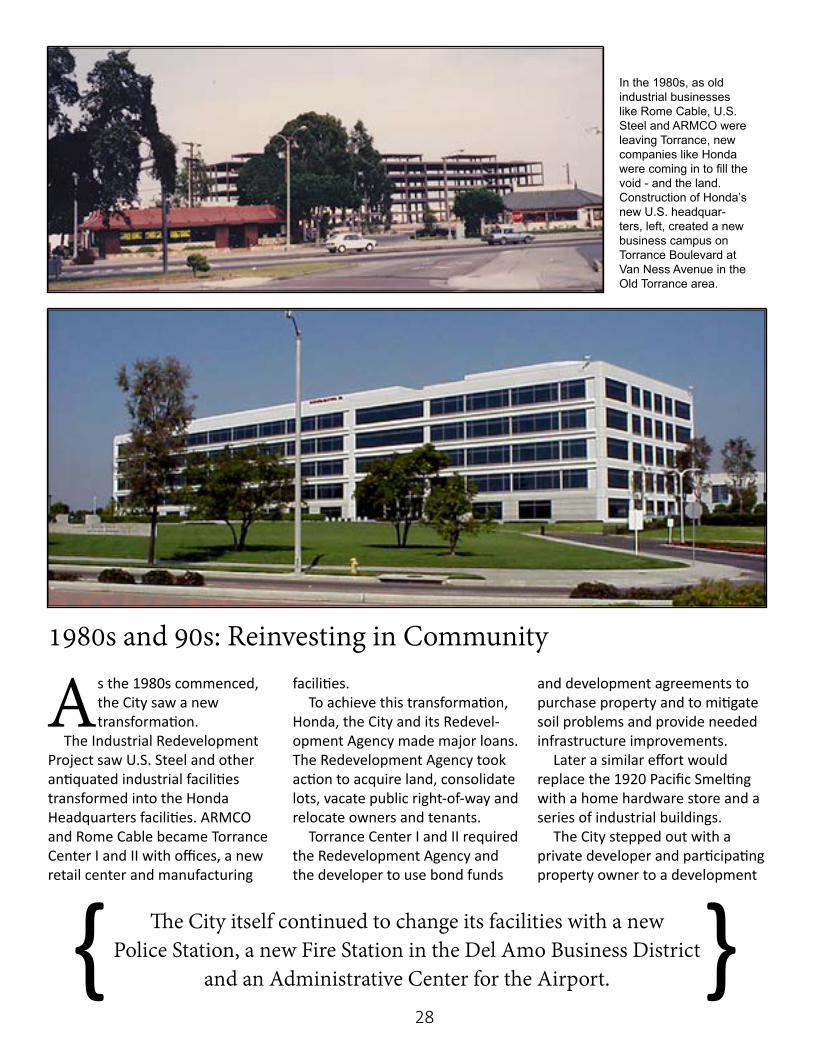
The City saw the addition of Old Towne Mall in 1972 along Hawthorne north of Del Amo Boulevard. It replaced a large part of the industrial area which had been Union Carbide. The Mall had a turn of the century theme, with a carousel and old-time storefronts.
The City also became involved with a second redevelopment
A new City Hall was built at the Civic Center in the 1970s. The old City Hall was refurbished to be used for other City departments.
The construction of the Civic Center Library in the 1970s was a major addition to the complex of City facilities and offices along Torrance Boulevard at Madrona Avenue.
The City also added to the growth with a major expansion of the Civic Center,
including a new main City Hall.{ }
27
project called Skypark along the Hawthorne corridor south of Lomita.
This continued the influx of office construction taking place farther north at Carson and Hawthorne.
Country Hills was a large residential development with a small commercial center which was developed at the site of a quarry at the south border of Torrance between Crenshaw and Hawthorne boulevards. It was built during 1976 and 1977, and required the developer to bring in thousands of cubic yards of dirt to fill the large hole.
The City received a large parcel of land in the Country Hills area, which was developed into De Portola Park.
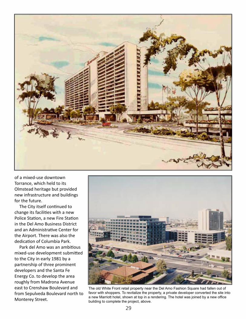
In 1979, the City adopted a third Redevelopment project to seek solutions for the decline of the downtown area. It was intended to be a bootstrap effort of downtown businesses to reenergize the area and address the large amount of vacancies and vagrants.
As the 70s came to a close, the City also saw the closing of some of the primary industrial facilities in Torrance including ARMCO, Rome Cable and U.S. Steel.
Old Towne Mall was added to the City’s retail offerings in 1972. The shopping center with old-fashioned storefronts was located on land that been home to Union Carbide.
A third redevelopment project would address areas of the old downtown that had fallen into disrepair, including (clockwise from middle left, the Murray Hotel, the Pacific Electric Railway depot and ARMCO.
28
As the 1980s commenced, the City saw a new transformation.
The Industrial Redevelopment Project saw U.S. Steel and other antiquated industrial facilities transformed into the Honda Headquarters facilities. ARMCO and Rome Cable became Torrance Center I and II with offices, a new retail center and manufacturing
facilities. To achieve this transformation,
Honda, the City and its Redevel-opment Agency made major loans. The Redevelopment Agency took action to acquire land, consolidate lots, vacate public right-of-way and relocate owners and tenants.
Torrance Center I and II required the Redevelopment Agency and the developer to use bond funds
and development agreements to purchase property and to mitigate soil problems and provide needed infrastructure improvements.
Later a similar effort would replace the 1920 Pacific Smelting with a home hardware store and a series of industrial buildings.
The City stepped out with a private developer and participating property owner to a development
1980s and 90s: Reinvesting in Community
In the 1980s, as old industrial businesses like Rome Cable, U.S. Steel and ARMCO were leaving Torrance, new companies like Honda were coming in to fill the void - and the land. Construction of Honda’s new U.S. headquar-ters, left, created a new business campus on Torrance Boulevard at Van Ness Avenue in the Old Torrance area.
The City itself continued to change its facilities with a new Police Station, a new Fire Station in the Del Amo Business District
and an Administrative Center for the Airport.{ }
29
of a mixed-use downtown Torrance, which held to its Olmstead heritage but provided new infrastructure and buildings for the future.
The City itself continued to change its facilities with a new Police Station, a new Fire Station in the Del Amo Business District and an Administrative Center for the Airport. There was also the dedication of Columbia Park.
Park del Amo was an ambitious mixed-use development submitted to the City in early 1981 by a partnership of three prominent developers and the Santa Fe Energy Co. to develop the area roughly from Madrona Avenue east to Crenshaw Boulevard and from Sepulveda Boulevard north to Monterey Street.
The old White Front retail property near the Del Amo Fashion Square had fallen out of favor with shoppers. To revitalize the property, a private developer converted the site into a new Marriott hotel, shown at top in a rendering. The hotel was joined by a new office building to complete the project, above.
30
Most of the northwest portion of the project was to be medium density condominiums or patio homes, with the southeast corner to be the site of a moderate high rise office development. The original plan included 2,500 residential units including a senior housing building and high-rise office buildings.
The development would have substantially impacted the vernal marsh on the west side of the project – the project was finally approved by the City Council with 1,700 residential units and office buildings at Crenshaw and Sepulveda Boulevard. It also provided for the dedication of 10 acres of park land.
There was community backlash to the approved project, and within a few weeks a petition campaign collected more than 17,000 signatures to force the matter to the ballot.
The project was reconsidered by the Council and sent back for further study, and a compromise was worked out with the devel-opers. It provided for a 34.4-acre donation of land for the Madrona Marsh and the sale by the devel-opers of another 8.5 acres of land
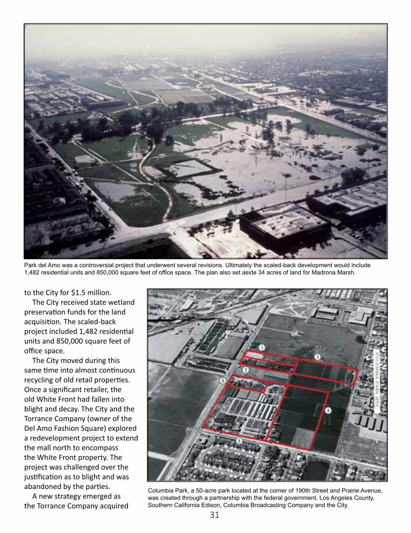
Redevlopment of Cabrillo Avenue, above and below, resulted in more mixed-use properties in the Old Town area with en eye toward revitalizing that part of the City.
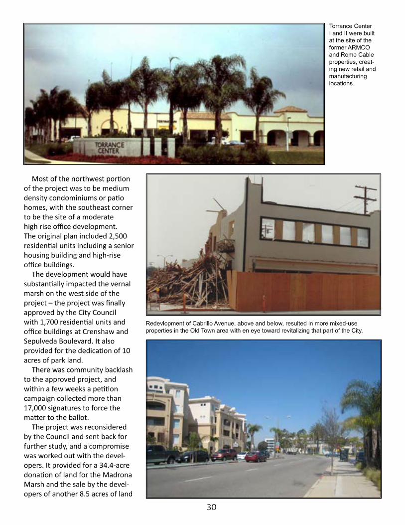
Torrance Center I and II were built at the site of the former ARMCO and Rome Cable properties, creat-ing new retail and manufacturing locations.
31
to the City for $1.5 million. The City received state wetland
preservation funds for the land acquisition. The scaled-back project included 1,482 residential units and 850,000 square feet of office space.
The City moved during this same time into almost continuous recycling of old retail properties. Once a significant retailer, the old White Front had fallen into blight and decay. The City and the Torrance Company (owner of the Del Amo Fashion Square) explored a redevelopment project to extend the mall north to encompass the White Front property. The project was challenged over the justification as to blight and was abandoned by the parties.
A new strategy emerged as the Torrance Company acquired
Park del Amo was a controversial project that underwent several revisions. Ultimately the scaled-back development would include 1,482 residential units and 850,000 square feet of office space. The plan also set aside 34 acres of land for Madrona Marsh.
Columbia Park, a 50-acre park located at the corner of 190th Street and Prairie Avenue, was created through a partnership with the federal government, Los Angeles County, Southern California Edison, Columbia Broadcasting Company and the City.
32
the aging Del Amo Mall south of Carson Street. The two malls were then connected with a bridge over Carson Street and a new Robinson’s department store.
It resulted in the largest indoor mall in the United States, and would remain so until the construction of the Mall of America in Minnesota.
Shortly after this project commenced, the White Front property went through a private redevelopment into a major office building and the City’s second major hotel, the Marriott.
The City was expanding its own facilities with a new City Yard, General Aviation Center, Transit Facility and Police headquarters.
Robinson Helicopter moved its existing facility on Skypark Drive at the Airport, taking up and expanding into several older industrial buildings.
In the early 1990s, Robinson Helicopter buiit a new manufacturing facility on Airport Way. top. And in 1992, a new General Aviation Center was built at Torrance Airport, middle. The City developed part of the Civic Center, above, to include the new Cultural Arts Center.
33
In the early part of the new decade, then-owner of Del Amo Fashion Center, Mills
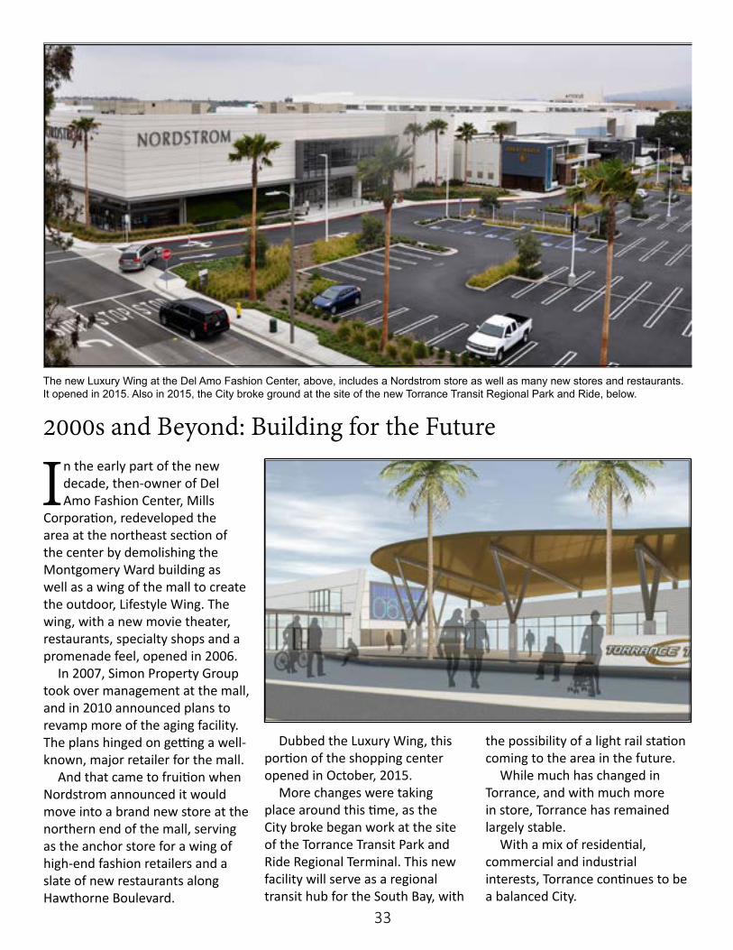
Corporation, redeveloped the area at the northeast section of the center by demolishing the Montgomery Ward building as well as a wing of the mall to create the outdoor, Lifestyle Wing. The wing, with a new movie theater, restaurants, specialty shops and a promenade feel, opened in 2006.
In 2007, Simon Property Group took over management at the mall, and in 2010 announced plans to revamp more of the aging facility. The plans hinged on getting a well-known, major retailer for the mall.
And that came to fruition when Nordstrom announced it would move into a brand new store at the northern end of the mall, serving as the anchor store for a wing of high-end fashion retailers and a slate of new restaurants along Hawthorne Boulevard.
Dubbed the Luxury Wing, this portion of the shopping center opened in October, 2015.
More changes were taking place around this time, as the City broke began work at the site of the Torrance Transit Park and Ride Regional Terminal. This new facility will serve as a regional transit hub for the South Bay, with
the possibility of a light rail station coming to the area in the future.
While much has changed in Torrance, and with much more in store, Torrance has remained largely stable.
With a mix of residential, commercial and industrial interests, Torrance continues to be a balanced City.
2000s and Beyond: Building for the Future
The new Luxury Wing at the Del Amo Fashion Center, above, includes a Nordstrom store as well as many new stores and restaurants. It opened in 2015. Also in 2015, the City broke ground at the site of the new Torrance Transit Regional Park and Ride, below.